Embed Size (px)
Citation preview

HAL Id: insu-01120228https://hal-insu.archives-ouvertes.fr/insu-01120228
Submitted on 25 Feb 2015
HAL is a multi-disciplinary open accessarchive for the deposit and dissemination of sci-entific research documents, whether they are pub-lished or not. The documents may come fromteaching and research institutions in France orabroad, or from public or private research centers.
L’archive ouverte pluridisciplinaire HAL, estdestinée au dépôt et à la diffusion de documentsscientifiques de niveau recherche, publiés ou non,émanant des établissements d’enseignement et derecherche français ou étrangers, des laboratoirespublics ou privés.
Topographic growth around the Orange River valley,southern Africa: A Cenozoic record of crustal
deformation and climatic changeOlivier Dauteuil, Paul Bessin, François Guillocheau
To cite this version:Olivier Dauteuil, Paul Bessin, François Guillocheau. Topographic growth around the Orange Rivervalley, southern Africa: A Cenozoic record of crustal deformation and climatic change. Geomorphol-ogy, Elsevier, 2015, 233, pp.5-19. �10.1016/j.geomorph.2014.11.017�. �insu-01120228�

ACC
EPTE
D M
ANU
SCR
IPT
ACCEPTED MANUSCRIPT
1
Topographic growth around the Orange River valley,
southern Africa: a Cenozoic record of crustal deformation and
climatic change
Olivier Dauteuil*, Paul Bessin, François Guillocheau
Geosciences-Rennes, UMR-CNRS 6118 University of Rennes 1, UEB, 35042 Rennes cedex,
France
*corresponding author: [email protected], Tel: 0033 223 236 968
ABSTRACT
We reconstruct the history of topographic growth in southern Africa on both sides of the
Orange River valley from an integrated analysis of erosion surfaces, crustal deformation
and climate change. First, we propose an inventory of erosion surfaces observed in the
study area and classify them according to their most likely formative process, i.e.
chemical weathering or mechanical erosion. Among the various land units observed we
define a new class of landform: the pedivalley, which corresponds to a wide valley with a
flat erosional floor. In the Orange River valley, we mapped three low-relief erosion
surfaces, each bevelling a variety of lithologies. The oldest and most elevated is (1) a
stripped etchplain evolving laterally into (2) a stepped pediplain bearing residual
inselbergs; (3) a younger pediplain later formed in response to a more recent event of
crustal deformation. These are all Cenozoic landforms: the etchplain is associated with a
late Paleocene to middle Eocene weathering event, and the two pediplains are older
than the middle Miocene alluvial terraces of the Orange River. Landscape evolution was
first driven by slow uplift (10 m/Ma), followed by a second interval of uplift involving a
cumulative magnitude of at least 200 m. This event shaped the transition between the
two pediplains and modified the drainage pattern. A final phase of uplift (magnitude: 60
m) occurred after the Middle Miocene and drove the incision of the lower terraces of the
Orange River. Climate exerted a major control over the denudation process, and
involved very humid conditions responsible for lateritic weathering, followed by more

ACC
EPTE
D M
ANU
SCR
IPT
ACCEPTED MANUSCRIPT
2
arid conditions, which promoted the formation of pedivalleys. Collectively, these
produce pediplains.
Keywords: Planation surfaces, etchplain, pediplain, pedivalley, uplift
1. Introduction
The relief of the Earth can be analyzed from the perspective of topographic
wavelength: mountains and rift shoulders correspond to several tens to hundreds of
kilometres, whereas elevated intraplate landforms (high plateaus) and large
depressions or “basins” extend over several thousands of kilometres. These "plateaus"
are widespread all around the world and are key areas for understanding large-scale
deformations associated with mantle dynamics or other lithospheric deformation
processes (shear stress at the base of the lithosphere, mantle delamination, etc.) (Braun,
2010). Plateaus are a major component of African topography, and the southern African
plateau, which extends from South Africa to southern Congo, is a large specimen among
this population of large plateaus (Fig. 1). This vast land surface, with a mean elevation
ranging from 1 to 2 kilometres, was extensively studied during the second half of the
20th century, particularly in the classic texts of King (1951; 1962) and Partridge and
Maud (1987). However, little attention has since been paid to this region by
geomorphologists despite the fact that it may record interactions between mantle
dynamics and climate. The origin of the anomalously high elevation of the plateau and
the timing of the uplift has been largely debated using landforms (mainly erosion
surfaces) as markers. The characterisation of uplift has been a subject of controversy
among thermochronologists measuring denudation rates throughout the Mesozoic and
Cenozoic (Gallagher and Brown, 1999a, 1999b; Brown et al., 2000; Tinker et al., 2008a).
Thermochronologists disagree over certain assumptions made by some
geomorphologists, particularly by Partridge and Maud (1987) according to whom a
planation surface is horizontal and should form close to sea level, and over related
inferences about the young age of plateau uplift (typically late Oligocene to Pliocene).
Thermochronological research has instead emphasized crustal uplift during the

ACC
EPTE
D M
ANU
SCR
IPT
ACCEPTED MANUSCRIPT
3
Cretaceous (Gallagher and Brown, 1999a, 1999b; Tinker et al., 2008a, 2008b) followed
by very low Cenozoic and modern rates of denudation — e.g. less than 4m/Ma (Decker
et al., 2013 and references therein). The processes causing the uplift have remained
speculative: Decker et al. (2013) suggested isostatic adjustment to denudation, while
Brown et al. (2002), Kounov et al. (2009) and Raab et al. (2002) advocated active
tectonics. Burke and Gunnell (2008) proposed a long-term landscape evolution scenario
involving successive tectonic cycles; the latest stage started ~ 30 Ma ago and promoted
the uplift of an African Surface. This surface formed closer to sea level than assumed by
authors who advocate that southern Africa has remained an elevated highland since the
Mesozoic. In the northern part on Namibia, McGregor (2009) and Dauteuil et al. (2013)
proposed that the land surface since the end of Atlantic rifting had remained elevated.
The main objective of this study is to analyse the evolution of the southern
African plateau by tracking the uplift record of one of its subregions. The plateau
landscape is analysed as an assemblage of distinct components, namely different
categories of erosion surface, pediments and incised fluvial valleys. This analysis points
out the importance of pediments in terms of their total surface area, and thus in terms of
the dominant landscape-shaping process. We discuss (1) their relative age and link the
inferred denudation chronology with (2) the timing of the uplift and the growth of relief
in southern Africa. We focus our analysis on the southern border of the southern African
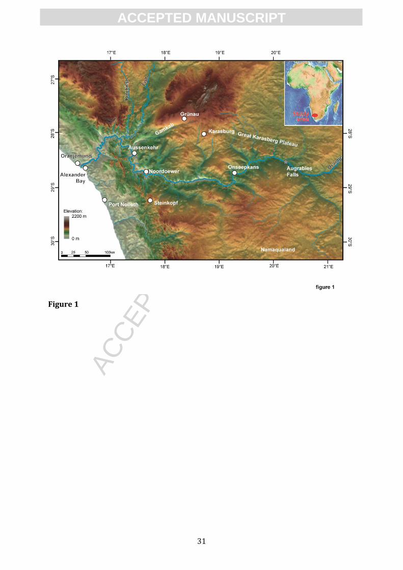
Plateau, in an area straddling the Orange River (Fig. 1) and extending from the Great
Karasberg Plateau (southern Namibia) to Namaqualand (north-western South Africa),
and from the Atlantic Ocean to the Augrabies Falls.
2. Geological evolution of southern Africa
2.1 Geological setting
The continental crust of southern Africa consists of Archean cratons, surrounded
by accreted Proterozoic terranes. From Carboniferous to early Permian times, the ice
sheet present during the Gondwana Glaciation reshaped the landform generating a
surface fossilized by the Karoo sediments (late Carboniferous to early Jurassic), most of
which were supplied by the growth of a mountain belt to the south, the Cape Fold Belt

ACC
EPTE
D M
ANU
SCR
IPT
ACCEPTED MANUSCRIPT
4
(Johnson et al., 2006). After eruption of the Karoo flood basalts (early Jurassic: Jourdan
et al., 2008), rifting occurred on both sides of South Africa. In the South Atlantic to the
west, oceanic accretion first occurred during the early Cretaceous (Hauterivian: Moulin
et al., 2010).
The study area is underlain by Proterozoic basement, unconformably overlain by
flat-lying sedimentary rocks of Neoproterozoic (Nama Group) and Carboniferous to
Permian (Karoo group) age. The Proterozoic metamorphic to igneous rocks result from
the accretion of four terranes during the Namaqua orogeny (1.2–1 Ga; Cornell et al.,
2006) and of the Gariep unit (on the Atlantic side) during the Pan-African orogeny (late
Neoproterozoic: Gresse et al., 2006). The mainly siliciclastic Nama and Karoo sediments
are preserved in Namibia. The main sedimentary accumulation is the Karoo Karasburg
Basin.
2.2 Geomorphological setting
The southern African (or Kalahari) Plateau has a mean elevation between 1,000
and 1,400 m. A varyingly steep marginal bulge, locally reaching elevations of 2,500 m,
forms the western margin of this plateau. From west to east, this marginal bulge is
composed of (1) a narrow coastal plain, (2) a convex domain with inselbergs reaching
elevations of 500–750 m upstream, (3) the so-called main scarp (200–400 m) and then
(4) the Plateau. One major trunk river, the Orange River, cuts through the plateau with
two main tributaries: the Fish River and the Voal River.
King (1956) defined three main surfaces in South Africa and later extrapolated
them to the whole of Africa (King, 1963): the Gondwana Surface was considered to be of
Jurassic age, the African Surface of late Cretaceous to “early Tertiary” (Eocene) age and
the Post-African Surface of “late Tertiary” age. Based on these observations, King (1955)
defined the concept of a pediplain, with a model of topographic growth tied to a model
of passive-margin scarp retreat (see discussion below). The staircase of planation
surfaces, instead of the scarp retreat model, subsequently became very popular in
southern Africa. King’s successors (e.g. Partridge and Maud, 1997) mainly focused on
the plateau uplift component, suggesting a very recent, late Pliocene, age of uplift. Burke
and Gunnell (2008) confirmed a post-Oligocene age for the uplift as previously
suggested by King, but tied it to the mantle-related “swell” dynamics of the African

ACC
EPTE
D M
ANU
SCR
IPT
ACCEPTED MANUSCRIPT
5
continent, which appear to have promoted large-scale plateau uplift. Although the
timing of uplift advocated by Burke and Gunnell (2008) does not contradict existing
thermochronological results, which indicate rapid denudation in response to rifting
during the late Cretaceous (e.g. Gallagher and Brown, 1999a, 1999b; Brown et al., 2000),
it introduced the notion of a second cycle of landscape-changing crustal buoyancy
during the Cenozoic. This event was not detected by apatite fission-track analysis,
possibly because it did not trigger a geomorphological response involving deep
denudation (i.e. no rock-cooling signal).
Using a different angle of approach to Burke and Gunnell (2008), here we focus
on the meaning of landscape signatures provided by assemblages of erosion surfaces,
valleys and hillslopes on both sides of the Orange River within 400 km of its mouth (Figs.
3 and 4). To the north, the Kalahari Plateau is filled with Kalahari sands dated as late
Miocene in the Makgadikgadi Pan (Botswana) (du Plessis, 1993). Mac Farlane et al.
(2010) described a lateritic weathering profile attributed to the African Surface,
generally dated as flat and low-lying between ~100 Ma and ~34 Ma. To the south, the
southern African Plateau in the Bushmanland area is scarred by a network of weakly
preserved anabranching river channels of middle Miocene age (de Wit and Bamford,
1993).
Pediments have long been recognized between the Orange River and
Namaqualand (Mabbutt, 1955). It is not entirely clear how these pediments relate
chronologically to the two fluvial terrace levels described by van Wyk and Pienaar
(1986) in the lower reaches of the Orange River, but the upper terrace has yielded
Burdigalian (~21 Ma to ~16 Ma) flora (Pickford and Senut, 2003).
2.3 Climatic setting
During Mesozoic to Cenozoic times, the climate underwent large variations with
major impacts on landscape evolution in southern Africa. Burke and Gunnell (2008)
summarised this evolution at the scale of the African continent. Knowledge about
palaeoprecipitation is mostly based on palaeobotanical evidences. The Cretaceous was
characterised by two sharp transitions: semi-arid to arid around 130 Ma (Hauterivian)
and 85 Ma (Santonian), with progressive aridification between 130 and 85 Ma (Gomez

ACC
EPTE
D M
ANU
SCR
IPT
ACCEPTED MANUSCRIPT
6
et al., 2002; Sandersen, 2006). The second half of the late Cretaceous up until the middle
Eocene (i.e. 85–40 Ma) was very humid along the Atlantic coast (de Villers, 1999;
Sandersen, 2006) but no data are directly available for the Paleocene. This humid period
was coeval with the formation of laterite in Namibia (Pickford and Senut, 1999), a
widespread process across Africa with well constrained age brackets for West Africa
between 59 and 45 Ma (Beauvais et al., 2008). No data are available for the Oligocene, i.e.
the early stages of the “icehouse” period. The early Miocene (Aquitanian) was humid
(Bramford and de Wit, 1993; Bramford, 2000). After the middle Miocene, the coastal
area of SW Africa became and remained arid (Pickford and Senut, 1999).
2.4 Study area
We studied both sides of the Orange River valley from 26°50'S to 30°10'S and
from the shoreline eastward to 21°15'E. The area was large enough to allow us to work
out how the lower reaches of the Orange River, one of the largest fluvial systems in
southern Africa, evolved below the Augrabies Falls. The Orange River valley marks a
main boundary between a rather flat domain to the north and a dissected domain to the
south (Fig. 1). The inner plateau displays a smooth topography at an elevation of ~1,000
m, with some mountain ranges reaching 2,200 m. The vast, low relief area displays
undulations with amplitudes that increase towards the Orange River and can be
subdivided into discrete, diagnostic land units described later. In the northwest, the
plateau exhibits a number of elevated topographic ranges striking NE–SW and separated
by a corridor. These ranges are bounded by normal faults that have generated either
tilted blocks or horsts and grabens, as in the Fish River Canyon (Mvondo et al., 2011).
The marginal topographic bulge to the west stands at an elevation of approximately
1,200 m. It is deeply incised by the Orange River and by other coastal rivers that have
been progressively cutting back into the plateau edge. The coastal zone extends from
base of the marginal bulge to the coast. The connection with the marginal bulge is
progressive in the wider segment and, contrary to common belief, it does not
systematically for a scarp.
3. Erosion surfaces: terminology used

ACC
EPTE
D M
ANU
SCR
IPT
ACCEPTED MANUSCRIPT
7
Erosion surfaces are diagnostic landforms, mainly at the scale of a continent such
as Africa. The nature, terminology and origin of erosion surfaces since the definition of
the peneplain and the geographical cycle by Davis (1899) have been a subject of debate
(e.g. Migon, 2004a; Twidale, 1983a, 1983b; Phillips, 2002). In this study, we propose an
inventory of erosion surfaces of different types that occur along the Orange River valley
and its surrounding plateaus. We also distinguish landforms according to their surface
area.
3.1. Large-scale (>104 km2) erosion surfaces
An erosion, or planation, surface (Migon, 2004a) is a nearly flat land surface that cuts
across underlying structures and rock outcrops. It may be incised by the drainage
network and display isolated, residual hills. Such surfaces are often warped, most of the
time by long wavelength deformation (x100 km). They can later undergo reworking (1)
by other planation processes (see discussion below), in this case becoming polygenetic
erosion surfaces; or (2) by river or pediment incision in response to a base-level fall. In
that case, the erosion surface becomes degraded or dissected. Because our investigative
method of long-term landscape development is highly sensitive to the definition and
interpretation of land system features, below we list the four diagnostic types of erosion
surface detected in the study area (Fig. 2):
(1) Peneplain. This word, defined by Davis (1899), has several definitions and origins
(discussed in Migon, 2004b). It was originally defined as “a nearly featureless plain”
with “perceptible inequalities, amounting frequently to two or three hundred feet”
and connected to the base level, i.e. the sea. No idea of processes was provided.
Later (Davis, 1930; Holmes, 1955), peneplains were assumed to be fluvial erosional
surfaces formed by the downwearing of hillslopes that progressively flatten the
relief. Even though some researchers question the occurrence of true peneplains
(e.g. Phillips, 2002), here we retain the definition of a fluvially-shaped surface.
(2) Pediplain. The pediplain was defined by King (1953) in contradiction to the
peneplain, as an erosion surface resulting from the parallel retreat (backwearing)
of scarps (hillslopes) and composed of many coalescent pediments (see definition
of these elementary landforms in section 3.2). Mabbutt (1996) proposed that
pediments resulted from processes of sheet flow involving alternate cycles of

ACC
EPTE
D M
ANU
SCR
IPT
ACCEPTED MANUSCRIPT
8
shallow burial by lag deposits and subsequent stripping. The processes that drive
the formation of a pediplain are widely debated and range from climate to crustal
deformation. Wirthmann (1999) has well summarised the evolution of these
concepts.
(3) Mantled etchplain. This variety of land surface is typified by the presence of a
weathering mantle, often lateritic in nature, and often capped by iron-rich duricrust
(Mabbutt, 1966; Millot, 1980; Grandin and Thiry, 1983). The term etchplain has
received broad definitions (see Thomas, 1989a), elaborating on the early intuitions
of Wayland (1933). The consensus is that an etchplain is a surface of bedrock
corrosion resulting from chemical weathering (i.e. etching) and physical processes.
The indurated surfaces are often topographically inverted and form mesas, i.e.
isolated plateaus (Chardon et al., 2006). Mantled etchplains (Migon, 2004c)
produced by chemical weathering can undergo degradation by partial stripping of
the weathering mantle. Exposure of the weathering front develops a partially
stripped etchplain (see below) but the capacity of chemical weathering to level a
rock surface is still being discussed. The maximum thickness of the lateritic profile
is often tens of metres (Bardossy and Aleva, 1990) and known to reach maxima of
~100 m (Beauvais and Chardon, 2013).
(4) Stripped etchplain. Stripped etchplains correspond either to the exposed base of
the weathering profile, or weathering front (Mabbutt, 1961), or to a surface with
vestiges of weathering profiles dissected by incised rivers or pediments (Twidale
and Bourne, 2013) with possible vestiges of deep weathering profile (laterites) on
some hillslopes (Büdel, 1957; Thomas, 1989a, 1989b). In this second type of
stripped etchplain, a major question is the kinematics of the incision, with two
plausible scenarios in response to base-level fall: (1) continuous chemical
weathering and physical stripping controlled by a seasonal regime (Büdel, 1957,
1982; Bremer, 1993); or (2) alternations of chemical and mechanical erosion
dictated by periodic climate change (Thomas, 1989a, 1989b; Millot, 1981; Beauvais
et al., 2008).
3.2. Elementary erosion surfaces: pediment, inselberg, pedivalley

ACC
EPTE
D M
ANU
SCR
IPT
ACCEPTED MANUSCRIPT
9
The literature has long distinguished between pediments and wash pediments, or
glacis, but below we also introduce a landform previously described but never given
much prominence in the literature: the pedivalley.
Pediments are gently inclined, low-relief erosional surfaces truncating the
underlying rocks. They display concave or straight longitudinal profiles and are mantled
at most by thin and discontinuous sediment layers (Whitaker, 1979; White, 2004;
Dohrenwend and Parsons, 2009). Since Davis (1938), who opposed sheetflood and
streamflood as two likely candidates in the formation of pediments, the processes
driving pediment evolution have continued to be debated. Running water should (1)
cover the pediment entirely (no channel incision) and (2) its transport capacity should
ensure evacuation of the eroded debris. At times of intense flooding, the flow is a dense
mixture of water and sediments (sheetfloods), and is more efficient if a large amount of
soft rocks is available upstream (e.g. saprolite in the case of a weathered basement).
Two types of pediment have been defined based on their present-day climatic
distribution: arid and tropical pediments. Mammericks (1964), who compared
pediments in Congo and the American West, suggests a difference in size between the
two types: dryland pediments were steeper and smaller (0.5–11° and 1 to 600 km2;
Salomon, 2007), with layers of coarse-grained lag deposits (>4 mm), whereas the
tropical pediments were larger, with shallower gradients and mainly clay-rich lag
deposits. In the case of modern dryland pediments in Nevada, Dohrenwend and Parsons
(2009) shows that the pediments are not controlled by variations in the underlying
lithology. In contrast, Ollier (1959), Mabbutt (1966) and Thomas (1989a, 1989b) have
indicate that tropical pediments were narrowly controlled by the thickness of the
underlying lateritic profiles, and that lithology was another control variable.
Dohrenwend and Parsons (2009) also showed that both downwearing and backwearing
processes occurred on pediments.
Glacis (Dresch, 1947) are soft-rock pediments (typically in shale, etc.), with a
concave-up longitudinal profile (1 to 12°) dominated upstream by steep slopes and
often mantled by a large thickness of debris. The main differences with rock pediments
are (1) the presence of sediments, which indicates short transport distances from the
source and periods of sheetwash, and (2) their ubiquitous location regardless of climatic
context.

ACC
EPTE
D M
ANU
SCR
IPT
ACCEPTED MANUSCRIPT
10
Here, we define a new term to characterise pediments that look like wide valleys
with flat erosional floors. This type of landform, which is characteristic of the study area,
has already been described in the literature (e.g. Mammericks, 1964, Thomas, 1989a;
Thomas, 1989b) but not named. We tentatively call them pedivalleys. The planation
process results from the parallel retreat of a pre-existing scarp in combination with
bedrock weathering.
Inselbergs are isolated hills that stand above the surrounding, flatter erosional
plain. This term was restricted to dome-shaped landforms in metamorphic and plutonic
rocks. Inselbergs record topographic lowering due to base-level fall. They are relict
features of weathering periods (e.g. Thomas, 1978; Twidale, 1983a; Migon, 2006), and
shaping by other processes such as wind has also been considered (e.g. Selby, 1982).
Whatever the process, the bedrock undergoes very low rates of erosion (1–2 m/Ma in
Namibia, Matmon et al. (2013)). King (1951) suggested that inselbergs were
pediplanation residuals. Inselbergs are shaped in two stages: (1) a weathering period in
an environment corresponding to a mantled etchplain, with a topographically irregular
weathering front (typically controlled by lithology); followed by (2) a fall in base level
and a denudational response that removes at least the softer weathered rock across
expanding pediment surfaces. This results in a stripped etchplain. Tropical inselbergs
thus result from the exhumation of areas with a thin lateritic profile. The height of the
inselbergs can attain hundreds of metres, i.e. more than observed weathered thickness
maxima (~100 m). Thus, high inselbergs result from the downward migration of the
weathering front and consequently indicate a continuously falling base level. The
presence of inselbergs implies that a surface corresponding the top of laterite profile
existed at a greater elevation than the present-day inselberg summits. That surface was
likely a mantled etchplain.
3.3. Methodology and data
Geomorphological analysis was carried out by mapping the assemblage of
erosion surfaces detected in the study area in order to hypothesize the succession of
events and processes most likely to explain the landscape evolution. The mapping was
performed by combining (1) field observations, (2) DEM analysis using SRTM data
processed with the ArcGIS© suite, and (3) Google Earth interpretations. Discrimination

ACC
EPTE
D M
ANU
SCR
IPT
ACCEPTED MANUSCRIPT
11
between the different erosion surface categories was performed using criteria such as
landform shape, spatial extent and continuity, and the nature of changes in hillslope and
scarp morphology. Absolute elevation and flatness were not among the critical criteria
because a surface may acquire a proportion of its gradient from tectonic or epeirogenic
deformation. One potentially useful diagnostic difference for distinguishing between
planation processes is the drainage pattern. We extracted the drainage network using
ArcGIS© processing routines. Despite the rather flat topography, the extracted drainage
network displays a consistent pattern with variations confirmed both in the field and by
remote sensing data. A detailed analysis was performed on the Gamkab Valley, a key
area for understanding the relationships between the erosion surfaces and their driving
processes.
Based on the mapping, we distinguished three erosion surfaces (Fig. 3): an
etchplain, an intermediate pediplain (pediplain 1), and a lower pediplain (pediplain 2).
Preserved and dissected surfaces were mapped, allowing for an interpolation and then a
2.5D reconstruction of the shape of these landforms. The drainage network was
reported on the surfaces. The map produced is interpreted in terms of climate changes
and vertical deformation, and an absolute time frame is proposed by correlation with
evidence provided by the regional literature.
4. Geomorphic analysis of the Orange River valley between the Augrabies Falls
and the sea
4.1 The upper etchplain
Depending on the underlying lithology, this surface can occur (1) on slightly tilted
sedimentary rocks, nearly flat and varyingly degraded; or (2) on crystalline basement
(gneiss, granite), more undulating with some flat areas, and partly degraded around the
edges (Fig. 3). In its degraded portions, the lower surface (pediplain 1, see below)
carries inselbergs that never rise above the horizontal projection of this upper etchplain.
Weathering products, mainly kaolin (i.e. base of the lateritic weathering profile), are
preserved both on hillslopes with undulating surfaces and on inselbergs. The residual
inselbergs and residual lateritic profiles prove that a thick and more extensive laterite
profile previously existed. The corresponding land surface was higher than the summits

ACC
EPTE
D M
ANU
SCR
IPT
ACCEPTED MANUSCRIPT
12
of the peripheral inselbergs and was at least at the same elevation as the high etchplain.
No complete laterite profiles are preserved in the study area (no evidence of iron-rich
duricrust, even on the well-preserved flat surface). This means that this surface is more
or less the base of a stripped weathering profile. This etchplain is preserved as a plateau
and occurs in the north-west of the study area (Karasburg plateau). The ranges, bounded
by faults, correspond to tilted blocks that are younger than the erosion surfaces. South
along the Orange River or in the Springbok area, this surface is degraded and preserved
as clusters of hills (inselberg fields with some flat tops)
4.2 Pediplain 1
Pediplain 1 (Figs. 3, 4) corresponds to a continuous assemblage of elongated
pedivalleys limited by low-angle longitudinal breaks in slope. The pedivalleys are up to
40 km wide and up to 100 km long, with an upslope–downslope difference in elevation
of a few tens of metres and a mean longitudinal slope up to 1% (Fig. 4). A veneer of
scattered quartz-gravel accumulations covers them. Some (rare) occurrences of
kaolinitic saprolite crop out on the pedivalley surfaces themselves or at the base of the
upstanding scarps or inselbergs. The co-presence of remnants of the stripped lateritic
profile and of inselbergs suggests that this pediplain results from the transformation of
the stripped etchplain (upper etchplain) defined above. The topographic boundary
between pediplain 1 and the upper etchplain is either a scarp (up to 160 m high) or a
more discrete break in slope (Fig. 4).
Pediplain 1 (Figs. 3, 4) extends from the scarp that forms the boundary with the
high etchplain in the north, to the Orange River in the south. It displays slight changes in
regional slope on both sides of longitude 19°30': in the west the regional slope is to the
west and in the east, to the east. This surface is degraded close to the Orange River,
where the pediplain is preserved in the form of dissected flat-topped hills (mostly
inselbergs). The Orange River has deeply incised this surface where it crosses the
marginal bulge (up to 400 m of incision). The reconstructed shape of this surface
(including the flat-topped hills close to the Orange River valley) defines a smooth convex
envelope surface toward the Orange valley.
4.3 Pediplain 2

ACC
EPTE
D M
ANU
SCR
IPT
ACCEPTED MANUSCRIPT
13
Pediplain 2 is the lowest surface and grades directly to the Orange River in
several places (Fig. 3). This surface corresponds to coalescent pedivalleys that are
smaller and less elongated than those of pediplain 1: it is 60 km long, 30 km wide and
has a mean DEM-derived slope of up to 3%. Scarce thin alluvial deposits are preserved
on the pediments. No occurrence of kaolinitic saprolite was found: this is no longer a
stripped etchplain. It is easy to distinguish this pediplain from pediplain 1 close to the
Orange River valley because this surface is lower in altitude by tens of metres. However,
telling the two apart is more difficult upstream because pediplains 1 and 2 sometimes
merge and are only separated by a low-angle break in slope. Pediplain 2 extends for
approximately 50 km on both sides of the river. The Augrabies Falls correspond to the
upstream break-in-slope of this pediplain (Fig. 4). The present-day rivers (mainly the
Orange River) have not significantly incised this surface, indicating that the present-day
Orange River has been acting as the local base level of pediplain 2. The profile of
pediplain 2 has upstream from convex- to concave-up. Pediplain has overprinted the
older pediplain (pediplain 1), and the relationship is well expressed in the Gamkab
pedivalley.
4.4. Growth of pediments 1 and 2: the Gamkab pedivalley
The Gamkab pedivalley (Fig. 5) has a sub-rectangular shape striking NE–SW, is
142 km long and 40 km wide, i.e. an area greater than 5,600 km2. The elevation ranges
from 1,430 m (NE) to 340 m (SW), i.e. an average slope of 0.7%. This valley is divided
into two longitudinal segments: upstream where it belongs to pediplain 1, and
downstream to pediplain 2. The separation between these two segments corresponds to
a break in slope (Fig. 5) associated with an increase in slope downstream of up to 2%.
In the upper part (pediplain 1), the NW flank displays drainage with a
widespread braided pattern that evolves into a parallel pattern close to the main outlet
of the Gamkab catchment. This change fits with the downward increase in slope. The
widespread braided pattern covers a huge area and was associated with a thin layer of
gravel indicating that it resulted from the action of running water with low transport
capacity. In the lower part (pediplain 2), the drainage is more dendritic. At the boundary
between the two pediplains, dendritic streams invade the upper parts and capture some

ACC
EPTE
D M
ANU
SCR
IPT
ACCEPTED MANUSCRIPT
14
braided streams. The river profile displays a convex shape in the upper part and a linear-
to-concave shape in the lower part. This change in profile shape coincides with the
change in drainage pattern and implies that the upper and lower parts were shaped by
different processes. The morphology of the Gamkab valley has thus recorded two
denudational events. The first generated a convex shape and involved fluvial or hillwash
processes water. During the second period, denudation was comparatively more
efficient: the valley slopes steepened and the drainage pattern became dendritic and
incised the pre-existing surface.
4.5. Drainage network on the pediplains
The drainage network automatically extracted from the DEM (Fig. 6) displays a
network with two patterns: a braided to parallel pattern and a more or less dendritic
pattern. Meanders only affect the Fish River and the Konkiep River. The first type
prevails on pediplain 1. The braided to parallel streams join a perpendicular trunk
stream, well illustrated in the upper part of the Gamkab valley. The trunk streams flow
eastward. The sub-dendritic pattern occurs on pediplain 2, with its main streams
connected to the Orange River. These main streams trend N–S. The two pediplains are
thus associated with contrasting drainage patterns, showing that hydrological conditions
changed between the two stages.
We analysed the longitudinal profiles of 49 rivers in the area (Fig. 7). The profiles
were automatically extracted from the DEM with the ArcGIS© software. To compare
profile shapes, length and elevation range were normalised to 1. This kind of graph
highlights three types of river profile: linear, convex-up, and concave-up. Figure 7
illustrates the spatial distribution of these three patterns. The convex shape largely
dominates the region (approximately ¾), mainly inland; the concave shape represents
less than ¼ of the total, and the linear pattern is poorly represented. The concave rivers
are mainly present in the coastal belt and surrounding areas. The convex rivers flow
preferentially on the erosion surfaces and have a dendritic to parallel drainage pattern.
Several rivers have a composite profile shape, such as the Orange River, which, however,
mainly exhibits a convex channel profile. The profile is concave when it flows through
the coastal plain and at the plateau edge, i.e. where it has steeply incised the topography.
Thus the distribution of the longitudinal profiles correlates with the morphology: convex

ACC
EPTE
D M
ANU
SCR
IPT
ACCEPTED MANUSCRIPT
15
on the flat areas, concave in the incised areas. This points to a genetic relationship
between these two kinds of channel profiles and surface morphology. The longitudinal
profile of the Orange River displays one main knickpoint located at Augrabies Falls.
5. Discussion
This study shows that three erosion surfaces have shaped the landscape on both
sides of the Orange River valley. Although the number of surfaces corresponds to the
number given in previous studies (King, 1951; Partridge and Maud, 1987), their
interpretation is approached from a different methodological angle and articulated with
genetic processes. It is nonetheless possible to propose a correlation with these
previous works: the African surface fits with the high etchplain, and pediplains 1 and 2
with the post-African surface.
5.1 Erosion surfaces and lithology
Before attempting to interpret the erosion surfaces in terms of climate and/or
crustal deformation, we checked to see if they were controlled by lithology (Fig. 8). The
maps in Figure 8 show the three surfaces classified as a function of lithology and age.
The geological units are those provided by South African Geological Survey maps.
Pediplains 1 and 2 are associated with all lithologies consequently are not controlled by
the lithology. The high etchplain is mainly dominated by one lithology corresponding to
Neo-Proterozoic sediments and to a much smaller amount of volcanic rocks. However,
rock types similar to the high etchplain were encountered on both pediplains,
suggesting an absence of lithological control over erosion surfaces whatever their age or
position in the landscape. Structural controls, in contrast, appear to be more important
than rock composition. Horizontal strata, for example, appear to be more resistant to
weathering and erosion than inclined strata.
5.2 Topographic growth and landscape evolution processes

ACC
EPTE
D M
ANU
SCR
IPT
ACCEPTED MANUSCRIPT
16
Here we reconstruct the successive stages of topographic growth, starting from
pediplain 2, which is the best preserved and is connected to the present-day Orange
River. The description is limited to west of the Augrabies Falls (Fig. 9).
Pediplain 2 is the younger large planation surface of the study area. It connects to
the Orange River, which is the present-day local base level and is itself directly
connected to sea level to the west of the Augrabies Falls. It does not exist over the entire
study area, especially over the marginal bulge, and disappears east of Augrabies Falls.
Close to Noordoewer, an alluvial terrace, the age of which has been debated, covers this
pediplain (Van Wyk and Pinaard, 1986; Jacob et al., 1999). Pediplain 2 directly reworked
pediplain 1 close to the Orange River, as previously described through the example of
the Gamkab Valley. This overpint increased the depth of fluvial incision and the general
slope steepness, and promoted drainage piracy west of the Augrabies Falls. These
features indicate that the transition between the pediplains corresponds to a significant
fall in base level.
Pediplain 1 is a composite surface with pediments cut into the upper etchplain.
Several markers, such as inselbergs, a residual lateritic profile, and residual hills forming
undulating topography testify to the presence of an ancient lateritic profile over the
entire study area. A minimum thickness for the weathered basement can be estimated
by adding average inselberg height (around 150 m) to the weathering profile thickness
(50 m): from this we infer that at least 200 m of basement rock was weathered and
selectively stripped. This did not occur during a single long period, but rather resulted
from an alternation of weathering and mechanical stripping. The upper etchplain is the
remaining clue to the weathering episode that preceded the development of pediplain 1.
The interpolated extent of this surface from its various vestiges indicates that the entire
study area was deeply affected by weathering as far as the coast. The transition from the
upper etchplain to pediplain 1 was marked by a fundamental change in dominant
process: at first deep weathering, followed by mechanical erosion. This step change in
geomorphological processes is ascribable to a major climatic change from humid
tropical to semi-arid. To summarize, landscape evolution in the study area was
successively controlled by climate change and by a falling base level.
The drainage pattern is an excellent constraint for determining the amplitude of
base-level fall. On pediplain 1, the drainage network suggests water flowing as a parallel
series of braided channels, all connecting to a main collector stream that followed the

ACC
EPTE
D M
ANU
SCR
IPT
ACCEPTED MANUSCRIPT
17
axis of the pedivalley. East of 19°30’E, these main streams flowed toward the southeast
and northeast, and converged toward a palaeovalley corresponding to the proto-Orange
River. To the west of this longitude, the streams run westward. On pediplain 2, the
drainage pattern is more dendritic, and the main streams connecting to the Orange
River strike N–S after a distinct elbow of capture. This change in stream direction
corresponds to a main change in the regional slope. Consequently, the base-level fall that
precipitated the transition between pediplain 1 and pediplain 2 was induced by a
dynamic crustal event, tectonic or otherwise, that tilted this part of the plateau
westward.
5.3 Event chronology
Apart from the Orange River terraces, no components of this landscape have been
dated. The age of the main lateritic weathering at the origin of the highly stripped
etchplain can only be discussed using regional comparisons. A major period of
weathering is known to have occurred in NW Africa from the Palaeocene to middle
Eocene times (59–45 Ma, based on 39Ar–40Ar dating of lateritic profiles in Burkina Faso:
Chardon et al., 2006; Beauvais et al., 2008). This Paleogene weathering event coincides
with the age of the African Surface described by King (King, 1951). However, such long-
distance correlations between local studies are difficult to fit into a fully coherent
picture at the scale of the African continent (Burke and Gunnell, 2008). Thick kaolinitic
saprolite is known to occur below the Kalahari sands (McFarlane et al., 2010) as well as
all along the coastal plain and amidst the upstream convex relief below the escarpment
(in Namibia, Pickford and Senut, 1999; in South Africa: Heckroodt, 1992; Botha, 2000).
The occurrence of late Oligocene (27.4 Ma) to earliest Pliocene (5.2 Ma) weathering
profiles on the South African Plateau north of Kimberley (Gutzmer et al., 2012)
challenges the view that kaolinitic saprolite should be Paleogene rather Neogene.
However, closer to the study area, in the Sperrgebiet area of southern Namibia, the main
weathering event is dated stratigraphically to before the deltaic to aeolian Buntfeldshuh
Formation, i.e. should be older than late Eocene (Pickford and Senut, 1999; Pickford et
al., 2008). This would confirm the early Paleogene as the most likely time window
during which deep weathering occurred across the upper etchplain. It follows that
pediplains 1 and 2 are younger rather than Neogene.

ACC
EPTE
D M
ANU
SCR
IPT
ACCEPTED MANUSCRIPT
18
The youngest known landforms in the landscape are the fluvial terraces of the
Orange River, of late early Miocene age (Pickford and Senut, 1999, 2003). Debate focuses
on knowing the relationships between these dated terraces and the terrace of unknown
age located upstream of the marginal bulge in the Noordoewer area (van Wyk and
Pienaar, 1986; Jacob et al., 1999; de Wit, 1999): whether it is the same age or older
because of its much higher elevation (at least 100 m) remains unresolved. Regardless of
how this is interpreted, pediplains 1 and 2 are older than the late early Miocene
(Burdigalian, 20–15 Ma).
5.4 Magnitude of vertical displacements
The study area is located inland from the complex transition zone that separates
the highlands from the sea. We determined the relative vertical displacement by
analysing the change in local base level. Close to sea level, base-level variations can be
either eustatic or tectonic. Because the longitudinal profile of the Orange River suggests
equilibrium west of the Augrabies Falls, with no major knickpoints between the Falls
and the coast (Fig. 7), we assumed a homogeneous behaviour of the geomorphic system
in the coastal belt. The 60 m incision in the lower Orange terraces (Van Wyk and Pienaar,
1986) can thus be attributed to eustatic changes. The amplitude of sea-level variations
has been greatly discussed since the classic works of Haq et al. (1997), who suggested a
sea-level fall of 210–260 m since the middle Eocene. Miller et al. (2005), and more
recently Rowley (2013), have suggested much lower values. Miller et al. (2005)
suggested values between 40 and 120 m (but no more than 40 m since the late Eocene)
and Rowley (2013) suggest values no greater than 20 m since 40 Ma. These recent data
may indicate that the maximum sea-level fall since the end of the weathering period is
less than 50 m. This suggests that most of the base-level fall recorded by pediplains 1
and 2 should be ascribed to uplift of the continent crust.
Three kinds of deformation controlled topographic growth (Fig. 9). Slow uplift
during the Paleocene weathering stage (upper etchplain) reached a magnitude of at
least 250 m. This minimal value is constrained by the elevation of the inselbergs. The
uplift rate can only roughly be determined because of high uncertainties on the ages,
and stands around 10m/Ma. The faster and shorter uplift event that initiated the
overprint of pediplain 1 over pediplain 2 generated these two nested pediplains and

ACC
EPTE
D M
ANU
SCR
IPT
ACCEPTED MANUSCRIPT
19
promoted valley incision close to the marginal bulge. Based on the depth of the incised
valleys, this uplift is estimated to be at least 200 m. The third and final deformation
event was recorded by the drainage pattern: the dominant flow direction changed from
east to west. This change demonstrates a reversal in the regional slope caused by a
westward tilt of the regional topography. Overall, total uplift has reached at least 450 m
since the Early Paleocene.
This Cenozoic uplift at the origin of the present-day plateau does not rule out the
evidence provided by thermochronological data, which indicates a major denudation
and then possible uplift during late Cretaceous times (Gallagher and Brown, 1999a,
1999b; Tinker et al., 2008a, 1999b). The measurement of silicilastic sedimentary fluxes
along the Atlantic passive margin (Guillocheau et al., 2012) indicates an amount of
silicilastic sediments of around 2 millions of km3, most of it sourced by onshore
denudation. As previously argued by Burke and Gunnell (2008), this means that the first
late Cretaceous plateau was removed by denudation and that the present-day relief is
Cenozoic in age and probably preserved because of persistently arid environments in
this region since the middle Miocene.
This work highlights how the detailed mapping of erosion surfaces and their
genetic interpretation in terms of process provides significant constraints on local
variations in base level. Geomorphic proxies that should be researched in the future
include: (1) etchplains with tall inselbergs, (2) staircases of pediplains and their
associated incised valleys, and (3) changes in drainage pattern. At localities close to the
coast, the variations in base level were higher than the eustatic variations during the
studied time interval; these variations were therefore caused by vertical crustal
displacement.
6. Conclusions
The aim of this paper was to describe and interpret landscape evolution on both
sides of the Orange River downstream of the Augrabies Falls. We proposed a model of
landscape growth for the southern African Plateau, on both sides of the Orange River
valley. Our analysis focused on erosion surfaces and inselbergs, in order to discriminate
between landscape changes caused by climate and landscape changes caused by crustal
movement.

ACC
EPTE
D M
ANU
SCR
IPT
ACCEPTED MANUSCRIPT
20
The main landform assemblages are etchplains and pediplains associated with
incised valleys. This confirms the results of earlier work (Mabbutt, 1955, 1966; King,
1951, 1955; Burke and Gunnell, 2008). We clarified the nomenclature of erosion
surfaces using a process-based approach (i.e. chemical weathering-dominated vs.
mechanical erosion-dominated), identifying three main types among a theoretical range
of four: peneplain, pediplain, mantled etchplain and stripped etchplain. We also
described the widespread occurrence of a class of landform under-reported until now,
the pedivalley, which corresponds to a broad pediment forming an unusally wide valley.
Populations of coalescing pedivalleys form pediplains.
Three stepped land systems were defined, from oldest to youngest and from top
to bottom: (1) a stripped upper etchplain (exhumation of the base of a lateritic profile);
(2) an upper pediplain (pediplain 1) bearing isolated inselbergs (these locate the high
points of the upper etchplain weathering front); (3) a lower pediplain (pediplain 2),
which connects to the present-day Orange River.
All these erosional surfaces are Cenozoic in age, starting with the major African-scale
weathering event of late Paleocene to middle Eocene age (60–45 Ma) and ending in the
late early to early-middle Miocene (20–13 Ma) (age provided by the Orange River
alluvial deposits on pediplain 2).
The studied landforms record an uplift of the southern African Plateau during
Cenozoic times in two stages: (1) slow uplift (10m/Ma) during an interval that started at
the end of the major weathering period (formation of the upper etchplain during the
middle Miocene) and ended after the onset of a lasting shift to drier conditions
(formation of pediplain 1). This changed the emphasis from chemical weathering to
physical erosion. (2) a second stage of uplift, to which the landscape responded by
nesting pediplain 2 into pediplain 1. This promoted an increase in regional slope and a
substantial reorganisation of the drainage pattern (watershed, stream direction, channel
style, etc.). A semi-quantitative estimate of the uplift can be provided from the height of
the tallest inselbergs (around 250 m of vertical movement for the first uplift) from the
depth of incision by rivers displaying equilibrium profiles (minimum of 200 m of vertical
movement for the second uplift interval) Neither of these uplift magnitudes created a
denudational response of sufficient magnitude to be detected by apatite fission-track
dating methods, which explains why this Cenozoic history of uplift and landscape
change previously evaded detection by thermochronological methods (Burke and

ACC
EPTE
D M
ANU
SCR
IPT
ACCEPTED MANUSCRIPT
21
Gunnell, 2008). The latter only captured the major peak of syn- and early post-rift
denudation during the Mesozoic.
Climate was a major control over erosional processes. Periods of the Cenozoic
dominated by high precipitation and little or no uplift were characterised by intense
weathering and the formation of deep lateritic profiles. During more arid conditions,
mechanical denudation prevailed at rather low rates and promoted the formation of
pediments, which achieve spectacular topographic smoothing of bedrock surfaces but
shallow denudation. In agreement with Burke and Gunnell (2008), this lasting aridity
probably explains why more than 15 Ma after the last pulse of uplift, the elevated
plateau is still there.
Acknowledgments
ANR TOPOAfrica and CNRS–INSU project Action Marges funded this work. We thank K.
Burke and an anonymous reviewer for their pertinent and useful comments, and Guest
Editor Y. Gunnell for improving the English.
References
Bamford, M.K., 2000. Cenozoic macro-plants. In: Partridge, T.C., Maud, R.R. (Eds.), The
Cenozoic of southern Africa. Oxford University Press, Oxford, pp. 351–356.
Bamford, M.K., de Wit, M.C.J., 1993. Taxonomic description of fossil wood from Cainozoic
Sak River terraces, near Brandvlei, Bushmanland, South Africa. Palaeontologia
Africana 30, 71–80.
Bardossy, G., Aleva, G.J.J., 1990. Lateritic bauxites. Elsevier, Amsterdam.
Beauvais, A., Chardon, D., 2013. Modes, tempo, and spatial variability of Cenozoic
cratonic denudation: the West African example. Geochemistry, Geophysics,
Geosystems 14, 1590–1608.
Beauvais, A., Ruffet, G., Hénocque, O., Colin, F., 2008. Chemical and physical erosion
rhythms of the West African Cenozoic morphogenesis: The 39Ar–40Ar dating of
supergene K–Mn oxides. Journal of Geophysical Research 113 (F4),
doi:10.1029/2008JF000996.

ACC
EPTE
D M
ANU
SCR
IPT
ACCEPTED MANUSCRIPT
22
Botha, G.A., 2000. Paleosols and duricrusts. In: Partridge, T.C., Maud, R.R. (Eds.), The
Cenozoic of southern Africa. Oxford University Press, Oxford, pp. 131–144.
Braun, J., 2010. The many surface expressions of mantle dynamics. Nature Geoscience 3,
825–833.
Bremer, H., 1993. Etchplanation, review and comments of Büdel's model. Zeitschrift für
Geomorphologie, Supplement Band 92, 189–200.
Brown, R.W., Gallagher, K., Gleadow, A.J.W., Summerfield, M.A., 2000. Morphotectonic
evolution of the South Atlantic margins of Africa and South America. In:
Summerfield, M.A. (Ed.), Geomorphology and global tectonics. Wiley, Chichester,
pp. 255–281.
Brown, R.W., Summerfield, M.A., Gleadow, A.J.W., 2002. Denudation history along a
transect across the Drakensberg Escarpment of southern Africa derived from
apatite fission track thermochronology. Journal of Geophysical Research 107, B12,
2333, doi:2310.1029/2001JB000745.
Büdel, J., 1957. Die "Doppelten Einebnungsflächen" in der feuchten Tropen. Zeitschrift
für Geomorphologie 1, 201–228.
Büdel, J., 1982. Climatic Geomorphology. Princeton University Press, Princeton, New
Jersey, 443 pp.
Burke, K., Gunnell, Y., 2008. The African erosion surface: a continental-scale synthesis of
geomorphology, tectonics, and environmental change over the past 180 million
years. Geological Society of America Memoir 201, 66 pp.
Chardon, D., Chevillotte, V., Beauvais, A., Grandin, G., Boulangé, B., 2006. Planation,
bauxites and epeirogeny: One or two paleosurfaces on the West African margin?
Geomorphology 82, 273–282.
Cornell, D.H., Thomas, R.J., Gibson,R., Moen, H.F.G., Moore, J.M., Reid, D.L., 2006. The
Namaqua–Natal Province. In: Johnson, M.R., Anhaeuseer, C.R., Thomas, R.J. (Eds.),
The geology of South Africa. Geological Society of South Africa and Council for
Geosciences, Johannesburg and Pretoria, pp. 325–379.
Dauteuil, O., Rouby, D., Braun, J., Guillocheau, F. Deschamps, F. 2013. Post-Breakup
evolution of the margin of Namibia: constraints from a numerical approach.
Tectonophysics 604, 122–138.
Davis, W.M., 1899. The geographical cycle. Geographical Journal 14, 481–504.
Davis, W.M., 1930. Rock floors in arid and humid climates. Journal of Geology 38, 1–27.

ACC
EPTE
D M
ANU
SCR
IPT
ACCEPTED MANUSCRIPT
23
Davis, W.M., 1938. Sheetfloods and streamfloods. Geological Society of America Bulletin
49, 1337–1416.
De Villiers, S.E., 1999. Palaeobotanical implications arising from palynological studies of
Eocene sediments from the continental shelf, Northern Cape Province, South
Africa, Actes du 4ème Symposium de Palynologie africaine. Geo-Eco-Trop,
Numéro Spécial, Sousse, Tunisie, pp. 129–140.
De Wit, M.C.J., 1999. Post-Gondwana drainage and the development of diamond placers
in western South Africa. Economic Geology 94, 721–740.
De Wit, M.C.J., Bamford, M.K., 1993. Fossil wood from the Brandvlei area, Bushmanland,
as an indication of palaeoenvironmental changes during the Cainozoic.
Palaeontologia Africana 30, 81–89.
Decker, J.E., Niedermann, S., de Wit, M.J., 2013. Climatically influenced denudation rates
of the southern African plateau: clues to solving a geomorphic paradox.
Geomorphology 90, 48–60.
Dohrenwend, J.C., Parsons, A.J., 2009. Pediments in arid environments. In: Parsons, A.J.,
Abrahams, A.D. (Eds.), Geomorphology of desert environments. Springer, Berlin–
Heidelberg, pp. 377–411.
Dresch, J., 1947. Pénéplaines africaines. Annales de Géographie 302, 125–137.
Du Plessis, P.I., 1993. The sedimentology of the Kalahari Group in four study areas in
northern Botswana. PhD thesis (unpublished), University of Stellenbosch South
Africa.
Gallagher, K., Brown, R., 1999a. The Mesozoic denudation history of the Atlantic margins
of southern Africa and southeast Brazil and the relationship to offshore
sedimentation. In: Cameron, N.R., Bate, R.H., Clure, V.S. (Eds.), The oil and gas
habitats of South Atlantic. Geological Society of London, Special Publication 153,
pp. 41–53.
Gallagher, K., Brown, R., 1999b. Denudation and uplift at passive margins: the record on
the Atlantic Margin of southern Africa. Philosophical Transactions of the Royal
Society London 357, 835–859.
Gomez, B., Martinez-Delclos, X., Bamford, M., Philippe, M., 2002. Taphonomy and
palaeoecology of plant remains from the oldest African Early Cretaceous amber
locality. Lethaia 35, 300–308.
Grandin, G., Thiry, M., 1983. Les grandes surfaces continentales tertiaires des régions

ACC
EPTE
D M
ANU
SCR
IPT
ACCEPTED MANUSCRIPT
24
chaudes. Succession des types d'altération. Cahiers de l'Office de la Recherche
Scientifique et Technique Outre-Mer, série Géologie XIII, pp. 3–18.
Gresse, P.G., von Veh, M.W., Frimmel, H.E., 2006. Namibian (Neoproterozoic) to Early
Cambrian successions. In: Johnson, M.R., Anhaeuser, C.R., Thomas, R.J. (Eds.), The
geology of South Africa. Geological Society of South Africa and Council for
Geosciences, Johannesburg, Pretoria, pp. 395–420.
Guillocheau, F., Rouby, D., Robin, C., Helm, C., 2012. Quantification and causes of the
terrigeneous sediment budget at the scale of a continental margin: a new method
applied to the Namibia–South Africa margin. Basin Research 24, 3–30.
Gutzmer, J., Du Plooy, A.P., Beukes, N.J., 2012. Timing of supergene enrichment of low-
grade sedimentary manganese ores in the Kalahari Manganese Field, South Africa.
Ore Geology Reviews 47, 136–153.
Haq, B.U., Hardenbol, J., Vail, P.R., 1987. Chronology of fluctuating sea levels since the
Triassic. Science 235, 1156–1167.
Heckroodt, R.O., 1992. Kaolin ressources of the Republic of South Africa. Handbook of
the Geological Survey, Republic of South Africa 13, 102.
Holmes, C.D., 1955. Geomorphic development in humid and arid regions: a synthesis.
American Journal of Science 253, 377–390.
Jacob, R.J., Bluck, B.J., Ward, J.D., 1999. Tertiary-age diamondiferous fluvial deposits of
the lower Orange River valley, southwestern Africa. Economic Geology 94, 749–
758.
Johnson, M.R. van Vuuren, C.J., Visser, J.N.J., Cole, D.I., Wickens, H. de V., Christie, A.D.M.,
Roberts, D.L., Brandl, G., 2006. Sedimentary rocks of the Karoo Supergroup. In:
Johnson, M.R., Anhaeuser, C.R., Thomas, R.J. (Eds.), The geology of South Africa.
Geological Society of South Africa and Council for Geosciences, Johannesburg,
Pretoria, pp. 461–499.
Jourdan, F., Féraud, G., Bertrand, H., Watkeys, M.K., Renne, P.R., 2008. The 40Ar/39Ar ages
of the sill complex of the Karoo large igneous province: Implications for the
Pliensbachian–Toarcian climate change. Geochemistry, Geophysics, Geosystems,
9, Q06009.
King, L.C., 1951. South African scenery; a textbook of geomorphology, (2nd edition).
Oliver and Boyd, Edinburgh, 379 pp.
King, L.C., 1953. Canons of landscape evolution. Geological Society of America Bulletin

ACC
EPTE
D M
ANU
SCR
IPT
ACCEPTED MANUSCRIPT
25
64, 721–751.
King, L.C., 1955. Pediplanation and isostasy, an example from South Africa. Proceedings
of the Geological Society of London 1527, 115–118.
King, L.C., 1956. Drakensberg Scarp of South Africa: a clarification. Geological Society of
America Bulletin 67, 121–122.
King, L.C., 1962. Morphology of the Earth: a study and synthesis of world scenery. Oliver
and Boyd, Edinburgh, 726 pp.
King, L.C., 1963. South African scenery, a textbook of geomorphology (3rd edition).
Oliver and Boyd, Edinburgh, 308 pp.
Kounov, A., Viola, G., de Wit, M.J., Andreoli, M., 2009. Denudation along the Atlantic
passive margin: new insights from apatite fission-track analysis on the western
coast of South Africa. In: Lisker, F., Ventura, B., Glasmacher, U. (Eds.), Geological
Society of London, Special Publication 324, pp. 287–306.
Mabbutt, J.A., 1955. Pediment land forms in Little Namaqualand, South Africa.
Geographical Journal 121, 77–83.
Mabbutt, J.A., 1961. "Basal surface" or "weathering front". Proceedings of the Geologists'
Association 72, 357–358.
Mabbutt, J.A., 1966. Mantle-controlled planation of pediments. American Journal of
Science 264, 78–91.
Mammerickx, J., 1964. Pédiments désertiques et pédiments tropicaux. Acta Geographica
Lovaniensia 3, 359–370.
Matmon, A., Mushkin, A., Enzel, Y., Grodek, T., Ream, A., 2013. Erosion of a granite
inselberg, Gross Spitzkoppe, Namib Desert. Geomorphology 201, 52–59.
McFarlane, M.J., Eckardt, F.D., Coetzee, S.H., Ringrose, S., 2010. An African surface
weathering profile in the Kalahari of North West Ngamiland, Botswana:
processes and products. Zeitschrift für Geomorphologie 54, 273–303.
McGregor, D., 2009. AAPG ICE Rio de Janeiro “South Atlantic Deepwater Reservoirs:
Responses to Tectonic, Climatic and Eustatic Controls from Two Not-So-Passive
Margins,” Search and Discovery Article #90100.
Migon, P., 2004a. Planation surfaces. In: Goudie, A.S. (Ed.), Encyclopedia of
Geomorphology. Routledge, London, pp. 788–792.
Migon, P., 2004b. Peneplain. In: Goudie, A.S. (Ed.), Encyclopedia of Geomorphology.
Routledge, London, pp. 771–772.

ACC
EPTE
D M
ANU
SCR
IPT
ACCEPTED MANUSCRIPT
26
Migon, P., 2004c. Etching, etchplain and etchplanation. In: Goudie, A.S. (Ed.),
Encyclopedia of Geomorphology. Routledge, London, pp. 345–347.
Migon, P., 2006. Granite landscapes of the world. Oxford University Press, Oxford, 384
pp.
Miller, K.G. ,Kominz, M.A., Browning, J.V., Wright, J.D., Mountain, G.S., Katz, M.E.,
Sugerman, P.J., Cramer, B.S., Christie-Blick, N., Pekar, S.F., 2005. The Phanerozoic record
of global sea-level change. Science 310, 1293–1298.
Millot, G., 1980. Les grands aplanissements des socles continentaux dans les pays
subtropicaux, tropicaux et désertiques, Livre Jubilaire Société Géologique de
France, Mémoire hors-série, pp. 295–305.
Millot, G., 1981. Weathering sequences. "Climatic" planations. Leveled surfaces and
paleosurfaces. In: van Olphen, H., Veniale, F. (Eds.), Proceedings of the VII
International Clay Conference, Bologna and Pavia. Elsevier, Amsterdam, pp. 585–
593.
Moulin, M., Aslanian, D. Unternehr, P., 2010. A new starting point for the South and
Equatorial Atlantic Ocean. Earth-Science Reviews 98, 1–37.
Mvondo, F., Dauteuil, O., Guillocheau, F. 2011. The Fish River Canyon (southern
Namibia): A record of Cenozoic mantle dynamics? Comptes Rendus Géosciences
343, 478–485.
Ollier, C.D., 1959. A two-cycle theory of tropical pedology. Journal of Soil Science 10,
137–148.
Partridge, T.C., Maud, R.R., 1987. Geomorphic evolution of southern Africa since the
Mesozoic. South African Journal of Geology 90, 179–208.
Phillips, J.D., 2002. Erosion, isostatic response, and the missing peneplains.
Geomorphology 45, 225–241.
Pickford, M., Senut, B., 1999. Geology and palaeobiology of the Namib desert Southwest
Africa. Geological Survey of Namibia, Memoir 18, 155 pp.
Pickford, M., Senut, B., 2003. Miocene palaeobiology of the Orange River Valley, Namibia.
In: Pickford, M., Senut, B. (Eds.), Geology and Palaeobiology of the central and
southern Namib., Vol 2: Palaeontology of the Orange River Valley, Namibia.
Memoir of the Geological Survey of Namibia, pp. 1–22.
Pickford, M., Senut, B., Morales, J., Mein, P., Sanchez, I.M., 2008. Mammalia from the
Lutetian of Namibia. Memoir of the Geological Survey of Namibia 20, 465–514.

ACC
EPTE
D M
ANU
SCR
IPT
ACCEPTED MANUSCRIPT
27
Raab, M.J., Brown, R.W., Gallagher, K., Carter, A., Weber, K., 2002. Late Cretaceous
reactivation of major crustal shear zones in northern Namibia; constraints from
apatite fission track analysis. Tectonophysics 349, 75–92.
Rowley, D.B., 2013. Sea level: Earth’s dominant elevation—Implications for duration and
magnitudes of sea level variations. Journal of Geology 121, 445–454.
Salomon, J.-N. 2007. Cônes d'éboulis, de déjection, glacis et piémonts: essai de
définitions. Études de Géographie Physique 34, 53–67.
Sandersen, A., 2006. A palynological investigation of the offshore Cretaceous sequence
on the south-west coast of South Africa. PhD Thesis Thesis, University of the
Witwatersrand, Johannesburg, South Africa.
Selby, M.J., 1982. Form and origin of some bornhardts of the Namib Desert. Zeitschrift
für Geomorphologie 26, 1–15.
Thomas, M.F., 1978. The study of inselbergs. Zeitschrift für Geomorphologie,
Supplement Band 31, 1–41.
Thomas, M.F., 1989a. The role of etch processes in landform development. I. Etching
concepts and their applications. Zeitschrift fur Geomorphologie 33, 129–142.
Thomas, M.F., 1989b. The role of etch processes in landform development. II. Etching
and the formation of relief. Zeitschrift fur Geomorphologie 33, 257–274.
Tinker, J., de Wit, M., Brown, R., 2008a. Linking source and sink: Evaluating the balance
between onshore erosion and offshore sediment accumulation since Gondwana
break-up, South Africa. Tectonophysics 455, 94–103.
Tinker, J., de Wit, M., Brown, R., 2008b. Mesozoic exhumation of the southern Cape,
South Africa, quantified using apatite fission track thermochronology.
Tectonophysics 455, 77–93.
Twidale, C.R., 1981. Early explanations of inselbergs. Revue de Géomorphologie
dynamique 30, 49–61.
Twidale, C.R., 1983a. Pediments, peneplains and ultiplains. Revue de Géomorphologie
dynamique 32, 1–35.
Twidale, C.R., 1983b. Australian laterites and silcretes: ages and significance. Revue de
Géologie dynamique et de Géographie physique 24, 35–45.
Twidale, C.R., Bourne, J.A., 2013. Pediments as etch forms: implications for landscape
evolution. Journal of Geology 121, 607–622.
Van Wyk, J.P., Pienaar, L.F., 1986. Diamondiferous gravels of the lower Orange River,

ACC
EPTE
D M
ANU
SCR
IPT
ACCEPTED MANUSCRIPT
28
Namaqualand. In: Anhaeusseer C.R. (Ed.), Mineral Deposits of South Africa,
Geological Society of South Africa, Johannesburg, pp. 2309–2321.
Wayland, E.J., 1933. Peneplains and some other erosional platforms. Note 1. Annual
Report Bulletin, Protectorate of Uganda, Geological Survey, Department of Mines,
pp. 77–79.
Whitaker, C.R., 1979. The use of the term "pediment" and related terminology.
Zeitschrift für Geomorphologie 23, 427–439.
White, K., 2004. Pediment. In: Goudie, A.S. (Ed.), Encyclopedia of Geomorphology.
Routledge, London, pp. 768–771.
Wirthmann, A., 1999. Geomorphology of the Tropics. Springer, Heidelberg, 323 pp.
Figure Captions
Fig. 1. Morphology of the study area. The Orange valley is located in the south of the
southern African Plateau (insert). The river flows from the inner part of the
Plateau to the Atlantic Ocean, and cuts a gorge through the SW-African marginal
bulge. Note the location of a tilted coastal domain that is slightly more incised than
the topography inland.
Fig. 2. A working classification of erosion surfaces. Four types of erosion surface were
distinguished depending on whether they are predominantly formed by erosion or
by weathering, i.e. whether climate or crustal deformation are the main forcing
factors. These definitions are tied to the geomorphic context of the study area. The
initial topography is shown in light grey, bedrock in dark grey.
Fig. 3. Erosion surfaces in the study area. Three surfaces were identified: two pediplains
and an etchplain. Pediplain 1 and the etchplain were degraded by inroads made by
pediplain 2. The remnant geomorphic features indicate that these two late surfaces
covered the entire study area and were driven by a local base level corresponding
to a proto-Orange Valley. White dots locate the Orange alluvial terraces of
Burdigalian age (Pickford and Senut, 1999; Pickford and Senut, 2003).

ACC
EPTE
D M
ANU
SCR
IPT
ACCEPTED MANUSCRIPT
29
Fig. 4. 2.5D perspective of the north side of the Orange River displaying the shapes and
links between the erosion surfaces. a: view of pediplain 1 with inselbergs north of
Karasburg; b: view of the different erosion surfaces in the Noordoerwer area; c:
2.5D view of the topography of the study area; d: synthetic topographic section of
the three surfaces.
Fig. 5. The Gamkab River valley: case study of a pedivalley. a: parallel drainage pattern
on the north flank of the valley (Google Earth image); b: landscape with the
Gamkab River underlined by trees; c: topographic profile down the flank of the
pedivalley; d: mesh block diagram of the Gamkab catchment showing how
pediplain 2 has encroached on pediplain 1. Also note the striking change in
drainage pattern between the two pediplains.
Fig. 6. Drainage pattern and erosion surfaces. The drainage pattern (black lines) was
automatically extracted from the DEM. The two pediplains (yellow and orange)
display different drainage networks: parallel for pediplain 1 and dendritic for
pediplain 2. The current Orange River is shown in dark brown. The grey
background displays the topography and the thick dotted line indicates the limit of
the east- and west-flowing drainages.
Fig. 7. Set of longitudinal river profiles in the study area. All profiles were normalised
both in length and height (insert in lower left corner). Blue corresponds to a
concave, red to a convex, and green to a linear profile. The insert in the upper right
corner displays the longitudinal profile of the Orange River, with its main
knickpoint at the Augrabies Falls. Note the difference in river profiles between the
coastal and inner domains.
Fig. 8. Erosion surfaces and lithology. Each surface is represented with its corresponding
bedrock outcrops. The lithological nomenclature was obtained from the geological
maps provided by the South African Geological Survey. Each map corresponds to
only one planation surface or its corresponding degraded avatar, and the zone
without colour to the other planation surfaces. Pediplains 1 and 2 do not display
any correlation with lithology. The etchplain shows one dominant colour, which

ACC
EPTE
D M
ANU
SCR
IPT
ACCEPTED MANUSCRIPT
30
corresponds mainly to sedimentary rocks and locally to the volcanics. However,
similar outcrops are also present on other surfaces, indicating that lithological
control is limited. We conclude that lithology had no influence on topographic
growth other than perhaps on a very local scale.
Fig. 9. Landscape evolution of the Orange River valley area. We correlated landscape
evolution (second column) around the Orange River valley with the climatic
environment (third column) and with variations in base level (fourth column).
After a long period of weathering from the late Paleocene to the middle Eocene,
landscape change was initially driven by a change in climatic conditions. A crustal
deformation event occurred subsequently during the early Miocene, changing the
drainage polarity and generating pediplain 2. A rise in sea level during the
Burdigalian, and finally a fall in sea level shaped the present-day landscape.
Variations in base level are shown on a logarithmic scale.
ACC
EPTE
D M
ANU
SCR
IPT
ACCEPTED MANUSCRIPT
31
Figure 1

ACC
EPTE
D M
ANU
SCR
IPT
ACCEPTED MANUSCRIPT
32
Figure 2

ACC
EPTE
D M
ANU
SCR
IPT
ACCEPTED MANUSCRIPT
33
Figure 3

ACC
EPTE
D M
ANU
SCR
IPT
ACCEPTED MANUSCRIPT
34
Figure 4

ACC
EPTE
D M
ANU
SCR
IPT
ACCEPTED MANUSCRIPT
35
Figure 5

ACC
EPTE
D M
ANU
SCR
IPT
ACCEPTED MANUSCRIPT
36
Figure 6

ACC
EPTE
D M
ANU
SCR
IPT
ACCEPTED MANUSCRIPT
37
Figure 7

ACC
EPTE
D M
ANU
SCR
IPT
ACCEPTED MANUSCRIPT
38
Figure 8

ACC
EPTE
D M
ANU
SCR
IPT
ACCEPTED MANUSCRIPT
39
Figure 9

ACC
EPTE
D M
ANU
SCR
IPT
ACCEPTED MANUSCRIPT
40
Highlights
We mapped three planation surfaces in Orange valley: an etchplain and two pediplains.
We simplified the typology of planation surfaces from genetic processes.
We defined a new landform type: the pedivalley.
We estimated vertical displacements from geomorphic markers: at least 400 m since late Paleocene.