Embed Size (px)
Citation preview
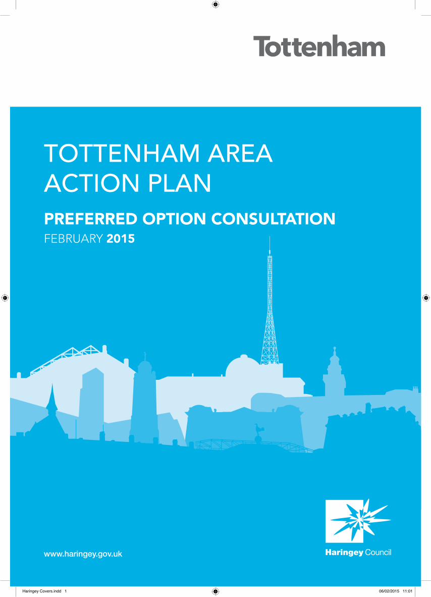
TOTTENHAM AREA ACTION PLAN PREFERRED OPTION CONSULTATIONFEBRUARY 2015
www.haringey.gov.uk
Haringey Covers.indd 1 06/02/2015 11:01
2
Statutory Information
Planning and Compulsory Purchase Act 2004
Town and Country Planning (Local Development) (England) (Amendment) Regulations 2012 -
consultation pursuant to Regulation 18
London Borough of Haringey
Tottenham Area Action Plan Development Plan Document
Preferred Option Draft for Consultation on the subject matter of the Development Plan
February 2015
3
Foreword The Tottenham Area Action Plan will be a blueprint for the comprehensive and co-ordinated
regeneration of Tottenham and the local neighbourhoods within it.
Currently we are still in the early stages of preparing this Plan, so there is still significant
scope and opportunity for local people and stakeholders to get involved and influence the
final document.
Since we last consulted the community on the broad options for change, we have been
working with our delivery partners and the community to better understand the strengths of
the area that need to be built upon, the opportunities that exist that need to be realised, and
the existing issues that need to be addressed.
Taking account of the comments received to consultation in January 2014, this document
sets out the Council’s Preferred Option for how we believe the Tottenham area should be
developed. In particular, this document establishes a shared future vision for the area –
building on the responses received to the ‘Tottenham’s Future’ consultation and outlined in
the Strategic Regeneration Framework (March 2014) – and details how that vision will be
delivered through policies aimed at managing specific issues and through proposals for
development on specific sites.
To progress the document to its next stage, we now want your views on whether you think
the vision for the area is the right one, and whether the suggested policies and site
proposals are a sufficient and adequate guide to development to achieve that vision.
We want the Area Action Plan to be more than just
a policy document. It is important to us and our
delivery partners that the local community and key
stakeholders can give their support to the final Plan
and can work with us to deliver it over both the
short and long-term. Therefore, if you are a local
resident, business owner, or just have an interest
in how this area should be developed in the future,
we strongly urge you to get involved and have your
say in shaping the content of this important Plan for
Tottenham and the Borough.
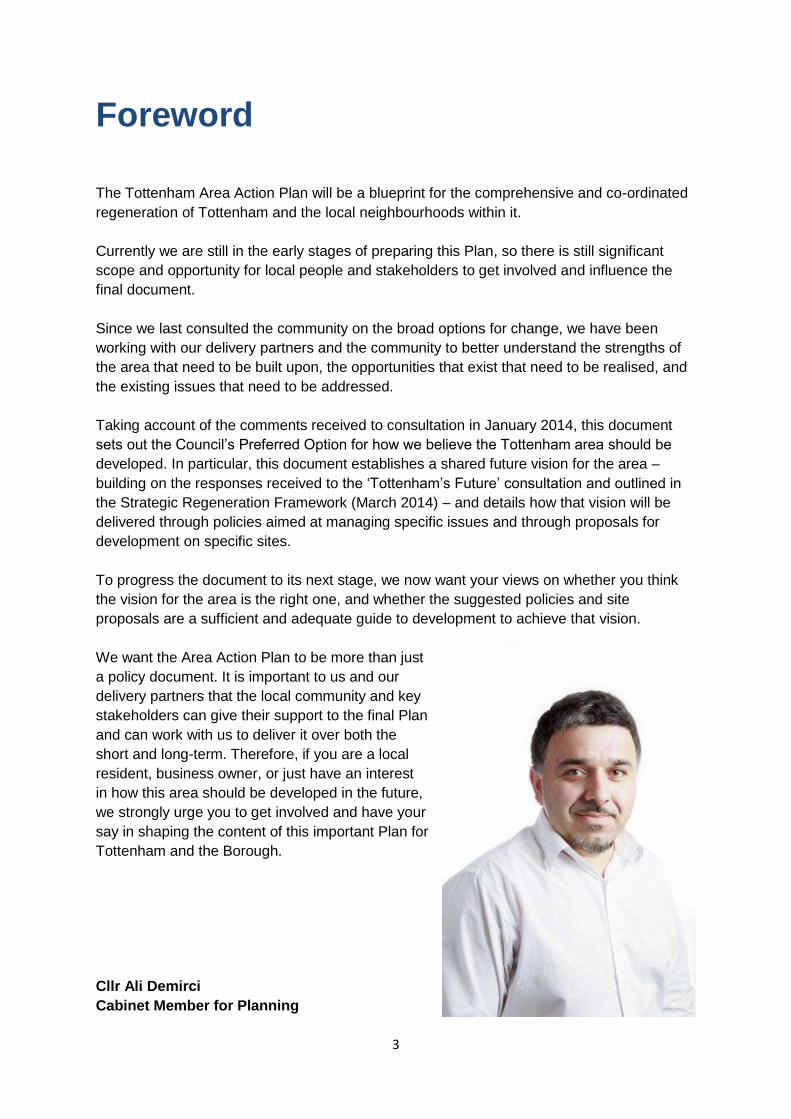
Cllr Ali Demirci
Cabinet Member for Planning
4
Table of Contents Section Page No.
1.Introduction 5
2. Issues, Challenges and Opportunities 15
3. The vision & Strategic Objectives for Tottenham 23
4. Promoting Positive Regeneration in Tottenham – Policies
AAP 1 Regeneration
AAP 2 Housing
AAP 3 Tottenham Hale District Centre
AAP 4 Green link
AAP 5 Changes to Designated Employment Areas
31 32 34 35 37 38
5. Neighbourhood Areas and Opportunity Sites 41
Neighbourhood Area – Seven Sisters/West Green Road and Tottenham Green
SS1 Lawrence Road
SS2 Gourley Triangle
SS3 Apex House and Seacole Court
SS4 Helston Court and Russel Road
SS5 Wards Corner
TG1 Tottenham Leisure Centre Car park
TG2 Tottenham Chances
TG3 Tottenham Police Station and Reynardson Court
42 45 47 49 51 53 55 57 59 61
Neighbourhood Area – North Tottenham
NT1 Northumberland Park North
NT2 Northumberland Park
NT3 High Road West
NT4 North of White Hart Lane
NT5 Tottenham Hotspur Stadium
63 69 71 73 76 78
Neighbourhood Area – Bruce Grove
BG1 Bruce Grove Snooker Hall and Banqueting Suite
BG2 Tottenham Delivery Office
BG3 Bruce Grove Station
BG4 Moorefield Road
80 83 85 87 89
Neighbourhood Area – Tottenham Hale
TH1 Station Square West
TH2 Ashley Road South
TH3 Ashley Road North
TH4 Station Interchange
TH5 Tottenham Hale Retail Park
TH6 Hale Village Tower
TH7 Hale Wharf
TH8 Welbourne Centre
TH9 Fountayne and Markfield Road
TT10 Herbert Road and Constable Road
91 95 99
101 104 106 108 110 113 115 117
6. Implementation, Delivery and Monitoring 119
7. Appendices A. Tottenham Housing Trajectory and Job Growth Targets B. Evidence Base Studies C. Proposed deleted policies and proposal sites for the Haringey UDP (2006) D. Superseded SPDs and Guidance notes E. Glossary F. Key to maps
123 127 129 131 132 138
5
1 Introduction
1.1 Tottenham is a key regeneration area within London. It is home to many distinct,
diverse and strong communities where over 200 different languages are spoken. It has a rich
history, a huge talent pool and, despite the recent recession, the highest start up of new
businesses in London. It also has relatively low land values and densities, sites available for
development, and some of the best transport links in north London, making it an attractive
proposition for new investment. At the same time, parts of the area also experience high
levels of unemployment, benefit dependency, overcrowding and crime, and low levels of
educational attainment, household income and health. It also suffers from a poor public
realm in some areas and a lack of accessibility to quality open spaces and there are
deficiencies in community & recreation facilities.
1.2 The desire to build upon its strengths, respond to the community’s aspirations and
concerns for change, to realise the opportunities for growth, and the need to help address
the challenges of deprivation, have led Tottenham to be identified as a priority area for
regeneration.
1.3 The Tottenham Area Action Plan (AAP) is a significant and important component of
the regeneration strategy for Tottenham which establishes the local spatial planning
framework for the area, giving detailed expression to the overall growth objectives for
Tottenham as contained in the Haringey Strategic Policies Local Plan (2013). In particular,
the AAP seeks to realise the significant potential for urban renewal and intensification,
particularly within Seven Sisters, Tottenham Green, Tottenham Hale and Northumberland
Park. The AAP builds on the conclusions and recommendations of the following documents:
The Physical Development Framework for Tottenham (2012); and
The Tottenham Strategic Regeneration Framework (2014);
1.4 The AAP provides for major new housing development aimed at delivering a further
10,000 new homes and significantly improving the quality of existing social housing stock,
through estate renewal such as that proposed for North Tottenham, providing for a more
balanced mix of housing tenure and greater housing choice. It also makes provision to
deliver substantial employment growth, creating 5,000 new jobs through new retail
development at Tottenham Hale, the intensification and diversification of existing industrial
estates, and mixed leisure development, as part of a hub incorporating the new Tottenham
Hotspur FC stadium, enhancing North Tottenham’s distinct offer as a leisure destination and
providing a catalyst for wider High Street and estate renewal.
1.5 The AAP proposes measures to ensure new development and growth is
complemented by further improvements to public transport and interchange facilities, better
pedestrian links with the surrounding area, including to the Lee Valley, and provision of
community infrastructure – specifically new schools and healthcare.
6
1.6 Lastly, a major focus of the Plan is on recognising and reinforcing the distinctive
characteristics of Tottenham’s neighbourhoods, highlighting its important historic assets,
delivering environmental improvements and helping to address the inequalities present
across Tottenham.
Purpose of the Tottenham Area Action Plan (AAP)
1.7 The Area Action Plan (AAP) is being prepared in order to ensure that the scale of
development and change proposed for Tottenham to 2026 and beyond is positively
managed and guided by a planning framework and investment decisions that meet the
aspirations that the local community and the Council have for the area as a whole, as well as
the places within it.
1.8 It is particularly important that local residents and businesses can understand and
appreciate how the changes proposed will affect them and their community. The AAP
therefore seeks to provide clarity and increased certainty about how the opportunities for
improving Tottenham’s places will be realised and its challenges addressed. Specifically, it
prescribes a vision for how neighbourhoods are to develop, allocates strategic sites for
particular uses and types of development, and sets out Tottenham specific policies aimed at
ensuring new development is ambitious, appropriate and sustainable in a Tottenham context
(i.e. balances development and population growth with increased and improved
infrastructure, access to training and employment, and delivers a wider range of housing
choice).
1.9 The AAP has a strong focus on delivery and implementation. It is intended to alert
infrastructure providers and public sector agencies to the growth targets and existing
deficiencies present, so that they may schedule service and capacity upgrades accordingly.
Effective cross-service working, securing the coordinated and timely delivery of social and
physical infrastructure improvements, will be essential to support new development and
ensure that continued growth across Tottenham is sustainable. Equally, the AAP provides
further guidance on the appropriate phasing of new development, taking into account the
need to ensure positive regeneration occurs which benefits the whole of Tottenham,
including on allocated sites with greater constraints than others so that
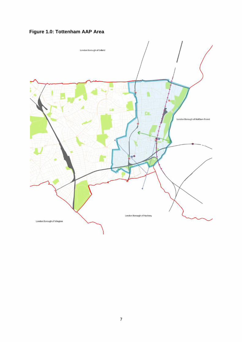
1.10 The boundary of the AAP (see Figure 1.0) has been drawn to capture the key
strategic sites, whilst recognising that they sit naturally within and alongside other sites and
neighbourhoods that are not intended to be subject to the same level of change but that will
benefit from the targeted regeneration and proposals to improve physical connections,
transport accessibility, employment creation and enhanced social infrastructure. Conversely,
the drawing of an AAP boundary does not preclude opportunities to realise better
connections and other improvements outside of the AAP area including access to green
spaces, heritage and leisure facilities, and links to other employment hubs.
7
Figure 1.0: Tottenham AAP Area
8
Preparation of the Preferred Option
AAP
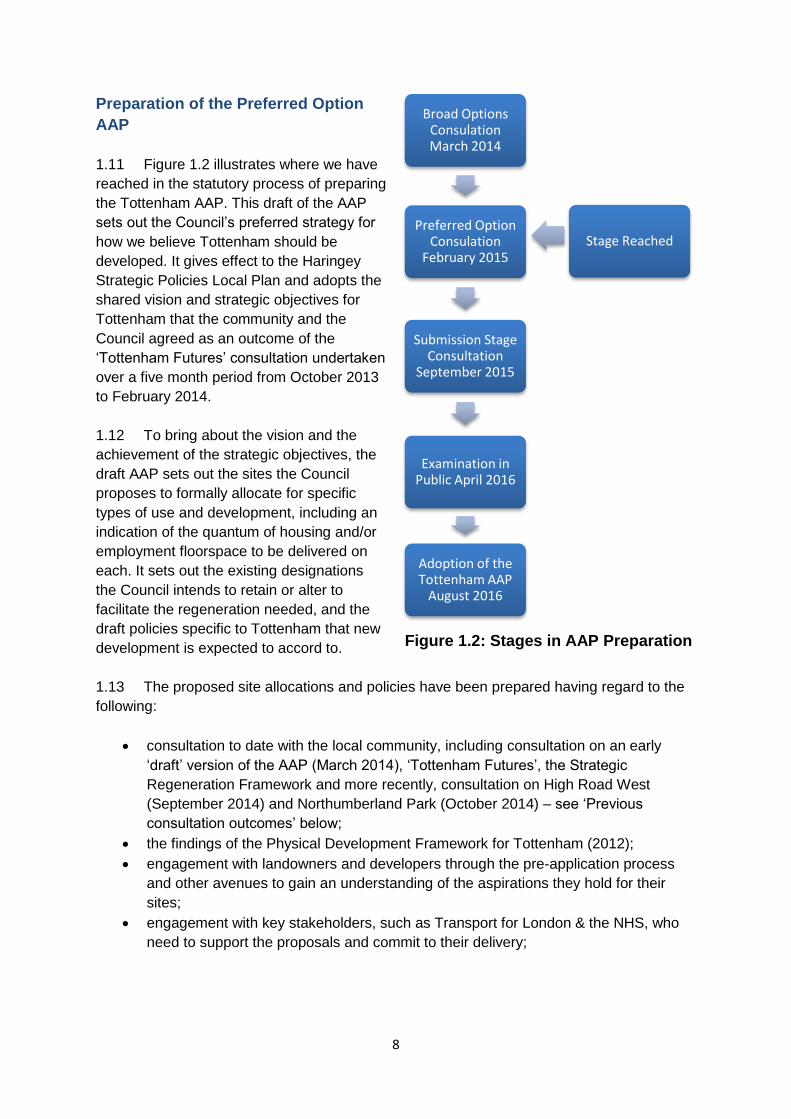
1.11 Figure 1.2 illustrates where we have
reached in the statutory process of preparing
the Tottenham AAP. This draft of the AAP
sets out the Council’s preferred strategy for
how we believe Tottenham should be
developed. It gives effect to the Haringey
Strategic Policies Local Plan and adopts the
shared vision and strategic objectives for
Tottenham that the community and the
Council agreed as an outcome of the
‘Tottenham Futures’ consultation undertaken
over a five month period from October 2013
to February 2014.
1.12 To bring about the vision and the
achievement of the strategic objectives, the
draft AAP sets out the sites the Council
proposes to formally allocate for specific
types of use and development, including an
indication of the quantum of housing and/or
employment floorspace to be delivered on
each. It sets out the existing designations
the Council intends to retain or alter to
facilitate the regeneration needed, and the
draft policies specific to Tottenham that new
development is expected to accord to.
1.13 The proposed site allocations and policies have been prepared having regard to the
following:
consultation to date with the local community, including consultation on an early
‘draft’ version of the AAP (March 2014), ‘Tottenham Futures’, the Strategic
Regeneration Framework and more recently, consultation on High Road West
(September 2014) and Northumberland Park (October 2014) – see ‘Previous
consultation outcomes’ below;
the findings of the Physical Development Framework for Tottenham (2012);
engagement with landowners and developers through the pre-application process
and other avenues to gain an understanding of the aspirations they hold for their
sites;
engagement with key stakeholders, such as Transport for London & the NHS, who
need to support the proposals and commit to their delivery;
Broad Options Consulation March 2014
Preferred Option Consulation
February 2015
Submission Stage Consultation
September 2015
Examination in Public April 2016
Adoption of the Tottenham AAP
August 2016
Stage Reached
Figure 1.2: Stages in AAP Preparation
9
the findings of evidence base studies1, including emerging masterplan work,
Tottenham specific studies on Transport, as well as borough-wide studies on
housing need, flooding, employment, open space and urban character; and
other policy developments related to Tottenham, including the potential designation
of Tottenham as a Housing Zone and the scope for Crossrail 2 to serve Tottenham,
providing significantly greater access to locations within the borough, to London and
the wider South east.
1.14 With regard to sites, it is important to note that delivery of key developments within
the Plan’s timeframe is critical to the success of the AAP, and sites that can feasibly be
developed within this timeframe have been prioritised. However, it is acknowledged that
other sites, currently unidentified, may become available during this fifteen year period.
Therefore guidance is proposed for each neighbourhood and across the entire area to
ensure all development is managed, and not just that planned for on currently identified
sites.
1.15 Lastly, the AAP also sets out the approach the Council, along with its delivery
partners, will take to deliver and implement the AAP. Many parties will have a role to play in
Tottenham’s regeneration. The AAP will provide a solid foundation for physical change but
much broader coordination between agencies, the private sector and local communities is
still required if the broader social and economic objectives, and the vision for Tottenham, are
to be achieved.
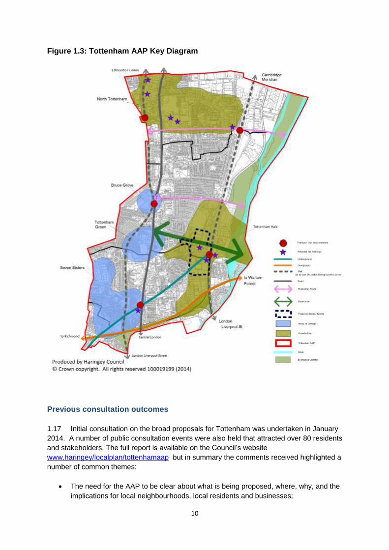
1.16 The key proposals being advocated for Tottenham through the AAP Preferred Option
stage are summarised in Figure 1.3.
1 A list of the evidence base used to inform the preparation of the AAP is set out in Appendix B. As each
evidence base study is completed, these will be made available on the Council’s website.
10
Figure 1.3: Tottenham AAP Key Diagram
Previous consultation outcomes
1.17 Initial consultation on the broad proposals for Tottenham was undertaken in January
2014. A number of public consultation events were also held that attracted over 80 residents
and stakeholders. The full report is available on the Council’s website
www.haringey/localplan/tottenhamaap but in summary the comments received highlighted a
number of common themes:
The need for the AAP to be clear about what is being proposed, where, why, and the
implications for local neighbourhoods, local residents and businesses;
11
That the area is already densely populated and therefore there is concern whether
the number of new residential development proposed for Tottenham is appropriate
and equitable in a borough-wide sense;
The existing deficiencies in health care facilities, primary school places, and local
open space serving the area that will be further exacerbated if additional housing is
added - new infrastructure provision must be secured and not just promised;
Concern that regeneration will led to the gentrification of Tottenham, with existing
residents and businesses forced out;
A desire to see the distinctive existing character of neighbourhoods retained and
preserved, including local heritage;
The need for further detail on the types of jobs proposed to be delivered, how they
will be secured for local benefit, and what the proposals are for existing local
employment sites, including proposals to support, retain (including relocation), and
grow local businesses and secure affordable workspace;
That regeneration in Tottenham should not be solely for, or in the hands, of major
developers and landowners but should be in collaboration with the existing
community.
1.18 In addition to consultation specifically on the draft AAP, the Council has been seeking
the views and priorities that Tottenham residents have to a wide range of social and
economic issues. This included commissioning, in 2013, an independent organisation called
Soundings to undertake a five-month consultation exercise called ‘Tottenham’s Future’.
More than 3,700 responses were received and analysed, a significant number of which
focused on matters that the AAP should address. A full summary of all responses received
to ‘Tottenham’s Future’ is available on the Council’s website2, whilst the key messages
relevant to strategic planning and the AAP are summarised below:
The need to create more job opportunities for local people and support local people
to get in to work;
The need to provide properly funded facilities, activities and spaces for young people;
Support local independent traders, attract higher end national retails to the High
Street and restrict betting shops and fast-food takeaways;
Address overcrowding and provide for a mix of decent, secure social housing and
well designed homes that are affordable to rent and own;
Improve the physical environment, safety and the provision of local amenities; and
Support local communities and ensure they benefit from regeneration.
1.19 The most recent consultation by the Council was on the proposed masterplan for
High Road West, which ran from 13th September to 25th October 2014, generating 292
responses including the following of relevance to the AAP:
Broad agreement to the comprehensive estate renewal of the Love Lane Estate;
Support for the provision of an additional 1,200 new homes where this increases
housing choice and provides for a better mix of housing in the area;
2 http://www.haringey.gov.uk/index/housing_and_planning/tottenham/tottenham-consultations/previous-
consultation-work.htm
12
Residents wished to see the High Road remain as the main shopping area, with
improved public spaces, new retail and community hub provision;
Improvements to local transport facilities, including the station and bus stops, are
required to support new development;
Protection of the local quality heritage buildings also came through strongly;
Many local businesses raised concerns to the regeneration proposals for the area
and, in particular, proposals for relocation of existing businesses.
1.20 In drafting the Preferred Option AAP, the Council has had regard to all the
comments received to date to consultation in Tottenham and, where possible, has taken
these on board.
Sustainability Appraisal, Habitats Assessment and Equalities Impact
Assessments
1.21 In addition to the evidence base studies, the AAP is also supported by a
Sustainability Appraisal, Habitats Assessment and an Equalities Impact Assessment. The
Sustainability Appraisal tests the policies and proposals to identify the likely social,
environmental and economic impacts that may arise, and evaluates options for mitigating
negative impacts and enhancing positive impacts. The Habitats Assessment determines
whether the proposals in the AAP might have a significant effect on a European designated
natural habitat. The Equalities Impact Assessment examines how the AAP meets the needs
of the whole community and makes sure that the proposals and policies being advocated
through the Plan do not result in any disproportionate disadvantage to any group in the
community. The three assessments are an iterative process, providing further appraisal at
each stage of the Plan’s preparation and are published alongside the AAP for public
consideration and comment.
Status of the Preferred Option APP and relationship to other Plans
1.22 The AAP is being produced to give effect to the Local Plan Strategic Policies (March
2013) and the London Plan (2011 including the Further Alterations). Figure 1.4 shows where
the Tottenham AAP fits within the policy hierarchy for Haringey. As a statutory
Development Plan Document, the AAP will form part of the Borough’s Local Plan and will be
used to appraise planning application proposals located within the Tottenham AAP boundary
area. At this stage – the Preferred Option stage – the AAP will be a material consideration in
the determination of planning applications.
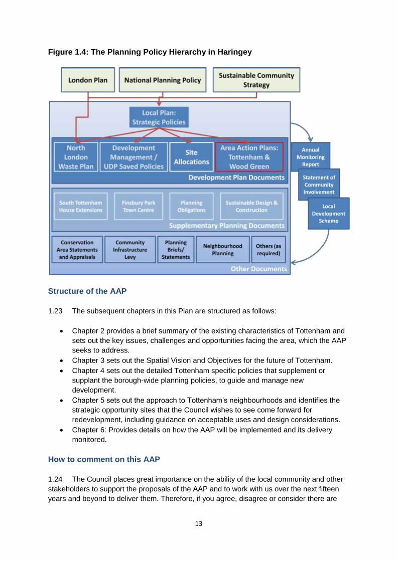
13
Figure 1.4: The Planning Policy Hierarchy in Haringey
Structure of the AAP
1.23 The subsequent chapters in this Plan are structured as follows:
Chapter 2 provides a brief summary of the existing characteristics of Tottenham and
sets out the key issues, challenges and opportunities facing the area, which the AAP
seeks to address.
Chapter 3 sets out the Spatial Vision and Objectives for the future of Tottenham.
Chapter 4 sets out the detailed Tottenham specific policies that supplement or
supplant the borough-wide planning policies, to guide and manage new
development.
Chapter 5 sets out the approach to Tottenham’s neighbourhoods and identifies the
strategic opportunity sites that the Council wishes to see come forward for
redevelopment, including guidance on acceptable uses and design considerations.
Chapter 6: Provides details on how the AAP will be implemented and its delivery
monitored.
How to comment on this AAP
1.24 The Council places great importance on the ability of the local community and other
stakeholders to support the proposals of the AAP and to work with us over the next fifteen
years and beyond to deliver them. Therefore, if you agree, disagree or consider there are
14
better alternatives to those being proposed through the Preferred Option, then please tell us
and we will take these into account when we prepare the final draft of the AAP. In particular,
we want your views on the suggested policies and site proposals, and whether you consider
these to be sufficient and robust enough guide to new development and deliver sustainable
outcomes.
1.25 The AAP and all supporting documentation can be found on the Council’s website at
www.haringey/localplan. Hard copies of the Preferred Option consultation documents are
also available for inspection and short term loan from the Council’s offices at the Civic
Centre and at all public libraries in the Borough.
1.26 Consultation will commence on 5 February 2015 for an eight week period. Over the
consultation period the Council will hold a series of drop in events within Tottenham and
across the Borough. The times and locations for these events are set out in the public notice
in the local paper, on the Council’s website, and in the covering letter sent out to residents
and stakeholders on our consultation database. These events will be informal and offer the
opportunity for the public to come in and discuss the Preferred Option AAP, and any other
issues of relevance to the Plan, with officers.
How to comment
1.27 Comments on the document can be made in the following ways:
By email to [email protected];
By attending one of the consultation drop in events advertised in the covering letter,
the public notices and on the Council’s website; or
In writing to: Strategic Planning, 6th Floor, River Park House, Wood Green N22 8HQ
1.28 The closing date for receipt of comments is the 23rd March 2015. All comments
received will be published on the Council’s website and will taken into account in deciding
the way forward for Tottenham in the final AAP.
What happens next?
1.29 We will use the comments received from this consultation, along with those received
to the other draft Local Plan documents, to prepare the final draft of the Plan – the
Submission draft (Regulation 19) document. A consultation report will be prepared that
responds to the comments received, highlighting the changes made to the AAP as a result.
The aim is to submit the final AAP to the Secretary of State in November 2015 following pre-
submission publication in summer 2015. From that point the Planning Inspectorate will
appoint an Inspector who will hold an ‘Examination in Public’ into the Plan and determine
whether the AAP is sound and appropriate. We hope the final plan will be adopted by the
Council in early 2016.
15
2 Issues, Challenges and Opportunities
Tottenham Today
Urban character
2.1 The Tottenham AAP covers an area of approximately 560ha, comprising the wards of
Northumberland Park, Tottenham Hale and Tottenham Green, and parts of Bruce Grove, St
Ann’s and Seven Sisters .
2.2 It includes large areas of employment land, particularly along the West Anglia railway
line, and a predominantly suburban hinterland, which exhibits a range of different
characteristics including a mix of late Victorian and Edwardian housing, with later in-fill
development of high rise tower blocks and low rise housing estates. The area experiences
high concentrations of social housing and poor quality privately rented accommodation.
More than 60% of the Borough’s social housing is in and around Tottenham, approximately
40% of that being located in the Northumberland Park ward alone. The borough has around
30,000 social homes or which 16,000 are owned by the Council.
2.3 The Lee Valley Regional Park forms both the Borough and AAP boundary to the
east, much of which is designated Green Belt land and is accessible but for which access
from most parts of Tottenham is poor due to severance caused by both the over ground
railway line and the A1055. Across the rest of the AAP area there are a limited number of
open spaces, particularly pocket parks and play space.
2.4 Tottenham High Road is the main transport corridor, connecting Tottenham to Enfield
and the M25 in the north and Hackney and central London to the South. The High Road is
also an important historic corridor, comprising six separate but adjoining conservation areas
along its length. Recent investment by the Council using Lottery Heritage funding, has
specifically targeted the refurbishment and enhancement of the Nineteenth Century shop
fronts and their facades along the High Road, but there remain a large number of heritage
assets, across the AAP area, on the English Heritage at risk register.
2.5 The area is well served by rail and tube lines, including the Victoria line, which serves
both Seven Sisters and Tottenham Hale, and over ground connections to Stansted airport,
as well as links to Cambridge and Liverpool Street. There is also an extensive bus network
running through the area and excellent connections to the regional and national road
network.
2.6 Two of the borough’s five district centres are located in Tottenham, along with a
number of smaller local centres and shopping parades, and a retail park at Tottenham Hale.
The area houses the main campus for the College of Haringey, Enfield and North East
London (CHENEL), the historic Tottenham Town Hall, the Bernie Grant Arts Centre, the
16
Marcus Garvey Library, and Tottenham Green Leisure Centre. It is also home to the
Tottenham Hotspur Football Club at White Hart Lane, which is a major landmark and crowd
draw within the Borough. The Club recently received planning permission for a new £430m
stadium development on its existing site which will provide a catalyst for wider regeneration
of the surrounding area. The redevelopment of the stadium is an important part of the
regeneration of Tottenham.
Social demographics
2.7 The existing population of the Tottenham AAP area is just over 78,0003, making up
around 30% of the total population of Haringey. The demographic profile of the area has
changed considerably over the last two decades. It has a much younger population than the
rest of the borough and the capital: - 28.1% aged 0-19 compared to 25.6% for Haringey and
24.5% in London (NB: White Hart Lane has the highest proportion of 0-19 year olds
(32.5%)). It is also one of the most ethnically diverse areas in the country, with over three
quarters (78.9%) of residents from minority groups, compared to 55.1% for London. Both its
ethnic diversity and younger population are factors driving housing need within the area.
2.8 As well as being one of the most diverse areas in the UK, it is also one of the most
deprived. As Figure 2.1 shows, the entire Tottenham AAP area falls within the top 20% most
deprived areas in England, and more than half within the top 10%. It is one of the poorest
performing areas in the country for income, education, skills and health. 41% of local
children live in poverty, compared to a UK average of 20.9%, and around 40% are in
workless households, compared with the London average of 21%. 25% of households are
experiencing overcrowding. Much of this deprivation stems from labour market
disadvantage, with unemployment and low skills base being the two biggest issues facing
Tottenham today.
Figure 2.1: Indices of Multiple Deprivation in Haringey
3 http://data.london.gov.uk/dataset/gla-2012rnd-trend-ward-proj/resource/bdc2c3d8-3feb-44ba-a5dd-
13ad9e54ea7b
17
2.9 Although unemployment is reducing, the area still experiences some of the highest
levels of unemployment in London and the UK. Some 17,430 residents are claiming an out-
of-work benefit – equivalent to 22.3% of the population – and markedly higher than rates
across the rest of London (12.4%). This rate is amongst the highest 5% in the country, and
one ward in particular – Northumberland Park – has the highest rate of out-of-work benefit
claimants in the whole of London, at 31.5%. Youth unemployment is also particularly acute,
with 5.4% of 18-24 year olds in the area claiming Job Seekers Allowance, increasing to
nearly 10% in Northumberland Park.
2.10 Those residents in employment tend to be in lower paid jobs. In 2012/13 the median
household income in Tottenham was £21,834, substantially below both Haringey (£33,140)
and London (£35,740). This is likely to be a reflection of educational attainment, which in
Tottenham is improving but remains below London levels. In 2013, only 69% of the pupils
who lived and studied in the area achieved level 4+ at Key Stage 2, and 57% of pupils 5 or
more A*- C at GCSE level, compared to 79% and 64.5% for London respectively. Of those
aged 16 and over, only 37% have a qualification at level 3 or above. This is lower than
Haringey (50.4%) and London (48.8%), and a quarter of all adults in Tottenham have no
qualifications at all.
2.11 The high levels of deprivation are also having a negative impact on people’s health
and wellbeing. In 2012/13, 44.9% of all 10 and 11 year olds living in Tottenham were either
overweight or obese, compared with 37.4% for London. 15.6% of residents suffer from a
long term limiting illness and 6.8% described their health as either bad or very bad. This
compares to 14.2% and 5% for London respectively.
2.12 Poor health and wellbeing is also affecting life expectancy in the area. In
Northumberland Park, life expectancy for males is 7.7 years shorter than for males living in
the more affluent parts of the Borough. For woman the gap is less but is still significant at 3.5
years.
2.13 Tottenham also has the highest levels in the UK of people living in temporary
accommodation. Currently, 35 in every 1,000 households in Tottenham is in temporary
accommodation compared to a London average of 12 and a UK-wide average of 2. Many
migrants to London come to the area partly as a consequence of the relatively cheap cost of
living compared to other parts of London. These migrants then leave the area once they
have established themselves economically.
Economy
2.14 Tottenham was once a thriving and prosperous area. As recently as the 1960s and
70s local employers included many household names, such as duplicator manufacturer
Gestetner (3,000 employees); the makers of Basildon Bond, (900 employees); and Harris
Lebus – a then internationally known maker of furniture (6,000 employees). Other sizable
firms included bottlers, bakers and a division of what later became Trebor Bassett, the
confectioners (700 employees). Today all of these names are gone.
18
2.15 Many of Tottenham’s problems are a direct consequence of the demise of its
manufacturing base. Despite strong transport links and the availability of good employment
sites, those jobs have not been replaced and have contributed to the high levels of
unemployment experienced in the area.
2.16 Tottenham’s economic geography is based upon various fragmented centres of
economic activity, including pockets of Strategic Industrial Land in both the north and south
of the AAP area, the Tottenham Hotspur stadium in Northumberland Park, and a fairly
disorganized retail offer split between Bruce Grove on the High Road, West Green at Seven
Sisters and the retail park at Tottenham Hale. In recent years however, the area has
experienced an increase in SME activity, mostly associated with creative industries, but this
sector is still in its infancy.
Key drivers for change and regeneration
2.17 The key drivers for change are the forces that will influence and shape Tottenham
over the coming years and have influenced the Council’s decision to prepare this Area
Action Plan. These key drivers are outlined below and either result in opportunities to be fully
exploited or require positive interventions to counteract or address:
Deprivation, inequalities and health care
2.18 A key challenge and driver for the AAP is to help address some of the underlying
factors contributing to the levels of deprivation experienced in Tottenham. Without positive
intervention, the causes of deprivation will continue to persist, undermining efforts to
positively affect regeneration of the area. In particular, the AAP needs to ensure new
development into the area secures opportunities for skills training, apprenticeships and local
employment, prioritises low cost home ownership, especially family housing, and contributes
to the provision of quality education, healthcare and recreation facilities. Significantly, it
needs to create more balanced and mixed communities to address the imbalance of housing
tenures within specific neighbourhoods, namely those with disproportionately high levels of
social housing. Working positively and collaboratively with both NHS England and the
Haringey Clinical Commissioning Group will be the key to ensuring the need for improved
primary health care provision in Tottenham is delivered.
Unemployment
2.19 There is a need to create new jobs, both to replace the businesses that left in the
1960s and 1970s but also as a component of managed growth, providing a balance of
homes and jobs to achieve more sustainable communities. As such, Tottenham expected to
meet provision for the bulk of the London Plan’s forecast growth of 12,000 jobs in the
Borough by 2026. With a change in reputation, its excellent transport connections, low
business costs and affordable/Low cost housing offer, there is real potential to attract new
businesses to the area. Local evidence suggests Tottenham is experiencing high demand
for small-scale, cheap and flexible space for small businesses. Provision needs to be made
to renew and diversify Tottenham’s poorer performing industrial estates to realise the
prospect of accommodating more intensive employment uses as well as the burgeoning
19
creative industries sector and ‘maker’ economy. Given the need for start-up businesses to
exist cheaply, with the right support there is potential to make the area a hub of early-stage
entrepreneurship with provision for appropriately sized move-on space, to enable new and
existing businesses to grow.
2.20 New ways to deliver new employment floorspace and the potential for all new major
development to provide construction apprenticeships and training targeted at local young
people also needs to be fully exploited as should commitments to using local supply chains
and opportunities to assist new businesses with their local recruitment needs, especially
within the service sectors, through local job fairs.
Overcrowding
2.21 A quarter homes within Tottenham are overcrowded. Cramped living conditions can
harm family relationships, negatively affect children’s education, affect sleep, and cause
depression, stress and anxiety. It can also detrimentally affect a person’s perception of
options and future prospects. Redevelopment of poor quality housing, prioritising family
sized housing, strict application of the Mayor’s internal space standards, and adherence to
good design and layout can all help to significantly alleviate the overcrowding being
experienced within parts of Tottenham. The emerging Local Plan will be seeking to prioritise
family housing across the east of Haringey, including Tottenham through a restriction on
converting family homes to small units. This should ensure sufficient stock of family sized
properties in Haringey to meet the needs of Haringey’s existing and future residents.
Population and housing growth
2.22 As London’s population continues to grow, so does pressure on all boroughs to
accommodate such growth. The latest projections suggest that London’s population could
increase from 8.4m in 2011 to 9.54m by 2026. Over the same period, Haringey’s population
is also projected to grow by an additional 37,300 people.
2.23 To meet the housing needs of the growing population, Haringey must provide a
minimum of 19,800 new homes across the Borough between 2011 and 2026. Tottenham is
expected to contribute half of this - 10,000 new homes. This is on the basis of the
availability of developable strategic Brownfield sites, its excellent transport connections, and
the need for investment and change to bring about the regeneration needed within
Tottenham. It is considered that sustainable residential development in Tottenham, in the
form of higher densities and well designed taller buildings in accessible locations, can meet
this target. However, it is crucial for the AAP to ensure that the delivery of the growth
agenda runs hand-in-hand with delivery of the regeneration agenda, particularly as a
proportion of the new homes provided will come from the renewal of the Council’s housing
estates.
2.24 Addressing the high levels of population churn is therefore a priority, and will be
achieved partly by across-the-board increases in the quality of education, the protection and
provision of more family housing and home ownership, improvements to the local
environment and the creation of local job opportunities.
20
The quality of existing housing stock and estate renewal
2.25 Part of the challenge in regenerating Tottenham is to improve the quality of the
existing housing stock which often has poor layouts, lacks any permeability and legibility in
street networks and is generally over concentrated with smaller homes (1 and 2 bed). While
efforts have been taken, through the Decent Homes Programme, to retrofit properties to
bring them up to standard, this is not possible for all homes, especially those within estates
that are poorly laid out and constrained in terms of the ability to make further modifications.
In such cases, estate renewal is a much more cost effective means by which to bring these
homes up to modern living standards.
2.26 The redevelopment of lower density estates provides the opportunity to tailor the new
housing to better meet existing resident’s housing needs, to increase overall housing
numbers, and to provide a better mix of housing choice, including social, privately rented and
privately owned housing.
Meeting social needs
2.27 New development and growth must be supported by adequate social infrastructure.
Community centres, health centres, schools, libraries should all become part of an integrated
social fabric, with a series of ‘village green’ spaces with mixed social activities. At night
schools or other facilities could become places for recreation – for sports, music or similar
events.
2.28 New public spaces need to be added and existing spaces significantly improved so
that each part of Tottenham has a quality network of green and accessible space.
2.29 New commercial operators must be encouraged, so that once again Tottenham will
see its own cinema and theatres, and charities that provide activities must be engaged. The
provision of new local centres (e.g. such as community halls and medical centres) should
include provision to share facilities with local charities to facilitate their engagement.
Realising the investment in public transport
2.30 Over the Plan period, Tottenham is expected to see significant investment in public
transport accessibility, including a new intermodal station at Tottenham Hale, a new
entrance to White Hart Lane station, the three tracking of the West Anglia Main Line, the
incorporation of the Southbury Loop line (through Seven Sister, Bruce Grove and White Hart
Lane Stations) into the London Overground network by 2015, the electrification and longer
trains on the Barking-Gospel Oak line, and improvements in frequency on the Tottenham
Hale to Stratford line. This sits alongside improvements in road, bus, cycle and pedestrian
networks, and by 2026, the introduction of Crossrail 2 stations at Seven Sisters, Tottenham
Hale and Northumberland Park, significantly increasing the accessibility of Tottenham to
wider London.
21
2.31 The scale of development planned for Tottenham is therefore commensurate with the
level of investment being made to improve the transport connectivity of the area. Such
investment is crucial in supporting sustainable growth; for promoting and securing further
inward investment; and in delivering the wider regeneration objectives for the area.
Town centres
2.32 There is a need to improve the retail offer across the whole of the Tottenham area,
ensuring the offer in each location complements and does not compete with each other.
Shopping streets could be reduced in size and replaced with stronger centres to help attract
visitors, and concentrate activity to areas that make provision for people to congregate. This
would allow well-known multiples who provide good value and employment to be located in
Tottenham, together with a mix of smaller units allowing family businesses to continue.
2.33 There is a need to realise the investment being made by Tottenham Hotspur FC on
their stadium site, ensuring this becomes a hub of activity throughout the week and not just
on match days. The transport enhancements to Tottenham Hale support the development of
a district centre in this location, with potential to realise and develop an office market.
2.34 Improving the retail offer will require positive interventions in the form of public realm
enhancements, reduced congestion, and encouraging a better variety of local amenities
such as recreation, leisure, community spaces and cultural facilities.
Heritage and cultural assets
2.35 The AAP needs to ensure that the regeneration of the area acknowledges the
importance that local cultural and heritage assets make to the character and vitality of the
area, such as the many Listed and Locally Listed buildings on the High Road and around
Tottenham Green Tottenham Hotspur FC Stadium, Bernie Grants Arts Centre, Bruce Grove
Youth Centre, and CHENEL, ensure these are integrated into new developments to ensure
their continued use and protection. Engaging with English Heritage at the earliest opportunity
will be a key to delivering the aims of this AAP and the Council will continue to engage
positively on the preparation of this AAP with the London Advisory Committee of English
Heritage in a proactive and collaborative manner.
Education
2.36 The work of some excellent schools and colleges will be built upon, and Tottenham’s
increasing educational standards should continue to push upwards. Further school provision
needs to be made within the area to serve both the existing and new communities. Where
new schools are proposed, opportunities for the use of shared facilities should be fully
explored.
The need for a Strategic Plan
22
2.37 As a once-prosperous area that fell into decline, Tottenham now needs the ability to
be managed as a coherent whole once more. To make this happen Tottenham needs bold
action. The AAP is required to ensure development and change does not take place
piecemeal and takes account of the area as a whole, rather than focusing on sites or estates
in isolation. The need for comprehensive redevelopment is a key message of this AAP. It
also ensures the community understands what is being proposed so that when applications
are made these can be determined in accordance with this AAP.
23
3 The Vision & Strategic Objectives for Tottenham
A Future Vision for Tottenham Tottenham will be the next great area of London. It will build on its geographical, natural and cultural strengths and capitalise on the dynamics of neighbourhood improvement, the significant infrastructure investments being delivered in the area and the availability of large development sites. The combination of transformative actions and continuous incremental improvement will unlock Tottenham’s potential as an increasingly attractive place to live, work, study and visit, a neighbourhood fully benefitting from London’s growth and its position in a world city. Tottenham’s transformation will benefit existing as well as future residents of Tottenham. It will build on the strength and resilience of the existing community to help deliver a positive future for Tottenham. To set a simple goal: ‘By age twenty, children born in Tottenham today will enjoy a higher quality of life and a wider range of opportunities comparable with the best in London. Their ambitions will also be greater, nurtured by the social and physical investments made today. Their opportunities will match those ambitions. Their Tottenham will:
be a desirable neighbourhood, where existing and new residents will find quality housing at all stages in their lives;
build on existing resilient and self-sustaining communities and foster a sense of wellbeing, optimism and willingness to engage with one another;
have a thriving local economy, anchored by strong local entrepreneurialism and a mix of successful businesses;
draw employers and employees from across London and provide its residents with a broad range of work opportunities at all skill levels, especially in the increasingly important creative and green economic sectors;
attract new transformative educational, institutional and business enterprises that help re-brand Tottenham as a location for major investment;
have great schools that support their children and young people to achieve academic, social and economic success;
enable high achieving students who will match those from across London and the UK. They will have real choices about their further education, employment and training and pursue higher learning or exciting careers within Tottenham and further afield;
be a community that enjoys physical and social wellbeing, has abundant opportunities to have fun and is supported by access to open spaces and recreation facilities, including opportunities for cycling and walking, progressive health initiatives and engaging young people in active citizenship;
contribute to Haringey’s role as a leading low-carbon borough by adopting sustainable development and design standards at the community and building scales, providing low carbon energy sources to new developments and by enhancing the presence of the green employment sector through skills training and improved employment space offer;
be known as a place for recreation and leisure activities, that attracts more visitors to a range of destinations;
be a unique place of beauty and interest as its historic character and natural environment is enhanced through investment and high quality and low-carbon building and public space design’
24
3.1 The above future vision for Tottenham was developed in consultation with the local
community and is contained within the ‘Tottenham Strategic Regeneration Framework’ which
was formally adopted by the Council in March 2014. The vision for Tottenham is further
supported by seven key strategic objectives, set out below. The community have told us
these objectives need to happen to realise real and positive change:
Strategic Objectives for the AAP
Objective 1: World class education and training
Tottenham already has outstanding rated schools, but we want all our provision
to be the best up to the age of 18 and beyond. This must include improved
access and higher participation rates in apprenticeships and university. We will
work with existing schools and providers to improve or maintain their already
great provision and will also attract new schools and new providers – including
a major educational institution, to ensure Tottenham residents can compete with
the best.
3.2 For the AAP, this means:
Making provision within the site allocations for new schools and high education
institutions;
Providing high quality student accommodation in accessible locations; and
Securing opportunities through the planning process for local training and
apprenticeships in the construction sector and its supply chain.
Objective 2: Improved access to jobs and business opportunities
Tottenham is part of the world’s most exciting city and an existing and
competitive global jobs market. We want better access to these opportunities for
Tottenham’s communities but we also want more of those opportunities to be in
Tottenham itself. We will work to attract major investment and deliver local
business growth in successful business sectors to provide new jobs in, and for,
Tottenham.
3.3 For the AAP this means:
Securing provision for at least 5,000 new jobs alongside housing growth;
Ensuring regeneration delivers economic growth, through provision to enable the
rationalisation, renewal, and intensification of existing employment floorspace,
securing flexible managed workspace for SMEs, move on space, and new sites for
major employers;
Revitalising high streets, improving the retail and leisure offer, traffic calming and
improving the quality of the urban environment;
Making provision for fast broadband and digital infrastructure
25
Objective 3: A different kind of housing market
Tottenham has a great mix of housing, it was the last great Victorian suburb, but
it is part of a city where housing demand is outstripping supply and in some
areas the housing quality is not what it should be. We want Tottenham to be
known for having a different London housing market and will work with local
residents to begin an ambitious programme of estate renewal where necessary.
We will secure investors to provide a whole range of housing at a range of
prices and tenures to ensure more people get access to the quality homes they
need.
3.4 For the AAP this means:
Allocating sufficient sites to deliver 10,000 new homes;
Securing comprehensive development that creates new residential neighbourhoods
providing for a range of housing types, including high quality institutional private
rented sector housing, family housing and low cost home ownership options;
Working with landowners, developers and local communities to proactively manage
housing delivery;
Unlocking the potential of sites through investment in infrastructure;
Ensuring the type and size of homes delivered contribute to the creation of more
mixed and balanced communities;
Managing the loss of family housing and tackling poorly managed Houses in Multiple
Occupation; and
Promoting estate renewal that delivers higher quality, energy efficient homes in
integrated and safe neighbourhoods.
Objective 4: A fully connected community with even better transport links
Tottenham is only 12 minutes to the centre of London on the tube or train, but it
can be even better. Improvements are already being made and we will work to
improve the connections within Tottenham for all types of transport – including
walking and cycling. In the longer term we will consistently make the case for
the delivery of Crossrail 2 and further rail improvements to provide high
frequency rail services connecting Tottenham with central and other parts of
London.
3.5 For the AAP this means:
Securing more frequent rail services to Stratford and the transformational benefits
that Crossrail 2 will provide;
Safeguarding land for Crossrail 2 consistent with the Government’s future
Safeguarding Direction;
Upgrading stations, particularly Tottenham Hale, White Hart Lane and
Northumberland Park;
Including provision for new bus services connecting residential communities with the
High Road and key stations;
26
Securing the provision of high quality public realm improvements around key
transport interchanges, ensuring these are inclusive and accessible;
Maximising development capacity around key interchanges to espouse the
investment being make and to attract further inward investment; and
Securing provision for strategic walking and cycling routes and infrastructure
throughout Tottenham, improving east – west linkages and easier access to the Lee
Valley Regional Park.
Objective 5: A strong and healthy community
Tottenham is a network of strong, cohesive and diverse neighbourhoods. Many
people love living here and feel they belong, but an improved Tottenham will
need improved health care provision, a continued joint effort to further reduce
crime and support to foster strong and new social networks – particularly for
young people. We will work with the community to build a stronger sense of
pride and provide better and more connected public, health, voluntary and youth
services.
3.6 For the AAP this means:
Ensuring new development results in high quality residential environments, that are
inclusive, safe and functional;
Establishing the creation of an interconnected Green Grid, including new pocket
parks, play space, and landscaped green areas, as well as enhanced connections to
the Lee Valley Regional Park;
Establishing a district heating network serving existing and new developments;
Increasing public transport accessibility, walking and cycling, promoting car free
developments and reducing the dominance of car-led environmental, improving and
enhancing streetscapes, reducing congestion and improving air quality;
Increasing the supply of energy-efficient homes in new developments and through
retrofitting; and
Making provision for further and improved health centres, schools, and community
facilities, including accommodation for the voluntary sector.
Objective 6: Great places
Strong communities need great places to meet and spend time in. Tottenham
has great character areas and gems like the Bruce Castle Museum, the Bernie
Grant Arts Centre, the Markfield Beam Engine Pumping House, Spurs and the
Lee Valley Park on its doorstep. We need to retain but build on this character
and will use investment and bold planning measures to create great town
centres, public spaces and streets – giving Tottenham places to meet, shop and
play.
3.7 For the AAP this means:
Securing the significant transport investments proposed for Tottenham;
27
Seeking opportunities to recognise and enhancing the historic environment and other
places of interest that make the area an attractive place and attract people to
Tottenham;
The creation of a clear, consistent street network and better pedestrian and cycle
links into the Lee Valley Regional Park;
Securing the provision of high-quality public spaces, especially on the High Road and
through the gyratory projects; and
More places to shop and play, strengthening the role of the town centres, enhancing
their offer both for retail and leisure but also for wider community use as places to
meet and interact.
Objective 7: A right investment and high quality development
Regenerating Tottenham can’t be done alone – it will require partnerships and
money. Tottenham is seeing the benefit at Tottenham Hale now, with a new
development that has already seen more than 700 new homes and 1,200
student flats delivered. We will work in the interests of the local community to
attract further high quality investment to Tottenham ensuring it is of the highest
quality and the best design.
3.8 For the AAP this means:
Ensuring investment in public transport and development, such as the Spur’s
Stadium, provide the catalyst for targeted regeneration;
Prioritising the delivery of allocated sites;
Securing provision of high quality affordable workspace through cross-subsidy if
necessary;
Identifying the infrastructure requirements needed to support new development and
create sustainable communities;
Ensuring development and infrastructure delivery take place in tandem; and
Putting in place appropriate mechanisms to secure / accelerate delivery of the AAP,
including the provision of Council owned sites for redevelopment in the early phases.
3.9 Building upon the overarching vision and strategic objectives above, the following
establishes the AAP ‘spatial strategy’ for how Tottenham and the places within will develop
by 2026 through implementation and delivery of this Area Action Plan:
The ‘Spatial Strategy’ for Tottenham
3.10 Development and regeneration within Tottenham with be targeted at four specific
neighbourhood areas. The four neighbourhood areas are identified in Map 5.1 and comprise:
Tottenham Hale;
Seven Sisters/West Green Road and Tottenham Green;
Bruce Grove; and
North Tottenham (which includes Northumberland Park, the Tottenham Hotspur
Stadium & High Road West).
28
3.11 These neighbourhoods are targeted for new development and regeneration because
they have or are planned to benefit from significant public and private investment. Areas
outside these neighbourhoods are not directly targeted for new development in this AAP but
will evolve organically, which may involved limited or no change or redevelopment, and
benefit from the wider regeneration of Tottenham. This AAP will ensure development
proposals adjacent to these neighbourhoods are determined in accordance with the
principles of this AAP and the vision to deliver positive regeneration in Tottenham.
3.12 For the Tottenham Hale neighbourhood, the focus will be on comprehensive
regeneration. The neighbourhood will accommodate a significant portion of the housing and
jobs proposed within the Tottenham AAP area (5,000 new homes and 4,000 jobs of the
10,000 homes and 5,000 jobs planned for all of Tottenham). Development will make the
most of Tottenham Hale’s location beside the open spaces and waterways of the Lee Valley
Park, and the provision of a new transport hub, including new bus interchange facility, a new
station, improved train frequencies, and Crossrail 2, as well as a new all through school in
the current Lee Valley Technopark building. A new road layout and significant public realm
improvements are also planned, creating a more traditional street network and making
pedestrian movement through the area easier. This includes the proposal for a new Green
Link (recommended in the Physical Regeneration Framework for Tottenham 2012),
extending from the High Road, through Down Lane Park, to Hale Village and Hale Wharf,
through to The Paddock – although the final route through Down Lane Park is as yet to be
confirmed.
3.13 This infrastructure will help facilitate the creation of a new District Town Centre
through the redevelopment of the existing Retail Park and Ashley Road area, within which
the Council expects to see provision made for a range of town centre uses, including retail,
office, hotel community, leisure and higher education facilities. Within the South Tottenham
and Tottenham Hale industrial areas, the Council will encourage renewal and reorientation to
more intensive industrial and employment uses, and within select parts, will promote
warehouse living where this supports existing creative communities and secures the
employment use of these sites. On other industrial estates within the Tottenham Hale
neighbourhood, such as the Millmead estate, the Council will seek to retain these in their
current use and will strongly resist proposals to introduce non-industrial uses.
3.14 In the North Tottenham neighbourhood, the new Tottenham Hotspur FC stadium
development will provide the catalyst for comprehensive regeneration of both High Road
West and Northumberland Park. The priority is to ensure that, even on non-match days, the
area is lively and attracts people to make the most of the stadium development, the High
Road, and wider urban realm improvements that will take place as part of this development.
Provision is therefore proposed for new community facilities and leisure orientated retail
development to further cement the area’s reputation as a premier leisure destination within
North London.
3.15 Comprehensive estate renewal is proposed for both Northumberland Park and Love
Lane which includes a programme to deliver better mix of social housing, tailored to meet
residents housing needs, particularly for affordable family housing, alongside a mix of
29
market, private rented and intermediate housing, providing for a substantial increase of
3,850 net new homes within this neighbourhood.
3.16 Both existing and new residents within the North Tottenham Neighbourhood will
benefit from enhanced provision of new schools, health care facilities, community uses,
increased train frequencies, Crossrail 2 at Northumberland Park station (in the long term),
and the creation of new local parks and open spaces, forming a network of green spaces
and play spaces, linking through to the Lee Valley Regional Park.
3.17 The proposal for Bruce Grove is to consolidate and strengthen its role as the retail
heart of the High Road, with underutilised or poorer quality sites around the station proposed
for redevelopment, providing new housing, retail and community uses. The levels of
development proposed for the area are modest in comparison with the other three
neighbourhood areas, but will require careful consideration to ensure they integrate with and
enhance the distinctive heritage character of the area, and contribute to the area’s vibrancy.
3.18 Further down the High Road, proposals at Tottenham Green are aimed at enhancing
the cultural offer of the area, reinforcing the areas role as focal point for cultural and civic
activity within Tottenham, including making the most of the Green itself as a significant
community asset on the High Road. Provision is therefore to be made for new cafes and
restaurants to enhance and support the existing cultural offer in the area. The recent public
realm improvements to Tottenham Green will be further extended along the High Road to
the north of the Green where the new development will be required to reflect and enhance
the heritage and conservation status of the area.
3.19 At Seven Sisters and West Green Road, new landmark buildings around the station
will help communicate the area’s significance as a vibrant district centre, a gateway into
Tottenham, and a major transport hub – the latter to be further enhanced through investment
as part of London’s Overground network and, in the longer term, Crossrail 2. Further public
realm improvements are proposed to help address the current dominance of the heavily
trafficked road network.
3.20 Beyond the District Centre boundary, development is focused mostly on estate
renewal programmes aimed at enhancing the existing housing stock and providing existing
and new residents with greater housing choice within a higher quality residential setting.
Whilst proposals for Gourley Place and Lawrence Road offer the opportunity for mixed use
development which should secure the replacement of the existing employment floorspace
and where possible, deliver light industrial uses and affordable workspace for small to
medium enterprises.
3.21 Outside of the targeted regeneration areas, it is expected that residents will benefit
significantly from the improvements to public transport, better east – west connections, the
provision of new and expanded schools and health care facilities, new parks and new
employment opportunities. Further, these areas will benefit from planning policies that seek
to protect existing family sized housing by restricting the conversion of houses to flats and
Houses in Multiple Occupation. As well as maintaining a supply of family housing, in
Tottenham, such restrictions will help stem the tide of poor quality private rented

30
accommodation and assist in retaining the residential amenity within these predominantly
suburban areas.
31
4 Promoting Positive Regeneration
in Tottenham – Policies
Introduction
4.1 This and the following chapter of this AAP provide the Area Wide and Site Specific
Policies. The Development Policies build on and supplement existing Local Plan policies and
have been nuanced to reflect the regeneration vision for Tottenham. They do not repeat the
Council’s wider Local Plan policies or the 2011 London Plan and should be read in
conjunction with the London Plan and Haringey’s Local Plan which includes:
Strategic Policies Local Plan (2013)
Unitary Development Plan Saved Policies (2013)
4.2 In addition, there are emerging regional and local policy documents to which, once
adopted, will form part of Haringey’s Development Plan. These include the Further
Alterations to the London Plan (FALP) and three additional Local Plan Documents which the
Council is currently consulting on:
Alterations to the Strategic Policies Local Plan;
Development Management Policies; and
Site Allocations.
4.3 The development policies are:
AAP 1 Regeneration
AAP2 Housing
AAP3 Tottenham Hale District Centre
AAP4 Green Link
AAP5 Changes to Designated Employment Areas
4.4 Two guidance notes are provided in this section, giving guidance on how future sites
for Crossrail will be safeguarded and the Council’s approach to meeting the need for Gypsy
and Traveller pitches in Haringey.
32
Policy AAP1 Regeneration
A. The Council will support planning applications for development within the
Tottenham AAP area which promote the positive regeneration of
Tottenham.
B. The Council will take a proactive approach to working with landowners, the
Mayor of London, the local community and other interested parties to help
deliver the changes needed in Tottenham to meet the vision and objectives
for the regeneration of Tottenham.
C. Development Proposals should demonstrate how they have capitalised on
opportunities to reduce social inequalities in Tottenham, improve the
quality and supply of housing to meet housing needs, improve health and
wellbeing, contribute to a diverse and sustainable economy and help
deliver the necessary infrastructure to support change in Tottenham.
D. Development proposals will be expected to maximise the use of public and
private sector investment to provide a range of types and sizes of homes,
create mixed and balanced communities, create economic opportunities
for local residents and businesses, improve and enhance the local
environment, reduce carbon emissions and adapt to climate change, in
accordance with the other policies of this AAP and Haringey’s Local Plan.
E. The Council expects all development proposals in the AAP area to come
forward as part of wider comprehensive redevelopment proposals, taking
account of adjacent uses (existing or proposed), neighbouring landowner
expectations, the Council’s expectations for the delivery of infrastructure
on sites identified in this AAP , the shared vision for Tottenham and the
policies of this AAP and Haringey’s Local Plan. Developers should consult
with the Council at the earliest opportunity on such proposals and where
appropriate, a masterplanning exercise should be prepared in consultation
with the Council.
F. Development proposals on sites adjacent to the AAP site allocations will
be expected to demonstrate how the proposal has had regard to the
development principles of the AAP including the proposals for change
arising from the site allocation.
Supporting Site Assembly
G. The Council will use compulsory purchase powers to assemble land for
development within the Tottenham AAP area where Landowners and
developers can demonstrate that:
a. they have a viable, deliverable and Local Plan compliant scheme; and
b. they have made all reasonable attempts to acquire, or secure an
option over, the land/building(s) needed, through negotiation.
33
c. Comprehensive redevelopment of the assembled site is either
required to deliver the site’s allocation as prescribed in Section 5.0 of
this AAP or is in the public interest; and
d. The development proposed for the assembled site would contribute
to the delivery of the Tottenham AAP objectives.
H. Where compulsory purchase is necessary, applicants will be required to
demonstrate how the associated costs impact upon development viability
4.5 To ensure the vision of this Area Action Plan are achieved, Policy AAP1 seeks to
ensure all development proposals submitted to the Council proactively respond to the vision
and ensure the regeneration objectives for the Tottenham AAP area are achieved. At the
same time, the Council also has a responsibility to proactively to work with landowners and
other parties to help deliver the aims of the AAP. The programme for growth is ambitious but
with the support from the Mayor of London, both financially and politically, support from the
community and the development industry the vision for Tottenham will be realised. AAP1 (B)
provides the Council’s commitment to helping facilitate and deliver the necessary change.
4.6 Private and public investment will be key to delivering the ambitious regeneration
vision for Tottenham. The Housing Zone is one example of investment which will directly and
indirectly contribute significantly to delivering the aims of this AAP. The Housing Zone
monies will direct important investment to the AAP area supporting transport and public
realm improvements which will benefit existing and future residents of Tottenham.
Development will be expected to harness the benefits of such investment and maximise the
opportunities this presents which could lead to more sustainable development outcomes.
Another such example will be Crossrail which will redefine the accessibility levels of parts of
the AAP area. Developers and the Council should utilise this to optimise housing delivery
and more effectively meet the objectives of the Haringey Local Plan.
4.7 Ensuring development proposals are designed and submitted to Haringey as part of
wider comprehensive developments avoids concerns associated with piecemeal
development. The aim is to ensure landowners are talking to each other and are aware of
the shared vision for the AAP area, including the sites allocated for important infrastructure
projects. Haringey wants to ensure development proposals do not prejudice wider
development aspirations for the Tottenham AAP area. Comprehensive redevelopment which
is designed in consultation with the Council is likely to result in a faster planning consent
being granted and will avoid any undue delays in the planning process, to the benefit of
everyone involved.
4.8 A comprehensive approach to development will often be in the public interest within
the Tottenham AAP area. Whilst incremental schemes might be more easily delivered, the
constraints posed by site boundaries, neighbouring development or uses, and below-ground
services all have potentially limiting consequences for scale, layout and viability. Across the
Tottenham area as a whole, such consequences could depress the optimum use of land, the
proper planning of development (in terms of layout, design, use etc) and the ability of
development to support the achievement of wider regeneration initiatives or objectives.
34
Policy AAP2 Housing
A. To improve the diversity and choice of homes and encourage long term
communities to develop in Tottenham, the Council will seek the delivery of
10,000 homes across the Tottenham AAP in order to meet housing needs,
contribute to mixed and balanced communities and to improve the quality
of homes;
B. The Council will expect affordable housing to be provided in accordance
with Policy SP2 of the Strategic Policies Local Plan and DM17 of the
Development Management DPD, with the exception of:
a. Allocated sites within the Tottenham Hale AAP Neighbourhood area
(the Housing Zone) will be expected to deliver 50% market housing
and 50% affordable housing; and
b. the affordable tenure split (DM17 A(c))which in the case of
development in the Tottenham AAP area will result in an overall
tenure mix of 60% intermediate accommodation and 40% affordable
rented accommodation.
C. Development proposals incorporating residential will be expected to
provide the housing in accordance with the minimum capacities, densities,
sizes and tenure mixes of individual sites set out in the relevant sub area
policies and site allocations in this AAP. Higher densities and capacities
may be acceptable in appropriate locations, close to town centres, in areas
with good local facilities and amenities and in areas well served by public
transport, providing the other policies of this AAP and Haringey’s Local
Plan are not compromised;
D. To improve the quality of homes in Tottenham, new housing should be
high quality and delivered in accordance with Policy DM16 of the
Development Management DPD;
E. To better address the concerns of viability in delivering renewal on
Haringey’s housing estates in Tottenham (as listed in Alt53 of the
Alterations to the Strategic Policies Local Plan), the Council will support
higher density mixed tenure development in accordance with C above, as a
mechanism to
a. improve the quality and range of affordable housing options,
b. better address housing needs in Haringey;
c. secure a more balanced community; and
d. increase housing delivery in Tottenham.
4.9 Tottenham is expected to experience unprecedented growth over the next decade
and a sustainable approach to delivering homes to meet this growth is provided in AAP2.
Parts of Tottenham experience overcrowding and deprivation compounded by poor quality
35
social housing, significant churn in population, polarised communities and limited housing
options that might better respond to the aspirations of communities through available market
and intermediate homes. Policy AAP2 above seeks to deliver 10,000 new homes across the
Tottenham AAP area as a mechanism for stimulating regeneration and economic growth.
The capacity to deliver 10,000 new homes has been identified in the allocated housing sites
outlined in the allocations sections of this report. Additional sources of capacity may come
forward as a result of the investment going into the area and as these developments come
forward, they will contribute to meeting housing needs in Tottenham.
4.10 To rebalance the high levels of social rented accommodation in Tottenham, which
equates to more than 60% of the boroughs’ total social rented stock and to most effectively
use the funding received to help meet housing needs in Tottenham, Policy AAP2 seeks a
nuanced approach to affordable housing delivery. Creating mixed and balanced
communities in accordance with DM17 of the Development Management DPD, the Council
would like to introduce alternative tenures into areas currently dominated by a single tenure
type,
4.11 Tottenham also has an ageing stock of Council housing and rather than re-providing
low quality existing stock which is not a sustainable solution and is not viable, the Council
will support proposals for more widespread renewal of Tottenham’s housing estates in
accordance with policy AAP2 (E). This support will lead to significant improvements in the
size and quality of affordable housing; better address housing needs; secure a balanced
community; and will increase housing delivery.
4.12 Improving the quality of housing in Tottenham is a key priority and policy AAP2 (D) is
written to be consistent with the Council’s wider aims for improving development design in
Haringey, as set out in the Haringey Development Management DPD.
Policy AAP3 Tottenham Hale District Centre
A. The Council will support planning applications for development within the
Tottenham Hale District Centre as indicated in Map 4.1 to promote the
positive regeneration of Tottenham Hale.
B. Development proposals should provide:
a. A substantially improved public realm that unifies the streets and
spaces around the gyratory, improves access to the station and
prioritises pedestrian and cyclist circulation and safety;
b. A new urban form – consistent with the areas status and accessibility
including greater permeability and legibility of streets;
c. Attractive and functional public spaces located around the gyratory;
and
d. Incorporate permeable surfaces, green space and trees.
C. A range of retail, leisure, healthcare facilities or community facilities with
active ground floor frontages;
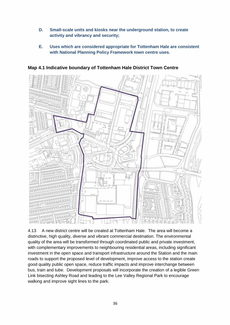
36
D. Small-scale units and kiosks near the underground station, to create
activity and vibrancy and security;
E. Uses which are considered appropriate for Tottenham Hale are consistent
with National Planning Policy Framework town centre uses.
Map 4.1 Indicative boundary of Tottenham Hale District Town Centre
4.13 A new district centre will be created at Tottenham Hale. The area will become a
distinctive, high quality, diverse and vibrant commercial destination. The environmental
quality of the area will be transformed through coordinated public and private investment,
with complementary improvements to neighbouring residential areas, including significant
investment in the open space and transport infrastructure around the Station and the main
roads to support the proposed level of development, improve access to the station create
good quality public open space, reduce traffic impacts and improve interchange between
bus, train and tube. Development proposals will incorporate the creation of a legible Green
Link bisecting Ashley Road and leading to the Lee Valley Regional Park to encourage
walking and improve sight lines to the park.
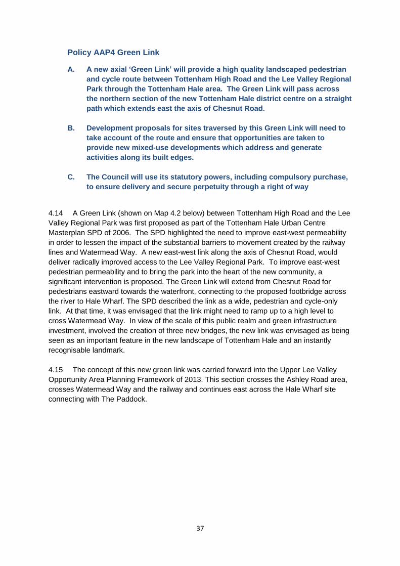
37
Policy AAP4 Green Link
A. A new axial ‘Green Link’ will provide a high quality landscaped pedestrian
and cycle route between Tottenham High Road and the Lee Valley Regional
Park through the Tottenham Hale area. The Green Link will pass across
the northern section of the new Tottenham Hale district centre on a straight
path which extends east the axis of Chesnut Road.
B. Development proposals for sites traversed by this Green Link will need to
take account of the route and ensure that opportunities are taken to
provide new mixed-use developments which address and generate
activities along its built edges.
C. The Council will use its statutory powers, including compulsory purchase,
to ensure delivery and secure perpetuity through a right of way
4.14 A Green Link (shown on Map 4.2 below) between Tottenham High Road and the Lee
Valley Regional Park was first proposed as part of the Tottenham Hale Urban Centre
Masterplan SPD of 2006. The SPD highlighted the need to improve east-west permeability
in order to lessen the impact of the substantial barriers to movement created by the railway
lines and Watermead Way. A new east-west link along the axis of Chesnut Road, would
deliver radically improved access to the Lee Valley Regional Park. To improve east-west
pedestrian permeability and to bring the park into the heart of the new community, a
significant intervention is proposed. The Green Link will extend from Chesnut Road for
pedestrians eastward towards the waterfront, connecting to the proposed footbridge across
the river to Hale Wharf. The SPD described the link as a wide, pedestrian and cycle-only
link. At that time, it was envisaged that the link might need to ramp up to a high level to
cross Watermead Way. In view of the scale of this public realm and green infrastructure
investment, involved the creation of three new bridges, the new link was envisaged as being
seen as an important feature in the new landscape of Tottenham Hale and an instantly
recognisable landmark.
4.15 The concept of this new green link was carried forward into the Upper Lee Valley
Opportunity Area Planning Framework of 2013. This section crosses the Ashley Road area,
crosses Watermead Way and the railway and continues east across the Hale Wharf site
connecting with The Paddock.
38
Map 4.2: The Green Link
4.16 The proposed Green Link is a bold green infrastructure investment in the Tottenham
Hale area. When delivered, the Green Link will represent a landmark green infrastructure
intervention which delivers radically improved public accessibility to the open landscapes of
the Lee Valley Regional Park. Chesnut Road already provides the area with a pedestrian
route towards Tottenham High Road. The proposed Green Link extends the axis of this
existing route directly east into the Regional Park. In order to ensure the new link has the
most transformative effect on the local environment, its axis should be as straight and legible
as possible, affording long sight lines between the Regional Park and the High Road.
4.17 Sites where the proposed alignment crosses over privately owned land area are
included in this AAP as site allocations. Development proposals that come forward on these
sites must facilitate the delivery of the Green Link. Any development proposals which would
hinder the delivery of the Green Link, or require land which is necessary to deliver the Green
Link proposal will be resisted.
Policy AAP5 Changes to Designated Employment Areas
A. The changes in the hierarchy of Designated Employment Areas for the
Tottenham AAP area are as follows:
a. RA9 (High Road West): Designated as a Local Employment Area:
Regeneration Area (NT3);
b. LSIS18 (Willoughby Lane): Designated as a Locally significant
industrial Site ;
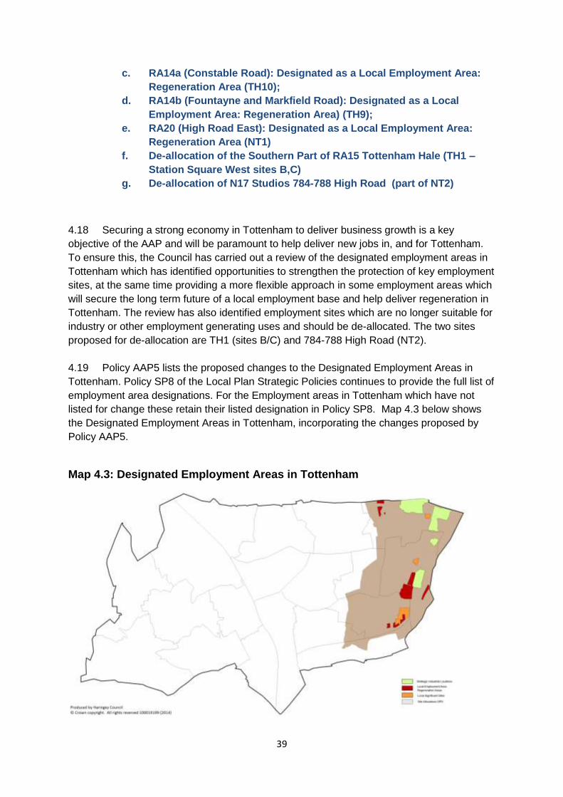
39
c. RA14a (Constable Road): Designated as a Local Employment Area:
Regeneration Area (TH10);
d. RA14b (Fountayne and Markfield Road): Designated as a Local
Employment Area: Regeneration Area) (TH9);
e. RA20 (High Road East): Designated as a Local Employment Area:
Regeneration Area (NT1)
f. De-allocation of the Southern Part of RA15 Tottenham Hale (TH1 –
Station Square West sites B,C)
g. De-allocation of N17 Studios 784-788 High Road (part of NT2)
4.18 Securing a strong economy in Tottenham to deliver business growth is a key
objective of the AAP and will be paramount to help deliver new jobs in, and for Tottenham.
To ensure this, the Council has carried out a review of the designated employment areas in
Tottenham which has identified opportunities to strengthen the protection of key employment
sites, at the same time providing a more flexible approach in some employment areas which
will secure the long term future of a local employment base and help deliver regeneration in
Tottenham. The review has also identified employment sites which are no longer suitable for
industry or other employment generating uses and should be de-allocated. The two sites
proposed for de-allocation are TH1 (sites B/C) and 784-788 High Road (NT2).
4.19 Policy AAP5 lists the proposed changes to the Designated Employment Areas in
Tottenham. Policy SP8 of the Local Plan Strategic Policies continues to provide the full list of
employment area designations. For the Employment areas in Tottenham which have not
listed for change these retain their listed designation in Policy SP8. Map 4.3 below shows
the Designated Employment Areas in Tottenham, incorporating the changes proposed by
Policy AAP5.
Map 4.3: Designated Employment Areas in Tottenham
40
Guidance Note 1 - Indicative Crossrail 2 Areas
4.20 In 2015 it is anticipated that Transport for London will announce a set of safeguarded
sites for the delivery of Crossrail 2. Crossrail 2 is supported by the Council, and the
challenges and opportunities for spatial planning will be addressed as more information
becomes available. These sites will be subject to national legislation safeguarding them, and
any requirements will be added to the Plan as applicable. The safeguarding process is the
subject of current consultation. If construction/work sites and/or timescales are known before
publication of the Plan, they will be included for consultation in the Proposed Submission
consultation.
4.21 The approach to safeguarded sites will be:
Sites required for the construction of Crossrail 2 safeguarding will be protected as
necessary.
Sites within 400m (a 5 minute walk) of a proposed Crossrail 2 station will be closely
scrutinised to ensure the proposed development optimizes the future accessibility
provided by the introduction of Crossrail 2. This may include ensuring that a mix of
uses and potentially enhanced infrastructure may be required from proposals in this
area.
Sites within 800m (10 minute walk) of Crossrail will be scrutinised for how they can
complement the introduction of Crossrail 2. This may include design issues such as
provision of routes to and from the station, and consideration of density to include
future PTAL increase.
Guidance Note 2 - Gypsy & Traveller Pitches
4.22 The Examination in Public of the Local Plan: Strategic Policies identified that the Site
Allocations document would allocate land suitable for meeting Haringey’s Gypsy and
Traveller accommodation needs. SP3 of the Local Plan sets a list of criteria which new
pitches should meet.
4.23 It is considered that sites which are being transferred from B2/B8 employment to a
mix of uses provide the best opportunities for accommodating the Council’s existing, and
emerging need. This is due to the change of value between the existing and future land
value is generally higher on these sites than on residential intensification schemes. This will
allow for greater flexibility in terms of site design, which will better enable an appropriate site
being created for pitch provision.
4.24 An ongoing study into the needs of the gypsy & traveller communities will identify
future need over the plan period. Existing pitches will be included in this study to understand
what contribution to meeting need they can make.
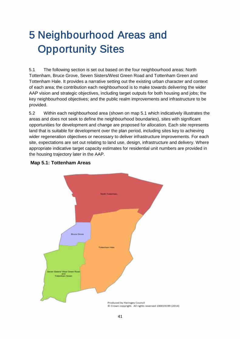
41
5 Neighbourhood Areas and
Opportunity Sites
5.1 The following section is set out based on the four neighbourhood areas: North
Tottenham, Bruce Grove, Seven Sisters/West Green Road and Tottenham Green and
Tottenham Hale. It provides a narrative setting out the existing urban character and context
of each area; the contribution each neighbourhood is to make towards delivering the wider
AAP vision and strategic objectives, including target outputs for both housing and jobs; the
key neighbourhood objectives; and the public realm improvements and infrastructure to be
provided.
5.2 Within each neighbourhood area (shown on map 5.1 which indicatively illustrates the
areas and does not seek to define the neighbourhood boundaries), sites with significant
opportunities for development and change are proposed for allocation. Each site represents
land that is suitable for development over the plan period, including sites key to achieving
wider regeneration objectives or necessary to deliver infrastructure improvements. For each
site, expectations are set out relating to land use, design, infrastructure and delivery. Where
appropriate indicative target capacity estimates for residential unit numbers are provided in
the housing trajectory later in the AAP.
Map 5.1: Tottenham Areas
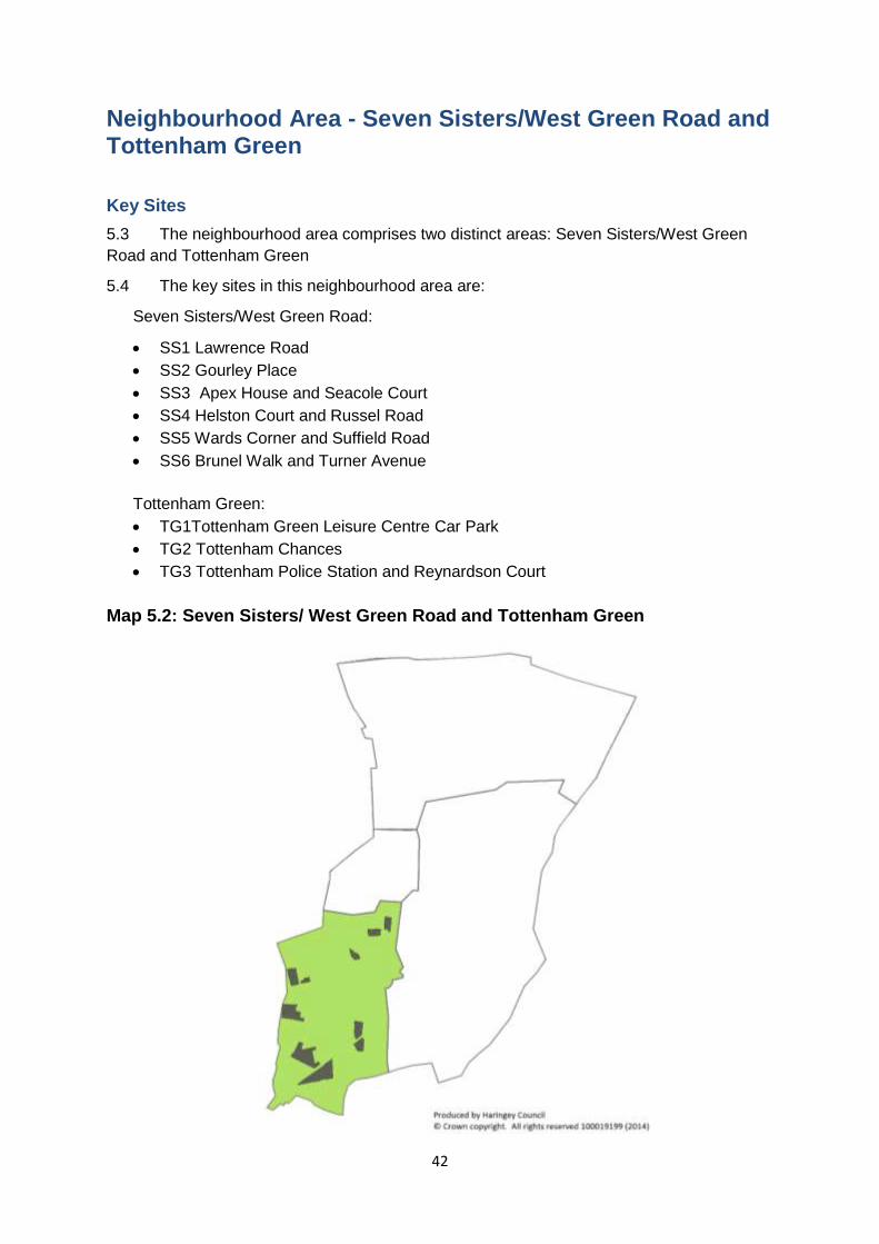
42
Neighbourhood Area - Seven Sisters/West Green Road and Tottenham Green
Key Sites
5.3 The neighbourhood area comprises two distinct areas: Seven Sisters/West Green
Road and Tottenham Green
5.4 The key sites in this neighbourhood area are:
Seven Sisters/West Green Road:
SS1 Lawrence Road
SS2 Gourley Place
SS3 Apex House and Seacole Court
SS4 Helston Court and Russel Road
SS5 Wards Corner and Suffield Road
SS6 Brunel Walk and Turner Avenue
Tottenham Green:
TG1Tottenham Green Leisure Centre Car Park
TG2 Tottenham Chances
TG3 Tottenham Police Station and Reynardson Court
Map 5.2: Seven Sisters/ West Green Road and Tottenham Green
43
The character of the neighbourhood area
5.5 Seven Sisters is a key gateway into Tottenham and, along with West Green Road,
constitutes the Seven Sisters District Town Centre. It is also a significant transport hub – and
is set to have an even greater role as a part of Crossrail 2 (in the longer term) whilst
benefiting in the short term from investment as part of London’s Overground network in the
short term. The area benefits from good to excellent public transport accessibility with three
stations forming an important and busy public transport node. These stations connect well
with local buses on Seven Sisters Road and the High Road whilst the area is also a busy
area for cyclists.
5.6 Given their proximity to major roads and public transport stations, Tottenham High
Road, Seven Sisters Road and West Green Road are the focus for development activity in
the area on key sites. However, these roads are heavily trafficked and as a consequence
the public realm and pedestrian environment suffer and should be improved via strategic
regeneration projects and sites.
5.7 Tottenham Green provides a rich mix of civic and cultural uses, many of which are
listed buildings, including a, theatre, college campus, leisure centre and church all centred
around the historical Tottenham Green. Currently the area is not fulfilling its full potential as
Tottenham’s cultural and civic hub and there is an aspiration to enhance activity in the area
at all times of the day, and throughout the week. To achieve this Tottenham Green will be
the focus for new cafes and restaurants to enhance and support the existing cultural offer in
the area. Public realm enhancements will build upon the recent improvements in Tottenham
Green and focus on the shared spaces and routes between the existing buildings. Any new
development must enhance the historical status of the area and its existing buildings
5.8 The character of the area is equally mixed, from industrial/employment uses within
post war buildings in the south to the more established educational, cultural and leisure
buildings and land uses clustered around the recently enhanced open space at Tottenham
Green. The area also contains two housing estates earmarked for renewal which are
Helston Court and Russel Road and Brunel Walk and Turner Avenue. Town centre retail use
is clustered to the south of the area. The area is significantly enriched by a number of
prominent heritage buildings whilst the High Road corridor is a conservation area.
Key neighbourhood area objectives
5.9 The key objectives for the neighbourhood area are:
Increased retail floorspace at Seven Sisters District Centre to enhance its’ retail
characteristics
Redevelopment of key sites including Wards Corner, Apex House, Lawrence Road
and Gourley Triangle
Targeted streetscape and environmental improvements along West Green Road,
Tottenham High Road and Seven Sisters Road including paving, signage,
landscaping and street furniture
New affordable employment/workspace suitable for new enterprises and medium
sized businesses as part of mixed use redevelopment at Gourley Place and
Lawrence Road.
44
A landmark building at Apex House providing significant new mixed tenure homes
and ground floor space for employment/commercial space to complement
development on the Wards Corner site.
Targeted building and shop front/signage improvements consistent with the
enhancement of the character, heritage and townscape attributes of the area
alongside new development.
Development should support Tottenham Green as the civic and cultural heart of
Tottenham, with an enhanced restaurant, cafe and cultural offer that complements
public realm improvements to the Green.
Redevelopment of underused sites that detract from the historical status of the area
and conservation area
Public realm enhancements between the buildings on the Green to create a more
attractive and coherent area
Promotion of the provision of workspace to support the successful and emerging
SME community around Tottenham Green.
Urban realm improvements:
5.10 The urban realm improvements for the neighbourhood area are:
The redevelopment of key sites on the High Road should lead to improvements to
footway and public realm/station entrances in the vicinity of Sevens Sisters road and
High Road junction
New way finding/signage as part of wider Tottenham branding and route finding
Opportunities for education and cultural events on Tottenham Green
Improvements to the south side of Seven Sister road/High road associated with the
development of Apex House.
Improvements to the public realm around Gourley Place associated with new land
use and development to address existing anti social behaviour.
Important buildings and spaces should be conserved and enhanced and their
settings and viewing corridors improved, notably St Ignatius Church, St Ann’s Church
and wider setting and Page Green.
Infrastructure
5.11 The infrastructure projects for the neighbourhood area are:
The site is expected to be served by new Crossrail 2 station infrastructure at Seven
Sisters.
Transfer of the mainline to London Overground will lead to improvements at Seven
Sisters over ground station
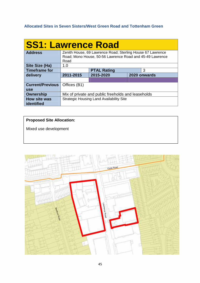
45
Allocated Sites in Seven Sisters/West Green Road and Tottenham Green
SS1: Lawrence Road Address Zenith House, 69 Lawrence Road; Sterling House 67 Lawrence
Road; Mono House, 50-56 Lawrence Road and 45-49 Lawrence Road
Site Size (Ha) 1.0
Timeframe for PTAL Rating 3
delivery 2011-2015 2015-2020 2020 onwards
Current/Previous use
Offices (B1)
Ownership Mix of private and public freeholds and leaseholds
How site was identified
Strategic Housing Land Availability Site
Proposed Site Allocation:
Mixed use development
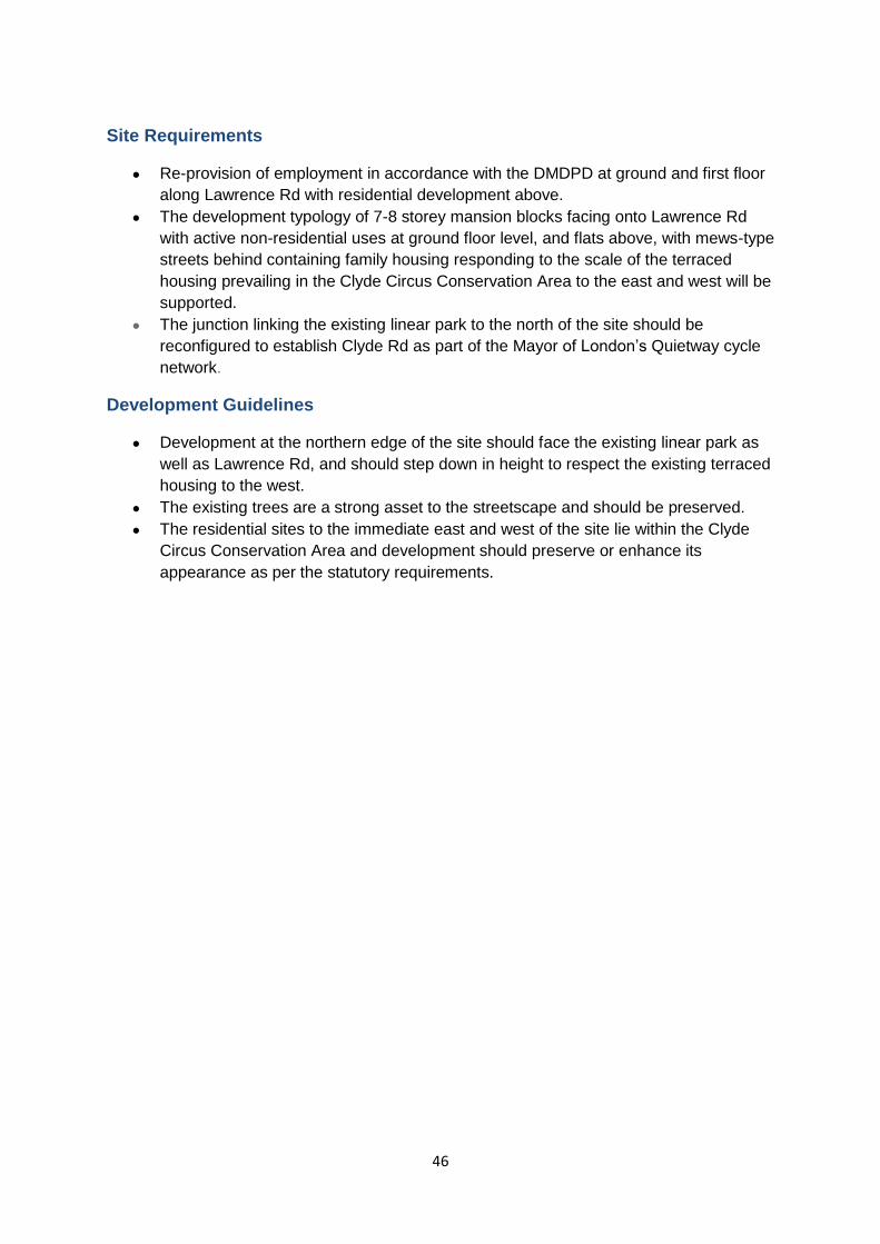
46
Site Requirements
Re-provision of employment in accordance with the DMDPD at ground and first floor
along Lawrence Rd with residential development above.
The development typology of 7-8 storey mansion blocks facing onto Lawrence Rd
with active non-residential uses at ground floor level, and flats above, with mews-type
streets behind containing family housing responding to the scale of the terraced
housing prevailing in the Clyde Circus Conservation Area to the east and west will be
supported.
The junction linking the existing linear park to the north of the site should be
reconfigured to establish Clyde Rd as part of the Mayor of London’s Quietway cycle
network.
Development Guidelines
Development at the northern edge of the site should face the existing linear park as
well as Lawrence Rd, and should step down in height to respect the existing terraced
housing to the west.
The existing trees are a strong asset to the streetscape and should be preserved.
The residential sites to the immediate east and west of the site lie within the Clyde
Circus Conservation Area and development should preserve or enhance its
appearance as per the statutory requirements.
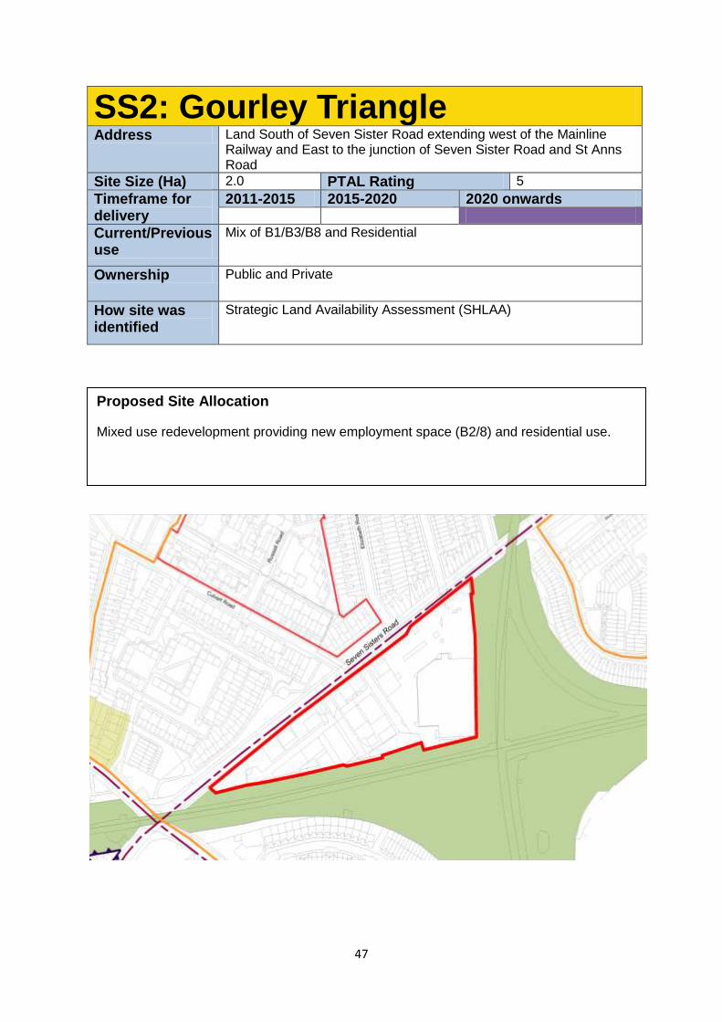
47
SS2: Gourley Triangle Address Land South of Seven Sister Road extending west of the Mainline
Railway and East to the junction of Seven Sister Road and St Anns Road
Site Size (Ha) 2.0 PTAL Rating 5
Timeframe for delivery
2011-2015 2015-2020 2020 onwards
Current/Previous use
Mix of B1/B3/B8 and Residential
Ownership Public and Private
How site was identified
Strategic Land Availability Assessment (SHLAA)
Proposed Site Allocation
Mixed use redevelopment providing new employment space (B2/8) and residential use.
48
Site Requirements
Active frontage onto Seven Sisters Rd with employment uses located here.
The employment use should be of a typology that is compatible with residential use
To preserve and enhance the SINC and ecological corridor to the south and east of
the site.
There is potential for some 6-11 storey development along Seven Sisters Rd, but
these should be point blocks rather than continuous slabs.
Development Guidelines
Where necessary, the layout of the new development should provide for adequate
separation between industrial and residential uses on the site.
This site is identified as being in an area with potential for being part of a
decentralised energy network. This may be as a decentralised energy hub, as a
customer, or requiring part of the site to provide an easement for the network.
Studies should be undertaken to understand what potential contamination there is on this site prior to any development taking place. Mitigation of and improvement to local air quality and noise pollution should be made on this site.
Capped commercial rents will be expected in this area in line with draft Development Management policies.
The potential for a pedestrian crossing of the rail line to the south of the site should be considered.
The servicing of buildings fronting Seven Sisters Road should be provided from the rear.
Parking should be minimised on this site due to the excellent local public transport connections.
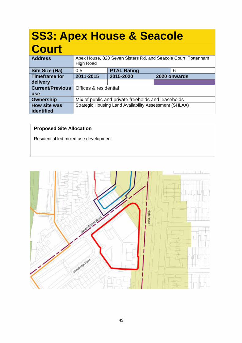
49
SS3: Apex House & Seacole Court Address Apex House, 820 Seven Sisters Rd, and Seacole Court, Tottenham
High Road
Site Size (Ha) 0.5 PTAL Rating 6
Timeframe for delivery
2011-2015 2015-2020 2020 onwards
Current/Previous use
Offices & residential
Ownership Mix of public and private freeholds and leaseholds
How site was identified
Strategic Housing Land Availability Assessment (SHLAA)
Proposed Site Allocation
Residential led mixed use development
50
Site Requirements
This is a suitable location for a high quality tall building marking the location of the
public transport interchange of train, tube, bus and Overground rail, and the junction
of Seven Sisters Rd and Tottenham High Rd. Careful consideration of the long views
of this building along, including the linear view along the High Rd and Seven Sisters
Rd, as well as the effect on the microclimate should be considered in line with the
DMDPD.
The tallest element will need to have regard to properties to the rear of the site, as
well as to its relationship to other buildings along Seven Sisters and Tottenham High
Rd. This could be a slender point block tower.
Where necessary, the development should step down towards the lower density
building to the south and south-west of the site.
Part of the site is located in the Seven Sisters Conservation Area and development
should preserve or enhance its appearance as per the statutory requirements Any development will be required to consider the proposals relationship to the
proposal at Wards Corner and the provision of public space and public realm
improvements to support the arrival to Seven Sisters Station and for moving
between this site and Wards Corner
Development Guidelines
The Council will consider a range of town centre uses along the High Road Frontage
which could include small scale A1 retail located close to the apex with Seven Sisters
Road. However along Seven Sisters Road, the Council with only permit secondary
retail uses such as use classes A2, A3, A4, A5, D or B1 Studies should be undertaken to understand what potential contamination there is on
this site prior to any development taking place. Mitigation of and improvement to local
air quality and noise pollution should be made on this site.
Car free development is suitable for this site.
This site is in a Critical Drainage Area - proposals should refer to the Local Flood
Risk Management Strategy.
The existing mature trees along Tottenham High Rd will be retained.
This site is identified as being in an area with potential for being part of a
decentralised energy network. This may be as a decentralised energy hub, as a
customer, or requiring part of the site to provide an easement for the network.
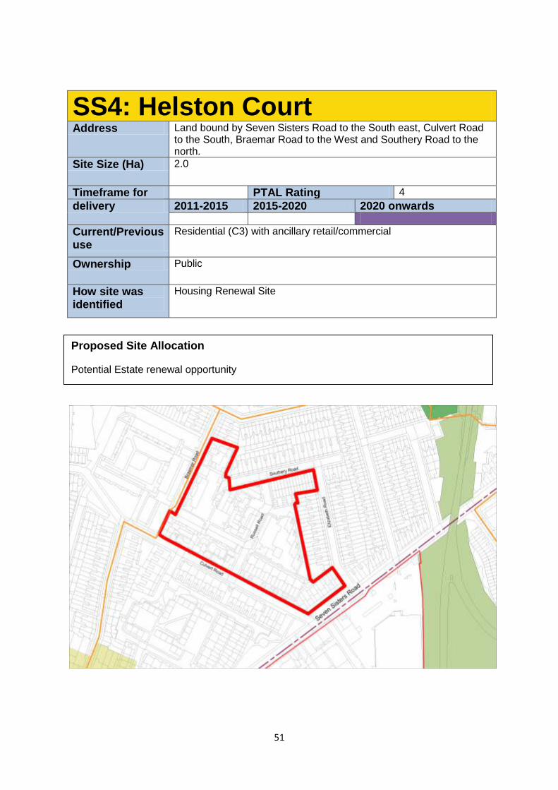
51
SS4: Helston Court Address Land bound by Seven Sisters Road to the South east, Culvert Road
to the South, Braemar Road to the West and Southery Road to the north.
Site Size (Ha) 2.0
Timeframe for PTAL Rating 4
delivery 2011-2015 2015-2020 2020 onwards
Current/Previous use
Residential (C3) with ancillary retail/commercial
Ownership Public
How site was identified
Housing Renewal Site
Proposed Site Allocation
Potential Estate renewal opportunity
52
Site Requirements
A masterplan approach in collaboration with local residents will be taken to this area
seeking to improve permeability, and the coherence of the street network, and
improve the residential building stock.
No buildings need to be retained.
A new frontage onto Seven Sisters Rd will be created in which buildings of up to 6
storeys will be permitted. Heights will need to be restricted to the north, east and
west to respect the amenity of residents of properties on Elizabeth Rd, Culvert Rd,
and Braemar Rd.
Southey Rd will be extended through to Braemar Rd.
Development Guidelines
Improved permeability thought he site will be supported to tie the area into the local
road network. A through route will be supported, but traffic calmed to stop through
traffic.
This site is made up of several post war housing developments, and a masterplan
that ties the area together will be supported.
This site is identified as being in an area with potential for being part of a
decentralised energy network. This may be as a decentralised energy hub, as a
customer, or requiring part of the site to provide an easement for the network.
Studies should be undertaken to understand what potential contamination there is on this site prior to any development taking place. Mitigation of and improvement to local air quality and noise pollution should be made on this site.
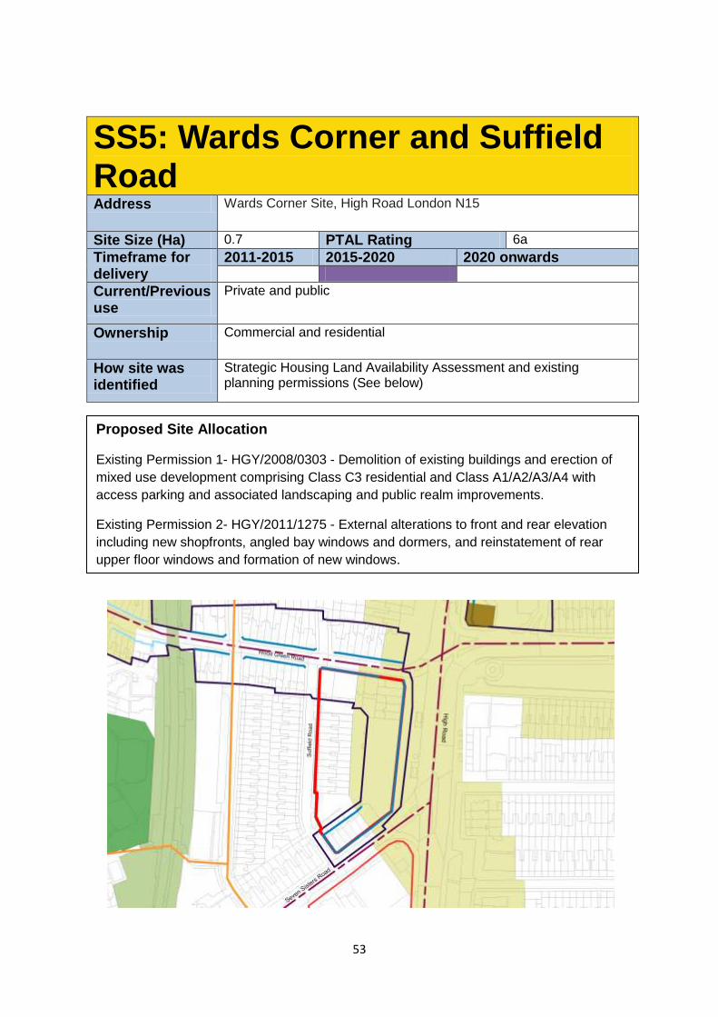
53
SS5: Wards Corner and Suffield Road Address Wards Corner Site, High Road London N15
Site Size (Ha) 0.7 PTAL Rating 6a
Timeframe for delivery
2011-2015 2015-2020 2020 onwards
Current/Previous use
Private and public
Ownership Commercial and residential
How site was identified
Strategic Housing Land Availability Assessment and existing planning permissions (See below)
Proposed Site Allocation
Existing Permission 1- HGY/2008/0303 - Demolition of existing buildings and erection of
mixed use development comprising Class C3 residential and Class A1/A2/A3/A4 with
access parking and associated landscaping and public realm improvements.
Existing Permission 2- HGY/2011/1275 - External alterations to front and rear elevation
including new shopfronts, angled bay windows and dormers, and reinstatement of rear
upper floor windows and formation of new windows.
54
Future Planning Requirements
Ensure a comprehensive approach to this site is secured
To help facilitate a coordinated approach towards development along the High Road
and in particular Apex House
Re-provision of the existing market should be provided on site and arrangements
should be made for the temporary housing of the market whilst the proposal is being
development.
Secure retail and other town centre uses at ground floor level onto the West Green
Road, High Road and Seven Sisters Road frontages.
The site lies within the Seven Sisters Conservation Area and development should
preserve or enhance its appearance as per the statutory requirements
Ensure a high quality public realm is secured
This site is identified as being in an area with potential for being part of a
decentralised energy network. This may be as a decentralised energy hub, as a
customer, or requiring part of the site to provide an easement for the network.
Studies should be undertaken to understand what potential contamination there is on
this site prior to any development taking place. Mitigation of and improvement to local
air quality and noise pollution should be made on this site.
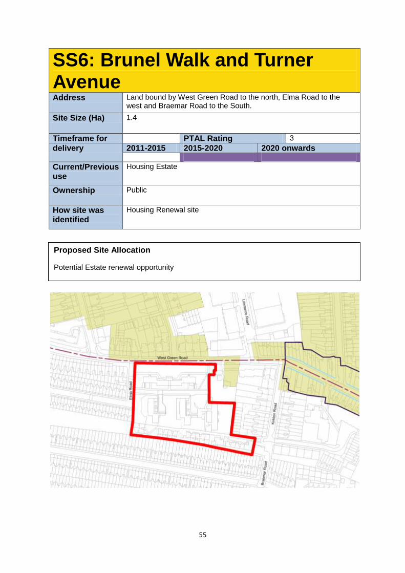
55
SS6: Brunel Walk and Turner Avenue Address Land bound by West Green Road to the north, Elma Road to the
west and Braemar Road to the South.
Site Size (Ha) 1.4
Timeframe for PTAL Rating 3
delivery 2011-2015 2015-2020 2020 onwards
Current/Previous use
Housing Estate
Ownership Public
How site was identified
Housing Renewal site
Proposed Site Allocation
Potential Estate renewal opportunity
56
Site Requirements
A masterplan approach should be undertaken.
Existing buildings do not need to be retained, although refurbishment of the existing
blocks with limited infill of the Turner Avenue part of the site should be considered.
Design should take into account and positively respond to the Clyde Circus
Conservation Area adjacent to the site.
Development Guidelines
Development along West Green Road will set a datum of building heights of 4
storeys for this site. Heights could increase towards the centre of the site, but would
need to be reduced to the south, east and west to respect the amenity of neighboring
residential buildings.
Improved site permeability to enhance connection to the local road network. A
through route may be acceptable if sensitively integrated and designed to restrict
through traffic, including traffic calming measures.
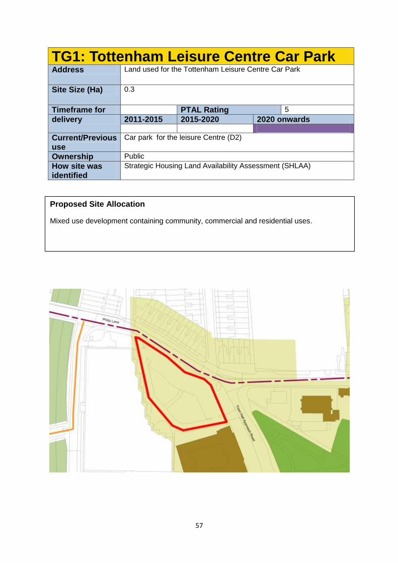
57
TG1: Tottenham Leisure Centre Car Park Address Land used for the Tottenham Leisure Centre Car Park
Site Size (Ha) 0.3
Timeframe for PTAL Rating 5
delivery 2011-2015 2015-2020 2020 onwards
Current/Previous use
Car park for the leisure Centre (D2)
Ownership Public
How site was identified
Strategic Housing Land Availability Assessment (SHLAA)
Proposed Site Allocation
Mixed use development containing community, commercial and residential uses.
58
Site Requirements
This is an extremely prominent and sensitive site, and an exceptional design will be
required.
The site lies within the Tottenham Green Conservation Area and development should
preserve or enhance its appearance as per the statutory requirements. Development
will be limited to 5 storeys to help achieve this.
Tottenham Green provides the civic heart of this part of the High Road, and forms the
focus of an emerging cultural quarter. Development on this site will help to achieve
this aim by providing an additional civic use, and by creating an improved sense of
enclosure to the Green and Phillip Lane.
The education and arts centre to the south, and church within the green are all
statutorily listed buildings, and the vicarage directly opposite the site is locally listed.
Development on this site will be required to respond to and enhance the setting of
these assets
Evidence will need to be provided to the Council to demonstrate the loss of the car
park will not demonstrably affect the vitality and viability of the leisure centre and
library and opportunities have been explored to work with the leisure centre operator
to enhance the remaining car parking provision and re-provide an appropriate
number of spaces on site where possible.
Development Guidelines
The new building needs to address Phillip Lane, Tottenham Green, and provide an
attractive and easily accessible route to the existing library and leisure centre from
Tottenham Green, and provide an acceptable frontage facing the Leisure Centre.
The new building should act as a ‘wayfinder’ to this important community asset and
should not act as obstacle to viewing the centre from Philip Lane and the Green.
The site is in an identified area of archaeological importance.
The Green itself has a Significant Local Open Land and Historic Park designation
Vehicle access should be from Phillip Lane. Pedestrian access will predominantly be
from Town Hall Approach Road, and the primary entrance to the site should be from
here.
A Cycle Superhighway is proposed in close proximity to the site, and local Quietway
cycle routes operate in the area. Cycle parking should be provided as part of any
development.
This site is identified as being in an area with potential for being part of a
decentralised energy network. This may be as a decentralised energy hub, as a
customer, or requiring part of the site to provide an easement for the network.
Studies should be undertaken to understand what potential contamination there is on this site prior to any development taking place. Mitigation of and improvement to local air quality and noise pollution should be made on this site.
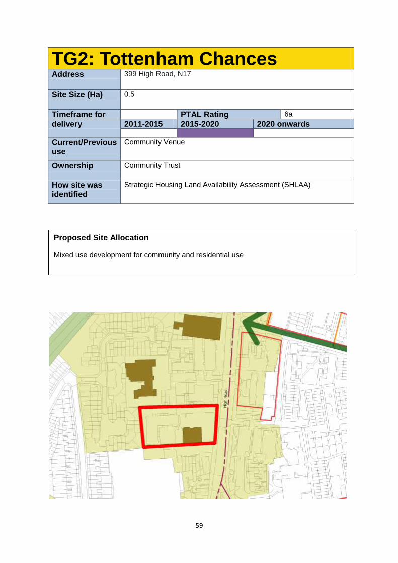
59
TG2: Tottenham Chances Address 399 High Road, N17
Site Size (Ha) 0.5
Timeframe for PTAL Rating 6a
delivery 2011-2015 2015-2020 2020 onwards
Current/Previous use
Community Venue
Ownership Community Trust
How site was identified
Strategic Housing Land Availability Assessment (SHLAA)
Proposed Site Allocation
Mixed use development for community and residential use
60
Site Requirements
The development may include one of the following:
o a sensitively designed limited extension with the retention of the listed
building; or
o Comprehensive redevelopment justifying the loss of the listed building.
Proposal for comprehensive redevelopment involving the loss of the listed building
will need to be rigorously justified.
If demolition of the listed building is justified, new development should continue the
building line established in 391 and 413 High Rd.
Development should respect the setting of neighbouring locally listed buildings
There is potential for back land development behind the High Rd frontage.
Views to the former High Cross School from the High Rd should be maintained and
enhanced where possible.
The site lies within the Tottenham Green Conservation Area and development should
preserve or enhance its appearance as per the statutory requirements. Development
will be limited to 5 storeys to help achieve this.
Development Guidelines
Particular care for the amenity of 413 High Rd should be taken through any potential
redevelopment.
This site is identified as being in an area with potential for being part of a
decentralised energy network. This may be as a decentralised energy hub, as a
customer, or requiring part of the site to provide an easement for the network.
Studies should be undertaken to understand what potential contamination there is on
this site prior to any development taking place. Mitigation of and improvement to local
air quality and noise pollution should be made on this site.
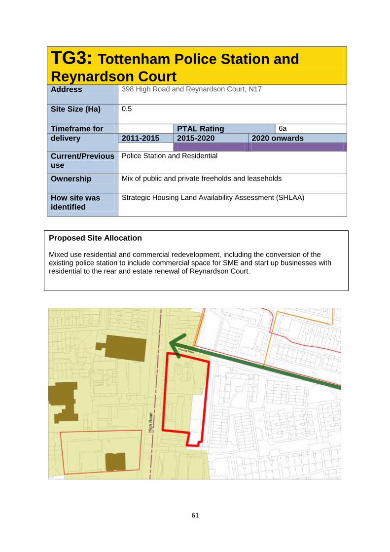
61
TG3: Tottenham Police Station and
Reynardson Court Address 398 High Road and Reynardson Court, N17
Site Size (Ha) 0.5
Timeframe for PTAL Rating 6a
delivery 2011-2015 2015-2020 2020 onwards
Current/Previous use
Police Station and Residential
Ownership Mix of public and private freeholds and leaseholds
How site was identified
Strategic Housing Land Availability Assessment (SHLAA)
Proposed Site Allocation
Mixed use residential and commercial redevelopment, including the conversion of the existing police station to include commercial space for SME and start up businesses with residential to the rear and estate renewal of Reynardson Court.
62
Site Requirements
A Green Link is proposed at the northern edge of the site, and proposals should
facilitate development of and enhance access to this new route.
The existing Police station and the façade of 2 Chestnut Rd should be retained as
per planning consent (HGY/2011/1604: Demolition of existing building and erection of
new students' accommodation building comprising 6 storeys to provide 94 students
units with gym, common room, shop, laundry room, storeroom cycle store, refuse
store and lift)
There is a presumption for retention of the existing building, but schemes that include
372-376 may be considered where it can be demonstrated that the benefit to the
Conservation Area can be enhanced through the extension and/or change of use of
these buildings. The rear of these buildings is suitable for redevelopment.
Building heights will be limited to respect the scale of existing buildings to be retained
on this site.
The site lies within the Tottenham Green Conservation Area and development should
preserve or enhance the character of the historic environment, in line with the
relevant statutory requirements.
Demolition and redevelopment of the 1980s extension to the police station, along
with space for related ancillary uses, will be acceptable.
Development Guidelines
The High Road building line should be continued, with designs taking account of the
line of the existing police Station and 372-376 Tottenham High Rd.
Development at the northern and southern edges of the site should positively
respond to the existing heritage assets and wider historic environment.
The existing trees to the front and rear of Reynardson Court may be removed,
however with an equivalent number of trees, at a minimum, replaced as part of public
realm enhancements in proximity to the site. This will be secured via planning
obligation.
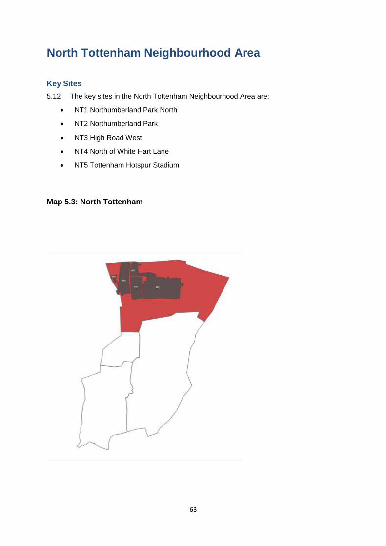
63
North Tottenham Neighbourhood Area
Key Sites
5.12 The key sites in the North Tottenham Neighbourhood Area are:
NT1 Northumberland Park North
NT2 Northumberland Park
NT3 High Road West
NT4 North of White Hart Lane
NT5 Tottenham Hotspur Stadium
Map 5.3: North Tottenham
64
Character of the neighbourhood area
Northumberland Park Regeneration Area
5.12.1 The Northumberland Park area includes the Northumberland Park Estate and
surrounding areas situated within the Northumberland Park ward. The north of the area is
bound by the Brantwood Road and Tariff Road industrial estates and immediately to the
north of the industrial estates is the borough boundary with Enfield and the Central
Leeside/Meridian Water regeneration area in Enfield. To the east is the Tottenham Hale
branch of the West Anglia Main Line, Northumberland Park bus and rail stations and the
Victoria Line Depot. The southern boundary is formed by Park Lane and traditional street
networks consisting predominantly of two storey semi detached houses built from the late
1980s to the 1910s with some later additions. To the west of the neighbourhood area is the
Tottenham Hotspur Stadium (which is currently undergoing major redevelopment) and the
Love Lane Housing Estate (which is part of the High Road West area).
5.12.2 The area is directly adjacent to the Lee Valley Regional Park which provides
opportunities for new access points and landscaping strategies that encourage access to the
park and waterways.
5.12.3 The neighbourhood area consists of several places and smaller neighbourhoods that
have been developed over time. There are a large number of terraced houses in private
ownership in the centre of the area, as well as larger Council owned estates. There are a
large number of cul-de-sacs in the area and the network of streets is unclear. Generally the
east-west roads are well defined but there is a lack of north-south links, contributing to the
area being fragmented.
5.12.4 The area suffers from undefined public and private spaces that are not always well
looked after. Entrances don’t address the street and many frontages are inactive, leaving
streets ill-defined and not well overlooked. There is an amount of decent housing stock that
could be retained and improved. However, the majority of the post-war buildings are creating
poorly structured urban conditions with unclear network of streets and undefined spaces.
There is a predominance of social housing and smaller homes.
High Road West Regeneration Area
65
5.12.5 The area is located in North Tottenham between the Greater Anglia railway line to
the west and the High Road to the east. It extends from the new Brook House development
in the north to Brereton Road in the south. The area is cut off from surrounding terraced
street patterns by the elevated railway which limits connectivity with the High Road and the
Tottenham Hotspur Football Club Stadium to the east and neighbourhoods to the north and
south. The area is a level site falling gently toward the River Lee to the east. A major
tributary of the Lee, the River Moselle and the culverted section runs along White Hart Lane.
5.12.6 The area is characterised by a fragmented urban form which is dominated by three
building types: point block 1960s housing set in large areas of open space, industrial sheds,
and three storey terraced buildings fronting the High Road and White Hart Lane.
5.12.7 The southern part of the area is predominantly characterised by local authority
housing estates which were built in the 1960s and have very poor street and block layouts
with a lack of connections and fragmented networks. The northern part of the area is
predominantly characterised by large industrial employment units occupied by a number of
local businesses such as timber merchants, car mechanics and metalwork fabrication which
also includes a safeguarded waste facility. The northern end of the area is characterised by
a now vacant superstore and the new 22 storey Brook House development scheme.
5.12.8 Smaller properties typically front the High Road and White Hart Lane and provide a
local parade of shops that are in need of investment. This could provide the potential
opportunity for minimal expansion of the existing Local shopping parade. The local parade is
predominantly characterised by narrow plot widths which extend deeply behind the High
Road. The retail units are typically occupied by independent operators and there is a high
proportion of hot food takeaway and convenience stores. This area is also significantly
influenced by the scale and form of the football stadium.
Key objectives
Northumberland Park
The key objectives for Northumberland Park are:
Comprehensive economic, social and physical regeneration focused around a
transformative estate renewal programme.
A substantially improved urban form and character which creates safe, modern and
high quality places.
A range of housing types to meet the needs of the community and create a high
quality residential neighbourhood with a distinct and coherent identity, providing at
least 2200 new additional homes of a different, type, tenure and size and the creation
of more family housing in the heart of the neighbourhood.
Taller or higher density development near to the redeveloped Tottenham Hotspur FC
stadium and transport links such as Northumberland Park Station or where there are
existing taller buildings.
New homes along traditional street patterns and sit within an attractive public realm
network.
Preservation and enhancement of existing good quality homes.
66
Improved open space in Northumberland Park as well as improved access to
surrounding open spaces.
Ensure social infrastructure meets existing and future community needs in high
quality buildings that promote an integrated community and opportunities for all.
Urban realm improvements
5.13 The urban realm improvements for the neighbourhood area are:
New and enhanced public open spaces alongside a defined hierarchy of
interconnected pedestrian routes.
An enhanced public realm and high quality, safe routes that better connect the
neighbourhood with Tottenham High Road, the Lee Valley Regional Park and the
opportunities delivered by the Tottenham Hotspur FC stadium, transport and
infrastructure improvements.
A mix of commercial uses, including new and affordable workspaces, leisure, and
retail that revitalises and activates local streets.
An improved Northumberland Park Station that reflects the transport improvements
on the West Anglia Main Line and potential designation as a Crossrail 2 station.
These improvements should also improve security, safety and the experience of
arriving by rail along with a new bridge at Northumberland Park Station that forms a
key part of new public realm and a landscaped route between the High Road and the
Lee Valley Park
Infrastructure
5.14 The infrastructure projects in the neighbourhood area are:
New pedestrian and cycling bridge at Northumberland Station and new and
enhanced routes into the Lee Valley Regional Park
Improvements to community infrastructure provision including new primary health
facilities.
New and enhanced education facilities commensurate with the growth in forecast
population.
New rail and station facilities at Northumberland Park associated with the delivery of
Crossrail 2.
New and enhanced bus routes reflecting the area’s role as a key regional growth
hub.
High Road West
Key Objectives
5.15 The key objectives for High Road West are to:
Create a vibrant, attractive and sustainable neighbourhood and a new sports and
leisure destination for North London.
Create a well connected neighbourhood which is accessible by all forms of transport
and has attractive walkable streets including new north-south and east-west links
67
Provide a safe and welcoming neighbourhood, which is a balanced place to live and
work with active street frontages and attractive open space.
Provide a minimum of 1,400 new homes which are a mixture of different tenures and
type, maximising housing choice for residents and creating a thriving area for small
business and enterprise.
Expand the local shopping centre along the High Road fronting the new football
stadium, including the new public square.
Promote social interaction with new public open spaces for the community to foster
community cohesion and social inclusion.
Incorporate a range of residential typologies including courtyard blocks of varying
heights and terraced housing.
Urban realm improvements
5.16 The urban realm improvements for High Road West will:
Create a legible network of east-west streets and north-south links that connect into
the surrounding areas, existing lanes off the High Road and open spaces and
connect public spaces, key buildings and the station;
Provide a new public square which will –
o serve as the heart of the High Road West area and a welcoming gateway into
North Tottenham;
o include a new library, community learning centre and education hub at the
centre of the square and space for pubic activities including screening sports
events and shows;
o become a destination for shops, restaurants and cafes with development
focused around the new entrance to White Hart Lane Station;
o support attractive residential typologies; and
o provide a clear route for visitors to match and event days at Tottenham Hotspur
Football Club arriving at a new White Hart Lane station entrance.
Enhance Tottenham High Road by -
o creating an attractive shopping destination for local people and visitors; and
o a programme of improvements to refurbish the existing Victorian building stock
and improvements to paving, lighting and street furniture to enhance the
attractiveness and safety of the High Road.
Infrastructure
5.17 The infrastructure projects in High Road West are:
Improvements to community infrastructure provision, including a crèche, a new
library and education hub, a new healthcare centre including a pharmacy and new
leisure facilities associated with the redevelopment of Tottenham Hotspur Stadium.
Improvements to White Hart Lane Station and a new entrance to the station to align
with the new public square and the new clear route provided by the square from the
station to the new football stadium

68
The new Brook House Primary School will open on the former Cannon Rubber
Factory in September 2015 (it is currently operating in temporary premises at
Tottenham Green)
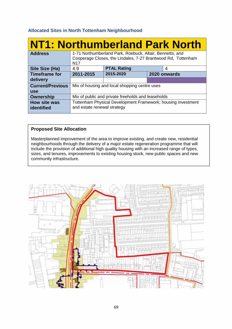
69
Allocated Sites in North Tottenham Neighbourhood
NT1: Northumberland Park North Address 1-71 Northumberland Park, Roebuck, Altair, Bennetts, and
Cooperage Closes, the Lindales, 7-27 Brantwood Rd, Tottenham N17
Site Size (Ha) 4.9 PTAL Rating 4
Timeframe for delivery
2011-2015 2015-2020 2020 onwards
Current/Previous use
Mix of housing and local shopping centre uses
Ownership Mix of public and private freeholds and leaseholds
How site was identified
Tottenham Physical Development Framework; housing investment and estate renewal strategy
Proposed Site Allocation
Masterplanned improvement of the area to improve existing, and create new, residential neighbourhoods through the delivery of a major estate regeneration programme that will include the provision of additional high quality housing with an increased range of types, sizes, and tenures, improvements to existing housing stock, new public spaces and new community infrastructure.
70
Site Requirements
Development will be in conformity with any future adopted masterplan for the area.
Redevelopment will create more, new, and better housing with greater diversity of
scale and tenure and type
New east-west and north-south routes will be created, and existing routes enhanced.
This includes enhancing Northumberland Park as a key bus route through the area,
linking with Northumberland Park Station.
Retention of good housing stock where appropriate
The High Road frontage should be enhanced including retention of listed and locally
listed buildings where appropriate.
Development Guidelines
High quality new public spaces within the site should be created, with a net increase
in the amount of publically accessible urban realm.
This site is identified as being in an area with potential for being part of a
decentralised energy network. This may be as a decentralised energy hub, as a
customer, or requiring part of the site to provide an easement for the network.
Development should complement and make use of the amenity provided by Florence
Hayes Rec (In LB Enfield).
Studies should be undertaken to understand what potential contamination there is on
this site prior to any development taking place. Mitigation of and improvement to local
air quality and noise pollution should be made on this site.
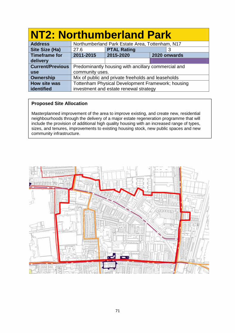
71
NT2: Northumberland Park Address Northumberland Park Estate Area, Tottenham, N17
Site Size (Ha) 27.6 PTAL Rating 3
Timeframe for delivery
2011-2015 2015-2020 2020 onwards
Current/Previous use
Predominantly housing with ancillary commercial and community uses.
Ownership Mix of public and private freeholds and leaseholds
How site was identified
Tottenham Physical Development Framework; housing investment and estate renewal strategy
Proposed Site Allocation
Masterplanned improvement of the area to improve existing, and create new, residential neighbourhoods through the delivery of a major estate regeneration programme that will include the provision of additional high quality housing with an increased range of types, sizes, and tenures, improvements to existing housing stock, new public spaces and new community infrastructure.
72
Site Requirements
Development will be in conformity with any future adopted masterplan for the area.
Redevelopment will create more, new, and better housing with greater diversity of
scale and tenure and type, and will contribute to the creation of a Family Housing
Area.
Existing east-west routes will be enhanced, including Park Lane as a pedestrian and
cycling friendly route and Local Centre, connecting Tottenham High Rd and the Lee
Valley Regional Park. Bus routes will be improved through the area and link with
Northumberland Park Station.
A fine graining of the road network in the area will be created with the aim of
increasing permeability. There will be a strong focus on creating new north-south
streets and new streets must connect to existing streets to the north and south of the
area, and to new spaces proposed around the new stadium development to the west.
Retention of good housing stock where appropriate
Taller buildings will be located at the south east corner of the site as part of the
proposed Northumberland Park tall buildings cluster, and in the west and south west
of the site adjacent to the stadium development.
Small scale commercial development along Park Lane and at Northumberland Park
Station. Any commercial should not detract from the main aim of concentrating town
centre uses on the High Road
New health infrastructure will be provided within the area
Education infrastructure will be enhanced including the provision of a new through-
school within the masterplan area.
Development Guidelines
High quality, new public spaces within the site should be created, with a net increase
in the amount of publically accessible urban realm.
This site is identified as being in an area with potential for being part of a
decentralised energy network. This may be as a decentralised energy hub, as a
customer, or requiring part of the site to provide an easement for the network.
The potential for new employment opportunities to be developed along Park Lane
should be explored in line with our ambitions to revitalise this key local street.
Studies should be undertaken to understand what potential contamination there is on
this site prior to any development taking place. Mitigation of and improvement to local
air quality and noise pollution should be made on this site.
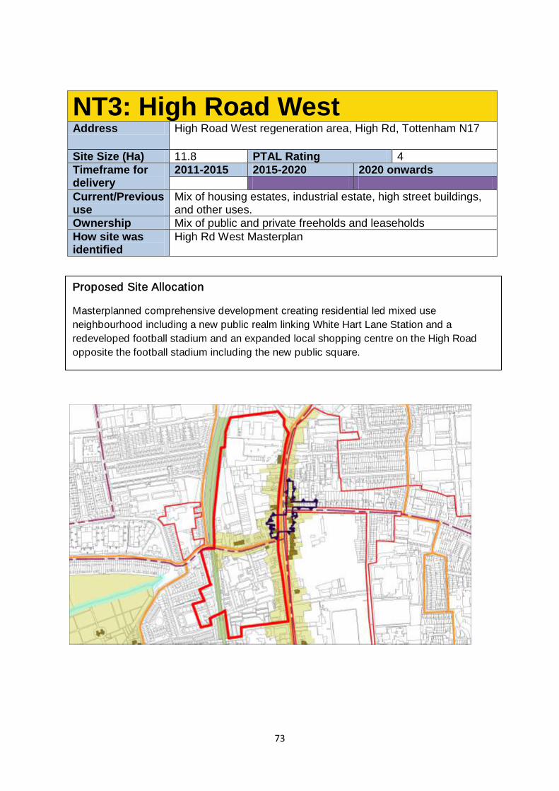
73
NT3: High Road West Address High Road West regeneration area, High Rd, Tottenham N17
Site Size (Ha) 11.8 PTAL Rating 4
Timeframe for delivery
2011-2015 2015-2020 2020 onwards
Current/Previous use
Mix of housing estates, industrial estate, high street buildings, and other uses.
Ownership Mix of public and private freeholds and leaseholds
How site was identified
High Rd West Masterplan
Proposed Site Allocation
Masterplanned comprehensive development creating residential led mixed use
neighbourhood including a new public realm linking White Hart Lane Station and a
redeveloped football stadium and an expanded local shopping centre on the High Road
opposite the football stadium including the new public square.
74
Site Requirements
Development will need to conform to the Masterplan Framework agreed by the
Council’s Cabinet in December 2014
Creation of a new residential neighbourhood through increased housing choice and
supply with minimum 1,400 new homes of a mix of tenure, type and unit size –
including the re-provision of existing social rented council homes.
A new connection between an enhanced White Hart Lane Station, the High Road
and the redeveloped football stadium will be created.
Creation of a new public square and a community park
New retail provision to enlarge the existing shopping parade, creating a new local
centre opposite the new stadium, including the new public square. This should
complement not compete with Bruce Grove District Centre.
Enhance the area as a destination through the creation of new leisure, sports and
cultural uses and provide seven day a week activity.
Increase the quality and quantity of community facilities and social infrastructure -
such as a new library, learning and education hub.
Improve east/west pedestrian and cycling connectivity with places such as the
Northumberland Park Estate and Lee Valley Park.
The site lies within the North Tottenham Conservation Area, and includes listed and
locally listed buildings. Development should preserve or enhance their appearance in
line with statutory requirements.
The regeneration of heritage assets should be considered where the benefits of
change and sympathetic development can enhance the overall viability and
attractiveness of future investment into the future of heritage buildings in the area.
Tall buildings should be placed along the railway corridor to create a legible tall
building spine. The buildings should use Brook House as a reference point and
descend in height as they approach the North Tottenham Conservation Area.
Increase and enhance the quality and quantity of community facilities and social
infrastructure , including:
o New Learning Centre including library and community centre
o New Health facility incorporating a Pharmacist.
o Provision of new Crèche.
o Provision of a range of leisure uses, e.g. cinema, bowling alley.
o Provision of new community sports provision
o Provision of a new and enhanced public open space including a large new
community park and high quality public square and a defined hierarchy of
interconnected pedestrian routes.
o Improved and enhanced entrance to White Hart Lane Station with step free
access
Development Guidelines
Produce a net increase in the amount and the quality of both public open space and
private amenity space within the area
75
To deliver transport improvements including a new, safe and attractive entrance to
White Hart Lane Station and improved rail connectivity.
Part of the site has a licensed waste capacity, and this will need to be reprovided
before development can commence in line with Draft Policy SA4.
Re-provision of employment floorspace lost as a result of the redevelopment as new
leisure, sports and cultural floorspace and as modern, flexible workspaces. This
could be achieved by workspaces with potential to connect to High Road retail
properties, and/or through the creation of workspace behind the High Road and the
railway arches.
The site is within a Critical Drainage Area and any proposals should refer to the Local
Flood Risk Management Strategy
This site is identified as being in an area with potential for being part of a
decentralised energy network. This may be as a decentralised energy hub, as a
customer, or requiring part of the site to provide an easement for the network.
Create a legible network of east-west streets that connect into the surrounding area,
existing lanes off the High Road, and open spaces.
Establish clear building frontages along the High Road and White Hart Lane to
complement the existing character of the Local Centre.
Incorporate a range of residential typologies which could include courtyard blocks of
varying heights and terraced housing.
In the part of the site facing the new stadium, development should respond to both
the existing High Road Character, and the greater heights and density of the new
stadium. This need to be carefully considered given the height differential between
the existing historic High Road uses and future Stadium development.
Larger commercial and leisure buildings should be located within close proximity to
the new public square linking the station to the stadium.
Due to the size of the site and scale of development envisaged, particular
consideration of the effect of the works on the nearby communities, including how
phasing will be delivered. This is referenced in the High Road West Masterplan
Framework.
The Moselle runs in a culvert underneath the site and will require consultation with
the Environmental Agency.
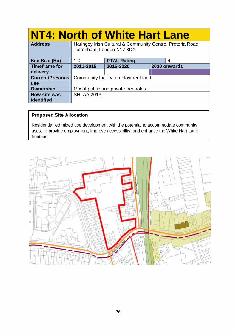
76
NT4: North of White Hart Lane Address Haringey Irish Cultural & Community Centre, Pretoria Road,
Tottenham, London N17 8DX
Site Size (Ha) 1.0 PTAL Rating 4
Timeframe for delivery
2011-2015 2015-2020 2020 onwards
Current/Previous use
Community facility, employment land
Ownership Mix of public and private freeholds
How site was identified
SHLAA 2013
Proposed Site Allocation
Residential led mixed use development with the potential to accommodate community
uses, re-provide employment, improve accessibility, and enhance the White Hart Lane
frontage.
77
Site Requirements
New east west route across the northern part of the site, linking White Hart Lane and
Pretoria Rd and enhancement to north/south access to improve permeability.
White Hart Lane retail premises should be enhanced through any development.
There should be no net loss in employment floorspace.
The existing community use should be re-provided before any redevelopment occurs.
Development Guidelines
The potential for a new north south route linking the new east-west route to White
Hart Lane at the south of the site should be considered.
Consideration of height of neighbouring buildings particularly adjacent to the
properties on Pretoria Rd. This site is identified as being in an area with potential for
being part of a decentralised energy network. This may be as a decentralised energy
hub, as a customer, or requiring part of the site to provide an easement for the
network.
Studies should be undertaken to understand what potential contamination there is on
this site prior to any development taking place. Mitigation of and improvement to local
air quality and noise pollution should be made on this site.
Development should seek to complement future development at High Road West.
Consideration of sensitive neighbouring uses such as the school
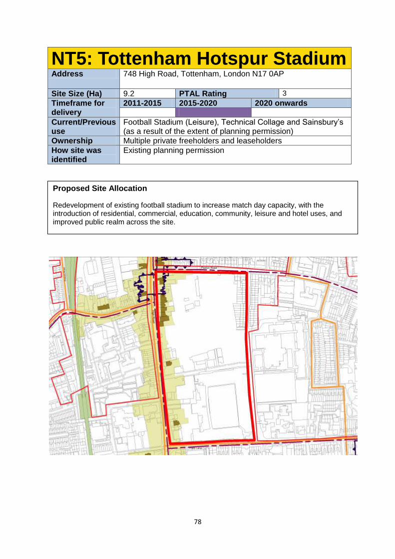
78
NT5: Tottenham Hotspur Stadium Address 748 High Road, Tottenham, London N17 0AP
Site Size (Ha) 9.2 PTAL Rating 3
Timeframe for delivery
2011-2015 2015-2020 2020 onwards
Current/Previous use
Football Stadium (Leisure), Technical Collage and Sainsbury’s (as a result of the extent of planning permission)
Ownership Multiple private freeholders and leaseholders
How site was identified
Existing planning permission
Proposed Site Allocation
Redevelopment of existing football stadium to increase match day capacity, with the introduction of residential, commercial, education, community, leisure and hotel uses, and improved public realm across the site.
79
Future Planning Requirements
Should any new planning applications come forward in the future the Council will seek:
Comprehensive development across the site;
High quality design, that responds positively to the Conservation Area and provides
an active frontage to the High Road and Park Lane, including considering
connectivity and scale of development;
Improved interface with sites to the east of the stadium to support regeneration
objectives for this area;
High quality publicly accessible spaces within the site on non-match days that
complements other public realm/spaces in the area and link with key existing and
future walking and cycling routes in the locality;
The leisure/ commercial uses should be complementary and not competing with the
uses proposed on the expanded Local Centre on the western side of the High Road
within the High Road West area.
To address the statutory presumption in favour of retaining heritage assets unless
justifiable;
An increase in residential on the site; and
Improved connectivity east-west across the site.
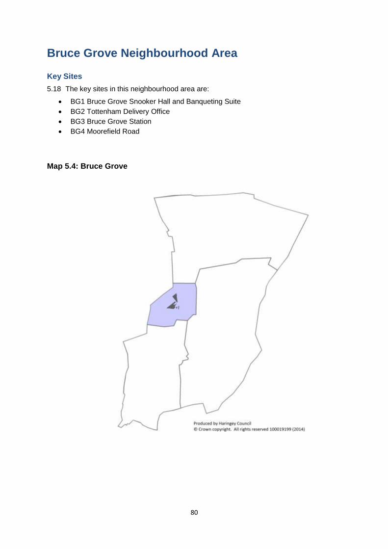
80
Bruce Grove Neighbourhood Area Key Sites
5.18 The key sites in this neighbourhood area are:
BG1 Bruce Grove Snooker Hall and Banqueting Suite
BG2 Tottenham Delivery Office
BG3 Bruce Grove Station
BG4 Moorefield Road
Map 5.4: Bruce Grove

81
The character of the neighbourhood area
5.19 In contrast to the other neighbourhood areas in Tottenham, Bruce Grove will
experience more moderate change based on enhancing its existing and distinctive retail,
heritage and residential assets.
5.20 The role of Bruce Grove as the retail heart of the High Road will be reinforced
through the enhancement of its conservation area characteristics and associated heritage
assets while the shrinkage of the town centre boundary along Bruce Grove will help to
intensify and focus retail provision along the High Road.
5.21 Bruce Grove’s primary retail frontage and core shopping area is along the High Road
while the town centre boundary (along with a significant secondary portion of retail frontage)
continues along the A10 (Bruce Grove). In general the commercial units in this part of the
town centre are of poor quality and dilute the commercial offer along the High Road which
should be the functional and physical axis to which the adjoining areas respond.
5.22 In general the quality of the streetscape within Bruce Grove is varied with some
Victorian period properties interspersed with more modern development. However, the
quality of the built environment is often detracted from by poor quality shop fronts and street
clutter from signage and street furniture. This situation is worsened by the high volumes of
traffic and the car dominated movement corridor of the High Road which does not promote
pedestrian movement. In general there are a number of transport infrastructure issues that
need to be addressed through proactive planning if the Council’s aim of facilitating a modal
shift from the car in this area is to be achieved. These issues include the quality of Bruce
Grove station which serves this area but is poorly located and inaccessible to people with
limited mobility, parking standards, poor east west movement to the Lee Valley Park and the
lack of safe routes for cycling.
Key neighbourhood area objectives
5.23 The key objectives for the neighbourhood area are:
Limited growth through complementary mixed use development on allocated sites
consistent with the existing scale and character of the Conservation Area and Town
Centre.
Consolidation and targeted reduction of primary retail frontages within the town
centre boundary along Bruce Grove to consolidate and intensify commercial
provision along the High Road, improvements to shop fronts and signage and
managing potential for “negative clusters” of betting shops and takeaways.
Improvement of Bruce Grove Station and forecourt through redevelopment and the
re-branding to London Overground network.
The promotion of high quality new restaurant/residential character area along Bruce
Grove which reflects the potential aspirations and clustering of two major residential
led development sites and capitalises on opportunities from the improvement of Brice
Grove Station.
The enhancement and legibility of Bruce Grove’s heritage assets which complement
the town centre’s character and as a place for smaller floorplate commercial units.
82
Public realm improvements and transport projects which facilitate improved
pedestrian circulation and movement including improvements to permeability.
The enhancement and improvement of way finding and legibility of the area’s
heritage assets such as Bruce Castle.
Urban realm improvements:
5.24 The urban realm improvements for the neighbourhood area are:
Improved/widened footways along Bruce Grove to improve movement and bus
passenger waiting facilities
Redevelopment and environmental improvements to Bruce Grove Station Forecourt
Targeted streetscape and environmental improvements including an enhanced urban
realm between Seven Sisters and Tottenham Green and recognition/redesign of the
street to encourage use of the proposed “Green Link” to Tottenham Hale and the Lee
Valley Regional Park.
Infrastructure
5.25 The infrastructure projects for the neighbourhood area are:
Investment in Bruce Grove Station will take place as part of the transfer of the station
assets to TfL and introduction of London Overground services in 2015.
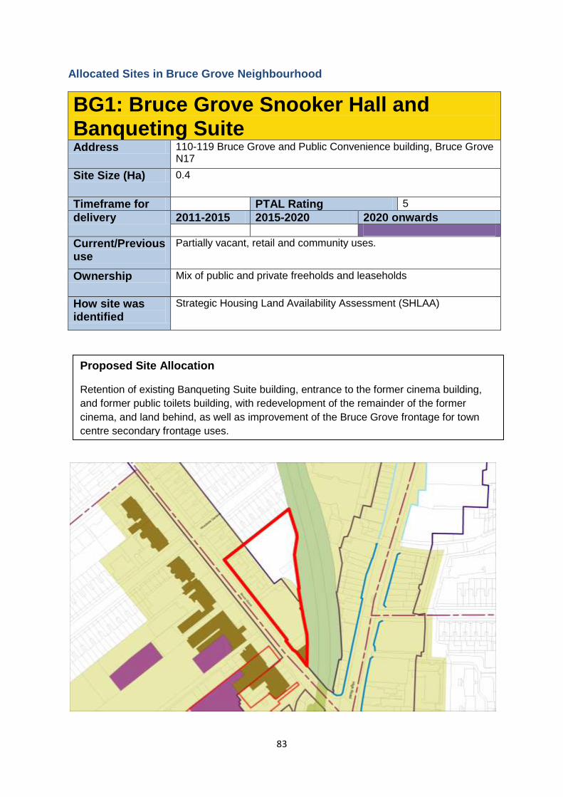
83
Allocated Sites in Bruce Grove Neighbourhood
BG1: Bruce Grove Snooker Hall and Banqueting Suite Address 110-119 Bruce Grove and Public Convenience building, Bruce Grove
N17
Site Size (Ha) 0.4
Timeframe for PTAL Rating 5
delivery 2011-2015 2015-2020 2020 onwards
Current/Previous use
Partially vacant, retail and community uses.
Ownership Mix of public and private freeholds and leaseholds
How site was identified
Strategic Housing Land Availability Assessment (SHLAA)
Proposed Site Allocation
Retention of existing Banqueting Suite building, entrance to the former cinema building,
and former public toilets building, with redevelopment of the remainder of the former
cinema, and land behind, as well as improvement of the Bruce Grove frontage for town
centre secondary frontage uses.
84
Site Requirements
The public toilets, entrance to the former cinema, and the Banqueting Suite frontage
will be retained and brought back into active use.
An alternative use for the former public toilets building will be found, with
improvements to the surrounding public realm.
Retention of the secondary town centre frontage on this site, and creation of new
frontage on the former cinema site.
The site lies within the Bruce Grove Conservation Area and development should
preserve or enhance its appearance as per the statutory requirements.
Development Guidelines
A small new urban square could be considered on the former cinema site.
A sensitive additional storey extension to the Banqueting Suite will be acceptable
where it can be demonstrated that it enhances the setting and character of the
building, and the wider Conservation Area.
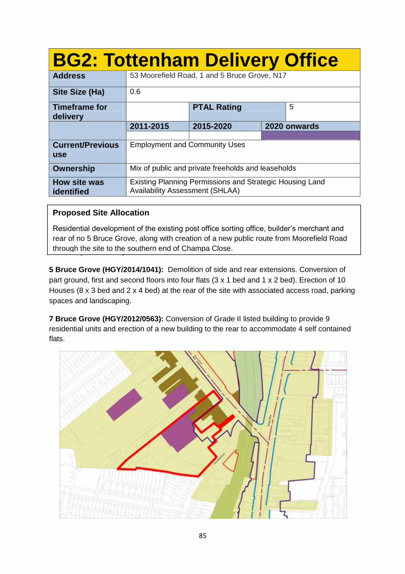
85
BG2: Tottenham Delivery Office Address 53 Moorefield Road, 1 and 5 Bruce Grove, N17
Site Size (Ha) 0.6
Timeframe for delivery
PTAL Rating 5
2011-2015 2015-2020 2020 onwards
Current/Previous use
Employment and Community Uses
Ownership Mix of public and private freeholds and leaseholds
How site was identified
Existing Planning Permissions and Strategic Housing Land Availability Assessment (SHLAA)
Existing Planning Permissions
5 Bruce Grove (HGY/2014/1041): Demolition of side and rear extensions. Conversion of
part ground, first and second floors into four flats (3 x 1 bed and 1 x 2 bed). Erection of 10
Houses (8 x 3 bed and 2 x 4 bed) at the rear of the site with associated access road, parking
spaces and landscaping.
7 Bruce Grove (HGY/2012/0563): Conversion of Grade II listed building to provide 9
residential units and erection of a new building to the rear to accommodate 4 self contained
flats.
Proposed Site Allocation
Residential development of the existing post office sorting office, builder’s merchant and
rear of no 5 Bruce Grove, along with creation of a new public route from Moorefield Road
through the site to the southern end of Champa Close.
86
Site Requirements
Development should seek to enhance the setting of all heritage assets along Bruce
Grove, especially those fronting the site.
Development proposals for the site should include a new vehicular access road from
Moorefield Road (on the eastern edge of the site). This should also provide an
access to the permitted residential development to the rear of No 5, currently
proposed to be accessed by a narrow route off Bruce Grove. This could then be
converted to a pedestrian and cycling route only, protecting the listed buildings and
enhancing their setting.
The new route through the site should allow the possibility of a connection to the
southern end of Champa Close to the west of the site.
The site lies within the Bruce Grove Conservation Area and development should
preserve or enhance it’s the character of the historic environment, in line with
relevant statutory requirements.
Contribution towards improvement of public realm along Bruce Grove, especially No.
1-5 should be sought.
Development Guidelines
Development should positively respond to the adjacent heritage assets in terms of
scale , form and massing
A maximum of four storeys in height would be considered with three storeys or lower
closest to the listed buildings and the terraces to the south.
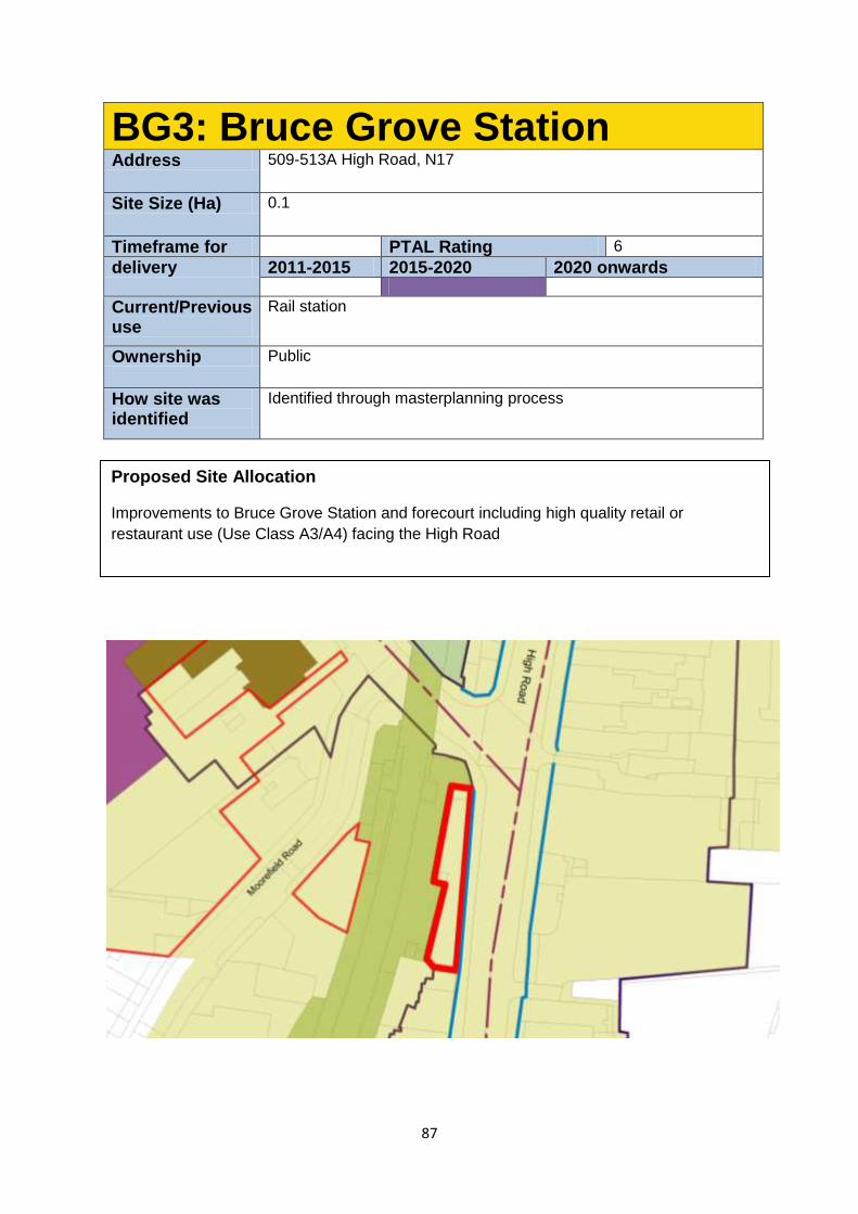
87
BG3: Bruce Grove Station Address 509-513A High Road, N17
Site Size (Ha) 0.1
Timeframe for PTAL Rating 6
delivery 2011-2015 2015-2020 2020 onwards
Current/Previous use
Rail station
Ownership Public
How site was identified
Identified through masterplanning process
Proposed Site Allocation
Improvements to Bruce Grove Station and forecourt including high quality retail or
restaurant use (Use Class A3/A4) facing the High Road
88
Site Requirements
Improvements to the locally listed station building and public realm outside of the
station.
An innovative single storey extension on the existing forecourt, linked to the arched
openings within the station, for retail or restaurant use.
Space for a landscaped court at the northern end of the existing forecourt, with a
potential that it could in future be connected to the station and used as an outdoor
area to a restaurant unit.
Widening the pavement to the High Road.
An active, lively frontage onto the High Road that complements the existing station.
Between 1 and 3 retail/restaurant units
The site lies within the Bruce Grove Conservation Area and development should
preserve or enhance its appearance as per the statutory requirements.
Development Guidelines
Should respond to both the existing High Road shop frontage as well as complement
the existing locally listed Bruce Grove Station.
Form & massing of the design should enhance the character & appearance of the
Bruce Grove Conservation Area and surrounding heritage assets.
Should respond to the TfL proposals for the public realm in the High Road and Bruce
Grove, which form the A10 and are part of the Strategic Route Network.
Servicing and refuse storage to the new retail/restaurant unit(s) to be resolved.
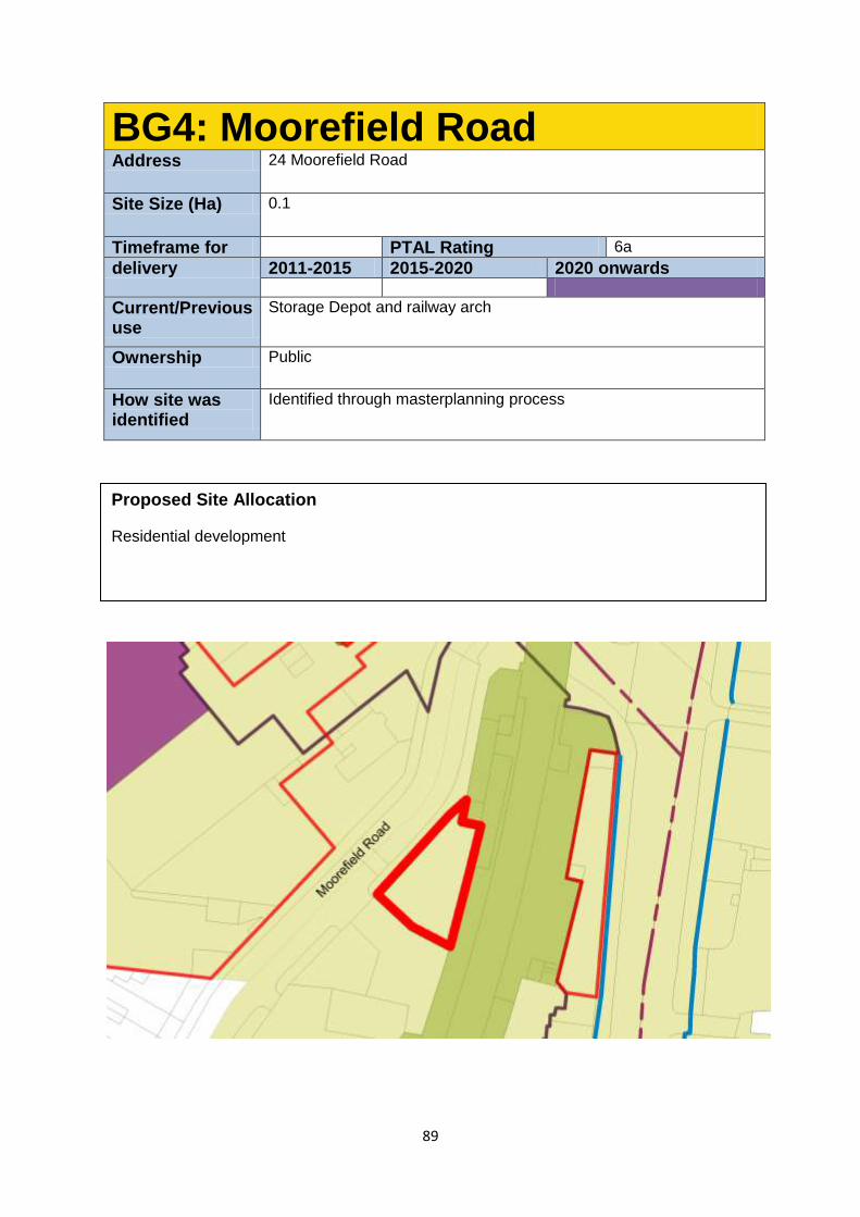
89
BG4: Moorefield Road Address 24 Moorefield Road
Site Size (Ha) 0.1
Timeframe for PTAL Rating 6a
delivery 2011-2015 2015-2020 2020 onwards
Current/Previous use
Storage Depot and railway arch
Ownership Public
How site was identified
Identified through masterplanning process
Proposed Site Allocation
Residential development
90
Site Requirements
The site lies within the Bruce Grove Conservation Area and is also adjacent to listed
and locally listed buildings. Development should preserve or enhance heritage assets
and the wider historic environment.
Development should include rationalisation and improvement of the public realm
along Moorefield Road, especially the pavement beside the stairs to the station
platform.
Development Guidelines
Development should positively respond to adjacent heritage assets in terms of scale,
form and massing
Consideration should be given to the site’s proximity to the railway line, especially
with regards to residential use, and due consultation should be carried out with
Network Rail.
The development should not be visible from the High Road over and above the
station. A maximum of four storeys is envisaged.
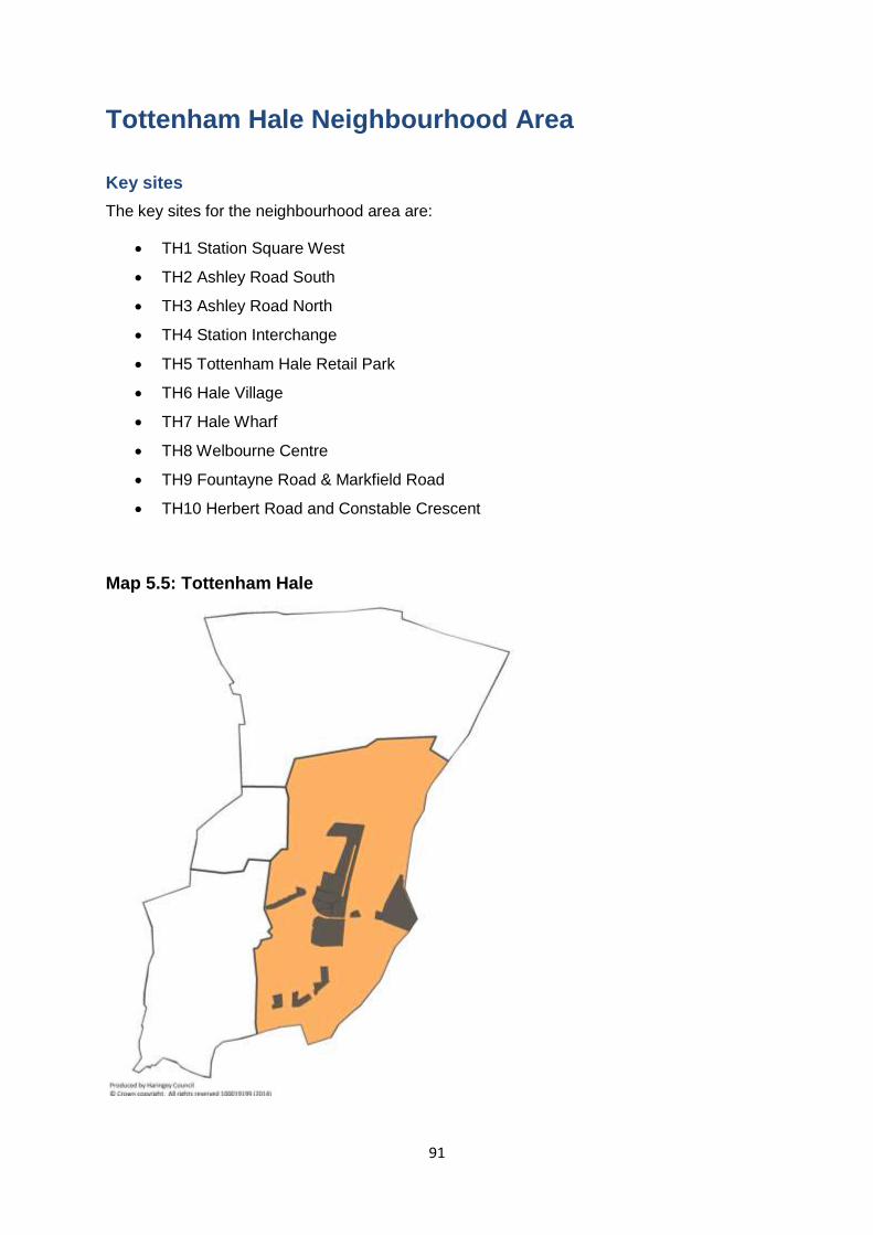
91
Tottenham Hale Neighbourhood Area
Key sites
The key sites for the neighbourhood area are:
TH1 Station Square West
TH2 Ashley Road South
TH3 Ashley Road North
TH4 Station Interchange
TH5 Tottenham Hale Retail Park
TH6 Hale Village
TH7 Hale Wharf
TH8 Welbourne Centre
TH9 Fountayne Road & Markfield Road
TH10 Herbert Road and Constable Crescent
Map 5.5: Tottenham Hale
92
The Character of the Neighbourhood Area
5.26 Located to the far east of the borough, Tottenham Hale’s eastern boundary edges
the River Lee. The area can be classified as a diverse, inner London urban area located
within a rich natural physical landscape with large areas such as the Lee Valley Park and the
Walthamstow Wetlands towards the east dedicated to open space, marshes and allotments.
At present accessibility to these significant assets is poor and the area feels cut off from this
neighbourhood area.
5.27 While transport links and infrastructure are a major advantage of the area with
excellent public transport and a high PTAL rating around Tottenham Hale Station
accessibility to the station is poor with a fragmented street pattern and a number of housing
estates limiting through movement. At present Tottenham Hale Station act’s as an anchor
point for the area and has some of the highest levels of public transport accessibility in the
Upper Lee Valley with a significant interchange between local buses, the Victoria Line and
National Rail trains into London Liverpool Street and Stratford and north to Stansted,
Cheshunt and Cambridge.
5.28 The area’s lack of permeability and severance is exacerbated by the car dominated
main roads, the railway line, Ferry Lane and a traffic gyratory. As a result, Tottenham Hale
lacks a cohesive sense of place and has a fragmented urban structure without a discernible
focal point for community activity.
5.29 While Tottenham Hale lacks a town centre designation, a major commercial focal
point in the area is the Tottenham Hale Retail Park which is a purpose built complex
providing large format floorspace typically for the sale of large goods.
5.30 Haringey’s emerging 2015 Open Space and Biodiversity Study indicates that there is
an existing open space deficiency in the area when measured against the eight typologies.
Whilst the Lee Valley Regional Park (LVRP) is classed as strategic open space and in this
typology provision is adequate, access to smaller open spaces such as pocket parks within
the Tottenham Hale area is deficient.
5.31 Tottenham Hale’s employment areas including Millmead and Lockwood Industrial
Estates to the north of Hale Village and the South Tottenham Employment Area (Fountayne
Road and Markfield Industrial Estates) to the south of the Retail Park are a microcosm of
Tottenham’s diversity, with a rich mix of business types, building stock and demographics
contained within a relatively small geographic area. These areas are currently performing
well with low vacancy rates. In some areas around the Rangemoor Road Employment Area
and the South Tottenham Employment Area there is a nascent creative sector but with a
number of unauthorised live/work issues.
5.32 The neighbourhood area is one where targeted investment can best accelerate the
delivery of substantial volumes of new homes and jobs. Investment in transport infrastructure
is already happening, however to create a community with 5,000 homes and 4,000 jobs,
there is a need for early infrastructure planning (working with the utility providers) and
significant place-shaping investment to ensure that we are creating a place that can serve as
a home, a place of work and a destination in its own right.
5.33 Through these interventions including the construction of a Green Link, Tottenham
Hale will be a destination where people can easily access the open spaces and waterways
of the Lee Valley Park. Removing the barriers to the Lee Valley Park and creating a
93
sustainable network of cycle and pedestrian routes was a key objective of the Upper Lee
Valley Opportunity Area Planning Framework and is now reflected in the aims of the Area
Action Plan.
5.34 Tottenham Hale will provide a range of housing with the emphasis being on the more
affordable end of the spectrum. The delivery of 1 and 2 bed units will be prioritised in
keeping with Tottenham Hale’s urban character. High quality family housing will be
concentrated on sites that best accommodate this use through access to open space or
relate to increased social infrastructure provision. The housing approach in this area also
recognises the opportunity to introduce a quality, managed institutional private rented sector
at scale in the heart of the new district centre.
5.35 Employment land in this area will be retained and intensified in order to create a
greater job density, whilst recognising that a limited amount of employment land is
appropriate for more mixed use development in order to promote strategic regeneration
initiatives. The successful employment elements of the different areas will be promoted while
in the South Tottenham employment area, there is the opportunity to introduce limited
warehouse living to those working in the area’s nascent creative sector. Millmead and
Lockwood industrial estates will continue to be protected. The 4,000 jobs delivered in
Tottenham Hale will be from the core of the district centre, intensifying existing retail offer,
some office and higher education institutions and small scale creative employment in
Warehouse Living accommodation in the relevant designated areas.
Key Neighbourhood Area Objectives
5.36 The key objectives for this neighbourhood area are:
A distinctive new mixed use district centre incorporating higher density development
will be created at Tottenham Hale in accordance with the Tottenham Hale District
Centre Framework
The delivery of 5,000 new homes through a portfolio approach to housing that offers
a wider range of choices across the housing spectrum.
The creation of 4,000 new jobs in a wide range of sectors including retail office,
leisure and enterprise and craft related employment spaces, including new and
improved/enhanced industrial workspace in the established industrial areas and the
intensification and protection of B class use on employment land
The Council will take a portfolio approach to housing, using the delivery tools at its
disposal to make flexible arrangements for certain uses in key areas of Tottenham
Hale.
An enhanced public realm that prioritises pedestrian circulation and linkages to the
Lee Valley Regional Park, including through a new Green Link.
The designation of sites for significantly improved community facilities including a
new healthcare facility, and a new all form entry school (Harris Academy) and a
education hub which may include a multi institution higher education campus
Development within the wider Tottenham Hale area will be required to respond to the
aspiration for a distinctive new walkable “place/destination.”
Given the fragmented site ownership, and the aspirations for a new, coherent centre
with distinct but harmonious urban form, development on allocated sites shall be in
accordance with coordinated masterplans.
94
The Council and its partners will support measures to promote comprehensive
delivery on key strategic sites, including undertaking site assembly
Along the River Lee encourage its active usage through the provision of canal boat
mooring facilities.
Relocation of the Ashley Road depot facilities.
Urban realm improvements
5.37 The urban realm improvements for the neighbourhood area are:
A Tottenham Hale Green Link bisecting Ashley Road and leading to the Lee Valley
Regional Park which encourages walking and movement and improve sight lines to
the Lee Valley Regional Park
New north/south route connecting Ashley Road to the Retail Park
A series of interconnected, permeable, safe courtyards on development sites
between Fountayne Road and Ferry Lane
At the Retail Park site, the incorporation of a public square which acts as a focal point
for the community
Along Ashley Road, a public realm and road surface that prioritises the pedestrian
movement, including the introduction of a shared surface, pavement widening and
dropped kerbs,
Design features to reinforce the River Lee’s role for amenity and leisure, including a
riverside route at Hale Wharf, paddocks and a canal towpath,
Improvement with Ferry Lane and Forrest Road - Wetlands Access Centre –
Blackhorse Lane – joint investment opportunities
Infrastructure
5.38 The infrastructure projects for the Neighbourhood Area are:
Healthcare facility of 1500 -2000sqm in size to accommodate in the short to medium
term, existing and increased demand as the population grows.
Decentralised energy hub, forming part of a wider decentralised energy network
All through school - Harris Academy and multi use sports area
Measure to protect and enhance the Paddocks
New bridges crossing the River Lee
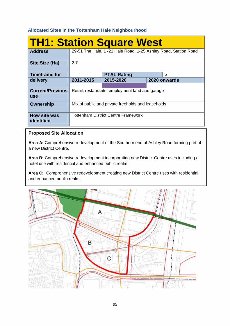
95
Allocated Sites in the Tottenham Hale Neighbourhood
TH1: Station Square West Address 29-51 The Hale, 1 -21 Hale Road, 1-25 Ashley Road, Station Road
Site Size (Ha) 2.7
Timeframe for PTAL Rating 5
delivery 2011-2015 2015-2020 2020 onwards
Current/Previous use
Retail, restaurants, employment land and garage
Ownership Mix of public and private freeholds and leaseholds
How site was identified
Tottenham District Centre Framework
Proposed Site Allocation
Area A: Comprehensive redevelopment of the Southern end of Ashley Road forming part of
a new District Centre.
Area B: Comprehensive redevelopment incorporating new District Centre uses including a
hotel use with residential and enhanced public realm.
Area C: Comprehensive redevelopment creating new District Centre uses with residential
and enhanced public realm.
:
96
Site Requirements: Area A
This site (Area A) will be comprehensively redeveloped, and must accord with the
emerging masterplan for Tottenham Hale District Centre, including areas B & C of
this policy.
This site (Area A) will be given a Designated Employment Area: Regeneration Area
status to recognize the contribution to the local economy that this site can make. It is
anticipated that the redevelopment of this site will not create a net reduction in
employment floor space and will result in a substantial increase in jobs.
A Green link will be created along the northern edge of the site, running between
Tottenham High Rd and the Lee Valley.
Ashley Rd will be enhanced, with an enhanced crossing of Hale Rd/ Watermead Way
being created.
Town Centre uses will be required on all frontages to Ashley Rd. Active frontage,
potentially employment, should be provided on the Hale Rd/Watermead Way
frontage.
There should be a greater proportion of employment use provided to the east of
Ashley Rd, with as a minimum ground floor employment, and more if viable.
Heights should generally be highest along the Hale Rd/Watermead Way frontage.
Development should take the form of perimeter blocks with the potential for tall point
block buildings of 11+ storeys at strategic points along the southern edge of this site.
Ashley Road should provide a pedestrian and cycle friendly link through the District
Centre including linking the Station Square and the Green Link.
Proposals should consider the potential opportunities presented by retaining (and
refurbishing) or demolishing the existing Victorian terraces on Hale Road.
Development Guidelines: Area A
The interface with Down Lane Park should be treated with care.
Development should form a consistent building line, and complement Berol House
and the Eagle Pencil Works to the north.
Ashley Road should be retained as a key movement spine
The Victoria Line runs in a shallow tunnel beneath part of this site.
This site is in an area of flood risk, and a Flood Risk Assessment should accompany
any planning permission.
Care will be required on south facing frontages to limit heights to avoid
overshadowing of block courtyards.
Studies should be undertaken to understand what potential contamination there is on
this site prior to any development taking place. Mitigation of and improvement to local
air quality and noise pollution should be made on this site.
Parking should be minimised on this site due to the excellent local public transport
connections.
This site is identified as being in an area with potential for being part of a
decentralized energy network. This may be as a decentralised energy hub, as a
customer, or requiring part of the site to provide an easement for the network.
Each development will be expected to contribute to a comprehensive public realm
strategy, through the use of pooled S106 contributions.
97
Site Requirements: Area B
Permission has already been granted for a part of this site, and developments should
complement this permission. (HGY/2014/0498: A 96 bed hotel (Class C1) including a
146sqm restaurant/bar, 3 disabled car parking spaces and 6 dedicated cycle spaces
This site (Area B) will be comprehensively redeveloped, and must accord with the
emerging Tottenham Hale District Centre Framework, including areas A & C of this
policy.
Ashley Road will be extended through this site as the key public and movement spine
passing through the Centre.
Ground floor uses on this site will be town centre uses, playing a key role in
establishing Tottenham Hale as a District Centre.
Existing employment floor space will be reprovided on this site.
Development will generally be 3-10 storeys as a perimeter block. Taller elements
marking the key corners of the site will be considered, possibly of 11+ storeys.
However, the site cannot accommodate tall buildings on all corners and therefore a
comprehensive proposal will be necessary for Area B.
Development Guidelines: Area B
The Victoria Line runs in a shallow tunnel beneath part of this site.
This site is in an area of flood risk, and a Flood Risk Assessment should accompany
any planning permission.
Development should strengthen the role of Station Road
Station Rd, and potentially the extended Ashley Rd will provide service access for the
buildings on this site.
Studies should be undertaken to understand what potential contamination there is on
this site prior to any development taking place. Mitigation of and improvement to local
air quality and noise pollution should be made on this site.
Parking should be minimised on this site due to the excellent local public transport
connections.
This site is identified as being in an area with potential for being part of a
decentralized energy network. This may be as a decentralised energy hub, as a
customer, or requiring part of the site to provide an easement for the network.
Care will be required on south facing frontages to limit heights to avoid
overshadowing of block courtyards.
Each development will be expected to contribute to a comprehensive public realm
strategy, through the use of pooled S106 contributions.
Site Requirements: Area C
This site (Area C) will be comprehensively redeveloped, and must accord with the
emerging Tottenham Hale District Centre Framework, including areas B & A of this
policy.
98
Ashley Road will be extended through this site as the key public and movement spine
passing through the Centre.
Development of the part of the site to the west of Ashley Rd will generally be 3-10
storeys as a perimeter block. Taller elements marking the key corners of the site will
be considered, possibly of 11+ storeys.
Development of the part of the site to the east of Ashley Rd will reinforce the Ashley
Rd route and provide enclosure for the bus station and the District Centre. This could
be 7-10 storeys with the potential for a higher point block building of exceptional
quality at the southern end rising up to 15 storeys.
Development Guidelines: Area C
Studies should be undertaken to understand what potential contamination there is on
this site prior to any development taking place. Mitigation of and improvement to local
air quality and noise pollution should be made on this site.
Station Rd, and potentially the extended Ashley Rd will provide service access for the
buildings on this site.
Parking should be minimised on this site due to the excellent local public transport
connections.
Each development will be expected to contribute to a comprehensive public realm
strategy, through the use of pooled S106 contributions.
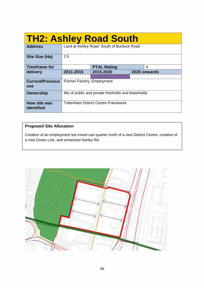
99
TH2: Ashley Road South Address Land at Ashley Road South of Burdock Road
Site Size (Ha) 2.5
Timeframe for PTAL Rating 4
delivery 2011-2015 2015-2020 2020 onwards
Current/Previous use
Former Factory, Employment.
Ownership Mix of public and private freeholds and leaseholds
How site was identified
Tottenham District Centre Framework
Proposed Site Allocation
Creation of an employment led mixed use quarter north of a new District Centre, creation of
a new Green Link, and enhanced Ashley Rd.
100
Site Requirements
This site will be given a Designated Employment Area: Regeneration Area status to
recognize the contribution to the local economy that this site can make. It is
anticipated that the redevelopment of this site will not create a net reduction in
employment floor space. Residential development will be acceptable for the purpose
of cross subsidising the reprovision of employment floor space.
Ashley Road will be retained as the key public and movement spine. Employment
uses will be expected on both sides of the Ashley Road frontage at ground floor level,
and above wherever viable.
Good quality buildings, including, but not limited to Berol House and 16 Ashley Rd
should be retained and adapted for flexible, and affordable employment use. Further
employment will be supported, with cross subsidization from residential.
A Green link will be created along the southern edge of the site, running between
Tottenham High Rd and the Lee Valley.
Potential for new a education hub on the eastern part of the site, fronting Watermead.
Development Guidelines
The most suitable use on the Watermead Way frontage is considered to be
employment which may include an educational use
Development should utilise the amenity, and respect the character of Down Lane
Park to the west and north-west. This should include limiting blank facades fronting
onto the park.
The existing industrial character on Ashley Rd should be maintained and enhanced,
encouraging new businesses to come into the area.
Ashley Road itself should be pedestrian and cycle friendly, and provide a legible
route to the new District Centre to the south. Measures to improve the activity onto
Ashley Rd will be supported on this site, including the orientation of sites to open
onto Ashley Rd with frequent front doors.
Studies should be undertaken to understand what potential contamination there is on
this site prior to any development taking place. Mitigation of and improvement to local
air quality and noise pollution should be made on this site.
Parking should be minimised on this site due to the excellent local public transport
connections.
This site is identified as being in an area with potential for being part of a
decentralized energy network. This may be as a decentralised energy hub, as a
customer, or requiring part of the site to provide an easement for the network.
Additional permeability through the addition of a pedestrian and local access route
passing east-west through the site could be considered.
Studies should be undertaken to understand what potential contamination there is on
this site prior to any development taking place. Mitigation of and improvement to local
air quality and noise pollution should be made on this site.
Assess the implication of any potential flood risk
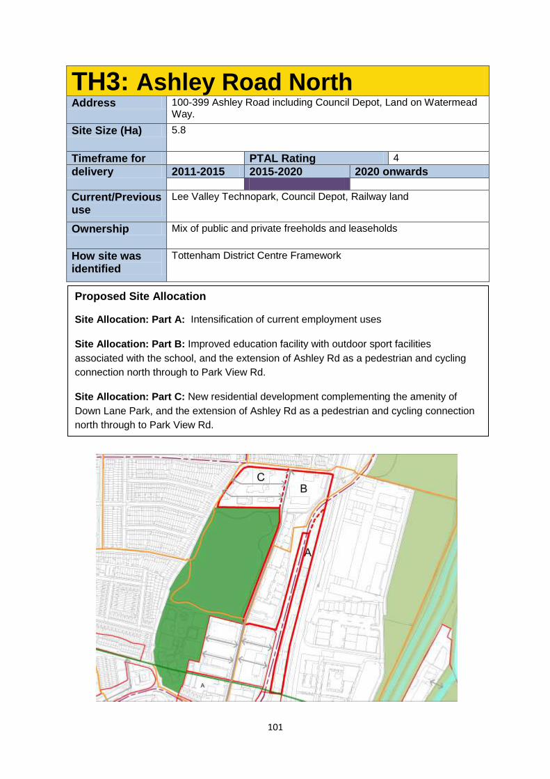
101
TH3: Ashley Road North Address 100-399 Ashley Road including Council Depot, Land on Watermead
Way.
Site Size (Ha) 5.8
Timeframe for PTAL Rating 4
delivery 2011-2015 2015-2020 2020 onwards
Current/Previous use
Lee Valley Technopark, Council Depot, Railway land
Ownership Mix of public and private freeholds and leaseholds
How site was identified
Tottenham District Centre Framework
Proposed Site Allocation
Site Allocation: Part A: Intensification of current employment uses
Site Allocation: Part B: Improved education facility with outdoor sport facilities
associated with the school, and the extension of Ashley Rd as a pedestrian and cycling
connection north through to Park View Rd.
Site Allocation: Part C: New residential development complementing the amenity of
Down Lane Park, and the extension of Ashley Rd as a pedestrian and cycling connection
north through to Park View Rd.
102
Site Requirements: Area A
This site will remain as an employment site. It is anticipated that the redevelopment
of this site could result in a more intensified employment use and will not create a net
reduction in employment floor space.
Site Requirements: Area B
A new route extending the line of Ashley Rd north between Areas A and B of this
policy will be created, improving access into the Lee Valley Regional Park.
Vehicular access to the site will be from Ashley Rd/Burdock Rd or Park View Rd, but
there will not be a link from one to the other.
The south-east corner of this site should be the tallest point. Heights should be
reduced towards the north, and where the site faces Down Lane Park.
Site Requirements: Area C
A new route extending the line of Ashley Rd north between Areas A and B of this
policy will be created, improving access into the Lee Valley Regional Park.
Residential will be the primary use on this site.
Vehicular access to the site will be from Ashley Rd or Park View Rd, but there will not
be a link from one to the other.
The sites existing licensed waste capacity will be replaced prior to any
redevelopment taking place.
Design Guidelines: Area A
The southern edge of this site should create a positive interface with the proposed
Green Link.
Design Guidelines: Area B
Any residential development above the school should avoid overlooking of the
school.
Explore the potential for the use of part of the games areas of Down Lane Park
during school hours as a way of providing the school with good quality sports
facilities should be explored.
Paths connecting Watermead Way, Ashley Rd and Park View Rd should be
rationalised, and made safer and more welcoming to resolve local safety concerns,
and make the routes more direct, and thus better used.
Studies should be undertaken to understand what potential contamination there is on
this site prior to any development taking place. Mitigation of and improvement to local
air quality and noise pollution should be made on this site.
Design Guidelines: Area C
Heights will be restricted to the north and west to respect the amenity of neighbouring
terraced housing.

103
Heights could step up to 6 storeys in the east of the site.
The mature trees on the site, and in the park should be protected and incorporated
into any future design
The crossroads in the north west corner of the site where Park View Rd, Dowsett Rd
and Havelock Rd converge should be made a focal point as a gateway from the
residential hinterland of Tottenham towards the emerging Tottenham Hale District
Centre.
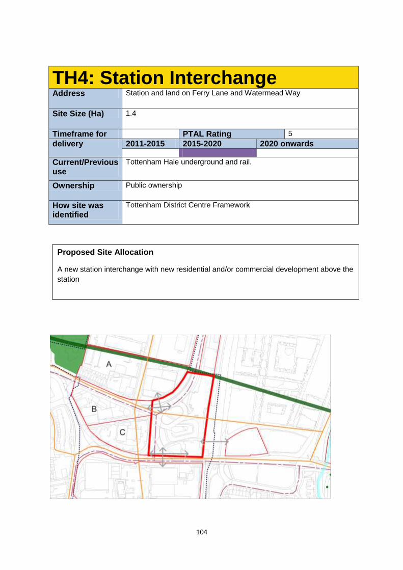
104
TH4: Station Interchange Address Station and land on Ferry Lane and Watermead Way
Site Size (Ha) 1.4
Timeframe for PTAL Rating 5
delivery 2011-2015 2015-2020 2020 onwards
Current/Previous use
Tottenham Hale underground and rail.
Ownership Public ownership
How site was identified
Tottenham District Centre Framework
Proposed Site Allocation
A new station interchange with new residential and/or commercial development above the
station
105
Current Planning Permission (HGY/2013/2610)
Works to extend the operational railway station at Tottenham Hale. Creation of a new station
entrance, enlarged station concourse, improved access and a new access for all bridge.
Extension of the existing footbridge to form a new station entrance from Hale Village,
relocation of the station vent shaft and provision of a new station control facility, provision of
retail units and associated works. Development involves the closure of the existing Ferry
Lane subway
When a new planning permission comes forward subsequently
This site will form the new Tottenham Hale District Centre.
Development of this site could be up to 11 storeys
Provision has been made within the approved scheme (HGY/2013/2610) for over-
station residential development.
The Station Interchange will be a new high quality point of arrival, departure and
interchange.
The new public square will become the heart of the new station
potential to introduce a new pedestrian link beneath the road to the retail park with
the introduction of Crossrail
Creation of a physical link between the Station and the Green Link.
Studies should be undertaken to understand what potential contamination there is on
this site prior to any development taking place. Mitigation of and improvement to local
air quality and noise pollution should be made on this site.
Parking should be minimised on this site due to the excellent local public transport
connections.
This site is identified as being in an area with potential for being part of a
decentralized energy network. This may be as a decentralised energy hub, as a
customer, or requiring part of the site to provide an easement for the network.
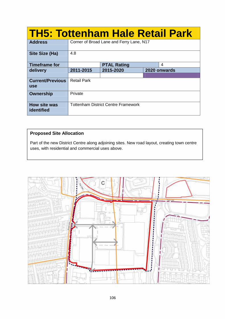
106
TH5: Tottenham Hale Retail Park Address Corner of Broad Lane and Ferry Lane, N17
Site Size (Ha) 4.8
Timeframe for PTAL Rating 4
delivery 2011-2015 2015-2020 2020 onwards
Current/Previous use
Retail Park
Ownership Private
How site was identified
Tottenham District Centre Framework
Proposed Site Allocation
Part of the new District Centre along adjoining sites. New road layout, creating town centre
uses, with residential and commercial uses above.
107
Site Requirements
Any Council-approved District Centre Framework will be prepared for this site, and
development should be in accordance with it.
Ashley Rd will be extended through this site creating a town centre spine linking the
station area to the employment district to the south. The alignment of Fountayne Rd
to the south should form a parallel north south street when extended into this site.
Ground and potentially parts of first floors will be town centre uses. Residential use
will be permitted above.
Development of the eastern side of the site will not proceed until the requirements of
Crossrail 2 have been established. Heights will generally increase from south and
west to north and east, with the potential for taller point block buildings of 11+ storeys
marking key landmark points. The remaining development should be 3-8 storeys,
with no higher than 5 storeys along Broad Lane.
Design Guidelines
New streets created within the site will have a town centre typology with active
frontages at ground floor level and provision for servicing from the street.
New streets should also connect with developments likely to come forward to the
south of the site, notably Fountayne Rd. If possible east - west streets should align
with roads to the west of Broad Lane, notably Tynemouth Road.
Developing the site in phases will ensure the site is better integrated to the
surrounding area.
Introducing a new pedestrian link between this site and the station
Studies should be undertaken to understand what potential contamination there is on
this site prior to any development taking place. Mitigation of and improvement to local
air quality and noise pollution should be made on this site.
Parking should be minimised on this site due to the excellent local public transport
connections.
This site is identified as being in an area with potential for being part of a
decentralized energy network. This may be as a decentralised energy hub, as a
customer, or requiring part of the site to provide an easement for the network.
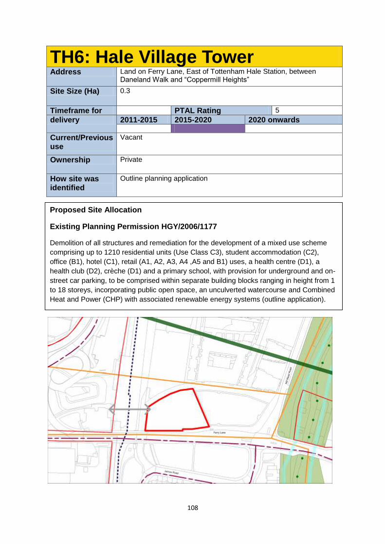
108
TH6: Hale Village Tower Address Land on Ferry Lane, East of Tottenham Hale Station, between
Daneland Walk and “Coppermill Heights”
Site Size (Ha) 0.3
Timeframe for PTAL Rating 5
delivery 2011-2015 2015-2020 2020 onwards
Current/Previous use
Vacant
Ownership Private
How site was identified
Outline planning application
Proposed Site Allocation
Existing Planning Permission HGY/2006/1177
Demolition of all structures and remediation for the development of a mixed use scheme
comprising up to 1210 residential units (Use Class C3), student accommodation (C2),
office (B1), hotel (C1), retail (A1, A2, A3, A4 ,A5 and B1) uses, a health centre (D1), a
health club (D2), crèche (D1) and a primary school, with provision for underground and on-
street car parking, to be comprised within separate building blocks ranging in height from 1
to 18 storeys, incorporating public open space, an unculverted watercourse and Combined
Heat and Power (CHP) with associated renewable energy systems (outline application).
109
Site requirements
The outline planning permission identifies the site as the location for a tall building
(18 storeys).
Ground floor uses should contribute to the vitality of the existing urban streets within
the site and engage with the Ferry Lane frontage.
Development will need to provide for limited car parking to serve accessible
residential units, taking account of the usage of existing spaces in Hale village
Proposals for development that provides additional units beyond outline pp extent will
need to provide details of infrastructure impacts arising from additional
units/occupants.
Development Guidelines
Proposals for a tall building over 18 stories will require justification and will need to be
of exceptional architectural quality in accordance with the DMDPD tall building policy.
Design should respect and respond to the wider site and should meet the
requirements of the relevant DM policy on tall buildings. The approved scheme
(OSD@Tottenham Hale Station) includes a bridge landing in the urban realm outside
this site, and any design on this site should respond positively to this.
Any development should demonstrate how it has an acceptable relationship with
neighbouring land uses by virtue of microclimate and daylight/sunlight.
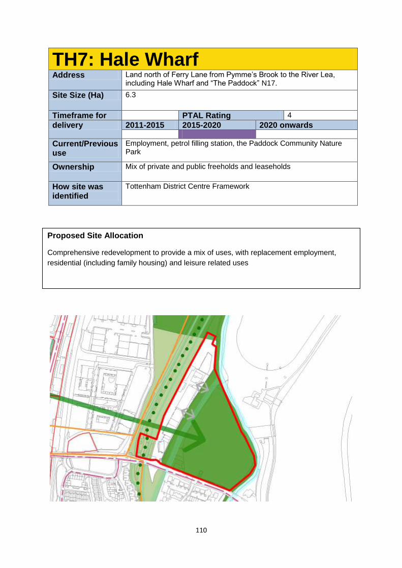
110
TH7: Hale Wharf Address Land north of Ferry Lane from Pymme’s Brook to the River Lea,
including Hale Wharf and “The Paddock” N17.
Site Size (Ha) 6.3
Timeframe for PTAL Rating 4
delivery 2011-2015 2015-2020 2020 onwards
Current/Previous use
Employment, petrol filling station, the Paddock Community Nature Park
Ownership Mix of private and public freeholds and leaseholds
How site was identified
Tottenham District Centre Framework
Proposed Site Allocation
Comprehensive redevelopment to provide a mix of uses, with replacement employment,
residential (including family housing) and leisure related uses
111
Site Requirements
This site will be given a Designated Employment Area: Regeneration Area status to
recognize the contribution to the local economy that this site can make. It is
anticipated that the redevelopment of this site will not create a net reduction in
employment floor space.
Part of the site (Hale wharf) is in employment use and will need to reflect the
Council’s aspiration to create a mix of uses on this site through the replacement of
existing employment levels with new employment space and complementary
leisure uses that provide amenities for the users of the Regional Park
Improve connections to, and the use and utility of the Paddocks open space and
ensure re-development of the former petrol station site to create high quality
waterside development.
The Development will need to respond to the new Green Link which will pass through
this site linking Tottenham High Rd to the Walthamstow Wetlands and Lee Valley
Regional Park.
In order to deliver the proposed new homes and jobs, comprehensive re-
development of the site is required.
The redevelopment of the garage site, within the green belt, will need to be included
as part of a comprehensive plan for the overall site and demonstrate compliance with
green Belt objectives. Consideration will be given to previously developed land on
this site within the Green belt in accordance with the guidance in the National
Planning Policy Framework.
Development should be delivered in a co-ordinated manner. Comprehensive re-
development for the site is required. The garage site across the Lea navigation, and
the Lock Keepers Cottage to the east should be developed as part of a
comprehensive proposal.
The design of the new development will need to have regard to environmental,
ecological interests in the locality, particularly relating to the water environment and
habitat of the Lee Valley Regional Park.
Development Guidelines
Redevelopment of the Hale Wharf site will need to ensure continued facilities for the
house boat community north of the Hale Wharf site and explore the potential
provision of Moorings on the western side of the site to accommodate employment
barges/temporary moorings.
New development should enable the ongoing operation and maintenance of the lock
gates. New development should not adversely impact on the ecological assets in the
area.
The development shall include a range of unit sizes and types and take advantage of
the sites suitability for family housing
The Environment Agency will be a key stakeholder in agreeing any new
development proposals as the site is just outside of a high flood risk area. The site is
in close proximity to the Walthamstow Marshes SSSI, Lee Valley Ramsar Site and
Special Protection Areas.
112
Building heights will have to respond to the proximity and ‘openness’ of the Green
Belt. Buildings should step down in height from Ferry Lane and create an effective
marker point to the river.
Buildings should be orientated to allow a continuous sight line from the Green Link
into the Lee Valley Regional Park. The design and form of the development on the
eastern side of the Wharf site (and on the former garage site) should be responsive
to the natural environment of the park and river.
This site is identified as being in an area with potential for being part of a
decentralised energy network. This may be as a decentralised energy hub, as a
customer, or requiring part of the site to provide an easement for the network.
The Lee Valley Regional Park Plan seeks to ensure improvement of the paddocks
area and any proposal should have consideration of this plan.
Improvement of the access into the Hale Wharf site is required.
The development will need to be designed having regard to risks of flooding and in
accordance with the Flood Risk Assessment
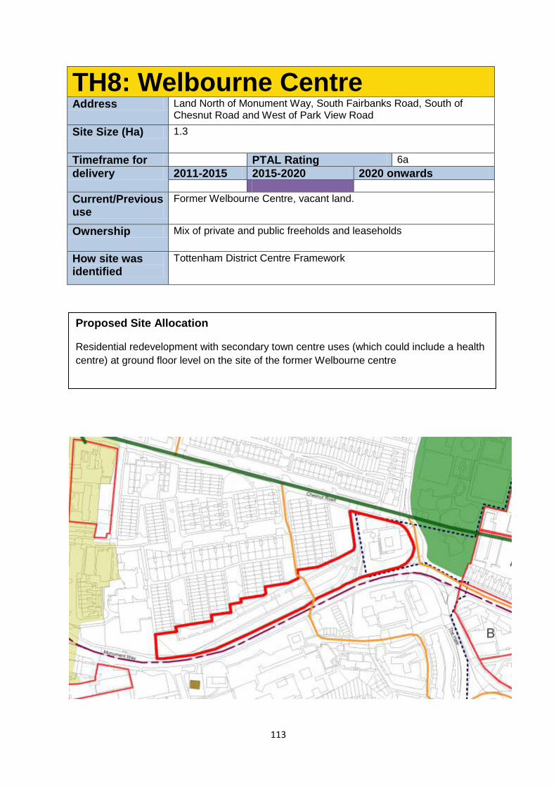
113
TH8: Welbourne Centre Address Land North of Monument Way, South Fairbanks Road, South of
Chesnut Road and West of Park View Road
Site Size (Ha) 1.3
Timeframe for PTAL Rating 6a
delivery 2011-2015 2015-2020 2020 onwards
Current/Previous use
Former Welbourne Centre, vacant land.
Ownership Mix of private and public freeholds and leaseholds
How site was identified
Tottenham District Centre Framework
Proposed Site Allocation
Residential redevelopment with secondary town centre uses (which could include a health
centre) at ground floor level on the site of the former Welbourne centre
114
Site Requirements
Development at ground floor level should be a use that complements the District
Centre. This may take the form of a new health centre.
Residential development will be permitted above.
The site of the former Welbourne centre is considered a suitable location for a taller
building marking the edge of the new Green Link.
Infill development to Chesnuts Estates
Design Guidelines
The tallest element of the site should address the frontage onto Park View Rd, with
heights reduced to the west towards the existing housing estate.
Opportunities to consider introducing activity to Monument way including residential
development and the introduction of junctions to help calm traffic
This site is identified as being in an area with potential for being part of a
decentralised energy network. This may be as a decentralised energy hub, as a
customer, or requiring part of the site to provide an easement for the network.
Studies should be undertaken to understand what potential contamination there is on
this site prior to any development taking place. Mitigation of and improvement to local
air quality and noise pollution should be made on this site.
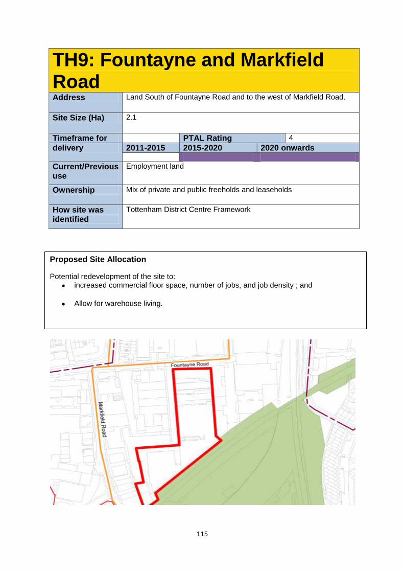
115
TH9: Fountayne and Markfield Road Address Land South of Fountayne Road and to the west of Markfield Road.
Site Size (Ha) 2.1
Timeframe for PTAL Rating 4
delivery 2011-2015 2015-2020 2020 onwards
Current/Previous use
Employment land
Ownership Mix of private and public freeholds and leaseholds
How site was identified
Tottenham District Centre Framework
Proposed Site Allocation
Potential redevelopment of the site to:
increased commercial floor space, number of jobs, and job density ; and
Allow for warehouse living.
116
Site Requirements
The site will be given a Designated Employment Area: Regeneration Area status to
reflect the Council’s aspiration to create a mix of uses on this site through the re-
introduction of creative employment uses.
Reintroducing employment-generating uses is the key aim of this policy. These may
be created at ground floor level as part of a mixed use development, or in purpose-
built blocks.
Redevelopment should look at the feasibility of connection up to the quietways
network between the new Tottenham Hale District Centre and Markfield Park and the
River Lea via a combination of Ashley Road, Fountayne Road and Markfield Rd
should be enabled through development in this area.
Capped commercial rents will be expected in this area in line with the Draft
Development Management Policies DPD.
Development Guidelines
There is potential for most of the buildings on this site to be retained due to their
industrial heritage value.
The quantum of dedicated employment floor space on the site should match that
originally built on the site.
The principles of the Warehouse Living Development Management policy apply to
this site.
Provision of suitable accommodation that meets acceptable standards will be
required.
This site is identified as being in an area with potential for being part of a
decentralised energy network. This may be as a decentralised energy hub, as a
customer, or requiring part of the site to provide an easement for the network.
Studies should be undertaken to understand what potential contamination there is on
this site prior to any development taking place. Mitigation of and improvement to local
air quality and noise pollution should be made on this site.
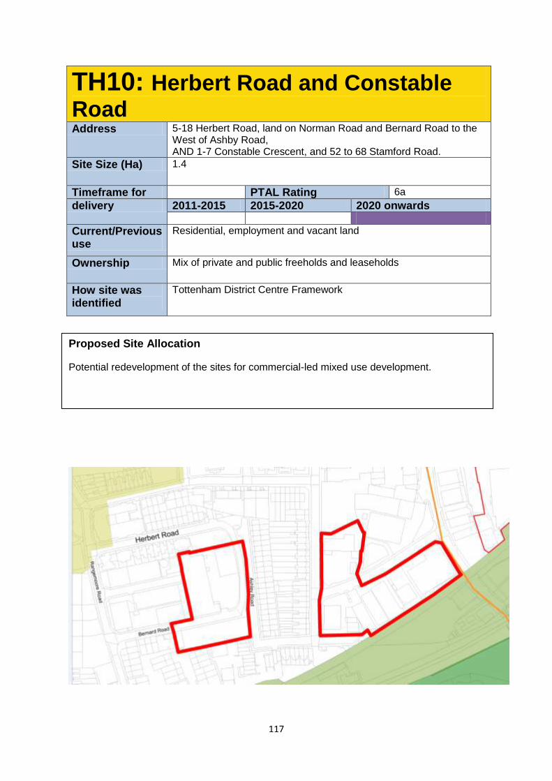
117
TH10: Herbert Road and Constable
Road Address 5-18 Herbert Road, land on Norman Road and Bernard Road to the
West of Ashby Road, AND 1-7 Constable Crescent, and 52 to 68 Stamford Road.
Site Size (Ha) 1.4
Timeframe for PTAL Rating 6a
delivery 2011-2015 2015-2020 2020 onwards
Current/Previous use
Residential, employment and vacant land
Ownership Mix of private and public freeholds and leaseholds
How site was identified
Tottenham District Centre Framework
Proposed Site Allocation
Potential redevelopment of the sites for commercial-led mixed use development.
118
Site Requirements
The site will be given a Designated Employment Area: Regeneration Area status to
reflect the Council’s aspiration to create a mix of uses on this site through the re-
introduction of creative employment uses.
The quantum of dedicated employment floorspace on the site should match that
originally built on the site.
Capped commercial rents may be expected in this area in line with the Draft
Development Management Policies DPD.
Development Guidelines
Removal of the “double road” on Ashby/Bernard/Herbert Rd.
Reintroducing employment-generating uses is the key aim of this policy.
Improved interfaces with the surrounding residential area should be created.
This site is identified as being in an area with potential for being part of a
decentralised energy network. This may be as a decentralised energy hub, as a
customer, or requiring part of the site to provide an easement for the network.
Studies should be undertaken to understand what potential contamination there is on
this site prior to any development taking place. Mitigation of and improvement to local
air quality and noise pollution should be made on this site.
119
6 Implementation, Delivery and
Monitoring
6.1 Each of the opportunity sites identified in this document will play a role in delivering
the vision for the area and it is imperative that the Council does as much as possible to aid
their delivery.
6.2 The Council will take the lead on project managing the implementation and delivery
of the Tottenham AAP. Dedicated resources will be put to managing and coordinating
delivery of both sites and supporting infrastructure.
6.3 A key mechanism for delivering the Tottenham AAP will be the Council’s
decisions on planning applications. The policies in the Strategic Policies Local Plan, along
with those in this AAP and the Development Management Policies, once adopted, will
provide the framework for such decisions. Planning decisions will be crucial to ensuring that
new development appropriately responds to the Plan’s objectives and policies. We will also
take account of the Council’s supplementary planning documents and guidance when
determining planning applications.
Working in partnership
6.4 The Council does not have the resources to implement the AAP alone.
Implementation and delivery of the AAP will require the Council to work closely with a range
of different partners, including landowners and developers, as well as infrastructure
providers, the Greater London Authority and Transport for London, to ensure a coordinated
framework and approach to delivery. The AAP provides the necessary framework for
coordinating a large number of development proposals, along with investment in
infrastructure, across the whole of the Tottenham area, over the life of the Plan, and across
all partners involved.
Stalled developments or sites
6.5 Where appropriate the Council will prepared, in consultation with landowners,
developers and the community, more detailed masterplans where this aids in accelerating
delivery.
6.6 Further, as set out in Policy AAP1, the Council will also use its compulsory purchase
order powers to facilitate site assembly where this is required to enable comprehensive,
timely and coordinated development to come forward.
6.7 In certain circumstances, the Council may look to utilise its strategic acquisition fund
to acquire sites, but such an approach will require robust assessment in terms of value for
money.
120
Council as a landowner and developer
6.8 The Council has substantial landholdings across the AAP area, much of which has
been allocated for redevelopment. The Council is committed to bring its sites forward in a
timely manner and will, if appropriate, enter into joint ventures or other such arrangements,
to facilitate this.
6.9 Any procurement exercise will be undertaken in an open and transparent manner.
Infrastructure delivery
6.10 An overall commitment to improving the pedestrian realm, delivering a range of new
public open spaces and strengthening public transport and movement generally underpins
the entire approach to the successful delivery of the AAP. The intention is to provide a strong
setting and encouragement for new homes and jobs.
6.11 An Infrastructure Delivery Plan will be prepared for the AAP, setting out key
responsibilities and timeframes, recognising the many partners that will assist in
implementing the AAP over its lifetime. This Delivery Plan will align with the borough-wide
Infrastructure Delivery Plan for the Strategic Policies, which is currently being updated, and
provide further information specific to the Tottenham area.
6.12 Given market values there is a demonstrable prospect of raising funding through
private developer contributions as indicated by the Borough’s existing planning evidence
base. The following funding structure identifies broad potential contributions from a variety of
sources.
well-structured Regeneration Programme prepared by LBH, with staff, plans, studies,
and initiatives focusing on delivery against ten strategic themes;
A prospectus of potential transport investments prepared by Transport for London
(TfL) to support growth and regeneration in Tottenham;
A comprehensive redevelopment proposal for the Tottenham Hotspur Football Club
(THFC) Stadium, with its associated new superstore and University Technical
College, as well as new leisure, retail, residential and hotel uses;
A major improvement, master planning and estate renewal package being developed
for the ‘High Road West’ area of north Tottenham;
A £41 million public sector funding and investment package for Tottenham;
A new Hosing Zone designation for Tottenham Hale, initially, then rolling out over the
rest of the AAP area; and
A central government-backed £500 million borrowing guarantee for housing and
transport improvements
Monitoring
6.13 The Council will regularly review and monitor performance towards delivery of the
AAP vision and strategic objectives (set out in Section 3), and the delivery of individual
opportunity sites and policy initiatives, using the Strategic Policies indicators, where relevant,
as well as through a bespoke set of monitoring indicators for the AAP as set out below.
Progress and performance outcomes will be published annually in the Authority Monitoring
Report.
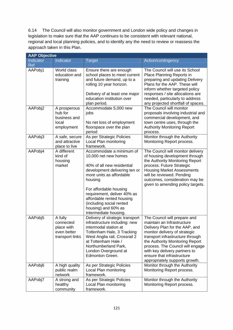
121
6.14 The Council will also monitor government and London wide policy and changes in
legislation to make sure that the AAP continues to be consistent with relevant national,
regional and local planning policies, and to identify any the need to review or reassess the
approach taken in this Plan.
AAP Objective
Indicator Ref
Indicator Target Action/contingency
AAPobj1 World class education and training
Ensure there are enough school places to meet current and future demand, up to a rolling 10 year horizon. Delivery of at least one major education institution over plan period.
The Council will use its School Place Planning Reports in preparing and updating Delivery Plans for the AAP. These will inform whether targeted policy responses / site allocations are needed, particularly to address any projected shortfall of spaces.
AAPobj2 A prosperous hub for business and local employment
Accommodate 5,000 new jobs No net loss of employment floorspace over the plan period
The Council will monitor proposals involving industrial and commercial development, and town centre uses, through the Authority Monitoring Report process.
AAPobj3 A safe, secure and attractive place to live
As per Strategic Policies Local Plan monitoring framework.
Monitor through the Authority Monitoring Report process.
AAPobj4 A different kind of housing market
Accommodate a minimum of 10,000 net new homes 40% of all new residential development delivering ten or more units as affordable housing For affordable housing requirement, deliver 40% as affordable rented housing (including social rented housing) and 60% as Intermediate housing.
The Council will monitor delivery of housing development through the Authority Monitoring Report process. Future Strategic Housing Market Assessments will be reviewed. Pending outcomes, consideration may be given to amending policy targets.
AAPobj5 A fully connected place with even better transport links
Delivery of strategic transport infrastructure including: new intermodal station at Tottenham Hale, 3 Tracking West Anglia rail, Crossrail 2 at Tottenham Hale / Northumberland Park, London Overground at Edmonton Green.
The Council will prepare and maintain an Infrastructure Delivery Plan for the AAP, and monitor delivery of strategic transport infrastructure through the Authority Monitoring Report process. The Council will engage with key delivery partners to ensure that infrastructure appropriately supports growth.
AAPobj6 A high quality public realm network
As per Strategic Policies Local Plan monitoring framework.
Monitor through the Authority Monitoring Report process.
AAPobj7 A strong and healthy community
As per Strategic Policies Local Plan monitoring framework.
Monitor through the Authority Monitoring Report process.
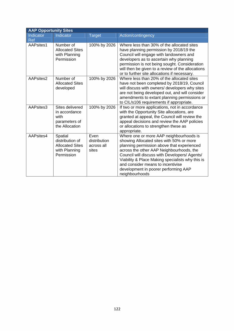
122
AAP Opportunity Sites
Indicator Ref
Indicator Target Action/contingency
AAPsites1 Number of Allocated Sites with Planning Permission
100% by 2026 Where less than 30% of the allocated sites have planning permission by 2018/19 the Council will engage with landowners and developers as to ascertain why planning permission is not being sought. Consideration will then be given to a review of the allocations or to further site allocations if necessary.
AAPsites2 Number of Allocated Sites developed
100% by 2026 Where less than 20% of the allocated sites have not been completed by 2018/19, Council will discuss with owners/ developers why sites are not being developed out, and will consider amendments to extant planning permissions or to CIL/s106 requirements if appropriate.
AAPsites3 Sites delivered in accordance with parameters of the Allocation
100% by 2026 If two or more applications, not in accordance with the Opportunity Site allocations, are granted at appeal, the Council will review the appeal decisions and review the AAP policies or allocations to strengthen these as appropriate.
AAPsites4 Spatial distribution of Allocated Sites with Planning Permission
Even distribution across all sites
Where one or more AAP neighbourhoods is showing Allocated sites with 50% or more planning permission above that experienced across the other AAP Neighbourhoods, the Council will discuss with Developers/ Agents/ Viability & Place Making specialists why this is and consider means to incentivise development in poorer performing AAP neighbourhoods
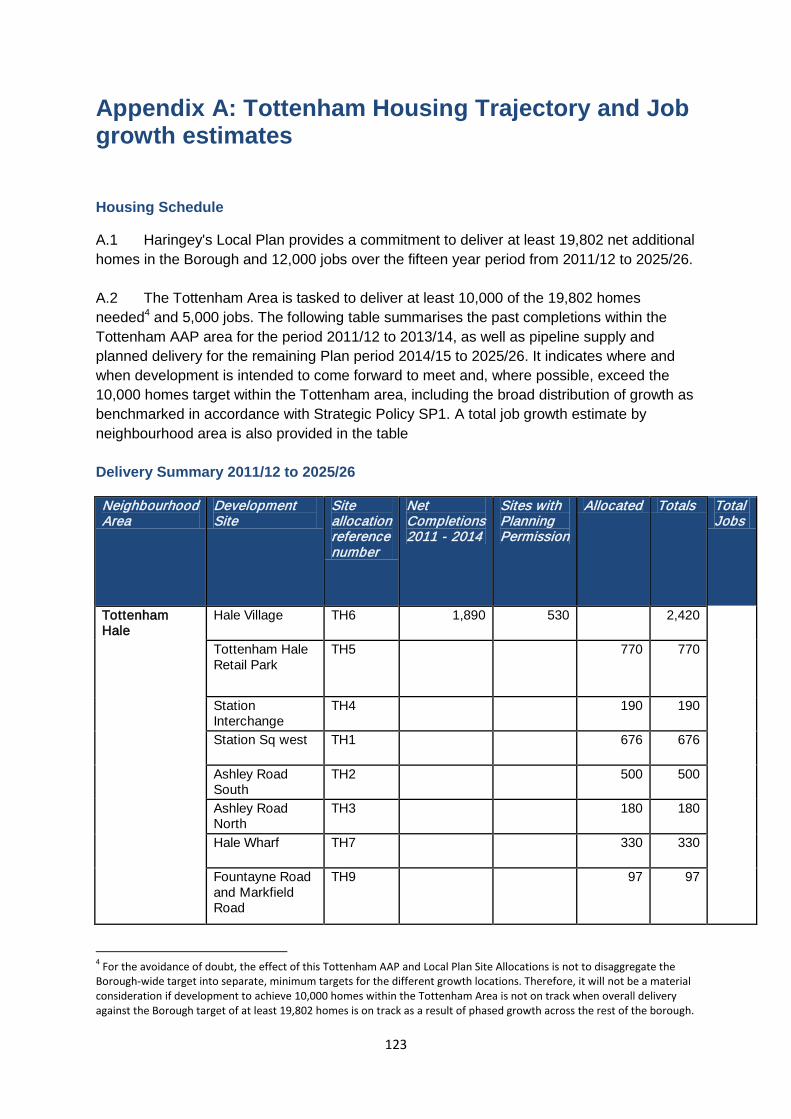
123
Appendix A: Tottenham Housing Trajectory and Job growth estimates
Housing Schedule
A.1 Haringey's Local Plan provides a commitment to deliver at least 19,802 net additional
homes in the Borough and 12,000 jobs over the fifteen year period from 2011/12 to 2025/26.
A.2 The Tottenham Area is tasked to deliver at least 10,000 of the 19,802 homes
needed4 and 5,000 jobs. The following table summarises the past completions within the
Tottenham AAP area for the period 2011/12 to 2013/14, as well as pipeline supply and
planned delivery for the remaining Plan period 2014/15 to 2025/26. It indicates where and
when development is intended to come forward to meet and, where possible, exceed the
10,000 homes target within the Tottenham area, including the broad distribution of growth as
benchmarked in accordance with Strategic Policy SP1. A total job growth estimate by
neighbourhood area is also provided in the table
Delivery Summary 2011/12 to 2025/26
Neighbourhood Area
Development Site
Site allocation reference number
Net Completions 2011 - 2014
Sites with Planning Permission
Allocated Totals Total Jobs
Tottenham Hale
Hale Village TH6 1,890 530 2,420
Tottenham Hale Retail Park
TH5 770 770
Station Interchange
TH4 190 190
Station Sq west TH1 676 676
Ashley Road South
TH2 500 500
Ashley Road North
TH3 180 180
Hale Wharf TH7 330 330
Fountayne Road and Markfield Road
TH9 97 97
4 For the avoidance of doubt, the effect of this Tottenham AAP and Local Plan Site Allocations is not to disaggregate the
Borough-wide target into separate, minimum targets for the different growth locations. Therefore, it will not be a material consideration if development to achieve 10,000 homes within the Tottenham Area is not on track when overall delivery against the Borough target of at least 19,802 homes is on track as a result of phased growth across the rest of the borough.
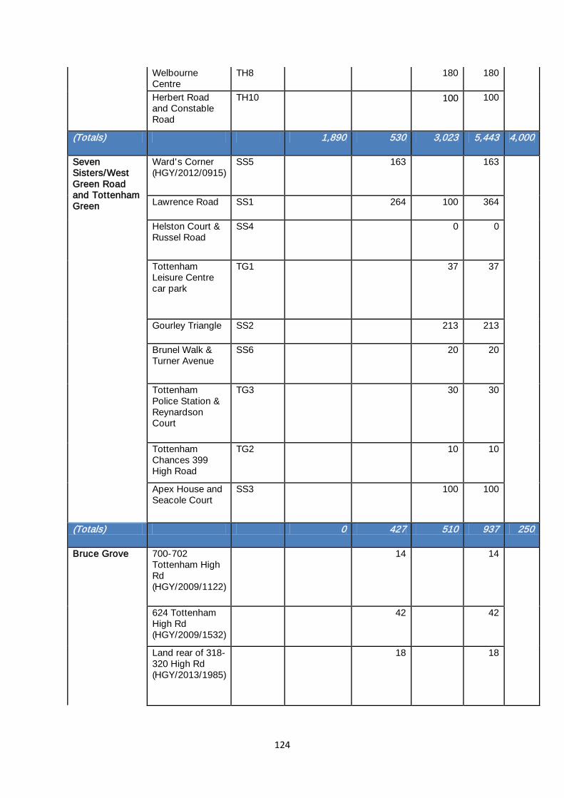
124
Welbourne Centre
TH8 180 180
Herbert Road and Constable Road
TH10 100 100
(Totals) 1,890 530 3,023 5,443 4,000
Seven Sisters/West Green Road and Tottenham Green
Ward's Corner (HGY/2012/0915)
SS5 163 163
Lawrence Road SS1 264 100 364
Helston Court & Russel Road
SS4 0 0
Tottenham Leisure Centre car park
TG1 37 37
Gourley Triangle SS2 213 213
Brunel Walk & Turner Avenue
SS6 20 20
Tottenham Police Station & Reynardson Court
TG3 30 30
Tottenham Chances 399 High Road
TG2 10 10
Apex House and Seacole Court
SS3 100 100
(Totals) 0 427 510 937 250
Bruce Grove 700-702 Tottenham High Rd (HGY/2009/1122)
14 14
624 Tottenham High Rd (HGY/2009/1532)
42 42
Land rear of 318-320 High Rd (HGY/2013/1985)
18 18
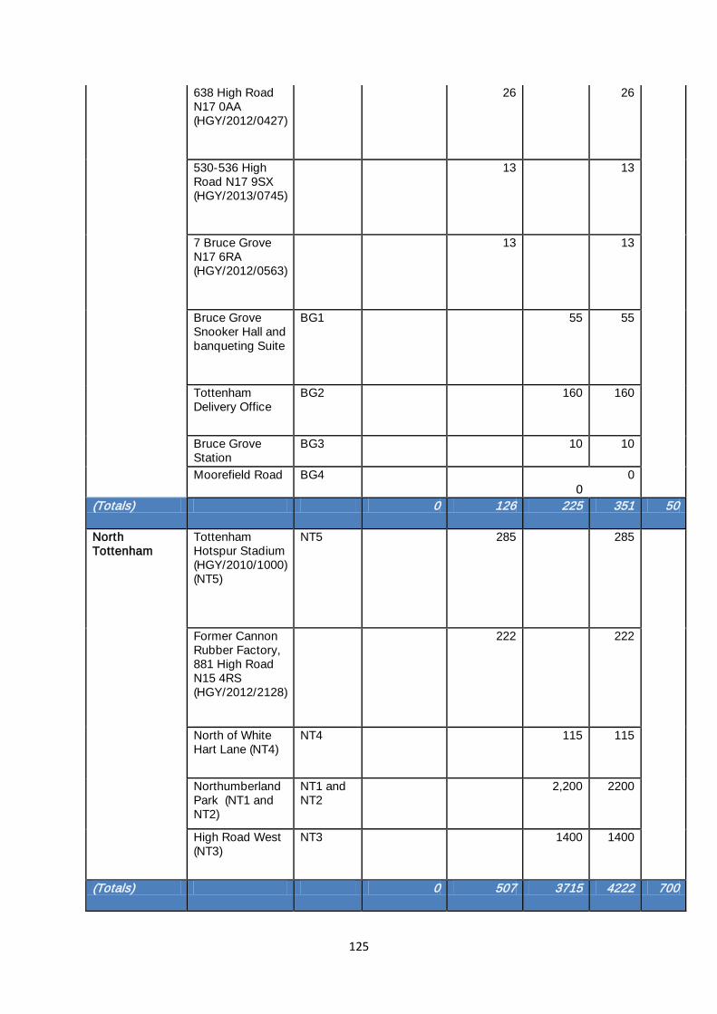
125
638 High Road N17 0AA (HGY/2012/0427)
26 26
530-536 High Road N17 9SX (HGY/2013/0745)
13 13
7 Bruce Grove N17 6RA (HGY/2012/0563)
13 13
Bruce Grove Snooker Hall and banqueting Suite
BG1 55 55
Tottenham Delivery Office
BG2 160 160
Bruce Grove Station
BG3 10 10
Moorefield Road BG4 0
0
(Totals) 0 126 225 351 50
North Tottenham
Tottenham Hotspur Stadium (HGY/2010/1000) (NT5)
NT5 285 285
Former Cannon Rubber Factory, 881 High Road N15 4RS (HGY/2012/2128)
222 222
North of White Hart Lane (NT4)
NT4 115 115
Northumberland Park (NT1 and NT2)
NT1 and NT2
2,200 2200
High Road West (NT3)
NT3 1400 1400
(Totals) 0 507 3715 4222 700

126
Net small sites completions 2011-2014
347 347
TOTAL 2,237 1,590 7,473 11,300 5,000
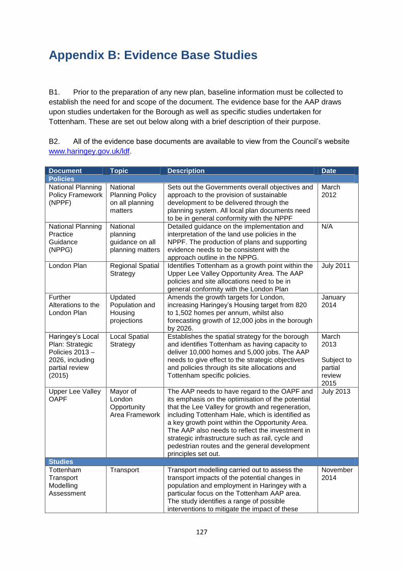
127
Appendix B: Evidence Base Studies B1. Prior to the preparation of any new plan, baseline information must be collected to
establish the need for and scope of the document. The evidence base for the AAP draws
upon studies undertaken for the Borough as well as specific studies undertaken for
Tottenham. These are set out below along with a brief description of their purpose.
B2. All of the evidence base documents are available to view from the Council’s website
www.haringey.gov.uk/ldf.
Document Topic Description Date
Policies
National Planning Policy Framework (NPPF)
National Planning Policy on all planning matters
Sets out the Governments overall objectives and approach to the provision of sustainable development to be delivered through the planning system. All local plan documents need to be in general conformity with the NPPF
March 2012
National Planning Practice Guidance (NPPG)
National planning guidance on all planning matters
Detailed guidance on the implementation and interpretation of the land use policies in the NPPF. The production of plans and supporting evidence needs to be consistent with the approach outline in the NPPG.
N/A
London Plan Regional Spatial Strategy
Identifies Tottenham as a growth point within the Upper Lee Valley Opportunity Area. The AAP policies and site allocations need to be in general conformity with the London Plan
July 2011
Further Alterations to the London Plan
Updated Population and Housing projections
Amends the growth targets for London, increasing Haringey’s Housing target from 820 to 1,502 homes per annum, whilst also forecasting growth of 12,000 jobs in the borough by 2026.
January 2014
Haringey’s Local Plan: Strategic Policies 2013 – 2026, including partial review (2015)
Local Spatial Strategy
Establishes the spatial strategy for the borough and identifies Tottenham as having capacity to deliver 10,000 homes and 5,000 jobs. The AAP needs to give effect to the strategic objectives and policies through its site allocations and Tottenham specific policies.
March 2013 Subject to partial review 2015
Upper Lee Valley OAPF
Mayor of London Opportunity Area Framework
The AAP needs to have regard to the OAPF and its emphasis on the optimisation of the potential that the Lee Valley for growth and regeneration, including Tottenham Hale, which is identified as a key growth point within the Opportunity Area. The AAP also needs to reflect the investment in strategic infrastructure such as rail, cycle and pedestrian routes and the general development principles set out.
July 2013
Studies
Tottenham Transport Modelling Assessment
Transport Transport modelling carried out to assess the transport impacts of the potential changes in population and employment in Haringey with a particular focus on the Tottenham AAP area. The study identifies a range of possible interventions to mitigate the impact of these
November 2014
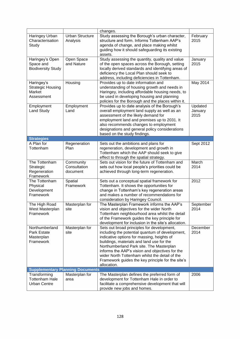
128
changes.
Haringey Urban Characterisation Study
Urban Structure Analysis
Study assessing the Borough’s urban character, structure and form. Informs Tottenham AAP’s agenda of change, and place making whilst guiding how it should safeguarding its existing assets.
February 2015
Haringey’s Open Space and Biodiversity Study
Open Space and Nature
Study assessing the quantity, quality and value of the open spaces across the Borough, setting locally derived standards and identifying areas of deficiency the Local Plan should seek to address, including deficiencies in Tottenham.
January 2015
Haringey’s Strategic Housing Market Assessment
Housing Provides up to date information and understanding of housing growth and needs in Haringey, including affordable housing needs, to be used in developing housing and planning policies for the Borough and the places within it.
May 2014
Employment Land Study
Employment Land
Provides up to date analysis of the Borough’s overall employment land supply as well as an assessment of the likely demand for employment land and premises up to 2031. It also recommends changes to employment designations and general policy considerations based on the study findings.
Updated January 2015
Strategies
A Plan for Tottenham
Regeneration Plan
Sets out the ambitions and plans for regeneration, development and growth in Tottenham which the AAP should seek to give effect to through the spatial strategy.
Sept 2012
The Tottenham Strategic Regeneration Framework
Community Consultation document
Sets out vision for the future of Tottenham and sets out how local people’s priorities could be achieved through long-term regeneration.
March 2014
The Tottenham Physical Development Framework
Spatial Framework
Sets out a conceptual spatial framework for Tottenham. It shows the opportunities for change in Tottenham’s key regeneration areas and makes a number of recommendations for consideration by Haringey Council.
2012
The High Road West Masterplan Framework
Masterplan for site
The Masterplan Framework informs the AAP’s vision and objectives for the wider North Tottenham neighbourhood area whilst the detail of the Framework guides the key principle for development for inclusion in the site’s allocation.
September 2014
Northumberland Park Estate Masterplan Framework
Masterplan for site
Sets out broad principles for development, including the potential quantum of development, indicative options for massing, heights of buildings, materials and land use for the Northumberland Park site. The Masterplan informs the AAP’s vision and objectives for the wider North Tottenham whilst the detail of the Framework guides the key principle for the site’s allocation.
December 2014
Supplementary Planning Documents
Transforming Tottenham Hale Urban Centre
Masterplan for area
The Masterplan defines the preferred form of development for Tottenham Hale in order to facilitate a comprehensive development that will provide new jobs and homes.
2006
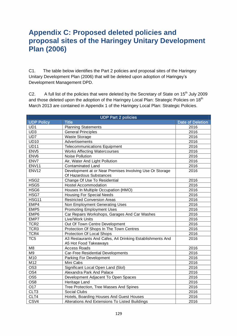
129
Appendix C: Proposed deleted policies and proposal sites of the Haringey Unitary Development Plan (2006) C1. The table below identifies the Part 2 policies and proposal sites of the Haringey
Unitary Development Plan (2006) that will be deleted upon adoption of Haringey’s
Development Management DPD.
C2. A full list of the policies that were deleted by the Secretary of State on 15th July 2009
and those deleted upon the adoption of the Haringey Local Plan: Strategic Policies on 18th
March 2013 are contained in Appendix 1 of the Haringey Local Plan: Strategic Policies.
UDP Part 2 policies UDP Policy Title Date of Deletion UD1 Planning Statements 2016 UD3 General Principles 2016 UD7 Waste Storage 2016 UD10 Advertisements 2016 UD11 Telecommunications Equipment 2016 ENV5 Works Affecting Watercourses 2016 ENV6 Noise Pollution 2016 ENV7 Air, Water And Light Pollution 2016 ENV11 Contaminated Land 2016 ENV12 Development at or Near Premises Involving Use Or Storage
Of Hazardous Substances 2016
HSG2 Change Of Use To Residential 2016 HSG5 Hostel Accommodation 2016 HSG6 Houses In Multiple Occupation (HMO) 2016 HSG7 Housing For Special Needs 2016 HSG11 Restricted Conversion Areas 2016 EMP4 Non Employment Generating Uses 2016 EMP5 Promoting Employment Uses 2016 EMP6 Car Repairs Workshops, Garages And Car Washes 2016 EMP7 Live/Work Units 2016 TCR2 Out Of Town Centre Development 2016 TCR3 Protection Of Shops In The Town Centres 2016 TCR4 Protection Of Local Shops 2016 TC5 A3 Restaurants And Cafes, A4 Drinking Establishments And
A5 Hot Food Takeaways 2016
M8 Access Roads 2016 M9 Car-Free Residential Developments 2016 M10 Parking For Development 2016 M12 Mini Cabs 2016 OS3 Significant Local Open Land (Slol) 2016 OS4 Alexandra Park And Palace 2016 OS5 Development Adjacent To Open Spaces 2016 OS8 Heritage Land 2016 O17 Tree Protection, Tree Masses And Spines 2016 CLT3 Social Clubs 2016 CLT4 Hotels, Boarding Houses And Guest Houses 2016 CSV4 Alterations And Extensions To Listed Buildings 2016
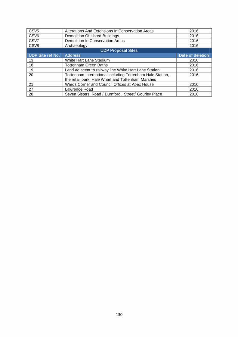
130
CSV5 Alterations And Extensions In Conservation Areas 2016 CSV6 Demolition Of Listed Buildings 2016 CSV7 Demolition In Conservation Areas 2016 CSV8 Archaeology 2016
UDP Proposal Sites UDP Site ref No. Address Date of deletion 13 White Hart Lane Stadium 2016 18 Tottenham Green Baths 2016 19 Land adjacent to railway line White Hart Lane Station 2016 20 Tottenham International including Tottenham Hale Station,
the retail park, Hale Wharf and Tottenham Marshes 2016
21 Wards Corner and Council Offices at Apex House 2016 27 Lawrence Road 2016 28 Seven Sisters, Road / Durnford, Street/ Gourley Place 2016
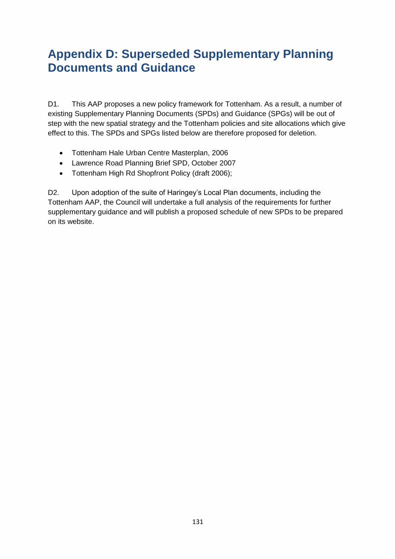
131
Appendix D: Superseded Supplementary Planning Documents and Guidance D1. This AAP proposes a new policy framework for Tottenham. As a result, a number of
existing Supplementary Planning Documents (SPDs) and Guidance (SPGs) will be out of
step with the new spatial strategy and the Tottenham policies and site allocations which give
effect to this. The SPDs and SPGs listed below are therefore proposed for deletion.
Tottenham Hale Urban Centre Masterplan, 2006
Lawrence Road Planning Brief SPD, October 2007
Tottenham High Rd Shopfront Policy (draft 2006);
D2. Upon adoption of the suite of Haringey’s Local Plan documents, including the
Tottenham AAP, the Council will undertake a full analysis of the requirements for further
supplementary guidance and will publish a proposed schedule of new SPDs to be prepared
on its website.
132
Appendix E: Glossary
Accessibility: Ability of people or goods and services to reach places and facilities.
Accessible Development: A building, facility etc. and its wider environment which can be
reached and used, in particular by people with disabilities.
Accessible Transport: Transport services and vehicles designed and operated to be usable by
people with disabilities and other transport disadvantaged people, with characteristics possibly including affordable fares, wheelchair user accessibility and easy reach of final destination.
Active Frontages: street frontages where there is an active visual engagement between those in the street and those on the ground floors of buildings. This quality is assisted where the front facade of buildings, including the main entrance, faces and open towards the street. This is not the same as attractive frontages, such as art walls, green walls or display boxes. Active frontages are often taken to mean continuous rows of highly-glazed shop fronts with frequent entries and cafes.
Affordable Rent: Rented housing let by registered providers of social housing to households
who are eligible for social rented housing. Affordable Rent is not subject to the national rent regime but is subject to other rent controls that require a rent of no more than 80 per cent of the local market rent.
Affordable Housing: Affordable housing includes social rented and intermediate housing
provided to specific eligible households whose needs are not met by the market (See entry for affordable rent, intermediate and social rented for further details).
Amenity: A positive element or elements which contribute to the overall character or an area, for example open land, trees, historic buildings and the inter-relationship between all elements in the environment.
Authority Monitoring Report (AMR): The AMR reviews progress on the preparation of the Council’s Local Plan and monitors the effectiveness of Local Plan policies.
Area Action Plan (AAP): Development Plan Documents used to provide a planning framework
for areas of change (e.g. major regeneration) and areas of conservation.
Area of Archaeological Importance: Areas with known archaeological potential where the Council’s archaeology policies will normally be strictly applied.
Area for Intensification: These are areas which have significant potential for increases in
residential, employment and other uses through development for regeneration of available sites and exploitation of potential for regeneration, through higher densities and more mixed and intensive use. These areas have good existing or planned public transport.
Area of Change: these are areas with considerable potential for growth, though on a lesser
scale than growth areas. These areas are appropriately located to support growth and contain identified sites which are available and suitable for development.
Area of Opportunity: London’s principal opportunities for accommodating large scale
development to provide substantial numbers of new employment and housing, each typically more than 5,000 jobs and /or 2,500 homes, with a mixed and intensive use of land and assisted by good public transport accessibility.
Article 4 Direction: A power available under the 1995 General Development Order allowing the
Council, in certain instances, to restrict permitted development rights.
Backland Development: Development of land-locked sites, such as rear gardens, private open space or old lock up garages, usually within predominately residential areas.
Biodiversity: Biodiversity encompasses the whole variety of life on earth (including on or under
water) including all species of plants and animals and the variety of habitats within which they live. It also includes the genetic variation within each species.
Biodiversity Action Plan (BAP) – Haringey: The Biodiversity Action Plan includes policies and
actions that will contribute towards conserving, enriching and celebrating the wildlife in Haringey.
Blue Ribbon Network: Policy covering London’s waterways, water spaces and land alongside them.
Building Research Establishment Assessment Method (BREEAM): used to assess the
environmental performance of new and existing buildings.
Brownfield Land: Previously developed land which is or was occupied by a permanent structure.
133
Borough Roads: Roads for which the Borough is the Highway Authority.
Building Line: The line formed by frontages of buildings along a street.
Car Club: Schemes which facilitate vehicle sharing.
Central Activity Zone (CAZ): The CAZ is the area where planning policy recognises the importance of strategic finance, specialist retail, tourist and cultural uses and activities, as well as residential and more local functions.
Care in the Community: This enable people in need of care, whether because of old age,
disability, illness or other reasons, to continue to live in their own homes or in homely settings within the community.
Census: A ten-yearly comprehensive nation-wide sample survey of population, housing and
socio-economic data. The latest one was conducted in March 2011.
Cluster: Geographical concentration of interconnected companies, specialised supplies, service providers in related industries, and associated institutions (for example universities, standard agencies, and trade associations) in particular firms that compete but also co-operate.
Code for Sustainable Homes: The national standard for the sustainable design and construction of new homes.
Combined Heat and Power (CHP): The combined production of heat, usually in the form of
steam, and power, usually in the form of electricity.
Community Facilities: Community facilities can be defined as including children’s play and recreation facilities, services for young people, older people and disabled people, as well as health facilities, facilities for emergency services, including police facilities, education facilities, libraries, community halls, criminal justice facilities meeting rooms, places of worship, public toilets, pubs and post offices.
Community Infrastructure Levy (CIL): A per square metre tariff on new development seeking
to raise revenue to fund new infrastructure.
Community Transport: A range of voluntary sector, non profit-making transport services designed to meet the needs of people who do not have access to private transport and for whom public transport is unsuitable.
Comparison Goods: Goods for which the purchase involves comparison by the customer and
which while not being purchased frequently must nevertheless be stocked in a wide range of size, colours and fabrics, jewellery, furniture and goods normally sold at specialist shops and general stores.
Compulsory Purchase Order (CPO): An order which enables a statutory authority to purchase
an area of land compulsory for an approved project.
Conservation Area: Area designated by the Council under the Town and Country Planning (Listed Buildings and Conservation Areas) Act 1990 as possessing special architectural or historic interest. The Council will seek to preserve and enhance the character and appearance of these areas.
Contaminated Land: Land which contains potentially harmful substances as a result of human activity or from natural causes may be regarded as contaminated land. Because substances in or on the land may be hazardous and likely to affect its proposed development, a quantitative risk based assessment is required to determine whether the proposed development should proceed and whether some form of remedial action is required.
Context: In urban design terms the character and setting of the immediate local area within
which a building or site is situated or to be sited. The context will take into account any local distinctiveness of an area i.e. the particular positive features of a locality that contribute to its special character and sense of place and distinguishes one local area from another.
Convenience Goods: Good purchased on a regular basis which meet the day to day needs of local residents. They require minimum effort in selection and buying e.g. food, newspapers and other goods of a standardised type of which there is a wide sale.
Conversions: The sub-division of residential properties into self-contained flats or maisonettes.
Core Strategy: The Core Strategy was the former title of the Local Plan: Strategic Policies
document.
Culture: A way of life including, but not limited to language, arts and science, thought, spiritual activity, social activity and interaction (the Roshan Cultural Heritage Institute).
Cultural Quarter: Area where a critical mass of cultural activities and related uses are emerging,
usually in historic or interesting environment.
134
Decent Homes Standard: A Government standard for housing which requires both Councils
and Registered Social Landlords (RSLs) to bring up their property standards to a defined minimum by 2010.
Density: The number of habitable rooms per hectare.
Designated Views - views which focus on architecturally and culturally important groups of buildings that can be enjoyed from well managed public spaces
Development Management Policies DPD (DMDPD): These are the policies which are required
to ensure that all development in the borough meets the spatial vision and objectives set out in the Local Plan.
Development Plan Documents (DPD): Statutory planning documents that form part of the Local
Development Framework including the Local Plan: Strategic Policies, Development Management Policies and Site Allocations Document.
District Centre: District centres have traditionally provided convenience goods and services for more local communities and accessible by public transport, walking and cycling.
Ecological Corridor: Ecological Corridors are relative areas of green space running through built up areas that allow the movement of plants and animals to other areas and habitats.
Emergency Services: Includes Fire, Police and Ambulance services.
Employment Land Review (ELR): A study providing evidence of the macroeconomic circumstances driving the need for provision of employment land in the borough.
Environmental Assessment: A method or procedure for predicting the effects on the
environment of a proposal, either for an individual project or a higher-level ‘strategy’ (a policy, plan or programme), with the aim of taking account of these effects in decision-making.
Fluvial: Water in the Thames and other rivers.
Form: The layout (structure and urban grain), density, scale (height and massing), appearance
(materials and details) and landscaping of development.
General Development Order (GDO): Identifies the certain types of usually minor development
for which planning permission is not required and which therefore do not require a planning application to be submitted to the Council.
Greater London Authority (GLA): The GLA is a strategic citywide government for London. It is made up of a directly elected Mayor and a separately elected Assembly.
Green Belt: Green Belt is an area of land which has been given special status to restrict
inappropriate development.
Green Chain/Link: Linked green spaces composed of such elements as open land, footpaths,
canals and rivers which provide public access, play valuable recreational, conservation, ecological and general amenity role. Green chains can also be Ecological Corridors.
Green Industries: This business sector that produced goods or services, which compared to other more commonly used goods and services, are less harmful to the environment.
Green Infrastructure: A network of connected, high quality, multi-functional open spaces,
corridors and the links in between that provide multiple benefits for people and wildlife.
Green Roofs: Planting on roofs to provide climate change, amenity and recreational benefits.
Growth Area: Specific areas for new residential development to accommodate future population
growth. In Haringey, there are two including Tottenham Hale, Opportunity Area, and Haringey Heartlands, Area of Intensification.
Gyratory: A road junction at which traffic enters a one-way system around a central island.
Health Impact Assessment (HIA): A process for ensuring that land use and planning decision making at all levels consider the potential impacts of decisions on health and health inequalities. It identifies actions that can enhance positive effects and reduce or eliminate negative effects.
Heritage Land: Heritage Land is open land of strategic importance to London of significance for
its landscape, historical and nature conservation interest. The only Heritage land at the present time is Highgate Golf Course which forms part of the wider area of Hampstead Heath.
Highway Authority: An authority responsible for a highway, whether or not maintainable at
public expenses.
Historic Parks and Gardens: Parks and gardens containing historic features dating from 1939 or earlier registered by English Heritage. These parks and gardens are graded I, II or II* in the same way as Listed Buildings. Only Alexandra Park and Finsbury Park are registered in Haringey.
Homes and Community Agency (HCA): HCA is the national housing and regeneration agency for England.
135
House in Multiple Occupation (HMO): Housing occupied by members of more than one
household, such as student accommodation or bedsits.
Housing Association: see Registered Provider.
Housing Trajectory: Graph illustrating the supply of projected completion housing completions
up to 2026.
Industrial Business Park (IBP): Strategic industrial locations that are particularly suitable for
activities that need better quality surroundings including research and development, light industrial and higher value general industrial, some waste management, utility and transport functions, wholesale markets and some small scale distribution. They can be accommodated next to environmentally sensitive areas.
Intermediate Housing: Housing available at prices and rents above those of social rent but
below market prices or rents.
Landmarks - Buildings and structures, other than Strategically Important Landmarks, that are visually or culturally prominent in Designated Views
Landscape: The character and appearance of land, including its shape, form, ecology, natural features, colours and elements and the way these elements combine.
Lifetime Home: Ordinary homes designed to provide accessible and convenient homes for a
large segment of the population.
Linear View: A view seen through narrow gaps between buildings or landscaping
Listed Building: Locally listed buildings are those which satisfy one or more of the following
criteria: historic interest, architectural interest or environmental significance. Statutory listed buildings are buildings of special architectural or historic interest, they are graded as I, II* or with grade I being the highest. English Heritage is responsible for designating buildings for statutory listing in England.
Local Development Documents (LDD): The collective term for Development Plan Documents,
Supplementary Planning Documents (does not form part of the statutory development plan) and other documents including the Statement of Community Involvement.
Local Development Framework (LDF): The plan for the future development of the local area,
drawn up by the local planning authority in consultation with the community. In law this is described as the development plan documents adopted under the Planning and Compulsory Purchase Act 2004. Current Local Plans or other planning policies, which under the regulations would be considered to be development plan documents, form part of the Local Plan.
Local Development Scheme (LDS): The LDS sets out the programme/timetable for preparing
the LDD.
Local Implementation Plan (LIP): Statutory transport plans produced by London boroughs bringing together transport proposals to implement the Mayor’s Transport Strategy at the local level.
Local Nature Reserve (LNR): Sites which offer special opportunities for people to see and learn about wildlife in natural surroundings. LNRs are a statutory designation made under the National Parks and Access to the Countryside Act 1949.
Local Plan: Strategic Policies: The Local Plan: Strategic Policies is a Development Plan
Document setting out the vision and key policies for the future development of the borough up to 2026.
Local Shopping Centre: The level of shopping centre below District Centre level, providing
services for local communities.
Local Strategic Partnership (LSP): A partnership of people that bring together organisations from the public, private, community and voluntary sector within a local authority area.
London Development Agency (LDA): Organisation acting on behalf of the Mayor, whose aim is
to further the economic development and regeneration of London.
London Plan (The Spatial Development Strategy): The London Plan is the name given to the
Mayor’s spatial development strategy for London.
Market Housing: Private housing for rent or for sale, where the price is set in the open market.
Metropolitan Open Land (MOL): Strategic open land within the urban area that contributes to
the structure of London.
Metropolitan Town Centre: Metropolitan centres serve wide catchments areas and can cover several boroughs. Typically they contain at least 100,000sq.m of retail floorspace with a significant proportion of high-order comparison goods relative to convenience goods. These centres generally have very good accessibility and significant employment, leisure, service and civic functions.
136
Mixed tenure: A mix of affordable and market housing.
Mixed Use Development: Provision of a mix of complementary uses, such as residential, community and leisure uses on a site, within the same building or within a particular area.
National Planning Policy Framework (NPPF): Sets out the Government’s planning policies for
England and how they are expected to be applied. The NPPF replaces 44 planning documents, primarily Planning Policy Statements (PPS) and Planning Policy Guidance (PPGs), which previously formed Government policy towards planning.
Neighbourhood and more local centres: Typically serve a localised catchment often most
accessible by walking and cycling. They include local parades and small cluster of shops, mostly for convenience goods and other services.
Open Space: All land in London that is predominately undeveloped other than by buildings or
structures that are ancillary to the open space use. The definition covers the broad range of types of open space within London, whether in public or private ownership and whether public access is unrestricted, limited or restricted.
Panorama - A broad prospect seen from an elevated public viewing place
Planning Obligations Supplementary Planning Document: A guidance document offering support in the implementation of planning obligations on planning applications subsequent to the adoption of the Haringey CIL.
Primary Care Trust (PCT): PCTs decide what health services a local community needs, and
they are responsible for providing them.
Public Realm: This is the space between and within buildings that is publicly accessible,
including streets, squares, forecourts, parks and open spaces.
Public Transport Accessibility Level (PTAL): Public Transport Accessibility Levels are a measure of the extent and ease of access to the public transport network.
Regeneration: The economic, social and environmental renewal and improvement of a rural or
urban area.
Registered Provider: non-profit making organisations that provide low-cost housing for people in need of a home.
River Prospect: Short and longer distance visual experiences of a rivers cape (in HGY case Lee, Moselle or New River)
Section 106 Agreements (S106)/Planning Obligations: These agreements confer planning
obligations on persons with an interest in land in order to achieve the implementation of relevant planning policies as authorised by Section 106 of the Town and Country Planning Act 1990.
Secured by Design: The planning and design of street layouts, open space, and buildings so as
to reduce the likelihood or fear of crime.
Site Allocations Development Plan Document: This will form part of Haringey’s LDF and will guide land use and future development in the borough until 2026.
Sites of Importance for Nature Conservation (SINC): SINCs are areas protected through the
planning process having been designated for their high biodiversity value.
Small and Medium Enterprises (SMEs): Small and Medium Enterprises (SMEs) comprise businesses with more than 11 but less than 250 staff.
Social Infrastructure: Facilities and services including health provision , early years provision ,
schools, colleges and universities, community, cultural, recreation and sports facilities, places of worship, policing and other criminal justice or community safety facilities, children and young people’s play and informal recreation facilities. This list is not intended to be exhaustive and other facilities can be included as social infrastructure.
Social Rented Housing: Rented housing owned and managed by local authorities or registered
social landlords, or be provide by other bodies under equivalent rental agreements.
Spatial Vision: A statement of long term shared goals for the spatial structure of an area.
Statement of Community Involvement (SCI): The Council’s policy for involving the community in the preparation, review and alteration of LDDs and planning applications. It includes who should be involved and the methods to be used.
Strategic Environmental Assessment (SEA): Expression used by the European Union to
describe environmental assessment as applied to policies, plans and programmes.
Strategic Housing Land Availability Assessment (SHLAA): An assessment of land availability for housing which informs the London Plan and borough local development documents, as set out in section 48 of the NPPF
Strategic Housing Market Assessment (SHMA): An assessment of housing need and demand which informs the London Plan and borough local development documents.
137
Strategic Industrial Location (SIL): These comprise Preferred Industrial Locations (PILs) and
Industrial Business Parks and exist to ensure that London provides sufficient quality sites, in appropriate locations, to meet the needs of industrial and related sectors including logistics, waste management, utilities, wholesale markets and some transport functions.
Supplementary Planning Document (SPD): Provides supplementary information about the
policies in DPDs. They do not form part of the development plan and are not subject to independent examination.
Supplementary Planning Guidance (SPG): Additional advice, provided by the Council on
particular topic or policy areas and related to and expanding upon statutory policies.
Sustainability Appraisal (SA): This is a systematic and continuous assessment of the social, environmental and economic effects of strategies and policies contained in the DPDs, which complies with the EU Directive for Strategic Environmental Assessment.
Sustainable Urban Drainage Systems (SUDS): An alternative approach from the traditional ways of managing runoff from buildings and hard standing. They can reduce the total amount, flow and rate of surface water that runs directly to rivers through storm water systems.
Tall Buildings: The Council has adopted the definition of Tall and Large Buildings as those
which are substantially taller than their neighbours, have a significant impact on the skyline, are of 10 storeys and over or are otherwise larger than the threshold sizes set for referral to the Mayor of London.
Townscape View - Unfolding close view of built up environment with spaces between and in each case views might or might not contain (but will be more significant if they do)
Tree Preservation Order (TPO): Made under the Town and Country Planning Act 1990 by the
local planning authority to protect trees of importance for amenity, landscape and nature conservation.
Urban Characterisation Study (UCS): An appraisal of the character of the borough in terms of built urban form, topography, conservation and heritage value.
Use Classes Order: The Town and Country Planning (Use Classes) Order 1987, as amended,
lists 15 classes of use. A change of use within the same Class does not constitute development and thus does not require planning permission.
Unitary Development Plan (UDP): A UDP is a land use plan that seeks to make the most
efficient and effective use of land in the public interest. The LDF will eventually replace Haringey’s UDP 2006.
View Corridor: Strategic important views designated in the London Views Management Framework.
Warehouse Living: Purpose built and genuine integrated working and living accommodation
specifically targeted at the creative industries sectors.
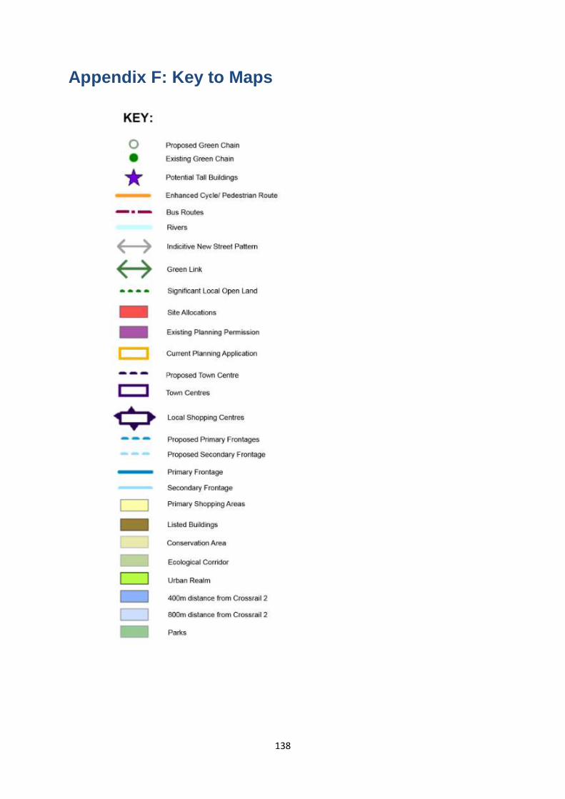
138
Appendix F: Key to Maps

Please indicate if you would like a copy of this document in another language not listed or any of the following formats and send to the freepost address below.
Large print On diskOn audio tape BrailleAnother language
Name:
Address:
If you want this in your own language please tick the box, fill in your nameand address and send to the freepost address below
Freepost RLXS-XZGT-UGRJ, Translation & Interpreting Services 6th Floor,
River Park House, 225 High Road, N22 8HQ 1024.77_Tottenam AAP Consultation
ShqipNëse dëshironi ta keni këtë në gjuhëntuaj, ju lutemi vendosni shenjën ✓ në kuti,shënoni emrin dhe adresën tuaj dhe nisenime postë falas në adresën e mëposhtme.
≈≈@@%%……@@
•@√A¬ »A¿" ™º]F]@ •@√¬@≈R A¬D∑"≈R ∆*@Ã@»R D√Dæ* µ*@¬
æ*D≈ •¬L≤UŒ" ∞*D≈R ÕA∫*∞* ≈@Dd Aº]F]∞* A¿"¬, ™≈% •@√¬@≈R ¬@«
A∫*∞*@¬@ A…D± A¬Dµ*≈R A∫*∞*@¬@»R √@A∫*D»R A¿"¬, ™≈R ∑"¬I D∞*@¬
ª*@∞*Aº]F]A∞*º]F] …@≤D≈ ¬@–
FrançaisPour recevoir ces informations dans votrelangue, veuillez cocher la case, inscrire vosnom et adresse et nous renvoyer ce formu-laire, sans affranchir, à l’adresse ci-dessous.
EÏÏËÓÈοAÓ ı¤ÏÂÙ ·˘Ùfi ÙÔ ¤ÓÙ˘Ô ÛÙË ÁÏÒÛÛ· Û·˜,·Ú·Î·Ïԇ̠ÛËÌÂÈÒÛÙ ÙÔ ÙÂÙÚ¿ÁˆÓÔ,Û˘ÌÏËÚÒÛÙ ÙÔ ÔÓÔÌ·ÙÂÒÓ˘ÌÔ Î·È Ùˉȇı˘ÓÛ‹ Û·˜ Î·È ÛÙ›ÏÙ ÙÔ ÛÙËÓ ·Ú·Î¿Ùˆ‰È‡ı˘ÓÛË ¯ˆÚ›˜ Ù·¯˘‰ÚÔÌÈÎfi Ù¤ÏÔ˜.
KurdîKu hun wena la zîmanixa daxwâzin.Lewira îflaret bîkin Navixa û navnîflanaxa tijebikin â biflenin ê navniflana jêr la vepêre.
PortuguêsSe desejar receber o folheto na suaprópria língua, por favor assinale aquadrícula, preencha com o seu nome emorada e envie para o endereço ‘freepost’(com porte pago) abaixo indicado.
Limba românăDacă doriţi un exemplar al broşurii înlimba dvs. maternă, vă rugăm să bifaţi casetacorespunzătoare, să ne daţi numele şiadresa dvs., şi să trimiteţi formularul laadresa de mai jos, fără timbru poştal.
Soomaali Haddii aad kan ku rabto afkaaga fadlanxarriijin ku dhig sanduuqa yar, ku qor magacaaga iyo cinwaankaaga oo markaas u dir cinwaanka boosta lacag la'aanta ah eehoos ku qoran.
TürkçeBu kitapçığın Türkçe’sini istiyorsanız,kutuyu işaretleyip, adınızı-soyadınızı, adresiniziyazdıktan sonra, lütfen bunu posta puluyapıştırmadan aşağıdaki adrese gönderin.
Please state: