Embed Size (px)
Citation preview


Towards an integrated approach to river basin management
Authors (Alphabetical Order)
Ronaldo Barthem, Isabel Calle, Carlos Ca�as, Oscar Castillo, Bruce Forsberg, Michael Goulding, Carmen Heck, Mariana Montoya, Carol Mora,
Eduardo Venticinque
Edited by: Elizabeth Anderson
Compilation: Diego Coll Design: Micaela VareseMaps and Cartography: Armando MercadoPhotography: Andre Baertschi, Walter Wust

OVERVIEW 4
PANORAMA OF THE INAMBARI RIVER BASIN 6
WHY THE INAMBARI RIVER BASIN? 11
SCENARIOS OF CHANGE 12
RECOMMENDATIONS FOR INTEGRATED RIVER BASIN MANAGEMENT IN INAMBARI 16
CONCLUSIONS 21
REFERENCES 22
Table of Contents

4 Inambari: Towards an integrated approach to river basin management
these basins exemplify regional characteristics: high biological diversity, dozens of indigenous communities and Amazonian peoples with intimate cultural and economic links to Andean-Amazon ecosystems, and rapid transformation. But some Peruvian Basins merit further discussion for their even more pronounced importance. The Inambari River Basin is among these.
The Inambari River Basin is a sub-basin of the larger Madre de Dios - Madeira - Amazon system. Its headwaters drain some of the highest Andean areas of the southwestern Amazon, and eroding material from the Inambari Basin's steep slopes provides critical bedload sediment inputs to downstream rivers. Further, some of the wettest areas of the Andean-Amazon are found in the Inambari, where annual precipitation can exceed 4 meters, underscoring the Inambari's importance to the hydrology of the Madre de Dios and Madeira systems. Large, long-distance migratory fishes visit the Madre de Dios and Inambari confluence area as part of their life cycles. In terms of the kinds of rapid landscape transformation occurring throughout the Andean-Amazon, the Inambari again is a standout. The Inambari has been identified as a priority basin in Peru for new hydropower development, it has already been subjected to increasing extractive industries of gold and uranium mining, and it is within the zone of influence of the new Carretera Interoce�nica that links Brazil with the Pacific coast of South America.
There exists therefore an urgent need for a critical mass and synthesis of scientific information that will help in understanding the dynamics of the Inambari River Basin, and highlighting its regional, national, and international importance. This information will help with evaluation of the individual and cumulative effects of different human activities-infrastructure, extractive industries, hydropower development-in the Inambari and the Andean-Amazon region at various spatial and temporal scales. The present document intends to contribute to the growing body of scientific information available, and make recommendations for a shift towards integrated river basin management in the Inambari and other Andean-Amazon Basins.
The Andes cover only about 13% of the Amazon Basin, yet this region has an indelible imprint on the hydrology, ecology and biogeochemistry of the lowland Amazon Basin. Heavy loads of suspended and bedload sediments-and associated abundant organic matter and nutrients-are exported by rivers from the geologically young Andean landscape. Fundamental aspects of floodplain formation and productivity, existence of laterally connected habitats for aquatic biota, and river-mediated movement of migratory fishes are all linked to the magnitude and variability of water and materials supplied from the Andes. These eastern slopes of the Andes-also known as the Andean-Amazon-are one of the most biologically and culturally diverse regions on Earth. Species richness across multiple taxonomic groups-plants, birds, amphibians, and mammals-is higher than nearly any other region globally, and many Andean-Amazon species are found here and no where else. Freshwater biodiversity remains understudied, yet estimates suggest similar trends of high species richness and high endemism, as with other groups. Humans have inhabited high elevation areas of the Andean-Amazon over a history that extends thousands of years, relying on freshwater and terrestrial ecosystems as a source of life, culture, and livelihoods. And in middle and lower elevation regions, hundreds of indigenous communities and more recent Amazonian colonists eke out a living intimately connected with rivers and other natural resources. More recently, the Andean-Amazon region has attracted the attention of the international scientific and conservation community for a different reason than its diversity: the rapid transformation of its landscape by hydropower dams, new road construction, and extractive mining industries, among other factors. These changes to the Andean-Amazon landscape have the potential to irreversibly alter ecosystems, economies, and social conditions in the region and thousands of kilometers downstream.
Three Andean-Amazon Basins are found in Peru: the Mara��n, Ucayali, and Madre de Dios. The Mara��n and Ucayali Rivers, flowing in a northeastern direction, unite to form the initial stretches of the mainstem Amazon River. The Madre de Dios and its tributaries, including the Inambari River, form part of the large river network that comprises the Madeira River Basin and drains the southwestern region of the Amazon Basin. Trends in
OVERVIEW

Inambari: Towards an integrated approach to river basin management 5
The Inambari River belongs to the Madre de Dios Basin, one headwater systems of the Madeira Basin, which is the largest tributary of the large Amazon River.
The Lowlands and the Andes within the Inambari Basin in southeastern Peru. This region receives the highest values of annual precipitation along the Peruvian Andes-Amazon region. Local rainfall events at the Andean foothills, appreciated at the background of the picture, occur very often during the year and control the flow regime of major headwater tributaries of Inambari.
Inambari basinMadre de Dios basinMadeira basinAmazonas basin
0 150 450 km300
ECUADOR
PERU
OCEANO
PACIFICO
BOLIVIA
CHILE
PARAGUAY
BRASIL
COLOMBIA
VENEZUELAGUYANA
SURINAMEGUYANA
FRANCESA

6 Inambari: Towards an integrated approach to river basin management
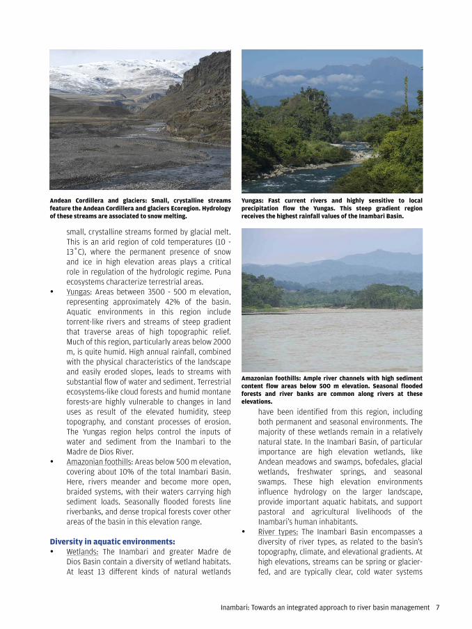
produce short-term flood peaks at any time of the year. At lower elevations, however, the Inambari features a more marked seasonality, with lower flows occurring roughly between July and September and higher flows between November and April. Three major ecoregions are found in the Inambari Basin, distinguished on the basis of elevation: Andean cordillera and glaciers (>3500 m), Yungas (3500 - 500 m), and the Amazonian foothills (<500 m). Annual precipitation is spatially and temporally variable throughout the Inambari. High elevation areas are arid, middle and low elevation areas are humid (2800 -7500 mm annual rainfall).
Ecoregions of the Inambari River Basin:• Andean Cordillera and glaciers: Areas above
3500 m elevation, covering roughly 48% of the basin. Aquatic environments in this region include
Country: Peru
Region: Southern Andean-Amazon, Cordillera Cara-baya, including slopes covering elevations from 180 - 5976 m on the eastern flank of the Peruvian Andes. The Inambari River is a tributary of the larger Madre de Dios River, itself an affluent of the Madeira Basin, which eventually drains into the larger Amazon River.
Inambari River Basin: The Inambari River Basin spans parts of Puno, Cuzco, and Madre de Dios departments within Peru, encompassing an area of approximately 20,360 km2. Within the Madre de Dios Basin, the Inambari is one of three major sub-basins, alongside those of the Tambopata and Alto Madre de Dios rivers. Of these three, the Inambari is the basin that drains the largest part of high Andean areas (above 3500 m) and has an estimated mean annual discharge of approximately 797 m3/s at its point of discharge into the Madre de Dios RIver. The natural flow regime of the Inambari varies as a function of elevation and precipitation. At middle elevations (3500 - 500) rivers are highly sensitive to local precipitation, which can
PANORAMA OF THE INAMBARI RIVER BASIN
The Inambari Basin encompasses around 20,000 km2 and drains the largest portion of the Andean foothills and highlands of the Madre de Dios Basin in southeastern Peru. On the basis of threats, protected areas, wetlands, and connectivity, eleven river basin management units have been classified within the Inambari for management purposes.
Inambari: Towards an integrated approach to river basin management 7
have been identified from this region, including both permanent and seasonal environments. The majority of these wetlands remain in a relatively natural state. In the Inambari Basin, of particular importance are high elevation wetlands, like Andean meadows and swamps, bofedales, glacial wetlands, freshwater springs, and seasonal swamps. These high elevation environments influence hydrology on the larger landscape, provide important aquatic habitats, and support pastoral and agricultural livelihoods of the Inambari's human inhabitants.
• River types: The Inambari Basin encompasses a diversity of river types, as related to the basin's topography, climate, and elevational gradients. At high elevations, streams can be spring or glacier-fed, and are typically clear, cold water systems
small, crystalline streams formed by glacial melt. This is an arid region of cold temperatures (10 - 13ÊC), where the permanent presence of snow and ice in high elevation areas plays a critical role in regulation of the hydrologic regime. Puna ecosystems characterize terrestrial areas.
• Yungas: Areas between 3500 - 500 m elevation, representing approximately 42% of the basin. Aquatic environments in this region include torrent-like rivers and streams of steep gradient that traverse areas of high topographic relief. Much of this region, particularly areas below 2000 m, is quite humid. High annual rainfall, combined with the physical characteristics of the landscape and easily eroded slopes, leads to streams with substantial flow of water and sediment. Terrestrial ecosystems-like cloud forests and humid montane forests-are highly vulnerable to changes in land uses as result of the elevated humidity, steep topography, and constant processes of erosion. The Yungas region helps control the inputs of water and sediment from the Inambari to the Madre de Dios River.
• Amazonian foothills: Areas below 500 m elevation, covering about 10% of the total Inambari Basin. Here, rivers meander and become more open, braided systems, with their waters carrying high sediment loads. Seasonally flooded forests line riverbanks, and dense tropical forests cover other areas of the basin in this elevation range.
Diversity in aquatic environments:• Wetlands: The Inambari and greater Madre de
Dios Basin contain a diversity of wetland habitats. At least 13 different kinds of natural wetlands
Yungas: Fast current rivers and highly sensitive to local precipitation flow the Yungas. This steep gradient region receives the highest rainfall values of the Inambari Basin.
Andean Cordillera and glaciers: Small, crystalline streams feature the Andean Cordillera and glaciers Ecoregion. Hydrology of these streams are associated to snow melting.
Amazonian foothills: Ample river channels with high sediment content flow areas below 500 m elevation. Seasonal flooded forests and river banks are common along rivers at these elevations.
8 Inambari: Towards an integrated approach to river basin management
trend seen in other parts of the Andean-Amazon as well. This decline in species richness with upslope movement relates to changes in the natural features of the landscape: aquatic habitats constrict, water temperatures become colder, and dissolved oxygen decreases at higher elevations. One endemic species has been registered to date from the Inambari: Chaetostoma marcapatae. And at least one species of trout, Onchorhynchus mykiss, has been introduced to the Inambari basin, and its presence has been documented from rivers between 1100 and 4000 m elevation.
• Migratory fishes: The natural dynamism of the Inambari River's flow helps to signal migration or movement of fishes in downstream areas. And many species of fishes also inhabit or visit the basin to complete their life cycle. Four different kinds of migratory behavior have been observed for fishes in the Inambari Basin.o Long-distance migratory fishes: include
catfishes of the genus Brachyplatystoma (dorado, mota flemosa), long-lived, large-bodied animals that migrate 3700 - 5500 km between the Amazon's estuary and Andean piedmont. Studies have shown that highest density of larvae in the region occurs around the end of October, coinciding with the first months of the rainy season.
o Regional migrants: include species of Characids (like Prochilodus) and catfishes (like Zungaro, Pseudoplatystoma) that are amply distributed in the Madeira River Basin and use the headwater regions, such as those of Inambari, Alto Madre de Dios, and Tambopata, for spawning.
o Local migrants: include species like Aguarunichthys (ashara) and Salminus (s�balo macho) that inhabit the Madre de Dios and Inambari, moving between lowland and headwater areas during different life stages.
o Andean migrants: hypothesized, possible movement of certain species between Andean environments, but in need of further study.
Linkages between humans and ecosystems:Diverse human populations inhabit the Inambari River Basin, and their social, cultural and economic activities have been linked to its rivers over a long history. Human presence in the Inambari dates back to at least the Incan Empire. Natural characteristics of the Inambari Basin-for example, a geology that sustains mineral production and mining for gold and uranium; diverse tropical forests harvested for rubber and lumber-have attracted waves of migrants in the past
that provide habitat for macroinvertebrates and other aquatic fauna, and water supply to human populations. At middle elevations, rivers become fast-moving torrents of cool water that cut through areas of steep slopes and carry increasing loads of sediments, organic matter and nutrients. Many waterfalls are found in this transitional middle elevation region. At lower elevations, rivers begin to meander through a flatter landscape, their channels becoming braided and broad. At these lower elevations, the periodic interactions between river channels and floodplains are ecologically and socially important. This lateral connectivity helps to provide habitat for fishes or inputs of organic matter to the main channel, and helps create productive floodplains upon which human activities depend.
• Freshwater fishes: At least 350 fish species are known from the Madre de Dios Basin, but it is estimated that closer to 450-500 species actually occur there. For the Inambari, approximately 100 species have been identified to inhabit areas above 350 meters in the basin. The areas between 350-200 m elevation are nearly inaccessible except by river, which limits scientific study. Therefore species richness is largely underestimated, as there is a high probability of existence of many un-described species. Based on data from many years of scientific expeditions, four orders of native fishes - Siluriformes (catfishes), Characiformes (characins), Gymnotiformes (electric fishes), and Perciformes (cichlids)-are known from the Andean region of the Inambari Basin above 350 m. Patterns of distribution of fishes suggest decreasing species richness with increasing elevation, a
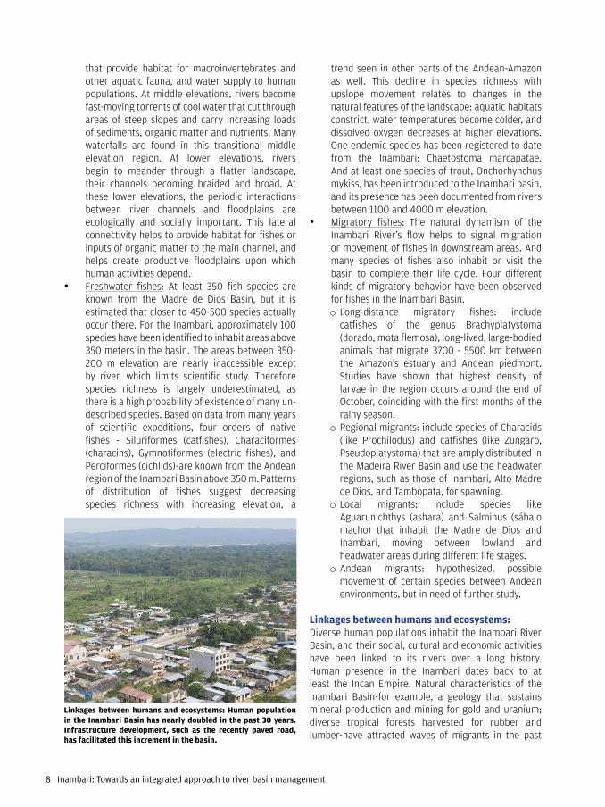
Linkages between humans and ecosystems: Human population in the Inambari Basin has nearly doubled in the past 30 years. Infrastructure development, such as the recently paved road, has facilitated this increment in the basin.
Inambari: Towards an integrated approach to river basin management 9
assemblages can happen over very short distances along elevational gradients above 500 m; the group of species found at one location may be markedly different from the group of fish species found just a few kilometers up or downstream. Recognition of regional diversity of fishes and other organisms is an important component of integrated river basin management.
• Migratory fishes: The Madre de Dios Basin contains critical areas for spawning of long-distance and regional migratory fishes, and is home to local migrants as well. The Inambari may have important sites for spawning within the larger Madre de Dios, as suggested by anecdotal evidence from human populations near Mazuko. Additionally, the Inambari Basin possesses the appropriate hydrologic and geomorphologic characteristics that fit migratory species needs. Andean migrants within the Inambari may move between montane aquatic environments during certain life stages. Many migratory fishes that visit the Madre de Dios or Inambari Basins are important to regional fisheries and to food security for human populations.
Considerations for Integrated River Basin Management:The lives and livelihoods of human populations within the Inambari Basin are linked to the basin's ecosystems. And many people located in areas geographically distant from Inambari also receive the benefits of the basin's ecosystems, for example in electricity that was generated or minerals that were mined from its rivers. Human activities in the Inambari, while valuable, also can compromise ecosystems when not pursued with
two centuries. Human population has nearly doubled in the past 30 years in the Inambari Basin, increasing from approximately 73,000 to 145,000 inhabitants over the period 1981-2007. Agricultural livelihoods sustain much of the human population, with an estimated 1.1 million hectares in the basin occupied by small-scale or communal agricultural lands (INEI 2012).
Opportunities and targets for integrated river basin management• The natural flow regime: The inherent dynamism of
the Inambari River influences a suite of ecological processes, at local and regional scales. The Inambari is a primary source of suspended and bedload sediments to the downstream Madre de Dios and Madeira Rivers, their transport mediated by flow. These sediments, as well as the organic matter and nutrients also exported downstream by the Inambari River, help with formation and maintenance of productive floodplains, critical for agricultural livelihoods and food security of regional human populations. Natural fluctuations in water flow in the Inambari cue migratory behavior and spawning in multiple species of freshwater fishes.
• Connected riverine pathways along elevational gradients: Species richness of terrestrial and aquatic organisms is known to vary with elevation. Growing understanding of distribution of freshwater fishes along elevational gradients in the Inambari and other Andean-Amazon rivers suggests a general decline in species richness with increasing elevation, however many species that occur at middle and high elevations are endemic. Additionally, change or turnover in fish species
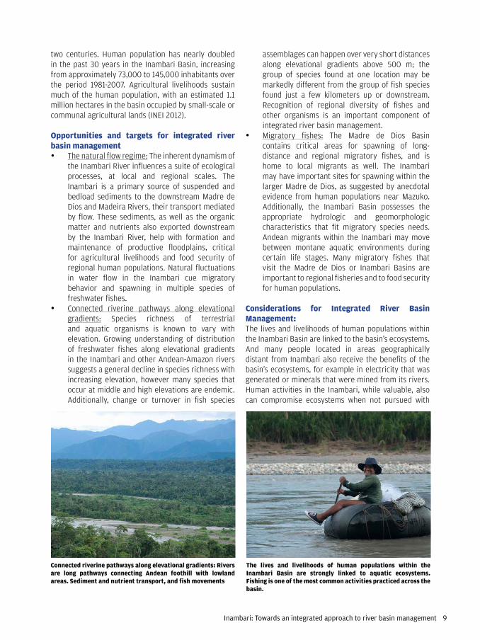
Connected riverine pathways along elevational gradients: Rivers are long pathways connecting Andean foothill with lowland areas. Sediment and nutrient transport, and fish movements
The lives and livelihoods of human populations within the Inambari Basin are strongly linked to aquatic ecosystems. Fishing is one of the most common activities practiced across the basin.

10 Inambari: Towards an integrated approach to river basin management
and potential for negative impacts on the Inambari Basin.
• Road building: The new Carreterra Interoce�nica Sur Per� - Brasil and other roads that connect regional cities are contributing to changes in the Inambari Basin and surrounding landscape, and in local human populations. Road building can directly affect rivers, through movement of sediments. But the indirect effects of road building for rivers may be more insidious. Increased access to previously remote areas and the associated deforestation, agricultural expansion, environmental contamination, or urbanization will have consequences for the condition of the Inambari and other rivers over the long term. These changes also affect the availability and quality of conditions in rivers upon which other
appropriate environmental and social safeguards. Similarly, one activity can affect another, when an integrated or basin-scale approach to management is absent. Some of the human activities ongoing in the basin that merit consideration within an integrated context are:
• Mining: Both artisanal and industrial mining exist in the Inambari basin, and mining is perhaps the human activity most responsible for degradation of aquatic environments to date. This degradation stems in part from the fact that there is limited application and enforcement of environmental and social safeguards for mining operations in the Inambari Basin. Use of mercury in gold mining has been linked to problems of contamination. But, for the time being, the disturbance of riverbed sediments that occurs during mining is a more serious local threat than mercury contamination, affecting both the stability of the river channel and the turbidity of the water column. Changes to hydrology of the basin, especially conversion of riverine areas to reservoirs, would increase likelihood of mercury contamination becoming a serious problem for ecosystems and human health.
• Small-scale agriculture: Small camps for culti-vation of coca exist along the banks of the Inambari and its tributaries. Chemicals used in the processing of coca, particularly for elaboration of cocaine, are typically dumped into rivers. This activity may present challenges to management on the basis of its clandestine nature, but still warrants recognition for its periodic occurrence
Small-scale agriculture: Coca cultivation has become to increase along the Inambari basin and its tributaries. It produces deforestation and pollution with chemicals dumped into rivers.
Mining operations modify significantly river banks, introduce mercury in aquatic ecosystems, and add large amounts of sediments to rivers and streams. Habitat alteration and destruction are the major impact this activity produces in the Inambari Basin.
Road building: The new Carretera Interoceánica Sur Perú. Its pavimentation was completed by 2010 and it connects Brazil with the Pacific coast.

Inambari: Towards an integrated approach to river basin management 11
The story of the Inambari River begins high in the Andes, where a network of small streams and rivers drain an arid, high elevation landscape, gaining in number and in volume of flow as they descend downslope, entering cloud forests and humid areas. Here these rivers pick up sediments that have eroded from steep canyon walls or riverbanks, and along with these sediments come nutrients and rich organic matter, also now moving downstream. Heading toward the lowlands, river channels open into braided, rocky-bottomed systems providing habitat for numerous resident species of fishes and for long-distance migrants, like catfishes whose journey begins thousands of kilometers away. In this region, the Inambari flows into the larger Madre de Dios. And later this river will unite waters with the Beni and then the Madeira, which will carry the water and sediments originating from Inambari into the mainstem Amazon River far downstream. The Inambari River Basin drains a land area of approximately 20,360 km2 and represents around 10% of the land area of the Madre de Dios Basin, roughly 1.5% of the Madeira, and less than 0.3% of the greater Amazon. But the Inambari plays a critical role disproportionate to its small size in hydrology and sediment dynamics of the larger basins within which it sits. Its drainage area encompasses extensive Andean piedmont and highland regions. Almost 90% of the Inambari basin is located above 350 m elevation and includes areas of highest rainfall in the larger Madre de Dios Basin and areas of high erosion. Discharge from the Inambari River accounts for approximately 5% of the flow in the Madeira River, and 1% of that of the Amazon (Goulding et al., 2010). Rocky bedload sediments from the Inambari sustain river channels and other downstream areas.
human activities depend, especially hydropower development. Best practices and consideration of new roads within a larger landscape context can help identify implications of road development that can be considered in basin level planning and management.
• Hydropower development: The 100-MW Central Hidroel�ctrica San Gab�n II, located at around 2100 m elevation on the San Gab�n River, has been in operation since the late 1990s. As of 2014, an additional 15 hydropower projects are currently under various stages of consideration - from licensing, to evaluation, to planning, to feasibility study. This possible proliferation of hydropower dams in the Inambari basin has several consequences. For example, one of the proposed projects, Inambari, would be located near the outlet of the basin on the Inambari River, therefore disrupting connectivity between all upstream, headwater areas of the basin and the larger Madre de Dios-Madeira-Amazonas system. The cumulative effects of multiple dams in operation in one river basin, in this case the Inambari, will lead to substantial alteration of the hydrologic and sediment regimes in that basin. Further, dams introduce barriers to movement of fishes and other migratory organisms that depend on connected pathways to realize their life cycle. There is a strong need to consider existing and proposed hydropower development within an integrated river basin management context. Additionally, decades of lessons from other places have helped to identify the importance of environmental and social safeguards in hydropower development, and the consideration of these safeguards from the earliest phases of planning on through operation and maintenance of a dam.
WHY THE INAMBARI RIVER BASIN?
Almost 90% of the Inambari basin is located above 350 m elevation and includes areas of highest rainfall in the larger Madre de Dios Basin.
Hydroelectric Power San Gabán in the Inambari Basin. It is located at 2100 m elevation and is the only operating dam in the Inambari Basin.
12 Inambari: Towards an integrated approach to river basin management
Hydropower DevelopmentTropical regions have become new frontiers for hydropower dam construction, a trend exemplified by the recent, ongoing proliferation of hydropower projects throughout the Amazon Basin. Dozens of large, storage dams are in operation, under construction, or proposed for lowland Amazonian rivers. There is growing concern about their implications for lowland ecosystems and human populations with cultural, health and livelihood ties to these ecosystems. Similarly, the river alterations caused by an estimated 48 existing and 151 planned hydropower projects1 for Andean-Amazon rivers could have wide ranging consequences for this region and the lowland Amazon (Finer & Jenkins, 2012). Until recently, all of the eight major mainstem Andean-Amazon rivers-Caquet�, Putumayo, Napo, Mara��n, Ucayali, Madre de Dios, Beni, and Mamor�-were unimpeded by dams, although some of their tributaries have been altered by dams since the latter half of the 20th century (McClain & Naiman 2008). Hydropower dams and other kinds of human-induced fragmentation of Andean-Amazon rivers change the ability of these rivers to act as pathways for movement of water, organic matter, sediment, nutrients, and organisms between the headwaters and lowland areas of the Amazon Basin. Many migratory fish species that inhabit the Madeira-Madre de Dios-Inambari system depend on unimpeded rivers to complete their life cycles; some of these same species account for a substantial part of landings at regional fisheries markets. Furthermore, much of the Andean-Amazon region has been inhabited by humans over thousands of years, with rivers providing a source of water supply, waste assimilation, recreation, and cultural importance over a long history. Hydropower dams are very likely to compromise the quality and availability of these other uses of rivers. Given these local impacts and the projected losses in connectivity between the headwaters and downstream areas of the Amazon Basin, proliferation of hydropower development in the Andean-Amazon region was recently identified as one of the 15 most pressing issues for global conservation efforts (Sutherland et al., 2013).
These trends of increasing hydropower development are evident in the Inambari River Basin, where one project is in operation (San Gab�n II) and at least 15 hydropower projects are currently planned. The Inambari River Basin, alongside the Mara��n Basin, 1 Based on Finer & Jenkins 2012. These figures include all projects >2 MW installed generation capacity. A larger, unknown number of dams with lower installed generation capacity also have already or will alter Andean Amazon rivers.
Human inhabitants have left a strong impact on the Inambari Basin, and continue to do so. The Inambari finds itself in the midst of a process of rapid transformation. Acceleration of mining and deforestation, and proliferation of hydropower development now threaten ecosystems and the human populations that depend on these ecosystems. Given the Inambari's importance in the Andean-Amazon and its influence on downstream areas, there is a need to pursue a goal of more integrated river basin management.
SCENARIOS OF CHANGE

Inambari: Towards an integrated approach to river basin management 13
contributor of sediments to the mainstem Amazon. And within the Madeira's larger catchment, the Inambari is one of the basins draining highly erosive, steep slopes from which large amounts of riverine sediments derive. In the Inambari River Basin, apart from natural characteristics of the basin, riverine sediment dynamics are influenced by multiple factors, among these land use, mining, and hydropower dams.
Sediment dynamics in light of hydropower development River impoundment is a major concern for the regional sediment cycle. Transport of sediments, maintenance of river channels, and formation of river channels are all geomorphologic processes linked to a rive's hydrologic regime, as the volume and velocity of water affects sediment movement, deposition, and scour. As hydropower dams alter river flows, and typically block the river channel, they alter sediment regimes; for basins with multiple dams-like Inambari-the sequential effects of individual dams on downstream projects are an important consideration. Dams affect both suspended sediment load and bed sediment load.
Sediment dynamics and mining The Inambari Basin has experienced a marked increase in mining activity since the 1990s, particularly gold mining. Both artisanal and industrial mining occur in the basin. Gold mining has occurred primarily in the Caychihue and Dos de Mayo sub-basins, although extensive concessions recently have been granted throughout the Inambari. Deforestation and subsequent erosion near mining sites increase sediment in rivers, and byproducts or materials used in mining, such as mercury, contaminate waterways. Studies of sediment dynamics and total suspended sediment (TSS) fluxes suggest that TSS
likely has the highest potential capacity for hydropower generation of any basin in Peru. An estimated 3,846 MW of new generation capacity is being considered for hydropower projects in just the Inambari River Basin; this is more than the current hydropower generation capacity in all of Peru. Currently, roughly 50% of Peru's electricity is generated by hydropower dams. But this percentage and the country's total installed generation capacity are likely to increase over the period 2010 - 2040 (MINEM 2012). An increase in hydropower development in the Inambari and other Peruvian river basins is said to be part of a national strategy to satisfy growing domestic needs for electricity, but also part of future plans to sell electricity as an export product to neighboring countries, particularly Brazil.
This scenario of increasing hydropower development in the Inambari River Basin could mean various things for the future of rivers and their ability to provide freshwater ecosystem services to human populations in the southern Amazon of Peru. Most directly, hydropower dams in the Inambari will change the hydrologic and sediment regimes of the Inambari River and its tributaries. Less export of sediments, organic matter, and nutrients from the Inambari to downstream areas will occur, and natural patterns of high and low flows, which act as signals and are linked to biological functions for many migratory fishes, will change. Habitats for fishes and other aquatic biota will also be altered, as running water ecosystems are converted into lake-like reservoirs behind dams. Beyond these direct riverine effects, hydropower development can spark other changes in a landscape and among its human inhabitants. Dam development often opens new roads and access to previously remote areas, facilitating expansion of agriculture, forest clearing, or urbanization. During the construction phase, dams frequently attract large numbers of migrant workers who may bring other customs or even diseases into the region, and may remain as inhabitants of the region long after dam construction has finished. While it is difficult to predict the extent and magnitude of these kinds of effects, the recognition of the potential changes for Inambari and the articulation of appropriate management strategies is critical.
Sediment ScenariosAndean rivers provide critical sources of sediments to the mainstem Amazon; according to some estimates as much as 90-95% of suspended sediment carried by the mainstem Amazon River originates from Andean sources (McClain & Naiman 2008). The Madeira River Basin stands out even among Andean rivers as a major
Andean rivers provide with sediment and nutrients to lowland reaches of Amazon Rivers. This is more evident during rainy season when the highest rates of erosion and river velocity occur at the Andean foothill tributaries

14 Inambari: Towards an integrated approach to river basin management
Mercury / Gold mining ScenariosPeru's southern Amazon region, and particularly the Madre de Dios River Basin, has experienced a dramatic increase in mining activity since the 1990s. Gold mining, mainly illegal, is rampant in the area and has already resulted in deforestation of tens of thousands of hectares. The spread of gold mining has been motivated in part by an increase in the price of gold in world markets, which has risen six-fold over the past decade. Within the larger Madre de Dios system, the Inambari has emerged as one of the basins with a major increase in gold mining since the 1990s. A consequence of this mining activity has been large inputs of mercury into rivers of the Inambari Basin, accompanied by increasing concern for the ecological and human health implications of mercury contamination. Gold miners exploit coarse sands in alluvial or placer deposits, and mercury is used in various stages of the mining process. Estimates suggest that in the larger Madre de Dios Basin, roughly 16 metric tons of gold are produced annually and 44.8 tons of mercury are used in the extraction process. Additionally, erosion in mining areas transports floodplain and terra firme sediments to rivers; these sediments can contain naturally occurring or mining-related sources of mercury.
Mercury concentrations are low in natural waters and mercury is somewhat harmless in aquatic environments until it is transformed into methyl-mercury through a bacterially mediated process. This process occurs mainly in anoxic, acidic aquatic environments with high dissolved organic carbon, conditions that are relatively rare in the Inambari Basin. Methyl-mercury, once formed, can be efficiently bio-accumulated and bio-magnified in aquatic food webs, although this risk may be low in the Inambari relative to lowland areas of the
fluxes in rivers with large mining operations can exceed natural background levels by 2-3 orders of magnitude. The interacting effects of increased TSS from mining and the presence of reservoirs associated with hydropower dams are also not trivial; estimates of reservoir sediment loads under scenarios where 25%, 75% and 100% of total upstream basin area was subjected to mining activity suggest that sediment loads in future reservoirs would be 3-4 orders of magnitude higher than the present 0% level of mining activity, thus compromising the lifespan and productive capacity of the proposed hydropower dams.
Downstream effects of altered sediment dynamics Dams function as traps for river sediments, and this is predicted to be the case for the proposed hydropower projects in the Inambari Basin. The consequence of sediment trapping is reduced sediment supply to downstream areas. Water released downstream from dams may be free or nearly free of sediments, and thus its capacity for scouring the downstream channel will be higher. In the lower parts of the Inambari Basin and in the Madre de Dios, river channels exhibit a large spectrum of bed load particle sizes and braided channels. In a scenario where dams block export of sediments but release some water, river channel scour and erosion will likely remove smaller particles of sand and gravel, while remaining large boulders form a kind of Áarmoured channel, altering the habitats upon which many aquatic species depend. Suspended sediment loads of rivers downstream have potential for recovery with inputs from other undammed tributaries, thus the downstream effects of dams on this component of the sediment regime may not be so significant at the Madeira or Amazon Basin scale. Conversely, the effects of dams in the Inambari on bed sediment load transport are more difficult to estimate and could be more problematic for downstream areas. The Inambari Basin is a major source of bed load materials that may not be replaced by other tributaries without extensive Andean areas in their basins. Finally, downstream reductions in sediment will also likely affect productivity and existence of floodplain areas. Floodplain vegetation, and even many riverine species, depends on flood pulses to maintain seasonal growth patterns; sediments carried with these flood pulses maintain floodplains and increase soil fertility. Over time, areas downstream from dams that once were covered by floodplain forests may be substituted by more terra firme forests or transformed into agricultural lands.
Gold mining activity has increased within the basin since 1990. Sediment removal and added into many rivers and streams have altered directly aquatic habitats and in some cases disrupted migration routes of fishes.

Inambari: Towards an integrated approach to river basin management 15
health concerns for human populations dependent on river fishes as a main protein source, most risks would be associated with consumption of migratory species rather than consumption of local, resident fishes. It must be noted however that these observed conditions are expected to change with landscape and river alterations. Reservoirs of hydropower dams in the Inambari would create conditions more conducive for mercury methylation: anoxic and acidic bottom areas with low dissolved oxygen, and consequently could increase the mercury levels in resident fishes and local human populations that eat these species.
Greenhouse Gas ScenariosGreenhouse gas emissions from tropical reservoirs were first documented in the early 1990s, and since then general understanding of the conditions that lead
Amazon with more anoxic, acidic wetland environments. Studies from fishes known to bio-magnify mercury-such as Hoplias malabaricus, or fasaco-have shown that individuals near Puerto Maldonado have slightly higher levels of mercury in tissues than specimens from upstream sites less impacted by gold mining. Nevertheless, mercury concentrations in sampled resident fishes were substantially lower than those of fishes from other parts of the lowland Amazon, where better conditions for mercury methylation exist naturally. Conversely, mercury levels in many of the migrating predatory fishes that enter the Madre de Dios Basin have been documented at levels above safe human consumption of these animals. The cause for elevated mercury levels in these migratory fishes is difficult to attribute, as they spend time in multiple areas across the Amazon during their life cycles. In terms of human
Huaypetue, a town created by the gold mining activity, is the most extreme situation where the permanent sediment inputs have overpassed the capacity of rivers to carry suspended sediment in the Inambari Basin.
This section of the Inambari basin would be covered by the reservoir if dam was built. The large amount of forest that will be flooded will be decomposed and will very likely release CO2 and CH4 to the reservoir.

16 Inambari: Towards an integrated approach to river basin management
Recommendation 1: Promote a basin-scale approach to evaluation of infrastructure, extractive, agriculture, and energy projectsNatural hydrographic boundaries define a river basin, determining areas from which water, sediments, and other materials run off of the landscape into rivers. Within basin boundaries, natural processes, physical conditions, environmental characteristics, and even social context are likely to be interconnected. Changes in one aspect of a basin-such as land use, road construction, or hydropower development-affect environmental conditions and human activities in other parts of a basin. Given this clear area of influence on river systems, rivers ideally should be managed according to basin boundary lines, and new infrastructure, extractive, agriculture, or energy projects should be evaluated in terms of their potential implications on the entire basin. Unfortunately, in many places around the world and in much of Peru, this basin-scale approach to management and development is not routine.
The geographic context or level at which a basin-scale approach should be applied is an important consideration for management and evaluation of development projects. In the case of Inambari, its river basin is part of a nested system: Inambari is a sub-basin of the Madre de Dios River Basin, which is a sub-basin of the Madeira River Basin, which itself is a sub-basin of the Amazon River Basin. Further, the Inambari Basin can be sub-divided into numerous smaller river basins.
So at which basin-scale should management be considered? Recent scientific studies have illustrated the role that the Inambari and other Andean Amazon river basins exert on lowland Amazonian systems in terms of export of sediments and nutrients, and the importance of these headwater systems as spawning areas for long-distance migratory fishes that travel from as far as the Amazon's estuary to the Madre de Dios / Inambari basin. Therefore, any project, such as a dam, mining extraction, or other infrastructure that could significantly impede upstream-downstream movement of water, matter, and organisms, should ideally be considered at the scale of the larger Amazon or at least Madeira system. Other interventions, such as those that may not disrupt river connectivity or may not involve extensive land use changes, could be adequately evaluated on the scale of the Madre de Dios or even
to their release has increased markedly. Methane (CH4)
and carbon dioxide (CO2) are the primary greenhouse
gases released from reservoirs. The amount of these gases that are released from reservoirs depends on the density and stored organic carbon content of terrestrial vegetation present upon flooding, the time since reservoir creation, and climate, among other factors (St Louis et al. 2000).
In the case of the Inambari, some of the proposed dams will flood large areas currently covered by dense tropical forest. The inundation of these terrestrial ecosystems following impoundment will accelerate decomposition of vegetation and soils, accompanied by a release of CO
2. Additionally, thermal stratification of reservoirs
and reductions of dissolved oxygen, also a result of decomposing vegetation, can lead to anoxia and generation of increased amounts of CH
4. The two gases,
CO2 and CH
4 will be released from reservoir surfaces and
also downstream of the dam by rapid degassing through turbines and surface diffusion from downstream river channels. The magnitude of these greenhouse gas fluxes from proposed reservoirs in the Inambari is very difficult to estimate. Studies from elsewhere have shown that greenhouse gas fluxes from reservoirs vary as related to reservoir age, latitude, dissolved organic carbon, and depth. Therefore, emissions from future reservoirs in the Inambari may be highest in the first 5-10 years following dam construction, and then may subsequently level off. Surface emissions of CO
2 and
CH4 from areas downstream of dams may exceed gas
emissions from the reservoir and will likely follow this same temporal pattern. In summary, experience from other tropical landscapes suggests that forested areas of the pre-dammed landscape of the Inambari Basin are a net sink for CO
2 and CH
4, and net emissions of these
greenhouse gases following river impoundment will likely be higher than historical levels.
RECOMMENDATIONS FOR INTEGRATED RIVER BASIN MANAGEMENT IN INAMBARI

Inambari: Towards an integrated approach to river basin management 17
and considering environmental, economic, and social factors for which a project could have implications at these different scales.
Recommendation 2: Conduct an examination of cumulative effects of river and landscape alterations The effects of individual river and landscape alterations-such as a hydropower dam, or a new road construction-can vary in time and in space, and rarely occur in isolation. Rather, effects of a hydropower dam or a new road can add to or interact with effects of other developments in a river basin. These aggregated impacts will engender a magnified and basin-wide synergic effect. Cumulative impact assessment studies provide a framework for examination of these additive and interactive effects.
Hydropower dams and their effects on riverine connectivity provide a case in point for understanding the importance of cumulative impact assessment. For example, the presence of one hydropower dam fragments a river network in one place, dividing it into upstream and downstream sections; additional dams increase the overall percentage fragmentation of the entire river network, but also split the network into increasingly smaller, discontinuous fragments. Several scientific frameworks-such as fragmentation analyses or the serial discontinuity concept-have attempted to quantitatively estimate the cumulative effects of dams in terms of losses in riverine connectivity. These concepts are helpful in providing a basis for evaluation of cumulative effects of dams on one environmental parameter (connectivity), and also illustrate the
Inambari Basin itself. Consideration of scales at which a project may affect social conditions is also critical; sometimes the social implications of a hydropower dam, extractive industry, road construction, or agricultural project may be more or less wide-ranging than the scales of environmental impact. For example, a hydropower or agricultural project in a headwater region like the Inambari Basin could affect regional fisheries markets or food security outside of the Inambari's basin boundaries. Alternatively, migrations of human workers from other areas to the Inambari may have more relevant implications for public health at the scale of local human populations than at an Amazon or Madeira Basin scale.
Currently, in the Inambari River Basin, it is more likely for infrastructure, extractive, agriculture, and energy projects to be evaluated on local scales, with focus on the direct impacts or changes in local areas of influence. The increasing river alteration and infrastructure development currently underway now offer an opportunity to adopt a more basin-scale approach to management and evaluation of project impacts. International recognition of the importance of the Andean-Amazon region and the potential implications of hydropower development in Inambari and other headwater systems for the entire Amazon Basin has also helped draw attention to the need for a basin-scale approach. To this end, feasibility and environmental impact assessment studies for individual infrastructure, extractive, agriculture, and energy projects should be required to complete an analysis of scales of impact, using river basin boundaries (Inambari, Madre de Dios, Madeira, Amazon) as nested units for evaluation,

18 Inambari: Towards an integrated approach to river basin management
the integration of all human intervention effects independent of any one particular project. In the case of Inambari, and even in the context of the larger Andean-Amazon region, a strategic environmental assessment would help to identify current and future risks of river and landscape alterations in the region, and could help identify projects that merit priority and projects whose negative consequences could exceed benefits. A strategic environmental assessment can also help identify critical ecosystems, wetlands, and biodiversity occurring within a river basin that should be protected on the basis of their ecological or social significance. Given the critical role that Andean-Amazon headwater areas exert on the greater Amazon Basin, this consideration could help to avoid large-scale environmental and social problems downstream and in the future.
Recommendation 3: Establish a multi-sector / multi-scale platform for management of the Inambari River BasinA river basin can be considered a common good. In the case of Inambari, ecosystems within the basin's boundaries harbor fish species that provide protein and income to local human populations; include fertile land areas for agriculture; protect forests that regulate regional climate and support high biodiversity; contain sites for extraction of gold, uranium, and other materials; sustain river flows that generate electricity; among numerous other goods and services. Each of these different uses of natural capital of the Inambari is typically managed by a separate entity. As a consequence, different interests can come into conflict with one another, resource use may be haphazard or unnecessarily intense, and common resources may face rapid degradation.
A multi-sector / multi-scale platform for management of the Inambari River Basin is necessary to protect and promote sustainable use the basin's resources. A multi-sector / multi-scale platform is a vehicle by which actors from different government institutions at a national level-for instance, the Ministry of the Environment, National Service of Natural Protected Areas, and Ministry of Production-can provide input for basin management alongside departmental or local government authorities. This platform also provides a space for non-governmental organizations, civil society groups, and the private sector to play a role in decision-making in a basin context. These kinds of platforms depend on certain features: formal channels for participation of the different sectors; existence of an overarching convening authority; transcendence of
challenges of considering the impacts of more than one project at time. It is also important to note that hydropower dams can have social and environmental impacts on other aspects of a basin as well, especially when considered alongside other developments. An example here would be changes in human populations and land use that may occur as a result of hydropower dam construction, as migrant workers from other areas come and settle in the region of the dam; these kinds of demographic and land use changes could be compounded or exacerbated if a new road were also to be under construction, facilitating increased access to previously uninhabited areas and additional human population growth through migration. Road construction has also been shown in multiple cases to increase deforestation, a land use change that has implications for the sediment load and water quality of rivers, which in turn can affect sediment dynamics in the reservoir of a dam. In the case of Inambari and Peru in general, there is a need for increased incorporation of cumulative impact assessment to be part of the process of evaluation of projects or even study of their effects post-construction. Most basins, like Inambari, already have multiple projects of different kinds--like roads, dams, agricultural areas, illegal mining, among others-and their number and extent is likely to increase. Currently, most new projects like hydropower dams are evaluated on an individual basis during the environmental impact assessment process. Given the complex nature of cumulative effects, clear guidance and a strong legal framework that supports cumulative impact assessment would facilitate more adoption of this practice. Consideration of cumulative impacts will also allow resource managers to better understand how a group of projects will affect the Inambari Basin. With that information, better guidance can be given to individual projects on how to design and implement strategies to avoid, mitigate, or compensate impacts within the context of the changes occurring over the larger basin. At a broader scale, beyond just cumulative impact assessment, the practice of strategic environmental assessment has been gaining ground in recent years internationally. Strategic environmental assessment aims to look at the context, opportunities, and challenges of different scenarios of development in a river basin or other landscape. These assessments should incorporate a temporal component, consider changes at multiple scales, and also should be focused on politics, plans, and programs that consider

Inambari: Towards an integrated approach to river basin management 19
NÊ29338, 2009), is responsible for management of water in rivers and planning water use in individual basins, but not for governance of the larger landscape that influences the condition of these rivers. The Ministry of Environment (Ministerio del Ambiente-MINAM) is responsible for biodiversity conservation and protection of native species, with the exception of freshwater fishes, which are under the management jurisdiction of the Ministry of Production (Ministerio de la Producci�n-PRODUCE). Similarly, legislation that protects natural resources, such as the Ley de Areas Protegidas (Ley NÊ 26834, 1997), focuses only on the area delimited by a protected area but has no jurisdiction on water bodies, nor does it consider the larger basin within which that area sits.
However, there is cause for optimism, as the new Ley de Recursos H�dricos (2009) stipulates the formation of a Basin Council (Consejo de Cuenca) for river basins in order to allow for involvement of government, private sector, civil sector organizations, and others to participate in water resources management alongside the Autoridad Nacional del Agua. Given the newness of this policy, few examples in Peru exist as related to its implementation and the creation of a Basin Council. In the case of Inambari, this Basin Council hasn't yet been formally established, and there appear to be two
traditional political boundaries; and broad recognition for the value of contributions from all levels of society to integrated river basin management. A multi-sector / multi-scale platform for management is also much stronger than the sum of its parts. Different participants contribute different kinds of knowledge and experience to the platform, and different competencies for management. The advantage of a multi-sector / multi-scale platform lies in its integrative aspects, which offer a space for more contextually-appropriate, complex decision-making for management and greater potential for collaborative enforcement of management objectives at local to regional to basin scales. What is the current outlook for a multi-sector / multi-scale platform for river basin management in the Inambari Basin? Presently, the absence of a coordinating body at a basin scale provides a challenge. So do the diverse territorial jurisdictions over resources-the Inambari Basin covers parts of three departments, Cusco, Puno, Madre de Dios, and numerous districts. These jurisdictions follow political divisions rather than natural basin boundaries. At a national level, the roles of different ministries or government agencies for management can be somewhat confusing. For example, the National Water Authority (Autoridad Nacional del Agua-ANA), under the Ley de Recursos H�dricos (Ley
The Inambari basin includes important Andean wetlands such as ample prairies associated to peatlands and glaciers. The Inambari Basin hosts the major number of wetland types in southeastern Peru.

20 Inambari: Towards an integrated approach to river basin management
Basin. This proposal was made based on the fact that the processes followed to create the MMCI included gathering input from various sectors, among these environmental, development and planning officers from municipal governments in the basin, as well as civil society organizations. The existence of the MMCI therefore provides a vehicle for moving forward with the formation of the Inambari Basin Council, and the stakeholder input that was solicited during creation of the MMCI will be an invaluable resource for the Basin Council as well. Basin-scale planning and project evaluation, cumulative impacts assessment, strategic environmental assess-ment, and multi-sector / multi-scale collaboration are all tools for integrated river basin management. Implementation of these tools requires a coordinating body with a clear vision, defined objectives, and authority to convene diverse stakeholders. In the Inambari, the Basin Council, promoted by the MMCI with support from ANA, will help to fill this critical role, hopefully in the near future.
possible paths for its creation. The first would be to allow ANA to promote the formation of the Inambari Basin Council and shepherd its development. The second would be to pursue the establishment and strengthening of the Inambari Basin Council by taking advantage of the recently formed Mancomunidad of Municipalities of the Inambari Basin (MMCI). The MMCI is a commonwealth of municipal governments that was established in October 2013 with the goal of improving quality of life in the Inambari region through the pursuit of specific development objectives, some of which clearly state the importance of the concept of river basin management. A vision for the MMCI and its role has been articulated and circulated among municipal governments.
Vision of the Mancomunidad of Municipalities of the Inambari (MMCI).By 2021, the MMCI will contribute decisively to issues of governance and social, economic, and environmental development in its area, with a focus on the basin, its actions reflected in: the improvement of the quality of life of basin inhabitants and the better use of human potential; in guaranteed food security, education, technology, and integral development; in the efficient management of economic development; in obtaining benefits from environmental services; in the dynamism of sustainable economic activities, including tourism, sustainable use of natural resources, and conservation of water resources. All of these actions will be based on concerted efforts.
Within the vision of the MMCI, there are four major, overarching themes that advocate integrated river basin management for Inambari:
1. An integrated, basin-scale focus on management
2. Basin-level governance that relies on inter-institutional collaboration and participation at multiple levels and from multiple sectors
3. Social, environmental, and economic development that promotes improved quality of life
4. River basin conservation to protect water resources and encourage sustainable use of natural resources.
The creation of the MMCI has helped with articulation of key criteria and elements for legal associations between municipalities that share natural resources within the same basin. Thus, the MMCI has been suggested as the mechanism to lead the promotion of the basin council for integrated management of the Inambari River

Inambari: Towards an integrated approach to river basin management 21
CONCLUSIONS
The case of the Inambari illustrates many of the characteristics of Andean-Amazon river basins and their influence on ecosystems and human populations locally and in distant geographies. Despite its relatively small geographic area, the Inambari plays a critical role in the hydrology, sediment dynamics, and ecology of the larger Madre de Dios, which in itself represents a very important headwater basin of the Madeira and Amazon basins. And like other Andean-Amazon Basins, the Inambari enriches the lives and livelihoods of thousands of people in the Amazon and beyond, through the ecosystems it sustains, the electricity it generates, and the minerals it exports.
The case of Inambari also illustrates the complexities of the Andean-Amazon landscape and the transformations to which this landscape currently is being subjected. The scale and intensity of hydropower development, road building, and mining that is underway in the Inambari is unprecedented for a basin of its size in the Andean-Amazon region. In this context, pursuit of an integrated approach to river basin management is critical for the future of the Inambari and for other Andean-Amazon river basins.
The Inambari at its lowlands reaches in the Department of Madre de Dios. Large floodplain areas remain exposed along the wide-braided channel during dry months of the year, which are used occasionally for agriculture.

22 Inambari: Towards an integrated approach to river basin management
McClain, M.E. and Naiman, R.J. 2008. Andean influences on the biogeochemistry and the ecology of the Amazon River. Bioscience 58(4):325-338.
St. Louis, V.L., Kelly, C.A., Duchemin, E. Rudd, J.W.M., and Rosenberg, D.M. 2000. Reservoir surfaces as sources of greenhouse gases to the atmosphere: A global estimate. BioScience 50(9): 766-775.
Sutherland, W. J., Bardsley, S., Clout, M., Depledge, M. H., Dicks, L. V., Fellman, L., Watkinson, A. R. (2013). A horizon scan of global conservation issues for 2013. Trends Ecol Evol, 28(1), 16-22. doi: 10.1016/j.tree.2012.10.022
Anderson, E. P., & Maldonado-Ocampo, J. A. (2011). A regional perspective on the diversity and conservation of tropical Andean fishes. Conserv Biol, 25(1), 30-39. doi: 10.1111/j.1523-1739.2010.01568.x
INEI 2012. IV Censo Nacional Agropecuario 2012.
Finer, M., & Jenkins, C. N. (2012). Proliferation of hydroelectric dams in the Andean Amazon and implications for Andes-Amazon connectivity. PLoS One, 7(4), e35126. doi: 10.1371/journal.pone.0035126
Goulding, M., Barthem, R., Ca�as, C, Hidalgo, M., and Ortega, H. 2010. La cuenca del Rio Inambari: Ambientes acuaticos, biodiversidad y represas. Wildlife Conservation Society, Peru.
MINEM 2012. Elaboraci�n de la Nueva Matriz Energ�tica Sostenible y Evaluaci�n Ambiental Estrat�gica, como Instrumentos de Planificaci�n.
REFERENCES