Embed Size (px)
Citation preview
Town of Ashford, NY Master Plan
Adopted XX, 2018
Table of Contents Acronyms ...................................................................................................................................................... 1 Element 1: Issues and Opportunities ............................................................................................................ 1
1.1. Introduction .................................................................................................................................. 1
1.2. Public Process ............................................................................................................................... 3
Element 2: Physical Setting and Demographics ............................................................................................ 4 2.1. Location ......................................................................................................................................... 4
2.2. Topography ................................................................................................................................... 5
2.3. Water Resources ........................................................................................................................... 6
2.4. Demographics ............................................................................................................................. 15
2.5. Physical Setting and Demographic Goals .................................................................................... 18
2.6. Physical Setting and Demographic Recommendations .............................................................. 18
Element 3: Housing ..................................................................................................................................... 20 3.1. Existing Housing Conditions ........................................................................................................ 20
3.3. Housing Recommendations ........................................................................................................ 26
Element 4: Transportation .......................................................................................................................... 28 4.1. Existing Transportation Facilities ................................................................................................ 28
4.2. Transportation Issues Raised During Planning Process .............................................................. 34
4.3. Transportation Goals and Objectives .......................................................................................... 34
4.4. Transportation Recommendations ............................................................................................. 34
Element 5: Utilities and Community Facilities ............................................................................................ 36 5.1. Existing Utilities and Community Facilities Conditions ............................................................... 36
5.2. Utilities and Community Facilities Goals and Objectives ............................................................ 38
5.3. Utilities and Community Facilities Recommendations ............................................................... 39
Element 6: Agricultural, Natural and Cultural Resources ........................................................................... 41 6.1. Agriculture Resources Inventory ................................................................................................. 41
6.2. Natural Resource Inventory ........................................................................................................ 42
6.3. Agricultural, Natural, and Cultural Resources Goals and Objectives .......................................... 42
6.4. Agricultural, Natural, and Cultural Resources Recommendations ............................................. 43
Element 7: Economic Development ............................................................................................................ 45 7.1. Economic Development Existing Conditions .............................................................................. 45
7.2. Industry Cluster Analysis ............................................................................................................. 52
7.3. Environmentally Contaminated Sites.......................................................................................... 67
7.5. Economic Development Goals and Objectives ........................................................................... 68
7.6. Economic Development Recommendations ............................................................................... 69
Element 8: Intergovernmental Cooperation ............................................................................................... 72
8.1. Ashford’s Intergovernmental Relationship ................................................................................. 72
8.2. Intergovernmental Cooperation Goals and Objectives .............................................................. 73
8.3. Intergovernmental Cooperation Recommendations .................................................................. 73
Element 9: Land Use .................................................................................................................................. 75 9.1. Existing Land Use ...................................................................................................................... 75
9.2. Land Divisions ........................................................................................................................... 87
9.3. Land Use Projections ................................................................................................................. 87
9.4 Future Land Use Plan ................................................................................................................ 87
9.6. Land Use Goals and Objectives ................................................................................................. 94
9.7. Land Use Recommendations .................................................................................................... 95
Element 10: Implementation ...................................................................................................................... 96 10.1. Summary of Key Planning Issues and Opportunities .............................................................. 96
10.2. Implementation Tools ............................................................................................................. 96
10.3. Regulatory Measures .............................................................................................................. 97
10.4. Non-Regulatory Measures ...................................................................................................... 99
10.5. Consistency Among Plan Elements / 20-Year Vision ............................................................ 100
10.6. Plan Adoption, Monitoring, Amendments and Updates ...................................................... 101
10.7. Five-Year Action Plan ............................................................................................................ 102

Acronyms AADT Average Annual Daily Traffic LTHHPC Long-Term Home Health Care Program
AML Agricultural Markets Law NAICS North American Industry Classification System
BPRR Buffalo and Pittsburgh Railroad
ND Neighborhood Development
CCHD Cattaraugus County Health Department
NPDES National Pollution Discharge Elimination System
CDBG Community Development Block Grant
NRCS Natural Resources Conservation Service
CEDS Comprehensive Economic Development Strategy
NYSCED New York State Department of Environmental Conservation
CHHA Certified Home Health Agency
NYSDOT New York State Department of Transportation
CRP Conservation Reserve Program
QECW Quarterly Census of Employment and Wage
CSA Community Supported Agriculture
RCRA Resource Conservation Recovery Act
CSM Certified Survey Maps Residential RA
This district is generally intended to preserve agricultural lands and provide for very low-density rural development. Development in this district includes single-family homes that are detached, free-standing residential structures. The approximate density should be at least 1 dwelling unit per 5 acres or more. This land use is not included in either Planning District.
DHS Department of Homeland Security
Residential RB
This district includes a variety of housing types including single- family attached, single-family detached and duplex housing configurations. The preferred density is 2 dwelling units per acre.
DNR Department of Natural Resources
Residential RC
This district includes a variety of housing types including single- family attached, single-family detached and duplex housing configurations. The preferred density range is 4 to 8 dwelling units per acre.
EDA Economic Development Administration
SEQRA State Environmental Quality Review Act
EPA Environmental Protection Agency
SFHA Special Flood Hazard Areas
FEMA Federal Emergency Management Agency
SR State Route
FIRM Flood Insurance Rate Map STW Southern Tier West Regional Planning and Development Board
FSA Farm Service Agency T May Support Trout Population
FTA Federal Transit Administration
TS Trout Spawning
GED General Equivalency Degree USDA United States Department of Agriculture
GPM Gallons Per Minute WHIP Wetland Habitat Incentive Program
HOME Home Investment Partnerships Program
WRP Wetland Reserve Program
LQ Location Quotient

Ashford NY Master Plan: Issues and Opportunities | 1
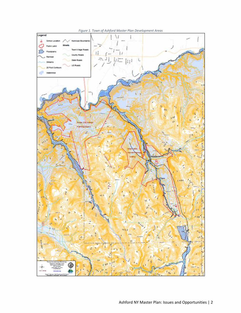
Element 1: Issues and Opportunities 1.1. Introduction 1.1.1. About this Plan The Town of Ashford Master Development Plan has been developed to provide background and
direction for a variety of land use decisions for two areas defined by the Town for growth and
development. This Master Plan will encompass only a portion of the entire Ashford Planning District and
will focus on examining land use development along State Route 219 (SR 219), the Buffalo-Pittsburgh
Highway Corridor, and the West Valley Hamlet and Ashford Town areas – See Figure 1 for the proposed
geographic areas of the Master Development Plan.
Included in this Master Development Plan are ten elements that provide baseline information and
specific goals, objectives, and recommendations specific to each element. This plan should be used by
the Town of Ashford Planning Board and Town Board to make decisions about growth and development
over the next 20-year period. Periodic updates are required to ensure this Plan remains current over
time. Specific requirements and procedures for use and maintenance of this plan are provided in the
Implementation Element.
Elements of this plan include:
1. Issues and Opportunities
2. Physical Setting and Demographics
3. Housing
4. Transportation
5. Utilities and Community Facilities
6. Agricultural, Natural, and Cultural Resources
7. Economic Development
8. Intergovernmental Cooperation
9. Land Use
10. Implementation
This element of the plan (Issues and Opportunities) begins with the 20-Year Vision Statement and
concludes with the town’s public process for approving the Master Development Plan.
1.1.2. 20-Year Vision Statement Preserve the agricultural and natural heritage of the area for future generations. Maintain the natural
heritage and unique topographic and geologic features throughout the town while allowing orderly
development to occur along the State Route 219 (SR 219), the Buffalo-Pittsburgh Highway Corridor, and
the West Valley Hamlet.
Ashford NY Master Plan: Issues and Opportunities | 2
Figure 1. Town of Ashford Master Plan Development Areas

Ashford NY Master Plan: Issues and Opportunities | 3
1.2. Public Process 1.2.1. Planning Committees Meetings A series of Planning Committee Meetings were held to determine implementation strategies, review
draft plans and provide guidance on plan recommendations. All meetings were adequately noticed and
open to the public.
1.2.2. Community Visioning Exercise On XX, 2018 there was held a Community Visioning exercise with the general public to focus the
direction of the planning effort. The meeting was attended by # people and was presided over by the
Planning Board. Attendees were given a general breakdown of the New York Planning Law and the local
process for development of a local master plan. Afterward, the attendees were divided into two groups
to discuss their future vision of Ashford.
Meeting participants were asked to forecast what the Town will look like in 20-years. Most participants
agreed that they would like to -------.
Participants were also asked what their goals were for the comprehensive planning process. Responses
included development of-------.
1.2.3. Community Survey An existing community survey was used to help develop goals and objectives for this planning effort. The
survey was performed in date and had a % return rate. Results show <need results>.
1.2.4. Open House An open house was held on XX, 2018 to provide an informal opportunity for community residents to
view plan maps and other illustrations and talk with consultants and plan commission members about
the recommended plan. There were approximately # people in attendance. The main discussion points
were <fill in after meeting>.
1.2.5. Public Hearings A public hearing was held on XX, 2018, in accordance with State law, before the Ashford Town Board for
adoption of the master plan. The purpose of the hearing was to discuss elements of the master plan and
to adopt the plan. The plan was adopted on date.
1.2.6. Other Opportunities for Public Input All residents, local business owners, and individuals concerned about the future of Ashford have the
opportunity to submit comments on the comprehensive plan at any point in time. A Public Participation
Plan was held on date to describe the public process.
Ashford NY Master Plan: Physical Setting and Demographics | 4
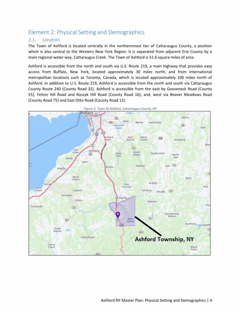
Element 2: Physical Setting and Demographics 2.1. Location The Town of Ashford is located centrally in the northernmost tier of Cattaraugus County, a position
which is also central to the Western New York Region. It is separated from adjacent Erie County by a
main regional water way, Cattaraugus Creek. The Town of Ashford is 51.6 square miles of area.
Ashford is accessible from the north and south via U.S. Route 219, a main highway that provides easy
access from Buffalo, New York, located approximately 30 miles north, and from international
metropolitan locations such as Toronto, Canada, which is located approximately 100 miles north of
Ashford. In addition to U.S. Route 219, Ashford is accessible from the north and south via Cattaraugus
County Route 240 (County Road 32). Ashford is accessible from the east by Gooseneck Road (County
55), Felton Hill Road and Roszyk Hill Road (County Road 16); and, west via Beaver Meadows Road
(County Road 75) and East Otto Road (County Road 12).
Figure 2. Town of Ashford, Cattaraugus County, NY
Ashford NY Master Plan: Physical Setting and Demographics | 5
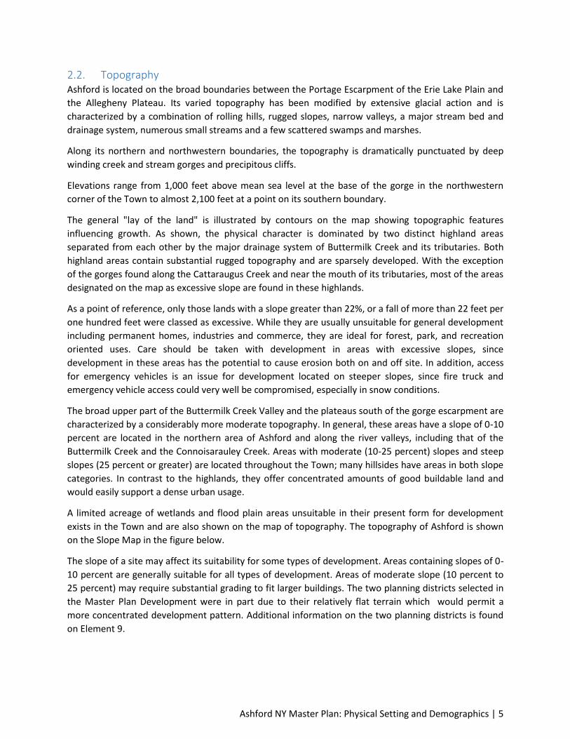
2.2. Topography Ashford is located on the broad boundaries between the Portage Escarpment of the Erie Lake Plain and
the Allegheny Plateau. Its varied topography has been modified by extensive glacial action and is
characterized by a combination of rolling hills, rugged slopes, narrow valleys, a major stream bed and
drainage system, numerous small streams and a few scattered swamps and marshes.
Along its northern and northwestern boundaries, the topography is dramatically punctuated by deep
winding creek and stream gorges and precipitous cliffs.
Elevations range from 1,000 feet above mean sea level at the base of the gorge in the northwestern
corner of the Town to almost 2,100 feet at a point on its southern boundary.
The general "lay of the land" is illustrated by contours on the map showing topographic features
influencing growth. As shown, the physical character is dominated by two distinct highland areas
separated from each other by the major drainage system of Buttermilk Creek and its tributaries. Both
highland areas contain substantial rugged topography and are sparsely developed. With the exception
of the gorges found along the Cattaraugus Creek and near the mouth of its tributaries, most of the areas
designated on the map as excessive slope are found in these highlands.
As a point of reference, only those lands with a slope greater than 22%, or a fall of more than 22 feet per
one hundred feet were classed as excessive. While they are usually unsuitable for general development
including permanent homes, industries and commerce, they are ideal for forest, park, and recreation
oriented uses. Care should be taken with development in areas with excessive slopes, since
development in these areas has the potential to cause erosion both on and off site. In addition, access
for emergency vehicles is an issue for development located on steeper slopes, since fire truck and
emergency vehicle access could very well be compromised, especially in snow conditions.
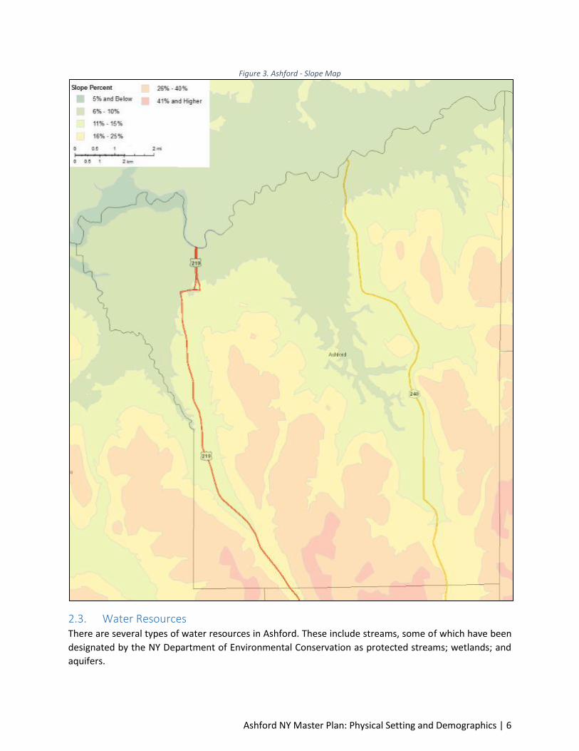
The broad upper part of the Buttermilk Creek Valley and the plateaus south of the gorge escarpment are
characterized by a considerably more moderate topography. In general, these areas have a slope of 0-10
percent are located in the northern area of Ashford and along the river valleys, including that of the
Buttermilk Creek and the Connoisarauley Creek. Areas with moderate (10-25 percent) slopes and steep
slopes (25 percent or greater) are located throughout the Town; many hillsides have areas in both slope
categories. In contrast to the highlands, they offer concentrated amounts of good buildable land and
would easily support a dense urban usage.
A limited acreage of wetlands and flood plain areas unsuitable in their present form for development
exists in the Town and are also shown on the map of topography. The topography of Ashford is shown
on the Slope Map in the figure below.
The slope of a site may affect its suitability for some types of development. Areas containing slopes of 0-
10 percent are generally suitable for all types of development. Areas of moderate slope (10 percent to
25 percent) may require substantial grading to fit larger buildings. The two planning districts selected in
the Master Plan Development were in part due to their relatively flat terrain which would permit a
more concentrated development pattern. Additional information on the two planning districts is found
on Element 9.
Ashford NY Master Plan: Physical Setting and Demographics | 6
Figure 3. Ashford - Slope Map
2.3. Water Resources There are several types of water resources in Ashford. These include streams, some of which have been
designated by the NY Department of Environmental Conservation as protected streams; wetlands; and
aquifers.

Ashford NY Master Plan: Physical Setting and Demographics | 7
2.3.1. Streams and Drainage Areas The outlines of the various drainage areas in Ashford are drawn on the map below. The delineation of
these areas is important to the planning of water supplies, storm and sanitary sewer systems and
potential recreation lakes required by future development. Cattaraugus Creek and its main local
tributaries - Buttermilk and Connoisarauley Creeks, provide the major surface drainage for the Town.
Buttermilk Creek has its source in the southeast corner of the Town and flows northward into
Cattaraugus Creek. The Gooseneck Creek flows west to the Buttermilk Creek.
The western one-third of the Town drains westerly into Connoisarauley Creek and then north into
Cattaraugus Creek. Its source is in the town of Ellicottville. The erosive action of this waterway has
created over one-half mile of spectacular gorges, waterfalls and pools along its lower length.
As further depicted, several smaller drainage basins make up the remainder of the surface drainage
system. In the northeast, the Sony Brook is a separate tributary while three other areas along the
northern boundary drain directly into the Cattaraugus. A small piece of the southeastern corner of the
Town falls into another major watershed and drains south into Beaver Meadows Creek. On the opposite
corner, the edge of the East Otto Creek drainage basin extends into the Town.
Figure 4. Ashford - Watershed Boundaries
2.3.2. Classifications of Water All waters of the state are provided a class and standard designation based on existing or expected best
usage of each water or waterway segment. The classification AA or A is assigned to waters used as a
source of drinking water. Classification B indicates a best usage for swimming and other contact
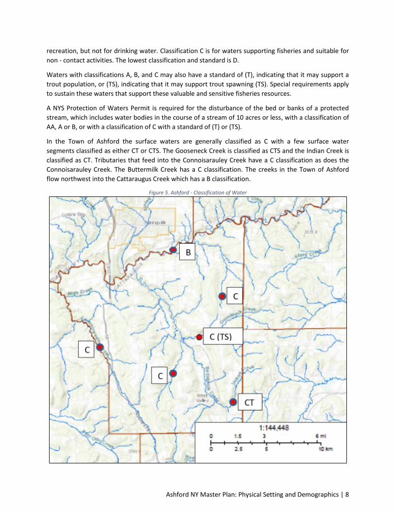
Ashford NY Master Plan: Physical Setting and Demographics | 8
recreation, but not for drinking water. Classification C is for waters supporting fisheries and suitable for
non - contact activities. The lowest classification and standard is D.
Waters with classifications A, B, and C may also have a standard of (T), indicating that it may support a
trout population, or (TS), indicating that it may support trout spawning (TS). Special requirements apply
to sustain these waters that support these valuable and sensitive fisheries resources.
A NYS Protection of Waters Permit is required for the disturbance of the bed or banks of a protected
stream, which includes water bodies in the course of a stream of 10 acres or less, with a classification of
AA, A or B, or with a classification of C with a standard of (T) or (TS).
In the Town of Ashford the surface waters are generally classified as C with a few surface water
segments classified as either CT or CTS. The Gooseneck Creek is classified as CTS and the Indian Creek is
classified as CT. Tributaries that feed into the Connoisarauley Creek have a C classification as does the
Connoisarauley Creek. The Buttermilk Creek has a C classification. The creeks in the Town of Ashford
flow northwest into the Cattaraugus Creek which has a B classification.
Figure 5. Ashford - Classification of Water
Ashford NY Master Plan: Physical Setting and Demographics | 9
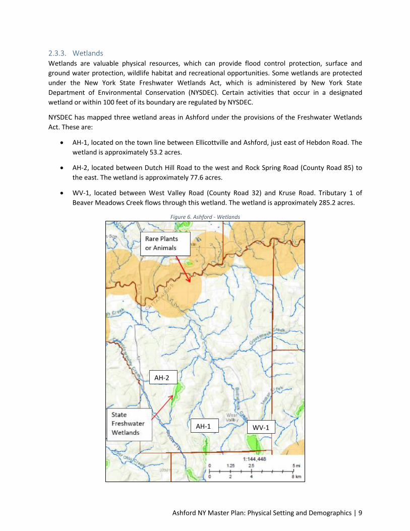
2.3.3. Wetlands Wetlands are valuable physical resources, which can provide flood control protection, surface and
ground water protection, wildlife habitat and recreational opportunities. Some wetlands are protected
under the New York State Freshwater Wetlands Act, which is administered by New York State
Department of Environmental Conservation (NYSDEC). Certain activities that occur in a designated
wetland or within 100 feet of its boundary are regulated by NYSDEC.
NYSDEC has mapped three wetland areas in Ashford under the provisions of the Freshwater Wetlands
Act. These are:
AH-1, located on the town line between Ellicottville and Ashford, just east of Hebdon Road. The
wetland is approximately 53.2 acres.
AH-2, located between Dutch Hill Road to the west and Rock Spring Road (County Road 85) to
the east. The wetland is approximately 77.6 acres.
WV-1, located between West Valley Road (County Road 32) and Kruse Road. Tributary 1 of
Beaver Meadows Creek flows through this wetland. The wetland is approximately 285.2 acres.
Figure 6. Ashford - Wetlands
AH-2
AH-1 WV-1

Ashford NY Master Plan: Physical Setting and Demographics | 10
Source: NY State Department of Environmental Conservation, Environmental Resource Mapper
2.3.4. Aquifers Aquifers are important reservoirs of ground water. The US Department of the Interior Geological Survey
has mapped aquifers in Western New York. There is one aquifer in Ashford, which is shown on the map
below. The aquifer is located in the southeastern section of Ashford, in association with Beaver
Meadows Creek and wetlands WV-1. The Geological Survey estimated the yield of this aquifer at 5 to 50
gallons per minute (gpm). This is a relatively low rate of transmissivity.
Figure 7. Ashford - Aquifers
2.3.5. Flood Hazard Areas Areas of flood hazard are shown on the map below. The flood hazard in Ashford is classified as Special
Flood Hazard Areas (SFHA) and has been identified and mapped by the Federal Emergency Management
Agency, (FEMA) on the Flood Insurance Rate Map (FIRM) for Ashford. The SFHA is also known as the
100-year floodplain. Statistically, areas of flood hazard have a one percent chance of being inundated in
any year.
The SFHA is divided by FEMA into a floodway and a floodway fringe. The floodway is the channel of the
stream, plus any adjacent floodplain areas, that must be kept free of encroachment so that the 100-year
flood can be carried without substantial increases in flood heights. The portion of the SFHA between the

Ashford NY Master Plan: Physical Setting and Demographics | 11
floodway and the boundary of the 100-year floodplain is known as the floodway fringe. Development
within a regulatory floodway is severely restricted. Development within the floodway fringe is regulated
to minimize damage to persons and property.
Most of the major streams in Ashford have floodplains associated with them. These include:
Buttermilk Creek
Cattaraugus Creek
Connoisarauley Creek
Gooseneck Creek
A floodplain can also be found on the WV-1 wetland in the southeast area of Ashford.

Ashford NY Master Plan: Physical Setting and Demographics | 12
Figure 8. Ashford - Floodplains
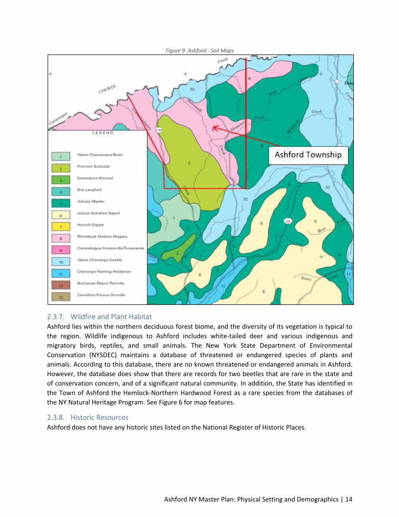
2.3.6. Soils The soils in the Town of Ashford, with the exception of valleys where upland soils have subsequently
been deposited by water action, come from glacial activity. Cattaraugus County experienced several
advances and retreats of glacial ice during the Pleistocene ice age. The ice age began about 300,000
years ago and ended during the late Wisconsin glaciation, about 12,000 to 17,000 years ago.
The soil characteristics vary considerably and surface soil textures range from gravelly loam to clay with
a high percentage of silt loams. The most common upland soil types are Fremont-Schuyler silt loam,

Ashford NY Master Plan: Physical Setting and Demographics | 13
Volusia-Mardin silt loam, Rhinebeck-Hudson-Niagara soils and the Valois-Chenango-Castille gravelly silt
loam.
The Fremont soils are somewhat poorly drained and are nearly level to strongly sloping. They are on
broad upland flats, in saddles, and on side slopes. The subsoil and substratum are medium to
moderately fine textured. The rate of water movement is moderate in the surface layer, moderately
slow or moderate in the upper part of the subsoil, and very slow or slow in the lower part of the subsoil
and substratum
The Rhinebeck soils formed in very deep, lake-laid deposits that are dominantly clay and silts. They are
fine textured, somewhat poorly drained, and nearly level to strongly sloping. They are on broad flats on
valley plains. They generally do not contain rock fragments. The rate of water movement is moderately
slow or moderate in the surface layer, and slow in the subsoil and substratum.
The Valois soils formed in a very deep glacial till that is derived from sandstone, siltstone, and shale and
commonly is intricately intermingled with or underlain by glacial outwash. These soils are medium and
moderately coarse textured, well drained and gently sloping to very steep. They are present on low
knolls, ridges, and hills on lower valley sides and valley floors. The rate of water movement is moderate
in the surface layer and subsoil and moderate or moderately rapid in the substratum.
With the exception of the Mardin soil which is a moderately well-drained, upland soil, all of these are
classified as poorly and imperfectly drained soils (See Figure 8). They characteristically have gray,
compact, impervious subsoils, which impede the penetration of water and roots. In Cattaraugus County,
there is more vacant land among the soils of this group than any other group and forests appear to be
the most feasible crop.
Along the escarpment plateau, the predominant soils are Chenango gravelly silt loam and Mahoning silty
clay loam. The Chenango type, because of its content and textural qualities, is considered choice for
agricultural purposes. The lands in the Town having this soil type are, for reasons of topography and
drainage, also the most ideal lands for urban community growth. The Mahoning soils are poorly drained
with qualities similar to the upland types. Their presence along the steeper and transition slope area,
however, will not adversely affect the development potential of the plateau areas.
The permeability of the soil in in the West Valley Hamlet is moderate to poor. As a consequence of this
limitation on natural drainage, storm water runoff will become an increasing problem as development
occurs. More important, the low permeability will create a health hazard if excessive amounts of sewage
effluent are applied. The common method of sewage disposition is by means of septic tank and leach
field, which will be safe only if it is correlated with soil types and density of use.
Ashford NY Master Plan: Physical Setting and Demographics | 14
Figure 9. Ashford - Soil Maps
2.3.7. Wildfire and Plant Habitat Ashford lies within the northern deciduous forest biome, and the diversity of its vegetation is typical to
the region. Wildlife indigenous to Ashford includes white-tailed deer and various indigenous and
migratory birds, reptiles, and small animals. The New York State Department of Environmental
Conservation (NYSDEC) maintains a database of threatened or endangered species of plants and
animals. According to this database, there are no known threatened or endangered animals in Ashford.
However, the database does show that there are records for two beetles that are rare in the state and
of conservation concern, and of a significant natural community. In addition, the State has identified in
the Town of Ashford the Hemlock-Northern Hardwood Forest as a rare species from the databases of
the NY Natural Heritage Program. See Figure 6 for map features.
2.3.8. Historic Resources Ashford does not have any historic sites listed on the National Register of Historic Places.
Ashford NY Master Plan: Physical Setting and Demographics | 15
2.4. Demographics Located thirty-five minutes south of Buffalo, New York, in scenic Cattaraugus County, are Ashford’s quiet
streets, small locally-owned businesses, and active service organizations are all a part of the friendly
small-town atmosphere.
Henry Frank, a former Revolutionary War scout, is thought to have been the first settler in the area
which became the Town of Ashford in 1824. The hamlet of West Valley was named in honor of George
West, an early Ashford Town Supervisor and later a New York State Assemblyman.
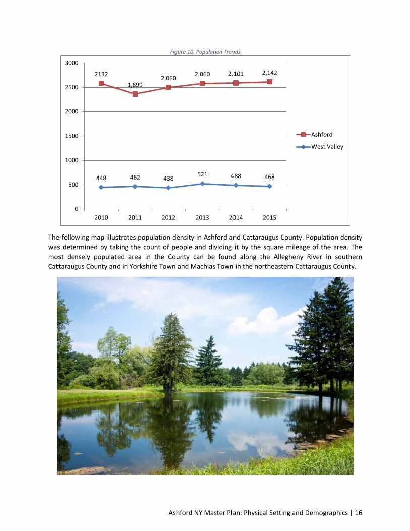
2.4.1. Population Trends Ashford is home to approximately 2,142 residents (U.S. Census). A comparison of the 2000 and 2010
Census reveals that the area has decreased in population. In 2000, Ashford’s population was 2,223
people and by 2010 it lost 91 residents, recording 2,132 people. Over the 10-year time span, Ashford’s
annual growth rate was approximately 0.96 percent. From 2010 to 2015, Ashford experienced slight
population growth, adding 10 new residents, accounting for a 1 percent growth rate. During this time
period, the County continued to lose population.
Table 1. Population
Population 2000 2010 2015 Percent Change
2000-2010 2010-2015 2000-2015
Ashford 2,223 2,132 2,142 -4.1% 0.5% -3.6%
West Valley N/A 518 468 - -9.7% -
Cattaraugus County 83,955 80,317 78,962 -4.3% -1.7% -5.9%
Source: US Census 2000 & 2010, ACS 2011-2015
West Valley Hamlet is found in the southeast part of Ashford at the junction of Routes 53 and 240. The
population of the Hamlet according to the 2010 US Census is 518 persons. By 2015, the Hamlet lost 50
people, shrinking 9.7 percent. During the 5-year time period, the Hamlet had a growth rate of 0.98
percent.
Ashford NY Master Plan: Physical Setting and Demographics | 16
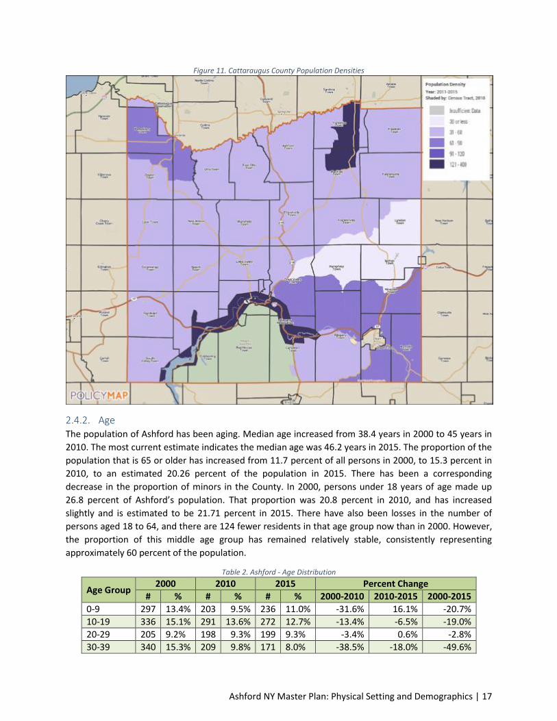
Figure 10. Population Trends
The following map illustrates population density in Ashford and Cattaraugus County. Population density
was determined by taking the count of people and dividing it by the square mileage of the area. The
most densely populated area in the County can be found along the Allegheny River in southern
Cattaraugus County and in Yorkshire Town and Machias Town in the northeastern Cattaraugus County.
448 462 438 521 488 468
2132
1,899 2,060
2,060 2,101 2,142
0
500
1000
1500
2000
2500
3000
2010 2011 2012 2013 2014 2015
Ashford
West Valley
Ashford NY Master Plan: Physical Setting and Demographics | 17
Figure 11. Cattaraugus County Population Densities
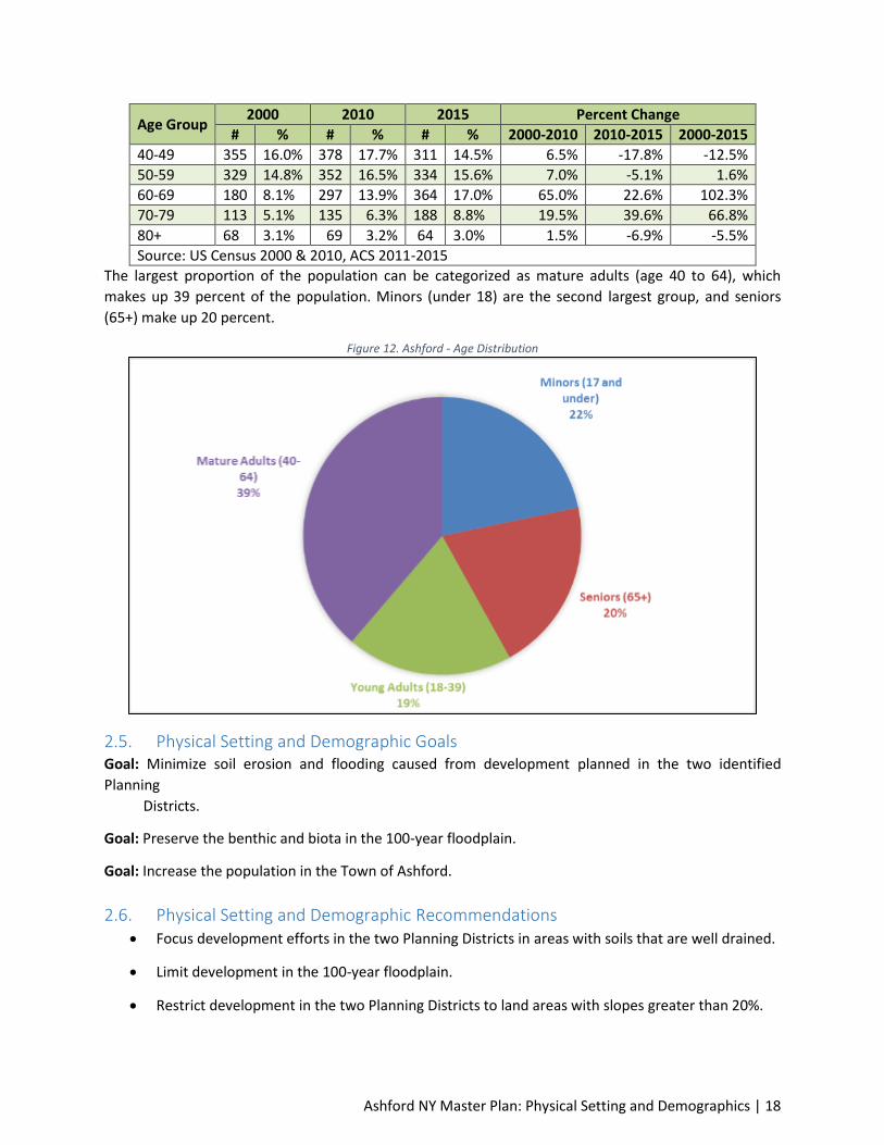
2.4.2. Age The population of Ashford has been aging. Median age increased from 38.4 years in 2000 to 45 years in
2010. The most current estimate indicates the median age was 46.2 years in 2015. The proportion of the
population that is 65 or older has increased from 11.7 percent of all persons in 2000, to 15.3 percent in
2010, to an estimated 20.26 percent of the population in 2015. There has been a corresponding
decrease in the proportion of minors in the County. In 2000, persons under 18 years of age made up
26.8 percent of Ashford’s population. That proportion was 20.8 percent in 2010, and has increased
slightly and is estimated to be 21.71 percent in 2015. There have also been losses in the number of
persons aged 18 to 64, and there are 124 fewer residents in that age group now than in 2000. However,
the proportion of this middle age group has remained relatively stable, consistently representing
approximately 60 percent of the population.
Table 2. Ashford - Age Distribution
Age Group 2000 2010 2015 Percent Change
# % # % # % 2000-2010 2010-2015 2000-2015
0-9 297 13.4% 203 9.5% 236 11.0% -31.6% 16.1% -20.7%
10-19 336 15.1% 291 13.6% 272 12.7% -13.4% -6.5% -19.0%
20-29 205 9.2% 198 9.3% 199 9.3% -3.4% 0.6% -2.8%
30-39 340 15.3% 209 9.8% 171 8.0% -38.5% -18.0% -49.6%
Ashford NY Master Plan: Physical Setting and Demographics | 18
Age Group 2000 2010 2015 Percent Change
# % # % # % 2000-2010 2010-2015 2000-2015
40-49 355 16.0% 378 17.7% 311 14.5% 6.5% -17.8% -12.5%
50-59 329 14.8% 352 16.5% 334 15.6% 7.0% -5.1% 1.6%
60-69 180 8.1% 297 13.9% 364 17.0% 65.0% 22.6% 102.3%
70-79 113 5.1% 135 6.3% 188 8.8% 19.5% 39.6% 66.8%
80+ 68 3.1% 69 3.2% 64 3.0% 1.5% -6.9% -5.5%
Source: US Census 2000 & 2010, ACS 2011-2015
The largest proportion of the population can be categorized as mature adults (age 40 to 64), which
makes up 39 percent of the population. Minors (under 18) are the second largest group, and seniors
(65+) make up 20 percent.
Figure 12. Ashford - Age Distribution
2.5. Physical Setting and Demographic Goals Goal: Minimize soil erosion and flooding caused from development planned in the two identified
Planning
Districts.
Goal: Preserve the benthic and biota in the 100-year floodplain.
Goal: Increase the population in the Town of Ashford.
2.6. Physical Setting and Demographic Recommendations Focus development efforts in the two Planning Districts in areas with soils that are well drained.
Limit development in the 100-year floodplain.
Restrict development in the two Planning Districts to land areas with slopes greater than 20%.

Ashford NY Master Plan: Physical Setting and Demographics | 19
Support development in the Planning Districts that incorporates stormwater quality and
quantity management systems that will protect surface waters, floodplains, wetlands and
habitats.
Develop and implement strategies focused on attracting a younger demographic to live and
work in the Town of Ashford.

Ashford NY Master Plan: Housing | 20
Element 3: Housing This element provides a baseline assessment of Ashford’s current housing stock. The housing
characteristics of a community are an important element of a comprehensive plan. First, the physical
location of housing often determines where municipal service provisions need to be concentrated.
Second, the condition of housing stock is often a good indicator of social and economic conditions
present within a community. Finally, identifying housing clusters of new development will often indicate
where future housing is likely to locate, and what capital improvements might be necessary to
accommodate new populations. The information presented in this element of the Town of Ashford’s
Master Development Plan will provide officials with information about the current housing stock and
detail occupancy characteristics. It will also list housing issues and recommendations to help guide
future housing development.
3.1. Existing Housing Conditions A majority of the information listed in the following section was taken directly from US Census data
years 2000, 2010 and 2015.
3.1.1. Household Trends In contrast to population trends, the number of households in Ashford has been modestly increasing.
The number of households in Ashford grew from 857 to 895 between 2000 and 2015, which is an
increase of 4.3 percent. The slight increase in the number of households despite population declines is
due to a trend toward smaller households, consistent with national trends. The average household size
in Ashford fell from 2.59 persons in 2000 to 2.39 persons in 2015. The average family1 size declined very
slightly, staying at just about 3 persons per family over the 15-year time period.
West Valley Hamlet follows Ashford’s overall housing trends. Between 2010 and 2015, the Hamlet
added 10 housing units.
Figure 13. Household Trends
1 The Census defines “family” as a group of two or more people who are related by birth, marriage, or adoption
and residing together. One-person households are not included in the count of families.
857 838 895
176 215
0
100
200
300
400
500
600
700
800
900
1000
2000 2010 2015
Nu
mb
er
of
Ho
use
ho
lds
Year
Ashford
West Valley
Ashford NY Master Plan: Housing | 21
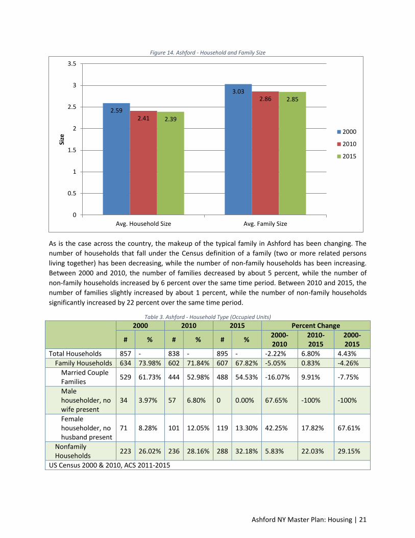
Figure 14. Ashford - Household and Family Size
As is the case across the country, the makeup of the typical family in Ashford has been changing. The
number of households that fall under the Census definition of a family (two or more related persons
living together) has been decreasing, while the number of non-family households has been increasing.
Between 2000 and 2010, the number of families decreased by about 5 percent, while the number of
non-family households increased by 6 percent over the same time period. Between 2010 and 2015, the
number of families slightly increased by about 1 percent, while the number of non-family households
significantly increased by 22 percent over the same time period.
Table 3. Ashford - Household Type (Occupied Units)
2000 2010 2015 Percent Change
# % # % # % 2000-2010
2010-2015
2000-2015
Total Households 857 - 838 - 895 - -2.22% 6.80% 4.43%
Family Households 634 73.98% 602 71.84% 607 67.82% -5.05% 0.83% -4.26%
Married Couple Families
529 61.73% 444 52.98% 488 54.53% -16.07% 9.91% -7.75%
Male householder, no wife present
34 3.97% 57 6.80% 0 0.00% 67.65% -100% -100%
Female householder, no husband present
71 8.28% 101 12.05% 119 13.30% 42.25% 17.82% 67.61%
Nonfamily Households
223 26.02% 236 28.16% 288 32.18% 5.83% 22.03% 29.15%
US Census 2000 & 2010, ACS 2011-2015
2.59
3.03
2.41
2.86
2.39
2.85
0
0.5
1
1.5
2
2.5
3
3.5
Avg. Household Size Avg. Family Size
Size
2000
2010
2015
Ashford NY Master Plan: Housing | 22
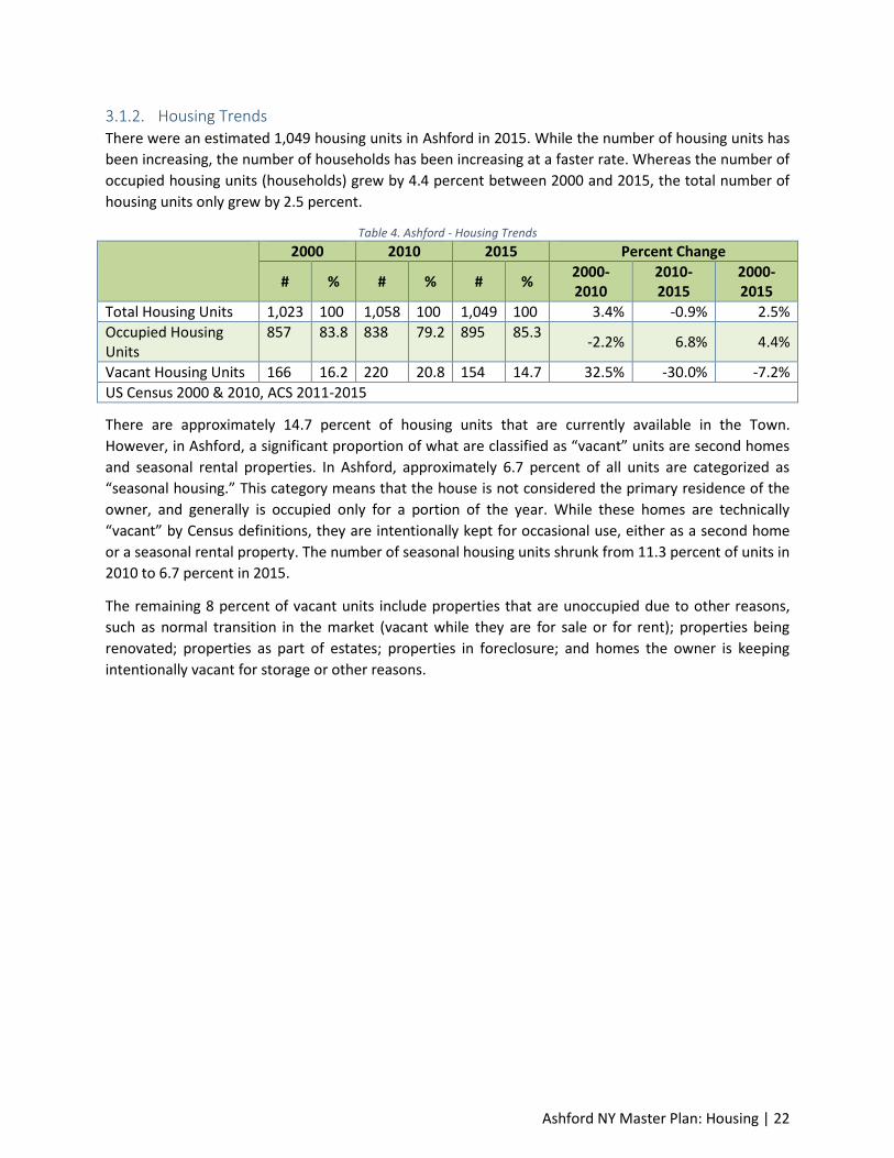
3.1.2. Housing Trends There were an estimated 1,049 housing units in Ashford in 2015. While the number of housing units has
been increasing, the number of households has been increasing at a faster rate. Whereas the number of
occupied housing units (households) grew by 4.4 percent between 2000 and 2015, the total number of
housing units only grew by 2.5 percent.
Table 4. Ashford - Housing Trends
2000 2010 2015 Percent Change
# % # % # % 2000-2010
2010-2015
2000-2015
Total Housing Units 1,023 100 1,058 100 1,049 100 3.4% -0.9% 2.5%
Occupied Housing Units
857 83.8 838 79.2 895 85.3 -2.2% 6.8% 4.4%
Vacant Housing Units 166 16.2 220 20.8 154 14.7 32.5% -30.0% -7.2%
US Census 2000 & 2010, ACS 2011-2015
There are approximately 14.7 percent of housing units that are currently available in the Town.
However, in Ashford, a significant proportion of what are classified as “vacant” units are second homes
and seasonal rental properties. In Ashford, approximately 6.7 percent of all units are categorized as
“seasonal housing.” This category means that the house is not considered the primary residence of the
owner, and generally is occupied only for a portion of the year. While these homes are technically
“vacant” by Census definitions, they are intentionally kept for occasional use, either as a second home
or a seasonal rental property. The number of seasonal housing units shrunk from 11.3 percent of units in
2010 to 6.7 percent in 2015.
The remaining 8 percent of vacant units include properties that are unoccupied due to other reasons,
such as normal transition in the market (vacant while they are for sale or for rent); properties being
renovated; properties as part of estates; properties in foreclosure; and homes the owner is keeping
intentionally vacant for storage or other reasons.
Ashford NY Master Plan: Housing | 23
Figure 15. Ashford – Housing Trends
Housing tenure has remained fairly stable in Ashford. In 2015, approximately 81.6 percent of units are
occupied by the home owner, while about 18.4 percent were occupied by renters. This proportion of
owner to renter has not varied significantly since 2000. The growth in the number of housing units has
largely been in rental properties. The number of occupied rentals in Ashford increased from 133 in 2000
to an estimated 165 in 2015.
As previously noted, a total of 227 housing units are found within West Valley Hamlet, of which 213 are
occupied. Approximately 76% of the housing units are owner occupied and the balance are rented.
Table 5. Ashford - Housing Tenure Trends
2000 2010 2015 Percent Change
# % # % # % 2000-2010 2010-2015 2000-2015
Total Occupied Units 857 100 838 100 895 100 -2.2% 6.8% 4.4%
Owner Occupied 724 84.5 713 85.1 730 81.6 -1.5% 2.4% 0.8%
Renter Occupied 133 15.5 125 14.9 165 18.4 -6.0% 32.0% 24.1%
Source: US Census 2000 & 2010, ACS 2011-2015
The renter-to-owner index in Ashford is 22.6. The index is the number of renter-occupied housing units
for every 100 owner-occupied housing units. Higher values indicate geographies where there are more
renter households, compared to owner households. Within the County, Salamanca Town has the lowest
index, while Salamanca City has the highest. Of the 37 Cattaraugus County Subdivisions, Ashford was
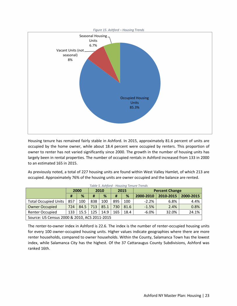
ranked 16th.
Occupied Housing Units 85.3%
Vacant Units (not seasonal)
8%
Seasonal Housing Units 6.7%

Ashford NY Master Plan: Housing | 24
Figure 16. Ashford - Renter-to-Owner Index
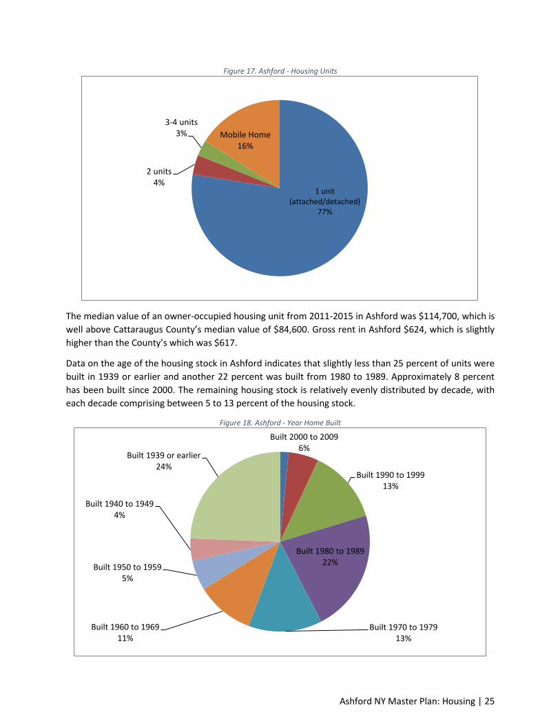
The housing stock in Ashford is largely single unit dwellings. According to Census estimates, 77.5 percent
of residential units are one-family homes and another 16 percent are mobile homes, representing 93.5
percent of the housing stock. About 3.6 percent of units are in two-family homes or doubles. The
remainder of units (approximately 2.9 percent) is in multiple-unit homes (three-or-four units in the
building).
Ashford NY Master Plan: Housing | 25
Figure 17. Ashford - Housing Units
The median value of an owner-occupied housing unit from 2011-2015 in Ashford was $114,700, which is
well above Cattaraugus County’s median value of $84,600. Gross rent in Ashford $624, which is slightly
higher than the County’s which was $617.
Data on the age of the housing stock in Ashford indicates that slightly less than 25 percent of units were
built in 1939 or earlier and another 22 percent was built from 1980 to 1989. Approximately 8 percent
has been built since 2000. The remaining housing stock is relatively evenly distributed by decade, with
each decade comprising between 5 to 13 percent of the housing stock.
Figure 18. Ashford - Year Home Built
1 unit (attached/detached)
77%
2 units 4%
3-4 units 3% Mobile Home
16%
Built 2000 to 2009 6%
Built 1990 to 1999 13%
Built 1980 to 1989 22%
Built 1970 to 1979 13%
Built 1960 to 1969 11%
Built 1950 to 1959 5%
Built 1940 to 1949 4%
Built 1939 or earlier 24%

Ashford NY Master Plan: Housing | 26
3.1.3. Affordable Housing The Town of Ashford, like most rural communities, does not contain any public housing. However, there
is a great diversity in housing options available within nearby incorporated communities at a variety of
prices.
The New York State Office of Community Renewal administers the Community Development Block Grant
(CDBG) program for the State of New York. The NYS CDBG program provides financial assistance to
eligible cities, towns, and villages with populations under 50,000 and counties with an area population
under 200,000, in order to develop viable communities by providing decent, affordable housing, and
suitable living environments, as well as expanding economic opportunities, principally for persons of low
and moderate income.
In addition, the New York State Home Partnership Investment Program (HOME) is administered by the
New York State Housing Trust Fund Corporation (HTFC). The program uses federal HOME funds to
expand the supply of decent, safe, and affordable housing within the State.
The HOME Program funds a variety of activities through partnerships with counties, towns, cities,
villages, private developers, and community-based non-profit housing organizations. The program
provides funds to acquire, rehabilitate, or construct housing, or to provide assistance to low-income
home-buyers and renters.
3.2. Housing Goals and Objectives
Goal: Identify home repair programming monies to address aging housing stock.
Objective: To maintain rural character by preserving homes.
Goal: Determine appropriate locations where new residential lots should be developed.
Objectives:
Encourage new residential development to lands generally unsuitable for farming.
To maintain and preserve viewsheds.
To determine preferred setback requirements and possible revisions to the existing
zoning code.
Goal: Maintain rural housing aesthetic.
Objectives:
To explore the development of guidelines to control massing and structural
characteristics of new housing.
To ensure compatibility with established housing and farming operations.
Goal: Diversify the housing stock from single family residential to higher density forms of development
within the two Planning Districts.
3.3. Housing Recommendations Pursue federal and state program funds to develop public housing.
Ashford NY Master Plan: Housing | 27
Apply for federal and state grants that fund repairs in housing that is older than 50 years.
In the two Planning Districts (further described in Element 9), encourage neighborhood
(subdivision) designs and locations that protect residential and agricultural areas from
infringement by incompatible land uses, promote connectivity of road and environmental
systems, and preserve rural character.
Work with developers for appropriate structure siting to maintain natural features.
Control housing development through site investigations focused on slopes, soil classifications,
and other metrics important for rural character preservation.
Write zoning codes to distinguish residential districts with respect to density and intensity of use
standards.
Identifying opportunities for infill development (i.e., parcels of vacant land within an area
previously developed) on existing residential lots in the West Valley Hamlet.
Ashford NY Master Plan: Transportation | 28
Element 4: Transportation This element includes a compilation of background information, visions, goals, objectives, policies,
maps, and recommendations to guide the future development and maintenance of various modes of
transportation in the Town of Ashford.
4.1. Existing Transportation Facilities 4.1.1. Street Network Two major roadways traverse Ashford. United States (U.S) Route 219 is a major north-south route,
which connects Canada and Buffalo in the north to Pennsylvania in the south. It also provides access to
Interstate No. 86, a major east-west highway. Presently, US Route 219 is a limited access two lane
undivided highway which runs approximately through the center of Cattaraugus County from Erie
County to the north and Pennsylvania to the south –See Figure 19. After a lengthy study, the New York
State Department of Transportation (NYSDOT) has determined that Route 219 should be upgraded to a
four-lane divided highway, the "freeway alternative," from Springville to Interstate No. 86. NYDOT’s
most recent available average annual daily traffic (AADT) for the segment of Route 219 in Ashford is
around 8,493 cars.
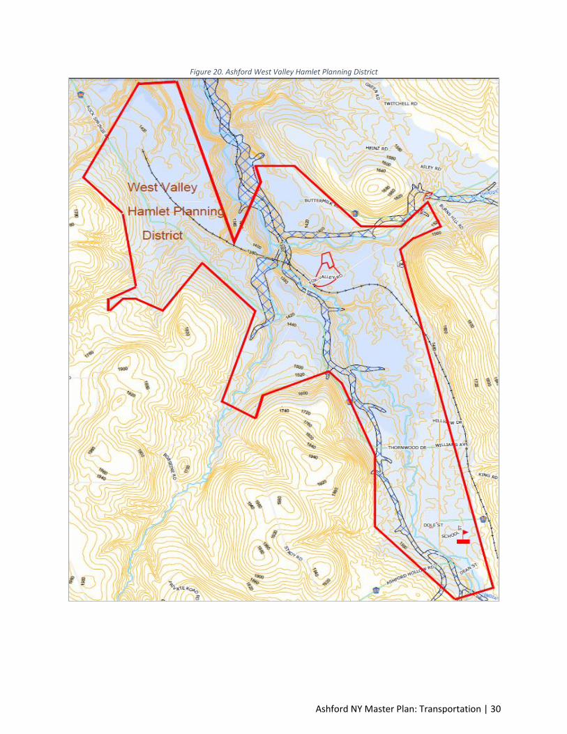
The state has delineated a new right-of-way for Route 219, which will run generally easterly of the
current alignment. There will be two interchanges in Ashford, one which will be at Peters Road and the
other will be at Snake Run Road. The state has not released a definitive timetable for construction of the
new road. A detailed map of the State Route 219 Planning Area is shown in Figure 20.
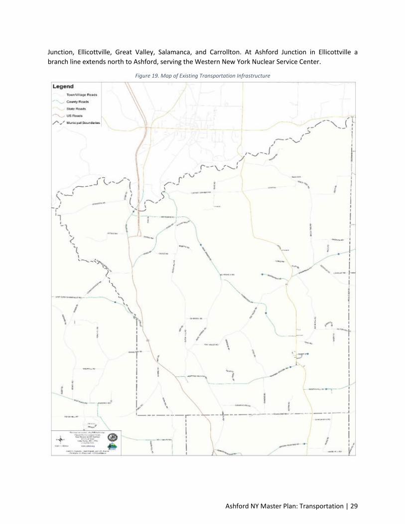
NY Route 240- West Valley Road (or County Road 32) is an alternative north-south route, which
connects to NY Route 324 and Interstate 290 in Amherst in northern Erie County and terminates at
Route 242 in the hamlet of Ashford Junction in the Town of Ellicottville in northern Cattaraugus County.
NYDOT’s most recent available average annual daily traffic AADT for the segment of Route 240 in
Ashford is 706 cars. The West Valley Hamlet is located in this area of the Town of Ashford and is the
second area that the Town is seeking to develop a Master Development Plan - See Figure 21.
There are also several county roads in Ashford. These include:
County Road 12 – Dutch Hill Road
County Road 16- Roszyk Hill Road
County Road 32 – West Valley Road (also known as Route 240)
County Road 53 – Ashford Hollow Road
County Road 55 – Goosneck Road
County Road 85 – Schwartz Road/Rock Springs Road
County Road 86- Thornwood Drive
4.1.2. Rail The Buffalo and Pittsburgh Railroad (BPRR), which is owned by Genesee & Wyoming, Inc., runs north-
south from Buffalo to Pennsylvania. In Cattaraugus County, the line traverses Yorkshire, Machias
Ashford NY Master Plan: Transportation | 29
Junction, Ellicottville, Great Valley, Salamanca, and Carrollton. At Ashford Junction in Ellicottville a
branch line extends north to Ashford, serving the Western New York Nuclear Service Center.
Figure 19. Map of Existing Transportation Infrastructure
Ashford NY Master Plan: Transportation | 30
Figure 20. Ashford West Valley Hamlet Planning District
Ashford NY Master Plan: Transportation | 31
Figure 21. Ashford - Route 219 Corridor Planning District
4.1.3. Transit Service Most communities in Cattaraugus County are small enough that the provision of a transit system is not
financially justified. As such, the Town does not offer transit service.
Coach USA, based out of Butler, Pennsylvania, provides inter-city bus service through Chautauqua and
Cattaraugus Counties. Service is operated daily from Jamestown to Dunkirk to Silver Creek, and Irving;
and from Jamestown to Olean, with scheduled stops along the way. Additional service is provided from
Olean to Buffalo Airport, with scheduled and flag stops in Cattaraugus and Erie Counties. Additional
inter-city service is provided from Olean to New York City.

Ashford NY Master Plan: Transportation | 32
4.1.4. Aviation Service The Town of Ashford does not have aviation service within the jurisdiction. The Chautauqua-Jamestown
County Airport lies directly west (approximately 42 miles) of the Town of Ashford. The airport offers
daily commercial service to Pittsburgh. The Buffalo International Airport is approximately 51 miles
north-northwest of the Town of Ashford.
4.1.5. Pedestrian and Bicycle Transportation The Town does not have developed a pedestrian or bicycle trail system. Within Ashford there is a
snowmobile trail that crosses the southern part of the Town from in an east to west manner and then
travels north along Dutch Hill Road. The snowmobile trail is maintained by a local snowmobile club.
Figure 22. Ashford - Trails Map
4.1.6. Transportation Facilities for the Disabled There are currently limited public transportation facilities for the disabled in the area. The Cattaraugus
County Coordinated Public Transit-Human Services Transportation Plan has adopted a coordinated
public transit-human services transportation plan in order to access certain new and existing programs
funded by the Federal Transit Administration (FTA). Those programs are:
Ashford NY Master Plan: Transportation | 33
Section 5310 - Elderly and Individuals with Disabilities
Section 5316 - Job Access and Reverse Commute (JARC)
Section 5317 - New Freedom
The purpose of the plan is to provide a framework for the coordination of transportation services for
aging adults, persons with disabilities, and individuals with economic disadvantages within the County.
Love INC of Springville, NY offers rides to and from medical appointments, agency appointments and
other places. Most of these rides are provided with the use of the Love INC car. The drivers are all
church volunteers. This service is available to Ashford Town residents through the local church network.
4.1.7. Trucking A local business search for trucking firms within Ashford revealed three trucking outfits within close
proximity of the town. These firms utilize access to SR 219 and local county highways for transport of
materials.
4.1.8. Water Transportation There are no local water transportation or port services. The nearest port service is located in Buffalo,
approximately 50 miles to the northwest.
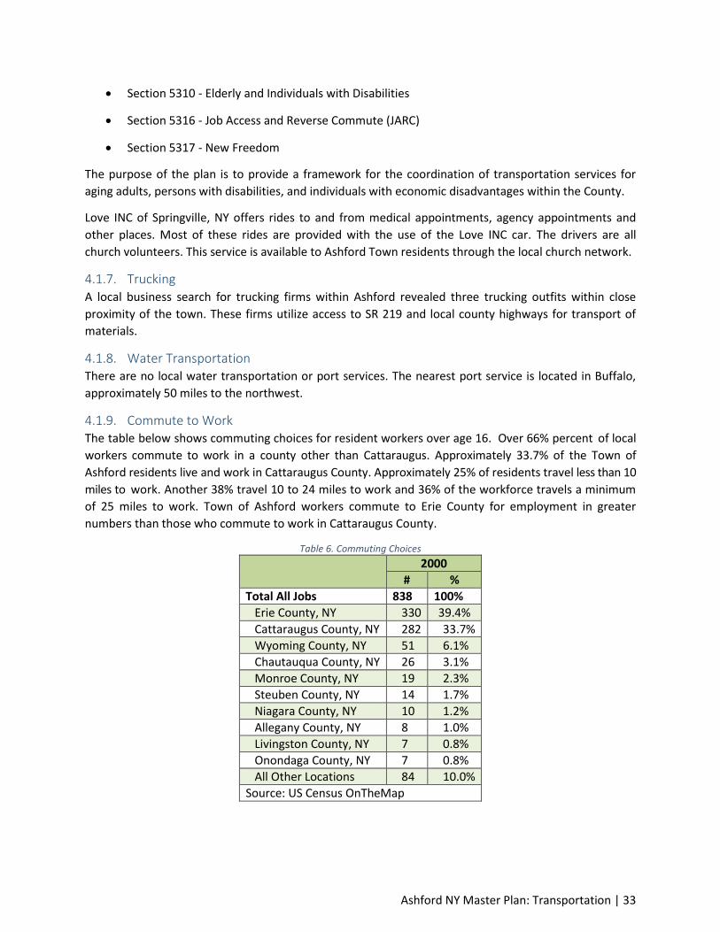
4.1.9. Commute to Work The table below shows commuting choices for resident workers over age 16. Over 66% percent of local
workers commute to work in a county other than Cattaraugus. Approximately 33.7% of the Town of
Ashford residents live and work in Cattaraugus County. Approximately 25% of residents travel less than 10
miles to work. Another 38% travel 10 to 24 miles to work and 36% of the workforce travels a minimum
of 25 miles to work. Town of Ashford workers commute to Erie County for employment in greater
numbers than those who commute to work in Cattaraugus County.
Table 6. Commuting Choices
2000
# %
Total All Jobs 838 100%
Erie County, NY 330 39.4%
Cattaraugus County, NY 282 33.7%
Wyoming County, NY 51 6.1%
Chautauqua County, NY 26 3.1%
Monroe County, NY 19 2.3%
Steuben County, NY 14 1.7%
Niagara County, NY 10 1.2%
Allegany County, NY 8 1.0%
Livingston County, NY 7 0.8%
Onondaga County, NY 7 0.8%
All Other Locations 84 10.0%
Source: US Census OnTheMap
Ashford NY Master Plan: Transportation | 34
4.1.10. Local, State, and Regional Transportation Plan STR 219 (Local)
The New York Department of Transportation does have plans on record for extending SR 219 which
passes through the Town of Ashford. The Department of Transportation is preparing plans to expand
State Trunk Highway (SR) 219 from 2-lanes to a 4 -lane divided highway from about the Village of
Springfield to the Pennsylvania State line.
The Cattaraugus County is working with the New York Department of Transportation and the Town of
Ashford Town Board to develop a long-range vision for the corridor. The Committee and the public are
considering what the land use and local road system adjacent to the highway might look like over the
next 20 or 30 years.
4.2. Transportation Issues Raised During Planning Process Speeding: as in most communities, there are issues with motorists speeding on local roadways. With the
lack of sufficient local enforcement personnel, this problem goes largely unchecked.
Maintain condition of local roads: maintaining appropriate access to and condition of the county
highway system, state highways, and local roadways is a top priority since most residents commute to
other communities for employment and services.
4.3. Transportation Goals and Objectives Goal: Maintain the local street network.
Objectives:
To continue upgrading the most in-need roadways first.
To work with state and county entities to maintain safe operating conditions on
highways.
Goal: Maintain access to the state highway system.
Objectives: To work with the New York Department of Transportation to accommodate local
needs when changes are proposed to SR 219.
Goal: Provide walking/biking trail access to local residents.
Objectives:
To enhance the capability and feasibility of pedestrian and bicycling transportation
throughout the town.
To identify opportunities to expand the local transportation network and connections to
regional trails.
Goal: Enable sufficient traffic flow, economic opportunity, and access.
Objectives: To work with state and county officials to provide safe and controlled access
opportunities.
4.4. Transportation Recommendations Utilize an annual roadway evaluation system to determine a ranking for street upgrades.
Develop an annual system of funding allocation, such as a Capital Improvement Plan, to ensure
adequate funding for needed upgrades and repair.

Ashford NY Master Plan: Transportation | 35
Communicate with the New York Department of Transportation concerning future
redevelopment of SR 219.
Integrate and connect new streets to be created as part of any development proposal with the
existing street network. For example, new subdivisions shall be designed to connect to existing
subdivisions where possible.
The use of cul de sacs and other roadways with a single point of access should be minimized in
new developments because they force traffic onto a limited number of through streets.
However, the use of cul de sacs will be permitted to preserve environmentally sensitive areas or
significant open spaces.
Coordinate the provision and improvement of transportation infrastructure along SR 219 and
frontage roads with land use and development along SR 219.
Ashford NY Master Plan: Agricultural, Natural and Cultural Resources | 36
Element 5: Utilities and Community Facilities This element includes background information, visions, goals, objectives, policies, and recommendations
to guide the future development of utilities and community facilities in the Town of Ashford. This
element describes location, use and capacity of existing public utilities and community facilities that
serve the Town and includes recommendations for future utilities needs and upgrades.
5.1. Existing Utilities and Community Facilities Conditions 5.1.1. Sanitary Sewer System There is no municipal sewer service provided for residents of the Town. All sanitary sewer is contained
by private on-site wastewater treatment systems. Landowners seeking to develop must obtain a sewer
permit from the county.
5.1.2. Water Supply All residential water is by private well except for in parts of West Valley Hamlet. Anecdotal evidence
suggests overall water quality is good in the town. Many residents use water softeners to control
hardness.
5.1.3. Storm Sewer System There is a limited local storm sewer system in unincorporated Town of Ashford where curb and gutter
exist. These facilities consist of streets with curb and gutter collecting storm water via storm inlets.
Storm water drains to the collector tributaries which feed into creeks that flow north to the Cattaraugus
Creek.
5.1.4. Community Facilities The Ashford Town Hall contains facilities for Town Board meetings and recreational activities. The
facility includes some kitchen facilities, restrooms and some storage room. The Town has a garage
facility which contains snow plows, loaders, salters, brush cutters, and mowers.
5.1.5. Post Office The Town of Ashford has one post office to service the community needs. The Post office is located at
9386 Route 240 West Valley, NY 14171 – 9998.
5.1.6. Fire Protection The Town of Ashford is divided into two fire districts. The West Valley Volunteer Fire Company #1 is
located at 9091 State Route 240 in West Valley. This is a combination fire department that provides
emergency fire, rescue and medical services to the Town of Ashford. Fire Company #2 is located on
Route 219 in Ashford Hollow.
5.1.7. Law Enforcement The Cattaraugus County Sheriff’s Department and State provides public safety and law enforcement
services to the Town of Ashford.
5.1.8. Health Care The Cattaraugus County Health Department's (CCHD) Nursing Services Division provides preventive,
restorative and palliative care to improve the quality of life of the individual, the family and the
community.
Ashford NY Master Plan: Agricultural, Natural and Cultural Resources | 37
Home Care services in Cattaraugus County are provided through two programs; the Certified Home
Health Agency (CHHA) and the Long-Term Home Health Care Program (LTHHCP). The CHHA provides
skilled services to individuals of all ages usually following an acute illness, injury or surgery. The LTHHCP
serves as an alternative to nursing home placement for chronically ill or disabled individuals of all ages.
In 2016, Cattaraugus County Health Department's Certified and Long-Term Home Health agency
provided care to 1,438 individuals with an average daily census of 327. Home Health Care is covered by
Medicare, Medicaid and most private insurance plans.
Community health clinics provide a variety of services to community members at health department
offices in Machias, Salamanca and Olean. Bertrand Chaffee Hospital is 7 miles away north in Springville,
Erie County.
The Bertrand Chaffee Hospital is located in Springville, New York, and is located less than 8 miles from
the northern part of the Town of Ashford. In addition, Ashford Town residents have access to world class
health care services in Buffalo which is approximately 30 miles to the north-northwest.
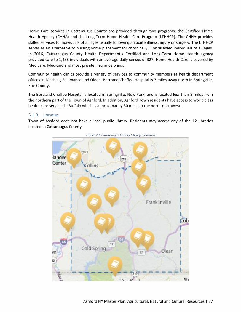
5.1.9. Libraries Town of Ashford does not have a local public library. Residents may access any of the 12 libraries
located in Cattaraugus County.
Figure 23. Cattaraugus County Library Locations

Ashford NY Master Plan: Agricultural, Natural and Cultural Resources | 38
5.1.10. Schools The majority of Ashford students are enrolled in the West Valley School District. West Valley is a rural
community located in Cattaraugus County and this district provides education to grades Pre-K through
12th in one Facility, the West Valley Central School. The District has 230 students enrolled and has a
Student / Teacher Ratio of 9.8.
5.1.11. Electricity and Natural Gas The electric utility company in West Valley is National Grid which maintains the distribution system and
all transmission lines. Natural gas is provided to the town by National Fuel. National Grid does not
provide natural gas services to all parts of the Town of Ashford. Some areas purchase propane, fuel oil
or rely on wood burning systems.
5.1.12. Telephone and Television Services Primary telephone service within Ashford is provided by Frontier and Verizon, although other providers
are available. Television services are offered through satellite service companies.
5.2. Utilities and Community Facilities Goals and Objectives Goal: Maintain sufficient availability of local public and semi-public facilities and equipment.
Objective: To continue to update Town Hall facilities and equipment on an as-needed basis.
Goal: Maintain sufficient emergency services.
Objective:
To continue to utilize and support appropriate levels of funding and equipment to
ensure proper operation of the West Valley Volunteer Fire Company.
To continue securing emergency services, mercy flights and first responder contracts
through Cattaraugus County and the State.
To support the Cattaraugus County Sheriff’s Department for local police support.
Goal: Maintain sufficient Potable Water Supply and Services.
Objective:
To encourage capping of abandoned wellheads.
To promote safe agricultural practices to reduce the possibility of groundwater
contamination.
To encourage private monitoring of water levels and quality.
Goal: Maintain sufficient power service and utility access.
Objective:
To continue cooperative efforts with the various power service and utility providers to
deliver sufficient service.
To continue to recommend appropriate easements to ensure appropriate delivery of
electric service.
To encourage major energy consumers (such as businesses in the hamlet of Ashford) to
participate in solar and wind renewable energy practices.
Ashford NY Master Plan: Agricultural, Natural and Cultural Resources | 39
To maintain the current infrastructure and work with private utilities to improve
infrastructure opportunities for residents that may not have access to the system.
5.3. Utilities and Community Facilities Recommendations Perform regular maintenance on existing utilities and facilities in a timely and efficient manner.
Update Town facilities as needed. Encourage residents to properly maintain private, on-site
waste disposal systems to prolong the useful life of those systems and avoid groundwater
contamination.
Encourage landowners to identify and cap abandoned well heads.
Work with the DEC to monitor ground water quality especially in areas of the Town with
increased residential densities.
Observe appropriate siting and public meeting requirements to guide future development of
power plants/ transmission lines.
Develop a sanitary and stormwater plan for providing service in the two Planning Districts
(further described in Element 9). This plan should include a geographical layout of stormwater
and sewer laterals and collector lines, pump stations, force mains and the construction of a
sewer treatment plant. The Town should include the purchase of land and/or easements for
placement of the sewer and stormwater lines and treatment plant(s).The sanitary sewer system
would include the construction of a treatment plant that is located proximate to the
Connoisarauley Creek. Ideally the treatment plant would provide service to both Planning
Districts. The stormwater and sanitary sewer system should be sized to accommodate growth
planned in the two Planning Districts. Additional details on the sewer and stormwater planning
is provided in Element 9. The Plan would include permit requirements of NYDEC for discharge of
treated effluent into the Connoisarauley Creek.
The Town should seek federal and state funding to pay for the sewer and stormwater plan. The
United States Environmental Protection Agency (EPA), United States Department of Agriculture
(USDA) and United States Economic Development Administration (EDA) can provide funding to
undertake sewer and stormwater planning elements. These federal agencies can also provide
funding for capital construction.
The Town should develop a unitary water distribution system for the entirety of the West Valley
Hamlet and the Rt. 219 Planning District. The Plan would include the provision of a water supply
study to identify reliable surface water and groundwater sources. The Plan would include an
assessment of sizing of piping needed to supply water to the two Planning Districts as well as
the treatment capacity of a Potable Water Treatment Plant. The Plan would include permit
requirements of NYSDEC for withdraw of water from either the groundwater or surface water.
The water lines for the two Planning Districts would likely be placed adjacent to sewer lines and
within property easements.
Ashford NY Master Plan: Agricultural, Natural and Cultural Resources | 40
The Town should seek federal and state funding to pay for the potable water plan. The EPA,
USDA and EDA can provide funding to undertake potable planning elements. These federal
agencies can also provide funding for capital construction.
The Town in conjunction with the West Valley Volunteer Fire Company #1 and #2 should pursue
federal and state grant funding to support fire services. Funding for the West Valley Volunteer
Fire Company #1 services can be received from the United States Department of Homeland
Security (DHS) and USDA Rural Utility Service.
Ashford NY Master Plan: Agricultural, Natural and Cultural Resources | 41
Element 6: Agricultural, Natural and Cultural Resources This element includes an analysis of existing agricultural, natural and cultural resources in and around
the Town of Ashford. The element presents existing conditions, visions, goals, objectives, policies and
programs for the conservation and promotion of effective management of agricultural, natural and
cultural resources in the Town.
6.1. Agriculture Resources Inventory 6.1.1. Active Agriculture Ashford contains a significant amount of land that is still in active agricultural production. This land use
ranks third in terms of acreage, with approximately 23 percent of the land devoted to agriculture. Much
of Ashford is located within the Ashford Meadows Agriculture District – See figure 24 below. New York
State Agriculture and Markets Law stipulate that parcels that are used for agriculture and which are
located in a designated agricultural district may be eligible for tax benefits if they meet certain criteria.
6.1.2. Productive Farmland Soils Prime farmland soils are plentiful throughout the town. The prime farmland designation indicates Class
1 or 2 soils. These class designations refer to the quality of soils for growing crops and are based on
United States Department of Agriculture (USDA) classifications. Class 1 soils are the best soils in
Cattaraugus County for growing all crops. Class 2 soils are also very good agricultural soils; however,
they may be prone to wetness and are therefore less desirable than Class 1 soils. It should be noted that
not all prime farm soils are used for farming; some have been developed with residential or other uses.
The “prime farmland” designation simply indicates that these soils are good for productive farming.
6.1.3. Agriculture Districts Town of Ashford in Cattaraugus County is classified by USDA as a “Rural Area.” The Town also has
considerable land areas that have been classified as an agricultural district by Cattaraugus County. In
relation to agricultural districts certified pursuant to New York State Article 25-AA of the Agriculture &
Markets Law (“AML”), the State Environmental Quality Review Act (SEQRA) applies to the adoption,
modification, continuation, consolidation and termination of agricultural districts. County legislative
bodies adopt, review, modify and consolidate agricultural districts pursuant to AML§§303, 303-a, 303-b,
and 303-c. Local legislative bodies, including these county legislative bodies, are subject to SEQRA.
County legislative bodies also undertake review of agricultural districts pursuant to AML §303-a,
consider requests for inclusion of land which is predominantly viable agricultural land within certified
agricultural districts under AML §303-b and may consolidate agricultural districts under AML §303-c. If
an agricultural district is simply continued, with no material change, the recertification of the district is
considered a Type II action, and no further environmental review is required. However, if an agricultural
district is modified, consolidated or terminated upon its review, the modification, consolidation or
termination would be deemed an Unlisted Action under SEQRA, requiring a short EAF to determine
environmental significance.

Ashford NY Master Plan: Agricultural, Natural and Cultural Resources | 42
Figure 24. Ashford Meadows - Agriculture District in Ashford Town
6.2. Natural Resource Inventory 6.2.1. Open Space/Environmental Corridors As in most agricultural communities, open spaces are plentiful since there is not a great deal of built
environment overall. Aside from the vast agricultural areas, the river ways also provide open space
areas.
6.3. Agricultural, Natural, and Cultural Resources Goals and Objectives
Goal: Request the Ashford Meadows Agricultural District designation in the two planning districts be
modified under SEQRA.
Objective: Complete a short EAF to determine environmental significance.

Ashford NY Master Plan: Agricultural, Natural and Cultural Resources | 43
Goal: Protect water quality and quantity throughout the Town.
Objective:
To work with the NYDEC and Cattaraugus County to identify critical zones, such as
groundwater recharge areas.
Follow Cattaraugus County ordinances that protect groundwater recharge areas.
Preserve wetland areas that serve a vital role in replenishing groundwater resources.
Goal: Preserve natural areas throughout Ashford.
Objective:
To work with property owners to encourage preservation of hilltops.
To work with developers and private property owners to maintain primary view sheds
visible from major roadways (SR 219).
To work with the NYDEC to identify incentives for private landowners to preserve
natural areas.
Goal: Preserve historically significant buildings, sites, and events.
Objective:
To work with the Cattaraugus County Historical Society to identify historic resources so
they may be considered in future planning.
To ensure that any known cemeteries, human burials or archaeological sites are
protected from encroachment by roads or any development activities.
To continue working with local churches to ensure the longevity of these unique and
historic structures.
Goal: Preserve prime agricultural land.
Objective:
To encourage conversion of active farmland in the two Planning District to suburban
higher density residential lots and commercial uses.
Goal: Encourage preservation of the rural landscape.
Objective:
To discourage conversion of active farmland to rural residential lots in areas outside the
two Planning Districts.
To encourage the development of scenic and conservation easement programs, and
encourage voluntary participation in areas outside the two Planning Districts.
To encourage additional programming for new or beginning farmers.
6.4. Agricultural, Natural, and Cultural Resources Recommendations Encourage land use patterns and practices that are environmentally sensitive and that do not
disrupt the natural hydrologic system, including the balance between ground and surface waters.
Ashford NY Master Plan: Agricultural, Natural and Cultural Resources | 44
Encourage landowners to ensure proper stormwater management practices, such as rain
gardens, stormwater detention, infiltration and wetland restoration, to maintain or increase
groundwater recharge and reduce excess runoff.
Work with Cattaraugus County, the DEC, and other relevant agencies to identify and protect
floodplain areas and natural drainage ways from being filled or altered in any way that reduces
their function.
Promote existing best management practices (BMPs) along the Connoisarauley Creek and its
tributaries to preserve riverbanks and enhance viewsheds along the resource.
Consider the creation of a groundwater overlay protection district to preserve the existing
groundwater resources. The overlay district may be expanded to include other environmentally
sensitive areas.
Discourage disruptive development that is visible for many miles and damages the scenic
character of the region. Where development does occur near ridgelines, the development
should take place on the lowest portion of the parcel and in the area with the least slope.
Work with the County to amend its subdivision regulations as necessary to incorporate low-
impact development and conservation design techniques that:
Limit total impervious area;
Minimize site disturbance and soil compaction to preserve natural topography and
minimize erosion;
Ensure sound water quality and run-off controls while minimizing the use of storm drain
pipes (this includes allowing, where applicable, the use of rain gardens, permeable
pavements, etc.);
Require adequate buffer areas and setbacks to minimize encroachment and preserve the
natural character and scenic quality of sensitive resources.
Utilize native vegetation in new plantings
Work with the Code Enforcement Officer and Cattaraugus County to enforce property
maintenance codes to help maintain rural residential quality and architecturally significant
structures.
Contact and coordinate with local churches to maintain and preserve these unique structures.
Encourage the County or State to develop a Purchase of Development Rights (PDR) program to
provide monetary incentive for maintaining adequate acreage necessary to retain active
farming outside of the two Planning Districts.
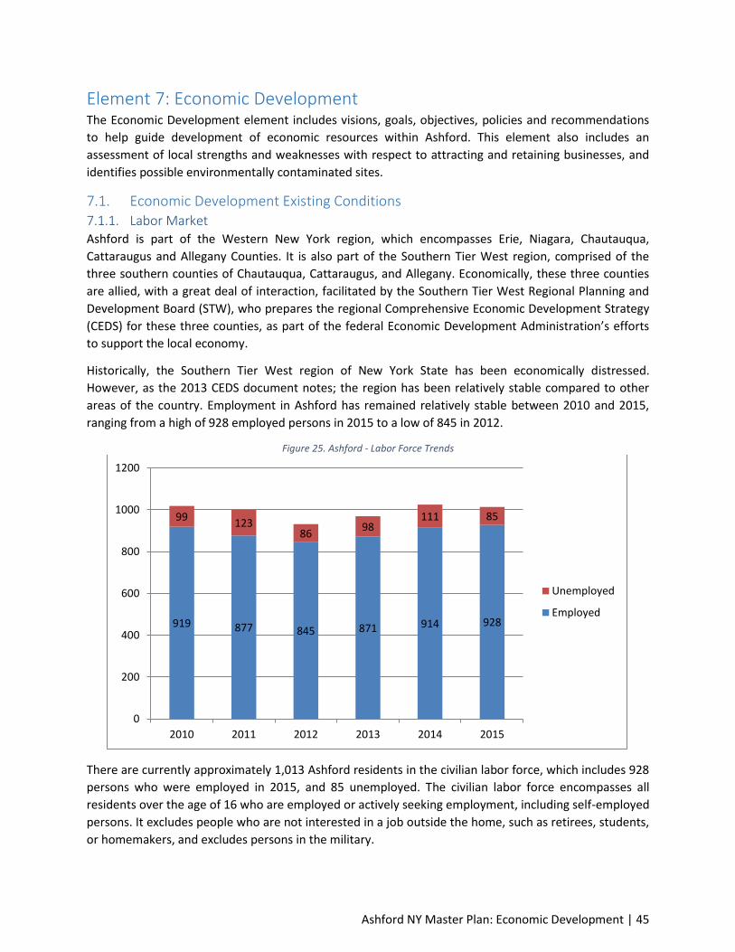
Ashford NY Master Plan: Economic Development | 45
Element 7: Economic Development The Economic Development element includes visions, goals, objectives, policies and recommendations
to help guide development of economic resources within Ashford. This element also includes an
assessment of local strengths and weaknesses with respect to attracting and retaining businesses, and
identifies possible environmentally contaminated sites.
7.1. Economic Development Existing Conditions 7.1.1. Labor Market Ashford is part of the Western New York region, which encompasses Erie, Niagara, Chautauqua,
Cattaraugus and Allegany Counties. It is also part of the Southern Tier West region, comprised of the
three southern counties of Chautauqua, Cattaraugus, and Allegany. Economically, these three counties
are allied, with a great deal of interaction, facilitated by the Southern Tier West Regional Planning and
Development Board (STW), who prepares the regional Comprehensive Economic Development Strategy
(CEDS) for these three counties, as part of the federal Economic Development Administration’s efforts
to support the local economy.
Historically, the Southern Tier West region of New York State has been economically distressed.
However, as the 2013 CEDS document notes; the region has been relatively stable compared to other
areas of the country. Employment in Ashford has remained relatively stable between 2010 and 2015,
ranging from a high of 928 employed persons in 2015 to a low of 845 in 2012.
Figure 25. Ashford - Labor Force Trends
There are currently approximately 1,013 Ashford residents in the civilian labor force, which includes 928
persons who were employed in 2015, and 85 unemployed. The civilian labor force encompasses all
residents over the age of 16 who are employed or actively seeking employment, including self-employed
persons. It excludes people who are not interested in a job outside the home, such as retirees, students,
or homemakers, and excludes persons in the military.
919 877 845 871 914 928
99 123
86 98
111 85
0
200
400
600
800
1000
1200
2010 2011 2012 2013 2014 2015
Unemployed
Employed

Ashford NY Master Plan: Economic Development | 46
Table 7. Ashford - Employment Trends
Civilian Labor Force Employed Unemployed Unemployment Rate
2010 1,018 919 99 9.7%
2011 1,000 877 123 12.3%
2012 931 845 86 9.2%
2013 969 871 98 10.1%
2014 1,025 914 111 10.8%
2015 1,013 928 85 8.4%
Source: ACS 2006-2010, 2007-2011, 2008-2012, 2009-2013, 2010-2014, & 2011-2015
The unemployment rate in Ashford has been relatively similar only rising and falling slighting over the
past years. The unemployment rate is affected to only by the number of persons who are unemployed,
but also by the total number of persons in the labor force. Therefore, the unemployment rate can
actually rise during strong economies as the labor pool increases. Conversely, the labor pool often
shrinks during economic downturns. The most recent available rate (2015) is 8.4 percent. Ashford’s
unemployment rate has historically been higher than both the state and county; however, numbers for
2015 are illustrating that Ashford has a similar unemployment rate to both the state and county.
Figure 26. Trends in Unemployment
7.1.2. Employment by Industry The following table presents employment by industry for Ashford. The sector which employs the largest
share of Ashford residents is educational services, health care and social assistance, which employed
approximately 20 percent. The arts, entertainment, and recreation, and accommodation industry ranks
second in Ashford for employment, representing 14.3 percent of the work force. The construction
industry comes in a close third, with approximately 13.7 percent of residents employed in the industry.
0
2
4
6
8
10
12
14
2010 2011 2012 2013 2014 2015
Ue
mp
loym
en
t R
ate
%
Ashford
Cattaraugus
New York
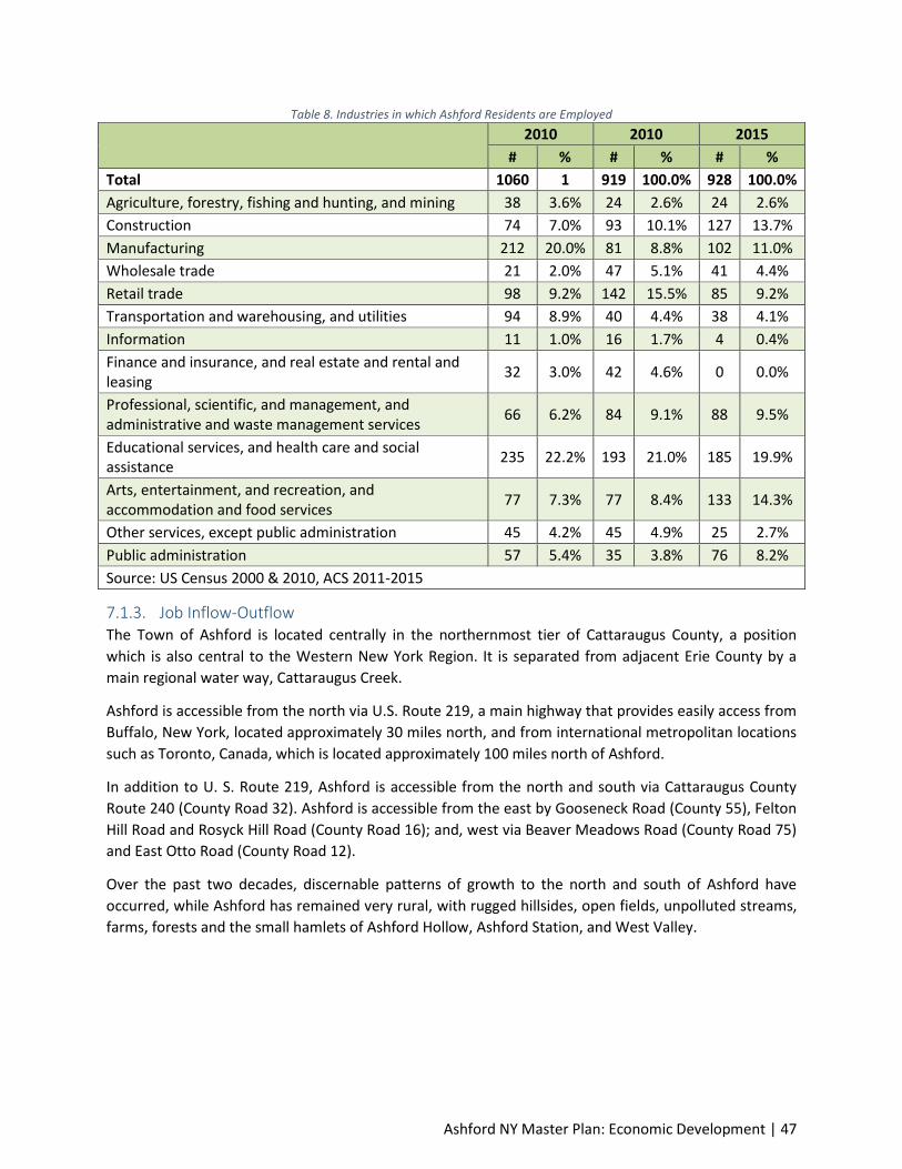
Ashford NY Master Plan: Economic Development | 47
Table 8. Industries in which Ashford Residents are Employed
2010 2010 2015
# % # % # %
Total 1060 1 919 100.0% 928 100.0%
Agriculture, forestry, fishing and hunting, and mining 38 3.6% 24 2.6% 24 2.6%
Construction 74 7.0% 93 10.1% 127 13.7%
Manufacturing 212 20.0% 81 8.8% 102 11.0%
Wholesale trade 21 2.0% 47 5.1% 41 4.4%
Retail trade 98 9.2% 142 15.5% 85 9.2%
Transportation and warehousing, and utilities 94 8.9% 40 4.4% 38 4.1%
Information 11 1.0% 16 1.7% 4 0.4%
Finance and insurance, and real estate and rental and leasing
32 3.0% 42 4.6% 0 0.0%
Professional, scientific, and management, and administrative and waste management services
66 6.2% 84 9.1% 88 9.5%
Educational services, and health care and social assistance
235 22.2% 193 21.0% 185 19.9%
Arts, entertainment, and recreation, and accommodation and food services
77 7.3% 77 8.4% 133 14.3%
Other services, except public administration 45 4.2% 45 4.9% 25 2.7%
Public administration 57 5.4% 35 3.8% 76 8.2%
Source: US Census 2000 & 2010, ACS 2011-2015
7.1.3. Job Inflow-Outflow The Town of Ashford is located centrally in the northernmost tier of Cattaraugus County, a position
which is also central to the Western New York Region. It is separated from adjacent Erie County by a
main regional water way, Cattaraugus Creek.
Ashford is accessible from the north via U.S. Route 219, a main highway that provides easily access from
Buffalo, New York, located approximately 30 miles north, and from international metropolitan locations
such as Toronto, Canada, which is located approximately 100 miles north of Ashford.
In addition to U. S. Route 219, Ashford is accessible from the north and south via Cattaraugus County
Route 240 (County Road 32). Ashford is accessible from the east by Gooseneck Road (County 55), Felton
Hill Road and Rosyck Hill Road (County Road 16); and, west via Beaver Meadows Road (County Road 75)
and East Otto Road (County Road 12).
Over the past two decades, discernable patterns of growth to the north and south of Ashford have
occurred, while Ashford has remained very rural, with rugged hillsides, open fields, unpolluted streams,
farms, forests and the small hamlets of Ashford Hollow, Ashford Station, and West Valley.
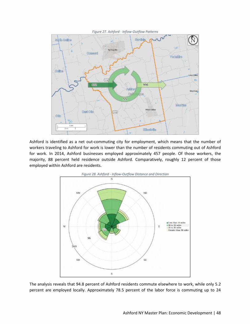
Ashford NY Master Plan: Economic Development | 48
Figure 27. Ashford - Inflow-Outflow Patterns
Ashford is identified as a net out-commuting city for employment, which means that the number of
workers traveling to Ashford for work is lower than the number of residents commuting out of Ashford
for work. In 2014, Ashford businesses employed approximately 457 people. Of those workers, the
majority, 88 percent held residence outside Ashford. Comparatively, roughly 12 percent of those
employed within Ashford are residents.
Figure 28. Ashford - Inflow-Outflow Distance and Direction
The analysis reveals that 94.8 percent of Ashford residents commute elsewhere to work, while only 5.2
percent are employed locally. Approximately 78.5 percent of the labor force is commuting up to 24

Ashford NY Master Plan: Economic Development | 49
miles to work in Ashford from locations mainly originating from the North. This reflects a strong
correlation with workers commuting both directions from the Springville to Ashford for employment.
7.1.4. Income The U.S. Census reports income in brackets based on household type. The income bracket that accounts
for the largest percentage of Ashford households (22.8 percent) and non-families households (27.4
percent) is the $35,000–$50,000 range. The income bracket that accounts for the largest percentage of
Ashford families (22.7 percent) and married-couple families (28.3 percent) is the $100,000–$145,999
range.
Figure 29. Ashford - Income Distribution
The median household income in Ashford is $47,321 annually. This is higher than Cattaraugus County’s
average of $42,601, but lower than the State of New York’s value of $ 59,269, and the nation’s median
household income of $53,889.
7.1.5. Cost of Living in Cattaraugus County The living wage shown is the hourly rate that an individual must earn to support their family, if they are
the sole provider and are working full-time (2080 hours per year). All values are per adult in a family
unless otherwise noted. The state minimum wage is the same for all individuals, regardless of how many
dependents they may have. The poverty rate is typically quoted as gross annual income. We have
converted it to an hourly wage for the sake of comparison.
3.0
0%
15
.30
%
10
.60
%
22
.80
%
20
.60
%
10
.30
%
16
.60
%
0.8
0%
4.0
0%
17
.30
%
6.9
0%
17
.50
%
17
.10
%
13
.30
%
22
.70
%
1.2
0%
1.2
0%
8.8
0%
8.6
0%
16
.20
%
21
.30
%
14
.10
%
28
.30
%
1.4
0%
7.3
0%
15
.30
% 1
8.4
0%
27
.40
%
25
.70
%
3.8
0%
2.1
0%
0%
L E S S T H A N
$ 1 4 , 9 9 9 $ 1 5 , 0 0 0 T O
$ 2 4 , 9 9 9 $ 2 5 , 0 0 0 T O
$ 3 4 , 9 9 9 $ 3 5 , 0 0 0 T O
$ 4 9 , 9 9 9 $ 5 0 , 0 0 0 T O
$ 7 4 , 0 0 0 $ 7 5 , 0 0 0 T O
$ 9 9 , 9 9 9 $ 1 0 0 , 0 0 0 T O
$ 1 4 9 , 9 9 9 $ 1 1 5 0 , 0 0 0 O R M O R E
Household Families Married-couple families Non-family households

Ashford NY Master Plan: Economic Development | 50
Table 9. Living Wage in Cattaraugus County
Hourly Wages
1 A
du
lt
1 A
du
lt 1
Ch
ild
1 A
du
lt
2 C
hild
ren
1 A
du
lt
3 C
hild
ren
2 A
du
lts
(1 W
ork
ing)
2 A
du
lts
(1 W
ork
ing)
1 C
hild
2 A
du
lts
(1 W
ork
ing)
2 C
hild
ren
2 A
du
lts
(1 W
ork
ing)
3 C
hild
ren
2 A
du
lts
(1 W
ork
ing
Par
t Ti
me
)
1 C
hild
*
2 A
du
lts
2 A
du
lts
1 C
hild
2 A
du
lts
2 C
hild
ren
2 A
du
lts
3 C
hild
ren
Living Wage
$10.19 $23.84 $31.73 $40.88 $16.89 $21.19 $23.72 $26.21 $13.47 $8.45 $13.47 $17.20 $20.90
Poverty Wage
$5.00 $7.00 $9.00 $11.00 $7.00 $9.00 $11.00 $13.00 - $3.00 $4.00 $5.00 $6.00
Minimum Wage
$9.00 $9.00 $9.00 $9.00 $9.00 $9.00 $9.00 $9.00 - $9.00 $9.00 $9.00 $9.00
Source: Living Wage Calculator, Massachusetts Institute of Technology
7.1.6. Poverty Approximately 11.2 percent of Ashford residents are living in poverty. This is lower than the county,
state and national averages. Ashford’s poverty rates generally follow national trends, where families
with female householders, no husband present are classified as having the highest poverty rate.
West Valley Hamlet has a poverty rate which is higher than the Town of Ashford. Although the poverty
rate is higher, it is similar to other rural hamlets in New York. For example Lime Lake NY, population 661
has a 16.8 percent poverty rate and East Randolph, NY, population 558 has and a 37.2 percent poverty
rate.
Table 10. Poverty Rate
Population Group Ashford West Valley
Cattaraugus County
New York
United States
All people 11.2% 20.9% 18.3% 15.7% 15.5%
Under 18 26.7% 60% 27.7% 22.2% 21.7%
18 years and over 6.9% 9.6% 15.4% 13.9% 13.5%
All Families 6.6% 11.4% 12.4% 12.0% 11.3%
Married couples families 1.2% 0% 7.3% 6.2% 5.6%
Families with female householders, no husband present
28.6% 39% 30.0% 28.2% 30.6%
Source: ACS 2011-2015
As illustrated in the figure below, compared to the rest of the County, Ashford has a relatively low
percent of population living below poverty level from 2011-2015.

Ashford NY Master Plan: Economic Development | 51
Figure 30. Estimated percent of population living below poverty level between 2011-2015
7.1.7. Education and Workforce Training Ashford’s workforce is well educated, and only 8.6 percent had failed to either graduate from high
school or obtain a General Equivalency Degree (GED) between 2011 and 2015. However, compared to
New York State and the United States, there are lower levels of completing bachelor’s degrees or higher
levels of education.
Table 11. Educational Attainment (persons aged 25 or older)
Ashford Cattaraugus County New York United States
No High School Diploma 8.6% 12.1% 14.4% 13.3%
High School Diploma or GED 40.8% 40.9% 26.7% 27.8%
Some college, no degree 17.4% 17.6% 16.2% 21.1%
Associate’s degree 17.0% 11.6% 8.5% 8.1%
Bachelor’s degree 10.4% 10.3% 19.4% 18.5%
Graduate or professional degree 5.8% 7.5% 14.8% 11.2%
All Bachelor’s degree or Higher 16.2% 17.8% 34.2% 29.8%
Source: ACS 2011-2015
There are a number of options for Ashford residents to obtain a good education and workforce training
in Cattaraugus County, which includes the County’s sixteen school districts, Cattaraugus-Allegany

Ashford NY Master Plan: Economic Development | 52
BOCES, Jamestown Community College, Saint Bonaventure University, Cattaraugus-Allegany Workforce
Investment Board, and other training related organizations. Training focuses both on basic employment
skills and specialized education designed to meet the specific needs of the industrial base.
7.2. Industry Cluster Analysis 7.2.1. Background Industry Cluster analysis is a relatively new concept in evaluating a region’s economy. An Industry
Cluster is a geographic concentration of interrelated competitive businesses with sufficient size to
generate external economies. Industries that are part of clusters have developed buyer-supplier
relationships, share labor pools, draw qualified workers from area institutions of higher education, and
are located near each other.
Industry Clusters can also be developed as Value Chains where activities of two or more businesses
operate in a specific industry. An example of a Value Chain Industry Cluster is the Michigan automotive
industry where auto parts suppliers are located near the automotive assembly plants. Industry Clusters
can also be a collection of businesses that produce a similar product or service. A typical Main Street in a
small town would be considered an Industry Cluster for retail and food establishments. Cities can
facilitate industry cluster development through tax and zoning policy, and by providing necessary
infrastructure.
The identification of Industry Clusters is an important element in successfully recruiting businesses and
facilitating development efforts focused on companies that complement existing businesses.
Furthermore, it can also identify gaps in Value Chains, and inform local decision-makers of industries
that are either growing or declining so that programs and policies can be developed to address these
challenges.
7.2.2. Bubble Chart Information An Industry Cluster Analysis can be completed for a city, county, region or state, and it can be depicted
by use of a “Bubble Chart.” A Bubble Chart is a method economists use to display three dimensions of
data. The bubbles displayed on a graph represent the relative size of each industry’s employment in the
focus area. Specifically, this analysis focuses on the size of employment in a particular industry in
Cattaraugus County compared to other local industries. The horizontal axis measures the percent
change in the Location Quotient (LQ) over a designated period of time - in this case from 2010-2014. An
LQ represents a methodology to quantify the concentration of a local industry to a larger geographic
area. This analysis compares local Industry Clusters in Cattaraugus County to the same Industry Clusters
in New York. Bubble Cluster industries positioned to the right side of one on the vertical axis are
classified as growing, while those to the left are classified as shrinking. The vertical axis measures the
concentration of an industry relative to New York. An LQ concentration of one or higher indicates that
the cluster is more heavily concentrated in Cattaraugus County than in New York. Economists also
consider these Industry Clusters to be net exporters of goods and/or services to areas outside of the
region. A LQ less than one for an industry suggests that Cattaraugus County has a weaker concentration
in a given industry compared to New York.
7.2.3. Data Sources The Industry Cluster analysis completed by TFG for Cattaraugus County examines the period from 2010
to 2014 using Longitudinal-Employer Household Dynamics Origin-Destination Employment Statistics and
Ashford NY Master Plan: Economic Development | 53
American Community Survey data. Additionally, the cluster analysis used Quarterly Census of
Employment and Wages (QCEW) data for private and public sector employment based on the North
American Industry Classification System (NAICS). QCEW data is the official employment and wage data
reported by employers to the state. This information is presented through United States Census data,
where the data for Cattaraugus County and New York was retrieved.
7.2.4. Industry Cluster Analysis for Cattaraugus County The figure below depicts the most recent concentrations of industries in Cattaraugus County relative to
the state of New York for the period of 2002-2014. It identifies the concentration growth or decline of
industries over this period of time, as reflected in the LQ.
The upper right-hand quadrant contains strong and advancing industry clusters. This means that
clusters located in this quadrant are more concentrated in Cattaraugus County and are growing. These
clusters are strengths that help the County stand out from the competition. Small, high growth clusters
can be expected to become more dominant over time. Cattaraugus County has the following clusters
located in this quadrant: manufacturing; public administration; retail trade; and arts, entertainment, and
recreation.
The lower right-hand quadrant contains weak but emerging industry clusters. This means that these
clusters are underrepresented in the County but are growing, often quickly. If growth trends continue,
these clusters will eventually move into the top right quadrant. Clusters in this quadrant are considered
“emerging” strengths for Cattaraugus County. Clusters found in this quadrant include: other services;
wholesale trade; construction; finance and insurance; real estate, rental and leasing; management of
companies and enterprises; and professional, scientific and technical services.
The upper left-hand quadrant contains clusters that are strong but declining. Clusters located in this
quadrant are more concentrated in Cattaraugus County but are declining (negative growth). These
clusters typically fall into the lower quadrant as job losses cause a decline in concentration. Industries
locates in this quadrant include: mining, quarrying, and oil and gas extraction; agriculture, forestry,
fishing and hunting; education services; and accommodation and food services.
The lower left-hand quadrant contains weak and declining industry clusters. This means that these
clusters are underrepresented in the County (low concentration) and are also losing jobs. Clusters in this
quadrant may indicate a gap in the workforce pipeline if local industries anticipate a future need. In
general, clusters in this quadrant show a lack of competitiveness. Clusters in this quadrant include:
health care and social assistance; administration and support, waste management and remediation;
transportation and warehousing; utilities and information.
Strong Industry Clusters
Strong and Advancing Clusters
One of the strongest and advancing industry cluster in Cattaraugus County is the arts, entertainment,
and recreation cluster. This cluster includes firms primarily involved in: performing arts and spectator
sports; museums, parks and historical sites; and amusement, gambling and recreation industries. This
cluster employed approximately 1,930 people in 2014 and accounted for about 5% of the County’s
employment. These jobs are primarily concentrated around Salamanca, Ellicottville, and Olean. From
2002 to 2014, this industry grew 364.88% and had 2014 concentration of 2.53. The average annual
wages of $16,104 are well below the state average annual wage of $48,982.

Ashford NY Master Plan: Economic Development | 54
Manufacturing is an important source of employment for workers in Cattaraugus County.
Establishments in the Manufacturing sector are often described as plants, factories, or mills and
characteristically use power-driven machines and materials-handling equipment. However,
establishments that transform materials or substances into new products by hand or in the worker's
home and those engaged in selling to the general public products made on the same premises from
which they are sold, such as bakeries, candy stores, and custom tailors, may also be included in this
sector. Manufacturing establishments may process materials or may contract with other establishments
to process their materials for them. Both types of establishments are included in manufacturing. This
industry cluster had 3,566 jobs, representing approximately 13 percent of the County’s employment.
While the industry is the third largest employer, it experienced a contraction between 2002 and 2014,
reducing the industry workforce by 1,600 jobs. Despite this contraction, the manufacturing industry has
a high LQ of 2.44. The manufacturing cluster posts annual average wages of $59,927; this is below the
Figure 31. Arts, Entertainment and Recreation Jobs within Cattaraugus County
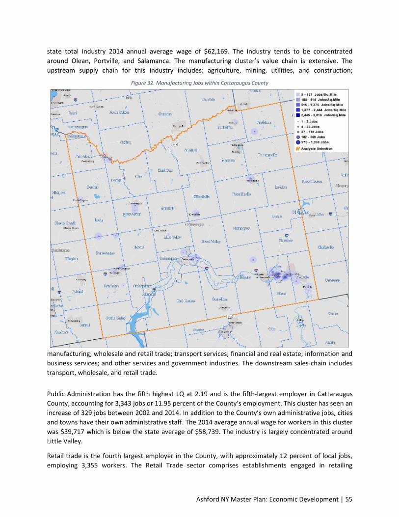
Ashford NY Master Plan: Economic Development | 55
state total industry 2014 annual average wage of $62,169. The industry tends to be concentrated
around Olean, Portville, and Salamanca. The manufacturing cluster’s value chain is extensive. The
upstream supply chain for this industry includes: agriculture, mining, utilities, and construction;
manufacturing; wholesale and retail trade; transport services; financial and real estate; information and
business services; and other services and government industries. The downstream sales chain includes
transport, wholesale, and retail trade.
Public Administration has the fifth highest LQ at 2.19 and is the fifth-largest employer in Cattaraugus
County, accounting for 3,343 jobs or 11.95 percent of the County’s employment. This cluster has seen an
increase of 329 jobs between 2002 and 2014. In addition to the County’s own administrative jobs, cities
and towns have their own administrative staff. The 2014 average annual wage for workers in this cluster
was $39,717 which is below the state average of $58,739. The industry is largely concentrated around
Little Valley.
Retail trade is the fourth largest employer in the County, with approximately 12 percent of local jobs,
employing 3,355 workers. The Retail Trade sector comprises establishments engaged in retailing
Figure 32. Manufacturing Jobs within Cattaraugus County
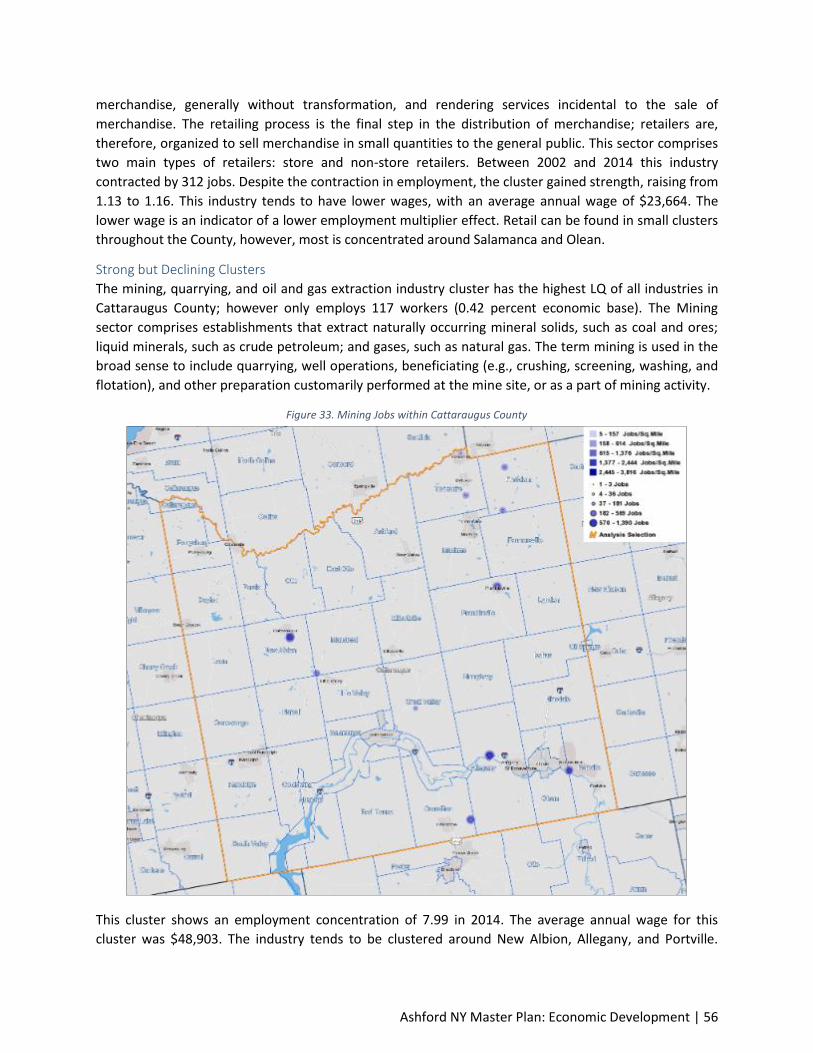
Ashford NY Master Plan: Economic Development | 56
merchandise, generally without transformation, and rendering services incidental to the sale of
merchandise. The retailing process is the final step in the distribution of merchandise; retailers are,
therefore, organized to sell merchandise in small quantities to the general public. This sector comprises
two main types of retailers: store and non-store retailers. Between 2002 and 2014 this industry
contracted by 312 jobs. Despite the contraction in employment, the cluster gained strength, raising from
1.13 to 1.16. This industry tends to have lower wages, with an average annual wage of $23,664. The
lower wage is an indicator of a lower employment multiplier effect. Retail can be found in small clusters
throughout the County, however, most is concentrated around Salamanca and Olean.
Strong but Declining Clusters
The mining, quarrying, and oil and gas extraction industry cluster has the highest LQ of all industries in
Cattaraugus County; however only employs 117 workers (0.42 percent economic base). The Mining
sector comprises establishments that extract naturally occurring mineral solids, such as coal and ores;
liquid minerals, such as crude petroleum; and gases, such as natural gas. The term mining is used in the
broad sense to include quarrying, well operations, beneficiating (e.g., crushing, screening, washing, and
flotation), and other preparation customarily performed at the mine site, or as a part of mining activity.
This cluster shows an employment concentration of 7.99 in 2014. The average annual wage for this
cluster was $48,903. The industry tends to be clustered around New Albion, Allegany, and Portville.
Figure 33. Mining Jobs within Cattaraugus County

Ashford NY Master Plan: Economic Development | 57
Agriculture is important to the County as a land use, as a source of income, and as an employer.
Approximately 228 workers were employed by this industry in 2014, a 14.6 percent decrease since 2002.
In addition to fewer workers in this industry cluster, there have been structural changes to farming in
the County. The number of farms has steadily declined, dropping from 1,157 in 2002 to 1,038 in
2012(the most recent data available). Acreage of land devoted to farming has also slightly declined
between 2002 and 2012, decreasing by 2.3 percent; however, the average size of farms has been
increasing from 175 acres in 2002 to 190 acres in 2012. This trend towards fewer but larger farm
operations parallels statewide trends. Although the industry lost jobs over the 13 year period,
agriculture, forestry, fishing and hunting remains highly concentrated as a specialization within the
County, recording an LQ of 3.12. The annual average wages for this cluster is $27,886; this is below the
state total industry 2014 annual average wage of $31,243. Within the County, this industry is
concentrated around Ashford, Freedom, Persia, Leon, Conewango, Randolph and Napoli.
Figure 34. Agriculture Jobs within Cattaraugus County
Educational services is another strong cluster in Cattaraugus County. The Educational Services sector
comprises establishments that provide instruction and training in a wide variety of subjects. This
Ashford NY Master Plan: Economic Development | 58
instruction and training is provided by specialized establishments, such as schools, colleges, universities,
and training centers. These establishments may be privately owned and operated for profit or not for
profit, or they may be publicly owned and operated. They may also offer food and/or accommodation
services to their students. Representing 15.6 percent of the County workforce, it is the largest employer
in the County providing 4,365 jobs. Some of the largest employers in the County fit this cluster, including
St. Bonaventure University and the Pioneer Central School District. The industry has strong clusters in
Yorkshire, Ashford, Franklinville, Little Valley, Randolph, Salamanca, Allegany, Olean and Portville. The
LQ of the industry is 1.42. The average annual wages of $33,182 are well below the state average annua
lwage of $53,201.
Tied closely with arts, entertainment and recreation cluster is the accommodation and food service
cluster. Concentrations of the industry can be found in Ellicottville, Salamanca, and Olean. This cluster
provided jobs for 1,390 people in 2014, approximately 8.31 percent of the County’s workforce. The
Industry gained 161 jobs between 2002 and 2014 and has an average annual wage of $15,041.
Cattaraugus County’s strong arts, entertainment and recreation cluster and accommodation and food
services clusters are linked with the bustling tourism industry associated with the area.
Weak Industry Clusters
Weak and Emerging Clusters
The other services sector comprises establishments engaged in providing services not specifically
provided for elsewhere in the classification system. Establishments in this sector are primarily engaged
in activities, such as equipment and machinery repairing, promoting or administering religious activities,
grant making, advocacy, and providing dry cleaning and laundry services, personal care services, death
care services, pet care services, photofinishing services, temporary parking services, and dating services.
This cluster provides jobs for approximately 1,087 people, representing 3.88 percent of the County’s
employment. Establishments in this industry are found across the county, with concentrations in
Salamanca, Allegany, Olean and Portville. This industry cluster has an LQ of 0.97 and has a lower average
annual wage of $21,524.
The wholesale trade sector comprises establishments engaged in wholesaling merchandise, generally
without transformation, and rendering services incidental to the sale of merchandise. The merchandise
described in this sector includes the outputs of agriculture, mining, manufacturing, and certain
information industries, such as publishing. This industry provides jobs for 720 workers, a decrease of 108
jobs since 2002. Despite the decrease in employment numbers, the industry’s concentration is growing,
from 0.6 in 2002 to .67 in 2014. Jobs in the industry tend to be clustered around Portville, Olean and
Salamanca; however can be found to a lesser extent in other areas of the county, such as Yorkshire,
Ashford, Perrysburg, Leon, Mansfield, Ellicottville, Conewango, and Hinsdale.
As of 2014, the construction cluster accounts for 623 jobs in Cattaraugus County. Since 2002 this
industry has experienced a 9.88 percent growth, adding 56 jobs. During the same time period, the LQ
grew from 0.49 to 0.59. The average annual wage for the construction industry in Cattaraugus County
for 2014 was approximately $43,446, and has an employment multiplier of 1.90. This means for every
construction job created, another 1.9 indirect jobs are also created.
The Finance and Insurance sector comprises establishments primarily engaged in financial transactions
(transactions involving the creation, liquidation, or change in ownership of financial assets) and/or in
facilitating financial transactions. This industry provides jobs for 735 individuals, similar to employment

Ashford NY Master Plan: Economic Development | 59
levels in 2002. The majority of jobs in this industry are found in Olean, Salamanca and Allegany. Jobs can
also be found in Portville, Randolph, Little Valley, Ellicottville, Franklinville, New Albion, Dayton, Ashford
and Yorkshire.
The Real Estate and Rental and Leasing sector comprises establishments primarily engaged in renting,
leasing, or otherwise allowing the use of tangible or intangible assets, and establishments providing
related services. The major portion of this sector comprises establishments that rent, lease, or otherwise
allow the use of their own assets by others. The assets may be tangible, as is the case of real estate and
equipment, or intangible, as is the case with patents and trademarks. The real estate, rental and leasing
sector provides jobs for 256 people in Cattaraugus County. This industry has seen a 23 increase in
employment since 2002. The industry’s concentration is growing in strength, from 0.32 in 2002 to 0.41
in 2014. Jobs in this cluster tend to be located in Olean, Allegany, Ellicottville, Portville, and Salamanca.
The Management of Companies and Enterprises sector comprises (1) establishments that hold the
securities of (or other equity interests in) companies and enterprises for the purpose of owning a
controlling interest or influencing management decisions or (2) establishments (except government
establishments) that administer, oversee, and manage establishments of the company or enterprise and
that normally undertake the strategic or organizational planning and decision making role of the
company or enterprise. Establishments that administer, oversee, and manage may hold the securities of
the company or enterprise. This sector employed 177 workers in 2014, growing 13.46 percent since
2002. The LQ for this industry is 0.37, a slight increase since 2002’s LQ of 0.31, and has an annual
average wage of $34,453. Jobs in this cluster tend to be located in Yorkshire, Ellicottville, and Olean.
Professional, scientific and technical services had an LQ of 0.29 in 2014, which is a 45.94 percent
increase in concentration compared to 2002. The industry provides jobs for approximately 527 workers,
adding 87 jobs to the workforce since 2002. The cluster has the third-highest annual wage in
Cattaraugus County of $52,042. The higher wage reflects the educational attainment and skills
necessary to perform in the Industry. Jobs in this cluster tend to be dispersed throughout the County,
however, are more concentrated around Portville, Olean, Salamanca and Randolph.
Weak and Declining Clusters
The health care and social assistance service industry is the second-largest employment sector in
Cattaraugus County, yet has an LQ of 0.91. The Health Care and Social Assistance sector comprises
establishments providing health care and social assistance for individuals. The sector includes both
health care and social assistance because it is sometimes difficult to distinguish between the boundaries
of these two activities. The industries in this sector are arranged on a continuum starting with those
establishments providing medical care exclusively, continuing with those providing health care and
social assistance, and finally finishing with those providing only social assistance. The services provided
by establishments in this sector are delivered by trained professionals. All industries in the sector share
this commonality of process, namely, labor inputs of health practitioners or social workers with the
requisite expertise. Many of the industries in the sector are defined based on the educational degree
held by the practitioners included in the industry. This industry had a 17.6 percent employment
contraction between 2002 and 2014. During this period, the health care and social assistance service
cluster also contracted in the State, by 19.42 percent. The clusters average annual wage has seen a risen
from $23,602 in 2002 to earning approximately $41,449 by 2014. While this industry’s wage is rising, the
moderate pay results in a lower employment multiplier effect. Jobs in this cluster tend to be located in
Ashford NY Master Plan: Economic Development | 60
Olean, Allegany, Salamanca, Little Valley, and Perrysburg. There are also a fewer number of jobs in this
cluster located in Randolph, Ellicottville, Franklinville, Machias, Yorkshire and Ashford.
The administrative and support and waste management and remediation Services sector comprises
establishments performing routine support activities for the day-to-day operations of other
organizations. This industry employs 655 workers in 2014, a contraction of 325 jobs compared to 2002
employment levels. Ashford and Olean have the highest concentration of jobs in the County for this
industry. The industry pays a moderate annual average wage of $46,160.
The transportation and warehousing sector includes industries providing transportation of passengers
and cargo, warehousing and storage for goods, scenic and sightseeing transportation, and support
activities related to modes of transportation. This industry has seen a contraction in employment, from
993 jobs in 2002 to 393 jobs in 2014. The LQ of the industry has seen a contraction from 0.96 to 0.4 over
the same time period. The annual average wage for this sector was $36,712.
The information sector comprises establishments engaged in the following processes: (a) producing and
distributing information and cultural products, (b) providing the means to transmit or distribute these
products as well as data or communications, and (c) processing data. The industry provides jobs for 186
people and tends to be located in Olean and Portville. The industry has a concentration of 0.2 in 2014
and an average annual wage of $48,129.
The utilities sector comprises establishments engaged in the provision of the following utility services:
electric power, natural gas, steam supply, water supply, and sewage removal. The industry lost 45 jobs
between 2002 and 2014, employing 28 people in 2014. These jobs are located predominantly in Olean.
In addition to the loss in jobs, the concentration of the industry has decreased from 0.43 to 0.21 over
the same time period. This industry has an extremely high annual average wage of $118,703. In addition
to a high average annual wage, this industry has a high employment multiplier of 5.13.
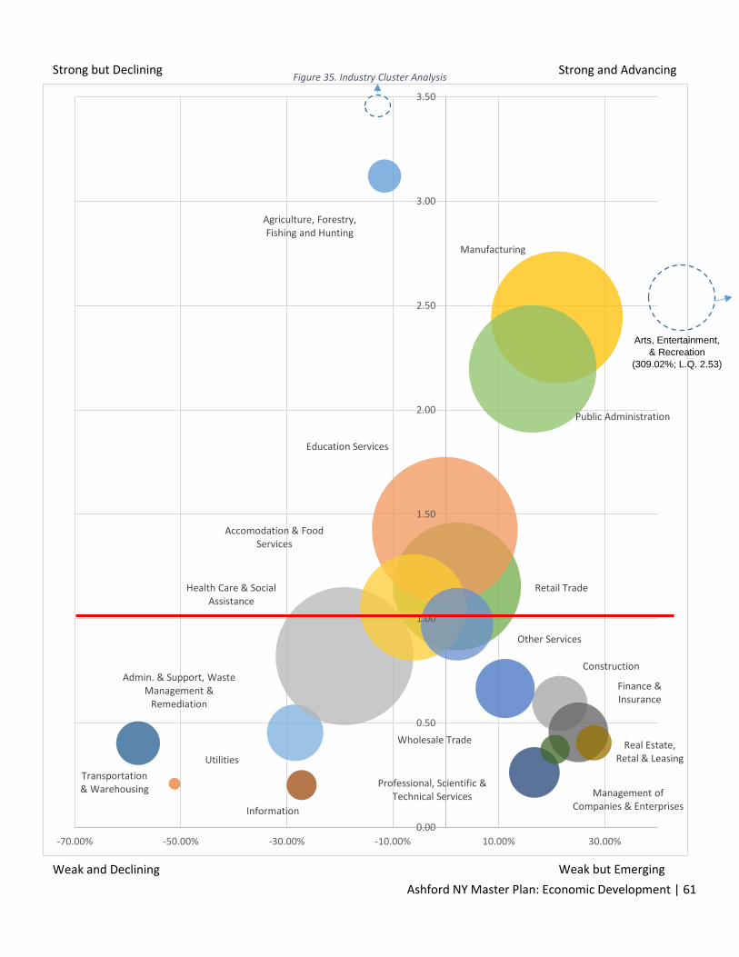
Ashford NY Master Plan: Economic Development | 61
Figure 35. Industry Cluster Analysis
Agriculture, Forestry, Fishing and Hunting
Utilities
Construction
Manufacturing
Wholesale Trade
Retail Trade
Transportation & Warehousing
Information
Finance & Insurance
Real Estate, Retal & Leasing
Professional, Scientific & Technical Services Management of
Companies & Enterprises
Admin. & Support, Waste Management &
Remediation
Education Services
Health Care & Social Assistance
Accomodation & Food Services
Other Services
Public Administration
0.00
0.50
1.00
1.50
2.00
2.50
3.00
3.50
-70.00% -50.00% -30.00% -10.00% 10.00% 30.00%
Arts, Entertainment,
& Recreation
(309.02%; L.Q. 2.53)
Strong and Advancing Strong but Declining
Weak and Declining Weak but Emerging
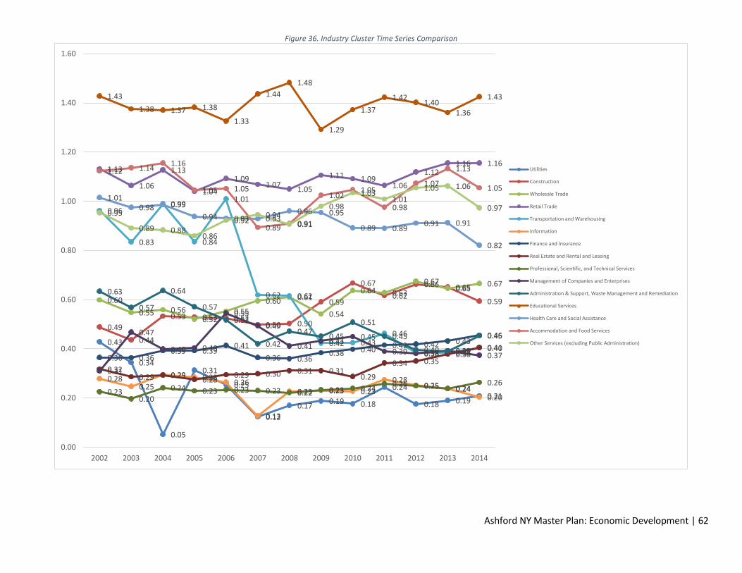
Ashford NY Master Plan: Economic Development | 62
Figure 36. Industry Cluster Time Series Comparison
0.43
0.34
0.05
0.31
0.25
0.12
0.17 0.19 0.18
0.24
0.18 0.19 0.21
0.49
0.44
0.53 0.53 0.52 0.50 0.50
0.59
0.67
0.62
0.66 0.65
0.59 0.60
0.55 0.56 0.52
0.55 0.60 0.61
0.54
0.64 0.63
0.67 0.65
0.67
1.13
1.06
1.13
1.04
1.09 1.07
1.05
1.11 1.09 1.06
1.12 1.16 1.16
0.96
0.83
0.99
0.84
1.01
0.62 0.62
0.42 0.43 0.46
0.38 0.38 0.40
0.28 0.25
0.29 0.28 0.26
0.13
0.23 0.23 0.23
0.28 0.25 0.24
0.20
0.36 0.36 0.39 0.39
0.41
0.36 0.36 0.38 0.40 0.42 0.42 0.43
0.46
0.32 0.29 0.29
0.28 0.29 0.30 0.31 0.31
0.29
0.34 0.35 0.38
0.41
0.23 0.20
0.24 0.23 0.23 0.23 0.22 0.23 0.24 0.26 0.25 0.24
0.26
0.31
0.47
0.40 0.40
0.55
0.49
0.41 0.43
0.45
0.39 0.38 0.39 0.37
0.63
0.57
0.64
0.57
0.52
0.42
0.47 0.45
0.51
0.45
0.40 0.39
0.45
1.43
1.38 1.37 1.38
1.33
1.44
1.48
1.29
1.37
1.42 1.40
1.36
1.43
1.01 0.98 0.99
0.94 0.93 0.93 0.96 0.95
0.89 0.89 0.91 0.91
0.82
1.12 1.14 1.16
1.05 1.05
0.89 0.91
1.02 1.05
0.98
1.07
1.13
1.05
0.95
0.89 0.88 0.86
0.92 0.94
0.91
0.98
1.03 1.01
1.05 1.06
0.97
0.00
0.20
0.40
0.60
0.80
1.00
1.20
1.40
1.60
2002 2003 2004 2005 2006 2007 2008 2009 2010 2011 2012 2013 2014
Utilities
Construction
Wholesale Trade
Retail Trade
Transportation and Warehousing
Information
Finance and Insurance
Real Estate and Rental and Leasing
Professional, Scientific, and Technical Services
Management of Companies and Enterprises
Administration & Support, Waste Management and Remediation
Educational Services
Health Care and Social Assistance
Accommodation and Food Services
Other Services (excluding Public Administration)

Ashford NY Master Plan: Economic Development | 63
Figure 37. Industry Cluster Time series Comparison (Continued)
3.53
2.31
3.44
2.82
3.64
2.97
2.83 2.79
3.21 3.15
3.22
3.09 3.12
2.02 2.1
1.57
1.84
2.06 1.97
1.87
2.21
2.1
2.24
2.4 2.39 2.44
0.62 0.58
0.77
2.06
2.21
2.81
2.56
2.25 2.33
2.39 2.29 2.33
2.53
1.89
2.57
2.89 2.89
2.31
2.71
2.86
2.53
2.33 2.28
1.97 2.02
2.2
0
0.5
1
1.5
2
2.5
3
3.5
4
2002 2003 2004 2005 2006 2007 2008 2009 2010 2011 2012 2013 2014
Agriculture, Forestry, Fishing and Hunting
Manufacturing
Arts, Entertainment, and Recreation
Public Administration
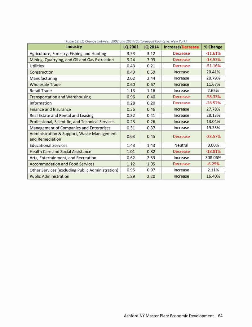
Ashford NY Master Plan: Economic Development | 64
Table 12. LQ Change between 2002 and 2014 (Cattaraugus County vs. New York)
Industry LQ 2002 LQ 2014 Increase/Decrease % Change
Agriculture, Forestry, Fishing and Hunting 3.53 3.12 Decrease -11.61%
Mining, Quarrying, and Oil and Gas Extraction 9.24 7.99 Decrease -13.53%
Utilities 0.43 0.21 Decrease -51.16%
Construction 0.49 0.59 Increase 20.41%
Manufacturing 2.02 2.44 Increase 20.79%
Wholesale Trade 0.60 0.67 Increase 11.67%
Retail Trade 1.13 1.16 Increase 2.65%
Transportation and Warehousing 0.96 0.40 Decrease -58.33%
Information 0.28 0.20 Decrease -28.57%
Finance and Insurance 0.36 0.46 Increase 27.78%
Real Estate and Rental and Leasing 0.32 0.41 Increase 28.13%
Professional, Scientific, and Technical Services 0.23 0.26 Increase 13.04%
Management of Companies and Enterprises 0.31 0.37 Increase 19.35%
Administration & Support, Waste Management and Remediation
0.63 0.45 Decrease -28.57%
Educational Services 1.43 1.43 Neutral 0.00%
Health Care and Social Assistance 1.01 0.82 Decrease -18.81%
Arts, Entertainment, and Recreation 0.62 2.53 Increase 308.06%
Accommodation and Food Services 1.12 1.05 Decrease -6.25%
Other Services (excluding Public Administration) 0.95 0.97 Increase 2.11%
Public Administration 1.89 2.20 Increase 16.40%

Ashford NY Master Plan: Economic Development | 65
Industry Employment
2002 Employment
2014 Employment
Gain/Loss % Change
Agriculture, Forestry, Fishing and Hunting
267 228 -39 -14.61%
Mining, Quarrying, and Oil and Gas Extraction
149 117 -32 -21.48%
Utilities 73 28 -45 -61.64%
Construction 567 623 56 9.88%
Manufacturing 5166 3566 -1600 -30.97%
Wholesale Trade 828 720 -108 -13.04%
Retail Trade 3667 3355 -312 -8.51%
Transportation and Warehousing 993 393 -600 -60.42%
Information 282 186 -96 -34.04%
Finance and Insurance 736 735 -1 -0.14%
Real Estate and Rental and Leasing 233 256 23 9.87%
Professional, Scientific, and Technical Services
440 527 87 19.77%
Management of Companies and Enterprises
156 177 21 13.46%
Administration & Support, Waste Management and Remediation
980 655 -325 -33.16%
Educational Services 4618 4365 -253 -5.48%
Health Care and Social Assistance 4743 3908 -835 -17.60%
Arts, Entertainment, and Recreation 299 1390 1091 364.88%
Accommodation and Food Services 2164 2325 161 7.44%
Other Services (excluding Public Administration)
1119 1087 -32 -2.86%
Public Administration 3014 3343 329 10.92%

Ashford NY Master Plan: Economic Development | 66
Industry Average Wages 2002 Average Wages 2014 Average Wages
Gain/Loss % Change
Agriculture, Forestry, Fishing and Hunting
$19,435 $27,886 $8,451 43.48%
Mining, Quarrying, and Oil and Gas Extraction
$31,865 $48,903 $17,038 53.47%
Utilities $65,920 $118,703 $52,783 80.07%
Construction $28,471 $43,446 $14,975 52.60%
Manufacturing $38,024 $59,927 $21,903 57.60%
Wholesale Trade $34,217 $45,797 $11,580 33.84%
Retail Trade $17,563 $23,664 $6,101 34.74%
Transportation and Warehousing
$22,305 $36,712 $14,407 64.59%
Information $29,897 $48,129 $18,232 60.98%
Finance and Insurance $26,839 $49,336 $22,497 83.82%
Real Estate and Rental and Leasing
$19,684 $26,843 $7,159 36.37%
Professional, Scientific, and Technical Services
$29,137 $52,042 $22,905 78.61%
Management of Companies and Enterprises
$28,079 $34,453 $6,374 22.70%
Administration & Support, Waste Management and Remediation
$41,730 $46,160 $4,430 10.62%
Educational Services N/A $33,182 N/A N/A
Health Care and Social Assistance
$23,602 $41,449 $17,847 75.62%
Arts, Entertainment, and Recreation
$11,770 $16,104 $4,334 36.82%
Accommodation and Food Services
$10,003 $15,041 $5,038 50.36%
Other Services (excluding Public Administration)
$14,153 $21,524 $7,371 52.08%
Public Administration $30,494 $39,717 $9,223 30.25%
Sources: US Census 2000 and 2014 Business Patterns
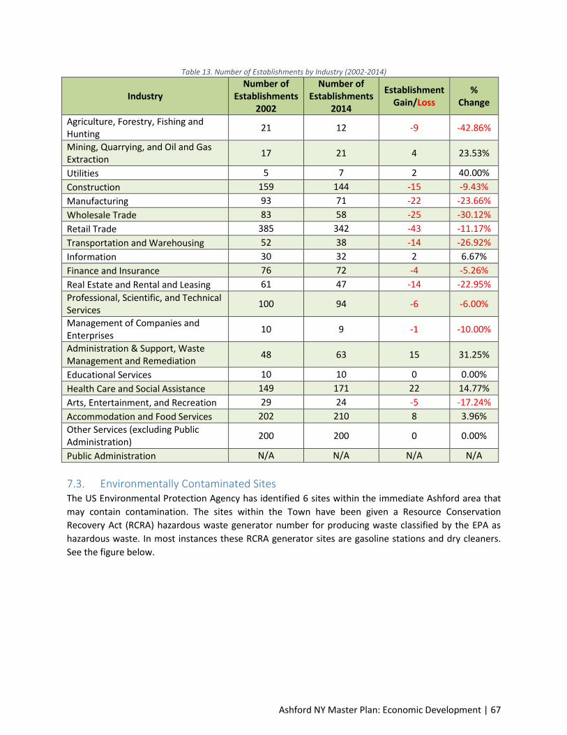
Ashford NY Master Plan: Economic Development | 67
Table 13. Number of Establishments by Industry (2002-2014)
Industry Number of
Establishments 2002
Number of Establishments
2014
Establishment Gain/Loss
% Change
Agriculture, Forestry, Fishing and Hunting
21 12 -9 -42.86%
Mining, Quarrying, and Oil and Gas Extraction
17 21 4 23.53%
Utilities 5 7 2 40.00%
Construction 159 144 -15 -9.43%
Manufacturing 93 71 -22 -23.66%
Wholesale Trade 83 58 -25 -30.12%
Retail Trade 385 342 -43 -11.17%
Transportation and Warehousing 52 38 -14 -26.92%
Information 30 32 2 6.67%
Finance and Insurance 76 72 -4 -5.26%
Real Estate and Rental and Leasing 61 47 -14 -22.95%
Professional, Scientific, and Technical Services
100 94 -6 -6.00%
Management of Companies and Enterprises
10 9 -1 -10.00%
Administration & Support, Waste Management and Remediation
48 63 15 31.25%
Educational Services 10 10 0 0.00%
Health Care and Social Assistance 149 171 22 14.77%
Arts, Entertainment, and Recreation 29 24 -5 -17.24%
Accommodation and Food Services 202 210 8 3.96%
Other Services (excluding Public Administration)
200 200 0 0.00%
Public Administration N/A N/A N/A N/A
7.3. Environmentally Contaminated Sites The US Environmental Protection Agency has identified 6 sites within the immediate Ashford area that
may contain contamination. The sites within the Town have been given a Resource Conservation
Recovery Act (RCRA) hazardous waste generator number for producing waste classified by the EPA as
hazardous waste. In most instances these RCRA generator sites are gasoline stations and dry cleaners.
See the figure below.
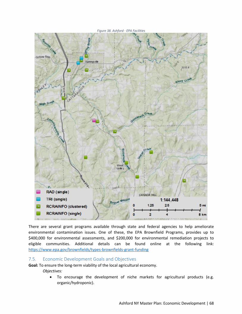
Ashford NY Master Plan: Economic Development | 68
Figure 38. Ashford - EPA Facilities
There are several grant programs available through state and federal agencies to help ameliorate
environmental contamination issues. One of these, the EPA Brownfield Programs, provides up to
$400,000 for environmental assessments, and $200,000 for environmental remediation projects to
eligible communities. Additional details can be found online at the following link:
https://www.epa.gov/brownfields/types-brownfields-grant-funding
7.5. Economic Development Goals and Objectives Goal: To ensure the long-term viability of the local agricultural economy.
Objectives:
To encourage the development of niche markets for agricultural products (e.g.
organic/hydroponic).

Ashford NY Master Plan: Economic Development | 69
To encourage secondary business development, such as outdoor markets, around the
agricultural economy.
To promote working with Cattaraugus County and other agencies such as the County
Extension Agency, to explore regional approaches to aiding the agricultural economy.
Goal: Limit sporadic development of commercial sites.
Objectives:
Identify preferred areas where commercial development is acceptable (hamlet of
Ashford, near municipalities, etc.)
To maintain uninterrupted expanses of agricultural land and discourage the splitting of
active agricultural parcels that would divide working lands, or place barriers between
active lands.
Goal: Maintain access to local goods and services.
Objectives:
To support local commercial corridors within neighboring municipalities.
To attempt to work with neighboring municipalities to develop a long-term area-wide
strategy to promote local goods and services.
To provide necessary support for active Ashford businesses.
Goal: Provide a welcoming environment for small business development.
Objectives:
To work with local, regional, and state programming to grow small business
development and retention.
To support local initiative and entrepreneurial spirit by allowing home-based business
development.
Goal: Collaborate with the federal Department of Energy on the West Valley Demonstration Project
Objectives:
Continue to work with the West Valley Demonstration Project to develop new research
and development programs.
Goal: Collaborate with Cattaraugus County on expansion of recreation programs
Objectives: To support the expansion of the recreation industry cluster in the Town of Ashford.
7.6. Economic Development Recommendations Support and market all forms of agriculture, including those less common in Cattaraugus county
like: organic agriculture; vineyards; orchards; research farming; community agriculture; or, the
production of other niche agricultural products.
Where development occurs, establish guidelines for appropriate site design to mitigate
potentially negative environmental impacts.

Ashford NY Master Plan: Economic Development | 70
Collaborate with adjoining municipalities in the planning, timing, location, and form of all
recreation, commercial and/or industrial development proposed in the Town or surrounding
area.
Encourage establishment of proposed businesses that are compatible with the Town’s status as
a rural, agricultural and residential community.
Work with the County and the Cattaraugus-Allegany Workforce Investment Board, Inc. (WIB),
the One Stop Career Centers, and our Partner agencies to identify local and state programming
to help aid in business development and recruitment. This includes identifying start-up funding
or incentive programming.
Ensure that the future zoning ordinance provides opportunities for home-based businesses and
support local entrepreneurial initiatives.
Encourage expansion and development of existing Ashford businesses. Work with these entities
to enhance their productivity and longevity within the community.
Pursue establishing a Community Benefits Agreement with the DOE Contractor at the West
Valley Demonstration Project.

Ashford NY Master Plan: Economic Development | 71
Ashford NY Master Plan: Intergovernmental Cooperation | 72
Element 8: Intergovernmental Cooperation This element of the Master Development Plan analyzes the relationship of the Town of Ashford in terms
of planning and decision making to adjacent local governmental units and quasi- public, regional, state,
and federal governmental entities. It looks at these governmental entities’ planning and land use
control/growth management documents, agreements, and programs and how they relate to the Town.
8.1. Ashford’s Intergovernmental Relationship 8.1.1. New York Department of Environmental Conservation (DEC) The New York DEC, Office of Natural Resources is responsible for fish & wildlife management, marine
resources and lands and forests. Cattaraugus County is included in the Western New York Wildlife
Management Area – Region 9, however, a Plan has not been developed in the Town of Ashford. The NY
DEC offers competitive grants for environmental protection and improvement to municipalities,
community organizations, not-for-profit organizations and others. Additional information on grant
programs is available at www.dec.ny.gov/pubs/grants.html
8.1.2. USDA – Natural Resources Conservation Service (NRCS) and Farm Service Agency (FSA)
Many farmers and landowners in the Town participate in the conservation programs offered by NRCS.
There are lands in Ashford that have been established as grass, trees, or wetland cover through
programs such as the Conservation Reserve Program (CRP), Wetland Reserve Program (WRP) and
Wildlife Habitat Incentive Program (WHIP). Conservation practices are maintained on active farmland
through the Conservation Compliance Program.
8.1.3. New York Department of Transportation (DOT) The actions of the New York DOT have little local impact within the Town save for maintenance and
access limitations concerning SR 219, the only state highway within the jurisdiction. The DOT will review
comprehensive plans for applicability to long-term transportation plans.
8.1.4. Cattaraugus County The Cattaraugus County Planning Division provides countywide planning and community development
services to the constituents of Cattaraugus County. These services include developing and implementing
countywide plans and strategies for economic development, agricultural protection, tourism,
transportation, and environmental protection. The Cattaraugus County Planning Board reviews and
makes recommendations on local municipal zoning and land use actions, such as site plans, special use
permits, variances, and the adoption or amendment of comprehensive plans or zoning laws.
The Cattaraugus County Public Works Department maintains a large segment of roads, bridges and
drainage structures in the County. The Town’s Interaction with this Department has been good. The
condition of the county highway system is a priority concern for the Town since these roadways provide
important linkages to service centers, and regional highways within the region.
8.1.5. Local School Districts The majority of Ashford children are enrolled in the West Valley School District.
8.1.6. Surrounding Municipalities Towns: Ashford has very little interaction with the surrounding towns of East Otto, Ellicottville, Machias
and Yorkshire. Each of these governments relies on agreements forged independently to provide

Ashford NY Master Plan: Intergovernmental Cooperation | 73
municipal services. There might be an opportunity to identify cost-sharing agreements, consolidation of
facilities, or other capital assets in coming years, but communication is currently limited due to lack of
interest or need.
8.1.7. Local Area Organizations There are a number of recreation organizations in the Ashford area. Most cater to needs of sportsman,
including the Springfield Field and Stream, Machias Sportsmen Club, and the Ellicottville Sportsman
Club.
8.2. Intergovernmental Cooperation Goals and Objectives Goal: Work with state agencies to keep apprised of current and future planning efforts.
Objectives:
To acquire notice of DNR acquisitions within the Town of Ashford area.
To communicate land use development desires to the DOT along SR 219.
To obtain regular updates from DOT concerning expansion and development plans near
Route 219.
To become familiar with agricultural programming available through the Natural
Resources Conservation Service.
Goal: Continue working relationships with regional entities.
Objectives:
To coordinate with the Cattaraugus Highway Department for repair and upgrade of local
highways.
To utilize existing ordinances, including the Cattaraugus County Subdivision Ordinance,
to help control development.
Goal: Work with adjacent communities to achieve local initiatives.
Objectives:
To work proactively with interested participants to identify cost sharing measures such
as capital improvements projects or equipment sharing.
8.3. Intergovernmental Cooperation Recommendations Meet regularly with the NY DOT regarding DOT development plans near the Town of Ashford.
Provide a copy of this Master Development Plan and any proposed updates or amendments to
all governmental units, including the New York DOT and Cattaraugus County Public Works
Department.
Refer development applications that will impact other governmental entities to the appropriate
government, agency or staff in a timely manner, and consider their comments during the Town’s
decision-making process. Request these entities respond in kind with their local development.
Work collectively with local governments and agencies to protect water quality and prime
farmland.

Ashford NY Master Plan: Intergovernmental Cooperation | 74
Maintain existing intergovernmental cooperation efforts such as mutual aid agreements with
neighboring fire services.
Consider pursuing agreements amongst the Town and other nearby Towns and Cattaraugus
County on sharing governmental service functions.

Ashford NY Master Plan: Land Use | 75
Element 9: Land Use The basic objective of the community as embodied in the underlying philosophy of this Master
Development Plan is to provide a safe, physical, economic, social and cultural environment for its
residents, present and future. This element contains objectives, policies, goals, maps and programs to
guide the future development and redevelopment of public and private property. The element also
contains types and densities of existing land uses within the Town. The chapter also includes maps and
land use projections.
With this Master Development Plan the Town of Ashford seeks to provide guidance on future actions for
the Town of Ashford and for the two identified Planning Districts – the Route 219 Corridor and the West
Valley Hamlet. It presents a vision for the future, with long-range goals and objectives for all activities that
affect the local government. This includes guidance on how to make decisions on public and private land
development proposals, the expenditure of public funds, cooperative efforts and issues of pressing
concern, such as farmland preservation or the rehabilitation of older neighborhoods areas.
A Master Plan Development serves the following functions:
The plan provides continuity across time, and gives successive public bodies a common
framework for addressing land-use issues.
It is the means by which a community can balance competing private interests.
It is the means by which a community can protect public investments. Planning is the means by
which a community avoids digging up last year’s new road to lay this year’s new sewer pipe.
Well-planned, orderly and phased development patterns are also less expensive for a community
to provide with public services than low-density, scattered development.
It allows communities to plan development in a way that protects valued resources. Planning can
identify environmental features like wetlands, agricultural lands, woods and steep slopes and
suggest strategies for preserving those resources from destruction or degradation by
inappropriate development.
It provides guidance for shaping the appearance of the community. A plan can set forth policies
that foster a distinctive sense of place.
It promotes economic development. The plan contains valuable information that drives the
location decisions of prospective businesses.
It provides justification for decisions. Plans provide a factual and objective basis to support
zoning decisions and can be used by communities to defend their decisions if challenged in court.
Through public dialogue, citizens express a collective vision for the future.
9.1. Existing Land Use An essential component in the developing of the Town of Ashford Master Plan is recognition of the current
pattern of land use development. The use of land changes over time, and an understanding of trends and
current development patterns is important when planning for future development.
The pattern of existing land use in Ashford is generally typical of both the region and rural New York State.
With the exception of the West Valley Demonstration Project, the Town of Ashford contains little major
industry and past development has related to either forestry or agriculture, with the vast majority of land
remaining in these categories. Of the total land area, 29,886 acres, less than 3% is currently used for
industrial purposes. As shown in Figure 39 development has largely been in the areas of agriculture, vacant
land and residential uses.

Ashford NY Master Plan: Land Use | 76
There are few retail businesses in the Town of Ashford and they offer a limited variety of goods and
services. These services are more concentrated in the West Valley Hamlet. Local residents tend to patronize
business centers in Springville, Ellicottville, Arcade, Olean, Salamanca, and Buffalo, where a larger selection
of goods is available.
Current land uses in the Town are shown on the Existing Land Use Map. The existing land use map was
developed using data from Cattaraugus County Real Property Office, tax parcel information. It should be
noted that the classification system that was used to create the existing land use map assumes that each
tax map parcel contains only one land use. In some cases parcels do contain more than one land use, for
example, a farm and a residence, so discretion was employed in categorizing each parcel. In addition, some
very large parcels contain one house; in these cases the entire parcel is classified as residential, even
though the bulk of the parcel is vacant.

Ashford NY Master Plan: Land Use | 77
Figure 39. Ashford - Existing Land Use Map

Ashford NY Master Plan: Land Use | 78
9.1.1. Overview of Existing Land Use The following are definitions for each land use type listed in Table 14 below. The definitions were
purposefully derived from both the Cattaraugus County Comprehensive Plan Vision 2000 since the
percentage of land uses are derived from the County GIS, as well as property type classifications from
the New York State Real Property Type Classifications. In some cases the county has not provided a
definition for a land use. In these cases, TFG has relied upon definitions derived from other local
government zoning laws to describe the land use.
Table 14. Ashford - Existing Land Use
Type of Land Use Acres Percent
Commercial/Recreational 80.04 0.27%
Wild, Forested, Conservation Land & Public Parks 247.40 0.83%
Community Services 391.49 1.31%
Industrial 741.55 2.48%
Public Services 1,598.90 5.35%
Agriculture 6,866.28 22.97%
Vacant 6,971.01 23.33%
Residential 12,989.46 43.46%
Total 29,886.13 100.00%
Agriculture: Included in this category are land used for cropland, land for livestock and products,
nurseries and greenhouses, specialty farms and other land used as part of an operating farm but not
specifically in these categories.
Commercial/Recreational: This land use category includes recreational uses such as camping, skiing,
golfing and water-oriented activities. This category includes the following commercial uses:
Apartments
Hotel
Motel
Mobile Home Parks (trailer parks, trailer
courts) - The mobile homes are usually
owner occupied but the land and
facilities are rented or leased.
Camps, Cottages, Bungalows - Usually
rented on a seasonal basis.
Inns, Lodges, Boarding and Rooming
Houses, Tourist Homes, Fraternity and
Sorority Houses - Sleeping
accommodations with or without meals
or kitchen privileges.
Dining Establishments
Night Clubs - Facilities which feature an
extensive menu, legal beverages and
live entertainment.
Bar - Facilities which serve only legal
beverages, not food.
Auto Dealers - Sales and Service -
Includes truck or farm machinery
dealerships, auto or truck rental
agencies, motor home sales and service
facilities, etc.
Service and Gas Stations - Sell gasoline
and/or provide minor repairs and
services.
Auto Body, Tire Shops, Other Related
Auto Sales - Specialized auto equipment
and repair

Ashford NY Master Plan: Land Use | 79
Automatic Car Wash - Car is pulled
through a series of cleaning processes.
Manual Car Wash - Car is driven into a
stall; revolving brushes rotate around
the car (semiautomatic).
Self-Service Car Wash - Usually a multi
stall structure featuring a car owner
operated coin system with spray type
hoses for washing and rinsing a car.
Parking Garage - Usually a multistory
structure with elevators and/or ramps,
used mainly for car storage.
Parking Lot - A commercial open
parking lot for motor vehicles.
Small Parking Garage - A garage with
two or more stalls, usually found in a
residential area, being rented for
parking.
Storage, Warehouse and Distribution
Facilities
Fuel Storage and Distribution Facilities -
Facility for fuel storage and distribution
including gasoline, oil, liquid petroleum
bottled gas, natural gas, and coal.
Grain and Feed Elevators, Mixers, Sales
Outlets
Lumber Yards, Sawmills
Coal Yards, Bins
Cold Storage Facilities - Used for
perishables, produce or other items.
Trucking Terminals
Piers, Wharves, Docks and Related
Facilities
Other Storage, Warehouse and
Distribution Facilities
Retail Services
Regional Shopping Centers - Multi
occupant facilities with ten or more
stores, usually featuring a large
department store or two, and ample
paved parking.
Area or Neighborhood Shopping
Centers - Smaller shopping facilities
which usually feature a junior
department store, several other stores,
and ample parking; may include a
supermarket.
Large Retail Outlets - These facilities are
usually complemented by a large
supermarket and have ample parking
Large Retail Food Stores
Dealerships - Sales and Service (other
than auto with large sales operation) -
Boats, snowmobiles, garden
equipment, etc.
Banks and Office Buildings
Office Building
Professional Building
Miscellaneous Services
Funeral Homes
Dog Kennels, Veterinary Clinics
Greenhouses
Billboards
Community Services: Cattaraugus County includes in the definition of Community Services public uses
such as government buildings, Army, Navy, Air Force, Marine and Coast Guard (installations, radar, etc.),
correctional facilities, highway garage, libraries, schools, colleges and universities, special schools and
Ashford NY Master Plan: Land Use | 80
institutions (used for the physically or mentally impaired), roads, streets, highways and parkways
(including adjoining land), Indian reservations, animal welfare shelters, cemeteries homes for the aged
and medical centers and semi-public uses such as lodges and churches.
Vacant: This is land which is not used for any purpose. Included in this category is any vacant or
abandoned land which may at some time be used for agricultural, recreational, residential, commercial,
and industrial or community facility purposes. This category also includes wastelands, sand dunes, salt
marshes, rocky areas and woods and brush of non-commercial tree species not associated with forest
lands.
Residential: This land use type describes dwellings present on land. The land use type defines a series of
residential uses for varying density of dwellings per acre, as well as seasonal residences, mobile homes,
and residences with incidental commercial use. The following are sub-definitions within this land use
type:
One Family Year-Round Residence - A one family dwelling constructed for year-round occupancy
(adequate insulation, heating, etc.)
One Family Year-Round Residence with Accessory Apartment - A one family, year-round residence
with a secondary self-contained dwelling unit. Accessory apartments are usually contained within
or added to the principle residence and are often occupied by immediate family members.
Two Family Year-Round Residence - A two family dwelling constructed for year-round occupancy.
Three Family Year-Round Residence - A three family dwelling constructed for year-round
occupancy.
Rural Residence with Acreage - A year-round residence with 10 or more acres of land; it may have
up to three year-round dwelling units.
Estate - A residential property of not less than 5 acres with a luxurious residence and auxiliary
buildings.
Seasonal Residences - Dwelling units generally used for seasonal occupancy; not constructed for
year-round occupancy (inadequate insulation, heating, etc.).
Mobile Home - A portable structure built on a chassis and used as a permanent dwelling unit.
Multiple Mobile Homes - More than one mobile home on one parcel of land; not a commercial
enterprise.
Residence with Incidental Commercial Use - A residence which has been partially converted or
adapted for commercial use (e.g. residence with small office in basement). Primary use is
residential.
Industrial: This land use type describes the following industrial uses:
High Tech. Manufacturing and Processing - These buildings are used as research laboratories
with a high percentage of office/laboratory space. The construction costs of these facilities are
Ashford NY Master Plan: Land Use | 81
higher than other warehouse/manufacturing facilities reflecting their architectural design, super
adequate upgrades, and more comprehensive finish.
Light Industrial Manufacturing and Processing - These structures may have been built for a
specific manufacturing process. They feature high ceilings and open construction which allows
for good workflow.
Heavy Manufacturing and Processing - These are large area structures design and built for
production. They will have extensive concrete foundations for industrial equipment and a high
voltage electrical system.
Mining and Quarrying - This category includes parcels used in or necessary adjunct to the
provision of mining and quarrying, i.e., sand and gravel, limestone, trap rock, salt, iron and
titanium, talc, lead and zinc, gypsum, and other mining and quarrying.
Wells - Oil - Natural Flow (for production), Oil - Forced Flow (for production), Gas (for
production)
Junkyards
Public Services: This category includes, but is not limited to, parcels used in or as a necessary adjunct to
the provision of public services.
Flood Control - Land used for the accumulation, storage or diversion of water for flood control
purposes only.
Water Supply - Land used for the accumulation, storage, transmission or distribution of water
for purposes other than flood control or production of electricity (e.g., aqueducts and pipelines).
Water Treatment Facilities
Water Transmission
Communication - Includes all telephones, telecommunications, telegraph, radio, television,
CATV property, Poles, wires, cable, cellular telephone towers etc.
Motor Vehicle - Land used in the provision of transportation services by motor vehicles (e.g., bus
terminals, taxicab garages, truck terminals and warehouses, etc.). Does not include public
highways, bridges, tunnels, subways and property used in the maintenance (except by persons
providing transportation services), manufacture and sale of motor vehicles.
Water - Land used for water transportation (e.g., canal).
Bridges, Tunnels and Subways
Pipelines
Waste Disposal - Does not include facilities used exclusively for the disposal of waste from an
industrial process, which should be coded as industrial property.
Solid Wastes
Ashford NY Master Plan: Land Use | 82
Incinerators and waste compacting facilities. Does not include landfills and dumps
Landfills and Dumps
Sewage Treatment and Water Pollution Control
Air Pollution Control
Real property for which the State Board establishes assessments.
General electric and gas facilities, buildings, and land including offices, garages, service centers,
etc.
Electric Power Generation Facilities - Includes all land and facilities associated with electric
generating stations, i.e. power plant equipment, reservoirs, dams, power house, penstock pipe,
waterway structures, etc.
Wild, Forested, Conservation Lands and Public Parks: This division includes all private lands which are
associated with forest land areas that do not conform to any other property type classification, plus
plantations and timber tracts having merchantable timber.
Forest Land Under Section 480 of
the Real Property Tax Law
Private Hunting and Fishing Clubs
State Owned Forest Lands
Reforested Land and Other Related
Conservation Purposes
Public Parks
Other Wild or Conservation Lands
Wetlands, Either Privately or
Governmentally Owned, Subject to
Specific Restrictions as to Use
Land Under Water, Either Privately
or Governmentally Owned (other
than residential - more properly
classified as code 315)
Taxable State Owned Conservation
Easements
Other Taxable State Land
Assessments
Residential: Approximately 43.46 percent of the land in Ashford is devoted to residential use. This
category of land use includes single family homes, multi-family homes, estates and seasonal residences.
Residential properties can be found all throughout Ashford and are not concentrated in any specific
area.
Vacant: Significant amounts of vacant land are located throughout Ashford. Approximately 23 percent
of land in the town is vacant. Much of the vacant land could be used for rural residential development,
agriculture, or undeveloped land.
Agriculture: Ashford contains a significant amount of land that is still in active agricultural production.
This land use ranks third in terms of acreage, with approximately 23 percent of the land devoted to
agriculture. Much of Ashford is located within the Ashford Meadows Agriculture District. New York State
Ashford NY Master Plan: Land Use | 83
Agriculture and Markets Law stipulate that parcels that are used for agriculture and which are located in
a designated agricultural district may be eligible for tax benefits if they meet certain criteria.
Public Services: About 5 percent of Ashford land is dedicated to public use. The vast majority of that
land is used for the West Valley Demonstration Project site. The West Valley Demonstration Project is a
unique operation within the Department of Energy. It came into being through the West Valley
Demonstration Project Act of 1980. The Act recognizes that the Department is responsible for solidifying
the high-level waste, disposing of waste created by the solidification, and decommissioning the facilities
used in the process. The land and facilities are not owned by the Department. Rather, the project
premises are the property of the New York State Energy Research and Development Authority
(NYSERDA) and represents only 200 acres of the larger Western New York Nuclear Service Center, which
is approximately 3,300 acres, also owned by NYSERDA. After DOE's responsibilities under the Act are
complete, the Act requires that the premises be returned to New York State. Until that time, the Act
requires New York State to pay 10 percent of the project costs, and the Department pays the remaining
90 percent.
The other public service land is used by Buffalo & Pittsburgh Railroad.
Industrial: Industrial land in Ashford is primarily used for manufacturing purposes. Approximately 2
percent of the land is used for manufacturing. Industrial Use land areas are located in the Northeast part
of the County subdivision and adjacent and just south of the Western New York Nuclear Service Center
site.
Community Services: Approximately 1.3 percent of property in Ashford is used for the well-being of the
community. Land parcels classified as community services include property used for cemetery, churches,
police and fire, education institutions, and land owned by the New York State Department of
Transportation.
Wild, Forested, Conservation Land and Public Parks: Less than one percent of land in Ashford is
classified as wild, forested, conservation land and public parks. The majority of the parcels in this
category are State Owned Land Other Than Forest Preserve which directly back onto the north and west
border of the Western New York Nuclear Service Center site.
Commercial/Recreational: Less than one percent of the land in Ashford is used for Commercial or
Recreation services.
9.1.2. West Valley Hamlet Planning District - Existing Land Use The West Valley Hamlet Planning District is approximately 2200 acres in size and is located in the
southeast portion of the Town of Ashford – See Figure 40.

Ashford NY Master Plan: Land Use | 84
Figure 40. West Valley Hamlet Planning District
The Planning District consists of generally flat land on both sides of Indian Creek that flows from north to
south to the confluence of the Buttermilk Creek. The District is bound on the east and west by Piedmont
topographic highs. The Buffalo & Pittsburgh rail line traverses the Planning District from the West Valley
Ashford NY Master Plan: Land Use | 85
Demonstration Project south to route 242 in Ellicottville. The northern part of the Planning District is
bisected by the Gooseneck Creek which also flows into the Buttermilk Creek.
The West Valley Hamlet is the largest of the three unincorporated hamlets in the Town of Ashford. West
Valley Hamlet is found in the southeast part of Ashford at the junction of County Road 53 and New York
State Route 240 – West Valley Road. The population of the hamlet according to the US Census, 2010 is
518 persons. There are a total of 227 housing units in the hamlet of which 213 are occupied.
Approximately 76% of the housing units are owner occupied and the balance is rented. The census
denotes that the poverty rate in the hamlet is 20.9%.
The hamlet provides municipal services and is a focal center. The Town government is located in West
Valley Hamlet as are most of the Town’s commerce and industry, and the West Valley Central School.
The majority of the land in the hamlet is used for residential purposes. Most residences in the hamlet
are single-family, detached dwellings. Most of the housing is clustered in close proximity to Route 240
and side streets that feed into Route 240. The current land use density of development varies from 4-8
dwelling units per acre near the intersection of Route 240 and Dole Street to much lower densities
further east and west of Route 240.
The Hamlet has a small commercial corridor along Route 240 between County Roads 32 and 53.
Additionally, there are several parcels within the hamlet that provide community services, such as:
• Ashford Community and Training Center, located on Dole Street just off of Route 240
• West Valley Central School, located just east of Route 240 off of School Street
• West Valley Volunteer Fire Department, located along Route 240 just north of Roszyk Hill Road
9.1.3. Route 219 Corridor Planning District – Existing Land Use The Route 219 Corridor Planning District is approximately 4,000 acres in size and is comprised of land
situated on both sides of the US Route 219 in the upper northwest area of the Town of Ashford- See
figure 41. The District extends to the Cattaraugus Creek and the border between the Town of Ashford
and Erie County to the North. The Planning District is restricted to the west by the Connoisarauley Creek.
To the east the Planning District is bound by the Cattaraugus Creek and by rugged topography of the
Allegany Plateau. The Planning District resides in a valley and is bisected from east to west by the Nigh
Creek which is located north of Peters Road.
Land use in the Route 219 Corridor Planning District has been primarily agriculture; however, the Route
219 has been expanded slightly into the Town of Ashford as a four-lane divided highway and is teed at
Peters Road. At the US Route 219 and Route 12 intersection there are a number of commercial land
uses.

Ashford NY Master Plan: Land Use | 86
Figure 41. Ashford - Route 219 Corridor Planning District
Cattaraugus County has indicated support for the completion of Route 219 as a four-lane expressway
through the County for economic development and access. In the 2015 Comprehensive Plan report,
Cattaraugus County indicated that Towns should strengthen, implement and utilize planning tools
including comprehensive development planning, zoning, and sub-division and site plan regulations,
particularly within the Route 219 Corridor where development pressure will be the highest in coming
years.
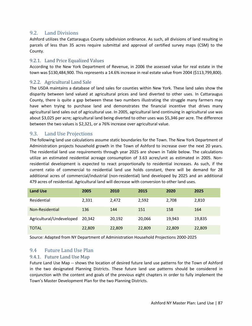
Ashford NY Master Plan: Land Use | 87
9.2. Land Divisions Ashford utilizes the Cattaraugus County subdivision ordinance. As such, all divisions of land resulting in
parcels of less than 35 acres require submittal and approval of certified survey maps (CSM) to the
County.
9.2.1. Land Price Equalized Values According to the New York Department of Revenue, in 2006 the assessed value for real estate in the
town was $130,484,900. This represents a 14.6% increase in real estate value from 2004 ($113,799,800).
9.2.2. Agricultural Land Sale The USDA maintains a database of land sales for counties within New York. These land sales show the
disparity between land valued at agricultural prices and land diverted to other uses. In Cattaraugus
County, there is quite a gap between these two numbers illustrating the struggle many farmers may
have when trying to purchase land and demonstrates the financial incentive that drives many
agricultural land sales out of agricultural use. In 2005, agricultural land continuing in agricultural use was
about $3,025 per acre; agricultural land being diverted to other uses was $5,346 per acre. The difference
between the two values is $2,321, or a 76% increase over agricultural value.
9.3. Land Use Projections The following land use calculations assume static boundaries for the Town. The New York Department of
Administration projects household growth in the Town of Ashford to increase over the next 20 years.
The residential land use requirements through year 2025 are shown in Table below. The calculations
utilize an estimated residential acreage consumption of 3.63 acres/unit as estimated in 2005. Non-
residential development is expected to react proportionally to residential increases. As such, if the
current ratio of commercial to residential land use holds constant, there will be demand for 28
additional acres of commercial/industrial (non-residential) land developed by 2025 and an additional
479 acres of residential. Agricultural land will decrease with conversion to other land uses.
Land Use 2005 2010 2015 2020 2025
Residential 2,331 2,472 2,592 2,708 2,810
Non-Residential 136 144 151 158 164
Agricultural/Undeveloped 20,342 20,192 20,066 19,943 19,835
TOTAL 22,809 22,809 22,809 22,809 22,809
Source: Adapted from NY Department of Administration Household Projections 2000-2025
9.4 Future Land Use Plan 9.4.1. Future Land Use Map Future Land Use Map -- shows the location of desired future land use patterns for the Town of Ashford
in the two designated Planning Districts. These future land use patterns should be considered in
conjunction with the content and goals of the previous eight chapters in order to fully implement the
Town’s Master Development Plan for the two Planning Districts.
Ashford NY Master Plan: Land Use | 88
The Town of Ashford is committed to pursuing a high quality of life for all residents, regardless of age,
race, education or economic situation. Therefore, no single development type or pattern fits perfectly
across the entire Planning District. The future land use maps proposed in this document represent an
emphasis on sustainable development that provides the variety to meet these needs. The future land
use plan and maps do this by incorporating mixed‐use centers, identifying corridors ripe for
redevelopment and infill, and tailoring the growth zone to a size that will both accommodate future land
use needs and meet economic and environmental goals, while remaining fiscally responsible to
taxpayers.
With this Master Development Plan, the Town of Ashford proposes flexibility in new development and
redevelopment that offers the opportunity for innovative planning while reflecting the design of existing
surrounding communities. Providing a mix of land uses and ensuring that those uses are designed for
maximum public benefit are goals that are intertwined. Design means a variety of things – physical
appearance, pedestrian and vehicular traffic flow, appropriate locations for parks and other services,
and the inter‐relationship between different types of uses.
Alternatives to low density suburban development are becoming increasingly popular as more people
and governments look for sustainable alternatives to conventional suburban development. “Smart
Growth” and “New Urbanist” models focus on more efficient use of land and resources, while offering a
choice in transportation and living situation through compact, walkable development. They emphasize
the corner store and neighborhood school, street trees and on‐street parking, and recommend offering
a full range of housing types in every setting from compact development to rural villages. The U.S. Green
Building Council has adopted a new LEED certification for Neighborhood Development (ND). This new
LEED ND certification provides designation for communities which embrace and incorporate these
“Smart Growth” and “New Urbanist” concepts within their design.
Studies show that developments with smaller lot sizes and pedestrian friendly design, located in close
proximity to public services and facilities, provide taxpayer savings through more efficient service
delivery. This occurs because compact development requires reduced linear feet of capital investment
per paying user, thereby reducing the individual contributor’s cost. Another benefit of these
communities, particularly when the mix of uses includes employment and affordable, traditional
neighborhood housing, is that they increase the ability of low and moderate income families to stretch
their limited budgets by using transit for work and other daily activities, reducing the need for the family
vehicle. Smaller homes are less expensive to heat or cool, important to all and critical to those of more
modest incomes as energy prices continue to rise. As the ‘baby boomers’ create a larger population of
older Americans than ever before, a larger supply of smaller, more affordable and convenient housing is
likely to be in demand. Additionally, studies are relating the health benefits that come from a resident’s
ability to walk to nearby amenities as well as reduced air pollution from the decrease in automobile
trips. Finally, mixed use development provides 24‐hour populations near retail and offices and therefore
the “eyes on the street” that make a community safer.
Both the Route 219 Corridor and West Valley Hamlet Planning Districts currently contain important
transportation corridors. A goal of this Master Plan is to create a land use development environment
that will ultimately support transit corridors. Transit corridors and neighborhoods within 1/4 mile of the
corridors are areas where infill and redevelopment should be focused, with an emphasis on a diversity
of housing types, mix of uses, redevelopment of older commercial corridors, concentration of

Ashford NY Master Plan: Land Use | 89
employment opportunities and a high degree of interconnectivity of the street and bicycle/pedestrian
network. The densities found in mixed use development and along transit corridors should reflect those
necessary to support transit service.
Code amendments that encourage development and redevelopment to occur at the necessary densities
to support a more efficient use of transportation systems and reduce single occupancy vehicle travel are
necessary. An appropriate mix of uses will be needed as well as amendments that mandate the higher
level of design needed for mixed use centers and transit corridors to function in an attractive and
efficient way and connect and blend into surrounding communities. Successful development and
redevelopment of these areas will require close coordination among the Town of Ashford, Cattaraugus
County and the State of New York to provide needed infrastructure to support compact development.
Locations for institutions and community services that help to support community building should also
be included in the design of the Planning Districts. By including locations for schools, places of worship,
community halls and other service centers in the design, the Planning Districts will have focal points that
bring neighbors together.
Suburban development will continue to be in demand and a preferred way of living for a large
percentage of the population. This form of development is included in the Route 219 Corridor Planning
District and is denoted as Residential “B” and Residential “C”. Residential “B” is proposed to be located
furthest from the Route 219 transportation corridor. The lower density proposed in Residential “B” - 2
dwelling units/acre - will surround and support the denser mixed‐use centers and should be encouraged
to utilize the latest and most innovative conservation design strategies in their designs. Residential “C” -
4 to 8 dwelling units/acre is proposed to be a higher density of development that is located adjacent to
the Commercial/Mixed Use Development in the Route 219 Corridor Planning District. This intensity of
development is an appropriate transition from the Commercial/Mixed Use Development area. Future
residents in both the Residential “B” and Residential “C” areas will also support commercial
establishments in the Planning District.
Economic development and redevelopment are vital for the future sustainability of the Town of Ashford.
In order for such development to occur, there must be sufficient land available for non‐residential
projects. In both the Route 219 Corridor and West Valley Hamlet Planning Districts considerable land has
been designated as either Commercial or Commercial/Mixed Development. These land areas are
envisioned to permit uses in the Commercial/Recreation land use category that are provided in the
Cattaraugus County Comprehensive Plan. The Commercial/Mixed Development area is envisioned to
permit a residential density of 4-8 dwelling units/acre which is consistent with the Residential “C”
development area. The Commercial/Mixed Use Development would also permit commercial
developments that would permit a more intense level of development that adhered to established
dimensional standards such as open space ratio, minimum site area, maximum building height, and
other required elements.
The West Valley Hamlet Planning District also includes an Industrial development area. The West Valley
Demonstration Project is situated in this development area. The Planning District recognizes this existing
industrial use and expands this area in order to provide opportunities for new industries to locate there.
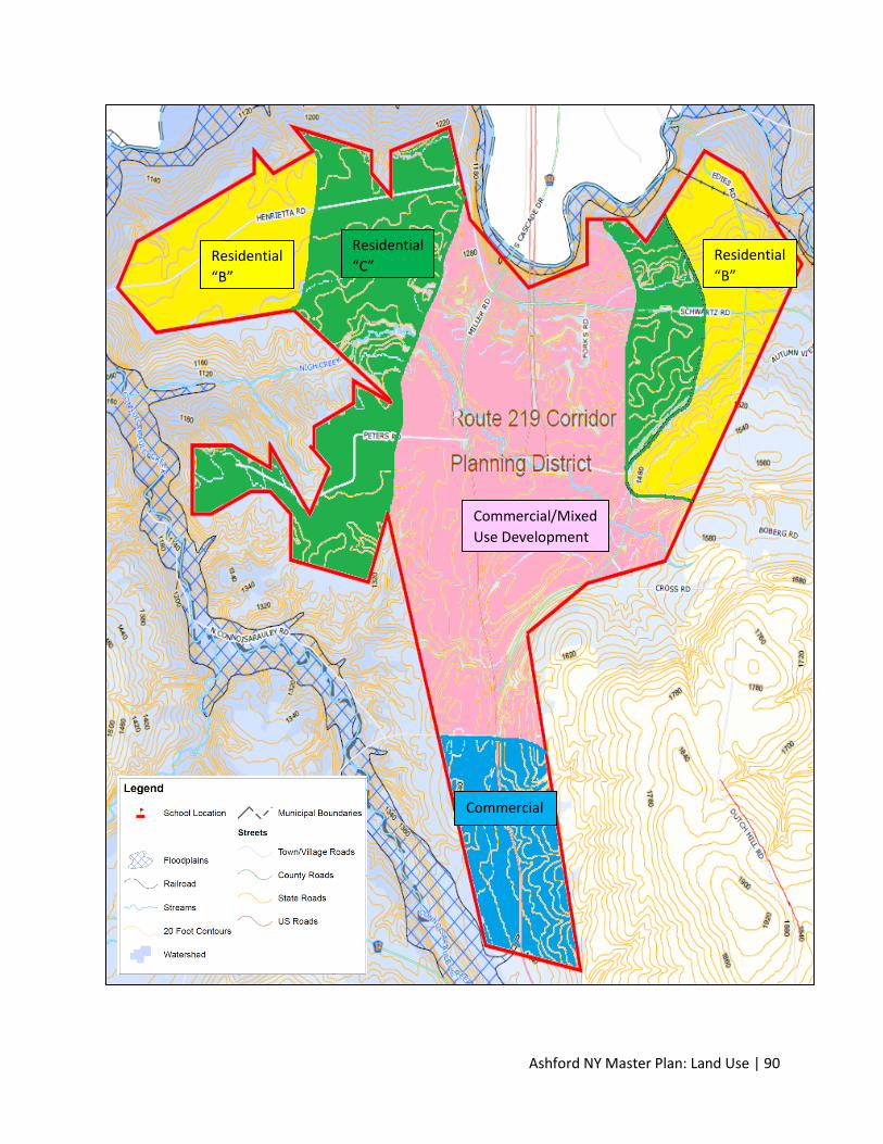
Ashford NY Master Plan: Land Use | 90
Commercial/Mixed
Use Development
Residential
“B” Residential
“B”
Residential
“C”
Commercial
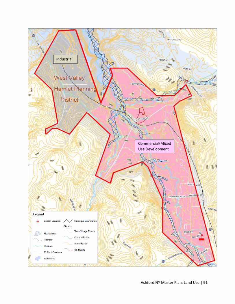
Ashford NY Master Plan: Land Use | 91
Commercial/Mixed
Use Development
Industrial
Ashford NY Master Plan: Land Use | 92
9.4.2. Sewer and Water Utility Plan Both the Route 219 Corridor and West Valley Hamlet Planning Districts are currently not served by
sanitary or storm sewer and the West Valley Hamlet has recently extended potable water supply to
residents and businesses in only the southern part of the Planning District. Water is drawn from
subsurface groundwater aquifers throughout all of the Town of Ashford by individual homeowners,
businesses, industries, and the Town of Ashford. Surface waters could also provide water supply to
consumers in the Planning District.
This Master Plan proposes phased expansion of sanitary sewer service in both Planning Districts and the
provision of water service in the Route 219 Corridor Planning District. Utilities development would best
be undertaken by first constructing sewer collector lines that parallel Route 219 in the Route 219
Planning District and parallel Route 240 in the West Valley Planning District. Development and
redevelopment of land is envisioned to start nearest to sewer collector areas and established road
systems and then proceed out from the collector lines to areas where sewer laterals would be
constructed to feed into collector lines in the Planning Districts. The goal would be to provide sewer
service for the entire land areas in both Planning Districts. Both Planning Districts were drawn to take
advantage of the natural land grade which would permit gravity sewer flows from the laterals to the
collector stem and ultimately to one or more wastewater treatment plants that would be constructed
adjacent to the Connoisarauley Creek.
Under a full build-out in the West Valley Hamlet Planning District, TFG estimates approximately 1,200
acres of developable in the commercial/mixed use development designation. The balance of land in the
Planning District is Industrial zone, including the West Valley Demonstration Project that already has its
own sewer system. Based on these development assumptions and using a density of development of 4-8
dwelling units/acre results in a range of residential units of 4,800 to 9,600 units. This development
pattern would equate to 14,400 to 28,800 new residents to the Planning District based on a unit count
of 3 persons residing in a dwelling unit. These are ambitious estimates that will likely fall short of real
conditions; however, they provide a basis for the Town to plan for sizing wastewater conveyance and
treatment systems.
The Route 219 Corridor Planning District is approximately 4,000 acres of which approximately 3,500
would be available for development (minus environmental constraints). This Planning District has
multiple land use designations which could result in great variability with respect to development unit
counts for estimating sewer capacity needs. The following assumptions are used to derive a residential
unit count that could be expected under a full build-out in the Planning District.
Acreage = 3,500
Dwelling Units/Acre = 4
Occupants/Dwelling Unit = 3
3,500 acres x 4 DUs/Acre x 3 persons/DU = 42,000 persons.
This is considered an ambitious estimate of population growth in this Planning District; however, it
provides a guide to the Town as it plans for providing sewer and water service for this area.
Ashford NY Master Plan: Land Use | 93
Potable water service would align with sewers in the Route 219 Planning Corridor. Locating these
utilities along transportation corridors is critical for the sake of land consumption and fiscal
responsibility to develop and redevelop in the Planning Districts to maximize growth potential in a
compact area. Accommodating more homes and businesses in a smaller geographic area reduces the
size of the area that must be served by infrastructure, thereby increasing cost efficiencies that are
reflected in the cost of living for residents.
9.5. Future Land Use Categories These Future Land Use Categories are used to describe the intent of each district depicted on the Future
Land Use Map. Often, they forecast a zoning district or other implementation tool (such as overlay
district) to implement the Future Land Use Map.
Environmental: The environmental district includes areas where special protection is encouraged
because of unique landscape, topographical features, wildlife, or historical value. They often contain the
best remaining woodlands and wetlands, wildlife habitats, floodlands, groundwater recharge and
discharge areas, and steeply sloped lands in the Town. Environmental areas are only depicted on the
Future Land Use map by symbol designation.
Agricultural: The Ashford Meadows District encompasses 14,767 acres and is located in the towns of
Ashford and Ellicottville. A map of the Ashford Meadows Agricultural District in the Town of Ashford is
included in Element 6. Portions of the Agricultural District are currently within the two designated
Planning Districts for this Master Plan Development. The current land use designations and allowable
uses that have been assigned by Cattaraugus County remain.
Commercial: The commercial district includes uses that include retail or light industrial. Commercial
districts may also include areas of intense commercial development along major routes of
transportation access, such as interchange areas off highways or interstates. Commercial development
in Ashford may include the following types:
o Commercial/Mixed Use Development: Development in this district includes structures
dedicated to the sale of goods or merchandise for personal or household consumption.
Structures include neighborhood stores, or designated shopping districts such as a
downtown area. This district also permits residential development at a density of 4-8
dwelling units/acre. The permitted uses in the Commercial/Mixed Use Development are
consistent with Cattaraugus County uses in the Commercial/Recreational designation.
o Commercial: This district includes manufacturing of goods for consumer sale. In many
cases these uses may be considered “light industrial” in that products are produced for
end users rather than for use by other industries. The permitted uses in the
Commercial/Mixed Use Development are consistent with Cattaraugus County uses in
the Commercial/Recreational designation.
Residential: A residential district includes land uses where the predominant use is housing. In areas that
are zoned residential, building may include single family housing, two- family housing (duplexes,
townhomes) or mobile homes. Zoning for residential use may permit some services or work
opportunities or may totally exclude business and industry. Residential development in Ashford may
include the following types:

Ashford NY Master Plan: Land Use | 94
Residential (RA): This district is generally intended to preserve agricultural lands and provide for
very low-density rural development. Development in this district includes single-family homes
that are detached, free-standing residential structures. The approximate density should be at
least 1 dwelling unit per 5 acres or more. This land use is not included in either Planning District.
Residential (RB): This district includes a variety of housing types including single- family
attached, single-family detached and duplex housing configurations. The preferred density is 2
dwelling units per acre.
Residential (RC): This district includes a variety of housing types including single- family
attached, single-family detached and duplex housing configurations. The preferred density
range is 4 to 8 dwelling units per acre.
9.6. Land Use Goals and Objectives Goal: Promote a land use pattern for the efficient and cost-effective provision of public facilities.
Objectives:
Direct urban development toward existing development areas that have adequate
public facilities, services or soils suitable for urban development.
Encourage patterns of urban development which minimize the cost of providing public
facilities and services.
Discourage the premature development of rural lands to urban uses.
Encourage residential development to be located near existing service centers such as
the West Valley Hamlet and the Route 219 Corridor Planning District.
Goal: Draft the Town of Ashford Zoning Code.
Objectives:
To better provide zoning districts to control for preferred development types.
To expand the number of zoning districts to include more districts for commercial and
residential use.
To implement the Future Land Use Plan.
Goal: Preserve, protect and keep productive agricultural lands.
Objectives:
To preserve for continued agricultural use, land containing the best agricultural soils.
To protect existing farms to the extent possible from the encroachment of non-
agricultural development.
To prevent land use conflicts between rural and urban uses.
To encourage large, contiguous tracts of agricultural land uninterrupted by conflicting,
non-agricultural land uses.
Ashford NY Master Plan: Land Use | 95
To maintain the rural character of the Town.
To refine and redevelop land use controls to ensure preservation of designated
agricultural lands.
Goal: Conserve and protect the significant environmental, scenic, cultural and historical resources of the
Town.
Objectives:
To ensure that rural and urban land uses are located, developed and managed to
minimize harmful impacts on the Town’s natural resources.
To encourage the preservation of open spaces and scenic areas, which contribute to the
rural character and quality of life in the Town.
To encourage the conservation of areas that are of natural resource, open space, scenic,
historical and archeological significance.
To encourage buffer areas adjacent to designated critical and significant areas to be
preserved.
9.7. Land Use Recommendations Cluster developments in a manner to preserve water quality, working farms, un-fragmented
wildlife corridors, and woodlands.
Attempt to “hide” development from roads to the extent possible through natural topography
and vegetation (e.g. tree lines, wooded edges, and setbacks).
Limit a more intense residential development to those areas that can best be accommodated by
public services (like near West Valley Hamlet and the Route 219 Corridor Planning District),
thereby minimizing cost.
Draft the Town of Ashford Zoning Ordinance to identify and define zoning districts. Include
multiple agricultural, public, residential, commercial and industrial districts as described in this
plan.
Ensure land use decisions are consistent and follow the prescribed course as defined within this
plan. Major changes in the pattern of development should include an update of this plan
through official action.
Prohibit development on slopes greater than 20%.
Participate in local, regional, state and federal land protection programs.
Encourage Planning Board members to attend training workshops when available.
Work to develop land use patterns and site designs that preserve scenic vistas, woodlands,
farmland, and wildlife habitat.

Ashford NY Master Plan: Implementation | 96
Element 10: Implementation The implementation of the Town of Ashford Master Plan involves decision-making by both public
officials and the citizens of the community. These decisions will be measured by the concern for the
welfare of the general community; the willingness to make substantial investments for improvement
within the community, and the realization that certain procedures must be followed and adhered to for
the continued high quality environment found within the Town. Suggested implementation measures
include:
The implementation and enforcement of regulatory ordinances and non-regulatory activities
based on the goals and objectives identified in the Master Plan.
The development of programs and support systems that further the goals and objectives set
forth by the Town in this plan.
The establishment and support of a continued planning process providing for periodic review
and updates to the plan and land use control measures.
The support of committees and local organizations to carry out specific community
improvements as identified in the comprehensive plan.
10.1. Summary of Key Planning Issues and Opportunities The following list summarizes some of the key issues identified through public involvement activities.
Issues also reflect observed liabilities and comments made through the planning development process.
Development Controls: Several implementation tools, programs, and ordinances are available to help
Ashford control for future development and preservation activities. The utilization of Building Site
Regulations as identified in this element is a key component to implementing this plan.
Preserve Agricultural Lands and Economic Production: In order to maintain Ashford’s rural integrity and
sustain highly productive agricultural lands in food and fiber production, encroachment of non-
agricultural development should be limited.
Environmental Protection: Preservation of environmental features was a primary concern during the
public participation process.
Better Intergovernmental Relationships and Planning: One of the key issues raised in each of the public
meetings is improving cooperation between the communities, especially between Cattaraugus County
and the Town of Ashford.
Balancing public interest and private property rights: The need to balance public interest and private
property rights is a goal stated within the state’s comprehensive planning legislation. Land use decisions
should consider equitable and defensible growth management strategies.
10.2. Implementation Tools Implementation Tools include the rules, policies, and ordinances used to facilitate or control for a
desired outcome. Examples include zoning ordinances and official maps, or the availability of certain
incentives. This section includes regulatory and non-regulatory measures.
Ashford NY Master Plan: Implementation | 97
10.3. Regulatory Measures The following regulatory measures can be used to guide development and implement the
recommendations of a Master Development Plan. The Town Board officially adopts these regulatory and
land use control measures as ordinances (or as revisions to the existing ordinances). For the purposes of
this document, “regulatory measures” are those that must be adhered to by everyone if adopted.
10.3.1. Zoning Ordinance Zoning is used to guide and control the use of land and structures on land. In addition, zoning
establishes detailed regulations concerning the areas of lots that may be developed, including setbacks
and separation for structures, the density of the development, and the height and bulk of building and
other structures. The general purpose for zoning is to avoid undesirable side effects of development by
segregating incompatible uses and by maintaining adequate standards for individual uses.
The establishment of zoning districts is generally conducted after careful consideration of the
development patterns indicated in the Master Development Plan. Creating zoning district boundaries
has the overall effect of changing the plan (unless amendments correspond to changes within the plan);
therefore, it is reasonable to assume that indiscriminate changes may result in weakening of the plan.
Action: The new zoning ordinance should include districts devoted to agricultural, conservation,
commercial, industrial and residential uses. In particular, this Master Plan describes the orderly
development of more intense residential and commercial/industrial uses in two designated Planning
Districts. The new zoning ordinance should create unique zoning districts in these Planning Districts such
as is described in Element 9.
Additional residential districts outside of the two Planning Districts should establish density and
intensity of use standards. The Town Board should expand agricultural zoning district classifications to
accommodate small farm operations (less than 35 acres) and specialty or niche crop production, like co-
ops or community supported agriculture (CSA) and to protect the integrity of Exclusive Agricultural
lands. There should also be distinct commercial areas that identify the intent and intensity of this
district. The update should also include sign regulations and a list of conditional uses by district (may
include discussions on kennels, skeet shooting, etc.).
10.3.2. Maps An official map shows the location of areas which the municipality has identified as necessary for future
public streets, recreation areas, and other public grounds. By showing the area on the Official Map, the
municipality puts the property owner on notice that the property has been reserved for a future public
facility or purpose.
There are no immediate plans for the Town to draft an official map. However, should local officials want
to forecast future improvements by their location, an official map should be drafted.
Action: Adopt an official map at which time changes in the rate of development require increased long-
term infrastructure planning.
10.3.3. Sign Regulations Local governments may adopt regulations, such as sign ordinances, to limit the height and other
dimensional characteristics of advertising and identification signs. The purpose of these regulations is to

Ashford NY Master Plan: Implementation | 98
promote the well-being of the community by establishing standards that assure the provision of signs
adequate to meet essential communication needs while safeguarding the rights of the people in the
community to a safe, healthful and attractive environment.
Ashford does currently have a local sign regulation which is 20 years old. The County currently controls
signage in areas controlled through its Zoning Ordinance.
Action: Monitor community desire for signage standards as determined through complaints or requests.
Consider including sign regulations in a zoning code update
10.3.4. Erosion/Stormwater Control Ordinance The purpose of stormwater or erosion control ordinances is to set forth stormwater requirements and
criteria which will prevent and control water pollution, diminish the threats to public health, safety,
welfare, and aquatic life due to runoff of stormwater from development or redevelopment. Adoption of
local ordinances for stormwater does not preempt more stringent stormwater management
requirements that may be imposed by National Pollution Discharge Elimination System (NPDES)
Stormwater Permits issued by the Department of Environmental Conservation, or the Sanitary Code of
the Cattaraugus County Health District.
The Town of Ashford does not have a local erosion or stormwater control ordinance. However, the
Cattaraugus County Sanitary Code of the Cattaraugus County Health District is in effect countywide
where local regulations do not exist.
Action: Continue to utilize the existing county ordinance until such time that more stringent
requirements are preferred to control for increased stormwater pressures brought about by new
development.
10.3.5. Overlay Districts An overlay district is an additional zoning requirement that is placed on a geographic area but does not
change the underlying zoning. Overlay districts have been used to impose development restrictions or
special considerations on new development. For the Town, these may include special requirements for
commercial buildings along highway corridors or regulations to preserve “viewsheds”. No current
overlays exist within the town.
Action: Consider the creation of a groundwater overlay protection district to preserve the existing
groundwater resources. The overlay district may be expanded to include other environmentally sensitive
areas, or viewshed corridors could be identified along major transportation routes.
10.3.6. Building/Housing Codes The New York State Office of Planning and Development administers the Building Standards and Codes.
The Code is primarily enforced by municipal or county building inspectors who must be state-certified.
Action: Continue to require that builders follow state building codes for all structures built within the
jurisdiction.
Ashford NY Master Plan: Implementation | 99
10.3.7. Sanitary Codes The Cattaraugus County Department of Health provides local regulation for communities that do not
have municipal sanitary service. The County has adopted rules for the proper siting, design, installation,
inspection and management of private sewage systems and non-plumbing sanitation systems.
Developments utilizing private sewage systems are required to obtain a permit and abide by regulations
set forth in the Cattaraugus County Utilities Ordinance.
Action: Continue to work with Cattaraugus County for the issuance of permits and enforcement of
established regulations.
10.3.8. Subdivision Ordinance Subdivision regulations serve an important function by ensuring the orderly growth and development of
unplatted and undeveloped land. These regulations are intended to protect the community and
occupants of the proposed subdivision by setting forth reasonable regulations for public utilities, storm
water drainage, lot sizes, street design, open space, and other improvements necessary to ensure that
new development will be an asset to the Town.
Development in the Town of Ashford is currently required to follow the Cattaraugus County Subdivision
Ordinance. The ordinance contains separate certified survey map procedures, map submission
requirements, and design standards for new development.
Actions: Continue to utilize the county ordinance until which time local officials would like to enforce
increased local standards.
10.3.9. Building Site Ordinance Building site ordinances detail minimum regulations, provisions and requirements for development. The
purpose of building site ordinances is to ensure development occurs consistent with municipal values.
Building site ordinances also protect public health, safety and welfare; help to preserve the rural
character of the Town; and, sustain property values and the property tax base. Building Site Regulations
in the Town of Ashford are necessary to enable adherence to the Towns Master Development Plan.
Action: Develop a Building Site Ordinance that prohibits non-farm structural development on
agricultural designated land as identified on the Future Land Use Map. Include standards for site
development and site review (maps, survey reports, etc.). Consider adding features the community has
requested, such as structural development standards which curtail the placement of buildings in the
middle of open fields.
10.4. Non-Regulatory Measures The following non-regulatory measures can be used to guide development and implement the
recommendations of a comprehensive plan. These measures often exist as policies or as special
incentives available to willing participants. For the purposes of this document, “non-regulatory
measures” are meant to encourage a particular practice, but not legislate it.
10.4.1. Capital Improvement Plan This is an ongoing financial planning program intended to help implement planning proposals. The
program allows local communities to plan for capital expenditures and minimize unplanned expenses.
Ashford NY Master Plan: Implementation | 100
Capital improvements or expenditures are those projects that require the expenditure of public funds
for the acquisition or construction of a needed physical facility.
Capital improvement programming is a listing of proposed projects according to a schedule of priorities
over a short time period. It identifies needed public improvements, estimates their costs, discusses
means of financing them, and establishes priorities over a three-to-five year programming period.
Improvements or acquisitions considered a capital improvement include:
Public buildings (i.e. – fire and police stations)
Park acquisition and development
Roads and highways
Utility construction and wastewater treatment plants
Joint school and other community development projects
Fire and police protection equipment
A capital improvement plan (CIP) or program is a method of financial planning for these types of
improvements and scheduling the expenditures over a period of several years in order to maximize the
use of public funds. Each year the capital improvement program should be extended one year to
compensate for the previous year that was completed.
This keeps the improvement program current and can be modified to the community’s changing needs.
Preparation of a Capital Improvement Program: The preparation of a Capital Improvement Program is
normally the joint responsibility between the community administrator or plan commission, various
staff, governing body, and citizen commissions. The preparation of a capital improvement program may
vary from community to community depending on local preferences, the local form of government and
available staff. In communities that have a community development plan or comprehensive plan, a
planning agency review of the proposed capital improvement program is desirable.
The Town has not implemented a Capital Improvement Plan.
Action: Utilize an annual system of funding allocation, such as capital improvement plan, to ensure
adequate funding and programming for needed upgrades and repair of related capital improvements.
10.5. Consistency Among Plan Elements / 20-Year Vision The adoption of a comprehensive plan under the current State zoning enabling provisions is voluntary. If
a city, town or village chooses to utilize the process, the resulting plan may range from a set of policy or
vision statements to a very lengthy document composed of many subject-specific component plans
(e.g., components relating to transportation, natural resources, historic resources, or population
statistics). Once an actual plan is adopted, however, all land use regulations must be in accordance with
it. This usually means (though it is not mandated) that plan adoption is followed by the adoption of a
series of zoning laws designed to “implement” the comprehensive plan. For the Town of Ashford, then,
the statutory requirement that zoning be “in accordance with a comprehensive or well-considered plan
refers to the comprehensive plan pursuant to Town Law, §272-a, or Village Law, §7-722.
Ashford NY Master Plan: Implementation | 101
This Master Development Plan references previous planning efforts, and details future planning needs.
To keep consistency with the Master Development Plan, the Town should incorporate existing plans as
components to the Master Development Plan, and adopt all future plans as detailed elements of this
Plan.
Ashford will continue to make educated decisions based upon available information and public input.
Planning will revolve around the 20-Year Planning Vision (below) and decisions will incorporate a
comprehensive look at all elements to determine appropriate cohesiveness of the decision against
stated visions.
20-Year Vision: Preserve the agricultural and natural heritage of the area for future generations.
Maintain the natural heritage and unique topographic and geologic features throughout the town while
allowing targeted planned growth to occur in designated growth areas.
10.6. Plan Adoption, Monitoring, Amendments and Updates 10.6.1. Plan Adoption In order to implement this plan, it must be adopted by the Town Planning Board. After the Board adopts
the plan by resolution, the Town Board must adopt the plan by ordinance. This action formalizes the
plan document as a frame of reference for general development decisions over the next 20 years. Once
formally adopted, the plan becomes a tool for communicating the community’s land use policy and for
coordinating legislative decisions.
10.6.2. Plan Use and Evaluation The Town of Ashford will base all of its land use decisions against this plan’s goals, objectives, policies,
and recommendations including decisions on private development proposals, public investments,
regulations, incentives, and other actions.
Although this plan has described policies and actions for future implementation, it is impossible to
predict the exact future condition of the Town. As such, the goals, objectives, and actions should be
monitored on a regular basis to maintain concurrence with changing conditions.
The plan should be evaluated at least every 5 years, and updated at least every 10 years. Members of
the Town Board, Planning Board, and any other decision-making body should periodically review the
plan and identify areas that might need to be updated. The evaluation should consist of reviewing
actions taken to implement the plan’s vision, its goals and objectives. The evaluation should also include
an update of the 5-Year Action Plan located within this element.
10.6.3. Plan Amendments The Town of Ashford Master Development Plan may be amended at any time by the Town Board
following the same process to amend the plan as it originally followed when it was initially adopted
regardless of how minor the amendment or change is.
Amendments may be appropriate throughout the lifecycle of the plan, particularly if new issues emerge
or trends change. These amendments will typically be minor changes to the plan’s maps or text. Large-
scale changes or frequent amendments to meet individual development proposals should be avoided or
the plan loses integrity. Any proposed amendments shall be submitted to the Planning Board for their
review and recommendations prior to consideration by the Town Board for final action.
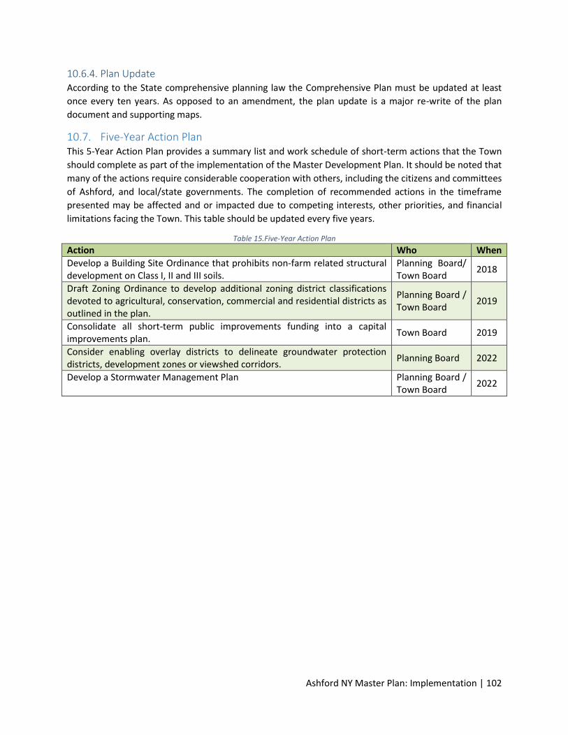
Ashford NY Master Plan: Implementation | 102
10.6.4. Plan Update According to the State comprehensive planning law the Comprehensive Plan must be updated at least
once every ten years. As opposed to an amendment, the plan update is a major re-write of the plan
document and supporting maps.
10.7. Five-Year Action Plan This 5-Year Action Plan provides a summary list and work schedule of short-term actions that the Town
should complete as part of the implementation of the Master Development Plan. It should be noted that
many of the actions require considerable cooperation with others, including the citizens and committees
of Ashford, and local/state governments. The completion of recommended actions in the timeframe
presented may be affected and or impacted due to competing interests, other priorities, and financial
limitations facing the Town. This table should be updated every five years.
Table 15.Five-Year Action Plan
Action Who When
Develop a Building Site Ordinance that prohibits non-farm related structural development on Class I, II and III soils.
Planning Board/ Town Board
2018
Draft Zoning Ordinance to develop additional zoning district classifications devoted to agricultural, conservation, commercial and residential districts as outlined in the plan.
Planning Board / Town Board
2019
Consolidate all short-term public improvements funding into a capital improvements plan.
Town Board 2019
Consider enabling overlay districts to delineate groundwater protection districts, development zones or viewshed corridors.
Planning Board 2022
Develop a Stormwater Management Plan Planning Board / Town Board
2022

![2014 LCMS D 7 na˚MARRS [14-RQ-3151-S] · Baltimore MD Charles Town WV Prattsville NY Easton PA Ashford CT Ashland VA Gordonsville VA Zionsville PA Lutherville MD Westminster MD Fredericksburg](https://img.pdfslide.net/doc/110x75/5f9a95b56c64cc29db7deeb9/2014-lcms-d-7-namarrs-14-rq-3151-s-baltimore-md-charles-town-wv-prattsville.jpg)