Embed Size (px)
Citation preview
Town of Plymouth Comprehensive Plan Draft August, 2016 1
Town of Plymouth
Comprehensive Plan
Draft
Prepared by
Presented: August 11, 2016
Edited: August 18, 2016
Jeff Whalen, [email protected]
Emery Younger, [email protected]
(207) 942-6389
Town of Plymouth Comprehensive Plan Draft August, 2016 2
Comprehensive Plan Committee Joan Burke Jerry Dunivan Arrin Farrar Lorraine Farrar Mike Grass Sr. Geraldine Richardson Wade Richardson Michael Seavey Linda Seavey Norm Viger
Town Officials Selectman:
Adam Temple Mike Grass
Linda Seavey
Town Clerk: Rebecca Gray Treasurer: Geizette Witherly
Town of Plymouth Comprehensive Plan Draft August, 2016 3
Table of Contents
Vision………………………………………………………………….….4
Historical and Archaeological Resources…………………………………5
Agriculture and Forestry Resources……………………………...……....11
Economic Development…………………………………………….……15
Fiscal Capacity ……………………………………...………….….…….20
Natural Resources……………………………………………….………..24
Outdoor Recreation……………………………………………….………38
Transportation……………………………………………………….……43
Water Resources……………………………………………………….….48
Public Facilities ……………………………………………………….….55
Housing …………………………………………………………….……..61
Land Use.…………………………………………………………….……66
Future Land Use.………………………………………………….….……71
Public Participation………………………………………………….…….72
Regional Coordination……………………………………………….……73
Town of Plymouth Comprehensive Plan Draft August, 2016 4
Vision
Having a vision for the town of Plymouth means looking forward and making plans for
the future. This vision needs to be put on paper, so that our goals for Plymouth can be
assessed by our community and then put into action and addressed.
The completion of the comprehensive plan gives the town the opportunity to work
towards future plans for our community that can benefit all ages. It will assist us in
preserving the character of this small bedroom community, and in keeping our natural
resources clean and available for future generations.
Our principal goals are to have a new town office and fire station built in the next 3 to 4
years. The building that is now housing the town office and post office can be restored to
its original as 4 room school house and can be used as a historical society to help
preserve the history of Plymouth. A newly created historical society would offer a safe
place to store the town’s pictures and other memorabilia for posterity. We believe that it’s
important to be able to look back toward our past, in order to see how to go forward into
the future.
Plymouth Pond is one of our town’s favorite spots for fishing, swimming, kayaking, and
enjoying the view. Ice fishing and ice sailing are also popular pass-times. We need to
recognize the local importance of Plymouth Pond and work to conserve its beauty and the
habitat for our fish and wildlife, as well as maintain the public access for sporting and
leisure activities.
We envision a recreation department that has more equipment for the playground, and
community involvement and activities for the children and the adults. In addition, we
would like to expand our walking path and encourage outdoor activities and exercise for
all the residents. We believe this would attract new residents to the area and increase the
community’s quality of life.
The vision includes encouraging investment in senior housing for our elderly citizens, so
that they may stay in Plymouth and be near family and familiar surroundings, and
continue to participate in a vibrant community life.
Encouraging farmers and forestry industries to have a positive effect on the land is an
important goal for the future as well.
The Comprehensive Plan Committee believes that the proposed plan for the Town of Plymouth should be exempt from identifying growth areas in its Future Land Use Plan based on the Criteria for Growth Area Exemptions based on minimal or no growth. (1) Residential The population of Plymouth was 1343 in 2007 and the current population is 1388. This is an increase of only 3.3% which is well below the threshold of 5% listed
Town of Plymouth Comprehensive Plan Draft August, 2016 5
in the criteria. Since 2007, Plymouth has had 27 new housing starts. Again, this is well below the criteria threshold of 50. (2) Commercial/ Institutional No change in the last ten years. (3) Industrial No change in the last ten years. Historic & Archaeological Resources
Findings and Conclusions
• Plymouth does not have an organized list of historic and archeological sites and
buildings, or a historical committee at this time.
• There is no public location to safely store and exhibit artifacts
• Need exists to encourage residents and others connected with the community’s
history to share what they have
• Funding is needed to preserve sites on National Historic Register and repair and
or maintain other historical sites in town.
Historical Overview
• Town was incorporated by vote of Maine legislature on February 21, 1826.
• There are still buildings that exist from the early settlers, also cemeteries with
burials from the Civil War, Mexican War, and War of 1812 that need to be
restored.
A Brief Outline of Plymouth’s History :
Key events of the history of the town are summarized in the paragraphs that follow. This
history was generously written and provided by the late Wade Richardson and Leon
Hopkins. Plymouth was incorporated, by vote of the Maine legislature, on February 21,
1826. This action occurred only six years after Maine had gained statehood. The town
was created in the southwestern corner of Penobscot County with the western town line
abutting Somerset County and approximately one half of the southern town line abutting
Waldo County. The remaining town lines abut only Penobscot County towns.
In the early 1800’s, the area that became Plymouth was heavily forested with excellent
timber and a good water supply. This drew the attention of lumbermen from surrounding
areas as well as from New Hampshire and Massachusetts. They believed the lumber and
water power would someday make the area a manufacturing center.
Reportedly, the first settler was a Mr. Martin who built a home, near the stream, on a lot
that later became known as Moses Holt pasture. He chose this location as he thought
when a road was built it would follow the stream. The stream, which is the outlet of
Plymouth Pond, was later named Martin Stream.
Town of Plymouth Comprehensive Plan Draft August, 2016 6
In 1805, Josiah Hopkins, of Mayflower stock, moved from Unity with a family of eight
children and bought the mill property on which a sawmill was in operation at the time. At
about the same time, Adoniram Houston came and built a home at the foot of Barbaric
Hill.
By 1812, the following families had settled here: Amos Chandler, William, and Ichabod
Allen, Daniel Holbrook, William Phips, John F. Palmer, and Jacob Brooks.
A large part of the area land was owned by a Dr. Dix of Boston, a philanthropist, for
whom the Dixmont Hills were named. Colonel Samuel Butman, a Captain in active
service in the war of 1812, and later Colonel of an infantry regiment, was Dr. Dix’s land
agent.
Butman was a member of the convention that framed the Constitution for the State of
Maine in 1820 and was also the first president of the Maine State Agricultural Society. In
the Mid 1820’s he served as a representative to the Maine Legislature, and in the 1830’s
he served as a representative to the United States Congress in Washington D.C. and
supposedly traveled from Dixmont Corner to Washington by stagecoach. Later, in 1851,
he was president of the Maine Senate. Prior to 1820, Mr. Butman built a home in
Plymouth village. The building was unique in the sense that it was lined with bricks
between the framework studding. The bricks were made at a brickyard at the rear of his
property. For many years, during the 1900’s, the home was owned by Mr. & Mrs. J.R.
Longley. In the mid 1980’s the home was destroyed by fire while owned by the Robert
Tenny family.
In creating the town of Plymouth, approximately, half of its land area was taken from
Etna on the east and Chandlerville (later became Detroit) on the west. The records do not
show how the Somerset and Penobscot county line was established, which in turn became
Plymouth’s western boundary.
In 1821, Mr. Parker Eaton, great grandfather of Mrs. Elsie Clark and great, great
grandfather of Mrs. Ruth Clark Bickford, settled here with his family of eight children. In
1824, while still a part of Etna, Mr. Eaton designed and built the floating bridge which
evolved into what is now called the long bridge on Route 7. It must have been quite a
task in its day.
Being an inland area, population growth was quite slow and it was nearly 20 years before
there were enough inhabitants to petition the Maine Legislature for the formation of a
town. In the winter of 1825-1826 the petition for the creation of a municipality was
forwarded to the Legislature which approved the incorporation of Plymouth on February
21, 1826.
In 1830, the first census taken after incorporation showed the population to be 504
residents. The ensuing censuses revealed the growth, decline, and regrowth pattern of the
town.
Town of Plymouth Comprehensive Plan Draft August, 2016 7
From the time of incorporation in 1826, Plymouth showed a steady and continued growth
for the next 30 years. From 1860, the population started a downward trend, reaching its
lowest level in 1940 when census figures showed 462 residents.
Nationally Significant Historical Structures:
Based on preliminary survey data, the following properties may be eligible for listing in the
National Register of Historic Places:
Plymouth Grange, Rt. 7
Farmstead, 2035 Moosehead Trail
Plymouth Town Office (School House)
Archeological Resources:
Archaeological resources are physical remains of the past, most commonly buried in the
ground or very difficult to see on the surface. Archaeological sites are defined as
prehistoric or historic. Prehistoric sites are those areas where remains are found that were
deposited thousands of years before written records began in the United States. These
sites are the only source of information about prehistory. More recent archaeological
sites, historic, are those sites which occurred after written records began. In Maine,
archaeological sites are most commonly found within 25 yards of an existing or former
shoreline and early roads.
There are no sites that are currently known in Plymouth. No professional prehistoric
archaeological survey has been done in the township.
Archaeological survey is needed around Round Pond and Plymouth Pond, a short stretch
of the East Branch, Martin Stream, and the wetlands and streams associated with the
esker near Martin Stream.
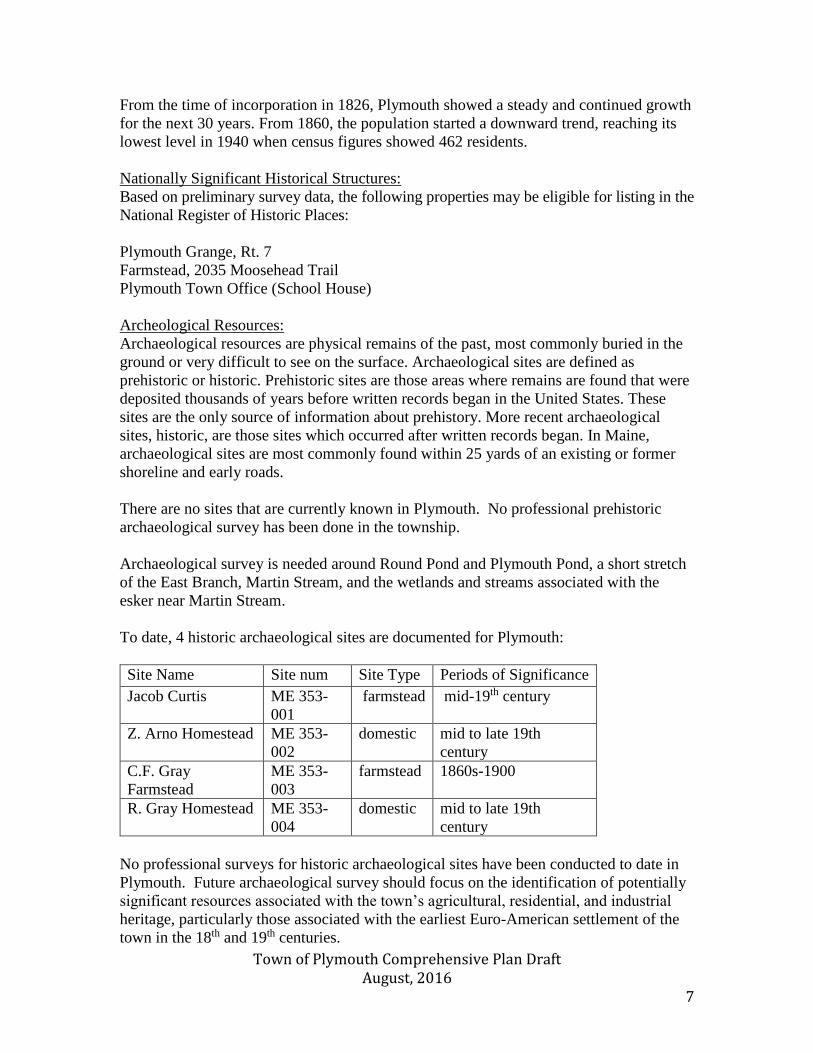
To date, 4 historic archaeological sites are documented for Plymouth:
Site Name Site num Site Type Periods of Significance
Jacob Curtis ME 353-
001
farmstead mid-19th century
Z. Arno Homestead ME 353-
002
domestic mid to late 19th
century
C.F. Gray
Farmstead
ME 353-
003
farmstead 1860s-1900
R. Gray Homestead ME 353-
004
domestic mid to late 19th
century
No professional surveys for historic archaeological sites have been conducted to date in
Plymouth. Future archaeological survey should focus on the identification of potentially
significant resources associated with the town’s agricultural, residential, and industrial
heritage, particularly those associated with the earliest Euro-American settlement of the
town in the 18th and 19th centuries.

Town of Plymouth Comprehensive Plan Draft August, 2016 8
Protection of Historical and Archeological Resources
Plymouth has enacted minimal local land use standards for the protection of
archaeological and historic resources in subdivision regulations. There are additional
standards contained in the Shoreland Zoning and Floodplain Management Ordinances.
There are no provisions for the protection of archaeological and historic resources other
than for land/structures to be subdivided or within shore land areas.
Town of Plymouth Comprehensive Plan Draft August, 2016 9
Town of Plymouth Comprehensive Plan Draft August, 2016 10
State of Maine Goals:
To preserve the State’s historic and archaeological resources.
Identify and maintain
the values of those
structures, sites and
areas that possess
architectural
characteristics of
historical importance
and/or possess
historical significance.
Form a Historical
Committee
Selectmen
Short term
Funding is needed to
preserve sites on the
National Historic
Register and repair or
maintain other historic
sites in town.
To use the Town office
building as a Historical
Site and restore the
building back to the
four (4) room school
house.
Selectmen to form a
committee
Short term
Policies to Address
Maine State Goals
Actions and Strategies
to address Maine state
goals
Responsibility Timeframe
Protect to the greatest
extent possible the
significant historical
and archaeological
resources in the
community
Identify and inventory
buildings and sites of
historic and or
archeological
significance.
Protect the historic
sites and archeological
resources in the
community. There is
no public location to
safely store and
exhibit artifacts.
To send out a town
newsletter to sign up
volunteers to form a
Historical Society
Historical Committee Ongoing
Renovate the town
office back to the four
(4) room school house
and use the building for
all historical papers,
photos and artifacts.
Historical Committee
Long term
Town of Plymouth Comprehensive Plan Draft August, 2016 11
Agriculture and Forest Resources
Findings and Conclusions
-Forestry and agriculture are historic industries, which have begun to make a resurgence
within Plymouth
-The existence of forest and farm land has a positive effect on community life and
property values
Introduction
Both agricultural and forestry industries have been a constant part of Plymouth’s
economy since the town’s founding. In recent years, these two land-based economic
sectors have faced challenges from a changing economy. Despite these adversities,
agriculture and forestry continue to be present and evolving within the Plymouth
community.
Agricultural Resources
In 2012, Penobscot County had 677 farms, a decrease from 706 farms in 2007. The
average farm size was 167 acres, which is an increase from the 2007 size of 162 acres.
This increase has been prompted by a rise in the number of farms with between 50 and
180 acres. This has been paralleled by a decrease in the number of larger farms above
200 acres, as well a slight decrease in the amount, of farms below 10 acres.
Over the past few decades, the agricultural industry within Plymouth has steadily
declined. Farms that once lined Moosehead Trail and Clark Rd, have since been replaced
by gravel pits. Other farms have simply been abandoned due to the difficult lifestyle that
the occupation is accompanied by. In the past five years, however, small scale agriculture
has made a slight recovery. Recently, more residents have been turning to small scale
agriculture, in order to provide food for their household. This has included residents
purchasing a few chickens or cows, as well as the expansion of home gardens.
Additionally, a small scale farm has begun operating which supplies the community with
grass-fed beef, while another resident along Moosehead Trail now offers locally sourced
apples to the community. The community has numerous parcels of land that are classified
as farmland of statewide importance. Much of this fertile land is centered along the Etna
and Rutland Roads.
Since 2009, the number of residents identifying agriculture, forestry, fishing or hunting as
their primary occupation has risen from 6 to 15. This increase is likely to be concentrated
in farms that are larger 10 acres. The existence of farms within a community not only
produces agriculture-related employment, it also increases the community’s property tax
values. According to, the Trust for Public Land, properties adjacent to open land are
valued between 5 and 35 percent higher than similar properties which border other types
of land users.
Town of Plymouth Comprehensive Plan Draft August, 2016 12
In 2016, there were only two parcels that were registered under the Maine State Farmland
Tax Program. One parcel was comprised of 70 acres of land, while the second parcel is
made up of 45 acres. In order to qualify, for the Farmland Tax Program land parcels must
exceed five acres, and also generate at least $2,000 annually from the sale of agricultural
products.
Town of Plymouth Comprehensive Plan Draft August, 2016 13
Forest Resources
The Town of Plymouth has a long history of logging and forestry. Throughout the 19th
and early 20th century the community was populated by many loggers who were a large
supplier of wood products to area paper mills. Today far fewer wood-based jobs exist
within Plymouth, however substantial land is still owned for the purpose of, forestry.
Two local families have been active in the logging industry for decades, and their work
has ensured the industry’s continuity.
The existence of woodlands within the community offers more than just an economic
driver. Forested areas serve as a valuable habitat for wildlife, while also offering
recreational opportunities. Additionally, woodlands protect both the quality of water and
a community’s rural feel.
Over the past 20 years, the number of acres harvested by the timber industry has
fluctuated dramatically. Between 1995 and 2000, the annual total of acres harvested in
Plymouth ranged from 1,010 to 233. From 2005 to 2010, the total of acres was between
561 and 112 acres. This decrease in logging is indicative of the regional economic trends
which have affected much of central and northern Maine. Since 2000, Maine’s paper
manufacturing industry has lost roughly half of the 13,000 individuals it once employed.
In 2015, 44 parcels in Plymouth were enrolled in the Maine Tree Growth Tax Program.
This program provides tax valuation incentives for landowners who own acreage which is
used for the commercial harvesting of forest products. Plymouth has seen a steady
increase in the number of parcels that have enrolled in the program over the past five
years. Currently, 5,158 acres of land within Plymouth are enrolled in the Tree Growth
Program. This is roughly 25% of the community’s total land, and includes both soft and
hard woods.

Town of Plymouth Comprehensive Plan Draft August, 2016 14
Goals, Policies, Action Strategies, and Implementation
Introduction
Agriculture and forestry continue to provide an important source of income and character
to the town of Plymouth. The creation of policies that allow these resources to be
preserved and these industries to thrive are important to the community’s future.
State of Maine Goal that Plan needs to address
To safeguard the State’s agricultural and forest resources from forms of development that
has the potential to threaten those resources
Policies necessary to
address State of Maine
goals
Action strategies necessary to
address State of Maine goals
Responsible
Party
Time Frame
Safeguard lands identified
as prime farmland or
capable of supporting
commercial forestry
Support farming and
forestry and encourage their
economic viability
Consult with the Maine Forest
Service, as well as Tree Growth
Program members, if land use
regulations pertaining to forest
management practices are
considered
Consult with Soil and Water
Conservation District staff if
ever any land use pertaining to
agriculture are considered
Encourage owners of productive
forest and farm land to enroll in
state tax programs
Add provisions in ordinances
that accommodate the needs of
emerging small scale
agriculture, such as roadside
stands, greenhouses, farmer’s
markets, and pick-your-own
operations.
Planning Board
Planning Board
Selectmen/
Assessors
Planning Board
As Needed
As Needed
Ongoing
Ongoing
Town of Plymouth Comprehensive Plan Draft August, 2016 15
Economic Development
Findings and Conclusions
-Plymouth is a bedroom community that sends the majority of its residents to workplaces
in Belfast, Bangor, Waterville, and other surrounding communities.
-Most of the community’s employers are small scale, and employ fewer than five
individuals.
Regional Economy
Plymouth’s location is equidistant between the urban areas of Waterville and
Bangor/Brewer. This location allows residents to access two of the largest communities
in the State. Additionally, Plymouth’s close proximity to Newport/Palmyra allows it to
take advantage to the many stores and businesses located in those two communities. As
Plymouth is within commuting distance of Bangor, the community is able to access the
wealth of employees that exist within Bangor and Brewer. As the largest city in northern
Maine, Bangor is a regional hub for government services and private companies. In total,
Bangor is home to 3,302 companies. The main economic sectors within Bangor include
health services, technical support, transportation, education, and retail. Despite being far
smaller than Bangor, Waterville contains 1,226 companies. Waterville’s economy is
dominated by the health services, education, retail, tourism, finance, and technical
services sectors. Additionally, many residents of Plymouth have been able to find
employment in Belfast, which is roughly one hour south of Plymouth. Belfast is home to
companies such as Bank of America and Athena health, which together employ roughly
1,600 people in the coastal community. Additionally, OnProcess Technology which
arrived in Belfast in 2015, employs 160 employees, but is planning to expand to 400
employees in the coming years.
Major employers in Bangor include St. Joseph’s Hospital, Eastern Maine Healthcare
Systems, Hannaford Supermarkets, L.L. Bean, Bangor Savings Bank, NexxLink, and
Bangor International Airport. Within Waterville major employers are Maine General
Health, Colby College, Waterville School Department, T-Mobile, Mardens, and Home
Depot.
Plymouth’s Economy
Historically, Plymouth’s economy was dominated by the presence of manufacturing mills
along the Martin Stream. These facilities utilized the power of the water to produce cloth,
lumber, leather, furniture, and carriages. Throughout the late 19th century, Plymouth was
home to ten stores, two hotels, and a number of schools. Additionally, the community
contained a booming agricultural industry. Farms previously existed along Moosehead
Trail and Clark Road; however, those have since been replaced with gravel pits.
Today, Plymouth is home to roughly 25 businesses, some of these operate out of the
owner’s home. These range from the Plymouth Village Store to Complete Hydraulics.
Over half of Plymouth’s employers have less than five employees, while only one
company employs more than 20 people. This limited number of large-scale employers,
causes most residents of Plymouth to commute to neighboring towns and commercial
Town of Plymouth Comprehensive Plan Draft August, 2016 16
centers. Roughly 50% of all residents commute further than 30 minutes each day. In
contrast, just 5% of all residents had a commute of less than 10 minutes.
These economic trends have resulted in Plymouth transforming into a bedroom
community, where most residents leave the town for both employment and services. With
limited retail options, residents must drive to nearby Newport or Bangor for any major
shopping. One of Plymouth’s greatest assets is its proximity to I-95. This allows
community members to be easily connected with surrounding communities. The
continued existence of high quality transportation infrastructure is a cornerstone for
Plymouth’s economic development. The community’s location along I-95 also allows
Plymouth to tap into the Maine’s broadband cable network, known as the Three Ring
Binder. This network enables almost all of Plymouth to have access to fixed wireless
internet, which serves as a positive economic driver for the community.
In order to continue to reduce its unemployment rate, the community should focus on
expanding the, amount of small-scale employers. It is unlikely that the Town will be able
to attract a large-scale employer of upwards of 20 employees. Furthermore, the lack of a
substantial downtown business district makes it challenging to attract storefront
businesses. Instead the community can craft programs to make itself friendlier to
employers of two to three people. Plymouth’s access to Internet and transportation
infrastructure is an asset for attracting new businesses. Plymouth should also continue to
support the Sebasticook Valley Chamber of Commerce, and investigate the possibility of
creating additional networking groups for local entrepreneurs. Unfortunately, as a
bedroom community the success of Plymouth is tied to the growth, or contraction, of
Bangor, Belfast, Newport, and Waterville. By continuing to monitor the economies of
these four labor market areas, Plymouth will be able to have a better understanding of its
economic outlook.
Labor Force
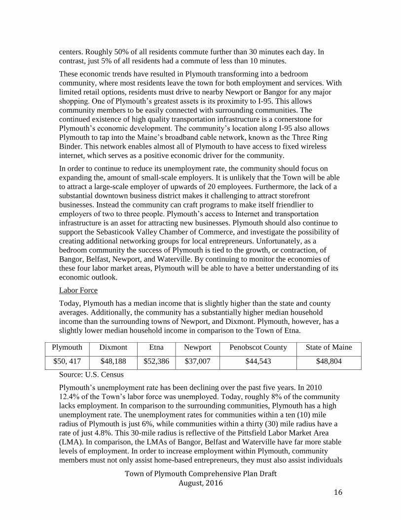
Today, Plymouth has a median income that is slightly higher than the state and county
averages. Additionally, the community has a substantially higher median household
income than the surrounding towns of Newport, and Dixmont. Plymouth, however, has a
slightly lower median household income in comparison to the Town of Etna.
Source: U.S. Census
Plymouth’s unemployment rate has been declining over the past five years. In 2010
12.4% of the Town’s labor force was unemployed. Today, roughly 8% of the community
lacks employment. In comparison to the surrounding communities, Plymouth has a high
unemployment rate. The unemployment rates for communities within a ten (10) mile
radius of Plymouth is just 6%, while communities within a thirty (30) mile radius have a
rate of just 4.8%. This 30-mile radius is reflective of the Pittsfield Labor Market Area
(LMA). In comparison, the LMAs of Bangor, Belfast and Waterville have far more stable
levels of employment. In order to increase employment within Plymouth, community
members must not only assist home-based entrepreneurs, they must also assist individuals
Plymouth Dixmont Etna Newport Penobscot County State of Maine
$50, 417 $48,188 $52,386 $37,007 $44,543 $48,804
Town of Plymouth Comprehensive Plan Draft August, 2016 17
hoping to access the Belfast, Waterville and Bangor labor markets. This can be achieved
by the creation of carpool networks, which reduces the transportation barriers that inhibit
employment.
Plymouth 2010 2014 2015
Total Labor Force 732 717 689
Employed 641 655 633
Unemployed 91 62 56
Unemployed Rate (%), Plymouth 12.4 8.6 8.1
Unemployed Rate (%), Pittsfield LMA N/A 8.3 7.6
Unemployed Rate (%), Bangor Metro LMA N/A 5.4 4.2
Unemployed Rate (%), Waterville LMA N/A 5.9 4.9
Unemployed Rate (%), Belfast LMA N/A 6.2 5.3
Unemployed Rate (%), State of Maine 7.2 5.3 4.2
Note: Annual Unemployment Rates are not seasonally adjusted
Source: Maine Department of Labor
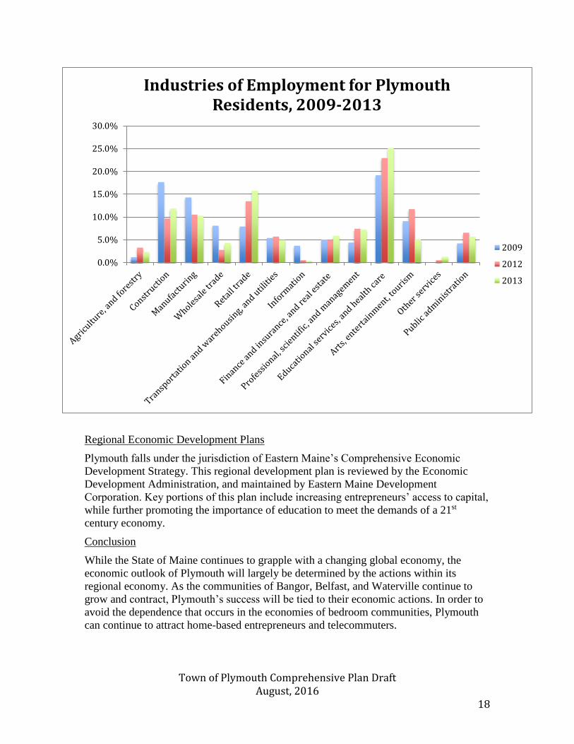
Occupation of Labor Force
In order to further assess the needs of the Plymouth community, it is necessary to
determine what sorts of jobs the community is currently sustaining. Among residents of
Plymouth the highest earning industries are Education and Health Care, Retail Trade,
Construction, and Manufacturing. Manufacturing has been declining both in Plymouth
and throughout the state over the past five years. In contrast, the Education and
Healthcare, and Retail Trade industries have consistently risen. Unfortunately, the
declining Manufacturing industry has one of the highest median incomes of Plymouth’s
industries. Currently, the median annual earnings of a Manufacturing employee are
$40,833, while the average earnings of Retail industry employees is $28,036. Similarly,
the median annual earning for an education or health care professional is $33,025. In
order to spur economic growth, it is necessary to both decrease the community’s
unemployment rate, while also increasing the amount of high earning professions.
Currently the transportation and warehousing sector, has the second highest median
income. This industry’s workers have an average annual salary of $55,313. However, this
industry area has remained relatively static over the past seven years. The Finance and
Insurance sector, which is the community’s highest paid sector, has also remained
stationary in recent years. Both of these, high paying employment spheres employ just
10% of the community’s residents.
Town of Plymouth Comprehensive Plan Draft August, 2016 18
Regional Economic Development Plans
Plymouth falls under the jurisdiction of Eastern Maine’s Comprehensive Economic
Development Strategy. This regional development plan is reviewed by the Economic
Development Administration, and maintained by Eastern Maine Development
Corporation. Key portions of this plan include increasing entrepreneurs’ access to capital,
while further promoting the importance of education to meet the demands of a 21st
century economy.
Conclusion
While the State of Maine continues to grapple with a changing global economy, the
economic outlook of Plymouth will largely be determined by the actions within its
regional economy. As the communities of Bangor, Belfast, and Waterville continue to
grow and contract, Plymouth’s success will be tied to their economic actions. In order to
avoid the dependence that occurs in the economies of bedroom communities, Plymouth
can continue to attract home-based entrepreneurs and telecommuters.
0.0%
5.0%
10.0%
15.0%
20.0%
25.0%
30.0%
Industries of Employment for Plymouth Residents, 2009-2013
2009
2012
2013
Town of Plymouth Comprehensive Plan Draft August, 2016 19
Goals, Policies, Action Strategies, and Implementation
Introduction
Currently Plymouth enjoys a median income which is slightly above the statewide
average, while also being affected by a relatively high unemployment rate. As a bedroom
community, with less than 10% of its workforce locally employed, the Town of Plymouth
has reduced impact on the economic development of its residents. The community must
focus on attracting more small scale employees and entrepreneurs, in order to reduce its
unemployment rate.
State of Maine Goal that Plan needs to address
Promote an economic development climate that increases job opportunities and overall
economic well-being.
Policies necessary to
address State of Maine
goals
Action strategies necessary to
address State of Maine goals
Responsible
Party
Time Frame
Support existing local
business owners, while
continuing to attract new
entrepreneurs to the area
Coordinate with regional
economic development
organization, neighboring
towns, and local chamber
of commerce to support
economic development
Ensure that residents are
able to access regional
labor markets for
employment
Maintain zoning laws that
protect resident’s quality of
life, while also identifying
areas for further industrial
development
Create local ordinances that
identify areas for development,
while only regulating small
scale and cottage industries if
nuisances occur.
Form local support groups for
small business owners to help
communicate best practices and
create a local professional
network
Cooperate with local commuters
to create car pool networks to
Belfast, Bangor, and Waterville.
Ensuring that the Planning
Board remains informed about
potential commercial activities
and their economic benefits, as
well as residents’ concerns
Selectmen/
Planning Board
Selectmen
Selectmen
Planning Board
Ongoing
Short term
Ongoing
Ongoing
Town of Plymouth Comprehensive Plan Draft August, 2016 20
Fiscal Capacity
Findings and Conclusions
-Plymouth has a large amount of borrowing power, due to its low amount of debt.
-Until recently, the Town’s Valuation level did not rise with inflation. Over the past year,
its property values have risen, which has decreased this deficit.
Introduction
Fiscal capacity refers to a community’s ability to meet the need of residents by funding
both current and future public expenditures. Currently, Plymouth enjoys a healthy fiscal
capacity; however, factors such as static valuation levels and increasing education costs
pose a challenge to the community.
Revenues
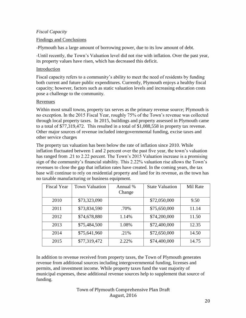
Within most small towns, property tax serves as the primary revenue source; Plymouth is
no exception. In the 2015 Fiscal Year, roughly 75% of the Town’s revenue was collected
through local property taxes. In 2015, buildings and property assessed in Plymouth came
to a total of $77,319,472. This resulted in a total of $1,088,558 in property tax revenue.
Other major sources of revenue included intergovernmental funding, excise taxes and
other service charges
The property tax valuation has been below the rate of inflation since 2010. While
inflation fluctuated between 1 and 2 percent over the past five year, the town’s valuation
has ranged from .21 to 2.22 percent. The Town’s 2015 Valuation increase is a promising
sign of the community’s financial stability. This 2.22% valuation rise allows the Town’s
revenues to close the gap that inflation rates have created. In the coming years, the tax
base will continue to rely on residential property and land for its revenue, as the town has
no taxable manufacturing or business equipment.
Fiscal Year Town Valuation Annual %
Change
State Valuation Mil Rate
2010 $73,323,090 $72,050,000 9.50
2011 $73,834,590 .70% $75,650,000 11.14
2012 $74,678,880 1.14% $74,200,000 11.50
2013 $75,484,500 1.08% $72,400,000 12.35
2014 $75,641,960 .21% $72,650,000 14.50
2015 $77,319,472 2.22% $74,400,000 14.75
In addition to revenue received from property taxes, the Town of Plymouth generates
revenue from additional sources including intergovernmental funding, licenses and
permits, and investment income. While property taxes fund the vast majority of
municipal expenses, these additional revenue sources help to supplement that source of
funding.
Town of Plymouth Comprehensive Plan Draft August, 2016 21
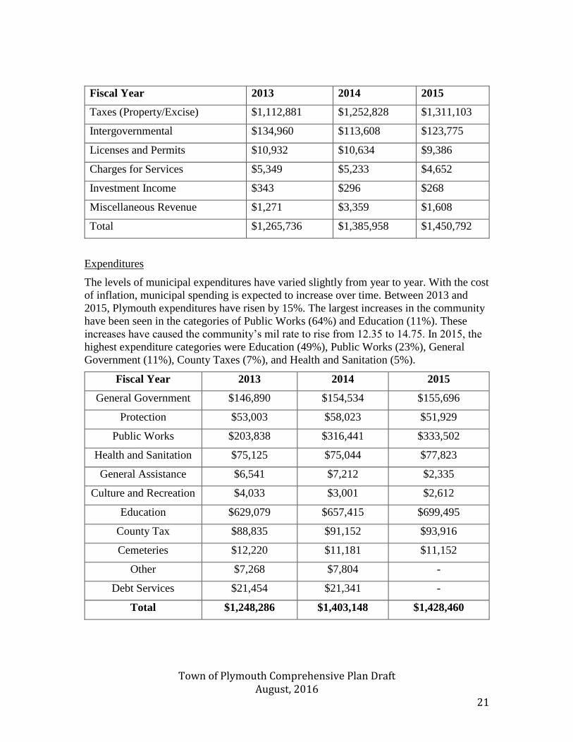
Fiscal Year 2013 2014 2015
Taxes (Property/Excise) $1,112,881 $1,252,828 $1,311,103
Intergovernmental $134,960 $113,608 $123,775
Licenses and Permits $10,932 $10,634 $9,386
Charges for Services $5,349 $5,233 $4,652
Investment Income $343 $296 $268
Miscellaneous Revenue $1,271 $3,359 $1,608
Total $1,265,736 $1,385,958 $1,450,792
Expenditures
The levels of municipal expenditures have varied slightly from year to year. With the cost
of inflation, municipal spending is expected to increase over time. Between 2013 and
2015, Plymouth expenditures have risen by 15%. The largest increases in the community
have been seen in the categories of Public Works (64%) and Education (11%). These
increases have caused the community’s mil rate to rise from 12.35 to 14.75. In 2015, the
highest expenditure categories were Education (49%), Public Works (23%), General
Government (11%), County Taxes (7%), and Health and Sanitation (5%).
Fiscal Year 2013 2014 2015
General Government $146,890 $154,534 $155,696
Protection $53,003 $58,023 $51,929
Public Works $203,838 $316,441 $333,502
Health and Sanitation $75,125 $75,044 $77,823
General Assistance $6,541 $7,212 $2,335
Culture and Recreation $4,033 $3,001 $2,612
Education $629,079 $657,415 $699,495
County Tax $88,835 $91,152 $93,916
Cemeteries $12,220 $11,181 $11,152
Other $7,268 $7,804 -
Debt Services $21,454 $21,341 -
Total $1,248,286 $1,403,148 $1,428,460
Town of Plymouth Comprehensive Plan Draft August, 2016 22
Debt
Plymouth is currently a member of Regional School Unit #19. As of June 30, 2015, the
Unit had an outstanding debt of $3,026,789. Plymouth’s proportional share of the Unit’s
debt is $256,979. Additionally, the Town approved a bond in 2015 for the completion of
a public works project. This has resulted in $480,000 in debt, which will expire in 2020.
The State of Maine regulates the amount of debt that a municipality is able to accumulate.
State law limits outstanding debt to 15 percent of the municipality’s last state valuation.
The State’s limit is reduced to 7.5 percent if debts related to schools, sewers, and water
and special district purposes are excluded.
Based upon Plymouth’s state valuation, the maximum amount of debt that the community
can accumulate is $11.16 million. This level of borrowing, however, should be avoided,
due to the dramatic rise in taxes that it would prompt. Should a situation arise where the
town would require significant funding, it has the necessary borrowing power.
Capital Improvement Expenditure Funds
As of December 31, 2015, the Town of Plymouth had approximately $138,606
committed for capital projects in the community. This includes funding for a fire truck
($12,136), playground ($2,856), sand and salt shed ($79,734), municipal building
(20,000), and special projects ($23,340). Additionally, the town has $9,969 committed
for other purposes including a cemetery addition and comprehensive planning.
Fiscal Capacity
In order to have a healthy fiscal capacity, a municipality must be able to fund services
and promptly pay their community’s operating costs. This is based on the ability of
property taxes, borrowing, and other revenue sources to meet the community’s financial
needs. Two factors must be considered when evaluating a community’s fiscal capacity:
property values and existing debt. If Plymouth’s valuation rises at a higher rate, the
community will be able to have adequate revenue without increasing mil rates. However,
if the town’s valuation level continues to rise at a rate that is equal to or below inflation,
it is likely that increased mil rates will be required. Plymouth is increasingly fortunate in
terms of existing debt. The community’s low debt levels, and high level of borrowing
power have ensured that it will be able to prudently take out additional bonds to cover
capital investments.
Town of Plymouth Comprehensive Plan Draft August, 2016 23
State of Maine Goals:
To plan for, finance, and develop an efficient system of public facilities and services to
accommodate anticipated growth and economic development.
Policies necessary to address
State of Maine Goals
Action strategies necessary to
address State of Maine goals
Implementation
Responsibility
Time
Frame
Finance existing and needed
facilities and services in a
satisfactory and cost effective
manner.
Explore grants available to assist
in the funding of capital
investments within the
community
Continue the increase of
municipal valuations to match
inflation rates
Plan for major capital
expenditures through the creation
of a Capital Investment Plan
Collaborate with neighboring
communities to explore finance
shared capital investments, in
order to reduce costs
Complete a relevant grant search
and apply for applicable awards
Encourage the growth and
expansion of building to
increase tax base
Review public facilities and
identify upcoming areas of
repair or replacement
Board of
Selectmen
Board of
Selectmen
Board of
Selectmen/
Planning Board
Board of
Selectmen/
Department
Heads
Ongoing
Ongoing
Ongoing
Short Term
Town of Plymouth Comprehensive Plan Draft August, 2016 24
Natural Resources
Findings and Conclusions
-Plymouth is home to critical species and habitats, which with the cooperation of local
actors can be preserved for future generations
-Residents of Plymouth deeply value the natural resources that exist within the
community
Setting
Plymouth is located in south western Penobscot County, Maine. The community is
bordered by five towns. These bordering towns include Detroit (Somerset County) and
Troy (Waldo County), as well as Newport, Etna, and Dixmont (all in Penobscot County).
The geographic area of Plymouth is 31.05 square miles, or 19,872 acres. Roughly 4% of
Plymouth’s area is comprised of water.
The climate of Plymouth is defined by harsh winters and moderate summers. The average
high temperature during the summer months (June through August) is 77° F, and in the
winter months (December through February) it is 31° F. On average, Plymouth receives
41.9 inches of rain each year, additionally it receives approximately 65 inches of snow
annually.
Topography
A community’s topography, which deals with the area’s physical features, can influence
both the natural beauty and development of a region. Two main factors are considered in
the profile: relief and slope.
The general height of land, or relief, above sea level and other surrounding areas varies
throughout Plymouth. The lowest point of the community is the areas surround Plymouth
Bog and Plymouth Pond; here the elevation is in the range of 250 feet above sea level. In
contrast, the highest portion of Plymouth is in the vicinity of Ward Hill, where the
elevation exceeds 600 feet above sea level.
Within the Town of Plymouth, three topographic areas exist:
1) The northern half of the Town of Plymouth is defined by its low character. This
region surrounds Plymouth Bog and mainly falls into the Bog’s sub-watershed.
2) Much of the Town’s southwest quadrant lies in a second topographic area. Far
higher than the upper portion of the community, and is defined by the presence of
Ward Hill. This area is split between the Plymouth Pond and Plymouth Bog sub-
watersheds.
3) The final topographic portion of the town occupies much of the town’s south east
quadrant, while also extending along the portions of the town that lie beneath
Round Pond. This area is slightly higher than the topographic area around
Plymouth Bog. In this region, the elevation is roughly 400 feet above sea level.
The area is divided between the Plymouth Pond and Skinner Bog sub-watersheds.
Town of Plymouth Comprehensive Plan Draft August, 2016 25
The slope of an area is defined by how quickly or slowly the ground rises or falls in a
particular geographic area. The measurement of this variable can, have an effect on the
level of development and land use that a community is able to experience. In general, the
steeper an area, the more expensive it is for development to occur. This is due to the
higher cost of constructing and maintaining roads and utilities in steeper terrain.
Additionally, this expense is increased with the higher potential for environmental
degradation and erosion. While some variations in slope exist throughout Plymouth, the
community is fortunate to be very level. Some steep areas do exist in the vicinity of Ward
Hill, as well as along the northwest shoreline of Plymouth Bog. These sloping areas
likely formed during the recession of glaciers from the region. Glacial melting in Maine
occurred roughly 17,000 years ago, and has also accounted for the formation of dramatic
peaks, like Mt. Katahdin, as well as more slopping hills, such as Acadia’s Bubbles.
Soils
The soil composition of a region is an important factor in determining the level of
development that a community can physically withstand. The composition of soil is able
to determine whether the area is suitable for the building of roads, buildings, or utility
pipes, as well as showing if land is usable for agriculture and other industries.
Development which occurs on soil that is unable to support such a use may have dire
consequences, such as environmental degradation and increased maintenance costs.
The Town of Plymouth is home to numerous soil types. These various soils are scattered
throughout the community. Some of the top soil types include: Dixmont Very Stony Silt
Loam (DyB), Monarda-Burnham Complex (MrB), Thorndike Very Rocky (TkB),
Biddeford Mucky Peat (BoA), and Bangor Very Stony Silt (BnB).
Soil Type Characteristics Location
Dixmont Very Stony Silt
Loam
Poorly drained Ward Hill Area
Monarda-Burnham
Complex
Poorly drained Plymouth Pond
Shoreline
Thorndike Very Rocky Somewhat excessively
drained
NE Plymouth
Biddeford Mucky Peat Very poorly drained Plymouth Bog
Bangor Very Stony Silt Well drained NE Plymouth
Source: USDA Natural Resource Conservation Service
Intensive mapping by the U.S. Department of Agriculture offers an in-depth view of soil
composition throughout the community. This mapping should be consulted prior to
development to determine the soil’s suitability. The above table displays some soil
characteristics however the town of Plymouth is home to more than 50 diverse soil types.
Town of Plymouth Comprehensive Plan Draft August, 2016 26
Floodplains
A floodplain is the flat expanse of land that extends from a body of water, which has
potential to be covered during a flood. Floodplains exist around both fresh and saltwater
bodies. Under the Federal Insurance Program, the 100-year floodplain is called the flood
hazard area. This space extends to areas that have a 1%, or once in one-hundred years-,
probability of being affected by flooding. During a flood, water depths in the floodplain
may range from less than a foot in some areas to more than 10 feet in others. Regardless
of the depth of flooding, however, all areas of a floodplain are regulated by the
requirements of the Flood Insurance Program. Floodplain that border rivers and streams
are composed of both a floodway, where water flows, and a flood fringe, where water
backs up. The channel will usually include the channel of a river or stream and some land
area adjacent to its banks. The portions of Plymouth that fall within the flood plain area
are along Martin Stream, Plymouth Pond, Round Pond, the Carlton Bog Drainage Area,
and the Martin Stream Drainage Area in northeast Plymouth. Much of the flood plain
area remains undeveloped.
The existence of a floodplain within Plymouth qualifies it for the National Flood
Insurance Program, which allows residents who fall within the floodplain to purchase
insurance.
In 2016, there were two flood insurance policies issued in Plymouth. This amounted to
$254,800 of in-force policy coverage. Since 1978, there have been no flood insurance
claims in Plymouth.
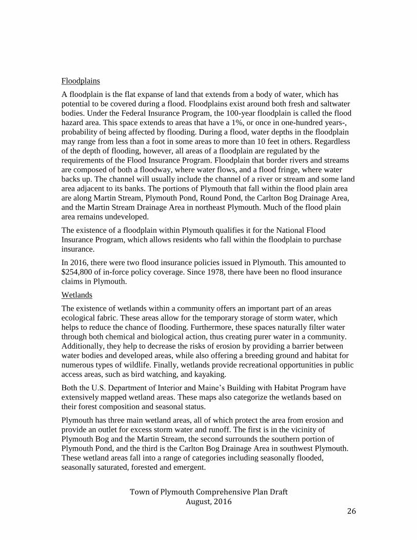
Wetlands
The existence of wetlands within a community offers an important part of an areas
ecological fabric. These areas allow for the temporary storage of storm water, which
helps to reduce the chance of flooding. Furthermore, these spaces naturally filter water
through both chemical and biological action, thus creating purer water in a community.
Additionally, they help to decrease the risks of erosion by providing a barrier between
water bodies and developed areas, while also offering a breeding ground and habitat for
numerous types of wildlife. Finally, wetlands provide recreational opportunities in public
access areas, such as bird watching, and kayaking.
Both the U.S. Department of Interior and Maine’s Building with Habitat Program have
extensively mapped wetland areas. These maps also categorize the wetlands based on
their forest composition and seasonal status.
Plymouth has three main wetland areas, all of which protect the area from erosion and
provide an outlet for excess storm water and runoff. The first is in the vicinity of
Plymouth Bog and the Martin Stream, the second surrounds the southern portion of
Plymouth Pond, and the third is the Carlton Bog Drainage Area in southwest Plymouth.
These wetland areas fall into a range of categories including seasonally flooded,
seasonally saturated, forested and emergent.
Town of Plymouth Comprehensive Plan Draft August, 2016 27
Map A: Wetland Characterization

Town of Plymouth Comprehensive Plan Draft August, 2016 28
Map B: 100 Year Floodplain Area
Source: Maine Department of Agriculture, Conservation, and Forestry
Town of Plymouth Comprehensive Plan Draft August, 2016 29
Wildlife
Wildlife is classified as natural resource, due to the source of livelihood that non-
domesticated species offer through the recreation industry. Furthermore, as part of the
greater ecosystem, wildlife help to support their habitats and ensure the health of their
surroundings. As development progresses, habitat areas can frequently be threatened by
human activity. The three major wildlife habitats that should be considered within
Plymouth are: riparian and wetland habitats, critical and endangered species areas, and
undeveloped habitat blocks.
Wetlands and riparian habitats offer valuable benefits to control both floodplains and
erosion. However, these habitats also provide an important service to water-reliant
species. Many birds use wetland and rivers as nesting areas, while also providing a home
for beavers, otters, and numerous types of fish. Furthermore, this environment assist
many more animals on a secondary level, with muskrats, deer, mink, and raccoons
relying using this resource for feeding purposes. Within Plymouth, this habitat can be
found in the Plymouth Bog, Carlton Bog Drainage Area, Plymouth Pond, and Round
Pond vicinities. Portions of the riparian habitat between Martin Stream and Plymouth
Bog are classified as an Appalachian-Acadian Basin Swamp Ecosystem. The Carlton Bog
Drainage Area has been classified by the Department of Inland Fisheries as a Raised
Level Bog Ecosystem.
Other riparian habitats exist along the Martin Stream. These areas give a buffer zone
between the river and dry and upland area. This offers a space for birds and amphibians
to exist and seek shelter. Furthermore, this barrier assists in the regulation of water
temperatures.
Habitat areas that harbor critical or endangered species are also an important area of
concern for the Town of Plymouth. According to the Maine Department of Inland
Fisheries and Wildlife, Plymouth is currently home to three birds that fall into either the
endangered or special concern categories: Bald Eagles, Black Terns, and Great Blue
Herons. The Bald Eagle is currently listed as a species of special concern. Two Bald
Eagle habitats have been located along Plymouth Pond; one is found near the south end
of the Rt. 7 Bridge, while the second is located along the Pond’s undeveloped northeast
shore. Black Terns have been listed as an endangered species; however, a habitat area
exists within Plymouth Pond. Finally, Great Blue Herons, also a species of special
concern, have been located, in western Plymouth, near Clark Rd.
Finally, large undeveloped habitat blocks create beneficial habitats for many local species
of wildlife. For example, roughly 4,000 acres of land within Plymouth are classified as
Candidate Deer Wintering Areas. These undeveloped regions have the potential to offer
shelter for deer during periods of extreme cold or deep snow. Significant areas of
undeveloped habitat exist in northeastern Plymouth. 2,065 acres of undeveloped habitat is
present in the area between Interstate-95 and the Newport border, a further 1,293 acres
exists between I-95 and Rt. 69. Another area of 1,368 acres of undeveloped habitat exists
in the vicinity, of Ward Hill. Additionally, 1,192 acres is present between Round Pond
and Plymouth Pond.
Town of Plymouth Comprehensive Plan Draft August, 2016 30
Each identified area provides support for numerous species of wildlife. In turn these fish,
mammals, and amphibians improve the health of both their habitat and the local
economy. A loss of habitat for these species will not generally result in an immediate
impact on a local community. Over time, however, an accumulation of habitat loss can
reduce the carrying capacity and ultimately the prevalence, of wildlife.
Fisheries
The fish contained in Plymouth and Round Ponds are a valuable natural resource and
community asset. This healthy fish population has the potential to draw anglers and
naturalists alike to Plymouth. Plymouth Pond is a shallow body of water where both
small and largemouth bass, chain pickerel, and white perch can all be found. While the
bass population was only introduced in 1972, the original stock has created an excellent
fishery in the Pond.
Round Pond is considerably deeper than Plymouth Pond, and also offers ample fishing
opportunities. The Pond is home to Largemouth bass, Chain pickerel, White perch, and
Hornpout.
Martin Stream is also a healthy fishing environment, where residents can find bass, brook
trout, and white suckers.
Rare Threatened and Endangered Insects
Plymouth Pond is also home to the Lilypad Clubtail, or Arigomphus furcifer. This type of
dragonfly is listed as a species of special concern by the Maine Department of Inland
Fisheries and Wildlife. Lack of knowledge is one factor that the IFW has identified as
contributing towards its endangered status. As its name implies, the insect is frequently
found perched on lily pads.
Locally Significant Natural Areas
Community members from Plymouth have identified a number of local areas that have
significant natural beauty and provide appreciated recreational opportunities. These sights
are: Plymouth Pond, Martin Stream, Gray Hill, Small Rd., and Rutland Rd. This
collection of natural areas provides space for a number of recreational activities,
including hunting, fishing, bird watching, and kayaking.
Plymouth Pond is largely undeveloped, and provides ample opportunities for fishing, bird
watching, and boating. The waterbody is fully contained within Plymouth, and provides a
relaxing space for residents to enjoy numerous leisure activities. Martin Stream runs
through the central portion of Plymouth. This waterway is shared with the surrounding
communities of Dixmont, Newport and Detroit. The stream also provides a space for
fishing. Gray Hill, is located in western Plymouth. The hill provides scenic views of
Plymouth and the surrounding area. Rutland Road cuts across southwestern Plymouth.
This thoroughfare is a valued walking path for community residents. Finally, Small Road
in south central Plymouth is seen by many as an ideal space or sunset views. Located to
the east of Round Pond it offers a beautiful vista for residents to enjoy.
Town of Plymouth Comprehensive Plan Draft August, 2016 31
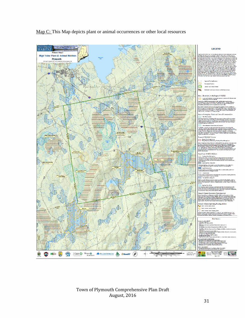
Map C: This Map depicts plant or animal occurrences or other local resources
Town of Plymouth Comprehensive Plan Draft August, 2016 32
Scenic Resources
The natural beauty of Plymouth is one of the town’s defining factors. Despite being 31
square miles, the community is home to only 1,380 residents. This allows the community
to have a population density which is far below the national average. The rural character
of Plymouth, combined with the Pond, which serves as a community focal point, makes
the Town a naturally scenic area. Plymouth’s natural beauty allows residents to enjoy a
high quality of life by being just moments away from boating, fishing, hiking, and
hunting opportunities. The natural topography, prevalent wildlife, and existing
development patterns have made Plymouth a community that is steeped in natural beauty
and recreational opportunities.
In order to maintain these scenic resources, the Town of Plymouth has enacted a number
of ordinances. These local regulations ensure that landowners appear in front of the
Town’s Planning Board prior to subdividing any lots. Additionally, the community has a
minimum lot size to reduce the risk of high density population.
Protection of Natural Resources
Natural resources are important part of the Plymouth community. Their presence offers a
source of livelihood and leisure for many of the community’s residents. Furthermore,
natural features like wetlands and soil types provide a physical support that allows the
community to avoid the costly effects of increased erosion or unstable land.
By adhering to state guidelines that regulate shore land building, the community has been
able to ensure that the natural beauty and geologic structure of Plymouth and Round
Ponds continues to be preserved. Additionally, the participation of susceptible households
in the National Flood Insurance Program prevents at-risk residents from experiencing
flood-related financial issues.
The Plymouth Environmental Action Team (PEAT) is a citizen-led group that has helped
to preserve and protect the community’s natural resources. PEAT has carried out local
events such as trash clean ups, while also engaging in activities with state and local
officials. Most notably, PEAT has cooperated with state legislators to combat a nuisance
odor that has come from an area sewage treatment plant.
Plymouth’s residents are very invested in the scenic beauty of their community, and have
voiced their opposition to development which will alter the Town’s ambiance. For
example, in 2014 OTT Communication installed utility poles along the Rt. 7 causeway
that crosses Plymouth Pond, which diminished the Pond’s scenic beauty. In response,
residents approached the Maine DOT and Planning Board and had the poles removed.
Both the State of Maine and the Town of Plymouth have taken steps to preserve natural
areas within the community. The Maine Department of Inland Fisheries and Wildlife
currently manages roughly 700 acres in Plymouth Bog. This land was acquired in the
aftermath of industrial pollution within the bog and maintains the safety of the
community’s water resources. The town of Plymouth has also preserved areas at the
Triangle Parcel (1.75 acres) near the junction of Moosehead Trail and Lower Detroit Rd,
as well as two acres of land surrounding the Town’s Fire Station. Publicly owned

Town of Plymouth Comprehensive Plan Draft August, 2016 33
recreation areas also exist at the Town’s Playground and ballfield, as well as the
community’s war memorial.
Town of Plymouth Comprehensive Plan Draft August, 2016 34
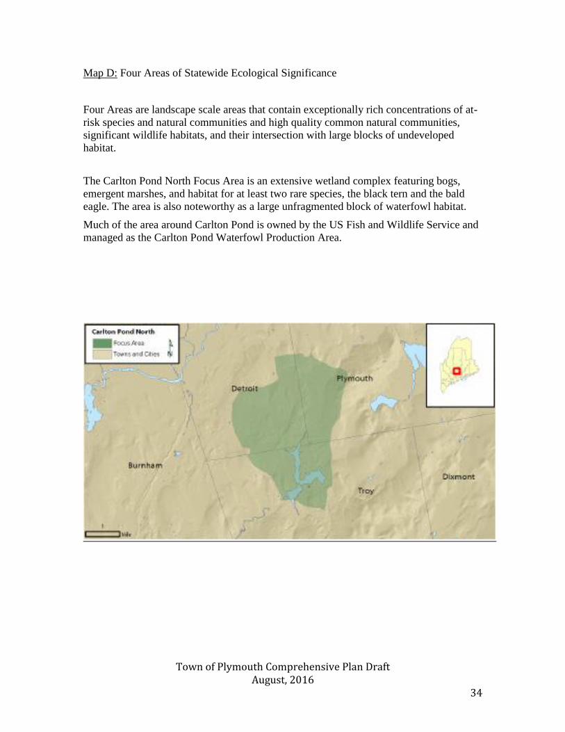
Map D: Four Areas of Statewide Ecological Significance
Four Areas are landscape scale areas that contain exceptionally rich concentrations of at-
risk species and natural communities and high quality common natural communities,
significant wildlife habitats, and their intersection with large blocks of undeveloped
habitat.
The Carlton Pond North Focus Area is an extensive wetland complex featuring bogs,
emergent marshes, and habitat for at least two rare species, the black tern and the bald
eagle. The area is also noteworthy as a large unfragmented block of waterfowl habitat.
Much of the area around Carlton Pond is owned by the US Fish and Wildlife Service and
managed as the Carlton Pond Waterfowl Production Area.
Town of Plymouth Comprehensive Plan Draft August, 2016 35
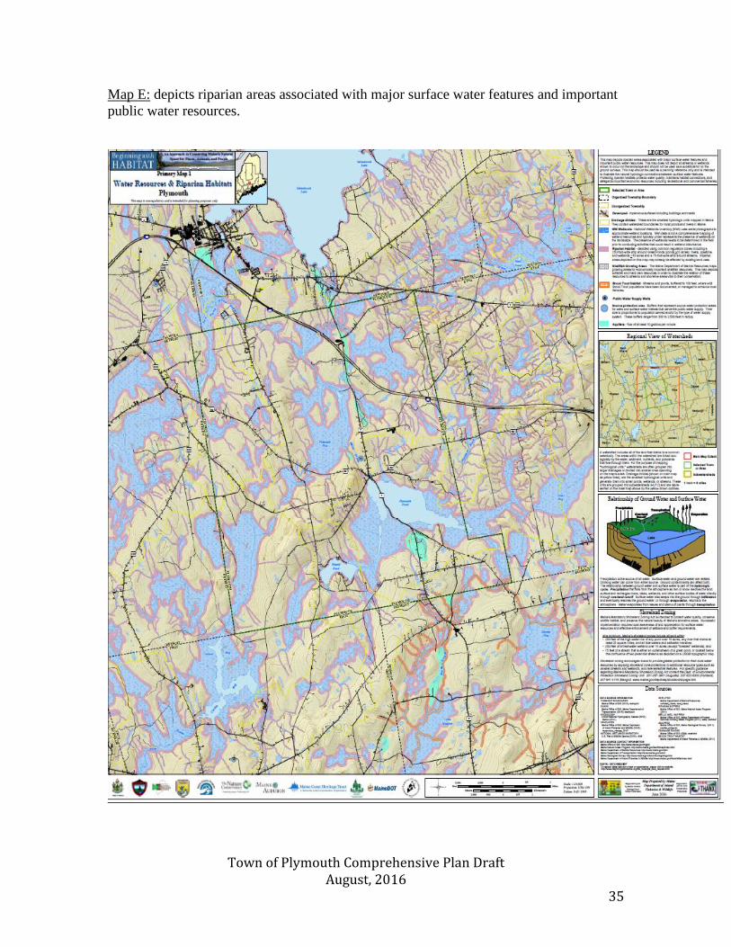
Map E: depicts riparian areas associated with major surface water features and important
public water resources.
Town of Plymouth Comprehensive Plan Draft August, 2016 36
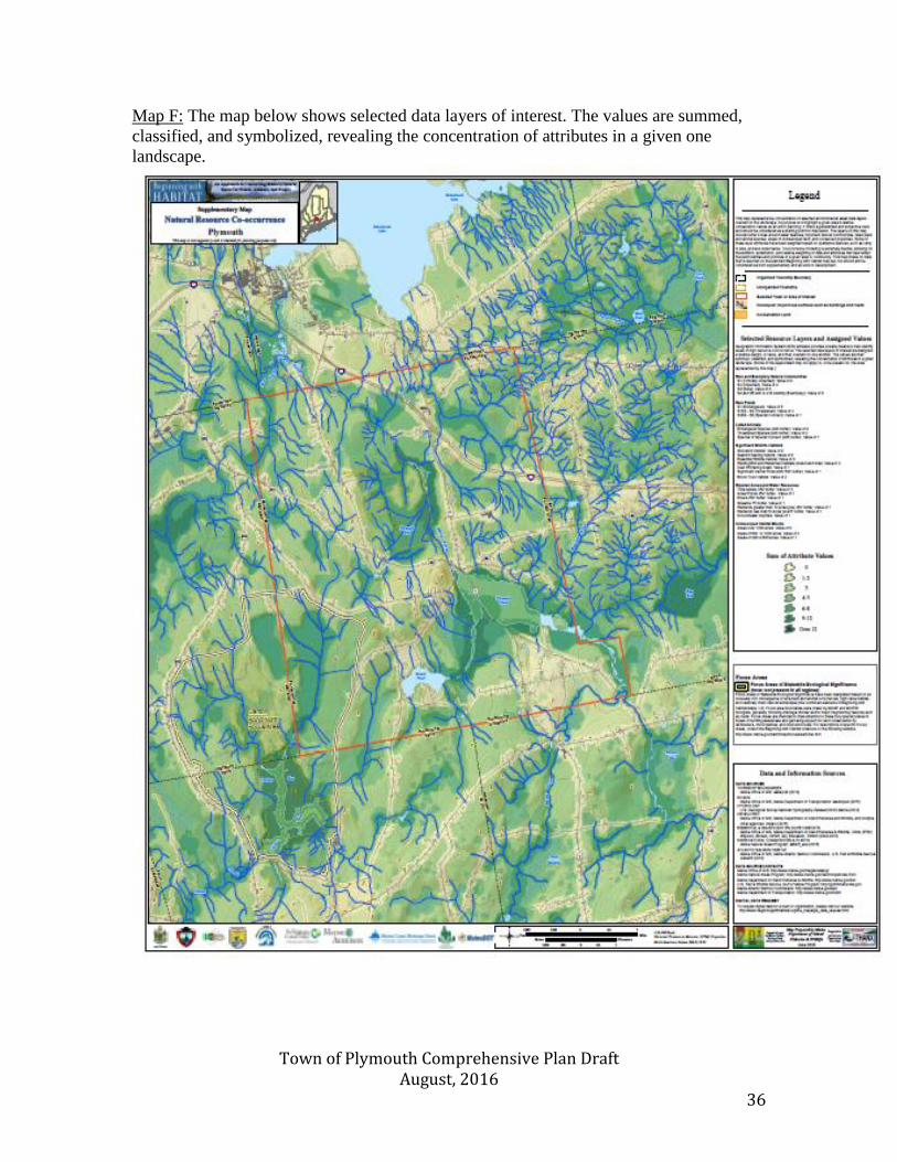
Map F: The map below shows selected data layers of interest. The values are summed,
classified, and symbolized, revealing the concentration of attributes in a given one
landscape.
Town of Plymouth Comprehensive Plan Draft August, 2016 37
State of Maine Goals:
To protect the State’s other critical natural resources, including with limitations,
wetlands, wildlife and fisheries habitat, shore lands, scenic vistas and unique natural
areas.
Policies necessary to address
State of Maine Goals
Action strategies necessary to
address State of Maine goals
Implementation
Responsibility
Time
Frame
Conserve critical natural
resources in the community
Coordinate with neighboring
communities to protect scenic
beauty of natural areas
Recognize the local importance of
Plymouth Pond and work to
conserve the pristine shoreline
Maintain fishery and wildlife
populations through habitat
preservation
Assist vulnerable homeowners by
informing them of the National
Flood Insurance Program
Cooperate with the Department of
Inland Wildlife and Fisheries to
continue to preserve the Plymouth
Bog area
Assist potential builders and
developers in avoiding critical
species habitat areas
Develop a Town Conservation
Committee and empower them
to take on a leadership role.
Participate in local and regional
efforts to monitor, protect, and
improve water quality
Maintain a watchful eye on the
Pond and wildlife
Incorporate low-impact
development standards into the
land-use ordinance
Inform local landowners of their
perceived property risk
Volunteers check with the
Commissioner of Wildlife and
Fisheries periodically
Investigate and develop
incentives to encourage
landowners to avoid such areas
Board of
Selectmen
Conservation
Committee
P.E.A.T.
M.V.L.P.
Conservation
Committee
Planning Board
Town Office
P.E.A.T
Conservation
Committee
Selectmen
Planning Board
Short-term
Long-term
Long-term
Short-term
Ongoing
Ongoing
Long-term
Town of Plymouth Comprehensive Plan Draft August, 2016 38
Outdoor Recreation
Findings and Conclusions
-The Town of Plymouth has a vast amount of outdoor recreational resources, however
many of these are made possible through easements that must be respected and
maintained.
-The community’s surface water recreation areas are an important part of Plymouth’s
character, and their access points can continue to be expanded.
Introduction
Recreation and open space are critical to a community’s quality of life. The availability
of outdoor recreational activities, whether on pristine and undeveloped land or along the
banks of mighty rivers, is a central part of the character of Maine. Recreational facilities,
such as community buildings, ball fields, playgrounds, beaches and parks provide places
where residents can socialize and be active. Open space provides areas for outdoor
recreation, such as access to water bodies for boating, fishing, swimming and ice skating,
and trails for walking, horseback riding, snowshoeing, cross-country skiing, hiking,
wildlife and bird watching, and snowmobiling and ATV riding. Furthermore, open space
provides a habitat for wildlife and contributes to the scenic beauty of an area. Regionally
and locally, open space and other outdoor recreational offerings are considered economic
assets for ecotourism and second/seasonal home development. Additionally, outdoor
recreation areas attract potential residents and increase a community’s quality of life.
Public Outdoor Recreation Areas
Plymouth is home to numerous recreation areas, which are administered by a variety of
authorities. The Town of Plymouth has ownership of three main parcels of land. The first
parcel, known as the Triangle Lot, is 1.75 acres. This green space is located near the
junction of Moosehead Trail and the Lower Detroit Rd, it serves as a gateway to a public
trail network that uses land easements to create a recreation area. The second town owned
parcel is in the vicinity of the Plymouth Fire Department and includes two acres of land.
The final area of land is the community’s baseball field and playground. Located along
Moosehead Trail, this facility provides a space for residents to come together and
socialize while also enjoying recreational baseball games. The baseball area is equipped
with electricity and includes a snack bar that provides refreshments during games. The
area’s playground has been recently expanded over the past few years to fully meet the
needs of Plymouth’s youngest residents. Additionally, the town has secured an easement
near the baseball field which allows attendees to have ample room for parking.
Recreation space is also available through land that is owned and maintained by the State
of Maine. The Maine Department of Wildlife and Inland Fisheries operates the Plymouth
Bog Wildlife Management Area. This bog habitat offers a protected area for residents to
canoe, kayak, hike, and bird watch.
Town of Plymouth Comprehensive Plan Draft August, 2016 39
Recreation Department
The Town of Plymouth has an active Recreation Department that is operated by
volunteers and provides activities for residents’ children. Four coordinators organize a
wide variety of events including craft nights, baseball leagues, and soccer camps.
Additional athletic programs are carried out through RSU #19. At the high school level,
area students, are able to participate in 13 different sports teams that are coordinated by
Nokomis Regional High School.
Bodies of Water
Plymouth is home to four main bodies of water: Martin Stream, Plymouth Bog, Plymouth
Pond, and Round Pond. Each of these provides distinct recreational opportunities, which
are an asset to both residents and wildlife. The Martin Stream begins in Plymouth Pond
before flowing north to the Newport border. The stream provides a space for residents to
enjoy hunting, wildlife and bird watching. Martin Stream flows into Plymouth Bog. This
unique riparian habitat is home to numerous species of plants and wildlife. Additionally,
Plymouth Bog is part of a 700 acres Wildlife Management Area that is maintained by
Maine’s Department of Inland Wildlife and Fisheries. This ensures that a body of water
will continue to be publicly accessible and protected. Plymouth’s centerpiece is Plymouth
Pond, which also provides the community with ample recreation opportunities. The pond
is a popular location for boating, fishing, and swimming. The shoreline of 480-acre pond
has remained almost completely undeveloped. The majority of shoreline land is owned
by private landowners who have opted to preserve the pond’s pristine character.
Additionally, the pond is accessible due to the existence of a public boat launch; plans for
an expansion of this boating facility are currently being discussed. Finally, Plymouth is
home to Round Pond. Unlike Plymouth Pond, Round Pond is surrounded by many
shorefront homes. The 134-acre pond is also a popular spot for fishing and boating.
Hunting and Fishing
Like many Maine communities, Plymouth is home to numerous hunters and fishermen.
This form of recreation allows resident to be immersed in nature, while also carrying out
an activity that requires skill, concentration and dedication. Many of Maine’s hunter and
fishermen are some of the state’s most ardent conservationists, as the future of their sport
is reliant on healthy wildlife populations. Within Plymouth landowners have been
accommodating to traditional land use activities, and only a small amount of landowners
have posted their property. Popular hunting areas include Plymouth Bog as well as the
undeveloped land in northeast Plymouth. Much of Plymouth is populated with deer,
waterfowl, and upland game birds. The community’s water bodies provide a wealth of
fishing opportunities. Popular fish include Brook trout, Largemouth bass, Chain pickerel,
White perch, and Hornpout.
Walking Trails
The Town of Plymouth is home to numerous walking trail systems, which also are
accessible for snow shoeing, cross country skiing, horseback riding, and mountain biking.
Many of these trail networks, such as the Rutland Rd., are abandoned roads, which
ensures that they are level, wide, and conveniently located to Plymouth’s residents. Trails
also exist in the Town-owned Triangle Lot, with future plans to connect this portion of

Town of Plymouth Comprehensive Plan Draft August, 2016 40
the community to the nearby ball field. This trail will be formed through the securement
of easements from area property owners.
Snowmobile and ATV Trail System
The Town of Plymouth is home to an impressive system of snowmobile and ATV trails,
which is both maintained and enjoyed by local residents. The Endless Season Riders
Snowmobile and ATV Club is a membership organization that supports 27 miles of
snowmobile trails, as well as 24 miles of ATV trails. These trails spread to every corner
of Plymouth, which allows for endless amounts of enjoyment. This trail network also
connects to neighboring communities, which further expands riders’ options. While
membership fees are collected, they are set at an affordable rate to allow all residents to
take advantage of this resource. Funds that are raised allow for the maintenance of
grooming machines. The Department of Inland Wildlife and Fisheries also provides
funding through reimbursements for maintenance services. Additionally, Endless Season
Riders provides an important line of communication between the sportsmen, land owners,
and ATV/Snowmobile riding communities. This ensures that the needs of all three
constituencies are being respected, and the best possible outcome is reached for all
residents. For example, Endless Season Riders have the ability to close the gates to its
trails during hunting seasons. This protects the safety of riders, while also ensuring that
game animals are not scared off by the noise of ATVs/Snowmobiles.
Future Recreation Opportunities
Much of the public and private recreation opportunities within Plymouth rely on the
creation of easements with private land owners. By maintaining a positive relationship
between residents and landowners, the community will be able to safeguard this land
access for future generations. Additionally, the community should continue to provide
workshops or reading material, which allow residents to understand how to respectfully
use private lands.
Town of Plymouth Comprehensive Plan Draft August, 2016 41
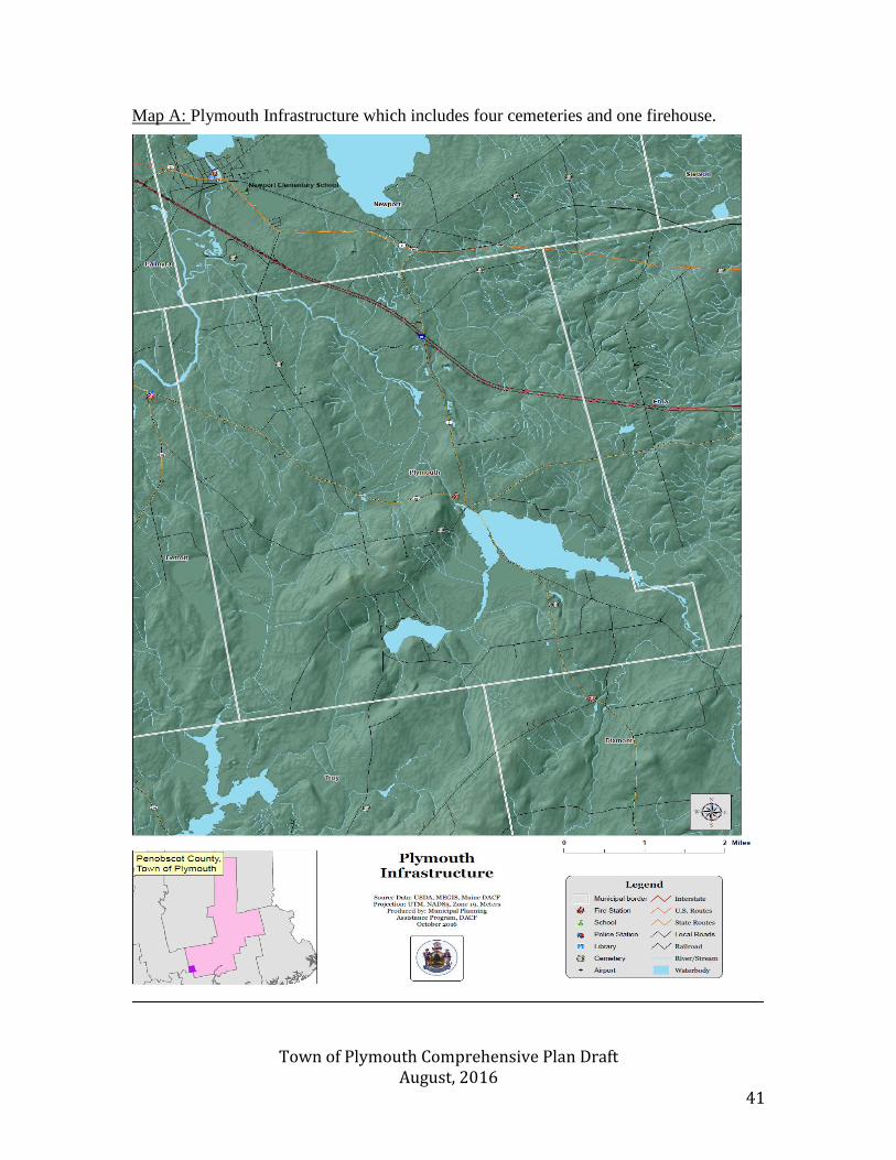
Map A: Plymouth Infrastructure which includes four cemeteries and one firehouse.
Town of Plymouth Comprehensive Plan Draft August, 2016 42
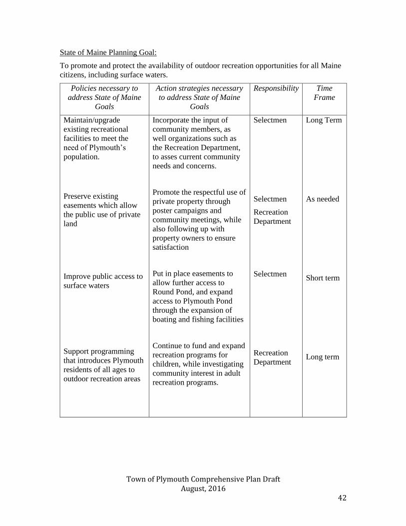
State of Maine Planning Goal:
To promote and protect the availability of outdoor recreation opportunities for all Maine
citizens, including surface waters.
Policies necessary to
address State of Maine
Goals
Action strategies necessary
to address State of Maine
Goals
Responsibility Time
Frame
Maintain/upgrade
existing recreational
facilities to meet the
need of Plymouth’s
population.
Preserve existing
easements which allow
the public use of private
land
Improve public access to
surface waters
Support programming
that introduces Plymouth
residents of all ages to
outdoor recreation areas
Incorporate the input of
community members, as
well organizations such as
the Recreation Department,
to asses current community
needs and concerns.
Promote the respectful use of
private property through
poster campaigns and
community meetings, while
also following up with
property owners to ensure
satisfaction
Put in place easements to
allow further access to
Round Pond, and expand
access to Plymouth Pond
through the expansion of
boating and fishing facilities
Continue to fund and expand
recreation programs for
children, while investigating
community interest in adult
recreation programs.
Selectmen
Selectmen
Recreation
Department
Selectmen
Recreation
Department
Long Term
As needed
Short term
Long term
Town of Plymouth Comprehensive Plan Draft August, 2016 43
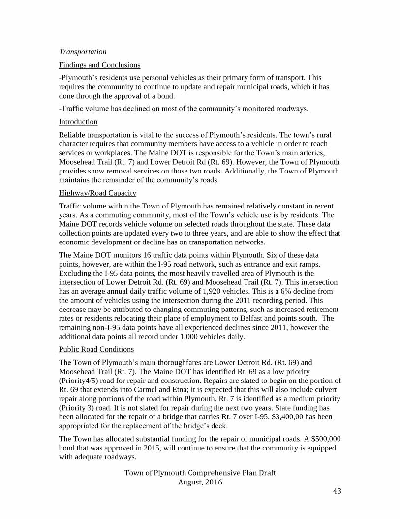
Transportation
Findings and Conclusions
-Plymouth’s residents use personal vehicles as their primary form of transport. This
requires the community to continue to update and repair municipal roads, which it has
done through the approval of a bond.
-Traffic volume has declined on most of the community’s monitored roadways.
Introduction
Reliable transportation is vital to the success of Plymouth’s residents. The town’s rural
character requires that community members have access to a vehicle in order to reach
services or workplaces. The Maine DOT is responsible for the Town’s main arteries,
Moosehead Trail (Rt. 7) and Lower Detroit Rd (Rt. 69). However, the Town of Plymouth
provides snow removal services on those two roads. Additionally, the Town of Plymouth
maintains the remainder of the community’s roads.
Highway/Road Capacity
Traffic volume within the Town of Plymouth has remained relatively constant in recent
years. As a commuting community, most of the Town’s vehicle use is by residents. The
Maine DOT records vehicle volume on selected roads throughout the state. These data
collection points are updated every two to three years, and are able to show the effect that
economic development or decline has on transportation networks.
The Maine DOT monitors 16 traffic data points within Plymouth. Six of these data
points, however, are within the I-95 road network, such as entrance and exit ramps.
Excluding the I-95 data points, the most heavily travelled area of Plymouth is the
intersection of Lower Detroit Rd. (Rt. 69) and Moosehead Trail (Rt. 7). This intersection
has an average annual daily traffic volume of 1,920 vehicles. This is a 6% decline from
the amount of vehicles using the intersection during the 2011 recording period. This
decrease may be attributed to changing commuting patterns, such as increased retirement
rates or residents relocating their place of employment to Belfast and points south. The
remaining non-I-95 data points have all experienced declines since 2011, however the
additional data points all record under 1,000 vehicles daily.
Public Road Conditions
The Town of Plymouth’s main thoroughfares are Lower Detroit Rd. (Rt. 69) and
Moosehead Trail (Rt. 7). The Maine DOT has identified Rt. 69 as a low priority
(Priority4/5) road for repair and construction. Repairs are slated to begin on the portion of
Rt. 69 that extends into Carmel and Etna; it is expected that this will also include culvert
repair along portions of the road within Plymouth. Rt. 7 is identified as a medium priority
(Priority 3) road. It is not slated for repair during the next two years. State funding has
been allocated for the repair of a bridge that carries Rt. 7 over I-95. $3,400,00 has been
appropriated for the replacement of the bridge’s deck.
The Town has allocated substantial funding for the repair of municipal roads. A $500,000
bond that was approved in 2015, will continue to ensure that the community is equipped
with adequate roadways.
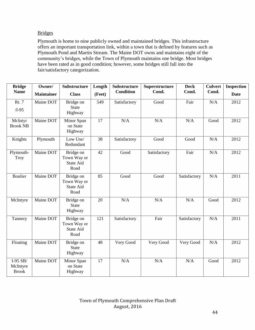
Town of Plymouth Comprehensive Plan Draft August, 2016 44
Bridges
Plymouth is home to nine publicly owned and maintained bridges. This infrastructure
offers an important transportation link, within a town that is defined by features such as
Plymouth Pond and Martin Stream. The Maine DOT owns and maintains eight of the
community’s bridges, while the Town of Plymouth maintains one bridge. Most bridges
have been rated as in good condition; however, some bridges still fall into the
fair/satisfactory categorization.
Bridge
Name
Owner/
Maintainer
Substructure
Class
Length
(Feet)
Substructure
Condition
Superstructure
Cond.
Deck
Cond.
Culvert
Cond.
Inspection
Date
Rt. 7
/I-95
Maine DOT Bridge on
State
Highway
549 Satisfactory Good Fair N/A 2012
McIntyr
Brook NB
Maine DOT Minor Span
on State
Highway
17 N/A N/A N/A Good 2012
Knights Plymouth Low Use/
Redundant
38 Satisfactory Good Good N/A 2012
Plymouth-
Troy
Maine DOT Bridge on
Town Way or
State Aid
Road
42 Good Satisfactory Fair N/A 2012
Boulier Maine DOT Bridge on
Town Way or
State Aid
Road
85 Good Good Satisfactory N/A 2011
McIntyre Maine DOT Bridge on
State
Highway
20 N/A N/A N/A Good 2012
Tannery Maine DOT Bridge on
Town Way or
State Aid
Road
121 Satisfactory Fair Satisfactory N/A 2011
Floating Maine DOT Bridge on
State
Highway
48 Very Good Very Good Very Good N/A 2012
I-95 SB/
McIntyre
Brook
Maine DOT Minor Span
on State
Highway
17 N/A N/A N/A Good 2012
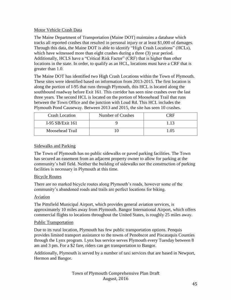
Town of Plymouth Comprehensive Plan Draft August, 2016 45
Motor Vehicle Crash Data
The Maine Department of Transportation (Maine DOT) maintains a database which
tracks all reported crashes that resulted in personal injury or at least $1,000 of damages.
Through this data, the Maine DOT is able to identify “High Crash Locations” (HCLs),
which have witnessed more than eight crashes during a three (3) year period.
Additionally, HCLS have a “Critical Risk Factor” (CRF) that is higher than other
locations in the state. In order, to qualify as an HCL, locations must have a CRF that is
greater than 1.0.
The Maine DOT has identified two High Crash Locations within the Town of Plymouth.
These sites were identified based on information from 2013-2015. The first location is
along the portion of I-95 that runs through Plymouth, this HCL is located along the
southbound roadway before Exit 161. This corridor has seen nine crashes over the last
three years. The second HCL is located on the portion of Moosehead Trail that runs
between the Town Office and the junction with Loud Rd. This HCL includes the
Plymouth Pond Causeway. Between 2013 and 2015, the site has seen 10 crashes.
Crash Location Number of Crashes CRF
I-95 SB/Exit 161 9 1.13
Moosehead Trail 10 1.05
Sidewalks and Parking
The Town of Plymouth has no public sidewalks or paved parking facilities. The Town
has secured an easement from an adjacent property owner to allow for parking at the
community’s ball field. Neither the building of sidewalks nor the construction of parking
facilities is necessary in Plymouth at this time.
Bicycle Routes
There are no marked bicycle routes along Plymouth’s roads, however some of the
community’s abandoned roads and trails are perfect locations for biking.
Aviation
The Pittsfield Municipal Airport, which provides general aviation services, is
approximately 10 miles away from Plymouth. Bangor International Airport, which offers
commercial flights to locations throughout the United States, is roughly 25 miles away.
Public Transportation
Due to its rural location, Plymouth has few public transportation options. Penquis
provides limited transport assistance to the towns of Penobscot and Piscataquis Counties
through the Lynx program. Lynx bus service serves Plymouth every Tuesday between 8
am and 3 pm. For a $2 fare, riders can get transportation to Bangor.
Additionally, Plymouth is served by a number of taxi services that are based in Newport,
Hermon and Bangor.

Town of Plymouth Comprehensive Plan Draft August, 2016 46
Regional Transportation Plans
The Maine DOT compiles numerous transportation plans to identify upcoming and long-
range public works projects. As mentioned earlier, Plymouth is currently set to receive
upgrades to a bridge along Moosehead Trail.
Additionally, Eastern Maine Development Corporation is responsible for creating
strategic plans related to the region’s transportation needs. EMDC’s “Getting There
Maine” program offers resources, such as a ride board, to assist residents.
Town of Plymouth Comprehensive Plan Draft August, 2016 47
State of Maine Planning Goal:
To plan for, finance and develop an efficient system of public facilities and services to
accommodate anticipated growth and economic development
Promote public health, protect natural and cultural resources, and enhance livability by
managing land use in ways that maximize efficiency of the transportation systems and
minimize increases in vehicle miles travelled.
Policies necessary to
address State of Maine
Goals
Actions needed to meet
State of Maine goals
Responsible Party Time Frame
Prioritize community
and regional needs
associated with safe,
efficient, and optimal
use of transportation
systems
Safely and efficiently
improve or preserve
the transportation
system
Promote community’s
health, livability and
economy through
increasing the
efficiency of transport
systems
Promote fiscal
prudence by
maximizing the
efficiency of the state
highway network
Develop, and continue
to develop,
maintenance and
improvement plans for
the Town’s roads
Collaborate with
surrounding
communities, region,
and state in planning
efforts
Advertise Penquis
existing Lynx program,
while investigating the
possibility of creating a
community carpool
network
Actively participate in
regional and state
transport planning
efforts.
Selectmen
Selectmen
Selectmen
Selectmen
Ongoing
Ongoing
Ongoing
Ongoing
Town of Plymouth Comprehensive Plan Draft August, 2016 48
Water Resources
Findings and Conclusions
-Plymouth is home to unique water habitats, such as the Plymouth Bog and Plymouth
Pond, which are an important part of the community’s character and quality of life.
-Water quality within the Town is fairly high; however, the contamination of Plymouth
Bog continues to require attention and monitoring.
Introduction
Water resources, both in the form of surface and ground water, provide an important
service to the community of Plymouth. Residents of Plymouth are able to tap into
plentiful aquifers for their residential and commercial needs. By continuing to ensure that
the Town has access to high quality water supplies, Plymouth will be able to use this
natural resource as a selling point for continued development.
Surface Waters
Plymouth Pond is the largest body of water within the Town of Plymouth. The pond is
480 acres, and has a maximum depth of 10 feet. The mean depth is 4 feet. The water
quality of Plymouth Pond has been rated as “Average” by the Maine Department of
Environmental Protection. The perimeter of the pond is 4.8 miles. The majority of the
Pond’s shoreline remains undeveloped. The northern and southern shores of the ponds
are dominated by shrub-scrub wetland areas. The eastern shore, near the lake’s Etna
border, is classified as a forested wetland area. The summer surface temperature is 74 °F,
while the bottom of the pond has been recorded at 73°F. This body of water is
characterized by its shallowness, which allows the water temperatures to remain high.
Additionally, there is a profuse growth of aquatic vegetation. Historically, the pond’s
principal fish were Chain pickerel, White perch, and Hornpout. In an effort, to increase
local fisheries, the Maine Department of Inland Fisheries and Wildlife stocked he pond
with bass. In June 1972,50 five to ten (10) inch wild largemouth bass were transferred
from a pond at Colby College to Plymouth Pond. Over the past 44 years, this population
of fish has successfully expanded. Today, the pond contains both its principal historic
fish species, as well as Smallmouth and Largemouth bass, American eels, and Yellow
perch. Furthermore, the pond is also home to a nesting colony of rare black terns.
Plymouth Pond is accessible through a public boat ramp on Route 7, which allows the
pond to be used for numerous recreational activities.
Round Pond, also known as Gray Pond, is located downstream from Plymouth Pond. The
pond is 134 acres, and has a maximum depth of 30 feet. Unlike Plymouth Pond, much of
Round Pond’s shoreline has been developed for residential use. This development has
been carried out pursuant to the State of Maine’s guidelines related to shore land
building, which stipulates that structures built after 1989 must be set 100 feet back from
the body’s high water mark. Portions of the pond’s northern and eastern shores remain
undeveloped; these areas are classified as shrub-scrub wetlands areas. Considerably
deeper than Plymouth Pond, the summer surface temperature is 70°F. The water
temperature at the maximum depth is 54°F. The pond’s principal fish include
Largemouth bass, Chain pickerel, White perch, and Hornpout. Largemouth bass were
first observed in Round Pond in 1993, they are believed to have migrated from Plymouth
Town of Plymouth Comprehensive Plan Draft August, 2016 49
Pond. It is expected that this population of Bass will continue to grow in the coming
years.
Martin Stream and Plymouth Bog are both located to the north of Plymouth Pond, which
serves as the source of Martin Stream. The Bog and Stream area lies between Moosehead
Trail (Rt. 7) and Lower Detroit Rd. (Rt. 69). Approximately 700 acres of Plymouth Bog
is currently designated as a Wildlife Management Area, and under the management and
ownership of the Maine Department of Inland Fisheries and Wildlife. During the 19th
century, the Stream was the site of multiple mills. Today, this wetlands area has been
impacted by industrial pollution stemming from an oil disposal facility along Sawyer Rd..
Throughout the 1960s, 1970s, and 1980s the Portland-Bangor Waste Oil Inc. operated at
this site. During this period the company’s 17-acre property was seriously polluted. In
2009, the area was granted superfund site status by the U.S. Environmental Protection
Agency after 10 residential wells were found to be contaminated. The settlement
allocated $11.2 million for the clean-up of the area, including the installation of a pump
to draw out ground water and run it through a system of charcoal filters. Due to this
contamination ammonia, has been located in Martin Stream. Concerns have also been
flagged by the Maine Department of Environmental Protection related to the river’s
Benthic-Macroinvertebrate assessments. Despite these concerns, the Maine DEP expects
the Stream to attain make a complete recovery and attain the organization’s benchmarks
for water quality. Currently, Martin Stream is classified as an “A” level water body. This
is the second-highest water quality rating, and shows that the stream is suitable for the
designated uses of drinking water after disinfection; fishing; agriculture; recreation in and
on the water; industrial process and cooling water supply; and hydroelectric power
generation. The purification pump, which was put in place, according to the settlement
guidelines, is still in place and monitored regularly. This apparatus ensures that
potentially contaminated water is being continuously treated.
Water Quality
The Maine Volunteer Lake Monitoring Program (MVLP), in collaboration with the
Maine Department of Environmental Protection, has surveyed Plymouth Pond to
determine the body of water’s quality. Overall the Maine DEP has rated the water as
“average.” Data from the MVLP, which was collected between 1997 and 2010, shows
that the summer phosphorus level of Plymouth Pond has an average somewhere between
22 and 26 parts per billion. This is relatively high; however, this can be partially
attributed to the pond’s increased levels of humic acid which cause decreased visibility.
This combination of factors, as well as the pond’s shallow character, leads the MVLP to
categorize Plymouth Pond as dystrophic.
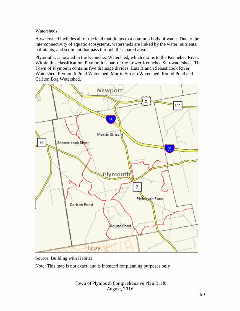
Town of Plymouth Comprehensive Plan Draft August, 2016 50
Watersheds
A watershed includes all of the land that drains to a common body of water. Due to the
interconnectivity of aquatic ecosystems, watersheds are linked by the water, nutrients,
pollutants, and sediment that pass through this shared area.
Plymouth,, is located in the Kennebec Watershed, which drains to the Kennebec River.
Within this classification, Plymouth is part of the Lower Kennebec Sub-watershed. The
Town of Plymouth contains five drainage divides: East Branch Sebasticook River
Watershed, Plymouth Pond Watershed, Martin Stream Watershed, Round Pond and
Carlton Bog Watershed.
Source: Building with Habitat
Note: This map is not exact, and is intended for planning purposes only
Town of Plymouth Comprehensive Plan Draft August, 2016 51
Groundwater
Groundwater occurs when precipitation permeates the soil, enters cracks and crevices
within the subsoil, and eventually settles in the bedrock, where it sits beneath the water
table. This ground water can then be tapped into for both residential and commercial
uses. Wells draw from permeable layers in the fractured bedrock and saturated soil.
Aquifers are geologic area where groundwater is prevalent and supported. Two types of
aquifers tend to be found in Maine: bedrock aquifers, and sand and gravel aquifers. Wells
in sand and gravel aquifers can produce upwards of 10 gallons per minute. Some sand
and gravel aquifers can reach production levels of 2,000 gallons per minute. Bedrock
aquifers generally yield between 2 and 25 gallons per minute.
Sand and Gravel Aquifers
Mapping from the Maine Department of Inland Fisheries and Wildlife’s Beginning with
Habitat database shows that two large sand and gravel aquifers are located in Plymouth.
The first is just south of Plymouth Pond. This aquifer is located between Moosehead
Trail and Loud Rd, it abuts the Plymouth Pond wetland area. The second main aquifer
extends north from Plymouth Pond near Rt. 7. This aquifer is located near the confluence
of Martin Stream and the Plymouth Bog. A third sand and gravel aquifer is located near
the junction of Lower Detroit Rd and Moosehead Trail. This aquifer is located near the
public water supply well at the Clifford Bottling Facility.
Bedrock Aquifers
Far less information is available related to Maine’s bedrock aquifers. Most residential
wells access bedrock aquifers to provide for their minimal water needs. A well 200 feet
deep that yields 2 gallons of water per minute will generally supply an adequate amount
of water for a residence.
Contamination
Contamination is possible in both sand and gravel aquifers and bedrock aquifers. Some
contamination sources include failing septic systems, road salt, industrial pollution, and
hazardous substances. The Town of Plymouth’s, past experience with contamination that
stemmed from Portland-Bangor Waste Oil Inc industrial activities, provide a warning
about the susceptibility of ground water to pollution. That being said; the activities
surrounding Plymouth Bog have had little effect on the public Plymouth Water District.
As of 2015, the Plymouth Water District’s test results reveal the radionuclides,
inorganics, microbiological, lead and copper levels are all well below the state’s
requirements.
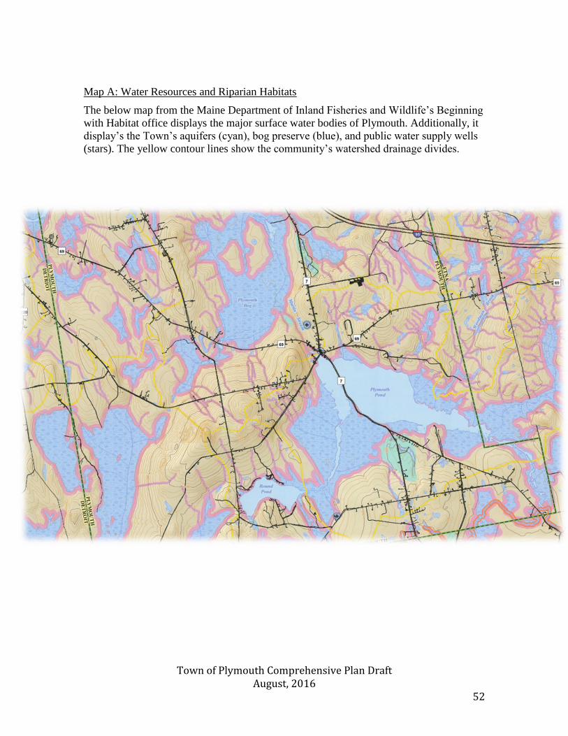
Town of Plymouth Comprehensive Plan Draft August, 2016 52
Map A: Water Resources and Riparian Habitats
The below map from the Maine Department of Inland Fisheries and Wildlife’s Beginning
with Habitat office displays the major surface water bodies of Plymouth. Additionally, it
display’s the Town’s aquifers (cyan), bog preserve (blue), and public water supply wells
(stars). The yellow contour lines show the community’s watershed drainage divides.

Town of Plymouth Comprehensive Plan Draft August, 2016 53
Map : Classifications of Rivers and Streams
The below map from the Maine Department of Environmental Protection displays all
water resources within the Town of Plymouth along with the classifications of Rivers and
Streams. Additonally, it list impaired waters that do not meet classisfication. The only
tributary within the Town of Plymouth boundary that’s identified as impaired is the East
Branch of the Sebasticook River.
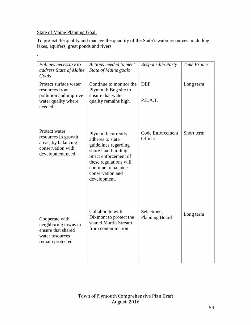
Town of Plymouth Comprehensive Plan Draft August, 2016 54
State of Maine Planning Goal:
To protect the quality and manage the quantity of the State’s water resources, including
lakes, aquifers, great ponds and rivers
.
Policies necessary to
address State of Maine
Goals
Actions needed to meet
State of Maine goals
Responsible Party Time Frame
Protect surface water
resources from
pollution and improve
water quality where
needed
Protect water
resources in growth
areas, by balancing
conservation with
development need
Cooperate with
neighboring towns to
ensure that shared
water resources
remain protected
Continue to monitor the
Plymouth Bog site to
ensure that water
quality remains high
Plymouth currently
adheres to state
guidelines regarding
shore land building.
Strict enforcement of
these regulations will
continue to balance
conservation and
development.
Collaborate with
Dixmont to protect the
shared Martin Stream
from contamination
DEP
P.E.A.T.
Code Enforcement
Officer
Selectmen,
Planning Board
Long term
Short term
Long term
Town of Plymouth Comprehensive Plan Draft August, 2016 55
Public Facilities and Services
Findings and Conclusions
-Plymouth currently enjoys high quality, local services such as fire protection, electricity,
water supply and trash removal.
-Increasing internet connectivity must remain a priority for the community, as high speed
internet is critical to economic growth.
Introduction
High quality Public Facilities are vital to the success of any community. These local
institutions provide key services that allow for a high quality of life, and increased
economic development. Plymouth has demonstrated its commitment to its public
facilities by judiciously planning its capital improvements and ensuring the satisfaction of
its residents.
Public Water System
Following the environmental damage caused by industrial activity within Plymouth, a
water district was created to ensure that private wells were not utilizing contaminated
aquifers. The Plymouth Water District currently serves approximately 60 customers. The
Water District uses radon removal and some chlorination to ensure that the drinking
water meets regulations. The Plymouth Water District has consistently exceeded the
Maine CDC’s water safety standards.
Sewage Disposal
The Town of Plymouth does not have a public sewer system. Residents utilize private
leach fields and septic tanks in order to dispose of waste.
Solid Waste Disposal
The Town of Plymouth currently contracts with Bolster’s Rubbish Removal for the
disposal of solid waste. The community’s contract allows for weekly roadside trash
pickup. Additionally, roadside recycling collection occurs once each month. The contract
for waste disposal is put out to bid on an annual basis, and has rotated between a number
of companies in recent years.
Storm Water Management
There is no piped storm water management system within Plymouth. Streets are drained
through existing culverts.
Town of Plymouth Comprehensive Plan Draft August, 2016 56
Public Education
Plymouth is a member of Regional School Unit #19, which also includes Corinna, Etna,
Hartland, Newport, Palmyra, and St. Albans. Plymouth’s students currently attend
Newport Elementary School, Sebasticook Middle School, and Nokomis Regional High
School. Some students also attend Etna-Dixmont School. In 2015, 194 students from
Plymouth were enrolled in RSU #19.
Plymouth is also home to a large number of families who have opted to homeschool their
children. Currently roughly 25 students are homeschooled within the community.
Law Enforcement
Plymouth does not have a local police force and instead contracts with regional law
enforcement agencies. Law enforcement is provided by the Penobscot County Sheriff and
the Maine State Police. Emergency calls are dispatched by the Penobscot County
Sheriff’s Bangor office, as well as through Maine State Police Troop E. The Penobscot
County Sheriff and the Maine State Police have divided the region into six rural patrol
areas. This subdivision ensures that contracting communities receive adequate coverage.
The Maine Department of Inland Fisheries and Wildlife’s Game Wardens also provide
service to Plymouth, and enforce policies within Plymouth’s Wildlife Management Area.
Fire Department
Plymouth is served by a volunteer fire department, which currently has 15 members.
Plymouth’s fire department is located along Lower Detroit Rd., near the intersection of
Moosehead Trail. The structure was built in the 1970s, and is comprised of four bays,
which house the Department’s three fire trucks. It is expected that upgrades to the fire
department’s facilities and equipment will be necessary in the upcoming years. In order
to account for these financial needs $12,136 has been allocated for the Department’s
capital projects.
Emergency Medical Services
The Plymouth Volunteer Fire Department provides emergency medical services to
residents of the community. The fire department has mutual aid agreements with
surrounding towns in order to ensure that Plymouth’s resident receive the best possible
protection and care. Additionally, Sebasticook Valley Hospital provides ambulance
services to the Plymouth community. Their team of on-call paramedics delivers critical
care to urgent patient needs. Sebasticook Valley Hospital is located in Pittsfield, roughly
10 miles from Plymouth. Advanced medical care and trauma services are provided by
Eastern Maine Medical Center in Bangor, which is roughly 30 miles from Plymouth.
Town of Plymouth Comprehensive Plan Draft August, 2016 57
Public Works Department
The Town’s road system is maintained by the Department of Public Works. Services that
are provided include winter snow removal, brush cutting, and replacement of culverts.
The Town’s Road Commissioner is elected on an annual basis, and is responsible for the
care and upkeep of the community’s roads. The Town is responsible for approximately
27 miles of roads.
Public Library
There is no public library within Plymouth; however public libraries are located in both
Newport and Carmel. Many Plymouth residents utilize the Newport Library for a small
fee.
Town Office
The Town Office is located along Moosehead Trail, near Plymouth Pond. The building is
home to the U.S. Post Office, as well as the Town Clerk’s office. The space is a former
school house, and is an important historic landmark for community members. Regular
Selectmen meetings are held in the building. Plans have been discussed regarding the
moving of the Town Office to a new facility, and converting the current building into a
historical society or museum.
Larger community meetings are held in the Town Grange, which includes a small stage.
This community gathering place is also of historic importance to the community.
Town Administration
The government of the Town of Plymouth has been formed in accordance with Maine
State laws. The community is governed through the Town Meeting model of government.
Citizens assemble annually to discuss town-wide concerns, and to vote on town business
matters such as the annual budget. Members of the Board of Selectmen are elected
annually on the day prior to the Town Meeting.
Plymouth’s Board of Selectmen is comprised of three members. Each member is elected
to a one year term. The Board of Selectmen meets regularly to handle all regular Town
business. The Selectmen also serve as assessors and overseers of the poor. Additionally, the Town is governed by a Planning Board. This body make all
determinations related to community zoning and building.
Communication
Electricity is provided by Central Maine Power’s transmission system, which
accommodates the community’s energy needs. Cellular telephone service is available.
Plymouth’s close proximity to I-95 and Maine’s Three Ring Binder Broadband Network,
allows all residents to access the internet. Portions of the community that lie to the north

Town of Plymouth Comprehensive Plan Draft August, 2016 58
of Plymouth Pond have access to high speed internet, while those who live south of
Plymouth Pond have a weaker connection. Plans are currently being formed to extend
high speed internet to the entire community, in a way that is both efficient and preserves
the scenic beauty of Plymouth. Internet connection is provided by OTT communications

Town of Plymouth Comprehensive Plan Draft August, 2016 59
Map A: Plymouth Infrastructure
Town of Plymouth Comprehensive Plan Draft August, 2016 60
State of Maine Planning Goal:
To plan for finance and develop an efficient system of public facilities and services to
accommodate anticipated growth and economic development.
Policies necessary to
address State of
Maine Goals
Actions needed to meet
State of Maine goals
Responsible Party Time Frame
Efficiently meet
identified public
service needs
Provide public
facilities that promotes
growth and
development in certain
geographic areas
Continue to supply
services in a
financially responsible
manner
Solidify internet
connectivity, to allow
the entire town to
benefit from high
speed access
Continue to maintain a
list of potential capital
improvement projects,
and ensure that they are
incorporated into the
Town’s annual budget.
Locate new public
facilities in areas which
will foster a tight knit
community
Collaborate with
surrounding
communities to explore
additional opportunities
for shared services.
Meet with OTT
officials to determine
the most aesthetically
pleasing and
technologically
efficient manner to
connect southern
Plymouth with internet
Selectmen
Selectmen,
Planning Board
Selectmen
Selectmen,
Planning Board
Short term
Long term
Ongoing
Short term
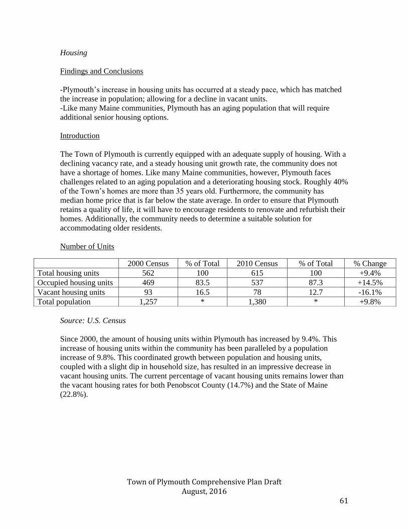
Town of Plymouth Comprehensive Plan Draft August, 2016 61
Housing
Findings and Conclusions
-Plymouth’s increase in housing units has occurred at a steady pace, which has matched
the increase in population; allowing for a decline in vacant units.
-Like many Maine communities, Plymouth has an aging population that will require
additional senior housing options.
Introduction
The Town of Plymouth is currently equipped with an adequate supply of housing. With a
declining vacancy rate, and a steady housing unit growth rate, the community does not
have a shortage of homes. Like many Maine communities, however, Plymouth faces
challenges related to an aging population and a deteriorating housing stock. Roughly 40%
of the Town’s homes are more than 35 years old. Furthermore, the community has
median home price that is far below the state average. In order to ensure that Plymouth
retains a quality of life, it will have to encourage residents to renovate and refurbish their
homes. Additionally, the community needs to determine a suitable solution for
accommodating older residents.
Number of Units
Source: U.S. Census
Since 2000, the amount of housing units within Plymouth has increased by 9.4%. This
increase of housing units within the community has been paralleled by a population
increase of 9.8%. This coordinated growth between population and housing units,
coupled with a slight dip in household size, has resulted in an impressive decrease in
vacant housing units. The current percentage of vacant housing units remains lower than
the vacant housing rates for both Penobscot County (14.7%) and the State of Maine
(22.8%).
2000 Census % of Total 2010 Census % of Total % Change
Total housing units 562 100 615 100 +9.4%
Occupied housing units 469 83.5 537 87.3 +14.5%
Vacant housing units 93 16.5 78 12.7 -16.1%
Total population 1,257 * 1,380 * +9.8%
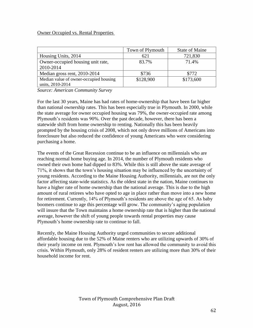
Town of Plymouth Comprehensive Plan Draft August, 2016 62
Owner Occupied vs. Rental Properties
Town of Plymouth State of Maine
Housing Units, 2014 621 721,830
Owner-occupied housing unit rate,
2010-2014
83.7% 71.4%
Median gross rent, 2010-2014 $736 $772 Median value of owner-occupied housing
units, 2010-2014 $128,900 $173,600
Source: American Community Survey
For the last 30 years, Maine has had rates of home-ownership that have been far higher
than national ownership rates. This has been especially true in Plymouth. In 2000, while
the state average for owner occupied housing was 79%, the owner-occupied rate among
Plymouth’s residents was 90%. Over the past decade, however, there has been a
statewide shift from home ownership to renting. Nationally this has been heavily
prompted by the housing crisis of 2008, which not only drove millions of Americans into
foreclosure but also reduced the confidence of young Americans who were considering
purchasing a home.
The events of the Great Recession continue to be an influence on millennials who are
reaching normal home buying age. In 2014, the number of Plymouth residents who
owned their own home had dipped to 83%. While this is still above the state average of
71%, it shows that the town’s housing situation may be influenced by the uncertainty of
young residents. According to the Maine Housing Authority, millennials, are not the only
factor affecting state-wide statistics. As the oldest state in the nation, Maine continues to
have a higher rate of home ownership than the national average. This is due to the high
amount of rural retirees who have opted to age in place rather than move into a new home
for retirement. Currently, 14% of Plymouth’s residents are above the age of 65. As baby
boomers continue to age this percentage will grow. The community’s aging population
will insure that the Town maintains a home ownership rate that is higher than the national
average, however the shift of young people towards rental properties may cause
Plymouth’s home ownership rate to continue to fall.
Recently, the Maine Housing Authority urged communities to secure additional
affordable housing due to the 52% of Maine renters who are utilizing upwards of 30% of
their yearly income on rent. Plymouth’s low rent has allowed the community to avoid this
crisis. Within Plymouth, only 28% of resident renters are utilizing more than 30% of their
household income for rent.
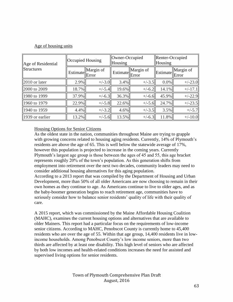
Town of Plymouth Comprehensive Plan Draft August, 2016 63
Age of housing units
Age of Residential
Structures
Occupied Housing Owner-Occupied
Housing
Renter-Occupied
Housing
Estimate Margin of
Error Estimate
Margin of
Error Estimate
Margin of
Error
2010 or later 2.9% +/-3.0 3.4% +/-3.5 0.0% +/-23.0
2000 to 2009 18.7% +/-5.4 19.6% +/-6.2 14.1% +/-17.1
1980 to 1999 37.9% +/-6.3 36.3% +/-6.6 45.9% +/-22.9
1960 to 1979 22.9% +/-5.8 22.6% +/-5.6 24.7% +/-23.5
1940 to 1959 4.4% +/-3.2 4.6% +/-3.5 3.5% +/-5.7
1939 or earlier 13.2% +/-5.6 13.5% +/-6.3 11.8% +/-10.0
Housing Options for Senior Citizens
As the oldest state in the nation, communities throughout Maine are trying to grapple
with growing concerns related to housing aging residents. Currently, 14% of Plymouth’s
residents are above the age of 65. This is well below the statewide average of 17%,
however this population is projected to increase in the coming years. Currently
Plymouth’s largest age group is those between the ages of 45 and 55, this age bracket
represents roughly 20% of the town’s population. As this generation shifts from
employment into retirement over the next two decades, community leaders may need to
consider additional housing alternatives for this aging population.
According to a 2013 report that was compiled by the Department of Housing and Urban
Development, more than 50% of all older Americans are now choosing to remain in their
own homes as they continue to age. As Americans continue to live to older ages, and as
the baby-boomer generation begins to reach retirement age, communities have to
seriously consider how to balance senior residents’ quality of life with their quality of
care.
A 2015 report, which was commissioned by the Maine Affordable Housing Coalition
(MAHC), examines the current housing options and alternatives that are available to
older Mainers. This report had a particular focus on the requirements of low-income
senior citizens. According to MAHC, Penobscot County is currently home to 45,400
residents who are over the age of 55. Within that age group, 14,400 residents live in low-
income households. Among Penobscot County’s low income seniors, more than two
thirds are affected by at least one disability. This high level of seniors who are affected
by both low incomes and health-related conditions increases the need for assisted and
supervised living options for senior residents.
Town of Plymouth Comprehensive Plan Draft August, 2016 64
The MAHC has proposed four options for low-income seniors which allow them to
remain in their communities, while also receiving adequate health care. The first is the
creation of home modification funding programs. While no such program currently exists
in Maine, in Massachusetts a state-funded program currently allows low income seniors
to access government-funded loans of up to $30,000 for modifications such as wheelchair
ramps or wider doors. The second option is through attaining waivers for Medicaid Home
and Community Based Services (HCBS). This waiver system allows seniors who are
eligible for institutional services to access Medicaid-funded services in their home. These
waivers have been available to Maine Care enrollees since 1994, and the Maine
Department of Health and Human Services is currently reviewing plans to further expand
this program. The third option is the creation of Villages, which allow seniors in a small
geographic area to access shared services in their own homes through a community
network. This model of senior care typically depends on volunteer coordinators, and
membership in a Village requires dues that may exceed $500/year. Grants and other
financial assistance can make Villages more affordable for low income seniors. The final
option is the utilization of property tax and utility rate reduction programs. Through this
model, senior citizens are eligible to receive up to $900 in credit toward their property tax
bill. Under a previous Maine program, which was in effect until 2013, seniors could
receive credits of up to $2,000. This program is especially helpful for seniors who have
already paid off their mortgage, but are struggling to deal with the cost of maintaining
their home.
MAHC also proposes options for communities who would like to increase the
institutional options for aging residents who would like to stay in their community, but
can no longer stay in their home. The main option presented is co-housing. This
affordable solution houses seniors in smaller residences around a common area. This
creates a space that is accessible for residents and supervised by live in staff members.
While the overall price to residents may be equal to traditional home costs, this option
allows decreased costs for housekeeping, nursing, and other services.
Residents of Plymouth have a deep urge to create affordable housing options, which will
allow seniors to remain in the community. By offering such housing, the Town will be
able to retain its multi-generational character. Such a facility would also increase seniors
quality of life, by allowing them to stay close to family, friends, and activities, rather than
moving to facilities in Newport or Bangor. Residents believe that a former group home
facility along Moosehead Trail would offer an ideal setting for the creation of a co-
housing facility.
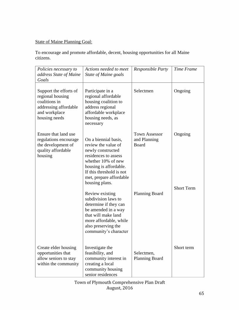
Town of Plymouth Comprehensive Plan Draft August, 2016 65
State of Maine Planning Goal:
To encourage and promote affordable, decent, housing opportunities for all Maine
citizens.
Policies necessary to
address State of Maine
Goals
Actions needed to meet
State of Maine goals
Responsible Party Time Frame
Support the efforts of
regional housing
coalitions in
addressing affordable
and workplace
housing needs
Ensure that land use
regulations encourage
the development of
quality affordable
housing
Create elder housing
opportunities that
allow seniors to stay
within the community
Participate in a
regional affordable
housing coalition to
address regional
affordable workplace
housing needs, as
necessary
On a biennial basis,
review the value of
newly constructed
residences to assess
whether 10% of new
housing is affordable.
If this threshold is not
met, prepare affordable
housing plans.
Review existing
subdivision laws to
determine if they can
be amended in a way
that will make land
more affordable, while
also preserving the
community’s character
Investigate the
feasibility, and
community interest in
creating a local
community housing
senior residences
Selectmen
Town Assessor
and Planning
Board
Planning Board
Selectmen,
Planning Board
Ongoing
Ongoing
Short Term
Short term
Town of Plymouth Comprehensive Plan Draft August, 2016 66
Land Use Findings and Conclusions: -Preservation of the rural character of Plymouth is a chief consideration when discussing land use policy. - Plymouth population has declined 0.9 percent since 2009 and is only expected to increase by 0.4 percent by 2034. Introduction: Plymouth is a rural community composed of residences, small farms, and a small village center. Plymouth’s early economy included manufacturing, forestry, and agriculture. Most of early community economic drivers no longer exist. The town now acts as a bedroom community for Bangor, Waterville, and Belfast. Most commerce occurs outside of town, with the exception of the Plymouth Village Store. The town of Plymouth will plan for its future needs based on past trends and design policies based on the character of the community. Agricultural Land Use Over the past few decades the agricultural industry within Plymouth has steadily declined. Farms that once lined Moosehead Trail and Clark Rd, have since been replaced by gravel pits. This is due to individuals using lots for best and most practical uses. However, small scale agriculture has seen a slight uptick. Some residents are turning to small scale agriculture to provide a variety of crops for themselves and the local community. Most land use is miscellaneous crop farms. These farms are dispersed throughout the community. In 2016, there were only two parcels that were registered under the Maine State Farmlands Tax Program. One parcel was comprised of 70 Acres of land, while the second parcel is made up of 45 acres. Commercial Land & Industrial Land Use There is no cluster of commercial or industrial areas in Plymouth. There are a scattering of commercial and home businesses throughout the community. Historically, Plymouth was dominated by the presence of manufacturing mills. Today, there is no use of land that would be considered industrial. Over the next 10 years, Plymouth will continue to be a bedroom community with no new industrial or commercial clusters.
Town of Plymouth Comprehensive Plan Draft August, 2016 67
Village Land Use Plymouth has a small traditional village that services the basic needs of the community as well as hunters, anglers, boaters, snowmobilers, etc. The village includes a post office, town office, fire station, grange hall, convenience store, and Diner. Public Property Most of Plymouth’s public property is located in village area. Properties include the municipal building, fire station, playground, grange hall, and sand and salt storage. Additionally, the town owns a number of cemeteries, a boat landing, and EPA Superfund site. There is also a tax acquired unbuildable lot located near Martin Stream off Moosehead Trail/Rte. 7. Land Use Regulations: To management development there is in minimum lot requirement of 80,000 square feet, subdivision regulations, shore land zoning ordinance, and floodplain management ordinance. To administer these ordinances there is an appointed five (5) member planning board and a part time certified code enforcement officer. The capacity of those involved with planning has been adequate. Subdivision Regulations The current Subdivision regulations were adopted by the Planning Board in March 1974 and most recently amended in 2009. In addition to the review criteria contained in the State Subdivision law, it has additional standards including the Shoreland Zoning Ordinance and the newly adopted Ordinance Regulating Solid Waste Facilities. Plymouth’s Shoreland Zoning Ordinance applies to all land areas within 250 feet, horizontal distance, of the normal high-waterline of any great pond or river, or upland edge of the freshwater wetland, and all land areas within 75 feet, horizontal distance, of the normal high-water line of the stream. The ordinance was adopted in 2015 and follows the current state minimum guidelines. A copy of the Shoreland Zoning map is located at the end of this section. Three (3) districts have been established in the ordinance including: Resource Protection, Limited Residential, and Stream Protection. The three districts are also officially identified on each of the communities Official Shoreland Zoning map. The zones are described as follows:
Town of Plymouth Comprehensive Plan Draft August, 2016 68
• Resource Protection: Areas where development would jeopardize significant natural
scenic, recreational and historic resources, including but not limited to flood plains,
precipitous slopes, wildlife habitat, and other areas critical to the ecology of the region
of state.
• Limited Residential: Areas suitable for residential and recreational development.
• Stream Protection: This district generally includes areas within 100ft of streams.
The Ordinance Regulating Solid Waste Facilities governs all land and all structures within the boundaries of the Town of Plymouth. The purpose of the ordinance is to protect the health and safety of the residents of the Town of Plymouth; to enhance and maintain the quality of the environment; to conserve natural resources; and to prevent water, air and land pollution through regulation of storage and land applications of municipal and industrial wastewater treatment plant sludge and other residuals, and septage. Floodplain Management Ordinance Plymouth participates in the National Flood Insurance Program and has enacted a Floodplain Management Ordinance. The ordinance complies with the requirements of the National Floodplain Insurance Program. The Ordinance is administered by the Code Enforcement Officer. Since the ordinance was adopted in 2014, there have been no claims. Minimum Lot Size and Set Backs The Minimum sizes for lots upon which structure are to be placed is 80,000 square feet. The minimum front setback is 58 feet, measured from the road centerline and 15 feet from other lot lines. Land Use Analysis The residents of Plymouth believe that the town has been striking the right balance. Plymouth is ideally located for a bedroom community that supports Bangor, Belfast, and Waterville communities. In addition, its country living makes this an ideal place for those who work in urban setting but cherish a rural quality of life. Current population growth has been in decline over the past 5 years. Consequently, there has been little interest in, and no pressure for residential, commercial, or industrial development. The Town is currently equipped with an adequate supply of housing. With a declining vacancy rate, and a steady housing unit growth rate, the community does not have a shortage of homes. However, the aging population and older housing stocks could lead to added expenses and a need for additional town services. The map of current land uses and lack of development pressure allows town officials to effectively maintain existing land uses and prepare and plan for
Town of Plymouth Comprehensive Plan Draft August, 2016 69
future land uses by prioritizing those areas of the community which are best suited for residential, commercial, industrial, agricultural, forestry, and public uses in the future. Plymouth has also identified other areas as seen as the development constraints map where little or no growth should be encouraged, such as prime forest lands, wetland areas, areas of endangered natural resources, aquifers, etc. One area the community would like to discourage development is the village center. Ideally, the community would like to preserve the small number of historical buildings and limit further growth. Since there is ample room for additional growth, and little to no growth is anticipated, it will be important to target existing growth in areas that accommodate development and preserve rural resources. To accomplish this, the town has created standards for development along the scenic corridors, Plymouth Pond, Round Pond, and community ridge lines. Additionally, Plymouth will be looking to provide incentives to landowners to keep large parcels of land for farming. Residents and town officials have sought to build a plan based on what the community sees for the future of Plymouth. It is intended guide the town in future community decisions over the next 10 years.
Town of Plymouth Comprehensive Plan Draft August, 2016 70
State of Maine goal plan that needs to be addressed: To encourage orderly growth and development in appropriate areas of each community, while protecting the state’s rural character, making efficient use of public services, and preventing development sprawl
Policies Necessary to address State of Maine
Goals
Action strategies necessary to address State of Maine Goals
Implementation Responsibility
Time Frame
Coordinate land use strategies with other local and regional land use planning efforts. Support the locations, types, scales, of land uses desired in the vision for Plymouth Support the level of financial commitment to provide needed infrastructure. Maintain efficient permitting procedures. Protect critical rural areas from impacts of development.
Meet with neighboring communities to coordinate land use designations and learn about regulatory strategies. Coordinate with communities to provide emergency services, food banks, land preservation standards, and trail system maintenance agreement s for outdoor recreation. Prepare recommendations to current land ordinances and consider adoptions of new land management ordinances that include: voluntary land use strategy, identify growth and rural areas, updating site and subdivision ordinances, and road repair recommendations Budget a Capital Investment Plan anticipated to support proposed land use Employ a code enforcement officer who is certified in accordance with 30-A MRSA § and provide him/her with tools, training, support, necessary to enforce the land regulations Periodically evaluate implementation of this plan as outlined in the plan evaluations element.
Planning Board Planning Board Selectmen Selectmen Selectman Code Enforcement Officer Code Enforcement Officer
Ongoing Short Term & Ongoing Long term & ongoing Long Term & Ongoing Ongoing Ongoing Ongoing
Town of Plymouth Comprehensive Plan Draft August, 2016 71
Future Land Use Policies and Strategies: The Town intends to maintain the community’s rural character by encouraging orderly development in appropriate areas of town, while protecting open space, forest, agricultural land, and critical natural resources. Based on 2014 census estimates, Plymouth population since 2009 has declined 0.9 percent. The Comprehensive Plan Committee has concluded that the Town of Plymouth is exempt from identifying growth areas in its Future Land Use Plan based on the Criteria for Growth Area Exemptions due to minimal or no growth, as follows: (1) Residential The population of Plymouth was 1343 in 2007 and the current population is 1388. This is an increase of only 3.3% which is well below the threshold of 5% listed in the criteria. Since 2007, Plymouth has had 27 new housing starts. Again, this is well below the criteria threshold of 50. (2) Commercial/ Institutional No change in the last ten years. (3)Industrial No change in the last ten years. The Maine State Economist’s population projections for Plymouth projections support Plymouth’s status as a minimal or no-growth community, as defined in the Comprehensive Plan Review Criteria Rules. Therefore, the Plymouth Comprehensive Plan Committee has developed the Plymouth Plan on the basis of a Growth Area Exemption. Therefore, the Town will not be identifying future growth areas at this time, but will continue to monitor the anticipated growth trends and prepare accordingly.

Town of Plymouth Comprehensive Plan Draft August, 2016 72
Public Participation
The Plymouth Comprehensive Plan was performed by relying on input from residents
through a series of public outreach activities to assure that the vision and future planning
were shaped by a broad cross-section of Plymouth’s population. Leading the public
participation effort was an eleven (11) member Comprehensive Planning Committee.
The committee met regularly to update the Comprehensive Plan; the process included an
aggressive approach for engaging residents in the public participation activities to have
their voices heard.
A community-wide survey was developed with the assistance of Eastern Maine
Development Corporation to ask a series of questions to determine:
• Satisfaction with the quality of life/living in Plymouth Maine
• Benefits of living in Plymouth (i.e., cost of living, caring community, access to
medical and social services, education, etc.)
• Disadvantages for living in Plymouth (i.e., property taxes, lack of housing, low
population growth, quality of streets and roads, etc.)
• Assessment of the quality of life (better, same, worse)
• Satisfaction with economic growth
• Identification of preferences for economic development and community
improvements
• Ranking (satisfied or dissatisfied) of services and community characteristics)
• Preferences for communications regarding community meetings or news
In addition to these questions, the survey encouraged participants to share additional
comments. The survey was mailed to approximately 800 individual households with
prepaid postage return envelopes, and an electronic version was also posted on the
Plymouth’s town web site. In all 295 responded which represents 35% of the total
households.
The priorities, preferences, and challenges identified through the public participation
opportunities are reflected in the Comprehensive Plan and served to frame Plymouth’s
vision for the future. The Town intends on holding a meeting and adopting the plan after
the state reviews and finds the plan complete and consistent with Maine’s Growth
Management Act.
Town of Plymouth Comprehensive Plan Draft August, 2016 73
Regional coordination: Plymouth currently partners with neighboring communities which is discussed in multiple chapters throughout the comprehensive plan. This collaboration has allowed Plymouth to share costs while maintaining public services. The primary areas of service include transportation, public education, law enforcement, and housing. Additionally, Plymouth continues to coordinate with neighboring communities to provide emergency services, food banks, land preservation standards, and trail system maintenance agreement s for outdoor recreation. The town will continue to meet with neighboring communities to discuss current service agreements, coordinate land use designations, and learn about regulatory strategies. Plymouth falls under the jurisdiction of Eastern Maine’s Comprehensive Economic Development Strategy (CEDS). This regional development plan is reviewed by the Economic Development Administration, and maintained by Eastern Maine Development Corporation. Key portions of this plan include increasing entrepreneurs’ access to capital, while further promoting the importance of education to meet the demands of a 21st century economy. Plymouth intends to use EMDC as a resource when opportunities to share costs with neighboring communities exist. The town also expects to consult with EMDC when implementing parts of the comprehensive plans require federal and state funding.
Plymouth is a small community with declining population and limited financial resources. The town recognizes the importance continuing to work with our community neighbors and economic development partners. Plymouth will continue to look for community partnerships in:
✓ Recycle additional materials ✓ Keep ponds open and clean
✓ Expand trail systems for walking, snowmobiles, cross country ✓ Animal control services ✓ Historical preservation
✓ Volunteer Fire Department ✓ Road side garbage pickup ✓ Protect ground water ✓ Public and health safety ✓ Elderly housing
These are just some examples where collaboration will be a priority.