Embed Size (px)
Citation preview
Transportation Master PlanTOWN OF SAUGEEN SHORES
1
Town of Saugeen Shores
Transportation Master Plan
PUBLIC INFORMATION CENTRE
Saugeen Shores Community Complex Rotary Hall
600 Tomlinson Drive, Port ElginWednesday, August 7, 2019
4:00 pm to 8:00 pm
Transportation Master PlanTOWN OF SAUGEEN SHORES
2
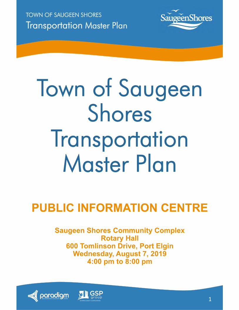
WELCOME!The purpose our PIC today is to:
Review the work completed on the study (so far) Summarize community and stakeholder input received to date Present the recommended directions for the Transportation
Master Plan Explain the next steps in the process Invite and receive your feedback
Please pick-up a comment sheet!
We encourage you to use the sheet provided to record any comments on the material presented today. Specific items where your input is requested are denoted by:
Questions?
Feel free to ask any member of our project team in attendance. We are happy to assist!
1
Question Number on Comment Sheet
Transportation Master PlanTOWN OF SAUGEEN SHORES
3
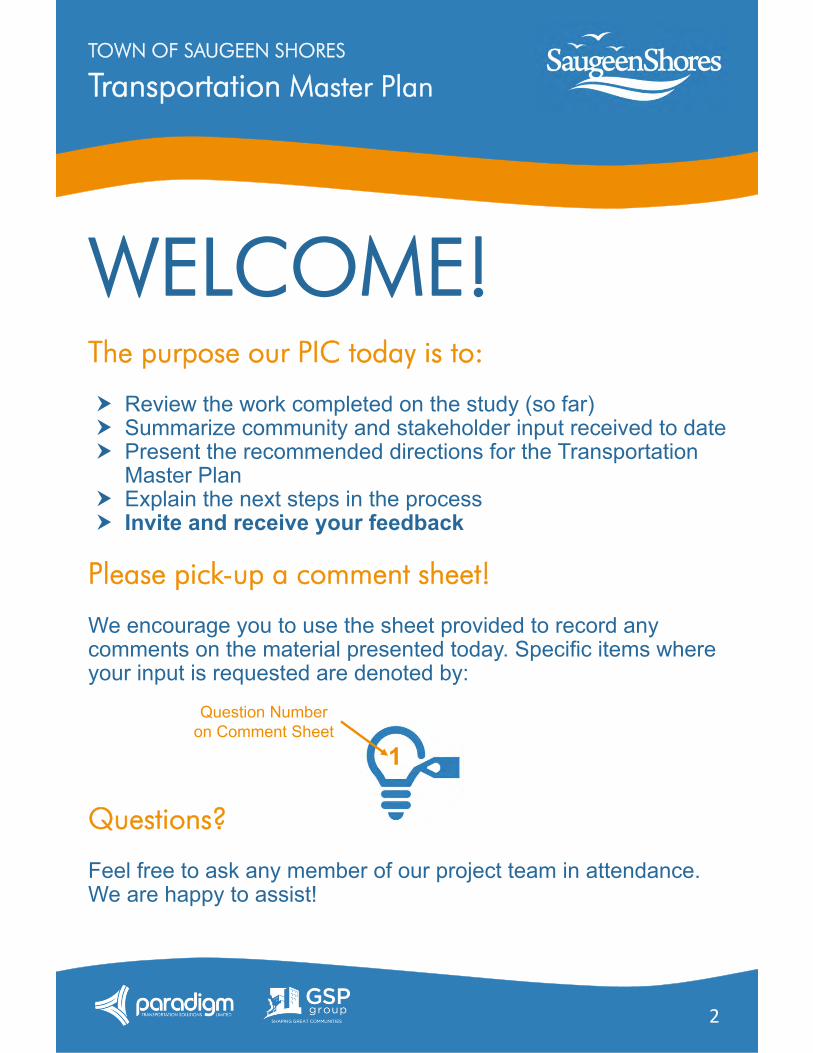
Study BackgroundWhat is the Transportation Master Plan?
The Town of Saugeen Shores Transportation Master Plan (TMP) will direct how we grow responsibly with our Town's Official Plan and examine current transportation issues within our community. The plan will also:
Assess existing and future growth patterns Determine the need for improvements Establish policies around a needed transportation network
Study Process
Municipal Class Environmental Assessment
The study is following the requirements of the Municipal Class Environmental Assessment and will address the first two phases of this approved planning process.
Stage 1:Establish Vision and Context
Stage 2:Identify the Opportunities
Stage 3:Develop Strategies
Stage 4:Prepare Transportation Master Plan
We are here
Transportation Master PlanTOWN OF SAUGEEN SHORES
4
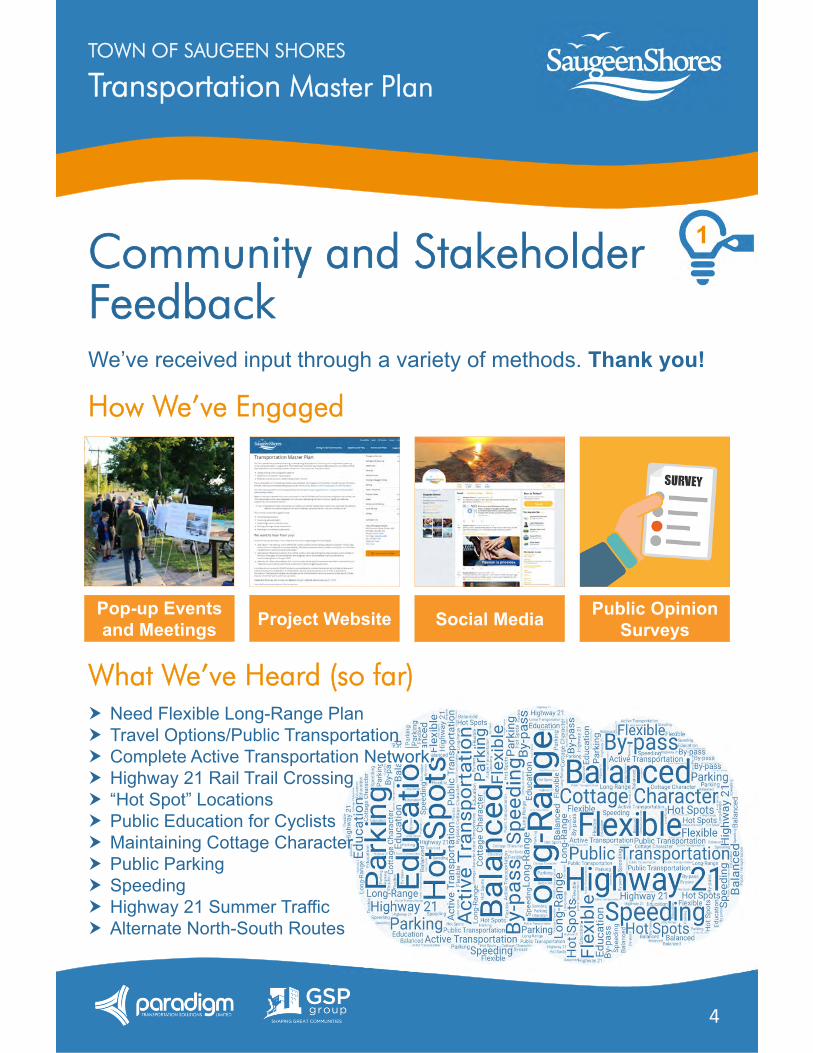
Community and Stakeholder FeedbackWe’ve received input through a variety of methods. Thank you!
How We’ve Engaged
What We’ve Heard (so far)
Pop-up Events and Meetings Project Website Social Media Public Opinion
Surveys
Need Flexible Long-Range Plan Travel Options/Public Transportation Complete Active Transportation Network Highway 21 Rail Trail Crossing “Hot Spot” Locations Public Education for Cyclists Maintaining Cottage Character Public Parking Speeding Highway 21 Summer Traffic Alternate North-South Routes
1
Transportation Master PlanTOWN OF SAUGEEN SHORES
5
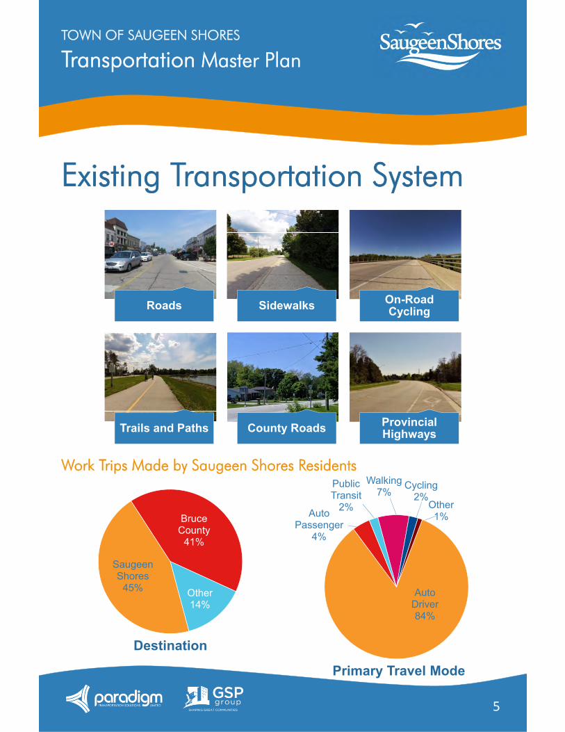
Existing Transportation System
Work Trips Made by Saugeen Shores Residents
Roads Sidewalks On-Road Cycling
Trails and Paths County Roads Provincial Highways
Saugeen Shores
45%
Bruce County
41%
Other14%
Destination
Primary Travel Mode
Auto Driver84%
Auto Passenger
4%
Public Transit
2%
Walking7%
Cycling2%
Other1%
Transportation Master PlanTOWN OF SAUGEEN SHORES
6
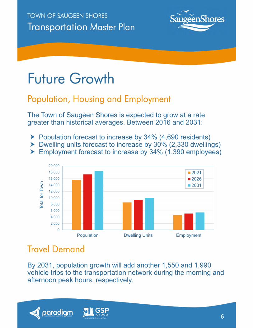
Future GrowthPopulation, Housing and Employment
The Town of Saugeen Shores is expected to grow at a rate greater than historical averages. Between 2016 and 2031:
Population forecast to increase by 34% (4,690 residents) Dwelling units forecast to increase by 30% (2,330 dwellings) Employment forecast to increase by 34% (1,390 employees)
Travel Demand
By 2031, population growth will add another 1,550 and 1,990 vehicle trips to the transportation network during the morning and afternoon peak hours, respectively.
0
2,000
4,000
6,000
8,000
10,000
12,000
14,000
16,000
18,000
20,000
Population Dwelling Units Employment
Tota
l for
Tow
n
Chart Title
202120262031
Transportation Master PlanTOWN OF SAUGEEN SHORES
7
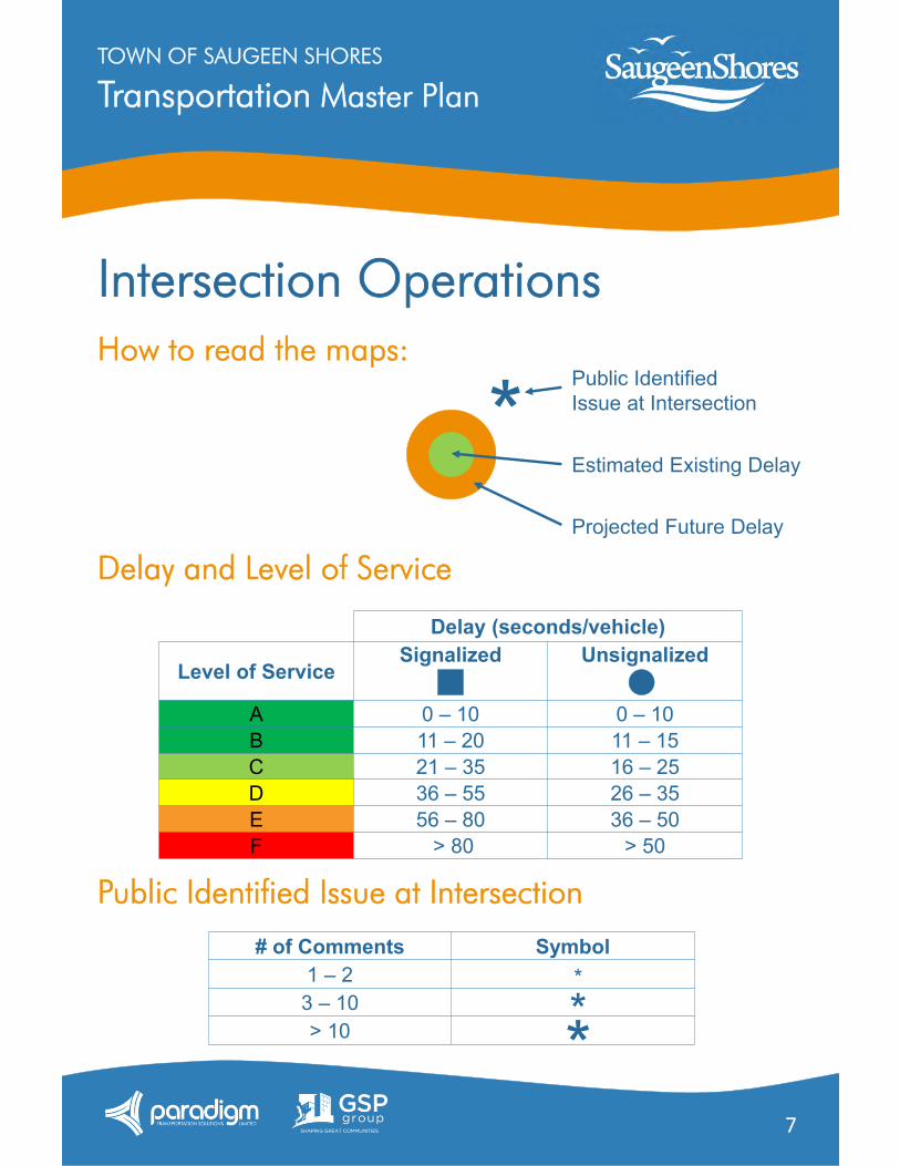
Intersection OperationsHow to read the maps:
Delay and Level of Service
Public Identified Issue at Intersection
Delay (seconds/vehicle)
Level of ServiceSignalized Unsignalized
A 0 – 10 0 – 10B 11 – 20 11 – 15C 21 – 35 16 – 25D 36 – 55 26 – 35E 56 – 80 36 – 50F > 80 > 50
* Public Identified Issue at Intersection
Estimated Existing Delay
Projected Future Delay
# of Comments Symbol1 – 2
3 – 10> 10
*
**
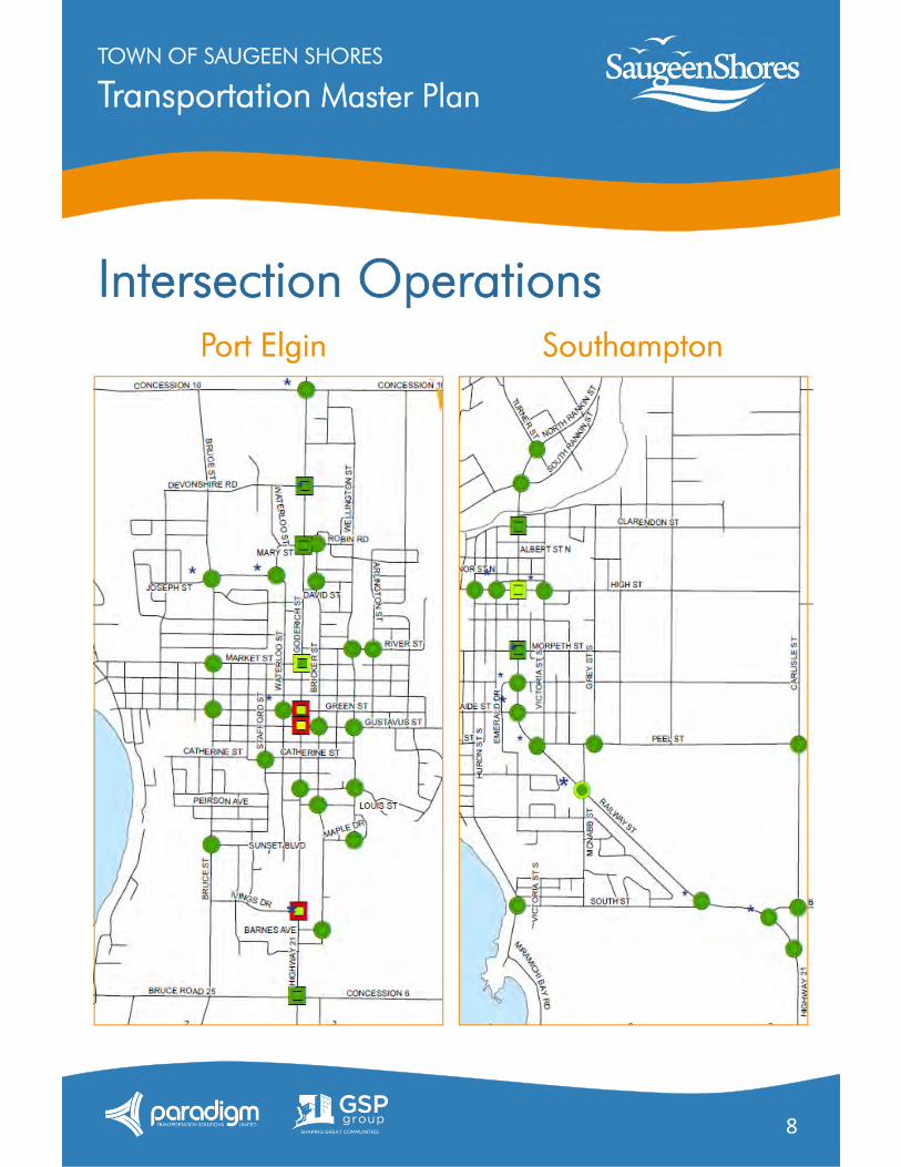
Transportation Master PlanTOWN OF SAUGEEN SHORES
8
Intersection OperationsSouthamptonPort Elgin
Transportation Master PlanTOWN OF SAUGEEN SHORES
9
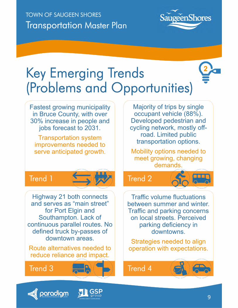
Key Emerging Trends(Problems and Opportunities)
Fastest growing municipality in Bruce County, with over
30% increase in people and jobs forecast to 2031.Transportation system
improvements needed to serve anticipated growth.
Trend 1
Majority of trips by single occupant vehicle (88%).
Developed pedestrian and cycling network, mostly off-
road. Limited public transportation options.
Mobility options needed to meet growing, changing
demands.
Trend 2
Highway 21 both connects and serves as “main street”
for Port Elgin and Southampton. Lack of
continuous parallel routes. No defined truck by-passes of
downtown areas.Route alternatives needed to reduce reliance and impact.
Trend 3
Traffic volume fluctuations between summer and winter. Traffic and parking concerns on local streets. Perceived
parking deficiency in downtowns.
Strategies needed to align operation with expectations.
Trend 4
2
Transportation Master PlanTOWN OF SAUGEEN SHORES
10
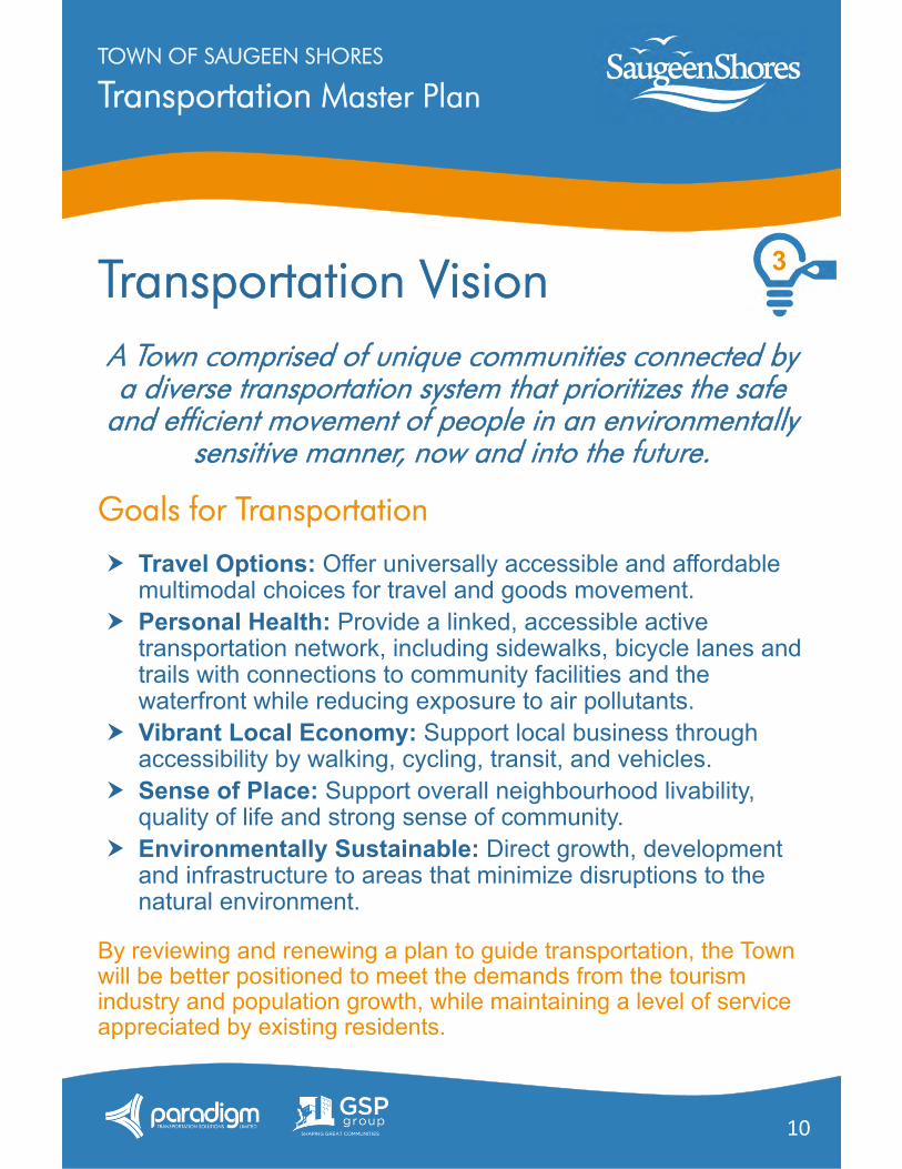
Transportation VisionA Town comprised of unique communities connected by a diverse transportation system that prioritizes the safe
and efficient movement of people in an environmentally sensitive manner, now and into the future.
Goals for Transportation
Travel Options: Offer universally accessible and affordable multimodal choices for travel and goods movement.
Personal Health: Provide a linked, accessible active transportation network, including sidewalks, bicycle lanes and trails with connections to community facilities and the waterfront while reducing exposure to air pollutants.
Vibrant Local Economy: Support local business through accessibility by walking, cycling, transit, and vehicles.
Sense of Place: Support overall neighbourhood livability, quality of life and strong sense of community.
Environmentally Sustainable: Direct growth, development and infrastructure to areas that minimize disruptions to the natural environment.
By reviewing and renewing a plan to guide transportation, the Town will be better positioned to meet the demands from the tourism industry and population growth, while maintaining a level of service appreciated by existing residents.
3
Transportation Master PlanTOWN OF SAUGEEN SHORES
11
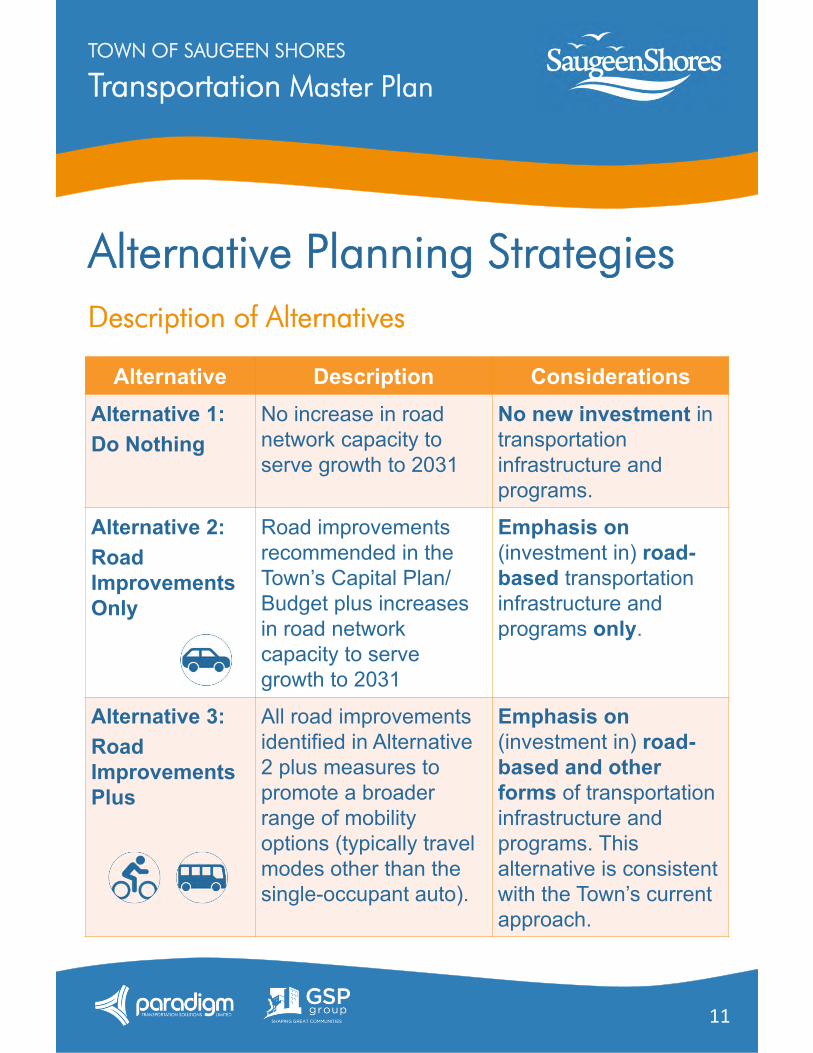
Alternative Planning StrategiesDescription of Alternatives
Alternative Description ConsiderationsAlternative 1:Do Nothing
No increase in road network capacity to serve growth to 2031
No new investment in transportation infrastructure and programs.
Alternative 2:Road Improvements Only
Road improvements recommended in the Town’s Capital Plan/ Budget plus increases in road network capacity to serve growth to 2031
Emphasis on(investment in) road-based transportation infrastructure and programs only.
Alternative 3:Road Improvements Plus
All road improvements identified in Alternative 2 plus measures to promote a broader range of mobility options (typically travel modes other than the single-occupant auto).
Emphasis on (investment in) road-based and other forms of transportation infrastructure and programs. This alternative is consistent with the Town’s current approach.
Transportation Master PlanTOWN OF SAUGEEN SHORES
12
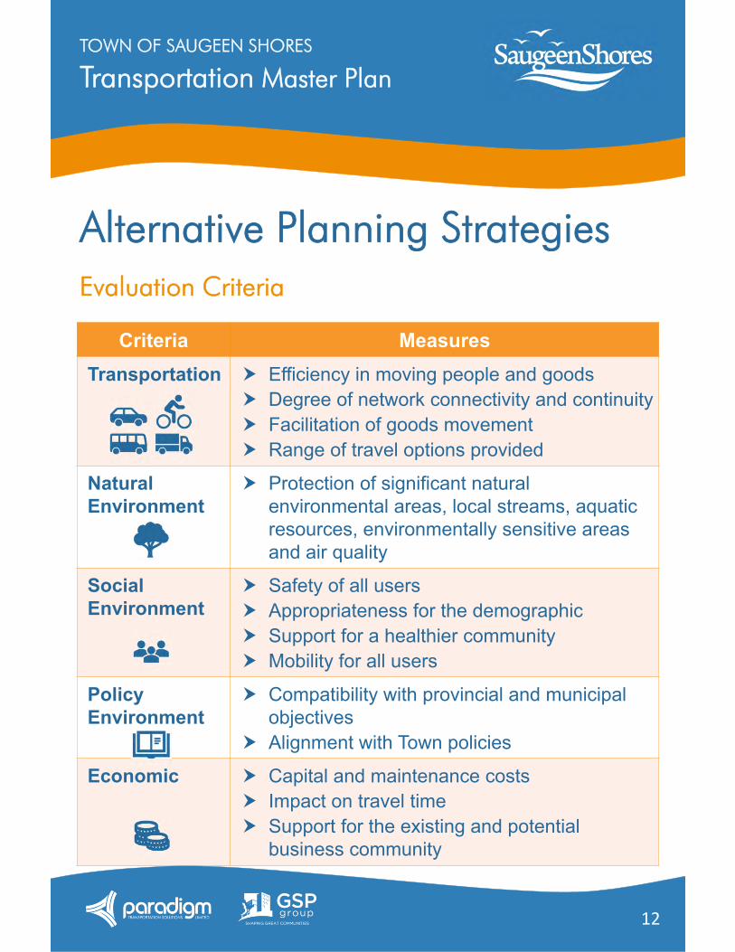
Alternative Planning StrategiesEvaluation Criteria
Criteria MeasuresTransportation Efficiency in moving people and goods
Degree of network connectivity and continuity Facilitation of goods movement Range of travel options provided
Natural Environment
Protection of significant natural environmental areas, local streams, aquatic resources, environmentally sensitive areas and air quality
Social Environment
Safety of all users Appropriateness for the demographic Support for a healthier community Mobility for all users
Policy Environment
Compatibility with provincial and municipal objectives
Alignment with Town policies
Economic Capital and maintenance costs Impact on travel time Support for the existing and potential
business community
Transportation Master PlanTOWN OF SAUGEEN SHORES
13
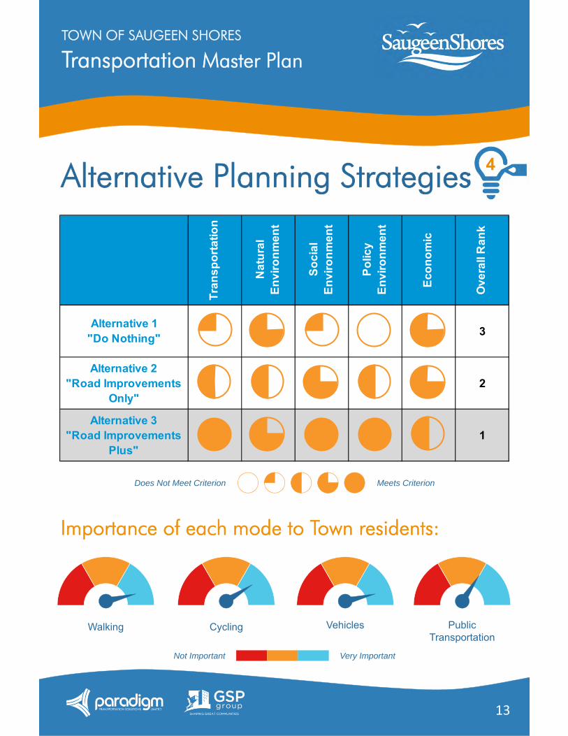
Alternative Planning Strategies
Column1 Column1 Column1Column1
Walking Cycling Vehicles PublicTransportation
Does Not Meet Criterion Meets Criterion
Importance of each mode to Town residents:
Not Important Very Important
Tran
spor
tatio
n
Nat
ural
En
viro
nmen
t
Soci
al
Envi
ronm
ent
Polic
y En
viro
nmen
t
Econ
omic
Ove
rall
Ran
k
Alternative 1"Do Nothing" 3
Alternative 2"Road Improvements
Only"2
Alternative 3"Road Improvements
Plus"1
4
Transportation Master PlanTOWN OF SAUGEEN SHORES
14
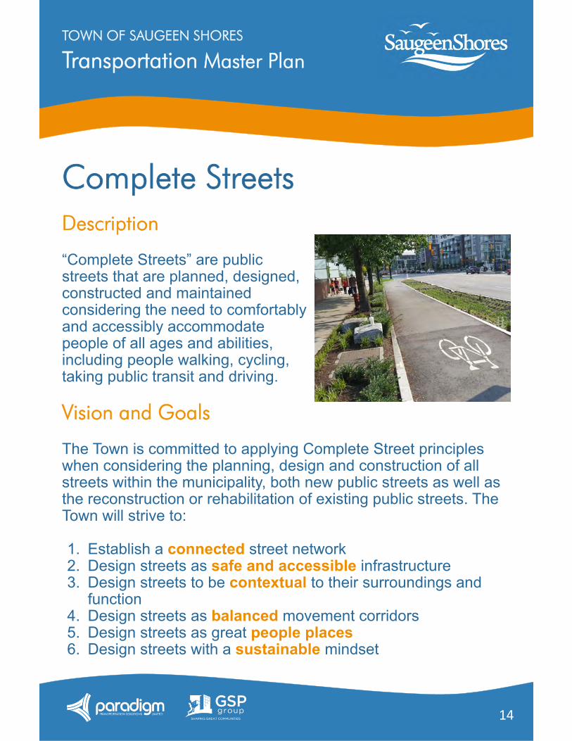
Complete StreetsDescription
“Complete Streets” are publicstreets that are planned, designed,constructed and maintainedconsidering the need to comfortablyand accessibly accommodatepeople of all ages and abilities,including people walking, cycling,taking public transit and driving.
Vision and Goals
The Town is committed to applying Complete Street principles when considering the planning, design and construction of all streets within the municipality, both new public streets as well as the reconstruction or rehabilitation of existing public streets. The Town will strive to:
1. Establish a connected street network2. Design streets as safe and accessible infrastructure3. Design streets to be contextual to their surroundings and
function4. Design streets as balanced movement corridors5. Design streets as great people places6. Design streets with a sustainable mindset
Transportation Master PlanTOWN OF SAUGEEN SHORES
15
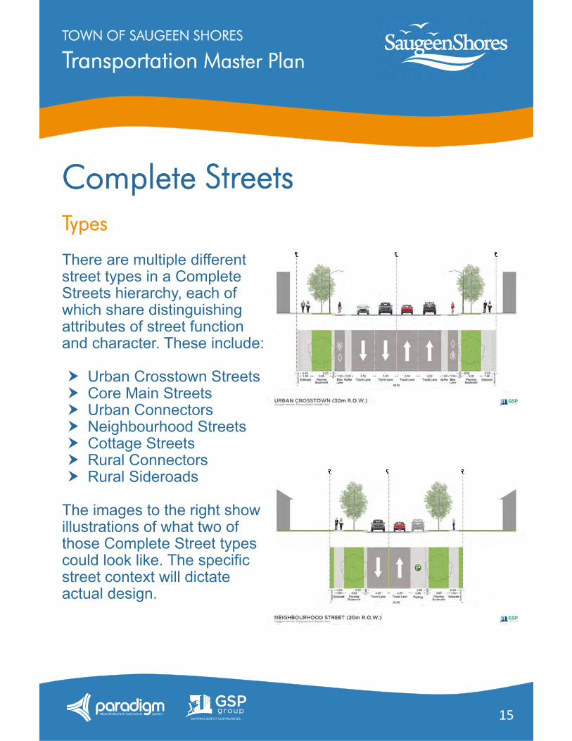
CompleteTypes
There are multiple different street types in a Complete Streets hierarchy, each of which share distinguishing attributes of street function and character. These include:
Urban Crosstown Streets Core Main Streets Urban Connectors Neighbourhood Streets Cottage Streets Rural Connectors Rural Sideroads
The images to the right show illustrations of what two of those Complete Street types could look like. The specific street context will dictate actual design.
Streets
Transportation Master PlanTOWN OF SAUGEEN SHORES
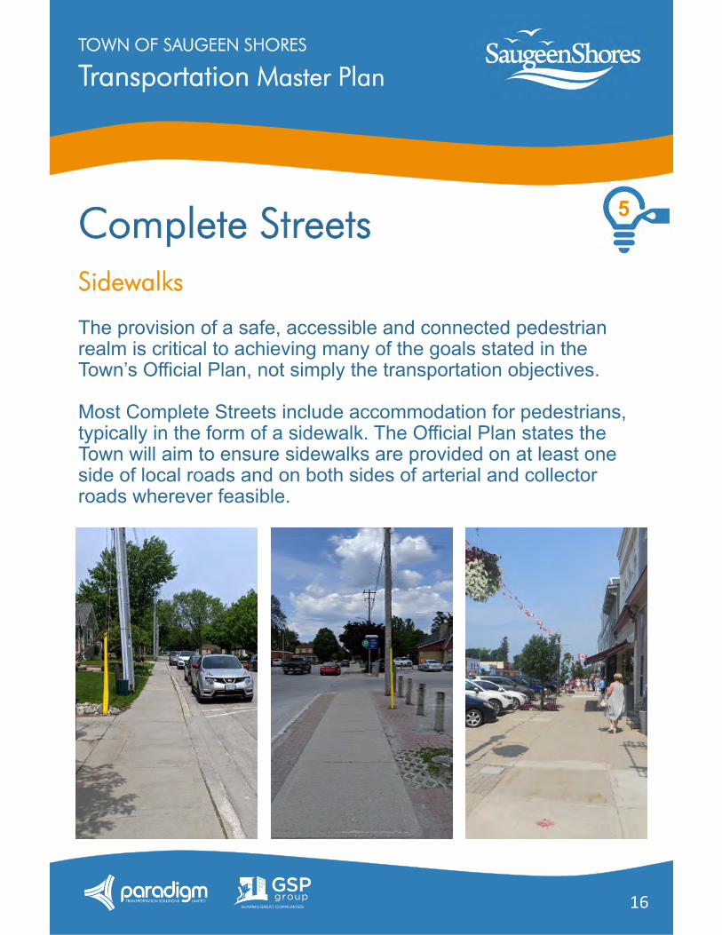
16
Complete StreetsSidewalks
The provision of a safe, accessible and connected pedestrian realm is critical to achieving many of the goals stated in the Town’s Official Plan, not simply the transportation objectives.
Most Complete Streets include accommodation for pedestrians, typically in the form of a sidewalk. The Official Plan states the Town will aim to ensure sidewalks are provided on at least one side of local roads and on both sides of arterial and collector roads wherever feasible.
5
Transportation Master PlanTOWN OF SAUGEEN SHORES
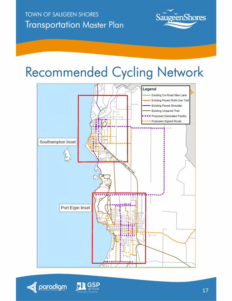
17
Recommended Cycling Network
Transportation Master PlanTOWN OF SAUGEEN SHORES
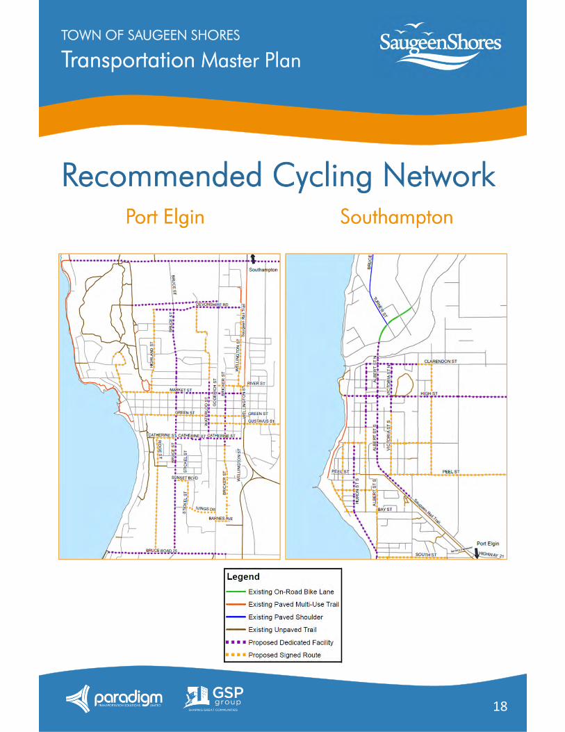
18
Recommended Cycling NetworkSouthamptonPort Elgin
Transportation Master PlanTOWN OF SAUGEEN SHORES
19
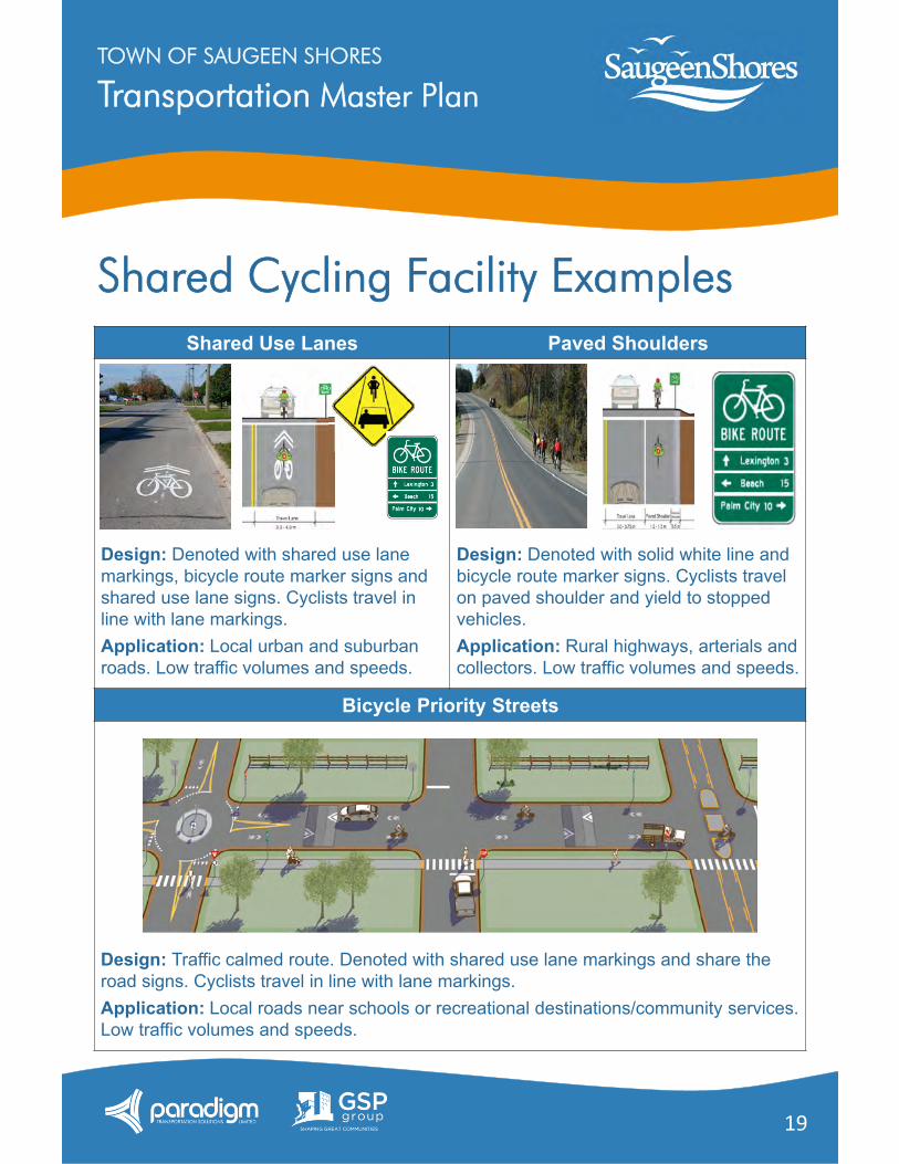
Shared Cycling Facility ExamplesShared Use Lanes Paved Shoulders
Bicycle Priority Streets
Design: Denoted with shared use lane markings, bicycle route marker signs and shared use lane signs. Cyclists travel in line with lane markings.Application: Local urban and suburban roads. Low traffic volumes and speeds.
Design: Denoted with solid white line and bicycle route marker signs. Cyclists travel on paved shoulder and yield to stopped vehicles.Application: Rural highways, arterials and collectors. Low traffic volumes and speeds.
Design: Traffic calmed route. Denoted with shared use lane markings and share the road signs. Cyclists travel in line with lane markings.Application: Local roads near schools or recreational destinations/community services. Low traffic volumes and speeds.
Transportation Master PlanTOWN OF SAUGEEN SHORES
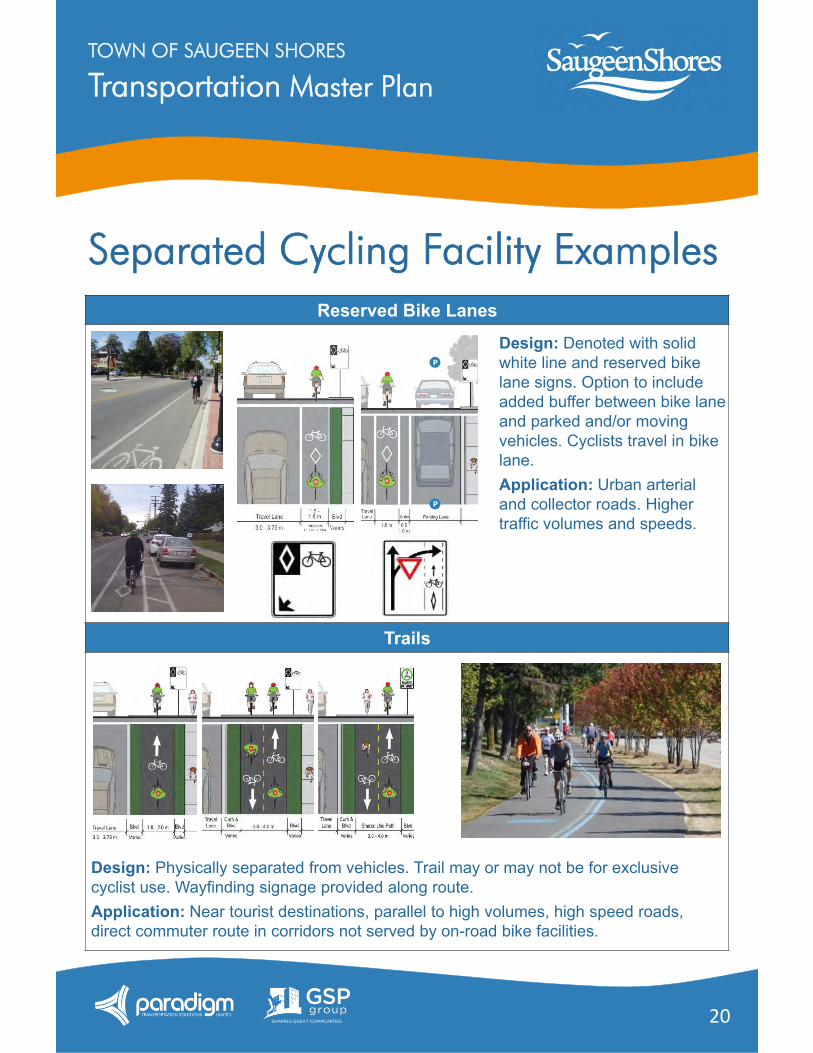
20
Separated Cycling Facility ExamplesReserved Bike Lanes
Trails
Design: Denoted with solid white line and reserved bike lane signs. Option to include added buffer between bike lane and parked and/or moving vehicles. Cyclists travel in bike lane.Application: Urban arterial and collector roads. Higher traffic volumes and speeds.
Design: Physically separated from vehicles. Trail may or may not be for exclusive cyclist use. Wayfinding signage provided along route.Application: Near tourist destinations, parallel to high volumes, high speed roads, direct commuter route in corridors not served by on-road bike facilities.
Transportation Master PlanTOWN OF SAUGEEN SHORES
21
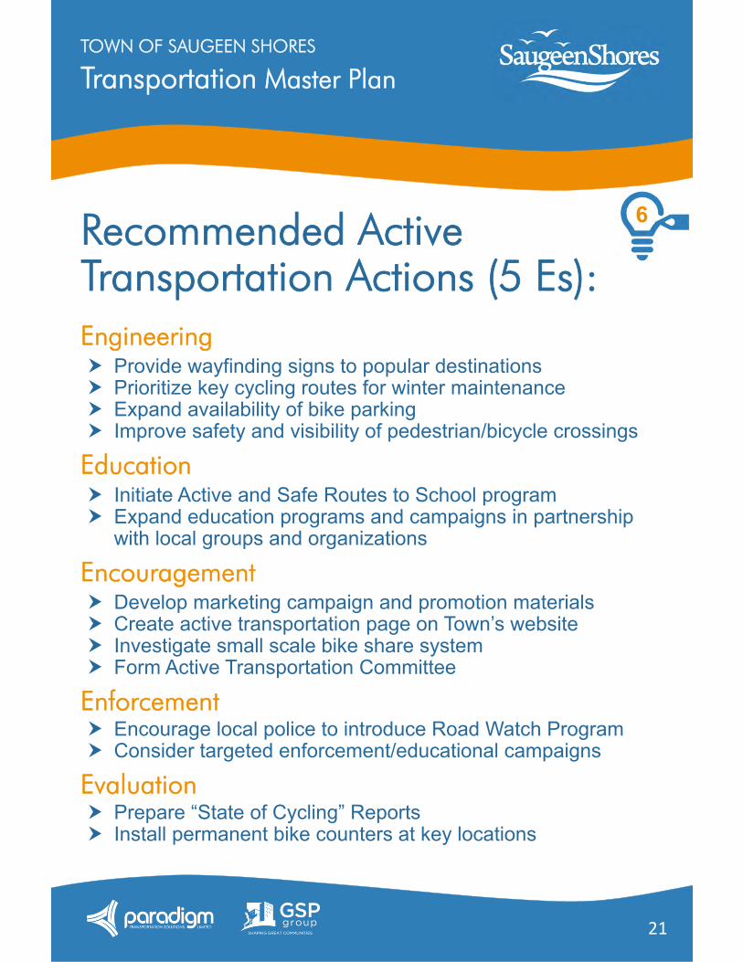
Recommended Active Transportation Actions (5 Es):Engineering Provide wayfinding signs to popular destinations Prioritize key cycling routes for winter maintenance Expand availability of bike parking Improve safety and visibility of pedestrian/bicycle crossings
Education Initiate Active and Safe Routes to School program Expand education programs and campaigns in partnership
with local groups and organizations
Encouragement Develop marketing campaign and promotion materials Create active transportation page on Town’s website Investigate small scale bike share system Form Active Transportation Committee
Enforcement Encourage local police to introduce Road Watch Program Consider targeted enforcement/educational campaigns
Evaluation Prepare “State of Cycling” Reports Install permanent bike counters at key locations
6
Transportation Master PlanTOWN OF SAUGEEN SHORES
22
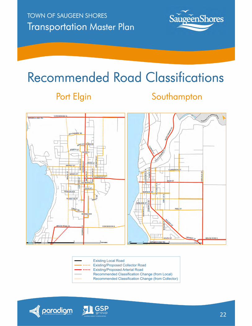
Recommended Road Classifications
Existing Local RoadExisting/Proposed Collector RoadExisting/Proposed Arterial RoadRecommended Classification Change (from Local)Recommended Classification Change (from Collector)
SouthamptonPort Elgin

Transportation Master PlanTOWN OF SAUGEEN SHORES
23
Recommended Road Improvements
Intersection DescriptionGoderich Street andIvings Drive
Northbound left-turn lane Northbound left-turn advanced phase
Goderich Street andGustavus Street
Time of day parking restrictions on Goderich Street Shared left-through and through-right movements
Goderich Street andGreen Street
Time of day parking restrictions on Goderich Street Shared left-through and through-right movements
Railway Street andMcNabb Street
Roundabout
All Signalized Intersections Signal timing optimization as required
Road From To DescriptionAnglesia Street Peel Street Spence Street Develop to CollectorAnglesia Street Spence Street High Street Upgrade to CollectorBricker Street Peirson Avenue North of Maple
StreetAcquire and develop to Collector
Bruce Road 25* Bruce Road 33 Goderich Street Widen and install bike lanesBruce Street Bruce Road 25 Sunset Boulevard Develop to CollectorBruce Street Peirson Avenue Falcon Street Widen and install sidewalkBruce Street Devonshire Road Concession 10 Develop to CollectorCatherine Street Bruce Street Stafford Street Upgrade to Collector. Acquire
property and straighten jog.Concession 10 Bruce Street Miramichi Bay
RoadWiden to Collector width
Concession 10 Bruce Street Extension
Maplewood Drive Upgrade to Arterial
High Street Grenville Street Anglesia Street Upgrade to ArterialMaplewood Drive Brentwood Drive Concession 10 Acquire and develop to CollectorSpence Street Grenville Street Anglesia Street Upgrade to CollectorWaterloo Street Mary Street Devonshire Road Acquire and develop to Collector
Transportation Master PlanTOWN OF SAUGEEN SHORES
24
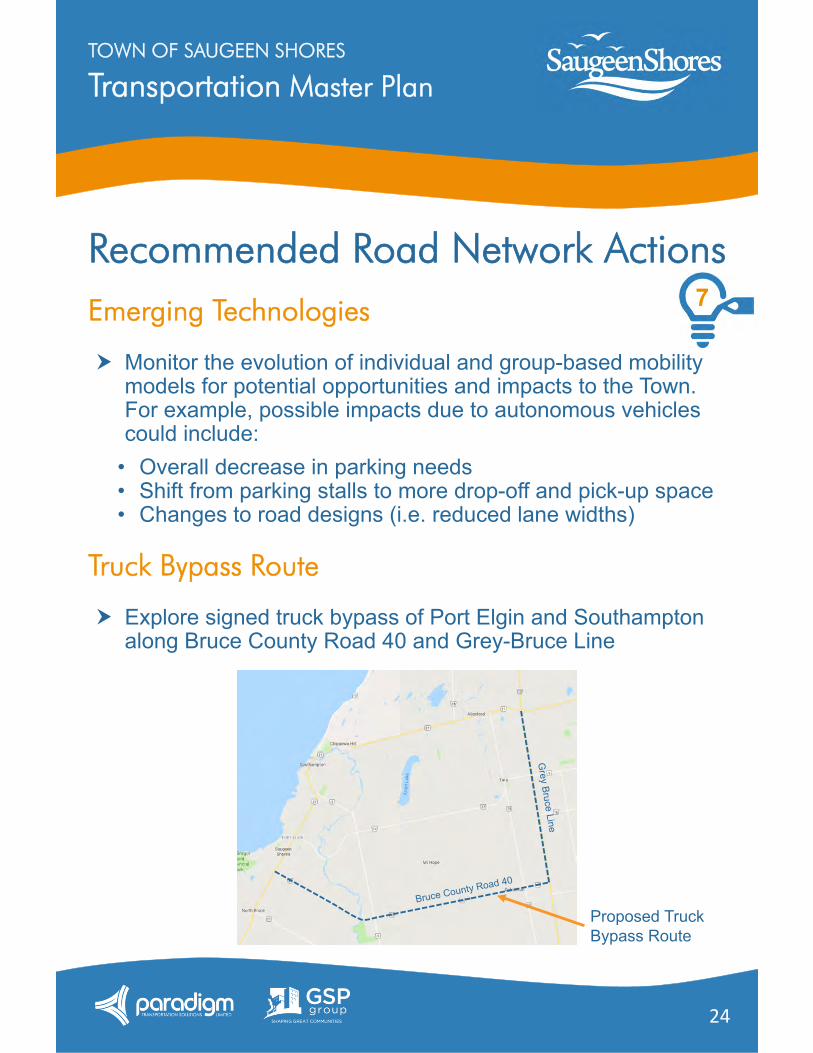
Recommended Road Network ActionsEmerging Technologies
Monitor the evolution of individual and group-based mobility models for potential opportunities and impacts to the Town. For example, possible impacts due to autonomous vehicles could include:
• Overall decrease in parking needs • Shift from parking stalls to more drop-off and pick-up space • Changes to road designs (i.e. reduced lane widths)
Truck Bypass Route
Explore signed truck bypass of Port Elgin and Southampton along Bruce County Road 40 and Grey-Bruce Line
Proposed Truck Bypass Route
7
Transportation Master PlanTOWN OF SAUGEEN SHORES
25
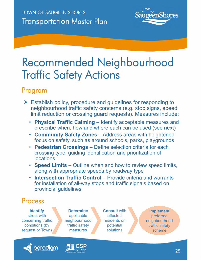
Recommended Neighbourhood Traffic Safety ActionsProgram
Establish policy, procedure and guidelines for responding to neighbourhood traffic safety concerns (e.g. stop signs, speed limit reduction or crossing guard requests). Measures include:
• Physical Traffic Calming – Identify acceptable measures and prescribe when, how and where each can be used (see next)
• Community Safety Zones – Address areas with heightened focus on safety, such as around schools, parks, playgrounds
• Pedestrian Crossings – Define selection criteria for each crossing type, guiding identification and prioritization of locations
• Speed Limits – Outline when and how to review speed limits, along with appropriate speeds by roadway type
• Intersection Traffic Control – Provide criteria and warrants for installation of all-way stops and traffic signals based on provincial guidelines
ProcessConsult with
affected residents on
potential solutions
Determineapplicable
neighbourhood traffic safety measures
Identifystreet with
concerning traffic conditions (by
request or Town)
Implementpreferred
neighbourhood traffic safety
scheme
Transportation Master PlanTOWN OF SAUGEEN SHORES
26
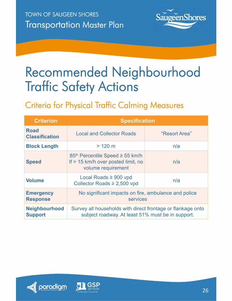
Recommended Neighbourhood Traffic Safety ActionsCriteria for Physical Traffic Calming Measures
Criterion SpecificationRoad Classification Local and Collector Roads “Resort Area”
Block Length > 120 m n/a
Speed85th Percentile Speed ≥ 55 km/hIf > 15 km/h over posted limit, no
volume requirementn/a
Volume Local Roads ≥ 900 vpdCollector Roads ≥ 2,500 vpd n/a
Emergency Response
No significant impacts on fire, ambulance and police services
Neighbourhood Support
Survey all households with direct frontage or flankage onto subject roadway. At least 51% must be in support.
Transportation Master PlanTOWN OF SAUGEEN SHORES
27
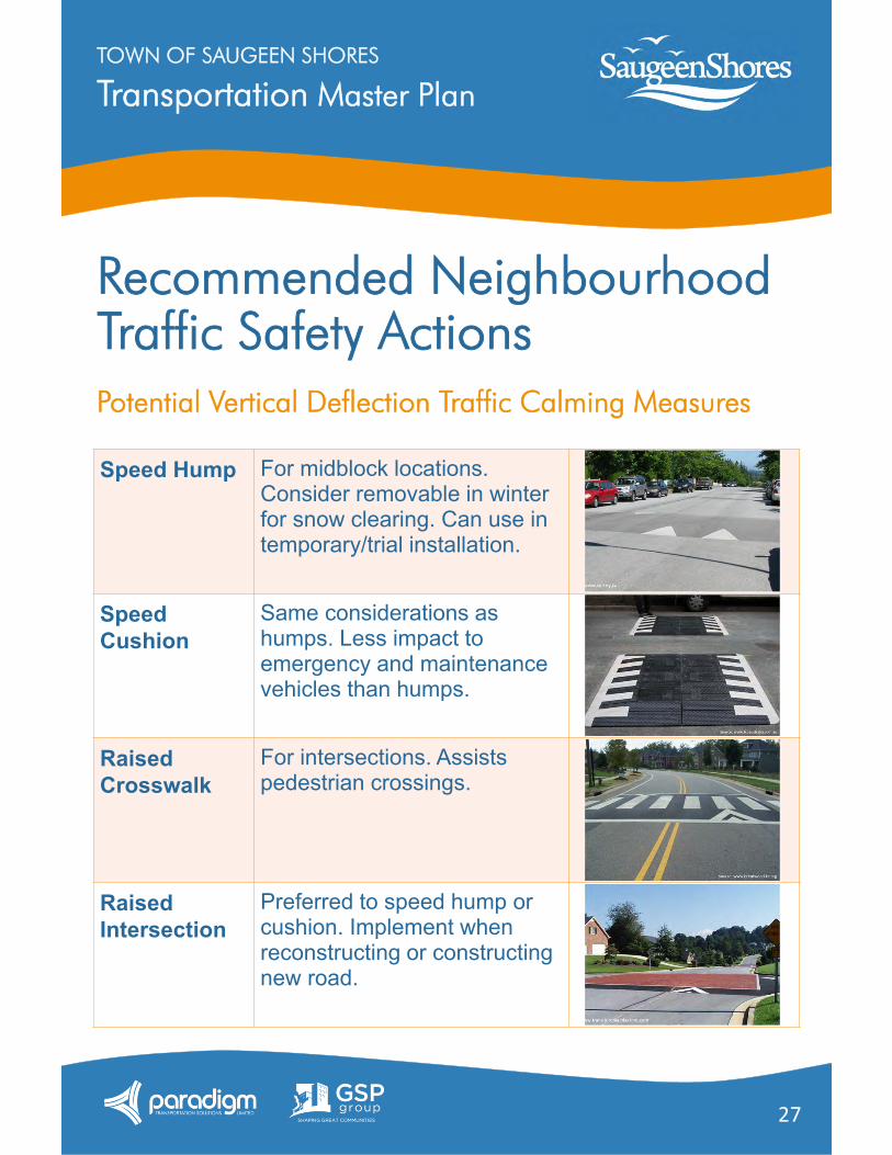
Recommended Neighbourhood Traffic Safety ActionsPotential Vertical Deflection Traffic Calming Measures
Speed Hump For midblock locations. Consider removable in winter for snow clearing. Can use in temporary/trial installation.
Speed Cushion
Same considerations as humps. Less impact to emergency and maintenance vehicles than humps.
Raised Crosswalk
For intersections. Assists pedestrian crossings.
Raised Intersection
Preferred to speed hump or cushion. Implement when reconstructing or constructing new road.
Transportation Master PlanTOWN OF SAUGEEN SHORES
28
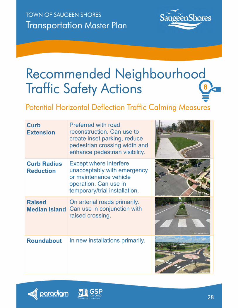
Recommended Neighbourhood Traffic Safety ActionsPotential Horizontal Deflection Traffic Calming Measures
8
Curb Extension
Preferred with road reconstruction. Can use to create inset parking, reduce pedestrian crossing width and enhance pedestrian visibility.
Curb Radius Reduction
Except where interfere unacceptably with emergency or maintenance vehicle operation. Can use in temporary/trial installation.
Raised Median Island
On arterial roads primarily. Can use in conjunction with raised crossing.
Roundabout In new installations primarily.
Transportation Master PlanTOWN OF SAUGEEN SHORES
29
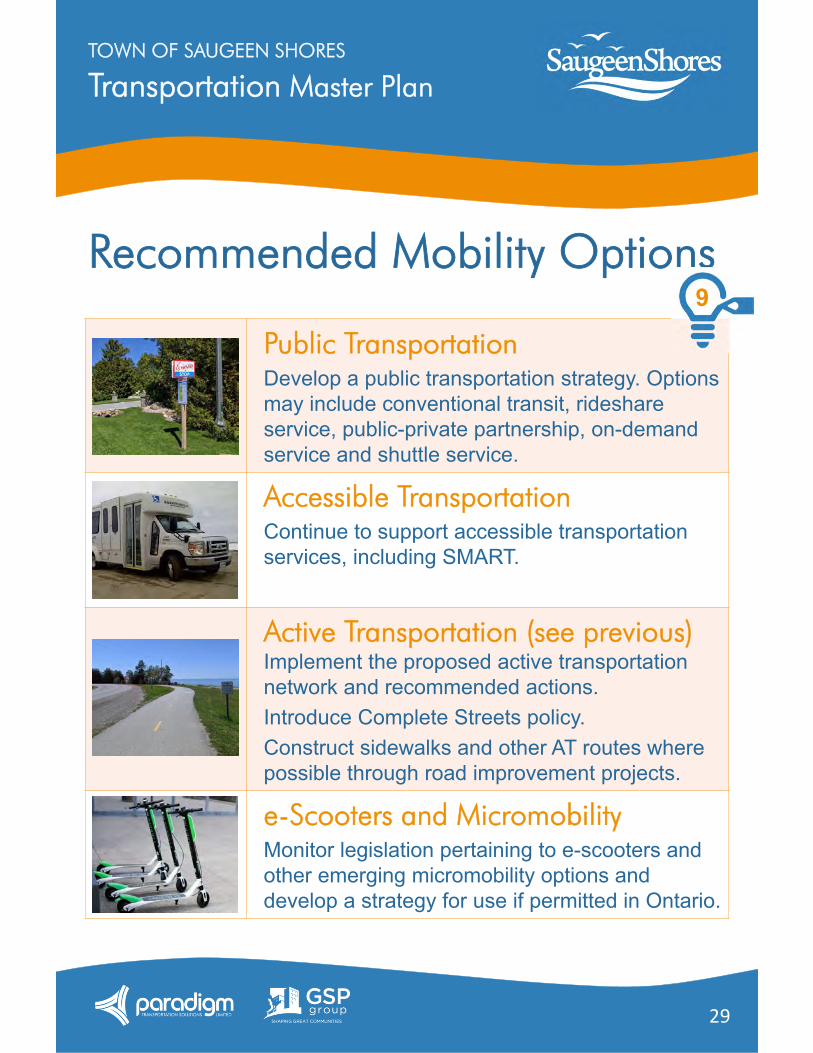
Recommended Mobility Options
Public TransportationDevelop a public transportation strategy. Options may include conventional transit, rideshare service, public-private partnership, on-demand service and shuttle service.
Accessible TransportationContinue to support accessible transportation services, including SMART.
Active Transportation (see previous)Implement the proposed active transportation network and recommended actions.Introduce Complete Streets policy.Construct sidewalks and other AT routes where possible through road improvement projects.
e-Scooters and MicromobilityMonitor legislation pertaining to e-scooters and other emerging micromobility options and develop a strategy for use if permitted in Ontario.
9
Transportation Master PlanTOWN OF SAUGEEN SHORES
30
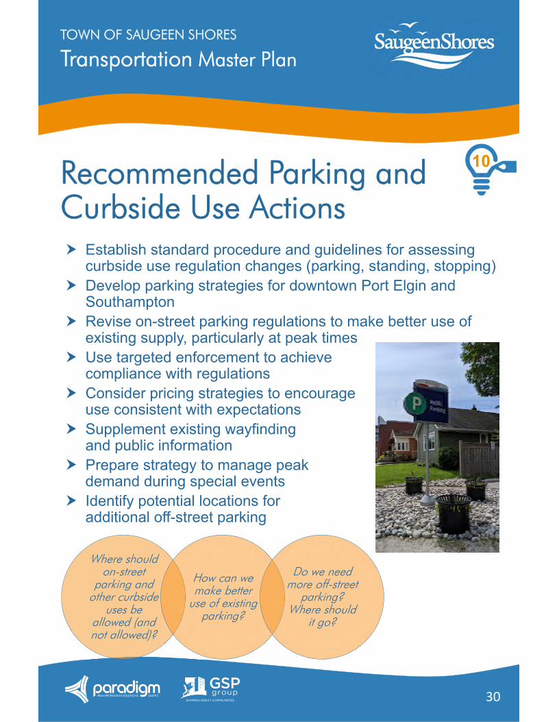
Recommended Parking and Curbside Use Actions Establish standard procedure and guidelines for assessing
curbside use regulation changes (parking, standing, stopping) Develop parking strategies for downtown Port Elgin and
Southampton Revise on-street parking regulations to make better use of
existing supply, particularly at peak times Use targeted enforcement to achieve
compliance with regulations Consider pricing strategies to encourage
use consistent with expectations Supplement existing wayfinding
and public information Prepare strategy to manage peak
demand during special events Identify potential locations for
additional off-street parking
Where should on-street
parking and other curbside
uses be allowed (and not allowed)?
How can we make better
use of existing parking?
Do we need more off-street
parking? Where should
it go?
10
Transportation Master PlanTOWN OF SAUGEEN SHORES
31
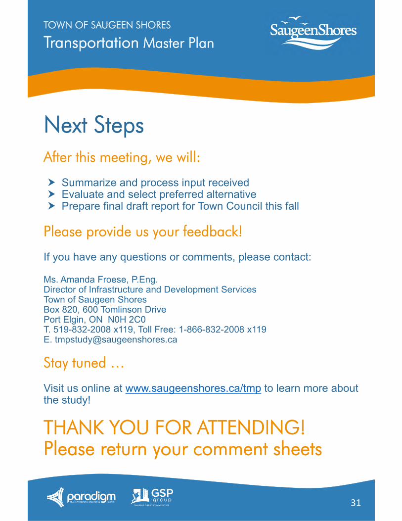
Next StepsAfter this meeting, we will:
Summarize and process input received Evaluate and select preferred alternative Prepare final draft report for Town Council this fall
Please provide us your feedback!
If you have any questions or comments, please contact:
Ms. Amanda Froese, P.Eng.Director of Infrastructure and Development ServicesTown of Saugeen ShoresBox 820, 600 Tomlinson DrivePort Elgin, ON N0H 2C0T. 519-832-2008 x119, Toll Free: 1-866-832-2008 x119E. [email protected]
Stay tuned …
Visit us online at www.saugeenshores.ca/tmp to learn more about the study!
THANK YOU FOR ATTENDING!Please return your comment sheets