Embed Size (px)
Citation preview
Town of WebsterLocal Waterfront Revitalization Program
Adoptty/:Town of Webster, Town Board, September 4, 1997
" ,
Approved:NYS Secretary of State Alexander F. Treadwell, April 9, 1998
Concurred:U.S. Office of Ocean and Coastal Resource Management, July 9, 1998
This Local Waterfront Revitalization Program(LWRP) has been adopted and approved inaccordance with provisions ofthe WaterfrontRevitalization of Coastal Areas and InlandWaterways Act (Executive Law, Article 42)and its implementing regulations (6 NYCRR601). Federal concurrence on theincorporation of this Local WaterfrontRevitalization Program into the New YorkState Coastal Management Program as aroutine program change has been obtained inaccordance with provisions of the U.S.Coastal Zone Management Act of 1972 (pL.92-583), as amended, and its implementingregulations (15 CFR 923).
The preparation of this program wasfinancially aided by a federal grant from theU.S. Department of Commerce, NationalOceanic and Atmospheric Administration,Office of Ocean and Coastal ResourceManagement, under the Coastal ZoneManagement Act of 1972, as amended.Federal Grant No. NA-82-AA-D-CZ068.
The New York State Coastal ManagementProgram and the preparation of ' LocalWaterfront Revitalization Programs areadministered by the New York StateDepartment of State, Division of CoastalResources, 41 State Street, Albany, New York12231.

UNITED STATES DEPARTMENT OF COMMERCENationsl Ocesnlc and Atmospheric AdminilltrlticnNATIONAL OCEAN SERVICEOFFICE OF OCEAN AND COASTAL RESOURCE MANAGEMENTSiI"er Spring. Maryland 20910
JIJL - 9 1998
George StaffordDirectorDivision of Coastal Resourcesand Waterfront Revitalization
Department of State41 State StreetAlbany, New York 12231
Dear Mr. Stafford:
The Office of Ocean and Coastal Resouroe Management concurs with your request toincorporate the Town of Webster Local Waterfront Revitalization Program (LWRP) into theNew York State Coastal Management Program as a Routine Program Change (RPC). Wereceived comments from six Federal agencies, none of which objected to incorporating theLWRP as a RPC. This approval assumes you will make no further changes to the document inaddition to the ones submitted.
In accordance with the Coastal Management Regulations, 15 CFR 923.84, FederalConsistency will apply to the Town of Webster after you pUblish notice ofour approval.
Sincerely,
THE TOWN OFWEBSTER
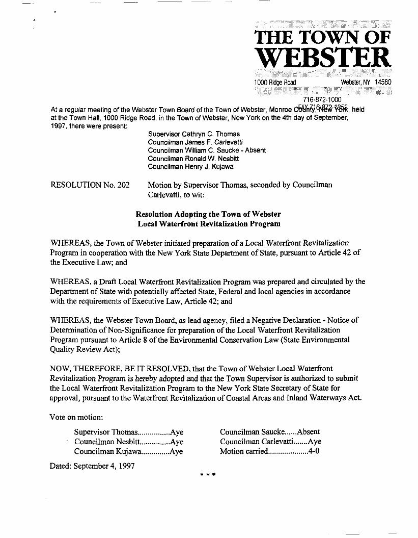
716-872-1000At a regular meeting of the Webster Town Board of the Town of Webster, Monroe c~lY,6Nl?~~, heldat the Town Hall, 1000 Ridge Road, in the Town of Webster, New York on the 4th day of September,1997, there were present:
Supervisor Cathryn C. ThomasCouncilman James F. CarlevattiCouncilman William C. Saucke - AbsentCouncilman Ronald W. NesbittCouncilman Henry J. KUjawa
RESOLUTION No. 202 Motion by Supervisor Thomas, seconded by CouncilmanCarlevatti, to wit:
Resolution Adopting the Town of WebsterLocal Waterfront Revitalization Program
WHEREAS, the Town of Webster initiated preparation ofa Local Waterfront RevitalizationProgram in cooperation with the New York State Department of State, pursuant to Article 42 ofthe Executive Law; and
WHEREAS, a Draft Local Waterfront Revitalization Program was prepared and circulated by theDepartment of State with potentially affected State, Federal and local agencies in accordancewith the requirements of Executive Law, Article 42; and
WHEREAS, the Webster Town Board, as lead agency, filed a Negative Declaration - Notice ofDetermination of Non-Significance for preparation of the Local Waterfront RevitalizationProgram pursuant to Article 8 of the Environmental Conservation Law (State EnvironmentalQuality Review Act);
NOW, THEREFORE, BE IT RESOLVED, that the Town of Webster Local WaterfrontRevitalization Program is hereby adopted and that the Town Supervisor is authorized to submitthe Local Waterfront Revitalization Program to the New York State Secretary of State forapproval, pursuant to the Waterfront Revitalization of Coastal Areas and Inland Waterways Act.
Vote on motion:
Supervisor Thomas Aye. Councilman Nesbitt Aye
Councilman Kujawa Aye
Dated: September 4, 1997
* * *
Councilman Saucke AbsentCouncilman Carlevatti AyeMotion carried .4-0
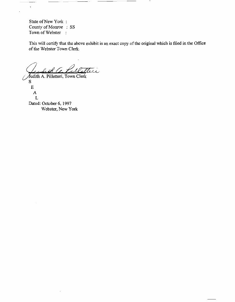
State ofNew York:County of Monroe SSTown of Webster :
This will certify that the above exhibit is an exact copy of the original which is filed in the Officeof the Webster Town Clerk.
udith A. Pilletteri, Town ClerkSE
AL
Dated: October 6, 1997Webster, New York
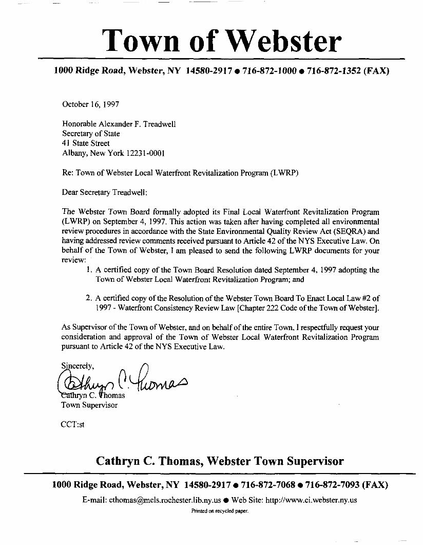
Town of Webster1000 Ridge Road, Webster, NY 14580-2917.716-872-1000.716-872-1352 (FAX)
October 16, 1997
Honorable Alexander F. TreadwellSecretary of State41 State StreetAlbany, New York 12231-0001
Re: Town of Webster Local Waterfront Revitalization Program (LWRP)
Dear Secretary Treadwell:
The Webster Town Board fonnallyadopted its Final Local Waterfront Revitalization Program(LWRP) on September 4, 1997. This action was taken after having completed all environmentalreview procedures in accordance with the State Environmental Quality Review Act (SEQRA) andhaving addressed review comments received pursuant to Article 42 of the NYS Executive Law. Onbehalf of the Town of Webster, I am pleased to send the following LWRP documents for yourreview:
I. A certified copy of the Town Board Resolution dated September 4, 1997 adopting theTown of Webster Local Waterfront Revitalization Program; and
2. A certified copy of the Resolution ofthe Webster Town Board To Enact Local Law #2 of1997 - Waterfront Consistency Review Law [Chapter 222 Code ofthe Town of Webster].
As Supervisor of the Town of Webster, and on behalf of the entire Town, I respectfully request yourconsideration and approval of the Town of Webster Local Waterfront Revitalization Programpursuant to Article 42 of the NYS Executive Law.
CCT:st
Cathryn C. Thomas, Webster Town Supervisor
1000 Ridge Road, Webster, NY 14580-2917. 716-872-7068 • 716-872-7093 (FAX)
E-mail: [email protected]. Web Site: http://www.ci.webster.ny.usPrinted on recycled paper.
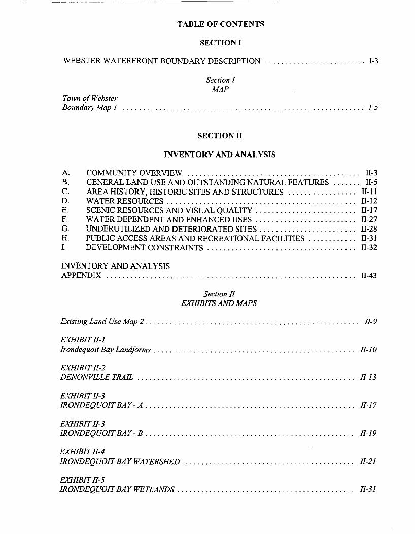
TABLE OF CONTENTS
SECTION I
WEBSTER WATERFRONT BOUNDARY DESCRIPTION 1-3
Section IMAP
Town ofWebsterBoundary Map 1 1-5
SECTION II
INVENTORY AND ANALYSIS
A. COMMUNITY OVERVIEW 11-3B. GENERAL LAND USE AND OUTSTANDING NATURAL FEATURES 11-5C. AREA HISTORY, HISTORIC SITES AND STRUCTURES 11-11D. WATER RESOURCES 11-12E. SCENIC RESOURCES AND VISUAL QUALITy 11-17F. WATER DEPENDENT AND ENHANCED USES . . . . . . . . . . . . . . . .. 11-27G. UNDERUTILIZED AND DETERIORATED SITES. . . . . . . . . . . . . . . . . . . . . . .. 11-28H. PUBLIC ACCESS AREAS AND RECREATIONAL FACILITIES 11-31I. DEVELOPMENT CONSTRAINTS 11-32
INVENTORY AND ANALYSISAPPENDIX 11-43
Section IIEXHIBITS AND MAPS
Existing Land Use Map 2 . . . . . . . . . . . . . . . . . . . . . . . . . . . . . . . . . . . . . . . . . . . . . . . . . . . .. 11-9
EXHIBIT II-IIrondequoit Bay Landforms . . . . . . . . . . . . . . . . . . . . . . . . . . . . . . . . . . . . . . . . . . . . . . . . .. II-JO
EXHIBITII-2DENONVILLETRAIL I~I3
EXHIBIT II-3IRONDEQUOIT BAY-A II-17
EXHIBITII-3IRONDEQUOIT BAY - B . . . . . . . . . . . . . . . . . . . . . . . . . . . . . . . . . . . . . . . . . . . . . . . . . . .. II-I9
EXHIBITII-4IRONDEQUOIT BAY WATERSHED II-2I
EXHIBIT11-5IRONDEQUOIT BAY WETLANDS. . . . . . . . . . . . . . . . . . . . . . . . . . . . . . . . . . . . . . . . . . .. II-3I
EXHIBIT II-6FISH SPECIES AND AQUATIC PLANTS ASSOCIATEDWITH IRONDEQUOIT BA Y . . . . . . . . . . . . . . . . . . . . . . . . . . . . . . . . . . . . . . . . . . . . . . . .. II-35
EXHIBIT II-7BREEDING BIRDS OF THE IRONDEQUOIT BAY AREA 11-37
Town of WebsterHabitat Map - a ... . . . . . . . . . . . . . . . . . . . . . . . . . . . . . . . . . . . . . . . . . . . . . . . . . . . . . . .. II-49
Town ofWebsterHabitat Map - b II-51
SECTION III
POLICIES
SECTION IV
PROPOSED LAND AND WATER USESAND PROPOSED PROJECTS
A. PROPOSED LAND USE PLAN . .. . . . .. .. . . . . . . . . . . . . . . . . . . . . . . . .. . . . .. IV-3
B. PROPOSED PUBLIC AND PRIVATE PROJECTS IV-19
Section IVMAPS
Proposed Land Use Map 3 IV-ll
Webster Park Potential Land Acquisition. . . . . . . . . . . . . . . . . . . . . . . . . . . . . . . . . . . . .. IV-17
SECTION V
TECHNIQUES FOR IMPLEMENTING THE PROGRAM
A LOCAL LAWS AND REGULATIONS IMPLEMENTING THE LWRP , V-7
B OTHER PUBLIC AND/OR PRIVATE ACTIONS NECESSARY TO IMPLEMENT THELWRP V-12
C TOWN OF WEBSTER MANAGEMENT STRUCTURE. . . . . . . . . . . . . . . . . .. V-l3
D LOCAL FINANCIAL RESOURCES V-17
E SUMMARY OF IMPLEMENTATION OF LWRP POLICIES THROUGH LEGISLATIONAND OTHER ACTIONS V-19

Section VMAP and Exhibit
Zoning Map 4 " V-5
MANAGEMENT STRUCTURE , .. .. .. V-15
SECTION VI
STATE AND FEDERAL ACTIONS AND PROGRAMSLIKELY TO AFFECT IMPLEMENTATION
A. STATE AND FEDERAL ACTIONS AND PROGRAMS WHICH SHOULD BEUNDERTAKEN IN A MANNER CONSISTENT WITH THE LWRP VI-3
B. STATE AND FEDERAL ACTIONS AND PROGRAMS NECESSARY TOFURTHER THE TOWN OF WEBSTER'S LWRP VI-26
SECTION I
WATERFRONT RE ITALIZATION AREA BOUNDARY
SECTION 1
WEBSTER WATERFRONT BOUNDARY DESCRIPTION
The boundary of the Town of Webster's waterfront revitalization area is as follows:
Offshore Bmmdary
The offshore boundary of the Town of Webster waterfront revitalization area coincides with theTown municipal boundary line along the midpoint oflrondequoit Bay to the west.
The offshore boundary along Lake Ontario to the north coincides with the mean high landward line 246.8 feet above sea level (International Great Lakes datum).
Inland Boundary
Beginning at the Town line to the south, the boundary proceeds along the east edge of Bay Roadfrom the Town line north to Yolk Road, then westerly along the north edge ofVolk Road to DewittRoad, then northerly along the east edge ofDewitt Road to Countryside Lane and then easterly toBay Road, then northerly along Bay Road to Lake Road, then easterly along the south side of LakeRoad and continuing to the south edge ofVosburg Road to Ship Builders Creek, then following theflood zone ofShip Builders Creek to Klem Road and back up along the east side of the flood zoneofthe Creek to Vosburg Road and continuing easterly to Herman Road, then easterly along the southedge of Herman Road to Pellett Road, then northerly along the east edge of Pellett Road to LakeRoad, then easterly along the south edge ofLake Road to Whiting Road, then easterly along the westedge ofWhiting Road to the property line of Webster Park, then following the property line on thesouth and east edge of the Park up to Lake Road and then along the south edge of Lake Road to thetown line and north along the town line to Lake Ontario.
1-3

================~~~~==================~------~~r=
Town of Webster Boundary Map LN
r--
I /I New York State
.--T------/r--'-DepartmeDt-of-S~te',,-
I I",---" I I DivisiOr:'of
------------/.----!_-----(;oas.taI~~I I /-~
. / I .' Resources/
eka
3000 --Roads
Coastal Management Boundary
Town of Webster Boundary
Streams and Shoreline
Legend---
==-- County Boundary
Major Roads
SECTION II
INVENTORY AND ANALYSIS
A. COMMUNITY OVERVIEW
The Town of Webster is located in the northeast sector of Monroe County approximately ten milesnorth northeast of the Central Business District ofRochester, the primary urban center of MonroeCounty. The Town is bordered on the north by Lake Ontario and on the west by Irondequoit Bay.Its eastern boundary is the Wayne/Monroe County line and to the south is the Town of Penfield.
Webster has passed through three stages of development over time. In the nineteenth century, theTown was primarily agricultural with the Village of Webster being the only concentration ofresidences and businesses. During the first half of the twentieth century, the Town residentialdevelopment began to expand around the Village center, as well as in West Webster. Since 1950Webster has become one of the major suburban growth centers in Monroe County.
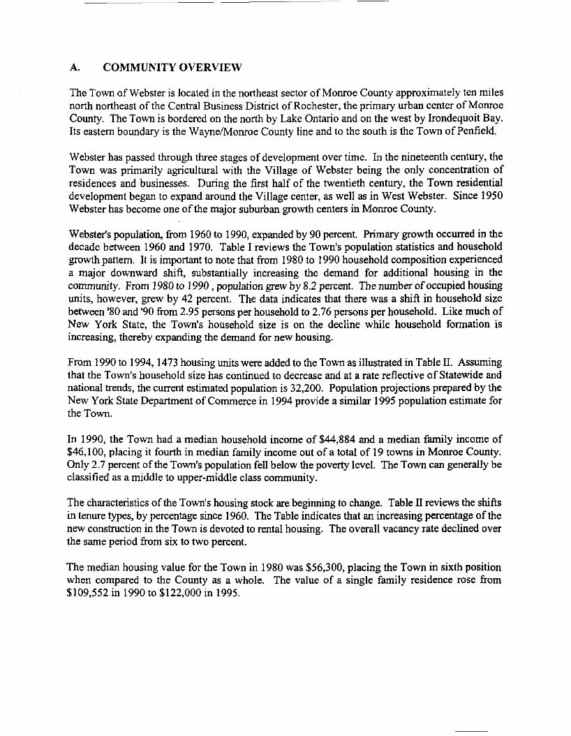
Webster's population, from 1960 to 1990, expanded by 90 percent. Primary growth occurred in thedecade between 1960 and 1970. Table I reviews the Town's population statistics and householdgrowth pattern. It is important to note that from 1980 to 1990 household composition experienceda major downward shift, substantially increasing the demand for additional housing in thecommunity. From 1980 to 1990 , population grew by 8.2 percent. The number ofoccupied housingunits, however, grew by 42 percent. The data indicates that there was a shift in household sizebetween '80 and '90 from 2.95 persons per household to 2.76 persons per household. Like much ofNew York State, the Town's household size is on the decline while household formation isincreasing, thereby expanding the demand for new housing.
From 1990 to 1994, 1473 housing units were added to the Town as illustrated in Table II. Assumingthat the Town's household size has continued to decrease and at a rate reflective of Statewide andnational trends, the current estimated population is 32,200. Population projections prepared by theNew York State Department of Commerce in 1994 provide a similar 1995 population estimate forthe Town.
In 1990, the Town had a median household income of $44,884 and a median family income of$46,100, placing it fourth in median family income out of a total of 19 towns in Monroe County.Only 2.7 percent of the Town's population fell below the poverty level. The Town can generally beclassified as a middle to upper-middle class community.
The characteristics of the Town's housing stock are beginning to change. Table IT reviews the shiftsin tenure types, by percentage since 1960. The Table indicates that an increasing percentage ofthenew construction in the Town is devoted to rental housing. The overall vacancy rate declined overthe same period from six to two percent.
The median housing value for the Town in 1980 was $56,300, placing the Town in sixth positionwhen compared to the County as a whole. The value of a single family residence rose from$109,552 in 1990 to $122,000 in 1995.
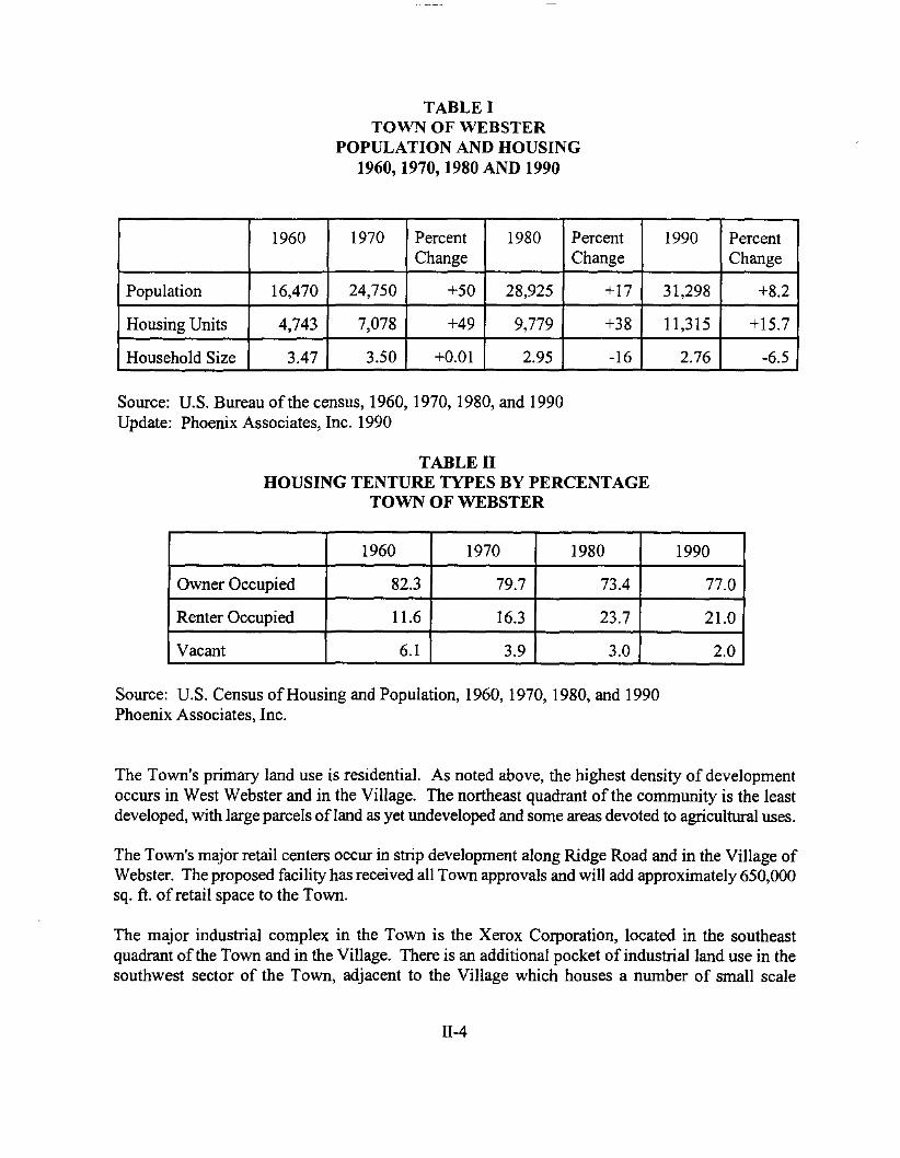
TABLE ITOWN OF WEBSTER
POPULATION AND HOUSING1960,1970,1980 AND 1990
1960 1970 Percent 1980 Percent 1990 PercentChange Change Change
Population 16,470 24,750 +50 28,925 +17 31,298 +8.2
Housing Units 4,743 7,078 +49 9,779 +38 11,315 +15.7
Household Size 3.47 3.50 +0.01 2.95 -16 2.76 -6.5
Source: U.S. Bureau of the census, 1960, 1970, 1980, and 1990Update: Phoenix Associates, Inc. 1990
TABLE IIHOUSING TENTURE TYPES BY PERCENTAGE
TOWN OF WEBSTER
1960 1970 1980 1990
Owner Occupied 82.3 79.7 73.4 77.0
Renter Occupied 11.6 16.3 23.7 21.0
Vacant 6.1 3.9 3.0 2.0
Source: U.S. Census ofHousing and Population, 1960, 1970, 1980, and 1990Phoenix Associates, Inc.
The Town's primary land use is residential. As noted above, the highest density of developmentoccurs in West Webster and in the Village. The northeast quadrant of the community is the leastdeveloped, with large parcels ofland as yet undeveloped and some areas devoted to agricultural uses.
The Town's major retail centers occur in strip development along Ridge Road and in the Village ofWebster. The proposed facility has received all Town approvals and will add approximately 650,000sq. ft. of retail space to the Town.
The major industrial complex in the Town is the Xerox Corporation, located in the southeastquadrant of the Town and in the Village. There is an additional pocket of industrial land use in thesouthwest sector of the Town, adjacent to the Village which houses a number of small scale
11-4
manufacturing and commercial facilities. In recent years, PSC, Lawyers Co-op, and BoulterIndustrial Park have expanded their facilities by 50 to 100%.
Approximately 680 acres of Town land, exclusive of school district facilities is devoted torecreational use. The two primary sites are the 550 acre Webster Park, located along the shore ofOntario Lake and operated by Monroe County and the privately operated Happy Acres GolfCourse.
The Town's major east/west arterials include Lake Road to the north, which serves as the southernboundary of the LWRP Area along Lake Ontario, the Route 104 expressway, and Ridge Road.Major north/south arterials and roads include, from east to west, Bay Road, Holt Road, N.YS. Route250, and Phillips, Salt and Basket Roads. All ofthe Town's developed areas are also served by localroads and county collector roads. There are some private roads extending from Lake Road to LakeOntario in the northern section of the Town. These roads provide access to scattered, year-roundsingle family residences along the lakeshore.
B. GENERAL LAND USE AND OUTSTANDING NATURAL FEATURES
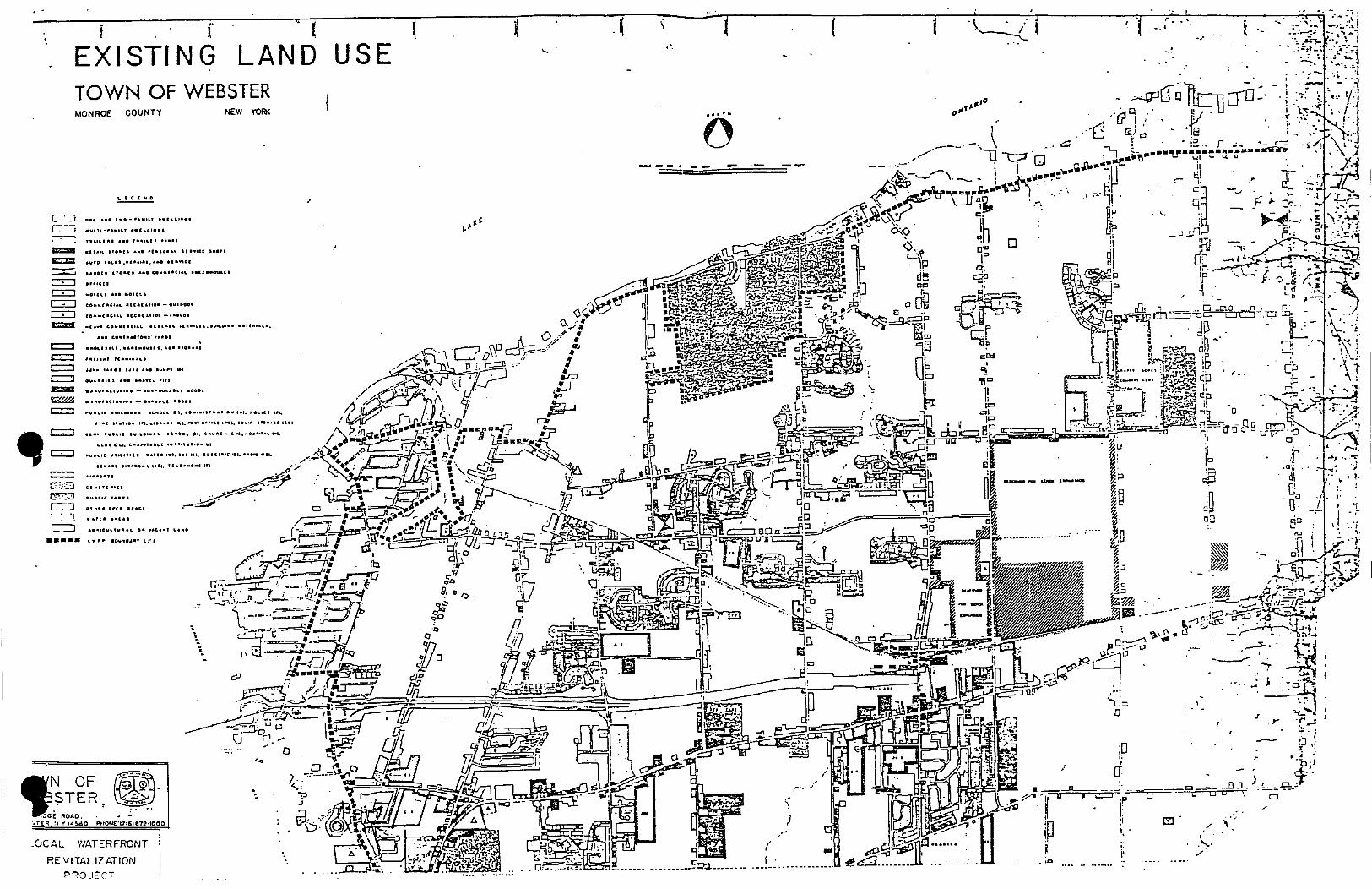
The LWRP area is generally that portion of Webster that borders on the east shore ofIrondequoitBay and the Lake Ontario coastline. For a description of existing land uses in the Town of WebsterWaterfront Revitalization Area, see Map 2, Existing Land Use.
For purposes of this report, the waterfront is broken down into three sub-areas:
1.
*
*
*
*
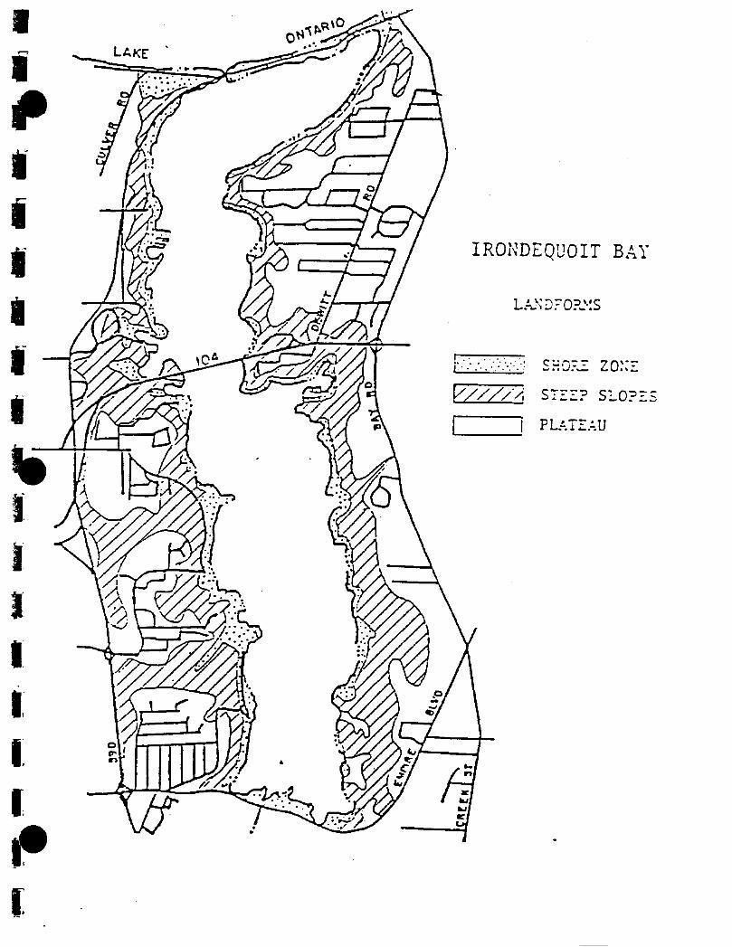
Irondequoit Bay (see Exhibit II-I)
Beginning at the Penfield line, the first 4,000 feet of Bay shoreline consists of amixture ofwooded steep slopes, some level areas, and a small wetland. There are nostructures along the Bay at this point. The plateau area consists ofminor residentialand commercial uses. The area also contains a proposed residential developmentsite.
The next 6,000 feet of shoreline consists of generally levelland. The area has beendeveloped into homes. The plateau area consists of a single family subdivision anda large proposed development site.
Northward, the land is generally wooded and steep around Devil's Cove, in thevicinity ofInspiration Point, and as far as the Route 104 bridge. Devil's Cove andthe adjacent land is a wetland. Single family residential developments are locatedalong Bay Road and on the high plateau above Inspiration Point.
From Route 104 to approximately 2,000 feet from the northern end of the Bay, theshore area is steep with bluffs ending at the water's edge. The slopes are generallywooded; however, sandy areas are found inteqnittently. The slopes are very fragileand prone to erosion.
II-5
*
2.
*
*
*
*
*
*
The plateau is generally developed in single family housing; however, at the presenttime there are two residential developments under construction. Though bothdevelopments "Stony Point Landing" and "The Bluffs" provide a single familyhousing, "Stony Point" provides a townhouse mixture. These sites are one ofthe fewareas north of the Route 104 bridge where the shoreline is flat enough to allow forwaterfront development. Both developments proposal includes docking facilities.
Lake Ontario
The land along the Lake between the Bay and Webster Park is generally wooded withseveral single family homes on large lots. The shoreline is stony with steep slopesup to the plateau. These slopes, however, are not as steep as the slopes aroundIrondequoit Bay or the slopes along the Bay in the Town of Irondequoit.
The area south of Lake Road extends from Vosburg and Herman Roads to PellettRoad on the East and includes Ship Builders Creek. The Creek area is within a floodplain and is considered a significant wildlife habitat. The heavily wooded areabetween Baker and Pellett Roads is also considered a significant habitat and, like theCreek area contains steep slopes.
Webster Park (Monroe County operated) lies approximately in the center of theTown's lake frontage. The Park is divided by Lake Road, and is generally woodedto the south ofthe road.
Picnic areas, a small rocky beach, and a fishing pier are located north of the road.Presently, the Park Master Plan is being updated. Although no plans have beenfinalized, possibilities include an expanded beach and breakwater system and a newboat launch.
From the Park to Nine Mile Point, the predominant land use is large lot residential.With a small portion located north ofjust west of the Nine Mile Point is composedof townhouses. Small rocky bluffs parallel the lake shore with narrow beaches inbetween.
Nine Mile Point is located at the outlet ofFour Mile Creek. The area consists of arestaurant with lodging accommodations. A residential area ofcottages, small yearround homes and trailers is adjacent to the restaurant along Four Mile Creek. Smallboat docks are located along the Creek.
The remainder of the study area from Nine Mile Point to the town line is in ruralresidential use with very <leep lots running from Lake Road to the Lake. The housesgenerally are close to an overlook of the Lake. Also present are a few smallsubdivisions. This area under the resent rezoning is zoned for predominately "LargeLot Development".
11-6
Topography in this area is flat, gently sloping down to the Lake. The lakefront isstony, with little change in grade from the Lake to the adjacent parcels. Vegetationis a combination of wooded, reverted farmland, meadows and isolated orchards.
3. Sandbar
The Sandbar is a narrow arm of land, approximately 100 to 500 feet in width, which extendsfor a distance of approximately 6,000 feet from the main shoreline and separates LakeOntario from Irondequoit Bay. The area is low and flood prone. Single family residencesand a few small commercial establishments occupy the northern part of the spit, while smallcommercial enterprises, including a marine facility and several deteriorated residentialstructures, are located on its south shore. Some vacant and underutilized parcels are locatedat the eastern end of the sandbar on both sides of the road. An abandoned railroad right-ofway parallels Route 18 on a raised road bed, obscuring views of the Lake. At the presenttime, the Town assembled a citizen committee to study the Sandbar Area to improve theavailability ofthe public water, installation ofsanitary sewer system, and a proposed 6.5 acreTown Waterfront Park located at the eastern portion of this area. Although the study is atthe early stages, the proposed park uses would consist ofboat launch, fishing, and parkingfacilities with a picnic area.
In the summer of 1985, the U.s. Army Corps of Engineers, as part of the Irondequoit Bayopening project, severed the bridge which formerly connected the Towns of Webster andIrondequoit. The removal of the bridge permitted open boat passage between Lake Ontarioand Irondequoit Bay. The action was, however, highly controversial because of itselimination of a transportation link between the two towns.
The absence of a crossing has interrupted the travel patterns ofresidents on both sides of theIrondequoit Bay outlet and has adversely affected the small businesses along the approachto the outlet, again, in both Irondequoit and Webster. The Towns, along with the MonroeCounty legislature, have all gone on record favoring the construction of a replacementcrossing for the outlet. A seasonal bridge is currently under construction.
C. AREA HISTORY, HISTORIC SITES AND STRUCTURES
The Wisconsin Glacier, the last of four successive glaciers of the Ice Age, was responsible for theformation ofthe Rochester and specifically the Irondequoit Bay areas. As the glacier melted, it leftlarge amounts ofwater trapped at the southern edge and formed a silt-laden lake in the IrondequoitValley, now known as Irondequoit Bay. Archaeologists have been able to find evidence of humanlife as early as the Archaic Period (3500 B.C.).
The area is rich in Indian history. Irondequoit Bay was considered as the gateway to the IroquoisNation. Trails through the area ran west to Niagara, east to Oswego and north and south along bothsides ofIrondequoit Bay to the lakeshore.
11-7
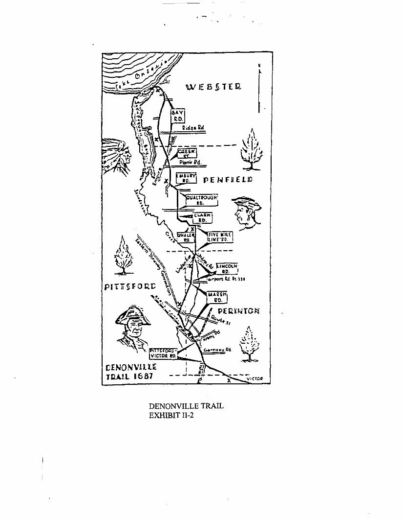
The first recorded visit ofwhite men took place on August 20, 1669, by the French explorer LaSalle.The area was the site ofmajor conflicts between the French and Seneca Indians. The unsuccessfulattacks were led by the Marquis de Denonville, as the governor of New France. The trail which hefollowed is illustrated in Exhibit 11-2. The trail is noted by seven markers extending from Brighton,through Penfield and northward to the Town of Webster.
Areas of historic importance along the lakeshore include two sites known as Oklahoma Beach anLocust Glen. Oklahoma Beach is located at the junction of Bay and Lake Roads and now isdeveloped with private homes. The site is famous for the location of the Cottreall Hotel, a populargathering place for fishermen, as well as the site of alleged "rum running" during the days ofprohibition. The hotel is now a private residence.
A short distance past Nine Mile Point on Lake Ontario is Locust Glen, once the site oftannery anda summer resort area with tennis courts, a harbor for landing small boats and camping facilities. Thesite is now the location of a private home.
There are no buildings or sites within the waterfront area listed, or eligible for listing, on theNational Register of Historic Places.
It should be noted that the western shoreline oflrondequoit Bay and sections of the Lake Ontarioshoreline are highly sensitive with respect to the presence of prehistoric archaeological sites.Sensitive areas have been noted on the "New York State Archaeological Site Inventory Map."
D. WATER RESOURCES
1. Water Surface Analysis
Lake Ontario: Lake Ontario is the twelfth largest freshwater body in the world by area(73,400 sq. miles) but because of its depth (average: 283 ft., maximum: 802 ft.), ranks as thetenth largest lake by volume (393) cubic miles ofwater). The Lake is 193 miles at its longestand 53 miles at its widest. It drains a watershed of30,000 sq. miles within New York Stateand the Province of Ontario in Canada. Including most of the major indentations of theshore, the Lake has approximately 726 miles of coastline, with a coast which is consideredfairly even. The Lake's surface elevation rests at about 244.0 feet above sea level, but wellover half its floor lies below sea level.
Lake Ontario's drainage basin receives, on average, 44 inches ofprecipitation annually, andthe Lake has a water retention period of six years. More than 6.1 million people live nearthe Lake's shores in Ontario Province and New York State, and 2.5 billion gallons ofwaterare withdrawn each day for farming, power, drinking and other domestic uses, mining,manufacturing, and commercial purposes. Non-consumptive uses of lake waters includeshipping, fishing, and other recreational pursuits.
Lake Ontario contains an extensive trout and salmon fishery developed by stocking programsin New York State and the Province of Ontario, as well as an important bass fishery
11-8
,.
,.
/ .....;..\.../
t::!'
~ ._....'
i -..!
,/'
DI.",
IT:
•g
..
Il
• on
r/
~r" I/
.... __ •• _nn__~U I -________ . ~ ....._...._..l", ... :;
..,
C. 'T .:;C-J .MI .... , •• - .... , .. , ••
o .~ ••• " ••••"... ..,....T........ (I." .•••-===- , "..s:=c: ....., .. ..
alitfO If' ,""'CC, - 0 .....
c:;:::J ••• .. ••".C!::J ,.. " ..
~ .ou 111111"&
CO co rIlC:U IICC.III.1I1.·
I:ii::l:I : .." ..I_e•••
....._- ..=;--~-;;::;:;;;;:;=~=--
iEX ISTI NG~~.. li-l(r----TOWN OF WEB LAND USE l -.~~..,,,"'" """,, STER '
NEW YORK
C·:.;;3~
r=."J.. --,_ ---.J
•••••
.OCAL ' -R- V.ATt,RFRONTt. VITALIZATION
PRO ,I!OCT
'
NOF' ~STER .-'..-'
~...:.')CE ROt.O : ~ ••
•. £'t ~~YI"l~80' .. -Ptlor~E "171611172"1000
I
IfjIItiIIfjl-
a'J'I,I,I.
II~(
IRONDEQUOIT BAY
L • ""J"="O:;"··S.~l a _""""'.
V/J///, S7::::? Sl..O?::.s
I I PU·.T:::.~U
WIEB§TEQ
l~'~!1J±
M.~1"r':
R. PENFII£LID
1\.. ,... I,\'~ .\::.9.:L
DENONVILLE TRAILEXHIBIT II-2
associated with the Lake Ontario shoreline. Boat and shore based fishennen catch salmonand trout in the near shore waters of the Lake, as well as in Irondequoit Bay, during thespring and fall fish migration periods.
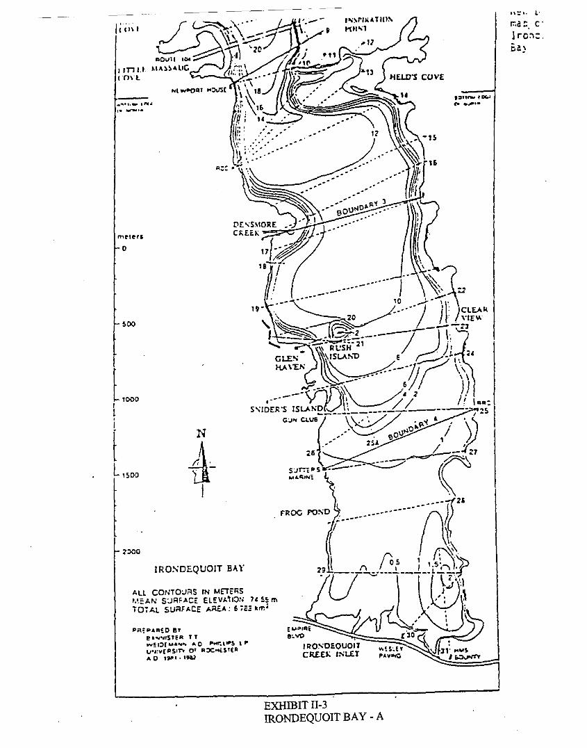
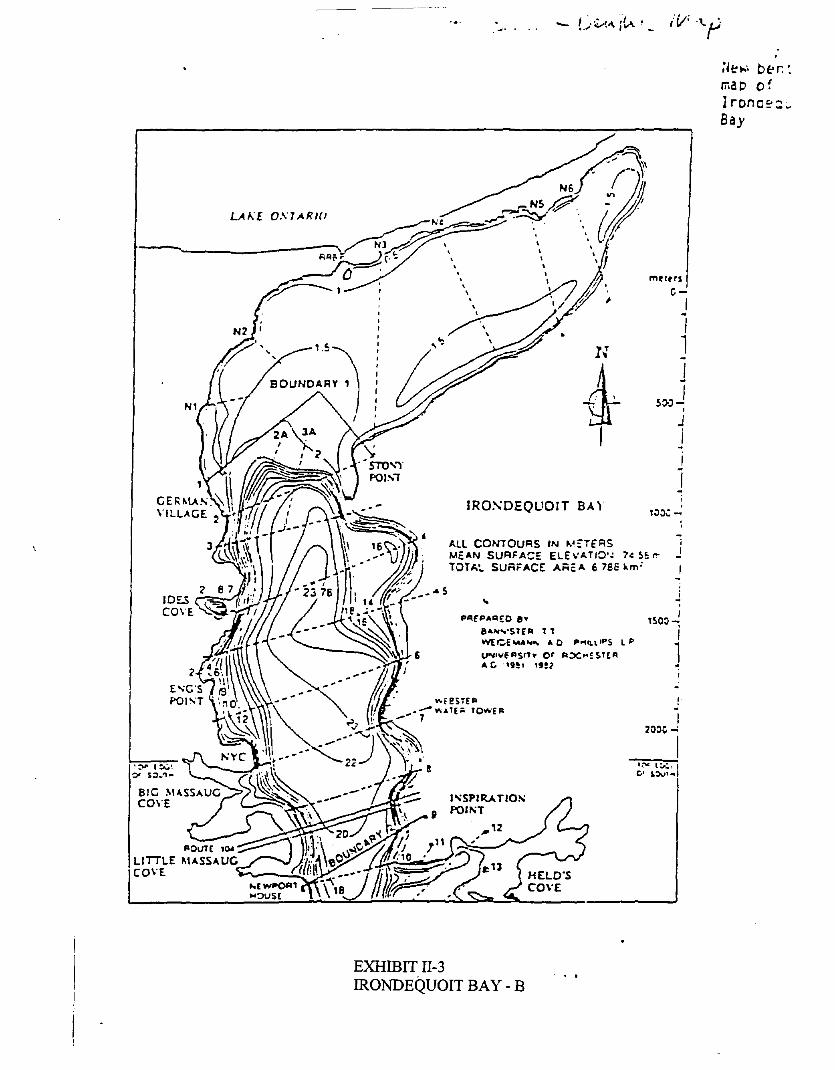
Irondequoit Bay (see Exhibit 11-3): Irondequoit Bay is located on the south shore ofLakeOntario and is about four miles east of Rochester Harbor and 29 miles west ofGreat SodusBay, the nearest Federal harbors. The Bay is bounded by the Towns ofIrondequoit (north,west, and south sides), Penfield (south and east sides), and Webster (east and north sides) inMonroe County. Irondequoit Bay is a natural harbor oriented in a north-south direction withsteep banks rising up to 150 feet above the water surface along the east and west shores, abarrier beach or sand bar at the north end, and a wetland at the south end. .
Irondequoit Bay is about four miles long and varies in width from 1/4 to 3/4 miles, exceptnear the Lake where it broadens to about 1-1/4 miles. The Bay has about 2.6 sq. miles ofwater surface and about 10 miles of shoreline (approximately two miles ofwhich are in theTown ofPenfield). The north and south ends ofthe Bay are shallow and generally less thansix feet below Low Water Datum (which for Lake Ontario is 242.8 feet). Depths in thecentral portion of the Bay range from about 30 feet to a maximum depth of about 75 feet.The Bay is primarily a warm water fishery including northern pike, largemouth bass,bullhead, and other species. It should be noted that trout migrate through the Bay toIrondequoit Creek.
2. Water Quality
The water ofIrondequoit Bay has suffered severely from the effects of urbanization. Forseveral decades, sewage effluent from the City ofRochester, adjoining communities, and themunicipalities along Irondequoit Creek to the south has impaired water quality in the Bay.
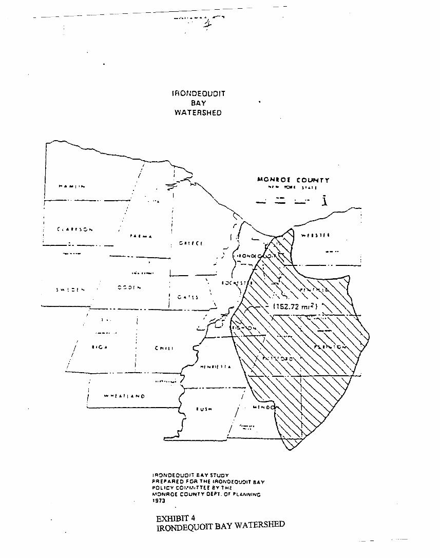
Because the Bay is at the foot ofa large watershed (see Exhibits IT-4 and 11-5), water qualityabuses originating in the watershed's upper reaches have had a major negative impact on theBay's water. Such abuses have included partially treated effluent from several sewagetreatment plants, as well as oil, herbicides, fertilizers, insecticides, animal wastes, road salt,and other pollutants carried into the Bay from its tributaries. High nutrient loads frompartially treated effluent combined with nutrient-rich sediment from agriculture and urbanrunoffhave been responsible for algae blooms whose decomposition causes noxious odors,unsightly conditions, increased alkalinity and reduced available oxygen in the water thatadversely affects fish life.
The extensive amount ofroad salt carried into the Bay from its watershed inhibits the mixingof the Bay's lower waters, extending the annual period of low-oxygen, stagnant, andbiologically undesirable conditions in the deeper portion of the Bay. Surface algae andsediment reduce the amount of sunlight which can penetrate to lower depths.
The inadequate operation of private septic systems on the shoreline and elsewhere in thewatershed adds to the deterioration ofwater quality and may create unsanitary conditions at

the point ofdischarge. The sediments, especially in the wetlands at the mouth ofIrondequoitCreek, are thought to be heavily polluted.
High water levels have eroded the steep slopes around the Bay, primarily on the east side,aggravating existing land slides and causing additional ones to occur. This has created scarsalong the Bay slopes. Increased erosion of the shoreline, in addition to causing propertydamage, has also added to the sediment load in the Bay.
The quality ofthe Bay's water has improved noticeably over the last several years as a resultof the comprehensive sewage treatment program ofMomoe County's Pure Waters Agency.(The Bay is currently rated as a Class B body ofwater by the State, meaning that it is suitablefor bathing and other usages, except as a source of water supply for drinking, culinary orfood processing purposes.) This program has diverted sewage from the treatment plants onIrondequoit Creek and Bay to an expanded and improved treatment facility which dischargesdirectly into Lake Ontario.
Purification of Irondequoit Bay, however, will be a slow, yet continual process once allpresent abuses are terminated. Because of the large quantities of nutrients and salt alreadyin the Bay, improvements in its water quality will be gradual, eventually bringing the qualityto the level which existed in 1940. One potential negative impact resulting from thereduction ofnutrients will be a decrease in surface algae blooms, allowing more sunlight topenetrate the Bay, thus promoting the growth of weeds in the shallow areas of the northernand southern ends of the Bay.
In addition to the improvements to sewage treatment facilities, Momoe County is activelyundertaking measures to improve Bay water quality through other techniques. The Countyhas recently, with federal and state financial assistance, taken action to reduce thephosphorous level ofthe Bay. An experimental program for using aluminum sulfate or alumto act as a seal on the bottom ofthe Bay was extremely successful. The entire Bay has sincebeen spread with alum to keep the phosphorous from recycling in the Bay. The County isalso undertaking a water quality program to reduce non-point sources of pollution in theIrondequoit Basin. The Irondequoit Bay Water Quality Management Plan has been preparedas part of that program.
E. SCENIC RESOURCES AND VISUAL QUALITY
Irondequoit Bay constitutes a major scenic resource for the Town ofWebster, as well as the entiregreater Rochester area. The Bay, because of its setting of steep, heavily wooded slopes andwetlands, provides views of exceptional beauty. The number of views and vistas, however, islimited by the presence of natural features such as steep slopes and woodlots.
The most accessible areas for viewing Irondequoit Bay in Webster are located on the Sandbar at thenorth end of the Bay, Irondequoit Bay Bridge, the State tumoffat the north side of the Route 104Bay Bridge, and the Village of Webster well field along the plateau area of the Bay. All of these
11-14
r.:a::. c'1rc:'l:.r.a~
I:::J""" ,~I
P .....,.
E....aIClii.e, '110
I ROSDEQUOITcRLEJ; ,sur
N
4~I
-~~~~~~~~~~~- --~
P~:P"l:IliO e.,e _--.."SfEA T TW!I:l£U..... AC .....~.. \.,.!I .....u ...:v(PSIT"t 0' RX""i.Sl'(AAD 'SII" 19&1
IRO~DEQUOJT BAr
All CO~ITO:J"'S IN METERS'.~EAN S~R~ACE ELEV~'IO:I 14 55 mTO~Al SUi'lFACE Ai'lE.A: 6 ;s~ _",i
noo
500
o
......- .,.. ..I_ ...-,.
EXHffiITII-3IRONDEQUOIT BAY - A
" -". I '. .1......-. •.",·~~,V""·_
:I~,,"' bf:' r. :map o!1rona:.-:;..Bay
,IRO:'>:OEQUOIT BA Y 'oo~-
,
~ "'VI I:":'!
~ s:;)..""
N
4I
..P!=\!P"AE.O 8"
8"''''''''51'£R 1 t pWE'=-e ...."JrliI... A 0 P""II.\.IPS LU~IYfASIT" or RXMf STtRA Co .,,,! I '9!1
EXHIBIT II-3IRONDEQUOIT BAY - B
mrlprs
c-I-I1I-sovJ,
JII
I
j,'SOO,
I
1
I200C -'
Il~ l;:";.1
e;" s.:tv,.1
IRONDEOUOITBAY
WATERSHED
"'"PI'
:.-'. 1
~-
MONIOI COl.lNTr.. , .. ~I )141'
el!!Cf
,... , .....
-------
.- ... _'"-----
".
I •.
II
----_ .. - -_ .. --~
Ci,,'r~:. ...
----._.. -
IR~NDEOUOI7 EA.Y STUDYPREp.c.REO FOR THE IRONOEOU~IT BAYPOLICY C01.'I.,.TT[E ev THEMONROE COUNTY DEPT. OF PL..,..."NC197;1
EXHIBIT 4IRONDEQUOIT BAY WATERSHED
clearly see the Route 104 Bridge in the distance and on a clear day, the terminus of the Bay alongEmpire Blvd. in Penfield. Increasing development along the west shore in Irondequoit can benoticed and the undeveloped, mostly natural state shorelines of both Penfield and Webster arenoticeable. Similar observations can be made from the other viewing points mentioned. One canalso observe the Bay's expansive wetlands, an area that attracts numerous birds and animals.
Views of the Bay are limited not only by such natural features as steep slopes and wooded lots, butalso by the pattern of land ownership that exists in Webster's waterfront. The Route 104 turnoff andthe jetty provide public access to the scenic vistas and views. Areas along the Sandbar are privatelycontrolled.
The concern for visual quality is one in which the action of one community can either enhance ordestroy another Town's scenic views. A residential project in a given town may have little impacton the scenic views available along its shores while at the same time severely impacting on thescenic views from the opposing shore. This issue is a matter ofconcern in the Town of Webster.
Multiple views of Lake Ontario are available within Webster Park. Its shoreline presents severalopportunities for views ofthe Lake. A restaurant located at Nine Mile Point presents an additionalscenic vista ofthe Lake. Other properties along the Lake shoreline are privately owned and offera unique view or vista ofthe Lake and its shoreline.
F. WATER DEPENDENT AND ENHANCED USES
Water dependent uses are considered by the Town ofWebster to be those uses which could not existwithout a waterfront location. Water enhanced uses are those uses which either benefit from orprovide a complement to a waterfront location. The following narrative provides a description ofsites and land uses located in the waterfront area which meet these criteria. Sites that are specificallywater dependent include:
*
*
Mayer's Marina, located on the Sandbar at the outlet between Irondequoit Bay and LakeOntario, and the existing New York State Park which includes jetty with walkway andparking facilities.
Existing Webster Park facilities, including a fishing jetty and waterfront walkway along LakeOntario (to be discussed in further detail in 7 of the Inventory and Analysis).
Shoreline development that can be classified as water enhanced includes the Glen Edith Restaurant,located on Irondequoit Bay, with seasonal dining and limited docking facilities for customers, andthe New York State Route 104 rest area located on the plateau of the Bay slopes. As can be seen bythis review, the number of land uses which are currently water dependent is quite limited in theTown.
II-21
1. Development
As in other Irondequoit Bay communities, the pressures for development as a result of theopening of the Bay to Lake Ontario are increasing. This need/demand for increasedutilization of the Town's waterfront area, along both the Bay and the lakeshore, for waterdependent and water enhanced uses is evidenced by the heightened interest of the privatesector in developing such sites along the Bay, particularly on plateau areas with relatedshoreline development. Several developers are in the process of having major residentialprojects reviewed and approved by the appropriate town boards and authorities. Althoughno proposals have as yet been presented for redevelopment along the Sandbar, propertyvalues in that area have begun to escalate dramatically. It can further be expected, that oncethe configuration of an outlet bridge is determined, major redevelopment proposals will bebefore the Town.
2. Boating
The number ofboats of all types that will eventually use the Bay is speculative, but couldbe as high as 2,000 according to the Army Corps of Engineers. (Boats currently using theBay number approximately 450 to 500). Webster is in a position to provide both dockageand launching facilities to respond to some of this demand. The residential proposalspresented for three sites along Irondequoit Bay will likely include dockage for privateresidents. Again, pending the outcome of the Outlet Bridge, launching/docking facilities onthe Sandbar may be possible. Two lakeshore sites for such facilities are Webster Park andNine Mile Point.
3. General Access
There is also an acknowledged need for improving the opportunities for access to waterfrontrecreation available through County parkland and other publicly owned sites within theplanning area. Both public and private efforts geared toward waterfront development andimproved access to water resources are, however, constrained by environmentally sensitiveland and water features which require protection. The area which is available to meet thedemands of both the public and private sectors is therefore limited and the developmentwhich does occur must follow sound environmental practices.
G. UNDERUTILIZED AND DETERIORATED SITES
As part ofWebster's LWRP, several large areas ofvacant land were identified as either underutilizedor somewhat deteriorated sites. Because ofsuch characteristics as size, location. visibility, value andproximity to the waterfront, these sites possess the highest potential for development in the Town'swaterfront area. These sites are discussed below and are designated by number on Map 3, ProposedLand Use, in Section IV.
11-22
1. Bay Front
Site]' Wjllow Point
This site, which is the location of the fonner Willow Point Park, runs from Bay Road toIrondequoit Bay. A proposed development consisting of several residential units in mid-risestructures and townhouses is currently being planned for the site. Development will occurprimarily on the eastern half of the site, which corresponds to the plateau area of the parcel.No waterfront development activity is proposed at this time. The potential for baysidedevelopment does exist in the future.
The site has high visibility and accessibility due to its Bay Road frontage, and is served bysewers. Further, its eastern portion is relatively flat and does not seem to contain any seriousconstraints to development. The other portion of the site, however, contains steep, woodedslopes and the waterfront area, which are regarded as extremely sensitive to the effects ofdevelopment and as such will be protected.
Site 2· Stony point Landing
This site, which is located along the northern portion ofIrondequoit Bay and west ofDeWittRoad, is the location of a proposed large-scale, residential development consisting of 109townhouses and 50 single family units. Development constraints include the site's steepwooded slopes, which are located immediately adjacent to the parcel's long Bay frontage.Docking facilities for residents of the development are centralized to limit damage to theslopes and waterfront area, and points up the sensitive nature of this site and the continuedcare that must be exercised when developing it.
Site 3' Bay Road/Bay Bridge Area
There is a large parcel ofprivately owned vacant land located at the intersection ofBay Roadand Bay Bridge. The area is immediately adjacent to Devil's Cove along Irondequoit Bay.The site contains extensive woodlots and steep slopes and is one of the finest scenicresources along Irondequoit Bay. The most eastern portion of the parcel borders Bay Roadand is relatively flat. Surrounding land uses include both single family and multipleresidential with some small retail uses to the south. The site has high potential, but can onlybe developed in such a manner so as not to destroy the natural resources of the area.
Site 4' The Damascus Temple
The Damascus Temple property is located offofBay Road. The site's extensive plateau areais flat and vacant with the exception of a private club facility. No use is made of thewaterfront area which contains both steep slopes and woodlots.
11-23
Sjte 5' DeWjtt Road and Landfill
There is a large undeveloped area bordered by DeWitt Road on the east, Route 104 on thesouth, and the Village of Webster's water supply on the west. The northern portion ofthesite is vacant and appears to contain no physical features which would constraindevelopment. However, because the site has been subdivided into several small parcels andbecause ownership ofthese parcels is in the hands of many different individuals, as well asthe Town and the County governments, acquisition and assembly ofthe site for developmentwill be very difficult and time consuming. The southern portion of the site contains alandfill.
The landfill is also listed on the NYS Register ofInactive Hazardous Waste Disposal Sites(No. 828035). The site is suspected of having received hazardous waste and is thereforeclassified as "2 A", a temporary classification indicating insufficient site data and the needfor further information before any actions are undertaken on the site.
Site 6' The Bluffs
This 48 single family unit subdivision located near the intersection ofDeWitt and BackusRoads offers great physical beauty and privacy, as well as a location near the intersection ofBay and Lake Roads. The site's topography, however, with steep slopes on three sides anda somewhat irregular configuration. To preserve these natural features, the development wasclustered in exchange for 4.0 acres of open space or parkland. Docking facilities for theresidents of this development are centralize to limit damage to steep slopes and shoreline.
2. Lakeshore
Site 7' Nine Mile Point
This site is located between Lake Road and Lake Ontario, opposite Phillips Road andWebster Road. Even though the majority of this area is vacant, Hedges Lakeside Villas,composed of a mixture of 21 townhouses and 20 villas, is located opposite Webster Roadintersection. In addition to its beauty and lakefront location, the site has the added advantageof having direct access to Xerox's Webster complex via Phillips Road. Possible publicaccess and use ofNine Mile Point in a way that is compatible with any future developmentofthe site will be explored by the Town as part ofits planning project review processes. Thesite presents an opportunity for providing additional access to Lake Ontario.
Site g. Vosburg Road
A large, vacant parcel at the intersection ofVosburg and Baker Roads seems well suited forlow-density residential development. If properly planned, such development should havea minimal negative impact on the surrounding area, which includes large-lot residential uses,farmland, vacant parcels and wooded lots.
11-24
The site's scenic surroundings and good vehicular access, as well as the availability ofutilities, should make it attractive to potential developers. Adding to the site's potential fordevelopment is the relatively large size of the parcels which comprise the site and theabsence of sensitive natural features that would inhibit development and add to constructioncosts.
3. Sandbar
Site 9· The Sandhar
The now completed opening ofIrondequoit Bay to Lake presents Webster with a uniqueopportunity to realize the fuJI potential of what has been an underutilized natural resource.The Sandbar's location between the Lake and Bay and the absence of steep slopes make itideal for the development ofwater-related commercial and recreational facilities, which willgreatly increase public access to these two bodies of water. Such facilities could includemarinas, boat launches, fishing piers, parks and promenades, beaches, restaurants, andvarious types of water-related commercial activities.
Several obstacles, however, stand in the way of utilizing this site in a way that will ensureits highest and best use, including the existence of numerous residential uses located onundersized parcels. These uses, many of which are in substandard condition and in closeproximity to the road, have cut off views and public access to the Bay and Lake. Becauseofthe large number of these uses and the small number oflarge parcels in single ownership,acquisition for redevelopment purposes will, no doubt, be slow and expensive.
Redevelopment will be further constrained by the present location of Route 18 and therailroad right-of-way. Sewer and water systems are inadequate to accommodate arearedevelopment.
Replacement ofthe Route 18 bridge over the Bay outlet is currently underway. Therefore,the nature and timing of the Sandbar's redevelopment can be resolved. The replacement ofthe bridge with a seasonal pivot bridge will have a profound impact upon the futuredevelopment of the Sandbar. Major projects should proceed now that this critical issue isresolved.
To ensure that the eventual redevelopment ofthe Sandbar is carried out in a comprehensivelyplanned manner and in such a way as to ensure maximum public access to the Bay and Lake,the Town must begin now to provide the necessary land use and zoning guidelines,regulations, and safeguards. Also necessary will be an ongoing, working relationship withother levels of government, including the County and the State, whose jurisdiction over thisarea overlaps that of the Town. Even with such cooperative arrangements, howev~, it mustbe recognized that redevelopment ofthe Sandbar will take several years to complete and theexpenditure oflarge sums ofboth public and private funds.
1I-25
H. PUBLIC ACCESS AREAS AND RECREATIONAL FACILITIES
The Webster LWRP area contains Webster Park, one ofMonroe County's major facilities. The parkcontains 567 acres of land and is rich in natural resources. Development to date has beenconcentrated in the northeast portion of the park, which is characterized by flat slopes and openspace, and close to road access. Remaining portions of the park are in an undeveloped or minimallydeveloped state. Resources of the park include: beachfront, mature forest, natural creeks andstreams, flood plains, etc. The park's primary focus is its waterfront area. The beach was utilizedin its early years for sun bathing and swimming, but has since lost its appeal.
The center of activity in the waterfront area is the fishing pier and break wall. As previously noted,the bluffs along the upper portion of the park provide dramatic, unobstructed views of the lake. Inaddition, the jetty on the Webster side provides for public access to the Lake from the Town'sextensive shoreline. The only remaining source of public access is the State Highway rest arealocated at the Irondequoit Bay Bridge.
All of these public facilities present opportunities for increased public access to the waterfront. Thelong-range plans for the County parks recognize the need for expanded opportunities and includea program to accommodate those needs (reviewed in detail in Section IV of the LWRP). Theproposed improvements would respect the environmentally sensitive nature of the parks' woodlots,steep slopes, wetlands and habitat areas.
Secondly, the Town ofWebster is investigating the feasibility ofa Town Park located on the easternportion of the Sandbar. A 6.5 acre parcel on the causeway approximately one mile long is a primelocation. It offers several desired recreational outlets like fishing, boating, picnicking, and the ideallocation for a public boat launch. The land elevation above water level is 3 to 4 feet which wouldprovide minimal disturbance during the construction phase of development to the bay. Onceconstructed, this area could provide a refuse harbor with easy launch and retrieval for trailer carriedboats.
The Town has one additional area where access to Village owned property within the Town wouldprovide for limited passive recreation and would heighten waterfront opportunities withoutinfringing upon existing land uses - the Village well field located along the plateau ofthe Bay.
I. DEVELOPMENT CONSTRAINTS
The area adjoining Irondequoit Bay has many unique and sensitive environmental features. Thesefeatures serve as a resource for recreation, visual beauty, and the functioning ofmany complex andcritical natural processes. Increasing pressures for development around Irondequoit Bay, however,threaten these natural features, and care must be exercised to balance development pressures withresource protection needs.
11-26
1. Wetland and Wildlife Habitat Constraints
Irondequoit Bay and Creek, located within the City of Rochester and the Towns ofIrondequoit, Webster, Perinton and Penfield in Monroe County, has been designated by theNew York State Secretary of State as a fish and wildlife habitat of statewide significance.(See the Appendix to the Inventory and Analysis for a detailed description of the IrondequoitBay and Creek habitat). The habitat includes the entire bay area, emergent wetlandsimmediately south of the bay and approximately seven miles upstream on Irondequoit Creek.
Irondequoit Bay has been classified by the New York State Department of EnvironmentalConservation as a Class I Wetland, which is the highest classification that can be given toa wetland. New York State retains permit granting authority for activities in Class Iwetlands, and therefore regulates activities around Irondequoit Bay. (DEC is considering theentire shoreline area of the Bay as a Class I Wetland because of the presence of bothsubmergent and emergent aquatic vegetation).
Types ofwetlands in the Irondequoit Bay area include: submergent, emergent, shrub, andhabitat. Each of these serves important functions such as: shoreline erosion protection,wildlife and fish habitat spawning and nursery areas, water quality filtration, open space andpassive recreation areas. See Exhibit ll-6 for the location of the various types ofwetlandsin the Irondequoit Bay area.
a. Wetlands - Submergent
Irondequoit Bay is substantially enclosed by a narrow band (200 - 600 feet wide) ofsubmergent aquatic vegetation. This aquatic bed is made up ofmilfoil, coontail andpondweeds. As already mentioned, it constitutes a regulated Class I wetland. Amajor limiting factor influencing the development of this vegetative type is theamount oflight reaching the bottom substrate. It is anticipated that as the quality ofBay water increases, water turbidity will decrease and allow more light to reach thebottom, and the aquatic bed will expand.
This submergent wetland plays an important role for Bay fish and wildlifepopulations. Fish use this habitat for spawning, feeding, escape cover, or nurseryhabitat. Waterfowl and wading birds use these areas to forage for food; reptiles andamphibians likewise may spend much of their life cycle in close association with theaquatic bed.
b. Wetlands - Emergent
Emergent wetlands provide excellent fish and wildlife habitats. Birds such as redwing blackbirds, rail and marsh wrens use cattails for nesting, feeding or roosting.Waterfowl use these areas during migration and brood rearing, and pheasants winterin them. Other birds such as hawks, great blue herons and bitterns forage for food inemergent wetlands. Muskrats use cattails for food and nest building and small
II-27
mammals, such as mice, winter in marshes. Deer may use cattail areas as escapecover. These areas may also be used as spawning habitat for northern pike. Whenemergent vegetation is associated with other wetland cover types, such as submergentvegetation, or with upland cover types, the habitat value is increased. These "edges"between different cover types are the areas where the greatest diversity ofhabitat andwildlife exist.
Aquatic wetland vegetation is found in the coves and embayments, and at the southend of the Bay beyond Webster. Water lily and duckweed are the most abundantspecies of aquatic vegetation. This type of vegetation is valuable as a feeding andnursery area for reptiles, amphibians, fish, and waterfowl.
c. Shrub Wetlands
Shrub wetlands are found in various coves on the east and west sides of the Bay.This wetland cover type is usually adjacent to the upland area and provides atransition zone between the wetland and the upland. Red osier dogwood, willow,arrowwood, buckthorn, and red maple and green ash saplings are common shrubspecies found around the Bay. Shrub areas are usually only seasonally flooded inspring and fall. Waterfowl use shrub wetlands during spring and fall migration;furbearers and songbirds use these areas during various times of the year.
d. 1Jpland Wildlife Habitat
The bulk ofthis habitat type is made up of "transitional hardwoods." This forestedarea provides habitat for characteristic woodland wildlife species such as whitetaildeer, eastern cottontail, eastern gray squirrel, woodcock, raccoon, and songbirds,among others. When these woodlot areas area situated directly adjacent to the openwater or wetland areas of the Bay, the habitat values increase. Great blue herons,American bittern, wood duck, osprey and others are among the common specieswhich utilize both wetland and upland habitats.
In addition to avian wildlife, many species ofmammals use the Bay area. The largestland mammal around the Bay, the whitetail deer, is common to the forested areaaround the Bay and is dependent upon the woods for escape cover, fawn rearing, andwinter cover. Small mammals utilizing the forest and wetland environment includefox, raccoon, muskrat, mink, squirrel, rabbit, mice and others. All are dependent forsome part of their existence on the cover provided by the wetlands, open water, andwooded areas.
e. Aquatic Habitat
The Bay supports a large number offreshwater fishes. This population is dominatedby some warm-water species not normally considered gamefish, such as white perch,alewife, or bowfin. These species do, however, contribute to the forage base of the
II-28
Exhibit II-S
Su:~=;g=nt ~etlancs
BAY
L£G::ND
"rl·r:~" ~"'''r~cn· ".otl·n~·r I :: _ ... U lli; ':' _ '" ,.. ~ _ c .. :::
Significant ~e:lcnc r.a~itz:~
IRONDEQUOITo
--- --, .....-
EXHIBIT II-6FISH SPECIES AND AQUATIC PLANTS ASSOCIATED WITH IRONDEQUOIT BAY
Fish Species
Golden shinerCarpSpottail shinerEmerald shiner
Largemouth bassSmallmouth bassPumpkinseedBlack crappieRockbass
White perch
Channel catfishBlack bullheadBrown bullhead
*Seasonal inhabitants
Aquatic Plants
SJ JBMERGENT
CoontailWatermilfoilSago pondweed
FLOATING
WalleyeJohnny darterYellow perch
AlewifeGizzard shad
White sucker
Northern pikeLonguose gar
Sea lamprey
*Rainbow trout*Brown trout*Coho salmon*Chinook salmon*Atlantic salmon
EMERGENT
LongleafpondweedBroadleaf cattailNarrow leaf cattail
SHRJJB*
Water lilyDuckweed
WillowRed osier dogwoodSilky dogwoodBuckthornGreen ash - sapling stageRed maple - sapling stageArrowwood
*Shrubs are not normally considered truely aquatic plants but these species are used aswetland indicators by biologist with the DEC (Region 8).
II-31
POSSlBI,E
EXHIBIT II-7BREEDING BIRDS OF THE IRONDEQUOIT BAY AREAl
PROBABLE
Chimney SwiftRed-headed WoodpeckerAlder FlycatcherRough-winged SwallowBrown CreeperChestnut-sided Warbler
MallardBlue-winged TealWood DuckRed-tailed HawkAmerican KestrelRing-necked PheasantVirginia RailCommon GallinuleAmerican WoodcockRock DoveMoorning DoveYellow-billed CuckooBlack-billed CuckooScreech OwlGreat Homed OwlRuby-throated HummingbirdBelted KingfisherCommon FlickerPileated WoodpeckerRed-bellied WoodpeckerHairy Woodpecker
Green HeronLeast BitternSoraKilldeerCommon SnipeWillow FlycatcherLeast Flycatcher
CONfIRMED
Downy WoodpeckerEastern KingbirdGreat-crested FlycatcherEastern PhoebeEastern Wood PeweeWhite-breasted NuthatchHouse WrenMarsh WrenGray CatbirdBrown ThrasherAmerican RobinWood ThrushVeeryCedar WaxwingStarlingRed-eyed VireoWarbling VireoYellow WarblerCerulean WarblerCommon YellowthroatAmerican Redstart
Tree SwallowWhite-eyed VireoYellow-throated VireoMourning WarblerHooded WarblerRufous-sided Towhee
House SparrowRed-winged BlackbirdNorthern OrioleCommon GrackleBrown-headed CowbirdScarlet TanagerCardinalRose-breasted GrosbeakIndigo BuntingHouse FinchBank SwallowBam SwallowBlue JayAmerican CrowBlack-capped ChickadeeTufted TitmouseAmerican GoldfinchChipping SparrowField SparrowSwamp SparrowSong Sparrow
1 Based on data from the N.Y.S. Dept. ofEnvironmental Conservation and the Federation ofN.Y.S. Bird Clubs Breeding Bird Atlas Project (1980-83), with additional information providedby Mr. Robert Spahn of Webster, N.Y.
Bay. With an improved water quality, a shift in abundance to species commonlysought after as sport fishes, such as largemouth bass, smallmouth bass, northern pike,and salmonids is expected.
In addition to the resident population of fish in the Bay, other species are found ingreat numbers seasonally. Salmonids use the Bay during spawning runs upIrondequoit Creek. It is possible that, as water quality continues to improve, someof the salmonids may become year-round residents within the Bay. The presentcondition ofthe salmonid fishery in Lake Ontario and adjoining bays and tributariesis a direct result of the State's intensive stocking program. 1984 stocking figuresshow that Irondequoit Creek received 19,100 Brown Trout yearlings, 17,000Rainbow Trout yearlings, and 10,800 Atlantic Salmon yearlings.
Exhibit 11-7 identifies fish species and aquatic plants associated with the IrondequoitBay area, and Exhibit 11-8 identifies breeding birds associated with this area.
2. Geological, Regulatory, and Infrastructure Constraints
a. Steep Slopes
Development activities on or adjacent to the steep slopes around Irondequoit Bay,Lake Ontario, Nine Mile Point and Shipbuilder's Creek can result in increases inerosion and sedimentation, degradation of the water quality of the Bay and the Lakeand its tributary streams, slope slippage, and destruction of the natural character ofthe Bay areas. The manner in which storm water drainage is handled, and thedisturbance of soils and removal ofvegetation can affect slope stability.
Slopes of 15 percent or greater may be subject to failure ifdisturbed either throughremoval of vegetation, which acts to stabilize the slope, or grading of slope areas,which exposes them to erosion by wind and water. Natural percolation of stormwater is reduced when vegetation is removed from slope areas, or impervioussurfaces (such as buildings and paved surfaces) are constructed.
Concentration of surface runoff from upland development areas to slope faces maycause excessive erosion and further reduce slope stability. Development relatedactivities may increase the risk of slope failure and cause damage to property.Additionally, increased boat traffic resulting from the Bay opening may enhance thenatural erosion at critical slope toe areas. Disturbances may also contribute to waterquality degradation through siltation.
Making large cuts and fills at the top or base of a steep slope, concentrating volumesof storm water in one location, or placing structures in or too close to slope areas,may disturb the established equilibrium of the soil profile to the point where theupper portion of the slope will begin to slip. This can result in extensive losses toreal estate which is built on or near the top or toe of the slopes.
b. Flood plains
The shoreline area and wetlands of Irondequoit Bay, Lake Ontario, Shipbuilder'sCreek, Nine Mile Point and Mill Creek (located in Webster Park) have beenidentified as flood prone in studies done by the Federal Emergency ManagementAgency. (These areas have been mapped and flood elevations cited as part of thelocal flood insurance program). Building activity in these flood prone areas isregulated by the National Flood Insurance Program and the Town's flood plainmanagement ordinance. Buildings within flood prone areas can impact the floodhandling capabilities of a body ofwater, such as Irondequoit Bay, and can becomeexposed to significant damage from high water levels.
c. Sojl Characteristics
The characteristics of the soils in the Bay area have been determined largely byglacial history, as well as topography, drainage, and vegetation. Plateau soils in theWebster section of the Bay have a high silt and clay content. They are underlain byglacial till, the relatively dense material deposited and compacted by the glacier.These soils are generally moderately well drained and deep.
The slopes around the Bay are formed predominantly from sediments laid down inthe pre-glacial Genesee River valley, although some bedrock outcrops are found inthe deeper stream valleys. The material is predominantly of fine sands and silts ofnearly uniform consistency, and the composition makes the material highlysusceptible to erosion. The soils are stabilized by the native vegetation and are welldrained.
Soils along the creeks and the flatter areas of the shoreline are alluvial, which meansthat they are derived from recently deposited sediments. They are usually ofa fineconsistency, poorly drained, and have a high water table.
d. Coastal Erosjon Hazard Areas
New York State Department ofEnvironmental Conservation has identified CoastalErosion Hazard Areas in Monroe County. Coastal Erosion Hazard Areas are thosecoastal shorelines described as follows:
*
*
Structural areas which are receding at an average rate ofone foot or more peryear; and
Natural protective features areas including beaches, dunes, sandbars, spits,shoals, barrier bays, barrier islands, bluffs and wetlands.
The entire Lake Ontario shoreline and Irondequoit Bay frontage south of Held'sCove, and the areajust north ofthe Penfield town line have been designated Coastal
11-36
Erosion Hazard Areas, and are subject to the regulations of Article 34 of theEnvironmental Conservation Law.
d. publjc Water Supply
The waterfront revitalization area receives its water supply primarily from wellsowned by the Village of Webster near the sandbar at the northern end ofIrondequoitBay. The wells draw from the Irondogenesee Acquifer. The wells are extremelydeep and are constructed in such a way so as to resist contamination. Anydevelopment which may occur near these wellfields must be carefully scrutinized toavoid contamination.
e. Sanitary Sewers and Alternatiye Systems
Part of the waterfront revitalization area is served by sanitary sewers and part isserved by on-site systems. Most of the lakeshore area is served by on-site systems.There is a section of sanitary sewers in the vicinity of Four Mile Creek. AlongIrondequoit Bay, sewers are available from the intersection of Dewitt and Backusroad, south along Dewitt to the Route 104 expressway. Other areas, including theSandbar, are served by private systems. The quality of systems along the Sandbaris of concern to the Town. A study to provide a sanitary sewer to this area wasstarted early 1995. The study is not yet completed and hopefully it will provideservice in the near future.
f. Air Quality
The Town of Webster has no air quality maintenance areas within its boundaries.
11-37
INVENTORY AND ANALYSIS
APPENDIX
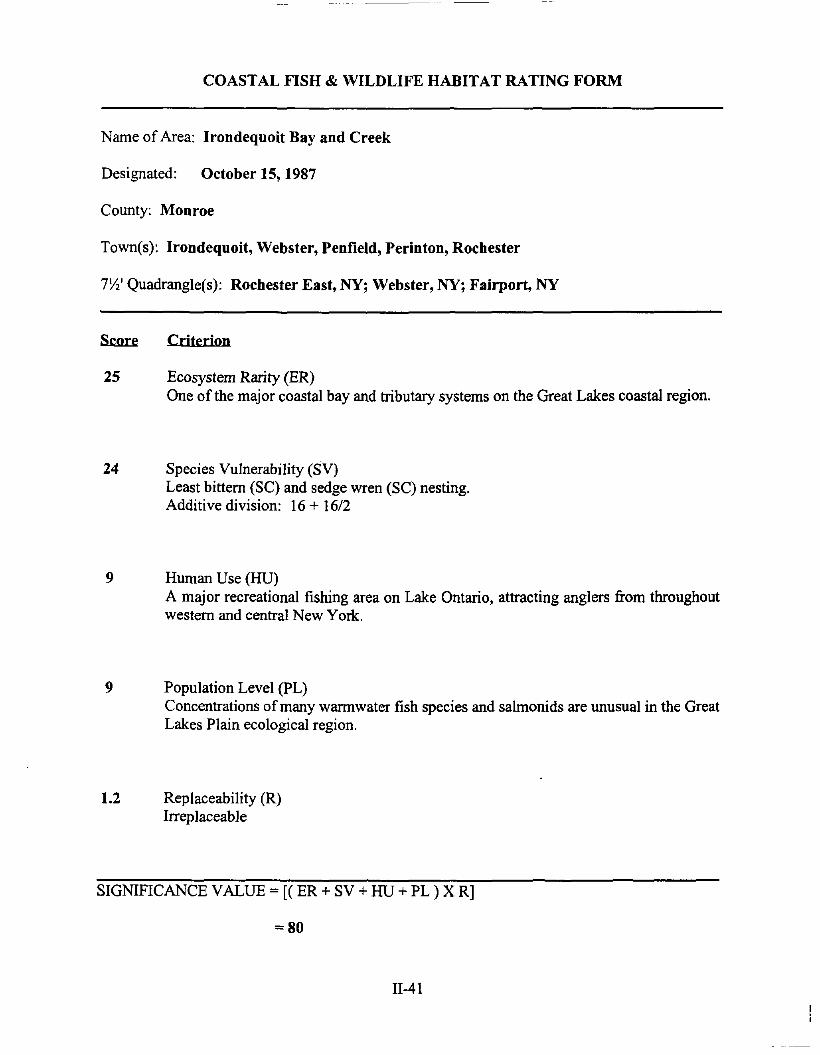
COASTAL FISH & WILDLIFE HABITAT RATING FORM
Name of Area: Irondequoit Bay and Creek
Designated: October 15, 1987
County: Monroe
Town(s): Irondequoit, Webster, Penfield, Perinton, Rochester
7W Quadrangle(s): Rochester East, NY; Webster, NY; Fairport, NY
&.m:e Criterion
25 Ecosystem Rarity (ER)One of the major coastal bay and tributary systems on the Great Lakes coastal region.
24 Species Vulnerability (SV)Least bittern (SC) and sedge wren (SC) nesting.Additive division: 16 + 16/2
9 Human Use (HU)A major recreational fishing area on Lake Ontario, attracting anglers from throughoutwestern and central New York.
9 Population Level (PL)Concentrations ofmany warmwater fish species and salmonids are unusual in the GreatLakes Plain ecological region.
1.2 Replaceability (R)Irreplaceable
SIGNIFICANCE VALUE == [( ER + SV + HU + PL ) X R]
== 80
II-41
SIGNIFICANT COASTAL FISH AND WILDLIFE HABITATS PROGRAMA PART OF THE NEW YORK COASTAL MANAGEMENT PROGRAM
BACKGROUND
New York State's Coastal Management Program (CMP) includes a total of 44 policies which areapplicable to development and use proposals within or affecting the State's coastal area. Any activitythat is subject to review under Federal or State laws, or under applicable local laws contained in anapproved local waterfront revitalization program will be judged for its consistency with thesepolicies.
Once a detennination is made that the proposed action is subject to consistency review, a specificpolicy aimed at the protection offish and wildlife resources of statewide significance applies. Thespecific policy statement is as follows: "Significant coastal fish and wildlife habitats will beprotected, preserved, and, where practical, restored so as to maintain their viability as habitats." TheNew York State Department of Environmental Conservation (DEC) evaluates the significance ofcoastal fish and wildlife habitats, and following a recommenda-tion from the DEC, the DepartmentofState designates and maps specific areas. Although designated habitat areas are delineated on thecoastal area map, the applicability of this policy does not depend on the specific location of thehabitat, but on the determination that the proposed action is subject to consistency review.
Significant coastal fish and wildlife habitats are evaluated, designated and mapped under theauthority ofthe Coastal Management Program's enabling legislation, the Waterfront Revitalizationand Coastal Resources Act (Executive Law of New York, Article 42). These designations aresubsequently incorporated in the Coastal Management Program under authority provided by theFederal Coastal Zone Management Act.
This narrative, along with its accompanying map, constitutes a record of the basis for this significantcoastal fish and wildlife habitat's designation and provides specific infonnation regarding the fishand wildlife resources that depend on this area. General infonnation is also provided to assist inevaluating impacts ofproposed activities on parameters which are essential to the habitat's values.This infonnation is to be used in conjunction with the habitat impainnent test found in the impactassessment section to detennine whether the proposed activities are consistent with the significantcoastal habitats policy.
DESIGNATED HABITAT: IRONDEQUOIT BAY AND CREEK
LOCATION AND DESCRIPTION OF HABITAT:
Irondequoit Bay and Creek are located approximately four miles east ofdowntown Rochester, N.Y.The bay and creek encompass approximately 2,000 acres located in the City ofRochester and theTowns of Irondequoit, Webster, Perinton, and Penfield, Momoe County (7.5' Quadrangles:Rochester East, N.Y.; Webster, N.Y.; and Fairport, N.Y.). The fish and wildlife habitat includesthe entire bay area, a large emergent wetland area at the south end of the bay, and Irondequoit Creek,upstream approximately seven miles from the bay to the confluence with Thomas Creek, just southof the Penn Central Railroad tracks. Irondequoit Bay is separated from Lake Ontario by a sandybarrier beach formation, and is bordered by relatively steep wooded slopes and bluffs. However,much of the western shoreline has been developed for residential and commercial uses. IrondequoitCreek is a very large, medium gradient, coolwater stream, which drains approxi-mately 170 squaremiles ofpredominantly suburban and rural residential lands.
FISH AND WILDLIFE VALVES:
Irondequoit Bay and Creek comprise one of the few major coastal bay and tributary systems in theGreat Lakes Plain ecological region ofNew York. The wetland area at the south end of the bay isone of the largest coastal marshes on western Lake Ontario. Irondequoit Bay supports a diverse andproductive warmwater fishery, including such species as smallrnouth bass, largemouth bass, northernpike, brown bullhead, white perch, white bass, longnose gar, and lake herring. Extensive beds ofsubmergent and emergent wetland vegetation, found in most coves and tributary mouths, areimportant spawning and nursery areas for many of these species. Irondequoit Bay and Creek alsohave significant concentrations of steelhead (lake-run rainbow trout), coho salmon, and brown trout.These salrnonids migrate through the bay and enter the creek to spawn (unsuccessfully in mostinstances) between late August and December. Steelhead also migrate into Irondequoit Creekbetween late February and April. Seasonal runs of salmonids occur as far inland as the confluencewith Trout Creek, near the hamlet ofMendon, but actual population levels in the upper reaches (i.e.,above Thomas Creek) are not well documented. Salrnonid concentrations in Irondequoit Bay andCreek are the result ofan ongoing effort by the NYSDEC to restore the Great Lakes salmonid fisherythrough stocking. In 1984, approximately 24,000 steelhead were released in Irondequoit Creek (asfar inland as Trout Creek), and approxi-mately 25,000 brown trout were released in the bay.Irondequoit Creek is also one of only three Lake Ontario tributaries where the NYSDEC isconducting an experimental landlocked (Atlantic) salmon stocking program to restore this fisheryin the Great Lakes. Approximately 18,000 yearling Atlantic salmon were released in the creek in1984. In the spring, salrnonids are generally found out along the Lake Ontario shoreline and providetroll fishing opportunities for many anglers. During the winter months, Irondequoit Bay is a popularice fishing area. As a result of the abundant fisheries resources in the area, anglers from throughoutwestern and central New York are attracted to Irondequoit Bay.
The entire Irondequoit Bay complex is used as a resting and feeding area by waterfowl during springand fall migrations. Species that regularly occur here during these periods include commongoldeneye, mergansers, mallard, blue-winged teal, wood duck, canvasback, redhead, scaup, blackduck, and Canada goose. This resource provides waterfowl hunting opportunities in the fall tosportsmen in the local area. Most ofthis hunting activity occurs along the eastern shore of the bay,in the Town of Webster. Depending on the extent of ice cover each year, some waterfowl mayremain in the bay in winter; mid-winter aerial surveys of waterfowl abundance for the ten year
period 1976-1985 indicate average concentrations ofover 100 birds in the area each year (370 in peakyear), dominated by mergansers, scaup, common goldeneye, and mallard. Wetland areas locatedaround the shoreline, and especially at the south end of the Irondequoit Bay, are also productivehabitats for a variety of marsh nesting birds. Probable or confirmed breeding bird species in theseareas include green-backed heron, least bittern (SC), mallard, blue-winged teal, wood duck, Virginiarail, sora, common moorhen, belted kingfisher, marsh wren, sedge wren (SC), red-winged blackird,and swamp sparrow.
IMPACT ASSESSMENT:
A habitat impairment test must be met for any activity that is subject to consistency review underfederal and State laws, or under applicable local laws contained in an approved local waterfrontrevitalization program. If the proposed action is subject to consistency review, then the habitatprotection policy applies, whether the proposed action is to occur within or outside the designatedarea.
The specific habitat impairment test that must be met is as follows.
In order to protect and preserve a significant habitat, land and water uses ordevelopment shall not be undertaken if such actions would:
• destroy the habitat; or,
• significantly impair the viability of a habitat.
Habitat destruction is defined as the loss of fish or wildlife use through direct physical alteration,disturbance, or pollution of a designated area or through the indirect effects of these actions on adesignated area. Habitat destruction may be indicated by changes in vegetation, substrate, orhydrology, or increases in runoff, erosion, sedimentation, or pollutants.
Significant impairment is defined as reduction in vital resources (e.g., food, shelter, living space) orchange in environmental conditions (e.g., temperature, substrate, salinity) beyond the tolerance rangeof an organism. Indicators of a significantly impaired habitat focus on ecological alterations andmay include but are not limited to reduced carrying capacity, changes in community structure (foodchain relationships, species diversity), reduced productivity and/or increased incidence of diseaseand mortality.
The tolerance range of an organism is not defmed as the physiological range ofconditions beyondwhich a species will not survive at all, but as the ecological range of conditions that supports thespecies population or has the potential to support a restored population, where practical. Either theloss of individuals through an increase in emigration or an increase in death rate indicates that thetolerance range ofan organism has been exceeded. An abrupt increase in death rate may occur asan environmental factor falls beyond a tolerance limit (a range has both upper and lower limits).Many environmental factors, however, do not have a sharply defined tolerance limit, but produceincreasing emigration or death rates with increasing departure from conditions that are optimal forthe species.
11-44
The range ofparameters which should be considered in applying the habitat impairment test includebut are not limited to the following:
1. physical parameters such as living space, circulation, flushing rates, tidal amplitude, turbidity,water temperature, depth (including loss of littoral zone), morphology, substrate type,vegetation, structure, erosion and sedimentation rates;
2. biological parameters such as community structure, food chain relationships, species diversity,predator/prey relationships, population size, mortality rates, reproductive rates, meristicfeatures, behavioral patterns and migratory patterns; and,
3. chemical parameters such as dissolved oxygen, carbon dioxide, acidity, dissolved solids,nutrients, organics, salinity, and pollutants (heavy metals, toxics and hazardous materials).
Although not comprehensive, examples of generic activities and impacts which could destroy orsignificantly impair the habitat are listed below to assist in applying the habitat impairment test toa proposed activity.
Any activity that degrades water quality, increases temperature or turbidity, alters water depths, orreduces flows in Irondequoit Bay or Creek would adversely affect the fish and wildlife resources ofthis area. Discharges ofsewage or stormwater runoff containing sediments, nutrients, or chemicalpollutants could adversely impact on fish and wildlife resources. Warmwater species would be mostsensitive during March through July, when spawning and incubation take place. Salmonids wouldbe most sensitive during their respective spawning periods, and in the spring after hatchery-raisedfish are released in the creek. Barriers to fish migration, whether physical or chemical, would havea significant effect on salmonid populations in Irondequoit Bay and Creek. Activities affectingIrondequoit Creek as far inland as Trout Creek should be evaluated for potential impacts. Thefisheries resources in Irondequoit Bay could support increased recreational fishing pressure, resultingin a fishery ofstatewide or greater significance. Expansion of the channel connecting IrondequoitBay with Lake Ontario may significantly increase access for human uses of fish and wildlife in thisarea. However, improved motorboat access may also stimulate further development ofmarinas andhousing around the bay. Such development could have significant impacts on fish and wildlife,through disturbance or elimination of productive wetland areas and littoral zones, and throughpollution of the bay from upland activities. Existing areas of natural vegetation borderingIrondequoit Bay and Creek should be maintained to provide bank cover, perching sites, soilstabilization, and buffer zones.
11-45
KNOWLEDGEABLE CONTACTS:
Greg Capobianco or Tom HartDivision of Coastal Resources & Waterfront RevitalizationNYS Department of State162 Washington AvenueAlbany, NY 12231Phone: (518) 474-6000
Carl Widmer, Fisheries Manageror Larry Myers, Wildlife Manageror Matt Sanderson, Environmental Protection BiologistNYSDEC - Region 86274 E. Avon-Lima RoadAvon, NY 14414Phone: (716) 226-2466
NYSDEC - Information Services700 Troy-Schenectady RoadLatham, NY 12110Phone: (518) 783-3932
11-46
" ;
:~-£ '~/~--." .
",'
N
-0-SCIIle: l''Bre~ I
aI
J
Irondequoit Bay and Creek (In part)
SIGNIFICANT COASTAL FISH AND WILDLIFE HABITATS
='·w York 51
-J:.., \l
Prepared by j', Hart and G. Capobianco March 1531 ScaJe: l':=. 4 ••..' •• -~... = __-= '"',....",.",..,...",*""e:=
SIGNIFICANT COASTAL FISH AND WILDLIFE HABITATSIrondequoit Bay and Creek (In part)
C'
Npw York Slalq "'apartment of Slate Division 01 Coastal Resources and Waterfront R' .; .. lIizalion
;::", .
(.
' ..
SECTION III
POLICIES
POLICY 1
POLICY lA
POLICYlB
POLICYIC
RESTORE, REVITALIZE, AND REDEVELOP DETERIORATED ANDUNDER-UTILIZED WATERFRONT AREAS FOR COMMERCIAL,INDUSTRIAL, CULTURAL, RECREATIONAL AND OTHERCOMPATIBLE USES.
CREATE A WATERFRONT ENVIRONMENT THAT INCLUDESAPPROPRIATE WATERFRONT USES. INDUSTRIAL USES SHALLBE EXPRESSLY PROHIBITED AND RESIDENTIAL USES, AMONGOTHERS, SHALL BE EXPRESSLY PERMITTED.
DEVELOP AVAILABLE PARCELS ALONG THE SANDBAR FORMIXED WATERFRONT USES, INCLUDING COMMERCIAL,RESIDENTIAL AND RECREATIONAL.
DEVELOP VACANT LANDS IN THE NINE MILE POINT AREA FORWATERFRONT MIXED USE TO INCLUDE SUCH USES ASBOATING FACILITIES, RESIDENCES AND COMPLEMENTARYCOMMERCIAL AND RECREATIONAL USES.
EXPLANATION OF POLICY
The Town ofWebster recognized its waterfront area along Lake Ontario and Irondequoit Bay amongits most important recreational and economic assets and intends that deteriorated and underutilizedwaterfront areas be restored, revitalized and redeveloped by encouraging uses and/or activitiesdeemed appropriate for the coastal zone based on their water and recreation oriented characteristics.Additionally, positive action should be taken to remove blighting conditions that currently exist.
The Town is primarily residential in character, with its main industrial and service commercial useslocated well to the south and east of the waterfront areas. As noted in the Inventory and Analysis(Section II), there are very few commercial uses within the planning area. Those that are present arelocated primarily on the Sandbar and in the vicinity ofNine Mile Point.
The Town will only permit scale and type of private development activities that will enhanceexisting stable residential development and sensitive environmental resources, and create anatmosphere that will cause the rehabilitation of existing commercial properties or development ofnew properties.
III-3
Industrial use of the waterfront area will not be permitted. The private development goals which theTown foresees will result in commercial and residential redevelopment activities that take advantageof the waterfront site and protect its unique environmental features.
The following guidelines will be used to interpret and apply the above policies to the Town ofWebster:
1. Development which occurs within the LWRP area will be compatible with or complementwhat appropriate development already exists within the boundaries.
2. Acceptable uses are considered to be:
residential, low and medium density;boating clubs;hotels, boatels;restaurants and small retail shops;marinas and related sales;parks, playgrounds, beaches;fishing piers, docks, wharves,boat launching facilities;boat storage;combinations of permitted uses;parking lots accessory to acceptable uses; andaccessory structures.
3. Any project shall be designed to encourage the stabilization and revitalization ofsurroundinguses.
4. Proposed uses/development actions will serve the Town's intent to provide expandedwaterfront opportunities to its own residents as well as visitors to its community, withinspecifically identified sites, and will be geared toward strengthening the community'seconomic base.
5. All projects shall to the maximum extent possible incorporate design elements which providefor additional access to the waterways, either on a pedestrian, boating or visual scale.
6. The action must lead to development which is compatible with the character of the area withconsideration given to scale, architecture style, density and intensity ofuse.
7. The action should improve adjacent and upland views of the water, and, at a minimum, mustnot affect these views in an insensitive manner.
8. Wherever possible, priority shall be given to uses which are dependent on a location adjacentto the water in the Waterfront Development District.
III-4
~-------------
9. The action should have the potential to improve the existing economic base of thecommunity, and, at a minimum, must not jeopardize this base.
10. The action should serve as a catalyst to private investment in the Waterfront DevelopmentDistrict.
In the summer of 1985, the U.S. Army Corps of Engineers, as part of the Irondequoit Bay openingproject, severed the bridge which formerly connected the Towns of Webster and Irondequoit. Theremoval of the bridge effectively permits open boat passage between Lake Ontario and IrondequoitBay. The action was, however, highly controversial because of its elimination of a transportationlink between the two towns.
The absence of a crossing has interrupted the travel patterns of residents on both sides of theIrondequoit Bay outlet and has adversely affected the small businesses along the approach to theoutlet, again, in both Irondequoit and Webster. The Towns, along with the Monroe Countylegislature, have all gone on record favoring the construction ofa replacement crossing for the outlet.
In the August of 1996, the Momoe County Department ofTransportation submitted and applicationto the U.S. Army Corps of Engineers for a permit to construct a pivot bridge over the IrondequoitBay outlet channel. In April of 1997, the Department of State concurred with the certification ofconsistency with the Coastal Management Program. In May of 1997, the NYS Department ofEnvironmental Conservation issued a permit to construct the bridge.
POLICY 2
POLICY2A
POLICY2B
POLICY2C
FACILITATE THE SITING OF WATER-DEPENDENT USES ANDFACILITIES ON OR ADJACENT TO COASTAL WATERS.
EXISTING WATER DEPENDENT USES SUCH AS MARINAS, ANDPRIVATE WATER ORIENTED ACTIVITIES FOUND ALONGIRONDEQUOIT BAY, WILL BE ALLOWED TO CONTINUE.
NEW DEVELOPMENT WILL BE LIMITED TO THOSE USES THATARE WATER-DEPENDENT OR WATER-ENHANCED.
PUBLIC FUNDS SHALL NOT BE EXPENDED TO PROMOTE USESTHAT ARE NOT WATER-DEPENDENT OR ENHANCED BY THEWATERFRONT LOCATION.
EXPI,ANATION OF POLICY
Because of sensitive environmental issues, the amount of land available for water-dependent andenhanced use is extremely limited. Pressures for its development are increasing. There is particularinterest in the development potential ofwaterfront land along Irondequoit Bay frontage because ofits proximity to Rochester, the opening of the Bay to Lake Ontario. Development pressures as wellas pressures for access to the water must be successfully balanced against environmental controls.
III-5
Land use controls should pennit only those uses which are either dependent upon or enhanced bythe waterfront. The Town of Webster will give priority status to water-dependent uses, insofar asis reasonable and practical. Considerations which will come into play will include the nature ofexisting development within and adjacent to the three Waterfront Development Districts and theimpact of the establishment of water-dependent uses on pre-existing development, on sensitiveenvironmental features and on the recreational use and navigability of both Irondequoit Bay andLake Ontario. The land use controls should also be directed toward improving the aesthetic appealand/or access to the waterfront for the general public.
The following uses and facilities are considered as water-dependent:
1. Uses which depend on the utilization of resources found in coastalwaters (for example: fishing, mining of sand and gravel, mariculture activities);
2. Recreational activities which depend on access to coastal waters(for example: swimming, fishing, boating, wildlife viewing);
3. Uses involved in the sea/land transfer of goods (for example:docks, loading areas, pipelines, short-tenn storage facilities);
,4. Structures needed for navigational purposes (for example: locks, dams, lighthouses);
5. Flood and erosion protection structures (for example: breakwaters, bulkheads);
6. Facilities needed to store and service boats and ships (for example: marinas, boat repair, boatconstruction yards);
7. Scientific/educational activities which, by their nature, require access to coastal waters;
8. Support facilities which are necessary for the successful functioning of pennitted waterdependent uses (for example: parking lots, first aid stations).
In addition to water-dependent uses, uses which are enhanced by a waterfront location should beencouraged to locate along the shore. A water-enhanced use is defined as a use that has no criticaldependence on obtaining a waterfront location, but the profitability ofthe use and/or the enjoymentlevel of the users would be increased significantly ifthe use were adjacent to, or had visual accessto, the waterfront. A restaurant which uses good site design to take advantage of a waterfront view,and a golfcourse which incorporates the coastline into the course design, are two examples ofwaterenhanced uses.
If there is no immediate demand for a water-dependent use in a given area but a future demand isreasonably foreseeable, temporary non-water dependent use should be considered preferable to anon-water dependent use which involves an irreversible, or nearly irreversible, commitment of land.Parking lots, passive recreational facilities, outdoor storage areas, and non-pennanent structures areuses or facilities which would likely be considered as "temporary" non-water dependent uses.
I11-6

In the actual choice of sites where water-dependent use will be encouraged and facilitated, thefollowing guidelines apply:
I. Competition for space - competition for space or the potential for it, should be indicatedbefore any given site is promoted for water-dependent use. The intent is to match waterdependent use with suitable locations and thereby reduce any conflicts between competinguses that may arise. Not just any site suitable for development should be chosen as a waterdependent use area. The choice ofa site should be made with some meaningful anticipatedimpact on the real estate market. The impact could either be one of increased protection toexisting water-dependent activities or else the encouragement of water-dependentdevelopment.
2. In-place facilities and services - most water-dependent uses, if they are to functioneffectively, will require basic public facilities and services. In selecting appropriate areas forwater-dependent uses, consideration should be given to the following factors:
a. The availability ofpublic sewers, public water lines and adequate power supply;
b. Access to public transportation, if a high number ofperson trips are to be generated.
3. Access to navigational channels - if recreational boating is planned, consideration should begiven to setting aside a site, within a sheltered harbor, from which access to adequately sizednavigation channels would be assured.
4. Compatibility with adjacent uses and the protection of other coastal resources - waterdependent uses should be located so that they enhance, or at least do not detract from, thesurrounding community. Consideration should also be given to such factors as the protectionofnearby residential areas from odors, noise and traffic. Affirmative approaches should alsobe employed so that water-dependent uses and adjacent uses can serve to complement oneanother. Water-dependent uses must also be sited so as to avoid adverse impacts on thesignificant coastal resources.
5. Preference in Water Development Districts - the promotion of water-dependent uses shouldserve to foster development as a result ofcapital programming, permit expediting, and otherstate and local actions that will be used to promote these sites.
6. Providing for expansion - a primary objective of the policy is to create a process by whichwater-dependent and water-enhanced uses can be accommodated well into the future. Stateand Federal agencies should therefore give consideration to long-tenn space needs and,where practical, accommodate future demand by identifYing more land than is needed in thenear future.
The following guidelines will be used to interpret and apply the policy in the Town ofWebster.
ill-7
1. The proposed use meets the test of requiring a waterfront site and is included on the list ofacceptable waterfront uses. The waterfront site is essential to its operation and/orenhancement.
2. Public facilities are in place for the activity or are to be put in place by the developer tofacilitate a desired use.
3. The proposed action has been so designed to make best use of the waterfront site.
4. The development action has been reviewed to identify ifthere are non-waterfront sites moreappropriate to the development.
POLICY 3
POLICY 4
POLICY 5
POLICY SA
POLICysB
THE STATE COASTAL POLICY REGARDING THE DEVELOPMENTOF MAJOR PORTS IS NOT APPLICABLE TO WEBSTER.
THE STATE COASTAL POLICY REGARDING THESTRENGTHENING OF THE ECONOMIC BASE OF SMALLERHARBOR AREAS IS NOT APPLICABLE TO WEBSTER.
ENCOURAGE THE LOCATION OF DEVELOPMENT IN AREASWHERE PUBLIC SERVICES AND FACILITIES ESSENTIAL TOSUCH DEVELOPMENT ARE ADEQUATE EXCEPT WHEN SUCHDEVELOPMENT HAS SPECIAL FUNCTIONAL REQUIREMENTSOR OTHER CHARACTERISTICS WHICH NECESSITATE ITSLOCATION IN OTHER COASTAL AREAS.
FUTURE DEVELOPMENT ALONG THE SHORELINE OFIRONDEQUOIT BAY AND LAKE ONTARIO SHALL COMPLY WITHSTATE COUNTY AND TOWN REGULATIONS RELATIVE TOPUBLIC SEWERS, OR APPROVED ALTERNATIVE SYSTEMS, ANDWATER SYSTEMS.
FUTURE DEVELOPMENT SHALL NOT BE PERMITTED ALONGTHE SHORELINE UNLESS ADEQUATELY SERVED BY PUBLICSEWER AND WATER, OR AN APPROVED ALTERNATIVE SYSTEM.
EXPLANATION OF P0IJCY
Because of the dependency of development upon the provision ofbasic municipal services, waterand sewer, and site access and because ofthe importance of improving and protecting water quality,no development should occur which is not serviced by existing water and sewer systems, theexpansion of those systems or approved alternative systems. Any expansion of sewer and wastesystems should occur in such a fashion as to promote orderly growth around existing centers ofdevelopment, and should take into consideration soil conditions, topography, density and impact ontreatment facilities.
III-8

It is also the intention of this policy to protect the Village of Webster water supply located near theSandbar and to ensure that private sewer systems are installed in such a manner so as to preventcontamination of ground water and water supply systems.
Development actions should be sited to promote an orderly pattern of growth where outwardexpansion beyond the Town's currently developed areas is occurring. The following guidelines willbe used in the interpretation and application of the policy to the Town of Webster waterfront area.
1. Development will first be promoted in areas which have access to public services andfacilities that are adequate to meet the requirement of the proposed action and where suchproposed action provides for the logical growth of the Town as spelled out in the Inventoryand Analysis (Section II) and Land Use Plan (Section IV).
2. Future development shall be encouraged in the specific areas identified for potentialdevelopment on the proposed land use map.
3. Service extensions can be provided by the sponsor of a proposed development, if suchextensions do promote the orderly growth of the Town. New development should beencouraged to form sewer districts with adjacent property owners in areas not presentlyserved by sewers. Sections II and IV discuss such sites.
4. No development action shall take place at any location where accessway, planned or in place,are inadequate to accommodate peak traffic generated by the action.
5. Any streetscape or street design components of a public or private development shallpositively impact on the waterfront environment.
6. Streets and highways serving the proposed site can safely accommodate peak trafficgenerated by the proposed development.
7. The water needs (consumptive and firefighting) of the proposed development can be met bythe existing or proposed water system.
POLICY 6
POLICY6A
EXPEDITE PERMIT PROCEDURES IN ORDER TO FACILITATETHE SITING OF DEVELOPMENT ACTIVITIES AT SUITABLELOCATIONS.
WHERE POSSIBLE, PROVIDE FOR LOCAL REVIEW AND PERMITPROCEDURES TO OCCUR CONCURRENTLY AMONG TOWNDEPARTMENTS AND WITH REQUIRED MUNICIPAL, COUNTY,STATE AND FEDERAL REVIEWS.
III-9
EXPLANATION OF POI .Icy
Pennit procedures and review requirements for Town, County, State and Federal government areoften confusing and time consuming. The Town of Webster has initiated a package ofadministrativereview procedures and new zoning provisions to ensure compliance with the Town waterfrontprogram. Review procedures, review periods and public hearing requirements are combined to themaximum extent possible.
For specific types of development activities and in areas suitable for such development, the TownofWebster, State and Federal agencies will make every effort to coordinate and synchronize existingpermit procedures and regulatory programs as long as the integrity of the regulations' objectives arenot jeopardized. Those procedures and programs will be coordinated within each agency. Also,efforts will be made to assure that each agency's procedures and programs are synchronized intoother agency's procedures at each level of government.
It should be noted that in the case of the Irondequoit Bay shoreline, the Towns of Webster,Irondequoit and Penfield and the New York State Department ofEnvironmental Conservation havebeen engaging in a cooperative management planning effort under the auspices ofMomoe CountyPlanning Department. The policies and management measures developed as part of that effort areincorporated into this LWRP. With the adoption of the LWRP, they will serve as uniformdevelopment and environmental protection standards for Irondequoit Bay.
POLICY 7 SIGNIFICANT COASTAL FISH AND WILDLIFE HABITATS, ASIDENTIFIED ON THE COASTAL AREA MAP, SHALL BEPROTECTED, PRESERVED, AND, WHERE PRACTICAL,RESTORED SO AS TO MAINTAIN THEIR VIABILITY ASHABITATS.
EXPLANATION OF POLICY
Habitat protection is recognized as fundamental to assuring the survival of fish and wildlifepopulations. Certain habitats are critical to the maintenance of a given population and, therefore,merit special protection. Such habitats exhibit one or more ofthe following characteristics: (I) areessential to the survival of a llrrge portion of a particular fish or wildlife population (e.g. feedinggrounds, nursery areas); (2) support populations ofrare and endangered species; (3) are found at avery low frequency within a coastal region; (4) support fish and wildlife populations havingsignificant commercial and/or recreational value; and (5) would be difficult or impossible to replace.
A habitat impairment test must be met for any activity that is subject to consistency review underfederal and State laws, or under applicable local laws contained in an approved local waterfrontrevitalization program. If that proposed action is subject to consistency review, then the habitatprotection policy applies, whether the proposed action is to occur within or outside the designatedarea.
III-I 0
The specific habitat impairment test that must be met is as follows:
In order to protect and preserve a significant habitat, land and water uses or development shallnot be undertaken if such actions would:
destroy the habitat; or
significantly impair the viability of a habitat.
Habitat destruction is defined as the loss of fish or wildlife use through direct alteration,disturbance, or pollution ofa designated area, or through the indirect effects of these actions on adesignated area. Habitat destruction may be indicated by changes in vegetation, substrate, orhydrology, or increases in runoff, erosion, sedimentation, or pollutants.
Significant impairment is defined as reduction in vital resources (e.g. food, shelter, living space)or change in environmental conditions (e.g., temperature, substrate, salinity) beyond the tolerancerange of an organism. Indicators of a significantly impaired habitat focus on ecological alterationsand may include, but are not limited to, reduced carrying capacity, changes in community structure(food chain relationships, species diversity), reduced productivity and/or increased incidence ofdisease and mortality.
The tolerance range of an organism is not defined as the physiological range ofconditions beyondwhich a species will not survive at all, but as the ecological range ofconditions that supports thespecies' population or has the potential to support a restored population, where practical. Either theloss of individuals through an increase in emigration or an increase in death rate indicates that thetolerance range ofan organism has been exceeded. An abrupt increase in death rate may occur asan environmental factor falls beyond a tolerance limit (a range has both upper and lower limits).Many environmental factors, however, do not have a sharply defined tolerance limit, but produceincreasing emigration or death rates with increasing departure from conditions that are optimal forthe species.
The range of parameters which should be considered in applying the habitat impairment testinclude:
1. Physical parameters, such as living space circulation, flushing rates, tidal amplitude,turbidity, water temperature, depth (including loss of littoral zone), morphology, substratetype, vegetation, structure, erosion and sedimentation rates;
2. Biological parameters, such as community structure, food chain relationships, speciesdiversity, predator/prey relationships, population size, mortality rates, reproductive rates,meristic features, behavioral patterns and migratory patterns; and
3. Chemical parameters, such as dissolved oxygen, carbon dioxide, acidity, dissolved solids,nutrients, organics, salinity, and pollutants (heavy metals, toxics and hazardous materials).
III-ll
Significant coastal fish and wildlife habitats are evaluated, designated and mapped pursuant to theWaterfront Revitalization and Coastal Resources Act (Executive Law ofNew York, Article 42). TheNew York State Department of Environmental Conservation (DEC) evaluates the significance ofcoastal fish and wildlife habitats, and following a recommendation from the DEC, the Departmentof State designates and maps specific areas.
POLICY7A PROTECT AND PRESERVE THE IRONDEQUOIT BAY AND CREEKIN ORDER TO MAINTAIN ITS VIABILITY AS A FISH ANDWILDLIFE HABITAT OF STATEWIDE SIGNIFICANCE.
EXPLANATION OF POLICY
Irondequoit Bay and Creek are located approximately four miles east ofdowntown Rochester, N.Y.(See the appendix to the Inventory and Analysis for a detailed description of this habitat).The bay and creek encompass approximately 2,000 acres located in the City of Rochester and theTowns of Irondequoit, Webster, Perinton, and Penfield, Monroe County (7.5' Quadrangles:Rochester East, N.Y.; Webster, N.Y.; and Fairport, N.Y.). The fish and wildlife habitat includes theentire bay area, a large emergent wetland area at the south end of the bay, and Irondequoit Creek,upstream approximately seven miles from the bay to the confluence with Thomas Creek, just southof the Penn Central Railroad tracks. Irondequoit Bay is separated from Lake Ontario by a sandybarrier beach formation, and is bordered by relatively steep wooded slopes and bluffs. However,must of the western shoreline has been developed for residential and commercial uses. IrondequoitCreek is a very large, medium gradient, cool water stream, which drains approximately 170 squaremiles ofpredominantly suburban and rural residential lands.
Any activity that degrades water quality, increases temperature or turbidity, alters water depths, orreduces flows in Irondequoit Bay or Creek would adversely affect the fish and wildlife resources ofthis area. Discharges of sewage or stormwater runoffcontaining sediments, nutrients, or chemicalpollutants could adversely impact on fish and wildlife resources. Warmwater species would be mostsensitive during March through July, when spawning and incubation take place. Salmonids wouldbe most sensitive during their respective spawning periods, and in the spring after hatchery-raisedfish are released in the creek. Barriers to fish migration, whether physical or chemical, would havea significant effect on salmonid populations in Irondequoit Bay and Creek. Activities affectingIrondequoit Creek as far inland as Trout Creek should be evaluated for potential impacts. Thefisheries resources in Irondequoit Bay could support increased recreational fishing pressure, resultingin a fishery of statewide or greater significance. Expansion of the channel connecting IrondequoitBay with Lake Ontario may significantly increase access for human uses of fish and wildlife in thisarea. However, improved motorboat access may also stimulate further development ofmarinas andhousing around the bay. Such development could have significant impacts on fish and wildlife,through disturbance or elimination of productive wetland areas and littoral zones, and throughpollution of the bay from upland activities. Existing areas of natural vegetation borderingIrondequoit Bay and Creek should be maintained to provide bank cover, perching sites, soilstabilization, and buffer zones.
1II-12
--------- ------------ --
Where there are wetland habitats that are viable development sites, objectives of protection andeconomic development shall be balanced against one another in favor of controls that protect thehabitats.
POLICY 8 PROTECT FISH AND WILDLIFE RESOURCES IN THE COASTALAREA FROM THE INTRODUCTION OF HAZARDOUS WASTESAND OTHER POLLUTANTS WHICH BIO-ACCUMULATE IN THEFOOD CHAIN OR WHICH CAUSE SIGNIFICANT SUBLETHAL ORLETHAL EFFECT ON THOSE RESOURCES.
EXPI ANATION OF POLICY
Hazardous wastes are unwanted by-products of manufacturing processes and are generallycharacterized as being flammable, corrosive, reactive or toxic. More specifically, hazardous wasteis defined in Environmental Conservation Law S27-0901 (3) as "a waste or combination ofwasteswhich because ofits quantity, concentration, or physical, chemical or infectious characteristics may:(a) cause, or significantly contribute to an increase in mortality or an increase in serious irreversible,or incapacitating reversible illness; or (b) pose a substantial present or potential hazard to humanhealth or the environment when improperly treated, stored, transported, disposed, or otherwisemanaged." A list ofhazardous wastes has been adopted by DEC (6 NYCRR Part 371).
The handling, storage, transport, treatment and disposal of the materials included on the hazardouswaste list adopted by NYSDEC and USEPA are strictly regulated in New York State to prevent theirentry or introduction into the environment, particularly into the State's air, land and waters. Suchcontrols should minimize possible contamination and bio-accumulation ofthese wastes in the State'scoastal fish and wildlife resources at levels that would cause mortality or create physiological andbehavioral disorders.
Other pollutants are those conventional wastes, generated from point and non-point sources, and notidentified as hazardous wastes, which are controlled through other State laws and managementpractices required by the Town and Monroe County Health Department.
POLICY 9
POLICY9A
EXPAND RECREATIONAL USE OF FISH AND WILDLIFERESOURCES IN COASTAL AREAS BY INCREASING ACCESS TOEXISTING RESOURCES, SUPPLEMENTING EXISTING STOCKS,AND DEVELOPING NEW RESOURCES. SUCH EFFORTS SHALL BEMADE IN A MANNER WHICH ENSURES THE PROTECTION OFRENEWABLE FISH AND WILDLIFE RESOURCES AND CONSIDERSOTHER ACTIVITIES DEPENDENT ON THEM.
THE POTENTIAL FOR ACCESS TO EXISTING FISH ANDWILDLIFE RESOURCES, FOR BOTH ACTIVE AND PASSIVERECREATIONAL PURPOSES, SHALL BE INCREASED.
Ill-I 3
ExPLANATION OF POLICY
Recreational uses ofcoastal fish and wildlife resources include consumptive uses such as fishing andhunting, and non-consumptive uses such as wildlife photography, bird watching and nature study.
Any efforts to increase recreational use of these resources will be made in a manner which ensuresthe protection of fish and wildlife resources in the Town's coast area and will take into accountcompatibility with surrounding land uses. Such efforts will be done in accordance with existingState law and in keeping with sound resource management considerations. Considerations includebiology of the species, carrying capacity of the resource, public demand, costs and availabletechnology.
The following additional guidelines will be considered by State, Federal and local agencies as theydetermine the consistency of their proposed action with the above policy.
1. Consideration should be made by Federal, State and local agencies as to whether an actionwill impede existing or future utilization of the State's recreational fish and wildliferesources.
2. Efforts to increase access to recreational fish and wildlife resources should not lead tooverutilization of that resource or cause impairment of the habitat. Sometimes suchimpairment can be more subtle than actual physical damage to the habitat. For example,increased human presence can deter animals from using the habitat area.
3. The impacts of increasing access to recreational fish and wildlife resources should bedetermined on a case-by-case basis, consulting the significant habitat narrative (see theAppendix to the Inventory and Analysis) and/or conferring with a trained fish and wildlifebiologist.
4. Any public or private sector initiatives to supplement existing stocks (e.g., stocking a streamwith fish reared in a hatchery) or develop new resources (e.g., creating private fee-huntingor fee-fishing facilities) must be done in accord with existing State law.
The Town does not anticipate taking any actions which would supplement existing wildlife stocksother than through good environmental management measures which improve the habitat andthereby, through natural processes, increase the wildlife population within its boundaries.
The portion of the policy which is most applicable to Webster is the concern for access to resources.There are currently only three sites for onshore fishing access (a pier in Webster Park and the newbreakwater at the Bay opening), Sandbar proposed boat launch facilities and a small park marina.With the exception of Webster Park there is no opportunity to explore the coastal zone on foot.
The Town intends to make use ofevery opportunity to increase access to the resources which it hasfor both the passive and active use of its waterfront area. The proposed plans for the future
1II-14
------------ ----------- ------
development of Webster Park (included in Section IV) include the railroad right-of-way along theSandbar for pedestrian access and a proposed boat launching facility in Webster Park and Sandbar.
POLICY 10
POLICY 11
POLICY11A
POLICY 11B
POLICY 11C
THE STATE COASTAL POLICY REGARDING DEVELOPMENT OFCOMMERCIAL FISHING IS NOT APPLICABLE TO WEBSTER.
BUILDINGS AND OTHER STRUCTURES WILL BE SITED IN THECOASTAL AREA SO AS TO MINIMIZE DAMAGE TO PROPERTYAND THE ENDANGERING OF HUMAN LIVES CAUSED BYFLOODING AND EROSION.
REDUCE THE RISK OF DAMAGE TO BUILDINGS ANDSTRUCTURES, AS WELL AS ALTERATION OF THE NATURALFUNCTIONS OF THE COASTAL ZONE, BY LIMITING BUILDINGACTIVITY WITHIN THE 100-YEAR FLOODPLAIN OF THE TOWN'SCOASTAL ZONE.
NON-CONFORMING, PRE-EXISTING USES SHALL NOT BEALLOWED TO EXPAND WITHIN COASTAL HAZARD AREAS.
ANY NON-CONFORMING PRE-EXISTING USES IN COASTALHAZARD AREAS WHICH FALL INTO NON-USE OR ARE BOARDEDPROPERTIES, SHALL NOT BE ALLOWED TO BE REUSED FORNON-CONFORMING PURPOSES.
EXPLANATION OF POI.ICY
Policy 11 applies to areas that have been identified as either floodprone, as determined by theFederal Emergency Management Agency, and, therefore, covered by the National Flood InsuranceProgram, or subject to erosion and identified as Coastal Erosion Hazard Areas under theEnvironmental Conservation Law.
This policy shall apply to the shorelines of Lake Ontario, Irondequoit Bay, Four Mile Creek, MillCreek and both branches ofShipbuilder's Creek which are designated as floodplains and covered bythe Flood Insurance Program. (See Section II for floodplain locations). Buildings will be sited tocomply with the provisions of the Flood Drainage and Prevention Regulations which regulate thelocation and type of construction in designated flood hazard areas.
The Lake Ontario shoreline and the areas of steep slopes along Irondequoit Bay have beendesignated as Coastal Erosion Hazard Areas by the Department of Environmental Conservation.These areas will be protected by the Coastal Erosion Hazard Areas Act, Environmental ConservationLaw, Article 3A 6NYCRR 505.
Development actions that occur on or near the Town's steep slopes ofIrondequoit Bay are of criticalconcern to the Town of Webster. Specific standards and criteria for construction in or near steep
. III-15
slope areas are dependent of specific site conditions, including slope, soil classes, and proposedactivities. No new non-movable structures or substantial enlargements of existing non-conformingstructures will be allowed in Webster's Coastal Erosion Hazard Areas covered by the EnvironmentalProtection Overlay District (EPOD).
POLICY 12
POLICY12A
POLICY 12B
POLICY 12C
ACTIVITIES OR DEVELOPMENT IN THE COASTAL AREA WILLBE UNDERTAKEN SO AS TO MINIMIZE DAMAGE TO NATURALRESOURCES AND PROPERTY FROM FLOODING AND EROSIONBY PROTECTING NATURAL PROTECTIVE FEATURESINCLUDING BEACHES, DUNES, BARRIER ISLANDS AND BLUFFS.PRIMARY DUNES WILL BE PROTECTED FROM ALLENCROACHMENTS THAT COULD IMPAIR THEIR NATURALPROTECTION CAPACITY.
DEVELOPMENT ALONG IRONDEQUOIT BAY WILL BE LOCATEDIN AREAS WHERE THERE IS NO THREAT TO SLOPE STABILITYLIKELY TO CAUSE SLOPE FAILURE.
DEVELOPMENT ACTIVITIES AND OTHER ACTIONS SUCH ASCLEARING OF VEGETATION, DISCHARGE OF STORMWATER,FILLING, CUTTING, GRADING OR EXCAVATING FOR ANYACTIVITY INCLUDING TEMPORARY OR PERMANENT ACCESSTO THE SHORELINE AND CONSTRUCTION OF EROSIONPROTECTIONSTRUCTURESSUCHASBRE~ALLSPROPOSED
FOR THE AREAS DEFINED AS STEEP SLOPES, AND SIMILARACTIONS OCCURRING ON THE PLATEAUS OF THE SLOPESSHALL NOT ENDANGER THE STABILITY OF THE SLOPE.
ANY DEVELOPMENT LOCATED ON THE SANDBAR BARRIERSHALL NOT DESTROY THE INTEGRITY OF THE SITE AS AUNIQUE AND PROTECTIVE LANDFORM.
EXPLANATION OF POLICY
The Town's beach area, Sandbar and steep slopes help safeguard its coastal lands and property fromdamage, as well as reduce the danger to human life, resulting from flooding and erosion. Excavationofcoastal features, improperly designed structures, inadequate site planning, or other similar actionwhich fail to recognize their fragile nature and high protective values, lead to the weakening ordestruction ofthose landforms. Activities or development in, or in proximity to, natural protectivefeatures must ensure that all such adverse effects are minimized.
This policy applies to natural protective features, delineated on Environmental Protection OverlayDistrict maps, including beaches, bluffs, and nearshore areas, and defined in NYCRR Part 505regulations implementing the Coastal Erosion Hazard Act.
III-I 6
Guidelines for reviewing consistency of shoreline actions with this policy are as follows:
1. Nearshore Area: Those lands under water beginning at the mean low waterline andextending waterward in a direction perpendicular to the shoreline to a point where mean lowwater depth is 15 feet or to a horizontal distance of 1,000 feet from the mean low water line,whichever is greater.
a. Guidelines
(l) Excavating, mining or dredging which diminishes erosion protection offeredby a natural protective feature in a nearshore area is prohibited, exceptconstruction or maintenance of navigation channels, bypassing sand aroundnatural and manmade obstructions, and artificial beach nourishment.
(2) Clean sand and gravel ofcompatible type and size are the only materials whichmay be deposited within nearshore areas.
2. Beach Areas: The zone ofunconsolidated material that extends landward from the mean lowwater line to a place where there is a marked change in a material or physiographic form, orto the line of permanent vegetation, or to the westward toe of a dune, whichever is mostwaterward.
3. Steep Slopes: Steep slopes include all areas along Irondequoit Bay within a fifteen percent(15%) slope or greater, including transitional zones at the top and base of slopes containingsoils with moderate to severe limitation for development, and recreational use and naturalprotective features as defined in NYCPR Part 505 regulations, Coastal Erosion Hazard Actand local regulations.
Guidelines
a. The construction of new buildings or structures or additions to or modifications ofexisting buildings or structures within steep slope areas are strictly regulated.
b. The· following activities are regulated in accordance to predetermined standards andcriteria.
(I) Clearing ofor construction ofa land area.
(2) Construction or placement of any sewage disposal system including individualdisposal systems.
(3) Filling, cutting, or excavating operations.
(4) Discharge of stormwater and/or construction and placement of stormwater runoffsystems.
III-17
c. No regulated activity shall be undertaken unless it can be adequately demonstrated that:
(I) The stable angle of repose of the soil classes found on the site has been used todetermine the proper placement of structures and other development relatedfacilities within the plateau area. Site-specific calculations ofthe stable angle ofrepose for the site were determined by a professional soil scientist or engineer usingthe soil classes and nomenclature contained in the Monroe County soil surveys andobtained for the site by borings as well as high intensity soil survey data providedby the applicant.
(2) The stability of soils will be maintained or increased to adequately support anyconstruction thereon, or to support any landscaping, agricultural, or similaractivities. This shall be documented by soil bearing data provided by a qualifiedtesting laboratory or engineer and paid for by the developer.
(3) No proposed activity will cause erosion or slipping ofsoil, or cause sediment to bedischarged into Irondequoit Bay, its wetlands or tributaries, or any stream ortributary.
(4) Plant life located on the slopes outside of the minimum area that need to bedisturbed for carrying on approved activities shall not be destroyed. Plants or otheracceptable ground cover shall reestablished in disturbed areas immediately uponcompletion of development activity so as to prevent any of the harmful set forthabove to maintain the natural scenic characteristics of any steep slope.
(5) Access down steep slopes shall be provided with ramp slopes no greater than I: 16and side slopes no greater than 1:3 if not terraced or otherwise structurallystabilized. Disturbed non-roadway areas shall be stabilized and adequately drained.
(6) Construction oferosion protection structures, particularly along the water side oferoding bluffs, shall be permitted to provide protection ofbluff features accordingto the following standards:
i) All erosion protection structures shall be designed and constructed accordingto generally accepted engineering principles found in publications of the U.S.Soil Conservation Service.
ii) The construction, modification or restoration of erosion protection structuresshall not be likely to cause any measurable increase in erosion at thedevelopment site or other locations and prevent adverse effects to naturalprotective features, existing erosion protection structures, and natural resourcessuch as significant fish and wildlife habitats.
ill-I 8
iii) Drainage of stonnwater shall not cause erosion or siltation, contribute to slopefailures, pollute groundwater, or cause damage to, or flooding of property.Drainage systems shall be designed and located to insure slope stability.
iv) Any grading, excavating or other soil disturbance conducted on a steep slopeshall not direct surface water runoffover the receding edge during construction.
v) There is no reasonable alternative for the proposed regulated activity on thatportion of the site not containing steep slopes.
(I)
(2)
POLICY 13
Excavation and mining, which diminish the erosion protection afforded bybeaches, are prohibited.
Clean sand and gravel ofcompatible type and size are the only materials whichmay be deposited within beach areas.
THE CONSTRUCTION OR RECONSTRUCTION OF EROSIONPROTECTION STRUCTURES SHALL BE UNDERTAKEN ONLY IFTHEY HAVE REASONABLE PROBABILITY OF CONTROLLINGEROSION FOR AT LEAST THIRTY YEARS AS DEMONSTRATED INDESIGN AND CONSTRUCTION STANDARDS AND/OR ASSUREDMAINTENANCE OR REPLACEMENT PROGRAMS.
EXPLANATION OF POLICY
Erosion protection structures that are improperly designed or constructed or are inadequatelymaintained do not provide adequate protection against erosion. As a result, development can be sitedin areas where it is subject to damage or loss due to erosion. The intent of this policy is to ensurethe reduction of such damage or loss.
This policy applies to any structures specifically designed to reduce or prevent erosion such as agroin, jetty, seawall, revetment, breakwater or artificial beach nourishment program. The followingguidelines will be used in applying the policy to the Penfield waterfront and in evaluating an action'sconsistency with this policy.
1. Long-tenn maintenance programs presented for erosion protection structures should includespecifications for nonnal maintenance ofdegradable materials and the periodic replacementof removable materials.
2. All material used in such structures must be durable and capable ofwithstanding inundation,wave impacts, weathering, ice damage and other stann effects.
III-I 9
3. The construction, modification, or restoration of erosion protection structures shall not haveadverse effects on natural protective features and natural resources such as significant fishand wildlife habitats and at the same time, shall respect the aesthetic environment.
4. All erosion protection structures shall be designed and constructed according to generallyaccepted engineering principles, which have demonstrated success or a likelihood of successin controlling long-term erosion. The protective measures must have a reasonableprobability of controlling erosion of the immediate site for at least 30 years.
POLICY 14 ACTIVITIES AND DEVELOPMENT INCLUDING THECONSTRUCTION OR RECONSTRUCTION OF EROSIONPROTECTION STRUCTURES, SHALL BE UNDERTAKEN SO THATTHERE WILL BE NO MEASURABLE INCREASE IN EROSION ORFLOODING AT THE SITE OF SUCH ACTIVITIES ORDEVELOPMENT, OR AT OTHER LOCATIONS.
EXPLANATION OF pOLICY
Erosion and flooding are processes which occur naturally. There are actions, however, that increasethe severity and adverse effects of those processes, causing damage to, or loss of property, andendangering human lives. These actions include: the use of erosion protection structures such asgroins, or the use of impermeable docks which block the littoral transport of sediment to adjacentshorelands, thus increasing their rate ofrecession; and the failure to observe proper drainage or landrestoration practices, thereby causing run-off and the erosion and weakening of shorelands.
The following guidelines will be used to interpret and apply the policy in the Town of Webster.
1. The construction, modification, or restoration oferosion protection structures must not causeany measurable increase in the erosion at the development site or other locations.
2. Activities should result in the minimal disturbance of vegetation and regeneration ofappropriate vegetation to prevent increased erosion problems.
3. Any grading, excavating, or other soil disturbance conducted on a steep slope must not directsurface water runoff over the receding edge during construction.
POLICY 15 MINING, EXCAVATION OR DREDGING IN COASTAL WATERSHALL NOT SIGNIFICANTLY INTERFERE WITH THE NATURALCOASTAL PROCESSES WHICH SUPPLY BEACH MATERIALS TOLAND ADJACENT TO SUCH WATERS AND SHALL BEUNDERTAKEN IN A MANNER WHICH WILL NOT CAUSE ANINCREASE IN EROSION OF SUCH LAND.
1lI-20

EXPLANATION OF POI .Icy
Coastal processes, including the movement of beach materials or shoreline sediment by water, andany mining, excavation or dredging in nearshore or offshore waters which changes the supply andnet flow of such materials can deprive shorelands of their natural regenerative powers. Mining andquarrying operations are prohibited within the Town, thereby protecting the upland areas of theWaterfront Revitalization Area. The New York State Department of Environmental Conservationregulates dredging, mining and excavation activities in shoreline and wetland areas. The regulationsare comprehensive in design and address actions according to their potential to interfere with thenatural coastal processes which supply beach materials, as well as the potential for increasingerosion. It should also be noted that dredging, mining and excavation are also regulated by the U.S.Army Corps ofEngineers.
See Policy 12.
POLICY 16
POLICY 16A
PUBLIC FUNDS SHALL ONLY BE USED FOR EROSIONPROTECTIVE STRUCTURES WHERE NECESSARY TO PROTECTHUMAN LIFE, AND NEW DEVELOPMENT WHICH REQUIRES ALOCATION WITHIN OR ADJACENT TO AN EROSION HAZARDAREA TO BE ABLE TO FUNCTION, OR EXISTINGDEVELOPMENT; AND ONLY WHERE THE PUBLIC BENEFITSOUTWEIGH THE LONG TERM MONETARY AND OTHER COSTSINCLUDING THE POTENTIAL FOR INCREASING EROSION ANDADVERSE EFFECTS ON NATURAL PROTECTIVE FEATURES.
PUBLIC FUNDS WILL NOT BE INVESTED INTO EROSIONCONTROL STRUCTURES FOR NEW OR PROPOSED PRIVATEDEVELOPMENT.
EXPI,ANATION OF POI.ICY
This policy recognizes the need for public investment in erosion protection to sustain existingdevelopment or assist new development requiring a waterfront location, when the public benefitwhich would be derived from such action outweighs what may be adverse impacts on naturalprotective features or causes an increase in erosion. The policy calls for a careful analysis ofbenefitsand long-term costs (adverse impacts) prior to an expenditure of public funds for protectivestructures for existing or new development.
The following factors shall be weighed in determining whether the expenditure ofpublic funds ismerited:
1. The importance ofthe development or services provided to the community;
2. The danger which a proposed activity may present to both life and property;
III-21
3. The availability of alternative locations, not subject to flooding or erosion damage, for agiven use; and
4. The necessity of a waterfront location for new development.
POLICY 17
POLICY 17A
POLICY 17B
POLICY 17C
POLICY 17D
WHENEVER POSSIBLE, USE NON-STRUCTURAL MEASURES TOMINIMIZE DAMAGE TO NATURAL RESOURCES AND PROPERTYFROM FLOODING AND EROSION. SUCH MEASURES SHALLINCLUDE: (i) THE SET BACK OF BUILDINGS AND STRUCTURES;(ii) THE PLANTING OF VEGETATION AND INSTALLATION OFSAND FENCING AND DRAINING; (iii) THE RESHAPING OFBLUFFS; AND (iv) THE FLOOD-PROOFING OF BUILDINGS ORTHEIR ELEVATION ABOVE THE BASE FLOOD LEVEL.
ACTIVITIES IN STEEP SLOPE AREAS SHOULD RESULT INMINIMAL DISTURBANCE OF NATURAL VEGETATION TOPREVENT INCREASED EROSION.
THE STATE IS ENCOURAGED TO INVESTIGATE THE ISSUE OFTHE WATER LEVEL OF LAKE ONTARIO AS AN APPROPRIATENON-STRUCTURAL MEASURE TO MINIMIZE EROSION.
DEVELOPMENT IS PROHmITED IN AREAS WHERE THERE IS ATHREAT TO SLOPE STABILITY LIKELY TO CAUSE SLOPEFAILURE.
BUILDING ACTIVITY WITHIN FLOODPLAIN AREAS OF THEWATERFRONT REVITALIZATION AREA WILL BE LIMITED.
See Policies I I, 12 and 33.
EXPLANATION OF POLICY
This policy recognizes both the potential adverse impacts offlooding and erosion upon developmentand upon natural protective features in the coastal areas as well as the costs ofprotection againstthose hazards which structural measures entail.
This policy shall apply to the planning, siting and design ofproposed activities and development,including measures to protect existing activities and development. To ascertain consistency withthe policy, it must be determined if anyone, or a combination of non-structural measures wouldafford the degree of protection appropriate both to the character and purpose of the activity ordevelopment and to the hazard. If non-structural measures are determined to offer sufficientprotection, then consistency with the policy would require the use of such measures, wheneverpossible.
III-22
In determining whether or not non-structural measures to protect against erosion or flooding willafford the degree of protection appropriate, an analysis, and if necessary, other materials such asplans, or sketches of the activity or development, the site, and the alternative protection measuresshould be prepared to allow an assessment to be made.
Non-structural measures shall include, but are not limited to, the following measures:
Within identified Coastal Erosion Hazard Areas:
1. Use of Minimum setbacks.
2. Strengthening ofcoastal landforms by such means as:
a. Planting appropriate vegetation on dunes and bluffs;
b. Reshaping bluffs to achieve an appropriate angle for repose so as to reduce the potentialfor slumping and to permit the planting of stabilizing vegetation; and
c. Installing drainage systems on bluffs to reduce runoff and internal seepage of waterswhich erode or weaken the landforms.
Within identified flood hazard areas:
1. Avoidance ofrisk or damage from flooding by the siting ofbuildingsoutside the hazard area.
2. Flood-proofing ofbuildings or their elevation above the base flood level.
POLICY 18 TO SAFEGUARD THE VITAL ECONOMIC, SOCIAL ANDENVIRONMENTAL INTERESTS OF THE STATE AND OF ITSCITIZENS,PROPOSED MAJOR ACTIONS IN THE COASTAL AREAMUST GIVE FULL CONSIDERATION TO THOSE INTERESTS, ANDTO THE SAFEGUARDS WHICH THE STATE HAS ESTABLISHEDTO PROTECT VALUABLE COASTAL RESOURCE AREAS.
EXPLANATION OF POI ,Icy
Proposed major actions are appropriate in the coastal area if they do not significantly impair ordiminish valuable coastal waters and resources. Proposed actions that would affect naturalresources, water levels and flows, shoreline damage, and recreation must take into account the social,economic and environmental interests of the State and its citizens to the extent that such actions, inWebster, impact these interests.
ID-23
POLICY 19
POLICY 19A
POLICY19B
PROTECT, MAINTAIN, AND INCREASE THE LEVEL AND TYPESOF ACCESS TO PUBLIC, WATER-RELATED RECREATIONRESOURCES AND FACILITIES SO THAT THESE RESOURCES ANDFACILITIES MAY BE FULLY UTILIZED BY ALL THE PUBLIC INACCORDANCE WITH REASONABLY ANTICIPATED PUBLICRECREATION NEEDS AND THE PROTECTION OF HISTORIC ANDNATURAL RESOURCES. IN PROVIDING SUCH ACCESS,PRIORITY SHALL BE GIVEN TO PUBLIC BEACHES, BOATINGFACILITIES, FISHING AREAS AND WATERFRONT PARKS.
IMPROVE AND EXPAND PUBLIC ACCESS OPPORTUNITIES BYEXPANDING RECREATIONAL OPPORTUNITIES AT WEBSTERPARK.
PUBLIC IMPROVEMENTS MADE TO ACCOMMODATE PUBLICACCESS SHALL MAKE ADEQUATE PROVISION FOR THEHANDICAPPED.
EXPLANATION OF POLICY
The policy addresses the issue ofbalancing the level of access to a resource against its capacity andthe necessity for its protection. Because much ofWebster's bay shoreline has long been consideredenvironmentally sensitive, there has been essentially no public recreational development in the area.
The opening of Irondequoit Bay will substantially increase the pressures for boating and fishingaccess to the Lake and the Bay. The LWRP Inventory and Analysis recognized the Sandbar andNine Mile Point as opportunities for mixed public/private development where increased publicaccess could occur. The Village wellfield and the proposed Sandbar Waterfront Park located onplateau land along the Bay offers additional opportunities for passive public access. Anydevelopment in these three areas will be undertaken with full recognition ofmaintaining a scale ofactivity which is not intrusive to the environment or existing stable land uses. The level of accessprovided should also be in accord with estimated use and shall not exceed the capability of theresource.
Along the Lake front, there is Webster Park. Its Master Plan calls for increased recreationalopportunities for boating and fishing. The Plan is described in detail in Section V and balancespublic access and protection ofnatural resources.
The following guidelines will be used in determining the consistency ofproposed action with thispolicy:
1. The existing access from adjacent or proximate public lands or facilities to public waterrelated recreation resources and facilities shall not be reduced, nor shall the possibility ofincreasing access to the future from the adjacent or proximate lands or facilities to publicwater-related recreation resources and facilities be eliminated, unless in the latter case,
III-24
estimates of future use of these resources and facilities are too low to justif'y maintaining orproviding increased public access or unless such actions are found to be necessary orbeneficial by the public body having jurisdiction over such access as the result of areasonable justification of the need to meet systematic objectives.
The following is an explanation of the terms used in the above guidelines:
a. Access - the ability and right of the public to reach and use public coastal lands andwaters.
b. Public lands or facilities - lands or facilities held by State or local government in feesimple or less-than-fee simple ownership and to which the public has access or couldhave access, including underwater lands and the foreshore.
c. A reduction in the existing level of public access includes, but is not limited to thefollowing:
(1) The number ofparking spaces at a public water-related recreation resource orfacility is significantly reduced.
(2) Pedestrian access is diminished or eliminated because ofhazardous crossingsrequired at new or altered transportation facilities, electric power transmissionlines, or similar linear facilities.
d. An elimination ofthe possibility of increasing public access in the future includes, butis not limited to the following:
(1) Construction ofpublic facilities which physically prevent the provision, exceptat great expense, ofconvenient public access to public water-related recreationresources and facilities.
(2) Sale, lease, or other transfer ofpublic lands that could provide public access toa public water-related recreation resource or facility.
(3) Construction of private facilities which physically prevent the provision ofconvenient public access to public water-related recreation resources orfacilities from public lands and facilities.
2. Any proposed project to increase public access to public water-related recreation resourcesand facilities shall be analyzed according to the following factors:
a. The level of access to be provided should be in accord with estimated public use. Ifnot,the proposed level ofaccess to be provided shall be deemed inconsistent with the policy.
III-25
b. The level of access to be provided shall not cause a degree of use which would exceedthe physical capability of the resource or facility. If this were detennined to be the case,the proposed level ofaccess to be provided shall be deemed inconsistent with the policy.
3. Federal and State agencies will not undertake or fund any project which increases access toa water-related resource or facility that is not open to all members of the public.
POLICY 20 ACCESS TO THE PUBLICLY-OWNED FORESHORE AND TOLANDS IMMEDIATELY ADJACENT TO THE FORESHORE OR THEWATER'S EDGE THAT ARE PUBLICLY·OWNED SHALL BEPROVIDED AND IT SHALL BE PROVIDED IN A MANNERCOMPATIBLE WITH ADJOINING USES. SUCH LANDS SHALL BERETAINED IN PUBLIC OWNERSHIP.
EXPLANATION OF POLICY
Policy 19 outlines the intent to increase public access through improvement oflands already inpublic ownership. Additionally, any land currently held or acquired later by the public shall remainin public ownership.
Insofar as it is feasible, methods for providing access to publicly owned foreshore, particularly thatwhich receives priority in the State's Coastal Management Program, will be implemented. Theseinclude: trail systems, the provision of access across transportation facilities to the coast, and thepromotion ofmixed and multi-use development. No action will be taken to improve public accesswhich endangers a unique coastal feature of the waterfront area.
The following guidelines will be used in detennining the consistency ofan action with these policystatements.
1. Existing access from adjacent or proximate public lands or facilities to existing public coastallands and/or waters shall not be reduced, nor shall the possibility of increasing access in thefuture from adjacent or nearby public lands or facilities to public coastal lands and/or watersbe eliminated, unless such actions are demonstrated to be ofoverriding regional or Statewidepublic benefit or, in the latter case, estimates of future use of these lands and waters are toolow to justify maintaining or providing increased access.
The following is an explanation of the tenns used in the above guidelines:
a) (See Policy 19 for definitions of"access" and "public lands or facilities").
b) A reduction in the existing or anticipated level of public access includes, but is notlimited, to the following:
III-26
(l) Pedestrian access is diminished or eliminated because of hazardous crossingsrequired at new or altered transportation facilities, electric power transmissionlines, or similar linear facilities.
(2) Pedestrian access is diminished or blocked completely by public or privatedevelopment.
c) An elimination of the possibility of increasing public access in the future includes, butis not limited to the following:
(1) Construction ofpublic facilities which physically prevent the provision, exceptat great expense, ofconvenient public access to public water-related recreationresources and facilities.
(2) Sale, lease, or other conveyance of public lands that could provide publicaccess to public coastal lands and/or waters.
(3) Construction of private facilities which physically prevent the provision ofconvenient public access to public coastal lands and/or waters from publiclands and facilities.
2. The existing level ofpublic access within public coastal lands or waters shall not be reducedor eliminated.
a) A reduction in the existing level of public access includes, but is not limited to, thefollowing:
(1) Access is reduced or eliminated because of hazardous crossings required atnew or altered transportation facilities, electric power transmission lines, orsimilar linear facilities.
(2) Access is reduced or blocked completely by any public developments.
3. Public access from the nearest public roadway to the shoreline and along the coast shall beprovided by new land use or development, except where (a) it is inconsistent with publicsafety, military security, or the protection of identified fragile coastal resources; (b) adequateaccess exists within one-half mile; or (c) agriculture would be adversely affected. Suchaccess shall not be required to be open to public use until a public agency or privateassociation agrees to accept responsibility for maintenance and liability of the accessway.
4. Federal and State agencies will not undertake or directly fund any project which increasesaccess to a water-related resource or facility that is not open to all members of the public.
III-27
5. Proposals for increased public access to coastal lands and waters shall be analyzed accordingto the following factors:
(a) The level of access to be provided should be in accord with estimated public use.Ifnot, the proposed level of access to be provided shall be deemed inconsistent withthe policy.
(b) The level of access to be provided shall not cause a degree of use which wouldexceed the physical capability of the resource. If this were determined to be thecase, the proposed level ofaccess to be provided shall be deemed inconsistent withthe policy.
6. No existing accessways shall be impeded by an action, nor shall the opportunity for futureexpansion ofpublic access to nearby publicly held lands be foreclosed. Examples of suchactions might include exclusive easements, temporary use permits, transportation facilities,or private development which effectively blocks currently available pedestrian access.
7. The planned public access will not have a detrimental impact on the coastal land. All suchpublic lands shall remain in public ownership and the existing level ofaccess will be retainedand improved.
All such public lands shall remain in public ownership and the existing level of access will beretained and improved.
See Policy 19.
POLICY 21 WATER DEPENDENT AND WATER ENHANCED RECREATIONWILL BE ENCOURAGED AND FACILITATED, AND WILL BEGIVEN PRIORITY OVER NON-WATER RELATED USES ALONGTHE COAST, PROVIDED IT IS CONSISTENT WITH THEPRESERVATION AND ENHANCEMENT OF OTHER COASTALRESOURCES AND TAKES INTO ACCOUNT DEMAND FOR SUCHFACILITIES. IN FACILITATING SUCH ACTIVITIES, PRIORITYSHALL BE GIVEN TO AREAS WHERE ACCESS TO THERECREATION OPPORTUNITIES OF THE COAST CAN BEPROVIDED BY NEW OR EXISTING PUBLIC TRANSPORTATIONSERVICES AND TO THOSE AREAS WHERE THE USE OF THESHORE IS SEVERELY RESTRICTED BY EXISTINGDEVELOPMENT.
EXPLANATION OF POIJCY
Just as water-related private and mixed use development is recommended in prior policies,recreational uses which are water-dependent or which are enhanced by a coastal location and whichincrease the general public's access to the coast shall receive priority.
III-28

The recent opening ofIrondequoit Bay to Lake Ontario will increase the demand for boating in theBay. The number of boats of all types that will eventually use the Bay could be as high as 2,000compared to approximately 500 currently using the Bay. This increased demand is expected to bringabout redevelopment of existing marinas and construction of new marinas in addition to boatlaunching and mooring facilities planned by the County.
Water-related recreation includes such obviously water-dependent activities as boating, swimming,and fishing as well as certain activities which are enhanced by a coastal location and increased thegeneral public's access to the coast such as pedestrian and bicycle trials, picnic areas, scenicoverlooks and passive recreation areas that take advantage of coastal scenery.
Provided the development of water-related recreation is consistent with the preservation andenhancement of such important coastal resources as fish and wildlife habitats, aestheticallysignificant areas, historic and cultural resources, agriculture and significant mineral and fossildeposits, and provided demand exists, water-related recreational development is to be encouragedand shall have a higher priority than any non-coastal dependent development. In addition, waterdependent recreation uses shall have a higher priority over water-enhanced recreation uses.Determining a priority among coastal dependent uses will require a case by case review.
The land use analysis provided in Section II and prior policy statements provide the identificationofsites for the expailsion ofwater-dependent recreational activity. The Sandbar and Nine Mile Pointare particularly suited for boating facilities and the Village wellfield offers an opportunity for awalking trail. The marking of the Denonville Indian Trail, which follows the Bay, as a pedestrianis being explored by the Monroe County Planning Department.
Potential development occurring at a variety of sites along the Bay, such as the Sandbar and NineMile Point, will be expected to accommodate water-dependent and water-enhanced recreation alongthe shoreline as opposed to other uses.
POLICY 22
POLICY22A
DEVELOPMENT WHEN LOCATED ADJACENT TO THE SHOREWILL PROVIDE FOR WATER-RELATED RECREATIONWHENEVER SUCH USE IS COMPATIBLE WITH REASONABLYANTICIPATED DEMAND FOR SUCH ACTIVITIES, AND ISCOMPATIBLE WITH THE PRIMARY PURPOSE OF THEDEVELOPMENT.
PRIVATE DEVELOPMENT ACTIONS WILL BE REVIEWED FORTHEIR ACCOMMODATION OF WATERFRONT FEATURES, SUCHAS BOAT MOORINGS AND DOCKINGS, RECREATIONEASEMENTS, WATERFRONT WALKS AND BICYCLE PATHS.
III-29

POLICY 22B: PRIVATE DEVELOPMENT ACTIONS WILL BE REVIEWED FORTHEIR ACCOMMODATION OF WATERFRONT FEATURES: E.G.,RESTAURANTS WITH VISUAL AND SHOREZONE ACCESS,RESIDENTIAL DEVELOPMENT WITH BOAT MOORINGS ANDRECREATION EASEMENTS, WATERFRONT WALK ANDBICYCLEWAYS.
ExPLANATION OF POI.ICY
Many public and private developments present practical opportunities for providing; recreationfacilities as an additional use of the site or facility. Both public and private actions shall, to thefullest extent possible, be water-related and/or enhanced by a waterfront location and, to the fullestextent possible, shall integrate some fonn of water-related recreation use within the design of theproject.
The types ofdevelopment that have the capacity to provide waterfront recreational use and that arealso appropriate for the waterfront include, but are not limited to:
nature preservesparksroadwaysshopping facilitiesrestaurantsmarinas
The cost ofconstruction of recreation uses, ifit does not require substantial additional expense (twopercent of the total project cost), can be borne by the construction sponsor. Each case, using the twopercent fonnula as a guide and taking into consideration the level ofpublic access to the recreationalfacilities, will be reviewed on an individual basis.
Prior to taking action relative to any development, State agencies should consult with the StateOffice ofParks, Recreation, and Historic Preservation, and with the Town to detennine appropriaterecreation uses.
Appropriate recreation uses which do not require any substantial additional construction shall beprovided at the expense of the project sponsor provided the cost does not exceed 2% of total projectcost.
In detennining whether compelling reasons exist which would make recreation inadvisable as amultiple use, public safety should reflect a recognition that some risk is acceptable in the use ofrecreation facilities.
Whenever a proposed development would be consistent with LWRP policies and the developmentcould, through the provision of recreation and other multiple uses, significantly increase public useofthe shore, then such development should be encouraged to locate adjacent to the shore.
III-30
POLICY 23
POLICY23A
PROTECT, ENHANCE AND RESTORE STRUCTURES, DISTRICTS,AREAS OR SITES THAT ARE OF SIGNIFICANCE IN THE HISTORY,ARCHITECTURE, ARCHAEOLOGY OR CULTURE OF THE STATE,ITS COMMUNITIES, OR THE NATION.
PROTECT ARCHAEOLOGICALLY SIGNIFICANT AREA INVICINITY OF A GARRISON CONSTRUCTED BY DENONVILLE.
EXPLANATION OF POLICY
Webster's waterfront district has several sites oflocal historical significance, including sections ofthe Denonville Trail used in 1687 by the Marquis de Denonville to claim land held by the IroquoisIndians; recreation areas dating back to the 1800's, including Glen Edith, Oklahoma Beach and theformer Cottreall Hotel; Shipbuilder's Creek, the site ofboat construction for the War of 1812; andNine Mile Point, once an active commercial fishing area of Lake Ontario.
A possible significant site dating from protohistoric times may be the site of a garrison constructedby the Denonville in preparation for his invasion of the Senecas in 1687. The actual location of thesite, however, is uncertain, with both the Irondequoit and Webster sides of the Irondequoit BaySandbar candidates for possible designation as the garrison site.
Prior to undertaking major construction activities in this area, anyone proposing such activity shallconsult with the NYS Office of Parks, Recreation and Historic Preservation to determine whethersignificant historic or archaeological resources are present at the site and what measures arenecessary to preserve these resources.
This policy shall not be construed to prevent the construction, reconstruction, alteration, ordemolition of any building, structure, earthwork, or component thereof which has been officiallycertified as being imminently dangerous to public health and safety.
There are no sites within Webster's local waterfront area on or eligible for inclusion on the Federalor State registers of historic places.
There are no other resources located in Webster local waterfront area to which this policy applies.
POLICY 24
POLICY 25
THE STATE COASTAL POLICY REGARDING THEPROTECTION OF SCENIC RESOURCES OF STATEWIDESIGNIFICANCE IS NOT APPLICABLE TO WEBSTER.
PROTECT, RESTORE OR ENHANCE NATURAL AND MAN-MADERESOURCES WHICH ARE NOT IDENTIFIED AS BEING OFSTATEWIDE SIGNIFICANCE, BUT WHICH CONTRIBUTE TO THEOVERALL SCENIC QUALITY OF THE COASTAL AREA.
III-31
EXPLANATION OF pOLICY
Actions occuning within the waterfront revitalization area shall protect, restore, or enhance theoverall scenic quality of the area. Actions will be reviewed to detennine whether they would belikely to impair the scenic beauty of the coast. Impainnent would include: (i) the irreversiblemodification of geologic fonns; the destruction, or removal of geologic fonns, vegetation orstructures that are significant to the scenic quality of the area; and (ii) the addition of structureswhich because of siting or scale will reduce views or which because of scale, fonn or materialsdiminish the scenic quality ofthe coast.
The following guidelines will be used in determining the consistency ofan action with this policy.
l. Siting and height limitations on structures to maintain the scenic quality of the shoreline andto retain views to and from the shore;
2. Clustering or orienting structures to retain views and save open space;
3. Removing deteriorated structures from the coastal landscape;
4. Maintaining, adding or selectively clearing vegetation to provide interest, encourage thepresence of wildlife, blend structures into the site, maintain or create views and disguiseunattractive elements.
5. Using appropriate materials, in addition to vegetation, to screen unattractive elements;
6. Using appropriate scales, fonns and materials to ensure that buildings and other structuresare compatible with and add interest to the landscape; and
7. Restricting signage.
POLICY 26
POLICY 27
THE STATE COASTAL POLICY REGARDING THECONSERVATION AND PROTECTION OF AGRICULTURAL LANDSIDENTIFIED ON THE COASTAL AREA MAP IS NOT APPLICABLETO WEBSTER.
DECISIONS ON THE SITING AND CONSTRUCTION OF MAJORENERGY FACILITIES IN THE COASTAL AREA WILL BE BASEDON PUBLIC ENERGY NEEDS, COMPATIBILITY OF SUCHFACILITIES WITH THE ENVIRONMENT, AND THE FACILITY'SNEED FOR A SHOREFRONT LOCATION.
III-32
---------~--~--
EXPLANATION OF POLICY
Demand for energy in New York will increase, although at a rate lower than previously predicted.The State expects to meet these energy demands through a combination of conservation measures;traditional and alternative technologies; and use ofvarious fuels including coal, in greater proportion.
A determination ofpublic need for energy is the first step in the process for siting new facilities. Thedirectives for determining this need are set forth in the New York State Energy Law. With respectto transmission lines, Article vn of the State's Public Service Law requires additional forecasts andestablishes the basis for determining the compatibility of these facilities with the environment andthe necessity for a shorefront location. With respect to electric generating facilities, environmentalimpacts associated with siting and construction will be considered by one or more State agencies or,if in existence, an energy siting board. The policies derived from these proceedings are entirelyconsistent with the general coastal zone policies derived from other laws, particularly the regulationspromulgated pursuant to the Waterfront Revitalization of Coastal Areas and Inland Waterways Act.The Act is used for the purposes of ensuring consistency with the State Coastal ManagementProgram and this Local Waterfront Revitalization Program.
In consultation with the Town of Webster, the Department of State will comment on State EnergyOffice policies and planning reports as may exist; present testimony for the record during relevantproceedings under State law; and use the State SEQR and DOS regulations to ensure that decisionson other proposed energy facilities (other than those certified under the Public Service Law) whichwould impact the waterfront area are made consistent with the policies and purposes of this LocalWaterfront Revitalization Program.
There is an existing nuclear power plant, the Ginna Plant, in the adjacent Town of Ontario, WayneCounty, located along the shores of Lake Ontario within five miles of Webster's LWRP easternboundary.
POLICY 28 ICE MANAGEMENT PRACTICES SHALL NOT INTERFERE WITHTHE PRODUCTION OF HYDROELECTRIC POWER, DAMAGESIGNIFICANT FISH AND WILDLIFE AND THEIR HABITATS, ORINCREASE SHORELINE EROSION OR FLOODING.
EXPLANATION OF POI.ICY
Prior to undertaking an action required for ice management, an assessment must be made of thepotential effects of such action on the production ofhydroelectric power, fish and wildlife and theirhabitats, as defined in the coastal area maps, flood levels, rates of shoreline erosion, navigation andnatural protective features.
Following such an examination, adequate methods of avoidance or mitigation of such potentialeffects must be utilized if the proposed action is to be implemented.
III-33

POLICY 29
POLICY 30
POLICY30A
POLICY30B
THE STATE COASTAL POLICY REGARDING THE DEVELOPMENTOF ENERGY RESOURCES ON THE OUTER CONTINENTAL SHELF,IN LAKE ERIE AND IN OTHER WATER BODIES IS NOTAPPLICABLE TO WEBSTER.
MUNICIPAL, INDUSTRIAL, AND COMMERCIAL DISCHARGE OFPOLLUTANTS, INCLUDING BUT NOT LIMITED TO, TOXIC ANDHAZARDOUS SUBSTANCES, INTO COASTAL WATERS WILLCONFORM TO STATE AND NATIONAL WATER QUALITYSTANDARDS.
THE USE OF LAND WITHIN WEBSTER'S WATERFRONTREVITALIZATION AREA FOR COMMERCIAL OR MUNICIPALPURPOSES, INCLUDING RECREATION, AND FOR ACCESSORYUSES, SUCH AS PARKING AREAS, WILL COMPLY WITH STATEAND NATIONAL WATER QUALITY AND DISCHARGESTANDARDS.
DEVELOPMENT ACTIONS THAT WOULD RESULT INDEGRADATION OF WATER QUALITY ARE NOT PERMITTED.
EXPLANATION OF POLICY
Any development within the Town's waterfront revitalization area can result in surface andgroundwater pollution.
Development actions that would result in degradation of water quality will not be permitted.Regulations which will mitigate impacts of runoff from impervious surfaces will be enforced.
Pollution ofIrondequoit Bay and Lake Ontario can originate from many sources, including "end-ofpipe" discharges, efiluent from sewage disposal systems, leaching, and industrial operations that passthrough the Monroe County's treatment facilities. Such activities are monitored by either the CountyHealth Department (discharge ofless than 1,000 gallons per day) or NYS DEC (discharge ofmorethan 1,000 gallons per day) for compliance with State and National water quality standards.
Town representatives have been participating in the Monroe County Water Quality ManagementCommittee and its Irondequoit Bay Subcommittee, which have been studying urban run-off inIrondequoit Bay. The objective ofthe Committee is to devise a set of guidelines which will bringabout improved water quality.
1lI-34
POLICY 31
POLICY 31A
STATE COASTAL AREA POLICIES AND MANAGEMENTOBJECTIVES OF APPROVED LOCAL WATERFRONTREVITALIZATION PROGRAMS WILL BE CONSIDERED WHILEREVIEWING COASTAL WATER CLASSIFICATIONS AND WHILEMODIFYING WATER QUALITY STANDARDS; HOWEVER, THOSEWATERS ALREADY OVER-BURDENED WITH CONTAMINANTSWILL BE RECOGNIZED AS BEING A DEVELOPMENTCONSTRAINT.
ANY ACTIONS THAT OCCUR ON IRONDEQUOIT BAY, LAKEONTARIO OR ADJACENT TO OTHER CLASSIFIED STREAMSWITHIN THE WATERFRONT AREA WILL BE REVIEWED FORTHEIR IMPACT ON WATER QUALITY.
EXPlANATION OF POLICY
Pursuant to the Federal Clean Water Act of 1977 (PL 95-217) the State has classified its coastal andother waters in accordance with consideration of best usage in the interest of the public and hasadopted water quality standards for each class of waters. These classifications and standards arereviewable at least every three years for possible revision or amendment, and will be reviewed bythe State in light of adopted Waterfront Revitalization Programs.
Irondequoit Bay has been classified "B" water quality and Lake Ontario as "A" Special. The waterquality classification for the Bay should be maintained. The Coordinating Committee forIrondequoit Bay is developing water quality management measures for the Bay to achieve a waterquality level that is reflective of its current B classification. The intent is to achieve a quality levelthat will enable the widest possible recreational use while protecting important wildlife habitats.
No bodies of water within Webster'S waterfront are currently classified as "limiting segments".Other major classified streams are Shipbuilder's Creek (D), Mill Creek (D), and Four Mile Creek(B).
POLICY 32 ENCOURAGE THE USE OF ALTERNATIVE OR INNOVATIVESANITARY WASTE SYSTEMS IN SMALL COMMUNITIES WHERETHE COSTS OF CONVENTIONAL FACILITIES AREUNREASONABLY HIGH, GIVEN THE SIZE OF THE EXISTING TAXBASE OF THESE COMMUNITIES.
EXPLANATION OF POLICY
All development that is contiguous to Lake Ontario or Irondequoit Bay must comply with allregulations relative to public sewers or approved alternative systems. Consideration should be givento allowing development on private sewage disposal systems where it can be demonstrated thatpublic utilities are not economically feasible and site conditions can adequately handle privatesanitary sewer construction and maintenance.
III-35
POLICY 33 BEST MANAGEMENT PRACTICES WILL BE USED TO ENSURETHE CONTROL OF STORMWATER RUNOFF AND COMBINEDSEWER OVERFLOWS DRAINING INTO COASTAL WATERS.
EXPLANATION OF POLICY
Best management practices (BMP's) include both structural and non-structural methods ofpreventing or mitigating pollution caused by the discharge ofstormwater runoffand combined seweroverflows. Combination sewers do not exist within the jurisdictional limits of the Town ofWebster.Stormwater runoff is either absorbed by subsurface soils or conducted along the surface to naturalor man-made water courses. The controls for non-point source runoff are discussed in Policy 37.
POLICY 34
POLICY34A
DISCHARGE OF WASTE MATERIALS INTO COASTAL WATERSFROM VESSELS SUBJECT TO STATE JURISDICTION WILL BELIMITED SO AS TO PROTECT SIGNIFICANT FISH AND WILDLIFEHABITATS, RECREATIONAL AREAS AND WATER SUPPLYAREAS.
RELEASE OF SOLID WASTE, SEWAGE OR HAZARDOUSMATERIALS INTO THE WATERS OF IRONDEQUOIT BAY ANDLAKE ONTARIO FROM BOATS OR VESSELS OPERATING ONSUCH WATERS IS PROHIBITED.
EXPLANATION OF POLICY
The discharge of sewage, garbage, rubbish, and other solid and liquid materials from watercraft andmarinas into the State's waters within certain distances of the Town's shoreline is regulated by TownLaw in accordance with Section 130, Part (17)f, led) of New York Town Law. Counties alsoregulate such activity under Section 46 ofNew York State Navigation Law. Both sets ofregulationswill be used to help prevent vessel pollutants from entering the water courses of the Town. TheTown ofWebster, along with Irondequoit and Penfield, are working cooperatively with the RegionalDepartment ofEnvironmental Conservation to establish optimum locations for pump-out facilitiesalong Irondequoit Bay.
POLICY 35 DREDGING AND DREDGE SPOILS DISPOSAL IN COASTALWATERS WILL BE UNDERTAKEN IN A MANNER THAT MEETSEXISTING STATE DREDGING PERMIT REQUIREMENTS, ANDPROTECTS SIGNIFICANT FISH AND WILDLIFE HABITATS,SCENIC RESOURCES, NATURAL PROTECTIVE FEATURES,IMPORTANT AGRICULTURAL LANDS, AND WETLANDS.
EXPLANATION OF POLICY
Dredging often proves to be essential for waterfront revitalization and development, maintainingnavigation channels at sufficient depths, pollutant removal and meeting other coastal management
III-36
needs. Such dredging projects, however, may adversely affect water quality, fish and wildlifehabitats, wetlands and other important coastal resources. Often these adverse effects can beminimized through careful design and timing of the dredging operation and proper siting of thedredge spoil disposal site. State dredging pennits will be granted if it has been satisfactorilydemonstrated that these anticipated adverse effects have been reduced to levels which satisfydredging standard set forth in the regulations developed pursuant to Environmental ConservationLaw (Articles 15,24,25 and 34), and are consistent with policies pertaining to the protection ofcoastal resources (Policies 7, 12, 15,25,26 and 44).
POLICY 36 ACTIVITIES RELATED TO THE SHIPMENT AND STORAGE OFPETROLEUM AND OTHER HAZARDOUS MATERIALS WILL BECONDUCTED IN A MANNER THAT WILL PREVENT OR AT LEASTMINIMIZE SPILLS INTO COASTAL WATERS; ALL PRACTICABLEEFFORTS WILL BE UNDERTAKEN TO EXPEDITE THE CLEANUPOF SUCH DISCHARGES; AND RESTITUTION FOR DAMAGESWILL BE REQUIRED WHEN THESE SPILLS OCCUR.
EXPLANATION OF POLICY
See Policy 39 for a definition of hazardous materials.
There are several State means, which follow, to implement this policy:
I. Oil Spill Prevention, Control and Compensation.Navigation Law (Article 12)
2. Penalties and Liabilities for Spills of Bulk Liquids.Environmental Conservation Law (Article 71-1941)
3. Transportation Law.(Article 2, Section 14-F)
These measures are considered adequate for the Town of Webster since no activities related to theshipment or substantial storage of petroleum and other hazardous materials occur within thewaterfront revitalization area, or will occur in the future.
POLICY 37 BEST MANAGEMENT PRACTICES WILL BE UTILIZED TOMINIMIZE THE NON-POINT DISCHARGE OF EXCESSNUTRIENTS, ORGANICS AND ERODED SPOILS INTO COASTALWATERS.
1II-37
EXPLANATION OF POLICY
Best management practices used to reduce these sources ofpollution include but are not limited tosoil erosion control practices and surface drainage control techniques.
Pollutants from non-point sources of runoff are major contributors to continuing water qualityproblems in Irondequoit Bay and Lake Ontario. Control of non-point sources remains a criticalfactor in further improvement and maintenance of water quality in Irondequoit Bay and LakeOntario.
Best Management Practices for Stormwater Runoff Management was adopted by I.B.C.c.are ineffect in the Town ofWebster in the areas of: construction site controls; structural runoff; pollutionsources; collection and treatment of runoff; and sedimentation and erosion performance standards.
POLICY 38 THE QUALITY AND QUANTITY OF SURFACE WATER ANDGROUNDWATER SUPPLIES WILL BE CONSERVED ANDPROTECTED, PARTICULARLY WHERE SUCH WATERSCONSTITUTE THE PRIMARY OR SOLE SOURCE OF WATERSUPPLY.
EXPLANATION OF POUCY
The Town's primary water source comes from the Irondo-Genesee aquifer, through wells operatedby the Village of Webster and located within the waterfront revitalization area. The wells areextremely deep (300 feet ±) and constructed in such a manner as to protect the aquifer againstcontamination. Active wells are tested twice yearly for quality by the Monroe County HealthDepartment and permits for additional wells are controlled through NYS DEC. All actions will bereviewed for their impact on the Irondo-Genesee aquifer.
POLICY 39 THE TRANSPORT, STORAGE, TREATMENT AND DISPOSAL OFSOLID WASTES, PARTICULARLY HAZARDOUS WASTES, WITHINCOASTAL AREAS WILL BE CONDUCTED IN SUCH A MANNER SOAS TO PROTECT GROUNDWATER AND SURFACE WATERSUPPLIES, SIGNIFICANT FISH AND WILDLIFE HABITATS,RECREATION AREAS, IMPORTANT AGRICULTURAL LANDS ANDSCENIC RESOURCES.
EXPI ,ANATION OF POLICY
Solid wastes include sludges from air or water pollution control facilities, demolition andconstruction debris, and industrial and commercial wastes. Solid waste management facilitiesinclude resource recovery facilities, sanitary landfills, and solid waste reduction facilities. These
1lI-38
definitions are based on the New York State Solid Waste Management Act (EnvironmentalConservation Law, Article 27).
Hazardous wastes are unwanted by-products of manufacturing processes and are generallycharacterized as being flammable, corrosive, reactive, or toxic. More specifically, hazardous wasteis defined in Environmental Conservation Law (Section 27-0901 [3]), as "waste or combination ofwastes which because of its quantity, concentration, or physical, chemical or infectiouscharacteristics may: (1) cause, or significantly contribute to an increase in mortality or an increasein serious irreversible, or incapacitating reversible illness; or (2) pose a substantial present orpotential hazard to human health or the environment when improperly treated, stored, disposed,transported or otherwise managed." A list of hazardous wastes has been adopted by DEC (6NYCRR Part 371).
There is currently no active transport, storage, treatment or disposal of hazardous wastes withinWebster's coastal area. No activity will occur within the waterfront revitalization area which willproduce such hazardous or solid wastes, as defined in the Environmental Conservation Law, Article27.
The Webster coastal area does contain a former landfill. A portion of the landfilI is also identifiedas a potential hazardous waste site. Future use ofthese sites will depend on a detailed investigationto assess the potential hazards or threats to public health.
POLICY 40 EFFLUENT DISCHARGE FROM MAJOR STEAM ELECTRICGENERATING AND INDUSTRIAL FACILITIES INTO COASTALWATERS WILL NOT BE UNDULY INJURIOUS TO FISH ANDWILDLIFE AND SHALL CONFORM TO STATE WATER QUALITYSTANDARDS.
EXPlANATION OF POI.ICY
A number of factors must be considered when reviewing a proposed site for facility construction.One ofthese factors is that the facility not discharge any effluent that will be unduly injurious to thepropagation and protection of fish and wildlife, the industrial development of the State, the publichealth, and public enjoyment of the receiving waters. The effects of thermal discharges on waterquality and aquatic organisms wilI be considered by State agencies or, if applicable, a siting boardwhen evaluating an applicant's request to construct a new electric generating facility.POLICY 41 LAND USE OR DEVELOPMENT IN THE COASTAL AREA WILL
NOT CAUSE NATIONAL OR STATE AIR QUALITY STANDARDS TOBE VIOLATED.
EXPLANATION OF POI ICY
Webster's LWRP incorporates air quality policies and regulations of the State Department ofEnvironmental Conservation. Requirements of the Clean Air Act establish the minimum standardsfor air quality in the coastal area. The Department of Environmental Conservation has spent
III-39
considerable resources to develop a regulatory and management program to identify and eliminatetoxic discharges into the atmosphere. The State's Coastal Management Program will assist incoordinating major toxic control programming efforts in the coastal region.
At the local level, land uses within the waterfront revitalization area will be restricted to residential,recreational and marine related and/or supportive commercial, all of which are unlikely to impactupon air quality. The New York State Department ofEnvironmental Conservation has jurisdictionover the monitoring of air quality to ensure that the provisions of the Clean Air Act are met.
POLICY 42 COASTAL MANAGEMENT POLICIES WILL BE CONSIDERED IFTHE STATE RECLASSIFIES LAND AREAS PURSUANT TO THEPREVENTION OF SIGNIFICANT DETERIORATION REGULATIONSOF THE FEDERAL CLEAN AIR ACT.
Em,ANATlON OF POUey
The policies of the State and Webster LWRP concerning proposed land and water uses and theprotection and preservation of special management areas will be taken into account prior to anyaction to change prevention of significant deterioration land classifications in coastal regions oradjacent areas. In addition, the Department ofState will provide the Department of EnvironmentalConservation with recommendations for proposed prevention of significant deterioration landclassification designations based upon State Coastal Management and Webster LWRP policies.
POLICY 43 LAND USE OR DEVELOPMENT IN THE COASTAL AREA MUSTNOT CAUSE THE GENERATION OF SIGNIFICANT AMOUNTS OFTHE ACID RAIN PRECURSORS: NITRATES AND SULFATES.
EXPLANATION OF POLICY
The Webster Local Waterfront Revitalization Program incorporates the State's policies on acid rain.As such, the Coastal Management Program will assist in the State's efforts to control acid rain.These efforts to control acid rain will enhance the continued viability of coastal fisheries, wildlife,agricultural, scenic and water resources.
POLICY 44 PRESERVE AND PROTECT TIDAL AND FRESHWATERWETLANDS AND PRESERVE THE BENEFITS DERIVED FROMTHESE AREAS.
EXPLANATION OF POlley
Freshwater wetlands include marshes, swamps, bogs and flats supporting aquatic and semi-aquaticvegetation and other wetlands so defined in the NYS Freshwater Wetlands Act and the NYSProtection of Waters Act.
i11-40
The benefits derived from the protection of such wetlands include but are not limited to:
1. habitat for wildlife and fish;
2. erosion, flood and storm control;
3. groundwater protection;
4. recreational opportunities; and
5. educational and scientific opportunities.
The Town of Webster has several significant fish and wildlife habitats within its coastal boundaries.The habitats are, in nearly all cases, also designated as wetlands or woodlots. Irondequoit Bay hasbeen designated a fish and wildlife habitat of statewide significance and preliminarily as a Class IWetland (Article 24 of the Freshwater Wetlands Act of the Environmental Conservation Law.)
The sections ofthe Bay designated as significant wetland habitats are scattered east side coves alongthe Bay frontage: He1ds Cove; Stony Point and south shoreline; northeast embayment; and, the siteofthe Webster Village Wellfield. These Bay areas are particularly unique because
they are areas with an overlap of wetland, upland and open water cover types which provideimportant habitat for fish and wildlife populations. Section I includes a map of these areas.
An action in and around wetlands can occur only when it has been established that such an actionis the only reasonable alternative to accomplish the applicant's objectives; minimizes degradationto, or loss of, any part of the wetland; is compatible with the public health and welfare; and satisfiesa compelling economic or social need.
Section 3.3
III-41
SECTION IV
PROPOSED LAND AND WATER USES
AND PROPOSED PROJECTS
A. PROPOSED LAND USE PLAN
1. Introduction
The proposed land use plan of the Town ofWebster's Local Waterfront Revitalization Program(LWRP) translates the policies of the program into a cohesive and comprehensive physical planfor the Town's waterfront areas. The process used to develop the proposed land use planconsisted of an evaluation of the Town's policies for the use and protection of its waterfrontresources, an assessment of the various land use needs of the Town and the consideration ofdevelopment potential, and constraints ofthe Town's various waterfront areas. In addition, thepotential impact of the proposed opening of Irondequoit Bay to Lake Ontario for unlimitedboating access were also considered in the development of the land use plan.
Specifically, the steps that were utilized in developing the proposed land use plan for the TownofWebster's LWRP included an identification ofgeneralized land use areas within the Town'sLWRP boundary, the definition and description of the actual land use designations to beemployed within the LWRP boundary, and the delineation of the uses on the map within thewaterfront areas previously identified. Proposed waterfront land uses are consistent with thepolicies for use and protection of the Town's waterfront resources set forth in Section III.
2. Identification of Generalized Land Use Areas Within the Town of Webster's LocalWaterfront Revitalization Boundary
As part of the development of an appropriate land use plan, the LWRP area was divided intothree subsections: Bayfront, Lakefront, and Sandbar.
Three types ofgeneralized development situations were identified within each of the three landuse subsections. These development situations include:
* Areas of existing stable uses where significant changes in the patterns of development areunlikely to occur, or vacant land where development projects are announced and proceedingthrough the Town review and approval process;
* Large areas of open space or undeveloped or inappropriately developed land suitable for avariety of land uses or suitable for land-banking and/or protection until land-use demand ismore clearly identified;
* Areas ofparticular concern that require special protection or attention because of the uniqueand/or important natural or man-made resources found there.
Each generalized land use area within the Town of Webster's LWRP boundary is brieflydescribed and evaluated below in terms ofthe three types ofdevelopment situations previouslyoutlined. The introductory descriptions summarize material presented in the Inventory andAnalysis, 2: General Land Use and Outstanding Natural Features.
IV-3
a. Bayfront
The Bayfront consists of that area of the Town of Webster located between Irondequoit Bayon the west, the Webster town line on the south, the LWRP boundary on the east, and LakeRoad, excluding the Sandbar, on the north.
In general, this area consists of the shorezone or toe area immediately adjacent to the bay,a plateau to the east, and several environmentally-sensitive landforms that are locatedthroughout the area.
Stable, residential uses dominate the plateau in the northern portion of this area. A formerprivately owned landfill is located in the central portion of the plateau. Some additionalminor residential development, including a subdivision for single-family homes, is locatedin the southern portion of the plateau area. Access to the plateau is provided via Bay Road,DeWitt Road and the Route 104 Expressway.
Large areas within the bayfront subsection that may be suitable for a variety of land usesinclude (Inventory and Analysis, 7: Underutilized and Deteriorated Sites):
*
*
*
*
*
Stony Point Landing, located along the northeastern shore of the Bay, just west ofDeWitt Road (Site No.2);
An area bordered by DeWitt Road on the east, the Town landfill on the south, theVillage ofWebster water supply on the west and existing residential development on thenorth (Site No.5);
The Bay Bridge/Bay Road site (Site No.3);
The Bluffs Subdivision located at the intersection of Backus Road and DeWitt Roadintersection (Site No.6);
Willow Point, located on the site of the former Willow Point Amusement Park, betweenIrondequoit Bay and Bay Road, just north of the Penfield Town line (Site No. I).
Willow Point and Stony Point Landing have been identified as particular opportunity sitesin Webster's LWRP.
b. Lakefront
The Lakefront consists ofthat area ofthe Town ofWebster between the Sandbar on the west,the LWRP boundary on the south, Lake Ontario on the north and the Webster town line onthe east.
In general, this area consists of a shorezone immediately adjacent to Lake Ontario thatincludes generally rocky, narrow beaches, small bluffs and some steep slopes, as well as
1V-4
relatively flat, level land or plateaus to the south and several environmentally-sensitivelandfonns that are located throughout the area.
Stable residential uses dominate the western portion of this area. West ofNine Mile Point,residential development is scattered and rural in character, and is primarily located on largelots immediately adjacent to the Lake Ontario shoreline. Webster Park is located in themiddle ofthe lakefront subsection, with most of the actual parkland situated south of LakeRoad.
Large areas within the lakefront subsection that may be suitable for a variety of land usesinclude (Inventory and Analysis, 7: Underutilized and Deteriorated Sites):
*
*
Nine Mile Point, located between Lake Road on the south, the Lake Ontario shorelineon the north, Phillips Road on the west and North Avenue on the east (Site No.8); and
A vacant parcel ofland located at the northeastern comer of the intersection ofVosburgand Baker Roads (Sites No.8).
Both of these sites have been identified as opportunity sites within the Town's LWRPboundary.
c. Sandbar
The Sandbar (Inventory and Analysis, 7: Underutilized and Deteriorated Sites, Site No.9),consists of that area of the Town ofWebster located at the northern end ofIrondequoit Bay,between the Bay and Lake Ontario, just east of the Irondequoit Bay outlet to the Lake.
This area consists of residential uses, small commercial establishments, a marina facility,vacant land, and several vacant and/or deteriorated structures. The bridge at the mouth ofIrondequoit Bay, which provided access between Irondequoit and Webster, has beenremoved A permit to construct a new pivot bridge in its place has been issued by the NYSDepartment of Environmental Conservation to the Momoe County Department ofTransportation. An abandoned railroad right-of-way parallels Route 18 on a raised road bedacross the Sandbar, obscuring views ofthe Lake to the north. The north side of the Sandbar,immediately adjacent to the lakefront, is lined with single-family development.
3. Summary and Assessment of the Project to Open Irondequoit Bay to Lake Ontario,and its Implications for the Town of Webster's LWRP Proposed Land Use Plan
The United States Anny Corps ofEngineers has undertaken a project to open Irondequoit Bayto Lake Ontario that would provide for unlimited boating access between the Bay and the Lake.This project consists of the removal of the Lake Road (Route 18) highway bridge, nowcompleted, at the Bay outlet, the construction of a new channel between the Lake and the Bay,as well as the construction of associated breakwalls and fishingjetties on either side of the Lake
IV-5
Ontario portion of the channel. In addition, a State marina is proposed for the northwesterncomer of the Bay in the Town of Irondequoit, with access to the Lake provided via the newoutlet channel.
A replacement bridge to carry Lake Road over the Bay outlet, which would continue to providevehicular access between the Towns of Webster and Irondequoit as well as to the Sandbar itself,is to be constructed as part of the overall project. The Monroe County Department ofTransportation has been issued a permit to construct a replacement bridge.
For the purposes of developing the proposed land use plan for the Town of Webster's LWRP,it is assumed that the replacement bridge will provide for essentially unlimited boating accessbetween the Bay and the Lake.
Providing for such boating access will obviously increase the pressures for new commercialand/or marina development in many locations along the Irondequoit Bay shoreline. However,site development constraints, such as bay water depth, ease ofvehicular access, amount of landavailable for parking, provisions for utilities and various environmental factors need to beconsidered before this type ofdevelopment can be allowed to occur around the Bay and on theSandbar in particular. The proposed LWRP land use plan and public and private projects forthe Town's waterfront areas were developed in consideration ofthese anticipated impacts.
4. Assessment of Land Use Needs Within the Town of Webster's Local WaterfrontRevitalization Boundary
In general, land use needs within the Town's LWRP boundary were developed in considerationofthe policies outlined in Section III, as well as the specific land use conditions and features thatcurrently exist in the area. These land use needs include the following:
* The preservation and enhancement ofvarious environmentally-sensitive and/or unique areasofspecial concern that include such land features as woodlots, floodplains and watercourses,steep slopeslbluffs, beaches, scenic vistas and fish and wildlife habitats.
* The development of appropriate water-dependent uses within the bayfront and lakefront,which take advantage oftheir proximity to the water, enhance the visual and aesthetic aspectsofthese waterfront areas, and help provide for the general economic growth of the Town.
* The enhancement of recreational opportunities provided by Lake Ontario and IrondequoitBay which include fishing, boating, swimming and hiking, as well as other more passiverecreational activities.
* The enhancement of stable residential areas, and the development ofnew residential districtsthat can provide adequate vehicular and pedestrian access, utility service and other essentialpublic services without disturbing or destroying existing environmental conditions orfeatures.
IV-6
------ ---------------
* The development of mixed-use areas within the waterfront revitalization area to takeadvantage of the proximity to the water, enhance the unique ambiance of the waterfront,provide for public access, and enhance public recreational opportunities in the area, withoutdisturbing or destroying existing environmental features or conditions.
5. Definition and Description ofLand Use Zones Proposed Within the Town ofWebster'sLocal Waterfront Revitalization Boundary
Before developing an actual and use plan for the three waterfront areas identified within theTown of Webster's LWRP boundary, it was first necessary to generally define the land usecategories to be utilized in the plan, and to briefly outline the purpose or intent ofeach categoryas it related to the LWRP policies discussed earlier and to the generalized Town land use needssummarized above.
The Town Zoning Ordinance, Irondequoit Bay Plan, Irondequoit Bay Technical CommitteeReport and various State coastal management documents were used to develop and define thesecategories and to establish their overall purpose or intent with respect to the Town's LWRP.
The land use categories used in the proposed Town of Webster LWRP land use plan are listedbelow. These categories were developed in order to ensure that the proposed land uses withinthe LWRP boundary were realistic in terms of current land use trends and projections,appropriate in relation to existing natural features and environmental constraints, concentrateddevelopment in areas with existing public infrastructure and services, minimized environmentalimpacts, and protected important natural and scenic resources.
* Low-Density Residential
This land use classification is limited to residential development at a density of 1.5 to 2.4units per acre. The purpose ofthis category is to preserve and enhance existing residentialareas and open space within the LWRP boundary and to provide for new residentialdevelopment at low densities.
* Medium-Density Residential
This land use classification includes single-family residential development as well as avariety of multi-family residential uses, such as townhouses, and condominiums andapartments with densities not exceeding 12 units per acre. The classification is designed tobe utilized in those areas within the LWRP boundary where somewhat higher-densityresidential development opportunities exist and can be adequately accommodated givenexisting access, and utility and environmental conditions. An additional purpose of thiscategory is to take advantage ofparticular areas within the LWRP boundary which, becauseof their size, and ability to accommodate higher-density development, should be utilized forthis type ofland use.
IV-7
* Public Land/Open Space
This land use classification includes all sites or parcels of land within the LWRP boundarywhich are publicly owned or proposed for public owner-ship, and/or will be utilized forpublic access to waterfront areas, public recreational activities, general open space areas orother public purposes. The intent of this land use category is to provide for public useswithin the Town's waterfront areas, to enhance the quality and character of the waterfrontareas through the maintenance of open space, and to ensure adequate protection of certainunique and/or environmentally sensitive areas in the waterfront zone.
* Waterfront Development
This land use classification provides for the development of a cohesive and integrated mixofappropriate water-dependent and/or recreation-oriented uses within specific areas of thewaterfront. Residential, commercial and/or public open spacelrecreational uses could beincluded within such areas. The mix of uses permitted within the area is intended to takemaximum advantage of the unique assets and characteristics of waterfront location as wellas to allow for creativity and flexibility in project design. However, because this designationwill be assigned to significant waterfront locations within the Town, strict developmentregulations and site design criteria will be included as a part of the overall requirements fordevelopment within the district.
6. Environmentally Sensitive Areas
Also included is an identification of environmentally sensitive areas. This identification coversunique, significant and/or environmentally-sensitive land forms or features within the LWRPboundary, including wetlands, steep slopeslbluffs, beaches, floodplains and watercourses,woodlots, scenic vistas, and fish and wildlife habitat areas. The purpose of identifying theseareas is to provide for the strict and consistent regulation of development within them, in orderto preserve and enhance the natural beauty of the waterfront, to discourage variousenvironmental problems from occuning around the waterfront, and to generally protect themany natural resources found there.
Protection ofwetlands within the LWRP boundary is important because these areas help reduceshoreline erosion, provide wildlife habitats and fish spawning and nursing grounds, improvewater quality by acting as natural sedimentation basins, and provide general open space andpassive recreational opportunities.
Protection of steep slopes bluffs within the LWRP boundary is important because these areascontain highly erodible and unstable soils. Slope disturbance contributes to water qualitydegradation through siltation and may also destroy attractive natural features and/or wildlifehabitats.
IV-8
Protection of floodplains within the LWRP boundary is important because they serve as waterstorage areas during periods of flooding or high water. Pennitting development withinfloodprone areas can severely affect the flood handling capabilities of a given body of water.
Protection of woodlots within the LWRP boundary is important because these areas provide soiland slope stabilization and enhance the general aesthetic quality and natural beauty of theTown's waterfront areas. indiscriminate clearing of these areas would result in decreased slopestability and increased soil erosion and runoff, as well as the potential destruction ofextensivewildlife habitat areas.
Protection of beaches within the LWRP boundary is important because these areaS provideunique recreational opportunities, enhance the aesthetic quality and natural beauty of thewaterfront and provide protection for steep slope areas from erosion caused by wave action.
Protection of scenic vistas throughout the Town of Webster's waterfront revitalization area isimportant in order to preserve and enhance the unique visual and aesthetic qualities and naturalbeauty of the Town's waterfront areas, and to ensure that development activity does notovershadow or dominate the natural landscape.
Protection of significant wildlife habitat within the LWRP boundary is important because theseareas provide a substantial refuge for many ground animals and birds, and also provide fishspawning and feeding grounds.
7. Delineation of Proposed Land Use Zones Within the Town of Webster's LocalWaterfront Revitalization Boundary
Proposed land uses within the Town's LWRP boundary are illustrated on Map 3, Proposed LandUse, and are presented below in tenns ofthe three generalized areas outlined in Part 2 of thissubsection. A variety of land uses are proposed within the various portions of the LWRPboundary based on a review ofexisting land use patterns and the status of existing and proposedpublic facilities in the area, site development potential and environmental constraints, overallTown land use trends, the policies of the Webster LWRP, and the specific purpose and intentof each land use district.
a. Bayfront
Within the Bayfront, there are several environmentally sensitive areas or unique naturalresources, including:
*
*
Steep slopes of 15 percent or greater measured over a linear distance of 10 feet, andareas within 50 feet ofthese slopes;
Floodways, 10 year floodplains and 100 year floodplains, as designated by the FederalInsurance Administration as part of the National Flood Insurance Program;
N-9

*
*
*
Natural andlor man-made streams and watercourses, and any area within 50 feet of thecenterline of such streams and watercourses; wetlands designated as Class I, Class II,Class III or Class IV by the New York State Department of Conservation, including abuffer zone within 200 feet of the edge of the wetland area.
Woodlots that include at least five or more contiguous acres of woodlands; and
Major scenic vistas and significant fish and wildlife habitat areas as identified andmapped as a part ofthe Town's LWRP.
Development permitted as a matter of right within these areas is limited to miscellaneousactivities required for the normal care and maintenance of property. All other developmentrequires review and permit approval by the Town in accordance with strict developmentstandards and criteria.
The sites identified in Section II, 7: Underutilized and Deteriorated Sites as underutilized andvacant will now be reviewed for land use and development potential. Three of the Bay siteshave developments currently under various stages of construction. The size of the parcels,their configuration, location within the LWRP, and have access public facilities make themappropriate for development.A residential, recreational development, including townhousesand single-family residents within an overall density of2.5 units per acre, has been proposedfor Stony Point Landing. The site contains 63 acres and is located along the northern portionof Irondequoit Bay just west of DeWitt Road. The project includes 50 single-familyresidences and 109 townhouse units, as well as 159 boat slips located on floating docks atthe bayshore. Tennis courts and a community center are also being planned for the exclusiveuse of project residents. The project is approximately 50% constructed.
Low-density residential is appropriate for the site. The low-density designation allows forthe site to be developed without encroaching on the most sensitive environmental feature ofthe site, its steep slopes. There will be no construction on slopes greater than 15 percent oron transitional areas at the top of the slopes in areas of questionable soils.
A medium-density residential project (approximately 6 units per acre) has been proposed forWillow Point, which is located on 47 acres ofland between Irondequoit Bay and Bay Road,just north of the WebsterlPenfield Town Line. The project includes 263 residential unitscomprised ofcondominiums in one mid-rise and several low-rise townhouse structures. Thesite contains features similar to the Stony Point area in that it also has an extensive area ofsteep slopes, good access, and proximity to public sewer lines. Adjacent land uses areprimarily single-family residences. The site has considerable frontage on Bay Road and iswithin a half mile of commercial development. Medium-density residential land use isappropriate for this area.
IV-lO
",'0
..
I .... '
." l!O._.
I I.a. .
i7----1~-· ., ~
·'1"'-'_a. . .:.
•
I t
.....J. /'
,(, ,
..' '....,;b_ . ..z-. -_"_'--I
Io •
fl.,-W
r-------- J--- ..•.•
I···· .. I
PUBUC LANDIOPEN SPACE
LOW-DENSITY RESIDENTIAL
WATER DEPENDENTWATER ENHANCED USES
LWRP BOUNDARY
MEDIUM-DENSITY RESIDENTIAL
OPPORTUNITY SITES
TOWN OF \VEBSTER .PROPOSED LAND USE
.' '0
w-$-eONWUO .s~
II
III
••~ I....... .-; 1
The project does not now include any shoreline development. Should it eventually proposea shoreline marina, as anticipated, such development would have to adhere to therequirements of the LWRP and other Town regulations.
Another development which most recently received Town subdivision approval and in theconstruction stage ofPhase I is The Bluffs Subdivision which started in late summer of 1995.This development plans to utilize its bay frontage by the use ofdocking facilities and publicaccess to the shoreline to the entire length of the project. Located near the intersection ofDeWitt and Backus· Roads is somewhat a irregular shape and contain steep slopes on threesides. This site was approved under the Cluster Development of the Town Zoning Codewhich provided 4.0 acres ofparkland locating 48 single family units located in the plateauarea outside sensitive environmental areas.
The remaining large areas of open space or undeveloped land within the bayfront that aresuitable for a variety of land uses include:
*
*
*
The Damascus Temple property, located between Bay Road and Irondequoit Bay, justnorth of the Hillsboro Cove;
A large area of vacant land, bordered by DeWitt Road on he east, the former WebsterTown Landfill on the south, and the Village of Webster water supply on the west;
A vacant parcel of land located at the southwest intersection of the Irondequoit BayBridge and Bay Road.
For various reasons, the development potential of these sites will not be fully realized forseveral years.
*
*
The Damascus Temple site is suited for medium-density development because of itslocation, size, and relatively flat topography and proximity to existing utilities. The sitefronts on Bay Road and is immediately adjacent to Hillsboro Cove, which is designatedfor medium-density residential use. Development in the near future at the DamascusTemple site is unlikely, however, because of the nature of its present use and currentownership.
The site on DeWitt Road which includes the former Town landfill presents adevelopment opportunity for low-residential and/or public use in the long term. Thesite, although large enough to accommodate a variety of uses, does have one majorenvironmental constraint: it is immediately adjacent to aquifers that supply the Town'swater. Development potential may, therefore, be limited.
The northern portion of the site has been subdivided into several smaller parcels, andbecause ownership of these parcels is in the hands of many individuals, including theTown and the County, the acquisition and assembly of the site for development would
IV-13
be very costly and time consuming. Public sewer and water lines could be extended tothe site.
Prior to any redevelopment, extensive testing of the landfill portion of the site wouldhave to be conducted to determine the viability and limitations of its reuse. Should sitedevelopment prove feasible over the long term, the issue of access would also need tobe addressed. Current access is limited to DeWitt Road, a residential street, with modestand stable single-family residences. Depending upon the scale of development, theoption ofproviding access through the State rest area could be explored. Ifdevelopmentdoes not prove to be feasible, the area's potential as a future passive recreation sitecontrolled by the Town or the County should be explored.
The last site for discussion is the large vacant parcel at the intersection ofBay Road andthe Irondequoit Bay Bridge. Because of the site's proximity to the access ramps forRoute 104, its access to Bay Road, and its extensive bay frontage at the western border,it has development opportunities for uses other than residential. As much as 75 percentofthe site, however, is in steep slopes and, therefore, nondevelopable. Also, the toe landthat is included in the site is part of a significant wetland habitat. Because of theseenvironmental constraints, a land use classification has not been designated for the site.Because of the site's location, however, the Town wishes to recognize its potential so asnot to foreclose the possibility of a sensitively developed commercial or residentialventure. The Town's current zoning map permits single-family residential as a matterof right, with the option of establishing a planned multiple family residential district.No changes will be included in the LWRP until such time as a specific proposal is inhand. Any proposal would proceed through the Town's established procedures fordevelopment reviews and approvals.
The remaining portion of the bayfront within the Town's LWRP boundary is proposedfor residential use. It is anticipated that these areas will not be subject to any foreseeablechanges in market conditions or other factors which would significantly alter theircharacter. The proposed land uses for these areas will generally follow the existingpattern of development and are therefore designated a low-density residential area asoutlined earlier.
b. Lakefront
Within the Lakefront, there are several areas of particular concern that involveenvironmentally-sensitive zones or unique natural resources. These areas are concentratedalong the shoreline in Webster Park, and in the vicinity ofShipbuilder's Creek. In each casethere are overlapping woodlots, steep slopes, and/or floodplains and watercourses. The areasthat are identified represent the same environmental conditions as defined for the Bayfront,i.e., steep slopes, flood-plains, floodways, woodlots, and vistas. Development criteria similarto those applied to the Bayshore are applied to the Lakefront.
1V-14
Within the lakefront shoreline, there are two previously identified opportunity sites:
*
*
Nine Mile Point, located between Lake Road and Lake Ontario, and between Route 250and Phillips Road; and
The Vosburg Road site, located in the north-eastern corner of the intersection ofVosburg and Baker Roads, just south of Lake Road.
Nine Mile Point is currently the site of a well-established restaurant/party house, a smallmotel facility, several cottages and single-family residences. In addition, Four Mile Creekempties into Lake Ontario along the northern edge of the site. The general terrain of the siteis relatively flat and is composed ofseveral large, vacant parcels of land. Town water serviceand sanitary sewers are currently available at the site. In addition to its natural beauty andlakefront location, the site has the added advantage ofhaving direct access, via Phillips Road,to the Xerox manufacturing complex located to the south. Portions of the site area suitablefor medium-density residential development.
The Nine Mile Point site provides an excellent opportunity for additional public access toLake Ontario for boating, swimming, fishing and other recreational activities. Any sitedevelopment would require a thorough review to ensure that environmentally sensitive areasare properly addressed. There is, however, the potential for creating a unique waterfront areawithin the Nine Mile Point site to take advantage of its proximity to Lake Ontario and FourMile Creek, and to provide for increased water-oriented recreational opportunities.
The Waterfront Development District is proposed for this area. The designation permits avariety of water-related commercial uses, as well as low-to-medium-density residentialdevelopment. Potential commercial and recreational uses for Nine Mile Point could includea boat launching facility and/or small marina, marina-related retail sales, restaurants, a boatel,and public open space. Such uses will incorporate and make provision for public access tothe waterfront, whenever feasible.
The Vosburg Road site is located inland from the actuallakefront and, therefore, involvesno lake or bay frontage. The southern portion of the site is relatively flat and could bedeveloped for low-density residential use, which would be compatible with existing,surrounding land uses. The northern section of the site involves a major woodlot, withrolling terrain and mature trees, and is recognized as an environmentally sensitive arearequiring protection. Based on existing land uses in the area, existing access and sewerservice, as well as the nature of site development constraints and environmentalconsiderations, the Vosburg Road property is designated low-density residential, with thepossibility of cluster-type housing being developed on the site.
The Town of Webster's Master Plan calls for the long-range development ofWebster BeachPark, which is located in the approximate center ofthe lakefront shoreline within the Town'sLWRP boundary. (See Exhibits IV-I-IV-3). Short-term development plans for the parkinclude the repair and renovation of existing parking facilities and park facilities, including
IV-I5
shelters, restrooms, ball fields and access roads. Facilities will be made accessible to thehandicapped and additional security lighting will be put in place. No physical expansion ofthe park is anticipated during the short-term (5-year) park development program. Long-termdevelopment plans for Webster Beach Park include the expansion of waterfront facilities.These park improvement proposals include the construction of a 4-ramp boat launch andprotective jetty, the addition of approximately 160 new parking spaces, the development ofnew trails, walkways and picnic shelters, improvements to the main pier, and theconstruction of an additional lake overlook area. The entire Webster Beach Park site,including proposed new development and/or land acquisitions, is proposed for publicland/open space use.
The remaining areas of the lakefront within the Town's LWRP boundary are proposed forresidential use. It is anticipated that these areas will not be subject to any foreseeablechanges in market conditions or other factors which would significantly alter their character.The proposed land uses for these areas will generally follow the existing pattern ofdevelopment and are therefore designated for low-density residential use.
c. Sandbar
Within the Sandbar, there are several environmentally-sensitive zones or unique naturalresources. The Sandbar represents the most unique land form within the Town of Webster'SLWRP boundary and provides some opportunities for redevelopment that is consistent withLWRP policies. The Sandbar's location between Lake Ontario and Irondequoit Bay and theabsence ofany significant steep slopes make it ideal for the development of water-relatedcommercial and recreational facilities and for the provision of new public access to thewaterfront. Such facilities could include marinas, boat-launch areas, fishing piers (alreadyin progress as part of the Bay opening project), promenades, public open space, swimmingareas, restaurants, and various other types ofwater-related development.
Redevelopment of the Sandbar, however, is constrained by inadequate sewer and watersystems, its classification as a floodplain and structural hazard area, and the present locationand the future construction of the bridge that carries Route 18 over the Irondequoit Bayoutlet.
It is assumed that a crossing will be established at the Irondequoit Bay Outlet. It is criticalthat the Town playa major and decisive role in the planning and design of a potentialcrossing and the accessways to the crossing. Any crossing should be designed in such a wayso as to minimize the impact on existing development and on the development potential ofthe Sandbar, and to further the goal of its redevelopment. Construction ofa four lane roadshould be avoided at all costs. Consideration should be given to the relocation of route 18as part of the design of the crossing.
IV-16
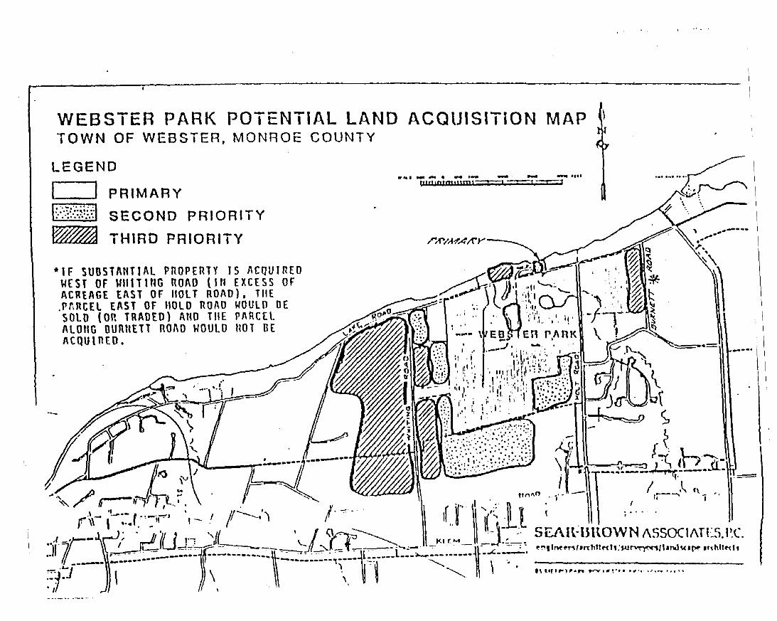
WEBSTER PARK POTENTIAL LAND ACQUISITiON MAPTOWN OF WEBSTER, MONROE COUNTY
LEGEND
PRIMARY
SECOND PRIORITY
THIRD PRIORITY
-IF SUBSTANTIAL PROPERTY IS ACQUIREOWEST OF \WlTlttG ROAD (Ill EXCESS OFACREAGE EAST or 1I0Ll ROAD), TItE.rnRtEL EAST OF HOLD nOAO WOULO OESOLO (on TRADED) Ano TilE rAnCHALOnG llunutTl nOAo WOULD ItOT DEACQUIOEO.
..... .., ......... ,... ....... ..... .... " ..tttrllntm,um'--'--! ===z =r=:1
..= ----
The configuration of the crossing will, in large measure, determine the redevelopmentoptions available for the Sandbar. The Sandbar is composed ofnumerous existing residentialuses on undersized lots. Many ofthese uses are in need ofrepair. These are close to the roadwhich has effectively cut offpublic views of and access to the waterfront area. Because ofthe large number of these uses and the small number of large parcels in single ownershipwithin the Sandbar, acquisition for redevelopment purposes will be slow and expensive. Inaddition, the Town intends to continue to respect the full ownership rights of currentlandowner residences.
The Sandbar is a good site within the Town of Webster's LWRP boundary for improvingaccess to both Lake Ontario and Irondequoit Bay, for developing commercial andrecreational uses that can take advantage of a proximity to water, and for creating a unique"maritime" environment that will help to increase tourism in the area and attract additionaleconomic development activities within the Town. Bay (west end) and Lake water depthsin the areas ofthe Sandbar can accommodate additional marina facilities. Vehicular accessto the Sandbar is provided via Route 18 (Lake Road). Based on this information, the entireSandbar area is proposed for waterfront development use.
The Town feels that private economic forces will eventually result in Sandbar redevelopmentand that the bridge study will provide the guidance for that development.
B. PROPOSED PUBLIC AND PRIVATE PROJECTS
As part of the development of the Town of Webster's LWRP, several public and private projectshave been identified that are feasible, can be undertaken and/or completed in the near future, andappear consistent with the overall policies and purposes of the Town's LWRP. When completed,these projects will help to further enhance, upgrade and revitalize the Town's waterfront areas.These projects are as follows:
* Willow Point Residential Development Project:
This is a private development project that involves the construction of263 residential unitson 47 acres ofland adjacent to Irondequoit Bay. Project cost: $30,000,000.
* Stony Point Landing Residential Development Project:
This is a private development project that involves the construction of 50 single-familyresidences and 109 townhouses on 63 acres ofland adjacent to Irondequoit Bay. Projectcost: $20,000,000.
* Webster Beach Park Redevelopment Project:
This is a public redevelopment project to be undertaken within the existing Webster BeachPark by the County of Monroe, in cooperation with the Town of Webster. The projectinvolves short-term rehabilitation of existing park facilities, as well as long-term park
IV-19
improvement projects, including the construction of a boat-launch facility, a new parkingareas, new trails, shelters and lake overlook, and the reconstruction of an existing pier.Project costs: $750,000 to $950,00 short term; $5,500,000 to $6,000,000 long term.
* Town ofWebster Boat Launch Facility Feasibility Study:
This is a public project involving the Town ofWebster and the County ofMonroe which willattempt to investigate the feasibility oflocating a much-needed Town boat-launch facilityin various waterfront areas within the Town's LWRP boundary.
In March of 1985, the New York State Legislature set aside a special allocation of up to$100,000 for a detailed feasibility study of the construction of a public boat-launch facilitywithin the Town ofWebster. At the time funds were set aside, it was assumed that WebsterBeach Park would be the site for such a facility. Preliminary design and engineering workcompleted by two consultant firms indicated that project costs for the development ofa boatlaunch facility within the park would range from between $1,800,000 to $2,500,000. Themajor reason for these substantial costs is the fact that breakwalls and jetties are necessaryas part of channel construction within Lake Ontario.
The Town ofWebster, in cooperation with the County, will undertake this feasibility studyusing State funds already set aside or new funds to be obtained from other sources. Thefeasibility study will investigate other potential boat-launch locations within the Town whichmay be less costly to develop than the Webster Park site. The study will include a completeengineering and design investigation and costlbenefit analysis of Nine Mile Point and theSandbar location to determine if such a facility could be developed in either one of thoselocations at less cost. Project cost: $50,000 to $100,000.
* Sandbar Projects:
(1) The New York State Department ofTransportation (NYSDOT) currently owns the PennCentral Railroad right-of-way property that stretches from across the northern portion of theSandbar, the Irondequoit Bay outlet to the mainland portion of the Town. The Town, incooperation with Momoe County and the NYSDOT, will make every effort to maintain theright-of-way in public ownership and to develop property as a pedestrian walkway andbikepath for the use and enjoyment of all. This may require the Town and/or the County toparticipate in the purchase ofsome or all of the right-of-way land and in the development ofthe proposed pedestrian trail. In the interim, the State Department of Transportation shouldbe charged with clarifying the current ownership of the R.O.W. and any encroachmentswhich have occurred along the right-of-way. Any issues of title must be clarified by theState before transference to the Town or County occurs.
(2) The Town of Webster is investigating the feasibility of land desired for the parkconsisting of6.5 acres, on a causeway about one mile long, with its widest point being 500
IV-20
feet, and its height an average of4 feet above water. If this land is available, it can be usedas a boat launch, fishing and picnic area.
This is a prime location because it offers several desired recreational outlets: e.g. fishing,boating, picnicking, and a spectacular view of both the lake and the bay. In addition, withthe boat launch on the bay side, it also provides a harbor of refuge and easy launch andretrieval for trailer carried boats.
In 1985, there were two bridges over the outlet to the bay, both of which had under sidesabout four feet above the water. Obviously they limited access to Lake Ontario. The USAnny Corps of Engineers removed the bridges, opened the bay made it a harbor of refuge.Following the opening, the bay became a bonanza for the boating community. Business suchas boat sales, slip rentals, tourism, derbies, regattas and lake fishing expanded. With accessto the lake, a whole new industry opened and is available to anyone who has a boat andtrailer.
Current plans call for contracts to design the park and write the DEIS to be let followingreceipt of the grant. Iflet out in January, they will be finished by mid March 1996, a totalof two months. Attached is a map locating the site.
(3) The Town of Webster will enforce all existing building codes, zoning regulations andother Town Ordinances applicable within the Sandbar district in order to eliminate anyviolations that currently exist and to enhance the general aesthetic and visual quality ofthearea. This activity is seen as part of the Town's ongoing responsibility to eliminate anythreats to public health, safety or welfare within the Town boundaries.
IV-2l
SECTION V
TECHNIQUES FOR IMPLEMENTING THE PROGRAM
TECHNIQUES FOR IMPLEMENTING THE PROGRAM
Section V of the Webster LWRP is organized to present a clear understanding of how each of theapplicable policies, proposed uses and projects for the program will be implemented.
The section includes a map ofthe zoning in the waterfront revitalization area (Map 4, page V-5), asummary ofthe legislative techniques that will implement the policies, and a list ofprojects that willalso assist in implementing the policies.
Separate discussions on the following issues are also presented:
1. Methodology for meeting the legal requirements for local consistency;
2. Definition of the management structure and procedures necessary to implement theLWRP at the local level; and
3. Identification of funding sources.
Much of the legislation that was enacted as part of the LWRP reflects the work of the IrondequoitBay Coordinating Committee. The Bay Committee was created under a cooperative agreementbetween the County ofMonroe and the Towns ofIrondequoit, Penfield and Webster. The New YorkState Department ofEnvironmental Conservation, although not a formal party to the agreement, wasa major participant in the work of the Committee.
The purpose of the Committee was to establish uniform regulations for public and privatedevelopment in the Irondequoit Bay area. The environmental objectives and developmentmanagement measures identified by the Committee were translated into legislation as part of thework completed for Section V of the LWRP.
V-3
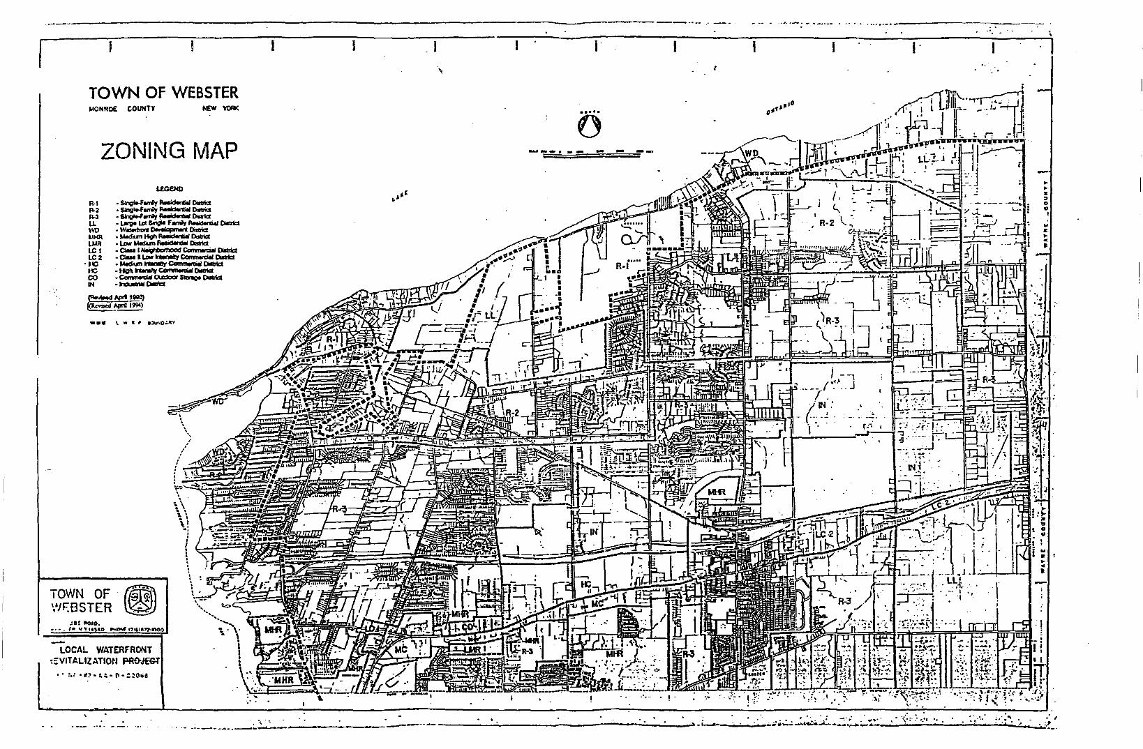
....K
"oU
I
-
-:" I l
~t{:. ' I..:':.... iT.._~._. _ Ir
----.....{)
--j-. --
LOCAL WATERfRONT~::VITALIZATION Pfl~JEGT
•••
ZONING rvlAP
TOWN OF e'.;.~0.'\'JF:BSTER ~
A. LOCAL LAWS AND REGULATIONS IMPLEMENTING THE LWRP
1. Drainage, Erosion And Sediment Control Ordinance, Chapter 104
The Drainage, Erosion and Sedimentation Control Ordinance, Chapter 104 ofthe Code ofthe Town of Webster, includes uniform erosion, sedimentation and storm water runoffcontrol standards that are applied to all development activities within the LWRP boundary.These measures will ensure that surface and ground water runoff will be controlled as muchas possible, that water quality impacts of such runoff will be reduced as much as possible,and that periodic monitoring of the water quality of public and private sector runoffdischarges will be conducted to ensure compliance with State and Federal water qualitystandards. In addition, this ordinance contains development performance standards designedto reduce potential negative impacts ofdevelopment activities on bay and lake water quality.
Chapter 104 provides for the control ofsite preparation and construction in order to preservethe quality of the natural environment including Lake Ontario and Irondequoit Bay, creeks,streams, ponds and other bodies ofwater, from the adverse impacts of site preparation andconstruction. A series of best management practices are referenced in the ordinance toensure that potential negative impacts of development activities on bay and lake waterquality through non-point discharge are minimized during and after project construction.The ordinance also includes provisions for the long-term maintenance of erosion protectionstructures within the LWRP boundary, as well as design and construction standards whichwill ensure erosion control.
2. Freshwater Wetlands, Chapter 130
Chapter 130 of the Code of the Town of Webster (Freshwater Wetlands) provides that theTown shall undertake and exercise its regulatory authority with regard to activities that aresubject to regulation under the New York State Freshwater Wetlands Act.
3. Landfilling, Chapter 147
Chapter 147 (Landfilling) prohibits dumping of any refuse, rubbish, dirt, waste material orother objectionable substances into the streams, lakes, bays or waterways within the Town.
4. Sewers, Chapter 175
Chapter 175 (Sewers) Section 175-7 prohibits unsanitary disposal ofwastes and dischargeof untreated sewage.
5. Subdivision of Land, Chapter 192
Chapter 192 of the Code of the Town ofWebster (Subdivision of Land) requires the use ofpublic sewer systems for new development in the Town when such sewers are available, and
V-7
also outlines Town policies regarding standards for water lines, sewers and septic tanksconstructed to service new development.
6. Water, Chapter 220
Chapter 220 of the Code of the Town of Webster (Water) outlines Town policies regardingstandards for water lines constructed to service new development.
7. Zoning Ordinance, Chapter 225:
The following changes made to the Town's Zoning Ordinance implement the LWRP:
a) The Environmental Protection Overlay District includes a uniform permitapplication and review procedure for development activities proposed withindesignated flood plain, steep slope, and woodlot areas. This detailed applicationand review procedure, which is contained within Chapter 225 of the Code oftheTown ofWebster (Zoning Ordinance), includes requirements for data submissionby the applicant, Town review of this information, a public hearing process, and thegrant or denial of permits. This process is to be coordinated with the appropriatestate and/or federal reviews of development permit applications.
The Environmental Protection Overlay District includes specific regulations andreview procedures for development proposed within 100-year flood plain areas.Development activities have to conform to the requirements ofthe National FloodInsurance Program. This district includes provisions for the preservation of naturalflood protection features such as beaches,dunes, barrier islands and bluffs.Enlargement or re-use ofpre-existing, non-conforming uses within this district arealso regulated. Any buildings that receive a permit and are constructed within the100-year flood plain are required to be flood proofed or constructed above the baseflood level.
The Environmental Protection Overlay District includes specific regulations andreview procedures for development proposed within designated steep slope areas.Development activities will be severely limited in these areas. Developers arerequired to determine the site soil conditions to ensure the stability of slopes andsoils during and after construction activities. Steep slopes include all areas with avertical slope of 15 percent or greater as well as a transition or buffer zone.Development activities will include clearing of vegetation, discharge of stormwater, filling, cutting, grading and excavating. Non-structural managementmeasures will be promoted to prevent damage to natural resources and property.
b) The Waterfront Development District provided for in Chapter 225 of the Code ofthe Town ofWebster Section 225-22 permits a variety of appropriate water and/orrecreation-oriented uses at Nine Mile Point and the Sandbar. These uses includelow and medium density residential development, yacht clubs, mannas,
V-8
hotelslboatels, restaurants, and parks/playgroundslbeaches. The regulations in thisdistrict include references to the permit review criteria to be used in reviewingcertain proposed developments, as well as additional site design standards and siteenvironmental factors to be used in reviewing all proposed development plans inthe district. The district promotes aesthetic considerations within the waterfrontrevitalization area through the utilization of permit review criteria and site designstandards by the Town Planning Board and will allow the Town to promote waterrelated recreational facilities within proposed developments whenever such uses arecompatible with anticipated demand and the primary purpose of the development.
These permit review criteria include:
*
*
*
*
*
*
*
Access and traffic generating characteristics ofthe proposed use;
Utility service;
Relationship of the proposed use to existing natural features;
Fire protection service;
Relationship of the proposed use to bay water depth;
Relationship of the proposed use to the existing land-use and zoningpattern in the area; and
Relationship of the proposed use to specified site designconsiderations.
The permit review criteria apply to the following uses permitted within theWaterfront Development District:
*
*
*
*
*
*
*
Subdivisions
Multi-family (high rise residential development)
Restaurants and other commercial uses
Yacht clubs, marinas
Parks
Hotels, boatels
Combination ofpermitted uses
V-9
Specific Waterfront Development District and Town Planning Board regulationsallow for the provision and/or maintenance of adequate open space and adequateaccess to the shoreline, and for the maintenance of important visual/aestheticelements within proposed developments in the waterfront revitalization area.
The Waterfront Development District includes references to permit review criteriathat will be used to ensure that public services and facilities essential to newdevelopment in a particular area within the LWRP boundary (including such thingsas site access and site utility service) are adequate before such development ispermitted. Site design standards for highway construction and general access forall proposed waterfront development within the LWRP boundary are also includedin this district.
c) Docks, berthing or moorings can be erected, located, moved or structurally alteredaccording to the permit and review procedures provided for in Chapter 225 of theCode of the Town of Webster Article IV.
These permit review criteria include:
*
*
*
*
*
*
*
The adequacy and arrangement of dockage facilities, the location anddesign of such structures, control of boat traffic and overallconvenience and safety in the sit;
The adequacy of the design elements of the plan to enhance theaesthetics aspects of the project;
The adequacy, location and design of accessory and service facilitiesfor dock users;
The location, arrangement, size and design of lighting, signage andother incidental systems;
The adequacy of provisions for access to the shore zone fromdockage or mooring;
The aesthetic and architectural qualities of the dockage, particularlybuilding styles and construction material sued, as they relate to theunique characteristics of the surrounding natural environment; and
The effect upon unique natural resources, potential conflicts withother water surface uses, fish and wildlife habitat and aquaticvegetation on the site.
V-lO
The pennit review criteria apply to the dock plans accessory to or incidental to orincluded with the following uses:
*
*
*
*
*
*
*
*
A single-family detached dwelling, multiple-family dwelling ortownhouse dwelling;
Public parks, playgrounds or similar public recreational usesauthorized or operated by a public agency and not operated for profit;
Parks, playgrounds or other similar private recreational usesauthorized or operated by homeowners associations comprised ofowners of single family detached dwellings, multiple-familydwellings or townhouse dwellings and not operated for profit;
Municipally owned and/or operated buildings or structures and othergovernmental uses and activities;
Private clubs or camps, private membership clubs, lodges or fraternalorganizations, neighborhood or community centers, or other similaruses;
Restaurants, yacht clubs, hotels, stores, shops or other similar uses;
Marinas, docking basins, boat launching ramps, mooring facilities,boat service, repair or storage facilities;
Public utility buildings or structures.
d) Chapter 225 of the Code of the Town of Webster (Zoning Ordinance) Section 22571 prohibits dumping ofwaste, refuse or any other substance without approval fromthe Town Board.
e) The Town Planning Board Section contains detailed site plan review procedures,permit review criteria, and additional site design standards and site environmentalfactors for the review of all development proposals within the waterfrontrevitalization area. The section contains pennit review criteria that will be utilizedto ensure that new development is adequately serviced by utilities and public roads.These criteria also consider the anticipated impacts of the proposed developmenton significant fish and wildlife habitats identified within the LWRP boundary.Projects that do not attempt to mitigate these impacts will not be granteddevelopment permits. Standards have been established (site design considerationsand permit review criteria) which provide for increased public access to theshoreline as part ofthe development approval process and which also outline designcriteria for such access. Site design considerations contained in this section outlinerecommended building heights, provisions for landscaping, vegetation and
V-ll
screening, and criteria for the use of appropriate building scales, shapes, forms andmaterials.
The Town Planning Board Section contains detailed site plan review procedures forwater dependent and water enhanced recreational uses proposed within the LWRPboundary. Permit review criteria that will be utilized to encourage these uses overother forms of development along the waterfront revitalization area are containedin this section. The Town Planning Board Section also contains detailed site planreview procedures, permit review criteria, and site design standards that promotethe integration ofwaterfront features, such as boat moorings, docks, walkways andrecreational easements, into new development plans, whenever possible, based onthe nature of the proposed site and development, and the anticipated demand forsuch facilities.
The Town Planning Board Section contains detailed site plan review procedures forany significant historic structures or archeological or cultural areas within the site.The criteria will also be utilized to determine whether or not the proposeddevelopment impacts any ofthose buildings or areas. If the proposed project doesimpact one of the structures or areas identified, then mitigation measures to protectthat area or structure must be taken or else the permit will be denied.
The section also outlines a step-by-step process that will be utilized to review alldevelopment applications and to grant or deny development permits. Mandatedstate and/or federal reviews of proposed projects are incorporated into the localreview process in this section.
B. OTHER PUBLIC AND/OR PRIVATE ACTIONS NECESSARY TO IMPLEMENTTHELWRP
In addition to the regulatory measures described in the preceding part, several other public andprivate actions will be necessary to assure implementation of the LWRP. These actions include:
1. Development ofthe Nine Mile Point site into a unique, mixed-use waterfront areathat would include water-related commercial uses, low to medium densityresidential development, restaurants, marinas and/or boat launches.
2. Improvement and expansion by the County ofpublic recreational facilities withinWebster Park, to include acquisition of additional land for park purposes andconstruction of a 4-ramp boat launch, new parking areas, new trails, picnic areasand lake overlooks.
3. Investigation by the Town ofthe feasibility oflocating a Town boat-launch facilityin various waterfront areas.
V-12
4. Maintenance of the public ownership of the Conrail Railroad right-of-way locatedon the Sandbar, and the development by the Town or County ofthat right-of-wayinto a pedestrian walkway and/or bikepath.
5. Investigation, by the Town, of marking the Denonville Indian Trail as apedestrianlhiking trail along Irondequoit Bay.
6. Land uses permitted within the Town's LWRP boundary are restricted toresidential, recreational and marina-related commercial. All of these land uses areunlikely to significantly impact air quality within the LWRP area or the Town. TheMonroe County Health Department currently monitors air quality on a periodicbasis to ensure that provisions of the Federal Clean Air Act are met within thecounty.
C. TOWN OF WEBSTER MANAGEMENT STRUCTURE
See Exhibit V-I, page V-I7, for a chart of the management structure. The Webster Town Boardshall serve as the lead agency for the LWRP. The Town of Webster's Commissioner of PublicWorks and his/her department shall be the local administrator responsible for the overallmanagement and coordination of the LWRP. The Commissioner shall be responsible for thefollowing specific activities relative to implementation:
*
*
*
*
*
Coordinating the review and approval process of the legislative changesrecommended as part of the LWRP;
Overseeing all actions required for the implementation ofpolicies and projects ofthe LWRP, e.g., code enforcement activities, capital improvements programming,federal and state grant applications, and coordination of activities with othergovernmental and private entities;
Preparing the environmental assessment for actions occurring within the LWRPboundary which will determine consistency with the policies and projects of theLWRP;
Participating in the State or Federal consistency review process for monitoring andreviewing proposed State and Federal actions as provided for by State and Federallaws and regulations; and
Providing to the Town Board, Planning Board or Zoning Board ofAppeals findingson the consistency ofproposed actions with the policies and purposes ofthe LWRP.
The Town anticipates the assistance of the Monroe County Planning Office in the process ofordinance adoption and the establishment of additional review and permit requirements proposed
V-13
to implement the LWRP. It is anticipated that this will also result in additional work load for theWebster Department of Public Works and the Building Department.
In general, the Town's procedures for assuring compliance with the coastal policies of its LWRPconsist of the administration and enforcement of zoning, the consistency law and other local lawsapplicable to its waterfront in conjunction with the environmental review procedures required by theState Environmental Quality Review Act (SEQRA). Each proposed action by the Town to directlyundertake or to permit, fund or otherwise approve a project, use or activity within the waterfront areawill be processed as follows:
In keeping with NYCRR Part 617.5, the Commissioner of Public Works will review each suchproject, use or activity in consultation with the applicant and/or other involved parties. This reviewwill identify:
1. all Town actions required (permits, funding or approvals) and the board,department, officer or other body responsible for the actions;
2. whether the actions are Type I or Unlisted Actions and therefore subject to theprovisions of SEQRA;
3. whether the actions might conflict with the LWRP; and4. Any other agencies that are involved.
The Commissioner ofPublic Works will advise the applicant and/or other involved parties regardingthe initial review, required forms and further procedures to be followed. In addition, theCommissioner ofPublic Works will provide assistance in the preparation of:
1. Town application forms;2. Environmental Assessment Forms (EAF's) for all Type I and Unlisted Actions; and3. Coastal Assessment Forms (CAF's) for actions subject to SEQR involving permits,
funding or approvals from State or federal agencies.
Upon receipt of completed EAF's, CAF's and, if appropriate, Town application forms, theCommissioner ofPublic Works will immediately initiate procedure in accordance with 6 NYCRRParts 617.6 and 617.7. At the same time, if any actions are determined in the initial review toinvolve potential conflicts with the policies and purposes of the LWRP, they will be referred to thePlanning Board for consistency review. Upon referral the Planning Board will, within thirty (30)days from the date ofreferral, prepare a written report to the lead agency rendering an opinion as towhether the proposed action is consistent with or inconsistent with one or more of the LWRP policystandards or conditions including a written elaboration ofthat opinion and the basis therefore. If theaction is subject to site plan approval by the Planning Board, the Planning Board shall integrate theconsistency review with the site plan review procedures to the maximum extent practicable, providedthat the provisions ofSEQRA have been satisfied before taking action on such site plans.
V-14
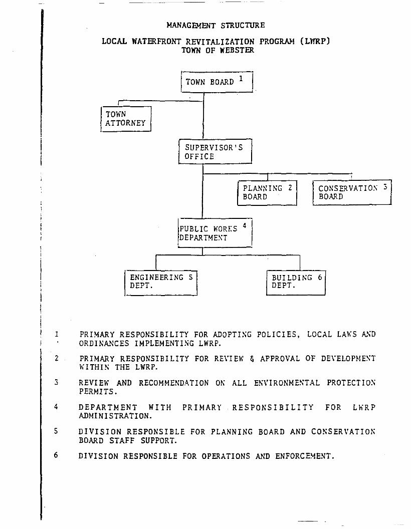
MANAGEMENT STRUCTIJRE
LOCAL WATERFRONT REVITALIZATION PROGRAM (LlfRP)TOWN OF WEBSTER
ATIO~ 3
TOWN BOARD 1
I
NORNEY
SUPERVISOR'SOFFICE
I I
PLAN~ING 2 CONSERVBOARD BOARD
PUBLIC WORKS 4
DEPARTME~T
I
I IENGINEERING S BUILDING 6DEPT. DEPT.
TOWATT
1 PRIMARY RESPONSIBILITY FOR ADOPTIXG POLICIES, LOCAL LAWS ~~D
ORDINMiCES IMPLEMENTING LWRP.
2 PRIMARY RESPONSIBILITY FOR REVI EW & APPROVAL OF DE\·ELOP~IE~T
WITHI~ THE LWRP.
3 REVIEW AND RECOMMENDATION OK ALL E~\'IRONME~TAL PROTECTIO~
PERMITS.
4 DEPARTMENT WITH PRD1ARY RESPONSIBILITY FOR Lh'RPADM! NI STRATI ON.
S DIVISION RESPONSIBLE FOR PLANNING BOARD AND CO~SERVATIO~
BOARD STAFF SUPPORT.
6 DIVISION RESPONSIBLE FOR OPERATIONS AND ENFORCE~ENT.
The lead agency will make its determination of consistency based on the CAF, the recommendationof the Planning Board, and such other information as is deemed necessary in its determination. Thelead agency shall have the authority, in its findings of consistency, to impose practicable andreasonable conditions on an action to ensure that it is carried out in accordance with the WaterfrontConsistency Review Law.
The Town will review State and Federal actions which are proposed for the Webster waterfront areain accordance with procedures established by the New York State Department of State. Theseprocedures are found in Appendix 1 of this section.
D. LOCAL FINANCIAL RESOURCES
Financial resources which may be needed for implementation of the LWRP would come fromseveral sources:
1. Local (Town and County) investment, for any actual projects described in SectionIV;
2. Local investment, for the general supervision and management ofthe program; and
3. Private investment, for development activities.
In addition to the costs associated with the management of Webster's Local WaterfrontRevitalization Program and the implementation of code revisions, there are five projects whichrequire local investment at the Town/County level. These projects are:
*
*
*
*
*
Webster Park redevelopment;
Bridge replacement study;
Purchase and development of the abandoned Hojack Line as a pedestrian walkwayand bikeway;
Construction, upgrading, or replacement of infrastructure facilities In olderwaterfront neighborhoods on an as needed basis; and
Potential acquisition of a privately owned landfill site and conversion to a passiverecreational facility.
The Webster Beach Park Redevelopment Project will be funded through the Monroe County CapitalImprovements Program. Short-tean improvements are expected to cost between $750,000 and$950,000, long-term improvements between $5,500,000 and $6,000,000. The Monroe Countylegislature authorized an expenditure ofup to $100,000 for the bridge replacement study. No fundshave been specifically earmarked for the Hojack Line, pending negotiations with the New York StateDepartment of Transportation and Department of Parks and Outdoor Recreation.
V-I?
These projects and actions are in addition to those which have been identified as the responsibilityof the State. Such projects and actions include:
*
*
Completion of the Irondequoit Bay opening project and the construction ofthe jettyat the Bay opening; and
Boat launch feasibility study authorized by the State Legislature.
Funds for those undertakings identified as the Town andlor County's responsibility will be raisedthrough one or more of the following financing techniques:
*
*
*
*
*
*
*
Financing projects and management with current revenues, paying cash instead ofborrowing against future revenues;
Bond issues, including: general obligation bonds (backed by full faith and creditof the municipality); special assessment bonds (levied against owners ofpropertydirectly benefitting from improvements); revenue bonds (which pledge incomefrom a specific enterprise);
Short-tenn notes issued by local banks;
Revenue funds, funds accumulated in advance for construction of capital projects;
Lease purchase agreements enabling private companies and authorities to build andlease public works facilities from the municipality;
Authority and special districts created to manage facilities which are supported byuser charges; and
State and Federal aid including: Community Development Urban County BlockGrants, Federal revenue sharing, New York State Land and Water ConservationProgram, New York State Neighborhood Park and Land Acquisition Program, Staterevenue sharing and Special Municipal Aid. In addition to the provision of localfunds, the successful implementation of several of the Local WaterfrontRevitalization Programs proposed projects, e.g., Stony Point, Willow Point, NineMile Point, will depend upon major investments on the part ofthe private sector aswell as the Town's ability to take a strong leadership role in working with propertyowners and potential investors to provide an effective framework for localpublic/private cooperation. By so doing, the Town will encourage the types ofprivate sector participation and investment which will be essential to the successfulimplementation ofthe residential and mixed-use developments discussed in SectionIV.
V-I8
E. SUMMARY OF IMPLEMENTATION OF LWRP POLICIES THROUGHLEGISLATION AND OTHER ACTIONS
POLICY 1
a. Legislation That Implements This Policy:
The following changes made to the Town's Zoning Ordinance as a result of the LWRPimplement the above policy:
1. The Waterfront Development District provided for in Chapter 225 of the Code ofthe Town of Webster Section 225-22 permits a variety of appropriate water and/orrecreation-oriented uses at Nine Mile Point and the Sandbar. These uses includelow and medium density residential development, yacht clubs, marinas,hotels/boatels, restaurants, and parkslplaygroundslbeaches. The regulations in thisdistrict include references to the permit review criteria to be used in reviewingcertain proposed developments, as well as additional site design standards and siteenvironmental factors to be used in reviewing all proposed development plans inthe district. The district promotes aesthetic considerations within the waterfrontrevitalization area through the utilization ofpermit review criteria and site designstandards by the Town Planning Board.
These permit review criteria include:
*
*
*
*
*
*
*
Access and traffic generating characteristics ofthe proposed use;
Utility service;
Relationship of the proposed use to existing natural features;
Fire protection service;
Relationship of the proposed use to bay water depth;
Relationship ofthe proposed use to the existing land-use and zoningpattern in the area; and
Relationship of the proposed use to specified site designconsiderations.
The permit review criteria apply to the following uses permitted within theWaterfront Development District:
* Subdivisions
V-19
*
*
*
*
*
*
Multi-family (high rise residential development)
Restaurants and other commercial uses
Yacht clubs, marinas
Parks
Hotels, boatels
Combination ofpermitted uses
2. Docks, berthing or moorings can be erected, located, moved or structurally alteredaccording to the permit and review procedures provided for in Chapter 225 of theCode of the Town of Webster Article IV.
These permit review criteria include:
*
*
*
*
*
*
*
The adequacy and arrangement ofdockage facilities, the location anddesign of such structures, control of boat traffic and overallconvenience and safety in the sit;
The adequacy of the design elements of the plan to enhance theaesthetics aspects of the project;
The adequacy, location and design of accessory and service facilitiesfor dock users;
The location, arrangement, size and design of lighting, signage andother incidental systems;
The adequacy of provisions for access to the shore zone fromdockage or mooring;
The aesthetic and architectural qualities of the dockage, particularlybuilding styles and construction material sued, as they relate to theunique characteristics of the surrounding natural environment; and
The effect upon unique natural resources, potential conflicts withother water surface uses, fish and wildlife habitat and aquaticvegetation on the site.
V-20
The pennit review criteria apply to the dock plans accessory to or incidental to orincluded with the following uses:
*
*
*
*
*
*
*
*
A single-family detached dwelling, multiple-family dwelling ortownhouse dwelling;
Public parks, playgrounds or similar public recreational usesauthorized or operated by a public agency and not operated for profit;
Parks, playgrounds or other similar private recreational usesauthorized or operated by homeowners associations comprised ofowners of single family detached dwellings, multiple-familydwellings or townhouse dwellings and not operated for profit;
Municipally owned and/or operated buildings or structures and othergovernmental uses and activities;
Private clubs or camps, private membership clubs, lodges or fraternalorganizations, neighborhood or community centers, or other similaruses;
Restaurants, yacht clubs, hotels, stores, shops or other similar uses;
Marinas, docking basins, boat launching ramps, mooring facilities,boat service, repair or storage facilities;
Public utility buildings or structures.
3. The Town Planning Board Section contains detailed site plan review procedures,pennit review criteria, and additional site design standards and site environmentalfactors for the review of all development proposals within the waterfrontrevitalization area.
4. Specific Waterfront Development District and Town Planning Board regulationsallow for the provision and/or maintenance of adequate open space and adequateaccess to the shoreline, and for the maintenance of important visual/aestheticelements within proposed developments in the waterfront revitalization area.
b. Additional Public And/or Private Actions That Implement This Policy:
1. Development ofthe Nine Mile Point site into a unique, mixed-use waterfront areathat would include water-related commercial uses, low to medium densityresidential development, restaurants, marinas and/or boat launches.
V-21
2. Improvement and expansion by the County ofpublic recreational facilities withinWebster Park, to include acquisition of additional land for park purposes andconstruction of a 4-ramp boat launch, new parking areas, new trails, picnic areasand lake overlooks.
3. Investigation by the Town ofthe feasibility oflocating a Town boat-launch facilityin various waterfront areas.
4. Maintenance of the public ownership of the Comail Railroad right-of-way locatedon the Sandbar, and the development by the Town or County of that right-of-wayinto a pedestrian walkway and/or bikepath.
POLICY 2
a. Legislation That Implements This Policy:
See 1.,2. and 3. under A. on pages V-7, V-8 & V-9.
b. Additional Public And/or Private Actions That Implement This Policy:
See 1. - 4. under B. on page V-IO
POLICY 3:
POLICY 4:
POLICY 5
NOT APPLICABLE.
NOT APPLICABLE.
a. Legislation That Implements This Policy:
Two changes made to the Town's Zoning Ordinance as a result of the LWRP implement theabove policy:
1. The Waterfront Development District includes references to permit review criteriathat will be used to ensure that public services and facilities essential to newdevelopment in a particular area within the LWRP boundary (including such thingsas site access and site utility service) are adequate before such development ispermitted. Site design standards for highway construction and general access forall proposed waterfront development within the LWRP boundary are also includedin this district.
2. The Town Planning Board Section contains detailed site plan review procedures forall development proposals within the LWRP. The section contains permit reviewcriteria that will be utilized to ensure that new development is adequately servicedby utilities and public roads.
V-22
Chapter 175 of the Code of the Town of Webster (Sewers), Chapter 220 of the Code of theTown of Webster (Water), and Chapter 192 of the Code of the Town of Webster(Subdivision of Land) require the use ofpublic sewer systems for new development in theTown when such sewers are available, and also outline Town policies regarding standardsfor water lines, sewers and septic tanks constructed to service new development.
b. Additional Public And/or Private Actions That Implement This Policy:
None required or identified.
POLICY 6
a. Legislation That Implements This Policy:
Two changes made to the Town's Zoning Ordinance as a result of the LWRP implement theabove policy:
1. The Town Planning Board Section contains detailed site plan review procedures forall development proposals within the LWRP. The section outlines a step-by-stepprocess that will be utilized to review all development applications and to grant ordeny development permits. Mandated state and/or federal reviews of proposedprojects are incorporated into the local review process in this section.
2. The Environmental Protection Overlay District includes a uniform permitapplication and review procedure for development activities proposed withindesignated flood plain, steep slope, and woodlot areas. This detailed applicationand review procedure, which is contained within Chapter 225 of the Code of theTO\\TI of Webster (Zoning Ordinance), includes requirements for data submissionby the applicant, Town review ofthis information, a public hearing process, and thegrant or denial ofpermits. This process is to be coordinated with the appropriatestate and/or federal reviews of development permit applications.
b. Additional Public And/or Private Actions That Implement This Policy:
None required or identified.
POLICY 7
a. Legislation That Implements This Policy:
Two changes made to the Town's Zoning Ordinance as a result of the LWRP implement theabove policy:
1. The Environmental Protection Overlay District includes specific regulations andreview procedures for development proposed within designated woodlot areas.
V-23
Development activities will be limited and will be subject to a permit procedure.By preserving woodlot areas within the LWRP boundary, important wildlife habitatareas will also be preserved and protected.
2. The Town Planning Board Section contains the permit review criteria that will beutilized to approve or deny development proposals for certain uses. These criteriaconsider the anticipated impacts of the proposed development on significant fishand wildlife habitats identified within the LWRP boundary. Projects that do notattempt to mitigate these impacts will not be granted development permits.
b. Additional Public And/or Private Actions That Implement This Policy:
None required or identified.
POLICY 8
a. Legislation That Implements This Policy:
Chapter 104 of the Code of the Town of Webster (Drainage, Erosion & Sedimentation)provides for the control of site preparation and construction in order to preserve the qualityof the natural environment including Lake Ontario and Irondequoit Bay, creeks, streams,ponds and other bodies of water, from the adverse impacts of site preparation andconstruction. Chapter 130 of the Code of the Town of Webster (Freshwater Wetlands)provides that the Town shall undertake and exercise its regulatory authority with regard toactivities that are subject to regulation under the New York State Freshwater Wetlands Act.Chapter 225 of the Code of the Town of Webster (Zoning Ordinance) Section 225-71prohibits dumping ofwaste, refuse or any other substance without approval from the TownBoard. Chapter 175 (Sewers) Section 175-7 prohibits unsanitary disposal of wastes anddischarge ofuntreated sewage. In addition, those State laws listed under Policy 8 in SectionTIl are implementation measures for this policy.
b. Additional Public And/or Private Actions That Implement This Policy:
None required or identified.
POLICY 9
a. Legislation That Implements This Policy:
The Waterfront Development District permits a variety ofappropriate water and/or recreationoriented uses at Nine Mile Point and the Sandbar. These uses include yacht clubs, marinas,parks, beaches and associated facilities that permit increased access to Irondequoit Bay andLake Ontario fish and wildlife resources. In addition, this district requires that adequateaccess be provided to the waterfront revitalization area within new developments and thatadequate vehicular access be provided to the development site.
V-24
\
b. Additional Public And/or Private Actions That Implement This Policy:
See l. and 2. under B. on page V-lO.
POLICY 10: NOT APPLICABLE.
POLICY 11
a. Legislation That Implements This Policy:
The Environmental Protection Overlay District includes specific regulations and reviewprocedures for development proposed within lOa-year flood plain areas. Developmentactivities have to conform to the requirements of the National Flood Insurance Program.Enlargement or re-use of pre-existing, non-conforming uses within this district are alsoregulated.
The Environmental Protection Overlay District includes specific regulations and reviewprocedures for development proposed within designated steep slope areas. Developmentactivities will be severely limited in these areas. Developers are required to determine thesite soil conditions to ensure the stability of slopes and soils during and after constructionactivities. Steep slopes include all areas with a vertical slope of 15 percent or greater as wellas a transition or buffer zone.
b. Additional Public And/or Private Actions That Implement Policy:
None required or identified.
POLICY 12
a. Legislation That Implements This Policy:
1. The Environmental Protection Overlay District includes specific regulations andreview procedures for development proposed within designated lOa-year floodplain areas. Development activities have to conform to the requirements of theNational Flood Insurance Program. This district includes provisions for thepreservation of natural flood protection features such as beaches, dunes, barrierislands and bluffs.
The Environmental Protection Overlay District includes specific regulations andreview procedures for development proposals within designated steep slope areas.Development activities will be severely limited in these areas. Developers arerequired to ensure the stability of slopes and soils during and after constructionactivities. Steep slopes include all areas with a vertical slope of 15 percent orgreater as well as a transition or buffer zone. Development activities will include
V-25
clearing of vegetation, discharge of storm water, filling, cutting, grading andexcavating. Non-structural management measures will be promoted to preventdamage to natural resources and property.
2. The Drainage, Erosion, and Sedimentation Control Ordinance includes uniformerosion, sedimentation and storm water runoffcontrol standards that will be appliedto all development activities within the LWRP boundary. These measures willfurther ensure the stability of steep slope areas. A series of best managementpractices are referenced in the ordinance to ensure that potential negative impactsof development activities on bay and lake water quality through non-pointdischarge are minimized during and after project construction. The ordinance alsoincludes provisions for the long-term maintenance of erosion protection structureswithin the LWRP boundary, as well as design and construction standards whichwill ensure erosion control.
b. . Additional Public And/or Private Actions That Implement This Policy:
None required or identified.
POLICY 13
a. Legislation That Implements This Policy:
See 2. above.
b. Additional Public And/or Private Actions That Implement This Policy:
None required or identified.
POLICY 14
a. Legislation That Implements This Policy:
See I. under A. on page V-14.
See 2. above.
b. Additional Public And/or Private Actions That Implement This Policy:
None required or identified.
V-26

-- - -- ---------- _ .. -
POLICY 15
a. Legislation That Implements This Policy:
State regulations are adequate to implement the LWRP policies. The New York StateDepartment of Environmental Conservation regulates dredging activities in shoreline andwetland areas. These regulations are comprehensive in nature and address actions accordingto their potential to interfere with the natural coastal processes which supply beach material,as well as their potential for increasing soil erosion and sedimentation. In addition, the TownofWebster Zoning Ordinance prohibits commercial mining and quarrying operations of anykind within the Town, thereby protecting the upland areas within the LWRP boundary.
b. Additional Public And/or Private Actions That Implement This Policy:
None required or identified.
POLICY 16
a. Legislation That Implements This Policy:
See 2. on page V-IS.
b. Additional Public And/or Private Actions That Implement This Policy:
None required or identified.
POLICY 17
a. Legislation That Implements This Policy:
The Environmental Protection Overlay District includes specific regulations and reviewprocedures for development proposed within designated IOO-year flood plain areas.Development activities will conform to the requirements of the National Flood InsuranceProgram. Any buildings that receive a permit and are constructed within the IOO-year floodplain are required to be flood proofed or constructed above the base flood level.
See 1. under A. on page V-14.
See 2. on page V-IS.
b. Additional Public And/or Private Actions That Implement This Policy:
None required or identified.
V-27
POLICY 18
a. Legislation That Implements This Policy:
None required or identified.
b. Additional Public And/or Private Actions That Implement This Policy:
None required or identified.
POLICY 19
a. Legislation That Implements This Policy:
The Town Planning Board Section contains detailed site plan review procedures for alldevelopment proposals within the LWRP. Standards have been established within theseprocedures (site design considerations and permit review criteria) which provide forincreased public access to the shoreline as part of the development approval process andwhich also outline design criteria for such access.
b. Additional Public And/or Private Actions That Implement This Policy:
See 1. - 4. under B. on pages V-10.
POLICY 20
a. Legislation That Implements This Policy:
The Town Planning Board Section contains detailed site plan review procedures for waterdependent and water enhanced recreational uses proposed within the LWRP boundary.Permit review criteria that will be utilized to encourage these uses over other forms ofdevelopment along the waterfront revitalization area are contained in this section.
b. Additional Public And/or Private Actions That Implement This Policy:
See 2., 3. and 4. under B. on pages V-10.
POLICY 21
a. Legislation That Implements This Policy:
See 1.,2. and 3. under A. on pages V-7, V-8 and V-9.
See A. under Policy 20.
V-28
---~---~ -------- ----
b. Additional Public And/or Private Actions That Implement This Policy:
See 1. - 4. under B. on pages V-10.
Investigation by the Town ofmarking the Denonville Indian Trail as a pedestrianlhiking trailalong Irondequoit Bay.
POLICY 22
a. Legislation That Implements This Policy:
1. The Waterfront Development.District permits a variety of appropriate water and/orrecreation-oriented uses at Nine Mile Point and the Sandbar. The regulations in thisdistrict include references to the permit review criteria and site design standards thatwill allow the Town to promote water-related recreational facilities within proposeddevelopments whenever such uses are compatible with anticipated demand and theprimary purpose of the development.
2. The Town Planning Board Section contains detailed site plan review procedures,permit review criteria, and site design standards that will be utilized in the reviewof all development proposals within the waterfront revitalization area. Thesecriteria and standards promote the integration of waterfront features, such as boatmoorings, docks, walkways and recreational easements, into new developmentplans, whenever possible, based on the nature of the proposed site anddevelopment, and the anticipated demand for such facilities.
b. Additional Public And/or Private Actions That Implement This Policy:
None required or identified.
POLICY 23
a. Legislation That Implements This Policy:
The Town Planning Board Section contains detailed site plan review procedures for alldevelopment proposals within the LWRP and the permit review criteria that will be utilizedto approve or deny development proposals for certain uses. These criteria require theidentification of any significant historic structures or archeological or cultural areas withinthe site. The criteria will also be utilized to determine whether or not the proposeddevelopment impacts any ofthose buildings or areas. If the proposed project does impactone of the structures or areas identified, then mitigation measures to protect that area orstructure must be taken or else the permit will be denied.
V-29

b. Additional Public And/or Private Actions That Implement This Policy:
See 1. - 2. under B. on page V-I O.
Investigation by the Town ofmarking the Denonville Indian Trail as a pedestrian/h:iking trailalong Irondequoit Bay.
POLICY 24: NOT APPLICABLE.
POLICY 25
a. Legislation That Implements this Policy:
The Town Planning Board Section contains detailed site plan review procedures for alldevelopment proposals within the waterfront revitalization area, and the permit reviewcriteria that will be utilized to approve or deny development proposals for certain uses. Sitedesign considerations contained in this section outline recommended building heights,provisions for landscaping, vegetation and screening, and criteria for the use ofappropriatebuilding scales, shapes, forms and materials.
b. Additional Public And/or Private Actions That Implement this Policy:
None required or identified.
POLICY 26: NOT APPLICABLE.
POLICY 27
a. Legislation That Implements this Policy:
State legislation implements this policy.
b. Additional Public And/or Private Actions That Implement this Policy:
None required or identified.
POLICY 28
a. Legislation That Implements this Policy:
State legislation implements this policy.
b. Additional Public And/or Private Actions That Implement this Policy:
None required or identified.
V-30
POLICY 29: NOT APPLICABLE.
POLICY 30
a. Legislation That Implements this Policy:
1. State legislation, listed under Policy 8 in Section III, implements this policy.
2. The Town ofWebster Zoning Ordinance, Chapter 225, Section 225-71, ofthe Codeofthe Town of Webster, prohibits dumping ofwaste, refuse or any other substancewithin the Town without approval from the Town Board. The Code of the town ofWebster, Chapter 175 (Sewers), Section 175-7, prohibits unsanitary disposal ofwastes and discharge ofuntreated sewage.
3. The Drainage, Erosion and Sedimentation Control Ordinance, Chapter 104 of theCode of the Town of Webster, includes uniform erosion, sedimentation and stormwater runoff control standards that will be applied to all development activitieswithin the LWRP boundary. These measures will ensure that surface and groundwater runoff will be controlled as much as possible, that water quality impacts ofsuch runoffwill be reduced as much as possible, and that periodic monitoring ofthewater quality of public and private sector runoff discharges will be conducted toensure compliance with State and Federal water quality standards. In addition, thisordinance contains development performance standards designed to reducepotential negative impacts ofdevelopment activities on bay and lake water quality.
4. The Town Planning Board Section contains detailed site plan review procedures forall development proposals within the LWRP and contains permit review criteriathat will be utilized to approve or deny development proposals for certain uses.These criteria require that the potential impacts ofa proposed development on LakeOntario and/or Irondequoit Bay water quality be considered and weighed againstthe feasibility of providing any mitigation measures to control such impacts.Permits will be denied for those development projects which significantly impactbay and/or lake water quality and which cannot or do not provide appropriatemitigation measures.
b. Additional Public And/or Private Actions That Implement this Policy:
1. The Monroe County Health Department can monitor discharge of effluent fromsewage disposal systems of less than 1,000 gallons per day to ensure compliancewith State and Federal water quality standards. The New York State Departmentof Environmental Conservation monitors discharge of effluent from sewagedisposal systems of greater than 1,000 gallons per day to ensure compliance withState and Federal water quality standards.
V-31
2. The proposed Water Quality Management Plan for the Irondequoit Basin, whichcontains a two-phased strategy for improving the Basin's water quality, consists ofwater quality improvement techniques, an administrative leader and staff, financingmethods, and intergovernmental cooperation.
POLICY 31
a. Legislation That Implements this Policy:
See 3. and 4. under A. on page V-20.
b. Additional Public And/or Private Actions That Implement this Policy:
None required or identified.
POLICY 32: NOT APPLICABLE.
POLICY 33
a. Legislation That Implements this Policy:
See 3. under A. on page V-20.
b. Additional Public And/or Private Actions That Implement this Policy:
None required or identified.
POLICY 34
a. Legislation That Implements tbis Policy:
1. Chapter 147 (Landfi.lIing) prohibits dumping of any refuse, rubbish, dirt, wastematerial or other objectionable substances into the streams, lakes, bays orwaterways within the Town. Chapter 225 (Town Zoning Ordinance), Section 22571, prohibits dumping of waste, refuse or any other substance within the Townwithout approval from the Town Board. Chapter 175 (Sewers), Section 175-7,prohibits unsanitary disposal ofwastes and discharge ofuntreated sewage.
2. The Water Surface Use Regulations Ordinance for Irondequoit Bay, which wasdeveloped by the Irondequoit Bay Coordinating Committee, addresses such issuesas: the speed and operation ofvessels within 300 feet ofthe shoreline and within500 feet ofany marinas or boat mooring areas; the reduction ofanticipated conflictsbetween recreational uses in the near shore area; the reduction ofwake effects onprivate property and environmentally-sensitive areas; and the prohibition of therelease of waste, garbage or hazardous materials from boats operating on
V-32
Irondequoit Bay and/or Lake Ontario, in order to generally protect the public health,safety and welfare, and to preserve the natural beauty and water quality of the bayand lake areas.
b. Additional Public And/or Private Actions That Implement this Policy:
None required or identified.
POLICY 35
a. Legislation That Implements this Policy:
The New York State Department of Environmental Conservation issues dredging permitsonly when it has been determined that the anticipated adverse impacts ofsuch activities havebeen reduced to acceptable levels that satisfy state dredging permit standards as set forth inregulations developed pursuant to the State Environmental Conservation Law.
b. Additional Public And/or Private Actions That Implement this Policy:
None required or identified.
POLICY 36: NOT APPLICABLE.
POLICY 37
a. Legislation That Implements this Policy:
See 2. on page V-15.
See 3. under A. on page V-20.
b. Additional Public And/or Private Actions That Implement this Policy:
None required or identified.
POLICY 38
a. Legislation That Implements this Policy:
See 2. on page V-I5.
See 3. under A. on page V-20.
V-33
b. Additional Public And/or Private Actions That Implement this Policy:
None required or identified.
POLICY 39
a. Legislation That Implements this Policy:
None required or identified.
b. Additional Public And/or Private Actions That Implement this Policy:
There is currently no storage, treatment andlor disposal of hazardous wastes within theTown's LWRP boundary. No activity will occur within this area which would produce suchhazardous wastes, as defined in Article 27 of the New York State EnvironmentalConservation Law. The LWRP area does contain a sanitary landfill for limited private usewhich should continue in operation for approximately five more years. The Town willcontinue to utilize best management practices in the operation of the landfill to protectground and surface water, significant fish and wildlife habitats, and recreation sites in theimmediate area. Chapter 147 (Landfilling) of the Code of the Town of Webster controls, toa greater extent, the operation of the landfill.
POLICY 40: NOT APPLICABLE
POLICY 41
a. Legislation That Implements this Policy:
None required or identified.
b. Additional Public And/or Private Actions That Implement this Policy:
Land uses permitted within the Town's LWRP boundary are restricted to residential,recreational and marina-related commercial. All of these land uses are unlikely tosignificantly impact air quality within the LWRP area or the Town. The Monroe CountyHealth Department currently monitors air quality on a periodic basis to ensure that provisionsof the Federal Clean Air Act are met within the county.
V-34
-------------- --
POLICY 42
a. Legislation That Implements this Policy:
State legislation, including the Air Pollution Control Act, Environmental Conservation Law(Article 19), the Waterfront Revitalization and Coastal Resources Act, and Executive Law(Article 42), implements this policy.
b. Additional Public And/or Private Actions That Implement this Policy:
None required or identified.
POLICY 43
a. Legislation That Implements this Policy:
See A. under Policy 42 above.
b. Additional Public And/or Private Actions That Implement this Policy:
None required or identified.
POLICY 44
a. Legislation That Implements this Policy:
None required or identified.
b. Additional Public And/or Private Actions That Implement this Policy:
None required or identified.
V-35
SECTION VI
STATE AND FEDERAL ACTIONS AND PROGRAMS
LIKELY TO AFFECT IMPLEMENTATION
State and Federal actions will affect and be affected by implementation of the LWRP. Under Statelaw and the U.S. Coastal Zone Management Act, certain State and Federal actions within or affectingthe local waterfront area must be "consistent" or "consistent to the maximum extent practicable" withthe enforceable policies and purposes ofthe LWRP. This consistency requirement makes the LWRPa unique, intergovernmental mechanism for setting policy and making decisions and helps to preventdetrimental actions from occurring and future options from being needlessly foreclosed. At the sametime, the active participation of State and Federal agencies is also likely to be necessary toimplement specific provisions of the LWRP.
The first part of this section identifies the actions and programs ofState and Federal agencies whichshould be undertaken in a manner consistent with the LWRP. This is a generic list of actions andprograms, as identified by the NYS Department ofState; therefore, some ofthe actions and programslisted may not be relevant to this LWRP. Pursuant to the State Watemont Revitalization and CoastalResources Act (Executive Law, Article 42), the Secretary of State individually and separatelynotifies affected State agencies of those agency actions and programs which are to be undertaken ina manner consistent with approved LWRPs. Similarly, Federal agency actions and programs subjectto consistency requirements are identified in the manner prescribed by the U.S. Coastal ZoneManagement Act and its implementing regulations. The lists of State and Federal actions andprograms included herein are informational only and do not represent or substitute for the requiredidentification and notification procedures. The current official lists of actions subject to State andFederal consistency requirements may be obtained from the NYS Department of State.
The second part of this section is a more focused and descriptive list of State and Federal agencyactions which are necessary to further implementation of the LWRP. It is recognized that a Stateor Federal agency's ability to undertake such actions is subject to a variety of factors andconsiderations; that the consistency provisions referred to above, may not apply; and that theconsistency requirements can not be used to require a State or Federal agency to undertake an actionit could not undertake pursuant to other provisions oflaw. Reference should be made to Section Nand Section V, which also discuss State and Federal assistance needed to implement the LWRP.
A. STATE AND FEDERAL ACTIONS AND PROGRAMS WHICH SHOULD BEUNDERTAKEN IN A MANNER CONSISTENT WITH THE LWRP
1. State Agencies
OFFICE FOR THE AGING
1.00 Funding and/or approval programs for the establishment of new or expandedfacilities providing various services for the elderly.
DEPARTMENT OF AGRICULTURE AND MARKETS
1.00 Agricultural Districts Program
2.00 Rural Development Program3.00 Farm Worker Services Programs.4.00 Permit and approval programs:
4.01 Custom SlaughterslProcessor Permit4.02 Processing Plant License4.03 Refrigerated Warehouse and/or Locker Plant License
DIVISION OF ALCOHOLIC BEVERAGE CONTROL/STATE LIQUORAUTHORITY
1.00 Permit and Approval Programs:
1.01 Ball Park - Stadium License1.02 Bottle Club License1.03 Bottling Permits1.04 Brewer's Licenses and Permits1.05 Brewer's Retail Beer License1.06 Catering Establishment Liquor License1.07 Cider Producer's and Wholesaler's Licenses1.08 Club Beer, Liquor, and Wine Licenses1.09 Distiller's Licenses1.10 Drug Store, Eating Place, and Grocery Store Beer Licenses1.11 Farm Winery and Winery Licenses1.12 Hotel Beer, Wine, and Liquor Licenses1.13 Industrial Alcohol Manufacturer's Permits1.14 Liquor Store License1.15 On-Premises Liquor Licenses1.16 Plenary Permit (Miscellaneous-Annual)1.17 Summer Beer and Liquor Licenses1.18 Tavern/Restaurant and Restaurant Wine Licenses1.19 Vessel Beer and Liquor Licenses1.20 Warehouse Permit1.21 Wine Store License1.22 Winter Beer and Liquor Licenses1.23 Wholesale Beer, Wine, and Liquor Licenses
DIVISION OF ALCOHOLISM AND ALCOHOL ABUSE
1.00 Facilities, construction, rehabilitation, expansion, or demolition or the funding ofsuch activities.
2.00 Permit and approval programs:
VI-4
------------ -
2.01 Letter Approval for Certificate of Need2.02 Operating Certificate (Alcoholism Facility)2.03 Operating Certificate (Community Residence)2.04 Operating Certificate (Outpatient Facility)2.05 Operating Certificate (Sobering-Up Station)
COUNCIL ON THE ARTS
1.00 Facilities construction, rehabilitation, expansion, or demolition or the funding ofsuchactivities.
2.00 Architecture and environmental arts program.
DEPARTMENT OF BANKING
1.00 Permit and approval programs:
1.01 Authorization Certificate (Bank Branch)1.02 Authorization Certificate (Bank Change of Location)1.03 Authorization Certificate (Bank Charter)1.04 Authorization Certificate (Credit Union Change ofLocation)1.05 Authorization Certificate (Credit Union Charter)1.06 Authorization Certificate (Credit Union Station)1.07 Authorization Certificate (Foreign Banking Corporation Change ofLocation)1.08 Authorization Certificate (Foreign Banking Corporation Public
Accommodations Office1.09 Authorization Certificate (Investment Company Branch)1.10 Authorization Certificate (Investment Company Change of Location)1.11 Authorization Certificate (Investment Company Charter)1.12 Authorization Certificate (Licensed Lender Change of Location)1.13 Authorization Certificate (Mutual Trust Company Charter)1.14 Authorization Certificate (private Banker Charter)1.15 Authorization Certificate (Public Accommodation Office - Banks)1.16 Authorization Certificate (Safe Deposit Company Branch)1.17 Authorization Certificate (Safe Deposit Company Change of Location)1.18 Authorization Certificate (Safe Deposit Company Charter)1.19 Authorization Certificate (Savings Bank Charter)1.20 Authorization Certificate (Savings Bank De Novo Branch Office)1.21 Authorization Certificate (Savings Bank Public Accommodations Office)1.22 Authorization Certificate (Savings and Loan Association Branch)1.23 Authorization Certificate (Savings and Loan Association Change of
Location)1.24 Authorization Certificate (Savings and Loan Association Charter)
VI-5
1.25 Authorization Certificate (Subsidiary Trust Company Charter)1.26 Authorization Certificate (Trust Company Branch)1.27 Authorization Certificate (Trust Company-Change of Location)1.28 Authorization Certificate (Trust Company Charter)1.29 Authorization Certificate (Trust Company Public Accommodations Office)1.30 Authorization to Establish a Life Insurance Agency1.31 License as a Licensed Lender1.32 License for a Foreign Banking Corporation Branch
NEW YORK STATE BRIDGE AUTHORITY
1.00 Acquisition, disposition, lease, grant ofeasement and other activities related to themanagement ofland under the jurisdiction of the Authority.
2.00 Facilities construction, rehabilitation, expansion, or demolition.
DEPARTMENT OF COMMERCE
1.00 Preparation or revision of statewide or specific plans to address State economicdevelopment needs.
2.00 Allocation of the state tax-free bonding reserve.
DEPARTMENT OF CORRECTIONAL SERVICES
1.00 Facilities construction, rehabilitation, expansion, or demolition or the funding ofsuchactivities.
DORMITORY AUTHORITY OF THE STATE OF NEW YORK
1.00 Financing ofhigher education and health care facilities.
2.00 Planning and design services assistance program.
EDUCATION DEPARTMENT
1.00 Facilities construction, rehabilitation, expansion, demolition or the funding ofsuchactivities.
VI-6
2.00 Pennit and approval programs:
2.01 Certification ofIncorporation (Regents Charter)2.02 Private Business School Registration2.03 Private School License2.04 Registered Manufacturer of Drugs and/or Devices2.05 Registered Pharmacy Certificate2.06 Registered Wholesale of Drugs and/or Devices2.07 Registered Wholesaler-Repacker ofDrugs and/or Devices2.08 Storekeeper's Certificate
EMPIRE STATE DEVELOPMENT CORPORATION and its subsidiaries and affiliates
1.00 Acquisition, disposition, lease, grant of easement or other activities related to themanagement of land under the jurisdiction ofthe Corporation.
2.00 Planning, development, financing, construction, major renovation or expansion ofcommercial, industrial, and civic facilities and the provision oftechnical assistanceor fmancing for such activities, including, but not limited to, actions under itsdiscretionary economic development programs such as the following:
(a) Tax-Exempt Financing Program(b) Lease Collateral Program(c) Lease Financial Program(d) Targeted Investment Program(e) Industrial Buildings Recycling Program
3.00 Administration of special projects.4.00 Administration of State-funded capital grant programs.
ENERGY PLANNING BOARD AND ENERGY OFFICE
1.00 Preparation and revision of the State Energy Master Plan.
NEW YORK STATE ENERGY RESEARCH AND DEVELOPMENT AUTHORITY
1.00 Issuance of revenue bonds to finance pollution abatement modifications in powergeneration facilities and various energy projects.
VI-7
DEPARTMENT OF ENVIRONMENTAL CONSERVATION
1.00 Acquisition, disposition, lease, grant of easement and other activities related to themanagement of lands under the jurisdiction of the Department.
2.00 Classification of Waters Program; classification ofland areas under the Clean AirAct.
3.00 Facilities construction, rehabilitation, expansion, or demolition or the funding ofsuchactivities.
4.00 Financial assistance/grant programs:
4.01 Capital projects for limiting air pollution4.02 Cleanup oftoxic waste dumps4.03 Flood control, beach erosion and other water resource projects4.04 Operating aid to municipal wastewater treatment facilities4.05 Resource recovery and solid waste management capital projects4.06 Wastewater treatment facilities
5.00 Funding assistance for issuance ofpermits and other regulatory activities (New YorkCity only).
6.00 Implementation of the Environmental Quality Bond Act of 1972, including:
(a) Water Quality Improvement Projects(b) Land Preservation and Improvement Projects including Wetland Preservation
and Restoration Projects, Unique Area Preservation Projects, MetropolitanParks Projects, Open Space Preservation Projects and Waterways Projects.
7.00 Marine Finfish and Shellfish Programs.
8.00 New York Harbor Drift Removal Project.
9.00 Permit and approval programs:
Air Resources
9.01 Certificate of Approval for Air Pollution Episode Action Plan9.02 Certificate ofCompliance for Tax Relief - Air Pollution Control Facility9.03 Certificate to Operate: Stationary Combustion Installation; Incinerator;
Process, Exhaust or Ventilation System9.04 Permit for Burial ofRadioactive Material9.05 Permit for Discharge ofRadioactive Material to Sanitary Sewer
VI-8
9.06 Pennit for Restricted Burning9.07 Pennit to Construct: a Stationary Combustion Installation; Incinerator;
Indirect Source of ir Contamination; Process, Exhaust or VentilationSystem
Construction Management
9.08 Approval of Plans an Specifications for Wastewater Treatment Facilities
Fish and Wildljfe
9.09 Certificate to Posses and Sell Hatchery Trout in New York State9.1 0 Commercial Inland isheries Licenses9.11 Fishing Preserve Lic nse9.12 Fur Breeder's Licens9.13 Game Dealer's Lice e9.14 Licenses to Breed D mestic Game Animals9.15 License to Possess d Sell Live Game9.16 Pennit to Import, Tr sport and/or Export under Section 184.1 (11-0511)9.17 Pennit to Raise and ell Trout9.18 Private Bass Hatch Permit9.19 Shooting Preserve Li enses9.20 Taxidermy License
Lands and Forest
9.21 Certificate of Envir nmental Safety (Liquid Natural Gas and LiquidPetroleum Gas)
9.22 Floating Object Penn't9.23 Marine Regatta Perm t9.24 Mining Permit9.25 Navigation Aid Perm t9.26 Permit to Plug and A andon (a non-commercial, oil, gas or solution mining
well)9.27 Pennit to Use Chemi als for the Control or Elimination of Aquatic Insects9.28 Permit to Use Che icals for the Control or Elimination of Aquatic
Vegetation9.29 Permit to Use Chemi als for the Control or Extennination of Undesirable
Fish9.30 Underground Storage Permit (Gas)9.31 Well Drilling Permit Oil, Gas, and Solution Salt Mining)
VI-9

Marine Resources
9.32 Digger's Permit (Shellfish)9.33 License of Menhaden Fishing Vessel9.34 License for Non-Resident Food Fishing Vessel9.35 Non-Resident Lobster Permit9.36 Marine Hatchery and/or Off-Bottom Culture Shellfish Permits9.37 Permits to Take Blue-Claw Crabs9.38 Permit to Use Pond or Trap Net9.39 Resident Commercial Lobster Permit9.40 Shellfish Bed Permit9.41 Shellfish Shipper's Permits9.42 Special Permit to Take SurfClams from Waters other than the Atlantic Ocean
Regulatory Affajrs
9.43 Approval- Drainage Improvement District9.44 Approval - Water (Diversions for) Power9.45 Approval of Well System and Permit to Operate9.46 Permit - Article 15, (Protection of Water) - Dam9.47 Permit - Article 15, (Protection of Water) - Dock, Pier or Wharf9.48 Permit - Article 15, (Protection of Water) - Dredge or Deposit Material in a
Waterway9.49 Permit - Article 15, (protection ofWater) - Stream Bed or Bank Disturbances9.50 Permit - Article 15, Title 15 (Water Supply)9.51 Permit - Article 24, (Freshwater Wetlands)9.52 Permit - Article 25, (Tidal Wetlands)9.53 River Improvement District Approvals9.54 River Regulatory District Approvals9.55 Well Drilling Certificate ofRegistration
Soljd Wastes
9.56 Permit to Construct and/or Operate a Solid Waste Management Facility9.57 Septic Tank Cleaner and Industrial Waste Collector Permit
Water Resources
9.58 Approval of Plans for Wastewater Disposal Systems9.59 Certificate ofApproval ofRealty Subdivision Plans9.60 Certificate of Compliance (Industrial Wastewater Treatment Facility)
VI-IO
9.61 Letters of Certificat on for Major Onshore Petroleum Facility Oil SpillPrevention and Cont 01 Plan
9.62 Permit - Article 36, ( onstruction in Flood Hazard Areas)9.63 Permit for State Ag ncy Activities for Development in Coastal Erosion
Hazards Areas9.64 Permit for State Ag ncy Activities for Development in Coastal Erosion
Hazards Areas9.65 State Pollutant Disch ge Elimination System (SPDES) Permit9.66 401 Water Quality C rtification
10.00 Preparation and revision of . Pollution State Implementation Plan.
11.00 Preparation and revision of ontinuous Executive Program Plan.
12.00 Preparation and revision of tatewide Environmental Plan.
13.00 Protection ofNatural and M -made Beauty Program.
14.00 Urban Fisheries Program.
15.00 Urban Forestry Program.
16.00 Urban Wildlife Program.
ENVIRONMENTAL FACILITIES CORPORATION
1.00 Financing program for poll tion control facilities for industrial firms and smallbusinesses.
FACILITIES DEVELOPMENT C RPORATION
1.00 Facilities construction, rehabi itation, expansion, or demolition or the funding ofsuchactivities.
OFFICE OF GENERAL SERVIC S
1.00 Administration of the Publi Lands Law for acquisition and disposition of lands,grants of land and grants of asement of land under water, issuance of licenses forremoval ofmaterials from I ds under water, and oil and gas leases for explorationand development.
VI-ll
2.00 Administration ofArticle 4-B, Public Buildings Law, in regard to the protection andmanagement of State historic and cultural properties and State uses ofbuildings ofhistoric, architectural or cultural significance.
3.00 Facilities construction, rehabilitation, expansion, or demolition.
DEPARTMENT OF HEALTH
1.00 Facilities construction, rehabilitation, expansion, or demolition or the funding ofsuchactivities.
2.00 Permit and approval programs:
2.01 Approval of Completed Works for Public Water Supply Improvements2.02 Approval ofPlans for Public Water Supply Improvements.2.03 Certificate ofNeed (Health Related Facility - except Hospitals)2.04 Certificate ofNeed (Hospitals)2.05 Operating Certificate (Diagnostic and Treatment Center)2.06 Operating Certificate (Health Related Facility)2.07 Operating Certificate (Hospice)2.08 Operating Certificate (Hospital)2.09 Operating Certificate (Nursing Home)2.10 Permit to Operate a Children's Overnight or Day Camp2.11 Permit to Operate a Migrant Labor Camp2.12 Permit to Operate as a Retail Frozen Dessert Manufacturer2.13 Permit to Operate a Service Food Establishment2.14 Permit to Operate a Temporary Residence/Mass Gathering2.15 Permit to Operate or Maintain a Swimming Pool or Public Bathing Beach2.16 Permit to Operate Sanitary Facilities for Realty Subdivisions2. I7 Shared Health Facility Registration Certificate
DIVISION OF HOUSING AND COMMUNITY RENEWAL AND ITS SUBSIDIARIESAND AFFILIATES
1.00 Facilities construction, rehabilitation, expansion, or demolition.
2.00 Financial assistance/grant programs:
2.01 Federal Housing Assistance Payments Programs (Section 8 Programs)2.02 Housing Development Fund Programs2.03 Neighborhood Preservation Companies Program2.04 Public Housing Programs2.05 Rural Initiatives Grant Program
VI-12
---- -~ --------,--------~--------
2.06 Rural Preservation C mpanies Program2.07 Rural Rental Assista ce Program2.08 Special Needs Demo stration Projects2.09 Urban Initiatives Gr t Program2.10 Urban Renewal Pro ams
3.00 Preparation and implementati n ofplans to address housing and community renewalneeds.
HOUSING FINANCE AGENCY
1.00 Funding programs for the co struction, rehabilitation, or expansion offacilities.
2.00 Affordable Housing Corpor ion
JOB DEVELOPMENT AUTHORI Y
1.00 Financing assistance progr s for commercial and industrial facilities.
MEDICAL CARE FACILITIES NANCING AGENCY
1.00 Financing of medical care fa ilities.
OFFICE OF MENTAL HEALTH
1.00 Facilities construction, rehab'litation, expansion, or demolition or the funding ofsuchactivities.
2.00 Permit and approval progr
2.01 Operating Certificat (Community Residence)2.02 Operating Certificat (Family Care Homes)2.03 Operating Certificat (Inpatient Facility)2.04 Operating Certificat (Outpatient Facility)
OFFICE OF MENTAL RETARD TION AND DEVELOPMENT DISABILITIES
1.00 Facilities construction, rehab litation, expansion, or demolition or the funding ofsuchactivities.
Vl-13
2.00 Permit and approval programs:
2.01 Establishment and Construction Prior Approval2.02 Operating Certificate Community Residence2.03 Outpatient Facility Operating Certificate
DIVISION OF MILITARY AND NAVAL AFFAIRS
1.00 Preparation and implementation of the State Disaster Preparedness Plan.
NATURAL HERITAGE TRUST
1.00 Funding program for natural heritage institutions.
OFFICE OF PARKS, RECREATION AND HISTORIC PRESERVATION (includingRegional State Park Commission)
1.00 Acquisition, disposition, lease, grant of easement or other activities related to themanagement of land under the jurisdiction of the Office.
2.00 Facilities construction, rehabilitation, expansion, or demolition or the funding ofsuchactivities.
3.00 Funding program for recreational boating, safety and enforcement.
4.00 Funding program for State and local historic preservation projects.
5.00 Land and Water Conservation Fund programs.
6.00 Nomination ofproperties to the Federal and/or State Register ofHistoric Places.
7.00 Permit and approval programs:
7.01 Floating Objects Permit7.02 Marine Regatta Permit7.03 Navigation Aide Permit7.04 Posting of Signs Outside State Parks
8.00 Preparation and revision of the Statewide Comprehensive Outdoor Recreation Planand the Statewide Comprehensive Historic Preservation Plan and other plans forpublic access, recreation, historic preservation or related purposes.
VI-14
------,------ -
9.00 Recreation services program.
Urban Cultural Parks Progr
POWER AUTHORITY OF THE S ATE OF NEW YORK
10.00
1.00 Acquisition, disposition, lea e, grant of easement and other activities related to themanagement of land under e jurisdiction of the Authority. .
2.00 Facilities construction, reha ilitation, expansion, or demolition.
ROCHESTER-GENESEE REGIO AL TRANSPORTATION AUTHORITY (regionalagency)
1.00 Acquisition, disposition, lea e, grant of easement and other activities related to themanagement ofland under ejurisdiction of the Authority.
2.00 Facilities construction, rehabi itation, expansion, or demolition or the funding ofsuchactivities.
sportation services to public water-related recreation
D TECHNOLOGY FOUNDATION
Increases in special fares forresources.
NEW YORK STATE SCIENCE
3.00
1.00 Corporation for Innovation evelopment Program.
DEPARTMENT OF SOCIAL SE
2.00 Center for Advanced Techn logy Program.
1.00 Facilities construction, rehabi itation, expansion, or demolition or the funding ofsuchactivities.
2.00 Homeless Housing and Assi tance Program.
3.00 Pennit and approval progr
3.01 Certificate ofIncorp ration (Adult Residential Care Facilities)3.02 Operating Certificat (Children's Services)3.03 Operating Certificat (Enriched Housing Program)
VI-IS
3.04 Operating Certificate (Home for Adults)3.05 Operating Certificate (Proprietary Home)3.06 Operating Certificate (Public Home)3.07 Operating Certificate (Special Care Home)3.08 Permit to Operate a Day Care Center
DEPARTMENT OF STATE
1.00 Appalachian Regional Development Program.
2.00 Coastal Management Program.
3.00 Community Services Block Grant Program.
4.00 Permit and approval programs:
4.01 Billiard Room License4.02 Cemetery Operator4.03 Uniform Fire Prevention and Building Code
STATE UNIVERSITY CONSTRUCTION FUND
1.00 Facilities construction, rehabilitation, expansion, or demolition or the funding ofsuchactivities.
STATE UNIVERSITY OF NEW YORK
1.00 Acquisition, disposition, lease, grant ofeasement and other activities related to themanagement of land under the jurisdiction of the University.
2.00 Facilities construction, rehabilitation, expansion, or demolition or the funding ofsuchactivities.
DIVISION OF SUBSTANCE ABUSE SERVICES
1.00 Facilities construction, rehabilitation, expansion, or demolition or the funding ofsuchactivities.
2.00 Permit and approval programs:
2.01 Certificate of Approval (Substance Abuse Services Program)
VI-16
DEPARTMENT OF TRANSPOR ATION
1.00 Acquisition, disposition, Ie e, grant of easement and other activities related to themanagement ofland under t e jurisdiction ofthe Department.
2.00 Construction, rehabilitation, xpansion, or demolition offacilities, including but notlimited to:
(a) Highways and par ays(b) Bridges on the State ighways system(c) Highway and parkw y maintenance facilities(d) Barge Canal(e) Rail facilities
3.00 Financial assistance/grant p ograms:
3.01 Funding s for construction/reconstruction andreconditioning/prese ation of municipal streets and highways (excludingroutine maintenance and minor rehabilitation)
3.02 Funding programs fo development of the ports ofAlbany, Buffalo, Oswego,Ogdensburg and Ne York
3.03 Funding programs fi r rehabilitation and replacement ofmunicipal bridges
3.04 Subsidies program fi r marginal branchlines abandoned by Conrail
3.05 Subsidies program r passenger rail service
4.00 Permits and approval progr
4.01 Approval ofapplica ions for airport improvements (construction projects)
4.02 Approvalofmunici al applications for Section 18 Rural and Small UrbanTransit Assistance rants (construction projects)
4.03 Approval of munici al or regional transportation authority applications forfunds for design, co struction and rehabilitation ofomnibus maintenance andstorage facilities
4.04 Approvalofmunici al or regional transportation authority applications forfunds for design an construction ofrapid transit facilities
4.05 Certificate of Conv nience and Necessity to Operate a Railroad
VI-17
4.06 Highway Work Pennits
4.07 License to Operate Major Petroleum Facilities
4.08 Outdoor Advertising Pennit (for off-premises advertising signs adjacent tointerstate and primary highway)
4.09 Pennits for Use and Occupancy ofN.Y. State Canal Lands (except RegionalPennits [Snow Dumping])
4.10 Real Property Division Permit for Use of State-Owned Property
5.00 Preparation or revision ofthe Statewide Master Plan for Transportation and sub-areaor special plans and studies related to the transportation needs of the State.
6.00 Water Operation and Maintenance Program--Activities related to the containment ofpetroleum spills and development ofan emergency oil-spill control network.
DIVISION OF YOUTH
1.00 Facilities construction, rehabilitation, expansion, or demolition or the funding orapproval of such activities.
2. Federal Agencies
DIRECT FEDERAL ACTIVITIES AND DEVELOPMENT PROJECTS
DEPARTMENT OF COMMERCE
National Marine Fisheries Services
1.00 Fisheries Management Plans
DEPARTMENT OF DEFENSE
Anny Corps of Engineers
1.00 Proposed authorizations for dredging, channel improvements, break-waters, othernavigational works, or erosion control structures, beach replenishment, dams or flood
VI-I8
control works, ice manage ent practices and activities, and other projects withpotential to impact coastalla ds and waters.
2.00 Land acquisition for spoil di posal or other purposes.
3.00 Selection of open water disp sal sites.
Anny, Navy and Air Force
4.00 Location, design, and acquisi ion ofnew or expanded defense installations (active orreserve status, including ass ciated housing, transportation or other facilities).
5.00 Plans, procedures and facilit es for landing or storage use zones.
6.00 Establishment of impact. co patibility or restricted use zones.
DEPARTMENT OF ENERGY
1.00 Prohibition orders.
GENERAL SERVICES ADMINIS RATION
1.00 Acquisition, location and esign of proposed Federal Government property orbuildings, whether leased or wned by the Federal Government.
2.00 Disposition of Federal surpl s lands and structures.
DEPARTMENT OF INTERIOR
Fish and Wildlife Servjce
1.00 Management ofNational Wi dlife refuges and proposed acquisitions.
Mineral Management Servjce
2.00 OCS lease sale activities inc uding tract selection, lease sale stipulations, etc.
VI-19
National park Service
3.00 National Park and Seashore management and proposed acquisitions.
DEPARTMENT OF TRANSPORTATION
Amtrak, Conrail
1.00 Expansions, curtailments, new construction, upgrading or abandonments or railroadfacilities or services, in or affecting the State's coastal area.
Coast Guard
2.00 Location and design, construction or enlargement ofCoast Guard stations, bases, andlighthouses.
3.00 Location, placement or removal of navigation devices which are not part of theroutine operations under the Aids to Navigation Program (ATON).
4.00 Expansion, abandonment, designation or anchorages, lightening areas or shippinglanes and ice management practices and activities.
Federal Aviation Administration
5.00 Location and design, construction, maintenance, and demolition ofFederal aids toair navlgation.
Federal Highway Administratjon
6.00 Highway construction.
St Lawrence Seaway Development Corporation
7.00 Acquisition, location, design, improvement and construction of new and existingfacilities for the operation ofthe Seaway, including traffic safety, traffic control andlength of navigation season.
VI-20
-- -----~---
DEPARTMENT OF DEFENSE
Anny Corps of Engineers
1.00 Construction of dams, dike or ditches across navigable waters, or obstruction oralteration of navigable wate s required under Sections 9 and 10 of the Rivers andHarbors Act of 1899 (33 V..C. 401, 403).
2.00 Establishment ofharbor line pursuant to Section 11 ofthe Rivers and Harbors Actof 1899 (33 V.S.C. 404, 405 .
3.00 Occupation of seawall, bu ead, jetty, dike, levee, wharf, pier, or other work builtby the U.S. pursuant to Secti n 14 of the Rivers and Harbors Act of 1899 (33 U.S.C.408).
4.00 Approval of plans for imp ovements made at private expense under USACEsupervision pursuant to the 'vers and Harbors Act of 1902 (33 U.S.C. 565).
5.00 Disposal ofdredged spoils i to the waters oftbe U.S., pursuant to the Clean WaterAct, Section 404, (33 U.S.C 1344).
6.00 All actions for which penni are required pursuant to Section 103 of the MarineProtection, Research and S ctuaries Act 0(1972 (33 V.S.C. 1413).
7.00 Construction of artificial isl ds and fixed structures in Long Island Sound pursuantto Section 4(f) ofthe River d Harbors Act of 1912 (33 U.S.C.).
DEPARTMENT OF ENERGY
Economjc Regulatory Commission
1.00 Regulation ofgas pipelines, d licensing ofimport or export ofnatural gas pursuantto the Natural Gas Act (15 U S.c. 717) and the Energy Reorganization Act of 1974.
2.00 Exemptions from prohibitio orders.
VI-21
Federal Energy Regulatory Commissjon
3.00 Licenses for non-Federal hydroelectric projects and primary transmission lines underSections 3(11), 4(e) and 15 of the Federal Power Act (16 U.S.C. 796(11), 797(11)and 808).
4.00 Orders for interconnection ofelectric transmission facilities under Section 202(b) ofthe Federal Power Act (15 U.S.c. 824a(b)).
5.00 Certificates for the construction and operation of interstate natural gas pipelinefacilities, including both pipelines and terminal facilities under Section 7(c) of theNatural Gas Act (15 U.S.C. 717f(c)).
6.00 Permission and approval for the abandonment ofnatural gas pipeline facilities underSection 7(b) ofthe Natural Gas Act (15 U.S.C. 7l7f(b)).
ENVIRONMENTAL PROTECTION AGENCY
1.00 NPDES permits and other permits for Federal installations, discharges in contiguouszones and ocean waters, sludge runoff and aquaculture permits pursuant to Section401,402,403,405, and 318 of the Federal Water Pollution Control Act of 1972 (33U.S.c. 1341, 1342, 1343, and 1328).
2.00 Permits pursuant to the Resources Recovery and Conservation Act of 1976.
3.00 Permits pursuant to the underground injection control program under Section 1424of the Safe Water Drinking Water Act (42 U.S.c. 300h-c).
4.00 Permits pursuant to the Clean Air Act of 1976 (42 U.S.C. 1857).
DEPARTMENT OF INTERIOR
Fish and Wildlife Services
1.00 Endangered species permits pursuant to the Endangered Species Act (16 U.S.c.153(a)).
Mjneral Management Service
2.00 Permits to drill, rights of use and easements for construction and maintenance ofpipelines, gathering and flow lines and associated structures pursuant to 43 U.S.c.
VI-22
1334, exploration and development plans, and any other permits or authorizationsgranted for activities described in detail in DCS exploration, development, andproduction plans.
3.00 Permits required for pipelines crossing federal lands, including DCS lands, andassociated activities pursuant to the DCS Lands Act (43 U.S.c. 1334) and 43 U.S.C.931 (c) and 20 U.S.C. 185.
INTERSTATE COMMERCE COMMISSION
1.00 Authority to abandon railway lines (to the extent that the abandonment involvesremoval oftrackage and disposition ofright-of-way); authority to construct railroads;authority to construct coal slurry pipelines.
NUCLEAR REGULATORY COMMISSION
1.00 Licensing and certification of the siting, construction and operation ofnuclear powerplans pursuant to Atomic Energy Act of 1954, Title IT of the Energy ReorganizationAct of 1974 and the National Environmental Policy Act of 1969.
DEPARTMENT OF TRANSPORTATION
Coast Guard
1.00 Construction or modification of bridges, causeways or pipelines over navigablewaters pursuant to 49 U.S.C. 1455.
2.00 Permits for Deepwater Ports pursuant to the Deepwater Ports Act of 1974 (33 U.S.C.1501).
Federal Aviation Admjnjstration
3.00 Permits and licenses for construction, operation or alteration ofairports.
FEDERAL ASSrSTANCE*
DEPARTMENT OF AGRICULTURE
10.068 Rural Clean Water Program
VI-23
10.409 Irrigation, Drainage, and Other Soil and Water Conservation Loans10.410 Low to Moderate Income Housing Loans10.411 Rural Housing Site Loans10.413 Recreation Facility Loans10.414 Resource Conservation and Development Loans10.415 Rural Renting Housing Loans10.416 Soil and Water Loans10.418 Water and Waste Disposal Systems for Rural Communities10.422 Business and Industrial Loans10.424 Industrial Development Grants10.426 Area Development Assistance Planning Grants10.429 Above Moderate Income Housing Loans10.430 Energy Impacted Area Development Assistance Program10.901 Resource Conservation and Development10.902 Soil and Water Conservation10.904 Watershed Protection and Flood Prevention10.906 River Basin Surveys and Investigations
DEPARTMENT OF COMMERCE
11.300 Economic Development - Grants and Loans for Public Works and DevelopmentFacilities
11.301 Economic Development - Business Development Assistance11.302 Economic Development - Support for Planning Organizations11.304 Economic Development - State and Local Economic Development Planning11.305 Economic Development - State and Local Economic Development Planning11.307 Special Economic Development and Adjustment Assistance Program - Long Term
Economic Deterioration11.308 Grants to States for Supplemental and Basic Funding ofTitles I, II, III, IV, and V
Activities11.405 Anadromous and Great Lakes Fisheries Conservation11.407 Commercial Fisheries Research and Development11.417 Sea Grant Support11.427 Fisheries Development and Utilization - Research and Demonstration Grants and
Cooperative Agreements Program11.501 Development and Promotion ofPorts and Intermodel Transportation11.509 Development and Promotion of Domestic Waterborne Transport Systems
DEPARTMENT OF HOUSING AND URBAN DEVELOPMENT
14.112 Mortgage Insurance - Construction or Substantial Rehabilitation of CondominiumProjects
14.115 Mortgage Insurance - Development of Sales Type Cooperative Projects
VI-24
14.117 Mortgage Insurance - Homes14.124 Mortgage Insurance - Investor Sponsored Cooperative Housing14.125 Mortgage Insurance - Land Development and New Communities14.126 Mortgage Insurance - Management Type Cooperative Projects14.127 Mortgage Insurance - Mobile Home Parks14.218 Community Development Block GrantslEntitlement Grants14.219 Community Development Block Grants/Small Cities Program14.221 Urban Development Action Grants14.223 Indian Community Development Block Grant Program
DEPARTMENT OF INTERIOR
15.400 Outdoor Recreation - Acquisition, Development and Planning15.402 Outdoor Recreation - Technical Assistance15.403 Disposal of Federal Surplus Real Property for Parks, Recreation, and Historic
Monuments15.411 Historic Preservation Grants-in-Aid15.417 Urban Park and Recreation Recovery Program15.600 Anadromous Fish Conservation15.605 Fish Restoration15.611 Wildlife Restoration15.613 Marine Mammal Grant Program15.802 Minerals Discovery Loan Program15.950 National Water Research and Development Program15.951 Water Resources Research and Technology - Assistance to State Institutes15.952 Water Research and Technology· Matching Funds to State Institutes
DEPARTMENT OF TRANSPORTATION
20.102 Airport Development Aid Program20.103 Airport Planning Grant Program20.205 Highway Research, Planning, and Construction20.309 Railroad Rehabilitation and Improvement - Guarantee of Obligations20.310 Railroad Rehabilitation and Improvement - Redeemable Preference Shares20.506 Urban Mass Transportation Demonstration Grants20.509 Public Transportation for Rural and Small Urban Areas
GENERAL SERVICES ADMINISTRATION
39.002 Disposal of Federal Surplus Real Property
VI-25
COMMUNITY SERVICES ADMINISTRATION
49.002 Community Action49.011 Community Economic Development49.013 State Economic Opportunity Offices49.017 Rural Development Loan Fund49.018 Housing and,Community Development (Rural Housing)
SMALL BUSINESS ADMINISTRATION
59.012 Small Business Loans59.013 State and Local Development Company Loans59.024 Water Pollution Control Loans59.025 Air Pollution Control Loans59.031 Small Business Pollution Control Financing Guarantee
ENVIRONMENTAL PROTECTION AGENCY
66.001 Air Pollution Control Program Grants66.418 eonstruction Grants for Wastewater Treatment Works66.426 Water Pollution Control- State and Areawide Water Quality Management Planning
Agency66.451 Solid and Hazardous Waste Management Program Support Grants66.452 Solid Waste Management Demonstration Grants66.600 Environmental Protection Consolidated Grants Program Support Comprehensive
Environmental Response, Compensation and Liability (Super Fund)
* Numbers refer to the Catalog ofFederal Domestic Assistance Programs, 1980 and its twosubsequent updates.
B. STATE AND FEDERAL ACTIONS AND PROGRAMS NECESSARY TO FURTHERTHE TOWN OF WEBSTER'S LWRP
Most ofthe objectives and projects incorporated into Webster's LWRP Waterfront Program can beimplemented through local actions as described in Section V. The primary local action was theadoption ofextensive changes to the Town's Ordinances and Zoning Map to encourage appropriatewaterfront development and to protect the sensitive environmental features of the shoreline.
There ar:e,i however, some specific objectives of the LWRP where federal or state assistance isnecessary.,
VI-26
1. State Actions
a. New York State Department of Transportation
• Section V of the LWRP includes the proposal that the Penn Central Railroadright-of-way property now owned by the NYSDOTand located on the Sandbarremain in public ownership for development as a pedestrian trail. The Town ofWebster has taken the position that it is the state's responsibility to clarify thecurrent ownership of the R.O.W. and any encroachments which have occurredalong the right-of-way. Any issues of title or. claims for reimbursement forimprovements made to the lands by adjacent property owners must be clarified bythe State before the transference of the land to the Town or County.
• Ifthe decision is made by the County that a crossing should be installed across theIrondequoit Bay Outlet, there must be provision of sufficient State funding toconstruct the crossing in such a manner so as to permit the unimpeded passage ofpleasure craft between Lake Ontario and Irondequoit Bay.
b. Department of Environmental Conservation
• Implementation and administration of Article 24 of the State's'EnvironmentalConservation Law for Webster's wetlands areas.. .
• Final mapping, adoption and implementation of the State's Section 505 CoastalErosion Hazard Areas legislation.
c. Office of Parks, Recreation and Historic Preservation
• Provision offunding assistance to Monroe County for the planning, development,construction, major renovation or expansion of improvements to Webster Park,including a public boat launch facility within the Park or at some other suitablelocation. The State Legislature allocated funds in the spring of 1985 to assist inthe financing of a feasibility study for the ramp. The funds have not beenreleased.
• Provision of funding assistance to connect the Conrail Railroad right-of-way onthe sandbar to a pedestrian/bicycle path.
d. Department of State
• Provision of funds to the Town of Webster with which to implement portions ofits LWRP including, but not limited to, the development and adoption of watersurface use regulations, and funds for planning, engineering and constructionrelated to a boat launch facility.
VI-27
• Provision of funds to the To~n of Webster to develop an administrative permitsystem for docks, wharves,and piers.
e. State Office of General Services
• Prior,to.atlY development occurring ,in the water or on the immediate waterfront,the,O~~ !Of General Services should be consulted for a determination of theState's in~rl:!stin underwater or formerly underwater lands and for authorizationto use lmd o~upy these lands.
2. Federal Actions
• Once the Irondequoit Bay opening project has been completed, the maintenanceofuavigation elements of the project, e.g., channel dredging and jetties.
VI·28