Embed Size (px)
Citation preview
TOWNSVILLE CITY WATERFRONT PRIORITY DEVELOPMENT AREA
Development Scheme | October 2015

The Department of Infrastructure, Local Government and Planning is responsible for infrastructure policy and investment, urban growth, local government and planning, Building Queensland, land use planning, development assessment and disaster recovery and resilience.
© State of Queensland, October 2015. Published by the Department of Infrastructure, Local Government and Planning, 100 George Street, Brisbane Qld 4000, Australia.
Licence: This work is licensed under the Creative Commons CC BY 3.0 Australia licence. To view a copy of the licence, visit www.creativecommons.org/licenses/by/3.0/au/deed.en. Enquiries about this licence or any copyright issues can be directed to the Senior Advisor, Governance on telephone (07) 3224 2085 or in writing to PO Box 15009, City East Qld 4002.
Attribution: The State of Queensland, Department of Infrastructure, Local Government and Planning.
The Queensland Government supports and encourages the dissemination and exchange of information. However, copyright protects this publication. The State of Queensland has no objection to this material being reproduced, made available online or electronically but only if it is recognised as the owner of the copyright and this material remains unaltered.
The Queensland Government is committed to providing accessible services to Queenslanders of all cultural and linguistic backgrounds. If you have difficulty understanding this publication and need a translator, please call the Translating and Interpreting Service (TIS National) on 131 450 and ask them to telephone the Queensland Department of Infrastructure, Local Government and Planning on 3227 8548.
Disclaimer: While every care has been taken in preparing this publication, the State of Queensland accepts no responsibility for decisions or actions taken as a result of any data, information, statement or advice, expressed or implied, contained within. To the best of our knowledge, the content was correct at the time of publishing.
Any references to legislation are not an interpretation of the law. They are to be used as a guide only. The information in this publication is general and does not take into account individual circumstances or situations. Where appropriate, independent legal advice should be sought.
An electronic copy of this report is available on the Department of Infrastructure, Local Government and Planning’s website at www.dilgp.qld.gov.au.

1 INTRODUCTION 1
2 STRATEGIC CONTEXT 1
2.1 Townsville 1
2.2 Location 2
3 LAND USE PLAN: CONTEXT 3
3.1 Operation of the Land use plan 3
3.2 Development assessment 4
3.3 PDA Vision 6
3.4 Structural elements 7
3.5 PDA-wide criteria 9
3.6 Precinct provisions 13
4 INFRASTRUCTURE PLAN 33
4.1 Infrastructure objectives 33
4.2 Infrastructure requirements 33
4.3 Placemaking infrastructure 33
4.4 Infrastructure funding and agreements 34
5 IMPLEMENTATION STRATEGY 35
5.1 Key projects 35
SCHEDULES 41
Schedule 1: PDA-wide exempt development 41
Schedule 2: Definitions 42
Schedule 3: Self-assessable provisions 44
Schedule 4: Constraints maps 45
Schedule 5: Development assessment powers 53
CONTENTS

1 TOWNSVILLE CITY WATERFRONT PRIORITY DEVELOPMENT AREADevelopment Scheme
1.1 Economic Development Act
The Economic Development Act 2012 (the Act) establishes the Minister for Economic Development Queensland (MEDQ) as a corporation sole to exercise the functions and delegations of the Act.
The main purpose of the Act is to facilitate economic development and development for community purposes in the State. The Act seeks to achieve this by establishing the MEDQ and providing for a streamlined planning and development framework for particular parts of the State declared as Priority Development Areas (PDAs).
1.2 Priority Development Area
The Townsville City Waterfront Priority Development Area (the PDA) was declared by regulation on 5 September 2014.
1.3 Application of the development scheme
The Townsville City Waterfront PDA Development Scheme (the scheme) is applicable to all development on land and water within the boundaries of the PDA (refer to Map 1).
From the date of approval under a regulation, the scheme replaces the Townsville City Waterfront PDA Interim Land Use Plan which commenced upon declaration.
2.1 Townsville
The City of Townsville is the largest city in Northern Australia. With more than 190,000 residents, Townsville is the major economic and service centre for North Queensland.
The city’s success is underpinned by strong population growth and economic opportunities as well as boasting a diverse economy. The Port of Townsville is a key productive precinct and is recognised for its particular strategic and economic value to the community. The declaration of the Townsville City Waterfront PDA proactively positions Townsville to reinforce its status as the capital of Northern Australia and a diverse, innovative and competitive business location. Townsville offers a fantastic lifestyle, with stunning natural environments as well as infrastructure that will support the city as it continues to grow. With the population expected to increase to between 270,000 and 300,000 over the next 25 years, Townsville will continue to build on its exceptional economic opportunities, lifestyle and environment elements to become a prosperous, connected and liveable Australian city.
1.4 Elements of the scheme
The scheme consists of:
i. a Land use plan,ii. an Infrastructure plan, andiii. an Implementation strategy.
The Land use plan regulates development in the PDA and includes a PDA Vision, a Structure plan (refer to Map 2) and a Precinct plan (refer to Map 3).
The Infrastructure plan details the infrastructure necessary to support the Land use plan for the PDA and identifies applicable infrastructure charges.
The Implementation strategy describes other strategies and mechanisms that will be used to complement the Land use plan and Infrastructure plan to achieve the outcomes for the PDA.
1.5 State interests
Relevant matters of State interest have been considered in the preparation of this scheme1.
1.6 Acknowledgements
The scheme was prepared under delegation by Townsville City Council in collaboration with Economic Development Queensland and the Port of Townsville Limited. State agencies, industry representatives and other key stakeholders were also consulted during its preparation.
1 INTRODUCTION 2 STRATEGIC CONTEXT
1 For the purposes of addressing state interests in development assessment, the State Assessment and Referral Agency (SARA) online mapping provides guidance in identifying if a state interest is relevant to the assessment of a PDA development application (refer to:http://www.dilgp.qld.gov.au/about-planning/sara-mapping-online-system.html).
Where the MEDQ delegates development assessment functions and powers, applicants and the delegate should also refer to http://www.dilgp.qld.gov.au/resources/guideline/pda/practice-note-14-state-interests.pdf (note: the functions and powers of the MEDQ under the definition are not delegated).

2.2 Location
The PDA covers land located on both sides of Ross Creek, which is directly adjacent to Townsville’s Central Business District (CBD), within the Townsville City Council Local Government Area.
The PDA has an area of approximately 97.2 hectares, including 63.7 hectares over land and 33.5 hectares over water. To the west, the PDA connects the Townsville Railway Station to the Breakwater. To the east, the PDA connects Reid Park to the Quayside Terminal. Land holdings bounding Ross Creek waterfront consist of water leases, vacant land, public utilities, open space areas, existing civic, residential and commercial buildings and sites currently under construction for mixed use purposes.
The northern portion of the PDA contains points of departure and arrival for ferry services (barge and passenger) between the mainland and Magnetic Island and Palm Island.
Map 1: Townsville City Waterfront Priority Development Area boundary
PDA Boundary
2 TOWNSVILLE CITY WATERFRONT PRIORITY DEVELOPMENT AREADevelopment Scheme
PDA Boundary
ROSS CREEK
PALMER STREET
ROSS CREEK
BREAKWATER MARINA
FLINDERS STREET
SAUNDERS STREET
DEA
N S
TREE
T
DE
NH
AM
ST
RE
ET
STA
NLEY
ST
RE
ET
TH
E S
TR
AN
D
REID PARK
DEAN PARK
CBD
PORT OF TOWNSVILLE
SOUTH TOWNSVILLE
TOWNSVILLE RAILWAY STATION
CASTLE HILL
3 TOWNSVILLE CITY WATERFRONT PRIORITY DEVELOPMENT AREADevelopment Scheme 4 TOWNSVILLE CITY WATERFRONT PRIORITY DEVELOPMENT AREA
Development Scheme
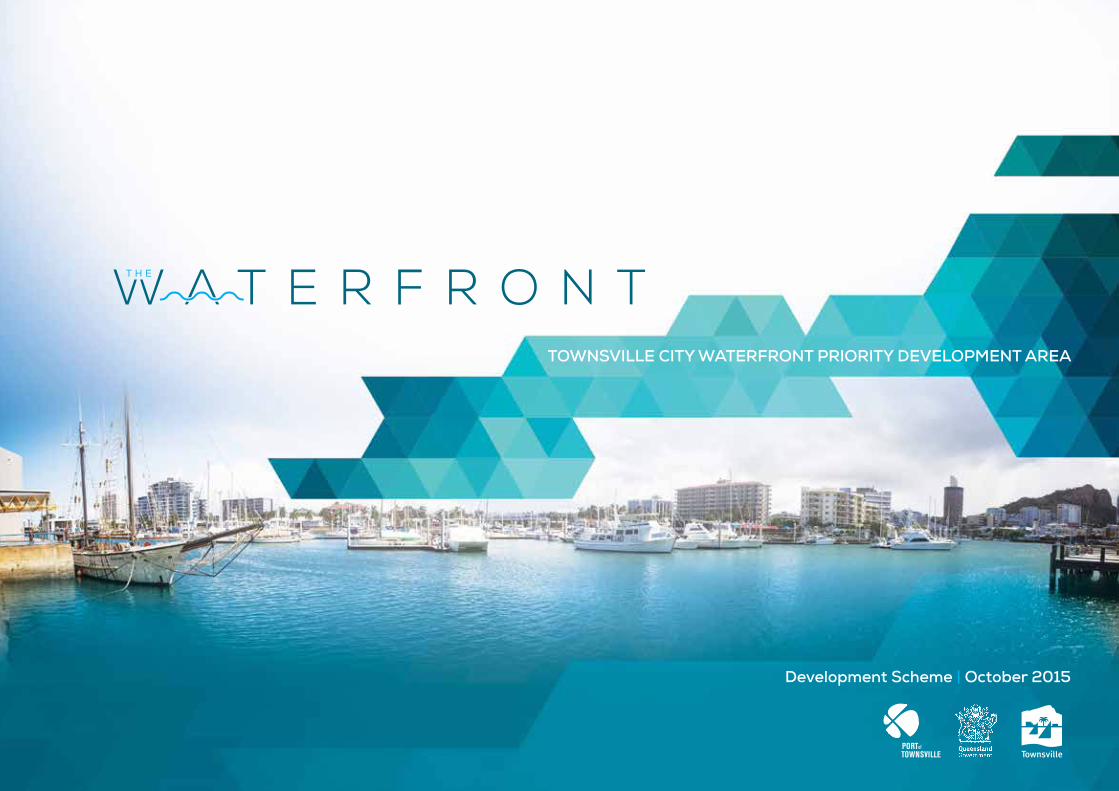
3.1 Operation of the Land use plan
3.1.1 Purpose of the Land use plan
The Land use plan establishes the PDA Vision and the development requirements that regulate development to achieve the PDA Vision (refer to Figure 1).
3.1.2 PDA vision
The PDA Vision is outlined in Section 3.3.
3.1.3 PDA development requirements
The PDA development requirements support and provide further information on the delivery of the PDA Vision and incorporate:
i. Structural elements (Section 3.4). The location of Structural elements are shown on Map 2 - Structure Plan and to the extent they are relevant apply to all PDA assessable development,
ii. PDA-wide criteria (Section 3.5). The PDA-wide criteria (Section 3.5) apply to all PDA assessable development in the PDA, and
iii. Precinct provisions (Section 3.6). The Precinct provisions (Section 3.6) for each precinct apply to:a. land in that precinct (precinct
intents and preferred land uses). The location of precincts are shown on Map 3 - Precinct plan, and
b. all development in that precinct (as expressed in Levels of assessment Table 1, Table 3, Table 4, Table 5, Table 6, Table 8 and Table 10).
The PDA guidelines and other State development guidelines provide guidance on how to achieve the PDA-wide criteria (Section 3.5) and Precinct provisions (Section 3.6)2.
3.1.4 Levels of assessment
Table 1, Table 3, Table 4, Table 5, Table 6, Table 8 and Table 10 prescribe the Levels of assessment for each precinct:
i. PDA exempt development (column 1), ii. PDA self-assessable
development (column 2),iii. PDA assessable development which
is permissible (column 3A), andiv. PDA assessable development
which is prohibited (column 3B).
3.1.5 Schedules
Schedule 1 identifies development that is exempt from assessment for the whole of the PDA.
Schedule 2 provides the use and administrative definitions required to interpret and apply the scheme.
Schedule 3 sets out the specific requirements applying to self-assessable development referenced in the relevant level of assessment tables.
Schedule 4 contains constraints maps which relate to PDA development requirements and may also make development PDA assessable development.
Schedule 5 contains the development assessment powers map.
3 LAND USE PLAN: CONTEXT
PDA Vision
Structural elements and Structure plan (Map 2)
PDA-wide criteria
• Urban design• Public realm
• Sustainability
• Street and movement network
• Natural environment
• Development constraints and public safety
• Infrastructure
Precinct provisions
• Precinct plan (Map 3)• Precinct provisions
• Levels of assessment tables (Table 1, Table 3, Table 4, Table 5, Table 6, Table 8 and Table 10)
Schedules
• PDA-wide exempt development• Definitions
• Self-assessable provisions
• Constraints maps (C 01 – C 08)
• Development assessment powers
Guidance material2
2 Refer to State government guidelines available at www.dilgp.qld.gov.au. Guidelines should be read in conjunction with the Land use plan, Infrastructure plan and Implementation strategy and any other document or guideline called up by the scheme.
Figure 1: Purpose of the Land use plan and relationship of scheme components
4 TOWNSVILLE CITY WATERFRONT PRIORITY DEVELOPMENT AREADevelopment Scheme
3.2 Development assessment
3.2.1 Interpretation
Section 33 of the Act defines development.
Schedule 2 provides the use and administrative definitions required to interpret and apply the scheme.
3.2.2 Requirements for self-assessable development
Under section 74 of the Act, PDA self-assessable development must comply with the requirements in the development scheme for carrying out PDA self-assessable development. These requirements are set out in Schedule 3.
3.2.3 Requirements for permissible development
Under section 73 of the Act, a PDA development approval will be required for development identified as Permissible development. A PDA development approval (development permit) is required in order to carry out Permissible development.
Identification of development as Permissible development does not mean that a PDA development approval (with or without conditions) will be granted.
A PDA development application must be lodged with the MEDQ3 for assessment and decision. Development must be consistent with the scheme to receive approval.
3.2.3.1 Development application
To the extent the Land use plan, Infrastructure plan, Implementation strategy and the guidelines2 are relevant, they are to be taken into account in the preparation of a PDA development application and the assessment of the application by the MEDQ3.
The Infrastructure plan and Implementation strategy may include further information which should be taken into account in the preparation, design and feasibility of development proposals.
3.2.3.2 Development consistent with the land use plan
Permissble development is consistent with the land use plan if:
i. the development complies with all relevant Structural elements (Section 3.4), PDA-wide criteria (Section 3.5) and Precinct provisions (Section 3.6), or
ii. the development does not comply with aspects of the Structural elements (Section 3.4), PDA-wide criteria (Section 3.5) or Precinct provisions (Section 3.6) but:a. the development does not conflict
with the PDA vision (Section 3.3), and
b. there are sufficient grounds to justify the approval of the development despite the non-compliance with the Structural elements (Section 3.4), PDA-wide criteria (Section 3.5) or Precinct provisions (Section 3.6).
3 MEDQ may delegate certain functions and powers under s.169 of the Act to a local government. Development assessment powers in Area A have been delegated by the MEDQ to Townsville City Council (for information purposes refer to Schedule 5: Development assessment powers).
In this section ‘grounds’ means matters of public interest which include the matters specified as the main purposes of the Act as well as:
i. superior design outcomes, andii. overwhelming community need.
‘Grounds’ does not include the personal circumstances of an applicant, owner or interested third party.
3.2.3.3 Demonstrating development is consistent with the land use plan
Permissible development must demonstrate how it is consistent with the PDA Vision (Section 3.3), Structural elements (Section 3.4), PDA-wide criteria (Section 3.5) and Precinct provisions (Section 3.6), and should demonstrate that development will not compromise or unreasonably prejudice the opportunities for the development of the remaining area in the precinct. Suggested ways applicants may demonstrate this is through a preliminary approval4 or Plan of Development (PoD).
Preliminary approval
There is no requirement to obtain a preliminary approval. However, applicants may choose to use preliminary approvals to stage development or to gain approval for a development concept before undertaking detailed planning.
In this regard, preliminary approvals may demonstrate how development achieves the requirements of the scheme at an intermediate level of spatial planning between the broad spatial framework of the Structure plan - Map 2 and Precinct provisions (Section 3.6) and the individual development proposals and associated Plans of Development (PoDs).
A preliminary approval may include the following:
i. all or a relevant part of the precinct determined in consultation with the MEDQ3,
ii. identify the location of connections to network infrastructure, including transport, within the precinct,
iii. identify land uses and development density,
iv. resolve, if required, any development constraints that may determine the extent of developable area or appropriate uses,
v. resolve the boundaries of development, public open space and any identified sites for community infrastructure such as parks and schools, and
vi. demonstrate that the development proposal:a. does not prejudice the ability for
surrounding land to be developed in an orderly and efficient manner consistent with the PDA Vision (Section 3.3), Structural elements (Section 3.4), PDA-wide criteria (Section 3.5) and the Precinct provisions (Section 3.6),
b. is consistent with the existing and approved development in the preliminary approval area or adjoining areas,
c. addresses additional requirements for development in the precinct, and
d. addresses other matters specified in a guideline2.
4 A preliminary approval is a PDA development approval that approves development subject to conditions, but does not authorise PDA assessable development to take place. A development permit is required in order to carry out PDA assessable development.
5 TOWNSVILLE CITY WATERFRONT PRIORITY DEVELOPMENT AREADevelopment Scheme 6 TOWNSVILLE CITY WATERFRONT PRIORITY DEVELOPMENT AREA
Development Scheme
3.2.3.4 Notification requirements
A PDA development application will require public notification if the application:
i. includes a proposal for development which does not comply with the Structural elements (Section 3.4) and Map 2 - Structure plan, PDA-wide criteria (Section 3.5) or the Precinct provisions (Section 3.6), or
ii. is for development which, in the opinion of the MEDQ3, may have adverse impacts on the amenity or development potential of adjoining land under separate ownership.
The MEDQ3 may require public notification in other circumstances if the development application is for a use or of a size or nature which, in the opinion of the MEDQ3, warrants public notification.
3.2.4 Development inconsistent with the land use plan
Under Section 86 of the Act, development that is inconsistent with the scheme cannot be granted a PDA development approval.
Prohibited development is inconsistent with the development scheme.
3.2.5 Infrastructure agreements
An infrastructure agreement may be established to address the provisions and requirements of the Infrastructure plan and Implementation strategy.
3.2.6 Relationship with local government planning scheme and other legislation
The development scheme may apply a provision of a planning instrument or a plan, policy or code made under the Planning Act6 or another Act. However, the scheme prevails to the extent of any inconsistency with those instruments.
Other legislation
In addition to assessment against the scheme, development may require assessment against other legislation including, for example, the Great Barrier Reef Marine Park Act 1975, the Building Act 1975 and the Planning Act6.
3.2.7 Interim use
An interim use is a land use that, because of its nature, scale, form or intensity, is not an appropriate long-term use of the land.
Interim land uses may occur if appropriately developed and operated and where located in areas which will not compromise the precinct provision in the longer term.
The MEDQ3 may approve an interim use if it can be demonstrated that an interim use will not preclude or delay an appropriate long-term use or intensity of development.
Information to support an application for an interim use may include:
i. a schedule of land supply and projected take-up rates, or
ii. plans showing how the development could transition from the proposed interim use to an appropriate longer term use.
The MEDQ3 may impose a condition of approval that limits the duration of an interim use.
Interim uses will only be approved if it can be demonstrated that the use will not prejudice the achievement of the PDA Vision.
Applicants should discuss the use of a preliminary approval with the MEDQ3 in pre-application meetings. The MEDQ3 may request the applicant to change a preliminary approval.
Plan of Development
A Plan of Development (PoD) may accompany an application for a material change of use or reconfiguring a lot and may deal with any proposed use as well as operational work.
A PoD is prepared by an applicant and may include maps, graphics and text that collectively demonstrate how proposed uses, works and lots will contribute towards the achievement of the PDA Vision. It should be consistent with the PDA Vision (Section 3.3), Structural elements (Section 3.4), PDA-wide criteria (Section 3.5) and Precinct provisions (Section 3.6).
A PoD should indicate the location and function of temporary and permanent uses and structures and how these uses and structures will relate to each other.
The PoD cannot include land beyond the boundary of the land the subject of the application, but may cover only part of the land the subject of the application. An applicant may also be required to demonstrate impacts and connections to areas adjoining the subject land in a separate plan to the PoD.
Under Schedule 1, a Material Change of Use in accordance with a PoD is exempt development and requires no further development approval under the scheme5.
5 For further advice on preparing a PoD refer to the applicable EDQ practice note available at www.dilgp.qld.gov.au.6 Sustainable Planning Act 2009.
6 TOWNSVILLE CITY WATERFRONT PRIORITY DEVELOPMENT AREADevelopment Scheme
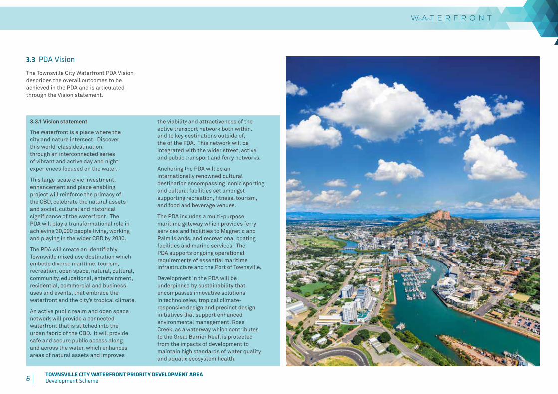
3.3 PDA Vision
The Townsville City Waterfront PDA Vision describes the overall outcomes to be achieved in the PDA and is articulated through the Vision statement.
3.3.1 Vision statement
The Waterfront is a place where the city and nature intersect. Discover this world-class destination, through an interconnected series of vibrant and active day and night experiences focused on the water.
This large-scale civic investment, enhancement and place enabling project will reinforce the primacy of the CBD, celebrate the natural assets and social, cultural and historical significance of the waterfront. The PDA will play a transformational role in achieving 30,000 people living, working and playing in the wider CBD by 2030.
The PDA will create an identifiably Townsville mixed use destination which embeds diverse maritime, tourism, recreation, open space, natural, cultural, community, educational, entertainment, residential, commercial and business uses and events, that embrace the waterfront and the city’s tropical climate.
An active public realm and open space network will provide a connected waterfront that is stitched into the urban fabric of the CBD. It will provide safe and secure public access along and across the water, which enhances areas of natural assets and improves
the viability and attractiveness of the active transport network both within, and to key destinations outside of, the of the PDA. This network will be integrated with the wider street, active and public transport and ferry networks.
Anchoring the PDA will be an internationally renowned cultural destination encompassing iconic sporting and cultural facilities set amongst supporting recreation, fitness, tourism, and food and beverage venues.
The PDA includes a multi-purpose maritime gateway which provides ferry services and facilities to Magnetic and Palm Islands, and recreational boating facilities and marine services. The PDA supports ongoing operational requirements of essential maritime infrastructure and the Port of Townsville.
Development in the PDA will be underpinned by sustainability that encompasses innovative solutions in technologies, tropical climate-responsive design and precinct design initiatives that support enhanced environmental management. Ross Creek, as a waterway which contributes to the Great Barrier Reef, is protected from the impacts of development to maintain high standards of water quality and aquatic ecosystem health.

7 TOWNSVILLE CITY WATERFRONT PRIORITY DEVELOPMENT AREADevelopment Scheme 8 TOWNSVILLE CITY WATERFRONT PRIORITY DEVELOPMENT AREA
Development Scheme
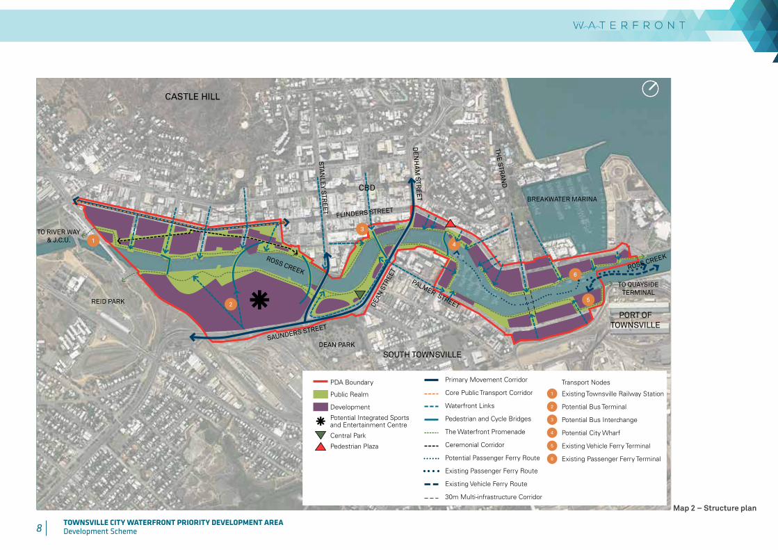
3.4 Structural elements
The Structural elements identified below and in Map 2 - Structure plan apply to all PDA assessable development in the PDA. To the extent that the Structural elements are relevant, they are to be taken into account in the preparation of the PDA development applications and the assessment of those applications.
The Structural elements support the delivery of the PDA Vision (Section 3.3) and the PDA-wide criteria (Section 3.5) and should be read in conjunction with these sections. Development within the PDA:
• allows for the establishment of a series of precincts, which provide for a diverse mix of urban uses to enhance and support the economic viability and vibrancy of the wider CBD,
• enhances public realm and improved access to the water through upgrades to, and establishment of new, public realm spaces, including parkland, connectivity corridors (including the Ceremonial Corridor), plazas and natural areas,
• enhances Central Park to serve a regional park7 function, providing for increased use and enjoyment of the park and development opportunities,
• improves access to the waterfront and public realm through pedestrian waterfront links and a connected Waterfront Promenade on both sides of Ross Creek,
• improves across-water links through the establishment of new pedestrian and cycle bridges8,9,
• enhances pedestrian connections with existing and planned public transport nodes, including the Department of Transport and Main Roads’ potential CBD Bus Interchange10 and the Townsville Railway Station,
• provides for passenger and vehicle ferry operations to continue in their current location while allowing for the opportunity for new facilities, or the relocation of existing facilities which provide enhanced connections to the CBD,
• supports the creation of a new pedestrian plaza in Flinders Street East integrated with a new City Wharf which provides access down to the water for use by tourist boats and a potential passenger transport connection from the passenger ferry terminal,
• supports a catalyst project to establish an integrated sport and entertainment centre and associated community facilities, potentially including a new bus terminal,
• preserves a 30m wide multi-use infrastructure corridor across Ross Creek at the end of The Strand,
• maintains the existing road network which is supported by new roads where detailed in the Precinct provisions (Section 3.6), and
• provides for Flinders Street West to continue to serve as a core public transport corridor connecting the CBD to the wider Townsville area.
9 Activities or works within Ross Creek may be considered waterway barrier works - refer to the Department of Agriculture and Fisheries guidelines available at www.daf.qld.gov.au.10 The preferred location of the CBD Bus Interchange will be determined in consultation with DTMR.
7 Regional Park refers to the classification and desired standard of parks under the Townsville City Council planning scheme’s Part 4 Priority infrastructure plan.8 Refer to Part 5 Implementation strategy regarding proposed establishment of new pedestrian and cycle bridges.
8 TOWNSVILLE CITY WATERFRONT PRIORITY DEVELOPMENT AREADevelopment Scheme
PDA Boundary
Public Realm
Development
Potential Integrated Sports and Entertainment Centre
Central Park
Pedestrian Plaza
Transport Nodes
1 Existing Townsville Railway Station
2 Potential Bus Terminal
3 Potential Bus Interchange
4 Potential City Wharf
5 Existing Vehicle Ferry Terminal
6 Existing Passenger Ferry Terminal
Primary Movement Corridor
Core Public Transport Corridor
Waterfront Links
Pedestrian and Cycle Bridges
The Waterfront Promenade
Ceremonial Corridor
Potential Passenger Ferry Route
Existing Passenger Ferry Route
Existing Vehicle Ferry Route
30m Multi-infrastructure Corridor
TO RIVER WAY & J.C.U.
TO QUAYSIDE TERMINAL
1
25
CASTLE HILL
3
6
4
ROSS CREEK
PALMER STREET
ROSS CREEK
BREAKWATER MARINA
FLINDERS STREET
SAUNDERS STREET
DEAN
STR
EET
DE
NH
AM
STR
EE
T
STA
NLE
Y STR
EE
T
THE
STRAN
D
REID PARK
DEAN PARK
CBD
PORT OF TOWNSVILLE
SOUTH TOWNSVILLE
Map 2 – Structure plan
9 TOWNSVILLE CITY WATERFRONT PRIORITY DEVELOPMENT AREADevelopment Scheme 10 TOWNSVILLE CITY WATERFRONT PRIORITY DEVELOPMENT AREA
Development Scheme
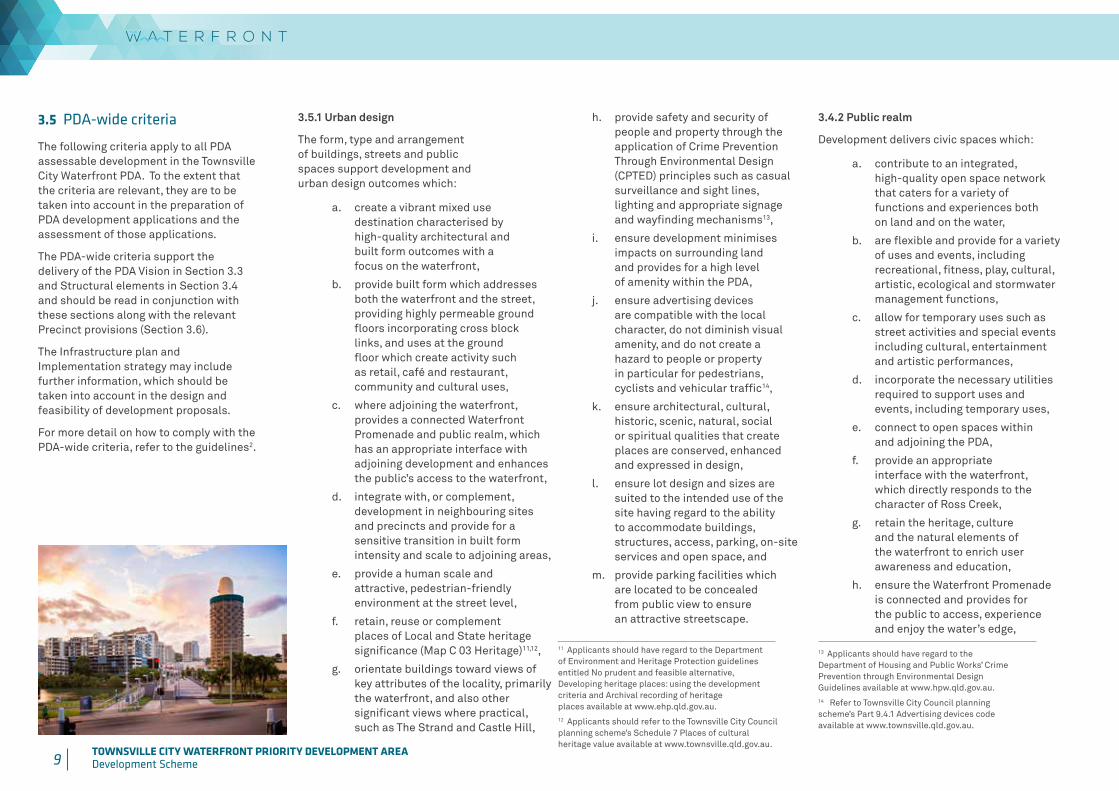
3.5 PDA-wide criteria
The following criteria apply to all PDA assessable development in the Townsville City Waterfront PDA. To the extent that the criteria are relevant, they are to be taken into account in the preparation of PDA development applications and the assessment of those applications.
The PDA-wide criteria support the delivery of the PDA Vision in Section 3.3 and Structural elements in Section 3.4 and should be read in conjunction with these sections along with the relevant Precinct provisions (Section 3.6).
The Infrastructure plan and Implementation strategy may include further information, which should be taken into account in the design and feasibility of development proposals.
For more detail on how to comply with the PDA-wide criteria, refer to the guidelines2.
3.5.1 Urban design
The form, type and arrangement of buildings, streets and public spaces support development and urban design outcomes which:
a. create a vibrant mixed use destination characterised by high-quality architectural and built form outcomes with a focus on the waterfront,
b. provide built form which addresses both the waterfront and the street, providing highly permeable ground floors incorporating cross block links, and uses at the ground floor which create activity such as retail, café and restaurant, community and cultural uses,
c. where adjoining the waterfront, provides a connected Waterfront Promenade and public realm, which has an appropriate interface with adjoining development and enhances the public’s access to the waterfront,
d. integrate with, or complement, development in neighbouring sites and precincts and provide for a sensitive transition in built form intensity and scale to adjoining areas,
e. provide a human scale and attractive, pedestrian-friendly environment at the street level,
f. retain, reuse or complement places of Local and State heritage significance (Map C 03 Heritage)11,12,
g. orientate buildings toward views of key attributes of the locality, primarily the waterfront, and also other significant views where practical, such as The Strand and Castle Hill,
h. provide safety and security of people and property through the application of Crime Prevention Through Environmental Design (CPTED) principles such as casual surveillance and sight lines, lighting and appropriate signage and wayfinding mechanisms13,
i. ensure development minimises impacts on surrounding land and provides for a high level of amenity within the PDA,
j. ensure advertising devices are compatible with the local character, do not diminish visual amenity, and do not create a hazard to people or property in particular for pedestrians, cyclists and vehicular traffic14,
k. ensure architectural, cultural, historic, scenic, natural, social or spiritual qualities that create places are conserved, enhanced and expressed in design,
l. ensure lot design and sizes are suited to the intended use of the site having regard to the ability to accommodate buildings, structures, access, parking, on-site services and open space, and
m. provide parking facilities which are located to be concealed from public view to ensure an attractive streetscape.
3.4.2 Public realm
Development delivers civic spaces which:
a. contribute to an integrated, high-quality open space network that caters for a variety of functions and experiences both on land and on the water,
b. are flexible and provide for a variety of uses and events, including recreational, fitness, play, cultural, artistic, ecological and stormwater management functions,
c. allow for temporary uses such as street activities and special events including cultural, entertainment and artistic performances,
d. incorporate the necessary utilities required to support uses and events, including temporary uses,
e. connect to open spaces within and adjoining the PDA,
f. provide an appropriate interface with the waterfront, which directly responds to the character of Ross Creek,
g. retain the heritage, culture and the natural elements of the waterfront to enrich user awareness and education,
h. ensure the Waterfront Promenade is connected and provides for the public to access, experience and enjoy the water’s edge,
13 Applicants should have regard to the Department of Housing and Public Works’ Crime Prevention through Environmental Design Guidelines available at www.hpw.qld.gov.au.14 Refer to Townsville City Council planning scheme’s Part 9.4.1 Advertising devices code available at www.townsville.qld.gov.au.
11 Applicants should have regard to the Department of Environment and Heritage Protection guidelines entitled No prudent and feasible alternative, Developing heritage places: using the development criteria and Archival recording of heritage places available at www.ehp.qld.gov.au.12 Applicants should refer to the Townsville City Council planning scheme’s Schedule 7 Places of cultural heritage value available at www.townsville.qld.gov.au.

10 TOWNSVILLE CITY WATERFRONT PRIORITY DEVELOPMENT AREADevelopment Scheme
i. provide equitable public access,
j. provide high-quality, well-designed streetscapes, landscape elements, planting and hardscape materials responsive to the climate and character of Townsville15,
k. provide landscape works which utilise endemic species, other locally hardy species and landscaping materials appropriate to the Dry Tropics’ cyclone-prone climate15,
l. ensure landscape works and embellishment is fit for purpose and designed to minimise maintenance costs and whole of life cycle costs15,
m. promote innovative and efficient design which optimises water and energy efficiency and responds appropriately to local conditions in open spaces,
n. provide an appropriate level of night-time illumination and enhance the night-time presence and vibrancy of streets, parkland, promenades, boardwalks, plazas and bridges, and
o. express Townsville’s cultural identity through external public art that embraces it’s natural surroundings and reflects on Townsville’s historic past.
3.5.3 Sustainability
Development supports sustainable outcomes which:
a. respond to Townsville’s Dry Tropics’ climate and facilitate sustainable built forms through energy efficient climate-responsive design, for example appropriate orientation and layout, water conservation, shading, natural lighting and passive cooling techniques16,
b. ensure ecosystems and natural physical processes are maintained, connected, enhanced and incorporated as features in the overall urban form,
c. allow for the integration of Water Sensitive Urban Design (WSUD) measures to deliver higher standards of water quality and, where relevant, the enhancement of the local visual character and safe recreational use, and
d. incorporate innovation in sustainability and new technologies, such as the integration of solar generation in built form and public realm, district cooling, green roofs and walls or other sustainable landscape elements, recycled water service and waste recycling service and does not unreasonably constrain future provision for integration with innovative public infrastructure.
3.5.4 Street and movement network
Development delivers well-designed movement networks which:
a. establish a Waterfront Promenade which connects to the wider active transport network (pedestrian and cycling) and public transport network,
b. feature the natural riparian character of Ross Creek in the upstream reaches, including boardwalks and pontoons at key vantage points. The design of the landscape, pathway and water’s edge treatments will transition through to an urban promenade with a wharf character, including hard and terraced edges, through the CBD towards the mouth of Ross Creek,
c. provide efficient and safe creek, water’s edge, street and movement networks for all users with a clear structure, in accordance with the network hierarchy. Maximise the network’s effectiveness and appropriately separate potential conflicting users such as pedestrian, vehicle, ferry, trailer and bus traffic,
d. promote physical and visual connectivity with key connections which align with public realm nodes, creek crossings, significant city destinations, public transport services and access to ferry services,
e. are located on roads that are appropriate for the nature of traffic generated, having regard to the safety and efficiency of the transport network, and the functions and characteristics identified of the road hierarchy and does not compromise the orderly provision or upgrading of the transport network 17 ,18,
f. ensure development reinforces the provision of public transport infrastructure, and ensure public transport routes and infrastructure are constructed to a standard19 appropriate to accommodate the intended use, including footpath treatments and facilities for the amenity and comfort of users,
g. provide connections which link to the broader active transport network and key destinations and transport generators such as Reid Park, the Ross River Parkway and The Strand and other elements of the transport network,
h. ensure a combination of shade and all-weather protection is provided throughout the network of footpaths and pathways along the city streets and an appropriate level of shade and all-weather protection is provided to the waterfront and public realm,
i. provide end-of-trip facilities for pedestrians and cyclists as part of development20, and
j. provide access, parking21, servicing and associated manoeuvring areas that are designed to be safe, functional and meet the reasonable demands generated by the development19.
18 Refer to the Townsville City Council planning scheme’s SC6.4 Development manual planning scheme policy, in particular SC6.4.3.13 Townsville road hierarchy, SC6.4.4.1 Geometric road design and SC6.4.3.14 Traffic impact assessment guidelines.available at www.townsville.qld.gov.au.
19 Refer to Townsville City Council planning scheme’s SC6.4 Development manual planning scheme policy for relevant standards available at www.townsville.qld.gov.au. 20 End-of-trip bicycle facilities will need to be provided for major development in accordance with the Queensland Development Code Mandatory Part 4.1 — Sustainable Buildings. “Major development” as defined in MP4.1. 21 Parking rates in accordance with Townsville City Council planning scheme’s SC6.10 Parking rates planning scheme policy available at www.townsville.qld.gov.au.
15 Applicants should refer to the Townsville City Council planning scheme’s SC6.4 Development manual planning scheme policy available at www.townsville.qld.gov.au.16 Development may employ the use of a ratings tool to demonstrate compliance with sustainability criteria.17 A transport impact assessment may be required to demonstrate compliance with this provision.
11 TOWNSVILLE CITY WATERFRONT PRIORITY DEVELOPMENT AREADevelopment Scheme 12 TOWNSVILLE CITY WATERFRONT PRIORITY DEVELOPMENT AREA
Development Scheme
3.5.5 Natural environment
The design, siting and layout of development responds to the natural environment and:
a. enhances and manages areas of natural assets identified on Map C 04 Natural Assets to provide a nett environmental benefit, including the use of compensatory offsets22, to important ecosystem services and the enjoyment of the inner city natural environment,
b. in the Very High environmental value area (Map C 04 Natural Assets), avoids disturbances and improves the environmental value of the asset,
c. contributes to the protection of environmental values and water quality objectives of receiving waters to the extent practicable23,
d. where within Ross Creek or adjoining natural asset areas, is designed to protect or manage impacts on the natural assets and instream ecosystem services, enhance water quality, maintain the hydrological function of the waterway and maintain the flushing of the existing upstream waterways and waterbodies, and
e. natural tidal processes and assets are integrated in the design of the public realm interface with Ross Creek, providing the community with a strong connection to the natural environment and improved health and wellbeing opportunities.
3.5.6 Development constraints and public safety
Development employs an evidence-based risk management approach that encourages innovation and will:
a. be sited, designed and constructed to avoid, minimise or resist the incidence of a development constraint (refer to Constraints Maps C 01 to C 08 in Schedule 3),
b. not involve permanent or temporary physical obstructions that will adversely affect the airport’s operational airspace area identified on Map C 01 Airport Environs24,
c. ensure that development within the Light intensity 6km radius area identified on Map C 01 Airport Environs does not involve external lighting or reflective surfaces that could distract or confuse pilots25,
d. ensure development within the 3km to 8km bird and bat strike zone identified on Map C 01 Airport Environs, does not attract a significant number of flying vertebrates,
e. not involve permanent or temporary physical obstructions that will adversely affect the operation of essential State maritime infrastructure identified on Map C 02 Noise Corridor and Essential Maritime Infrastructure, including the Port of Townsville’s lead light or lead light clearance buffer, existing structures26, the Port of Townsville and Reef Vessel Traffic Service, Marine Safety Queensland operations base and the Water Police base,
f. ensure that the risk to life, property and environment as a result of natural hazards is minimised, and development is managed to respond to the potential impacts of climate change,
g. ensure development is designed and located to be compatible with the nature of the flood hazard (Map C 05 Flood Hazard),
h. provide development with the floor level of all habitable rooms a minimum of 300mm above the defined flood level, and floor levels of non-habitable rooms above the defined flood event,
i. ensure development does not directly, indirectly or cumulatively worsen flood hazard characteristics outside the development site,
j. ensure development is designed and located to minimise susceptibility to, and the potential impacts of, storm tide inundation and erosion (Map C 06 Coastal Hazard – Storm tide Inundation and Map C 07 Coastal Hazard - Erosion Prone Area),
k. ensure development within the inner city area27 (Map C 06 Coastal Hazard – Storm tide Inundation and Map C 07 Coastal Hazard - Erosion Prone Area), provides measures to ensure critical services remain operational up to the defined storm tide event,
l. provide development with floor levels of habitable rooms which are above the defined storm tide event level28,
m. ensure that underground car parks are designed to prevent the intrusion of storm tide waters or flood waters by the incorporation of a bund or similar barrier above the defined storm tide event level28 and with a minimum height of 300mm above the defined flood level29,
n. ensure that acid sulfate soils are not disturbed, or where disturbance of acid sulfate soils cannot be avoided development neutralises existing acidity and prevents the generation of acid and metal contaminants, and the release of surface or groundwater flows containing acid and metal contaminants into the environment30,
22 Refer to the State government’s environmental offsets framework available at www.ehp.qld.gov.au.23 The environmental values and water quality objectives are established under the Environmental Protection (Water) Policy (2009). For Townsville, they are specified in the Ross River Basin Environmental Values and Water Quality Objectives 2012 and Black River Basin Environmental Values and Water Quality Objectives (2012).24 The Defence (Areas Control) Regulation (DACR) is a Commonwealth regulation under the Defence Act 1903. Development in the area covered by this regulation which exceeds certain heights will require a separate assessment process under Regulation 8 of the DACR by the Department of Defence. The Department of Defence also requires that all tall structures (30m high within 30km of the airport and 45m high elsewhere) are registered with RAAF Aeronautical Information Service.
25 The standards specified in CASA Guidelines: Lighting in the vicinity of aerodromes: Advice to lighting designers, may be used to demonstrate compliance with this performance outcome.26 Refer to Part 5 Implementation Strategy Strategic Action S11 which addresses boat ramps in Ross Creek27 The inner city area shown on Map C 06 Coastal Hazard – Storm tide Inundation is intended to be defended from storm surge risk by public works - refer to Part 5 Implementation Strategy Project M2 Storm Tide Barrier.28 For this development scheme, this is RL3.9m Australian Height Datum (AHD).29 Applicants should be aware that in some areas flood hazard areas will also co-exist with storm tide hazard areas. In these instances, the floor levels and other design responses will need to be sufficient to comply with these requirements and the Building Regulation 2006.
12 TOWNSVILLE CITY WATERFRONT PRIORITY DEVELOPMENT AREADevelopment Scheme
o. manage and minimise impacts on sensitive land uses and public health and safety through design and siting, including sources of noise from transport corridors31, Port of Townsville activity, infrastructure corridors, ship-sourced pollutants, acid sulfate soils, land contamination, existing waterfront marine structures and activities in the Culture and Entertainment precinct,
p. provide common user facilities for the handling and disposal of ship-sourced pollutants, including oil, garbage and sewage, at a suitable location in any development involving a marina or berthing facilities32. Where practical, the marina pollutant reception facility is connected to a sewerage or other waste reception infrastructure33,
3.5.7 Infrastructure
Development will protect existing or planned infrastructure and ensure infrastructure and services are:
a. provided in a timely, orderly, integrated and coordinated manner, which optimises existing networks,
b. provided at a standard that best meets community needs, growth and environmental requirements,
c. located and designed to maintain the required level of functionality during and immediately after a natural hazard event,
d. available, or capable of being made available, (including key infrastructure such as roads, public and active transport, water supply, sewerage, gas, drainage, park network, community facilities, energy and telecommunications)1,
e. located and designed to maximise efficiency and ease of maintenance and minimise whole of lifecycle costs,
f. located and designed to support the desired character and amenity of the locality,
g. designed to allow for, or to not unreasonably constrain, the integration of future innovative infrastructure solutions such as natural gas, district cooling, recycled water and waste recycling,
h. designed to contribute to improved water quality of Ross Creek and incorporates drainage, stormwater and waste water management measures that enhance ground and surface water quality and the environmental values and water quality objectives23 and aquatic ecosystem health, and
i. designed to incorporate best practice Water Sensitive Urban Design (WSUD) (adapted to the Dry Tropics environment), and integrated water cycle management responding to regionally-specific climate and water quality objectives.
q. avoid conflict between recreational and commercial boating activity and marine structures and operation of the Port of Townsville as a key infrastructure supporting the local, regional and national economy,
r. have regard to existing and planned development to avoid adverse impacts arising from dust, noise34 and light and incorporate appropriate design and siting responses to minimise the impacts,
s. identify and respond appropriately35 to discovered archaeological artefacts, noting their potential for occurrence along the western bank of Ross Creek,
t. minimise and manage adverse impacts on surrounding land and provides for an appropriate level of amenity within the site during construction, and
u. minimise soil erosion and siltation during construction.
31 Refer to Department of Housing and Public Works’ ‘Transport Noise Corridors’ and residential building requirements available at www.hpw.qld.gov.au.32 Refer to: Australian and New Zealand Environment and Conservation Council (ANZECC), 1997, Best Practice Guidelines for Waste Reception Facilities at Ports, Marinas and Boat Harbours in Australia and New Zealand. 33 Reception facilities require compliance assessment under the Plumbing and Drainage Act 2002. The plumbing compliance assessment process will ensure that the proposed facilities address ‘peak load’.34 Development achieves acceptable noise levels for noise sensitive uses in affected areas (refer to Environmental Protection (Noise) Policy 2008). An acoustic report may be required to evaluate and address potential noise impacts and recommend appropriate noise mitigation measures. 35 Part 9 of the Queensland Heritage Act 1992 establishes obligations where dealing with discovered archaeological artefacts.
30 Where works are proposed within the areas identified as potential acid sulfate soils on Map C 08 Acid sulfate soils, and the works do not meet the outcomes listed in the Townsville City Council planning scheme’s 9.4.2 Healthy Waters Code, Table 9.4.2.3 AO4.1, the applicant is required to undertake an on-site acid sulfate investigation in order to meet the outcomes listed in the Townsville City Council planning scheme’s Part 9.4.2 Healthy Waters Code, Table 9.4.2.3 AO4.2. The reason for undertaking an acid sulfate soils investigation is to determine the presence of acid sulfate soil in order to avoid disturbance. Where acid sulfate soils cannot reasonably be avoided, investigation results assist in the planning of treatment and remedial activities and must be undertaken in accordance with the Queensland Acid Sulfate Soil Technical Manual and relevant State Planning Policy.
Applicants should also refer to the Guidelines for Sampling Analysis of Lowland Acid Sulfate Soils in Queensland, Acid Sulfate Soils Laboratory Methods Guidelines or Australian Standard 4969. It is highly recommended that the applicant develop a practical Acid Sulfate Soil Management Plan for use in monitoring and treating acid sulfate soils.
13 TOWNSVILLE CITY WATERFRONT PRIORITY DEVELOPMENT AREADevelopment Scheme
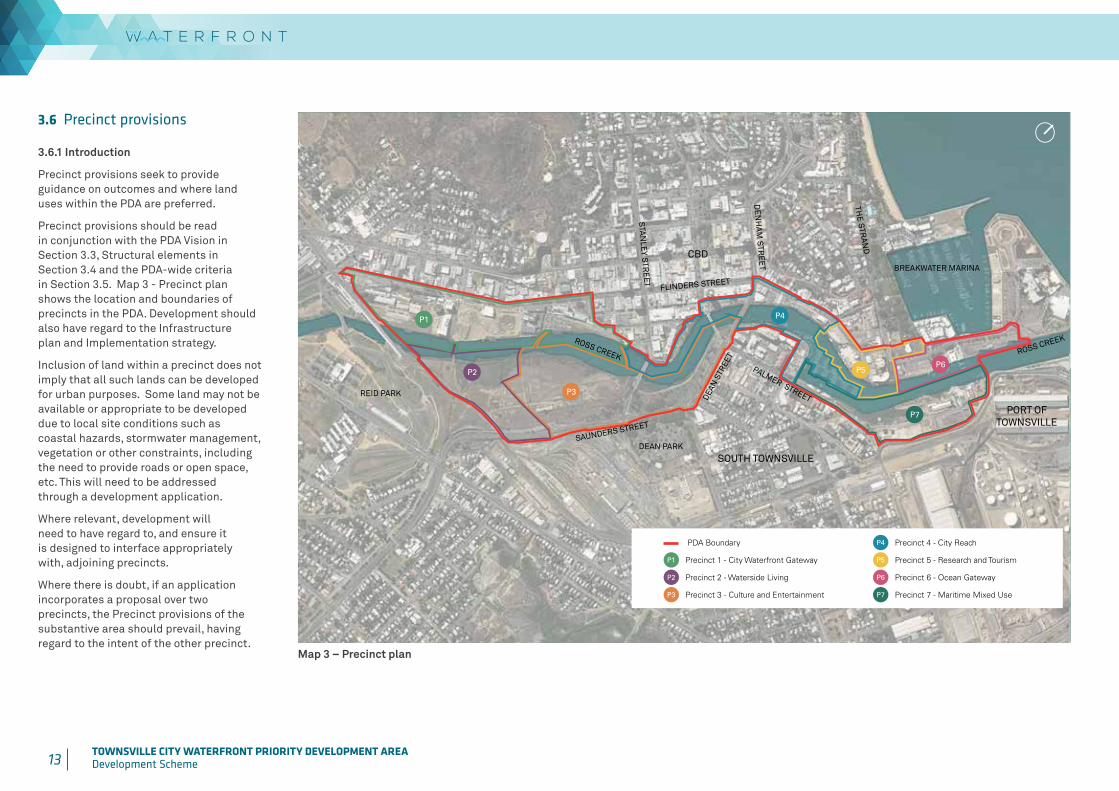
3.6 Precinct provisions
3.6.1 Introduction
Precinct provisions seek to provide guidance on outcomes and where land uses within the PDA are preferred.
Precinct provisions should be read in conjunction with the PDA Vision in Section 3.3, Structural elements in Section 3.4 and the PDA-wide criteria in Section 3.5. Map 3 - Precinct plan shows the location and boundaries of precincts in the PDA. Development should also have regard to the Infrastructure plan and Implementation strategy.
Inclusion of land within a precinct does not imply that all such lands can be developed for urban purposes. Some land may not be available or appropriate to be developed due to local site conditions such as coastal hazards, stormwater management, vegetation or other constraints, including the need to provide roads or open space, etc. This will need to be addressed through a development application.
Where relevant, development will need to have regard to, and ensure it is designed to interface appropriately with, adjoining precincts.
Where there is doubt, if an application incorporates a proposal over two precincts, the Precinct provisions of the substantive area should prevail, having regard to the intent of the other precinct.
Map 3 – Precinct plan
PDA Boundary
P1 Precinct 1 - City Waterfront Gateway
P2 Precinct 2 - Waterside Living
P3 Precinct 3 - Culture and Entertainment
P4 Precinct 4 - City Reach
P5 Precinct 5 - Research and Tourism
P6 Precinct 6 - Ocean Gateway
P7 Precinct 7 - Maritime Mixed Use
P1
P2
P3
P4
P5P6
P7
ROSS CREEK
PALMER STREET
ROSS CREEK
BREAKWATER MARINA
FLINDERS STREET
SAUNDERS STREET
DEAN
STR
EET
DE
NH
AM
STR
EE
T
STA
NLE
Y STR
EE
T
THE
STRAN
D
REID PARK
DEAN PARK
CBD
PORT OF TOWNSVILLE
SOUTH TOWNSVILLE
14 TOWNSVILLE CITY WATERFRONT PRIORITY DEVELOPMENT AREADevelopment Scheme

15 TOWNSVILLE CITY WATERFRONT PRIORITY DEVELOPMENT AREADevelopment Scheme
3.6.2 Precinct 1 – City Waterfront Gateway
Precinct intentThis precinct will form a southern gateway to the CBD. The character and intent of this precinct is to create a high density residential area supported by mixed uses including an anchor organisation (such as a tertiary or research institution). The precinct will allow for the creation of a hub of cultural activities including a mix of education and entertainment activities. The adaptive re-use of existing heritage buildings is encouraged to maintain the character of historic uses in context of their surroundings.
Preferred Land UseDevelopment within the City Waterfront Gateway Precinct will provide:
a. a diverse mix of high density accommodation, business and centre activities, educational establishments and entertainment activities, and
b. opportunities for community activities and spaces for community events (including temporary events), creative industries such as performing arts, artisan markets and incubator businesses.
Connectivity, Public Realm and Water’s EdgeDevelopment within the City Waterfront Gateway Precinct will provide:
a. views and pedestrian access between heritage buildings and Ross Creek through the creation of public open space and a plaza as well as waterfront dining, outdoor performance and cultural function opportunities,
b. a heritage plaza on the corner of Flinders and Blackwood Streets and public open space along Ross Creek,
c. for the Ceremonial Corridor to extend through the historic rail workshops area and provide connectivity between Ross Creek and Flinders Street,
d. for the Ceremonial Corridor to extend north along the historic rail alignment between the Heritage Railway Station and Ross Creek, including weather protection, interpretation of historic character, landscape and activation,
e. a pedestrian connection from the precinct to the Townsville Railway Station, and
f. a new vehicle entrance and intersection to the former rail workshop buildings site off Flinders Street.
Built Form and Climate ResponsivenessDevelopment within the City Waterfront Gateway Precinct will provide:
a. buildings which provide for public realm and design and setbacks appropriate for the use and function and interface with surrounding land,
b. building setbacks that allow for efficient space for services and accessible on-site servicing,
c. for the enhancement and adaptive re-use of the Heritage Railway Station and where feasible of the former rail workshop buildings,
d. that development does not destroy or substantially reduce the cultural heritage significance of the Heritage Railway Station unless there is no prudent and feasible alternative to carrying out the development,
e. a transitioning of building heights which maintain the primacy of the CBD, with buildings generally increasing from 6 storeys at the historic railyards area end up to 12 storeys towards the CBD end of the precinct and higher north of Aplin Street, and
f. at ground level, uses interface with the public realm, encouraging pedestrian movement and activity, via shading and passive design.
16 TOWNSVILLE CITY WATERFRONT PRIORITY DEVELOPMENT AREADevelopment Scheme

17 TOWNSVILLE CITY WATERFRONT PRIORITY DEVELOPMENT AREADevelopment Scheme
Table 1: Precinct 1 - City Waterfront Gateway Levels of assessment
Exempt development*
PDA self-assessable development PDA assessable development
Column 1 Column 2 Column 3A Permissible development
Column 3B Prohibited development
1. All development specified in Schedule 1
2. Any of the following development:
• Sales office
1. Any of the following uses where within an existing building which is not a State or Local heritage place:
• Bar
• Caretaker’s accommodation
• Child care centre
• Club
• Community residence
• Community use
• Educational establishment
• Emergency services
• Food and drink outlet (where not involving a drive through)
• Function facility
• Hotel
2. Any of the following uses where within an existing building and the gross floor area36 does not exceed 250m2:
• Community care centre
• Health care services
• Indoor sport and recreation
• Office
• Shop
• Veterinary services
All development, including development not defined in Schedule 2, other than development mentioned in Schedule 1 or Columns 1, 2 and 3B.
• Animal husbandry
• Brothel
• Bulk landscape supplies
• Cemetery
• Crematorium
• Cropping
• Detention facility
• Extractive industry
• High impact industry
• Intensive animal industry
• Medium impact industry
• Non-resident workforce accommodation
• Outstation
• Permanent plantation
• Roadside stall
• Rural industry
• Rural workers’ accommodation
• Special industry
*Where development does not meet exemption criteria, as stated in Column 1 PDA exempt development, it becomes PDA assessable development.
36 The gross floor area threshold is calculated for a new use or an extension to an existing use. It is not the cumulative total of the existing centre and the additional gross floor area forming part of the development application.
18 TOWNSVILLE CITY WATERFRONT PRIORITY DEVELOPMENT AREADevelopment Scheme
3.6.3 Precinct 2 – Waterside Living
Precinct intentThe Waterside Living Precinct is a new residential community and associated amenities on the eastern side of the southern reach of Ross Creek.
The waterfront interface maintains the area’s riparian character. This will be reflected in the enhancement of natural areas and provision of parkland which has a focus on the protection and enjoyment of the site’s natural habitat and views.
Preferred Land UseDevelopment within the Waterside Living Precinct will provide:
a. high density accommodations, including multiple dwellings and short-term accommodation,
b. generous parkland and streetscaping,
c. business and centre activities to service the precinct which is consistent with the intended role, scale and character of a neighbourhood-level activity centre37
and which does not compromise the intended role or successful functioning of other centres, and
d. uses at the interface with Precinct 3 which have a nexus with, and provide uses which complement, the preferred development of Precinct 3, such as short-term accommodation and convenience-scale shop.
37 Neighbourhood centres contain a generally limited range of retail, commercial and community-related activities which are focused on meeting the basic, day-to-day convenience needs of a surrounding neighbourhood within a walkable catchment. Neighbourhood centre catchments are in the order of 1,500 households.
Connectivity, Public Realm and Water’s EdgeDevelopment within the Waterside Living Precinct will provide:
a. upgrades to the existing bridge at Little Fletcher Street,
b. a pedestrian rail crossing linking Reid Park to The Waterfront,
c. parks and community uses adjacent to Ross Creek which have a nexus with the areas of natural asset, and
d. an appropriate response to the transport entry arrangements and traffic network to the precinct, in order to avoid potential conflict between uses in Precincts 2 and 3.
Built Form and Climate ResponsivenessDevelopment within the Waterside Living Precinct will provide:
a. buildings generally in accordance with Table 2: Building parameter guidelines for Precinct 2 – Waterside Living,
b. building heights generally up to 12 storeys,
c. dwellings and private open spaces which achieve an acceptable level of residential amenity,
d. maximised views to Castle Hill, Mount Stuart and Ross Creek, and
e. active uses at the interface with Precinct 3 at the ground level providing an active street interface.

19 TOWNSVILLE CITY WATERFRONT PRIORITY DEVELOPMENT AREADevelopment Scheme 20 TOWNSVILLE CITY WATERFRONT PRIORITY DEVELOPMENT AREA
Development Scheme

20 TOWNSVILLE CITY WATERFRONT PRIORITY DEVELOPMENT AREADevelopment Scheme
Table 2: Building parameter guidelines for Precinct 2 – Waterside Living
Level Building Balconies or outermost projection
Site cover
Front setbacks
70%
Basement 0m n/a
Levels 1-4 3m 1.5m
Level 5 and above 5m 3m
Side setbacks
Basement 0m 0m
Levels 1-2 1.5m or 0m where the adjoining building is built to boundary
Levels 3-4 2.5m or 0m where the adjoining building is built to boundary
Level 5 and above 3.5m 3.5m
Rear setbacks
Basement
6m or 0m where the adjoining building is
built to boundary
n/a
Level 1 n/a
Levels 2-3 4m
Level 4 and above 6m 6m
Table 3: Precinct 2 – Waterside Living Levels of assessment
Exempt development*
PDA self-assessable development
PDA assessable development
Column 1 Column 2 Column 3A Permissible development
Column 3B Prohibited development
1. All development specified in Schedule 1
2. Any of the following development:
• Sales office
Nil All development, including development not defined in Schedule 2, other than development mentioned in Schedule 1 or Columns 1, 2 and 3B.
• Animal husbandry
• Brothel
• Bulk landscape supplies
• Cemetery
• Crematorium
• Cropping
• Detention facility
• Extractive industry
• High impact industry
• Intensive animal industry
• Medium impact industry
• Non-resident workforce accommodation
• Outstation
• Permanent plantation
• Roadside stall
• Rural industry
• Rural workers’ accommodation
• Special industry
*Where development does not meet exemption criteria, as stated in Column 1 PDA exempt development, it becomes PDA assessable development.
21 TOWNSVILLE CITY WATERFRONT PRIORITY DEVELOPMENT AREADevelopment Scheme 22 TOWNSVILLE CITY WATERFRONT PRIORITY DEVELOPMENT AREA
Development Scheme
3.6.4 Precinct 3 – Culture and Entertainment
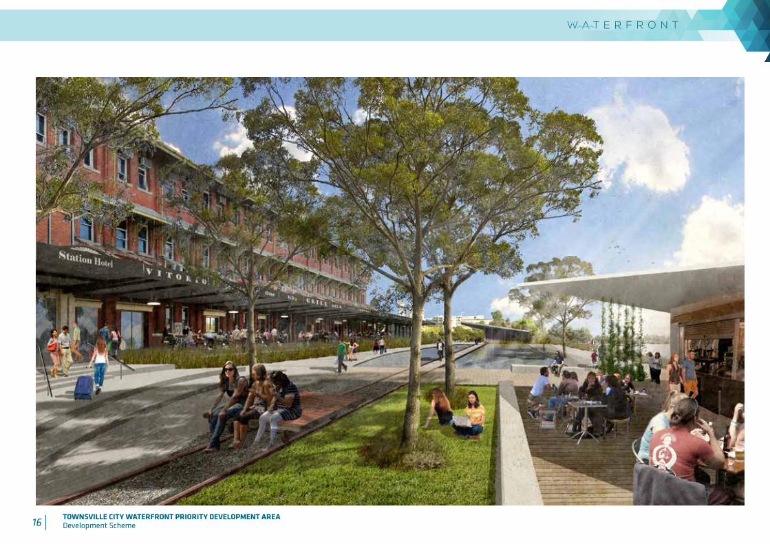
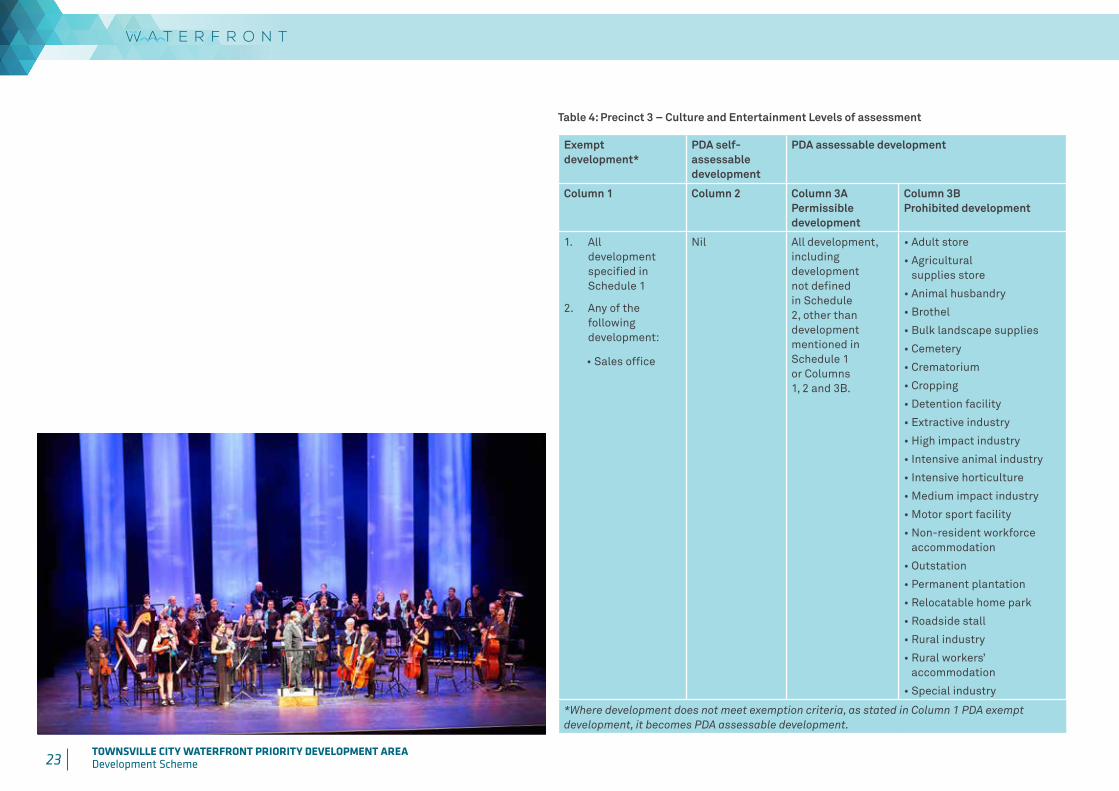
Precinct intentThe Culture and Entertainment Precinct is a vibrant, consolidated entertainment and culture node on the eastern bank of Ross Creek linked to the CBD and inner city through Central Park by pedestrian and cycle connections and the Waterfront Promenade.
Preferred Land UseDevelopment within the Culture and Entertainment Precinct will provide:
a. an integrated sports38 and entertainment centre, including convention facilities, within an urban setting that integrates with CBD parking and public transport network,
b. parking stations to service the integrated sports and entertainment centre,
c. a utility installation (bus terminal and driver facilities) to service the integrated sports and entertainment centre,
d. business, centre, entertainment and community activities set around the integrated sports and entertainment centre forecourts,
e. public open space and parks for community use including recreation and events,
f. community activities such as an art gallery, concert hall and performance spaces in Central Park, and
g. small-scale shops and food and drink outlets within Central Park.
Connectivity, Public Realm and Water’s EdgeDevelopment within the Culture and Entertainment Precinct will provide:
a. a new pedestrian and cycle bridge across Ross Creek linking the eastern bank to Aplin Street,
b. refurbishment of the existing heritage rail bridge to provide for pedestrian movement linking with the Ceremonial Corridor,
c. improved pedestrian connectivity at Victoria Bridge, George Roberts Bridge and the Waterfront Promenade interface,
d. an articulated and diverse water’s edge treatment that allows access to the water, seating and viewing areas, terracing and lookout decks and incorporates soft landscape treatments,
e. a shady pedestrian link from Victoria Bridge through Central Park,
f. a vehicle entrance via Saunders Street, intersection and drop-off facilities to service the integrated sports and entertainment centre, and
g. retention of existing shade trees and enhancement of Central Park including unique interactive play and fitness facilities which reflect the cultural character of the precinct.
38 The delivery of an integrated sports and entertainment centre is subject to the completion of a business case to determine scope, program and funding model in consultation with Local, State, Federal Government, regional and sports stakeholders.
Built Form and Climate ResponsivenessDevelopment within the Culture and Entertainment Precinct will provide:
a. development that displays an iconic, contemporary and tropical Townsville building character,
b. an integrated sports and entertainment centre building to promote ground floor active uses to interface with plaza forecourts for year-round activity,
c. engaging edges that promote pedestrian interaction with the surrounding public realm,
d. an arts and culture centre which forms a distinctive cultural gateway to the city with an active ground floor overlooking the waterfront, and
e. low-rise buildings within Central Park up to 2 storeys.

22 TOWNSVILLE CITY WATERFRONT PRIORITY DEVELOPMENT AREADevelopment Scheme
23 TOWNSVILLE CITY WATERFRONT PRIORITY DEVELOPMENT AREADevelopment Scheme 24 TOWNSVILLE CITY WATERFRONT PRIORITY DEVELOPMENT AREA
Development Scheme
Table 4: Precinct 3 – Culture and Entertainment Levels of assessment
Exempt development*
PDA self-assessable development
PDA assessable development
Column 1 Column 2 Column 3A Permissible development
Column 3B Prohibited development
1. All development specified in Schedule 1
2. Any of the following development:
• Sales office
Nil All development, including development not defined in Schedule 2, other than development mentioned in Schedule 1 or Columns 1, 2 and 3B.
• Adult store
• Agricultural supplies store
• Animal husbandry
• Brothel
• Bulk landscape supplies
• Cemetery
• Crematorium
• Cropping
• Detention facility
• Extractive industry
• High impact industry
• Intensive animal industry
• Intensive horticulture
• Medium impact industry
• Motor sport facility
• Non-resident workforce accommodation
• Outstation
• Permanent plantation
• Relocatable home park
• Roadside stall
• Rural industry
• Rural workers’ accommodation
• Special industry
*Where development does not meet exemption criteria, as stated in Column 1 PDA exempt development, it becomes PDA assessable development.
24 TOWNSVILLE CITY WATERFRONT PRIORITY DEVELOPMENT AREADevelopment Scheme
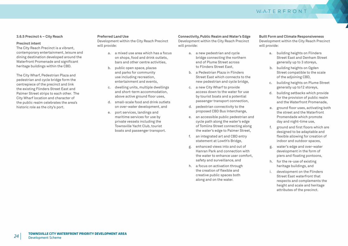
3.6.5 Precinct 4 – City Reach
Precinct intentThe City Reach Precinct is a vibrant, contemporary entertainment, leisure and dining destination developed around the Waterfront Promenade and significant heritage buildings within the CBD.
The City Wharf, Pedestrian Plaza and pedestrian and cycle bridge form the centrepiece of the precinct and link the existing Flinders Street East and Palmer Street strips to each other. The City Wharf location and character of the public realm celebrates the area’s historic role as the city’s port.
Preferred Land UseDevelopment within the City Reach Precinctwill provide:
a. a mixed use area which has a focus on shops, food and drink outlets, bars and other centre activities,
b. public open space, plazas and parks for community use including recreation, entertainment and events,
c. dwelling units, multiple dwellings and short-term accommodation, above active ground floor uses,
d. small-scale food and drink outlets on over-water development, and
e. port services, landings and maritime services for use by private vessels including the Townsville Yacht Club, tourist boats and passenger transport.
Connectivity, Public Realm and Water’s EdgeDevelopment within the City Reach Precinctwill provide:
a. a new pedestrian and cycle bridge connecting the northern end of Plume Street across to Flinders Street East,
b. a Pedestrian Plaza in Flinders Street East which connects to the new pedestrian and cycle bridge,
c. a new City Wharf to provide access down to the water for use by tourist boats and a potential passenger transport connection,
d. pedestrian connectivity to the proposed CBD Bus Interchange,
e. an accessible public pedestrian and cycle path along the water’s edge of Tomlins Street connecting along the water’s edge to Palmer Street,
f. an integrated art and CBD entry statement at Lowth’s Bridge,
g. enhanced views into and out of Hanran Park and connection with the water to enhance user comfort, safety and surveillance, and
h. a focus on activation through the creation of flexible and creative public spaces both along and on the water.
Built Form and Climate ResponsivenessDevelopment within the City Reach Precinctwill provide:
a. building heights on Flinders Street East and Denham Street generally up to 3 storeys,
b. building heights on Ogden Street compatible to the scale of the adjoining CBD,
c. building heights on Plume Street generally up to12 storeys,
d. building setbacks which provide for the provision of public realm and the Waterfront Promenade,
e. ground floor uses, activating both the street and the Waterfront Promendade which promote day and night-time use,
f. ground and first floors which are designed to be adaptable and flexible allowing for creation of indoor and outdoor spaces,
g. water’s edge and over-water development in the form of piers and floating pontoons,
h. for the re-use of existing heritage buildings, and
i. development on the Flinders Street East waterfront that respects and complements the height and scale and heritage attributes of the precinct.

25 TOWNSVILLE CITY WATERFRONT PRIORITY DEVELOPMENT AREADevelopment Scheme 26 TOWNSVILLE CITY WATERFRONT PRIORITY DEVELOPMENT AREA
Development Scheme
26 TOWNSVILLE CITY WATERFRONT PRIORITY DEVELOPMENT AREADevelopment Scheme
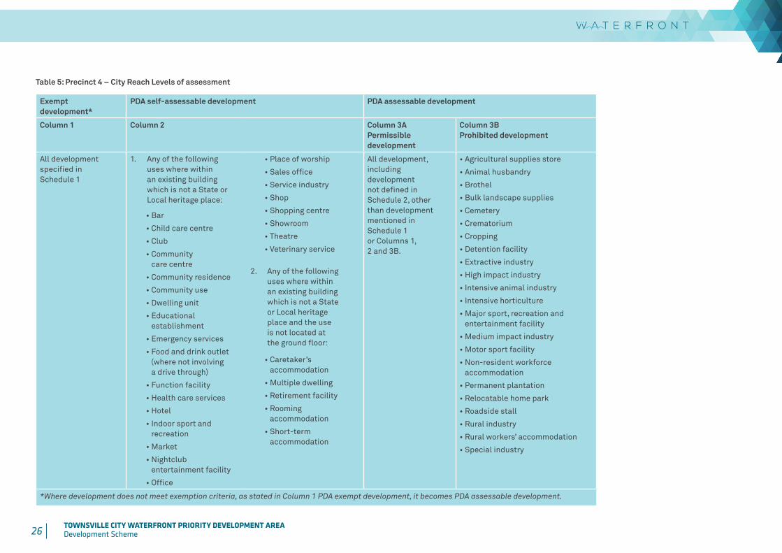
Table 5: Precinct 4 – City Reach Levels of assessment
Exempt development*
PDA self-assessable development PDA assessable development
Column 1 Column 2 Column 3A Permissible development
Column 3B Prohibited development
All development specified in Schedule 1
1. Any of the following uses where within an existing building which is not a State or Local heritage place:
• Bar
• Child care centre
• Club
• Community care centre
• Community residence
• Community use
• Dwelling unit
• Educational establishment
• Emergency services
• Food and drink outlet (where not involving a drive through)
• Function facility
• Health care services
• Hotel
• Indoor sport and recreation
• Market
• Nightclub entertainment facility
• Office
• Place of worship
• Sales office
• Service industry
• Shop
• Shopping centre
• Showroom
• Theatre
• Veterinary service
2. Any of the following uses where within an existing building which is not a State or Local heritage place and the use is not located at the ground floor:
• Caretaker’s accommodation
• Multiple dwelling
• Retirement facility
• Rooming accommodation
• Short-term accommodation
All development, including development not defined in Schedule 2, other than development mentioned in Schedule 1 or Columns 1, 2 and 3B.
• Agricultural supplies store
• Animal husbandry
• Brothel
• Bulk landscape supplies
• Cemetery
• Crematorium
• Cropping
• Detention facility
• Extractive industry
• High impact industry
• Intensive animal industry
• Intensive horticulture
• Major sport, recreation and entertainment facility
• Medium impact industry
• Motor sport facility
• Non-resident workforce accommodation
• Permanent plantation
• Relocatable home park
• Roadside stall
• Rural industry
• Rural workers’ accommodation
• Special industry
*Where development does not meet exemption criteria, as stated in Column 1 PDA exempt development, it becomes PDA assessable development.
27 TOWNSVILLE CITY WATERFRONT PRIORITY DEVELOPMENT AREADevelopment Scheme 28 TOWNSVILLE CITY WATERFRONT PRIORITY DEVELOPMENT AREA
Development Scheme
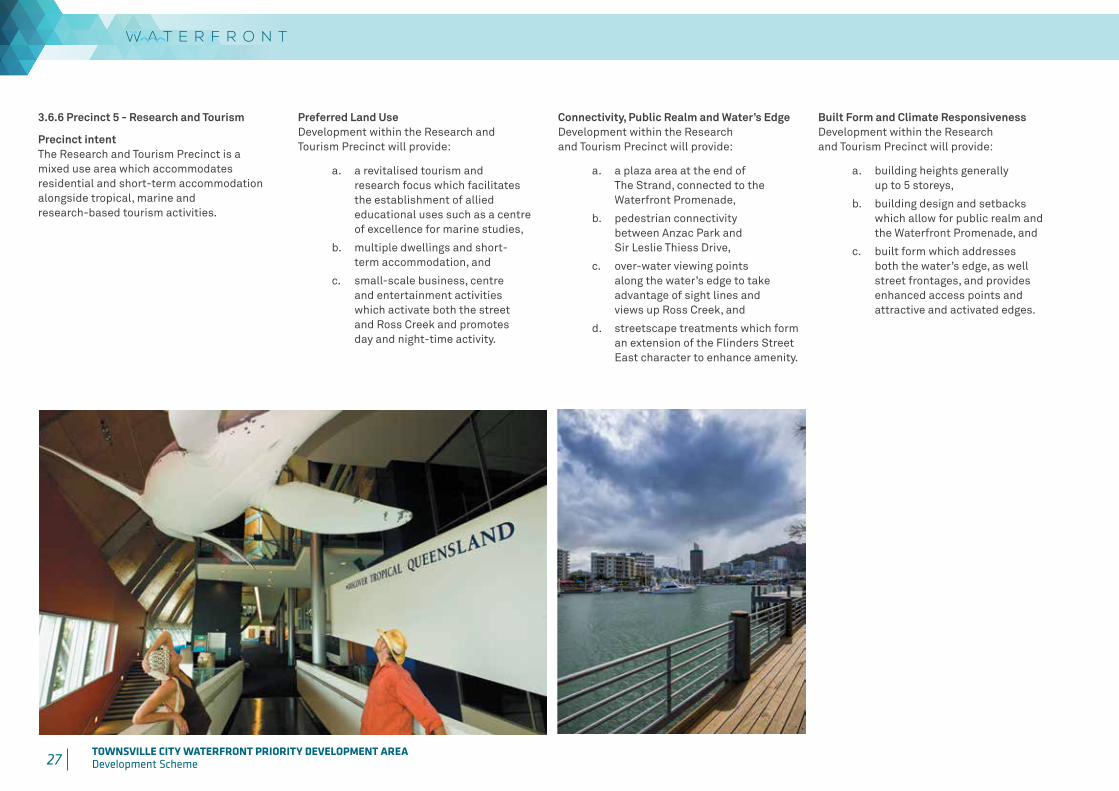
3.6.6 Precinct 5 - Research and Tourism
Precinct intentThe Research and Tourism Precinct is a mixed use area which accommodates residential and short-term accommodation alongside tropical, marine and research-based tourism activities.
Preferred Land UseDevelopment within the Research and Tourism Precinct will provide:
a. a revitalised tourism and research focus which facilitates the establishment of allied educational uses such as a centre of excellence for marine studies,
b. multiple dwellings and short-term accommodation, and
c. small-scale business, centre and entertainment activities which activate both the street and Ross Creek and promotes day and night-time activity.
Connectivity, Public Realm and Water’s EdgeDevelopment within the Research and Tourism Precinct will provide:
a. a plaza area at the end of The Strand, connected to the Waterfront Promenade,
b. pedestrian connectivity between Anzac Park and Sir Leslie Thiess Drive,
c. over-water viewing points along the water’s edge to take advantage of sight lines and views up Ross Creek, and
d. streetscape treatments which form an extension of the Flinders Street East character to enhance amenity.
Built Form and Climate ResponsivenessDevelopment within the Research and Tourism Precinct will provide:
a. building heights generally up to 5 storeys,
b. building design and setbacks which allow for public realm and the Waterfront Promenade, and
c. built form which addresses both the water’s edge, as well street frontages, and provides enhanced access points and attractive and activated edges.

28 TOWNSVILLE CITY WATERFRONT PRIORITY DEVELOPMENT AREADevelopment Scheme
Table 6: Precinct 5 – Research and Tourism Levels of assessment
Exempt development*
PDA self-assessable development PDA assessable development
Column 1 Column 2 Column 3A Permissible development
Column 3B Prohibited development
All development specified in Schedule 1
1. Any of the following uses where within an existing building which is not a State or Local heritage place:
• Bar
• Caretakers’ accommodation
• Child care centre
• Club
• Community care centre
• Community residence
• Community use
• Dwelling unit
• Educational establishment
• Emergency services
• Food and drink outlet (where not involving a drive through)
• Function facility
• Health care services
• Hotel
• Indoor sport and recreation
• Market
• Multiple dwelling
• Retirement facility
• Rooming accommodation
• Sales office
• Service industry
• Short-term accommodation
• Veterinary services
2. Any of the following uses where within an existing building and the gross floor area39 does not exceed 500m2:
• Office
• Shop
• Shopping centre
• Showroom
All development, including development not defined in Schedule 2, other than development mentioned in Schedule 1 or Columns 1, 2 and 3B.
• Agricultural supplies store
• Animal husbandry
• Brothel
• Bulk landscape supplies
• Cemetery
• Crematorium
• Cropping
• Detention facility
• Extractive industry
• High impact industry
• Intensive animal industry
• Intensive horticulture
• Major sport, recreation and entertainment facility
• Medium impact industry
• Motor sport facility
• Non-resident workforce accommodation
• Outstation
• Permanent plantation
• Relocatable home park
• Roadside stall
• Rural industry
• Rural workers’ accommodation
• Special industry
• Transport depot
• Wholesale nursery
*Where development does not meet exemption criteria, as stated in Column 1 PDA exempt development, it becomes PDA assessable development.
39 The gross floor area threshold is calculated for a new use or an extension to an existing use. It is not the cumulative total of the existing centre and the additional gross floor area forming part of the development application.

29 TOWNSVILLE CITY WATERFRONT PRIORITY DEVELOPMENT AREADevelopment Scheme 30 TOWNSVILLE CITY WATERFRONT PRIORITY DEVELOPMENT AREA
Development Scheme
3.6.7 Precinct 6 - Ocean Gateway
Precinct intentThe Ocean Gateway Precinct is to provide a significant area for well-designed residential and commercial uses, including a range of supportive service-orientated land uses40. Mixed-use style developments (e.g. business and centre activities and residential) would be encouraged, with a strong preference for commercial uses along the Waterfront Promenade.
Preferred Land UseDevelopment within the Ocean Gateway Precinct will provide:
a. opportunities for commercial uses along Ross Creek,
b. opportunities for both residential and short-term accommodation in the southern parts of the precinct with a mixture of dwelling types and styles, and
c. a mix of business and centre activities on ground floor premises. Centre activities service the immediate residential community only.
Connectivity, Public Realm and Water’s EdgeDevelopment within the Ocean Gateway Precinct will provide:
a. convenient and legible connections throughout the precinct between the buildings and the Waterfront Promenade and protect public access to the water’s edge, and
b. high-quality landscape and pedestrian connectivity throughout the precinct between the Waterfront Promenade, Sir Leslie Thiess Drive, ANZAC Park and The Strand.
40 Assumptions underpinning infrastructure planning provide for a base yield of 350 dwelling units and 4,800m² retail floor space and 3,200m² office floor space in Precinct 6 – Ocean Gateway. Development can seek to vary this where it can be demonstrated that proposals can be adequately serviced by infrastructure and the traffic network is not adversely affected (refer to item S12 of the Implementation strategy).41 Examples of standards include: AS/NZS 2107:2000 – Acoustics – recommended design sound levels and reverberation times for building interiors, Environmental Protection (Noise) Policy 2008, Environmental Protection (Air) Policy 2008, Guideline: Odour Impact Assessment from Developments. Qld DEHP and AS 4828:1997 – Control of the obtrusive effects of outdoor lighting.
Built Form and Climate ResponsivenessDevelopment within the Ocean Gateway will provide:
a. buildings generally in accordance with Table 7: Building parameter guidelines for Precinct 6 – Ocean Gateway,
b. buildings generally up to 10 storeys in height,
c. built form which addresses both the water’s edge, and the street, and provides enhanced access points and attractive and activated edges,
d. openings in buildings which are located, oriented, designed and constructed to reduce exposure to noise (and other) impacts as a result of Port of Townsville operations,
e. design measures including physical screening are incorporated in the built form to reduce exposure to adverse light impacts associated with the Port of Townsville operations,
f. lighting located to ensure that illumination and glare from the development does not conflict with Port of Townsville operations,
g. outdoor areas that are located, oriented, designed and constructed to reduce exposure to noise, light, dust or odour from Port of Townsville operations, and
h. for appropriate noise, dust, odour and lighting standards in future development to ensure siting, design and construction achieves acceptable levels of amenity41.
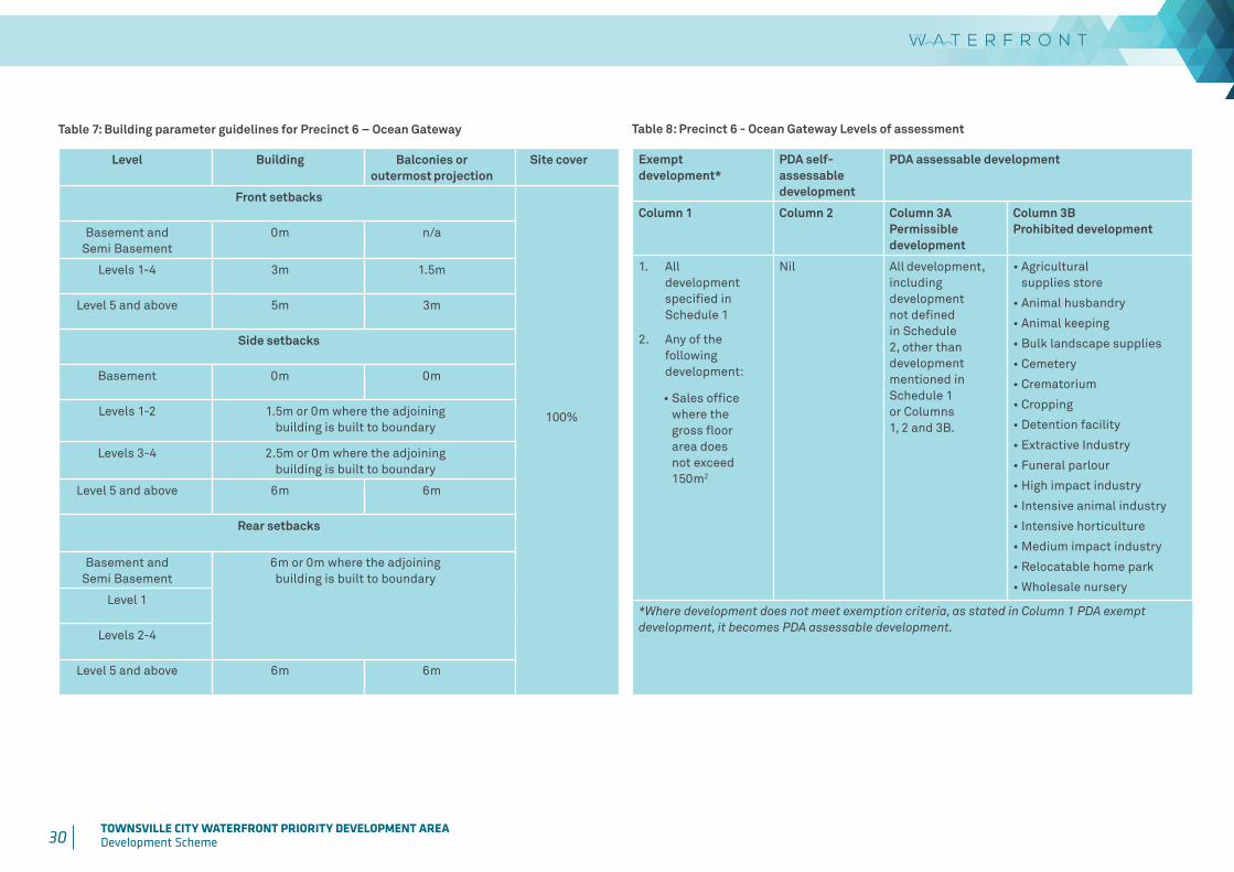
30 TOWNSVILLE CITY WATERFRONT PRIORITY DEVELOPMENT AREADevelopment Scheme
Table 8: Precinct 6 - Ocean Gateway Levels of assessment
Exempt development*
PDA self-assessable development
PDA assessable development
Column 1 Column 2 Column 3A Permissible development
Column 3B Prohibited development
1. All development specified in Schedule 1
2. Any of the following development:
• Sales office where the gross floor area does not exceed 150m2
Nil All development, including development not defined in Schedule 2, other than development mentioned in Schedule 1 or Columns 1, 2 and 3B.
• Agricultural supplies store
• Animal husbandry
• Animal keeping
• Bulk landscape supplies
• Cemetery
• Crematorium
• Cropping
• Detention facility
• Extractive Industry
• Funeral parlour
• High impact industry
• Intensive animal industry
• Intensive horticulture
• Medium impact industry
• Relocatable home park
• Wholesale nursery
*Where development does not meet exemption criteria, as stated in Column 1 PDA exempt development, it becomes PDA assessable development.
Table 7: Building parameter guidelines for Precinct 6 – Ocean Gateway
Level Building Balconies or outermost projection
Site cover
Front setbacks
100%
Basement and Semi Basement
0m n/a
Levels 1-4 3m 1.5m
Level 5 and above 5m 3m
Side setbacks
Basement 0m 0m
Levels 1-2 1.5m or 0m where the adjoining building is built to boundary
Levels 3-4 2.5m or 0m where the adjoining building is built to boundary
Level 5 and above 6m 6m
Rear setbacks
Basement and Semi Basement
6m or 0m where the adjoining building is built to boundary
Level 1
Levels 2-4
Level 5 and above 6m 6m
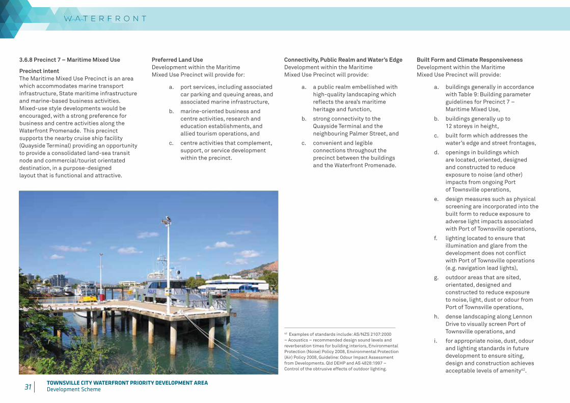
31 TOWNSVILLE CITY WATERFRONT PRIORITY DEVELOPMENT AREADevelopment Scheme 32 TOWNSVILLE CITY WATERFRONT PRIORITY DEVELOPMENT AREA
Development Scheme
3.6.8 Precinct 7 – Maritime Mixed Use
Precinct intentThe Maritime Mixed Use Precinct is an area which accommodates marine transport infrastructure, State maritime infrastructure and marine-based business activities. Mixed-use style developments would be encouraged, with a strong preference for business and centre activities along the Waterfront Promenade. This precinct supports the nearby cruise ship facility (Quayside Terminal) providing an opportunity to provide a consolidated land-sea transit node and commercial/tourist orientated destination, in a purpose-designed layout that is functional and attractive.
Connectivity, Public Realm and Water’s EdgeDevelopment within the Maritime Mixed Use Precinct will provide:
a. a public realm embellished with high-quality landscaping which reflects the area’s maritime heritage and function,
b. strong connectivity to the Quayside Terminal and the neighbouring Palmer Street, and
c. convenient and legible connections throughout the precinct between the buildings and the Waterfront Promenade.
Built Form and Climate ResponsivenessDevelopment within the Maritime Mixed Use Precinct will provide:
a. buildings generally in accordance with Table 9: Building parameter guidelines for Precinct 7 – Maritime Mixed Use,
b. buildings generally up to 12 storeys in height,
c. built form which addresses the water’s edge and street frontages,
d. openings in buildings which are located, oriented, designed and constructed to reduce exposure to noise (and other) impacts from ongoing Port of Townsville operations,
e. design measures such as physical screening are incorporated into the built form to reduce exposure to adverse light impacts associated with Port of Townsville operations,
f. lighting located to ensure that illumination and glare from the development does not conflict with Port of Townsville operations (e.g. navigation lead lights),
g. outdoor areas that are sited, orientated, designed and constructed to reduce exposure to noise, light, dust or odour from Port of Townsville operations,
h. dense landscaping along Lennon Drive to visually screen Port of Townsville operations, and
i. for appropriate noise, dust, odour and lighting standards in future development to ensure siting, design and construction achieves acceptable levels of amenity42.
42 Examples of standards include: AS/NZS 2107:2000 – Acoustics – recommended design sound levels and reverberation times for building interiors, Environmental Protection (Noise) Policy 2008, Environmental Protection (Air) Policy 2008, Guideline: Odour Impact Assessment from Developments. Qld DEHP and AS 4828:1997 – Control of the obtrusive effects of outdoor lighting.
Preferred Land UseDevelopment within the Maritime Mixed Use Precinct will provide for:
a. port services, including associated car parking and queuing areas, and associated marine infrastructure,
b. marine-oriented business and centre activities, research and education establishments, and allied tourism operations, and
c. centre activities that complement, support, or service development within the precinct.
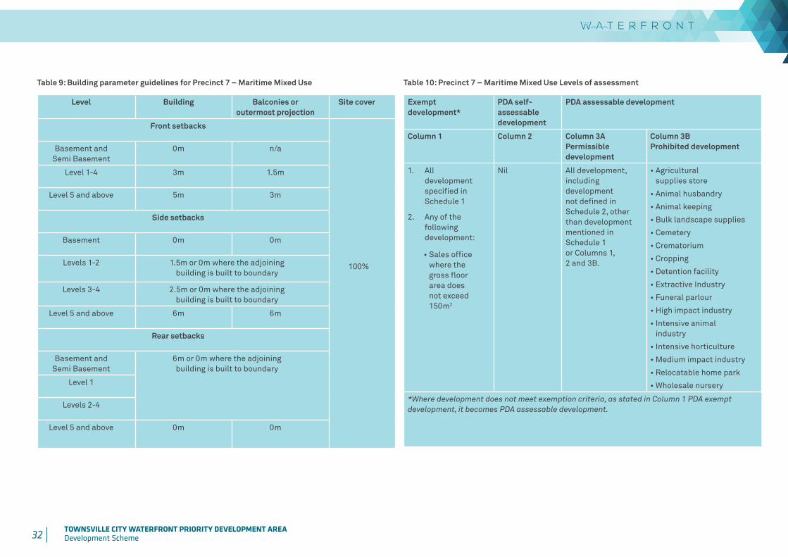
32 TOWNSVILLE CITY WATERFRONT PRIORITY DEVELOPMENT AREADevelopment Scheme
Table 9: Building parameter guidelines for Precinct 7 – Maritime Mixed Use
Level Building Balconies or outermost projection
Site cover
Front setbacks
100%
Basement and Semi Basement
0m n/a
Level 1-4 3m 1.5m
Level 5 and above 5m 3m
Side setbacks
Basement 0m 0m
Levels 1-2 1.5m or 0m where the adjoining building is built to boundary
Levels 3-4 2.5m or 0m where the adjoining building is built to boundary
Level 5 and above 6m 6m
Rear setbacks
Basement and Semi Basement
6m or 0m where the adjoining building is built to boundary
Level 1
Levels 2-4
Level 5 and above 0m 0m
Table 10: Precinct 7 – Maritime Mixed Use Levels of assessment
Exempt development*
PDA self-assessable development
PDA assessable development
Column 1 Column 2 Column 3A Permissible development
Column 3B Prohibited development
1. All development specified in Schedule 1
2. Any of the following development:
• Sales office where the gross floor area does not exceed 150m2
Nil All development, including development not defined in Schedule 2, other than development mentioned in Schedule 1 or Columns 1, 2 and 3B.
• Agricultural supplies store
• Animal husbandry
• Animal keeping
• Bulk landscape supplies
• Cemetery
• Crematorium
• Cropping
• Detention facility
• Extractive Industry
• Funeral parlour
• High impact industry
• Intensive animal industry
• Intensive horticulture
• Medium impact industry
• Relocatable home park
• Wholesale nursery
*Where development does not meet exemption criteria, as stated in Column 1 PDA exempt development, it becomes PDA assessable development.
33 TOWNSVILLE CITY WATERFRONT PRIORITY DEVELOPMENT AREADevelopment Scheme 34 TOWNSVILLE CITY WATERFRONT PRIORITY DEVELOPMENT AREA
Development Scheme
4 INFRASTRUCTURE PLAN Growth in the PDA is envisaged to propel economic development activity for the city area. Through the acquisition of strategic parcels of land in the PDA, the levy of infrastructure charges and initiatives such as the CBD development incentives program, Townsville City Council has already co-funded some of this growth.
4.1 Infrastructure objectives
The infrastructure plan identifies infrastructure which will allow for growth and development to achieve the PDA Vision.
The infrastructure plan will integrate and coordinate land use planning and infrastructure planning to ensure that infrastructure is planned and provided in an efficient and orderly manner. Additionally the infrastructure plan provides for other placemaking infrastructure unique to the vision and success of the PDA.
4.2 Infrastructure requirements
Infrastructure planned to be delivered within the PDA will fall into one of three categories:
• Network infrastructure,
• Non-network infrastructure, and
• Placemaking infrastructure.
4.2.2 Non-network infrastructure
Non-network infrastructure is the lower order infrastructure which generally services one development or connects development to the wider network infrastructure.
Non-network infrastructure will be provided by the developer, in accordance with relevant responsible entity’s requirements.
4.2.3 Placemaking infrastructure
Placemaking infrastructure is non-trunk infrastructure which specifically supports the PDA’s redevelopment, renewal and success. This includes community infrastructure, open space, marine infrastructure and movement networks, not necessarily limited to any specific planning horizon.
43 Refer to the Townsville City Waterfront Priority Development Area Infrastructure Charges Offset Plan available at www.townsville.qld.gov.au.44 This only includes local government and Port of Townsville Limited infrastructure.
4.3 Placemaking infrastructure
The Townsville City Waterfront Placemaking infrastructure is listed in Table 11. This Placemaking infrastructure is required to support the PDA Vision and success of the PDA. The timeframes associated with Placemaking infrastructure can be found in Part 5, Table 12.
Placemaking infrastructure takes the form of new infrastructure or upgrades to existing infrastructure. It may also augment Network infrastructure of trunk infrastructure, providing a higher standard of service than sought for Network or trunk infrastructure purposes (e.g. pathway feature lighting).
Part 5 Implementation Strategy identifies projects and strategies and indicative timeframes to support the delivery of Placemaking infrastructure and projects for the PDA. Any Placemaking infrastructure that is not identified in the ICOP43 will be funded through alternative revenue sources.
4.2.1 Network infrastructure
Network infrastructure is the high order shared infrastructure consisting of water supply, sewerage, stormwater, transport (including roads, footpaths and cycleways), open space and land for community facilities, planned to service (and is relevant to the level of service within and adjacent to) the PDA at the 2026 planning horizon.
Network infrastructure identified for the PDA will be listed in an Infrastructure Charging Offset Plan (ICOP)43.
The Network infrastructure identified in the ICOP43 will be funded from infrastructure charges44 and from alternative revenue sources such as charges collected from the local government area. It may be delivered by the developer as a condition of a PDA development approval.
The ICOP43 will provide further details on the Network infrastructure and also any offsets that may be applicable against infrastructure charges.
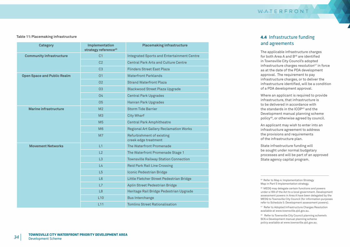
34 TOWNSVILLE CITY WATERFRONT PRIORITY DEVELOPMENT AREADevelopment Scheme
4.4 Infrastructure funding and agreements
The applicable infrastructure charges for both Area A and B46 are identified in Townsville City Council’s adopted infrastructure charges resolution47 in force as at the date of the PDA development approval. The requirement to pay infrastructure charges, or to deliver the infrastructure identified, will be a condition of a PDA development approval.
Where an applicant is required to provide infrastructure, that infrastructure is to be delivered in accordance with the standards in the ICOP43 and the Development manual planning scheme policy48, or otherwise agreed by council.
An applicant may wish to enter into an infrastructure agreement to address the provisions and requirements of the infrastructure plan.
State infrastructure funding will be sought under normal budgetary processes and will be part of an approved State agency capital program.
Table 11: Placemaking infrastructure
Category Implementation strategy reference45
Placemaking infrastructure
Community infrastructure C1 Integrated Sports and Entertainment Centre
C2 Central Park Arts and Culture Centre
C3 Flinders Street East Plaza
Open Space and Public Realm O1 Waterfront Parklands
O2 Strand Waterfront Plaza
O3 Blackwood Street Plaza Upgrade
O4 Central Park Upgrades
O5 Hanran Park Upgrades
Marine infrastructure M2 Storm Tide Barrier
M3 City Wharf
M5 Central Park Amphitheatre
M6 Regional Art Gallery Reclamation Works
M7 Refurbishment of existing creek edge treatment
Movement Networks L1 The Waterfront Promenade
L2 The Waterfront Promenade Stage 1
L3 Townsville Railway Station Connection
L4 Reid Park Rail Line Crossing
L5 Iconic Pedestrian Bridge
L6 Little Fletcher Street Pedestrian Bridge
L7 Aplin Street Pedestrian Bridge
L8 Heritage Rail Bridge Pedestrian Upgrade
L10 Bus Interchange
L11 Tomlins Street Rationalisation
45 Refer to Map 4: Implementation Strategy Map in Part 5 Implementation strategy. 46 MEDQ may delegate certain functions and powers under s.169 of the Act to a local government. Development assessment powers in Area A have been delegated by the MEDQ to Townsville City Council (for information purposes refer to Schedule 5: Development assessment powers).47 Refer to Adopted Infrastructure Charges Resolution available at www.townsville.qld.gov.au.48 Refer to Townsville City Council planning scheme’s SC6.4 Development manual planning scheme policy available at www.townsville.qld.gov.au.
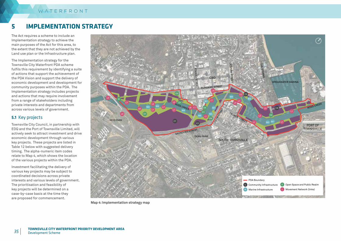
35 TOWNSVILLE CITY WATERFRONT PRIORITY DEVELOPMENT AREADevelopment Scheme 36 TOWNSVILLE CITY WATERFRONT PRIORITY DEVELOPMENT AREA
Development Scheme
5 IMPLEMENTATION STRATEGY The Act requires a scheme to include an Implementation strategy to achieve the main purposes of the Act for this area, to the extent that they are not achieved by the Land use plan or the Infrastructure plan.
The Implementation strategy for the Townsville City Waterfront PDA scheme fulfils this requirement by identifying a suite of actions that support the achievement of the PDA Vision and support the delivery of economic development and development for community purposes within the PDA. The Implementation strategy includes projects and actions that may require involvement from a range of stakeholders including private interests and departments from across various levels of government.
5.1 Key projectsTownsville City Council, in partnership with EDQ and the Port of Townsville Limited, will actively seek to attract investment and drive economic development through various key projects. These projects are listed in Table 12 below with suggested delivery timing. The alpha-numeric item codes relate to Map 4, which shows the location of the various projects within the PDA.
Investment facilitating the delivery of various key projects may be subject to coordinated decisions across private interests and various levels of government. The prioritisation and feasibility of key projects will be determined on a case-by-case basis at the time they are proposed for commencement.
Map 4: Implementation strategy map
C1
C3
C2
M5
M1M2
M3
M7M4
M4 M4
M6
M4
O1
O3
O1
O4
O2
L1L2
L2
L1
L1
L2
L6L7
L1 L1
L3
L8
L4
L5
L1
L1
PDA Boundary
C Community Infrastructure
M Marine Infrastructure
O Open Space & Public Realm
L Movement network (links)
C4
M701
L1
L1
L1
L10
L9
L11
O1
O5 ross creek
palmer street
ross creek
breakwater marina
flinders street
saunders street
dean
str
eet
de
nh
am
str
ee
t
sta
nle
y str
ee
t
the
stran
d
reid park
dean park
cbd
port of townsville
south townsville
PDA Boundary
C Community Infrastructure
M Marine Infrastructure
O Open Space and Public Realm
L Movement Network (links)
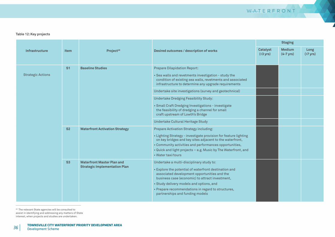
36 TOWNSVILLE CITY WATERFRONT PRIORITY DEVELOPMENT AREADevelopment Scheme
Table 12: Key projects
Infrastructure Item Project49 Desired outcomes / description of works
Staging
Catalyst (<3 yrs)
Medium (4-7 yrs)
Long (>7 yrs)
Strategic Actions
S1 Baseline Studies Prepare Dilapidation Report:
• Sea walls and revetments investigation - study the condition of existing sea walls, revetments and associated infrastructure to determine any upgrade requirements
Undertake site investigations (survey and geotechnical)
Undertake Dredging Feasibility Study:
• Small Craft Dredging Investigations - investigate the feasibility of dredging a channel for small craft upstream of Lowth’s Bridge
Undertake Cultural Heritage Study
S2 Waterfront Activation Strategy Prepare Activation Strategy including:
• Lighting Strategy - investigate provision for feature lighting on key bridges and key sites adjacent to the waterfront,
• Community activities and performances opportunities,• Quick and light projects – e.g. Music by The Waterfront, and• Water taxi/tours
S3 Waterfront Master Plan and Strategic Implementation Plan
Undertake a multi-disciplinary study to:
• Explore the potential of waterfront destination and associated development opportunities and the business case (economic) to attract investment,
• Study delivery models and options, and
• Prepare recommendations in regard to structures, partnerships and funding models
49 The relevant State agencies will be consulted to assist in identifying and addressing any matters of State interest, when projects and studies are undertaken.

37 TOWNSVILLE CITY WATERFRONT PRIORITY DEVELOPMENT AREADevelopment Scheme 38 TOWNSVILLE CITY WATERFRONT PRIORITY DEVELOPMENT AREA
Development Scheme
Infrastructure Item Project49 Desired outcomes / description of works
Staging
Catalyst (<3 yrs)
Medium (4-7 yrs)
Long (>7 yrs)
Strategic Actions
S4 Rationalise Waterfront Boundaries Identify opportunities to rationalise boundaries through consultation with key stakeholders including the State government and relevant State agencies, and analysis of existing property boundaries
S5 Waterfront Promenade Corridor Investigate the establishment of a connected movement corridor by utilising existing waterfront land in public ownership, reconfiguration of lots, creation of easements on private lots, and establishment of water leases in strategic locations
S6 Ross Creek Single Lease Investigate the establishment of a single lease over the water area of Ross Creek, upstream of the Port of Townsville within the PDA boundary
S7 Land Release Investigate opportunities to release key sites currently owned by the state or council for public tender
S8 Design Guidelines Prepare Public Realm Design Guideline to drive consistent quality and standards across the public realm
Prepare a Marine Plant Management Strategy to management development and the conservation of marine plants in consultation with the relevant State agencies.
Prepare Lighting Guideline to set standards and consistency across the PDA
Prepare Signage Guideline to set standards and consistency across the PDA
Prepare Public Art Guideline for procurement and curation of public art in the PDA
Prepare Waterfront Sustainability Guideline to inform desired development outcomes and drive sustainable outcomes for the PDA
Prepare a Water Sensitive Urban Design Strategy
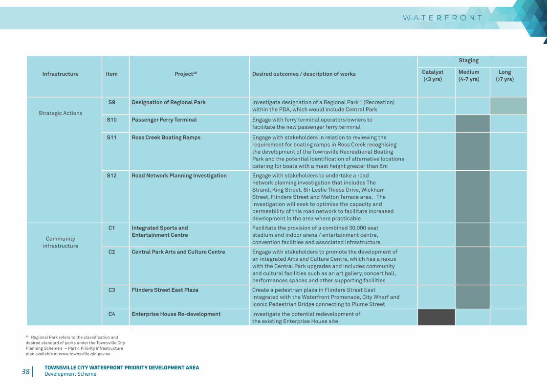
38 TOWNSVILLE CITY WATERFRONT PRIORITY DEVELOPMENT AREADevelopment Scheme
Infrastructure Item Project49 Desired outcomes / description of works
Staging
Catalyst (<3 yrs)
Medium (4-7 yrs)
Long (>7 yrs)
Strategic Actions
S9 Designation of Regional Park Investigate designation of a Regional Park50 (Recreation) within the PDA, which would include Central Park
S10 Passenger Ferry Terminal Engage with ferry terminal operators/owners to facilitate the new passenger ferry terminal
S11 Ross Creek Boating Ramps Engage with stakeholders in relation to reviewing the requirement for boating ramps in Ross Creek recognising the development of the Townsville Recreational Boating Park and the potential identification of alternative locations catering for boats with a mast height greater than 6m
S12 Road Network Planning Investigation Engage with stakeholders to undertake a road network planning investigation that includes The Strand, King Street, Sir Leslie Thiess Drive, Wickham Street, Flinders Street and Melton Terrace area. The investigation will seek to optimise the capacity and permeability of this road network to facilitate increased development in the area where practicable
Community infrastructure
C1 Integrated Sports and Entertainment Centre
Facilitate the provision of a combined 30,000 seat stadium and indoor arena / entertainment centre, convention facilities and associated infrastructure
C2 Central Park Arts and Culture Centre Engage with stakeholders to promote the development of an integrated Arts and Culture Centre, which has a nexus with the Central Park upgrades and includes community and cultural facilities such as an art gallery, concert hall, performances spaces and other supporting facilities
C3 Flinders Street East Plaza Create a pedestrian plaza in Flinders Street East integrated with the Waterfront Promenade, City Wharf and Iconic Pedestrian Bridge connecting to Plume Street
C4 Enterprise House Re-development Investigate the potential redevelopment of the existing Enterprise House site
50 Regional Park refers to the classification and desired standard of parks under the Townsville City Planning Scheme’s – Part 4 Priority infrastructure plan available at www.townsville.qld.gov.au.

39 TOWNSVILLE CITY WATERFRONT PRIORITY DEVELOPMENT AREADevelopment Scheme 40 TOWNSVILLE CITY WATERFRONT PRIORITY DEVELOPMENT AREA
Development Scheme
Infrastructure Item Project49 Desired outcomes / description of works
Staging
Catalyst (<3 yrs)
Medium (4-7 yrs)
Long (>7 yrs)
Open Space and Public Realm
O1 Waterfront Parklands Create an integrated open space network, delivered in stages, throughout the PDA, including options for open space areas adjacent to Waterfront Promenade
O2 Strand Waterfront Plaza Provision for a public waterfront plaza at the end of The Strand, integrated with the multi-use infrastructure corridor
O3 Blackwood Street Plaza Upgrade Investigate enhancement of existing park / plaza to the corner of Flinders and Blackwood Streets
O4 Central Park Upgrades Upgrades to Central Park, including investigating options for café / dining kiosks, shade arbour, unique playground, water play and fitness zone which is integrated with the proposed Central Park Arts and Culture Centre
O5 Designation of Regional Park Upgrades of Hanran Park to enhance amenity, safety and views into the site
Marine infrastructure51
M1 Multi-use Infrastructure Corridor Establish a multi-infrastructure corridor across Ross Creek at the end of The Strand
M2 Storm Tide Barrier Prepare preliminary concept and budget estimate for storm tide barrier, integrated within multi-use infrastructure corridor
M3 City Wharf Investigate provision for a new City Wharf, including associated dredging and replacement of derelict structures and unserviceable revetments
M4 Ross Creek Activation Investigate provision of moorings for temporary structures and infrastructure for events
M5 Central Park Amphitheatre Investigate reclamation Ross Creek to create an outdoor amphitheatre and river stage
M6 Culture and Entertainment Precinct Reclamation Works
Investigate reclamation works to enhance the various cultural facilities
M7 Refurbishment of existing creek edge treatment
Investigate replacement of existing concrete creek edge bank with new terraced interface, incorporating retaining, decking, seating, shade structures and planting
51 Activities or works within Ross Creek may be considered waterway barrier works - refer to the Department of Agriculture and Fisheries guidelines available at www.daf.qld.gov.au.

40 TOWNSVILLE CITY WATERFRONT PRIORITY DEVELOPMENT AREADevelopment Scheme
Infrastructure Item Project49 Desired outcomes / description of works
Staging
Catalyst (<3 yrs)
Medium (4-7 yrs)
Long (>7 yrs)
Movement networks51 L1 The Waterfront Promenade Establish a connected Waterfront Promenade (in stages) on both sides of Ross Creek with connections to the wider network
L2 The Waterfront Promenade (Stage 1) Establish Waterfront Promenade (Stage 1)
L3 Townsville Railway Station Connection Investigate establishment of a pedestrian and cyclist overpass to connect to the new station platform
L4 Reid Park Rail Line Crossing Establish a pedestrian and cyclist crossing over the rail line connecting to Reid Park
L5 Iconic Pedestrian Bridge Investigate establishment of new iconic pedestrian and cyclist bridge linking Plume Street to the Flinders Street Plaza
L6 Little Fletcher Street Pedestrian Bridge Investigate feasibility of upgrading existing bridge on the Little Fletcher Street alignment to provide pedestrian and cycle access across Ross Creek
L7 Aplin Street Pedestrian Bridge Investigate establishment of new pedestrian and cyclist bridge linking the Aplin Street axis to the integrated sports and entertainment centre
L8 Heritage Rail Bridge Pedestrian Upgrade Investigate feasibility of upgrading existing rail bridge on Heritage Railway Trail alignment to provide pedestrian and cycle access across Ross Creek
L9 King Street Realignment Investigate reinstating two-way traffic in King Street, Wickham Street, The Strand and Flinders Street East
L10 Bus Interchange Engage with stakeholders in relation to connections with the new CBD Bus Interchange facility
L11 Tomlins Street Rationalisation Upgrade of Tomlins Street, including rationalisation of street profile to provide for Waterfront Promenade
41 TOWNSVILLE CITY WATERFRONT PRIORITY DEVELOPMENT AREADevelopment Scheme 42 TOWNSVILLE CITY WATERFRONT PRIORITY DEVELOPMENT AREA
Development Scheme
The following tables identify development that is exempt from assessment in all precincts of the PDA.
Building work
Minor building work and demolition work, except if the land is identified on Map C 03 Heritage, as a State or Local heritage place52.
Carrying out building work associated with a material change of use that is PDA exempt development.
Carrying out building work associated with an approved material change of use.
Erecting no more than one (1) satellite dish, where the satellite dish has no dimension greater than 1.8m, except if the land is identified on Map C 03 Heritage, as a State or Local heritage place.
Material change of use of premises
Making a material change of use of premises for:
i. Home based business – if the gross floor area does not exceed 60m²,ii. Major electricity infrastructure, Park, Substation or Utility
installation – if provided by a public sector entity, andiii. Telecommunications facility – if aerial cabling for broadband purposes.
Material Change of Use if in accordance with an approved Plan of Development
Reconfiguring a lot
Subdivision involving road widening and truncations required as a condition of PDA development approval.
Operational work
Plumbing or drainage work
Carrying out plumbing or drainage work.
All aspects of development
Development undertaken for the purpose of public housing.
Development prescribed in Schedule 4 of the Sustainable Planning Regulation Act 2009, other than Table 5, item 14.
Filling or excavation where not on or adjoining a heritage place and not:i. within 1.5m of a lot boundary and exceeding a depth of 300mm; orii. involving:
a. a depth exceeding 1m; or
b. a volume of 100m³ or more.
Carrying out operational work associated with a material change of use that is PDA exempt development.
Carrying out operational work in accordance with the conditions of a PDA development approval for a material change of use or reconfiguring a lot.
Carrying out operational work associated with the decontamination of land.
Carrying out operational work that is clearing of vegetation:
i. other than significant vegetation, or ii. significant vegetation where:
a. carried out by or on behalf of Townsville City Council or a public sector entity, or
b. in accordance with the conditions of a PDA development approval for a material change of use or reconfiguring a lot.
Placing an advertising device on premises in accordance with the conditions of a PDA development approval for a material change of use.
Placing an advertising device on premises not associated with a PDA development approval which is not:
i. an animated sign; orii. a billboard; oriii. a pole sign; oriv. a pylon sign; orv. a three-dimensional object sign.
52 Where consistent with a General Exemption Certificate issued under the Queensland Heritage Act 1992, minor building and demolition work is exempt development.53 Refer to Townsville City Council planning scheme’s Part 9.4.1 Advertising devices code for the types of advertising devices available at www.townsville.qld.gov.au.
SCHEDULE 1: PDA-wide exempt development
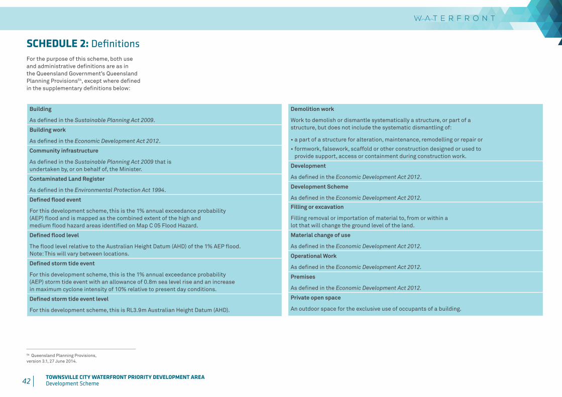
42 TOWNSVILLE CITY WATERFRONT PRIORITY DEVELOPMENT AREADevelopment Scheme
For the purpose of this scheme, both use and administrative definitions are as in the Queensland Government’s Queensland Planning Provisions54, except where defined in the supplementary definitions below:
54 Queensland Planning Provisions, version 3.1, 27 June 2014.
Building
As defined in the Sustainable Planning Act 2009.
Building work
As defined in the Economic Development Act 2012.
Community infrastructure
As defined in the Sustainable Planning Act 2009 that is undertaken by, or on behalf of, the Minister.
Contaminated Land Register
As defined in the Environmental Protection Act 1994.
Defined flood event
For this development scheme, this is the 1% annual exceedance probability (AEP) flood and is mapped as the combined extent of the high and medium flood hazard areas identified on Map C 05 Flood Hazard.
Defined flood level
The flood level relative to the Australian Height Datum (AHD) of the 1% AEP flood. Note: This will vary between locations.
Defined storm tide event
For this development scheme, this is the 1% annual exceedance probability (AEP) storm tide event with an allowance of 0.8m sea level rise and an increase in maximum cyclone intensity of 10% relative to present day conditions.
Defined storm tide event level
For this development scheme, this is RL3.9m Australian Height Datum (AHD).
Demolition work
Work to demolish or dismantle systematically a structure, or part of a structure, but does not include the systematic dismantling of:
• a part of a structure for alteration, maintenance, remodelling or repair or
• formwork, falsework, scaffold or other construction designed or used to provide support, access or containment during construction work.
Development
As defined in the Economic Development Act 2012.
Development Scheme
As defined in the Economic Development Act 2012.
Filling or excavation
Filling removal or importation of material to, from or within a lot that will change the ground level of the land.
Material change of use
As defined in the Economic Development Act 2012.
Operational Work
As defined in the Economic Development Act 2012.
Premises
As defined in the Economic Development Act 2012.
Private open space
An outdoor space for the exclusive use of occupants of a building.
SCHEDULE 2: Definitions
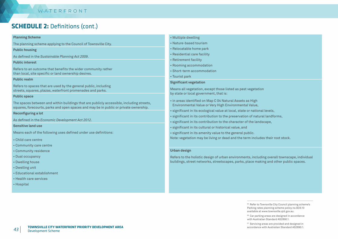
43 TOWNSVILLE CITY WATERFRONT PRIORITY DEVELOPMENT AREADevelopment Scheme 44 TOWNSVILLE CITY WATERFRONT PRIORITY DEVELOPMENT AREA
Development Scheme
• Multiple dwelling
• Nature-based tourism
• Relocatable home park
• Residential care facility
• Retirement facility
• Rooming accommodation
• Short-term accommodation
• Tourist park
Significant vegetation
Means all vegetation, except those listed as pest vegetation by state or local government, that is:
• in areas identified on Map C 04 Natural Assets as High Environmental Value or Very High Environmental Value,
• significant in its ecological value at local, state or national levels,
• significant in its contribution to the preservation of natural landforms,
• significant in its contribution to the character of the landscape,
• significant in its cultural or historical value, and
• significant in its amenity value to the general public.Note: vegetation may be living or dead and the term includes their root stock.
Urban design
Refers to the holistic design of urban environments, including overall townscape, individual buildings, street networks, streetscapes, parks, place making and other public spaces.
Planning Scheme
The planning scheme applying to the Council of Townsville City.
Public housing
As defined in the Sustainable Planning Act 2009.
Public interest
Refers to an outcome that benefits the wider community rather than local, site specific or land ownership desires.
Public realm
Refers to spaces that are used by the general public, including streets, squares, plazas, waterfront promenades and parks.
Public space
The spaces between and within buildings that are publicly accessible, including streets, squares, forecourts, parks and open spaces and may be in public or private ownership.
Reconfiguring a lot
As defined in the Economic Development Act 2012.
Sensitive land use
Means each of the following uses defined under use definitions:
• Child care centre
• Community care centre
• Community residence
• Dual occupancy
• Dwelling house
• Dwelling unit
• Educational establishment
• Health care services
• Hospital
55 Refer to Townsville City Council planning scheme’s Parking rates planning scheme policy no.SC6.10 available at www.townsville.qld.gov.au.56 Car parking areas are designed in accordance with Australian Standard AS2890.1. 57 Servicing areas are provided and designed in accordance with Australian Standard AS2890.1.
SCHEDULE 2: Definitions (cont.)

44 TOWNSVILLE CITY WATERFRONT PRIORITY DEVELOPMENT AREADevelopment Scheme
Table 13: Self-assessable provisions
Elements Self-assessable Outcomes (SO)
Built form SO1.1 The existing lawful building does not increase by more than 5% in gross floor area for buildings more than 1000m2 or 50m2 for buildings less than 1000m2.
SO1.2 Any residential uses are located above or behind ground storey retail, commercial or community uses where fronting Ross Creek or a Road.
SO1.3 Doorway recesses in building facades are not of a size or configuration that would conceal a person, unless lighting, mirrors, transparent materials or angled approaches are included to offset the potential for impacts on safety.
SO1.4 Each building or tenancy is provided with a highly visible street and unit number respectively.
Safe access SO2 Access is provided in accordance with Australian Standard AS2890.1.
On-site vehicle parking requirements
SO3.1 Car parking is provided at the rates set out in the planning scheme55.
OR
SO3.2 The existing number of on-site car parks is retained or increased.
Design of car parking areas
SO4.1 The existing standard56 of on-site car parks is maintained or improved.
SO4.2 The existing standard of landscaping is maintained or improved within carparking areas.
Onsite loading, unloading, manoeuvring and access by service vehicles
SO5 The existing provision for service vehicles57 is maintained or improved.
Services and utilities
SO6.1 The development is connected to council’s reticulated water supply system.
SO6.2 The development is connected to council’s reticulated sewerage system via an existing sewer connection to the site.
SO6.3 The development is provided with waste management appropriate to the use by way of a bin container storage area that has an imperviously sealed pad and is screened to the height of the bins.
Services and utilities (cont).
SO6.4 Roof and surface water is conveyed to the kerb and channel or an inter-allotment drainage system.
SO6.5 The development does not result in an increase in flood level or flood duration on upstream, downstream or adjacent properties.
SO6.6 Post development discharge of stormwater from the subject land does not exceed predevelopment peak flows and no change to flows across a downstream or adjoining property is created.
Amenity SO7.1 Functional aspects of the use such as service areas, material storage or use activities are not visible from the street.
SO7.2 Noise levels do not exceed acoustic quality objectives under the Environmental Protection (Noise) Policy 2008.
SO7.3 Development achieves the air quality objectives set out in the Environmental Protection (Air) Policy 2008.
SO7.4 Light emanating from any source complies with Australian Standard AS4282 Control of the Obtrusive Effects of Outdoor Lighting.
SO7.5 Outdoor lighting is provided in accordance with Australian Standard AS 1158.1.1 –Road Lighting – Vehicular Traffic (Category V) Lighting – Performance and Installation Design Requirements.
SO7.6 The open area used for the storage of refuse, vehicles, machinery, goods and materials used on the site is:
a. located no closer than 3m from any boundary; and
b. are screened from view by a 1.8m high solid screen fence.
SO7.7 Utility elements are:
a. located within or behind the building; or
b. screened by a 1.8m high solid wall or fence; or
c. behind landscaping having the same screening effect as a 1.8m screen fence.
SO7.8 Windows or openings that have direct views into adjoining residential buildings are provided with fixed screening that is a maximum of 50% transparent to obscure views into the adjoining residential building and maintain privacy for those residents.
SO7.9 Windows, balconies, and terraces of a dwelling unit are screened where overlooking a habitable room or private open space of another dwelling within 9m.
SCHEDULE 3: Self-assessable provisions
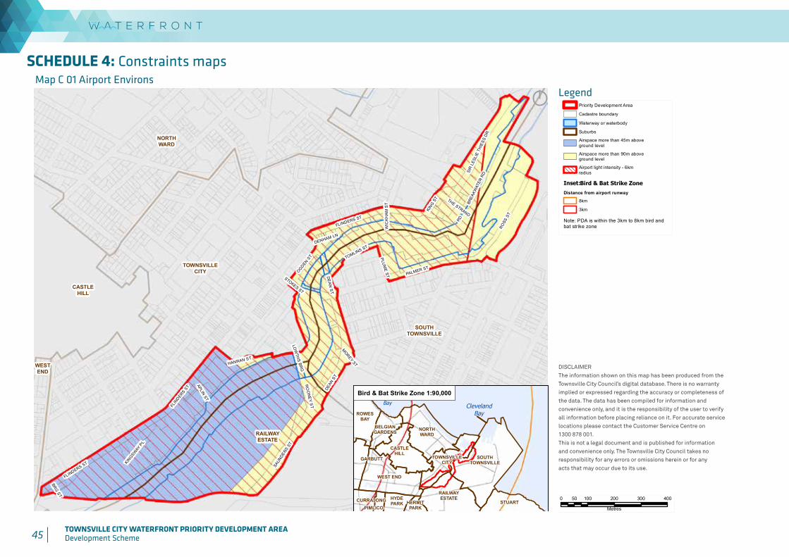
45 TOWNSVILLE CITY WATERFRONT PRIORITY DEVELOPMENT AREADevelopment Scheme 46 TOWNSVILLE CITY WATERFRONT PRIORITY DEVELOPMENT AREA
Development Scheme
SCHEDULE 4: Constraints maps
Produced by:
DISCLAIMERThe information shown on this map has been produced from the Townsville City Council's digital database. There is no warrantyimplied or expressed regarding the accuracy or completeness of the data. The data has been compiled for information and convenience only, and it is the responsibility of the user to verifyall information before placing reliance on it. For accurate service locations please contact the Customer Service Centre on1300 878 001.This is not a legal document and is published for informationand convenience only. The Townsville City Council takes noresponsibility for any errors or omissions herein or for anyacts that may occur due to its use.
Map C 01Airport Environs
DATE: 17/09/2015
GEOSPATIAL SOLUTIONSCorporate Services
WESTEND
TOWNSVILLECITY
NORTHWARD
CASTLEHILL
SOUTHTOWNSVILLE
RAILWAYESTATE
BRG ST
MOREY ST
STOKES ST
WIC
KH
AM
ST
RD
DENHAM LN
THE STRAND
APLIN ST
KINGSW
AY P
L
DEAN
ST
PLUM
E ST
LOW
THS BR
G
HANRAN ST
KING S
T
RO
ON
EY STFL
INDERS S
T
OGDEN ST TOMLINS ST
BREA
KWAT
ER R
DFLINDERS ST
PALMER ST
DEAN
ST
FLINDERS ST
ROSS
ST
SAUN
DERS
ST
SIR
LES
LIE
THIE
SS D
R
0 100 200 300 40050
Metres
LEGEND
´
SCALE: 1:10,000 @A4
© Townsville City Council 2015
DIGITAL FILE:20150616_CityPlan_PDA_C01_Airport.mxd
DRAWN BY: SYLDATE PRINTED: 18/09/2015
Priority Development Area
Cadastre boundary
Waterway or waterbody
Suburbs
Airspace more than 45m aboveground level
Airspace more than 90m aboveground level
Airport light intensity - 6kmradius
Note: PDA is within the 3km to 8km bird andbat strike zone
TOWNCOMMON
CURRAJONG HERMITPARK
ROWESBAY
GARBUTT
WEST END
TOWNSVILLECITY
NORTHWARD
PIMLICO
HYDEPARK
CASTLEHILL
BELGIANGARDENS
SOUTHTOWNSVILLE
RAILWAYESTATE
STUART
ClevelandBay
RowesBay
Inset: Bird & Bat Strike Zone
Distance from airport runway
8km
3km
Bird & Bat Strike Zone 1:90,000
Map C 01 Airport Environs
Produced by:
DISCLAIMERThe information shown on this map has been produced from the Townsville City Council's digital database. There is no warrantyimplied or expressed regarding the accuracy or completeness of the data. The data has been compiled for information and convenience only, and it is the responsibility of the user to verifyall information before placing reliance on it. For accurate service locations please contact the Customer Service Centre on1300 878 001.This is not a legal document and is published for informationand convenience only. The Townsville City Council takes noresponsibility for any errors or omissions herein or for anyacts that may occur due to its use.
Map C 01Airport Environs
DATE: 17/09/2015
GEOSPATIAL SOLUTIONSCorporate Services
WESTEND
TOWNSVILLECITY
NORTHWARD
CASTLEHILL
SOUTHTOWNSVILLE
RAILWAYESTATE
BRG ST
MOREY ST
STOKES ST
WIC
KH
AM
ST
RD
DENHAM LN
THE STRAND
APLIN ST
KINGSW
AY P
L
DEAN
ST
PLUM
E ST
LOW
THS BR
G
HANRAN ST
KING S
T
RO
ON
EY STFL
INDERS S
T
OGDEN ST TOMLINS ST
BREA
KWAT
ER R
D
FLINDERS ST
PALMER ST
DEAN
ST
FLINDERS ST
ROSS
ST
SAUN
DERS
ST
SIR
LES
LIE
THIE
SS D
R
0 100 200 300 40050
Metres
LEGEND
´
SCALE: 1:10,000 @A4
© Townsville City Council 2015
DIGITAL FILE:20150616_CityPlan_PDA_C01_Airport.mxd
DRAWN BY: SYLDATE PRINTED: 18/09/2015
Priority Development Area
Cadastre boundary
Waterway or waterbody
Suburbs
Airspace more than 45m aboveground level
Airspace more than 90m aboveground level
Airport light intensity - 6kmradius
Note: PDA is within the 3km to 8km bird andbat strike zone
TOWNCOMMON
CURRAJONG HERMITPARK
ROWESBAY
GARBUTT
WEST END
TOWNSVILLECITY
NORTHWARD
PIMLICO
HYDEPARK
CASTLEHILL
BELGIANGARDENS
SOUTHTOWNSVILLE
RAILWAYESTATE
STUART
ClevelandBay
RowesBay
Inset: Bird & Bat Strike Zone
Distance from airport runway
8km
3km
Bird & Bat Strike Zone 1:90,000
Legend
DISCLAIMERThe information shown on this map has been produced from theTownsville City Council’s digital database. There is no warrantyimplied or expressed regarding the accuracy or completeness ofthe data. The data has been compiled for information andconvenience only, and it is the responsibility of the user to verifyall information before placing reliance on it. For accurate servicelocations please contact the Customer Service Centre on1300 878 001.This is not a legal document and is published for informationand convenience only. The Townsville City Council takes noresponsibility for any errors or omissions herein or for anyacts that may occur due to its use.
Produced by:
DISCLAIMERThe information shown on this map has been produced from the Townsville City Council's digital database. There is no warrantyimplied or expressed regarding the accuracy or completeness of the data. The data has been compiled for information and convenience only, and it is the responsibility of the user to verifyall information before placing reliance on it. For accurate service locations please contact the Customer Service Centre on1300 878 001.This is not a legal document and is published for informationand convenience only. The Townsville City Council takes noresponsibility for any errors or omissions herein or for anyacts that may occur due to its use.
Map C 01Airport Environs
DATE: 17/09/2015
GEOSPATIAL SOLUTIONSCorporate Services
WESTEND
TOWNSVILLECITY
NORTHWARD
CASTLEHILL
SOUTHTOWNSVILLE
RAILWAYESTATE
BRG ST
MOREY ST
STOKES ST
WIC
KH
AM
ST
RD
DENHAM LN
THE STRAND
APLIN ST
KINGSW
AY P
L
DEAN
ST
PLUM
E ST
LOW
THS BR
G
HANRAN ST
KING S
T
RO
ON
EY STFL
INDERS S
T
OGDEN ST TOMLINS ST
BREA
KWAT
ER R
D
FLINDERS ST
PALMER ST
DEAN
ST
FLINDERS ST
ROSS
ST
SAUN
DERS
ST
SIR
LES
LIE
THIE
SS D
R
0 100 200 300 40050
Metres
LEGEND
´
SCALE: 1:10,000 @A4
© Townsville City Council 2015
DIGITAL FILE:20150616_CityPlan_PDA_C01_Airport.mxd
DRAWN BY: SYLDATE PRINTED: 18/09/2015
Priority Development Area
Cadastre boundary
Waterway or waterbody
Suburbs
Airspace more than 45m aboveground level
Airspace more than 90m aboveground level
Airport light intensity - 6kmradius
Note: PDA is within the 3km to 8km bird andbat strike zone
TOWNCOMMON
CURRAJONG HERMITPARK
ROWESBAY
GARBUTT
WEST END
TOWNSVILLECITY
NORTHWARD
PIMLICO
HYDEPARK
CASTLEHILL
BELGIANGARDENS
SOUTHTOWNSVILLE
RAILWAYESTATE
STUART
ClevelandBay
RowesBay
Inset: Bird & Bat Strike Zone
Distance from airport runway
8km
3km
Bird & Bat Strike Zone 1:90,000

46 TOWNSVILLE CITY WATERFRONT PRIORITY DEVELOPMENT AREADevelopment Scheme
Produced by:
DISCLAIMERThe information shown on this map has been produced from the Townsville City Council's digital database. There is no warrantyimplied or expressed regarding the accuracy or completeness of the data. The data has been compiled for information and convenience only, and it is the responsibility of the user to verifyall information before placing reliance on it. For accurate service locations please contact the Customer Service Centre on1300 878 001.This is not a legal document and is published for informationand convenience only. The Townsville City Council takes noresponsibility for any errors or omissions herein or for anyacts that may occur due to its use.
Map C 02Noise Corridors and
Essential MaritimeInfrastructure
DATE: 17/09/2015
GEOSPATIAL SOLUTIONSCorporate Services
WEST END
TOWNSVILLECITY
NORTHWARD
CASTLEHILL
SOUTHTOWNSVILLE
RAILWAYESTATE
BRG ST
MOREY ST
STOKES ST
WIC
KH
AM
ST
RD
DENHAM LN
THE STRAND
APLIN ST
KINGSW
AY P
L
DEAN
ST
PLUM
E ST
LOW
THS BR
G
HANRAN ST
KING S
T
RO
ON
EY STFL
INDERS S
T
OGDEN ST TOMLINS ST
BREA
KWAT
ER R
D
FLINDERS ST
PALMER ST
DEAN
ST
FLINDERS ST
ROSS
ST
SAUN
DERS
ST
SIR
LESL
IE T
HIES
S DR
0 100 200 300 40050
Metres
LEGEND
SCALE: 1:10,000 @A4
© Townsville City Council 2015
DIGITAL FILE:20150820_CityPlan_PDA_C02_Noise_Corridors.mxd
DRAWN BY: SYLDATE PRINTED: 18/09/2015
Priority Development Area
Cadastre boundary
Waterway or waterbody
Suburbs
Noise CorridorsRailway
Category 1 - noise corridor
Category 2 - noise corridor
Category 3 - noise corridor
Category 4 - noise corridor
Road
Category 1 - noise corridor
Category 2 - noise corridor
Category 3 - noise corridor
Category 4 - noise corridor
Essential Maritime Infrastructure
Port of Townsville Lead Light
Port of Townsville Lead Light Clearance Buffer
Essential Maritime Infrastructure
Note: Essential Maritime Infrastructureincludes Maritime Safety Queensland Base, Vessel Traffic Services and Queensland Water Police Service
Legend
DISCLAIMERThe information shown on this map has been produced from theTownsville City Council’s digital database. There is no warrantyimplied or expressed regarding the accuracy or completeness ofthe data. The data has been compiled for information andconvenience only, and it is the responsibility of the user to verifyall information before placing reliance on it. For accurate servicelocations please contact the Customer Service Centre on1300 878 001.This is not a legal document and is published for informationand convenience only. The Townsville City Council takes noresponsibility for any errors or omissions herein or for anyacts that may occur due to its use.
Map C 02 Noise Corridors and Essential Maritime Infrastructure
Produced by:
DISCLAIMERThe information shown on this map has been produced from the Townsville City Council's digital database. There is no warrantyimplied or expressed regarding the accuracy or completeness of the data. The data has been compiled for information and convenience only, and it is the responsibility of the user to verifyall information before placing reliance on it. For accurate service locations please contact the Customer Service Centre on1300 878 001.This is not a legal document and is published for informationand convenience only. The Townsville City Council takes noresponsibility for any errors or omissions herein or for anyacts that may occur due to its use.
Map C 02Noise Corridors and
Essential MaritimeInfrastructure
DATE: 17/09/2015
GEOSPATIAL SOLUTIONSCorporate Services
WEST END
TOWNSVILLECITY
NORTHWARD
CASTLEHILL
SOUTHTOWNSVILLE
RAILWAYESTATE
BRG ST
MOREY ST
STOKES ST
WIC
KH
AM
ST
RD
DENHAM LN
THE STRAND
APLIN ST
KINGSW
AY P
L
DEAN
ST
PLUM
E ST
LOW
THS BR
G
HANRAN ST
KING S
T
RO
ON
EY STFL
INDERS S
T
OGDEN ST TOMLINS ST
BREA
KWAT
ER R
D
FLINDERS ST
PALMER ST
DEAN
ST
FLINDERS ST
ROSS
ST
SAUN
DERS
ST
SIR
LESL
IE T
HIES
S DR
0 100 200 300 40050
Metres
LEGEND
SCALE: 1:10,000 @A4
© Townsville City Council 2015
DIGITAL FILE:20150820_CityPlan_PDA_C02_Noise_Corridors.mxd
DRAWN BY: SYLDATE PRINTED: 18/09/2015
Priority Development Area
Cadastre boundary
Waterway or waterbody
Suburbs
Noise CorridorsRailway
Category 1 - noise corridor
Category 2 - noise corridor
Category 3 - noise corridor
Category 4 - noise corridor
Road
Category 1 - noise corridor
Category 2 - noise corridor
Category 3 - noise corridor
Category 4 - noise corridor
Essential Maritime Infrastructure
Port of Townsville Lead Light
Port of Townsville Lead Light Clearance Buffer
Essential Maritime Infrastructure
Note: Essential Maritime Infrastructureincludes Maritime Safety Queensland Base, Vessel Traffic Services and Queensland Water Police Service
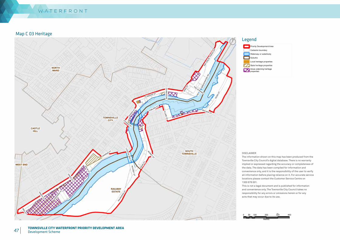
47 TOWNSVILLE CITY WATERFRONT PRIORITY DEVELOPMENT AREADevelopment Scheme 48 TOWNSVILLE CITY WATERFRONT PRIORITY DEVELOPMENT AREA
Development Scheme
Produced by:
DISCLAIMERThe information shown on this map has been produced from the Townsville City Council's digital database. There is no warrantyimplied or expressed regarding the accuracy or completeness of the data. The data has been compiled for information and convenience only, and it is the responsibility of the user to verifyall information before placing reliance on it. For accurate service locations please contact the Customer Service Centre on1300 878 001.This is not a legal document and is published for informationand convenience only. The Townsville City Council takes noresponsibility for any errors or omissions herein or for anyacts that may occur due to its use.
Map C 03Heritage
DATE: 17/09/2015
GEOSPATIAL SOLUTIONSCorporate Services
WEST END
TOWNSVILLECITY
NORTHWARD
CASTLEHILL
SOUTHTOWNSVILLE
RAILWAYESTATE
JONES ST
KNAPP ST
ARCHER ST
BRG ST
MOREY ST
STOKES ST
WIC
KH
AM
ST
RD
THE STRAND
APLIN ST
KINGSW
AY P
L
PLUM
E ST
LOW
THS BR
G
HANRAN ST
KING S
T
RO
ON
EY ST
OGDEN ST
TOMLINS ST
BREA
KWAT
ER R
D
DEAN
ST
FLINDERS ST
ROSS
ST
SAUN
DERS
ST
SIR
LESL
IE T
HIES
S DR
0 100 200 300 40050
Metres
LEGEND
´
SCALE: 1:10,000 @A4
© Townsville City Council 2015
DIGITAL FILE:20150903_CityPlan_PDA_C03_Heritage.mxd
DRAWN BY: SYLDATE PRINTED: 18/09/2015
Priority Development Area
Cadastre boundary
Waterway or waterbody
Suburbs
Local heritage properties
State heritage properties
Areas adjoining heritageproperties
Legend
DISCLAIMERThe information shown on this map has been produced from theTownsville City Council’s digital database. There is no warrantyimplied or expressed regarding the accuracy or completeness ofthe data. The data has been compiled for information andconvenience only, and it is the responsibility of the user to verifyall information before placing reliance on it. For accurate servicelocations please contact the Customer Service Centre on1300 878 001.This is not a legal document and is published for informationand convenience only. The Townsville City Council takes noresponsibility for any errors or omissions herein or for anyacts that may occur due to its use.
Map C 03 Heritage
Produced by:
DISCLAIMERThe information shown on this map has been produced from the Townsville City Council's digital database. There is no warrantyimplied or expressed regarding the accuracy or completeness of the data. The data has been compiled for information and convenience only, and it is the responsibility of the user to verifyall information before placing reliance on it. For accurate service locations please contact the Customer Service Centre on1300 878 001.This is not a legal document and is published for informationand convenience only. The Townsville City Council takes noresponsibility for any errors or omissions herein or for anyacts that may occur due to its use.
Map C 03Heritage
DATE: 17/09/2015
GEOSPATIAL SOLUTIONSCorporate Services
WEST END
TOWNSVILLECITY
NORTHWARD
CASTLEHILL
SOUTHTOWNSVILLE
RAILWAYESTATE
JONES ST
KNAPP ST
ARCHER ST
BRG ST
MOREY ST
STOKES ST
WIC
KH
AM
ST
RD
THE STRAND
APLIN ST
KINGSW
AY P
L
PLUM
E ST
LOW
THS BR
G
HANRAN ST
KING S
T
RO
ON
EY ST
OGDEN ST
TOMLINS ST
BREA
KWAT
ER R
D
DEAN
ST
FLINDERS ST
ROSS
ST
SAUN
DERS
ST
SIR
LESL
IE T
HIES
S DR
0 100 200 300 40050
Metres
LEGEND
´
SCALE: 1:10,000 @A4
© Townsville City Council 2015
DIGITAL FILE:20150903_CityPlan_PDA_C03_Heritage.mxd
DRAWN BY: SYLDATE PRINTED: 18/09/2015
Priority Development Area
Cadastre boundary
Waterway or waterbody
Suburbs
Local heritage properties
State heritage properties
Areas adjoining heritageproperties
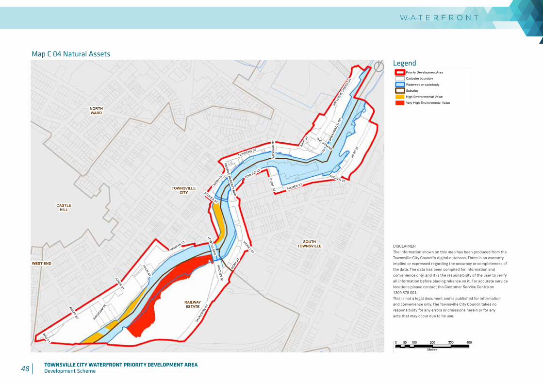
48 TOWNSVILLE CITY WATERFRONT PRIORITY DEVELOPMENT AREADevelopment Scheme
Produced by:
DISCLAIMERThe information shown on this map has been produced from the Townsville City Council's digital database. There is no warrantyimplied or expressed regarding the accuracy or completeness of the data. The data has been compiled for information and convenience only, and it is the responsibility of the user to verifyall information before placing reliance on it. For accurate service locations please contact the Customer Service Centre on1300 878 001.This is not a legal document and is published for informationand convenience only. The Townsville City Council takes noresponsibility for any errors or omissions herein or for anyacts that may occur due to its use.
Map C 04Natural Assets
DATE: 17/09/2015
GEOSPATIAL SOLUTIONSCorporate Services
WEST END
TOWNSVILLECITY
NORTHWARD
CASTLEHILL
SOUTHTOWNSVILLE
RAILWAYESTATE
JONES ST
KNAPP ST
ARCHER ST
BRG ST
MOREY ST
STOKES ST
WIC
KH
AM
ST
RD
THE STRAND
APLIN ST
KINGSW
AY P
L
PLUM
E ST
LOW
THS BR
G
HANRAN ST
KING S
T
RO
ON
EY ST
GE
OR
GE R
OB
ERTS B
RG
OGDEN ST
TOMLINS ST
BREA
KWAT
ER R
D
PALMER ST
DEAN
ST
FLINDERS ST
ROSS
ST
SAUN
DERS
ST
SIR
LESL
IE T
HIES
S DR
0 100 200 300 40050
Metres
LEGEND
´
SCALE: 1:10,000 @A4
© Townsville City Council 2015
DIGITAL FILE:20150616_CityPlan_PDA_C04_Natural.mxd
DRAWN BY: SYLDATE PRINTED: 18/09/2015
Priority Development Area
Cadastre boundary
Waterway or waterbody
Suburbs
High Environmental Value
Very High Environmental Value
LegendMap C 04 Natural Assets
DISCLAIMERThe information shown on this map has been produced from theTownsville City Council’s digital database. There is no warrantyimplied or expressed regarding the accuracy or completeness ofthe data. The data has been compiled for information andconvenience only, and it is the responsibility of the user to verifyall information before placing reliance on it. For accurate servicelocations please contact the Customer Service Centre on1300 878 001.This is not a legal document and is published for informationand convenience only. The Townsville City Council takes noresponsibility for any errors or omissions herein or for anyacts that may occur due to its use.
Produced by:
DISCLAIMERThe information shown on this map has been produced from the Townsville City Council's digital database. There is no warrantyimplied or expressed regarding the accuracy or completeness of the data. The data has been compiled for information and convenience only, and it is the responsibility of the user to verifyall information before placing reliance on it. For accurate service locations please contact the Customer Service Centre on1300 878 001.This is not a legal document and is published for informationand convenience only. The Townsville City Council takes noresponsibility for any errors or omissions herein or for anyacts that may occur due to its use.
Map C 04Natural Assets
DATE: 17/09/2015
GEOSPATIAL SOLUTIONSCorporate Services
WEST END
TOWNSVILLECITY
NORTHWARD
CASTLEHILL
SOUTHTOWNSVILLE
RAILWAYESTATE
JONES ST
KNAPP ST
ARCHER ST
BRG ST
MOREY ST
STOKES ST
WIC
KH
AM
ST
RD
THE STRAND
APLIN ST
KINGSW
AY P
L
PLUM
E ST
LOW
THS BR
G
HANRAN ST
KING S
T
RO
ON
EY ST
GE
OR
GE R
OB
ERTS B
RG
OGDEN ST
TOMLINS ST
BREA
KWAT
ER R
D
PALMER ST
DEAN
ST
FLINDERS ST
ROSS
ST
SAUN
DERS
ST
SIR
LESL
IE T
HIES
S DR
0 100 200 300 40050
Metres
LEGEND
´
SCALE: 1:10,000 @A4
© Townsville City Council 2015
DIGITAL FILE:20150616_CityPlan_PDA_C04_Natural.mxd
DRAWN BY: SYLDATE PRINTED: 18/09/2015
Priority Development Area
Cadastre boundary
Waterway or waterbody
Suburbs
High Environmental Value
Very High Environmental Value

49 TOWNSVILLE CITY WATERFRONT PRIORITY DEVELOPMENT AREADevelopment Scheme 50 TOWNSVILLE CITY WATERFRONT PRIORITY DEVELOPMENT AREA
Development Scheme
Produced by:
DISCLAIMERThe information shown on this map has been produced from the Townsville City Council's digital database. There is no warrantyimplied or expressed regarding the accuracy or completeness of the data. The data has been compiled for information and convenience only, and it is the responsibility of the user to verifyall information before placing reliance on it. For accurate service locations please contact the Customer Service Centre on1300 878 001.This is not a legal document and is published for informationand convenience only. The Townsville City Council takes noresponsibility for any errors or omissions herein or for anyacts that may occur due to its use.
Map C 05Flood Hazard
DATE: 17/09/2015
GEOSPATIAL SOLUTIONSCorporate Services
WEST END
TOWNSVILLECITY
NORTHWARD
CASTLEHILL
SOUTHTOWNSVILLE
RAILWAYESTATE
JONES ST
KNAPP ST
ARCHER ST
BRG ST
MOREY ST
STOKES ST
WIC
KH
AM
ST
RD
THE STRAND
APLIN ST
KINGSW
AY P
L
PLUM
E ST
LOW
THS BR
G
HANRAN ST
KING S
T
RO
ON
EY ST
GE
OR
GE R
OB
ERTS B
RG
OGDEN ST
TOMLINS ST
BREA
KWAT
ER R
D
PALMER ST
DEAN
ST
FLINDERS ST
ROSS
ST
SAUN
DERS
ST
SIR
LESL
IE T
HIES
S DR
0 100 200 300 40050
Metres
LEGEND
´
SCALE: 1:10,000 @A4
© Townsville City Council 2015
DIGITAL FILE:20150616_CityPlan_PDA_C05_Flood_Hazard.mxd
DRAWN BY: SYLDATE PRINTED: 18/09/2015
Priority Development Area
Cadastre boundary
Waterway or waterbody
Suburbs
High flood hazard area
Medium flood hazard area
LegendMap C 05 Flood Hazard
DISCLAIMERThe information shown on this map has been produced from theTownsville City Council’s digital database. There is no warrantyimplied or expressed regarding the accuracy or completeness ofthe data. The data has been compiled for information andconvenience only, and it is the responsibility of the user to verifyall information before placing reliance on it. For accurate servicelocations please contact the Customer Service Centre on1300 878 001.This is not a legal document and is published for informationand convenience only. The Townsville City Council takes noresponsibility for any errors or omissions herein or for anyacts that may occur due to its use.
Produced by:
DISCLAIMERThe information shown on this map has been produced from the Townsville City Council's digital database. There is no warrantyimplied or expressed regarding the accuracy or completeness of the data. The data has been compiled for information and convenience only, and it is the responsibility of the user to verifyall information before placing reliance on it. For accurate service locations please contact the Customer Service Centre on1300 878 001.This is not a legal document and is published for informationand convenience only. The Townsville City Council takes noresponsibility for any errors or omissions herein or for anyacts that may occur due to its use.
Map C 05Flood Hazard
DATE: 17/09/2015
GEOSPATIAL SOLUTIONSCorporate Services
WEST END
TOWNSVILLECITY
NORTHWARD
CASTLEHILL
SOUTHTOWNSVILLE
RAILWAYESTATE
JONES ST
KNAPP ST
ARCHER ST
BRG ST
MOREY ST
STOKES ST
WIC
KH
AM
ST
RD
THE STRAND
APLIN ST
KINGSW
AY P
L
PLUM
E ST
LOW
THS BR
G
HANRAN ST
KING S
T
RO
ON
EY ST
GE
OR
GE R
OB
ERTS B
RG
OGDEN ST
TOMLINS ST
BREA
KWAT
ER R
D
PALMER ST
DEAN
ST
FLINDERS ST
ROSS
ST
SAUN
DERS
ST
SIR
LESL
IE T
HIES
S DR
0 100 200 300 40050
Metres
LEGEND
´
SCALE: 1:10,000 @A4
© Townsville City Council 2015
DIGITAL FILE:20150616_CityPlan_PDA_C05_Flood_Hazard.mxd
DRAWN BY: SYLDATE PRINTED: 18/09/2015
Priority Development Area
Cadastre boundary
Waterway or waterbody
Suburbs
High flood hazard area
Medium flood hazard area

50 TOWNSVILLE CITY WATERFRONT PRIORITY DEVELOPMENT AREADevelopment Scheme
Produced by:
DISCLAIMERThe information shown on this map has been produced from the Townsville City Council's digital database. There is no warrantyimplied or expressed regarding the accuracy or completeness of the data. The data has been compiled for information and convenience only, and it is the responsibility of the user to verifyall information before placing reliance on it. For accurate service locations please contact the Customer Service Centre on1300 878 001.This is not a legal document and is published for informationand convenience only. The Townsville City Council takes noresponsibility for any errors or omissions herein or for anyacts that may occur due to its use.
Map C 06Coastal Hazard
- Stormtide Inundation
DATE: 17/09/2015
GEOSPATIAL SOLUTIONSCorporate Services
WESTEND
TOWNSVILLECITY
NORTHWARD
CASTLEHILL
SOUTHTOWNSVILLE
RAILWAYESTATE
JONES ST
KNAPP ST
ARCHER ST
BRG ST
MOREY ST
STOKES ST
WIC
KH
AM
ST
RD
THE STRAND
APLIN ST
KINGSW
AY P
L
PLUM
E ST
LOW
THS BR
G
HANRAN ST
KING S
T
RO
ON
EY ST
GE
OR
GE R
OB
ERTS B
RG
OGDEN ST
TOMLINS ST
BREA
KWAT
ER R
D
PALMER ST
DEAN
ST
FLINDERS ST
ROSS
ST
SAUN
DERS
ST
SIR
LES
LIE
THIE
SS D
R
0 100 200 300 40050
Metres
LEGEND
´
SCALE: 1:10,000 @A4
© Townsville City Council 2015
DIGITAL FILE:20150616_CityPlan_PDA_C06_Storm_Tide.mxd
DRAWN BY: SYLDATE PRINTED: 18/09/2015
Priority Development Area
Cadastre boundary
Waterway or waterbody
Suburbs
Inner city area
Stormtide inundation area
LegendMap C 06 Coastal Hazard - Stormtide Inundation
DISCLAIMERThe information shown on this map has been produced from theTownsville City Council’s digital database. There is no warrantyimplied or expressed regarding the accuracy or completeness ofthe data. The data has been compiled for information andconvenience only, and it is the responsibility of the user to verifyall information before placing reliance on it. For accurate servicelocations please contact the Customer Service Centre on1300 878 001.This is not a legal document and is published for informationand convenience only. The Townsville City Council takes noresponsibility for any errors or omissions herein or for anyacts that may occur due to its use.
Produced by:
DISCLAIMERThe information shown on this map has been produced from the Townsville City Council's digital database. There is no warrantyimplied or expressed regarding the accuracy or completeness of the data. The data has been compiled for information and convenience only, and it is the responsibility of the user to verifyall information before placing reliance on it. For accurate service locations please contact the Customer Service Centre on1300 878 001.This is not a legal document and is published for informationand convenience only. The Townsville City Council takes noresponsibility for any errors or omissions herein or for anyacts that may occur due to its use.
Map C 06Coastal Hazard
- Stormtide Inundation
DATE: 17/09/2015
GEOSPATIAL SOLUTIONSCorporate Services
WESTEND
TOWNSVILLECITY
NORTHWARD
CASTLEHILL
SOUTHTOWNSVILLE
RAILWAYESTATE
JONES ST
KNAPP ST
ARCHER ST
BRG ST
MOREY ST
STOKES ST
WIC
KH
AM
ST
RD
THE STRAND
APLIN ST
KINGSW
AY P
L
PLUM
E ST
LOW
THS BR
G
HANRAN ST
KING S
T
RO
ON
EY ST
GE
OR
GE R
OB
ERTS B
RG
OGDEN ST
TOMLINS ST
BREA
KWAT
ER R
D
PALMER ST
DEAN
ST
FLINDERS ST
ROSS
ST
SAUN
DERS
ST
SIR
LES
LIE
THIE
SS D
R0 100 200 300 40050
Metres
LEGEND
´
SCALE: 1:10,000 @A4
© Townsville City Council 2015
DIGITAL FILE:20150616_CityPlan_PDA_C06_Storm_Tide.mxd
DRAWN BY: SYLDATE PRINTED: 18/09/2015
Priority Development Area
Cadastre boundary
Waterway or waterbody
Suburbs
Inner city area
Stormtide inundation area
Produced by:
DISCLAIMERThe information shown on this map has been produced from the Townsville City Council's digital database. There is no warrantyimplied or expressed regarding the accuracy or completeness of the data. The data has been compiled for information and convenience only, and it is the responsibility of the user to verifyall information before placing reliance on it. For accurate service locations please contact the Customer Service Centre on1300 878 001.This is not a legal document and is published for informationand convenience only. The Townsville City Council takes noresponsibility for any errors or omissions herein or for anyacts that may occur due to its use.
Map C 06Coastal Hazard
- Stormtide Inundation
DATE: 17/09/2015
GEOSPATIAL SOLUTIONSCorporate Services
WESTEND
TOWNSVILLECITY
NORTHWARD
CASTLEHILL
SOUTHTOWNSVILLE
RAILWAYESTATE
JONES ST
KNAPP ST
ARCHER ST
BRG ST
MOREY ST
STOKES ST
WIC
KH
AM
ST
RD
THE STRAND
APLIN ST
KINGSW
AY P
L
PLUM
E ST
LOW
THS BR
G
HANRAN ST
KING S
T
RO
ON
EY ST
GE
OR
GE R
OB
ERTS B
RG
OGDEN ST
TOMLINS ST
BREA
KWAT
ER R
D
PALMER ST
DEAN
ST
FLINDERS ST
ROSS
ST
SAUN
DERS
ST
SIR
LES
LIE
THIE
SS D
R
0 100 200 300 40050
Metres
LEGEND
´
SCALE: 1:10,000 @A4
© Townsville City Council 2015
DIGITAL FILE:20150616_CityPlan_PDA_C06_Storm_Tide.mxd
DRAWN BY: SYLDATE PRINTED: 18/09/2015
Priority Development Area
Cadastre boundary
Waterway or waterbody
Suburbs
Inner city area
Stormtide inundation area
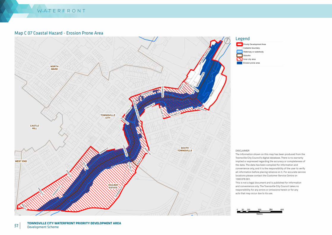
51 TOWNSVILLE CITY WATERFRONT PRIORITY DEVELOPMENT AREADevelopment Scheme 52 TOWNSVILLE CITY WATERFRONT PRIORITY DEVELOPMENT AREA
Development Scheme
Produced by:
DISCLAIMERThe information shown on this map has been produced from the Townsville City Council's digital database. There is no warrantyimplied or expressed regarding the accuracy or completeness of the data. The data has been compiled for information and convenience only, and it is the responsibility of the user to verifyall information before placing reliance on it. For accurate service locations please contact the Customer Service Centre on1300 878 001.This is not a legal document and is published for informationand convenience only. The Townsville City Council takes noresponsibility for any errors or omissions herein or for anyacts that may occur due to its use.
Map C 07Coastal Hazard
- Erosion Prone Area
DATE: 17/09/2015
GEOSPATIAL SOLUTIONSCorporate Services
WEST END
TOWNSVILLECITY
NORTHWARD
CASTLEHILL
SOUTHTOWNSVILLE
RAILWAYESTATE
JONES ST
KNAPP ST
ARCHER ST
BRG ST
MOREY ST
STOKES ST
WIC
KH
AM
ST
RD
THE STRAND
APLIN ST
KINGSW
AY P
L
PLUM
E ST
LOW
THS BR
G
HANRAN ST
KING S
T
RO
ON
EY ST
GE
OR
GE R
OB
ERTS B
RG
OGDEN ST
TOMLINS ST
BREA
KWAT
ER R
D
PALMER ST
DEAN
ST
FLINDERS ST
ROSS
ST
SAUN
DERS
ST
SIR
LESL
IE T
HIES
S DR
0 100 200 300 40050
Metres
LEGEND
´
SCALE: 1:10,000 @A4
© Townsville City Council 2015
DIGITAL FILE:20150616_CityPlan_PDA_C07_Erosion_Prone.mxd
DRAWN BY: SYLDATE PRINTED: 18/09/2015
Priority Development Area
Cadastre boundary
Waterway or waterbody
Suburbs
Inner city area
Erosion prone area
LegendMap C 07 Coastal Hazard - Erosion Prone Area
DISCLAIMERThe information shown on this map has been produced from theTownsville City Council’s digital database. There is no warrantyimplied or expressed regarding the accuracy or completeness ofthe data. The data has been compiled for information andconvenience only, and it is the responsibility of the user to verifyall information before placing reliance on it. For accurate servicelocations please contact the Customer Service Centre on1300 878 001.This is not a legal document and is published for informationand convenience only. The Townsville City Council takes noresponsibility for any errors or omissions herein or for anyacts that may occur due to its use.
Produced by:
DISCLAIMERThe information shown on this map has been produced from the Townsville City Council's digital database. There is no warrantyimplied or expressed regarding the accuracy or completeness of the data. The data has been compiled for information and convenience only, and it is the responsibility of the user to verifyall information before placing reliance on it. For accurate service locations please contact the Customer Service Centre on1300 878 001.This is not a legal document and is published for informationand convenience only. The Townsville City Council takes noresponsibility for any errors or omissions herein or for anyacts that may occur due to its use.
Map C 06Coastal Hazard
- Stormtide Inundation
DATE: 17/09/2015
GEOSPATIAL SOLUTIONSCorporate Services
WESTEND
TOWNSVILLECITY
NORTHWARD
CASTLEHILL
SOUTHTOWNSVILLE
RAILWAYESTATE
JONES ST
KNAPP ST
ARCHER ST
BRG ST
MOREY ST
STOKES ST
WIC
KH
AM
ST
RD
THE STRAND
APLIN ST
KINGSW
AY P
L
PLUM
E ST
LOW
THS BR
G
HANRAN ST
KING S
T
RO
ON
EY ST
GE
OR
GE R
OB
ERTS B
RG
OGDEN ST
TOMLINS ST
BREA
KWAT
ER R
D
PALMER ST
DEAN
ST
FLINDERS ST
ROSS
ST
SAUN
DERS
ST
SIR
LES
LIE
THIE
SS D
R
0 100 200 300 40050
Metres
LEGEND
´
SCALE: 1:10,000 @A4
© Townsville City Council 2015
DIGITAL FILE:20150616_CityPlan_PDA_C06_Storm_Tide.mxd
DRAWN BY: SYLDATE PRINTED: 18/09/2015
Priority Development Area
Cadastre boundary
Waterway or waterbody
Suburbs
Inner city area
Stormtide inundation area
Produced by:
DISCLAIMERThe information shown on this map has been produced from the Townsville City Council's digital database. There is no warrantyimplied or expressed regarding the accuracy or completeness of the data. The data has been compiled for information and convenience only, and it is the responsibility of the user to verifyall information before placing reliance on it. For accurate service locations please contact the Customer Service Centre on1300 878 001.This is not a legal document and is published for informationand convenience only. The Townsville City Council takes noresponsibility for any errors or omissions herein or for anyacts that may occur due to its use.
Map C 07Coastal Hazard
- Erosion Prone Area
DATE: 17/09/2015
GEOSPATIAL SOLUTIONSCorporate Services
WEST END
TOWNSVILLECITY
NORTHWARD
CASTLEHILL
SOUTHTOWNSVILLE
RAILWAYESTATE
JONES ST
KNAPP ST
ARCHER ST
BRG ST
MOREY ST
STOKES ST
WIC
KH
AM
ST
RD
THE STRAND
APLIN ST
KINGSW
AY P
L
PLUM
E ST
LOW
THS BR
G
HANRAN ST
KING S
T
RO
ON
EY ST
GE
OR
GE R
OB
ERTS B
RG
OGDEN ST
TOMLINS ST
BREA
KWAT
ER R
D
PALMER ST
DEAN
ST
FLINDERS ST
ROSS
ST
SAUN
DERS
ST
SIR
LESL
IE T
HIES
S DR
0 100 200 300 40050
Metres
LEGEND
´
SCALE: 1:10,000 @A4
© Townsville City Council 2015
DIGITAL FILE:20150616_CityPlan_PDA_C07_Erosion_Prone.mxd
DRAWN BY: SYLDATE PRINTED: 18/09/2015
Priority Development Area
Cadastre boundary
Waterway or waterbody
Suburbs
Inner city area
Erosion prone area
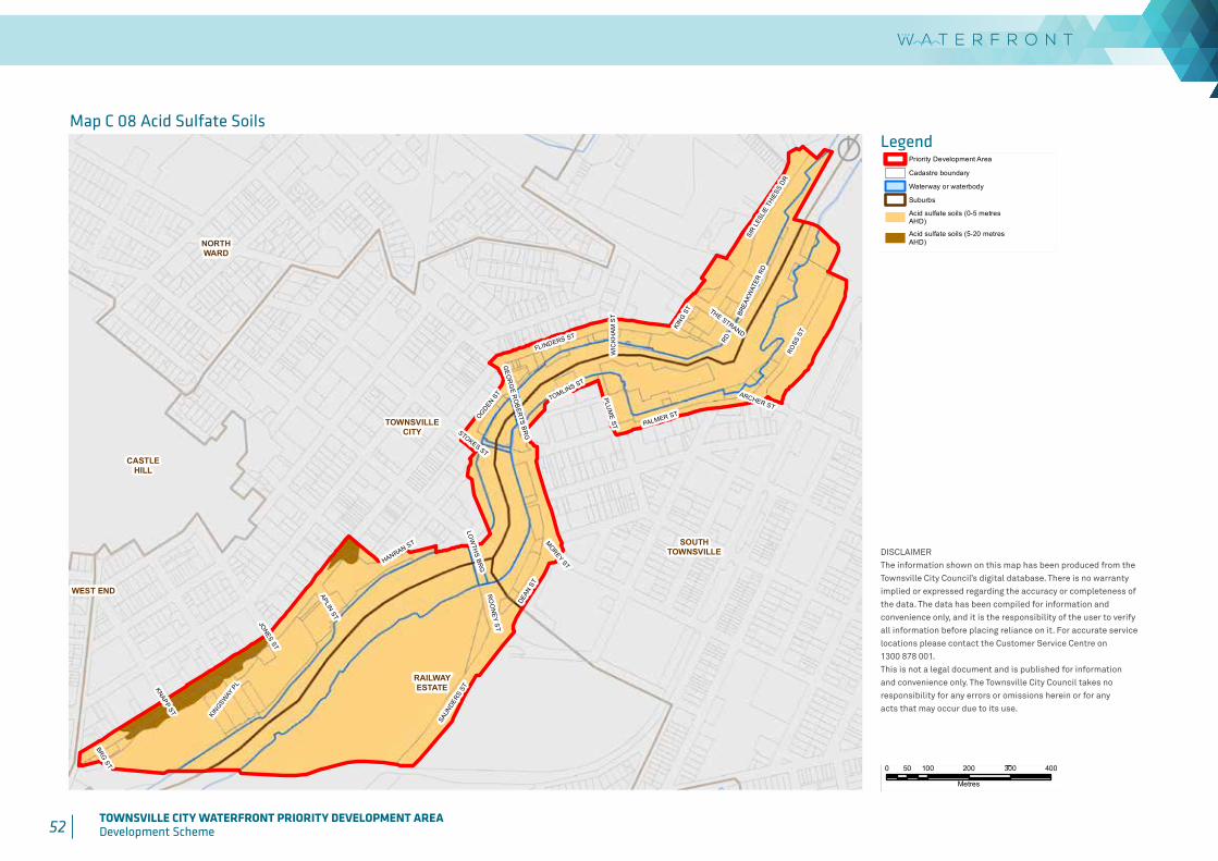
52 TOWNSVILLE CITY WATERFRONT PRIORITY DEVELOPMENT AREADevelopment Scheme
Produced by:
DISCLAIMERThe information shown on this map has been produced from the Townsville City Council's digital database. There is no warrantyimplied or expressed regarding the accuracy or completeness of the data. The data has been compiled for information and convenience only, and it is the responsibility of the user to verifyall information before placing reliance on it. For accurate service locations please contact the Customer Service Centre on1300 878 001.This is not a legal document and is published for informationand convenience only. The Townsville City Council takes noresponsibility for any errors or omissions herein or for anyacts that may occur due to its use.
Map C 08Acid Sulfate Soils
DATE: 17/09/2015
GEOSPATIAL SOLUTIONSCorporate Services
WEST END
TOWNSVILLECITY
NORTHWARD
CASTLEHILL
SOUTHTOWNSVILLE
RAILWAYESTATE
JONES ST
KNAPP ST
ARCHER ST
BRG ST
MOREY ST
STOKES ST
WIC
KH
AM
ST
RD
THE STRAND
APLIN ST
KINGSW
AY P
L
PLUM
E ST
LOW
THS BR
G
HANRAN ST
KING S
T
RO
ON
EY ST
GE
OR
GE R
OB
ERTS B
RG
OGDEN ST
TOMLINS ST
BREA
KWAT
ER R
D
PALMER ST
DEAN
ST
FLINDERS ST
ROSS
ST
SAUN
DERS
ST
SIR
LESL
IE T
HIES
S DR
0 100 200 300 40050
Metres
LEGEND
´
SCALE: 1:10,000 @A4
© Townsville City Council 2015
DIGITAL FILE:20150616_CityPlan_PDA_C08_Acid_Sulphate.mxd
DRAWN BY: SYLDATE PRINTED: 18/09/2015
Priority Development Area
Cadastre boundary
Waterway or waterbody
Suburbs
Acid sulfate soils (0-5 metresAHD)
Acid sulfate soils (5-20 metresAHD)
LegendMap C 08 Acid Sulfate Soils
DISCLAIMERThe information shown on this map has been produced from theTownsville City Council’s digital database. There is no warrantyimplied or expressed regarding the accuracy or completeness ofthe data. The data has been compiled for information andconvenience only, and it is the responsibility of the user to verifyall information before placing reliance on it. For accurate servicelocations please contact the Customer Service Centre on1300 878 001.This is not a legal document and is published for informationand convenience only. The Townsville City Council takes noresponsibility for any errors or omissions herein or for anyacts that may occur due to its use.
Produced by:
DISCLAIMERThe information shown on this map has been produced from the Townsville City Council's digital database. There is no warrantyimplied or expressed regarding the accuracy or completeness of the data. The data has been compiled for information and convenience only, and it is the responsibility of the user to verifyall information before placing reliance on it. For accurate service locations please contact the Customer Service Centre on1300 878 001.This is not a legal document and is published for informationand convenience only. The Townsville City Council takes noresponsibility for any errors or omissions herein or for anyacts that may occur due to its use.
Map C 08Acid Sulfate Soils
DATE: 17/09/2015
GEOSPATIAL SOLUTIONSCorporate Services
WEST END
TOWNSVILLECITY
NORTHWARD
CASTLEHILL
SOUTHTOWNSVILLE
RAILWAYESTATE
JONES ST
KNAPP ST
ARCHER ST
BRG ST
MOREY ST
STOKES ST
WIC
KH
AM
ST
RD
THE STRAND
APLIN ST
KINGSW
AY P
L
PLUM
E ST
LOW
THS BR
G
HANRAN ST
KING S
T
RO
ON
EY ST
GE
OR
GE R
OB
ERTS B
RG
OGDEN ST
TOMLINS ST
BREA
KWAT
ER R
D
PALMER ST
DEAN
ST
FLINDERS ST
ROSS
ST
SAUN
DERS
ST
SIR
LESL
IE T
HIES
S DR
0 100 200 300 40050
Metres
LEGEND
´
SCALE: 1:10,000 @A4
© Townsville City Council 2015
DIGITAL FILE:20150616_CityPlan_PDA_C08_Acid_Sulphate.mxd
DRAWN BY: SYLDATE PRINTED: 18/09/2015
Priority Development Area
Cadastre boundary
Waterway or waterbody
Suburbs
Acid sulfate soils (0-5 metresAHD)
Acid sulfate soils (5-20 metresAHD)
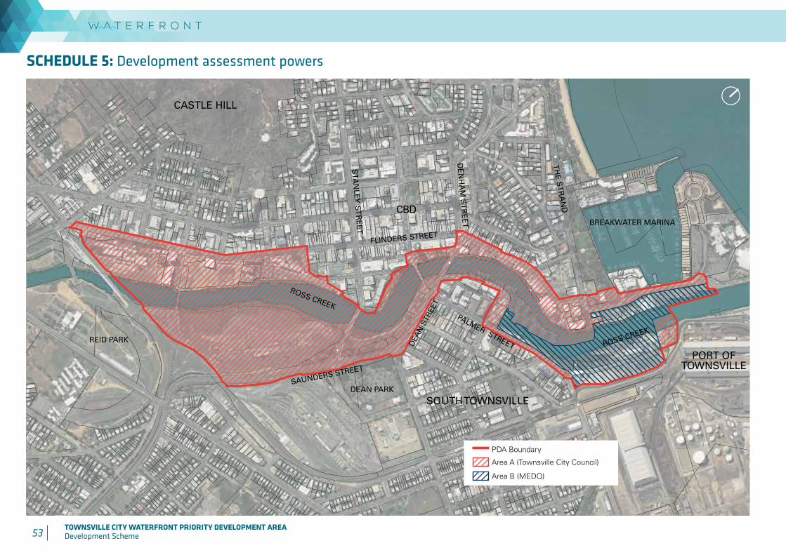
53 TOWNSVILLE CITY WATERFRONT PRIORITY DEVELOPMENT AREADevelopment Scheme 54 TOWNSVILLE CITY WATERFRONT PRIORITY DEVELOPMENT AREA
Development Scheme
PDA Boundary
Area A (Townsville City Council)
Area B (MEDQ)
ROSS CREEK
PALMER STREET
ROSS CREEK
BREAKWATER MARINA
FLINDERS STREET
SAUNDERS STREET
DEA
N S
TREE
T
DE
NH
AM
ST
RE
ET
STA
NLEY
ST
RE
ET
TH
E S
TR
AN
D
REID PARK
DEAN PARK
CBD
PORT OF TOWNSVILLE
SOUTH TOWNSVILLE
CASTLE HILL
SCHEDULE 5: Development assessment powers
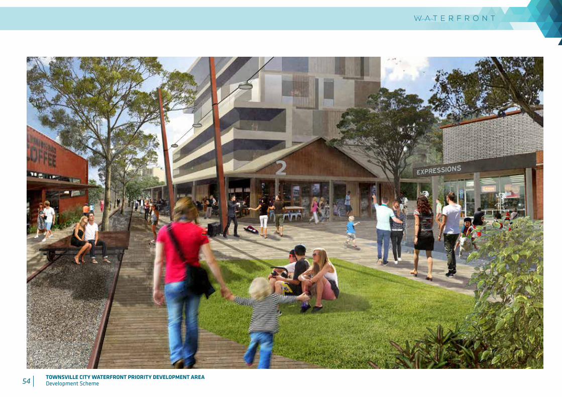
54 TOWNSVILLE CITY WATERFRONT PRIORITY DEVELOPMENT AREADevelopment Scheme

Visit our website at: www.townsville-port.com.au
Write to us at:PO Box 1031TownsvilleQueensland 4810
Telephone us: (07) 4781 1500
Fax us: (07) 47 811 525
Email us: [email protected]
Visit our website at: www.edq.qld.gov.au
Write to us at:
EDQDepartment of Infrastructure, Local Government and PlanningGPO Box 2202Brisbane QLD 4001
Telephone us: 13 Q GOV (13 7468)
Email us: [email protected]
Visit our website at: www.townsville.qld.gov.au
Write to us at:
Townsville City CouncilPO Box 1268 Townsville QLD 4810
Telephone us: 1300 878 001
Fax us: (07) 4727 9050
Email us: [email protected]
Contact Us
October 2015