Embed Size (px)
Citation preview
Townsville Port Expansion Project
Coordinator-General’s evaluation report on the environmental impact statement
September 2017
The Department of State Development Copyright
This publication is protected by the Copyright Act 1968. Licence
This work is licensed to the Department of State Development under a Creative Commons Attribution (CC BY) 3.0 Australia licence. To view a copy of this licence, visit: http://www.creativecommons.org/licenses/by/3.0/au/
You are free to copy, communicate and adapt this publication, as long as you attribute it as follows:
© State of Queensland, Department of State Development, September 2017.
The Queensland Government is committed to providing accessible services to Queenslanders of all cultural and linguistic backgrounds. If you have difficulty understanding this publication and need a translator, please call the Translating and Interpreting Service (TIS National) on telephone 131 450 and ask them to contact the Queensland Department of State Development on (07) 3452 7009.
Disclaimer
This report contains factual data, analysis, opinion and references to legislation. The CoordinatorGeneral and the State
of Queensland make no representations and give no warranties regarding the accuracy, completeness or suitability for
any particular purpose of such data, analysis, opinion or references. You should make your own enquiries and take
appropriate advice on such matters. Neither the Coordinator-General nor the State of Queensland will be responsible for
any loss or damage (including consequential loss) you may suffer from using or relying upon the content of this report.
By using or relying on such information you agree to indemnify the Coordinator-General and the State of Queensland
against any loss arising out of or in relation to your use or reliance.
Copies of this publication are available on our website at www.statedevelopment.qld.gov.au and further copies are available upon request to: Department of State Development PO Box 15009 City East, Queensland 4002. 1 William Street Brisbane Qld 4000 (Australia) Phone: 13QGOV (137468) Fax: 07 3220 6465 Email: [email protected] Web: www.statedevelopment.qld.gov.au
Townsville Port Expansion Project Coordinator-General’s evaluation report on the environmental impact statement
- iii -
Contents
Synopsis ....................................................................................................................... vi
1. Introduction ......................................................................................................... 1
2. About the project ................................................................................................. 1
2.1 The proponent .............................................................................................. 1
2.2 Location ........................................................................................................ 2
2.3 Project description ........................................................................................ 2
2.4 Project staging ............................................................................................. 8
2.5 Port operations ........................................................................................... 10
2.6 Project need ............................................................................................... 10
2.7 Dependencies and relationships with other projects .................................. 11
3. Environmental impact statement assessment process ................................. 11
3.1 Coordinated project declaration ................................................................. 12
3.2 Terms of reference ..................................................................................... 12
3.3 Review of the EIS ....................................................................................... 12
3.4 Additional information to the EIS ................................................................ 12
3.5 Review of the AEIS .................................................................................... 13
3.6 Commonwealth assessment ...................................................................... 15
4. Project approvals .............................................................................................. 16
4.1 Australian government approvals ............................................................... 20
4.2 State government approvals ...................................................................... 20
4.3 Local government approvals ...................................................................... 22
5. Evaluation of environmental impacts .............................................................. 23
5.1 Marine and coastal environment ................................................................ 23
5.2 Matters of state environmental significance ............................................... 47
5.3 Land use .................................................................................................... 57
5.4 Water resources ......................................................................................... 66
5.5 Air quality ................................................................................................... 70
5.6 Noise and vibration .................................................................................... 76
5.7 Waste ......................................................................................................... 84
5.8 Traffic and transport ................................................................................... 90
5.9 Hazard and risk .......................................................................................... 96
5.10 Social impacts .......................................................................................... 101
5.11 Economics ................................................................................................ 108
5.12 Cultural heritage ....................................................................................... 114
6. Conclusion ....................................................................................................... 116
Appendix 1. Imposed conditions .................................................................... 118
Appendix 2. Coordinator-General’s Stated Conditions ................................ 120
Schedule 1 - Environmental Authority ............................................................... 120
Schedule 2 - Development Permit for Material Change of Use for Environmentally Relevant Activity ..................................................................... 133
- iv - Townsville Port Expansion Project
Coordinator-General’s evaluation report on the environmental impact statement
Schedule 3 – Preliminary Approval for Operational Work – Tidal works within a coastal management district ................................................................ 134
Schedule 4 – Development Permit for Operational Work - Tidal works within a coastal management district ........................................................................... 135
Appendix 3. Proponent commitments ........................................................... 139
Stakeholder Management ................................................................................. 139
Regional Contribution ........................................................................................ 139
Infrastructure ..................................................................................................... 140
Planning and Land Use ..................................................................................... 140
Additional Studies and Testing .......................................................................... 141
Design and Procurement ................................................................................... 141
Construction Environmental Management Plan ................................................ 142
Dredge Management and Reactive Monitoring ................................................. 144
Operation: .......................................................................................................... 145
Appendix 4. Proposed Terms of Reference for Technical Advisory Committee ................................................................................... 147
1. Introduction ..................................................................................................... 147
2. Regulatory Oversight Committee .................................................................. 148
3. Technical Advisory Committee ...................................................................... 148
3.1 Purpose .................................................................................................... 148
3.2 Likely membership ................................................................................... 148
3.3 Scope of Work (prior to and during Stage 1 dredging) ............................. 149
3.4 Specific Roles .......................................................................................... 150
3.5 Indicative Technical Advisory Committee Schedule – Stage 1 TSHD Dredging ............................................................................................................ 152
4. Technical Specialist Team .............................................................................. 153
5. Dredging Implementation Team ..................................................................... 154
Acronyms and abbreviations .................................................................................. 155
Glossary .................................................................................................................... 158
Figures
Figure 2.2 Project location .......................................................................................... 3
Figure 2.3 Port expansion area ................................................................................... 6
Figure 2.4 Port expansion area and channels ............................................................ 7
Figure 5.1 Location of sensitive ecological receptors ............................................... 25
Figure 5.2 Coastal processes in Cleveland Bay ....................................................... 28
Figure 5.3 Tenure ..................................................................................................... 59
Figure 5.4 Surrounding key land transport routes ..................................................... 91
Townsville Port Expansion Project Coordinator-General’s evaluation report on the environmental impact statement
- v -
Tables
Table 2.2 Amendments to project design .................................................................. 4
Table 2.2 Project staging ........................................................................................... 9
Table 3.1 Key issues raised in public and agency submissions .............................. 13
Table 4.1 Core approvals required for the project ................................................... 17
Table 4.2 Possible subsequent approvals required for the project .......................... 19
Table 5.1 Description of zones of impact ................................................................. 29
Table 5.2 Direct habitat disturbance associated with dredging ................................ 30
Table 5.3 Direct habitat loss associated with reclamation ....................................... 37
Table 5.4 Protected and environmentally sensitive areas near the project ............. 48
Table 5.5 Significant fauna species located on port or near-port land ..................... 49
Table 5.6 Measured background air quality concentrations .................................... 70
Table 5.7 Greatest dust emissions across three construction scenarios, exceedances in bold ................................................................................ 72
Table 5.8 Predicted noise levels and background level exceedances for piling and rock breaking construction ....................................................................... 78
Table 5.9 Estimated quantity of wastes and potential impacts generated from project construction ............................................................................................. 85
Table 5.10 Description and estimated quantity of wastes generated from shipping operations at the Port of Townsville ......................................................... 87

- vi - Townsville Port Expansion Project
Coordinator-General’s evaluation report on the environmental impact statement
Synopsis
This report evaluates the potential impacts of the Townsville Port Expansion project
(the project). It has been prepared pursuant to section 35 of the State Development
and Public Works Organisation Act 1971 (Qld) (SDPWO Act).
The proponent, Port of Townsville Limited, a government-owned corporation, proposes
to expand the existing Port of Townsville by providing a new deepwater outer harbour
with six additional berths, undertake works to deepen and widen the existing approach
channels and beneficially reuse the dredge material to create 152 ha of reclaimed land
to accommodate the new berths, bulk cargo storage and future rail infrastructure. The
project adopts a staged development approach to match the future demand for
additional port facilities.
The proponent has prepared trade forecasts to the 2039/40 fiscal year, which underpin
the need for the project. The trade forecasts indicate that the current capacity of the
port – 23 million tonnes per annum – is expected to be reached by 2019/20.
The Port of Townsville needs to respond to the increasing size of cargo vessels and
cruise ships servicing the east coast of Australia. Currently, only 5% of cargo vessels
operating in Australian waters can access the Port of Townsville, and 26% of cruise
ships operating in the region are unable to enter the port. Once expanded, the Port of
Townsville would accommodate the new Panamax cargo vessel fleet. Potential growth
in the cruise ship tourism industry will only be possible if larger ships can access the
sea channels.
The project would require capital expenditure of $1.64 billion. Key project benefits
include:
wider and deeper shipping channels to boost trade and tourism in the region by
enabling larger cargo vessels and cruise ships to dock at the Port of Townsville
174 direct jobs at the peak of construction
180 permanent operational jobs
economic benefits of the project around $1.5 billion
time savings by increasing the volume of direct shipment of products to businesses
in North Queensland
reduced impacts and costs on road and rail infrastructure between Brisbane and
Townsville by removing 10,920 b-double trucks off the highways
no disposal of capital dredge material at sea.
In undertaking my evaluation, I have considered the environmental impact statement
(EIS), issues raised in submissions during the public consultation periods, the
additional EIS information (AEIS), and advice I have received from relevant
Commonwealth, state and local government agencies.
The following provides an overview of the main issues arising from my evaluation.
Townsville Port Expansion Project Coordinator-General’s evaluation report on the environmental impact statement
- vii -
Marine and coastal environment
Dredging
The proponent proposes to dredge 11.48 million m3 of material within the port limits
over approximately 10 - 11 years. No dredging is proposed in the Commonwealth-
controlled Great Barrier Reef Marine Park (GBRMP) nor the state-controlled Great
Barrier Reef Coast Marine Park. The dredging program would:
• widen the western side of the Platypus Channel to 180 m at the harbour, tapering to
135 m at Sea Channel
• widen the eastern side of the Sea Channel (opposite side from Magnetic Island) to
135 m tapering to 120 m
• deepen the Platypus and Sea Channels to an average depth of -12.8 m lowest
astronomical tide (LAT)
• lengthen the Sea and Platypus Channels by 1 km from 13.9 km to 14.9 km
• expand the harbour basin by 51.4 ha.
Marine water quality is an important environmental asset in Cleveland Bay due to the
presence of ecological receptors that are sensitive to altered water quality conditions.
These sensitive receptors include seagrass meadows, which are located throughout
Cleveland Bay, as well as reef communities (including coral reefs) at Middle Reef and
Magnetic Island. The Great Barrier Reef Marine Park is adjacent to the Port of
Townsville exclusion zone, and supports areas with high ecological values.
The EIS documentation addressed the potential impacts of capital and maintenance
dredging for the project. The potential impacts are primarily related to increased
turbidity associated with dredge sediment plumes and sediment deposition on sensitive
receptors. The modelling and impact assessment found that minor impacts to seagrass
beds and coral reefs are expected as a result of the project.
To help ensure that dredging-related risks are appropriately managed, the proponent
has committed to the establishment of a Technical Advisory Committee (TAC) to
oversee the dredging works for the project. The TAC would be made up of subject
matter experts charged with the responsibility of continuously reviewing data relating to
both water quality and ecosystem health, and developing trigger levels for the
assessment of environmental impacts during the dredging program. The TAC will
ensure appropriate trigger levels are included in the application for an environmental
authority (EA). I have stated conditions for the EA which set out the membership and
role of the TAC.
A dredge management plan (DMP) for the activity must be developed and approved by
the Department of Environment and Heritage Protection (DEHP) and implemented prior
to the commencement of the dredging activity. The DMP will provide a dredge-plant
focused environmental management plan which seeks to protect sensitive receptors for
the entirety of the dredging program. The DMP will also include a detailed description
of the receiving environmental monitoring program for water quality and sensitive
receptors which sets out the location of monitoring sites, sampling regime and
- viii - Townsville Port Expansion Project
Coordinator-General’s evaluation report on the environmental impact statement
methods, analytical procedures and the assessment methodology for the monitoring
data.
The DMP must be developed in consultation with the TAC. The DMP is to be submitted
to the DEHP for approval at least 40 days prior to the commencement of any dredging
activity.
I have stated conditions for the EA requiring the proponent to develop a sediment
plume monitoring program in consultation with the TAC. The monitoring program would
specify the location of monitoring sites, sampling regime and approach used to develop
trigger values and validate modelling presented in the EIS documentation. If trigger
values are exceeded management action must be taken to minimise or prevent plume
generation and protect environmental values.
I have also stated conditions which require the proponent to develop water quality limits
at sensitive receptors in consultation with the TAC. This includes water quality limits to
achieve local water quality objectives for sites at locations at Geoffrey Bay, Florence
Bay, Cockle Bay and Picnic Bay off Magnetic Island as well as sites at Virago Shoal,
Middle Reef and The Strand. The water quality limits are not to be exceeded for the life
of the dredging program.
The proponent will require an allocation notice which allows for the removal of quarry
material (predominantly silts and clays) below the high-water mark. I have set
conditions to address the potential impacts to the marine environment through both the
EA and Development Permit for Operational Works (Tidal Works in a coastal
management district). Accordingly, I recommend that DEHP approve the allocation
notice for the maximum period of six years.
I am satisfied that the maintenance dredging requirements of the project are
unavoidable and necessary for the ongoing and efficient operation of the Port of
Townsville. I note that the potential impacts associated with the increased maintenance
dredging associated with the project do not exceed that already authorised under the
existing approvals held by the proponent.
Reclamation
The proponent proposes to beneficially re-use dredged sediment with placement in
tidal waters to reclaim 152 ha of developable land (with a maximum disturbance area of
approximately 167.6 ha, inclusive of revetments and the western breakwater). This
would provide backing for the new berths. Stage 1 of the project would require the
construction of an initial reclamation area of approximately 58 ha. The proposed
reclamation may result in a range of potential impacts associated with acid sulfate
soils, impacts on coastal processes and impacts on receiving water quality water
quality in the Ross River and Cleveland Bay as a result of tailwater discharge.
Acid sulfate soils
Potential impacts relate to potential acid sulfate soils or contaminated land being
contained within the reclamation footprint. The EIS states that there would be a small
amount of material that would need to be treated.
Townsville Port Expansion Project Coordinator-General’s evaluation report on the environmental impact statement
- ix -
I have stated a condition for the EA which requires the characterisation of sediments
and suitability for land-based disposal of dredged material in accordance with
guidelines specified by DEHP prior to the commencement of the dredging activity. The
sediment sampling and analysis plan must be submitted to the administering authority
at least 40 days prior to the commencement of any dredging program.
I have also stated a condition for the EA which requires the proponent to submit an
acid sulfate soil management plan to DEHP at least 40 days prior to the
commencement of works, to ensure that acid sulfate soils are managed appropriately
to protect environmental values.
Coastal processes
Cleveland Bay is characterised by a relative low-energy wave environment.
Accumulated sediments make the bay relatively shallow, deepening to only 10 to 11 m
along its northern aspect. The coastline is shaped by low-energy waves, punctuated by
occasional higher energy cyclone wave occurrences able to penetrate across the bay
onto the shoreline.
The project could alter coastal processes around the Port. Potential impacts primarily
relate to the effect that reclamation and breakwater structures and the altered harbour
basin could have on sediment re-suspension, transport and settlement.
Ultimately, the project could redirect residual suspended sediment drift around the
reclamation area and there could be a small net reduction in fine sediment drift from
east to west. This is primarily a result of the sediment being captured by the outer
harbour extension and deeper Platypus Channel.
The existing port infrastructure has previously interrupted transport of sand to The
Strand. Updated modelling for the AEIS found that although the existing sand transport
processes may be altered, the fundamental stability of the beach system along The
Strand would not be compromised by the project.
Should the project result in impacts to coastal processes and beach systems, there is a
range of engineering solutions available to address these issues which may involve
beach nourishment works or coastal protection work, both of which would require
development approvals.
I have recommended that the proponent work with Townsville City Council to identify
any impacts to coastal processes and identify any beach nourishment and coastal
protection works required.
Tailwater discharge
Excess water on top of the dredge material would be discharged from the south-
eastern corner of the reclamation area into the mouth of the Ross River. There is the
potential for contaminants to be released from this area. Testing of sediment prior to
placement, management of contamination and control on the release of tailwater will be
required to ensure adverse impacts are effectively mitigated.
- x - Townsville Port Expansion Project
Coordinator-General’s evaluation report on the environmental impact statement
To ensure that discharge water released to the environment is an acceptable standard,
the proponent has committed to the development of a tailwater monitoring program. All
water from the reclamation area will be tested prior to release or retained and treated to
ensure compliance with relevant release limits.
To ensure that water is tested prior to release, I have stated conditions which describe
the surface water release limits to be achieved prior to any release of tailwater from the
reclamation area. Water quality limits for tailwater release will ensure that
environmental values are protected.
Matters of state environmental significance
Matters of state environmental significance (MSES) are environmental values that are
protected under Queensland legislation including fish habitat areas, marine plants,
protected wildlife habitat and protected areas including national parks and a state
marine park.
The project has the potential to impact on a range of MSES either directly through the
construction of the reclamation area or indirectly through impacts on receiving water
quality.
While other project-related impacts can be adequately mitigated, there is predicted to
be a permanent loss of approximately 167.6 ha of habitat for two species of nearshore
dolphins, the Australian snubfin dolphin (Orcaella heinsohni) and the Australian
humpback dolphin (Sousa sahulensis). These species are also matters of national
environment significance and impacts would be assessed by the Commonwealth
Department of the Environment and Energy (DEE).
I note that DEE will be considering offset conditions relating to significant residual
impacts to a number of threatened and migratory species. I have recommended that
the Department of Infrastructure, Local Government and Planning impose conditions
on development permits requiring the proponent to deliver offsets for any MSES under
the Environmental Offsets Act 2014 which are not considered by the DEE.
Land use
The proposed port expansion is located seaward of existing strategic port land and is
designated as future strategic port land under the Port of Townsville Land Use Plan.
The project would establish a reclamation area of 152 ha of land from under tidal water
through the beneficial re-use of capital dredged material from the Platypus and Sea
Channels. The establishment of the 152 ha area necessitates the disturbance of
additional tidal land to accommodate revetments and breakwaters, with a total
disturbance area of 167.6 ha. The beneficial re-use of capital dredged material is
consistent with the Sustainable Ports Development Act 2015. The initial reclamation
area would be 57.6 ha under Stage 1 of the project. The final reclamation area would
be constructed to 5.6 m Australian height datum (AHD).
The project is a planned expansion of existing port operations and therefore would
have minimal impacts on surrounding land uses. Further, the mitigation measures
Townsville Port Expansion Project Coordinator-General’s evaluation report on the environmental impact statement
- xi -
proposed by the proponent would ensure that Townsville City Council has adequate
information on the project when preparing its planning scheme.
Water resources
I am satisfied that the EIS and AEIS have adequately identified the potential impacts on
ground and surface water resources. The proponent has committed to implementing a
range of mitigation and management measures as part of the project’s environmental
management plans to manage any potential impacts on surface and groundwater
resources. This would include mitigation measures such as onsite erosion and
sediment controls, storing chemicals, fuel and oil away from water courses and
implementing an acid sulfate soil management plan.
The proponent has committed to ongoing monitoring of groundwater levels and water
quality, and the implementation of remediation and management measures to avoid
poor water quality. I have stated conditions for the EA requiring the proponent to
develop and implement a receiving water quality monitoring program.
I have also stated a condition requiring the proponent to ensure that water resource
impacts are managed in accordance with the construction environmental management
plan (CEMP), to avoid impacts on the surrounding environment from construction
activities.
I am satisfied that my stated conditions and the mitigation measures outlined in the
CEMP would ensure that groundwater and surface water values are protected from
unacceptable environmental harm.
Air quality
Following the revision of construction staging for the project in the AEIS, there is a
reduction in the predicted dust emissions expected from the project. This leads to a
lower predicted dust concentration than that reported in the EIS at sensitive receptors
beyond the boundary of the port. Overall, the EIS predicts compliance with the
Environmental Protection Policy (Air) (EPP(Air)) criteria (established for health and
wellbeing), at all modelled sensitive receptors, except for two minor exceedances at
two sensitive receptors. I note that the assessment of impacts on air quality in the EIS
is based on a worse-case scenario and therefore impacts are likely to be less
significant than those assessed.
The EIS also predicted that shipping emissions would be below the health and
wellbeing air quality objectives set out in the EPP(Air) for combustion by-products
including particulates at all sensitive receptors, during all three stages of construction.
The proponent has committed to the development and implementation of a CEMP
which will develop management mechanisms, targets and goals to monitor and review
the performance of the project’s management of air quality impacts. This would include
a Reactive Monitoring Program to set trigger values for air quality, which would require
a management response should they be exceeded.
- xii - Townsville Port Expansion Project
Coordinator-General’s evaluation report on the environmental impact statement
I have stated a condition requiring the proponent to manage potential impacts on air
quality in accordance with a CEMP. This would protect sensitive receptors from
environmental harm as a result of emissions from the project.
Noise and vibration
Modelling in the EIS indicated that noise levels at residential receptors would be below
existing ambient noise levels for most construction activities. Piling and rock breaking
works could result in exceedances of existing daytime ambient noise levels at
residential receptors. Noise experienced at Magnetic Island as a result of the project is
unlikely to be audible.
Night-time construction noise levels external to sensitive receptor locations would be
below the existing night-time background noise levels and compliant with both the
Environmental Protection Policy (Noise) 2008 and World Health Organisation night-
time noise objectives. However, where multiple items of equipment are operating
simultaneously in close proximity, exceedances of noise criteria may occur.
The proponent has committed to undertaking noise monitoring during both construction
and operations and proactively notifying potentially affected residents and commercial
operators of planned construction activities. This monitoring will inform the ongoing
refinement of the mitigation measures outlined above, and those presented in the
project’s environmental management plans.
I have stated conditions requiring the proponent to ensure that construction noise is
managed in accordance with a CEMP to reduce impacts to human health and
wellbeing.
I have also stated conditions for the project’s EA to ensure that the noise impacts
associated with the capital dredging are appropriately managed and environmental
nuisance is not caused at sensitive receptors or commercial places.
Waste
I am satisfied that the potential impacts of waste can be adequately managed through
the proposed mitigation measures and proponent’s commitments.
Waste management strategies for the project must be consistent with the intent of the
waste management hierarchy as defined in Schedule 1 of the Environment Protection
(Waste Management) Policy 2000, focusing on waste avoidance/ reduction, re-use,
recycling or disposal, in order of preference.
Traffic and transport
I note that the assessment of traffic and transport impacts found that for most
intersections analysed, the project would not result in significant degradation of
pavement or a substantial change to existing traffic volumes. However, in some cases
upgrades would be required to accommodate predicted traffic growth.
Further, I note that the use of the proposed haulage route from the Granitevale Quarry
to the Port of Townsville is regulated under an existing approval obtained by the
proponent, and that the approval would manage the major construction traffic-related
Townsville Port Expansion Project Coordinator-General’s evaluation report on the environmental impact statement
- xiii -
impacts as a result of the project. In addition, the proponent must undertake a revised
road impact assessment as part of a road audit during the detailed design phase, once
the final haulage routes have been determined. This would further quantify the potential
impacts of each stage of the project. Accordingly, no further conditions are required as
part of this assessment.
With regard to marine vessel traffic management, the proponent has committed to
ongoing monitoring of anchorage procedures and requirements as a result of increased
shipping due to the development of the project and other planned projects for the port.
This review will be undertaken in collaboration with Maritime Safety Queensland (MSQ)
and other agencies (such as the Great Barrier Reef Marine Park Authority).
I have stated a condition requiring the proponent to develop a construction vessel
traffic management plan in consultation with the Regional Harbour Master.
Hazard and risk
Serious events such as cyclones, storms, explosions, major chemical spills, or acts of
vandalism or terrorism can place the port and the safety of port workers and the
broader communities at risk. Planning for prevention, preparation, response and
recovery of such events will be managed through the proponent’s security and
emergency plans and procedures.
Changes associated with the project’s construction and operation will require the
modification of existing arrangements to suit the nature of work and adequately
manage the risk of security, disaster or terrorist events.
The relevant advisory agencies have been consulted through the EIS process and I am
satisfied that the emergency management planning processes for the port are
consistent with current industry practice for emergency management. I am also
satisfied that the proponent would meet its obligations in respect of work health and
safety, environmental and other regulatory areas. I also recognise the port’s
contribution to the district and state disaster management strategies, which will
continue during the construction and operation of the project.
I am satisfied the health and safety management and controls identified in the EIS are
adequate to safeguard against any safety and environmental consequences from
hazards associated with the project.
Social impacts
I am satisfied that the potential social impacts which may occur as a result of the
project have been adequately identified in the EIS, and that sufficient stakeholder
engagement has been undertaken to inform the EIS and AEIS. The proponent’s social
impact assessment (SIA) considered community and stakeholder engagement,
workforce management, housing and accommodation, local business and industry
content, and health and community wellbeing.
The potential employment opportunities provided by the project (both direct and
indirect) are significant for the region. The proponent has committed to using a
primarily local workforce, maximising employment opportunities for local residents
- xiv - Townsville Port Expansion Project
Coordinator-General’s evaluation report on the environmental impact statement
during construction and operation. The proponent does not propose to use a fly-in-fly-
out (FIFO) workforce. However given the complexity of the project, a small proportion
of highly specialised workers may be sourced from outside the region. A workforce
target of at least 10 per cent Indigenous employment during construction has also been
committed to by the proponent.
A local industry participation plan (LIPP) and an associated employment and
procurement policy (EPP) have been developed by the proponent, and will be updated
to further enhance project opportunities for local businesses and personnel. The
proponent has also committed to implementing appropriate mitigation strategies for
potential health and community wellbeing impacts, including those associated with
dredging, air and noise emissions, storage and disposal of wastes and hazardous
substances, and road and maritime traffic safety.
I have imposed two social conditions. The first requires the proponent to prepare a
community and stakeholder engagement plan (CSEP) to guide engagement activities
throughout the construction phase of the project. This condition requires that the
proponent’s impact mitigation and management strategies be updated and adapted in
response to stakeholder feedback. The second condition requires the proponent to
submit an annual social impact management report (SIMR) for each year during
construction. The SIMR will ensure the delivery of social benefits through reporting on
implementation of the proponent’s commitments and the outcomes achieved to
mitigate and manage social impacts during construction.
Overall, the commitments made by the proponent and the conditions I have imposed
on the project will ensure negative social impacts are effectively managed and will
deliver social benefits to the local community, particularly through increased
employment and business opportunities.
Economic impacts
The project would provide significant economic opportunities in the region, provide
local employment opportunities and provide greater access to international markets.
The project has economic benefits, estimated at $1.5 billion by the proponent, taking
into account revenue generated and the value of avoided lost revenue for not
expanding the port. However, I recognise that future development will be driven by
demand for additional berths and portside infrastructure.
The proponent has committed to ongoing community engagement with nearby
residents and businesses to identify and mitigate any economic impacts associated
with the project, including impacts to tourism operators.
Cultural heritage
The EIS acknowledges the traditional owners as being the Bindal and Wulgurukaba
People. The project is expected to have minimal impacts to Indigenous cultural
heritage values and any impacts will be managed through the proponent’s existing
Cultural Heritage Management Plan (CHMP). Cultural heritage investigations for the
EIS were undertaken in consultation with traditional owners.
Townsville Port Expansion Project Coordinator-General’s evaluation report on the environmental impact statement - 1 -
1. Introduction
This report has been prepared pursuant to section 35 of the State Development and
Public Works Organisation Act 19711 (Qld) (SDPWO Act) and provides an evaluation of
the environmental impact statement (EIS) and additional information to the EIS (AEIS)
for the Townsville Port Expansion Project (the project).
This report does not record all the matters that were identified and subsequently
addressed during the assessment. Rather, it concentrates on the substantive issues
identified during the EIS process and the measures and conditions required to address
the impacts. This report:
summarises the key issues associated with the potential impacts of the project on
the physical, social and economic environments at the local, regional and state
levels
presents an evaluation of the project, based on information contained in the draft
EIS and AEIS (collectively, the EIS documentation), submissions made on the EIS
and AEIS as well as information and advice from advisory agencies and other
relevant authorities
states and imposes conditions and makes recommendations under which the
project may proceed
documents the proponent’s commitments.
2. About the project
2.1 The proponent
Port of Townsville Limited (POTL) is the proponent for the project.
POTL is a government-owned corporation under the Government Owned Corporations
Act 1993, and is declared a port authority under the Transport Infrastructure Act 1994
(TI Act). Under the TI Act, POTL is responsible for establishing, managing and
operating port facilities at the Port of Townsville and the Port of Lucinda.
The proponent operates on a commercial basis and in a competitive environment to
meet the aim of securing the best rate of return on assets to the State of Queensland.
In 2015-16, POTL’s throughput tonnage at the Port of Townsville totalled approximately
9.22 million tonnes, which included the export of nickel ore, zinc, sugar, petroleum
products, live cattle, fertiliser and containerised trade.
1 Pursuant to section 197 of the SDPWO Act, the version of the Act in force at the time the project was declared (Reprint 6E, February 2011) applies for the evaluation of the project.
- 2 - Townsville Port Expansion Project
Coordinator-General’s evaluation report on the environmental impact statement
2.2 Location
The Port of Townsville is located in Cleveland Bay approximately 3 km east of the city
centre of Townsville in northern Queensland (Figure 2.2). Access to the port for large
ships is via the established Sea and Platypus Channels, which extend approximately
13 km seaward to the east of Magnetic Island (Figure 2.2). An existing dredge material
placement area (DMPA) is located in port waters approximately 4 km east of the Sea
Channel.
2.3 Project description
The project involves four key elements:
(1) dredging (widening and deepening) the Sea and Platypus Channels and an
expanded harbour basin
(2) establishing a 152-ha reclamation area
(3) construction of 4 km of rock revetments and a potentially a new 700 m western
breakwater (subject to need)
(4) construction of six new berths.
Each of these project elements is described separately in the sections below.
The principles which underpin the project include the following:
maximise the beneficial re-use of dredged material to achieve environmental
imperatives required by the Sustainable Ports Development Act 2015 (SPD Act)
maintain flexibility in the timing of staged dredging and reclamation to allow future
development to respond to trade growth
to the extent possible, ensure that future development of the port beyond the 40-
year planning horizon would not be compromised by inappropriate development in
the short term
provide development, in a staged manner, for vessel berths to meet the forecast
trade for the Port of Townsville and achieve economic imperatives
prioritise the Port of Townsville Channel Capacity Upgrade project (TCCUP) as
identified in the Townsville City Deal documents.
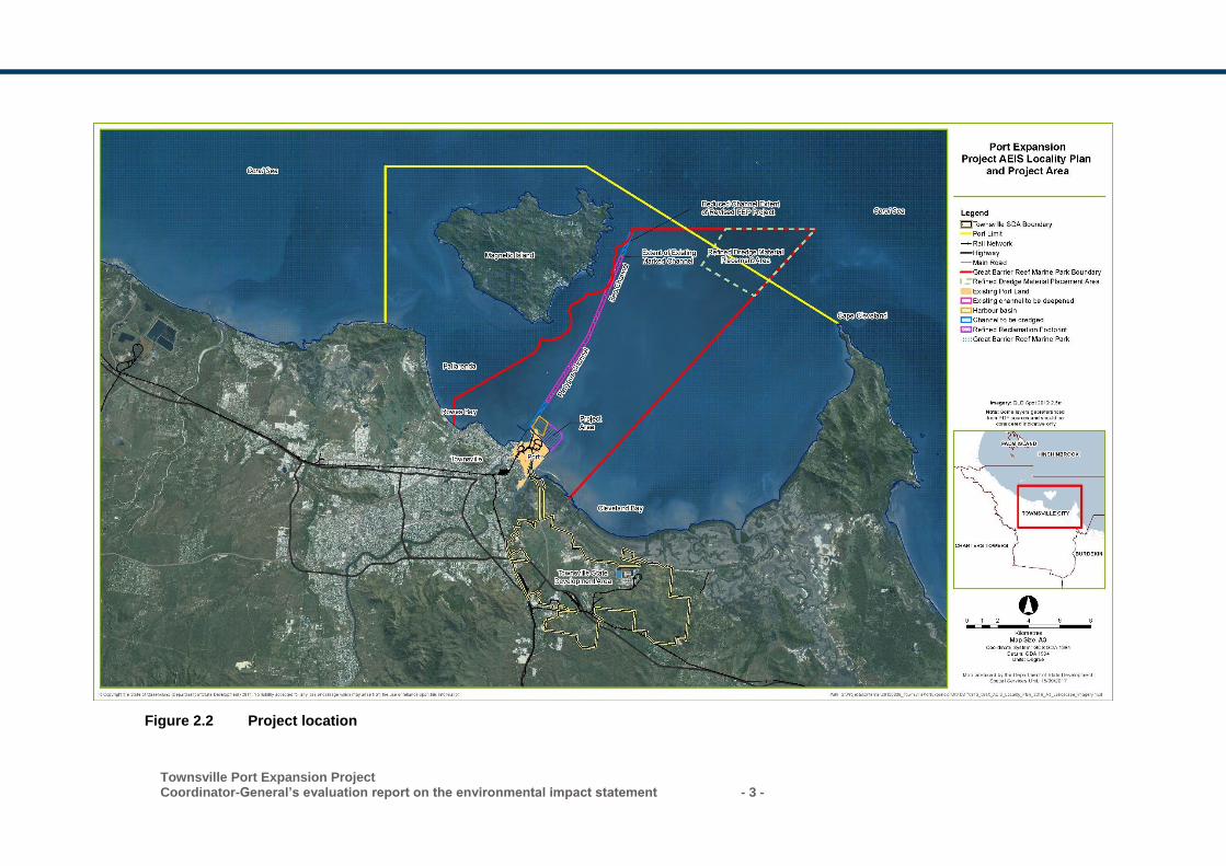
Townsville Port Expansion Project Coordinator-General’s evaluation report on the environmental impact statement - 3 -
Figure 2.2 Project location
- 4 - Townsville Port Expansion Project
Coordinator-General’s evaluation report on the environmental impact statement
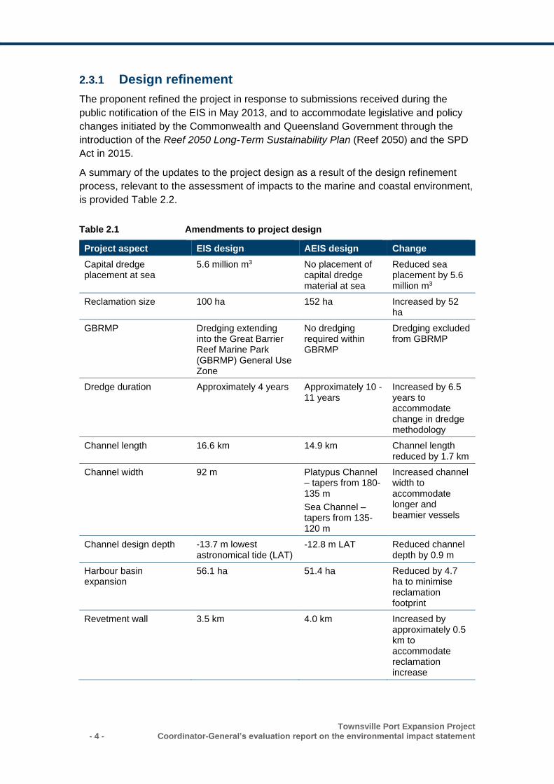
2.3.1 Design refinement
The proponent refined the project in response to submissions received during the
public notification of the EIS in May 2013, and to accommodate legislative and policy
changes initiated by the Commonwealth and Queensland Government through the
introduction of the Reef 2050 Long-Term Sustainability Plan (Reef 2050) and the SPD
Act in 2015.
A summary of the updates to the project design as a result of the design refinement
process, relevant to the assessment of impacts to the marine and coastal environment,
is provided Table 2.2.
Table 2.1 Amendments to project design
Project aspect EIS design AEIS design Change
Capital dredge placement at sea
5.6 million m3 No placement of capital dredge material at sea
Reduced sea placement by 5.6 million m3
Reclamation size 100 ha 152 ha Increased by 52 ha
GBRMP Dredging extending into the Great Barrier Reef Marine Park (GBRMP) General Use Zone
No dredging required within GBRMP
Dredging excluded from GBRMP
Dredge duration Approximately 4 years Approximately 10 - 11 years
Increased by 6.5 years to accommodate change in dredge methodology
Channel length 16.6 km 14.9 km Channel length reduced by 1.7 km
Channel width 92 m Platypus Channel – tapers from 180-135 m
Sea Channel – tapers from 135-120 m
Increased channel width to accommodate longer and beamier vessels
Channel design depth -13.7 m lowest astronomical tide (LAT)
-12.8 m LAT Reduced channel depth by 0.9 m
Harbour basin expansion
56.1 ha 51.4 ha Reduced by 4.7 ha to minimise reclamation footprint
Revetment wall 3.5 km 4.0 km Increased by approximately 0.5 km to accommodate reclamation increase
Townsville Port Expansion Project Coordinator-General’s evaluation report on the environmental impact statement - 5 -
2.3.2 Dredging
POTL propose to dredge 11.48 million m3 of material within the port limits over
approximately 10 - 11 years. No dredging is proposed in the Commonwealth-controlled
Great Barrier Reef Marine Park (GBRMP) nor the state-controlled Great Barrier Reef
Coast Marine Park. The dredging program would:
• widen the western side of the Platypus Channel to 180 m at the harbour, tapering to
135 m at Sea Channel
• widen the eastern side of the Sea Channel (opposite side from Magnetic Island) to
135 m tapering to 120 m
• deepen the Platypus and Sea Channels to an average depth of -12.8 m LAT
• lengthen the Sea and Platypus Channels by 1 km from 13.9 km to 14.9 km
• expand the harbour basin by 51.4 ha.
The AEIS envisaged the dredging of 2.2 million m3 of soft marine sediments and clayey
sands to be undertaken by a trailer suction hopper dredge (TSHD) with material
transferred to the reclamation area by pumping in slurry form through floating and fixed
pipelines. The AEIS also indicated that dredging of 9.28 million m3 of very stiff to hard
clay and clayey sand material would be undertaken using a large mechanical dredger
with dredge material placed in hopper barges for transfer to the reclamation area.
2.3.3 Reclamation area
POTL propose to beneficially re-use dredged sediment with placement in tidal waters
to ultimately reclaim 152 ha of land (with a maximum disturbance area of approximately
167.6 ha) to provide backing for the new berths. Stage 1 of the project would require
the construction of an initial reclamation area of approximately 58 ha. The final
reclamation area would be constructed to 5.6 m Australian height datum (AHD) and fall
to the eastern revetment to accommodate stormwater drainage.
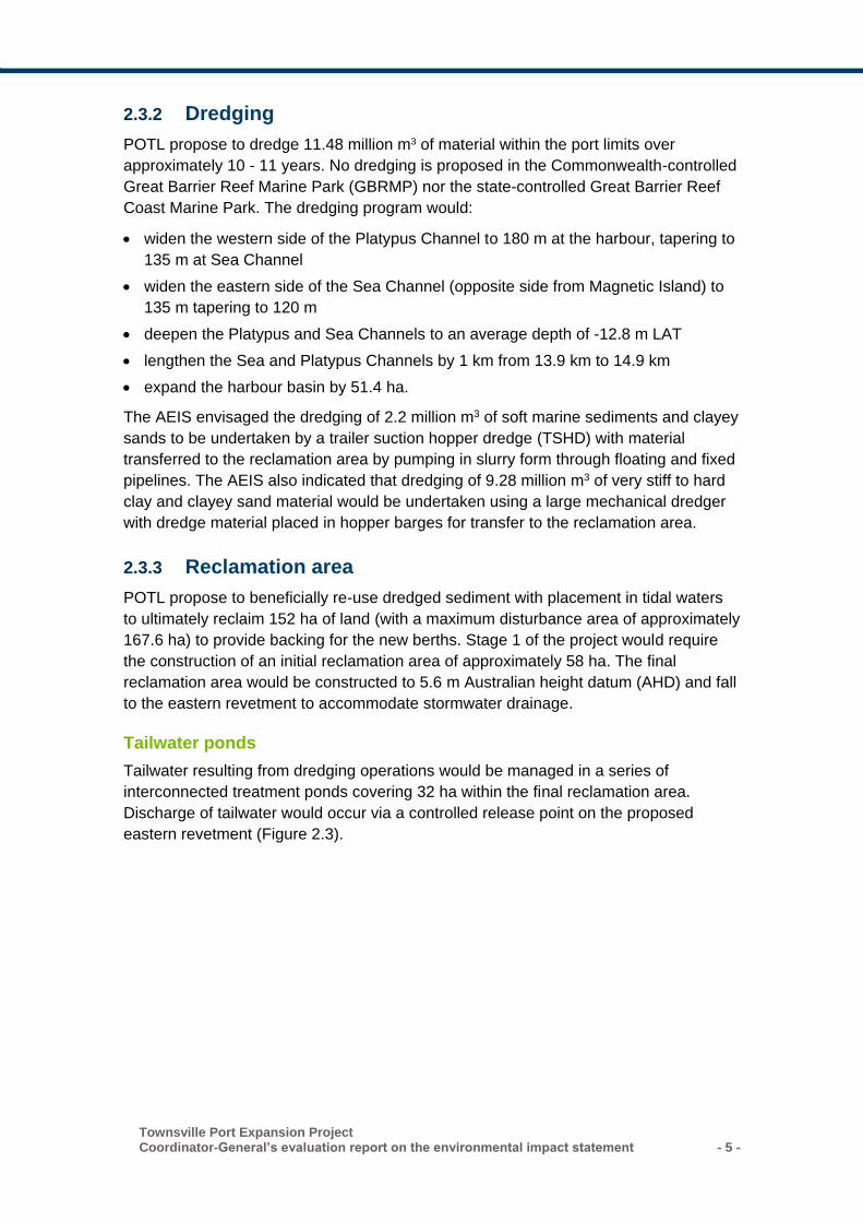
Tailwater ponds
Tailwater resulting from dredging operations would be managed in a series of
interconnected treatment ponds covering 32 ha within the final reclamation area.
Discharge of tailwater would occur via a controlled release point on the proposed
eastern revetment (Figure 2.3).
- 6 - Townsville Port Expansion Project
Coordinator-General’s evaluation report on the environmental impact statement
Figure 2.3 Port expansion area
Townsville Port Expansion Project Coordinator-General’s evaluation report on the environmental impact statement - 7 -
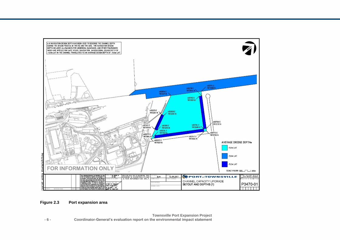
Figure 2.4 Port expansion area and channels
- 8 - Townsville Port Expansion Project
Coordinator-General’s evaluation report on the environmental impact statement
2.3.4 Revetment walls and breakwaters
At completion, the project would include 4 km of revetment wall consisting of rock-filled
bunds and rock armour layers. Approximately 2.2 km of revetment wall will be
constructed in Stage 1 of the project, enclosing the initial 58 ha reclamation area.
A north-eastern breakwater (approximately 700 m in length) would be constructed with
rubble mound and rock armouring. The project includes the potential construction of a
western breakwater of approximately 1 km in length. The western breakwater would
only be required if berth 12 is constructed and detailed design indicates that further
protection of the outer harbour is required.
Revetment walls and breakwaters would be constructed to relevant Australian
standards to protect the harbour against wave action, storm surge and sea level rise.
2.3.5 Berths
The project includes the construction of six berths backing the reclamation area. Berth
12 is proposed for ship operations that do not require breakwater protection and would
be constructed as a part of Stage 1 of the project. Berths 14 to 18 would be located in a
basin with breakwater protection, enabling the berths to be developed to suit all cargo
types. Construction of berths 14 to 18 could be undertaken in one or more stages
subject to demand for these facilities.
2.4 Project staging
The project will be developed in three primary stages as outlined in Table 2.2.
Subsequent to the release of the EIS documentation, the Townsville City Deal initiative
was finalised by the Australian Government, Queensland Government and Townsville
City Council (TCC). The Townsville City Deal envisages a package of early works for
the TCCUP.
The TCCUP forms part of Stage 1 of the project and involves the establishment of an
initial reclamation area of approximately 58 ha over a 12-month period. Stage 1 also
includes the proposed widening of Platypus and Sea Channels over approximately two
years to improve access for larger vessels.
The commencement of Stage 1 of the project relies upon the establishment of the
Granitevale Quarry (separately assessed and approved), which will provide the bulk of
the rock required for the construction of revetment structures.
Stages 2 and 3 would be undertaken progressively, depending on demand for
additional berths and portside infrastructure.
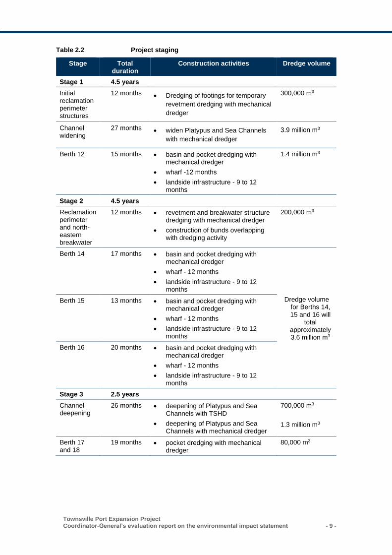
Townsville Port Expansion Project Coordinator-General’s evaluation report on the environmental impact statement - 9 -
Table 2.2 Project staging
Stage Total duration
Construction activities Dredge volume
Stage 1 4.5 years
Initial reclamation perimeter structures
12 months • Dredging of footings for temporary
revetment dredging with mechanical
dredger
300,000 m3
Channel widening
27 months • widen Platypus and Sea Channels
with mechanical dredger
3.9 million m3
Berth 12 15 months • basin and pocket dredging with mechanical dredger
• wharf -12 months
• landside infrastructure - 9 to 12 months
1.4 million m3
Stage 2 4.5 years
Reclamation perimeter and north-eastern breakwater
12 months • revetment and breakwater structure dredging with mechanical dredger
• construction of bunds overlapping with dredging activity
200,000 m3
Berth 14 17 months • basin and pocket dredging with mechanical dredger
• wharf - 12 months
• landside infrastructure - 9 to 12 months
Dredge volume for Berths 14, 15 and 16 will
total approximately 3.6 million m3
Berth 15 13 months • basin and pocket dredging with mechanical dredger
• wharf - 12 months
• landside infrastructure - 9 to 12 months
Berth 16 20 months • basin and pocket dredging with mechanical dredger
• wharf - 12 months
• landside infrastructure - 9 to 12 months
Stage 3 2.5 years
Channel deepening
26 months • deepening of Platypus and Sea Channels with TSHD
• deepening of Platypus and Sea Channels with mechanical dredger
700,000 m3
1.3 million m3
Berth 17 and 18
19 months • pocket dredging with mechanical dredger
80,000 m3
- 10 - Townsville Port Expansion Project
Coordinator-General’s evaluation report on the environmental impact statement
2.5 Port operations
The future use and development of the reclamation area does not form part of this
assessment. This report focuses on the assessment of the impacts associated with the
construction of the reclamation area, new berths, revetments and breakwater.
The impacts associated with the future use and development of the reclamation area
are the responsibility of the relevant tenants and operators under the Port of Townsville
Land Use Plan. Future developments will be required to seek approval from the Port of
Townsville as assessment manager. Accordingly, in some instances the operational
impacts of such future development have not been discussed, as it is outside the scope
of this assessment.
2.6 Project need
A preliminary engineering and environment study (AECOM, 2009) into the port’s future
identified the requirement for demand responsive expansions of the existing Port of
Townsville to meet North Queensland’s predicted growth.
The increase in trade will ultimately require development of additional berth space,
deepening and widening of the channels to the port (the Platypus and Sea channels).
These capital improvements are required to overcome constraints imposed on vessel
size.
The Port of Townsville needs to respond not only to the increase in the world’s fleet but
also to the vessels currently servicing other ports in Australia, particularly on the east
coast. Ultimately the desired situation is that the Port of Townsville is able to
accommodate container vessels with a capacity of up to 8,000-10,000 twenty-foot
equivalent units (TEU). This is generally the Panamax and New Panamax fleet which
are currently unable to access the port.
Updated figures provided by the proponent following the AEIS indicated that only 5% of
container vessels sailing in Australian waters can access the Port of Townsville. Larger
vessels are used by shipping lines due to the cost efficiencies of handling more cargo
on a single ship. These larger vessels cannot fit into the Port of Townsville, and must
use southern capital city ports. Freight for or from North Queensland is transported by
road and rail to these southern capital city ports, creating additional time and cost
burdens on road and rail networks.
Consideration was given to potential alternative options to the proposed project, as was
a ‘no action’ option. The most feasible arrangement was found to be the port expansion
layout in the Port of Townsville Master Plan completed in 2007, which creates a
protected outer harbour seaward of the existing port with a significant reclaimed area
for cargo storage.
Townsville Port Expansion Project Coordinator-General’s evaluation report on the environmental impact statement - 11 -
2.7 Dependencies and relationships with other projects
Port expansion activities would need to be undertaken in conjunction with a number of
other projects. Other developments at or adjacent to the Port of Townsville that are
planned, under construction or recently completed include:
• various berth modifications and rationalisation in the inner harbour
• potential new Berths 10b and 10c (with land-backed reclamation) and dredging of a
navigation diversion channel for Ross Creek craft, being investigated by POTL
• the development of the Graniteville quarry, for which POTL currently holds approval.
The quarry will supply the marine armour stone required to construct the revetments
for the reclamation area and breakwater
the port provides critical infrastructure in support of the Townsville State
Development Area (TSDA). The TSDA is a 4,900-ha land parcel located east of the
Townsville CBD, which was declared for heavy industry in 2003. The TSDA is the
preferred location in North Queensland for the establishment of industrial
development of regional, State and national significance. The TSDA aims to
maximise the efficient use of existing and future port, road, rail and ancillary
infrastructure.
3. Environmental impact statement assessment process
In undertaking this evaluation, I have considered the following:
the initial advice statement
the EIS and technical reports
issues raised in submissions on the EIS and AEIS
the AEIS and technical reports
advice from the proponent
revised reports and plans in response to the submissions on the AEIS
state agency advice post AEIS from:
– Department of Environment and Heritage Protection (DEHP)
– Department of National Parks, Sport and Racing (DNPSR)
– Department of Transport and Main Roads (DTMR)
– Department of Infrastructure, Local Government and Planning (DILGP)
– Department of Science, Information Technology and Innovation (DSITI)
Department of Environment and Energy (DEE)
private correspondence received post AEIS
The steps taken in the project’s EIS process are documented on the project’s webpage
at www.statedevelopment.qld.gov.au/tpe.
- 12 - Townsville Port Expansion Project
Coordinator-General’s evaluation report on the environmental impact statement
3.1 Coordinated project declaration
On 23 May 2011, the then Coordinator-General declared the project to be a ‘significant
project2’ under section 26(1)(a) of the SDPWO Act. This declaration initiated the
statutory environmental impact evaluation procedure of Part 4 of the Act, which
required the proponent to prepare an EIS for the project.
3.2 Terms of reference
The draft terms of reference (TOR) for the EIS for the proposed project were released
for public and advisory agency comment from 29 October 2011 to 25 November 2011.
Comments were received from 23 submitters including 12 from advisory agencies,
three from non-government organisations and eight from public submitters.
A final TOR was prepared having regard to submissions received and was issued to
the proponent on 16 February 2012.
3.3 Review of the EIS
The EIS was released for public and agency comment from 23 March 2013 to 13 May
2013. A total of 247 submissions were received and copies forwarded to the proponent.
The most prominent issues raised in submissions included:
opposition to disposal of dredge material in the Great Barrier Reef World Heritage
Area (GBRWHA)
dispersal of dredged material (by ocean currents) affecting beaches of Magnetic
Island
onshore placement of dredge material and risks of oxidation
concern that the water quality assessment was not undertaken in accordance with
relevant guidelines
dredging impact on marine life and waters in Cleveland Bay
cumulative impact of water quality in Cleveland Bay from upstream land-based
developments
economic impact on tourism on Magnetic Island.
3.4 Additional information to the EIS
On 30 July 2013, I requested that the proponent submit additional information
regarding:
additional material on water quality impacts (sedimentation, sediment suspension
and transport and turbidity)
2 Amendments to the SDPWO Act in December 2012 resulted in the replacement of the term ‘significant project’ with ‘coordinated project’.
Townsville Port Expansion Project Coordinator-General’s evaluation report on the environmental impact statement - 13 -
onshore placement of dredge materials and oxidation of sediments
further consideration of project alternatives (options for placement of dredge
material)
aquatic ecology relating to seagrasses, turtles and offsets
impacts to marine mammals from noise and vibration during construction and
operation
air quality monitoring at sensitive receptors (construction)
economic impacts (assessment of potential impacts to tourism)
cumulative impacts (upstream river run-off).
3.5 Review of the AEIS
On 28 September 2016, the proponent submitted the AEIS and I approved its release
for public and agency comment between 8 October 2016 and 7 December 2016.
9,125 submissions were received, including submissions from members of the
community, community organisations, business interests and government advisory
agencies.
Copies of submissions were forwarded to the proponent for comment and response.
This report has evaluated the EIS documentation, submissions to the EIS and AEIS
and other material relevant to the project. I have considered all submissions made on
the draft EIS and AEIS in my assessment in the relevant sections below.
Key issues raised in submissions
The key issues raised in the submissions on the EIS and AEIS have been summarised
in Table 3.1. I have considered each of the submissions and how the information
provided by the proponent addressed submitter issues in my evaluation of the project.
Table 3.1 Key issues raised in public and agency submissions
Topic Issue summary
Land use
• any decision on the proposal should be postponed until the Townsville
Port Master Plan is in place
Matters of
State
Environmental
Significance
• direct impacts of the project on habitats currently used by protected
shorebirds, primarily the existing reclamation area and ponds
• indirect impacts of the project on nearby habitat for migratory shorebirds
of the Ross River and Magnetic Island
• disruption to avifauna behaviour and movement patterns as a result of
construction and operation
• impacts of dredging on sensitive receptors including coral reefs and
seagrass beds
• impacts to marine turtles and turtle habitats
- 14 - Townsville Port Expansion Project
Coordinator-General’s evaluation report on the environmental impact statement
• impacts to nearshore dolphins and other marine megafauna
• potential impacts associated with the spread of invasive species
• the suitability of proposed offsets to manage residual impacts
• consideration of offsets in terrestrial fauna species management.
Marine and coastal environment
• impacts of dredging on sensitive receptors including coral reefs and seagrass beds
• mobilisation of contaminants into the water column
• the cumulative impacts of increased maintenance dredging associated with the revised dredging program
• dredge sediment impacts to Magnetic Island
• sediment resuspension in Cleveland Bay
• impacts associated with revetment rock wall construction including generation of dredge plumes and other sediment-related issues
• management of potential acid sulfate soils (PASS) and acid sulfate soils (ASS) within reclamation area
• management of tailwater from the reclamation area
• impacts of revetment construction on coastal processes
• impacts of underwater noise and vibration on marine fauna
• impacts of increased shipping on marine megafauna
• lighting impacts to marine turtles and other fauna
• introduction of marine pests.
Water
resources
• degradation of groundwater within the reclamation area from the
placement of PASS dredged materials
• potential flood impacts to the TSDA as a result of the project.
Air quality • dust affecting surrounding properties
• increases in risk to human health of respiratory illnesses and symptoms
from construction dust and emissions
• the port’s contribution to flow-on climate change impacts through the
potential export of coal.
Noise and
vibration
• compliance of night-time construction noise with Environmental
Protection Policy (Noise) (EPP (Noise)) goals
• day and night construction noise impacts
• construction traffic noise impacts
Waste • waste and saline water discharges into the sewerage network
• safe discharge of ship ballast water into the environment
• shore-based reception facilities for ship-generated waste
• hazardous materials to be stored and used on site
• land contamination
Traffic and
transport
• increased heavy vehicle movement associated with movement of rock
between the quarry and port
• requirement for an updated road impact assessment, road-use
management plan and traffic management plan
Townsville Port Expansion Project Coordinator-General’s evaluation report on the environmental impact statement - 15 -
• requirement for ongoing consultation with the Regional Harbour Master
in relation to vessel movements
• vessel traffic management, aids to navigation, ship-sourced
prevention/spill management.
Hazard and risk
• health and safety of port workers and the Townsville community arising
from development of the project
• security of the port and associated infrastructure resulting from
increased demand
• vulnerability of the port to events such as fire, terrorism and sabotage,
and the impact of such disasters on the city of Townsville.
Social • the need for transparent, meaningful engagement with the local
community and other relevant stakeholders regarding the proposed
project and potential impacts
• potential degradation of the marine environment and consequent
impacts to marine resource users, including local tourism operators,
commercial and recreational fishermen, and divers
• potential negative impacts to local businesses, resulting in reduced local
employment
• opportunities for local industry participation, including employment
opportunities for Aboriginal and Torres Strait Islanders
• reduction in the amenity value of the coastal areas and consequent
lifestyle impacts for local communities
• potential impacts to community health and safety due to issues such as
air and noise emissions, mosquito breeding, road and maritime safety,
and the management of wastes and hazardous substances.
Economic • the need for a revised cost benefit analysis as part of the business case
for the project
• lack of economic analysis and project justification regarding the need for
the project
• impact on tourism and dive operators on Magnetic Island during
dredging periods
• economic impact to recreational and commercial fishing including
impacts to a wide range of fish and shellfish species that have direct
economic significance to the region.
Cultural heritage
• adequacy of community consultation for the Indigenous community of
Palm Island
• notification of any discovery of items in the reclamation area that have
heritage values.
3.6 Commonwealth assessment
As this project will potentially have a significant impact on matters of national
environmental significance (MNES), the project was referred by the proponent to the
- 16 - Townsville Port Expansion Project
Coordinator-General’s evaluation report on the environmental impact statement
Commonwealth Minister for the Environment under the provisions of the Environment
Protection and Biodiversity Conservation Act 1999 (Cwlth) (EPBC Act).
On 1 July 2011, the Commonwealth Environment Minister’s delegate determined that
the project is a ‘controlled action’ under the EPBC Act (EPBC ref. 2011/5979). The
relevant controlling provisions under the EPBC Act are:
sections 12 and 15A: World Heritage properties
sections 15B and 15C: National Heritage places
sections 16 and 17B: Wetlands of international importance
sections 18 and 18A: Listed threatened species and communities
sections 20 and 20A: Listed migratory species
sections 23 and 24A: Commonwealth marine areas
sections 24B and 24C: the Great Barrier Reef Marine Park.
The delegate also determined that the project will be assessed by EIS under Part 8 of
the EPBC Act, separately and in parallel with the State’s assessment.
This EIS evaluation report will therefore only address potential impacts to state matters.
The project will however require approval from both the Queensland and
Commonwealth Governments before it can proceed.
4. Project approvals
Following the release of this report, the proponent would be required to obtain statutory
approvals from Commonwealth, state and local government jurisdictions. Table 4.1
provides a list of core approvals required for the project. There is no requirement for
the approvals and permits in the table below to be obtained sequentially.
The proponent acknowledges that further information may be required for additional
subsequent approvals as part of the construction phase and operational phase of the
port and by future port tenants. Table 4.2 provides a list of possible subsequent
approvals required for the project.
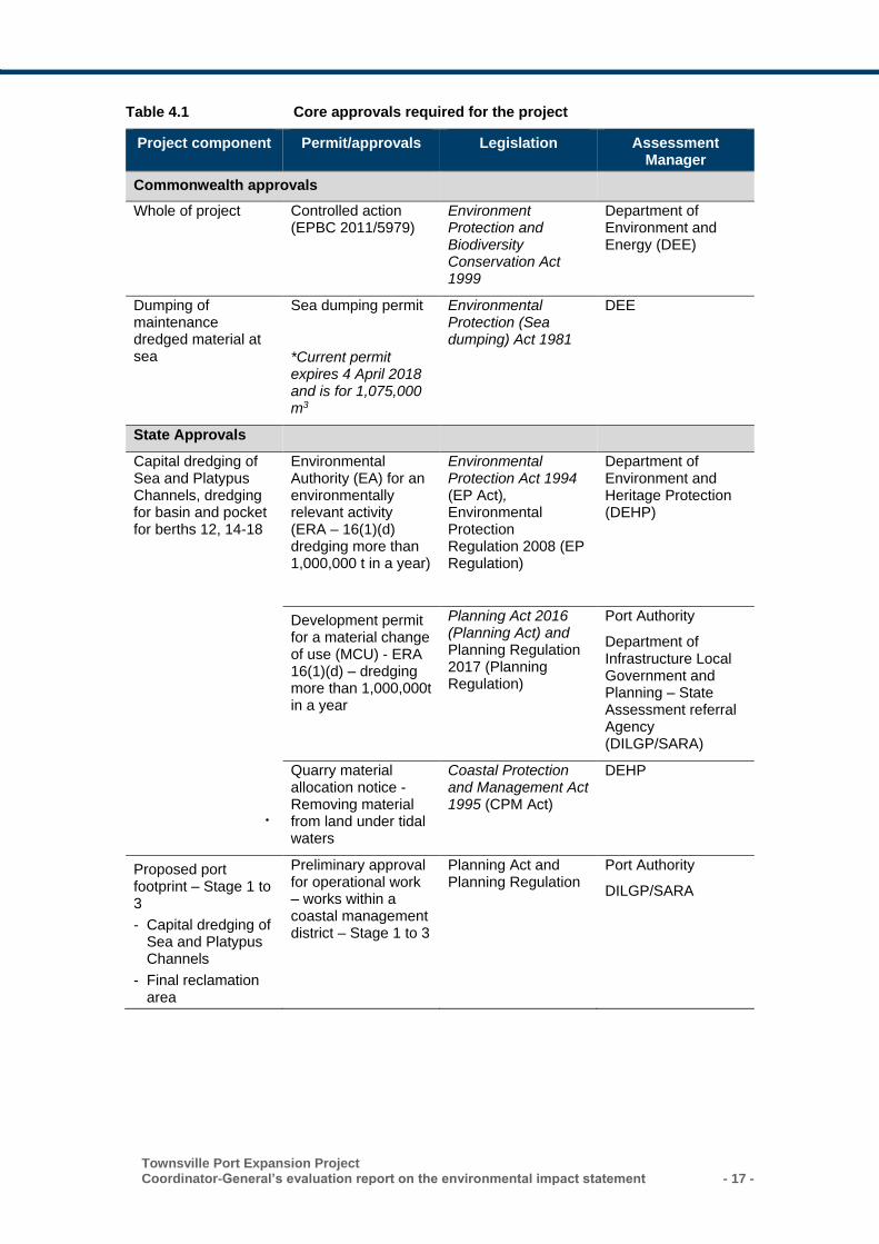
Townsville Port Expansion Project Coordinator-General’s evaluation report on the environmental impact statement - 17 -
Table 4.1 Core approvals required for the project
Project component Permit/approvals Legislation Assessment Manager
Commonwealth approvals
Whole of project Controlled action (EPBC 2011/5979)
Environment Protection and Biodiversity Conservation Act 1999
Department of Environment and Energy (DEE)
Dumping of maintenance dredged material at sea
Sea dumping permit
*Current permit expires 4 April 2018 and is for 1,075,000 m3
Environmental Protection (Sea dumping) Act 1981
DEE
State Approvals
Capital dredging of Sea and Platypus Channels, dredging for basin and pocket for berths 12, 14-18
Environmental Authority (EA) for an environmentally relevant activity (ERA – 16(1)(d) dredging more than 1,000,000 t in a year)
Environmental Protection Act 1994 (EP Act), Environmental Protection Regulation 2008 (EP Regulation)
Department of Environment and Heritage Protection (DEHP)
Development permit for a material change of use (MCU) - ERA 16(1)(d) – dredging more than 1,000,000t in a year
Planning Act 2016 (Planning Act) and Planning Regulation 2017 (Planning Regulation)
Port Authority
Department of Infrastructure Local Government and Planning – State Assessment referral Agency (DILGP/SARA)
Quarry material allocation notice - Removing material from land under tidal waters
Coastal Protection and Management Act 1995 (CPM Act)
DEHP
Proposed port footprint – Stage 1 to 3
- Capital dredging of Sea and Platypus Channels
- Final reclamation area
Preliminary approval for operational work – works within a coastal management district – Stage 1 to 3
Planning Act and Planning Regulation
Port Authority
DILGP/SARA
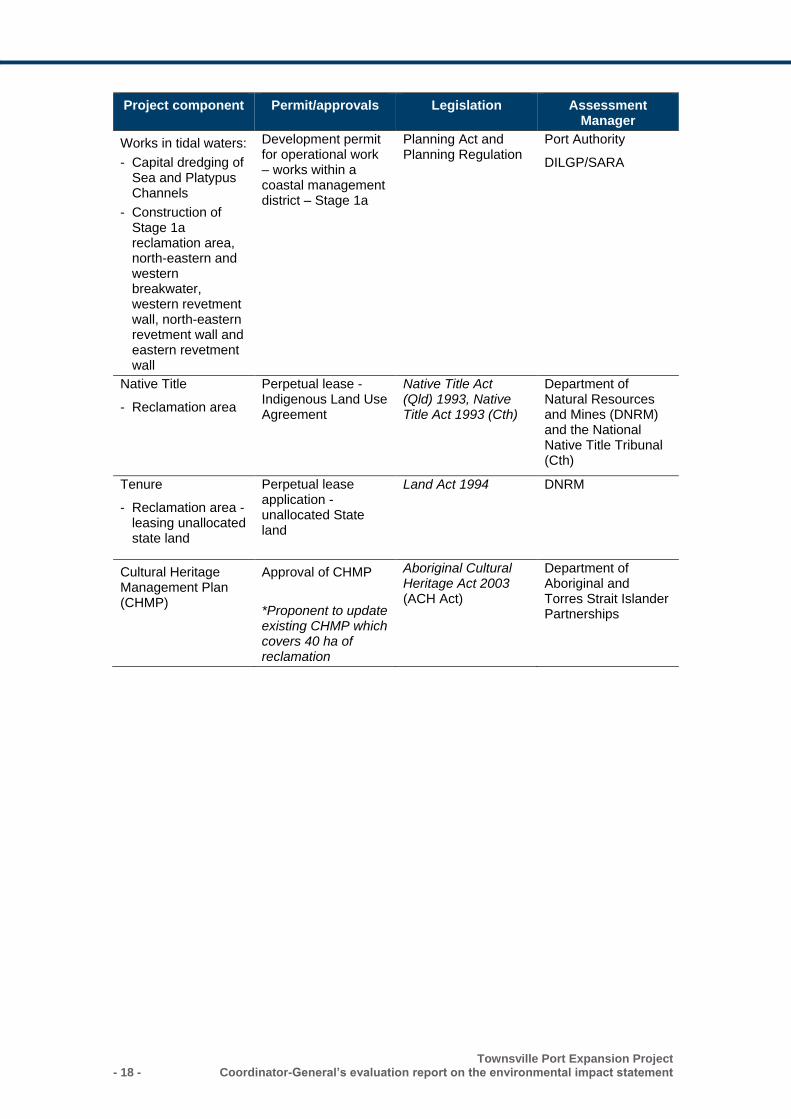
- 18 - Townsville Port Expansion Project
Coordinator-General’s evaluation report on the environmental impact statement
Project component Permit/approvals Legislation Assessment Manager
Works in tidal waters:
- Capital dredging of Sea and Platypus Channels
- Construction of Stage 1a reclamation area, north-eastern and western breakwater, western revetment wall, north-eastern revetment wall and eastern revetment wall
Development permit for operational work – works within a coastal management district – Stage 1a
Planning Act and Planning Regulation
Port Authority
DILGP/SARA
Native Title
- Reclamation area
Perpetual lease - Indigenous Land Use Agreement
Native Title Act (Qld) 1993, Native Title Act 1993 (Cth)
Department of Natural Resources and Mines (DNRM) and the National Native Title Tribunal (Cth)
Tenure
- Reclamation area -leasing unallocated state land
Perpetual lease application - unallocated State land
Land Act 1994 DNRM
Cultural Heritage Management Plan (CHMP)
Approval of CHMP
*Proponent to update existing CHMP which covers 40 ha of reclamation
Aboriginal Cultural Heritage Act 2003 (ACH Act)
Department of Aboriginal and Torres Strait Islander Partnerships
Townsville Port Expansion Project Coordinator-General’s evaluation report on the environmental impact statement - 19 -
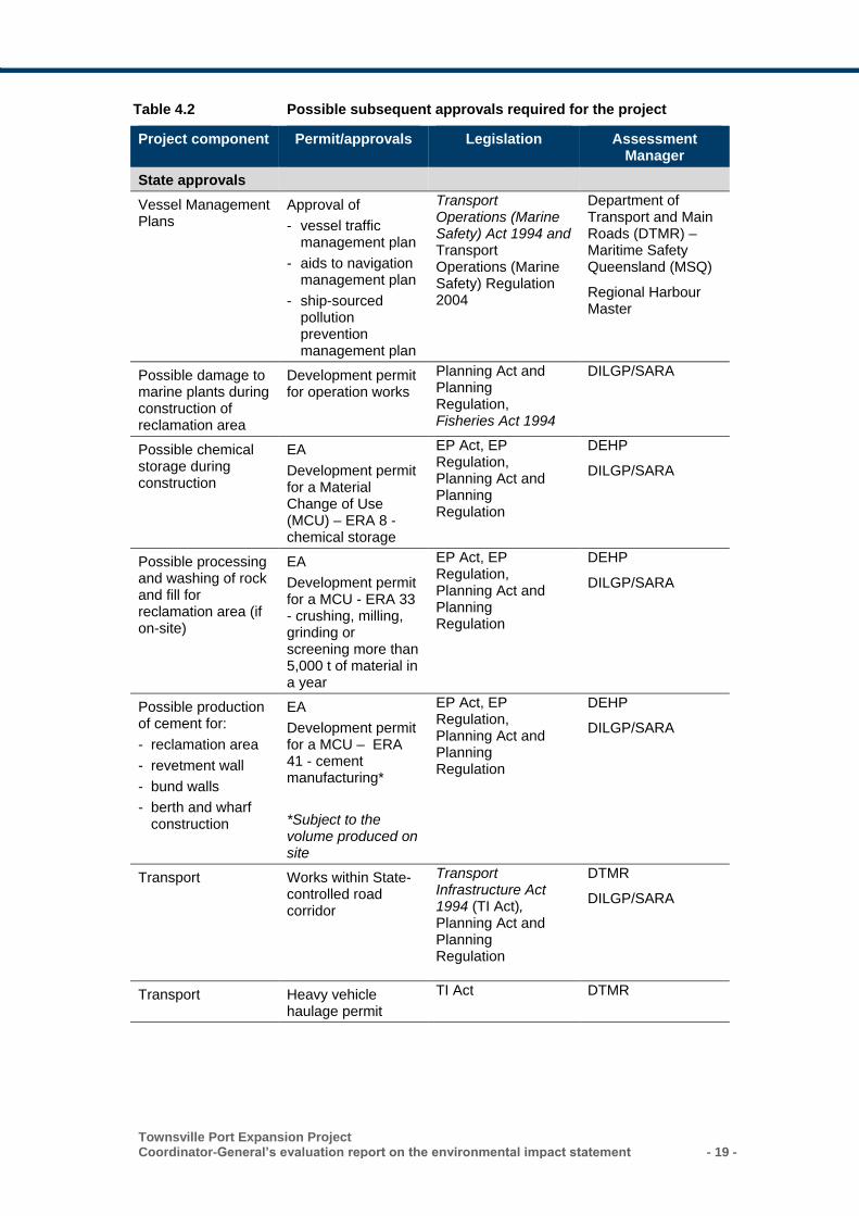
Table 4.2 Possible subsequent approvals required for the project
Project component Permit/approvals Legislation Assessment Manager
State approvals
Vessel Management Plans
Approval of
- vessel traffic management plan
- aids to navigation management plan
- ship-sourced pollution prevention management plan
Transport Operations (Marine Safety) Act 1994 and Transport Operations (Marine Safety) Regulation 2004
Department of Transport and Main Roads (DTMR) – Maritime Safety Queensland (MSQ)
Regional Harbour Master
Possible damage to marine plants during construction of reclamation area
Development permit for operation works
Planning Act and Planning Regulation, Fisheries Act 1994
DILGP/SARA
Possible chemical storage during construction
EA
Development permit for a Material Change of Use (MCU) – ERA 8 - chemical storage
EP Act, EP Regulation, Planning Act and Planning Regulation
DEHP
DILGP/SARA
Possible processing and washing of rock and fill for reclamation area (if on-site)
EA
Development permit for a MCU - ERA 33 - crushing, milling, grinding or screening more than 5,000 t of material in a year
EP Act, EP Regulation, Planning Act and Planning Regulation
DEHP
DILGP/SARA
Possible production of cement for:
- reclamation area
- revetment wall
- bund walls
- berth and wharf construction
EA
Development permit for a MCU – ERA 41 - cement manufacturing*
*Subject to the volume produced on site
EP Act, EP Regulation, Planning Act and Planning Regulation
DEHP
DILGP/SARA
Transport Works within State-controlled road corridor
Transport Infrastructure Act 1994 (TI Act), Planning Act and Planning Regulation
DTMR
DILGP/SARA
Transport Heavy vehicle haulage permit
TI Act DTMR
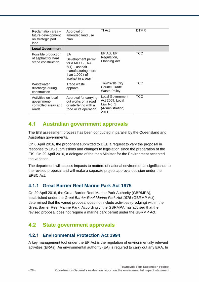
- 20 - Townsville Port Expansion Project
Coordinator-General’s evaluation report on the environmental impact statement
Reclamation area – future development on strategic port land
Approval of amended land use plan
TI Act DTMR
Local Government
Possible production of asphalt for hard stand construction
EA
Development permit for a MCU - ERA 6(1) – asphalt manufacturing more than 1,000 t of asphalt in a year
EP Act, EP Regulation, Planning Act
TCC
Wastewater discharge during construction
Trade waste approval
Townsville City Council Trade Waste Policy
TCC
Activities on local government-controlled areas and roads
Approval for carrying out works on a road or interfering with a road or its operation
Local Government Act 2009, Local Law No. 1 (Administration) 2011
TCC
4.1 Australian government approvals
The EIS assessment process has been conducted in parallel by the Queensland and
Australian governments.
On 6 April 2016, the proponent submitted to DEE a request to vary the proposal in
response to EIS submissions and changes to legislation since the preparation of the
EIS. On 29 April 2016, a delegate of the then Minister for the Environment accepted
the variation.
The department will assess impacts to matters of national environmental significance to
the revised proposal and will make a separate project approval decision under the
EPBC Act.
4.1.1 Great Barrier Reef Marine Park Act 1975
On 29 April 2016, the Great Barrier Reef Marine Park Authority (GBRMPA),
established under the Great Barrier Reef Marine Park Act 1975 (GBRMP Act),
determined that the varied proposal does not include activities (dredging) within the
Great Barrier Reef Marine Park. Accordingly, the GBRMPA has advised that the
revised proposal does not require a marine park permit under the GBRMP Act.
4.2 State government approvals
4.2.1 Environmental Protection Act 1994
A key management tool under the EP Act is the regulation of environmentally relevant
activities (ERAs). An environmental authority (EA) is required to carry out any ERA. In
Townsville Port Expansion Project Coordinator-General’s evaluation report on the environmental impact statement - 21 -
accordance with section 47C of the SDPWO Act, I have stated conditions in Appendix
2, Schedule 1 for inclusion in an EA for ERA – 16(1)(d) dredging more than 1,000,000
tonnes per year. The EA is for capital dredging of the Sea and Platypus Channels,
basin and pocket for Berths 12, 14-18 and the release of dredge tailwater from the
proposed reclamation area for Stages 1 to 3.
4.2.2 Planning Act 2016
On 3 July 2017, the Sustainable Planning Act 2009 was replaced by the Planning Act
2016. In accordance with section 37 of the SDPWO Act, I have stated conditions for a
development permit for a material change of use (MCU) for an ERA. Schedule 10, part
5, division 2, section 8(1) of the Planning Regulation 2017 states that a MCU for an
ERA is assessable development, if the activity is a concurrence ERA. Concurrence
ERAs are identified by a capital ‘C’ in column 3 of schedule 2 of the Environmental
Protection Regulation 2008. Capital dredging of 1,000 tonnes or more is a concurrence
ERA.
In accordance with section 39 of the SDPWO Act, I have stated conditions for a
preliminary approval for operational work for tidal works for Stages 1 to 3 of the project
and a development permit for operational work for tidal works for Stage 1 for works in a
coastal management district. Stated conditions are provided in Appendix 2, of this
report. The port authority (Port of Townsville Limited) is the assessment manager for
these approvals as the works occur within port limits.
4.2.3 Coastal Protection and Management Act 1995
Under section 73 of the CPM Act, the proponent would be required to hold a current
quarry material allocation notice that authorises the removal of material from land
under tidal waters.
Initially, as material is removed from land under tidal water and placed in the
reclamation area which is below the high-water mark, that activity is deemed
operational works and requires a development approval, due to the material being
disposed of in tidal waters.
The proponent will require an allocation notice which allows for the removal of quarry
material (predominantly silts and clays) below the high-water mark. I have set
conditions to address the potential impacts to marine environment through both the EA
and Development Permit for Operational Works (Tidal Works in a coastal management
district). Accordingly, I recommend that DEHP approve the allocation notice for the
maximum period of six years.
4.2.4 Marine Parks Act 2004
The Great Barrier Reef Coast Marine Park and the Commonwealth GBRMP share a
common boundary in relation to the project on the eastern side of Magnetic Island.
Section 7(3) of the Marine Parks Act 2004 requires consistency with the
commonwealth in relation to interpretation of this boundary location. On 29 April 2016,
the then Department of the Environment (now DEE), advised the proponent that the
- 22 - Townsville Port Expansion Project
Coordinator-General’s evaluation report on the environmental impact statement
project does not include activities within the GBRMP and permission from GBRMPA is
not required. The proposed channel dredging works associated with the project is not
within the boundary of the Great Barrier Reef Coast Marine Park, and therefore does
not require a marine park permit.
4.2.5 Sustainable Ports Development Act 2015
The SPD Act identifies the Port of Townsville as a priority port. The SPD Act allows
continued development in a priority port but requires capital dredge material to either
be beneficially re-used or disposed on land. The proponent proposes that capital
dredge material will be beneficially re-used as reclamation fill.
The master plan and port overlay for the Port of Townsville is currently being
developed by the Department of State Development. Port master planning for priority
ports is a port-related action of Reef 2050 and mandated under the SPD Act. The
existing planning and development decision responsibilities do not change in a master
planned area, under a priority port master plan and port overlay.
The SPD Act provides transitional provisions for those port development projects such
as Townsville that were subject to an EIS process that started before commencement
of the Act. In developing a master plan for the Port of Townsville, the Department of
State Development will give due consideration to the Coordinator-General’s evaluation
of the project’s EIS. Public comment on the draft master plan will also be sought.
4.2.6 DTMR’s Maintenance Dredging Strategy 2016
Established in 1864, the Port of Townsville is one of Queensland’s oldest ports.
Maintenance dredging at the Port is required annually and relocated to approved
offshore disposal sites. The proponent has a current Commonwealth permit for the
disposal of 1,075,000 m3 of (in situ) material from maintenance dredging. Maintenance
dredging as part of the current EIS will increase by 14%.
DTMR’s Maintenance Dredging Strategy 2016 provides the overarching framework for
protecting and managing impacts to the Great Barrier Reef by improving the way
maintenance dredging is planned, coordinated and regulated. The strategy sets out
guiding principles and actions that would be adopted in the Townsville Master Plan
under the SPD Act.
4.3 Local government approvals
The project is located within the TCC local government area. The proposal is exempt
from assessment against the local government planning scheme under the Planning
Act 2016 where activities are on Strategic Port Land. Permits would be required if any
activities occur on council-owned land, roads or using council’s infrastructure including
the provision of any local laws that have been gazetted under the Local Government
Act 2009.
Townsville Port Expansion Project Coordinator-General’s evaluation report on the environmental impact statement - 23 -
5. Evaluation of environmental impacts
This section discusses the major environmental effects identified in the EIS. For each
matter, I have included a detailed evaluation and imposed or stated conditions to
manage potential adverse impacts.
5.1 Marine and coastal environment
The project has the potential to impact on a range of marine and coastal values,
including water quality values, sensitive receptors such as seagrass beds and coral
reefs and significant species and their habitats.
5.1.1 Submissions received
The key marine and coastal environment issues raised in submissions on the EIS
documentation included the following:
impacts of dredging on sensitive receptors including coral reefs and seagrass beds
mobilisation of contaminants into the water column
the cumulative impacts of increased maintenance dredging associated with the
revised dredging program
dredge sediment impacts to Magnetic Island
sediment resuspension in Cleveland Bay
impacts associated with revetment rock wall construction including generation of
dredge plumes and other sediment-related issues
management of potential acid sulfate soils (PASS) and acid sulfate soils (ASS)
within reclamation area
management of tailwater from the reclamation area
impacts of revetment construction on coastal processes
impacts of underwater noise and vibration on marine fauna
impacts of increased shipping on marine megafauna
lighting impacts to marine turtles and other fauna
introduction of marine pests.
I have considered each submission, and the responses provided by the proponent in
my evaluation of the project. My assessment is provided in the relevant sections below.
5.1.2 Existing environment
The Port of Townsville is located in Cleveland Bay, which is bordered by Magnetic
Island and the Coral Sea to the north, Cape Pallarenda to the west and Cape
Cleveland to the east. The Ross River discharges into Cleveland Bay at the port, with
two other river systems feeding in to the north of Cleveland Bay (Bohle River) and the
south (Burdekin River). During wet season storm events, these and other smaller river
- 24 - Townsville Port Expansion Project
Coordinator-General’s evaluation report on the environmental impact statement
systems deliver sediments and nutrients into Cleveland Bay and other nearshore
waters of the Great Barrier Reef lagoon.
Despite significant changes to Townsville’s coastal zone as a result of urban and port
development, Cleveland Bay supports a broad range of significant marine ecological
values and functions. Particularly notable marine ecological values supported by
Cleveland Bay include the following (Figure 5.1):
a wide diversity of marine habitat types including intertidal beaches, mangrove
forests, saltmarshes, intertidal shoals, subtidal soft sediment habitats, rock walls,
coral reefs and rocky shores
one of the largest seagrass meadows in the broader region within the Cleveland Bay
Fish Habitat Area
coral communities of high biodiversity significance, particularly those around
Magnetic Island
habitats for a wide range of fish and shellfish species of direct economic significance
significant feeding areas for marine turtles, dugongs and dolphins, which are listed
as threatened or migratory under Commonwealth and/or state legislation
habitat for a range of other threatened or otherwise listed marine megafauna
species, including whales and sharks protected under the EPBC Act.
Marine water quality is an important environmental asset in Cleveland Bay and
surrounds due to the presence of a number of ecological receptors that are sensitive to
altered water quality conditions. These sensitive receptors include seagrass meadows,
which are located throughout Cleveland Bay, as well as reef communities (including
coral) at Middle Reef and Magnetic Island. The GBRMP is adjacent to the Port of
Townsville exclusion zone, and supports areas with high ecological values.
Catchment land use, coastal industry, shipping and related activities over the years
have resulted in elevated levels of nutrients and other contaminants in places,
particularly in Ross River and Creek and nearshore areas of Cleveland Bay.
Marine sediments in Cleveland Bay, particularly in the vicinity of port infrastructure,
harbours, shipping channels and the DMPA, have a long history of regular disturbance
from dredging and disposal activities. Naturally high suspended sediment can occur in
Cleveland Bay due to its shallowness and the muddy nature of the central bay
sediment.

Townsville Port Expansion Project Coordinator-General’s evaluation report on the environmental impact statement - 25 -
Figure 5.1 Location of sensitive ecological receptors
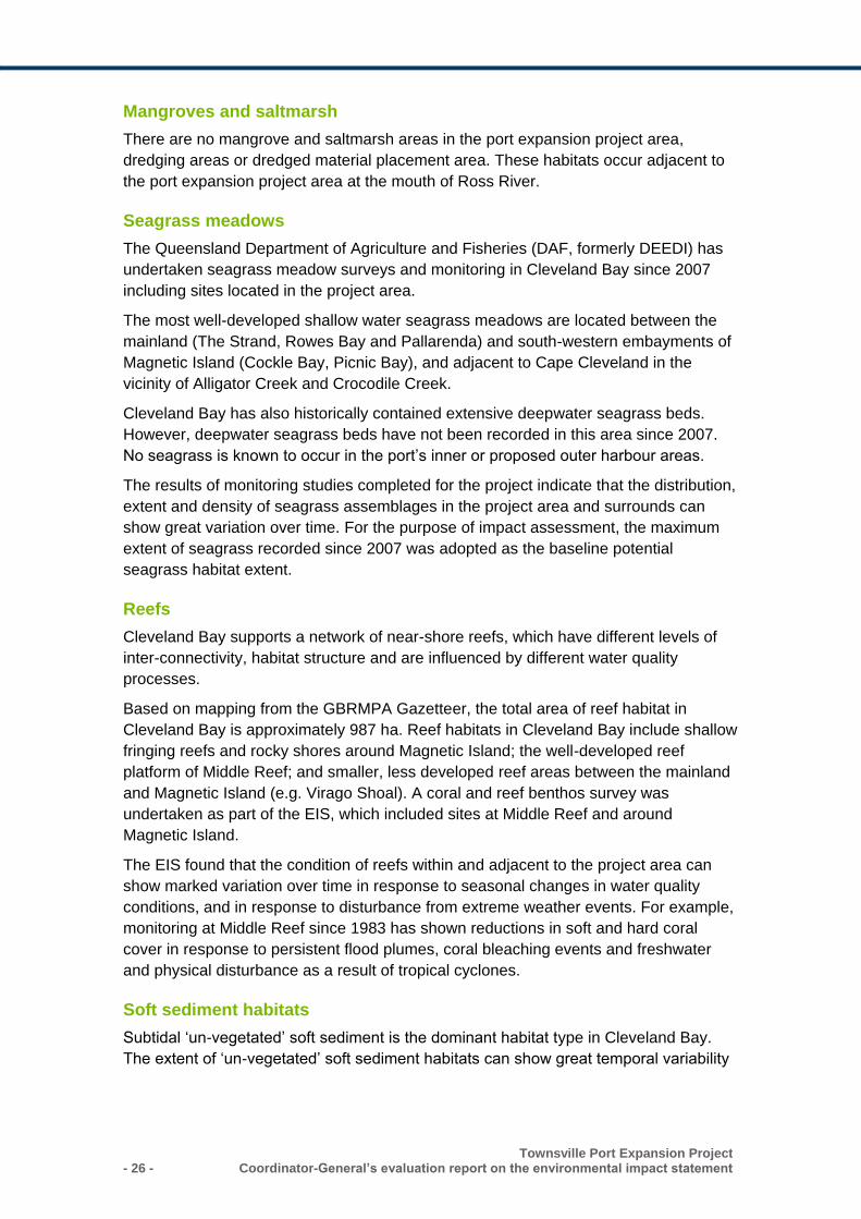
- 26 - Townsville Port Expansion Project
Coordinator-General’s evaluation report on the environmental impact statement
Mangroves and saltmarsh
There are no mangrove and saltmarsh areas in the port expansion project area,
dredging areas or dredged material placement area. These habitats occur adjacent to
the port expansion project area at the mouth of Ross River.
Seagrass meadows
The Queensland Department of Agriculture and Fisheries (DAF, formerly DEEDI) has
undertaken seagrass meadow surveys and monitoring in Cleveland Bay since 2007
including sites located in the project area.
The most well-developed shallow water seagrass meadows are located between the
mainland (The Strand, Rowes Bay and Pallarenda) and south-western embayments of
Magnetic Island (Cockle Bay, Picnic Bay), and adjacent to Cape Cleveland in the
vicinity of Alligator Creek and Crocodile Creek.
Cleveland Bay has also historically contained extensive deepwater seagrass beds.
However, deepwater seagrass beds have not been recorded in this area since 2007.
No seagrass is known to occur in the port’s inner or proposed outer harbour areas.
The results of monitoring studies completed for the project indicate that the distribution,
extent and density of seagrass assemblages in the project area and surrounds can
show great variation over time. For the purpose of impact assessment, the maximum
extent of seagrass recorded since 2007 was adopted as the baseline potential
seagrass habitat extent.
Reefs
Cleveland Bay supports a network of near-shore reefs, which have different levels of
inter-connectivity, habitat structure and are influenced by different water quality
processes.
Based on mapping from the GBRMPA Gazetteer, the total area of reef habitat in
Cleveland Bay is approximately 987 ha. Reef habitats in Cleveland Bay include shallow
fringing reefs and rocky shores around Magnetic Island; the well-developed reef
platform of Middle Reef; and smaller, less developed reef areas between the mainland
and Magnetic Island (e.g. Virago Shoal). A coral and reef benthos survey was
undertaken as part of the EIS, which included sites at Middle Reef and around
Magnetic Island.
The EIS found that the condition of reefs within and adjacent to the project area can
show marked variation over time in response to seasonal changes in water quality
conditions, and in response to disturbance from extreme weather events. For example,
monitoring at Middle Reef since 1983 has shown reductions in soft and hard coral
cover in response to persistent flood plumes, coral bleaching events and freshwater
and physical disturbance as a result of tropical cyclones.
Soft sediment habitats
Subtidal ‘un-vegetated’ soft sediment is the dominant habitat type in Cleveland Bay.
The extent of ‘un-vegetated’ soft sediment habitats can show great temporal variability
Townsville Port Expansion Project Coordinator-General’s evaluation report on the environmental impact statement - 27 -
in response to temporal changes in the extent of seagrass meadows. The EIS found
that the environmental integrity of un-vegetated soft sediment habitats in the port area,
navigation channels, DMPA and adjacent areas, including the mouth of Ross Creek
and Ross River, have been substantially modified by a number of past anthropogenic
activities.
In relation to environmental values, field studies completed for the project concluded
that the total project footprint of 167.6 ha supports soft sediment habitats which are well
represented within the nearshore environments of Cleveland Bay.
Coastal processes
Cleveland Bay is characterised by a relative low-energy wave environment.
Accumulated sediments make the bay relatively shallow, deepening to only 10 to 11 m
along its northern aspect. The coastline is shaped by low-energy waves, punctuated by
occasional higher energy cyclone wave occurrences that are able to penetrate across
the bay onto the shoreline. Figure 5.2 illustrates conceptually the broad coastal
processes of Cleveland Bay. These processes include:
hydrodynamics
– water levels relating to tides and storm surges
– the wave climate, which comprises both ocean waves entering the bay and wind
waves generated within the bay
– currents generated predominantly by tidal and wind forcing
– freshwater inflows from the Burdekin River, Ross River and Ross Creek
– tidal flows at the Ross River and Ross Creek
– key influencing factors of cyclones and other severe weather events.
marine sedimentation processes
– fluvial sediment supply from the rivers and streams, which may be fine wash load
that extends out into the bay before settling to the seabed or coarser sand that
deposits near the stream mouths and may be redistributed along the coast by
wave/current action
– fine sediment supply to the bay from the Burdekin River, carried in suspension by
currents either directly or, predominantly, after nearshore deposition and
subsequent resuspension
– bay seabed sediment resuspension, transport and deposition, potentially
changing the seabed morphology or sediment composition and/or infilling
dredged areas
shoreline sedimentation processes
– alongshore sand transport at the beach shorelines, driven by wave breaking
– beach erosion and accretion along the adjacent beach system
– factors affecting and required for beach stability.
- 28 - Townsville Port Expansion Project
Coordinator-General’s evaluation report on the environmental impact statement
Figure 5.2 Coastal processes in Cleveland Bay
Acid sulfate soils
According to the Townville City Council acid sulfate soils map, the existing port land is
mapped as containing PASS. Site assessment confirmed the presence of soils with
moderate potential acidity within the proposed sea channel dredge footprint and
reclamation area.
5.1.3 Assessment methodology
Dredging
The EIS addressed the potential impacts of capital and maintenance dredging for the
project including dredge plume and sediment deposition impacts to sensitive receptors
such as coral reefs and seagrasses. Due to the change in dredging program
(equipment and timing) and dredge material placement resulting from the design
refinement since the preparation of the EIS, the following impacting processes were re-
assessed in the AEIS:
turbid plume impacts to water quality from dredging
sediment deposition due to settling of suspended sediments in turbid dredge plumes
Townsville Port Expansion Project Coordinator-General’s evaluation report on the environmental impact statement - 29 -
impacts of dredge plumes and sediment deposition on seagrass communities and
coral reefs
suspension of contaminated sediments.
The impact assessment in the EIS documentation assessed an expected case
(suspended solids above background levels for 5% of the time) and worst-case
scenario (suspended solids above background for 1% of time) for dredge plume-related
impacts.
Multiple submissions expressed concerns relating to the methodology used to assess
the impacts of dredging in the EIS. The assessment of dredging impacts in the AEIS
was based on a ‘zones of impact’ approach recommended in GBRMPA modelling
guidelines for the assessment of dredging projects.
The output of this methodology is a mapped representation of ‘zones of influence’
(these are areas where there is the potential for some impact) and ultimately zones of
low, moderate and high impact, specific to the type, condition and location of the
sensitive receptor. This approach is recommended in GBRMPA Modelling Guidelines
for the assessment of dredging projects.
The zones of impact referred to in the EIS documentation and throughout this
evaluation report are described in Table 5.1.
Table 5.1 Description of zones of impact
Zones of impact
Description
Zone of influence
Within extent of detectable plume, but no predicted ecological impacts.
Zone of low impact
Water quality may be pushed beyond natural variation potentially resulting in sub-lethal impacts to ecological receptors with a nominal recovery time of approximately 6 months.
Zone of moderate impact
Water quality likely to be pushed beyond natural variation potentially resulting in sub-lethal impacts to ecological receptors and/or mortality with a nominal recovery time up to 24 months.
Zone of high impact
Water quality would most likely be pushed beyond natural variation (excluding extreme weather events) potentially resulting in mortality of ecological receptors with recovery greater than 24 months.
The lack of ambient data in the original model was raised as an issue raised in multiple
submissions. I note that the model presented in the AEIS included 12 months of
monitoring data (used to calibrate the model) which enabled ambient conditions to be
considered.
In relation to the assessment of impacts relating to sediment disturbance and
mobilisation, data from POTL’s Long Term Sediment Monitoring Program were
analysed to characterise the chemical properties of sediments and identify
contaminants of particular concern. Potential impacts were assessed based on the
likelihood of contaminated sediments being encountered during each project stage.
- 30 - Townsville Port Expansion Project
Coordinator-General’s evaluation report on the environmental impact statement
Reclamation area & breakwater
The assessment of impacts of construction of the reclamation area and breakwater in
the EIS documentation is based on the results of numerical modelling which considers
impacts to coastal processes.
These models facilitate the description of complex interactions of processes, including
those not able to be measured directly for practical and logistical reasons, and were
used as the key method of assessment of potential impacts to coastal processes in the
EIS and AEIS.
For the AEIS, data from POTL’s Long Term Sediment Monitoring Program were
analysed to characterise the chemical properties of sediments and identify
contaminants of particular concern and additionally to assess the risks associated with
ASS. A risk-based approach was adopted to characterise potential impacts associated
with dredging and dredge material placement.
5.1.4 Impacts and mitigation
Construction works would involve the capital dredging and the placement of armour
rock into the marine environment. Ongoing maintenance dredging and dredged
material placement would also be required throughout the life of the project. Dredging,
placement and other disturbances to marine sediments, such as pile driving, can alter
the physical and/or chemical characteristics of the existing marine sediment
environment, potentially resulting in adverse effects to marine ecological values.
Capital dredging
Direct habitat disturbance
Capital and maintenance dredging would result in habitat modification and ongoing
disturbance to an area of 264 ha of subtidal soft sediments, as described in Table 5.2.
Table 5.2 Direct habitat disturbance associated with dredging
Activity Impact type Habitat type Area affected
Dredging and deepening of harbour basin
Habitat modification - increase in depth; ongoing disturbance by maintenance dredging
Subtidal soft sediments
65 ha
Deepening of the existing navigation channels
Habitat modification - increase in depth; ongoing disturbance by maintenance dredging
Subtidal soft sediments
123 ha
Deepening, widening and/or lengthening of navigation channel in previously undredged areas
Habitat modification - increase in depth; ongoing disturbance by maintenance dredging
Subtidal soft sediments
76 ha
Townsville Port Expansion Project Coordinator-General’s evaluation report on the environmental impact statement - 31 -
Total area impacted by proposed dredging
264 ha
Dredge plumes associated with capital dredging
The project would require the dredging of 11.48 million m3 of material within the port
limits over approximately 10 - 11 years. The majority (approximately 80%) of dredging
for the project will be carried out using a mechanical (backhoe) dredge, with a
maximum of 2.3 million m3 (approximately 20%) of the total dredge volume for the
project removed by TSHD. The turbid plumes have the potential to impact upon
nearby sensitive ecological receptors, by reducing light levels required for
photosynthesis and smothering of plants and animals.
The impact assessment indicates that the greatest impact from dredging operations is
predicted to occur during the channel widening (Stage 1) and channel deepening
(Stage 3) of the Platypus and Sea Channels when dredging is undertaken by a TSHD.
Turbid dredge plumes from dredging during Stage 2 would be limited to the outer
harbour area, and would not disperse over a wide area (i.e. do not disperse near any
sensitive ecological receptors).
For both deepening and widening, all reefs along eastern Magnetic Island from Gowrie
Bay to the eastern margin of Cockle Bay Reef are located in the predicted zone of
influence. The closest reef to any of the potential impact zones is the northern end of
Geoffrey Bay, which occurs directly adjacent to the channel. As reefs do not fall into
any impact zones, significant impacts to corals are not predicted for the expected case,
including Cockle Bay.
For both channel deepening and widening, Magnetic Island coastal seagrass meadows
occur in the predicted zone of influence for both total suspended solids (TSS) and
sediment deposition, but not in any of the impact zones (zone of low, medium or high
impact).
For both channel deepening and widening, coastal seagrass meadows from Cape
Pallarenda to The Strand occur in the predicted zone of influence for both TSS and
sediment deposition, but not in any of the impact zones.
Dredging by the mechanical dredger is predicted to produce insignificant turbid dredge
plumes relative to the TSHD dredging.
Impact assessment using ‘zones of impact’ indicates that during Stages 1 and 2, the
coastal waters along the north-eastern coast of Magnetic Island are predicted to fall
within the zone of low impact (potential low level sub-lethal impacts of sensitive
receptors, if present) during the worst-case scenario only. During the expected case, all
zones of impact would be limited to the channel and adjacent areas where sensitive
ecological receptors are not known to occur. Note that these findings relate to the
unmitigated dredging case.
- 32 - Townsville Port Expansion Project
Coordinator-General’s evaluation report on the environmental impact statement
Zones of moderate impact (moderate sub-lethal impacts/small scale mortality of
sensitive receptors, if present) are predicted to occur during the worst-case scenario
only, and in localised areas near to the channel bend where sensitive ecological
receptors are not known to occur.
Sediment deposition during Stage 1 and Stage 3 would be predicted to result in zones
of low impact extending close to the Magnetic Island coastline but not into areas of
sensitive ecological receptors.
Based on these assessments, minor impacts are expected during dredging works due
to low level of potential impacts to water quality (and sensitive ecological receptors). A
low level of impact is defined in the EIS documentation (EIS, table B.4.16) as follows:
Water quality in Cleveland Bay and surrounds is temporarily impacted such that
mitigation measures prevent changes to water quality over an annual period, though
short-term exceedances may occur during construction activities.
The EIS documentation notes that deepwater ephemeral seagrass has been previously
recorded in Cleveland Bay on one occasion (in 2007), following successive years of
drought conditions. Should seagrass re-establish in this area it is possible that some
impacts (not necessarily mortality) could occur, primarily limited to seabed areas near
the channel where this coincides with the zone of high impact.
Mobilisation of contaminated sediments
Marine sediments may be mobilised at the dredge site via a range of mechanisms
including overflow dredging, direct disturbance by the dredge head, spills from the
mechanical dredger and leaking hoppers. Additional disturbance of sediments may
also occur as a result of other construction activities including placement of rock
armour and pile driving activities associated with construction of new shipping berths.
Concerns were raised in submissions relating to the disturbance and mobilisation of
contaminated sediments during construction, including during dredging works. There
were also specific matters raised in relation to levels of mercury and cyanide in
dredged material which could be released into the water column as a result of capital
dredging although neither contaminant was found to be of concern in sediment
sampling.
Sampling completed for the EIS found that the concentrations of contaminants in the
overall dredged material (within the project footprint) were well below National
Assessment Guidelines for Dredging (NAGD) screening values, and would not pose a
constraint to future offshore placement of those dredged materials. The risk of
mobilisation of contaminated sediments in the water column and contamination of land
via placement of contaminated sediment in reclamation are therefore considered low.
Particulate nutrients in sediment
The mobilisation of nutrients in sediment has the potential to impact a range of
environmental values. The assessment of nutrients in sediment in the EIS
documentation focused on dissolved nutrients (e.g. ammonia and nitrate) due to the

Townsville Port Expansion Project Coordinator-General’s evaluation report on the environmental impact statement - 33 -
known toxic effects on aquatic biota and also included particulate nutrients (i.e. total
nitrogen and total phosphorus) which can also impact water quality.
The EIS documentation found that concentrations of particulate nutrients would likely
be at low concentrations during dredging which would not affect water quality. As the
project now has all dredge material being placed in reclamation (i.e. no unconfined
marine placement), the potential impacts to the marine environment have been further
reduced.
Sediment deposition
The issue of sediment deposition was raised in multiple submissions to the EIS and
concerns both the settlement of suspended sediments associated with dredge plumes
and the resuspension of those sediments.
The assessment of impacts of sediment deposition in the EIS documentation used the
same zones of impact approach described for capital dredging above. The assessment
found that:
for both channel deepening and widening, reefs occur in the predicted zone of
influence for sediment deposition, but not in any of the impact zones
for both channel deepening and widening, Magnetic Island coastal seagrass
meadows occur in the predicted zone of influence for sediment deposition, but not in
any of the impact zones
for both channel deepening and widening, coastal seagrass meadows from Cape
Pallarenda to The Strand occur in the predicted zone of influence for both TSS and
sediment deposition, but not in any of the impact zones.
Cumulative dredging impacts
Submissions expressed the view that perceived increases in turbidity along the coast of
Magnetic Island is associated with port dredging activities. Analysis of aerial
photography undertaken as part of the AEIS has revealed that there continues to be no
clear trend of expansion or contraction of the beaches on Magnetic Island associated
with dredging activity. The numerical modelling completed for the AEIS supports the
finding that accumulation of dredged sediment is unlikely to occur on Magnetic Island
beaches.
The cumulative impacts associated with the extended duration and volume of dredging
were also issues raised by submissions. A cumulative impact assessment was
completed for the AEIS. The cumulative impact assessment focused on two key
sensitive ecological receptors identified in the GBRMPA Cumulative Impacts
Framework: coral reefs and seagrass beds. The assessment approach involved
determining the characteristics and impacts of major stressors (both project and non-
project) acting on the sensitive ecological receptors, and then investigating the
individual and combined impacts of these stressors.
The assessment concluded that the relative contribution of dredge sediment from the
expanded dredging program to overall sedimentation processes operating in Cleveland
Bay is minimal.
- 34 - Townsville Port Expansion Project
Coordinator-General’s evaluation report on the environmental impact statement
Mitigation measures
The following mitigation measures would be employed to ensure minimal potential
turbidity impacts generated by capital dredging works:
a model validation water quality monitoring program: short-term monitoring program
following commencement of capital dredging and tailwater discharge to validate
model findings and adjust the model if required
implement a reactive water quality monitoring program: this strategy would be
incorporated to ensure compliance with proposed trigger values and guidelines as
part of the dredge management plan (DMP) during dredging and construction works.
Monitoring data would be downloaded remotely and the duration and frequency
assessed against threshold triggers, with appropriate management actions
implemented if threshold triggers are exceeded
ensure the dredge operates in the approved dredge footprint
for the TSHD, ensure the dredge avoids excessive overflowing (i.e. dredging must
not continue after a full hopper load has been achieved)
for the TSHD, ensure that the dredge hopper compartment is to be kept water tight
during dredging activities, except disposal
no high-pressure jets to be used on TSHD dragheads to loosen materials
the TSHD is to be fitted with a ‘green valve’ to reduce the areal extent of turbidity
plumes generated by dredge operation. The green valve ensures that overflow from
the dredge vessel is released under the keel of the vessel rather than the water
surface
a reactive water quality monitoring program would be implemented during the
dredging program to monitor water quality at locations of sensitive receptors. The
reactive water quality monitoring program would be used in ‘real time’ to guide the
dredging program and to monitor the effectiveness of the above mitigation
measures. If trigger levels are exceeded, the dredge contractor would be
responsible for taking actions to ensure impacts are avoided at sensitive receptors
monitoring data would be downloaded remotely and the duration and frequency
assessed against threshold triggers, with appropriate management actions
implemented if threshold triggers are exceeded
the above monitoring would be undertaken concurrently with reactive ecological
monitoring
threshold triggers for the reactive water quality monitoring program are to be
developed once further monitoring data becomes available.
If the condition of sensitive receptors is poor and resilience is low, the impacts of
dredging may be greater than predicted. To manage the risk posed by changing
environmental conditions and stakeholder expectations, a revised assessment of
environmental risks would be undertaken immediately prior to major dredging
operations. The program would require the works program to be adjusted or
suspended to manage marine water quality if trigger levels are exceeded. This
approach would be combined with marine ecological assessment of coral and seagrass
health prior to, during and following major dredging events.
Townsville Port Expansion Project Coordinator-General’s evaluation report on the environmental impact statement - 35 -
A technical advisory committee (TAC) is to be established to oversee the project. The
TAC would be made up of subject matter experts charged with the responsibility of
continuously reviewing monitoring data relating to both water quality and ecosystem
health. The proponent has developed a TOR for the TAC in consultation with advisory
agencies which sets out the process for establishment of a regulatory oversight
committee, the TAC, a technical specialist team and a dredging implementation team.
The technical specialist team would determine the scope and approach for ecological
surveys and for setting triggers, the TAC would review the technical specialist team
scope and approach, as well as an initial reactive monitoring program (RMP) and
DMPs and the Regulatory Oversight Committee would advise the TAC of compliance
requirements. The proposed terms of reference for the TAC is included in Appendix 4
Maintenance dredging
Submissions questioned the potential increase in maintenance dredging associated
with the increased length and depth of the shipping channel and the impact of
maintenance dredging on ecologically sensitive receptors. The project would ultimately
increase the maintenance dredging volume by approximately 14%.
The increase in maintenance dredging associated with the project was anticipated by
the Queensland Maintenance Dredging Strategy, published in 2016. This is the primary
strategy concerned with the management of maintenance dredging at ports in the
GBRWHA. The strategy acknowledges that there are limited options at present
available in GBRWHA ports to try to reduce future maintenance dredging requirements.
The modelling presented in the EIS documentation indicates that sensitive receptors
(including seagrass beds and coral reefs fringing Magnetic Island) are unlikely to be
negatively impacted by detectable plumes associated with maintenance dredging.
These results indicate the following:
there would be a zone of influence (detectable plumes but negligible impacts
predicted) along the channel areas extending to the west past Middle Reef, and also
in the marine DMPA. The only zone of impact is a zone of low impact predicted to
occur in a relatively localised area near the channel bend
the change in turbidity due to dredging at sensitive receptor locations is predicted to
remain well within the range of variability in ambient water quality of Cleveland Bay
the relative contribution of dredge sediment to overall sedimentation processes
operating in Cleveland Bay is expected to be minimal.
The EIS documentation concluded that negligible impacts are predicted from
maintenance dredging. In the context of the impact assessment, negligible impacts are
described as follows (EIS, Table A.2.1):
No perceptible impacts to the water quality in Cleveland Bay and surrounds through the
use of effective mitigation measures during the construction and operational phases
and no perceptible change to long term water quality through altered flow regimes or
other hydrologic changes resulting from the project.
- 36 - Townsville Port Expansion Project
Coordinator-General’s evaluation report on the environmental impact statement
Sediment resuspension
Submissions raised issues regarding the potential resuspension of sediments as a
result of the project, as well as issues relating to sediment resuspension specifically as
a result of cruise ship movements.
Numerical modelling completed for the EIS examined the potential impacts of sediment
resuspension including propeller wash as a source of suspended sediments.
The EIS concluded that the proportion of resuspended dredge material likely to impact
sensitive receptors was minimal relative to natural sediment from the rest of Cleveland
Bay.
I have also considered the issue of sediment resuspension by cruise ships and find that
the risk is minimal given the inherently low speeds of vessels (7-13 knots in the
channels and < 6 knots in the harbour areas), which contrasts with other shipping ports
where cruise ships travel at much faster speeds, increasing propeller wash.
Mitigation measures
The Port of Townsville currently operates under a Long Term Dredging and Disposal
Management Plan. The Queensland Maintenance Dredging Strategy would require this
plan to be updated to reflect guidelines for Long-term Maintenance Dredging
Management Plans (LMDMPs) which are currently under development. The Long Term
Dredging and Disposal Management Plan includes the following information:
relevant past, current and proposed dredging activities in the port
disposal options, considerations and justification
environmental values in the port limits and wider Cleveland Bay, including sediment
quality, water quality, and sensitive habitats and biological receptors
procedures for maintenance dredging and dredged material management,
particularly with respect to minimising dredging, minimising ocean disposal,
associated environmental impacts and other environmental risks
legislative, policy and stakeholder considerations.
As discussed above, the proponent has developed a TOR for the TAC in consultation
with advisory agencies which sets out the process for continuous review of dredging
throughout the life of the project.
Reclamation area & breakwaters
Direct habitat loss
The proposed reclamation area and breakwaters would result in loss of up to 167.6 ha
of habitat as described in Table 5.3.
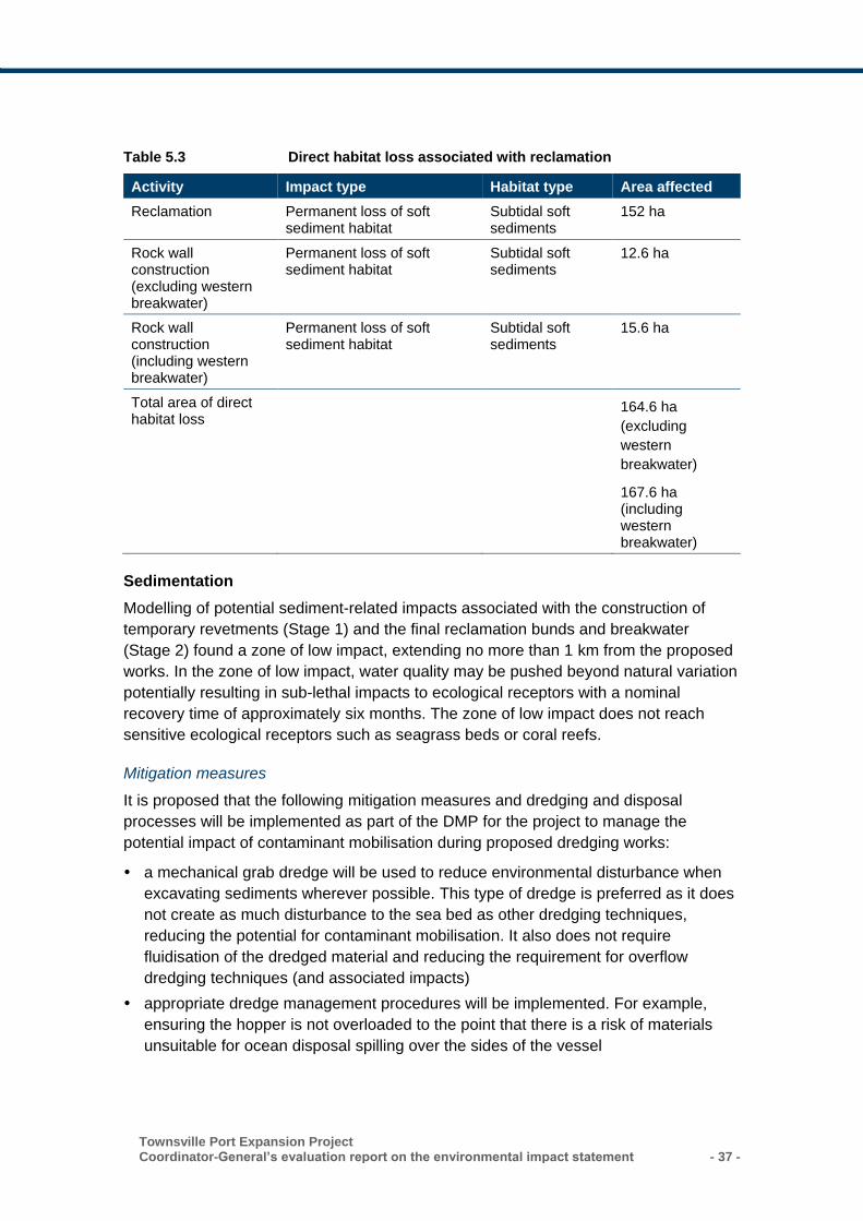
Townsville Port Expansion Project Coordinator-General’s evaluation report on the environmental impact statement - 37 -
Table 5.3 Direct habitat loss associated with reclamation
Activity Impact type Habitat type Area affected
Reclamation Permanent loss of soft sediment habitat
Subtidal soft sediments
152 ha
Rock wall construction (excluding western breakwater)
Permanent loss of soft sediment habitat
Subtidal soft sediments
12.6 ha
Rock wall construction (including western breakwater)
Permanent loss of soft sediment habitat
Subtidal soft sediments
15.6 ha
Total area of direct habitat loss
164.6 ha
(excluding
western
breakwater)
167.6 ha (including western breakwater)
Sedimentation
Modelling of potential sediment-related impacts associated with the construction of
temporary revetments (Stage 1) and the final reclamation bunds and breakwater
(Stage 2) found a zone of low impact, extending no more than 1 km from the proposed
works. In the zone of low impact, water quality may be pushed beyond natural variation
potentially resulting in sub-lethal impacts to ecological receptors with a nominal
recovery time of approximately six months. The zone of low impact does not reach
sensitive ecological receptors such as seagrass beds or coral reefs.
Mitigation measures
It is proposed that the following mitigation measures and dredging and disposal
processes will be implemented as part of the DMP for the project to manage the
potential impact of contaminant mobilisation during proposed dredging works:
a mechanical grab dredge will be used to reduce environmental disturbance when
excavating sediments wherever possible. This type of dredge is preferred as it does
not create as much disturbance to the sea bed as other dredging techniques,
reducing the potential for contaminant mobilisation. It also does not require
fluidisation of the dredged material and reducing the requirement for overflow
dredging techniques (and associated impacts)
appropriate dredge management procedures will be implemented. For example,
ensuring the hopper is not overloaded to the point that there is a risk of materials
unsuitable for ocean disposal spilling over the sides of the vessel
- 38 - Townsville Port Expansion Project
Coordinator-General’s evaluation report on the environmental impact statement
silt curtains will be used to prevent migration of turbid plumes when practicable
contaminated material will be placed in a separate bund with quality of tailwater
tested prior to release.
Mitigation measures to reduce the potential impacts associated with the reclamation
area include the management of tailwater discharge, use of sedimentation ponds and
the implementation of best practice sediment and erosion controls including the
following:
directing stormwater to sediment basins to eliminate off-site migration of sediment
staging the design and placement of sediment basins according to construction
schedules
controlling surface drainage from the reclaimed area through appropriate site
management (i.e. drainage reports to sediment ponds and drains are collected and
prevented from entering the sea by use of low bunds, sand bags or other temporary
control measures)
integrating on-site containment in the turbidity management/treatment that is
required for any discharge water.
The proponent’s approach to mitigating potential impacts to marine sediment quality
relies on a commitment to undertake further sediment testing prior to commencement
of works. Sampling and analysis of sediments would be governed by a Sampling
Analysis Plan developed in consultation with key stakeholders. If contaminated
hotspots are detected during sediment sampling and analysis, material would be
dredged only using a mechanical dredger and not a TSHD to reduce mobilisation of
contaminants.
I note that the NAGD-based sediment quality sampling rate and contaminant trigger
values are designed for mitigating impacts for oceanic (marine) disposal, not land-
based reclamation type disposal. It is therefore more appropriate for land-based
disposal of dredge spoil to be assessed against the National Environmental Protection
Measure guidelines using the trigger values appropriate for the final intended land use.
Tailwater
Excess water overlaying the dredge material would be discharged from the south-
eastern corner of the reclamation into the mouth of the Ross River and there is the
potential for contaminants to be released from this area. Testing of sediment prior to
placement, management of contamination and control on the release of tailwater would
be required to ensure adverse impacts are effectively mitigated.
Modelling presented in the EIS documentation simulated the release of tailwater from
the discharge area in a range of modelling scenarios from ‘expected case’ through to
‘worst case’. The results indicate that the suspended sediments discharged in the
tailwater would be minor relative to the natural level of turbidity in the receiving
environment.
While there would be some turbidity plumes generated by tailwater release, these are
localised near the tailwater discharge location and were of insufficient magnitude to
Townsville Port Expansion Project Coordinator-General’s evaluation report on the environmental impact statement - 39 -
generate impacts to any sensitive receivers, including intertidal seagrasses at the
mouth of the Ross River which are the sensitive receivers closest to the tailwater
discharge point.
Mitigation measures
Mitigation measures to reduce the impact of the project on marine water quality include
the following:
monitoring of dewatering, seepage or runoff waters as required
risk-based sampling of sediments within and adjacent to the project footprint
implementation of the construction environment management plan (CEMP) for
maritime works, such as marine piling, berth construction and breakwater
construction
implementation of a DMP during dredge construction periods that involve the
pumping of dredge material into the reclamation area
management of tailwater under a Tailwater Management Plan. Water being
discharged from the reclamation area (via a controlled discharge point) will be
monitored continuously for pH and other parameters.
The Port of Townsville Long Term Dredging and Disposal Management Plan would
provide the long-term spoil disposal strategy for the design life of the Port Expansion
Project (i.e. > 20 years). This Long Term Dredging and Disposal Management Plan
would continue to be regularly reviewed and updated as required.
Discharge of contaminated tailwater from the reclamation area was an issue raised in a
number of submissions. To address this concern, I have stated conditions which
specify the end of pipe limits to be achieved for a range of potential contaminants prior
to the release of tailwater.
Hydrodynamic impacts
There are a range of physical processes occurring in Cleveland Bay which may
potentially be impacted by the project, including hydrodynamics, marine sedimentation
and shoreline sedimentation processes. Hydrodynamic impacts relate to changes in
water levels, wave climate, currents and tidal exchanges.
The AEIS modelled three scenarios in the assessment of hydrodynamic impacts,
namely a Base Case (representative of conditions at the time of commencement of the
project), an Interim Case (at the conclusion of Stage 1) and an Ultimate Case (at the
conclusion of Stage 3 works).
Key findings of the assessment included the following:
the hydrodynamic impacts of the proposed port expansion are confined to changes
in velocity magnitude in the immediate vicinity of the proposed breakwaters and
reclamation area, as follows:
– in the ultimate case velocities to the north of the new north-eastern revetment are
reduced by up to 0.15 m/s
- 40 - Townsville Port Expansion Project
Coordinator-General’s evaluation report on the environmental impact statement
– velocities within the new port expansion harbour area are up to 0.2 m/s lower
than the Base Case due to the increases in depth and sheltering by breakwaters
– there are increases in velocity of up to 0.25 m/s relative to the Base Case to the
east of the proposed port expansion due to the diversion of tidal flows around the
reclamation area
water levels at all locations in the vicinity of the proposed works would not change
as a result of the project.
Coastal processes
The potential impact of the project on the wave climate in Cleveland Bay was raised in
a number of submissions. The revised design includes channel widening and as such
there was a requirement for impacts to be remodelled in the AEIS. The revised
modelling found that the widening of the Platypus and Sea Channels would not affect
the transmission or reflection of waves in Cleveland Bay and therefore the conclusions
of the EIS remain valid and appropriate for the AEIS.
The project would alter the bathymetry and hydrodynamics in the vicinity of the port.
Potential impacts primarily relate to the effect that reclamation and breakwater
structures and the altered harbour basin would have on sediment resuspension,
transport and deposition.
Ultimately, the project would redirect residual suspended sediment drift around the
reclamation area and there would be a small net reduction in fine sediment drift from
east to west. This is primarily a result of sediment being captured by the outer harbour
extension and widening and deepening of Platypus Channel.
Modelling of siltation impacts associated with the project found that a reduction in
siltation rates is likely in the inner harbour post Stage 1, with an increase in siltation of
Platypus and Sea Channels over the same period. The annual volume of sedimentation
occurring within the Platypus Channel is predicted to increase by around 20%, and by
13% in the Sea Channel following Stage 1.
Modelling also indicates that ultimately (post Stage 3) there would be a reduction in
siltation rates within the new enclosed outer harbour area, and an increase in siltation
in the Platypus and Sea Channel. The annual volume of sedimentation occurring within
the Platypus Channel is predicted to increase by around 26%, and within the Sea
Channel it is predicted to increase by around 65%. This is due to the increased channel
width and depth as part of the ultimate development.
Overall, this modelling indicates that the total quantity of siltation within all of the
dredged areas in the port combined would increase by around 14% relative to the
present situation. This would require a commensurate increase in maintenance
dredging volumes over time. The impacts of the expanded dredging program have
been considered in the EIS documentation.
An increase in the reclamation area between the EIS and AEIS raised in submissions
in relation to potential shoreline impacts, including impacts to alongshore sediment
transport.
Townsville Port Expansion Project Coordinator-General’s evaluation report on the environmental impact statement - 41 -
The existing port infrastructure has previously interrupted regional alongshore sand
transport to The Strand. Assessment of likely impacts to The Strand beach focused on
analysis of the effects on the local wave-induced sand transport rates relative to the
existing condition as established by those redevelopment works.
Updated modelling for the AEIS found that although the existing equilibrium condition
of zero alongshore sand transport may be altered, the fundamental stability of the
beach system along The Strand would not be compromised by the project with respect
to alongshore processes.
The revised wave modelling found that the reclamation area is not likely to result in any
substantive change to current processes which influence the condition of the shoreline
at the Ross River mouth and other areas to the east of the port.
Marine megafauna
Marine animals that swim near the water surface, such as whales, dolphins, dugongs
and turtles (collectively referred to as marine megafauna) could interact with the dredge
during capital dredging works.
Noise generated by construction activities for the project has the potential to impact
marine fauna in a number of ways including physiological damage, adverse
behavioural responses, physical damage and the masking of biologically important
sounds.
Noise modelling and measurements presented in the EIS and AEIS found that the
primary issue with respect to potential noise impacts is associated with pile driving
works during construction of the berth/wharf structures. In the absence of attenuation
measures, significant impacts could be expected on cetaceans, turtles and dugong
within 10 m of proposed works.
Marine megafauna that swim near the water surface could interact with vessels during
the operational phase of the project. In addition, the EIS (Section B.6.4.6) reported that
there are records of marine turtles being injured by TSHD.
Shipping traffic is expected to increase over the life of the project from 1-2 ship
movements per day to approximately 7 movements per day when the port reaches
operating capacity. This is compared to current timetabling for existing non-port ferry
traffic amounting to approximately 52 movements per day.
The EIS documentation found that the risk of boat strike is low given the infrequency of
vessels and that vessels such as the dredge are slow-moving, which would provide
marine fauna time to evade the approaching vessel.
Dredging will also form a persistent source of underwater noise, and will continue
(albeit intermittently) for the life of the project. Modelling completed for the AEIS
considered noise generated by a TSHD operating over a continual 24-hour period for
six months. The modelling found that, at distance less than 500 m from the TSHD
dredging activities there may be impairment to communication and/or bio-sonar
function in marine mammals. Shipping traffic may also impair communication and bio-
- 42 - Townsville Port Expansion Project
Coordinator-General’s evaluation report on the environmental impact statement
sonar function in marine mammals at times during which vessels are within 500m of
the fauna.
Mitigation measures
A range of mitigation measures are proposed which seek to reduce the impacts of the
project on marine megafauna generally, including maintaining a lookout for fauna while
the dredge sails, application of 300 m exclusion zones when marine mammals are
sighted, fitting of turtle deflectors on the draghead of the TSHD and limiting of lighting
levels for night-time works. These commitments will be reflected in a Marine
Megafauna Management Plan to be developed by the proponent in consultation with
DNPSR. The Marine Megafauna Management Plan will be developed in conjunction
with an appropriately qualified underwater noise consultant, and will include the
implementation of contemporary management measures.
Additional mitigation measures include:
water-based noise activities (pile driving in particular) will be commenced gradually
to provide warning to nearby marine megafauna (i.e. ramp-up/soft-start procedure)
noise mitigation measures to attenuate underwater noise such that the identified
hazard level can be reached as far as practicable, including:
– use of a resilient pad (dolly) will be used where feasible between the pile and
hammer head
– air curtains to attenuate noise levels where practicable
– dredge staging to manage piling noise.
Marine mammals (except dolphins which are highly mobile) and turtle observation and
response procedures including the application of a 300-m exclusion zone will be
implemented during dredging and placement activities. Dredging operations shall be
stopped where these fauna are observed within 300 m of the operating dredge until the
animals have moved further than 300 m or have not been sighted for 15 minutes. This
will be managed by a spotter positioned on the dredge itself. I am satisfied that this
approach would ensure that the incidence of vessel strike is avoided.
Acid sulfate soils
Dredging may result in the disturbance of PASS if sediments contained in the dredge
material are exposed to oxygen during the excavation and placement in the
reclamation area. If exposed, ASS releases large quantities of sulfuric acid and soluble
iron. Both substances can degrade the natural and built environment, and the acid can
mobilise other pollutants such as arsenic, lead and zinc; however, the degree of impact
would depend on the buffering capacity of the receiving environment. Acidic runoff and
other pollutants have the potential to reach the marine environment from the
reclamation area.
Mitigation measures
The dredging and construction of the reclamation area will be staged. An assessment
of the acid sulfate potential of subsurface sediments to be placed in the reclamation
Townsville Port Expansion Project Coordinator-General’s evaluation report on the environmental impact statement - 43 -
area would be carried out in accordance with the Guidelines for Sampling and Analysis
of Lowland Acid Sulfate Soils in Queensland.
This includes:
sampling of Pleistocene soils in dredge areas to confirm PASS status/management
requirements
placement of any PASS at the bottom of the reclamation area below the permanent
water table to prevent oxidisation and/or would be treated appropriately to ensure
neutralisation.
survey to confirm top of placed PASS. Where PASS is placed above lowest
astronomical tide (LAT), sample in accordance with relevant standards to confirm
the need for further management measures.
The proponent has also committed to the development of an Acid Sulfate Soils
Management Plan (ASSMP) in consultation with DEHP for the management and
monitoring of the reclamation area.
5.1.5 Coordinator-General’s conclusion
Capital and maintenance dredging
Marine water quality is an important environmental asset in Cleveland Bay and
surrounds due to the presence of a number of ecological receptors that are sensitive to
altered water quality conditions. These sensitive receptors include seagrass meadows,
which are located throughout Cleveland Bay, as well as reef communities (including
coral) at Middle Reef and Magnetic Island. The GBRMP is adjacent to the Port of
Townsville exclusion zone, and supports areas with high ecological values.
The EIS addressed the potential impacts of capital and maintenance dredging for the
project by modelling dredge plume and sediment deposition impacts to sensitive
receptors including coral reefs and seagrasses.
The assessment of potential dredging impacts was based on a ‘zones of impact’
approach recommended in GBRMPA modelling guidelines for the assessment of
dredging projects. The approach is based around the development of site-specific
threshold values using a combination of water quality (turbidity) and biological
tolerances of sensitive receptors. I am satisfied that the approach taken to assessing
the impact of dredging is both technically sound and suitable to inform the impact
assessment of potential impacts.
The assessment of dredging-related impacts concluded that seagrass beds and coral
reefs fall outside of the predicted zone of impact for all project stages – this means that
only minor impacts are expected on those values such as short-term exposure to
increased sediment loads from which recovery is likely to be rapid.
I have assessed the modelling presented for both unmitigated and mitigated scenarios
and I am satisfied that the impacts associated with long-term maintenance dredging
are minor when considered against background variability and can be effectively
managed.
- 44 - Townsville Port Expansion Project
Coordinator-General’s evaluation report on the environmental impact statement
To ensure the project does not have any adverse impacts due to capital dredging I
require all commitments incorporated into the EIS documentation and included in this
report to be fully implemented. The management of dredging involves multiple levels of
monitoring and review and is primarily managed under an EA.
A TAC would be established to oversee the dredging works for the project. The TAC
would be made up of subject matter experts charged with the responsibility of
continuously reviewing data relating to both water quality and ecosystem health. I have
stated conditions for the EA which set out the membership and role of the TAC. The
proposed terms of reference for the TAC is included in Appendix 4.
I have stated conditions for the EA requiring the proponent to develop a sediment
plume associated monitoring program in consultation with the TAC. The monitoring
program would specify the location of monitoring sites, sampling regime and approach
used to develop trigger values and validate modelling presented in the EIS
documentation. If trigger values are exceeded management action must be taken to
minimise or prevent plume generation and protect environmental values.
I have also stated a condition for the EA requiring a DMP to be developed and
implemented prior to the commencement of the dredging activity. The DMP will provide
a dredge-plant focused environmental management plan which seeks to protect
sensitive receptors. The DMP will also include a detailed description of the receiving
environmental monitoring program for water quality and sensitive receptors which sets
out the location of monitoring sites, sampling regime and methods, analytical
procedures and the assessment methodology for the monitoring data.
The DMP must be developed in consultation with the TAC. The DMP is to be submitted
to the DEHP for approval at least 40 days prior to the commencement of any dredging
activity.
If the condition of sensitive receptors is poor and resilience is low, the impacts of
dredging may be greater than predicted. To manage the risk posed by changing
environmental conditions, a re-assessment of environmental risks would be undertaken
immediately prior to major dredging operations. A RMP would require the works to be
adjusted or suspended to manage marine water quality if trigger levels are exceeded
during dredging. This approach would be combined with marine ecological assessment
of coral and seagrass health prior to, during and following major dredging events.
I have also stated conditions which require the proponent to develop water quality limits
at sensitive receptors in consultation with the TAC. This includes water quality limits to
achieve local water quality objectives for sites at locations at Geoffrey Bay, Florence
Bay, Cockle Bay and Picnic Bay off Magnetic Island as well as sites at Virago Shoal
and Middle Reef. The water quality limits are not to be exceeded for the life of the
dredging program.
The proponent will require an allocation notice which allows for the removal of quarry
material (predominantly silts and clays) below the high-water mark. I have set
conditions to address the potential impacts to the marine environment through both the
EA and Development Permit for Operational Works (Tidal Works in a coastal
Townsville Port Expansion Project Coordinator-General’s evaluation report on the environmental impact statement - 45 -
management district). Accordingly, I recommend that DEHP approve the allocation
notice for the maximum period of six years.
I am satisfied that the maintenance dredging requirements of the project are
unavoidable and necessary for the ongoing and efficient operation of the Port of
Townsville. I note that the potential impacts associated with the increased maintenance
dredging associated with the project do not exceed that already authorised under the
existing approvals held by the proponent.
Revetment rock wall, reclamation area and breakwaters
I am satisfied that the impacts of constructing revetments, establishing the reclamation
area and breakwaters were adequately assessed in the EIS documentation and can be
effectively managed.
The re-use of capital dredge material for reclamation works in the port area is
consistent with the SPD Act and Reef 2050 which prohibit sea-based disposal and
mandates disposal on land. Similarly, capital dredging within the regulated port limits of
Townsville is anticipated by Reef 2050.
Excess water overlaying the dredge material will be discharged from the south-eastern
corner of the reclamation into the mouth of the Ross River and there is the potential for
contaminants to be released from this area. Testing of sediment prior to placement,
management of contamination and control on the release of tailwater will be required to
ensure adverse impacts are effectively mitigated.
The Port of Townsville Long Term Dredging and Disposal Management Plan will
provide the long-term spoil disposal strategy for the design life of the Port Expansion
Project (i.e. >20 years). This Long Term Dredging and Disposal Management Plan will
continue to be regularly reviewed and updated as required.
I am satisfied that the proponent’s commitments relating to the management of dredge
material and monitoring of tailwater prior to release are sufficient to minimise the
impact of the proposed construction and filling of the reclamation area.
In order to ensure that discharge water released to the environment is of an acceptable
standard the proponent has committed to the development of a tailwater monitoring
program. All water from the reclamation area will be tested prior to release or retained
and treated to ensure compliance with surface water release limits.
I have stated conditions for the EA which describe the surface water release limits
which must be achieved prior to any release of tailwater from the reclamation area. End
of pipe water quality limits for tailwater release will ensure that environmental values
are protected.
In addition, I note the proponent’s commitment to develop and implement a CEMP,
operational environmental management plan (OEMP), an ASSMP and a sediment and
erosion control plan. I have stated a condition for the proponent to develop these
management plans and submit to DEHP prior to commencement of construction of the
reclamation area.
- 46 - Townsville Port Expansion Project
Coordinator-General’s evaluation report on the environmental impact statement
Sediment quality
I am satisfied that the EIS documentation is comprehensive in its assessment of risks
associated with sediment contamination and mobilisation and that these risks would be
effectively managed by the proponent.
The proponent’s approach to mitigating impacts to marine sediment quality relies on a
commitment to undertake further sediment testing prior to commencement of works.
Sampling and analysis of sediments will be governed by a sampling analysis plan
developed in consultation with key stakeholders. If contaminated hotspots are detected
during sediment sampling and analysis, material will be dredged only using a
mechanical dredger and not a TSHD to reduce mobilisation of contaminants to the
water column. If contaminated sediments are detected in dredge material, appropriate
steps will be taken to remediate the material prior to placement in reclamation.
To ensure that this commitment is met, I have stated a condition for the EA which
requires the characterisation of sediments and suitability for land-based disposal of
dredged material in accordance with guidelines specified by the administering authority
prior to the commencement of the dredging activity. The sediment sampling and
analysis plan must be submitted to the administering authority at least 40 days prior to
the commencement of any dredging program.
Coastal processes
I am satisfied that the EIS and AEIS appropriately considered potential impacts to
coastal processes and hydrodynamics. Further, I am satisfied that, against the
backdrop of existing port activity and natural variability, the impacts of the project on
coastal processes would be relatively minor in nature. Should the project result in
impacts to coastal processes and beach systems, there are a range of engineering
solutions available to redress these issues which may involve beach nourishment
works or coastal protection work, both of which would require development approvals.
I recommend that the proponent work with Townsville City Council to identify any
impacts to coastal processes and beach systems and the need for any beach
nourishment and coastal protection works.
Acid sulfate soils
The EIS documentation found that there is a low risk to potential acid sulfate soils at
some locations in the outer harbour and reclamation areas.
While the risk is low, I have stated conditions which must be adopted within the
environmental authority for the proponent to prepare a sediment sampling and analysis
plan. Based on the sediment sampling and analysis plan, the proponent must, develop
and implement an ASSMP that:
(a) complies with the current edition of the Queensland Acid Sulfate Soil Technical
Manual: Soil management guidelines
(b) achieves the surface water release limits for settled dredge tailwater set out in the
environmental authority.
Townsville Port Expansion Project Coordinator-General’s evaluation report on the environmental impact statement - 47 -
In addition, I require the excavation and placement of PASS or actual ASS to be
treated and managed to ensure that no untreated material is released to marine waters
or other natural receptors. This condition is also stated within the development permit
for operational works (tidal works).
5.2 Matters of state environmental significance
The project would require the deepening and widening of existing shipping channels
and the reclamation of approximately 167.6 ha of subtidal habitat characterised by soft
sediments. These activities have the potential to impact marine ecological values. The
project could also potentially impact on the intertidal habitat of migratory shorebirds
associated with the Ross River and the shoreline of Magnetic Island, impacting
terrestrial matters of state environmental significance (MSES).
5.2.1 Submissions received
The key issues regarding matters of state environmental significance raised in
submissions included the following:
• direct impacts of the project on habitats currently used by protected shorebirds,
primarily the existing reclamation area and ponds
• indirect impacts of the project on nearby habitat for migratory shorebirds of the
Ross River and Magnetic Island
• disruption to avifauna behaviour and movement patterns as a result of construction
and operation
• impacts of dredging on sensitive receptors including coral reefs and seagrass beds
• impacts to marine turtles and turtle habitats
• impacts to nearshore dolphins and other marine megafauna
• potential impacts associated with the spread of invasive species
• the suitability of proposed offsets to manage residual impacts
• consideration of offsets in terrestrial fauna species management.
I have considered each submission and the responses provided by the proponent in
my evaluation of the project and my assessment is provided in the relevant sections
below.
Submissions described above which relate primarily to impacts to the marine and
coastal environment are addressed in Section 5.1 of this report.
5.2.2 Existing environment
Protected and environmentally sensitive areas near the project are described in Table
5.4.
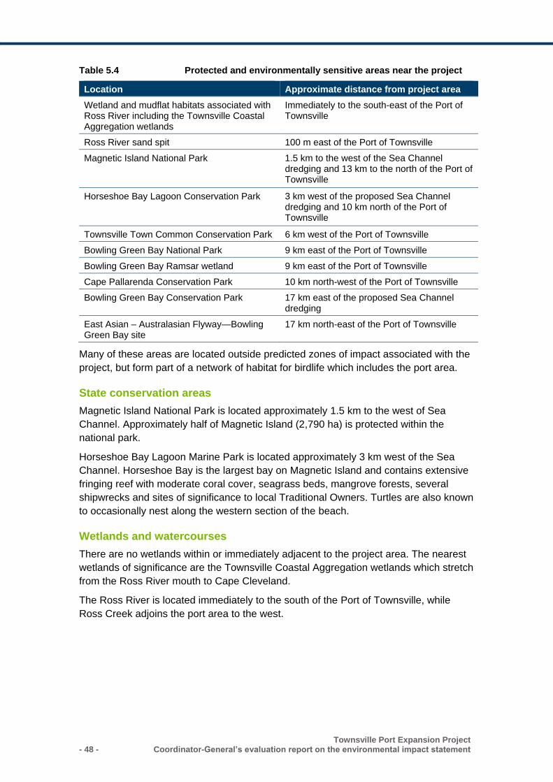
- 48 - Townsville Port Expansion Project
Coordinator-General’s evaluation report on the environmental impact statement
Table 5.4 Protected and environmentally sensitive areas near the project
Location Approximate distance from project area
Wetland and mudflat habitats associated with Ross River including the Townsville Coastal Aggregation wetlands
Immediately to the south-east of the Port of Townsville
Ross River sand spit 100 m east of the Port of Townsville
Magnetic Island National Park 1.5 km to the west of the Sea Channel dredging and 13 km to the north of the Port of Townsville
Horseshoe Bay Lagoon Conservation Park 3 km west of the proposed Sea Channel dredging and 10 km north of the Port of Townsville
Townsville Town Common Conservation Park 6 km west of the Port of Townsville
Bowling Green Bay National Park 9 km east of the Port of Townsville
Bowling Green Bay Ramsar wetland 9 km east of the Port of Townsville
Cape Pallarenda Conservation Park 10 km north-west of the Port of Townsville
Bowling Green Bay Conservation Park 17 km east of the proposed Sea Channel dredging
East Asian – Australasian Flyway—Bowling Green Bay site
17 km north-east of the Port of Townsville
Many of these areas are located outside predicted zones of impact associated with the
project, but form part of a network of habitat for birdlife which includes the port area.
State conservation areas
Magnetic Island National Park is located approximately 1.5 km to the west of Sea
Channel. Approximately half of Magnetic Island (2,790 ha) is protected within the
national park.
Horseshoe Bay Lagoon Marine Park is located approximately 3 km west of the Sea
Channel. Horseshoe Bay is the largest bay on Magnetic Island and contains extensive
fringing reef with moderate coral cover, seagrass beds, mangrove forests, several
shipwrecks and sites of significance to local Traditional Owners. Turtles are also known
to occasionally nest along the western section of the beach.
Wetlands and watercourses
There are no wetlands within or immediately adjacent to the project area. The nearest
wetlands of significance are the Townsville Coastal Aggregation wetlands which stretch
from the Ross River mouth to Cape Cleveland.
The Ross River is located immediately to the south of the Port of Townsville, while
Ross Creek adjoins the port area to the west.
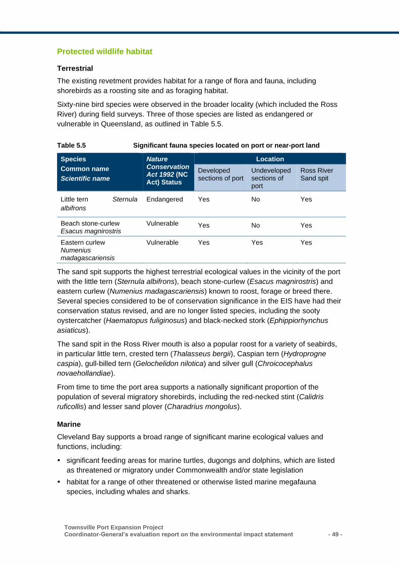
Townsville Port Expansion Project Coordinator-General’s evaluation report on the environmental impact statement - 49 -
Protected wildlife habitat
Terrestrial
The existing revetment provides habitat for a range of flora and fauna, including
shorebirds as a roosting site and as foraging habitat.
Sixty-nine bird species were observed in the broader locality (which included the Ross
River) during field surveys. Three of those species are listed as endangered or
vulnerable in Queensland, as outlined in Table 5.5.
Table 5.5 Significant fauna species located on port or near-port land
Species
Common name
Scientific name
Nature Conservation Act 1992 (NC Act) Status
Location
Developed sections of port
Undeveloped sections of port
Ross River Sand spit
Little tern Sternula
albifrons
Endangered Yes No Yes
Beach stone-curlew Esacus magnirostris
Vulnerable Yes No Yes
Eastern curlew Numenius madagascariensis
Vulnerable Yes Yes Yes
The sand spit supports the highest terrestrial ecological values in the vicinity of the port
with the little tern (Sternula albifrons), beach stone-curlew (Esacus magnirostris) and
eastern curlew (Numenius madagascariensis) known to roost, forage or breed there.
Several species considered to be of conservation significance in the EIS have had their
conservation status revised, and are no longer listed species, including the sooty
oystercatcher (Haematopus fuliginosus) and black-necked stork (Ephippiorhynchus
asiaticus).
The sand spit in the Ross River mouth is also a popular roost for a variety of seabirds,
in particular little tern, crested tern (Thalasseus bergii), Caspian tern (Hydroprogne
caspia), gull-billed tern (Gelochelidon nilotica) and silver gull (Chroicocephalus
novaehollandiae).
From time to time the port area supports a nationally significant proportion of the
population of several migratory shorebirds, including the red-necked stint (Calidris
ruficollis) and lesser sand plover (Charadrius mongolus).
Marine
Cleveland Bay supports a broad range of significant marine ecological values and
functions, including:
significant feeding areas for marine turtles, dugongs and dolphins, which are listed
as threatened or migratory under Commonwealth and/or state legislation
habitat for a range of other threatened or otherwise listed marine megafauna
species, including whales and sharks.
- 50 - Townsville Port Expansion Project
Coordinator-General’s evaluation report on the environmental impact statement
Dugong
Dugong (Vulnerable, NC Act) are relatively abundant in Cleveland Bay, particularly
over the seagrass meadows nearest Cape Cleveland. They occur throughout
Cleveland Bay as they move between seagrass meadows in and outside the bay.
Although there are no published population estimates for dugong in Cleveland Bay, the
greatest density of dugongs has been recorded in eastern Cleveland Bay with medium
densities noted from Cape Pallarenda.
The entire area of Cleveland Bay is located within the Cleveland Bay Dugong
Protection Area under the NC Act, which is a Zone ‘A’ Dugong Protection Area. This
designation restricts the grant of permits, licences or authorities to take or use
protected wildlife, with the intention of limiting threatening processes that may affect the
dugong and its habitat.
Nearshore dolphins
Both the Australian snubfin dolphin (Orcaella heinsohni) (Vulnerable, NC Act) and the
Australian humpback dolphin (Sousa sahulensis) (Vulnerable, NC Act), are common in
nearshore environments throughout Cleveland Bay, and are likely to regularly feed in
the port area and adjacent to the mouths of Ross Creek and Ross River.
The EIS reported that the estimate for the Australian snubfin dolphin ‘sub-population’ in
2002 in Cleveland Bay was 63 individuals of a total of several thousand individuals in
Queensland. The Indo-Pacific humpback dolphin sub-population in Cleveland Bay
during 2002 was 54 individuals.
The EIS concluded that observations of recurrent use of Cleveland Bay by adult and
calf Australian snubfin and humpback dolphins for foraging indicates that this area,
particularly around the mouth of Ross Creek and River, is an important habitat area for
both species.
Marine turtles
The EIS notes that six species of marine turtle are known to use Cleveland Bay as a
feeding ground. These species have been recorded in offshore, nearshore and
intertidal habitats in Cleveland Bay. The EIS reported that an estimated 416 individual
turtles are present in Cleveland Bay on average, with over 90% of these likely to be
green turtles. The highest number of turtles recorded occurs near seagrass and reef
habitats, namely at Cockle Reef (southern Magnetic Island), at seagrass meadows
between The Strand and Cape Pallarenda, in central Cleveland Bay and on coastal
seagrass meadows near Cape Cleveland. Other sea turtle species represented
approximately 10% of the total number of sea turtles in Cleveland Bay.
Cleveland Bay is not an important turtle breeding area, with most turtles in the region
believed to have originated from rookeries elsewhere on the central and north
Queensland coast and islands, or in other countries. The exceptions to this are flatback
and green turtles which nest at low densities on a number of sandy beaches adjacent
to the study area and surrounds, including Magnetic, Herald and Rattlesnake Islands,
The Strand and Australian Institute of Marine Science (AIMS) Beach on Cape
Cleveland.
Townsville Port Expansion Project Coordinator-General’s evaluation report on the environmental impact statement - 51 -
Regulated vegetation and connectivity areas
There is no regulated vegetation within the project footprint, with the nearest remnant
vegetation located approximately 1 km south of the port expansion area at the Ross
River mouth. There are no connectivity areas within the project footprint.
Offset areas
The project area does not contain any legally secured offset areas.
Highly protected zones of state marine parks
A highly protected area of a relevant Queensland marine park is a MSES. Highly
protected area means:
(a) a zone classified, under the Marine Parks Act 2004, as a conservation park zone,
marine national park zone or preservation zone, or
(b) another area prescribed under a regulation or zoning plan, under the Marine
Parks Act 2004, as a highly protected area.
The Great Barrier Reef Coast Marine Park is a state marine park that runs the length of
the Commonwealth GBRMP, and encompasses tidal waters up to highest astronomical
tide. The Great Barrier Reef Coast Marine Park is managed under the Marine Parks
(Great Barrier Reef Coast) Zoning Plan 2004 as a multiple use marine park.
The project is located within a port exclusion zone and is therefore outside of the
Commonwealth GBRMP and state marine park.
Fish habitat areas
An area declared under the Fisheries Act 1994 to be a fish habitat area (FHA) is a
MSES. The Cleveland Bay Fish Habitat Area covers an area of 28,810 ha and
stretches from south-east of the Ross River to Cape Cleveland including Sandfly,
Alligator, Crocodile and Cocoa Creeks and the Blacksoil and Salmon Creek coastal
wetland systems adjacent to Bowling Green Bay. This FHA was declared in 2008 to
ensure the protection of valuable commercial, recreational and Indigenous fisheries
resources; wetlands buffer zone from industrial and residential development; protection
of remaining undisturbed habitat. The project area is located approximately 1 km west
of the FHA.
Marine plants
A marine plant within the meaning of the Fisheries Act 1994 is a MSES. The
investigations for the EIS concluded that no marine plants are present in the
development footprint and therefore a development permit for removal, destruction or
damage of marine plants is unlikely to be required.
- 52 - Townsville Port Expansion Project
Coordinator-General’s evaluation report on the environmental impact statement
5.2.3 Assessment methodology
Significant residual impact assessment
The Environmental Offsets Act 2014 outlines the framework for state environmental
offsets and how they should be provided. The provision of an offset should only be
required following reasonable efforts to minimise, mitigate and avoid impacts.
Significant residual impact (SRI) guidelines are used to determine the significance of a
residual impact on MSES values from prescribed activities. An environmental offset is
required when an SRI considered likely to occur.
The SRI guideline is applied to development assessment under the Planning Act. The
SRI guideline was used to inform the EIS and assess the potential for impacts to MSES
values.
5.2.4 Impacts and mitigation
Shorebirds
Direct impacts to shorebirds during construction will be limited to the removal of the
existing north-eastern revetment (1,296 m) which is devoid of vegetation. Although
generally of low value from a terrestrial ecological viewpoint, this area does support
temporary ponds and rock walls used by shorebirds such as the sooty oystercatcher
(Haematopus fuliginosus), grey-tailed tattler (Tringa brevipes), common sandpiper
(Actitis hypoleucos), striated heron (Butorides striata) and whimbrel (Numenius
phaeopus).
The EIS reported that existing reclamation and constructed revetments, including the
existing reclamation ponds, are known to support a local population of migratory
shorebirds. The revetments, approximately 1,296 m long, will be temporarily disturbed
during project construction.
During construction of the new revetments, birds that use the space around the port
are likely to be displaced to the primary roosting site on the Ross River sand spit. This
potential impact will be temporary, as a new and longer revetment (2,912 m) will be
constructed. I accept the proponents’ view that this short-term loss in roosting area
poses a low risk to local populations of shorebirds. The AEIS concluded that shorebirds
frequenting the project area are known, in greater numbers, from nearby higher quality
habitat areas such as the Ross River sandspit and furthermore that habitat areas in the
wider region are capable of accommodating increases in shorebirds.
Submissions also raised issues relating to the potential impacts of noise, vibration and
light emissions on terrestrial fauna during both construction and operation of the
project. This primarily related to the disturbance of migratory shorebirds.
Although highly mobile, a constant disruption to foraging, breeding or roosting
behaviours means that birds may waste energy relocating; this is a concern for
migratory birds that must conserve energy reserves for their long migrations.
Townsville Port Expansion Project Coordinator-General’s evaluation report on the environmental impact statement - 53 -
The AEIS concluded that, while noise and vibration may have the effect of dissuading
bird visitation to a site, there is no evidence that past and current port activities have
the effect on the shorebird populations of the Ross River estuary. I have considered
this finding against relevant studies and guidelines, and consider it likely that the
separation of the proposed port expansion from the key shorebird habitat by a distance
of approximately 1 km is likely to attenuate potential noise impacts.
Artificial night-time light, while essential for worker and shipping operational safety, has
the potential to affect migratory birds through behavioural disturbance and
disorientation. The EIS, in considering this issue, included an assessment of existing
sources and modelled the impacts of predicted light spill associated with the project.
The modelling found that, at a distance of 270 m from the port expansion infrastructure,
the lighting level is equivalent to moonlight. At a distance of 1 km, potential lighting
impacts associated with the project are likely to be minor and are not expected to
exceed natural levels in key shorebird habitats.
Submissions raised the issue of potential indirect impacts of the project on flora and
fauna due to altered hydrology and sedimentation on mudflats and sand banks, the
spread of invasive species and noise, vibration and light emissions from construction
activities. I have considered these potential impacts individually below.
The EIS reports that the Ross River sand spit is defined as one of the top 40 roost sites
for shorebirds along the east coast of Queensland because it is regularly frequented by
around 2,000 shorebirds. The threatened little tern (Sternula albifrons), beach stone-
curlew (Esacus magnirostris) and eastern curlew (Numenius madagascariensis) either
roost, forage and/or breed on the Ross River sand spit.
Modelling shows that, even under the worst-case scenario, the project is unlikely to
change the way sediment is deposited in the area to the south of the port, specifically
the Ross River sand spit.
The AEIS modelled sediment movement and wave climate based on the revised
project design. The revised modelling found that the reclamation area is not likely to
result in any substantive change to the long term morphological condition at the Ross
River mouth. The existing state of shoreline progradation (expansion in a seaward
direction) at the Ross River mouth will also be maintained. I am satisfied that the
project will not alter coastal processes to the extent that shorebird habitats will be
significantly altered or lost.
Submissions also expressed concern relating to the discharge of tailwater from the
reclamation area into the Ross River. This issue is addressed in Section 5.1 of this
report.
Magnetic Island National Park is located approximately 1 km west of the dredging work
for the Sea Channel. Approximately 55% of Magnetic Island is national park. Parts of
Magnetic Island provide foraging and roosting habitat for migratory shorebirds,
including those that use the East Asian - Australasian Flyway.
The areas of the island which are most likely to be impacted by the project are the
intertidal areas on the coastline of the island, which may be potentially impacted as a
result of project dredging.
- 54 - Townsville Port Expansion Project
Coordinator-General’s evaluation report on the environmental impact statement
The impact assessment presented in the AEIS found that sediment deposition would
not impact sensitive ecological receptors associated with Magnetic Island.
Analysis of aerial photography undertaken as part of the AEIS also revealed that there
is no clear trend of expansion or contraction of the beaches on Magnetic Island
associated with dredging activity. The numerical modelling completed for the AEIS
supports the view that accumulation of dredged sediment is unlikely to occur on
Magnetic Island beaches. As such, adverse impacts to intertidal habitats, and therefore
potential impacts to migratory shorebird habitats on Magnetic Island are not expected.
Mitigation measures
The proponent has committed to develop measures to reduce potential noise, vibration
and accidental exposures to fauna during both construction and operation of the
project, including:
keeping equipment in good working condition and implementing general good site
working practices to reduce noise and vibration
shielding light sources and/or redirecting light away from adjacent foreshore
environments
managing lighting and, particularly, lighting design to reduce light spill from the site
in accordance with Australian Standards.
Submissions also raised potential issues relating to the discharge of tailwater from the
reclamation area into the Ross River. Excess water overlaying the dredge material will
be discharged from the south-eastern corner of the reclamation area into the mouth of
the Ross River and there is the potential for contaminants to be released from this
area. Testing of sediment prior to placement, management of contamination and
control on the release of tailwater will be required to ensure adverse impacts are
effectively mitigated.
Marine turtles
Potential impacts to turtles during construction relate primarily to capital dredging,
which is addressed in Section 5.1 of this report. Dredge sediment has the potential to
impact preferred foraging habitats of marine turtles, particularly seagrass beds and
coral reefs.
While turtles are typically most abundant around seagrass meadows and reefs, they
also traverse navigation channels as they move between feeding areas between
Magnetic Island and eastern Cleveland Bay. Turtles may also rest in channel areas, or
head to deeper waters (i.e. bottom of the channel) for refuge when disturbed. This
behaviour increases their susceptibility to vessel strike by ships.
Marine turtles are particularly sensitive to artificial lighting during nesting and hatching
and may be impacted by light spill associated with the project. As discussed above, the
EIS included an assessment of existing light sources and modelled the impacts of
predicted light spill associated with the project.
Townsville Port Expansion Project Coordinator-General’s evaluation report on the environmental impact statement - 55 -
Mitigation measures
The primary mitigation measure which reduces the potential impact of the project on
turtle habitat is the minimisation of turbid plumes generated by dredging activity and
subsequently minimising associated sediment settlement in key habitat areas. The
management of potential dredging impacts is discussed in Section 5.1 of this report.
Proposed mitigation measures to address potential lighting impacts include:
shielding and redirecting of the light source
use or directional fixtures that point down and away from the water wherever
possible
replacement of incandescent, fluorescent, and high-intensity lighting with the lowest
wattage practicable.
Light spill will be managed in accordance with Australian Standards and I am satisfied
that potential impacts can be satisfactorily managed.
Other measures relevant to marine turtles include fitting of marine turtle deflectors on
the draghead of the TSHD, establishment of exclusion zones and management
strategies to reduce the potential impact of underwater noise.
Nearshore dolphins
The EIS and AEIS found that greatest biodiversity values supported in areas to be lost
or disturbed is the provision of habitat for the two state-listed vulnerable nearshore
dolphins Australian snubfin dolphin (Orcaella heinsohni) and Australian humpback
dolphin (Sousa sahulensis). Waters surrounding the Port of Townsville, as well as the
mouths of Ross Creek and Ross River, represent locally important feeding areas for
both species.
I find that the project could potentially cause disruption to an ecologically significant
location (primarily associated with the loss of 167.6 ha of feeding habitat) of both
species of nearshore dolphins. The EIS concluded that the Cleveland Bay environment
has consistently been recognised as an important habitat for Australian snubfin and
Australian humpback dolphins of various age classes. Previous research and current
project data indicate waters close to Ross Creek and Ross River mouth represent the
most important habitat for Australian snubfin and Australian humpback dolphins within
Cleveland Bay.
The significance of the Cleveland Bay sub-population of both species is elevated by
recent research which finds that little interaction is occurring between subpopulations of
snubfin and Australian humpback dolphins along the Queensland coast. These
subpopulations have been reported to be discrete and therefore if a local population
declines, it is not expected to be repopulated by other regional populations.
Spread of invasive species
Submissions raised issues that the movement of vehicles and machinery has the
potential to introduce and disperse weed (seeds and propagules) into the project area,
as well as along the access route through parts of Townsville.
- 56 - Townsville Port Expansion Project
Coordinator-General’s evaluation report on the environmental impact statement
Mitigation measures
Management of weeds and pests will be achieved by the implementation of a range of
established measures such as inspections and wash-down of machinery and plant and
routine control of new infestations. These measures are detailed in CEMPs and
OEMPs. I consider the management of weeds and pests to be a routine aspect of site
environmental management, and furthermore that there are preventative and corrective
actions are available to manage risks from terrestrial weeds as part of day-to-day
management of environmental aspects on the project site.
Although the establishment of weeds on reclaimed project land during construction is
possible, I consider the risk to be low.
5.2.5 Coordinator-General’s conclusion
Terrestrial ecology
The principal impact of the project on terrestrial ecological values is the temporary
removal of revetment and shoreline habitat. Shorebirds will be temporarily displaced
from the man-made habitat on existing strategic port land. However, given that there
are many other roosting/foraging sites nearby, and that the total revetment area will
increase as a result of the project, I find that the impact is minor and temporary in
nature.
I am satisfied that the proponent’s commitments in relation to the management of
indirect dredging and water quality-related impacts are adequate to prevent adverse
impacts to the nearby habitats of migratory shorebirds.
I have stated conditions for the EA which describe the outcomes to be achieved at
sensitive receptors for the life of the dredging program. Effective management of the
dredging program would ensure that the habitat of migratory shorebirds is protected.
I am also satisfied that the potential project impacts of noise, vibration and lighting
levels on key shorebird habitats 1 km from the project site, can be satisfactorily
managed.
The issue of offsets for terrestrial MSES was addressed in the AEIS in response to
submissions. The project will not impact on regulated vegetation, connectivity areas,
wetlands or watercourses. There will, however, be a potential impact on foraging and
roosting habitat for the little tern, beach stone-curlew and eastern curlew.
I am satisfied that the potential impact on the habitat of these species will be temporary
and minor in nature. Assessment against the criteria for protected wildlife habitat
indicates that a significant residual impact on these species is unlikely. I support the
conclusion of the AEIS that the project is not expected to have a significant residual
impact on these species, or other MSES, and therefore, an offset is not required for
terrestrial MSES.
Marine ecology
I am satisfied that the assessment of potential impacts to marine ecological values
undertaken in the EIS and AEIS is sufficient. The impact assessment on sensitive
Townsville Port Expansion Project Coordinator-General’s evaluation report on the environmental impact statement - 57 -
receptors such as seagrass beds and coral reefs, which employed the ‘zones of
impact’ approach recommended by the GBRMPA, provides a sound platform for
assessing the consequences of the project on sensitive receptors and the species
which rely on those ecosystems. I am also satisfied the proposed mitigation measures,
which include the modification or cessation of dredging in response to monitoring, will
protect marine ecological values and ensure potential impacts are appropriately
managed.
Reclamation will result in the localised loss of soft sediment subtidal habitat and
foraging areas for two vulnerable species of nearshore dolphins, resulting in
displacement of dolphins foraging in the proposed development footprint of
approximately 167.6 ha.
While other project-related impacts can be adequately mitigated, the predicted
permanent loss of approximately 167.6 ha of habitat for the nearshore dolphins would
represent a SRI of the project. These species are also matters of national environment
significance and impacts would be managed by the Commonwealth Department of the
Environment and Energy (DEE).
I note that DEE will be considering offset conditions relating to significant residual
impacts to a number of threatened and migratory species. I have recommended that
the DILGP impose conditions on development permits requiring the proponent to
deliver offsets for any MSES under the Environmental Offsets Act 2014 which is not
considered by the DEE to ensure that offset requirements are not duplicated.
I am satisfied with the assessment undertaken on other MSES within the study area
and that any potential adverse impacts could be reduced or avoided employing the
mitigation measures included in the proponent’s commitments (Appendix 3).
5.3 Land use
The EIS documentation detailed the existing environment and identified potential land
use impacts resulting from the construction and operation of the project.
5.3.1 Submissions received
The key issues regarding land use impacts raised in submissions on the EIS and AEIS
included the following:
any decision on the proposal should be postponed until the Townsville Port Master
Plan is in place
I have considered the submissions raised, mostly in relation to the timing of the project
and the development of the Townsville Port Master Plan. My assessment is provided in
the relevant sections below.
- 58 - Townsville Port Expansion Project
Coordinator-General’s evaluation report on the environmental impact statement
5.3.2 Existing environment
Land use
The port was established in 1864 to service the newly settled rural hinterland through
the export of agricultural products. The existing port includes 311 ha of strategic port
land that provides for material storage and other support infrastructure to the berths,
and the reclamation area. The port has eight operational berths characterised by
several specialised facilities, including bulk handling facilities.
Native title
The area of seabed to be occupied by the project is presently unallocated state land.
The proponent would apply for a perpetual lease for the reclamation area pursuant to
section 24HA of the future provisions of the Native Title Act 1993 (Cwlth). POTL
intends to further negotiate an Indigenous Land Use Agreement (ILUA) with traditional
owners at the time freehold title is sought for the reclaimed land.
Tenure
The existing land tenure for the port is predominantly freehold with some perpetual
leases. Other classes of tenure that exist within and around the port include leasehold,
reserves and state land; as shown in Figure 5.3. Much of the land surrounding the port
is fragmented into smaller, largely developed lots primarily for low to medium density
dwellings. The reclamation area will be classified as unallocated state land when it is
constructed.
5.3.3 Queensland planning framework
Regional planning
The Queensland Government is currently preparing the North Queensland Regional
Plan which will be a statutory document covering the Townsville local government area.
Regional plans set the long-term strategic direction to guide how the region will grow
and respond to change over time by ensuring good planning outcomes are delivered.
While a draft regional plan has not been released, it is anticipated that the regional plan
will support the ongoing functions of the Port of Townsville.
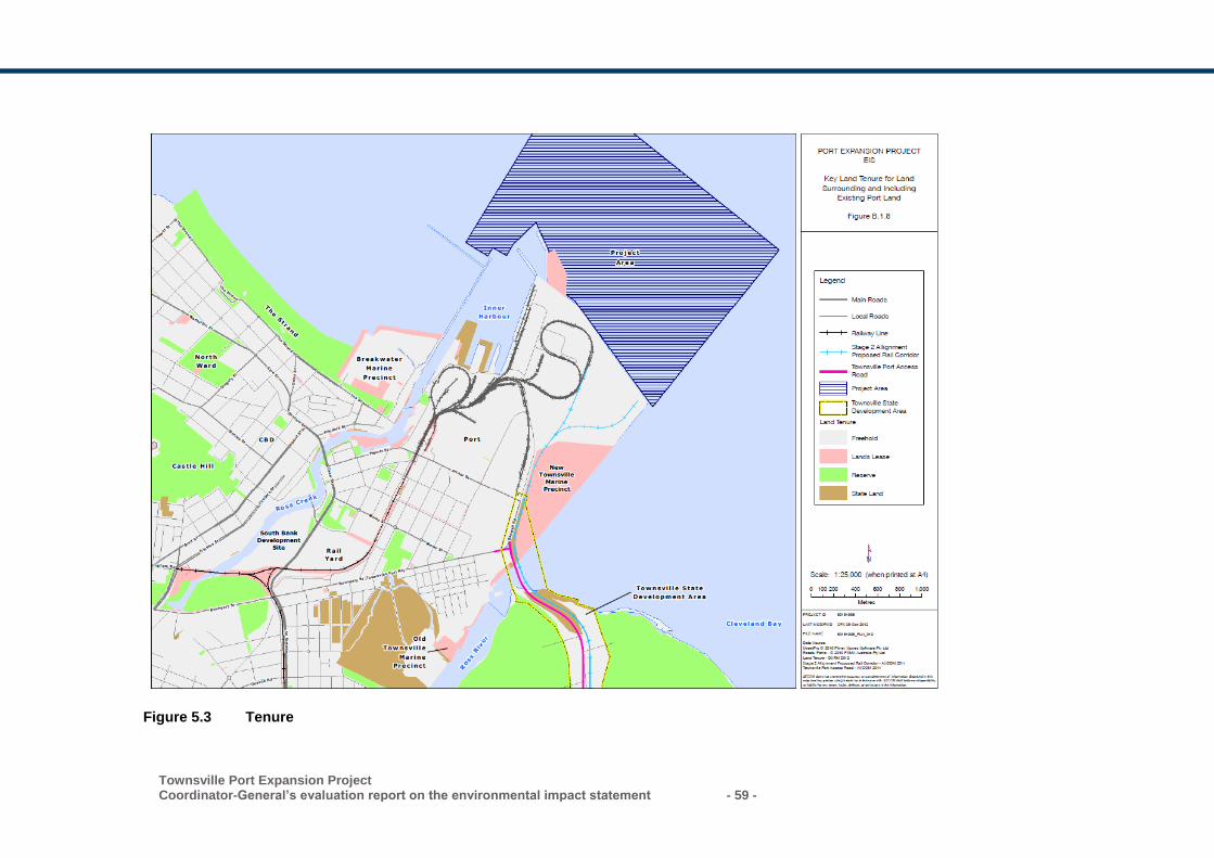
Townsville Port Expansion Project Coordinator-General’s evaluation report on the environmental impact statement - 59 -
Figure 5.3 Tenure
- 60 - Townsville Port Expansion Project
Coordinator-General’s evaluation report on the environmental impact statement
Port of Townsville Land Use Plan
The Port of Townsville Land Use Plan 2013 is prepared in accordance with the
provisions of the TI Act and provides a framework for the assessment of development
on strategic port land. Development on strategic port land is exempt from the
provisions of the Townsville City Plan and identifies the port authority as the
assessment manager.
The land immediately adjoining the proposed reclamation area is designated as port
industry and port operations (including the inner harbour). The EIS states that the
project does not require changes to any existing land uses within the port.
The land use plan identifies the port expansion project as future strategic port land.
Future development will be guided by a more detailed master plan currently being
prepared in cooperation with Townsville City Council.
It is anticipated that once a title has been created for the reclaimed land and it has
been incorporated into strategic port land, the land will adopt a zoning that is
commensurate with existing zones for similar port activity.
The port authority will be responsible for the development of the project in terms of
dredging and reclamation activities. The port authority will also be responsible for the
development of wharves and associated port infrastructure. Proponents for new
facilities within the port will be responsible for additional approvals related to those
facilities including compliance with the port master planning process once the port
overlay has been developed for the Port of Townsville.
To ensure that state and regional interests are maintained and protected, the Port of
Townsville Land Use Plan will require updating to reflect the North Queensland
Regional Plan when it is released.
Priority Port Master Plan
The SPD Act was passed by the Queensland Government in November 2015 to
manage port-related development in and adjacent to the GBRWHA. The SPD Act
identifies the Port of Townsville as a priority port and outlines a master planning
process to protect environmental values and support future long-term sustainable
development, consistent with the principles of ecologically sustainable development.
Under the SPD Act, the master plan document would establish the long-term strategic
vision and the port overlay would operate as a regulatory instrument to implement the
master plan within an identified master planned area. The master planned area may
include the port’s strategic port land under the TI Act, land within the state development
area (SDA) or priority development area (PDA). The master planned area may also
include marine areas but cannot include an area covered by tidal water that is outside
the port’s limits or an area within a Commonwealth marine park or a state marine park,
even if the area is within port limits.
Townsville State Development Area
The Townsville SDA supports economic development in a way that considers
environmental, cultural and social issues as well as existing industry and surrounding
Townsville Port Expansion Project Coordinator-General’s evaluation report on the environmental impact statement - 61 -
infrastructure within the region. The development scheme for the Townsville SDA
provides the statutory controls for development applications to carry out material
change of use or carry out operational works within the Townsville SDA. The
development scheme is administered by the Coordinator-General and includes code
provisions that are considered in the assessment of such applications. The south-east
portion of the existing port land is within the SDA. Any future activities triggering
regulated development will require approval in accordance with the SDA development
scheme.
Townsville City Waterfront Priority Development Area
The Townsville City Waterfront PDA development scheme is applicable to all
development on land and water within the boundaries of the PDA. The PDA covers
land located on both sides of Ross Creek from Quayside Terminal in the east to
Townsville Railway Station to the west. Currently, the south-western portion of the
Strategic Port Land with a Special Use Zone falls within the boundary of the PDA. The
Minister for Economic Development Queensland (MEDQ) through the Economic
Development Act 2012 has delegated development assessment powers to Townsville
City Council (TCC) for a sizable portion of the PDA. Schedule 5 of the PDA
development scheme maps illustrates the area of responsibility.
Whilst the project is not likely to trigger an assessment under the PDA development
scheme, any future development within the port’s Special Use Zone that will be located
with the boundary of the PDA may require development assessment approval through
MEDQ or TCC.
Townsville City Plan
The Townsville City Plan is the local planning scheme that currently applies to
development on land around the port that is non-strategic land. Any future development
approval triggering assessment by TCC will need to comply with the requirements
under the Townsville City Plan.
5.3.4 State Development Assessment Provisions
The State Development Assessment Provisions (SDAP) provide for specific matters of
state interest and further detail the code assessment criteria for assessable
development and referral requirements.
The SDAP assessment criteria are contained in standalone state codes which are
broadly grouped into locational, use-based or advice only. The SDAP is a statutory
document and is prescribed in the Planning Regulation.
The modules relevant to the project are:
State code 7 – Maritime safety
State code 8 – Coastal development and tidal works
State code 11 – Removal, destruction or damage of marine plants
State code 22 – Environmentally relevant activities.
- 62 - Townsville Port Expansion Project
Coordinator-General’s evaluation report on the environmental impact statement
Maritime safety
State code 7 of the SDAP ensures development supports the safe operation of vessels
in navigable waterways. The port is an existing operation and would ensure that
existing and future lighting would not interfere with the safe navigation of vessels. The
proposed development would enable larger vessels to enter and exit the port therefore
ensuring the safe movement of vessels.
Maritime Safety Queensland (MSQ) have statutory responsibilities under the various
maritime safety and transport operations Acts. It is a requirement that the proponent
develop vessel management plans in consultation with the regional harbour master and
MSQ as the proposed development includes the construction of a western breakwater.
These include:
a vessel traffic management plan
aids to navigation
ship-sourced pollution prevention/spill management.
The proponent must implement all impact mitigation measures necessary to avoid
adverse impacts to the safety, condition and efficiency of shipping in Queensland
waters. The project is generally consistent with the acceptable outcomes of state code
7. I recommend that the proponent continue to consult with the regional harbour master
regarding these issues.
Coastal development and tidal works
State code 8 of the SDAP maintains and conserves coastal processes and avoids
impacts to matters of state environmental significance.
Erosion prone area
The project is located within a coastal management district and is located within the
erosion prone area and medium storm tide inundation area. Development should not
occur in the erosion prone area unless the development is one of the following:
coastal-dependent development
temporary, readily relocatable or able to be abandoned
essential community infrastructure
redevelopment of an existing permanent building or structure that cannot be
relocated or abandoned
cannot feasibly be located elsewhere.
Water levels near the proposed works would not change as a result of the project.
Further, Cleveland Bay is characterised by a low-energy wave environment and
therefore risks of an erosion event are considered very low. As there are no acceptable
solutions, the performance outcome has been met as the proposed works form part of
an existing use. The project does not compromise any habitable buildings.
Townsville Port Expansion Project Coordinator-General’s evaluation report on the environmental impact statement - 63 -
Water quality
The performance outcome ensures that development maintains or enhances
environmental values of receiving waters and achieves the water quality objectives of
Queensland waters.
Water quality in Cleveland Bay and surrounds will be temporarily impacted. To manage
the impact to water quality, the conditions stated in the environmental authority will
manage impacts to sensitive receptors which include Picnic Bay, Geoffrey Bay,
Florence Bay and Cockle Bay. Trigger levels for water quality would be established to
ensure that action is taken to reduce sediment plumes before the maximum thresholds
as stated in the conditions are reached. For a more detailed assessment on water
quality, refer to Section 5.1 of this report. The proposed mitigation measures as
outlined in section 5.1 will achieve the performance outcome of the code.
Matters of state environmental significance
The performance outcome seeks to avoid impacts to MSES and where possible
provides an offset after demonstrating all reasonable avoidance, minimisation and
mitigation measures are undertaken.
The project would result in a permanent loss of approximately 167.6 ha of subtidal
habitat for two dolphin species that feed in the nearshore reef habitats. While both
species have been recorded in the project area in low numbers, the permanent loss of
feeding habitat results in a significant residual impact to this species.
In accordance with the significant residual impact guideline, where the significant
residual impact is considered an acceptable impact on a MSES, an offset is considered
appropriate in accordance with the Environmental Offsets Act 2014. Refer to section
5.2 of this report for further details. I note that DEE will be considering residual impacts
to the nearshore dolphins. Where the matter is not considered by DEE in its separate
decision on the project, DILGP/SARA would include offset conditions on the
development permit for tidal works. As there are no acceptable outcomes, I consider
the performance outcome to be complied with.
Dredging
The performance outcome ensures that any disposal of dredged material in tidal water
is demonstrated to be safe with regards to protection of the marine environment and by
meeting the National Assessment Guidelines for Dredging 2009 (NAGD). It also
ensures that the project is supported by a monitoring and management plan that
protects the marine environment.
The project would require the capital dredging of 11.48 million m3 of material within port
limits over approximately 10 - 11 years. Capital dredged material is proposed to be
beneficially reused. Maintenance dredging is assessed as part of this project and will
be placed in the existing dredged material placement area. There are no further
approvals for maintenance dredging.
I have stated conditions which require the proponent to develop water quality limits at
sensitive receptors in consultation with the TAC. This includes water quality limits to
- 64 - Townsville Port Expansion Project
Coordinator-General’s evaluation report on the environmental impact statement
achieve local water quality objectives for sites at locations at Geoffrey Bay, Florence
Bay, Cockle Bay and Picnic Bay off Magnetic Island as well as sites at Virago Shoal,
Middle Reef and The Strand.
I have also stated a condition for the EA requiring that a Dredge Management Plan
(DMP) for the activity must be developed and implemented prior to the commencement
of the dredging activity. The DMP is subject to review and amendment as required by
changing regulation, monitoring results, or recommendations from the TAC. The
revised DMP is to be submitted to DEHP for approval prior to the commencement of
the dredging activity. Refer to section 5.2 of this report for further details. As there are
no acceptable outcomes, I consider the performance outcome to be complied with.
Reclamation
The performance outcome notes that development does not involve reclamation of land
below tidal water, other than for the purposes of:
(1) coastal-dependent development, public marine development or community
infrastructure
(2) strategic ports, priority ports, boat harbours or strategic airports and aviation
facilities, in accordance with a statutory land use plan or master plan, where there
is a demonstrated net benefit for the state or region and no feasible alternative
exists
(3) coastal protection work, or work necessary to protect coastal resources or coastal
processes.
The Port of Townsville is identified as both a strategic port and priority port and
therefore meets these criteria. The proposed works on the reclamation area do not
comprise habitable buildings. Therefore, I consider the performance outcome to be
complied with.
Removal, destruction or damage of marine plants
State code 11 maintains the extent, distribution, diversity and condition of marine plant
communities and protects the ecological functions to which they contribute. The code
seeks to maintain the health and productivity of fisheries resources and fish habitat,
minimises impacts to the management, use, development and protection of fisheries
resources and fish habitat and avoids impacts to marine plants that are matters of state
environmental significance, and where avoidance is not reasonably possible, minimises
and mitigates impacts, and provides an offset for significant residual impacts where
appropriate.
The EIS stated that there are no marine plants present in the development footprint
and therefore a development permit for removal, destruction or damage of marine
plants is unlikely to be required. If any marine plants are located at the time of
construction, approvals may be required.
Environmentally relevant activities
State code 22 of the SDAP ensures that ERAs are located and designed to avoid or
mitigate environmental harm on environmental values of the natural environment,
Townsville Port Expansion Project Coordinator-General’s evaluation report on the environmental impact statement - 65 -
adjacent sensitive land uses and sensitive receptors. The code also aims to avoid
impacts to MSES, and where avoidance is not reasonably possible, minimise and
mitigate impacts, and provide an offset for significant residual impacts where
appropriate.
The project involves an EA for ERA 16 – dredging of more than 1,000,000 tonnes in a
year as well as a development permit for a material change of use for the ERA.
Potential impacts to MSES are likely to occur at the site of the project and have been
considered in the EIS process. For more information, refer to section 5.1 and 5.2. The
EIS documentation states that impacts can be mitigated through a Marine Megafauna
Management Plan and a DMP which will contain a range of mitigation measures which
would seek to reduce impacts of the project. Therefore, I consider the performance
outcome to be generally met.
5.3.5 Priority Ports Master Plan
Submissions raised concerns relating to the timing of the EIS in relation to the
finalisation of the master plan for the priority Port of Townsville (the master plan).
Section 49 of the SPD Act provides the transitional provisions that allow the EIS
process to continue as the process was underway prior to the commencement of the
SPD Act.
The master plan will include an environmental management framework to identify the
environmental values within and surrounding the master-planned area and the likely
impacts of development on environmental values, including those that contribute
towards the outstanding universal value of the GBRWHA.
The environmental management framework will consider the range of relevant State
and local government regulatory, management and reporting arrangements for the
identified values and impacts. The environmental management framework may then
identify gaps, inconsistencies or opportunities for improvement, and propose measures
to address these requirements. Measures required to address residual impacts to
environmental values will, where relevant, be implemented through the port overlay.
The EIS, supplementary material and this evaluation report will inform the preparation
of the master plan and port overlay for the priority Port of Townsville currently being
undertaken by the Queensland Government.
5.3.6 Coordinator-General’s conclusion
The EIS and AEIS identified the potential land use impacts associated with the project.
I am satisfied that the expansion will complement the surrounding land uses including
the Townsville SDA which provides a vital link to the Port of Townsville.
I have assessed the relevant SDAP modules and have stated conditions for the
relevant planning approvals to ensure that the state’s interest in development
assessment are maintained and protected. In accordance with section 39 of the
SDPWO Act, I have stated conditions for a preliminary approval for operational works
which lock in the overall development footprint including the channel works,
reclamation area and breakwaters. I have stated conditions for the development permit
- 66 - Townsville Port Expansion Project
Coordinator-General’s evaluation report on the environmental impact statement
for operational works to ensure the design and construction achieves environmental
outcomes.
I am satisfied that the project meets the requirements of the SPD Act in that capital
dredged material is beneficially reused to create reclaimed land. I note the concerns
raised by submitters in relation to the assessment of the project prior to the
development of a master plan for the priority Port of Townsville. The SPD Act provides
transitional provisions for port projects that are the subject to an EIS to continue. I
expect that my evaluation of environmental impacts will be given due consideration
when preparing the master plan for the priority Port of Townsville.
I also expect that any potential land use impacts would be further reduced through
planning and project refinements during detailed design and implementation of the
mitigation measures proposed in the EIS and AEIS.
5.4 Water resources
The EIS and AEIS detailed the surface water and groundwater resources within the
project area, potential impacts of the project on these water resources and proposed
mitigation measures.
The project has the potential to impact water resources through:
• altering flood water flow-through for the Ross River
• creation of a new shallow water table within the reclamation area
• generating surface water runoff from the reclamation area.
5.4.1 Submissions received
Key issues raised in submissions regarding potential impacts to water resources
included:
• degradation of groundwater within the reclamation area from the placement of
PASS dredged materials
• potential flood impacts to the TSDA as a result of the project.
I have considered each submission and the response provided by the proponent in my evaluation of the project. My assessment is provided in the relevant sections below.
5.4.2 Impacts and mitigation
Surface water
Potential surface water impacts from the project during the pre-construction and
construction phases include:
• storm water runoff from developing land containing resuspended sediments
• spills and leaks from fuel/oil and other contaminants
Townsville Port Expansion Project Coordinator-General’s evaluation report on the environmental impact statement - 67 -
• reduced water quality in surrounding creeks and waterways due to construction
traffic discharging spilled material and/or tracked dirt and mud.
The potential operational impacts of the project on surface water include:
• increased flooding potential in the Ross River Basin
• spills and leaks of fuel/oil and other hazardous contaminants
• storm water runoff that is impacted by potential on-site contaminant sources,
including the fuel storage facilities and vehicle wash-down areas.
The EIS identified that potential flooding impacts would most likely occur during the
operational phase of the project, when the reclamation area is complete. However, the
flood impact study undertaken as part of the EIS and AEIS predicted that there would
be no change to flood levels, extents or times of inundation as a result of the project.
In submissions on the EIS, DEHP and DTMR recommended the proponent conduct a
more comprehensive flood assessment and include the TSDA. The proponent
subsequently revised their modelling to investigate the sensitivity of the project to the
future development of the TSDA. The revised modelling undertaken in the AEIS
predicted that there would be no change to flood levels, flow or inundation as a result of
the project and the future development of the TSDA.
Mitigation measures
To avoid and minimise potential impacts to surface water resources during the project’s
pre-construction, construction and operational phases, the proponent proposes to
implement CEMPs and OEMPs which would include mitigation measures such as:
• directing stormwater to sediment basins and/or bunds to eliminate off-site migration
of sediment
• locating fuel, oil and chemical and wash-down facilities away from watercourse and
drainage channels in clearly designated areas in line with relevant Australian
standards
• development of a site-based stormwater management strategy, including a
stormwater management plan
• minimising the risk of contaminant spills by
− undertaking spoil response training for staff
− developing and implementing hazardous material handling procedures
− implementing emergency response procedures
− installing oil and grit separators for equipment maintenance areas on site
− providing spill control materials including booms and absorbent materials in
the event of a chemical spill
• regular inspections of erosion and sediment controls for maintenance and efficiency
• implementation of specific operational controls to contain contaminants at the
source. Source control measures will include, but not be limited to:
− vehicle wash racks
- 68 - Townsville Port Expansion Project
Coordinator-General’s evaluation report on the environmental impact statement
− machinery dip pans
− covered rubbish compartments
− dry cleaning
− chemical cabinets
• minimising to the extent practicable, contamination of surfaces exposed to runoff
• managing any spills of dangerous goods in accordance with emergency spill
response plans
• operation of a complaints management system.
The proponent proposes that vehicle spill kits and vehicle wash-down facilities would
reduce the surface water impacts produced by pre-construction and construction traffic.
Bunded areas would also provide mitigation for the impacts as a result of runoff events,
where such areas would retain site waters before they would be treated.
All runoff from the project would be treated to avoid contamination of the surrounding
environment. A purpose designed water and runoff treatment system would ensure any
surface water generated by the project would comply with DEHP’s runoff and
stormwater quality requirements.
Groundwater
The EIS states that as dredged material is placed in the reclamation area, a shallow
water table will develop in the sediments. Groundwater is likely to reach equilibrium
with the surrounding marine waters, leading to marine-saline chemistry and quality.
The potential impacts to the shallow water table created by the reclamation area
include:
• shallow groundwater acidification if PASS/ASS were placed in the reclamation area
• mobilisation of dissolved metals from the placement of dredged sediments in the
reclamation area
• increases in shallow groundwater levels during the placement of material
• leaching of potential contaminants to the shallow groundwater table.
The EIS notes that the impacts of the operational phase of the project to groundwater
would be negligible and the risk of impacts to any new groundwater formed under the
reclamation area is considered low.
Mitigation measures
Impacts to water resources during construction and operations would also be managed
through the project’s CEMP and OEMP, which will include mitigation measures
including:
• ongoing monitoring within the reclamation area of groundwater levels and water
quality at perimeter bores. If potential effects are observed, corrective actions will
include
− further investigations to qualify, quantify and delineate impacts
− identify and implement appropriate management and/or remediation measures
Townsville Port Expansion Project Coordinator-General’s evaluation report on the environmental impact statement - 69 -
• locating fuel, oil and chemical and wash-down facilities away from watercourse and
drainage channels
• storage of hazardous materials, chemicals, oils and fuels in clearly designated
storage areas as far as practicable from sensitive receptors, in accordance with
relevant Australian standards
• implementing an ASSMP covering both construction and operations
• education of site personnel in appropriate chemical handling and response
techniques.
Spill kits will be available to ensure that hazardous spills can be managed
appropriately, and contaminated material would be removed for treatment. The
proponent proposes ongoing monitoring of groundwater levels and water quality during
both the construction and operational phases of the project. To avoid poor water
quality, potential corrective actions, further investigations and the implementation of
appropriate remediation measures will be undertaken.
5.4.3 Coordinator-General’s conclusion
The project is not expected to have a significant impact on water resources on site or
within the surrounding area during construction or operation. I am satisfied that the
revised assessment of potential flooding impacts is adequate and that the project
would not result in any adverse flooding impacts in the surrounding areas.
I am satisfied the EIS and AEIS have identified the potential impacts to ground and
surface water resources, and that the potential impacts would be managed through the
implementation of the project’s CEMP and OEMP and the associated mitigation and
management measures contained within the project’s dredging EA.
The proponent has committed to the development and application of a site-based
stormwater management strategy. I expect that each site-based management strategy
is implemented for both the construction and operation of the project and include, as a
minimum, the surface water management and mitigation measures outlined above.
The proponent has also committed to ongoing monitoring of groundwater levels and
water quality, and the implementation of remediation and management measures to
avoid poor quality. I expect that mitigation measures to address any impacts to
groundwater quality include, as a minimum, the measures outlined above.
I have stated a condition for the EA requiring the proponent to develop and implement
a receiving water quality monitoring program as part of the DMP.
I have also stated a condition requiring the proponent to ensure that water resource
impacts are managed in accordance with the CEMP to avoid impacts to the
surrounding environment from construction activities.
I am satisfied that the stated conditions and mitigation measures outlined in the CEMP
would ensure that groundwater and surface water values are protected from
unacceptable environmental harm.
- 70 - Townsville Port Expansion Project
Coordinator-General’s evaluation report on the environmental impact statement
5.5 Air quality
The EIS air quality chapter discussed potential impacts and mitigation associated with
the construction of the project. Further detailed assessment was undertaken in the
AEIS to address submissions which were made on the EIS, particularly in relation to
potential operational impacts, potential impacts of shipping emissions and refinement
of the reactive monitoring program.
The EIS documentation found that key air quality parameters will remain within
acceptable limits at sensitive receptors. Assessment of the potential impacts of the
project on air quality is provided below.
5.5.1 Submissions received
Submissions received relating to air quality matters raised the following issues:
• dust affecting surrounding properties
• increases in risk to human health of respiratory illnesses and symptoms from
construction dust and emissions
• the port’s contribution to flow-on climate change impacts through the potential export
of coal.
I have considered each submission and the response provided by the proponent in my
evaluation of the project. My assessment is provided in the relevant sections below.
5.5.2 Existing environment
The Port of Townsville is located on a flat coastal plain adjacent to the ocean, where
the weather is typically warm, humid and windy with high rainfall and storms from
November to April. The EIS notes that the long-term average temperatures range from
13.6 °C to 26.0 °C in the dry season and 24.1 °C to 31.5 °C in the wet season.
The background air quality concentrations for dust are provided in Table 5.6.
Table 5.6 Measured background air quality concentrations
Air quality parameter
Averaging period Background concentration (µg/m3)
Environmental Protection Policy (Air) (EPP (Air)) quality objectives
Total suspended particles (TSP)
Annual 43.6 90
Particulate matter less than 10 micrometres in diameter (PM10)
24 hours 24.7 50
Annual 21.4 -
Particulate matter less than 2.5 micrometres in diameter (PM2.5)
24 hours 19.9 25
Annual 4.8 8
Townsville Port Expansion Project Coordinator-General’s evaluation report on the environmental impact statement - 71 -
Nitrogen dioxide (NO2)
1 hour 86.3 250
Annual 12.3 62
Carbon monoxide (CO)
8 hours 2,250 11,000
Sulfur dioxide (SO2) 1 hour 25.7 570
24 hours 17.1 230
Annual 2.9 57
I note that the measured background air quality concentrations are all below the EPP
(Air) ambient air quality objectives. I also note that the proponent indicated in the AEIS
that the background CO value used in the assessment has been sourced from a
monitoring station located alongside a major freeway within a densely populated urban
zone. The assessment has adopted the value as a conservative estimate as the levels
of CO in the surrounding the project area are more closely aligned to an operating
industrial area, where actual values are likely to be significantly lower than that of a
major freeway.
5.5.3 Assessment methodology
A total of 12 sensitive receptor locations were chosen to assess the potential air quality
impacts from the project to surrounding land uses. Of the 12 sensitive receptors, seven
are located within 2 km of the project and the remaining five between 2.7 km and 3.6
km of the project. Background PM10, meteorological data and TSP air quality data was
sourced from monitoring stations operated by DEHP to the west and south-west of the
port.
The air quality impact assessment was based on the three stages of construction, each
assuming varying inputs and levels of mitigation for predicted air quality impacts across
the three stages of construction. The model incorporated the following mitigation
measures in the assessment:
• road watering of unsealed roads
• wind barriers
• watering bulldozer activities on friable (dusty) soil
• sealing project areas not likely to be worked for long periods of time.
In accordance with the EPP (Air), the assessment focused on the 6th highest 24-hour
average PM10 and annual PM10 concentrations for the assessment, which allows five
exceedances per annum.
Operational air quality impacts were not assessed as future operational activities on the
reclamation area will be the responsibility of port tenants.
Flow-on greenhouse gas impacts from the export of coal through the port
The greenhouse gas assessment focused on the construction and operation of the
infrastructure itself, and not emissions associated with increased trade volumes likely
to be enabled by the project as a transport linkage. I note that a submission raised the
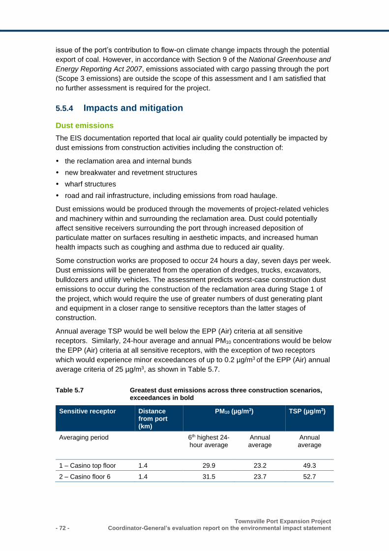
- 72 - Townsville Port Expansion Project
Coordinator-General’s evaluation report on the environmental impact statement
issue of the port’s contribution to flow-on climate change impacts through the potential
export of coal. However, in accordance with Section 9 of the National Greenhouse and
Energy Reporting Act 2007, emissions associated with cargo passing through the port
(Scope 3 emissions) are outside the scope of this assessment and I am satisfied that
no further assessment is required for the project.
5.5.4 Impacts and mitigation
Dust emissions
The EIS documentation reported that local air quality could potentially be impacted by
dust emissions from construction activities including the construction of:
the reclamation area and internal bunds
new breakwater and revetment structures
wharf structures
road and rail infrastructure, including emissions from road haulage.
Dust emissions would be produced through the movements of project-related vehicles
and machinery within and surrounding the reclamation area. Dust could potentially
affect sensitive receivers surrounding the port through increased deposition of
particulate matter on surfaces resulting in aesthetic impacts, and increased human
health impacts such as coughing and asthma due to reduced air quality.
Some construction works are proposed to occur 24 hours a day, seven days per week.
Dust emissions will be generated from the operation of dredges, trucks, excavators,
bulldozers and utility vehicles. The assessment predicts worst-case construction dust
emissions to occur during the construction of the reclamation area during Stage 1 of
the project, which would require the use of greater numbers of dust generating plant
and equipment in a closer range to sensitive receptors than the latter stages of
construction.
Annual average TSP would be well below the EPP (Air) criteria at all sensitive
receptors. Similarly, 24-hour average and annual PM10 concentrations would be below
the EPP (Air) criteria at all sensitive receptors, with the exception of two receptors
which would experience minor exceedances of up to 0.2 µg/m3 of the EPP (Air) annual
average criteria of 25 µg/m3, as shown in Table 5.7.
Table 5.7 Greatest dust emissions across three construction scenarios, exceedances in bold
Sensitive receptor Distance from port (km)
PM10 (µg/m3) TSP (µg/m3)
Averaging period 6th highest 24- hour average
Annual average
Annual average
1 – Casino top floor 1.4 29.9 23.2 49.3
2 – Casino floor 6 1.4 31.5 23.7 52.7
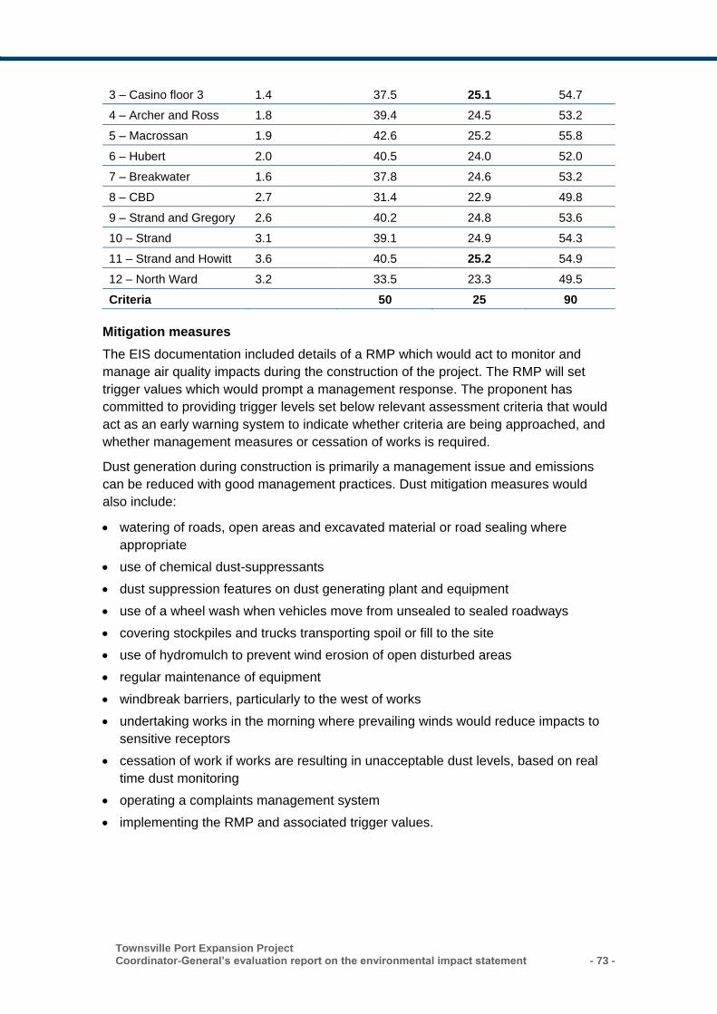
Townsville Port Expansion Project Coordinator-General’s evaluation report on the environmental impact statement - 73 -
3 – Casino floor 3 1.4 37.5 25.1 54.7
4 – Archer and Ross 1.8 39.4 24.5 53.2
5 – Macrossan 1.9 42.6 25.2 55.8
6 – Hubert 2.0 40.5 24.0 52.0
7 – Breakwater 1.6 37.8 24.6 53.2
8 – CBD 2.7 31.4 22.9 49.8
9 – Strand and Gregory 2.6 40.2 24.8 53.6
10 – Strand 3.1 39.1 24.9 54.3
11 – Strand and Howitt 3.6 40.5 25.2 54.9
12 – North Ward 3.2 33.5 23.3 49.5
Criteria 50 25 90
Mitigation measures
The EIS documentation included details of a RMP which would act to monitor and
manage air quality impacts during the construction of the project. The RMP will set
trigger values which would prompt a management response. The proponent has
committed to providing trigger levels set below relevant assessment criteria that would
act as an early warning system to indicate whether criteria are being approached, and
whether management measures or cessation of works is required.
Dust generation during construction is primarily a management issue and emissions
can be reduced with good management practices. Dust mitigation measures would
also include:
• watering of roads, open areas and excavated material or road sealing where
appropriate
• use of chemical dust-suppressants
• dust suppression features on dust generating plant and equipment
• use of a wheel wash when vehicles move from unsealed to sealed roadways
• covering stockpiles and trucks transporting spoil or fill to the site
• use of hydromulch to prevent wind erosion of open disturbed areas
• regular maintenance of equipment
• windbreak barriers, particularly to the west of works
• undertaking works in the morning where prevailing winds would reduce impacts to
sensitive receptors
• cessation of work if works are resulting in unacceptable dust levels, based on real
time dust monitoring
• operating a complaints management system
• implementing the RMP and associated trigger values.
- 74 - Townsville Port Expansion Project
Coordinator-General’s evaluation report on the environmental impact statement
Shipping emissions
The main sources of shipping emissions identified in the EIS documentation include
emissions from vessel auxiliary engine operation and the operation of the TSHD and
backhoe dredge. Only ships at berth were considered in the emissions assessment,
where they were assumed to be running a single auxiliary engine for 24 hours a day,
seven days per week.
Shipping emissions could potentially result in increased smoke plumes impacting local
air quality, increased combustion emissions in the local area and potentially an
increase in particulate matter impacts to surrounding properties, with resultant
environmental and human health impacts.
The assessment predicted that concentrations of NO2, SO2, CO and PM2.5 would be
below the EPP (Air) criteria at all sensitive receptors during all three stages of
construction. The maximum potential impact for each air quality indicator is as follows:
• 24-hour average emissions of PM2.5 would reach 20.7 µg/m3, below the EPP (Air)
criteria of 25 µg/m3
• 8-hour average emissions of CO would reach 2,263 µg/m3, below the EPP (Air)
criteria of 11,000 µg/m3
• 1-hour average emissions of NO2 would reach 232.3 µg/m3, below the EPP (Air)
criteria of 250 µg/m3
• 24-hour average emissions of SO2 would reach 20.6 µg/m3, below the EPP (Air)
criteria of 230 µg/m3.
Greenhouse gas emissions
The AEIS notes that the project would contribute to the production of CO, methane
(CH4) and nitrous oxide (N2O). Greenhouse gas emissions would be generated during
construction through:
• dredging operations
• consumption of fuel for the transport of construction materials to the port
• operation of on-site machinery.
The assessment predicted that the project would result in the production of 290,524
tonnes of CO2 equivalent (t/CO2-e). Capital dredging is predicted to contribute 30% of
the total emissions produced for the project, increasing by 9% due to the increase in
capital dredging works over a longer period of time, totalling 87,748 t/CO2-e.
Mitigation measures
The proponent has committed to the development and implementation of a CEMP
which will develop management mechanisms, targets and goals to monitor and review
the performance of the project’s management of greenhouse gas emissions. The
CEMP will include greenhouse gas abatement measures such as:
• periodic energy audits to monitor energy use and efficiency
Townsville Port Expansion Project Coordinator-General’s evaluation report on the environmental impact statement - 75 -
• greenhouse gas awareness training as part of site inductions
• developing an energy efficiency management plan
• developing a greenhouse gas inventory to monitor, audit and report on the project’s
performance
• regular tuning, modifying or maintaining equipment, plant and machinery to ensure
energy efficiency
• turning off engines while parked on site or when immobile for long periods of time
• investigating renewable energy options for administration facilities
• selecting the most direct haulage route possible between construction and spoil
sites
• using newer equipment with more fuel-efficient engines, where possible
• considering energy efficiency in procurement of equipment
• use of materials with high recycled content or lower embodied construction
materials.
5.5.5 Coordinator-General’s conclusion
Dust emissions
Some submissions raised the issue of the potential for dust to affect surrounding
residential properties and the potential for increased risk for respiratory illnesses. I note
that the proponent has developed a publicly available dashboard3 displaying monthly
air quality monitoring results at three monitoring locations around the boundary of the
port against the EPP (Air) criteria. I consider this a beneficial initiative which would
assist with ensuring the community has access to data indicating the port’s
performance with the EPP (Air) criteria.
I note that the assessment assumed the application of mitigation measures including
road watering, wind barriers and road sealing, and that minor exceedances of the
annual average PM10 criterion were identified. I am satisfied that the additional
mitigation measures outlined above, in combination with the proposed RMP, would
address submitter concerns and ensure dust emissions are managed to achieve
compliance with the EPP (Air) criteria.
I have stated a condition requiring the proponent to manage potential impacts to air
quality in accordance with a CEMP. This would protect sensitive receptors from
environmental harm as a result of emissions from the project.
Shipping emissions
I am satisfied with the assessment of shipping emissions undertaken and consider that
the shipping emission impacts would be minimal. I note that compliance with the EPP
(Air) objectives is predicted for NO2, SO2, CO and PM2.5 emissions.
3 Monthly air quality monitoring results, available at https://www.townsville-port.com.au/environment-community/community/operations-data-dashboard/
- 76 - Townsville Port Expansion Project
Coordinator-General’s evaluation report on the environmental impact statement
I note that the proponent has prepared the project’s CEMP and OEMP which would
provide a framework for managing the air quality impacts of the project. I am satisfied
that the mitigation measures included in those plans would adequately manage air
quality and greenhouse gas emission impacts during both construction and operations,
and implement the necessary actions to prevent impacts to the surrounding sensitive
receptors.
Greenhouse gas emissions
I acknowledge that the use of dredge plant and the emissions which would be
produced through the use of such machinery is an unavoidable impact of the project. I
expect that the mitigation measures outlined above for greenhouse gas emissions are
applied to manage emissions produced by the project.
5.6 Noise and vibration
This section discusses the potential terrestrial noise and vibration impacts of the
project, which includes noise and vibration impacts sourced from the construction of
the reclamation area, the operation of dredge plant and movements of trucks on
internal and external roads.
Potential underwater noise and vibration impacts and impacts to marine fauna are
further discussed in Section 5.2 and Section 5.1 of this report.
5.6.1 Submissions received
Submissions received during the EIS process relating to noise and vibration matters
raised the following issues:
• compliance of night-time construction noise with Environmental Protection (Noise)
Policy 2008 (EPP (Noise)) acoustic quality objectives
• day and night construction noise impacts
• construction traffic noise impacts.
I have considered each submission and the response provided by the proponent in my
evaluation of the project. My assessment is provided in the relevant sections below.
5.6.2 Existing environment
The EIS documentation notes that the project area supports existing port facilities with
the nearest residential sensitive receptors identified 1.4 km south-west from the project
boundary. The existing noise environment is characterised by traffic and port activity
noise.
Background noise monitoring presented revealed that the current sources of daytime
noise at the project site are from existing operational activities, traffic noise from roads
adjacent to the port and noise generated at the Townsville Marine Precinct including
noise from the operation of cranes, vehicles and gantries moving across the yards and
Townsville Port Expansion Project Coordinator-General’s evaluation report on the environmental impact statement - 77 -
boat-maintenance activities such as slippage, grinding and drilling. Background noise
levels at sensitive receptors are presented in Table 5.8.
Existing vibration sources at the port are generated by heavy vehicle movements from,
to and about the site and the movement of overhead cranes unloading cargoes from
ships onto wharves. No existing sources of ground-borne vibration were identified.
Monitoring revealed that the existing vibration environment at the port is characterised
by conservative Peak Particle Velocity (PPV) vibration levels lower than 0.10 mm/s,
which is unlikely to be perceptible.
5.6.3 Assessment methodology
The assessment of noise impacts was based on the outputs of modelling completed
using SoundPLAN 7.0, an environmental noise propagation model which predicts the
noise impacts of the project for assessment against relevant acoustic quality
objectives.
Construction and operational noise assessments assumed that noise-generating plant
would be operating continuously, on flat ground with no shielding or mitigation
measures, as a ‘typical worst-case’ scenario. The assessment predicted both the noise
levels likely to be experienced at six nearest sensitive receptors, an approach
consistent with Australian Standards. The noise levels predicted in the assessment are
external noise levels which would be experienced at the exterior of the structure or
property.
The assessment of potential vibration impacts from the project did not differentiate
between construction and operational effects, and therefore applied the same
methodology for each. Construction and operational vibration were assessed in terms
of both human exposure and effects on building structures. Construction and
operational vibration goals for the project were set against the Australian standard
Evaluation of human exposure to whole-body vibration. German standards Structural
vibration – human exposure to vibration in buildings and Structural vibration in buildings
– effects on structures were also used for the assessment as no relevant Australian
standard was available.
The EIS documentation adopted a conservative approach to the assessment of
vibration impacts, in that goals and criteria were based around piling, which would
generate the highest levels of vibration. Therefore, the predicted impacts are based on
a worst-case scenario and are likely to be reduced from that predicted.
Exhaust noise from ships berthed at the port is outside of the scope of POTL’s
influence, and has not been considered in this assessment.
Noise associated with the maintenance dredging of the channels is also not included in
this assessment as maintenance dredging noise is currently managed under an
existing approved EA held by POTL (EA reference EPPR00771113).
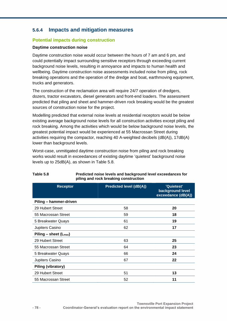
- 78 - Townsville Port Expansion Project
Coordinator-General’s evaluation report on the environmental impact statement
5.6.4 Impacts and mitigation measures
Potential impacts during construction
Daytime construction noise
Daytime construction noise would occur between the hours of 7 am and 6 pm, and
could potentially impact surrounding sensitive receptors through exceeding current
background noise levels, resulting in annoyance and impacts to human health and
wellbeing. Daytime construction noise assessments included noise from piling, rock
breaking operations and the operation of the dredge and boat, earthmoving equipment,
trucks and generators.
The construction of the reclamation area will require 24/7 operation of dredgers,
dozers, tractor excavators, diesel generators and front-end loaders. The assessment
predicted that piling and sheet and hammer-driven rock breaking would be the greatest
sources of construction noise for the project.
Modelling predicted that external noise levels at residential receptors would be below
existing average background noise levels for all construction activities except piling and
rock breaking. Among the activities which would be below background noise levels, the
greatest potential impact would be experienced at 55 Macrossan Street during
activities requiring the compactor, reaching 40 A-weighted decibels (dB(A)), 17dB(A)
lower than background levels.
Worst-case, unmitigated daytime construction noise from piling and rock breaking
works would result in exceedances of existing daytime ‘quietest’ background noise
levels up to 25dB(A), as shown in Table 5.8.
Table 5.8 Predicted noise levels and background level exceedances for piling and rock breaking construction
Receptor Predicted level (dB(A)) ’Quietest‘ background level
exceedance (dB(A))
Piling – hammer-driven
29 Hubert Street 58 20
55 Macrossan Street 59 18
5 Breakwater Quays 61 19
Jupiters Casino 62 17
Piling – sheet (Lmax)
29 Hubert Street 63 25
55 Macrossan Street 64 23
5 Breakwater Quays 66 24
Jupiters Casino 67 22
Piling (vibratory)
29 Hubert Street 51 13
55 Macrossan Street 52 11
Townsville Port Expansion Project Coordinator-General’s evaluation report on the environmental impact statement - 79 -
5 Breakwater Quays 54 12
Jupiters Casino 55 10
Rock breaker
29 Hubert Street 44 6
55 Macrossan Street 45 3
5 Breakwater Quays 47 5
Jupiters Casino 48 3
Night-time construction noise
Most construction activities required for the project would be undertaken during normal
daytime hours from 6.30 am to 6.30 pm. However, some construction activities would
be conducted over 24 hours, 7 days per week, including:
• dredging
• rock supply and placement
• pouring of wharf decks
• reclamation fill.
Night-time construction noise will potentially impact sensitive receptors through sleep
disturbance and impacts to quality of life. Night-time construction noise assessments
considered the percentage of time the equipment was expected to be in operation for
the night-time construction activities listed above, where only the dredge, excavators,
front-end loaders and generators would be in operation continuously. The Townsville
Marine Precinct was not included in the night-time assessment, as it is a commercial
precinct with daytime operation only.
The assessment predicted that typical night-time construction noise levels external to
sensitive receptor locations would be below the existing night-time background noise
levels and compliant with both the EPP (Noise) and World Health Organisation night-
time noise objectives. However, where multiple items of equipment are operating
simultaneously in close proximity, exceedances of noise criteria may occur.
The EIS documentation notes that it is unlikely that equipment other than generators
would be in use 24/7, and therefore the predicted noise levels are likely to be an
overestimate of average noise levels during the night-time period.
Traffic noise
Haulage routes have been refined since the completion of the EIS, with the proponent
proposing that the majority of construction traffic will now use the Port Access Road.
As part of a supporting study for the development approval for the Granitevale Quarry
and associated haulage route connecting to the Port of Townsville, a noise assessment
was undertaken to determine potential traffic noise impacts.
The assessment predicted that based on 2015 traffic volumes, the use of the Port
Access Road to transport quarry materials would increase annual average daily traffic
numbers by 2.4%, resulting in a 0.1 dB(A) increase in total traffic noise. The
- 80 - Townsville Port Expansion Project
Coordinator-General’s evaluation report on the environmental impact statement
assessment noted that an increase of less than 3 dB(A) over existing noise levels is
considered insignificant.
Capital dredging noise
I note that the EIS documentation has not provided a revised assessment of predicted
noise that would be generated by the capital dredging machinery.
Accordingly, I have stated a condition for the project’s EA requiring capital dredging
noise to be managed to ensure that environmental nuisance is not caused to sensitive
places or commercial places in the vicinity of the activity.
Vibration
Construction vibration would be generated by hydraulic hammers, vibrating rollers and
sheet piling activities, where piling would generate the highest levels of vibration for the
project.
For construction vibration, the assessment concluded that all sensitive receptors are
located at distances significantly greater than the minimum separation distance
required to avoid human discomfort and are therefore compliant with the relevant
vibration standard.
Mitigation measures
The proponent has committed to active noise and vibration monitoring at affected
receptors during works likely to cause disturbance for both construction and operations.
Construction and operational noise will be managed in accordance with the acoustic
quality objectives outlined in the EPP (Noise), while construction and operational
vibration would be managed in accordance with human exposure and structural
damage standards. Corrective actions will be taken if complaints are received in
relation to noise.
Construction noise mitigation measures have been outlined in the CEMP, and will
include:
• restricting hours of piling works to within the daytime period (between 7 am and 6
pm)
• monitoring site conditions and adjusting piling elements (such as the height and
weight of the impact hammer) to reduce noise impacts
• consideration of alternative piling types
• acoustic enclosures constructed in accordance with the Australian standard Guide
to noise and vibration control on demolition, demolition and maintenance sites
• identifying appropriate noise mitigation measures based on daily assessments of
noisy works
• selecting low-noise plant and equipment and using high-quality mufflers or silencers
• orienting and locating noisy plant away from sensitive receptors
• minimising the use of noise vehicle warning devices such as reversing safety signals
and horns
Townsville Port Expansion Project Coordinator-General’s evaluation report on the environmental impact statement - 81 -
• minimise the noise of packing up plant and equipment
• ensuring equipment is well maintained to avoid excessive noise production
• implementing a community relations plan which would include measures to notify
sensitive receptors in advance of construction activities that would likely result in
annoying noise and vibration impacts.
Potential impacts during operation
Operational noise
Operational noise impacts as a result of the project would include:
• noise generated by vessel engines
• operation of cranes and noise generated during the loading and unloading of ships
• operation of forklifts
• heavy vehicle movement on public and internal port roads, including semitrailers.
The operation of the project will be continuous (24 hours/day, 365 days/year) and long
term. The operational noise assessment was based on the ‘worst-case’ operation
scenario for Stage 3 of the project, for both daytime and night-time, when the project is
forecast to be complete and the expanded port is fully operational.
The assessment predicts that daytime operational noise would be below average
daytime background noise levels at all sensitive receptors, while there would be
exceedances of up to 2dB(A) at the Casino and 55 Macrossan Street of night-time
background noise levels. Exceedances are expected for both day and night-time
‘typical quietest’ noise levels of up to 8dB(A) and 11dB(A) respectively. Under certain
prevailing wind conditions, it will be likely the project’s operational noise will be audible
at the nearest mainland sensitive receptors.
Low frequency noise
The low frequency noise assessment presented in the EIS documentation included
predicted worst-case low frequency noise levels from the project, finding that external
low frequency noise would potentially be exceeded at five of the six sensitive receptors
by up to 13 dB(Lin). The assessment concluded that there is a moderate to significant
probability of significant low frequency noise audibility during adverse weather
conditions and with windows open.
The proponent identified that further assessment of the potential low frequency noise
impacts of the project would be required during detailed design to better quantify the
magnitude of impacts at sensitive receptors.
Cumulative noise impacts
The cumulative noise impact assessment predicted the impacts of the expanded port at
the completion of Stage 3, combined with the noise expected to be produced by the
Townsville Marine Precinct, located immediately adjacent to the port’s southern and
eastern boundaries.
- 82 - Townsville Port Expansion Project
Coordinator-General’s evaluation report on the environmental impact statement
The assessment found that the port would increase background daytime noise levels
by up to 2dB(A), while night-time noise would increase by up to 4dB(A), which may be
noticeable at sensitive receptors. The increase in night-time port operation noise of
4dB(A) at Breakwater Quays is predicted to be the greatest increase in cumulative
noise impacts. I note that an increase of 3dB(A) or more is generally a perceptible
increase in noise.
Vibration
The assessment of operational vibration impacts was based on a worse-case scenario,
developed by measuring vibration levels associated with heavy vehicles travelling
along the Bruce Highway. The worst-case scenario was used as an estimation of
vibrations likely to be produced during typical plan operation at the port.
The assessment predicts that ground vibration at the nearest sensitive receptor 1.4 km
away would be below the night-time residential vibration guidelines of 0.2 mm/s for
human comfort and below the 0.1 mm/s guideline at which vibration is typically
perceptible.
Mitigation measures
Operational mitigation measures would include:
• selecting low-noise-emitting equipment for use on the reclamation area
• enclosing fixed items of equipment, where feasible
• limiting the speed of vehicles on internal roads
• requesting port operators replace standard reversing beepers with lower-noise
impact beepers
• maintaining vehicles, plant and machinery to avoid unnecessary noise
• ensuring port operators are aware of the location of sensitive receptors and
appropriate noise reduction measures
• operating a complaints management system
• noise and vibration awareness training as part of site inductions.
5.6.5 Coordinator-General’s conclusion
Construction noise
Daytime construction noise
I note the potential for exceedances of noise objectives at nearby sensitive receptors
during piling and rock breaking works of up to 25dB(A) and the issues raised by a
submitter regarding the potential for increased construction noise impacts as a result of
the project. However, I note that the predicted daytime construction noise levels are
based on a worst-case scenario with no mitigation applied, and that the identified
exceedances are likely to be lower than predicted. Further, the identified sensitive
receptors are already likely exposed to high levels of noise due to their proximity to the
port, other industrial areas and roads.
Townsville Port Expansion Project Coordinator-General’s evaluation report on the environmental impact statement - 83 -
I expect that the proponent fulfils their commitment to undertake noise monitoring at
sensitive receptors during the construction and operation of the project. I also expect
that corrective actions are implemented, should monitoring indicate exceedances of
relevant acoustic quality objectives, through applying the mitigation measures outlined
above as a minimum.
I am satisfied that the mitigation measures outlined above would ensure that daytime
construction noise is managed to avoid impacts to human health and wellbeing.
Further, I note that the proponent has made a commitment to proactively notify any
potentially affected residents and commercial operators of planned construction
activities (including timing and duration of piling and rockfill placement) and I expect
them to meet this commitment.
In order to manage the potential noise impacts, I have stated a condition requiring the
proponent to ensure that construction noise is managed in accordance with a
Construction Environmental Management Plan to reduce impacts to human health and
wellbeing.
Night-time construction noise
I note that the Department of Health raised concerns with the assessment of night-time
noise impacts against all relevant EPP (Noise) night criteria. The EIS documentation
reported that potential noise emissions from plant and equipment typically used at night
during construction works would be continuous and steady in nature, as piling works
are not planned to occur at night.
Further, the assessment reported that residences and buildings in South Townsville
could provide additional shielding from any noise generated by the project which is
directed to the south, reducing the impacts identified in the assessment.
Accordingly, I am satisfied with the proponent’s response and the conclusion in the
assessment that night-time noise produced during the construction of the project would
comply with the EPP (Noise) and World Health Organisation criteria. I am satisfied that
implementing the suite of mitigation measures outlined above would further ensure
night-time noise is managed appropriately.
Traffic noise
I am satisfied with the assessment of the project’s contribution to traffic noise during
the construction of the project. I note that the usage of the Port Access Road to
transport marine armour stone from Granitevale Quarry to the Port of Townsville is
expected to result in a minor increase total traffic noise by 0.1 dB(A) and is unlikely to
be detectible.
I note that the haul route connecting the quarry to the port is regulated under an
existing approval held by the proponent for the development of the Granitevale Quarry
(reference no. MI13/0040). The approval includes conditions relating to the
management of noise impacts from the use of the haulage route. Accordingly, no
further consideration is required for this assessment.
Capital dredging noise
- 84 - Townsville Port Expansion Project
Coordinator-General’s evaluation report on the environmental impact statement
In the absence of revised modelling, I have stated conditions for the project’s EA to
ensure environmental nuisance is not caused to sensitive or commercial places in the
vicinity of capital dredging activities.
The conditions also set out the requirements for the proponent to respond to
demonstrated noise exceedances from the activity. I am satisfied that this would
ensure capital dredging noise is managed appropriately.
Operational noise
I note that operational noise is not expected to reach the levels identified until the
expanded port is completed at the end of Stage 3 of construction.
However, I require the proponent to fulfil their commitment to conducting noise and
vibration monitoring at nearby sensitive receptors during the operational phase of the
project. Monitoring results should inform the ongoing refinement of the mitigation and
management measures outlined above, and those presented in the project’s OEMP.
I am satisfied that the implementation of the mitigation measures would ensure the
identified exceedances are managed appropriately to avoid impacts to human health
and wellbeing.
Low frequency noise
I note that the proponent identified that further assessment of the potential low
frequency noise impacts of the project would be required during detailed design. I
expect that the proponent conducts these further assessments.
Construction and operational vibration
I consider that the assessment of construction and operational vibration provided in the
assessment is adequate and that the project’s potential vibration impacts would be
minimal. I am satisfied that the nearest sensitive receptors are located at distances far
enough from the port to ensure vibration effects are not experienced. Further, I am
satisfied that the implementation of the mitigation measures outlined above would also
ensure vibration impacts from construction and operational activities would avoid
potential impacts to human health, and that no further assessment or mitigation is
required.
5.7 Waste
The EIS addressed waste management associated with the project, including the
generation, appropriate storage, handling and storage of wastes during the
construction and operational phases.
The project’s potential waste impacts relate to poor waste handling and management,
resulting in release to the surrounding environment, degrading aesthetic amenity and
potentially the health of nearby marine and terrestrial ecosystems.
Dredge spoil has not been considered as waste and has been assessed in Section 5.1.
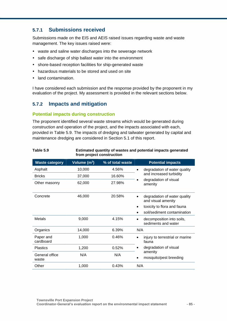
Townsville Port Expansion Project Coordinator-General’s evaluation report on the environmental impact statement - 85 -
5.7.1 Submissions received
Submissions made on the EIS and AEIS raised issues regarding waste and waste
management. The key issues raised were:
waste and saline water discharges into the sewerage network
safe discharge of ship ballast water into the environment
shore-based reception facilities for ship-generated waste
hazardous materials to be stored and used on site
land contamination.
I have considered each submission and the response provided by the proponent in my evaluation of the project. My assessment is provided in the relevant sections below.
5.7.2 Impacts and mitigation
Potential impacts during construction
The proponent identified several waste streams which would be generated during
construction and operation of the project, and the impacts associated with each,
provided in Table 5.9. The impacts of dredging and tailwater generated by capital and
maintenance dredging are considered in Section 5.1 of this report.
Table 5.9 Estimated quantity of wastes and potential impacts generated from project construction
Waste category Volume (m3) % of total waste Potential impacts
Asphalt 10,000 4.56% • degradation of water quality and increased turbidity
• degradation of visual amenity
Bricks 37,000 16.60%
Other masonry 62,000 27.98%
Concrete 46,000 20.58% • degradation of water quality and visual amenity
• toxicity to flora and fauna
• soil/sediment contamination
Metals 9,000 4.15% • decomposition into soils, sediments and water
Organics 14,000 6.39% N/A
Paper and cardboard
1,000 0.46% • injury to terrestrial or marine fauna
• degradation of visual amenity
• mosquito/pest breeding
Plastics 1,200 0.52%
General office waste
N/A N/A
Other 1,000 0.43% N/A
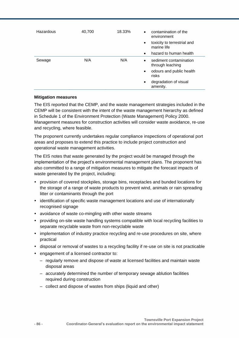
- 86 - Townsville Port Expansion Project
Coordinator-General’s evaluation report on the environmental impact statement
Hazardous 40,700 18.33% • contamination of the environment
• toxicity to terrestrial and marine life
• hazard to human health
Sewage N/A N/A • sediment contamination through leaching
• odours and public health risks
• degradation of visual amenity.
Mitigation measures
The EIS reported that the CEMP, and the waste management strategies included in the
CEMP will be consistent with the intent of the waste management hierarchy as defined
in Schedule 1 of the Environment Protection (Waste Management) Policy 2000.
Management measures for construction activities will consider waste avoidance, re-use
and recycling, where feasible.
The proponent currently undertakes regular compliance inspections of operational port
areas and proposes to extend this practice to include project construction and
operational waste management activities.
The EIS notes that waste generated by the project would be managed through the
implementation of the project’s environmental management plans. The proponent has
also committed to a range of mitigation measures to mitigate the forecast impacts of
waste generated by the project, including:
provision of covered stockpiles, storage bins, receptacles and bunded locations for
the storage of a range of waste products to prevent wind, animals or rain spreading
litter or contaminants through the port
identification of specific waste management locations and use of internationally
recognised signage
avoidance of waste co-mingling with other waste streams
providing on-site waste handling systems compatible with local recycling facilities to
separate recyclable waste from non-recyclable waste
implementation of industry practice recycling and re-use procedures on site, where
practical
disposal or removal of wastes to a recycling facility if re-use on site is not practicable
engagement of a licensed contractor to:
– regularly remove and dispose of waste at licensed facilities and maintain waste
disposal areas
– accurately determined the number of temporary sewage ablution facilities
required during construction
– collect and dispose of wastes from ships (liquid and other)
Townsville Port Expansion Project Coordinator-General’s evaluation report on the environmental impact statement - 87 -
removal of sewage to a reticulated water system, where possible during
construction, and removal of greywater and sewage to the TCC local sewerage
system during operation
education of staff to reduce waste
storage and removal of garbage to minimise pest attraction and breeding potential
handling of hazardous liquids in accordance with material safety data sheets and
manufacturer specifications, including development and maintenance of a complete
hazardous waste inventory
record the movement and quantities of regulated and quarantine wastes
transport cargoes in correct containers, which are maintained and handled in
accordance with industry and manufacturer standards
storage of hazardous and potentially hazardous waste in an appropriately bunded
areas.
I expect that the proponent implements these mitigation measures as part of the
project’s environmental management plans.
Potential impacts during operations
The EIS notes that wastes generated by operational activities will likely come from
three main sources:
shipping waste from vessels arriving in port
operational activities of the port which includes proponent offices, general
maintenance activities in common areas, roads, workshops and common user
berths when no ships are present
operators/tenants who control their specified site, some berths and all shipping,
loading and unloading when at berth.
Waste category, expected amounts generated and associated potential impacts are
outlined in Table 5.10.
Table 5.10 Description and estimated quantity of wastes generated from shipping operations at the Port of Townsville
Waste category Total anticipated generation (existing plus proposed
activities)
Potential impacts
General garbage 23 m3/month • entanglement or ingestion by fauna
• pest and mosquito breeding
• degradation of visual amenity
Hydrocarbons, chemicals and other liquid wastes
32 m3 per vessel
23,680 m3/annum
• toxicity to flora and fauna
• soil/sediment contamination
• degradation of water quality
• odours
- 88 - Townsville Port Expansion Project
Coordinator-General’s evaluation report on the environmental impact statement
Sewage 41 kL/day • sediment contamination through leaching
• odours and public health risk
• degradation of visual amenity
Hazardous waste 0.33 kg/month • contamination of the environment
• toxicity to terrestrial and marine life
• hazardous to human health
Quarantine waste 257 kg/month • introduction of foreign pest species
Waste from commercial cargo activities
N/A • contamination of marine water, benthic environment and sediments
• toxicity to marine flora and fauna
• degradation of visual amenity
Facilities maintenance waste
N/A • visual impacts from residual waste material stockpiles
Submissions raised during the EIS process requested detailed information on the
hazardous materials to be stored or used on the project site. The proponent advised
that any hazardous materials to be used or stored during the construction of the project
would be identified prior to commencement and that appropriate storage facilities would
be established in accordance with regulatory requirements and relevant Australian
standards. During project operations, tenants undertaking operations outside the
control of the proponent would be responsible for the safe handling and storage of
hazardous materials within their leased areas.
The EIS reported that liquid waste discharged from ships is small in volume and
therefore the potential for impacts is minimal. Cruise ships and military ships are the
only vessels currently discharging sewage into reticulated sewers or by pump out to
shore. A submitter requested further information on waste discharges into the sewer
network including saline discharges and shore-based reception facilities available for
ship-generated waste. The AEIS reported that military vessels may discharge saline
wastewater to the sewage network while berthed.
Mitigation measures
The proponent notes that the impact of saline discharges on the Cleveland Bay
Wastewater Treatment Plant will be minimised where possible by mixing saline
discharges with other flows to dilute the salinity. The proponent has committed to
working with TCC during detailed design of future landside infrastructure to minimise
impacts to the sewage system.
Townsville Port Expansion Project Coordinator-General’s evaluation report on the environmental impact statement - 89 -
The proponent’s procedures require that shipping waste collection is organised by the
shipping agent and handled in accordance with the Australian Maritime Safety
Authority regulations.
Land contamination
Submitters raised concerns regarding possible land contamination and therefore
contaminants leaching from the bund walls. The EIS undertook searches on 29
properties near the project to determine if any were listed under the Environmental
Management Register (EMR) or the Contaminated Land Register (CLR). The results
releveled 20 properties were listed on the EMR however none to be affected by the
project is listed on the EMR or on the CLR.
It is predicted that the construction of the project will not result in potential for land
contamination. Any future land use on strategic port land with potential for land
contamination will require development assessment under the relevant legislation.
Chapter 5.3 evaluates the risk of contaminated sediment being placed into reclamation
and plans for onshore and offshore grading of materials prior to dredging, handling and
placement. All sediment to be placed in reclamation will be tested in accordance with
the National Environmental Protection (Assessment of Site Contamination) guidelines.
Mitigation measures
The port currently operates under an Operational Environmental Management Plan
(OEMP), environmental licensing and incident management procedures. These
measures are aimed at avoiding potential release of contaminants onto the land during
operations including:
• leaks or spills of goods/materials, contaminants, hazardous materials and/or
dangerous goods
• imported contamination in soil and/or fill material
• general waste and debris.
5.7.3 Coordinator-General’s conclusion
I am satisfied with the assessment of predicted construction and operational waste
streams and that the potential impacts of waste can be adequately managed through
the proposed mitigation measures and proponent’s commitments.
The proponent commits that waste management strategies for the project will be
consistent with the intent of the waste management hierarchy as defined in Schedule 1
of the Environment Protection (Waste Management) Policy 2000, focusing on waste
avoidance/ reduction, re-use, recycling or disposal, in order of preference. I am
satisfied that potential impacts from land contamination can be appropriately managed
through the proponent’s OEMP.
- 90 - Townsville Port Expansion Project
Coordinator-General’s evaluation report on the environmental impact statement
5.8 Traffic and transport
The EIS documentation addressed the transport and traffic requirements and potential
impacts associated with the project. Potential traffic and transport impacts include:
• increased traffic on local roads due to construction vehicles, resulting in changed
traffic flow and movement through intersections
• potential degradation of pavement due to increased use, resulting in changed local
road conditions and road safety
• changed rail efficiencies due to additional freight movements on the surrounding rail
network.
5.8.1 Submissions received
Submissions received during the EIS process relating to traffic and transport raised the
following issues:
increased heavy vehicle movement associated with movement of rock between the
quarry and port
requirement for updated road impact assessment, Road Use Management Plan and
Traffic Management Plan
requirement for ongoing consultation with the Regional Harbour Master in relation to
vessel movements
vessel traffic management, aids to navigation, ship-sourced prevention/spill
management.
I have considered each submission and the response provided by the proponent in my
evaluation of the project. My assessment is provided in the relevant sections below.
5.8.2 Existing environment
Road network
The EIS identified that the primary road access to the port is via Boundary Street, an
urban arterial road. The revised design, as presented in the AEIS, avoids the use of
Boundary Street during construction for bulk materials haulage where possible. The
AEIS notes that the majority of heavy vehicle traffic is proposed to use the purpose-
built Townsville Port Access Road (Port Access Road).
The Port Access Road, completed in 2012, is a 10-km linkage between the Flinders
and Bruce Highways and the Port of Townsville (Figure 5.4). It provides direct access
to the port from the west and south, with the effect of reducing heavy vehicle traffic in
the residential areas in South Townsville.
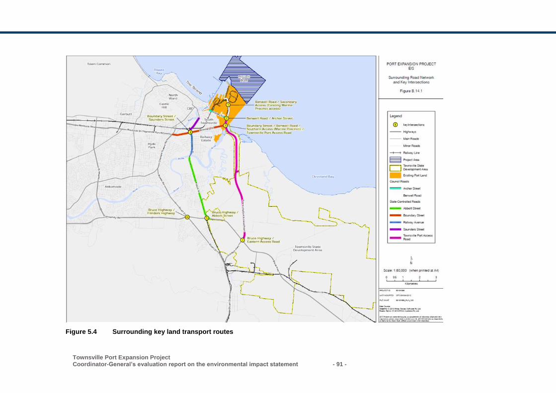
Townsville Port Expansion Project Coordinator-General’s evaluation report on the environmental impact statement - 91 -
Figure 5.4 Surrounding key land transport routes
- 92 - Townsville Port Expansion Project
Coordinator-General’s evaluation report on the environmental impact statement
Benwell Road, also an urban arterial road, is the main thoroughfare through port lands.
Archer Street, a sub-arterial road extending from the southern end of Benwell Road,
provides a secondary east-west connection to the port.
Maritime
Ships berthing at the Port of Townsville share the navigation routes in the GBRMP with
other major ports. Vessels berth in an enclosed breakwater protected harbour (other
than Berth 11) and arrive via waters in the GBRMP through to the Platypus and Sea
Channel system, which currently has an overall length of 13.9 km.
At present, because of the depth constraints in the channel and basin areas for larger
vessels, the port is best suited to Handymax shipping up to 55,000 deadweight
tonnage (DWT) (with draught up to 12 m). The project involves the creation of a new
outer harbour for large dry bulk and possibly liquid bulk vessels initially up to 75,000
DWT Panamax size with 13 m maximum draught, but in the long term capable of
berthing Panamax vessels up to 85,000 DWT with 14.6 m maximum draught.
Vessels waiting to enter the port generally do so in a general anchorage area
determined by Townsville Vessel Traffic Service, which is managed by MSQ and
located 16 km offshore, outside the port’s limits. However, there are some limited areas
where vessels can anchor inside the port waters, with depth constraints. There are
presently no specific designated anchorage areas inside the port waters. Vessels are
prohibited from anchoring in the channel and harbour basin, as well as a designated
area east of Magnetic Island.
5.8.3 Assessment methodology
The traffic assessments previously prepared by DTMR for the Port Access Road
project were utilised by the proponent to evaluate road capacity and constraints for the
project. The proponent also consulted with DTMR and TCC and reached an agreement
that the Townsville Thuringowa Traffic Model would be adopted to determine baseline
road traffic volumes as part of a preliminary road traffic impact assessment.
The road impact assessment focused on nearby intersections, as there is a higher level
of certainty that they will be utilised by project-related traffic over the 30-year project
timeframe. In addition, the EIS documentation notes that the modelling assessed only
those intersections where the project-related volumes are predicted to be 5% or greater
than background traffic. The Guidelines for Assessment of Road Impacts of
Development 2006 (GARID) (DTMR, 2006) state that, in general, a development’s road
impacts are considered to be insignificant if the development generates an increase in
traffic on the surrounding road network of no more than 5% of background traffic levels.
5.8.4 Impacts and mitigation
Potential impacts to the road network were described in the EIS documentation and
include the following:
Townsville Port Expansion Project Coordinator-General’s evaluation report on the environmental impact statement - 93 -
• medium-term amenity reduction and increased safety risk for road users along main
haulage routes
• increased heavy vehicle movement associated with haulage of rock between the
quarry and the port
• decreased operational efficiency of key intersections during both construction and
operation due to increased heavy vehicle movement
• pavement degradation as a result of increased load intensity during both
construction and operation
• reduced performance of rail networks due to significant increase in demand
• potential impacts to port operations.
Traffic-related amenity impacts
Potential traffic-related impacts to amenity include noise generated by an increase in
road and rail traffic as well as potential environmental and human health impacts such
as respirational difficulty and aesthetic impacts arising from dust emissions. Increased
dust and noise emissions relating to road traffic are addressed in Sections 5.5 and 5.6
of this report.
Operational efficiency impacts to key intersections
The assessment found that of the intersections analysed, all would operate within
acceptable limits or below capacity for the operation of the fully developed project, with
only the intersection of Boundary Street/Saunders Street requiring upgrading to
accommodate background traffic growth.
The assessment identified that the intersection of the Bruce Highway/ Port Access
Road would be operating at above capacity by 2046. However, the Port Access Road
was modelled in the assessment with only two lanes and an upgrade to increase the
road to four lanes is likely to be triggered by 2035. The assessment concluded that the
planned upgrade of the Port Access Road would ensure operation within acceptable
limits.
Pavement impacts
The EIS undertook a pavement impact assessment based on GARID to identify the
likely magnitude of pavement impacts to state-controlled roads and local roads due to
predicted heavy vehicle movements during construction and operation. An increase of
5% or greater of background traffic would likely result in pavement impacts.
The assessment found that the construction phase of the project would result in the
greatest impact to background traffic volumes. Further, heavy vehicles being utilised for
the construction and operational phases of the project are expected to result in
pavement impacts.
Submissions also queried the location of the proposed quarries and raised the potential
impacts of construction haulage activities on existing transport networks. Haulage
routes have been refined since the completion of the EIS and it is proposed that heavy
- 94 - Townsville Port Expansion Project
Coordinator-General’s evaluation report on the environmental impact statement
vehicle construction traffic will avoid the use of Boundary Street for bulk materials
haulage. This will significantly decrease the potential traffic impact on Boundary Street
compared to that presented in the EIS. The proponent proposes that the majority of
heavy vehicle traffic will use the purpose-built Port Access Road.
The assessment acknowledges that average numbers of heavy vehicles hauling
armour rock from quarry sources has increased during Stage 1 and Stage 2, for the
period during placement of revetments and the breakwater. Whilst the average number
of traffic movements is predicted to increase, impacts to Boundary Street as a result of
the project would be avoided through the use of the Port Access Road. The
assessment concluded that further assessment of potential pavement impacts along
haulage routes is required during detailed design.
Mitigation measures
To mitigate impacts to the local road network as a result of construction activities, the
proponent must undertake a revised road impact assessment, traffic operations
assessment and road safety assessment a minimum of six months prior to
commencing the haulage of quarry materials from the Granitevale Quarry. The
proponent has also committed to investigating opportunities for intersection
improvements to alleviate construction traffic impacts and the preparation of a road use
management plan and traffic management plan.
The proponent noted that due to the extended duration of the project, the road impact
assessment and traffic management plan will be revised for each stage of the project to
better reflect road conditions and traffic volumes as the project progresses.
Potential impacts to port operations
Designated anchorages for vessels that will utilise the port in the future were
highlighted as a potential issue in the assessment, however, it is not possible to predict
if the increased shipping activity over the timeframe of the project would result in a
greater requirement for vessel anchorage for existing port facilities and the new outer
harbour. The EIS documentation states that there is no obvious constraint to available
deepwater area for anchoring of vessels for the port, however, the number of
anchorages can be extended further north, north-east or east if required in the future.
Further, an increase in shipping can increase the likelihood of collisions, groundings,
introduction of marine pests, spills, waste disposal and anchor damage, all potentially
impacting the Great Barrier Reef. Providing additional designated anchorages would
assist in managing these potential impacts, improving safety and the management of
vessels anchored offshore.
The assessment notes that the incremental development of the project over several
decades is not expected to significantly impact upon the operations of the port, as
necessary operation plans will be updated and reviewed. However, the proponent
proposes that management plans to ensure safety, efficiency and environmental
objectives are achieved for shipping anchorage would be developed in consultation
with MSQ, the Regional Harbour Master and other relevant advisory agencies including
GBRMPA.
Townsville Port Expansion Project Coordinator-General’s evaluation report on the environmental impact statement - 95 -
Mitigation measures
The maritime operations management plan outlined in the EIS documentation identifies
mitigation measures required to manage potential impacts to the environment, vessel
safety and operational efficiency of the port.
A vessel traffic management plan will be required to be prepared in accordance with
the DTMR MSQ Guidelines for Major Development Proposals and reviewed and
approved by MSQ, prior to the commencement of the activity.
The proponent commits to working with MSQ and the Regional Harbour Master to
ensure all relevant information and agreements are in place prior to the implementation
of each stage of the project. In addition, the proponent commits to developing
mitigation strategies in accordance with MSQ guidelines.
5.8.5 Coordinator-General’s conclusion
I note that submitters raised concerns over the adequacy of the pavement impact
assessment. The EIS documentation indicated that the pavement impact assessment
was undertaken in accordance with relevant standards and DTMR GARID guidelines
and was based upon measured and forecast traffic volumes at the time of the
assessment. Accordingly, I am satisfied that the road impact assessment undertaken
for the EIS documentation is appropriate for the purpose of this assessment.
Submissions queried the adequacy of the intersection analysis and noted that only
intersections within the immediate vicinity of the port had been assessed. The EIS
assessment identified that once the transport routes and expected volumes of
additional project-related traffic have been confirmed, a more detailed impact
assessment would be undertaken during detailed design to better reflect the impacts of
the port. Further assessment to determine the need for ongoing pavement
rehabilitation and maintenance as necessary during the construction and operation of
the project will also be undertaken, in consultation with key agencies including DTMR
and TCC. I am satisfied that this will address the issues raised by submitters regarding
the need for updated road use and traffic management plans.
I am satisfied that the proponent commitments relating to the preparation of updated
traffic and road impact assessments as part of a road audit to be undertaken six
months prior to commencement of haulage for rock wall construction will address
issues raised by submitters.
Further, I note that the proposed haulage rout from Granitevale Quarry to the Port of
Townsville is regulated under an existing approval obtained by the proponent. The
potential impacts to the road network as a result of the movement of quarry materials to
the port for the project would be covered by the existing conditions under that approval
(reference no. MI13/0040), and accordingly, no additional conditions are required to
address these potential impacts.
Port operations
I note that the proponent has committed to ongoing review of anchorage procedures
and requirements as a result of increased shipping due to the development of the
- 96 - Townsville Port Expansion Project
Coordinator-General’s evaluation report on the environmental impact statement
project and other planned projects for the port, in collaboration with MSQ and other
agencies (such as the Great Barrier Reef Marine Park Authority).
I have stated a condition requiring the proponent to develop a construction vessel
traffic management plan in consultation with the Regional Harbour Master.
I am satisfied that this would address the issues raised in submissions regarding
consultation with the Regional Harbour Master and the need for managing vessel
traffic, and ensure that the requirements of the Transport Operations (Maritime Safety)
Act 1994 are met.
5.9 Hazard and risk
The EIS presented a project hazard and risk assessment consistent with Australian
Standards, which prioritised and recommended mitigation for potential impacts to
property and people. The amended project design does not compromise the validity of
the assessment presented in the EIS in relation to hazard and risk; accordingly, the
proponent has indicated that the previous assessment remains applicable for the
amended project.
The assessment considered key issues relating to hazard and risk at the expanded
port including the health and safety of port workers and the broader community,
security of the port as critical infrastructure and the management of emergency events.
5.9.1 Submissions received
Submissions received during the EIS process relating to hazard and risk raised the
following issues:
• health and safety of port workers and the Townsville community arising from
development of the project
• security of the port and associated infrastructure resulting from increased demand
• vulnerability of the port to events such as fire, terrorism and sabotage, and the
impact of such disasters on the city of Townsville.
I have considered each submission and the response provided by the proponent in my
evaluation of the project. My assessment is provided in the relevant sections below.
5.9.2 Existing environment
Serious events such as cyclones, storms, explosions, major chemical spills, or acts of
vandalism or terrorism can place the port and the safety of port workers and the
broader communities at risk. Planning for prevention, preparation, response and
recovery of such events are managed through the proponent’s security and emergency
plans and procedures.
A variety of threats associated with aspects of national security have the potential to
impact on critical infrastructure and the continuity of essential services associated with
the Port of Townsville. The Port of Townsville is essential infrastructure, described by
the Queensland Government as part of Australia’s physical facilities and supply chains,
Townsville Port Expansion Project Coordinator-General’s evaluation report on the environmental impact statement - 97 -
which if destroyed, degraded or rendered unavailable for an extended period would
impact on social or economic values.
The Port of Townsville currently operates under the following:
• an existing security plan and associated governances to support the conduct of port
operations to protect the security of facilities, infrastructure, people, maritime
operations and the wider community
• operational safeguards and security training and awareness for its staff
• preparation for response to security events.
Emergency management planning for the port follows formal processes structured on
the principles of the relevant Australian Standard (Planning for emergencies in
facilities). These approaches are consistent with current industry practice for
emergency management.
POTL maintains its own Risk Management Policy, Occupational Health and Safety
Management System and Environmental Management System, providing
organisational governance and stewardship on plans and procedures to manage risks
and meet its statutory obligations.
5.9.3 Assessment methodology
The assessment of health and safety hazard and risk for the project was consistent
with AS/NZS ISO 31000:2009 Risk Management – Principles and Guidelines
(Standards Australia, 2009). The consequence and probability estimates for impacts
outlined in the Australian Standard are applied through a risk matrix to evaluate the
risk. The risk assessment informs a risk register for the project, which was included in
the EIS.
The proponent completed a security risk assessment and implemented security plans
to address identified risks in accordance with the Australian Government’s maritime
security regime under the Maritime Transport and Offshore Facilities Security Act 2003.
The security risk assessment underpins the assessment of security risks in the EIS.
The risk assessment presented for emergency planning in the EIS was aligned to the
Townsville District Disaster Management Plan, prepared for the Townsville region. The
management plan complies with the guiding standard for preparation of state and
district disaster management plans and the National Emergency Risk Assessment.
I am satisfied that the approach to hazard and risk assessment in the EIS is consistent
with industry standards and appropriate in the context of the project.
5.9.4 Impacts and mitigation
Health and safety
The EIS contains a health and safety risk register which identifies risk sources
associated with four phases of the project: design, construction, operations and
decommissioning and disposal. Health and safety impacts identified in the EIS risk
register for the project covered ten work hazard categories:
- 98 - Townsville Port Expansion Project
Coordinator-General’s evaluation report on the environmental impact statement
• biomechanical (manual tasks)
• mechanical
• electrical
• chemical
• noise/vibration
• potential and stored energy
• thermal
• radiation
• biological
• work stressors.
The risk assessment completed for the project in accordance with AS/NZS ISO
31000:2009 Risk management – principles and guidelines (Standards Australia, 2009),
concluded that health and safety risks, across the 10 categories associated with the
project can be reduced to an acceptable level. The risk register will ultimately form part
of a risk management plan to provide ongoing review and assessment of risk
throughout the phases of the project.
The proponent operates under an established Occupational Health and Safety
Management System, Emergency Management Plan, Security Management Plan and
Environmental Management System. The risk assessment undertaken for the project
does not identify any unmanageable risks. Accordingly, I am satisfied that these
existing systems can be successfully updated to capture and control health and safety
risks associated with the project. Further, the proponent has committed to updating the
existing management systems and plans to accommodate the changing risk profile
associated with the port expansion. I require the proponent to fulfil this commitment.
Potential impacts during operation
Security, property and infrastructure
A variety of threats associated with aspects of national security have the potential to
impact on critical infrastructure and the continuity of essential services associated with
the port and the proposed expansion, once complete.
The proponent’s security policy is supported by the Port Operators’ Security
Assessment, Port of Townsville Security Plan, training and awareness for port
employees and audit and review processes. The proponent is also a participant in the
Townsville District Disaster Management Group, to which it has aligned response and
recovery contingencies.
The EIS recognised that the construction and operation of the project will require
variation and modification of the existing security, property and infrastructure
management arrangements to suit the operational nature of the project.
The EIS provided an assessment of potential impacts from a range of natural and
human interaction events. Potential impacts to the security risk setting will include the
following:
Townsville Port Expansion Project Coordinator-General’s evaluation report on the environmental impact statement - 99 -
• increased level of security associated with port operations and infrastructure areas
• broadening of geographic boundaries for ‘at risk’ receptors and consequential
increase of risk by increased scope of impacts, proximity to impacts and frequency
of exposure to impacts
• raised security threat potential by nature and size of operations, number and variety
of targets
• increased potential impacts and increased critical value of property and
infrastructure assets.
The proponent has an approved Maritime Security Plan in place, which is required by
Commonwealth legislation in accordance with the Maritime Transport and Offshore
Facilities Security Act 2003. The Maritime Security Plan meets the requirements under
the Maritime Transport and Offshore Facilities Security Act 2003 and is externally
audited by the Commonwealth Office of Transport Security. The content of the
Maritime Security Plan is prescribed by legislation and includes:
• a security assessment for the operation of the port
• a description of the security activities or measures to be undertaken or implemented
by the port operator under the plan for different maritime security levels
• a list of all security officers responsible for implementing and maintaining the plan
• description of how the implementation of the plan will make an appropriate
contribution towards the achievement of the maritime security outcomes.
The proponent has committed to the Maritime Security Plan being amended to
incorporate the proposed port expansion as it nears its operational stage. The
proponent proposes to work closely with relevant stakeholders, including tenants,
operators and companies in the port and with the Office of Transport Security to ensure
the Maritime Security Plan is complied with and is relevant to changing needs.
I am satisfied that existing governance arrangements around security, property and
infrastructure within and surrounding the port can be broadened to accommodate the
proposed expansion. I support the proponent’s commitment to update the existing
Maritime Security Plan and I have recommended that this to be undertaken by the
proponent.
Emergency management
The EIS considered and assessed risks associated with disaster and catastrophic
events and the port has prepared and implemented various procedures and plans for
emergency management of situations that may potentially arise.
Emergency management planning for the port follows formal processes structured on
the principles of AS 3745-2010 - Planning for emergencies in facilities. The proponent
has considered and assessed risks associated with disaster and catastrophic events as
part of its ongoing operation of the port. The main natural disaster hazards identified in
the EIS were flood, cyclones, storm tide (surge), tsunami, landslide, animal disease
(including mosquito-borne disease), earthquake and bushfire. Key human interaction
events were dam breach, terrorism, transport incident and chemical/fuel/oil spills.
- 100 - Townsville Port Expansion Project
Coordinator-General’s evaluation report on the environmental impact statement
Based on this assessment, POTL has prepared and implemented various governance
frameworks, procedures and plans for emergency management of situations that may
potentially arise from its business and operational responsibilities, including:
• Emergency Management Plan
• emergency response plans covering cyclones, fire and oil spills
• emergency notification system and evacuation procedures
• ship emergency and general information.
Mitigation measures
The AEIS identified that in addition to pre-existing emergency situation response
measures implemented at the port, additional mitigation measures would be
implemented, including:
• allowing contingencies in the project construction schedule due to potential impacts
from tropical cyclone events
• developing and implementing emergency response and evacuation procedures
• elevating water sensitive operational areas to avoid submersion during predicted
storm surge events
• account for predicted wave climate and water levels in procedures for handling and
storage of materials
• ensuring wave climate and water levels for the design of marine structures
(wharves, breakwaters and revetments) consider cyclone and sea level rise
projections covering the 50-year design life of the expansion.
The mitigation and management of potential impacts associated with natural and
human initiated disasters arising from the development and operation of the project will
be incorporated into existing emergency management measures implemented by the
proponent. Mitigation of disasters and catastrophic events are also to be addressed at
district and state levels through respective disaster management groups delivering
programs for prevention, preparedness, response and recovery. The program delivery
is coordinated across Commonwealth, state and local governments.
Mitigation of potential impacts to the project would be by way of a review of existing
disaster plans and amendment, as required, to ensure an integrated and holistic
approach to these matters is maintained. I support the commitment to update these
procedures and plans, included in Appendix 3, and require them to be undertaken by
the proponent.
5.9.5 Coordinator-General’s conclusion
I am satisfied the health and safety management and controls identified in the EIS are
adequate to safeguard against any potential safety and environmental consequences
from hazards associated with the project.
I acknowledge that changes during the course of the project’s construction and
operation phases will require variation and modification of the existing arrangements.
Townsville Port Expansion Project Coordinator-General’s evaluation report on the environmental impact statement - 101 -
I am satisfied that the emergency management planning processes for the port are
consistent with current industry practice for emergency management and its need to
meet its obligations in respect of work health and safety, environmental and other
regulatory areas. I also recognise the port’s contribution to the district and state
disaster management strategies, which will continue during the construction and
operation of the project.
5.10 Social impacts
A social impact assessment (SIA) was undertaken for the project in accordance with
the requirements of the project’s TOR. Specifically, the proponent was required to:
define the social and cultural area of the project
incorporate relevant community engagement requirements
present a social baseline study
develop a workforce profile
identify potential impacts and mitigation measures
propose management strategies.
The SIA considered potential social impacts in the context of three areas-of-influence,
these being:
regional level: the broader North Queensland Region including the local government
areas (LGAs) of Townsville, Hinchinbrook, Burdekin, Charters Towers, Palm Island,
McKinlay, Richmond, Flinders, Cloncurry and Mt Isa
district level: the Townsville LGA
local level: the suburbs of South Townsville, Railway Estate and Magnetic Island.
5.10.1 Submissions received
Submissions received during the EIS process relating to the social impacts of the project raised the following issues:
the need for transparent, meaningful engagement with the local community and
other relevant stakeholders regarding the proposed project and potential impacts
potential degradation of the marine environment and consequent impacts to marine
resource users, including local tourism operators, commercial and recreational
fishermen, and divers
opportunities for local participation, including employment opportunities for
Aboriginal and Torres Strait Islanders
reduction in the amenity value of the coastal areas and consequent lifestyle impacts
for local communities
potential impacts to community health and safety due to issues such as air and
noise emissions, mosquito breeding, road and maritime safety, and the
management of wastes and hazardous substances.
- 102 - Townsville Port Expansion Project
Coordinator-General’s evaluation report on the environmental impact statement
I have considered the submissions and the responses provided by the proponent in my
evaluation of the project, and my assessment is provided below.
5.10.2 Community and stakeholder engagement
Stakeholder engagement for the EIS process commenced in July 2011 and was guided
by the proponent’s community and stakeholder engagement plan (CSEP). Key aspects
of the EIS-phase engagement program included:
establishment of a dedicated toll-free project telephone number, email address and
website
13 project briefings with key stakeholder groups
four community information sessions in Townsville and on Magnetic Island
five rounds of information mailouts to key stakeholders, and four mass mail outs to
some 9,000 residences in the vicinity of the project
publication of project advertisements in three local newspapers and announcements
on two radio stations
distribution and capture of issues from project feedback forms (119 responses
received)
staffed and static project displays at various locations in Townsville and Magnetic
Island.
Additional engagement was undertaken between November 2016 and April 2017 in
support of the AEIS. Key activities included:
15 project presentations to various industry and community groups in Townsville
and on Magnetic Island
employment of a dedicated community engagement officer on Magnetic Island to
facilitate two-way communication with residents and interest groups
establishment of a Townsville Port Community Liaison Group, which meets monthly
to discuss matters of interest to the local community, including project developments
delivery of a ’Knowledge Forum‘ event on Magnetic Island to respond to queries
regarding various dredging and sediment transport/deposition concerns raised
during the stakeholder engagement process (approximately 70 attendees)
publication of project advertisements in two local papers
distribution of project update newsletters via email and social media channels
display of project information at 29 locations in Townsville and on Magnetic Island.
I consider the engagement which the proponent has undertaken to date to be adequate
for the purposes of supporting the EIS and AEIS. However, it is clear from the
submissions received for both the EIS and AEIS that a high degree of concern
regarding the proposed project remains amongst various groups, including directly-
affected stakeholders within the local community.
Townsville Port Expansion Project Coordinator-General’s evaluation report on the environmental impact statement - 103 -
Mitigation measures
The proponent has committed to ongoing engagement with the local community to
provide relevant project information and to proactively identify, mitigate and manage
social impacts which may occur as a result of the project. The proponent has also
committed to developing a stakeholder engagement management plan, implementing a
complaints policy, and re-establishing the Port Community Partnership Forum (or
similar).
I support these commitments, and to ensure that the proponent’s engagement activities
are effective and responsive to stakeholder concerns during construction and
operation, I have imposed a condition requiring the proponent to prepare a CSEP for
my review and approval, three months prior to the commencement of project works.
The CSEP will provide a practical framework for the delivery of ongoing engagement
activities. I have required that the CSEP be made publicly available via the project
website, and that it be regularly reviewed and updated (at least annually for the
duration of construction). Prior to any portion of the project becoming operational, I
have required that the proponent update its operational stakeholder management
plans.
I have also required that feedback received through implementation of the CSEP be
considered to inform updates of impact mitigation and management strategies.
Mitigation and management strategies in the construction environmental management
plan (CEMP), operational environmental management plan (OEMP), dredge
management plan (DMP), and any other relevant management plans required for the
project, are to be updated and adapted in response to stakeholder feedback.
5.10.3 Workforce management
The proponent has advised that a peak construction workforce of 174 personnel will be
required, along with an operational workforce of 180 personnel (this includes personnel
engaged in the construction and operation of landside infrastructure used by port
tenants). The proponent has committed to maximising opportunities for local personnel,
and so does not propose to utilise a fly-in-fly-out (FIFO) workforce. However, given the
complexity of the project, a small proportion of highly specialised workers may be
sourced from outside the region.
The EIS has stated that the existing construction industry workforce within the
Townsville region will have adequate capacity to meet the demands of the project. This
assessment is however based on data from the 2006 census; data from the 2011
census has been provided in the AEIS, however the labour force profile and capacity
analysis has not been updated.
Given the extended duration of the project (approximately 13 years), it is also
necessary to consider future trends in addition to present-day capacity. A recent
- 104 - Townsville Port Expansion Project
Coordinator-General’s evaluation report on the environmental impact statement
analysis by Construction Skills Queensland4 (CSQ) for the period 2017-2018 indicates
that there are some 7,200 construction-sector workers present in the broader
Townsville region, and that the sector is currently experiencing a surplus, with more
than 3,000 workers currently available.
Based on CSQ’s analysis, this surplus will be a long-term trend which is likely to persist
for several years. This supports the proponent’s assumption that the existing labour
pool within the local area will be sufficient to fulfil the majority of the workforce
requirements in the early stages of the project. The EIS has also suggested that growth
of the resident population in the Townsville region will be sufficient to cater for any
future workforce requirements.
Mitigation measures
The proponent has committed to utilising a primarily local workforce, and to ensuring
that the local community is made aware of upcoming employment opportunities. The
utilisation of locals by the proponent for the construction and operational workforce will
increase local employment opportunities and is unlikely to result in skills shortages.
Use of a primarily local workforce will also reduce the potential for negative social
impacts commonly associated with the influx of a non-local workforce, for example
increased pressure on social services and utilities.
The proponent has also committed to a workforce target of at least 10 per cent
Indigenous employees for the construction phase of the project.
In addition to these commitments, I have required that the proponent’s CSEP detail the
manner in which potential project employment opportunities will be communicated to
prospective job seekers within the local community.
5.10.4 Housing and accommodation
As the majority of the project construction and operational workforce is expected to
reside in the local region, the proponent does not propose to provide dedicated
accommodation for project personnel.
Some personnel may choose to relocate to a suburb in close proximity to the port. The
EIS has considered this to be a benefit for the local housing market; however, this may
also present a potential inflation risk if the demand for properties exceeds supply.
Vacancy data from SQM Research for May 20175 for the suburbs of Southern
Townsville and Railway Estate (which lie in close proximity to the port) indicate high
residential vacancy rates of more than 8 per cent, compared with the North
Queensland average of 4 per cent. The elevated vacancy rate has persisted since
January 2014, indicating that it is a long-term trend. This data supports the proponent’s
4 Construction Skills Queensland Data Centre, available at http://www.csq.org.au/csq/media/Common/Knowledge%20Centre/Knowledge%20Centre%20Publications/CSQ2260_Regional-Profile-Infographics_NORTHERN_FA.pdf
5 SQM Research residential vacancy rates data, available at
http://www.sqmresearch.com.au/graph_vacancy.php?postcode=4810&t=1
Townsville Port Expansion Project Coordinator-General’s evaluation report on the environmental impact statement - 105 -
assumption that the rent or purchase of housing in these areas by project personnel
would be unlikely to result in a short-term local housing shortage.
Mitigation measures
As the proponent has committed to recruiting primarily from the resident workforce
within the local and regional area, the project is unlikely to have a negative impact on
housing availability during construction and operation. Given the high vacancy rates in
the suburbs adjoining the port, any increase in demand which may occur is expected to
be of benefit to the community.
5.10.5 Local business and industry content
The project will provide numerous opportunities for local industries, for example in the
supply of contractor personnel, construction materials and machinery/equipment. The
proponent has developed a Local Industry Participation Plan (LIPP) and an associated
Employment and Procurement Policy (EPP) which will provide the framework for
engaging with local businesses and personnel.
Further detail regarding potential economic risks and opportunities associated with the
project is provided in 5.11 of this report.
Mitigation measures
The proponent has committed to updating the LIPP and the EPP. The proponent has
also committed to ensuring that local businesses are kept informed of upcoming
opportunities, and to engaging with Indigenous representative groups in Townsville as
part of the process for further developing the LIPP. I support the proponent’s
commitments, and consider that the updating and implementation of the LIPP and EPP
will benefit the local community.
In addition to these commitments, I have required that the proponent’s CSEP detail the
manner in which the proponent will engage with the local industry groups to ensure that
businesses are aware of potential project opportunities, and understand the relevant
registration and application processes.
5.10.6 Health and community wellbeing
Submissions received for both the EIS and the AEIS raised community health, safety,
and social/economic wellbeing concerns with regard to:
potential impacts to the amenity value, accessibility and social character of coastal
areas in the vicinity of Cleveland Bay and Magnetic Island, including resultant
impacts to community lifestyles and local businesses
potential health and wellbeing risks associated with air and noise emissions during
construction
potential contamination risks associated with the management of wastes and
hazardous substances
potential safety risks as a result of increased road and maritime traffic
- 106 - Townsville Port Expansion Project
Coordinator-General’s evaluation report on the environmental impact statement
potential health risks associated with mosquito breeding in standing water created
by landside construction phase earthworks.
Mitigation measures
In response to community concerns about potential impacts to community health,
safety and wellbeing, the proponent has committed to implementing a range of
mitigation and management strategies, including:
development and implementation of a DMP to minimise potential impacts to the
marine environment during dredging and mitigation strategies for potential impacts
to the social and economic wellbeing of marine resource users such as divers,
fishermen and tourism operators (refer to 5.1 of this report for further detail
regarding specific management actions to be incorporated into the DMP, as well as
reference to associated conditions)
development and implementation of a CEMP and an OEMP which will provide a
framework for managing a range of issues during both construction and operations
including air and noise emissions, storage and disposal of wastes and other
hazardous contaminants, and management of standing water (refer to Sections 5.4-
5.7 for further detail regarding specific management actions to be incorporated into
the CEMP and OEMP, as well as reference to associated conditions)
development and implementation of a traffic management plan (TMP) and a vessel
traffic management plan (VTMP) to provide a framework for the safe operation of
both land-based vehicles and marine vessels (refer to 5.8 of this report for further
detail regarding the requirements of the TMP and VTMP, as well as reference to
associated conditions)
implementation of a community complaints management process to ensure that
community complaints – including health, safety and wellbeing complaints – are
appropriately investigated and actioned.
5.10.7 Coordinator-General’s conclusion
Overall, I consider that the project will deliver positive social benefits, particularly as a
result of increased employment and business opportunities (both direct and indirect).
Potential negative social impacts can be effectively managed through implementation
of the commitments made by the proponent in the EIS and AEIS, along with
compliance with the conditions which I have imposed.
I have imposed two social conditions. I have imposed a condition requiring that the
proponent prepare a CSEP and update impact mitigation and management strategies
based on the outcomes of consultation with stakeholders. I have also imposed a
condition requiring that the proponent submit an annual social impact management
report (SIMR) on implementation of the proponent’s commitments and the outcomes
achieved to mitigate and manage social impacts during construction of the project.
Townsville Port Expansion Project Coordinator-General’s evaluation report on the environmental impact statement - 107 -
Community and stakeholder engagement
While I am satisfied that the proponent has undertaken adequate stakeholder
engagement to inform the EIS and AEIS, it is clear that a high degree of concern
regarding the project remains within some sectors of the community. The condition
requiring a CSEP will provide a practical framework for the delivery of ongoing
engagement activities. The condition also ensures that impact mitigation and
management strategies (the DMP, CEMP, OEMP and any other relevant management
plans required for the project) are updated and adapted in response to stakeholder
feedback.
Workforce management
I consider that the potential employment opportunities provided by the project (both
direct and indirect) will be of significant benefit to the region. I note the proponent’s
commitment to maximise employment opportunities for local residents during
construction and operation, and to a workforce target of at least 10 per cent Indigenous
employment during construction. Due to the large number of available construction
workers in the North Queensland Region I consider that the project is unlikely to create
a labour shortage.
I have required that the proponent’s CSEP detail the manner in which potential project
employment opportunities will be communicated to prospective job seekers within the
local community.
Housing and accommodation
As the majority of the project workforce is expected to reside in the local region, I
consider that the project is unlikely to result in excess demand for housing during
construction and operation. Suburbs near to the port are experiencing elevated rental
vacancy rates, and as such the relocation of personnel to these suburbs would benefit
the local community.
Local business and industry content
I am satisfied that the project will result in opportunities for local businesses and
personnel, and that the proponent has prepared and committed to updating the
relevant frameworks to enhance these opportunities through their LIPP and EPP.
I have required that the proponent’s CSEP demonstrate how the proponent will engage
with the local industry groups to ensure that businesses are aware of potential project
opportunities, and that they understand the relevant registration and application
processes.
Health and community wellbeing
I am satisfied that the mitigation and management strategies to which the proponent
has committed, along with conditions associated with other sections of this report, in
relation to potential health and community wellbeing impacts, are appropriate.
- 108 - Townsville Port Expansion Project
Coordinator-General’s evaluation report on the environmental impact statement
5.11 Economics
The EIS addressed the existing and projected future demand for port capacity,
constraints imposed by current port design limitations, the economic impact of lost
trade and potential economic impacts of the project. The assessment defined and
assessed a base case (do nothing) against the developed project to identify positive or
negative impacts during the construction and operation phases.
The EIS considered a wider economic policy framework including the Northern
Economic Triangle Infrastructure Plan 2007-2012, Queensland Regionalisation
Strategy 2011 and Townsville Community Plan 2011-2021.
5.11.1 Submissions received
Submissions received during the EIS process relating to the economic aspects of the
project raised the following issues:
the need for a revised cost benefit analysis as part of the business case for the
project
lack of economic analysis and project justification regarding the need for the project
impact on tourism and dive operators on Magnetic Island during dredging periods
economic impact to recreational and commercial fishing including impacts to a wide
range of fish and shellfish species that have direct economic significance to the
region.
I have considered each submission and the response provided by the proponent in my
evaluation of the project. My assessment is provided in the relevant sections below.
5.11.2 Regional and local economy
Townsville’s economy has transitioned over recent years and has been identified as
the gateway to Asia and northern Australia. Townsville LGA has a diverse economic
base with a gross regional product of $11.1 billion in 2014/20156. The port is a major
driver of economic growth in the region. It is well located in terms of accessibility to
Queensland’s economic sectors including agriculture, tourism, coal and mineral
resources.
The EIS found that the economy of Townsville performs well, shows strong population
growth and enjoys incomes on par with the rest of Queensland. It also has a well-
diversified economy. In contrast, the broader region, known as the Northern Economic
Triangle (NET) has low population growth, is much less urbanised, and has low wage
and salary incomes compared with Townsville and with Queensland. Its economy is
less diversified, with highly localised concentrations of employment in agriculture,
mining, construction and public sector services (including defence).
6 Townsville City Council, April 2016
Townsville Port Expansion Project Coordinator-General’s evaluation report on the environmental impact statement - 109 -
5.11.3 Project need
Port capacity
The proponent advises that the current capacity of the port is 23 million tonnes per
annum and this is expected to be reached by 2019/2020. The increase in trade will
ultimately require development of additional berth space, deepening and widening of
the channels to the port (Platypus and Sea Channels). These capital improvements are
required to overcome constraints imposed on vessel size by the present channel
geometry.
The proponent estimates that up to 10 vessels per month pass Townsville en route to
Brisbane because they are unable to enter the port due to limited navigational capacity.
Due to insufficient capacity, the AEIS notes that the economic impact of lost value is
between $779 million and $1,429 million.
The proponent notes that average cruise ship sizes are also increasing and that by
widening and deepening the channel, it will give certainty of access to cruise ship
operators. There are presently around 54 cruise ship vessels active in the region. The
EIS found that 26% of these cruise ships are currently unable to enter the port.
The Port of Townsville needs to respond not only to the increase in the overall size of
the world’s fleet but also to the vessels currently servicing other ports in Australia,
particularly on the east coast. The Panamax and New Panamax fleet for example are
currently unable to reliably access the port due to constraints imposed by vessel size
and channel geometry.
The AEIS notes that 100% utilisation of its current eight operational berths is not
achievable as factors such as physical constraints, piloting vessels between the inner
harbour and berth, mooring, clearing the berth, waiting for the correct tide, under-keel
clearance and maintenance windows all need to be taken into consideration.
There is substantial variation in the optimum utilisation for the various berths at Port of
Townsville. For example, for Berth 8, optimum utilisation is as low as 35% whereas for
Berth 2 it is 65%. The optimum utilisation value of 65% for Berth 2 is the highest of all
the berths in the Port. It is noteworthy that this berth is used for single cargo by a single
operator who is able to schedule their vessel arrival time. It has the capability to share
cargo handling cranes with the adjacent Berth 3 and illustrates the optimal utilisation
that could be expected in a fully optimised port without the physical constraints of the
existing breakwaters, berth arrangement and channel restrictions.
The port has clearly been operating below optimum utilisation in recent years, with an
average occupancy of approximately 40% across all berths in 2014/15. I note that three
of nine berths were operating above optimum berth capacity over this period while
Berth 7 was under demolition, Berth 10 was not operational for periods in 2011/12,
2012/13, and 2013/14, and Berth 8 has also been unavailable for operations for many
months over recent years as a result of port works.
By way of comparison, the AEIS provided data indicating that from 2006-2010, the
berth utilisation rate at the Port of Townville exceeded that of the Port of Melbourne,
Australia’s busiest port for containerised and general cargo. Evidence provided in the
- 110 - Townsville Port Expansion Project
Coordinator-General’s evaluation report on the environmental impact statement
AEIS suggests that expansion of ports with seemingly low utilisation is not an unusual
practice. For example, expansions are occurring at Victorian ports with utilisation rates
below 50%.
I accept that the optimal capacity for a port (in terms of berth numbers) is a balance
between berth utilisation and ship waiting time. When berth utilisation is high this leads
to low operational costs at the expense of high ship waiting time (anchorage delays).
Conversely, for a port with a high number of berths (and hence lower berth utilisation),
there will be low ship waiting times but high operating costs. Therefore, the
consideration of berth utilisation alone is not a good indicator of either port capacity or
future need. I also accept that the proposed expansion to the Port of Townsville is
required to accommodate medium and long-term future growth in trade volume over a
planning horizon to 2040 and beyond.
Business case
A business case was prepared by the proponent for the TCCUP in June 2017. The
business case was endorsed by shareholding Ministers and the 2017/18 Queensland
budget allocated $75 million in funding towards the $193 million TCCUP. The project is
closely aligned and supports the outcomes of Townsville City Council’s Economic
Development Plan, Advancing North Queensland Plan and the Townsville City Deal.
Submitters raised issues regarding the availability of the business case for the TCCUP.
It is noted that the business case for the TCCUP (and subsequent stages of the
project) are outside of the scope of the EIS and are the responsibility of the proponent.
The proponent proposes that the project will be undertaken in stages based on
demand and business cases will be developed for each stage as required.
5.11.4 Assessment methodology
The proponent used a general equilibrium model to estimate the impact of the project
on the Townsville LGA, the NET, Queensland and Australia.
The approach involved defining a base case (do nothing) and comparing that scenario
with a ‘with-project’ case. The impacts are the difference between the with-project case
and the base case. The base case adopted for the EIS assumed a scenario in which
projected coal and magnetite trades would not be handled through the Port of
Townsville, therefore preventing the timely development of those resource projects.
Due to the staged nature of construction work for the project there will be some overlap
with the multiple construction phases and the operational phase. For economic
modelling purposes, the initial phase of works, and the associated operational phases
are included in the modelling, although the operational phases are outside of the scope
of the EIS. The assessment modelled economic impacts over five project stages and
assumed costs of $1.49 billion for construction of the project (revised to $1.64 billion
subsequent to the EIS) and an additional $1.35 billion for port infrastructure which is
outside of the scope of the EIS.
Economic impacts of the project were described in two phases:
Townsville Port Expansion Project Coordinator-General’s evaluation report on the environmental impact statement - 111 -
(1) construction phase impacts; that is, the economic activity from building port
infrastructure, plus storage and loading facilities
(2) operational phase impacts (from operating the rail and loading facilities).
5.11.5 Economic impacts and mitigation
The EIS estimated the potential positive impacts to the local, regional and state
economies during the construction and operational phases of the project. I recognise
that the estimated benefits and associated timeframes to realise those benefits are
likely to differ from those presented in the EIS due to the demand-driven nature of the
project.
The potential positive impacts presented in the EIS documentation included:
on average, over the period to 2040, an additional 616 full-time equivalent (FTE)
employees per annum in Townsville LGA, with a peak addition of just under 2,300
FTE at the height of the construction activity.
over the period to 2025, the project would generate an additional $1.6 and $3.0
billion gross regional product in Townsville and the NET respectively.
the total increase in gross regional product due to the project to 2040 is $6.6 and
$9.4 billion for Queensland and Australia, respectively.
in terms of employment, higher levels of additional labour force are generated in
Townsville and the NET over the initial construction phase, while in Queensland and
Australia a substantial increase in labour force is generated over the operational
phase.
the effect of the project on wages is more pronounced locally in Townsville and the
NET, with expected increases of 1.6% and 2.0% in the construction phase,
respectively, and of 0.8% and 1.5% in the operational phase, respectively.
most of the additional investment generated by the project occurs mainly in
Townsville and the NET. The additional investment over the first ten years is
expected to increase by 6.8% in Townsville and 5.6% in the NET, while in the
second phase this is 0.5% in Townsville and 0.3% in the NET.
the contribution of the project to the Queensland economy reaches a maximum of
0.2% additional gross regional product (in line with the highest increase in the NET)
and then stabilises at 0.14% additional gross regional product.
compared with the base case for Townsville and the NET, Townsville sees an
increase of $320 and $360 million in its gross regional product in the construction
phase and an ongoing increase of approximately $225 million per year thereafter.
The proponent indicates that benefits associated with Stage 1 of the project (Channel
Capacity Upgrade Project) include the following:
fostering of growth in trade and provide essential trade pathways for trades in
accordance with the National Ports Strategy, enhancing the economic prosperity
growth and development of the region
- 112 - Townsville Port Expansion Project
Coordinator-General’s evaluation report on the environmental impact statement
enabling future capacity to be delivered in line with expected demand, ensuring the
Port of Townsville does not become the ’bottleneck‘ for the development of North
Queensland and Northern Australia
supporting tourism growth in the region through increased cruise vessel visits
ensuring optimal utilisation of existing assets and capacity at the Port of Townsville
improving navigational safety for all vessels entering the Port of Townsville
reducing impacts and costs on road and rail infrastructure between Brisbane and
Townsville
increasing direct shipment of products for businesses operating in Northern
Queensland
supporting strategic defence capability by improving navigational safety for vessel
transit of the channels.
The project would place short-term demands on Townsville’s labour market. As
Townsville’s unemployment rate is currently 11.6%, I am satisfied that the Townsville
labour market has sufficient capacity to absorb the direct and indirect effects of the
project. This issue is considered further in 5.10 (Social impacts) of this evaluation
report.
The project presents an opportunity to promote Indigenous employment and this was
raised by submitters. The proponent has committed to expanding their Local Industry
Participation Plan to include targets for Indigenous employment participation during
construction and operation of the project. The proponent will collaborate with
Indigenous representative groups in Townsville to harness this opportunity.
The project also provides an opportunity to promote local employment more broadly.
The proponent has committed to working with the Industry Capability Network7 to
promote greater weighting of tenders in favour of local content.
Potential adverse economic impacts of the project include impacts to local tourism and
diving operators and impacts to commercial fishers. The proponent has committed to
ongoing community engagement with Magnetic Island residents and businesses to
facilitate a mutual understanding, and to proactively identify any socioeconomic
impacts associated with the project, including impacts to tourism operators.
I note that the commercial fishing fleet predominantly relies on areas east of the port.
These users do not share either land or water areas with the commercial shipping for
which the Port of Townsville has been developed and as such direct impacts to
commercial fishing operations are not expected.
The protection of fisheries values within Cleveland Bay is also reliant on effective
management of dredging and construction works. These issues are addressed in
Section 5.3 of this evaluation report. I am satisfied that the measures proposed to
protect marine environmental values (including water quality and fisheries resources)
are adequate to address these concerns.
7 Industry Capability Network (ICN) is a government supported business network that introduces Australian and New Zealand companies to projects
Townsville Port Expansion Project Coordinator-General’s evaluation report on the environmental impact statement - 113 -
5.11.6 Coordinator-General’s conclusion
I am satisfied that the project would provide significant economic opportunities in the
region, provide local employment opportunities and provide greater access to
international markets.
I accept the findings of the proponent in relation to the short-term decline in port
throughput since the initial economic assessment was prepared for the EIS. There is a
need to update the capacity and configuration of the port to reflect regional external
changes in the shipping fleet and the behaviour of shippers.
The estimated benefits of the project include the revenue due to increased trade and
the value of avoided lost revenue that would occur if the project is not undertaken. The
extent of the benefits is mainly due to the impact of royalties, which largely exceed the
total value of trade volume through the port. The proponent’s assessment concluded
that the economic benefit of the project would be approximately $1.5 billion.
Notwithstanding the identified economic benefits of the project, I recognise that future
development will be driven by demand for additional berths and portside infrastructure.
To maximise the economic benefits of the project, I expect the proponent to:
maximise local employment opportunities over the life of the project, including
opportunities for local Indigenous people and other disadvantaged groups
provide training and development opportunities for people locally and regionally
ensure that Queensland suppliers, contractors and manufacturers are given full, fair,
and reasonable opportunity to tender for project-related business activities.
I recommend that the proponent regularly review and, if necessary, update their LIPP
to ensure that benefits to the local community are maximised. This review should be
undertaken at least annually.
I note that the proponent has committed to engaging with the Industry Capability
Network to promote greater weighting of tenders in favour of local content. I support
this commitment and expect that it will be undertaken.
The proponent has committed to ongoing engagement with Magnetic Island residents
and businesses in order to identify and mitigate any potential negative socioeconomic
impacts associated with the project. This includes impacts to businesses such as
tourism operators. To further strengthen this commitment, I have imposed a condition
requiring the proponent to prepare a community and stakeholder engagement plan
(CSEP) (Section 5.10 of this report). The CSEP is to detail the processes which the
proponent will utilise to engage with potentially-impacted stakeholders in order to
further develop relevant impact mitigation strategies for the project. These strategies
are to be incorporated into documents such as the construction environmental
management plan (CEMP), dredge management plan (DMP) or other relevant policies
or management plans.
- 114 - Townsville Port Expansion Project
Coordinator-General’s evaluation report on the environmental impact statement
5.12 Cultural heritage
The project is expected to have minimal impacts to indigenous cultural heritage values
and any impacts will be managed through the proponents CHMP. The EIS further
concluded that the project area itself has no known areas of non-Indigenous cultural
heritage values.
5.12.1 Submissions received
Two submissions were received during the EIS process that relate to the adequacy of
community consultation for the Indigenous community of Palm Island and the
notification of any discovery of items in the reclamation area that have heritage values.
I have considered each submission and the response provided by the proponent in my
evaluation of the project. My assessment is provided in the relevant sections below.
5.12.2 Existing environment
The Bindal and Wulgurukaba traditional owners noted that the areas of Ross River and
Ross Creek are integral components of the creation story that explain the creation of
Halifax Bay and Cleveland Bay coastlines. The area of Benwell Road beach was also
noted as an important place that many local Indigenous people still use for fishing,
yabbying and collecting shellfish. The land areas adjacent to and surrounding the
Cleveland Bay coastline contain tangible archaeological evidence for the Aboriginal
use and occupation of this landscape.
The port was established in 1864 and served a crucial part in the development of north
Queensland as the town subsequently developed around the harbour. The port has a
long history and has played a significant role in agricultural, industrial and military uses
within the area.
5.12.3 Assessment methodology
Indigenous cultural heritage
The EIS assessment commenced with a review of the existing cultural heritage report
for the port. A signed CHMP covering the expansion project was registered under Part
7 of the ACH Act on 23 December 2009. Within this report, the future expansion project
was identified as reclaiming only 40 ha of land. The proponent compared the findings
from this report against the current project area. An Indigenous cultural heritage
investigation was then carried out on the future development of the port in consultation
with the Bindal and Wulgurukaba traditional owners.
The cultural heritage investigation involved a combination of desktop assessment and
a site survey to assess the levels of cultural heritage significance in the project area.
Non-Indigenous cultural heritage
The EIS assessment included a desktop search of the Australian heritage database,
Queensland heritage database, Townsville City Council’s Heritage Database,
Townsville Port Expansion Project Coordinator-General’s evaluation report on the environmental impact statement - 115 -
Australian national shipwreck database and the listing of aircraft wreckage in north
Queensland.
The Great Barrier Reef was listed on the Australian heritage data base specifically for
its outstanding natural universal value. The proponent notes in the EIS that the
GBRWHA does not relate to non-Indigenous cultural heritage. This will be considered
by DEE in a separate assessment process.
Two places were listed on the Queensland Heritage Register and 48 sites were listed
on TCC’s Heritage Database. All were identified within the study area which adjoins the
project area. The study area comprises the existing Port of Townsville area and the
nearby portion of South Townsville.
No items or places of non-Indigenous cultural heritage significance were located within
the project area.
5.12.4 Impacts and mitigation
Indigenous cultural heritage
The EIS assessment determined that it was highly unlikely that the project would have
a detrimental impact to Indigenous heritage values as land areas adjacent to and
surrounding the Cleveland Bay coastline have already been subject to large amounts
of modification and disturbance. The Indigenous cultural heritage investigation
concluded that although the broader study area (including the project area) has been
substantially modified, it still plays a role in understanding the Indigenous cultural
landscape and values of the greater Townsville region.
Non-Indigenous cultural heritage
The EIS concluded that the project area itself has no known areas of heritage values.
Mitigation measures
The CHMP is intended to ensure the appropriate implementation of the
recommendations for the protection and management of Indigenous cultural heritage
values are a part of future port developments. This includes stop work procedures if
materials are discovered during construction and operations. This measure is also
captured in the proponent’s CEMP. The CHMP also recognises ongoing consultation
with Indigenous parties to ensure that they are kept informed of project developments
and progress for the duration of the project.
The proponent has committed to engaging with Indigenous parties in accordance with
the CHMP and providing cultural heritage inductions to relevant personnel and
contractors. A CHMP is a legally binding agreement between the proponent and native
title claimants under the ACH Act and details the procedures for identifying and
managing potential impacts to Indigenous cultural heritage.
The draft CEMP has been revised to include management of non-Indigenous cultural
heritage values. Should there be any items of potential heritage significance discovered
during dredging activities, work around the object would cease and the regulator will be
- 116 - Townsville Port Expansion Project
Coordinator-General’s evaluation report on the environmental impact statement
notified immediately in accordance with section 89 of the Queensland Heritage Act
1992.
5.12.5 Coordinator-General’s conclusion
I am satisfied that the EIS has adequately investigated and assessed the potential
impacts of the project on Indigenous cultural heritage and non-Indigenous cultural
heritage.
I note that an approved CHMP is in place covering part of the expansion project and I
am satisfied with the recommendations and mitigation measures identified. However, I
note that the proponent would update their existing CHMP to meet the requirements of
the ACH Act to include the revised project.
I am satisfied that the proposed mitigation measures in the CEMP would ensure
potential impacts to non-Indigenous cultural heritage are appropriately managed.
6. Conclusion
In undertaking my evaluation, I have considered the following:
the EIS, AEIS and supplementary material prepared for the project
submissions on the EIS and AEIS, including supplementary submissions received
following the AEIS and agency advice.
I am satisfied that the requirements of the SDPWO Act have been met and that
sufficient information has been provided to enable the necessary evaluation of potential
impacts, and inform the development of mitigation strategies and conditions of
approval.
The environmental assessment commenced with the declaration of this project as a
coordinated project in May 2011 and has involved a comprehensive body of work by
the proponent. More detailed work will occur in the detailed design phase of the project.
I have assessed and considered the potential impacts identified in the EIS
documentation and all submissions. I consider that the mitigation measures and
commitments proposed by the proponent together with the conditions and
recommendations stated in this report would result in overall acceptable outcomes.
Based on the information provided by the proponent and outlined in this evaluation
report, I conclude that the project is a vital component of Townsville’s future growth and
economic development.
The project has the potential to generate economic benefits throughout the region and
state including the employment of 174 people during construction, 180 during operation
and capital expenditure of $1.64 billion.
Accordingly, I recommend that the Townsville Port Expansion Project proceed, subject
to the conditions in Appendix 1 and 2. In addition, I require the proponent’s
Townsville Port Expansion Project Coordinator-General’s evaluation report on the environmental impact statement - 117 -
commitments to be fully implemented as presented in the EIS documentation and
summarised in Appendix 3 of this report.
To proceed further, the proponent will be required to:
obtain EPBC Act approval
obtain the relevant environmental authorities under the EP Act
obtain the relevant development approvals under the Planning Act.
Copies of this report will be issued to:
DEE
DEHP
DILGP
TCC.
A copy of this report will also be available on the DSD website at
www.statedevelopment.qld.gov.au/tpe.
In accordance with section 35A of the SDPWO Act, this report will lapse on 28
September 2021.
- 118 -
Appendix 1. Imposed conditions Townsville Port Expansion Project
Coordinator-General’s evaluation report on the environmental impact statement
Appendix 1. Imposed conditions
This appendix includes conditions imposed by the Coordinator-General under section 54B of
the SDPWO Act.
In accordance with section 54D of the SDPWO Act, these conditions apply to anyone who
undertakes the construction and operational aspects of the project, such as the proponent, an
assignee, agent, contractor, subcontractor or licensee of the proponent.
All of the conditions imposed in this appendix take effect from the date of this Coordinator-
General’s evaluation report. These conditions do not relieve the obligation for all approvals and
licences from relevant authorities required under any other Acts to be obtained for the project.
Condition 1. Community, stakeholder engagement and update of impact mitigation strategies
The purpose of this condition is to ensure that stakeholder interests in the project are clearly
identified and effectively managed. This condition also ensures that impact mitigation strategies
are updated and adapted in response to stakeholder feedback.
(a) The proponent is to submit, at least 3 months prior to the commencement of the
construction phase of the project, a community and stakeholder engagement plan
(CSEP) to the Coordinator-General for approval.
(b) The plan must include the following:
(i) a summary profile of the local community, focusing on potentially affected
stakeholder groups
(ii) an analysis of key stakeholders and stakeholder issues
(iii) engagement schedules and action plans
(iv) communication activities and tools
(v) roles and responsibilities for engagement
(vi) an appropriately-scaled complaints management process
(vii) objectives and key performance indicators
(viii) monitoring and reporting requirements
(ix) processes for incorporating stakeholder feedback into the further development of
project-specific impact mitigation strategies
(x) processes for providing timely notification to local job seekers and industry
service providers regarding potential project opportunities.
(c) The CSEP is to be made publicly available by the proponent on its website within one
month of its approval by the CoordinatorGeneral.
(d) The CSEP is to be reviewed and, if necessary, updated at least twice in the first year
of construction, and at least annually every year thereafter.
(e) The CSEP is to be implemented throughout the construction and operation of the
project.
(f) Feedback obtained from stakeholders is to be considered by the proponent in
informing and updating the impact mitigation strategies in the construction
environmental management plan (CEMP), operational environmental management
plan (OEMP), dredge management plan (DMP), and any other relevant management
plans required for the project.
Appendix 1. Imposed conditions Townsville Port Expansion Project Coordinator-General’s evaluation report on the environmental impact statement - 119 -
(g) Prior to any part of project becoming operational, the proponent is to update its
operational stakeholder management plans and strategies to ensure that operational
matters relating to the project are fully addressed.
Condition 2. Reporting on the implementation of social impact mitigation measures
The purpose of this condition is to report on the implementation of measures to mitigate and
manage the social impacts during the construction of the project.
(a) The proponent is to provide an annual social impact management report (SIMR) to the
Coordinator-General for approval for each year of construction, from the
commencement of construction of the project.
(b) The SIMR must describe the social impact management strategies and actions
implemented, including all social commitments made by the proponent in the EIS and
AEIS, and the outcomes achieved to:
(i) inform, consult, collaborate and negotiate with stakeholders and the community,
and to demonstrate that stakeholder and community concerns have been
considered in making decisions to avoid, mitigate and manage social impacts
(ii) provide local and regional employment, training, business and industry
development opportunities
(iii) mitigate and manage any impacts of the project on community health, safety and
wellbeing.
(c) Each SIMR is to be made publicly available on the proponent’s website within 1 month
of the Coordinator-General’s approval under Condition 2(a) during each year of the
reporting period.
- 120 -
Appendix 2. Coordinator-General’s Stated Conditions Townsville Port Expansion Project
Coordinator-General’s evaluation report on the environmental impact statement
Appendix 2. Coordinator-General’s Stated Conditions
Schedule 1 - Environmental Authority
This Schedule includes the Coordinator-General’s stated conditions for an environmental
authority for Environmentally Relevant Activity 16(1)(d) (dredging) under the Environmental
Protection Act 1994, stated under section 47C of the State Development and Public Works
Organisation Act 1971.
This environmental authority covers capital dredging for the project.
General conditions
Activities conducted under the environmental authority must be conducted in accordance with the following limitations:
dredging is limited to capital dredging for the purpose of the expansion of the Port of Townsville and Platypus and Sea channels;
dredging may only occur in accordance with the following plans:
i. Port Expansion Areas - Areas of Useable Land and Rockwalls, prepared by Port of Townsville, dated 08/06/2017, reference P3457-01;
ii. Port Expansion Areas - Area to Outer Toe of Rockwall, prepared by Port of Townsville, dated 01/09/2017, reference P3457-02;
iii. Channel Capacity Upgrade Setout and Depths (1), prepared by Port of Townsville, dated 14/09/2017, reference P3470-01;
iv. Channel Capacity Upgrade Setout and Depths (2), prepared by Port of Townsville, dated 14/09/2017, reference P3470-02;
v. Proposed Channel Widening and Port Expansion Projects, prepared by Port of Townsville, dated 10/01/2017, reference S1;
vi. Platypus Channel Batter, prepared by Port of Townsville, dated 12/09/2017, reference P3429-11.
vii. Sea Channel Batter, prepared by Port of Townsville, dated 12/09/2017, reference P3429-12.
viii. External Bund Wall Sections, prepared by SMEC, dated 12/09/2017, reference 30031122-GE-SME-DWG-201 revision 1;
a total maximum of 11.4 million cubic metres of dredged material may be removed;
dredging using a trailing suction hopper dredge (TSHD) must not exceed 1.5 million m3 in stage 1 and 700,000 m3 in Stage 3;
dredging of the Platypus and Sea channels with the TSHD may only be undertaken between April and September;
all dredged material must be placed in the reclamation area as shown on plan Port Expansion Areas - Areas to Outer Toe of Rockwall, prepared by Port of Townsville, dated 01/09/2017, reference P3457-02.
All reasonable and practicable measures must be taken to minimise the likelihood of environmental harm being caused.
Any breach of a condition of this environmental authority must be reported to the administering authority as soon as practicable within 24 hours of you becoming aware of the breach. Records must be kept including full details of the breach and any subsequent actions undertaken.
Other than as permitted by this environmental authority, the release of a contaminant into the environment must not occur.
Appendix 2. Coordinator-General’s Stated Conditions Townsville Port Expansion Project Coordinator-General’s evaluation report on the environmental impact statement - 121 -
Environmental monitoring results must be kept until surrender of this environmental authority. All other information and records that are required by the conditions of this environmental authority must be kept for a minimum of five (5) years. All information and records required by the conditions of this environmental authority must be provided to the administering authority, or nominated delegate upon request, within the required timeframe and in the specified format.
An appropriately qualified person(s) must monitor, record and interpret all indicators that are required to be monitored by this environmental authority and in the manner specified by this environmental authority and the Dredge Management Plan.
All analyses required under this environmental authority must be carried out by a laboratory that has NATA certification, or an equivalent certification, for such analyses. Exceptions to this condition are in situ monitoring and any analyses for which such certification is not available.
When required by the administering authority, monitoring must be undertaken in the manner prescribed by the administering authority, to investigate a report of environmental nuisance arising from the activity. The monitoring results must be provided to the administering authority, or nominated delegate, within the required timeframe and in the specified format upon request.
The dredging and dredged material placement activity must be undertaken in accordance with written procedures that:
identify potential risks to the environment from the activity during routine operations, closure and an emergency;
establish and maintain control measures that minimise the potential for environmental harm;
ensure plant, equipment and measures are maintained in a proper and effective condition;
ensure plant, equipment and measures are operated in a proper and effective manner;
ensure that staff are trained and aware of their obligations under the Environmental Protection Act 1994;
ensure that reviews of environmental performance are undertaken at least annually.
The new dredging activity must not commence unless the disposal or placement of the dredged material has been fully authorised under all relevant authorities, licences or other permits issued by the Commonwealth and Queensland governments.
Authorised dredged material placement must only take place within the locations and for the purposes set out in Table G1 – Placement location and purpose of dredged material.
Table G1. Placement location and purpose of dredged material
Location Purpose
Within the reclamation area as shown on Plan Port Expansion Areas - Area to Outer Toe of Rockwall, prepared by Port of Townsville, dated 01/09/2017, reference P3457-02.
Reclamation of tidal lands for Townsville Port extension purposes.
Any containment structures at locations specified in condition G11 must be certified by an appropriately qualified person(s) and maintained to the certified design.
Dredged material must not be disposed of in tidal water.
- 122 -
Appendix 2. Coordinator-General’s Stated Conditions Townsville Port Expansion Project
Coordinator-General’s evaluation report on the environmental impact statement
Dredged material must not be rehandled in tidal water except for transfers of dredged material into the reclamation area as shown on Plan Port Expansion Areas Area to Outer Toe of Rockwall, prepared by Port of Townsville, dated 01/09/2017, reference P3457-02.
Where the zone of influence of a sediment plume generated by the activity encroaches upon a sensitive receptor, slightly disturbed or high ecological value waters, sediment plume-associated monitoring (SPAM) is to be undertaken. The SPAM requirement is continuous logging at concern sites and control sites during dredging, with a baseline collection phase (baseline-based assessment with control site-based checking).
Prior to the commencement of the new dredging activity, a Dredge Management Plan8 for the activity must be developed and implemented in consultation with the Technical Advisory Committee and the Dredge Management Plan must contain the following:
1. Clearly stated aims and objectives.
2. Description of all dredging operations including: a) type of equipment to be used in dredging; b) volume of material to be removed, and duration and timing of the dredging
campaign; c) methods to be utilised for transporting dredged material; d) dredged material disposal methods; e) dredged material disposal location; f) standard operating procedures including impact-reduction procedures; g) management of noise generated by the dredging.
3. Maps or plans showing:
a) legend, north arrow and scale; b) boundaries of dredging operation; c) estimated or modelled risk-based zones of influence and zones of impact of
sediment plumes; d) location of the designated disposal site; e) location of sensitive receptors; f) all monitoring locations.
4. A detailed description of the sediment plume-associated monitoring program for both
dredge types including: a) sampling regime and methods; b) sediment plume model validation; c) monitoring sites; d) the assessment methodology for the monitoring data; e) the assessment methodology used to develop trigger values that will define
alert levels.
5. Data handling and evaluation procedures that demonstrate how monitoring data will be tested against alert levels.
6. A detailed description of the receiving environmental monitoring program (REMP)
for water quality and sensitive receptor indicators including:
a) the location of concern sites and control sites for monitoring purposes; b) sampling regime and methods; c) data handling and analytical procedures; d) the assessment methodology for the monitoring data that will include evaluation
of:
8 Note: The Dredge Management Plan is subject to review and amendment as required by changing regulation, monitoring results, commencement of a new dredging activity, or Technical Advisory Committee recommendations.
Appendix 2. Coordinator-General’s Stated Conditions Townsville Port Expansion Project Coordinator-General’s evaluation report on the environmental impact statement - 123 -
i. background water quality and sensitive receptor indicators at control sites and concern sites;
ii. the results of monitoring at concern sites compared against limits and background indicators;
iii. the suitability of limits and triggers in this authority and the Dredge Management Plan to protect environmental values
iv. water quality monitoring for the tailwater receiving environment based on risk identified in Condition WT3.
7. Management actions to be initiated if alert levels are exceeded.
8. Details of the Technical Advisory Committee members and their respective roles.
The Technical Advisory Committee membership must include independent experts in the fields of:
coral biology;
seagrass biology;
marine megafauna biology (turtles, dugongs and cetaceans);
coastal hydrodynamics and sediment transport;
water quality
The Technical Advisory Committee membership must be submitted to the administering authority a minimum of 20 business days prior to its first meeting and, if necessary membership be amended in accordance with any comments made by the administering authority.
A copy of the Dredge Management Plan must be submitted to the administering authority at least 40 business days prior to the commencement of the activity and, if necessary, amended in accordance with any comments made by the administering authority within 10 business days of the comments being received.
The Dredge Management Plan must not be implemented or amended in a way that contravenes or is inconsistent with any condition of this authority.
Written notification of the commencement date must be provided to the administering authority at least five (5) business days prior to establishing a new dredging activity.
A report validating the hydrodynamic modelling of the dredge plume detailed in the report Townsville Port Expansion Project Additional Information to the Environmental Impact assessment, Appendix A2 Townsville Port Expansion AEIS Hydrodynamic and Advection – Dispersion Modelling Technical Report, prepared by AECOM and BMT WBM, dated 30/03/2016, reference R.B21057.003.03.AEIS-Modelling.docx revision 3, must be submitted to the Technical Advisory Committee and the administering authority:
within three (3) months of the commencement of mechanical dredging;
within three (3) months of the commencement of TSHD dredging in the Platypus and Sea channels.
Water
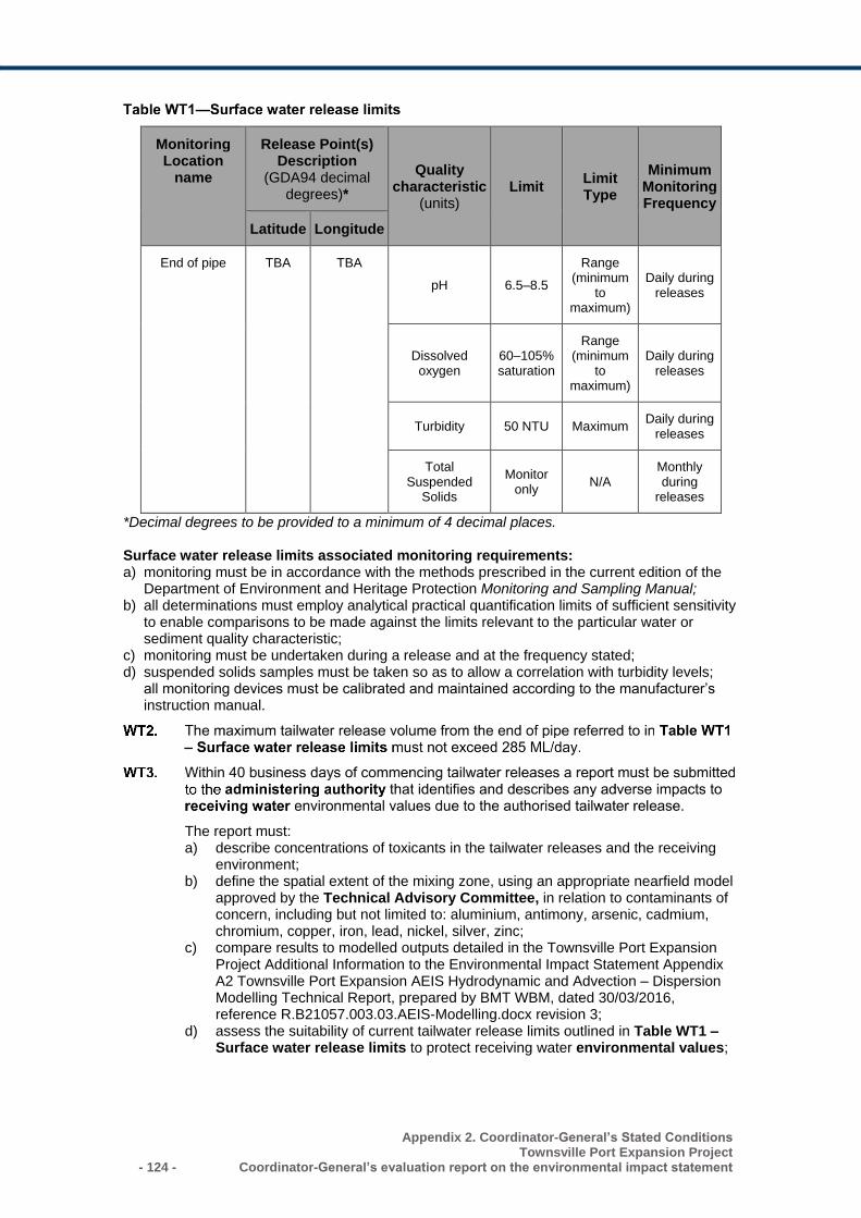
- 124 -
Appendix 2. Coordinator-General’s Stated Conditions Townsville Port Expansion Project
Coordinator-General’s evaluation report on the environmental impact statement
Monitoring Location
name
Release Point(s) Description
(GDA94 decimal degrees)*
Quality characteristic
(units) Limit
Limit Type
Minimum Monitoring Frequency
Latitude Longitude
End of pipe TBA TBA
pH 6.5–8.5
Range (minimum
to maximum)
Daily during releases
Dissolved oxygen
60–105% saturation
Range (minimum
to maximum)
Daily during releases
Turbidity 50 NTU Maximum Daily during
releases
Total Suspended
Solids
Monitor only
N/A Monthly during
releases
*Decimal degrees to be provided to a minimum of 4 decimal places. Surface water release limits associated monitoring requirements: a) monitoring must be in accordance with the methods prescribed in the current edition of the
Department of Environment and Heritage Protection Monitoring and Sampling Manual; b) all determinations must employ analytical practical quantification limits of sufficient sensitivity
to enable comparisons to be made against the limits relevant to the particular water or sediment quality characteristic;
c) monitoring must be undertaken during a release and at the frequency stated; d) suspended solids samples must be taken so as to allow a correlation with turbidity levels;
all monitoring devices must be calibrated and maintained according to the manufacturer’s instruction manual.
The report must: a) describe concentrations of toxicants in the tailwater releases and the receiving
environment; b) define the spatial extent of the mixing zone, using an appropriate nearfield model
approved by the Technical Advisory Committee, in relation to contaminants of concern, including but not limited to: aluminium, antimony, arsenic, cadmium, chromium, copper, iron, lead, nickel, silver, zinc;
c) compare results to modelled outputs detailed in the Townsville Port Expansion Project Additional Information to the Environmental Impact Statement Appendix A2 Townsville Port Expansion AEIS Hydrodynamic and Advection – Dispersion Modelling Technical Report, prepared by BMT WBM, dated 30/03/2016, reference R.B21057.003.03.AEIS-Modelling.docx revision 3;
d) assess the suitability of current tailwater release limits outlined in Table WT1 – Surface water release limits to protect receiving water environmental values;
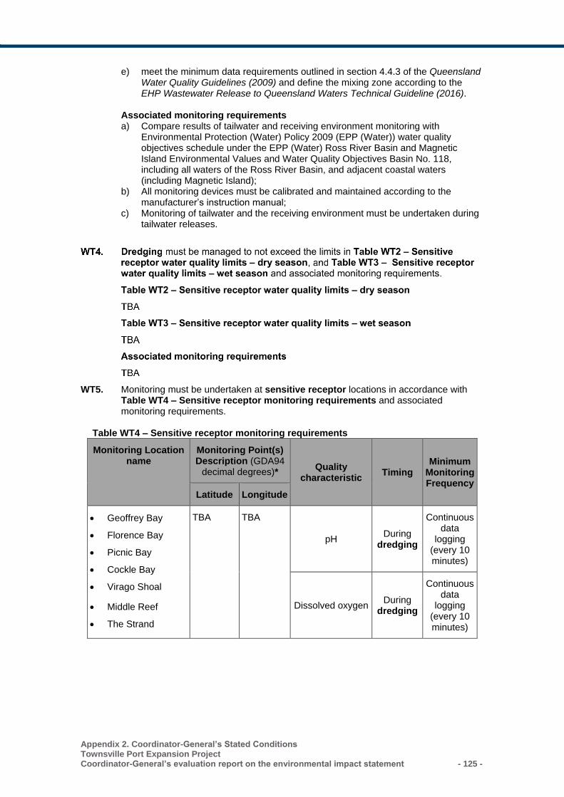
Appendix 2. Coordinator-General’s Stated Conditions Townsville Port Expansion Project Coordinator-General’s evaluation report on the environmental impact statement - 125 -
e) meet the minimum data requirements outlined in section 4.4.3 of the Queensland Water Quality Guidelines (2009) and define the mixing zone according to the EHP Wastewater Release to Queensland Waters Technical Guideline (2016).
Associated monitoring requirements a) Compare results of tailwater and receiving environment monitoring with
Environmental Protection (Water) Policy 2009 (EPP (Water)) water quality objectives schedule under the EPP (Water) Ross River Basin and Magnetic Island Environmental Values and Water Quality Objectives Basin No. 118, including all waters of the Ross River Basin, and adjacent coastal waters (including Magnetic Island);
b) All monitoring devices must be calibrated and maintained according to the manufacturer’s instruction manual;
c) Monitoring of tailwater and the receiving environment must be undertaken during tailwater releases.
WT5. Monitoring must be undertaken at sensitive receptor locations in accordance with Table WT4 – Sensitive receptor monitoring requirements and associated monitoring requirements.
Table WT4 – Sensitive receptor monitoring requirements
Monitoring Location name
Monitoring Point(s) Description (GDA94
decimal degrees)* Quality characteristic
Timing Minimum
Monitoring Frequency
Latitude Longitude
• Geoffrey Bay
• Florence Bay
• Picnic Bay
• Cockle Bay
• Virago Shoal
• Middle Reef
• The Strand
TBA TBA
pH During
dredging
Continuous data
logging (every 10 minutes)
Dissolved oxygen During
dredging
Continuous data
logging (every 10 minutes)
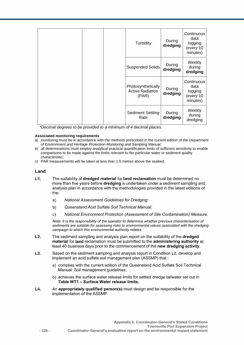
- 126 -
Appendix 2. Coordinator-General’s Stated Conditions Townsville Port Expansion Project
Coordinator-General’s evaluation report on the environmental impact statement
Turbidity During
dredging
Continuous data
logging (every 10 minutes)
Suspended Solids During
dredging
Weekly during
dredging
Photosynthetically Active Radiation
(PAR)
During dredging
Continuous data
logging (every 10 minutes)
Sediment Settling Rate
During dredging
Weekly during
dredging
*Decimal degrees to be provided to a minimum of 4 decimal places. Associated monitoring requirements a) monitoring must be in accordance with the methods prescribed in the current edition of the Department
of Environment and Heritage Protection Monitoring and Sampling Manual; b) all determinations must employ analytical practical quantification limits of sufficient sensitivity to enable
comparisons to be made against the limits relevant to the particular water or sediment quality characteristic;
c) PAR measurements will be taken at less than 1.5 metres above the seabed.
Land
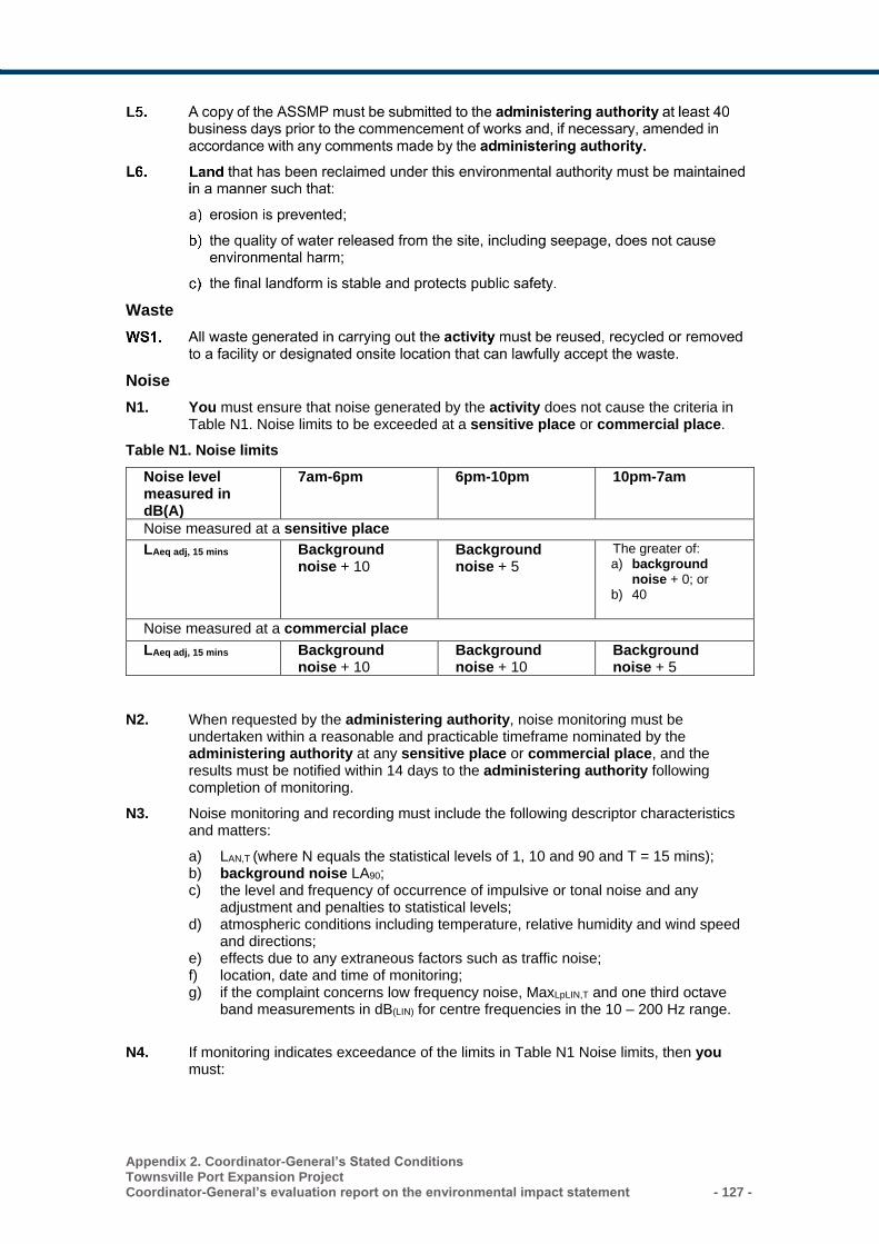
Appendix 2. Coordinator-General’s Stated Conditions Townsville Port Expansion Project Coordinator-General’s evaluation report on the environmental impact statement - 127 -
Waste
Noise
N1. You must ensure that noise generated by the activity does not cause the criteria in Table N1. Noise limits to be exceeded at a sensitive place or commercial place.
Table N1. Noise limits
Noise level measured in dB(A)
7am-6pm 6pm-10pm 10pm-7am
Noise measured at a sensitive place
LAeq adj, 15 mins Background noise + 10
Background noise + 5
The greater of: a) background
noise + 0; or b) 40
Noise measured at a commercial place
LAeq adj, 15 mins Background noise + 10
Background noise + 10
Background noise + 5
N2. When requested by the administering authority, noise monitoring must be undertaken within a reasonable and practicable timeframe nominated by the administering authority at any sensitive place or commercial place, and the results must be notified within 14 days to the administering authority following completion of monitoring.
N3. Noise monitoring and recording must include the following descriptor characteristics and matters:
a) LAN,T (where N equals the statistical levels of 1, 10 and 90 and T = 15 mins); b) background noise LA90; c) the level and frequency of occurrence of impulsive or tonal noise and any
adjustment and penalties to statistical levels; d) atmospheric conditions including temperature, relative humidity and wind speed
and directions; e) effects due to any extraneous factors such as traffic noise; f) location, date and time of monitoring; g) if the complaint concerns low frequency noise, MaxLpLIN,T and one third octave
band measurements in dB(LIN) for centre frequencies in the 10 – 200 Hz range.
N4. If monitoring indicates exceedance of the limits in Table N1 Noise limits, then you must:
- 128 -
Appendix 2. Coordinator-General’s Stated Conditions Townsville Port Expansion Project
Coordinator-General’s evaluation report on the environmental impact statement
a) address the complaint including the use of appropriate dispute resolution if required; or
b) immediately implement noise abatement measure so that emissions of noise from the activity do not result in further environmental nuisance.
N5. The method of measurement and reporting of noise level must comply with the latest edition of the administering authorities Noise Measurement Manual.
Air
A1. You must ensure that all reasonable and feasible avoidance and mitigation measures are employed so that the dust and particulate matter emissions generated by the activity do not cause exceedances of the following levels when measured at any sensitive place or commercial place:
a) dust deposition of 120 milligrams per square metre per day, averaged over 1 month, when monitored in accordance with the most recent version of Australian Standard AS 3580.10.1 “Methods for sampling and analysis of ambient air—Determination of particulate matter—Deposited matter – Gravimetric method“;
b) a concentration of particulate matter with an aerodynamic diameter of less than 10 micrometre (PM10) suspended in the atmosphere of 50 micrograms per cubic metre over a 24 hour averaging time, when monitored in accordance with the most recent version of Australian Standard AS 3580.9.6 “Methods for sampling and analysis of ambient air—Determination of suspended particulate matter—PM10 high volume sampler with size-selective inlet – Gravimetric method” or any method as approved by the administering authority;
c) a concentration of particulate matter suspended in the atmosphere of 90 micrograms per cubic metre over a 1 year averaging time, when monitored in accordance with the most recent version of Australian Standard AS 3580.9.3 “Methods for sampling and analysis of ambient air—Determination of suspended particulate matter—Total suspended particulate matter (TSP)—High volume sampler gravimetric method” or any method as approved by the administering authority.
A2. When requested by the administering authority, dust and particulate monitoring must be undertaken, and the results notified within 14 days to the administering authority following completion of monitoring. Monitoring must be carried out at a place(s) relevant to the potentially affected sensitive place or commercial place and must include:
a) for a complaint alleging dust nuisance, total suspended particulate matter (TSP) and dust deposition;
b) for a complaint alleging adverse health effects caused by dust, the concentration per cubic metre of particulate matter with an aerodynamic diameter of less than 10 micrometre (PM10) suspended in the atmosphere over a 24 hour averaging time.
Definitions Note that where a term is not defined, the definition in the Environmental Protection Act 1994, its regulations or environmental protection policies must be used. If a word remains undefined, it has its ordinary meaning.
Activity means the environmentally relevant activities to which the environmental authority relates.
Administering authority means the Department of Environment and Heritage Protection or its successor or predecessors.
Alert level represent tiers in a hierarchy of increasing environmental risk and are defined by trigger values. Three alert levels (low, moderate, and high) are typically used in a management action framework to indicate adverse conditions and guide management responses that aim to prevent and minimise environmental harm.
Appendix 2. Coordinator-General’s Stated Conditions Townsville Port Expansion Project Coordinator-General’s evaluation report on the environmental impact statement - 129 -
Appropriately qualified person(s) means a person or persons who has professional qualifications, training, skills or experience relevant to the nominated subject matter and can give authoritative assessment, advice and analysis to performance relative to the subject matter using the relevant protocols, standards, methods or literature.
Background noise means noise, measured in the absence of the noise under investigation, as LA90, adj, T being the A-weighted sound pressure level exceeded for 90 per cent of the time period of not less than 15 minutes, using Fast response.
Capital dredging: a) means dredging carried out for the purpose of:
i. creating or enlarging a channel, basin, port, berth or other similar thing; or ii. removing material that is unsuitable as a foundation for a port facility; or iii. creating a trench for a pipe, cable or tube; or iv. an activity incidental to an activity mentioned in subparagraph (i) to (iii); but
b) does not include dredging carried out for the purpose of:
i. maintaining a channel, basin, port, berth or other similar thing for its intended use; or
ii. protecting human life or property.
Commercial place means a place used as a workplace, an office or for business or commercial purposes and includes a place within the curtilage of such a place reasonably used by persons at that place.
Concern site means a site where a sensitive receptor occurs within the zone of influence of a sediment plume.
Continuous data logging means to record instrument-derived data in a memory storage device (a data logger). The frequency of data logging may be, for instance, every 10 minutes, but where a logger device is used in situ, the frequency may be dependent on the memory storage capacity of the logger and the time between logger retrieval events. Alternatively, continuous data logging may be performed via telemetry, with the data being broadcast to an ex situ computer or data logger.
Control site refers to a monitoring site located beyond the anticipated zone of influence of sediment plumes and has site pairing with one or more test sites or sentinel sites. In monitoring programs, control sites serve the same role as do reference sites but only for a defined subset of indicators.
Disturbed areas include areas:
a) that are susceptible to erosion; b) that are contaminated by the activity; and/or c) upon which stockpiles of soil or other materials are located.
Dredge Management Plan is an environmental management plan for the dredging activity. It defines and describes the:
a) scope, timing and duration of the dredging operation; b) sediment plume-associated monitoring programs; c) assessment of data, trigger values and alert levels, d) management actions that may be required in response to adverse monitoring results.
The Dredge Management Plan includes an aim to prevent and minimise environmental harm to sensitive receptors as a result of the dredging activity.
Dredged material means material that has been removed from under surface water, including spoil, other than a mineral within the meaning of any Act relating to mining. Material includes, for example, stone, gravel, sand, rock, clay, mud, silt and soil.
Dredge footprint is the area being dredged including batters.
- 130 -
Appendix 2. Coordinator-General’s Stated Conditions Townsville Port Expansion Project
Coordinator-General’s evaluation report on the environmental impact statement
Dredging includes extraction of mud, sand, coral, ballast, shingle, gravel, clay, earth and other material from the bed of Queensland tidal and non-tidal waters. Dredging does not include the banks of a waterway.
Environmental nuisance as defined in Chapter 1 of the Environmental Protection Act 1994.
Environmental value is:
a) a quality or physical characteristic of the environment that is conducive to ecological health or public amenity or safety; or
b) another quality of the environment identified and declared to be an environmental value under an environmental protection policy or regulation.
LAeq, adj, T means the adjusted A weighted equivalent continuous sound pressure level measures on fast response, adjusted for tonality and impulsiveness, during the time period T, where T is measured for a period no less than 15 minutes when the activity is causing a steady state noise, and no shorter than one hour when the approved activity is causing an intermittent noise.
Land means any land, whether above or below the ordinary high-water mark at spring tides (i.e. includes tidal land).
Measures has the broadest interpretation and includes:
a) procedural measures such as standard operating procedures for dredging operations, environmental risk assessment, management actions, departmental direction and competency expectations under relevant guidelines;
b) physical measures such as plant, equipment, physical objects (such as bunding, containment systems etc.), ecosystem monitoring and bathymetric surveys.
NATA means National Association of Testing Authorities.
New dredging activity means a dredging activity that is currently not underway, the next stage of a dredging campaign that is currently underway, or a discretely separate area in a larger dredge campaign that is currently underway.
Nominated delegate means another government agency that provides services to the administering authority.
Port facility means a facility or land used in the operation or strategic management of a port authority’s port. Port facility does not include a small-scale port facility to be used for a tourism or recreation purpose. Examples of a small-scale port facility—boat ramp, boat harbour, marina.
Receiving waters means the waters into which this environmental authority authorises tailwater releases from the reclamation area
Records include breach notifications, written procedures, analysis results, monitoring reports and monitoring programs required under a condition of this authority.
Reference site refers to a monitoring site located not only beyond the anticipated zone of influence of a sediment plume, but also beyond other sources of environmental impacts, and has site pairing with one or more test sites or sentinel sites. In monitoring programs, reference sites serve the same role as do control sites but can generally be suitable for a broader set of indicators.
Rehandled means handling or relocation of dredged material from a stockpile.
Release of a contaminant into the environment means to:
a) deposit, discharge, emit or disturb the contaminant; b) cause or allow the contaminant to be deposited, discharged, emitted or disturbed; c) fail to prevent the contaminant from being deposited, discharged emitted or disturbed; d) allow the contaminant to escape; e) fail to prevent the contaminant from escaping.
Appendix 2. Coordinator-General’s Stated Conditions Townsville Port Expansion Project Coordinator-General’s evaluation report on the environmental impact statement - 131 -
Sediment plume-associated monitoring means environmental monitoring associated with risk management of sediment plume-associated impacts.
Sediment plume-associated impacts are impacts associated with sediment plumes including turbidity and suspended solids concentrations, light attenuation or sedimentation rates elevated above either control site or reference site readings or baseline conditions for an equivalent time of year. Where dredged material possesses acid sulfate soil-related properties, sediment plume-associated impacts may also include pH, dissolved oxygen and metal and metalloid-related toxicity impacts.
Sensitive place includes the following and includes a place within the curtilage of such a place reasonably used by persons at that place:
a) a dwelling, residential allotment, mobile home or caravan park, residential marina or other residential premises;
a) a motel, hotel or hostel; b) a kindergarten, school, university or other educational institution; c) a medical centre or hospital; d) a protected area under the Nature Conservation Act 1992, the Marine Parks Act 2004
or a World Heritage Area; e) a public park or garden; f) for noise, a place defined as a sensitive receptor for the purposes of the
Environmental Protection (Noise) Policy 2008.
Sensitive receptor includes biological sensitive receptors together with other environmental values sensitive to the effects of dredge-generated sediment plume-associated impacts.
Sentinel site is a test site that is situated between the disturbance source and the sensitive receptor and serves to provide earlier warning of developing adverse conditions than does a test site.
Site pairing refers to monitoring sites that have a functional control-impact relationship, for example, Control site A is referenced to assess monitoring data collected from Concern Sites AA and AB, thus, Concern Sites AA and AB share site pairing with Control Site A.
Technical Advisory Committee means an assembly of appropriately-qualified persons representing experts in various scientific fields, formed to be capable of assessing sediment plume-associated monitoring data and presenting advice relevant to conducting the dredging campaign and protecting sensitive receptors as directed under this authority and the Dredge Management Plan.
Test site is a concern site that functions as a test point for compliance, is a monitoring site situated within the area where a sensitive receptor occurs and where environmental monitoring-related assessment criteria (e.g. trigger values) apply.
Tidal land means land that is submerged at any time by tidal water.
Trigger values are physicochemical, indicator-specific measurement values used to indicate a condition where an environmental value or sensitive receptor may be at low, moderate or high risk, or some other risk-related indicator.
Waters includes river, stream, lake, lagoon, pond, swamp, wetland, unconfined surface water, unconfined water, natural or artificial watercourse, bed and bank of any waters, dams, non-tidal or tidal waters (including the sea), stormwater channel, stormwater drain, roadside gutter, stormwater run-off, and groundwater and any part thereof.
You means the holder of the environmental authority.
Zone of influence of a sediment plume is, in its broadest application, defined by the dredge footprint and the area beyond the dredge footprint where at least some level of sediment plume-associated impacts are expected to occur. The overall zone of influence may be broken down into more risk-relevant Zone of impact sub-categories, such as the Zone of Unavoidable Loss (the dredge footprint and immediately adjacent areas), the Zone of
- 132 -
Appendix 2. Coordinator-General’s Stated Conditions Townsville Port Expansion Project
Coordinator-General’s evaluation report on the environmental impact statement
Moderate Impact, or the Zone of Low Impact, with each zone being defined according to its purpose or role in environmental management.
Zone of impact: See zone of influence definition.
Appendix 2. Coordinator-General’s Stated Conditions Townsville Port Expansion Project Coordinator-General’s evaluation report on the environmental impact statement - 133 -
Schedule 2 - Development Permit for Material Change of Use for Environmentally Relevant Activity
This Schedule includes the Coordinator-General’s stated conditions for a Material Change of
Use for an Environmentally Relevant Activity under the Planning Act 2016, stated under section
37 of the State Development and Public Works Organisation Act 1971.
Condition Number
Condition ID
Condition
1. SARA model condition V3.0 (AI01)
Development authorised under this approval for ERA 16(1)(d) is limited to the dredging of 11.48 million cubic metres and the disposal of dredged material at the reclamation area of 152 hectares as shown in Drawing P3457-01. Timing: At all times.
2. SARA model condition V3.0 (AD01)
The development must be carried out generally in accordance with the following plans:
• Port Expansion Areas - Areas of Useable Land and Rockwalls – P3457-01
• Port Expansion Areas - Area to Outer Toe of Rockwall - P3457-02
• Channel Capacity Upgrade setout and depths (1) – P3470-01
• Channel Capacity Upgrade setout and depths (2) – P3470-02 Timing: At all times.
3. SARA model conditions V2.0 (RA02; amended to be project and site specific)
Storage areas for hazardous contaminants must be located
above the 100 year average recurrence interval (ARI) flood level
or storm tide level, whichever is greater, at the site.
Timing: At all times.
- 134 -
Appendix 2. Coordinator-General’s Stated Conditions Townsville Port Expansion Project
Coordinator-General’s evaluation report on the environmental impact statement
Schedule 3 – Preliminary Approval for Operational Work – Tidal works within a coastal management district
This Schedule includes the Coordinator-General’s stated conditions for Preliminary Approval for
Tidal Works under the Planning Act 2016, stated under section 39 of the State Development
and Public Works Organisation Act 1971.
Condition Number
Condition ID
Condition
1. SARA model condition V3.0 (AD01)
The development must be carried out generally in accordance with the following plans:
• Port Expansion Areas - Areas of Useable Land and Rockwalls – P3457-01
• Port Expansion Areas - Area to Outer Toe of Rockwall - P3457-02
• Channel Capacity Upgrade setout and depths (1) – P3470-01
• Channel Capacity Upgrade setout and depths (2) – P3470-02
Timing: For the duration of construction works.
2. SARA model condition V3.0 (AD02)
The development must be carried out generally in accordance with the Townsville Port Expansion Project Additional Information to the Environmental Impact Statement prepared by AECOM and BMT WBM dated October 2016, in particular: a) Section 2 Project Description; b) Appendix B2 Construction Environmental Management Plan.
Timing: For the duration of construction works.
Appendix 2. Coordinator-General’s Stated Conditions Townsville Port Expansion Project Coordinator-General’s evaluation report on the environmental impact statement - 135 -
Schedule 4 – Development Permit for Operational Work - Tidal works within a coastal management district
This Schedule includes the Coordinator-General’s stated conditions for Tidal Works
under the Planning Act 2016, stated under section 39 of the State Development and
Public Works Organisation Act 1971.
Condition Number
Condition ID Condition
1. SARA model condition V3.0 (AD01)
The development must be carried out generally in accordance with the following plans:
• Port Expansion Areas - Areas of Useable Land and Rockwalls – P3457-01
• Port Expansion Areas - Area to Outer Toe of Rockwall - P3457-02
• Channel Capacity Upgrade setout and depths (1) – P3470-01
• Channel Capacity Upgrade setout and depths (2) – P3470-02
Timing: For the duration of construction works.
2. SARA model condition V3.0 (AD02)
The development must be carried out generally in accordance with the Townsville Port Expansion Project Additional Information to the Environmental Impact Statement prepared by AECOM and BMT WBM dated October 2016, in particular: c) Section 2 Project Description; d) Appendix B2 Construction Environmental Management
Plan.
Timing: For the duration of construction works.
Widening of Sea and Platypus Channels
3. New condition specific for this project
Prior to the commencement of works, submit Registered Professional Engineer of Queensland (RPEQ)1 certified plans prepared by a registered engineer for the following structures to [email protected] or mail to:
Department of Environment and Heritage Protection Permit and License Management Implementation and Support Unit GPO Box 2454 Brisbane QLD 4001.
The relevant structures are those whose purpose includes: a) The containment of dredged material; b) Settlement and discharge of tailwater; c) Treatment of acid sulfate soils;
- 136 -
Appendix 2. Coordinator-General’s Stated Conditions Townsville Port Expansion Project
Coordinator-General’s evaluation report on the environmental impact statement
d) Navigation channels.
Timing: 20 business days prior to the commencement of construction works. 1Note: The Department of Environment and Heritage Protection requires that plans submitted as part of an environmental approval or development application be GPS referenced and approved by a suitably qualified and experienced person who is a Registered Professional Engineer of Queensland (RPEQ). The current plans in the Townsville Port Expansion Project EIS and AEIS do not meet this requirement. Revised and suitably certified plans must be submitted with each stage development approval application.
4. New condition specific for this project
Submit “as constructed drawings” for the structures mentioned in Condition 2, based on post construction:
a) Hydrographic surveys of Platypus and Sea channels; and
b) Surveys of the reclamation area including external revetment walls to [email protected] or mail to:
Department of Environment and Heritage Protection Permit and License Management Implementation and Support Unit GPO Box 2454 Brisbane QLD 4001
Timing: Within three months of the completion of construction works
Reclamation area
5. SARA model condition V3.0 (CP02B)
1. An erosion and sediment control plan must be prepared by an appropriately qualified person(s), in accordance with Best Practice Erosion and Sediment Control (BPESC) guidelines for Australia (International Erosion Control Association). Timing: prior to construction works occurring.
2. Provide the erosion and sediment control plan to the [email protected] or mailed to:
Department of Environment and Heritage Protection Permit and License Management Implementation and Support Unit GPO Box 2454 Brisbane QLD 4001
Timing: prior to construction works occurring.
3. Undertake the development generally in accordance with the erosion and sediment control plan.
Appendix 2. Coordinator-General’s Stated Conditions Townsville Port Expansion Project Coordinator-General’s evaluation report on the environmental impact statement - 137 -
Timing: while construction works are occurring. 4. Provide written evidence from an appropriately
qualified person(s) that all elements of this condition have been complied with. Timing: upon completion of the construction works.
6. SARA model condition V3.0 (CP05; amended to be project and site specific)
The external revetment walls must be designed and constructed to wholly contain all material placed within the reclaimed area and to prevent the release of sediment to tidal waters. Timing: At all times.
7. SARA model condition V3.0 (CP08)
1. In the event that the works cause disturbance or oxidisation of acid sulfate soil, the affected soil must be treated and thereafter managed in accordance with the current Queensland Acid Sulfate Soil Technical Manual: Soil management guidelines, prepared by the Department of Science, Information Technology, Innovation and the Arts, 2014. Timing: upon disturbance or oxidisation until the affected soil has been neutralised or contained.
2. Certification by an appropriately qualified person(s), confirming that the affected soil has been neutralised or contained, in accordance with (a) above is to be provided to [email protected] or mailed to:
Department of Environment and Heritage Protection Permit and License Management Implementation and Support Unit GPO Box 2454 Brisbane QLD 4001
Timing: On the completion of each stage, if acid sulfate soils are encountered.
8. SARA model condition V3.0 (CP21A)
The volume (in cubic metres) of material disposed of within the reclamation area under this approval must be provided to [email protected] or mailed to:
Department of Environment and Heritage Protection Permit and License Management Implementation and Support Unit GPO Box 2454 Brisbane QLD 4001
Timing: Within two weeks of the completion of construction works
9. MS01 Provide written notice to: Regional Harbour Master – Townsville
- 138 -
Appendix 2. Coordinator-General’s Stated Conditions Townsville Port Expansion Project
Coordinator-General’s evaluation report on the environmental impact statement
Department of Transport and Main Roads Maritime Safety Quensland 60 Ross Street, South Townsville PO Box 1921 Townsville QLD 4810
(a) when the development authorised under this approval
is scheduled to commence.
Each notice must state this application number, the location and name of registered place and the condition number under which the notice is being given. Timing: At least two (2) weeks prior to the commencement of construction works
(b) when the development authorised under this approval
has been completed.
Each notice must state this application number, the location
and name of registered place and the condition number
under which the notice is being given.
Timing: Within two (2) weeks of the completion of construction works
10. Prior to the commencement of each stage, the proponent will
inform the Regional Harbour Master of expected vessel
types and activities.
The following plans must be developed in consultation with the Regional Harbour Master, and by a suitably qualified person if deemed necessary by the Regional Harbour Master:
• Construction vessel traffic management
• Construction ship-sourced pollution prevention.
Any plans required must be developed to the satisfaction of the Regional Harbour Master.
Timing: Any plans must be in place one month prior to commencement of each stage
11. MS06 Any navigational aid that is damaged due to the construction, operation or maintenance of the approved development must be promptly repaired or replaced at the applicant’s cost. In the event that any damage is caused to any aid to navigation, the Regional Harbour Master must be immediately contacted.
Appendix 3. Proponent commitments Townsville Port Expansion Project Coordinator-General’s evaluation report on the environmental impact statement - 139 -
Appendix 3. Proponent commitments
Note: any references to plans, guidelines and standards should be taken to mean a
reference to the most recent equivalent plan, guideline or standard in the event that the
referenced document is superseded.
Stakeholder Management
Update existing stakeholder management approaches to ensure that:
recreational and commercial boating interests are:
– consulted in relation to the overall program of works and suitable ways to
minimise impacts to boating interests
– notified of construction works and potential hazards and restrictions. This should
include Notice to Mariners, public signage, advertising and letters to key
stakeholder groups
there is regular engagement and communication with identified stakeholders
throughout project construction, including:
– notification of local residents and residents along transport routes of traffic
movements and noisy activities such as pile driving
– via the Port Community Liaison Group
interested stakeholders can attend the dredging Technical Advisory Committee
meetings as observers
the existing Local Industry Participation Plan, and POTL Employment and
Procurement Policy incorporates employment and business PEP opportunities
arising from PEP construction and operation
indigenous representative groups are aware of employment and business
opportunities during construction and operation
adequate staff are available to handle increases in stakeholder communications
during construction
traditional owners have ongoing input to implementation of the Cultural Heritage
Management Plan for POTL/PEP.
Regional Contribution
The following compensatory measures will be implemented by POTL:
financial and management contribution to expanding the declared Cleveland Bay
Fish Habitat Area to protect an additional 1,240 ha of intertidal and subtidal benthic
habitat in Cleveland Bay under the Fisheries Act 1994 in partnership with the
Queensland Government
on-ground actions and research to improve water quality entering the Great Barrier
Reef lagoon in the region through the North Queensland Dry Tropics Sustainable
Agriculture Program
- 140 -
Appendix 3. Proponent commitments Townsville Port Expansion Project
Coordinator-General’s evaluation report on the environmental impact statement
committed funding to the establishment and operation of a long-term ecosystem
health monitoring program for Cleveland Bay and core funding for associated
surveys of seagrass, corals, and megafauna.
Infrastructure
Conduct an infrastructure study during the prefeasibility or feasibility design stage,
addressing:
– demand and requirements for capacity augmentation
– design, construction and operation standards
– connection to existing systems.
Negotiate, agree and implement infrastructure agreements with infrastructure
providers for power, water/wastewater, road and rail transport, telecommunications
for both construction and operation phases where these are required to be held by
POTL (noting that some agreements will be directly with POTL customers)
Ensure that design of power, water/wastewater, road and rail transport,
telecommunications meets standards specified by infrastructure providers
If required by Townsville City Council and Department of Transport and Main Roads,
conduct a Road Audit six months prior to commencement of haulage for rock wall
construction
Prepare and implement a traffic management plan for the construction phase that
maintains an acceptable level of service and safety. Discuss the traffic
management plan with Townsville City Council and Department of Transport and
Main Roads and Port Community Liaison Group and incorporate improvement
suggestions. Update the plan on a regular basis in consultation with these key
stakeholders.
Ensure that Townsville City Council has adequate information on PEP infrastructure
and planning needs and issues when preparing its Priority Infrastructure Plan.
Continue to work with the Queensland government to provide input to regional
infrastructure planning, including the Mount Isa Rail Infrastructure Master Plan and
Eastern Access Rail Corridor.
Planning and Land Use
Ensure that Townsville City Council has adequate information on PEP infrastructure
and planning needs and issues when preparing its planning scheme. Information
should include advice about off-site impacts from road and rail corridors that might
dictate land use compatibility issues, including along Boundary Street and adjacent
to the rail corridor.
Assist and support Department of Transport and Main Roads in the event that the
Eastern Rail Corridor is required, particularly in providing information to support an
environmental impact assessment.
Appendix 3. Proponent commitments Townsville Port Expansion Project Coordinator-General’s evaluation report on the environmental impact statement - 141 -
Work cooperatively with rail freight providers to support any measures to minimise
and manage impacts of rail freight movements to and from POTL.
Additional Studies and Testing
The following additional studies and tests will be undertaken prior to commencement of
the relevant component of PEP:
Sediment testing in the outer harbour area and Platypus and Sea channels,
including for acid sulfate soils and metals will be undertaken prior to commencement
of dredging.
– Results of sediment testing are to be incorporated into the Dredge Management
Plan and the tailwater management component of the Construction
Environmental Management Plan, with additional management and monitoring
measures to be added as necessary to address any contaminants of concern.
– Test results must be no more than five years old at the time that dredging of a
particular component commences.
Design and Procurement
The following measures will be addressed in design of operational components of PEP
and in procurement:
Design of chemical storage and handling areas to meet requirements of with
relevant Australian Standards, the Australian Dangerous Goods Code and any
Queensland government requirements
Stormwater management systems to minimise release of contaminants to waters of
Cleveland Bay or other sensitive receptors, and treat stormwater as required
Waste storage facilities will be provided as appropriate to the types of materials
likely to be handled at PEP, and other types of waste that might be generated
Toilets and amenities will be connected to the Townsville sewerage system, or on-
site treatment systems provided. Sewerage reticulation and pumping systems will
include measures to prevent overflows in case of power outage or other system
failure.
Relevant requirements of the Queensland Urban Drainage Manual (DNRW, 2007)
and the principles of water sensitive design will be followed.
Minimisation of light spillage to the adjacent environment
Allowance for climate and natural disasters, including sea level rise, storm surge,
waves and severe weather events, taking into account predicted design life of PEP
Minimisation of energy consumption, including through building and equipment
design, and layout of material handling areas
Consideration of carbon footprint when selecting equipment
Opportunities for on-site renewable electricity generation
Site safety and security, including prevention of unauthorised access
- 142 -
Appendix 3. Proponent commitments Townsville Port Expansion Project
Coordinator-General’s evaluation report on the environmental impact statement
Maximisation of local employment and business opportunities.
Construction Environmental Management Plan
POTL and its major contractors will develop and implement a Construction
Environmental Management Plan (CEMP) for the reclamation area, including
construction of walls, handling of dredged material and management of tailwater. The
following matters should be addressed in the CEMP:
Legal requirements, including requirements arising from conditions of approval.
An acid sulfate soil management program that complies with the requirements of the
Queensland Acid Sulfate Soils Technical Manual. Consult with DEHP during
preparation of the plan and incorporate any comments received from DEHP.
A program for management of tailwater and stormwater from the reclamation area
including:
– Measures to prevent stormwater ingress to the reclamation area except from
incident rainfall
– Measures to ensure that tailwater and stormwater is fully contained and only
released in a controlled manner, in compliance with conditions of approval
– Trigger levels and contingency measures to detect and treat tailwater discharges
before non-compliant releases can occur
Procedures for securing water management systems in the event of severe weather
forecasts
Water quality monitoring for areas potentially impacted by construction activities.
This will include visual checks for sediment plumes, litter, oil and other floating
matter.
Measures to minimise dust generation, including, as necessary:
– Covering of loads
– Dust suppression
– Speed restrictions on haul routes
– Covering of long term stockpiles as required
– Temporary and permanent stabilisation of exposed areas as soon as possible.
Measures to minimise noise, including:
– Selection of appropriately sized equipment
– Maintenance of equipment in good order
– Location of pumps and other fixed plant away from sensitive receptors
– Minimise ‘rattling’ of empty trucks using public roads through good practice
management, eg securing tailgates
– Piling activities during normal working hours and Saturdays only.
Measures to minimise and manage construction waste, including:
– Minimising waste concrete and rubble
– Maximising reuse and recycling of waste construction materials
Appendix 3. Proponent commitments Townsville Port Expansion Project Coordinator-General’s evaluation report on the environmental impact statement - 143 -
– Provision of temporary amenities as required
– Containment of litter-producing wastes
– Safe storage of hazardous wastes
– Regular waste collection services.
Measures to prevent terrestrial faunal impact, including designated access routes
and speed limits in sensitive areas.
Minimisation of fuel consumption by vehicles and stationary plant, including
selection of most efficient equipment, switching off when not in use and optimisation
of haul routes and earthworks
Storage and handling of fuels, oils and other hazardous materials, including
measures to minimise likelihood of spills occurring, and consequences to sensitive
receptors if spills do occur. Storage and handling should comply with relevant
Australian Standards, the Australian Dangerous Goods Code and any Queensland
government requirements.
Measures to prevent tracking of sediment or other substances off-site by
construction vehicles
Integration and compliance with relevant requirements from the Cultural Heritage
Management Plan
Prevention of contamination arising from fuels and oils in machinery, including
during refuelling and maintenance activities
Measures to minimise light spillage to the adjacent environment
Measures to prevent accidental introduction of weeds and pest animals including in
imported soils and fill material
Measures to control vermin and feral animals
Visual checks and other procedures to minimise interactions with marine megafauna
during construction, particularly when starting up pile driving
A system of regular checks and inspections of work areas to identify and correct
issues that may lead to incidents or non-compliance
A system for identifying, tracking and implementing corrective actions.
Incident response, investigation and reporting procedures that are consistent with
and supplementary to PEP incident and emergency management plans).
Procedures for securing construction areas if severe weather events are forecast
Training of staff and contractors in implementation of the CEMP, including induction
training, refresher training and ongoing awareness raising
Systems for data management and record keeping.
Annual review and update all elements of the construction environmental
management plan during construction, with more frequent update if triggered by
non-compliance, serious environmental incident or important improvement
opportunity.
Provision of a copy of the plan, and any updated versions, to Federal, State and
local government agencies and other relevant stakeholders on request.
- 144 -
Appendix 3. Proponent commitments Townsville Port Expansion Project
Coordinator-General’s evaluation report on the environmental impact statement
Dredge Management and Reactive Monitoring
A Technical Advisory Committee will be formed to guide development of the Dredge
Management Plan and Reactive Monitoring Program. Membership will include
individuals with expertise in the following areas:
coral biology
seagrass biology
marine megafauna biology (turtles, dugongs and cetaceans)
coastal hydrodynamics and sediment transport
water quality.
The following matters will be included in the Dredge Management Plan:
If sediment testing identifies contaminant ‘hotspots’ and there is a risk that
mobilisation of contaminants could impact on environmental values, material will be
dredged using a mechanical dredger instead of a TSHD
Dredging using the TSHD will only be undertaken from April to September in any
given year.
Measures to minimise illumination and light spillage at night, while meeting
occupational health and safety requirements
Measures to minimise noise and underwater noise where possible
Interactions with marine megafauna will be avoided. Measures will include:
– ‘tickler’ chains on the TSHD dredge head
– ensuring that suction is stopped before lowering the TSHD dredge head
– a 300 m exclusion zone for marine megafauna during dredging activities
– training of ‘spotters’.
Prevention of spillage of fuels, oils and other hazardous materials from the dredge
and associated vessels
Procedures for refuelling that minimise risk of a spill to the marine environment
Spill response procedures and equipment
Deck and dredge head wash-down procedures that prevent release of contaminants
to surface waters. Avoidance of degreasers unless residue can be contained.
Procedures for securing vessels in the event of severe weather
Ship waste management measures, including safe onboard storage of waste
Compliance with all safety and environmental management requirements of the Port
of Townsville, Maritime Safety Queensland and Queensland Transport
Compliance with quarantine and biosecurity measures and additional measures in
relation to biofouling and ballast management for any vessels sourced from outside
the region. In particular:
– Dredges, including dredge heads and pipes, are to be thoroughly cleaned and
inspected at the port of origin to ensure that sediments, organic matter or water is
not transported to the Townsville area
Appendix 3. Proponent commitments Townsville Port Expansion Project Coordinator-General’s evaluation report on the environmental impact statement - 145 -
– Ballast water is not to be exchanged within the Great Barrier Reef Marine Park
except in accordance with Great Barrier Reef Marine Park Authority and
Queensland Transport requirements
– Any ballast tanks holding seawaters to be exchanged with a minimum 150% of
design volume with seawaters at a location as distant from the coastline or other
shallow (<100 m) areas as possible but not less than 5 nautical miles from the
coast (in accordance with IMO requirements).
– Any waters held in the hopper during transit to be treated as for other ballast
waters.
A reactive monitoring program, developed in consultation with a Technical Advisory
Committee, including:
– appropriate triggers and corrective actions to protect sensitive coral and seagrass
ecosystems
– a water quality monitoring program to ensure that water quality is maintained
below levels at which adverse effects on marine and coastal ecosystems may
occur
– a benthic monitoring program to detect impacts to coral, seagrass and benthic
ecosystems and track recovery following dredging activities
Operation:
POTL’s existing operating environmental management system will be updated to
incorporate management of environmental impacts and risks arising from all aspects of
PEP. This will include:
Any additional compliance requirements associated with any components of PEP,
including the reclamation area and new berths
Any additional operating procedures and management measures that are required
to manage new activities to achieve compliance with environmental regulations and
approvals and to maintain risk and impacts within acceptable environmental
standards. These may include measures in relation to:
– Storage and handling of hazardous materials
– Stormwater management
– Management of tailwater and runoff from the reclamation area
– Maintenance dredging of new berth pockets and swing basins
– Storage and handling of wastes
– Maximisation of reuse and recycling of wastes
– Adequate facilities for storage and handling of quarantine waste
– Minimisation of emissions to air and greenhouse gas emissions
– Minimisation of light spill
– Minimisation of noise.
An expanded monitoring system to include:
- 146 -
Appendix 3. Proponent commitments Townsville Port Expansion Project
Coordinator-General’s evaluation report on the environmental impact statement
– Monitoring required to achieve compliance with all relevant conditions of
environmental and planning approvals
– Monitoring of sediments in the inner and outer harbour for any contaminants that
may arise from bulk material storage and handling by new tenants
– Monitoring of water quality for any additional contaminants that may arise from
materials stored and handled at PEP
– Monitoring of beaches at The Strand to check for loss of sand.
Measures to prevent accidental introduction of weeds and pest animals and control
vermin and feral animals in the PEP area
Communication of legislated expectations for the use of low sulfur fuels when
berthing at the port
Updated incident prevention and response procedures to address particular hazards
arising from materials to be stored and handled as part of PEP
Procedures to prepare for and manage effects of increasingly severe weather
events, including coordination with Maritime Safety Queensland in relation to
shipping
Alignment of emergency response procedures with the Queensland Coastal
Contingency Action Plan or other current plan.
Tenants will be required to prepare, implement and maintain environmental
management plans, covering, but not limited to the following items:
Obtaining and complying with all environmental and planning approvals and licences
Stormwater management, based on the Urban Stormwater Quality Planning
Guidelines 2010, or locally applicable guidelines
Transport, storage and handling of hazardous materials, including bulk materials in
accordance with relevant Australian Standards, the Australian Dangerous Goods
Code and any Queensland government requirements
Regular inspections and monitoring and a system for corrective actions
A system for incident prevention, response, reporting and investigation
Procedures to prepare for and manage effects of increasingly severe weather
events
Minimisation of noise, particularly at night-time and on weekends
Training and awareness for staff in all requirements of the plan, including
emergency response
Maintenance dredging practices will include:
Ongoing testing of sediments in berth pockets and swing basins for contaminants
that might arise from the sorts of materials handled at the Port. Testing will be
based on the National Assessment Guidelines for Dredging. In the event that
sediments are not suitable for sea disposal, a land disposal option, or other suitable
option, will be developed.
Survey of channels and other berth areas following severe weather events to
determine the need for maintenance dredging.
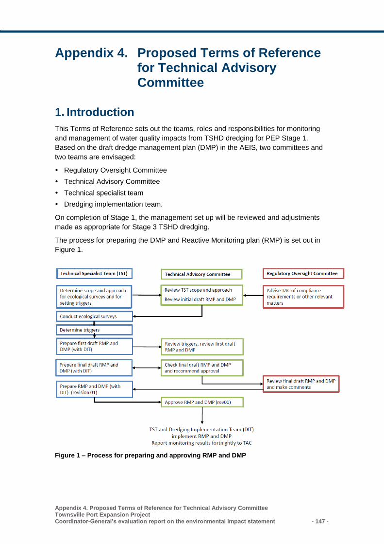
Appendix 4. Proposed Terms of Reference for Technical Advisory Committee Townsville Port Expansion Project Coordinator-General’s evaluation report on the environmental impact statement - 147 -
Appendix 4. Proposed Terms of Reference for Technical Advisory Committee
1. Introduction
This Terms of Reference sets out the teams, roles and responsibilities for monitoring
and management of water quality impacts from TSHD dredging for PEP Stage 1.
Based on the draft dredge management plan (DMP) in the AEIS, two committees and
two teams are envisaged:
Regulatory Oversight Committee
Technical Advisory Committee
Technical specialist team
Dredging implementation team.
On completion of Stage 1, the management set up will be reviewed and adjustments
made as appropriate for Stage 3 TSHD dredging.
The process for preparing the DMP and Reactive Monitoring plan (RMP) is set out in
Figure 1.
Figure 1 – Process for preparing and approving RMP and DMP
- 148 -
Appendix 4. Proposed Terms of Reference for Technical Advisory Committee Townsville Port Expansion Project
Coordinator-General’s evaluation report on the environmental impact statement
2. Regulatory Oversight Committee
The Regulatory Oversight Committee is constituted as follows:
Chair: POTL representative
Membership:
– POTL
– Federal Department of the Environment and Energy
– Queensland Department of Environment and Heritage Protection.
It is also expected that the POTL Environmental supervisor (dredging), Technical
Specialist Team leader and Chair, Technical Advisory Committee will act in an advisory
role to the Regulatory Oversight Committee.
The role of the Regulatory Oversight Committee is to:
Approve appointment of Technical Advisory Committee
Review and comment on the reactive monitoring program (RMP)
Oversee implementation of the RMP
Oversee compliance
Liaise with and/or refer matters to Technical Advisory Committee for advice.
It is noted that Queensland Department of Environment and Heritage Protection also
has a statutory role in issuing an Environmental Authority for dredging and other
construction-related activities.
3. Technical Advisory Committee
3.1 Purpose
The purpose of the Technical Advisory Committee is to:
Provide independent, expert based input on the scientific basis underlying the RMP
and contingency measures in the Dredge Management Plan (DMP)
Provide independent, expert based input to the application for Environmental
Authority in relation to water quality triggers for dredging
Endorse the RMP and contingency measures in the DMP
Provide independent oversight of the implementation of the RMP
Review environmental performance of the dredging against criteria and triggers and
evaluate corrective actions
Provide a contact point for the community and regulator in relation to TSHD
dredging activities.
3.2 Likely membership
It is expected that the Technical Advisory Committee will be made up of:
Appendix 4. Proposed Terms of Reference for Technical Advisory Committee Townsville Port Expansion Project Coordinator-General’s evaluation report on the environmental impact statement - 149 -
Independent chairperson:
Secretariat (POTL)
Expert technical advisers (science)
Dredging operations specialist
POTL Technical Specialist Team leader (see Section 4)
POTL Environmental Supervisor (Dredging) (See Section 5)
Observers from the community.
3.3 Scope of Work (prior to and during Stage 1 dredging)
The scope of work for the Technical Advisory Committee is to be reviewed and
finalised by the Technical Advisory Committee at its first meeting, taking into account
any direction from the Regulatory Oversight Committee.
However, it is anticipated that the scope of work for the Technical Advisory Committee
will involve:
Prior to the application for Environmental Authority (and commencement of Stage 1
TSHD dredging):
– Provide independent expert input into the preparation of the RMP and
contingency measures in the DMP, including:
o Review and comment on the scope of work for the Technical Specialist Team
in relation to ecological surveys, setting of water quality triggers and ecological
health indicators, and preparation of the RMP and DMP
o Critically review and comment on the RMP and contingency measures in the
DMP, including the monitoring trigger levels and indicators that have been set
o Advise on appropriate trigger levels for inclusion in the Environmental
Authority application
– Recommend the RMP and DMP for issue to the Regulatory Oversight Committee
for their review and comment
– Approve the final RMP and DMP for implementation
– Liaise with the Technical Specialist Team as required to resolve technical issues
during preparation of the RMP and DMP
– Address comments from the community.
During Stage 1 TSHD dredging:
– Receive fortnightly updates on monitoring from the Technical Specialist Team
and any mitigation responses to level 1 triggers
– In the event that level 2 water quality triggers are exceeded, provide real-time
advice to the Technical Specialist Team and Dredging Implementation Team on
biological response triggers and mitigation measures
– In the event that level 3 water quality triggers are exceeded, provided real-time
advice to the Technical Specialist Team and Dredging Implementation Team on
whether dredging should be suspended.
- 150 -
Appendix 4. Proposed Terms of Reference for Technical Advisory Committee Townsville Port Expansion Project
Coordinator-General’s evaluation report on the environmental impact statement
– Liaise with Regulatory Oversight Committee regarding non-compliance with
approval conditions (note that the Technical Specialist Team and Dredging
implementation committee will formally notify relevant agencies and the dredging
oversight committee of any non-compliances)
– Receive, investigate and respond to any complaints or incidents relating to TSHD
dredging.
– Advise on whether ongoing monitoring of mechanical dredging is required.
On completion of Stage 1 TSHD dredging:
– Critically review monitoring results and mitigation measures
– Make recommendations on any follow-up monitoring or other actions arising from
Stage 1 TSHD dredging
– Suggest improvements for RMP and DMP during Stage 3 TSHD dredging
– Provide a formal report to the Regulatory Oversight Committee.
The scope of work for Stage 3 TSHD dredging is expected to be similar.
3.4 Specific Roles
3.4.1 Independent Chair
The Independent Chair will need to have the following characteristics:
A working knowledge of water quality
A good understanding of marine ecosystem health
Experience with facilitating groups of this nature
Roles and responsibilities for the independent chair will include:
Determining meeting dates
Setting the agenda for meetings
Putting budgets to the secretariat
Facilitating meetings in an orderly manner, ensuring that Technical Advisory
Committee members and observers behave respectfully and constructively.
Reviewing incoming correspondence
Drafting correspondence on behalf of, and in consultation with the Technical
Advisory Committee
Finalising correspondence taking Technical Advisory Committee comments into
account
Providing final correspondence to the Secretariat for mailing and posting on website
Presenting at POTL’s Community Liaison Group and other forum as required
On advice from the Technical Advisory Committee, or in the event of a serious
complaint, advising the Dredging Implementation Team on mitigation actions,
including whether dredging should cease.
Appendix 4. Proposed Terms of Reference for Technical Advisory Committee Townsville Port Expansion Project Coordinator-General’s evaluation report on the environmental impact statement - 151 -
3.4.2 Secretariat
Roles and responsibilities for the secretariat will include:
Taking notes during meetings and draft meeting minutes and action lists
Coordinating incoming and outgoing mail, and forwarding incoming mail to the
Chair.
Organising meeting venue (POTL office), refreshments and other requirements for
Technical Advisory Committee meetings.
Distributing information to members on behalf of the Chair
Maintaining attendance records, minutes, and correspondence
Posting information on website on behalf of the Chair
Distributing minutes of past meetings, agenda and items for review and discussion
to members at least two weeks before each scheduled meeting
Handling logistical issues such as transport, expense claims and payments
Submitting Technical Advisory Committee budget to POTL for approval
Managing the budget for the Technical Advisory Committee.
3.4.3 Technical Advisors
Technical advisors will be recruited to provide expertise in the following areas:
Water quality:
– Water quality objectives
– Water quality monitoring approaches, including acute ecosystem health
indicators
Coral reef ecosystems
Seagrass ecosystems
Marine megafauna, including underwater noise.
Technical advisers should have experience with turbidity-related impacts.
Their role will be to provide expert technical input as directed by the Chair, and in
accordance with the objectives of the Technical Advisory Committee.
3.4.4 Dredging operations specialist
The dredging operations specialist will have experience in TSHD operation, and will:
provide input on water quality contingency measures for the TSHD
In the event of trigger levels being reached, provide advice on appropriate
responses.
3.4.5 Observers
Observers may attend meetings on written request to the Chair
Observers may attend as individuals or on behalf of an organisation
Observers:
- 152 -
Appendix 4. Proposed Terms of Reference for Technical Advisory Committee Townsville Port Expansion Project
Coordinator-General’s evaluation report on the environmental impact statement
– May participate in discussion if invited by the Chair
– May make written submissions to the Chair and, if invited by the chair, make
verbal representations to the Technical Advisory Committee regarding an issue of
concern
– Will treat everyone with respect and courtesy, and without harassment
– Will not misreport or misrepresent discussions of the Technical Advisory
Committee
– Will not be under the influence of alcohol or drugs
– Will obey direction of the Chair during the meeting
– Will be asked to leave if these protocols are not followed.
3.5 Indicative Technical Advisory Committee Schedule – Stage 1 TSHD Dredging
An indicative schedule for the Technical Advisory Committee for the Stage TSHD dredging is provided in Table 1Error! Reference source not found.. The schedule for Stage 3 TSHD dredging is expected to be similar, but will be determined closer to the commencement of Stage 3.
Table 1 – Indicative Schedule
Activity Timing Tasks
Meeting 1 12 months before Stage
1 TSHD dredging
Introductions
PEP project overview
Review Technical Advisory Committee terms of reference
Overview of (relevant) findings of EIS/AEIS
Work program for Technical Advisory Committee
Discuss RMP and DMP requirements
Review scope of work for Technical Specialist Team,
including agreeing process for setting trigger levels
Offline
review
5 months before Stage 1
TSHD dredging
Review 1st draft RMP and DMP (contingency measures)
Provide comment to Chair for distribution to Technical
Specialist Team
Meeting 2 4 months before Stage 1
TSHD dredging
Discuss comments with Technical Specialist Team and
agree on requirements for final draft RMP and DMP
Offline
reviews
Fortnightly during Stage
1 TSHD dredging
Review monitoring data from RMP
Provide feedback to Chair for distribution to Technical
Specialist Team
Meeting 3 Midway during Stage 1
TSHD dredging
Discuss implementation of the RMP and contingency
measures in DMP with Technical Specialist Team and
Dredging Implementation Team
Make recommendations for adjustments as appropriate
Meeting 4 3 months after
completion of Stage 1
TSHD dredging
Review monitoring results from RMP
Review post-dredging ecological surveys
Appendix 4. Proposed Terms of Reference for Technical Advisory Committee Townsville Port Expansion Project Coordinator-General’s evaluation report on the environmental impact statement - 153 -
Activity Timing Tasks
Provide feedback to Technical Specialist Team and
Dredging Implementation Team for future dredging activities
Prepare post-dredging report to Regulatory Oversight
Committee.
4. Technical Specialist Team
POTL will retain a technical specialist consulting team with expertise in:
The environmental management of dredging programs (team leader, POTL
representative)
Water quality, including:
– Setting water quality triggers
– Determining water quality monitoring methods and equipment
Marine ecology, including:
– Determining tolerances of seagrass and coral reef ecosystems to turbidity levels,
taking into account baseline condition and cumulative impacts
– Detecting signs of chronic and acute stress in coral and seagrass ecosystems.
Scope of work:
Review all baseline water quality monitoring data and EIS/AEIS hydrodynamic
modelling
Identify suitable locations for monitoring
Determine the health of coral reef and seagrass ecosystems in the zone of Influence
and zone of impact prior to commencement of dredging
Determine draft trigger levels for turbidity, light penetration and other indicators as
deemed necessary based on:
– Recent water quality monitoring data
– Pre-dredging condition of coral reef and seagrass ecosystems within the Zone of
Influence
Develop a draft Reactive Monitoring Program (RMP) that is:
– Based on commitments made in the EIS and AEIS
– Achieves compliance with Federal and Queensland approval conditions
Input into the corrective actions in the DMP, in consultation with the Dredging
Implementation Team
Liaise with and take advice from the Technical Advisory Committee regarding draft
trigger levels and RMP
Provide input into application for Environmental Authority for dredging
Implement the RMP
- 154 -
Appendix 4. Proposed Terms of Reference for Technical Advisory Committee Townsville Port Expansion Project
Coordinator-General’s evaluation report on the environmental impact statement
Notify Dredging Implementation Team and Technical Advisory Committee in the
event that triggers are reached
Report to Technical Advisory Committee and Regulatory Oversight Committee on
water quality compliance
Make adjustments to the RMP as directed by the Technical Advisory Committee and
Regulatory Oversight Committee.
Note that the Technical Specialist Team will monitor mechanical dredging for one
month to confirm the anticipated negligible level of impact. If agreed by the Technical
Advisory Committee, this monitoring will stop after one month.
5. Dredging Implementation Team
The Dredging Implementation Team is responsible for the TSHD dredging campaign,
including environmental management via implementation of the DMP. As DMP
contingency measures may include moving the dredging activity, and as
implementation of the TSHD also requires marine traffic control, the membership of the
Dredging Implementation Team is proposed as follows:
Chair: POTL representative
POTL Environmental supervisor (dredging)
Dredge contractor
– Manager
– Environmental manager
Regional harbour master
Port control.
The roles of the Dredging Implementation Team in relation to environmental aspects of
dredging are to:
Prepare the DMP, including advice from the Technical Advisory Committee and
Technical Specialist Team on dredging contingency measures
Prepare the application for Environmental Authority for capital dredging
Implement the DMP
Liaise with the Technical Specialist Team and Technical Advisory Committee
regarding contingency measures if water quality triggers are exceeded.
Townsville Port Expansion Project Coordinator-General’s evaluation report on the environmental impact statement - 155 -
Acronyms and abbreviations
Acronym Definition
ACH Act Aboriginal Cultural Heritage Act 2003 (Qld)
AEIS additional environmental impact statement
AHD Australian Height Datum
ASSMP acid sulfate soils management plan
CEMP construction environmental management plan
CH4 methane
CHMP cultural heritage management plan
CLR Contaminated Land Register
CO carbon monoxide
CPM Act Coastal Protection and Management Act 1995 (Qld)
CSEP community and stakeholder engagement plan
dB(A) decibels measured at the ‘A’ frequency weighting network
DAF Department of Agriculture and Fisheries
DEE Department of the Environment and Energy (Commonwealth)
DEHP Department of Environment and Heritage Protection
DILGP Department of Infrastructure, Local Government and Planning
DMP dredge management plan
DMPA dredge material placement area
DNPSR Department of National Parks, Sport and Racing
DNRM Department of Natural Resources and Mines
DO dissolved oxygen
DSITI Department of Science, Information Technology and Innovation
DTMR Department of Transport and Main Roads
DWT deadweight tonnage
EA environmental authority
EIS environmental impact statement
EMR Environmental Management Register
EP Act Environmental Protection Act 1994 (Qld)
EPBC Act Environment Protection and Biodiversity Conservation Act 1999 (Cwlth)
EPP Employment and Procurement Policy
EPP (Air) Environmental Protection (Air) Policy 2008
EPP (Noise) Environmental Protection (Noise) Policy 2008
EPP (Water) Environmental Protection (Water) Policy 2009
- 156 - Townsville Port Expansion Project
Coordinator-General’s evaluation report on the environmental impact statement
Acronym Definition
EP Regulation Environmental Protection Regulation 2008
ERA environmentally relevant activity
FHA fish habitat area
FTE full-time equivalent
GARID Guidelines for Assessment of Road Impacts of Development
GBRMP Great Barrier Reef Marine Park
GBRMPA Great Barrier Reef Marine Park Authority
GBRMP Act Great Barrier Reef Marine Park Act 1975 (Cwth)
GBRWHA Great Barrier Reef World Heritage Area
ILUA Indigenous Land Use Agreement
LAeq the average A-weighted sound pressure level of a continuous steady sound that has the same mean square sound pressure as a sound level that varies with time
LAmax the maximum average A-weighted sound pressure measured over a specified period of time
LAT lowest astronomical tide
LGA local government area
LIPP Local Industry Participation Plan
The Master Plan
The Master Plan for the Priority Port of Townsville
MCU material change of use
MNES matters of national environmental significance
MSES matters of state environmental significance
MSQ Maritime Safety Queensland
NAGD National Assessment Guidelines for Dredging 2009
NC Act Nature Conservation Act 1992 (Qld)
NET Northern Economic Triangle
N2O nitrous oxide
NO2 nitrogen dioxide
OEMP operational environmental management plan
PASS potential acid sulfate soils
PDA priority development area
PM10 particulate matter with equivalent aerodynamic diameter less than
10m
PM2.5 particulate matter with equivalent aerodynamic diameter less than
2.5m
POTL Port of Townsville Limited
PPV peak particle velocity
Townsville Port Expansion Project Coordinator-General’s evaluation report on the environmental impact statement - 157 -
Acronym Definition
Planning Act Planning Act 2016 (Qld)
PTLUP Port of Townsville Land Use Plan
Reef 2050 Reef 2050 Long-Term Sustainability Plan
RMP reactive monitoring program
SARA State Assessment Referral Agency
SDA state development area
SDAP State Development Assessment Provisions
SDPWO Act State Development and Public Works Organisation Act 1971 (Qld)
SIA social impact assessment
SIMR social impact management report
SO2 sulfur dioxide
SP Act Sustainable Planning Act 2009 (Qld)
SPD Act Sustainable Ports Development Act 2015 (Qld)
SRI significant residual impact
TAC Technical Advisory Committee
TCC Townsville City Council
TCCUP Port of Townsville Channel Capacity Upgrade Project
t/CO2-e tonnes of CO2 equivalent
TEU twenty-foot equivalent units
TI Act Transport Infrastructure Act 1994 (Qld)
TOR terms of reference
TSDA Townsville State Development Area
TSHD trailer suction hopper dredge
TSP total suspended particles
TSS total suspended solids
- 158 - Townsville Port Expansion Project
Coordinator-General’s evaluation report on the environmental impact statement
Glossary
Australian Height Datum (AHD)
The datum used for determining elevations in Australia which uses a national network of bench marks and tide gauges, and has set mean sea level as zero elevation.
assessment manager
For an application for a development approval, means the assessment manager under the Planning Act 2016 (Qld).
bilateral agreement The agreement between the Australian and Queensland governments that accredits the State of Queensland’s EIS process. It allows the Commonwealth Minister for the Environment to rely on specified environmental impact assessment processes of the state of Queensland in assessing actions under the Environment Protection and Biodiversity Conservation Act 1999 (Cwlth).
controlled action A proposed action that is likely to have a significant impact on a matter of national environmental significance; the environment of Commonwealth land (even if taken outside Commonwealth land); or the environment anywhere in the world (if the action is undertaken by the Commonwealth). Controlled actions must be approved under the controlling provisions of the Environment Protection and Biodiversity Conservation Act 1999 (Cwlth).
controlling provision
The matters of national environmental significance, under the Environment Protection and Biodiversity Conservation Act 1999 (Cwlth), that the proposed action may have a significant impact on.
coordinated project A project declared as a ' coordinated project' under section 26 of the SDPWO Act. Formerly referred to as a ‘significant project’.
Coordinator-General
The corporation sole constituted under section 8A of the State Development and Public Works Organisation Act 1971 and preserved, continued in existence and constituted under section 8 of the SDPWO Act.
EIS documentation The Townsville Port Expansion Project EIS and AEIS
environment As defined in Schedule 2 of the SDPWO Act, includes:
a) ecosystems and their constituent parts, including people and communities
b) all natural and physical resources
c) the qualities and characteristics of locations, places and areas, however large or small, that contribute to their biological diversity and integrity, intrinsic or attributed scientific value or interest, amenity, harmony and sense of community
the social, economic, aesthetic and cultural conditions that affect, or are affected by, things mentioned in paragraphs (a) to (c).
Townsville Port Expansion Project Coordinator-General’s evaluation report on the environmental impact statement - 159 -
environmentally relevant activity (ERA)
An activity that has the potential to release contaminants into the environment. Environmentally relevant activities are defined in Part 3, section 18 of the Environmental Protection Act 1994 (Qld).
imposed condition A condition imposed by the Queensland Coordinator-General under section 54B of the SDPWO Act. The Coordinator-General may nominate an entity that is to have jurisdiction for the condition.
initial advice statement (IAS)
A scoping document, prepared by a proponent, that the Coordinator-General considers in declaring a coordinated project under Part 4 of the SDPWO Act. An IAS provides information about:
the proposed development
the current environment in the vicinity of the proposed project location
the anticipated effects of the proposed development on the existing environment
possible measures to mitigate adverse effects.
listed species A plant or animal included in a schedule of endangered, vulnerable, or near-threatened biota, such as the schedules in the EPBC Act (Cwlth) or the Nature Conservation (Wildlife) Regulation 2006 (Qld).
matters of national environmental significance
The matters of national environmental significance protected under the Environment Protection and Biodiversity Conservation Act 1999. The eight matters are:
a) world heritage properties
b) national heritage places
c) wetlands of international importance (listed under the Ramsar Convention)
d) listed threatened species and ecological communities
e) migratory species protected under international agreements
f) Commonwealth marine areas
g) the Great Barrier Reef Marine Park
h) nuclear actions (including uranium mines).
mining activity As defined in section 110 of the EP Act
nominated entity (for an imposed condition for undertaking a project)
An entity nominated for the condition, under section 54B(3) of the SDPWO Act.
pH Measure of the acidity or alkalinity of a substance, with 1 being the most acidic, 7 being neutral and 14 being the most alkaline.
- 160 - Townsville Port Expansion Project
Coordinator-General’s evaluation report on the environmental impact statement
properly made submission (for an EIS or a proposed change to a project)
Defined under Schedule 2 of the SDPWO Act as a submission that:
i) is made to the Coordinator-General in writing
j) is received on or before the last day of the submission period
k) is signed by each person who made the submission
l) states the name and address of each person who made the submission
m) states the grounds of the submission and the facts and circumstances relied on in support of the grounds.
proponent The entity or person who proposes a coordinated project. It includes a person who, under an agreement or other arrangement with the person who is the existing proponent of the project, later proposes the project.
significant project A project declared (prior to 21 December 2012) as a 'significant project' under section 26 of the SDPWO Act. Projects declared after 21 December 2012 are referred to as ‘coordinated projects’.
stated condition Conditions stated (but not enforced by) the Coordinator-General under sections 39, 45, 47C, 49, 49B and 49E of the SDPWO Act. The Coordinator-General may state conditions that must be attached to a:
development approval under the Planning Act 2016
proposed mining lease under the Mineral Resources Act 1989
draft environmental authority under Chapter 5 of the Environmental Protection Act 1994 (EPA)
proposed petroleum lease, pipeline licence or petroleum facility licence under the Petroleum and Gas (Production and Safety) Act 2004
non-code compliant environmental authority (petroleum activities) under Chapter 4A of the EPA.
terrestrial Pertaining to land, the continents or dry ground.
the project Townsville Port Expansion Project
threatened species and ecological communities
Threatened species or ecological communities listed and protected under the provisions of the Environment Protection and Biodiversity Conservation Act 1999 (Cth).
turbidity The clarity of the water, which depends on the concentration of particles that are suspended in the water column.
vulnerable A species is vulnerable if:
its population is decreasing because of threatening processes; or
Townsville Port Expansion Project Coordinator-General’s evaluation report on the environmental impact statement - 161 -
its population has been seriously depleted and its protection is not secured; or
its population, while abundant, is at risk because of threatening processes; or
its population is low or localised or depends on limited habitat that is at risk because of threatening processes.
works Defined under the SDPWO Act as the whole and every part of any work, project, service, utility, undertaking or function that:
n) the Crown, the Coordinator-General or other person or body who represents the Crown, or any local body is or may be authorised under any Act to undertake, or
o) is or has been (before or after the date of commencement of this Act) undertaken by the Crown, the Coordinator-General or other person or body who represents the Crown, or any local body under any Act, or
p) is included or is proposed to be included by the Coordinator-General as works in a program of works, or that is classified by the holder of the office of Coordinator-General as works.

The Coordinator-General PO Box 15517, City East Qld 4002 tel 13 QGOV (13 74 68) fax +61 7 3452 7486 [email protected] www.statedevelopment.qld.gov.au