Embed Size (px)
Citation preview
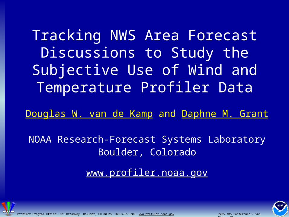
Tracking NWS Area Forecast Discussions to Study the Subjective
Use of Wind and Temperature Profiler Data
Douglas W. van de Kamp and Daphne M. Grant
NOAA Research-Forecast Systems LaboratoryBoulder, Colorado
www.profiler.noaa.gov
2005 AMS Conference – San Diego, CAProfiler Program Office 325 Broadway Boulder, CO 80305 303-497-6200 www.profiler.noaa.gov
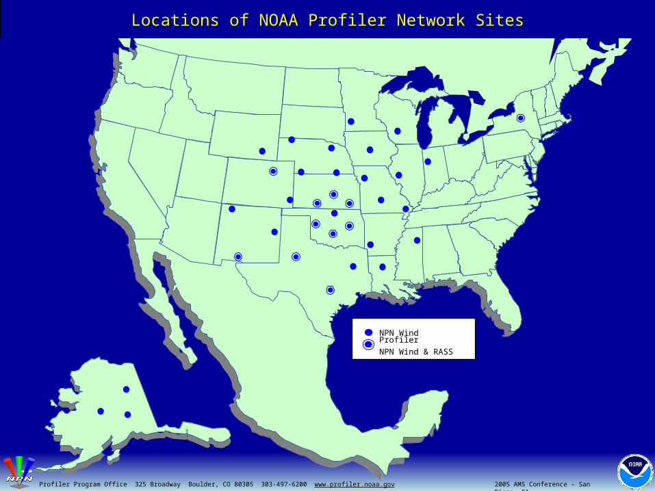
NPN Wind Profiler
NPN Wind & RASS
2005 AMS Conference – San Diego, CAProfiler Program Office 325 Broadway Boulder, CO 80305 303-497-6200 www.profiler.noaa.gov
Locations of NOAA Profiler Network Sites

CAP Wind Profiler
CAP Wind & RASS
Locations of Cooperative Agency Profiler Sites
2005 AMS Conference – San Diego, CAProfiler Program Office 325 Broadway Boulder, CO 80305 303-497-6200 www.profiler.noaa.gov

NPN Wind Profiler
NPN Wind & RASS
NPN Wind Profiler
NPN Wind & RASS
CAP Wind Profiler
CAP Wind & RASS
Locations of all known Profilers in the Continental U.S., Canada and Mexico
2005 AMS Conference – San Diego, CAProfiler Program Office 325 Broadway Boulder, CO 80305 303-497-6200 www.profiler.noaa.gov

Locations of National Weather Service Forecast Offices
2005 AMS Conference – San Diego, CAProfiler Program Office 325 Broadway Boulder, CO 80305 303-497-6200 www.profiler.noaa.gov

"...FORECAST CONCERN THIS CYCLE CONTINUES TO BE TIMING OF PRECIP CHANCES ALONG WITH HIGH TEMPS...
LATEST RADAR SHOWING MCS EDGING INTO SOUTHWEST PART OF CWA…
TWO MCS'S IN PLAY WHEN SHIFT STARTED BUT NORTHERN ONE THAT WAS OVER SOUTHERN SDAK HAS WEAKENED AS PER WARMING IN SATELLITE IMAGERY…
PROFILER NETWORK SHOWED SHORTWAVE POSITION IN WESTERN SDAK AND NEB AT 700 MB. STEERING WINDS AT MCCOOK...WHICH IS WHERE CONVECTION IS CURRENTLY ONGOING...ARE VERY LIGHT CONFIRMING SLOW MOVEMENT OF STORMS. COMPARED 500MB PROFILER WINDS WITH 06Z GFS AND IT LOOKS LIKE MODEL IS OVERDONE WITH STRENGTH OF 500 WAVE TO OUR IMMEDIATE WEST.
HIGHS TODAY SHOULD BE SIMILAR TO YESTERDAY AS…
TIMING OF SHORTWAVES THEN BECOMES FOCUS THROUGH THE EARLY WEEKEND. MCS DEVELOPMENT TONIGHT LOOKS TO GIVE A LITTLE BETTER CHANCE ...”
AREA FORECAST DISCUSSION NATIONAL WEATHER SERVICE HASTINGS NEBRASKA
SOUTH CENTRAL NEBRASKA AND NORTH CENTRAL KANSAS400 AM CDT FRI AUG 8 2003
2005 AMS Conference – San Diego, CAProfiler Program Office 325 Broadway Boulder, CO 80305 303-497-6200 www.profiler.noaa.gov

“UPDATE...COLD AND SNOWY WITH NORTHERLY WINDS ACROSS MOST OF THE FA. COASTAL FRONT IS JUST OFFSHORE EXCEPT IN SE NH WHERE IT HAS CREPT INLAND AND JUMPED TEMPS INTO THE LWR 30S. WILL BE UPDATING TO TOUCH UP THE FIRST PD. NO CHANGES FOR THE COASTAL WATERS.
DISCUSSION...MODELS STILL POINTING TOWARD A SIGNIFICANT WINTER WEATHER EVENT FOR THE FORECAST AREA...STARTING THIS EVENING AND LASTING INTO AT LEAST THE FIRST HALF OF MONDAY...BEFORE WINDING DOWN MONDAY AFTERNOON AND EARLY EVENING. BOTTOM LINE...NO CHANGE IN THE WARNINGS FOR TONIGHT AND MONDAY. BASED ON THE WARM AIR ADVECTION TO OUR SOUTH (STRONG VEERING ON THE RUTGERS PROFILER IN NJ)...THE SNOW SHOULD FALL HEAVILY AT TIMES NOT LONG AFTER STARTING. THIS SHOULD CONTINUE ACROSS THE REGION THROUGH 06Z OR SO. SNOWFALL RATES OF 2 OR 3 INCHES AN HOUR COULD DEVELOP IN THE STRONG WARMING. WHILE IT WON'T BE INCLUDED IN THE FORECAST...THUNDER AND LIGHTNING NOT OUT OF THE QUESTION.”
2005 AMS Conference – San Diego, CAProfiler Program Office 325 Broadway Boulder, CO 80305 303-497-6200 www.profiler.noaa.gov
AREA FORECAST DISCUSSIONNATIONAL WEATHER SERVICE GRAY/PORTLAND MAINE
SOUTHERN MAINE AND NORTHERN NEW HAMPSHIRE915 PM EST SUN DEC 14 2003

Amarillo
Austin/San Antonio
Baltimore/Washington DC
Binghamton
Brownsville
Charleston
Cheyenne Chicago
Corpus Christi
Denver
Des Moines
DetroitPontiac
Dodge City
Grand Forks
El Paso-Santa Teresa
Eureka
Flagstaff
Fort Worth
Gaylord
GoodlandGrand Junction
GrandRapids
Gray
Green Bay
Hanford
Hastings
Houston/Galveston
Jackson
KansasCity
La Crosse
Lake Charles
Lincoln
Little RockLos Angeles
Louisville
Lubbock
Marquette
Medford
Melbourne
Miami
Midland/Odessa
Mount Holly
Nashville
New Orleans/Baton Rouge
Norman
North PlatteNorthern IN
Omaha
Paducah
Portland
Pueblo
Quad Cities
Raleigh
Rapid City
RenoSacramento
San Angelo
SanFrancisco
Seattle
Shreveport
Sioux Falls
Springfield
St. Louis
Taunton
Topeka
Tulsa
TwinCities
Wichita
Wakefield
Number of AFDs
1-20:
21-40:
41-60:
61-90:
> 90
Tallahassee
Milwaukee/Sullivan
Tucson
Key West
Albuquerque
Locations of NWS Offices Identifying Use of Profiler Data in their Area Forecast Discussions, 6 January 2003 – 5 January 2004
2005 AMS Conference – San Diego, CAProfiler Program Office 325 Broadway Boulder, CO 80305 303-497-6200 www.profiler.noaa.gov

Categories of Profiler Data Usage Identified from the Area Forecast Discussions
2005 AMS Conference – San Diego, CAProfiler Program Office 325 Broadway Boulder, CO 80305 303-497-6200 www.profiler.noaa.gov
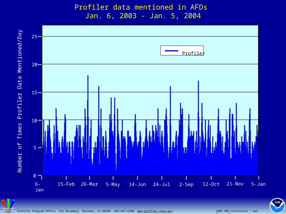
Profiler data mentioned in AFDs Jan. 6, 2003 - Jan. 5, 2004
25
20
15
10
5
0
6-Jan 26-Mar 5-May 14-Jun 24-Jul 2-Sep 12-Oct 21-Nov 5-Jan15-Feb
Num
ber
of
Tim
es
Pro
filer
Dat
a M
entio
ned/
Day
2005 AMS Conference – San Diego, CAProfiler Program Office 325 Broadway Boulder, CO 80305 303-497-6200 www.profiler.noaa.gov
Profiler

Profiler, RUC, & ACARS data mentioned in AFDs Jan. 6, 2003 - Jan. 5, 2004
Num
ber
of
Tim
es
Dat
a T
ype
Me
ntio
ned/
Da
y
25
20
15
10
5
0
6-Jan 15-Feb 26-Mar 5-May 14-Jun 24-Jul 2-Sep 12-Oct 21-Nov 5-Jan
2005 AMS Conference – San Diego, CAProfiler Program Office 325 Broadway Boulder, CO 80305 303-497-6200 www.profiler.noaa.gov 2005 AMS Conference – San Diego, CAProfiler Program Office 325 Broadway Boulder, CO 80305 303-497-6200 www.profiler.noaa.gov
RUCProfilerACARS
Summary
• Identified the use of wind and temperature profiler data in NWS Area Forecast Discussions
• Categorized the use of profiler data in forecaster’s decision making process
• Profiler data useful for general “situational awareness”, in addition to specific applications
• Data were found to be valuable and well integrated into routine operations at many NWS offices
2005 AMS Conference – San Diego, CAProfiler Program Office 325 Broadway Boulder, CO 80305 303-497-6200 www.profiler.noaa.gov 2005 AMS Conference – San Diego, CAProfiler Program Office 325 Broadway Boulder, CO 80305 303-497-6200 www.profiler.noaa.gov