Embed Size (px)
Citation preview
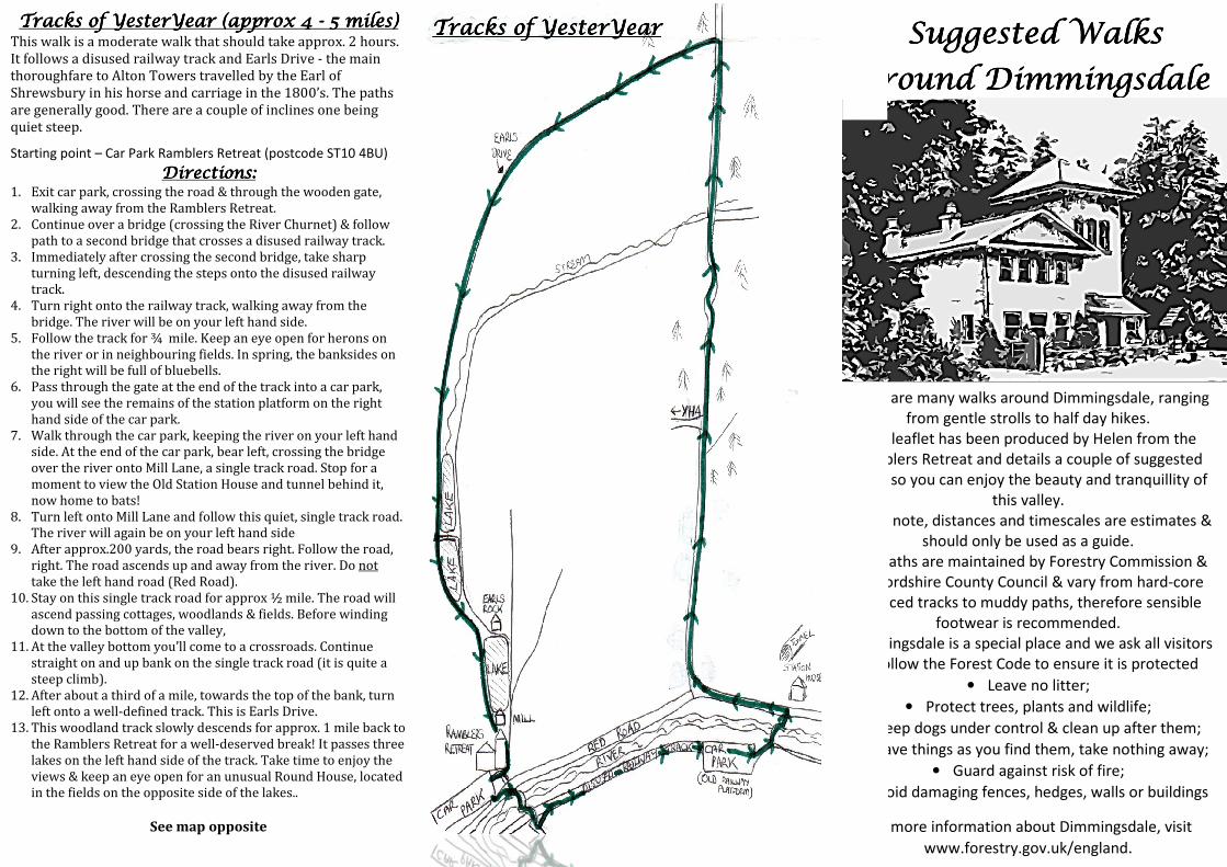
Tracks of YesterTracks of YesterTracks of YesterTracks of YesterYYYYearearearear (approx 4 (approx 4 (approx 4 (approx 4 ---- 5 miles)5 miles)5 miles)5 miles) This walk is a moderate walk that should take approx. 2 hours.
It follows a disused railway track and Earls Drive - the main
thoroughfare to Alton Towers travelled by the Earl of
Shrewsbury in his horse and carriage in the 1800’s. The paths
are generally good. There are a couple of inclines one being
quiet steep.
Starting point – Car Park Ramblers Retreat (postcode ST10 4BU)
Directions:Directions:Directions:Directions: 1. Exit car park, crossing the road & through the wooden gate,
walking away from the Ramblers Retreat.
2. Continue over a bridge (crossing the River Churnet) & follow
path to a second bridge that crosses a disused railway track.
3. Immediately after crossing the second bridge, take sharp
turning left, descending the steps onto the disused railway
track.
4. Turn right onto the railway track, walking away from the
bridge. The river will be on your left hand side.
5. Follow the track for ¾ mile. Keep an eye open for herons on
the river or in neighbouring fields. In spring, the banksides on
the right will be full of bluebells.
6. Pass through the gate at the end of the track into a car park,
you will see the remains of the station platform on the right
hand side of the car park.
7. Walk through the car park, keeping the river on your left hand
side. At the end of the car park, bear left, crossing the bridge
over the river onto Mill Lane, a single track road. Stop for a
moment to view the Old Station House and tunnel behind it,
now home to bats!
8. Turn left onto Mill Lane and follow this quiet, single track road.
The river will again be on your left hand side
9. After approx.200 yards, the road bears right. Follow the road,
right. The road ascends up and away from the river. Do not
take the left hand road (Red Road).
10. Stay on this single track road for approx ½ mile. The road will
ascend passing cottages, woodlands & fields. Before winding
down to the bottom of the valley,
11. At the valley bottom you’ll come to a crossroads. Continue
straight on and up bank on the single track road (it is quite a
steep climb).
12. After about a third of a mile, towards the top of the bank, turn
left onto a well-defined track. This is Earls Drive.
13. This woodland track slowly descends for approx. 1 mile back to
the Ramblers Retreat for a well-deserved break! It passes three
lakes on the left hand side of the track. Take time to enjoy the
views & keep an eye open for an unusual Round House, located
in the fields on the opposite side of the lakes..
See map opposite
Tracks of Tracks of Tracks of Tracks of
aaaarrrroooo
There are many walks
This leaflet has been
Ramblers Retreat
walks s
Please note,
Footpa
Staffordshire County Council
surfaced tracks to muddy pat
Dimmingsdale is a special place
to follow the Forest Code to ensure i
• Keep dogs under control
• Leav
• Avo
For m
Tracks of Tracks of Tracks of Tracks of YYYYesteresteresteresterYYYYearearearear Suggested Suggested Suggested Suggested WWWWalks alks alks alks
aaaarrrroooouuuunnnndddd DDDDiiiimmmmmmmmiiiinnnnggggssssddddaaaalllleeee
There are many walks around Dimmingsdale, ranging
from gentle strolls to half day hikes.
This leaflet has been produced by Helen from the
Ramblers Retreat and details a couple of suggested
walks so you can enjoy the beauty and tranquillity of
this valley.
Please note, distances and timescales are estimates &
should only be used as a guide.
tpaths are maintained by Forestry Commission &
Staffordshire County Council & vary from hard-core
surfaced tracks to muddy paths, therefore sensible
footwear is recommended.
Dimmingsdale is a special place and we ask all visitors
to follow the Forest Code to ensure it is protected
• Leave no litter;
• Protect trees, plants and wildlife;
Keep dogs under control & clean up after them;
Leave things as you find them, take nothing away;
• Guard against risk of fire;
oid damaging fences, hedges, walls or buildings
or more information about Dimmingsdale, visit
www.forestry.gov.uk/england.
Pass through a smallIn
A gentle, A gentle, A gentle, A gentle, ppppicturesqueicturesqueicturesqueicturesque stroll.stroll.stroll.stroll.
If you are looking for a very gentle stroll then
follow the directions below.
This is a picturesque walk passing two lakes,
streams, woodland and rocky outcrops.
It is an easy, flat walk suitable for small children or
those who simply cannot walk very far. It is also
suitable for pushchairs.
At a gentle pace it will take approx. ¾ hour.
Starting point – Car Park at Ramblers Retreat
(postcode ST10 4BU)
Directions:Directions:Directions:Directions:
1. Exit car park and take left-hand path past the
Ramblers Retreat. The path will pass a converted
Smelting Mill located on the right hand side of the
path.
2. You will reach a lake, located on right hand side of
the path. Here you can enjoy beautiful views of
the lake and valley. Children can also feed the
ducks that live on the lake.
3. Continue on this path, passing woodland on your
left and streams on your right. On your left, you
may be able to see an outcrop of sandstone rock
which looks like a lion’s head, however when the
trees are in full bloom it may be difficult to view.
4. Follow this path until you arrive at a second lake,
again located on the right hand side of the path.
5. When ready, simply turn around and retrace your
steps back to the Ramblers Retreat car park.
Castle View WalkCastle View WalkCastle View WalkCastle View WalkA relatively easy walk
views of woodland
Towers.
which is a Site of Scientific Interest due to its flora & fauna.
There are a couple of inclines during this walk,
not particularly steep. Walking boots or study shoes are
recommended.
Starting point
4BU)
1.
2.
3.
4.
5.
6.
7.
8.
9.
10.
11.
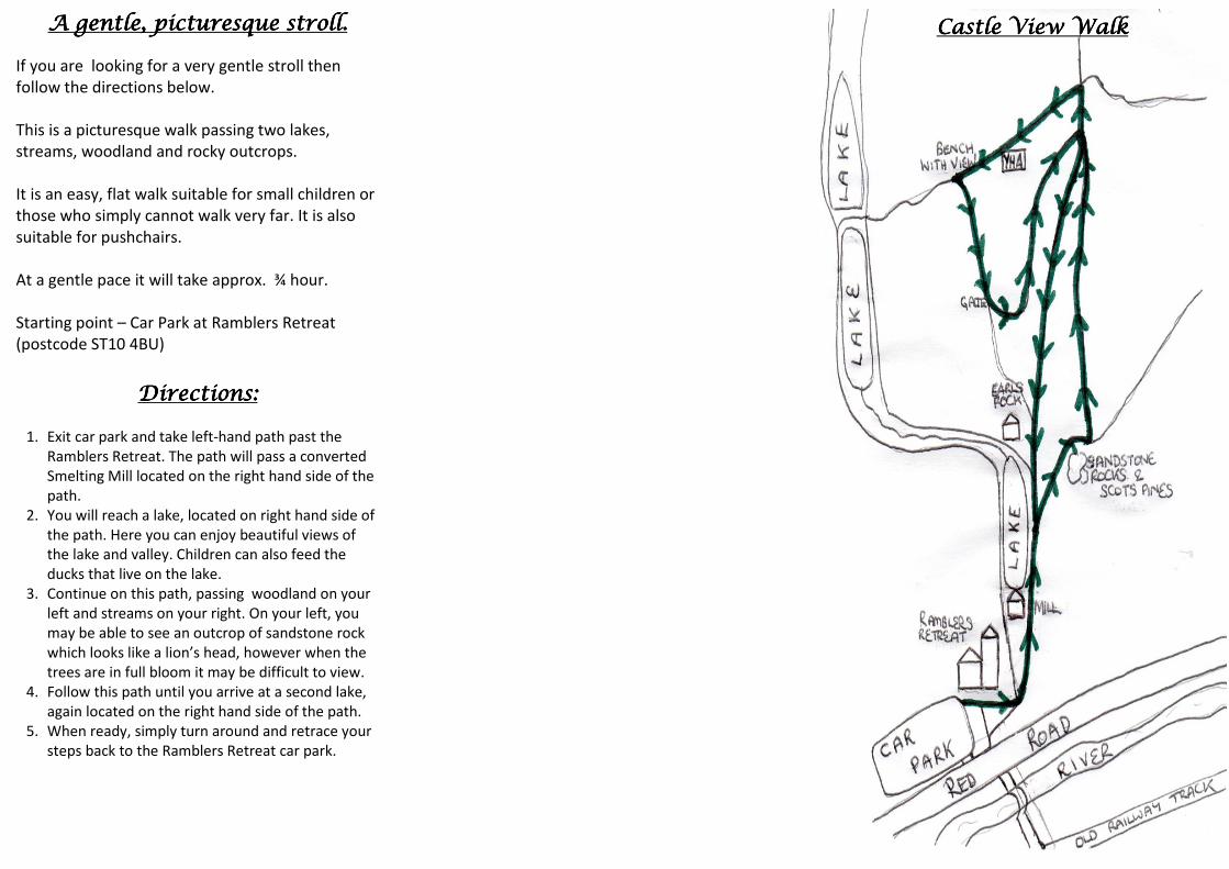
Castle View WalkCastle View WalkCastle View WalkCastle View Walk (approx 2 miles)(approx 2 miles)(approx 2 miles)(approx 2 miles) A relatively easy walk, taking approx.1 hour, offering lovely
views of woodland, sandstone outcrops & the castle at Alton
Towers. It will also take you through an ancient hill pasture
which is a Site of Scientific Interest due to its flora & fauna.
There are a couple of inclines during this walk, but these are
not particularly steep. Walking boots or study shoes are
recommended.
Starting point – Car Park at Ramblers Retreat (postcode ST10
Directions:Directions:Directions:Directions:
Exit car park and take right-hand path past the Ramblers
Retreat. The path will pass a converted Smelting Mill located
on the left hand side of the path.
You will reach a lake (again located on left of the path). Here
you can enjoy beautiful views of the lake and valley.
The path continues with the lake on your left but shortly
divides. Take the right hand path up bank. As you reach the
top of the bank look up to view sandstone outcrops & Scots
pine trees growing out of the rocks.
Continue until the path splits again. Take the left hand path
which bends around to the left. Follow this path for approx.
½ mile. Again, there are impressive woodlands and
sandstone rocky outcrops on the right hand side of the path.
You will then arrive at a cross roads. Take the right path up
bank for approx. 50 yards arriving at a T-junction.
Turn left at the T-junction and follow the path past the YHA
on your left hand side. The path continues behind the YHA
after which you will pass through a small gate and into a
meadow. This meadow is ancient pasture and is a Site of
Scientific Interest.
Follow the path straight ahead and you will come to a bench
on your right. Sitting on the bench gives you a lovely view
down the valley to the castle at Alton Towers.
Keeping your back to the bench, follow the path straight
ahead through the meadow. At the bottom of the meadow
you will pass through a gate.
Shortly after the gate, take the left hand path. Continue for
approx. 1/3 mile.
You will then arrive at a crossroads. Take the left hand path
that descends down the valley.
Keep going straight on this path until you return to the
Ramblers Retreat (approx.1/2 mile). You will pass a house
called “Earls Rock on your right hand side and the lake, which
will again be on your right hand side.
Castle Castle Castle Castle View View View View WalkWalkWalkWalk