Embed Size (px)
Citation preview
Traffic Flow Management in the National Airspace SystemOctober 2009
A presentation explaining terms, techniques, and programs associated with traffic flow management in the National Airspace System.
2 || October 2009 Traffic Flow Management in the National Airspace System || 3
RestRiction of LiabiLity and discLaimeR
The Federal Aviation Administration (FAA) makes no claims, promises, or guarantees about the accuracy, completeness, or adequacy of this material and expressly disclaims liability for errors and omissions in the contents. No warranty of any kind, implied, expressed, or statutory, including, but not limited to, warranties of non-infringement of third party rights, title, merchantability, fitness for a particular purpose, and freedom from computer virus, is given with respect to the contents of this material or its hyperlinks to Internet resources.
Reference in this presentation to any specific commercial products, processes, or services, or the use of any trade, firm, or corporation name is for the information and convenience of the public, and does not constitute endorsement, recommendation, or favoring by FAA.

4 || October 2009 Traffic Flow Management in the National Airspace System || 5
tabLe of contents
IntroductionSystem Operations MissionOrganizational StructureGeneral Managers of Tactical Operations Areas of ResponsibilityTraffic Management OverviewBasic Traffic Management Techniques and TermsGround Delay Programs (GDP)Time-based Flow Management (TBFM)Traffic Management Advisor (TMA)Airspace Flow Programs (AFP)Ground Stops (GS)Adaptive Compression (AC)Integrated Collaborative Rerouting (ICR)DelayTier InformationOperational Information System (OIS)AdvisoriesPlanning TeamWeather ToolsDe-icing/Anti-icingSevere Weather Avoidance Plan (SWAP)RoutesPreferred RoutesCoded Departure Routes (CDR)National PlaybookFlow Evaluation Area (FEA)/Flow Constrained Area (FCA)North American Route Program (NRP)Priority HandlingDiversion RecoverySpecial Traffic Management Program (STMP)High Density Traffic Airports (HDTA)
78910111521303032373940414344454647485052545556575859606163
6 || October 2009 Traffic Flow Management in the National Airspace System || 7
intRoduction
Welcome to an introduction of Traffic Flow Management (TFM) for flight operations personnel. This material will explain terms, techniques, and programs associated with Traffic Flow Management in the National Airspace System (NAS). As flight operations personnel and pilots, you may feel the effects of Traffic Management Initiatives (TMI) when flying into highly congested airspace, which may be caused by traffic volume, special events, or weather conditions.
Knowing how to access relevant information and understanding traffic management initiatives will aid you in planning your flight, avoiding needless delay, and gaining full access to the NAS.
Many organizations have dedicated resources for coordinating with FAA Traffic Management personnel, but you don’t have to be an airline or large general aviation (GA) company to benefit from understanding how traffic management initiatives may affect your flight.
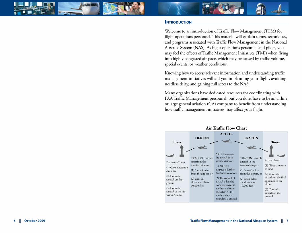
Air Traffic Flow Chart
Tower
Departure Tower
(1) Gives departure clearance
(2) Controls aircraft on the ground
(3) Controls aircraft in the air within 5 miles
TRACON
TRACON controls aircraft in the terminal airspace
(1) 5 to 40 miles from the airport, or
(2) until an altitude of above 10,000 feet
ARTCCs
ARTCC controls the aircraft in its specific airspace
(1) ARTCC airspace is further divided into sectors.
(2) The control of aircraft is handed from one sector to another and from one ARTCC to another when a boundary is crossed
TRACON
TRACON controls aircraft in the terminal airspace
(1) 5 to 40 miles from the airport, or
(2) when below an altitude of 10,000 feet
Tower
Arrival Tower
(1) Gives clearance to land
(2) Controls aircraft on the final approach to the airport
(3) Controls aircraft on the ground
jj
jj
jD D
8 || October 2009 Traffic Flow Management in the National Airspace System || 9
system opeRations mission
The United States Traffic Management System mission is to balance Air Traffic demand with system capacity to ensure the maximum efficient utilization of the NAS.
In addition, the System Operations mission is to:
Deliver the value and high quality Air Traffic services that our •users want. Provide safe, secure, and cost-effective Air Traffic services that •our stakeholders expect, now and into the future.Create a professional workplace for our employees to excel and •be innovative, fostering enthusiasm and pride for our vision and the services we provide.Be accountable for our performance in providing Air Traffic •services, with clear and specific goals linked to our stakeholders.
oRganizationaL stRuctuRe
What is the relationship between Traffic Management and Air Traffic Control (ATC)?
Traffic Management is a function in all Air Route Traffic Control Centers (ARTCCs), selected terminal facilities and the David J. Hurley Air Traffic Control System Command Center (ATCSCC).
Traffic Management personnel are air traffic controllers who analyze the demand on the system and implement initiatives that are relayed to En Route and Terminal controllers. Those En Route and Terminal controllers, along with system users relay information to Traffic Management personnel for use in their decision-making process.
Controllers and system customers relay information to Traffic Management personnel for use in their decision-making process.
What is the hierarchy?
For traffic management issues, tower personnel work through the Terminal Radar Approach Control (TRACON), if available, or directly with the overlying ARTCC.
In general, TRACON personnel work through the overlying ARTCC.
ARTCC personnel coordinate directly with the ATCSCC. The ATCSCC has final approval authority for all national traffic management initiatives and is responsible for resolving inter-facility issues.
The hierarchy for other issues is for field facilities to work through their Service Area Office, which reports to Washington Headquarters.
10 || October 2009 Traffic Flow Management in the National Airspace System || 11
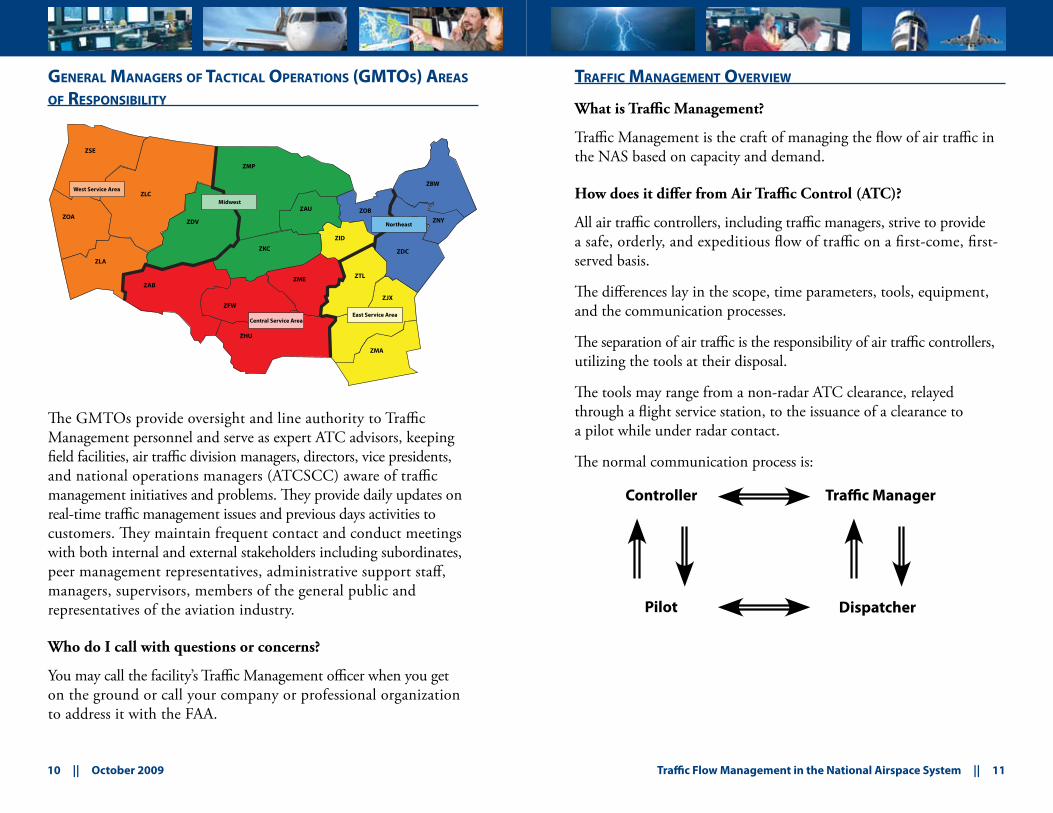
geneRaL manageRs of tacticaL opeRations (gmtos) aReas
of ResponsibiLity
The GMTOs provide oversight and line authority to Traffic Management personnel and serve as expert ATC advisors, keeping field facilities, air traffic division managers, directors, vice presidents, and national operations managers (ATCSCC) aware of traffic management initiatives and problems. They provide daily updates on real-time traffic management issues and previous days activities to customers. They maintain frequent contact and conduct meetings with both internal and external stakeholders including subordinates, peer management representatives, administrative support staff, managers, supervisors, members of the general public and representatives of the aviation industry.
Who do I call with questions or concerns?
You may call the facility’s Traffic Management officer when you get on the ground or call your company or professional organization to address it with the FAA.
tRaffic management oveRview
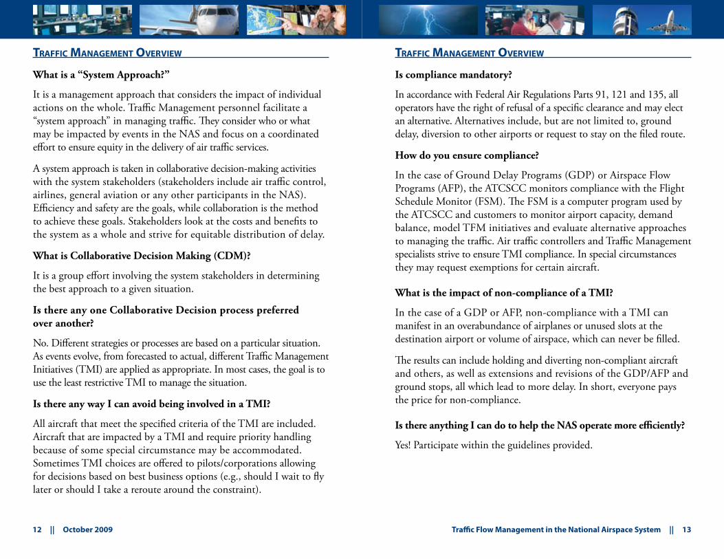
What is Traffic Management?
Traffic Management is the craft of managing the flow of air traffic in the NAS based on capacity and demand.
How does it differ from Air Traffic Control (ATC)?
All air traffic controllers, including traffic managers, strive to provide a safe, orderly, and expeditious flow of traffic on a first-come, first-served basis.
The differences lay in the scope, time parameters, tools, equipment, and the communication processes.
The separation of air traffic is the responsibility of air traffic controllers, utilizing the tools at their disposal.
The tools may range from a non-radar ATC clearance, relayed through a flight service station, to the issuance of a clearance to a pilot while under radar contact.
The normal communication process is:
ZBW
ZJX
ZMA
ZNYZOB
ZDC
ZME
ZHU
ZAB
ZOA
ZID
ZTL
ZKC
ZLA
ZFW
ZAU
ZLC
ZSE
ZMP
ZDV
East Service Area
Northeast
Central Service Area
Midwest
West Service Area
Controller Traffic Manager
Pilot Dispatcher
12 || October 2009 Traffic Flow Management in the National Airspace System || 13
tRaffic management oveRview
What is a “System Approach?”
It is a management approach that considers the impact of individual actions on the whole. Traffic Management personnel facilitate a “system approach” in managing traffic. They consider who or what may be impacted by events in the NAS and focus on a coordinated effort to ensure equity in the delivery of air traffic services.
A system approach is taken in collaborative decision-making activities with the system stakeholders (stakeholders include air traffic control, airlines, general aviation or any other participants in the NAS). Efficiency and safety are the goals, while collaboration is the method to achieve these goals. Stakeholders look at the costs and benefits to the system as a whole and strive for equitable distribution of delay.
What is Collaborative Decision Making (CDM)?
It is a group effort involving the system stakeholders in determining the best approach to a given situation.
Is there any one Collaborative Decision process preferred over another?
No. Different strategies or processes are based on a particular situation. As events evolve, from forecasted to actual, different Traffic Management Initiatives (TMI) are applied as appropriate. In most cases, the goal is to use the least restrictive TMI to manage the situation.
Is there any way I can avoid being involved in a TMI?
All aircraft that meet the specified criteria of the TMI are included. Aircraft that are impacted by a TMI and require priority handling because of some special circumstance may be accommodated. Sometimes TMI choices are offered to pilots/corporations allowing for decisions based on best business options (e.g., should I wait to fly later or should I take a reroute around the constraint).
tRaffic management oveRview
Is compliance mandatory?
In accordance with Federal Air Regulations Parts 91, 121 and 135, all operators have the right of refusal of a specific clearance and may elect an alternative. Alternatives include, but are not limited to, ground delay, diversion to other airports or request to stay on the filed route.
How do you ensure compliance?
In the case of Ground Delay Programs (GDP) or Airspace Flow Programs (AFP), the ATCSCC monitors compliance with the Flight Schedule Monitor (FSM). The FSM is a computer program used by the ATCSCC and customers to monitor airport capacity, demand balance, model TFM initiatives and evaluate alternative approaches to managing the traffic. Air traffic controllers and Traffic Management specialists strive to ensure TMI compliance. In special circumstances they may request exemptions for certain aircraft.
What is the impact of non-compliance of a TMI?
In the case of a GDP or AFP, non-compliance with a TMI can manifest in an overabundance of airplanes or unused slots at the destination airport or volume of airspace, which can never be filled.
The results can include holding and diverting non-compliant aircraft and others, as well as extensions and revisions of the GDP/AFP and ground stops, all which lead to more delay. In short, everyone pays the price for non-compliance.
Is there anything I can do to help the NAS operate more efficiently?
Yes! Participate within the guidelines provided.
14 || October 2009 Traffic Flow Management in the National Airspace System || 15
tRaffic management oveRview
How do I find out what’s going on in the NAS?
The FAA Web site, http://www.fly.faa.gov/, provides near real-time status information about the NAS. You may also receive information through the local air traffic facility (including flight service stations), your airline, flight department, or other professional organizations (e.g., National Business Aviation Association, Air Transport Association, Aircraft Owners and Pilots Association).
basic tRaffic management techniques and teRms
What are miles-in-trail (MIT)?
Miles-in-trail describes the number of miles required between aircraft departing an airport, over a fix, at an altitude, through a sector, or on a specific route.
MIT is used to apportion traffic into a manageable flow, as well as provide space for additional traffic (merging or departing) to enter the flow of traffic.
For example, standard separation between aircraft in the en route environment is five (5) nautical miles. During a weather event this separation may increase significantly to allow for deviations.
Are delays attributed to MIT?
Yes. Normally MIT is implemented in response to a specific situation. For example, Traffic Management has implemented a 30 MIT restriction on aircraft departing Baltimore-Washington International Thurgood Marshall Airport (BWI)/Ronald Reagan Washington National Airport (DCA)/Washington Dulles International Airport (IAD) via Jet Route 75 that will affect 10 aircraft in a one-hour timeframe. The delays encountered from this restriction would be accountable.
The FAA, with contract support, continues to evaluate MIT and the impact on delays. FAA facilities are required to provide justification for the requested MIT.
What are minutes-in-trail (MINIT)?
Minutes-in-trail describe the amount of time needed between successive aircraft. It is normally used when aircraft are operating in a non-radar environment or transitioning to/from a non-radar environment. This would be the case with offshore and oceanic routes spacing.
16 || October 2009 Traffic Flow Management in the National Airspace System || 17
basic tRaffic management techniques and teRms
Do you purposely plan on airborne holding?
Planned airborne holding may be used to manage traffic when delays per aircraft are expected to be brief. This will help to keep a supply of traffic available to meet the capacity of an airport when the slowdown is temporary. At other times, airborne holding is in response to a situation and is unplanned.
Is holding efficient?
At some facilities where holding airspace is available, holding ensures aircraft are available to fill the capacity at the airport.
In other cases, because of the airspace configuration, holding is impractical. For example, air traffic control sectors with large blocks of Special Use Airspace (SUA) and many flows of traffic to multiple airports that do not remain clear of holding pattern airspace make it difficult to execute holding safely. Hence, other means of spacing traffic must be utilized.
basic tRaffic management techniques and teRms
What are sequencing programs?
Sequencing programs are designed to achieve a specified interval between aircraft. They may be software generated or determined by Traffic Management personnel.
There are different sequencing programs to accommodate different phases of flight.
A Departure Sequence Program (DSP) assigns a departure time to achieve a constant flow of traffic over a common point. Normally this involves departures from multiple airports.
An En Route Sequencing Program (ESP) assigns a departure time that will facilitate integration into the overhead stream.
An Arrival Sequencing Program (ASP) assigns fix-crossing times to aircraft destined for the same airport. An automated ASP, Traffic Management Advisor (TMA), is a time-based tool used to maximize airport efficiency. (See section on TMA.)
How do Traffic Managers use altitude?
They use altitude to segregate different flows of traffic or to distribute the number of aircraft requesting access to a specified geographic area. (See Low Altitude Alternate Departure Route (LAADR), Capping, Tunneling, Tower En Route descriptions below.)
18 || October 2009 Traffic Flow Management in the National Airspace System || 19
basic tRaffic management techniques and teRms
What is Low Altitude Alternate Departure Routing (LAADR)?
LAADR is a procedure whereby flight altitudes may be limited to flight level (FL)230 and below. LAADR procedures are primarily used in the departure phase of flight, but can be extended for an entire flight when operational benefits are achieved.
Where can I find out about them?
Contact your local ATC facility to see if LAADR procedures are applicable.
Airline dispatchers, as well as your NBAA and ATA representative, may have this information available. The ATCSCC will normally publish, via advisory, the use of LAADR after the Operations Planning Telcon (PT).
Am I eligible to use LAADR procedures?
This procedure may be assigned to you. If it is, you will be informed to expect an altitude lower than your requested altitude.
For short flights, the procedure may be applied for the entire route. For long flights, you will be given a point to expect a higher altitude.
If you are unable to use LAADR procedures (e.g., due to fuel constraints, etc.), advise ATC and expect alternatives, such as delay on the ground or re-routing.
basic tRaffic management techniques and teRms
What does “capping,” mean?
“Capping” is a colloquialism for planning to hold aircraft at altitudes lower than their requested altitude until they are clear of a particular area.
It may be in response to weather or other situations that have impacted air traffic controllers’ ability to provide service and it may be applied to the entire route of flight.
It is used during constrained situations in the NAS and enables aircraft to continue to depart while remaining underneath a constrained airspace.
How do I know if I’m being “capped?”
You will know when the air traffic controller advises you in your clearance to “expect” a final altitude lower than your requested altitude, based on the appropriate altitude for your direction of flight.
What if I don’t have enough fuel?
Each pilot-in-command has the option to refuse a clearance for safety reasons. If you cannot comply with the clearance, you are required to advise ATC. At that time, different options may be presented to you, including the option of taking a delay on the ground until the situation in the airspace is resolved.
20 || October 2009 Traffic Flow Management in the National Airspace System || 21
basic tRaffic management techniques and teRms
What is “tunneling?”
“Tunneling” is a colloquialism for descending traffic prior to the normal descent point at an arrival airport to keep aircraft clear of an airspace situation on the route of flight.
It is used to avoid conflicting flows of traffic and holding patterns.
How do I know if I’m being subjected to this technique?
You will be descended prior to your normal descent point for the destination airport.
What is tower-en route?
Tower-en route is a situation where the aircraft never reaches the en route stratum, but stays in the lower terminal altitudes being handed-off from one terminal facility (tower or TRACON) to another vs. center to center. This sometimes reduces delays, especially if the higher en route stratum is congested.
gRound deLay pRogRams (gdp)
A Ground Delay Program (GDP) is a traffic management procedure where aircraft are delayed at their departure airport in order to manage demand and capacity at their arrival airport. Flights are assigned departure times, which in turn regulates their arrival time at the impacted airport.
GDP will normally be implemented at airports where capacity has been reduced because of weather—such as low ceilings, thunderstorms or wind—or when demand exceeds capacity for a sustained period.
GDPs are implemented to ensure the arrival demand at an airport is kept at a manageable level to preclude extensive holding and to prevent aircraft from having to divert to other airports. They are also used in support of Severe Weather Avoidance Plan (SWAP). (See section on SWAP.)
How does the GDP work?
The FAA uses software called Flight Schedule Monitor (FSM) that compiles scheduled flight information and flight plans from the ARTCC to calculate and then display graphically the known demand for arrivals and departures at airports.
When an overage of demand versus capacity is noted, a GDP is modeled through the FSM software.
FSM assigns arrival “slots” to aircraft based on the available capacity and flight arrival times, and adds delay in sequential order until demand equals capacity.
22 || October 2009 Traffic Flow Management in the National Airspace System || 23
gRound deLay pRogRams (gdp)
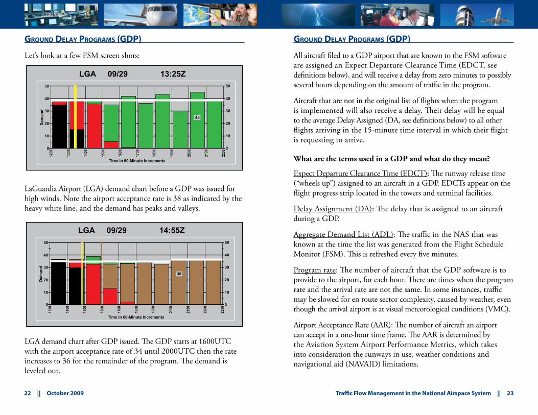
Let’s look at a few FSM screen shots:
LaGuardia Airport (LGA) demand chart before a GDP was issued for high winds. Note the airport acceptance rate is 38 as indicated by the heavy white line, and the demand has peaks and valleys.
LGA demand chart after GDP issued. The GDP starts at 1600UTC with the airport acceptance rate of 34 until 2000UTC then the rate increases to 36 for the remainder of the program. The demand is leveled out.
gRound deLay pRogRams (gdp)
All aircraft filed to a GDP airport that are known to the FSM software are assigned an Expect Departure Clearance Time (EDCT, see definitions below), and will receive a delay from zero minutes to possibly several hours depending on the amount of traffic in the program.
Aircraft that are not in the original list of flights when the program is implemented will also receive a delay. Their delay will be equal to the average Delay Assigned (DA, see definitions below) to all other flights arriving in the 15-minute time interval in which their flight is requesting to arrive.
What are the terms used in a GDP and what do they mean?
Expect Departure Clearance Time (EDCT): The runway release time (“wheels up”) assigned to an aircraft in a GDP. EDCTs appear on the flight progress strip located in the towers and terminal facilities.
Delay Assignment (DA): The delay that is assigned to an aircraft during a GDP.
Aggregate Demand List (ADL): The traffic in the NAS that was known at the time the list was generated from the Flight Schedule Monitor (FSM). This is refreshed every five minutes.
Program rate: The number of aircraft that the GDP software is to provide to the airport, for each hour. There are times when the program rate and the arrival rate are not the same. In some instances, traffic may be slowed for en route sector complexity, caused by weather, even though the arrival airport is at visual meteorological conditions (VMC).
Airport Acceptance Rate (AAR): The number of aircraft an airport can accept in a one-hour time frame. The AAR is determined by the Aviation System Airport Performance Metrics, which takes into consideration the runways in use, weather conditions and navigational aid (NAVAID) limitations.
LGA 09/29 13:25Z
Time in 60-Minute Increments
Dem
and
45
50
40
30
20
10
0
50
40
30
20
10
0
1200
1300
1400
1500
1600
1700
1800
1900
2000
2100
2200
LGA 09/29 14:55Z
Time in 60-Minute Increments
Dem
and
50
40
30
20
10
0
50
40
30
20
10
0
1300
1400
1500
1600
1700
1800
1900
2000
2100
2200
2300
36
24 || October 2009 Traffic Flow Management in the National Airspace System || 25
gRound deLay pRogRams (gdp)
How can I change my EDCT?
Aircraft must depart within +/- 5 minutes of their EDCT to be in compliance with the GDP. If you do not think you can make your assigned time or if you need to request an earlier or later time, then contact clearance delivery or the tower at the departure airport.
What types of GDPs are there?
There are two types of GDPs: A DAS (Delay Assignment) and a General Aviation Airport Program (GAAP) program.
There are two types of DAS programs:
A tier-based program includes ARTCCs that touch the ARTCC 1. in which the GDP airport is located. These programs are referred to as first tier, second tier, Six West (limited to West Coast airports), No West (limited to East Coast airports) and an All program. An All program would include all ARTCCs and, at times, Canadian facilities.A distance-based program is based on a specific mileage from 2. the GDP airport.
gRound deLay pRogRams (gdp)
What is a GAAP program?
GAAP is a type of GDP that allocates arrivals in an equitable manner to an airport temporarily in a high demand situation such as the NBAA conference, Indianapolis 500 Race, etc. It improves predictability and reliability for all operators – scheduled and unscheduled. The significant difference between a traditional DAS GDP and a GAAP is the way in which delays are assigned to flights that are unknown at the time of program implementation.
How does GAAP work?
A GAAP is issued when known demand is less than the airport acceptance rate (AAR) but it is expected that unknown traffic will meet or exceed capacity during certain time periods. GAAP compares known traffic to airport capacity and allocates arrival slots to the known flights, scheduled or unscheduled, which may result in delay. It also generates a list of unassigned slots, which are held for future flights that are unknown to the ETMS at the time of implementation. All Instrument Flight Rules (IFR) flight plans that enter the system after implementation of the program will be assigned the first available unassigned slot at or after their requested time of arrival. The maximum delay a flight may receive is 360 minutes; however this is a configurable parameter and may be reduced if deemed appropriate. It is most effective when it is implemented early on the day of expected increased demand to maximize slot availability and predictability. It is also used to reduce excessive maximum delay assignments at the end of the expected peak demand time frame. These programs are most effective when the time of program expiration is hours past the time of expected peak demand.
GAAP is not designed to be used when demand is at or above capacity for any extended period of time, because there will be limited availability for unassigned slots. If airport demand eventually exceeds capacity, the program may be revised to a DAS GDP resulting in new EDCTs for all known demand, scheduled or unscheduled.
26 || October 2009 Traffic Flow Management in the National Airspace System || 27
gRound deLay pRogRams (gdp)
Where is information detailing current GDPs depicted?
When a GAAP or DAS GDP is implemented, the ATCSCC details the parameters of the program(s) and issues an advisory and can be found at www.fly.faa.gov/adv/advAdvisoryForm.jsp. Current programs are also displayed on the ATCSCC Operational Informational System (OIS) Web page at www.fly.faa.gov/ois under the GDP section. Each line details the program airport, the start and end times of the program, flights included, scope*, reason, average delays (AVG), airport acceptance rate (AAR), program rate (PR), and the corresponding advisory number with hyperlink.
How do I know what my EDCT is?
EDCTs for a GAAP GDP may be accessible through the Web page (see below) by entering the tail number and date of flight. This Web page is active when a program is in place and can be found at: http://www.fly.faa.gov/gaap/jsp/gaapIndex.jsp
*Scope refers to the distance or tier-centers included in the GDP. While the program may not cause all flights to be delayed, all flights will receive an EDCT. Flights outside of the scope will receive an EDCT closely matching their proposed departure time.
gRound deLay pRogRams (gdp)
What is the process for implementing Traffic Management Initiatives (TMI)?
Air traffic personnel monitor the NAS for high demand sectors/airports on a continuous basis.
When a concern is raised about the traffic situation at a specific sector(s)/airport(s), a conference call is held among impacted air traffic facilities, the ATCSCC and the primary system users at the airport, to discuss alternatives and modeled scenarios.
An advisory may be issued when a GDP is being proposed but not yet implemented. If the decision is made to implement a GDP, then EDCTs will be sent to CDM members, airlines and NAS computers, and an advisory is issued that states a GDP has been implemented.
You may find more information about advisories at: http://www.fly.faa.gov/adv/advABD.jsp
How do the GDP procedures affect aircraft operators?
All aircraft are expected to depart within +/- 5 minutes of the EDCT. Each flight needs to plan to taxi in a manner consistent with meeting the EDCT. If an aircraft is late, air traffic controllers are required to call the ATCSCC to get a new EDCT. This could mean additional delay for the aircraft and missed slot opportunities for other aircraft.
How do I know I have an expect departure clearance time?
You may go to http://www.fly.faa.gov/ois to see if a GDP is in place for your destination airport or call the local flight service station or the departure airport tower.
28 || October 2009 Traffic Flow Management in the National Airspace System || 29
gRound deLay pRogRams (gdp)
How do I find out my EDCT?
All major airlines and some large business aviation companies have a connection to the FSM and receive their EDCTs electronically. Other users can look up their EDCT times through www.fly.faa.gov/edct by supplying their call sign, origin, destination and aircraft type exactly as entered on their filed flight plan.
Can my EDCT be changed?
It can be changed, based on changing conditions at the GDP airport (e.g., weather or changes in the airport acceptance rate). Airline customers may substitute their aircrafts’ EDCTs to meet their schedule objective.
How am I notified if it changes?
Airline dispatchers should provide updated EDCTs directly to company personnel. Other pilots receive their modified times from the tower at their departure airport.
What if I depart VFR and try to receive my clearance in the air?
Air traffic controllers are required to provide VFR aircraft with the appropriate delay assignment before providing the pilot with a clearance to the ground delayed airport. You may check with the local flight service station prior to departure to see if a GDP is in place.
The FSS may call the ARTCC, that controls your departure airport to get your EDCT prior to departure.
gRound deLay pRogRams (gdp)
Why do I get a time outside the parameters for the GDP that are posted on the Operational Information System (OIS)?
GDPs are based on original scheduled arrival times. Therefore, the estimated time en route (ETE) is considered in determining the appropriate departure time. The EDCT may be assigned after the times listed in the GDP.
In some cases the EDCT is after the program time because excess demand will flow over into subsequent hours, but must still be managed to ensure the balance between capacity and demand.
If you were estimated to arrive near the end of the GDP, you may be assigned an EDCT that puts your arrival time after the GDP has ended.
Do I receive a delay if I am requesting priority handling, such as a “diversion” or a “lifeguard” flight?
Aircraft requesting priority handling are assigned an EDCT. However, ATC will strive to provide priority service to civilian air ambulance flights if requested by the operator. Aircraft diverted because of a GDP will receive priority handling over all other aircraft to the extent possible.
Who should I contact if I need to change my departure time?
Pilots should contact their dispatch office or their departure airport control tower if they need to change their departure time. This, however, this could change your EDCT.
Where can I get status information on Ground Delay Programs?
GDP information is viewable on the Web site http://www.fly.faa.gov/ois, look under the header “Ground Delay Programs.” Additional guidance about interpreting the data is listed under the “help” button. GDP have been implemented at all major airports and, depending on the situation, can be issued at any airport in the country.
30 || October 2009 Traffic Flow Management in the National Airspace System || 31
time-based fLow management (tbfm)
TBFM is the technology and method used for adjusting capacity/demand imbalances at select airports, departure fixes, arrival fixes and en route points across the NAS.
tRaffic management advisoR (tma)
What is TMA?
TMA is the comprehensive automated tool for planning efficient flight trajectories from cruise altitude to the runway threshold. TMA has the ability to sequence and schedule aircraft to the outer fix, meter fix, final approach fix, and runway threshold, taking into account aircraft types and flight characteristics to maximize airport and TRACON capacity without compromising safety. It is operational at all 20 domestic Centers, select TRACONs and towers.
Who uses TMA?
Traffic Management Coordinators (TMC) create a plan to deliver the aircraft to the runway at a rate that will meet the capacity of the airport based upon the runway configuration, wind, and aircraft type. This plan consists of sequences and scheduled times of arrival (STA) at the meter fix, which are typically published points along an aircraft’s route of flight. Center and TRACON controllers use the times presented on their radar scope to ensure that the aircraft meets the scheduled time.
How does this process work?
TMA computes the estimated time of arrival (ETA) to the outer meter arc, meter fix, final approach fix, and runway threshold for each aircraft. The system will then compute the STA to each of these fixes in order to meet the constraints entered by the TMC. This progress is monitored directly by a timeline that provides the TMC with delay information for each individual flight and runway to ensure that aircraft are in the correct sequence. This timeline also assists in determining whether constraints need to be adjusted.
tRaffic management advisoR (tma)
How does this impact the controllers?
Center and TRACON controllers are provided times, in minutes, that must be lost or gained in order to meet the STA. Controllers use techniques such as speed control and vectors to ensure that the times are met.
What is metering?
Metering is the term used by TFMs when the TMA tool is activated. Adjacent Center Metering (ACM) provides time-based metering capability to neighboring centers. Single Center (SC) TMA provides the TFMs with the ability to view and manage arrival flows to a center’s internal airports.
What are the benefits of TMA?
TMA’s metering capability has resulted in capacity increases of 3 to 5 percent, with some airports seeing even higher results. There have been reductions of no-notice holding (a term used when TRACON controllers, due to volume or other constraints, put aircraft in the Center’s airspace in holding without advance notice).
Metering takes into account airport capacity and increases airspace efficiency, whereas MIT over a fix is a set parameter that when in use cannot be dynamically altered.
How does TMA work in conjunction with a GDP?
TMA software currently operates independently from FSM software. TMA is a more precise tool than a GDP. Research is being conducted to integrate the two systems to achieve a superior product. Every effort is made to ensure aircraft do not receive a GDP delay and a TMA delay.
32 || October 2009 Traffic Flow Management in the National Airspace System || 33
aiRspace fLow pRogRams (afp)
What is AFP?
Airspace Flow Programs (AFP) were introduced in Summer 2006 and marked a significant new step in en route traffic management. The principal goal for the initial deployment was to provide enhanced en route traffic management during severe weather events. An AFP is a traffic management process that identifies constraints in the en route system, develops a real-time list of flights that are filed into the constrained area, and distributes EDCTs to meter the demand through the area.
How does it work?
If an AFP is issued and a flight is included, the pilot will receive an EDCT. Meeting the departure time is important because it allows traffic managers to properly meter flights through the constrained area being controlled by the AFP.
When an AFP is issued, the FAA will send an advisory that is accessible at www.fly.faa.gov/adv/advAdvisoryForm.jsp.
The AFP will also appear on the OIS page at www.fly.faa.gov/ois/.
At airports with an airport traffic control tower, controllers will provide you with the EDCT when you call for your clearance. If you are departing an airport without a control tower, you can determine if your flight has an EDCT by checking the ATCSCC’s Web site at www.fly.faa.gov/edct. This Web site will provide information regarding the location and reason for an AFP. It will also provide a “Look Up” function to determine if your flight has received an EDCT.
aiRspace fLow pRogRams (afp)
It is important for you to check the ATCSCC Web site (before you depart) to determine if your flight is included in an AFP. Depending on the severity of the constraint leading to the AFP, you may:
Be assigned airborne holding to provide the delay necessary for •your flight to arriveBe rerouted to avoid the AFP altogether •Need to land to absorb the delay•Be allowed to enter the AFP with minimal delay•
You have a window of time in which to depart and not miss the EDCT. Flights are asked to depart as close to the time as possible.
If conditions warrant, you may depart 5 minutes before the EDCT and up to 5 minutes after. Outside of that window, you can exercise the following options:
If your company is a CDM member, flight operations have •a process for contacting the ATCSCC to request a new time.At airports with a control tower, the controller has a process for •requesting a new time and can assist you.At airports without a control tower, you may:•
Contact Flight Service.1. Contact the overlying ARTCC or TRACON.2.
34 || October 2009 Traffic Flow Management in the National Airspace System || 35
aiRspace fLow pRogRams (afp)
If you prefer to explore other options rather than the assigned delay, you may be able to:
Route out of the AFP. If there is another acceptable route •available that would take the flight out of the AFP, you may choose to refile the flight plan.Make a stop en route. You may elect to land at an intermediate •airport to provide the delay necessary for the flight to arrive at the AFP controlled time of arrival.
If you file a new flight plan into an existing AFP, the flight will be treated as a popup. Your flight will be assigned an EDCT consistent with the delay received by other flights filed to enter the AFP at about the same time.
If you file a flight plan out of an AFP and into another, the flight will be treated as a popup. Your flight will be assigned an EDCT consistent with the delay received by other flights filed to enter the AFP at about the same time. In addition, you will forfeit the arrival slot in the original AFP.
If your flight is included in both an airport ground delay program and an AFP, the EDCT for the ground delay program will take precedence.
aiRspace fLow pRogRams (afp)
It is recognized that the predicted demand through an AFP and the weather impacting the area may change substantially over time. When the conditions warrant, traffic managers will take steps to coordinate and implement revisions to the AFP. In a revision, AFP entry slots are recomputed so that demand is again metered to meet capacity and new EDCTs are sent to the enroute centers, control towers, and flight operations centers.
AFP Frequently Asked Questions
Who will implement AFPs and coordinate all AFP decisions?
The AFP position manager at the ATCSCC will have oversight responsibilities for all AFPs.
Are AFPs being utilized in all areas of the country?
Currently, the AFPs are focused on severe weather events in the eastern half of the United States. However, as AFP technology and procedures improve, it is expected that AFPs will be utilized to manage airspace constraints throughout the NAS. They are also being used to manage increased seasonal demand into Mexico and the Caribbean and; may be utilized during equipment failures which result in loss of radar coverage and/or frequencies.
In what weather scenarios do we expect to use the predefined AFPs?
The anticipated weather scenarios will include lines or popcorn storms in the NY Metro/Boston areas, in the Ohio Valley or Washington ARTCC, and the DC Metro region. The forecast should also include Collaborative Convective Forecast Product (CCFP) predictions of medium to high confidence in areas with greater than 50 percent coverage. After initial implementation, it is anticipated that the use of AFP will be expanded for use not only in weather scenarios but also in high air traffic demand scenarios. This will provide traffic managers with an additional tool to manage geographic areas that experience periods of complex, high-volume traffic.
36 || October 2009 Traffic Flow Management in the National Airspace System || 37
aiRspace fLow pRogRams (afp)
How is the AFP Arrival Rate (AAR) set?
Based on the anticipated conditions, the AFP manager will select an arrival rate based on guidelines developed through analysis of historical data. These guidelines will be refined over time. When ad-hoc AFPs are developed, the AAR may be a set number of aircraft allowed to pass through the FCA per hour or may be a percent reduction of known demand.
What happens if my flight has an AFP EDCT, but is caught in an airport ground stop?
The ground stop has the higher priority. If the ground stop is lifted and the AFP is still in place, the flight will get a new EDCT for the AFP along with a control type of RCTL (re-control). If the number of RCTL flights disrupts the delivery of the AFP, the AFP manager may elect to revise the AFP after the ground stop ends.
Will the Flight Service Stations (FSSs) be able to assist me in determining if my flight is captured in an AFP, what my EDCT delay is, or help file routes around an AFP?
FSSs are currently unable to obtain AFP EDCT information without calling a tower, TRACON or ARTCC. Although they do receive advisories, they are not equipped to keep up with updates, reroutes, revisions or cancellations.
Will DUATS show AFP and alert me that I am included in the program?
Direct User Access Terminal System (DUATS) is a Web system that provides a wide range of services to pilots, but does not provide EDCT information. Services include weather briefings, flight planning, aeronautical data, notices to airmen (NOTAMs), temportary flight restrictions (TFRs), weather graphics, etc. DUATS provides advisories in plain text format, but they are very difficult to read. It is unlikely that a GA pilot will get any AFP or EDCT information from DUATS based on their current capabilities.
gRound stops (gs)
What is a ground stop?
A ground stop (GS) is a procedure requiring aircraft that meet specific criteria to remain on the ground. The GS may be airport specific, related to a geographical area, or equipment related.
Why ground stop?
GSs are implemented when air traffic control is unable to safely accommodate additional aircraft in the system. They are most frequently used for:
Severely reduced capacity situations such as:1. Weather below user arrival minima;•Severe weather reducing usable routes;•Major equipment outages;•Catastrophic events.•
2. Precluding extended periods of airborne holding.3. Precluding sectors from reaching saturation levels.4. Precluding airports from reaching gridlock.
GSs are tier-based and are reactive to the current situation; however, in some situations, they may be planned in advance.
For example, inclement weather is forecast to develop along the East Coast. Aircraft may be released until the weather materializes, at that time, a GS would be issued to ensure additional aircraft are not released until the operational situation allows, and weather was no longer a factor.
38 || October 2009 Traffic Flow Management in the National Airspace System || 39
gRound stops (gs)
What is the process for ground stops?
Air Traffic facilities may implement an internal GS for up to 30 minutes. If the GS is expected to continue longer, the ATCSCC will assume control and may extend the time and expand the scope. An advisory will be issued by the ATCSCC advising customers of the stop.
Where can I get current status information on ground stops?
Ground stop information for delays of less than 15 minutes should be provided by the ATC facility. Delays of 15 minutes or more are viewable on the Web page www.fly.faa.gov/ois. Find them under the header “Ground Stops.” Or “Delay Info.”
Occasionally, aircraft inbound to an airport may be stopped over a specific fix. This information will be recorded on the OIS also under the heading “Delay Info.” Additional guidance about interpreting the data is listed under the “help” button.
adaptive compRession (ac)
What is Adaptive Compression (AC)?
Adaptive compression is a new approach to compression to help ensure that all slots in a program are used.
A background process at the ETMS hub will automatically:
Monitor a GDP or AFP for open slots•Identify slots that are in danger of going unused•Move other flights earlier to take advantage of those open slots •Move the open slots later•Update the databases with the changes•Send notification (EDCT updates) to the flight operators •about the changes
What are the benefits of Adaptive Compression?
AC benefits:
Higher utilization of the airport/airspace capacity •Customers can be more proactive regarding constraints, •restrictions, etc.Reduced workload for the ATCSCC specialist/ATC coordinator•
40 || October 2009 Traffic Flow Management in the National Airspace System || 41
integRated coLLaboRative ReRouting (icR)
What is ICR?
Integrated Collaborative Rerouting (ICR) is a process that builds on Flow Evaluation Area/Flow Constrained Area (FEA/FCA) capabilities used to reroute aircraft around en route constraints, incorporating operator preferences where possible.
TFM shares constraint information as early as possible via a •Planning Route AdvisoryAircraft operators analyze reroute options around the •defined constraint and submit preferred routes via Early Intent (EI) messagesTFM evaluates system impacts of EI preferences •TFM addresses impacts using preferred EI routes when possible, •and if necessary, issues required routes for other affected flights
What are the benefits of ICR?
ICR allows aircraft operators to:
Have more input regarding how their flights are rerouted•Be more proactive in planning for weather events, other •constraints, restrictions, etc.Have better understanding of alternatives acceptable to TFM•Make fewer exception requests for TFM to handle•
Other benefits: TFM has fewer flights to reroute•TFM receives earlier feedback on impact of reroutes to •controllers and sectorsBetter traffic predictability•
deLay
What is a “delay” according to the FAA?
Reportable delays occur when IFR aircraft are held on the ground or in flight for 15 minutes or more.
Delays may result from detaining an aircraft at the gate, short of the runway, on the runway, on a taxiway and/or in a holding configuration anywhere en route.
Are there any delays that are not reported?
Linear holds, e.g., speed reductions, and/or pilot initiated deviations around weather, cannot be accounted for and are not included in the reporting process.
Delays that are due to mechanical or other aircraft operator–company problems are not reported. Taxi time spent under the control of non-FAA entities, e.g., company or airport ramp towers, are not included in delay calculations, nor those resulting from a non-standard departure request.
How are delays measured and recorded?
Delay calculations begin when the aircraft enters ATC jurisdiction, e.g., calls for taxi on ATC-controlled airport property, or enters a holding pattern.
When delays are issued with a GDP, the EDCT, minus the proposed departure time and the average taxi time, equals the delay time. These delays are attributed to the arrival airport. Delay calculations end when the aircraft departs, or exits holding.
All airports have calculated average taxi times for all runway configurations. These values are not included in reported delays.
Delay calculations are entered each day by air traffic field facilities. The data is entered into software called the Operations Network (OPSNET).
42 || October 2009 Traffic Flow Management in the National Airspace System || 43
deLay
This information is forwarded to the ATCSCC for analysis. Delays are normally attributed to the following five factors: weather, volume, equipment, runway, and other. The “other” category is used for items such as security issues, aircraft accident, noise abatement, flight check, etc.
Why do aircraft that push back, call for clearance, etc., after me, depart ahead of me?
Air traffic control operates on the “first come, first served” principle. However, controllers are expected to use their best judgment in determining the safest and most efficient flow of traffic, considering the different types of aircraft and whether priority handling has been requested.
Also, different departure fixes may have TMIs that controllers must consider while orchestrating the most efficient operation.
Is there any way to help mitigate delays?
Use information available on the Web site http://www.fly.faa.gov/ois in planning your flight to meet any special requirements that could affect your flight.
Plan your flight to operate during the less busy times at the airport or in areas of congested airspace.
tieR infoRmation
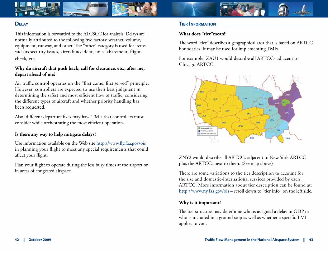
What does “tier”mean?
The word “tier” describes a geographical area that is based on ARTCC boundaries. It may be used for implementing TMIs.
For example, ZAU1 would describe all ARTCCs adjacent to Chicago ARTCC.
ZNY2 would describe all ARTCCs adjacent to New York ARTCC plus the ARTCCs next to them. (See map above)
There are some variations to the tier description to account for the size and domestic-international services provided by each ARTCC. More information about tier description can be found at: http://www.fly.faa.gov/ois – scroll down to “tier info” on the left side.
Why is it important?
The tier structure may determine who is assigned a delay in GDP or who is included in a ground stop as well as whether a specific TMI applies to you.
44 || October 2009 Traffic Flow Management in the National Airspace System || 45
opeRationaL infoRmation system (ois)
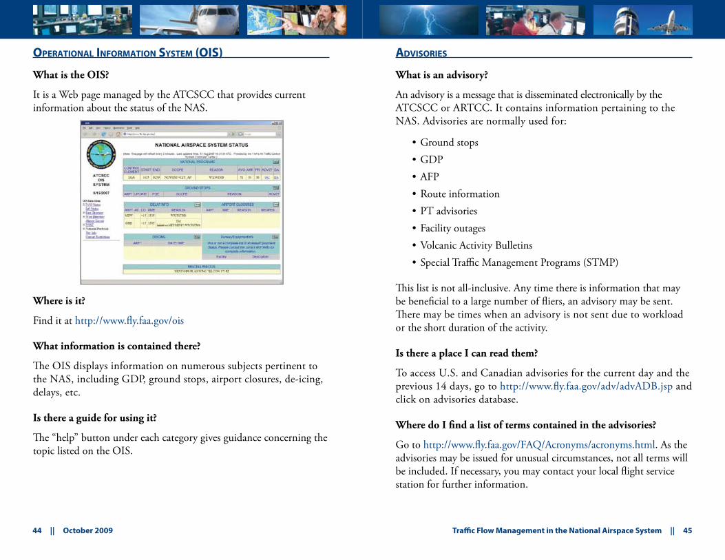
What is the OIS?
It is a Web page managed by the ATCSCC that provides current information about the status of the NAS.
Where is it?
Find it at http://www.fly.faa.gov/ois
What information is contained there?
The OIS displays information on numerous subjects pertinent to the NAS, including GDP, ground stops, airport closures, de-icing, delays, etc.
Is there a guide for using it?
The “help” button under each category gives guidance concerning the topic listed on the OIS.
advisoRies
What is an advisory?
An advisory is a message that is disseminated electronically by the ATCSCC or ARTCC. It contains information pertaining to the NAS. Advisories are normally used for:
Ground stops•GDP•AFP•Route information•PT advisories•Facility outages•Volcanic Activity Bulletins•Special Traffic Management Programs (STMP)•
This list is not all-inclusive. Any time there is information that may be beneficial to a large number of fliers, an advisory may be sent. There may be times when an advisory is not sent due to workload or the short duration of the activity.
Is there a place I can read them?
To access U.S. and Canadian advisories for the current day and the previous 14 days, go to http://www.fly.faa.gov/adv/advADB.jsp and click on advisories database.
Where do I find a list of terms contained in the advisories?
Go to http://www.fly.faa.gov/FAQ/Acronyms/acronyms.html. As the advisories may be issued for unusual circumstances, not all terms will be included. If necessary, you may contact your local flight service station for further information.
46 || October 2009 Traffic Flow Management in the National Airspace System || 47
pLanning team
What is the Planning Team?
The Planning Team is composed of FAA personnel at the ATCSCC, who work in concert with ARTCCs, select terminal facilities; and other system stakeholders such as representatives from airlines, general aviation organizations, military, NAVCANADA and other international facilities. The team collaboratively develops a plan for the daily management of the NAS.
How is it formulated?
The ATCSCC hosts a planning telephone conference every two hours to identify any constraints to the NAS for the next six hours. The team members present their ideas and concerns and develop an Operations Plan that explains the constraints and how they will be managed. The Operations Plan is published by the ATCSCC in advisory format after each conference and can be found at www.fly.faa.gov/ois. Click on the “+” symbol next to NSST and then on “Current Operations Plan.”
Can I participate?
Usually each team member has one representative that participates in the plan’s development. The number of phone lines is limited and a PIN number is required to join. If you have any input, your organization may have a representative who would be able to bring those ideas to the discussion.
weatheR tooLs
What weather information tools do you use in making traffic management decisions?
Traffic Management personnel utilize numerous weather products to help formulate their plan for the day. Some products are listed here:
Terminal Area Forecasts (TAF) describe anticipated weather •conditions at airports. In the U.S., these forecasts are produced every eight hours by the National Weather Service (NWS).Convective outlooks forecast the most severe thunderstorms in •the U.S. for the next 18 hours. They are updated several times throughout the day.The Collaborative Convective Forecast Product (CCFP) is a •forecast for intense convection activity made for two-, four- and six-hour periods by a group consisting of the NWS, the aircraft operators, ARTCC weather units and the meteorological service of Canada.
The CCFP is discussed, critiqued and adjusted to develop a forecast based on many different inputs. It is the primary planning weather tool for Traffic Management personnel during severe weather periods. It consists of a defined area (polygon), and describes maximum cloud tops, growth and decay tendencies, and direction and speed of movement, as well as the forecaster’s confidence in the forecast.
You can find out more information about the CCFP by contacting your ATA/NBAA/airline representative or go to the Web page below.
The CCFP is available at: http://aviationweather.gov/products/ccfp
Additional weather data is at: http://aviationweather.gov/
48 || October 2009 Traffic Flow Management in the National Airspace System || 49
de-icing/anti-icing
De-icing is the process of removing existing frozen precipitation, frost or ice from aircraft surfaces. Anti-icing is the process of preventing accumulation of frozen contaminants on aircraft surfaces. Both processes may involve the application of various fluids to the aircraft.
What is air traffic’s role in de-icing?
When requested by local airport operators at Federal Aviation Regulation (FAR) Part 107 and Part 139, airports impacted by icing weather conditions, air traffic participates in developing Local Airport De-icing Plans (LADP).
The LADP may affect:Airport Acceptance Rates (AAR)•Airport Departure Rates (ADR)•Gate hold procedures•
The LADP emphasize local strategies for minimizing the amount of time an aircraft spends on the ground after being de-iced/anti-iced.
Aircraft operators are expected to plan their de-icing/anti-icing activities in conjunction with the information supplied to them. Aircraft operators are expected to de-ice in a manner consistent to meet EDCT.
Once an aircraft has been de-iced, it will be released unless a ground stop applicable to that aircraft is in effect. If necessary, the notification and procedures for de-icing/anti-icing should be addressed in the LADP.
Aircraft operators are responsible for managing their holdover times and returning to be de-iced/anti-iced, if necessary.
de-icing/anti-icing
Where can I get current status information on de-icing and anti-icing?
Your local airport, including the air traffic control tower or gate management personnel, is the best source of information. Status information is also viewable on the Web site: http://www.fly.faa.gov/ois/. Look for the header “De-icing.” Additional help with interpreting the data is listed under the “help” button.
50 || October 2009 Traffic Flow Management in the National Airspace System || 51
seveRe weatheR avoidance pLan (swap)
SWAP is a formalized program that is developed for areas susceptible to disruption in air traffic flows caused by thunderstorms. Each air traffic facility may develop its own strategy for managing the severe weather event. Their plan then becomes part of the overall daily operations plan.
Is there a plan for managing traffic flows in severe weather?
As each weather event is unique, the response is tailored to meet the specific forecasted and actual events of the day. The SWAP plan is issued through the Planning Team.
Can I get a copy of it?
The plan, available to all users, is published as an advisory under the PT. Additionally, routes issued in support of SWAP are issued as route advisories by the ATCSCC. They may be found at www.fly.faa.gov.
What can I do in response to the SWAP?
Inform yourself about conditions in the NAS and plan appropriately. Be prepared to respond to rapidly changing weather conditions that may require new routes, often longer, to be issued.
ATC may request flights to evaluate flight conditions after the weather has passed. If capable, volunteer your services!
Why do I get delayed on the ground when the weather is VFR?
There may be times when the weather en route or at your destination airport prevents your departure, rather than the weather at your departure airport.
seveRe weatheR avoidance pLan (swap)
If aircraft are all deviating or being funneled through a small opening in the weather, traffic becomes very condensed and complex, thereby requiring additional traffic management initiatives. On the other hand, if the airport of destination has a reduced AAR for some reason you may be delayed because of TMIs or compliance with a GDP.
Is there something I can do to help?
Pay attention to what is being said on the radio and be informed!
52 || October 2009 Traffic Flow Management in the National Airspace System || 53
Routes
What route information is available?
Route information is contained in the:
Airport Facility Directory•Preferential route information in the host computer•Route Management Tool (RMT)•North American route advisory circular•OIS•Federal Air Regulations (FAR)•NOTAM•
Why are there so many sources?
Route information is published in various sources for different purposes, different users and different time frames.
Why does ATC reroute me?
To ensure you stay with the flow of traffic, remain clear of special use airspace, avoid congested airspace, and areas of known weather where aircraft are deviating or refusing to fly.
How do I find out what route ATC wants me to file?
The most current information is located on the OIS (www.fly.faa.gov/ois) in the advisories and in the NOTAMS. These sources document changes to standard routes for the current date or for a special event.
Routes
Why do I get routed so far from my requested route when it appears there is no weather on the route I filed?
As flows of traffic are moved to accommodate severe weather, the traffic that would have been on the non-impacted route may be moved to manage volume issues.
What if I don’t file the route ATC wants me to file?
Normally, air traffic controllers will clear you via the route specified by traffic management. You may be rerouted in the air or on the ground. Normally, the operator should file or amend flight plans with the appropriate routes when the aircraft is 45 minutes or more from the proposed departure time. ATC facilities will enter reroutes for active flights, or normally for flights less than 45 minutes from departure.
What if I can’t accept the route due to safety of flight or fuel concerns?
You are required to notify the controller you cannot accept the route for safety reasons. The controller will work with you to find an acceptable route. However, there may be occasions when you will have to divert to a different airport. In accordance with FAR, all operators have the right of refusal of a specific route and may elect an alternative. Alternatives include, but are not limited to, ground delay, diversion to another airport or a request to stay on filed route.
Who should I coordinate with beforehand if I know I can’t accept the route?
You should notify the clearance delivery controller if you cannot accept the route issued. If possible, an alternative will be offered. However, there may be no alternatives and you could be required to accept a delay on the ground until the route becomes available.
54 || October 2009 Traffic Flow Management in the National Airspace System || 55
pRefeRRed Routes
What is a preferred route?
A route that is requested, and has been published by ATC to inform users of the “normal” traffic flows between airports.
Why were they developed?
They were developed to increase system efficiency and capacity by having balanced traffic flows among high-density airports, as well as de-conflicting traffic flows where possible.
Where can I find them?
They are listed in the Airport-Facility Directory and in the RMT on the OIS.
When I file a preferred route, why am I immediately issued a new route on departure?
There may be other constraints on the system, e.g., severe weather that is disrupting normal traffic flows.
If you believe the preferred route is erroneous because you never receive the route, please contact the departure center with your questions.
coded depaRtuRe Routes (cdR)
What are Coded Departure Routes (CDR)?
CDRs are a combination of coded air traffic routings and refined coordination procedures.
They are designed to mitigate potentially adverse impacts to ATC and users during periods of severe weather or other events that impact the NAS.
CDRs facilitate electronic coordination of route data.
Where can I find CDRs?
The routes are located in the RMT on the OIS.
How will I know when to use them?
The ATCSCC will issue an advisory when CDRs are in effect. They may be listed on the Ops Plan for potential use.
Can I use them?
Only those who have a signed letter of agreement with the FAA are eligible to use the CDRs between the city pairs in the coded format. However, anyone can file a route that corresponds to a CDR.
Any pilot may file the route listed in the CDR route string if the field labeled “user file” contains a “Y.” The FAA is considering making CDRs available to all users.
56 || October 2009 Traffic Flow Management in the National Airspace System || 57
nationaL pLaybook
The National Playbook is a collection of SWAP routes that have been pre-validated and coordinated with impacted air route traffic control centers. They may be used in support of convective weather, military operations and other situations.
What are the routes?
Routes for the National Playbook are listed on the OIS.
Can I get a copy of them?
You may print a copy of the routes. However, the routes are updated approximately every 56 days, consistent with charting dates. A preview version of the new edition will be available seven days before the effective date.
How do I know when they are in effect and can I use them?
The ATCSCC will issue an advisory stating playbook or modified playbook routes are in effect, and will be published in the Ops Plan.
Any pilot may use the playbook routes when they are in effect.
How do I find out if it applies to me?
The route advisories issued by the ATCSCC normally specify the flows of traffic impacted by the advisory; e.g., all flights to Chicago O’Hare airport from the west. It will require you to look at your normally filed route to determine if the playbook applies to you.
What if I don’t know and don’t file the playbook route?
Air traffic controllers will issue the route either before departure or while airborne, as the situation dictates.
fLow evaLuation aRea (fea)/fLow constRained aRea (fca)
What is an FEA? FCA? How are they different?
Developed on an ad hoc basis, they are both three-dimensional volumes of airspace, along with flight filters and a time interval, used to identify flights. They may be drawn graphically, around weather, or they may be based on a NAS element such as a VORTAC. They are used to evaluate demand on a resource. They are different because an Evaluation Area is just under study while a Constrained Area requires action to address a particular situation.
How do I find out about FEAs and FCAs?
You will know about one because a route advisory will indicate the impact area as an FCA.
Can I view it graphically?
At this time, only authorized government users and CDM participants have access to viewing FEAs and FCAs.
How do I know one impacts me?
You may not. You may fly through an FCA if you are not one of the “filtered flights” that has been designated to remain clear of the airspace. If you are one of the “filtered flights” you will receive a route that remains clear of the FCA.
What if I don’t file around it?
ATC will issue a route that remains clear of the FCA, if appropriate.
58 || October 2009 Traffic Flow Management in the National Airspace System || 59
noRth ameRican Route pRogRam (nRp)
The North American Route Program (NRP) specifies provisions for flight planning at flight level 290 (FL290) and above, within the conterminous U.S. and Canada.
What does it do for me?
It enables flexible route planning for aircraft operating at FL290 and above, from a point 200 nautical miles (NM) from their point of departure to a point 200 NM from their destination. Additional flexibility is available by utilizing specified Departure Procedures (DP) and Standard Terminal Arrival Routes (STAR) that have been identified within 200 NM of the airport(s).
Why am I taken off my NRP route?
There may be times when air traffic requires flights to be on specified routes due to volume, weather or separation requirements. Under most circumstances an advisory is issued by the ATCSCC whenever NRP procedures are curtailed.
How do I find out more information?
Participation in NRP is voluntary and the process is outlined in FAA Advisory Circular 90-91h. For more information go to: http://www.faa.gov, click on Advisory Circular.
pRioRity handLing
Aircraft that meet specific criteria receive expeditious handling to the extent possible. Controllers are expected to use good judgment in determining their ability to provide priority handling based on the existing conditions.
Do any flights get priority handling?
An aircraft in distress has right-of-way over all other traffic. Priority may be provided to “lifeguard” flights, NRP program participants, diversions and other types of flights requesting special assistance.
How do I let you know I’m eligible and requesting priority handling?
The Aeronautical Information Manual and pertinent advisory circulars provide guidance on types of flights eligible for priority handling. They also explain how to indicate the information on your flight plan.
Flight departments should be aware of programs available to them for priority handling and how this information is forwarded to the FAA.
60 || October 2009 Traffic Flow Management in the National Airspace System || 61
diveRsion RecoveRy
Diversion Recovery refers to the effort made to return “diversions” to their originally intended destination.
What is a diversion?
A diversion is a flight that is required to land at other than its original destination for reasons beyond the control of the pilot or company, e.g., periods of significant weather.
How does the ATC know an aircraft has diverted?
The Flight Schedule Monitor (FSM) software has an “auto detection” algorithm that indicates a flight has changed its destination while airborne and subsequently filed a flight plan to the original destination. Additionally, if the flight plan contains the acronym “DVRSN” in the remarks section of the flight plan, this information is displayed on a separate Web page so that traffic management personnel are aware of the diversion and take action for expeditious handling to the extent possible.
Do aircraft that have diverted get priority handling?
ATC tries to provide priority handling to “diversions.” However, there may be times when a situation prevents ATC from providing this service.
What if I forget to put DVRSN in my flight plan?
You may call your airline representative, professional organization representative or notify the air traffic facility of your status as “a diversion.”
Where can I get additional information?
The Aeronautical Information Manual contains information regarding diversions and how to indicate this information to ATC.
speciaL tRaffic management pRogRam (stmp)
A STMP is a long-range strategic initiative that is implemented when a location requires special handling to accommodate above-normal traffic demand, e.g., Masters golf tournament, NBAA Convention, etc.
Why are they implemented?
They are implemented to balance capacity with demand. This becomes especially important when the demand is unknown prior to the event. Currently the FAA does not store flight plans in the NAS computer more than two hours in advance. STMP reservations provide long-range planning capability for the event.
How do I know if I have a slot or not?
A preliminary slot reservation number will be assigned upon completing a reservation either on-line at www.fly.faa.gov or on the touch-tone phone system at 1-800-875-9755. Between 24 and 12 hours prior to your arrival/departure reservation time, you are required to confirm your reservation and will receive a confirmation number. If your reservation is not confirmed at least 12 hours prior to your arrival/departure reservation time, it will be canceled and automatically made available into the reservation pool. If the reservation is made within 24 hours of the reservation received, it will automatically be confirmed with a confirmation number
What do I do with the reservation information I receive?
The Reservation Number MUST be put in the “remarks” section of the flight plan when you file. If not, the AFSS should not accept the flight plan.
Am I required to have a reservation if a STMP is in place?
Yes! The STMP NOTAM will specify whether it is for IFR and/or VFR aircraft and if it pertains to arrivals, departures, or both. If you do not obtain a reservation you will not be able to file into or out of the STMP Airport.
62 || October 2009 Traffic Flow Management in the National Airspace System || 63
speciaL tRaffic management pRogRam (stmp)
What happens if I don’t?
The AFSS should not accept a filed flight plan without a reservation. If you do not have a reservation, an ATC clearance cannot be issued to/from the STMP airport and you will have to attempt to obtain one at the STMP Web page or on the Touchtone phone system. Without a reservation, Centers and Towers cannot allow traffic to/from the STMP airport. You will then be asked to state your intentions.
Is there any way I can get a reservation, even though the STMP indicates no slots are available?
STMP reservations are distributed on a first-come, first-served basis. There may be occasions when an additional slot will be available. Utilizing the online STMP Web page or the touch-tone phone system, you will be able to check to see if any cancellations or additional slots have been released. The STMP NOTAM may contain a contact number to check on additional slots when applicable. Otherwise, the Web page or touch-tone line are the means to check status.
Why can’t I get a reservation in the Denver Ski Country STMP or any other STMP?
Unfortunately, the genesis for a STMP is the anticipation that demand will surpass capacity at an airport. Therefore, for very popular STMPs such as the Denver Ski STMP, reservations are taken very quickly as thousands of customers are attempting to obtain a very limited number of slots. Be aware that reservations are available 72 hours in advance exactly to the minute. On the top of the hour, 15, 30, 45 after the hour, you can expect a very heavy demand of calls or online queries for reservations. Once those few slots are gone for the 15-minute range, which happens very quickly, new reservations will not be available until released at the next quarter hour.
high density tRaffic aiRpoRts (hdta)
High Density Traffic Airports are specified in title 14 of the code of FAR, Part 93, and Subpart K. Currently, the following airports require unscheduled operations to acquire a reservation prior to operating at the airport:
John F. Kennedy International (JFK)•Ronald Reagan Washington National (DCA)•LaGuardia Airport (LGA) for specified periods of the day•Chicago O’Hare Airport (ORD)•Newark Liberty International (EWR)•
How do I get a reservation for a High Density Traffic Airport?
You may receive a reservation through the Airport Reservation Office (ARO), located at the ATCSCC, through a touch-tone telephone (800-875-9694) or the Internet http://www.fly.faa.gov/ecvrs.
Is there someone I can call if I need a reservation and can’t get one?
The ARO telephone number is 703-904-4452.
What happens if I try to go there and I don’t have a reservation?
The only unscheduled traffic accepted at the airports without a reservation is emergency aircraft. The FAA monitors compliance with the regulations and violators are cited.
64 || October 2009 Traffic Flow Management in the National Airspace System || 65
high density tRaffic aiRpoRts (hdta)
Why can’t I get a reservation at DCA?
Effective Aug. 18, 2005, charter and corporate aircraft are allowed into DCA subject to certain regulations. This process is complex; information and procedures can be found in the publication listed below.
Where can I get additional information?
FAA Advisory Circular 93-1A addresses operations at HDTA. Additional information is contained in the Aeronautical Information Manual. Information regarding General Aviation aircraft landing at DCA as well as HDTA airports can be found in Code of Federal Regulations (CFR) part 93, subpart K or http://www.tsa.gov/ keyword; DCA and Dept. of Homeland Security 49 CFR Parts 1520, 1540 and 1562.
notes

66 || October 2009 Traffic Flow Management in the National Airspace System || 67
notesnotes
2009-AJN-251
FAA National Headquarters800 Independence Avenue, S.W.
Washington, D.C. 20591