Embed Size (px)
Citation preview

Town of Truckee
Trails & Bikeways Master Plan
May 2007

Truckee Trails & Bikeways Master Plan
May 2007
Amended May 17, 2007 – Council Resolution No. 2007-20 Adopted April 4, 2002 – Council Resolution No. 2002-17
Prepared by the Town of Truckee Community Development
Department – Planning Division
Truckee Town Administrative Offices 10183 Truckee Airport Road
Truckee, California 96161 (530) 582-7820
Facilitation and technical assistance provided by the National Park Service
– Rivers, Trails & Conservation Assistance Program –
U.S. Department of the Interior National Park Service Pacific West Region Pacific Great Basin Support Office 1111 Jackson Street, Suite 700 Oakland, CA 94607 (510) 817-1449
Technical assistance provided by:
Alta Consulting – Michael Jones
Western Botanical Services – Julie Etra Wildlife Resource Consultants – Sue Fox
Susan Lindstrom, PH.D. – Consulting Archaeologist Leigh, Scott & Cleary Consulting – Gordon Shaw
Ward-Young Architects – Vangela Wilson
Truckee Trails & Bikeways Master Plan
May 2007 Page 2

Master Plan Development Team Development of the Truckee Trails & Bikeways Master Plan involved a diverse team of many community volunteers. Their hard-work and dedication is acknowledged by the Town of Truckee and appreciated by the community. Town of Truckee Staff
Tony Lashbrook, Community Development Director Duane Hall, Town Planner
Gavin Ball, Associate Planner / Project Manager Stacy Wydra, Assistant Planner Heidi Scoble, Assistant Planner
Chris Scott, Planning Technician Kelly Holm / Suellen McGeorge, Administrative Secretary
National Park Service Staff
Barbara Rice, Program Coordinator Suzanne Bourguignon, Student Intern
Rivers, Trails & Conservation Assistance Program
Advisory Committee
Bill Palmer / Nancy Richards Karen Sessler Doug Mullins / Dan O’Gorman
Karl Knapp Sherry Mays / Eric Larusson
Judy Mayorga Andrew Hall / Jacqueline Ginley
Truckee Trails & Bikeways Master Plan
May 2007 Page 3
Geoff Stephens Milan Wight
Jerusha Crockett-Hall
Conlan Jones Daniel Collin Paco Lindsay
Christine Rourke Lore McLaren
Steve Yale Chuck Bentson Barbara Green
Advisory Committee – Alternates
Nancy Markson Lisa Cutter
K. Valerie Green Jim Westphal
Claudia Carroll-Hanson Steve Marshman
Dan Wendin

Truckee Trails & Bikeways Master Plan
May 2007 Page 4
Advocacy Group
Steve Harris Jim Zellars
Barbara Sutherland Peggy Ricketts
Rod Miller Susan Antipa
David Fenimore
Michele Franke Ray Bonnett
Vickie Lamoureux John M. Ahern Jae Gustafson
Mountain Jack Ingram Dan LaPlant
Steering Committee
Kathleen Eagan Lisa Cutter
Paco Lindsey Barbara Green
Fran Herbst – United States Forest Service
Dan Wendin – Truckee Donner Land Trust
Doug Mullins – Truckee Donner Recreation
& Park District

Table of Contents
Chapter Page
1 Introduction & Summary……………………………………………………….8
A. Benefits of Trails & Bikeways B. Plan Purpose – Purpose Statement C. Plan Boundaries – Planning Area Description D. Plan Scope & Detail E. Timing & Process of Implementation F. Plan Organization & Content G. The Planning Process & Participants H. Community Input I. Annual Review
2 Existing Local & Regional Setting…………………………………….……15
A. Local Conditions B. Regional Conditions C. Local-Regional Connectivity
3 Relationship with the General Plan, Downtown Specific Plan & Other Community Plans…………………………………18
A. General Plan B. Downtown Specific Plan C. Truckee Donner Recreation and Park District Ten-Year Master Plan D. Nevada County Bicycle & Rural Recreational Trails Master Plans E. Placer County Regional Bicycle Plan, Legacy Program & MVCP
Update F. Plan Conflicts
4 Goals & Policies………………………………………………………………….22
A. What are they? B. Organization & Format C. Plan Goals & Policies
5 On-Street Bikeways…………………………………………………………….30
A. Purpose & Intent B. Types of Bikeways
Truckee Trails & Bikeways Master Plan
May 2007 Page 5

Table of Contents
Truckee Trails & Bikeways Master Plan
May 2007
C. Class I Bike Path Criteria D. List of Streets
6 Recreational Trails………………………………………………………….…..33
A. Purpose & Intent B. Types of Recreational Trails C. Corridor vs. Alignment Planning
7 Support Facilities & Programs……………………………………….……..36
A. Introduction B. Trailheads C. Trailheads with Parking Areas D. Restrooms E. Bicycle Parking & Changing Facilities F. Multi-Modal Connections G. Safety & Education H. Regional Cooperation & Opportunities
8 Design Guidelines………………………………………………………….......41
A. What are they? B. Use & Application C. Class I Bike Path & On-Street Bikeway Guidelines D. Earthen Trail Guidelines E. Disabled Access Guidelines F. Illustrated Guidelines
9 Design & Development………………………………………………….……..70
A. Recreational Trail Proposal & Evaluation Process B. What Type of Trail or Bikeway Design? C. Preferred Recreational Trail Segments D. On-Street Bikeway Proposal & Evaluation Process E. Preferred On-Street Bikeway Segments
10 Private Lands………………………………………………………………….….74
A. Overview B. Existing Development C. New Development – Reservation vs. Dedication D. Condemnation Policy Statement
Page 6

Table of Contents
Truckee Trails & Bikeways Master Plan
May 2007
11 Maintenance, Monitoring & Security……………………………………..77
A. Introduction B. Property Management C. Corridor Maintenance D. Paved Surface Maintenance
12 Funding & Financing…………………………………………………………...83
A. Opportunities B. Non-Profit / Foundation Opportunities C. Public-Private Partnerships D. Financing Techniques
13 Environmental Document……………………………………………….…...86
A. Program EIR – What is it? B. Application to Future Project Proposals C. EIR Scope D. Summary of Conclusions
Appendix
A List of Figures & Tables
B Document Exhibits Exhibit 1 – Recreational Trail Segment Descriptions
Exhibit 2 – Funding Sources Exhibit 3 – Financing Techniques Exhibit 4 – Non-Profit / Foundation Case Studies Exhibit 5 – Recreational Trail Proposal Decision Tree Exhibit 6 – On-Street Bikeway Proposal Decision Tree
C References & Literature Cited
D Map Exhibits Exhibit 1 – Local Map Exhibit 2 – On-Street Bikeway Map
Page 7

Chapter
1 Introduction & Summary Benefits of Trails & Bikeways Trails and multi-use paths are the foundation of a comprehensive bicycling and walking system. Trails offer numerous aesthetic and recreational opportunities, as well as commuter options for walking, hiking, bicycling, skating or otherwise traveling to and from community destinations. Residents desiring to bicycle or walk to work, go for a family bicycle ride or walk to the park or library, enjoy a longer outing to and around Donner Lake or along the Truckee River, or simply take pleasure in walking will benefit from new trails. Residents that use trails gain the added health benefit of exercise through cycling and walking. As trail systems are implemented, they also offer an alternative mode of transportation to the automobile. With increased walking and bicycling as a means of transportation, measurable air quality benefits result. Trails can have unexpected value by serving as a buffer for open spaces, wetlands, and wildlife habitat, even preserving clean water and aquifers. Along with these environmental benefits, trails offer educational opportunities through interpretation of the environment that they pass through. The creation of more trails for walking and bicycling in Truckee can raise property values, provide common space for social interactions, and supplement existing recreational opportunities. Trails have proven to be safe places that encourage healthy lifestyles and improve the livability of a community. They attract the young and the old, the healthy and the disabled. They are a marker of a welcoming and visionary community. Plan Purpose The Town of Truckee first committed to the development of a comprehensive Truckee Trails & Bikeways Master Plan in February 1996 with adoption of the first-ever Truckee General Plan. Many Land Use, Conservation & Open Space, and Circulation policies contained within the General Plan encourage the development and implementation of a non-motorized system promoting the use of alternative transportation and creating recreational opportunities for the Truckee community and beyond. Specifically, General Plan Conservation & Open Space Policy 8.1 provides direction to “establish a town-wide multi-use public trail system” with “linkages outside of Town limits” through the development and adoption of a local Master Plan. The purpose of the first-ever local Truckee Trails & Bikeways Master Plan is to implement this and the many
Truckee Trails & Bikeways Master Plan
May 2007 Page 8

Chapter 1 – Introduction & Summary
Truckee Trails & Bikeways Master Plan
May 2007
other directly related policies contained within the Town of Truckee General Plan. Consistent with this General Plan policy direction, the following ‘Purpose Statement’ has been developed to describe the intent of the Master Plan:
Purpose Statement
A community based planning effort promoting the development of a local multi-use trail and bikeway system designed to increase recreational, educational and alternative transportation opportunities for the benefit of local residents and visitors to the Truckee area. The system will link the Town’s historic downtown, residential and commercial areas, and recreational, educational, natural and historical resources and plan for connections to regional public lands and trail and bikeway systems.
The Master Plan has been planned and designed in large-part for non-motorized use consistent with the policy directive of the General Plan. The planned system will accommodate motorized recreational use in limited situations when alternative routes are unavailable, it is necessary to access public motorized recreation, and when consistent with goals of the Plan (see Chapter 4 – Goals & Policies, Planning Goal 1). Although development of the Plan has primarily been driven by the Town of Truckee, it is a community plan to be used by all public and private entities proposing development of a recreational trail or on-street bikeway project within the boundaries of the Plan. It is intended to be used as a guide for future local, state and federal roadway improvement projects and all future recreational trail projects. When reasonable and warranted, all local, state and federal sponsored projects providing an opportunity to implement the objectives of the Plan will be strongly encouraged to expand or modify the scope of these individual projects to be consistent with the Plan. Plan Boundaries The jurisdictional boundaries of the Town of Truckee established with incorporation of the Town in March 1993 create the limits of the focused planning effort for this Plan. The Truckee Trails & Bikeways Master Plan is not a regional plan. Although the scope of the Plan is solely contained within the incorporated Town limits, the Plan recognizes the Town of Truckee as an integral part of the larger Truckee / North Lake Tahoe region and considers the planned system within the regional context. The following ‘Planning Area Description’ has been developed consistent with the necessary local scope of the Master Plan and recognition of the needed coordination with regional trail and bikeway systems:
Page 9

Chapter 1 – Introduction & Summary
Truckee Trails & Bikeways Master Plan
May 2007
Planning Area Description
The planning area includes and focuses on all lands within the Town of Truckee, considering and planning for linkages to public lands and trail and bikeway systems within the Truckee and North Tahoe region.
Plan Scope & Detail The planning scope of the Plan is comprehensive, but not specific. The Plan has been designed and developed to be a long-range planning document for both recreational trails and on-street bikeways and the many environmental, political and social issues associated with implementation of the Plan. The goal of the Plan-development process was to create a framework for the creation of a town-wide system, involving a holistic or “big picture” analysis of the opportunities and constraints affecting its creation and implementation. The Plan is designed to promote connections between the many distinct areas and resources within the Town of Truckee, not specific connections within these individual areas or resources. The Plan necessarily does not attempt to provide answers or solutions for all specific issues associated with implementation of the planned system. The large scope of the Plan boundaries warranted the “broad stroke” planning philosophy utilized for development of the Plan and the deferment of specific project-level analysis to subsequent public processes. The most representative example of this planning philosophy is the ‘corridor’ planning methodology used for the recreational trail planning process further described in Chapter 6, Recreational Trails. Although the Plan does not contain a specific analysis of every issue associated with its implementation, it does identify these yet-to-be resolved issues and creates a public process designed and intended to ensure the open discussion and resolution of any remaining issues and unanswered questions specific to each individual proposal. Timing & Process of Implementation It is important to recognize that completion of the nearly 133 miles of recreational trails and on-street bikeways envisioned within the Plan will not occur overnight and that a timeline for its completion cannot be made. The Plan will be used as a tool to guide the incremental development of specific recreational trail segments and on-street bikeways as resources and opportunities arise. Opportunities to incrementally implement the Plan created with new development proposals, the availability of grant funding, dedicated budgeted monies and public-private partnerships will all contribute to the ultimate completion of the planned system. The Town of Truckee is committed to implementation of the Plan, both through the allocation of its own resources and encouragement and cooperation with other private and public entities.
Page 10

Chapter 1 – Introduction & Summary
Truckee Trails & Bikeways Master Plan
May 2007 Page 11
Plan Organization & Content The Master Plan consists of two volumes, this Master Plan document known as Volume I and the Environmental Impact Report (EIR) prepared in support of the Plan identified as Volume II. Many cross-references are contained within each document, most notably between Chapter 8 – Design Guidelines of this Volume I Master Plan document and the Volume II Environmental Impact Report further described in Chapter 13 – Environmental Document, of the Plan. The Planning Participants The Master Plan is a community based and developed plan. The planning process was initiated by the Town staff in late 1997 through the assembly of ten community members known to be advocates for the development of a comprehensive local system. This informal Steering Committee provided the initial direction and recommendation to the Town Council in commencing development of the Plan.
Figure 1.1 – Advertisement
Committed to the concept of a community based Plan involving as much community participation as possible, an advertising campaign was initiated by the Town staff with support by the Town Council to solicit community volunteers to help with the development of the Plan. The response was unexpectedly large, generating a pool of over forty individuals in which to formulate an effective, reasonably sized committee. This overwhelming volunteer interest resulted in the formation of two distinct groups, the Advisory Committee and the Advocacy Group, appointed by the Town Council in September, 1998. The Master Plan is a product of a two-year planning process (and then some) involving both of the two volunteer groups and representing the many diverse trail and bikeway interests within the Truckee community. Beyond the Advisory Committee members representing the local hiking, biking, equestrian, and alternative transportation interests and five distinct residential subdivisions, five at-large members and seven local public agencies / private districts / interest groups contributed to the Master Plan planning initiative. An appreciative acknowledgement and listing of the individual Steering Committee, Advisory Committee and Advocacy Group members involved in the planning effort is included at the forefront of the Plan, appropriately titled “Master Plan Development Team.” The planning process also involved the invaluable facilitation and technical assistance provided by Barbara Rice of the National Park Service – Rivers, Trails and Conservation Assistance Program. Through a program grant from the National Park Service to the Town of Truckee, Mrs. Rice’s expertise was

Chapter 1 – Introduction & Summary
Truckee Trails & Bikeways Master Plan
May 2007
provided to the planning effort throughout the development of the Master Plan. Her contribution to the Plan is also appreciatively recognized by the Town of Truckee, citizen volunteers and the community. The Planning Process Following five initial brainstorming sessions, the 1997 Steering Committee soon dissolved into the more formal Town Council appointed Advisory Committee and Advocacy Group. The Advisory Committee was responsible for the bulk of the products included within the Master Plan as a result of monthly evening meetings. Monthly meetings and weekend mapping sessions and “ground-testing” tours were attended by the Advisory Committee and Advocacy Group members commencing in April 1998. More than 30 meetings were conducted during the Plan-development process, representing more than a thousand of hours of volunteer time committed to the planning effort by members of the two groups. A methodical planning process was followed, commencing with the formation of group roles and rules, progressing through constraint / opportunity identification and trail corridor mapping, and completed with a review of the detailed elements of the Master Plan and Environmental Impact Report. Community Input In the Fall of ’99 prior to drafting the Master Plan, four informal community workshops were conducted in the local community – Glenshire Clubhouse, Tahoe Donner Clubhouse, Truckee Sanitary District, and Truckee Town Hall. The workshops were designed to solicit initial and “uncensored” feedback from the community on the Master Plan documents developed by the staff and the two volunteer groups. Over fifty community members attended the workshops, providing valuable input on the draft products presented at the workshops and helping to formulate the ultimate Master Plan. Additional advertisement of both the ongoing planning process and release of the draft documents was included in continuous Sierra Sun articles and within the quarterly Town Newsletter.
Figure 1.2 Workshop Promotion
Truckee-Donner Public Utility District - November 9thBoard Room
11570 Donner Pass Road5:30 pm to 7:00 pm
Tahoe Donner - November 16thNorthwoods Clubhouse
11509 Northwoods Boulevard5:30 pm to 7:00 pm
Truckee Sanitary District - November 17thBoard Room
12304 Joerger Drive5:30 pm to 7:00 pm
Glenshire - November 18thGlenshire Clubhouse
15726 Glenshire Drive6:00 pm to 7:30 pm
Truckee Trails & Bikeways Master PlanCOMMUNITY WORKSHOPS
These four community workshops have been scheduled in your neighborhood to provide an informal setting intended to solicit
your uncensored comments and critiques. Help formulate the Plan by providing your thoughts and ideas at the workshops!
Questions?Contact the Town of Truckee
Planning Division • (530) 582-7876
Page 12

Chapter 1 – Introduction & Summary
Truckee Trails & Bikeways Master Plan
May 2007
On January 10, 2001 a public scoping meeting was held to help define the scope of the Environmental Impact Report. The intent of this workshop was to provide the community an opportunity to comment on the scope, or content, of the environmental document and to identify specific community environmental issues warranting focused study and analysis. The draft Master Plan and Environmental Impact Report were released for public review on November 21, 2001. Release of the draft documents was included in the quarterly Town Newsletter mailed directly to over 10,000 in-town property owners. A similar notification mailing was concurrently distributed to over 8,000 out-of-town property owners. This public notification effort was intended to inform all community members and property owners of the availability of the Master Plan and Program Environmental Impact Report, to encourage community comment and input, and to promote an understanding of the goals and objectives of the Plan. Formal Planning Commission Review The Town Planning Commission held a public hearing on March 13, 2002 to formally consider the Master Plan and EIR and develop a recommendation to the Town Council. The Planning Commission acted unanimously to adopt Resolution 2002-06, recommending the Town Council adopt the Master Plan and certify the Final EIR. This recommendation included 24 specific changes to the Master Plan and 19 changes to the Final EIR, changes initiated by both the Planning Commission and recommended by staff in response to the many written comments and verbal testimony provided to the Planning Commission. Formal and Final Town Council Action On April 4, 2002 the Truckee Town Council considered the March 13, 2002 Planning Commission recommendation to adopt the Master Plan and certify the Final Environmental Impact Report. Many additional written public comments and verbal testimony was provided to the Town Council, a majority of which voiced support for adoption of the Master Plan and certification of the Final
Martis CreekLake
Donner Lake
PROSSER LAKEHEIGHTS
PROSSER LAKEVIEWESTATES
PANNONIA RANCHOS
OLYMPIC HEIGHTS
CAMBRIDGE ESTATES
THE MEADOWS
PONDEROSAPALISADES
SIERRA MEADOWS
ARMSTRONG
WOLFEESTATES
Boca Hill
Prosser Hill
Hobart Mills
CommemorativeEmigrant Trail
Donner Party CampPicnic Area
SchallenbergerRidge
Sugar BowlSki Area
Boreal RidgeSki Area
Donner SkiRanch
Castle Peak
Euer Valley
Carpenter Valley
ColdStreamValley
NegroCanyon
Northstar-At-TahoeSki Area
Martis Peak
Tahoe City Bike Trail
Hilltop
Alder Hill
Col d
Cr e
e k
Donner Creek
LakeAngela
FloraLake
AzaleaLake
SummitCreek
Gregory Creek
Trucke
e River
Trout Creek
Trout Creek
Alder Creek
Prosser Creek
Stat
ion
Cre
e k
Mar
tis C
reek
Trucke
e River
Truckee River
Pros
ser D
am Rd
.
Glenshire Dr.
Truckee Trails & Bikeways Master PlanDraft Local Map
S
N
EW
er Lake Trail
Donner LakeRim Trail
DonnRim
Old Hwy 40
Hirschdale
DryLake
Martis Valley
Boca Sierra Estates (PC-2)
LAHONTAN
Truc
kee R
iver
Truckee FallsGolf Course
Boca HistoricTownsite Trail
Legacy Trail - Phase II
Legacy Trail -Phase I
Sugar PineEstatesHawks Peak
McIverDairy
Donner Peak
Railroad Tunnel
Lake Mary
Legacy Trail -Phase III
Summit Lake
United StatesForest Service
Klondike Meadows
Martis PeakRoad
Proposed Class II Bike Lane
Proposed Class III Bike Route
Proposed Trail Segment (including Class I Bike Paths)
Publicly Owned Lands
Dedicated Recreation & Open Space Lands (Privately Owned)
Existing Trails (Commemorative Emigrant, Pacific Crest, & Tahoe Donner Trails)
Existing Unimproved Roads & Informal Trails
Planned Trails (Donner Lake Rim, Truckee River Legacy, & Sawtooth Ridge Trails)
Town Boundary
Little Truckee River
Prosser PitsOHV
Prosser Reservoir
JuniperCreek
Veteran's Building
Boat Ramp
ÆQ Camping
Æ_ Trailhead (existing and proposed)
Æc Library å SchoolÆP Hospital
East Martis Creek
Monte Carlo Creek
Prosser Creek
Prosser VillageInterchange
Hippie Hil l
CarpenterValley Road
Planned JoergerDrive BallfieldsCommunity
Center
Mill Site
Martis PeakRoad
Alder Creek Road
Donner CreekMobile Home Park
Connects w/ TahoeDonner Trail System
mento
Reno
Pacific Crest Trail
PacificCrest Trail
GLENSHIRE /DEVONSHIRE
HOAClubhouse
SawtoothRoad (06)
SawtoothRidge Trail
BaldMountain
TAHOE DONNER
Kings Beach / Lake Tahoe
Boca Road
ProsserOHV Area
Old Reno Road
gate
Donner Lake Rim Trail Connectsw/ Pacific Crest Trail
CrystalRanchEstates
(proposed)
switchbacks
BocaReservoir
r
Æ_
ÆQ
ÆQ
Æ_
Æ_
Æ_
ÆQr
ÆQ
ÆQ
ÆQ
r
r
Æ_
Æ_
r
Æ_
Æ_
r
å å åPoolÆP Æc
StateHighway89 South
ÆQ
r
&
r
FibreboardUndercrossing
Æ_
ÆQ
.-,80
.-,80
å
r
Æ_
Sierra Valley
Hwy. 89 S.Mousehole
JackassPoint
LakeviewCanyon
EmigrantCanyon
AirportFlats
Donner Lake Rim Trail- Alternate Bicycle Route -
;
;
Tahoe City / Lake Tahoe
Highway 267Bypass
Proposed trail routes are not specific trail ALIGNMENTS, but more general trail CORRIDORS. Specific trail alignments will be determined upon future traildevelopment proposals, reviewed by a technical advisory body within a public
forum utilizing the goals, policies, and design guidelines contained withinthe Trails & Bikeways Master Plan as the basis for this review.
This map is not a trail guide, it is a planning tool. Many of the alignments andstaging areas identified on the map are simply proposed and not open to the
public for any purpose. This map does not convey any rights to the public to useany trail routes shown on this map, nor does this map exempt any person
from trespassing charges.
&& &
&
&
&&
&
&
&&
&
&
& &
&
TRAIL CORRIDOR MAPPING
&
&
&
& &
&StateHighway89 North
&
&
&
&
&
The ProcessCollaboration and community involvement are critical to the success of the Plan and implementa-tion. It is the hope of the town, Advisory Com-
mittee, and Advocacy Group that the entire community be actively involved in shaping the Plan to best reflect the recreat ion and alterna-tive transportat ion needs (and desires!) of our community.
This November, a series of community workshops have been scheduled in your neighbor-hood to provide an informal sett ing intended to solicit your uncensored comments and critiques on the products produced through the planning process to date. They are not formal public hearings. They are open houses designed to pro-vide you with an initial opportunity to consider the ideas and products produced by your peers and neighbors over the past year.
The Questions
The Town of Truckee, in cooperation with local public agencies and community organizations, volunteer community members, and with technical assistance pro ed by the National Park Service Rivers, Trails, and
Conservation Assistance Program, has embarked on e first-ever local trails and bikeways planning initiative. In the summer of 1998, the Truckee Trails & Bikeways Advisory Committee and Advocacy Group were created to help shape the Plan, designed to incl de representation for the many trail and bikeway interests existing within our diverse community.
Recreation • Improve access for hiking, bicycling, horseback riding, cross-country skiing and snow-shoeing.
Transportation • Increase opportunities for walking, roller-blading, or bicycling to your destination as an alternative to motorized travel.
Education • Provide facilities to explore and learn about the fascinating natural and cultural environment of our community while protecting and enhancing these valuable resources.
The Goals
The Plan
This community-based planning effort aims to prom the development of a local multiple use trail and bikeway system to increase recreational, alternative t ransportation, and educational opportunities for the benefit of local residents and visitors to the Truckee area. The system will link the Town’s historic downtown, residential and commercial areas, recreational, educat ional, natural, and historical resources, as well as plan for connections to regional public lands and trail and bikeway systems. The planning effort is focused on lands located within the boundaries of the Town of Truckee, considering and planning for regional linkages.
The Purpose
Help formulate the Plan
vid
th
u
ote
by providing your ideas and thoughts at the
community workshops...
H ave adequate connections been planned to link the community and the region?Does the draft planned system satisfy the recreational, transportation, and educational goals of the community?Does the draft P lan reflect your vision of a local trail and bikeway system?
Truckee Trails & Bikeways
Master Plan
A cooperative effort between the Town of Truckee and its citizens with technical assistance from the National Park Service.
The following workshops have been scheduled in your neighborhood:
Truckee-Donner Public Utility District - November 9thBoard Room11570 Donner Pass Road5:30 pm to 7:00 pm
Tahoe Donner - November 16thNorthwoods Clubhouse11509 Northwoods Boulevard5:30 pm to 7:00 pm
Truckee Sanitary District - November 17thBoard Room12304 Joerger Drive5:30 pm to 7:00 pm
Glenshire - November 18thGlenshire Clubhouse15726 Glenshire Drive6:00 pm to 7:30 pm
For further inquiries about meeting dates and times, please contact Kelly Holm, Town of Truckee, Community Development Depart-ment at (530) 582-7876.
If you would like to learn more about the trails and bikeways planning initiative, please contact Gavin Ball, Town of Truckee, Com-munity Development Department at (530) 582-7876.
The Workshops
The OutcomeTrail and bikeway planning and development are actively being pursued - the Donner Lake Rim Trail, the Sawtooth Ridge Trail, and the Donner Pass Road bikelane are examples of recent projects. The Master P lan will ulti-
mately provide a consistent blueprint promoting a continuous and recognizable trail and bikeway system for Truckee and lay the ground-work for a regional system. Additional desired outcomes of the P lan include:
Providing more bicycle and pedestrian routes offering safe access to local destinations.Providing better connections to regional trails and bikeways.Improving connections from Downtown Truckee to residential areas.Establishing uniform signage, maps, and facilities to enhance the trail experience and promote resource stewardship.
The Participants
• Truckee Town Council and P lanning Commission• Truckee-Donner Recreation and Park District • United S tates Forest Service • Truckee Rotary Club Legacy P roject • California S tate Parks Sierra District • Truckee Donner Land Trust • Tahoe Donner, Glenshire, Sierra Meadows, P rosser and Donner Lake Homeowners Groups• Hiking, Biking, Equestrian & Alternative Transportation Interests
Figure 1.2 cont. Workshop Promotion
Page 13

Chapter 1 – Introduction & Summary
Truckee Trails & Bikeways Master Plan
May 2007
EIR. Opposition and concerns to adoption of the Master Plan were also expressed verbally and in writing, resulting in three specific additional changes to the Master Plan involving condemnation, public communication and an annual review of the Master Plan. This final Master Plan includes all of the changes made by the Town Council, reflected in their action to adopt Resolution 2002-17 adopting the Truckee Trails & Bikeways Master Plan and certifying the Final Environmental Impact Report. Annual Review In recognition of the Master Plan being a new and dynamic document, and in response to public comment provided during the formal public hearing process, the Town Council has committed to annually reviewing the successes and failures of the Master Plan and any specific projects implementing the Master Plan over the past year. This annual review will be held within a noticed public hearing before the Town Council or other hearing body as designated.
Page 14

Chapter
2 Existing Local & Regional Setting Local Conditions The current Truckee recreational trail system is characterized by a series of informal trails developed over many years of use and lacking any cohesiveness or planned connections. Few formal trails exist, limited to the 60-mile trail system owned and maintained by the Tahoe Donner Association (majority located outside of the Town limits) and a portion of the United States Forest Service-maintained Commemorative Emigrant Trail. The ongoing development of the +/- 50 mile Donner Lake Rim Trail (also a large portion located outside of the town boundaries) will hugely contribute to the cohesiveness of the Plan and provide critical regional connections. Many miles of informal trails exist in the community, to be in large-part formalized and integrated into the planned town-wide system. The current on-street bikeway system was non-existent prior to the summer of 1998, when the Town implemented the first in-town Class II bike lane on Donner Pass Road from the east Gateway area to Coldstream. No Class I or Class III bikeway facilities currently exist within the Town limits. Class II bike lanes have since been continued on Donner Pass Road to the east-end of Donner Lake and the length of the Northwoods Boulevard loop within the Tahoe Donner subdivision. Additional bike lane improvements are slated for Glenshire Drive, Highway 267 (portion through town with completion of the bypass) and Donner Pass Road around Donner Lake within the two-year horizon. Facilities in support of bicycling, including lockers, changing facilities, bike racks and restrooms, are also very limited. Lockers and changing facilities are limited to only the largest employers and businesses within the area, including the Town of Truckee, Tahoe Forest Hospital and Truckee Tahoe Lumber Company. The availability of bicycle racks continually increases as a requirement of new commercial and multiple family residential development occurring within the Town, however bike racks in support of existing development is essentially non-existent. Regional Conditions The greater Truckee / North Lake Tahoe region encompasses a large geographic area, a multitude of government jurisdictions, and many diverse environmental settings and conditions. The region includes the Placer County lands located south of the Town limits and extending into the northerly portion
Truckee Trails & Bikeways Master Plan
May 2007 Page 15

Chapter 2 – Existing Local & Regional Setting
Truckee Trails & Bikeways Master Plan
May 2007 Page 16
of the Lake Tahoe basin. The jurisdictional boundaries of the County of Nevada encompass the majority of the Town of Truckee town limits, including Donner Summit to the west, Carpenter Valley, Hobart Mills and Prosser Reservoir to the north, and Boca Reservoir and the Martis Valley (portion also in Placer County) to the west. Many state and federally owned lands are interspersed throughout both Placer and Nevada County, most notably those owned and maintained by the United States Forest Service. The Truckee / North Lake Tahoe region is similarly characterized by a network of informal trails, however to a lesser degree with the existence of well-known trails such as the Pacific Crest Trail, Commemorative Emigrant Trail, and Tahoe Rim Trail. A smaller network of formal trails such as the Northstar Ski Area and that existing within the many public lands located within the region contribute to the regional trail system, although also lack the necessary continuity to provide for effective use. Additional regional recreational trails such as the Sawtooth Rim Trail (see Local Map – connection with Segment 17) planned by the United States Forest Service will contribute to the regional trail system. Regional on-street bikeway opportunities are many, however lack any formal identification and managed use. State Highway 89 North / South, State Highway 267 and Old Highway 40 (Donner Pass Road) are all commonly utilized by bicyclists for recreation and alternative transportation routes within the region, however have only been signed as Class III bike routes. The north-south and east-west connections provided via these four highway segments are crucial to the success of an on-street bikeway network linking Truckee with the surrounding region. Regional bicycle connections to other forms of transportation such as public transit is currently available through the Tahoe Area Rapid Transit, Truckee Trolley and Northstar Shuttle services. These multi-modal connections have provided a higher degree of accessibility and mobility to regional residents and visitors, offering bicyclists and pedestrians safe transfer to regional destinations. Local - Regional Connectivity It is the hope of the Town of Truckee that this planning effort provides the basis for a needed larger, region-based planning effort. A coordinated effort between the regional public agencies and the community at-large will be necessary to establish a network of inter-linking recreational trails and on-street bikeways for the benefit of the greater Truckee / North Lake Tahoe region. A regional planning effort will also provide for more efficient use of lands and public resources by coordinating supporting facilities (see Chapter 7, Support Facilities & Programs). A summary of the independent regional trail and bikeway planning efforts is included within Chapter 3, Relationship with

Chapter 2 – Existing Local & Regional Setting
Truckee Trails & Bikeways Master Plan
May 2007
the General Plan, Downtown Specific Plan & Other Community Plans, of the Plan. Coordination and communication with the United States Forest Service, State of California Department of Transportation, Placer County, Nevada County, and each of their respective transportation planning agencies will be particularly crucial in support of a successful regionally-integrated network. Participation in active and future regional planning efforts such as the Lake Tahoe Regional Bikeway and Pedestrian Master Plan (draft August 2001, Tahoe Metropolitan Planning Organization) and that of the Sierra Front Recreation Coalition (ongoing, Bureau of Land Management, Carson City Field Office) will also be necessary in support of a regionally integrated network of recreational trails and on-street bikeways.
Page 17

Chapter
3 Relationship with the General Plan, Downtown Specific Plan & Other Community Plans
General Plan The development of a non-motorized transportation and recreation network for the Town of Truckee was a clear directive of the General Plan. Land Use, Circulation, and Conservation & Open Space policies contained within the General Plan provide direction to establish a “safe, comprehensive, and integrated system of facilities for non-motorized transportation to meet the needs of commuters and recreational uses and to provide an alternative to auto transportation.” (General Plan Circulation Goal 5)
…… recognize the Truckee River as one of the Town’s primary assets. Development will be pedestrian oriented and provide public access to recreation and open space. Circulation will be improved through an enhanced road system and by encouraging alternative means of transportation …...
Truckee Trails & Bikeways Master Plan
May 2007
Figure 3.1 General Plan
Vision Statement
As an implementing tool for, and an extension of, the Town General Plan, the Trails & Bikeways Master Plan must be consistent with the many goals and policies of the General Plan. Over fifty policies of the General Plan either directly or indirectly relate to the Master Plan, including General Plan policies in the following categories:
• Land Use • Downtown Study Area • Donner Lake Community Area • Noise
• Circulation • Conservation & Open Space • Planned Communities (known
as PC-1, PC-2 & PC-3) Each General Plan policy has been evaluated for consistency with the Master Plan and the proposed general trail system contained within Plate 5, Open Space, Natural / Scenic Resources and Trails, of the General Plan. Many references to General Plan policies are included within the Plan, and to a much greater extent, within each of the environmental sections of the Environmental Impact Report (EIR). Chapter 4.1, Land Use, Plans and Policies, of the EIR contains an analysis and summary of the Master Plan’s necessary consistency with the General Plan.
Page 18

Chapter 3 – Relationship with the GP & DSP
Truckee Trails & Bikeways Master Plan
May 2007
Downtown Specific Plan The Town of Truckee Downtown Specific Plan (DSP) was adopted by the Truckee Town Council in November ’97, implementing the pedestrian and bicycle circulation goals of the Town General Plan for the Downtown area. With one exception, the Master Plan does not modify the trails and bikeways provided for within the DSP, rather incorporates these planned improvements into the town-wide system by providing linkages and connections to trails and bikeways located outside of the DSP boundaries. In response to the planning for the Tahoe Donner 3rd connector road, the Master Plan does propose a change from the Class II bike lane contained within the DSP (Bridge Street connection) to a Class I bike path. The Master Plan has also been developed to provide consistency with the many applicable policies within the DSP. Truckee Donner Recreation and Park District Master Plan The Truckee Donner Recreation and Park District (TDRPD) adopted a Ten-Year Master Plan for the community in 1991 formulated to “facilitate the establishment of a balanced park, recreation and open space system.” The unmet recreational needs of the community were identified by the District through a survey of the residents and users of the District facilities and programs, concluding the development of “bike trails” as the highest community priority. Because the scope of the TDRPD Master Plan included more than just trail and bikeway facility planning, a detailed analysis of “bike paths” and “multiple use trails” were not included within the Plan. The TDRPD Plan appropriately deferred implementation of on-street bikeways to the Nevada County Transportation Commission and provided only general direction to create a recreational trail system to accommodate “casual, passive and low speed uses by many types of users.” The Truckee Trails & Bikeways Master Plan is intended to supplement and implement the TDRPD Master Plan by providing the more-detailed analysis necessary for the development of a town-wide trail and bikeway system. Nevada County Bicycle & Rural Recreational Trails Master Plans The Nevada County Bicycle Master Plan (NCBMP) was originally adopted in 1989 by the Nevada County Transportation Commission (NCTC). The NCBMP provides a “blueprint for developing a bikeways system that includes both on-street and off-street facilities as well as support facilities and programs throughout the County.” Although not adopted by the Town upon incorporation in 1993, the NCBMP has provided the foundation for the Truckee-specific on-street bikeway framework contained within the Truckee Trails & Bikeways Master Plan. The NCTC is currently working on an update to the NCBMP in cooperation with the Town to ensure consistency between the planned local system and the planned Nevada County bicycle network.
Page 19

Chapter 3 – Relationship with the GP & DSP
Truckee Trails & Bikeways Master Plan
May 2007 Page 20
Additionally, the County Board of Supervisors has authorized commencement of the planning process for the first Nevada County Rural Recreational Trails Master Plan. Continued communication and cooperation with Nevada County will be necessary to ensure the seamless transition from in-town trails and bikeways to those planned within the eastern portion of Nevada County. Placer County Regional Bikeway Plan, Legacy Program & MVCP Update The Placer County Transportation Planning Agency is soon to consider acceptance of an updated Placer County Regional Bikeway Plan (PCRBP). The PCRBP is focused on planning for regional bikeway connections throughout the unincorporated portions of the County, placing an emphasis on “regionally significant” bikeways defined as roadways providing connections between destinations and residential areas. Specific bikeway planning within each of the six incorporated jurisdictions within Placer County is not included within the regional scope of the PCRBP, although promoting the integration of bicycle planning into community planning is a goal of the PCRBP. In June 2000, Placer County residents voted in favor of the Placer Legacy Open Space and Agricultural Conservation Program. Although the Placer Legacy Program is primarily an initiative promoting the creation and protection of open space throughout the County, a recreational trail system is a secondary component of the planning effort. The ‘recreational resources’ element of the Program recognizes the limited recreational amenities in Placer County, particularly ‘low intensity’ or ‘passive recreation’ (e.g.: hiking, biking, equestrian) and the necessary support facilities (e.g.: access, parking, picnic grounds, restrooms, interpretive materials). Although the detailed recreational amenity planning is deferred to a subsequent public process(s), the Program does commit to “strategically improving and providing access to an interconnected, regional system of trails and parks.” Placer County is also currently updating the Martis Valley Community Plan (MVCP) for the southeast-neighboring Martis Valley, an important area linking the Truckee community with the recreational opportunities located within the Valley and the region beyond, including the north shore of Lake Tahoe. The limited ‘trails’ component of the original MVCP will be expanded within a “recreational trails” chapter of the MVCP, anticipated to promote linkages with the planned local Truckee recreational trail and on-street bikeway network in and through the Martis Valley. Plan Conflicts The Master Plan has been developed to provide the necessary consistency with both the General Plan and Downtown Specific Plan (DSP) in all reasonably foreseeable conditions and circumstances. Because all three documents are policy-setting in nature, conflicts may exist. In cases where there may be a

Chapter 3 – Relationship with the GP & DSP
Truckee Trails & Bikeways Master Plan
May 2007 Page 21
perceived conflict between the Master Plan policies and either the General Plan and / or DSP policies, the Community Development Director will make a determination as to which policy prevails. This determination will be subject to the appeal procedures of the Truckee Development Code contained within Chapter 18.140, Appeals.

Chapter
4 Goals & Policies Goals & Policies – What are they? The Master Plan Goals & Policies are important tools. They provided guidance for the two-year long planning process and will be used to guide and determine decisions involving implementation of specific trail and bikeway projects in the future. These Goals & Policies, in conjunction with the maps and Design Guidelines contained within the Master Plan and mitigation measures contained within the Environmental Impact Report, will be used to guide the type, design, and specific alignment of future trail and bikeway projects within the community. Identical to the Design Guidelines contained with Chapter 8 of the Master Plan, the Goals & Policies utilize “shoulds” in lieu of “shalls” to provide flexibility in their application. A recommendation / action must not significantly vary or contradict the objectives of the Master Plan, but need not be in absolute conformity with each and every policy or goal of the Plan. Organization & Format The Master Plan Goals & Policies are organized in three distinct groups – Planning, Development and Management. The Master Plan goals are broad policy statements of thirteen primary objectives of the Plan. The Master Plan policies are more specific statements implementing their respective goal statement. The Planning Goals & Policies provide guidance on the type, design and general location of trail corridors and policy direction on potential use and user conflicts, relationship of the planned system with private lands, effect upon community resources, and generating support for the Plan. The Planning Goals & Policies will be most utilized during the planning and design phases of proposed trail and bikeway projects. The Development Goals & Policies provide guidance to be applied during the construction phase of new trail and bikeway projects. The Development Goals & Policies also provides guidance for the funding and financing of trail and bikeway project construction and policy direction on the reservation and protection of trail corridors associated with new commercial and residential development within the Town. Further, the Development Goals & Policies generally set forth the necessary planning process for new trail and bikeway projects to ensure a well-thought-out project and consistency with the Master Plan.
Truckee Trails & Bikeways Master Plan
May 2007 Page 22
Chapter 4 – Goals & Policies
Truckee Trails & Bikeways Master Plan
May 2007
The Management Goals & Policies are equally as important in considering the development of a trail or bikeway project. It is critical that proposed trail and bikeway projects consider, plan, and provide for efficient and continued management and maintenance of the project to ensure it’s long-term success. Planning Goals & Policies Planning Goal 1 – Trail and Bikeway System The trail and bikeway system should provide a full-range of safe and convenient recreation and alternative transportation opportunities for multiple users. Policies
• The system should be planned for multiple users wherever possible,
considering user safety, environmental and physical constraints, and land use compatibility.
• The system should be planned primarily for non-motorized use, recognizing the need for motorized use on some trail segments when (i) alternative routes are unavailable, (ii) necessary to access planned or existing public motorized recreation, and (iii) consistent with the safety, land use compatibility, and environmental protection goals of the Plan.
• The alternative transportation system should create logical and safe linkages within the Town transportation network and frequently connect with those portions of the system planned for recreational use.
• The system should provide opportunities for winter use where appropriate, considering environmental conditions, availability of access and parking, safety, and maintenance needs.
• The system should be accessible to the physically challenged wherever possible.
Planning Goal 2 – Connectivity and Continuity The trail and bikeway system should link the Town’s historic downtown, residential and commercial areas, and recreational, educational, natural, and historical resources utilizing public and private lands as necessary and appropriate. Policies The system should:
• Utilize existing public lands, public easements and other public rights-of-way wherever possible.
Page 23

Chapter 4 – Goals & Policies
Truckee Trails & Bikeways Master Plan
May 2007
• Utilize established routes and boundaries and existing natural corridors wherever possible.
• Be planned through private lands when necessary to (i) ensure connectivity and continuity of the system, (ii) provide access to resources, or (iii) link the system with major access points.
• Be considerate of bisecting property with no or limited development potential.
• Consider the aesthetic value of the surrounding landscape and incorporate interest into the system by providing access and views to interesting sites, prominent features, and other scenic resources.
• Avoid existing or future negative visual impacts, unnatural alignments, corridors adjacent to incompatible land uses, and areas with little recreational and/or aesthetic value.
• Include easily accessible and highly visible access points providing recognizable and safe gateways into the system.
• Incorporate an on-street bikeway network providing a safe, convenient, and effective alternative to the automobile for bicycle traffic within the Town and linked with existing and planned regional bikeway systems and transit facilities.
Planning Goal 3 – Design Trail and bikeway design should adhere to a consistent design format to promote the development of a safe, recognizable and uniform system in keeping with the mountain character of Truckee. Policies
• The system should incorporate a consistent design between trail segments, but allow enough flexibility to adapt to changing community needs and to promote creative adaptations to achieve superior outcomes.
• Trails should be of the highest quality design, yet be cost-effective, functional, low impact, and easily maintained.
• Trail design should be based upon the character of the corridor and surrounding lands, the intended and varying needs of the user(s), and the expected volume of use by both residents and visitors.
• Supporting system facilities should complement the natural landscape and be located closer to existing developed areas.
• Alignments should primarily be dictated by natural landforms, features, and destinations, not man-made features. Trails should seem as if they are an integral part of the environment, conforming to the natural landscape and seeking the least resistant and most interesting path.
• Trail design should reflect the projected type of user and volume of use, including the use of separated and hard surfaced trails where appropriate.
Page 24

Chapter 4 – Goals & Policies
Truckee Trails & Bikeways Master Plan
May 2007 Page 25
• Trails should be designed to be safe given the expected type and volume of users.
• The bikeway system should be designed to minimize conflicts with vehicles and other users, utilizing the standards contained within the CalTrans Highway Design Manual, Chapter 1000, Bikeway Planning and Design.
• Class I Bike Paths and Class II Bike Lanes should be implemented wherever feasible and appropriate, considering the projected type of user and volume of use.
Planning Goal 4 – Private Lands The Town, appropriate public agencies, and community groups should work collaboratively and cooperatively with affected private landowners to effectively implement the goals of the Plan. Policies
• Private landowners providing trail dedications should inherit no additional liability and be provided the same liability protection afforded to public trail ownership entities.
• One or more public entities should accept private land dedications and the responsibility for public use liability.
• Private landowners providing public trail and bikeway alignments should have the ability to restrict the types and/or times of use to minimize land use conflicts when such restriction is consistent with goals of the Plan.
• Existing developed areas should be encouraged to provide lands within their respective developments necessary to provide a through connection, connecting spur, or supporting facilities contributing to the continuity of the system.
• The Town should work jointly with responsible agencies, Truckee Donner Land Trust, homeowner’s groups and other interested community groups to develop a land acquisition program to facilitate the acquisition of private lands necessary to establish a continuous system, employing a variety of equitable and innovative acquisition methods and using the most cost-effective methods available.
Planning Goal 5 – Land Use and User Conflicts The trail and bikeway system should be planned to minimize land use and user conflicts to provide a safe and enjoyable experience for the user.

Chapter 4 – Goals & Policies
Truckee Trails & Bikeways Master Plan
May 2007 Page 26
Policies
• Trail corridors, alignments, and design details should be reviewed by responsible emergency service providers to ensure adequate emergency access to the system.
• A post planning emergency response plan should be developed by the Town of Truckee and responsible emergency service providers and implemented prior to development of the system.
• Highly congested areas, particularly with automobiles, should be avoided.
• A user education program should be developed and promoted throughout the system to encourage proper trail use and etiquette.
• The system and associated facilities should have minimal impact on adjacent private and public lands and preserve the right of privacy for these lands.
Planning Goal 6 – Community Resources The trail and bikeway system should seek to access, protect, and enhance the natural and historic resources of Truckee. Policies
• The protection of Truckee’s scenic, natural, historic, cultural, geologic, open space, wildlife, floodplain, and wetland resources should be a primary consideration over other goals of the Plan.
• The system should seek to access and pass through a variety of ecosystems and natural and historic resources when the presence of the trail and its users does not adversely affect these resources.
• Trail corridors containing sensitive or fragile environmental resources and habitats should be avoided.
• The system should provide for educational opportunities and experiences, including educational facilities such as interpretive signage and kiosks.
Planning Goal 7 – Plan Support Community and responsible agency support is critical to successfully implement the planned trail and bikeway system. Open and consistent involvement and education in the final planning and implementation of the Plan should be encouraged and regularly provided. Policies
• A public education program encouraging public involvement and
promoting the benefits and opportunities of the planned system should be developed to encourage use and support of the system.
Chapter 4 – Goals & Policies
Truckee Trails & Bikeways Master Plan
May 2007 Page 27
• Public support for the planned system should be promoted through visible and expedient implementation of the Plan, including the phased construction of trail and bikeway segments to facilitate incremental completion of the system.
• User feedback should regularly be sought to monitor the success of the system and to identify areas for improvement.
• The Town and responsible agencies should seek opportunities to present and promote the goals of the Plan to all interested agencies and community groups.
Development Goals & Policies Development Goal 1 – New Development New development should provide for trail alignment reservations, dedications, and/or construction when trail corridors are identified within the Plan through these private lands. Policies
• New development should be reviewed by all responsible agencies for potential conflicts to planned connections.
• The Town should work with Nevada County and Placer County to review development proposals outside of the Town boundaries to ensure the protection of future connections with existing and planned regional trail and bikeway systems.
• New development should provide dedications, reservations, or other legal land entitlement when necessary to implement the overall goals of the Plan, including adequate area for the planned trail and bikeway design, supporting facilities, construction, and environmental protection.
• Incentives and innovative public / private partnerships should be developed and provided to new development to promote the funding and incremental construction of the trail and bikeway system by private development.
Development Goal 2 – Funding All available funding sources should be identified and diligently pursued for all projects implementing the goals of the Plan. Policies
• All sources of funding, both public and private, should be sought to support the planning, development, and management of the system.

Chapter 4 – Goals & Policies
Truckee Trails & Bikeways Master Plan
May 2007 Page 28
• The Town should establish an interagency and multi-partner fundraising committee with the objective of identifying and obtaining funding for development of the system.
• Volunteers should be encouraged to participate in trail construction. Development Goal 3 – Construction The trail and bikeway system should be constructed consistent with the goals of the Plan and incorporate measures to ensure protection of the natural environment. Policies
• Areas disturbed during trail construction should be revegetated and
restored to their previously existing natural condition. • Best Management Practices should be utilized for all trail construction
to prevent increased soil erosion and instability, substantially changed drainage patterns, and negative affects on adjacent lands.
• Every effort should be made to minimize the short-term impact of construction activities upon neighboring lands.
Development Goal 4 – Project Planning Careful project-specific planning is necessary to ensure consistency with the goals of the Plan and should be made a mandatory element of all trail and bikeway construction projects. Policies
• Pre-construction project planning meetings should be conducted with the responsible agencies to consider the feasibility of construction, including the identification of any necessary special design features, unusual constraints and costs, and sensitive environmental resources.
• A technical review advisory body should be established to ensure the construction of proposed projects consistent with the goals of the Plan and to consider and make recommendations on proposed projects to the decision making entity.
• A public forum should be established, in cooperation and coordination with local and regional responsible agencies and community groups, to encourage community and affected landowner participation in the preparation and review of proposed projects and their management.

Chapter 4 – Goals & Policies
Truckee Trails & Bikeways Master Plan
May 2007 Page 29
Management Goals & Policies Management Goal 1 – Stewardship Cooperation and coordination with both public and private entities should be established to ensure the careful and responsible management of the trail and bikeway system. Policies
• Every reasonable effort should be made to responsibly manage and
minimize potential long-term impacts upon neighboring property owners associated with use of the system.
• Maintenance and management responsibilities should be generally defined for the system as a whole and specifically defined for individual segments as part of the project approval process.
Management Goal 2 – Maintenance Quality and consistent long and short-term maintenance of the trail and bikeway system is paramount for the success of the system. Policies
• A public maintenance entity should be identified and established prior to the development of trail and bikeway projects.
• The necessary maintenance and management needs and responsibilities, the future maintenance needs, the likely management issues, and the availability of current and future management resources should be identified prior to development of the system.
• Regular system maintenance and frequent inspections should be ensured to prevent incremental degradation, ensure continued safety, and promote the maximum life of individual segments and the system as a whole.
• Volunteers should be encouraged and volunteer programs established to help with the long-term maintenance of the system.
• Existing developed areas should be encouraged to maintain those portions of the system and supporting facilities providing the most direct benefit to their respective development.

Chapter
5 On-Street Bikeways
Purpose & Intent A linked network of on-street bikeways is crucial to provide local residents and visitors to the area an alternative to the automobile as well as providing a recreational opportunity for bicyclists and pedestrians. The intent of the planned on-street bikeway system is to reduce automobile trips by providing safe and convenient routes linking the many residential neighborhoods, commercial districts, and public facilities and services. The on-street bikeway network is also designed to connect frequently with the planned recreational trail system consistent with the policies of Master Plan Planning Goal 1 (see Chapter 4, Goals & Policies). Types of Bikeways Two classes of bikeways are considered within the Master Plan, each providing an opportunity for alternative transportation and / or recreation within the town-maintained roadway system. A third class, Class I bike paths, also contribute to the overall bikeway network, however are defined by their off-street / separated design commonly utilized for recreation and therefore discussed within Chapter 6, Recreational Trails.
Figure 5.1 Class II – On-Street Striped & Signed
Bike Lane
Figure 5.2
Class III – On-Street Signed Bike Route
Consistent with Planning Goal 3, Class II bike lanes are the preferred class of bikeways as physical site conditions allow. Recognizing the many physical constraints existing in Truckee’s mountain setting, Class III bikeways are also
Truckee Trails & Bikeways Master Plan
May 2007 Page 30

Chapter 5 – On-Street Bikeways
Truckee Trails & Bikeways Master Plan
May 2007 Page 31
necessary and acceptable under certain conditions and locations. The planning and use of either bikeway facility should always consider user safety by minimizing conflicts with vehicles, both traveling on the adjacent roadway and movements in and out of parking areas. When planning either bikeway facility, potential conflicts with or the resultant elimination of on-street parking should be carefully evaluated, particularly within the Downtown Truckee area where parking is at a premium. Class II bike lanes have primarily been planned for major arterials, collectors and highways consistent with the character (higher vehicle speeds, wider street sections) and use (larger traffic volumes, regional / commuter traffic) of these roadways. Class II Bike facilities should be developed where average daily traffic exceeds 3000 – 5000 vehicles. Key factors to consider with a class II facility include available width of curb lane, available shoulder, drainage conditions, environmental conditions adjacent to the roadway, pavement quality, and on street parking. Approximately 44 miles of Class II bike lanes have been provided for within the Plan. Class III bike routes have been planned on residential serving roadways characterized by residential neighborhoods and slower vehicle speeds. Class III Bike facilities are most suitable on low volume streets, typically with an average daily traffic of less than 3000 vehicles. Approximately 32 miles of Class III bike routes are included within the Plan. On-street bikeways will necessarily follow the design standards of the California Department of Transportation, including minimum widths, pavement striping, surfacing materials and signage. The specific design standards applicable to all Class II and Class III bikeway facilities are included within Chapter 8 – Design Guidelines of the Master Plan. Class I Bike Path Design Criteria Although primarily discussed within the following Chapter 6, Recreational Trails, section of the Master Plan, Class I bike path facilities also provide an alternative transportation and recreation benefit for bicyclists. A feasibility analysis of the opportunities and constraints involved in implementing a Class I bike path in lieu of either a Class II bike lane or Class III bike route should accompany any new on-street bikeway proposal considering the following factors: Key Opportunities:
• Improved safety • Anticipated level of use and public support • No other alternative present, insufficient width on street for Class II route • Direct connection to key destinations. • Completes a missing link / gap closure.

Chapter 5 – On-Street Bikeways
Truckee Trails & Bikeways Master Plan
May 2007 Page 32
• Presence of a linear corridor such as a utility easement, undeveloped
street right-of-way, abandoned rail corridor, or waterway (river or aqueduct)
Key Constraints:
• Sensitive environmental conditions present • Property ownership and use rights • Exclusive or shared use of right-of-way • Costs (for both right of way acquisition as well as development) • Anticipated level of use • Maintenance and emergency vehicle access • Adjacent property impacts and level of public support
List of Streets The following streets have been identified within the Plan (see Appendix D, Exhibit 2, On-Street Bikeway Map) for improvement to either a Class II bike lane or Class III bike route:
Alder Creek Road (west) Alder Drive (portion) Alder Drive (portion) Alder Creek Road (east) Brockway Road (State Highway 267) Basil Avenue Bridge Street Beacon Road Donner Pass Road Bull Pine Trail
Clas
s II
Bik
e La
nes Dorchester Drive Deerfield Drive
East River Street Donner Lake Road Glenshire Drive Donnington Lane Martis Valley Road Hansel Avenue Northwoods Boulevard Heather Road (portion) Ponderosa Drive Highway Road Palisades Drive Lausanne Way Prosser Dam Road Martis Drive State Highway 89 North Meadow Way State Highway 89 South Old Highway Drive
Clas
s II
I B
ike
Rou
tes
State Highway 267 Bypass Olympic Boulevard South Shore Drive (portion) Palisade Street Southwest River Street Pine Forest Road West River Street Pine Street
Poppy Lane Rainbow Drive Rocky Lane St. Albans Place St. Bernard Drive (portion) Schussing Drive Sierra Drive Somerset Drive South Shore Drive (partial) Tamarack Road (east) The Strand Thomas Drive Woodbridge Lane (portion)

Chapter
6 Recreational Trails Purpose & Intent Recreational trails are intended to primarily provide recreational opportunities, but also can provide opportunities for alternative transportation dependent upon their design and location. The large majority of planned recreational trail segments are soft surface trails, consisting of a decomposed granite, gravel or rough graded trail surface dependent upon each specific site condition and projected use (see Figure 6.2). Some recreational trail segments are planned as a Class I bike path, separated from the roadway and designed with a minimum 8’ wide hard surfaced path.
Figure 6.1 Typical Class I
Bike Path
Types of Recreational Trails In most applications, recreational trails involve the use of soft surface trail surfaces. Recreational trails will encompass a wide variety of designs, ranging from rough-graded dirt single-track trails to wider decomposed granite or gravel paths. The type, width, and surfacing of recreational trails will be dependent upon the anticipated use and user of the individual trail segment. Class I bike paths, defined as a separated (from the roadway) paved surface path, are also considered within the recreational trail classification. Consistent with Master Plan Planning Goal 3, Class I bike paths are the preferred type of recreational trails due to their capability of supporting multiple types of users, although not practical for all trail segments due to a less intense projected use and / or physical site constraints. Approximately 57 recreational trail miles are included within the Plan, mapped as “green lines” on the Local Map (see Appendix D, Exhibit 1). A description, anticipated primary use, intended connection(s), and identified opportunities / constraints for each individual planned recreational trail segment is included within Appendix B, Exhibit 1, attached to this Plan.
Truckee Trails & Bikeways Master Plan
May 2007 Page 33

Chapter 6 – Recreational Trails
Truckee Trails & Bikeways Master Plan
May 2007 Page 34
Dependent upon the projected use and user demand of each individual recreational trail segment (and criteria discussed within Chapter 5, On-Street Bikeways), Class I bike paths may also contain a separated soft surface trail to provide for use by walkers, joggers and equestrians. This type of trail section accommodates the widest variety of trail users consistent with the goals of the Master Plan and is generally associated with the most highly traveled trail segments. Site conditions and resources permitting, a Class I bike path with a separated soft surface trail is the most desirable recreational trail section. A Class I bike path connecting (and interconnected) east to west (ie: Segment 33) and north to south (ie: Segment 25) will provide the best opportunity for linking the most people and places throughout the community. The recreational trail segments following the planned Tahoe Donner 3rd access route are envisioned as a Class I bike path, with or without a soft surface trail element as detailed in Figure 6.3. The community vision for the trails segments along or near the Truckee River and Donner Creek (Segments 33, 19, 14, 9, and 6) is a trail for both alternative transportation and recreational purposes. The segments will be designed and constructed as a Class I bike path with a soft surface recreational trail.
Figure 6.2 Soft Surface
Recreational Trail
Figure 6.3
Class I Bike Path with Soft Surface Recreational Trail

Chapter 6 – Recreational Trails
Truckee Trails & Bikeways Master Plan
May 2007
Corridor vs. Alignment Planning Development of the Master Plan is based upon a ‘corridor’ planning methodology. The mapped recreational trail segments (green lines on map) are intended to illustrate planned connections between one point and another contained within a broad corridor linking the two points (see following DT - Glenshire graphic). A detailed alignment analysis, involving the use of area-specific environmental and topographic information, of each planned recreational trail segment is beyond the scope of this Plan. All segments are based upon a general understanding of the physical conditions of the corridor. Some segments are more specific than others due to their intended utilization of existing rough graded roads, informal trails, previously planned trails or obvious natural constraints consistent with the goals of the Plan. Specific ‘alignment’ planning for each segment is the necessary next step, involving a much more detailed study of the opportunities and constraints existing within each corridor. This review will entail detailed plans (see Chapter 9 – Design & Development), environmental analysis (see Chapter 13 – Environmental Document) and public review utilizing the Master Plan Goals & Policies and Design Guidelines to determine the best possible trail alignment considering all of the many design and environmental factors.
Figure 6.4 Alignment (specific)
Planning
Figure 6.5 Corridor (general)
Planning
Page 35

Chapter
7 Support Facilities & Programs Introduction A successful recreational trail and on-street bikeway network requires more than simply constructing trails and striping bike lanes. Facilities in support of the planned comprehensive system such as trailheads and parking areas, restrooms and bicycle racks will be necessary to promote use of the system. Educational programs promoting safety and responsible use of the system will also be necessary as the system expands and the intensity of use increases. Trailheads Trailheads without formal parking areas are intended to primarily provide access to individual trail segments and the larger system by foot, equestrian or bicycle. Trailheads are often located within very close proximity to residential areas and easily accessible to nearby residents. If any vehicle parking is available in these areas, it is informal parking on the shoulders of the adjoining roadway or located nearby in existing public parking areas. A formal, but simple trailhead should accompany every entrance into the planned recreational trail network. Trailheads should be designed to be visible from the roadway and, at the same time, be compatible with the surrounding neighborhood. They should be attractive, inviting, safe and easily accessible. A small use area near the trailhead should be provided for informational signs, trash containers and equestrian facilities when equestrian use is anticipated for a particular trail segment. Trailhead features such as lighting and restrooms should not be included in trailhead areas without vehicle parking to ensure compatibility with the surrounding neighborhood. Figure 8.28 contained with Chapter 8, Design Guidelines, illustrates a basic trailhead configuration as guidance for the design of trailheads. Trailheads with Parking Areas Trailheads with areas for vehicle parking in close proximity to on-street bike lanes / routes and recreational trail segments are necessary in support of the planned system. Trailheads can include a small parking area or larger parking area dependent upon the anticipated demand and surrounding land uses. The illustrated design guidelines contained within Chapter 8, Design Guidelines, of the Master Plan includes graphic examples of both small (Figure 8.30) and large trailhead parking areas.
Truckee Trails & Bikeways Master Plan
May 2007 Page 36

Chapter 7 – Support Facilities & Programs
Truckee Trails & Bikeways Master Plan
May 2007 Page 37
Within the Plan, trailheads with vehicle parking areas have been primarily identified within existing areas utilized for parking, including existing publicly-maintained and owned parking areas such as:
• West End Beach • Donner Memorial State Park • Meadow Park
• Truckee River Regional Park • United States Forest Service,
Truckee District Offices Additional parking areas are commonly and appropriately utilized throughout the community, although unimproved and informal. These areas present an opportunity for improved parking or staging areas with minimal additional environmental disturbance or surrounding use conflicts. Examples include:
• Negro Canyon • Termination of South Shore
Drive • Commemorative Emigrant
Trail at Highway 89 North and Alder Creek Road
• Prosser Village Interchange
• Phase I Legacy Trail at East River Street
• Glenshire Bridge • Glenshire / Cambridge
Estates Meadow at Glenshire Drive
Additional opportunities for parking will become available with the construction of public facilities such as the Truckee Donner Recreation and Park District-sponsored Community Sports Park and schools. Areas of the community slated for large development such as the Old Mill Site and Historic Hilltop area also will provide for public parking opportunities as required by Downtown Specific Plan policy applicable to these areas. Restrooms The Master Plan does not specifically provide for the locations of new public restroom facilities in support of the planned trail and bikeway system. The Downtown Truckee Specific Plan (see Volume II, Policies & Programs, Chapter 6, Public Services & Facilities) includes provisions for the establishment of public restroom facilities in the Downtown area, centrally located within the boundaries of the Plan and integral to the planned system. Restroom facilities have been planned within the public parks (ie: Truckee River Park), newly constructed or expanded civil / public buildings (ie: Train Depot, relocated Town Hall site), significant new development areas (ie: Mill Site and Hilltop Master Plan areas) and public parking areas envisioned with the Downtown Specific Plan. Additional or expanded restroom facilities will be necessary on either end of the Plan boundaries to supplement the concentration of restrooms in the Downtown area. Public restroom facilities existing within the Donner Memorial State Park and West End Beach should adequately accommodate users of the planned system with minimal expansion. A public restroom facility(s) located

Chapter 7 – Support Facilities & Programs
Truckee Trails & Bikeways Master Plan
May 2007
within the eastern portion of the community will be necessary, most appropriately in close proximity to the Glenshire subdivision and associated with a newly constructed vehicle parking or staging area in support of the planned system. Public restrooms planned as part of the Truckee Donner Recreation and Park District-sponsored Community Sports Park can be used for users of the system connecting with the Martis Valley. Bicycle Parking & Changing Facilities The availability of bicycle parking facilities throughout the community is crucial to promote bicycling as an alternative to the automobile. Easily accessible and secure bicycle racks equivalent to five percent of the required vehicle parking spaces are a requirement for all new commercial development and larger multiple-family residential development in Town (see Town Development Code, Section 18.48.090, Bicycle Parking and Support Facilities) and encouraged for all public facilities. Standards for bicycle parking facilities are included within the Town Development Code and supplemented by the guidelines contained within Chapter 6, Design Guidelines, of the Plan (see Figure 8.25 and accompanying text). Shower and locker facilities are encouraged for all new development projects within the Town. The Town Development Code promotes the use of showers and lockers by providing an incentive for new development projects which include these facilities. Incentives can include a waiver or modification to any development standard, granted only when a reduction in the project-generated vehicle trips can be demonstrated by the project proponent. Although any development standard may be reduced or waived as an incentive, a reduction in the required vehicle parking spaces will be most common due to the direct relationship between the inclusion of shower and locker facilities and vehicle traffic reduction. Multi-Modal Connections Multi-modal connections are especially important in the region due to barriers for continuous bicycle travel such as topography or lack of existing bikeway facilities from one region to another. The Truckee Transportation Center located in the heart of Downtown Truckee within the historic train depot, currently serves as the sole multi-modal transfer location in Truckee. The Center provides transfer service for both the Truckee Trolley and Tahoe Area Rapid Transit public transportation services, both of which utilize bike racks on their vehicles for bicycle and transit rider convenience. Both transportation services should be encouraged to maintain and expand the ability for bicyclists to utilize public transit.
Page 38

Chapter 7 – Support Facilities & Programs
Truckee Trails & Bikeways Master Plan
May 2007 Page 39
Another important and currently deficient component of ensuring that bicyclists can take advantage of transit services is the availability of transfer stations with secure bicycle parking. Bicycle racks or locker facilities located within the Transportation Center will help promote bicycle-transit use as an alternative to the automobile. Although no formal park-and-ride lots exist in the area, Census data suggest that many eastern Nevada County residents participate in ridesharing utilizing informal or commercial parking areas. Bicycle racks or locker facilities located within these parking areas will also help to promote bicycle use. Safety & Education Programs educating and promoting safe bicycle travel and use for both adults and children are an important contributor to the long-term success of the planned system. Currently, the California Highway Patrol (CHP) – Truckee Substation is the largest contributor to local bicycle education and safety. Since 1990, the CHP has organized safety courses throughout the community promoting roadway and bicycle safety. In cooperation with non-profit community groups, the CHP has also sponsored annual “bicycle rodeos” in the Truckee and North Lake Tahoe region, primarily offered at elementary schools upon request. The CHP programs are supplemented by routine enforcement and distribution of bicycle safety and law literature produced in cooperation with the American Automobile Association. Under contract with the Nevada County Sheriff’s Office (NCSO), limited bicycle safety and education programs were offered to the Truckee community. A local bicycle safety and education program was implemented for two years commencing in 1997 under the NCSO Traffic Division, however lapsed due to lack of grant funding supporting this program. A renewed commitment to bicycle safety and education will be made an integral component of the first-ever Truckee Police Department, established and inheriting complete local authority in August 2001. The Truckee Donner Recreation and Park District also promotes safe bicycling through safety signage along all district-maintained trails and includes a safety education component within their bicycle maintenance course offered every summer. Additional safety and education programs for both bicyclists and / or equestrians is provided through the United States Forest Service-supported Tread Lightly Program, Truckee Junior Horseman, Luke Schafner Foundation, Safe Routes to Schools, Share the Road Program and the International Mountain Bike Association (commonly known as IMBA).

Chapter 7 – Support Facilities & Programs
Truckee Trails & Bikeways Master Plan
May 2007 Page 40
Regional Cooperation & Opportunities The planned connections with regional trail and bikeway networks promoted within the Master Plan also provides an opportunity to share the lands, resources and facilities of adjoining jurisdictions to provide supporting facilities and programs. The benefits of sharing the use and costs of these facilities and programs should always be explored with adjoining jurisdictions.

Truckee Trails & Bikeways Master Plan
May 2007 Page 41
Chapter
8 Design Guidelines
Introduction The Design Guidelines provide general criteria to be utilized and applied to each specific trail and bikeway project implementing the Master Plan. Realizing that all sites and conditions are unique, the Design Guidelines provide flexibility by providing various methods and techniques for the design of a particular trail or bikeway project proposal. The Design Guidelines purposely utilize “shoulds” in lieu of “shalls” to provide flexibility and promote creativity during the design and planning phases of a project. The spirit of the Design Guidelines should be considered more important than the letter. This is particularly true for recreational trail proposals. On-street bikeways by their nature must adhere more closely to the letter of the Design Guidelines. The bike lane and route specifications contained within the Design Guidelines have been developed for consistency with state and federal bikeway standards to provide a seamless transition from town-maintained roadways to state-maintained highways and in support of state and federal funding opportunities. Use & Application Use and application of the Design Guidelines will be important for all projects proposing to implement any recreational trail or on-street bikeway segment contained within the Master Plan. The Guidelines are to be used a guide in promoting a unique and interesting system, while at the same time providing a safe, recognizable and uniform system in keeping with Truckee’s mountain character. The Design Guidelines have been formatted into two distinctly different groups: (i) Class I bike paths and on-street bikeways (known as Class II and Class III facilities) and (ii) earthen surface recreational trails. Criteria for widths, surfacing types and many other design elements are included within this chapter, utilizing both a numerical and narrative format. Guidelines for disabled access and graphic illustrations are also included within this Chapter to supplement the paved and earthen surface guidelines. All are intended to be used during the planning and design phases of a recreational trail or on-street bikeway project in the community and applied to the final product. Demonstrated consistency with the Design Guidelines will be a primary element of the proposal and evaluation process described in Chapter 9.

Chapter 8 - Design Guidelines
Truckee Trails & Bikeways Master Plan
May 2007 Page 42
Class I Bike Paths & On-Street Bikeway Guidelines National design standards for bikeways have been developed by the American Association of Highway and Transportation Officials (AASHTO) and the California Department of Transportation (CalTrans). The CalTrans Highway Design Manual, Chapter 1000: Bikeway Planning and Design, serves as the official design standard for all bicycle facilities in California. All designated Class I, II or III bicycle facilities should conform to these standards. Where facilities do not meet these standards, they should not be referred to as a Class I, II or III facility. Design standards in Chapter 1000 fall into two categories, mandatory and advisory. CalTrans advises that all standards in Chapter 1000 be followed, which also provides a measure of design immunity. Not all possible design options are shown in Chapter 1000. For example, intersections, ramp entrances, rural roads, and a variety of pathway locations are not specified in the CalTrans Highway Design Manual. Three distinct classifications of paved bikeways are recognized by Caltrans and provided for within the Master Plan. All provide a recreational and alternative transportation purpose to varying degrees. Graphic illustrations of the three types of paved bikeways are including in Chapter 5, On-Street Bikeways, and Chapter 6, Recreational Trails, of the Master Plan. The three classifications of bikeways include: Class I Bikeway Variously called a bike path or multi-use trail.
Provides for bicycle travel on a paved right-of-way completely separated from any street or highway.
Class II Bikeway Referred to as a bike lane. Provides a striped lane for
one-way travel on a street or highway. Class III Bikeway Referred to as a bike route. Provides for shared use
with pedestrian or motor vehicle traffic. In addition to the CalTrans design standards, the following guidelines should be followed when designing a Class I bike path or multi-use trail: 1. Multi-use trails and unpaved facilities that serve a primarily recreational
rather than a transportation function and will not be funded with federal transportation dollars may not need to be designed to CalTrans standards.
2. Class I roadway crossings require preliminary design review. A prototype
design is presented in Figure 8.4. Generally speaking, bike paths that cross roadways with an average daily traffic (ADT) of over 20,000 vehicles will require either signalization, roundabout or grade separation.

Chapter 8 - Design Guidelines
Truckee Trails & Bikeways Master Plan
May 2007 Page 43
3. Landscaping should not be water intensive and consist of native
vegetation. 4. Barriers at pathway entrances should be clearly marked with reflectors
and should be ADA accessible (min. 5 feet clearance). 5. Bike path construction should take into account impacts of maintenance
and emergency vehicles on shoulders and vertical requirements. 6. Two foot wide unpaved shoulders for pedestrians / runners or a separate
tread-way should be provided where feasible. Direct pedestrians to the right side of the pathway with signing and stenciling.
7. Provide adequate trailhead parking and other facilities such as restrooms
and drinking fountains at appropriate locations. Table 8.1 - Class I Bicycle Path Specifications Pavement Type: Recycled Asphalt 3" (75 mm) Asphalt ¹ 3" (75 mm) Concrete ² 3" (75 mm) Sub-Base: Granite 4-6" (100-150 mm) Gravel 4-6" (100-150 mm) Shoulders: Decomposed Granite 2-4" (50-100 mm) Width: Minimum 1-way Path 5' (1.5 m) Minimum 2-way Path 8' (2.4 m) Preferred 2-way Path 10-12' (3.0-3.6 m) Shoulders: 2-3' (0.6-1.0 m) Lateral Clearance: 2-3' (0.6-1.0 m) Vertical Clearance: 8-10' (2.5-3.0 m) w/Equestrians 8-12' (3.6 m) Striping: Centerline (none, dashed yellow,
solid yellow) 4" (100 mm)
Edgeline (none or solid white) 4" (100 mm) Signing: (See Caltrans Traffic Manual and MUTCD) Minimum Cross Slope: 2% 2% Minimum Separation from Roadway: ³ 5' (1.5 m) Design Speed: 20-30 mph (40-50 kph) Maximum Super Elevation: 5% 5% Maximum Grades (over 100'): 5% 5% Removable Bollards (minimum spacing): 5' (1.5 m) Lighting (if night use is expected): 5-22 LUX 5-22 LUX
¹ Ashpalt may be unsuitable for bike paths in stream channels due to asphalt oils. Concrete paving is recommended
in areas where the trail is subject to regular water flow. ² A 6" concrete thickness may be used directly on compacted native material. ³ Unless physical barrier is provided.

Chapter 8 - Design Guidelines
Truckee Trails & Bikeways Master Plan
May 2007 Page 44
Table 8.2 - Class II Bike Lane Specifications Minimum Widths Adjacent to Parking 5’ (1.5m) No Parking ¹ 4’ (1.2m) Combination Parking Lane ² 11-13’
(1.2m)
Striping Left side line: solid white stripe 6” (150mm) Right side line: solid white stripe 4” (100mm) Approach to intersections Dashed
white stripe: 100-200’ (30m-60m)
Signing R81 Bike Lane Sign • beginning of all bike lanes • far side of all bike path crossings • at approaches and far side of all arterial crossings • at major changes in direction • maximum ½ mile (0.8km) intervals Custom Bike Route Sign with G33 Directional Arrow and destination signs
(where needed) • see items under R81 Bike Lane Sign • at approach to arterial crossings
Pavement Markings “Bike” legend “Lane” legend Directional arrow • See items under R81 Bike Lane Sign • At beginning and end of bike lane pockets at approach to intersection
Source: Caltrans Highway Design Manual, Chapter 1000, MUTCD, Caltrans Traffic Manual ¹ Minimum 3’ (.9m) between stripe and gutter joint. ² Rolled curb 11’ (3.3m), vertical curb, 12’ (3.6m), 13’ (3.9m) recommended with significant parking or turnover.
Class II bike lanes should also follow the following guidelines: 1. Caltrans provides recommended intersection treatments in Chapter 1000
including bike lane ‘pockets’ and signal loop detectors. The Department of Public Works should develop a protocol for the application of these recommendations, so that improvements can be funded and made as part of regular improvement projects.
2. Signal loop detectors should be considered for all arterial/arterial,
arterial/collector, and collector/collector intersections. The location of the detectors should be identified by a stencil of a bicycle and the words ‘Bicycle Detector’.
3. Bike lane pockets (min. 4' wide) between right turn lanes and through
lanes should be provided wherever available width allows, and right turn volumes exceed 150 motor vehicles/hour.
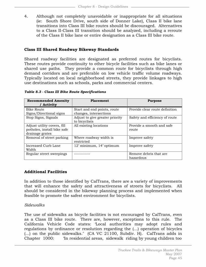
Chapter 8 - Design Guidelines
Truckee Trails & Bikeways Master Plan
May 2007 Page 45
4. Although not completely unavoidable or inappropriate for all situations
(ie: South Shore Drive, south side of Donner Lake), Class II bike lane transitions into Class III bike routes should be discouraged. Alternatives to a Class II-Class III transition should be analyzed, including a reroute of the Class II bike lane or entire designation as a Class III bike route.
Class III Shared Roadway Bikeway Standards Shared roadway facilities are designated as preferred routes for bicyclists. These routes provide continuity to other bicycle facilities such as bike lanes or shared use paths. They provide a common route for bicyclists through high demand corridors and are preferable on low vehicle traffic volume roadways. Typically located on local neighborhood streets, they provide linkages to high use destinations such as schools, parks and commercial centers. Table 8.3 - Class III Bike Route Specifications
Recommended Amenity / Activity
Placement Purpose
Bike Route Signs/Directional signs
Start and end points, route changes, intersections
Provide clear route definition
Stop Signs, Signals Adjust to give greater priority to bicyclists
Safety and efficiency of route
Adjust utility covers, fill potholes, install bike safe drainage grates
All existing locations Provide a smooth and safe route
Removal of street parking Where roadway width is restricted
Improve safety
Increased Curb Lane Width
12’ minimum, 14’ optimum Improve safety
Regular street sweepings ------------ Remove debris that are hazardous
Additional Facilities In addition to those identified by CalTrans, there are a variety of improvements that will enhance the safety and attractiveness of streets for bicyclists. All should be considered in the bikeway planning process and implemented when feasible to promote the safest environment for bicyclists. Sidewalks The use of sidewalks as bicycle facilities is not encouraged by CalTrans, even as a Class III bike route. There are, however, exceptions to this rule. The California Vehicle Code states: ‘Local authorities may adopt rules and regulations by ordinance or resolution regarding the (...) operation of bicycles (...) on the public sidewalks.’ (CA VC 21100, Subdiv. H). CalTrans adds in Chapter 1000: ‘In residential areas, sidewalk riding by young children too

Chapter 8 - Design Guidelines
Truckee Trails & Bikeways Master Plan
May 2007 Page 46
inexperienced to ride in the street is common. With lower bicycle speeds and lower auto speeds, potential conflicts are somewhat lessened, but still exist. But it is inappropriate to sign these facilities as bikeways. Bicyclists should not be encouraged (through signing) to ride facilities that are not designed to accommodate bicycle travel. Traffic Calming This includes any effort to moderate or reduce vehicle speeds and/or volumes on streets where that traffic has a negative impact on bicycle or pedestrian movement. Because these efforts may impact traffic outside the immediate corridor, study of traffic impacts is typically required. Other techniques include installing traffic circles, intersection islands, partial street closings, ‘bulb-out’ curbs, pavement treatments, lower speed signal timing, and narrowing travel lanes. Traffic circles, roundabouts, and other measures may be considered for residential collector streets where there is a desire to control travel speeds and traffic volumes but not to install numerous stop signs or traffic signals. Signing and Striping All bikeway signing should conform to the signing identified in the CalTrans Traffic Manual and/or the Manual on Uniform Traffic Control Devices (MUTCD). These documents give specific information on the type and location of signing for the primary bike system. A list of bikeway signs from CalTrans and the MUTCD are shown in Table 8.3. A typical bike route sign is shown in Figure 8.4.
• Develop a Truckee Bikeway System logo for use on the primary network. This sign may include a bikeway numbering system that is keyed into a publicly-produced bikeway map. An example of such a sign is shown in Figure 8.26.
• Installing bikeway signs should be a high priority, and may begin
immediately on Class III bike route portions of the bikeway network. Examples of bikeway signing for at-grade crossings are shown in Figures 8.4. Examples of bikeway regulatory and safety signs are shown in Figure 8.3.
• Locations in downtown and other employment areas where
centralized public covered bicycle parking can be installed, such as parking lots, should be identified. These facilities may charge a small user fee and / or be subsidized by nearby employers.

Chapter 8 - Design Guidelines
Truckee Trails & Bikeways Master Plan
May 2007 Page 47
Table 8.4 - Recommended Signing & Marking
Item
Location
Color
CalTrans
Designation
MUTCD
Designation
No Motor Vehicles Entrances to trail B on W R44A R5-3
Use Ped Signal/Yield to Peds
At crosswalks; where sidewalks are being used
B on W -----
R9-5 R9-6
Bike Lane Ahead: Right Lane Bikes Only
At beginning of bike lanes B on W ----- R3-16 R3-17
STOP, YIELD At trail intersections with roads and Coastal Bikeways
W on R R1-2 R1-1 R1-2
Bicycle Crossing For motorists at trail crossings
B on Y W79 W11-1
Bike Lane At the far side of all arterial intersections
B on W R81 D11-1
Hazardous Condition Slippery or rough pavement
B on Y W42 W8-10
Turns and Curves At turns and curves which exceed 20 mph design specifications
B on Y W1,2,3 W4,5,6,14 W56,57
W1-1,2 W1-4,5 W1-6
Trail Intersections At trail intersections where no STOP or YIELD required, or sight lines limited
B on Y W7,8,9 W2-1, W2-2 W2-3, W2-3 W2-4, W2-5
STOP Ahead Where STOP sign is obscured
B,R on Y
W17 W3-1
Signal Ahead Where signal is obscured B,R,G YW41 W3-3
Bikeway Narrows Where bikeway width narrows or is below 8'
B on Y W15 W5-4
Downgrade Where sustained bikeway gradient is above 5%
B on Y W29 W7-5
Pedestrian Crossing Where pedestrian walkway crosses trail
B on Y W54 W11A-2
Restricted Vertical Clearance
Where vertical clearance is less than 8'6"
B on Y W47 W11A-2
Railroad Crossing Where trail crosses railway tracks at grade
B on Y W47 W10-1
Directional Signs (i.e. Downtown, Train Station, etc.
At intersections where access to major destinations is available
W on G G7 G8
D1-1b(r/l) D1-1c
Right Lane Must Turn Right; Begin Right Turn Here, Yield to Bikes
Where bike lanes end before intersection
B on W R18 R3-7 R4-4
Truckee Bikeway Trail logo: at all trail entrances, major intersections, major access points
Varies ------
-----
Trail Regulations All trail entrances B on W ----- -----

Chapter 8 - Design Guidelines
Truckee Trails & Bikeways Master Plan
May 2007 Page 48
Multi-purpose Trail: Bikes Yield to Pedestrians
All trail entrances ----- ----- -----
Bikes Reduce Speed & Call Out Before Passing
Every 2,000 feet B on W ----- -----
Please Stay On Trail In environmentally-sensitive areas
----- ----- -----
Caution: Storm Damaged Trail
Storm damaged locations B on Y ----- -----
Trail Closed: No Entry Until Made Accessible & Safe for Public Use
Where trail or access points closed due to hazardous conditions
-----
-----
-----
Speed Limit Signs Near trail entrances: where speed limits should be reduced from 20 mph
B on W -----
-----
Trail Curfew 10PM - 5AM
Based on local ordinance R on W ----- -----
Earthen Trail Guidelines This section sets forth design and maintenance recommendations for the earthen recreational trails within the planned system. These recommendations reflect current thinking with respect to the functioning of low-impact multiple-use earthen trails. The earthen trail design recommendations are geared towards providing a high quality trail system that provides trail users with a high quality recreational experience. Proposed recommendations seek to meet the anticipated needs of a wide variety of trail users. Because trails are bare earthen surfaces, erosion from rainfall, runoff, and trail use can produce significant amounts of sediments. Thus, potential trail impacts on local water quality should be considered. Trails can also impact groundwater, wetlands, wildlife, vegetation, community layout, scenic values and land uses. Because of these considerations, the design recommendations and maintenance program for the earthen trail system should aim to fulfill the following goals:
• Provide workable facilities for multiple users • Preserve scenic resources • Protect water quality, wetlands, floodplains and streams • Protect sensitive areas, including designated wildlife habitats and plant
communities • Protect historic resources • Control erosion and protect exposed soil areas
Define Levels of Challenge for Multi-use Trails Because the needs of trail users vary, trail specifications can be combined in different ways to develop level-of challenge categories for multiple use trails in

Chapter 8 - Design Guidelines
Truckee Trails & Bikeways Master Plan
May 2007 Page 49
the trail network. By grouping the trails into three broad levels, decisions can be made about such issues as whether to provide abundant trail amenities, how wide to make bridge crossings, and other considerations. Level I trails, the easiest category of multi-use trails, would be wide, low-gradient trails with large turning radii, few obstructions, and opportunities for half- and full-day excursions and/or loops of five miles or less. Such trails would accommodate the widest variety of uses and are also prime candidates for winter grooming. Level II trail users would expect to find moderate gradients, possibilities for longer excursions and more rugged tread surfaces. Level III trails would have steeper overall gradients and pitches, narrower and more primitive tread surfaces and possibly longer routes. Table 8.5 - Trail Characteristics by Level of Challenge
Level I - Easiest
Level II - Moderate
Level III - Difficult
► Many trail amenities ► High level of maintenance ► Signage indicating destinations within ½-1 mile ► Info kiosks on route ► Close ties with trail heads and restroom facilities ► Links to major destinations and commercial areas ► Limited sections of moderate grades ► High numbers of people present ► 12’ vertical clearance ► Trail treads – 24” wide ► Trail blazes always in sight
► Moderate grades ► 10’ vertical clearance ► Moderate numbers of people present ► Good connectivity and signage to main trails ► Narrow treads, 18” wide ► Signage indicating major destinations within 2-4 mile distances
► Sections with steep grades ► Low numbers of people present ► Signage indicating major destinations, 3-5 mile distances ► Narrow treads ► Non-groomed ski trails
Trail Design Considerations Trail design considerations include: gradient, overall elevation gain, sight distance, overhead and right-of-way clearing, radii for switchbacks and climbing turns, and tread width and conditions. Trails for different user groups may require specific design solutions and the people in the various user groups will have certain expectations about the location of amenities and the level of difficulty desired on an outing. Key user groups are: hikers, mountain bikers and equestrians. The following table can be used to develop trail recommendations to meet the varying levels of public expectation on the trail system.

Chapter 8 - Design Guidelines
Truckee Trails & Bikeways Master Plan
May 2007 Page 50
Table 8.6 - Trail Levels & Recommendations
Criteria
User Group
Easiest
Moderate
Difficult
Hikers 10% for 100’ 15% for 300’ Up to 30% for 500’
Mountain Bikers
10% maximum sustained pitch
for 100’
10% maximum sustained pitch
for 300’
Sustained grades or pitches greater than
10%
Gradient
Equestrians 15% for 200’ 25% for 300’ 30% for 500’ Hikers 2-4’
Mountain
Bikers
6’ minimum for climbing turn:
10’
3’ For speeds of 5-
15 mph: 55’
2’
Switchback and Turn
radii Equestrians 5’
Hikers
18”-24”, obstacle free
12”-18”, roots, embedded
rocks and some logs may be
left.
12”, tread is not graded
Mountain Bikers
24”, smooth 12”-24”, some rough sections.
12”, varied- some portage required.
Cleared Tread, Surface
Equestrians
24”, with cleared surface, reinforced cross
drains and puncheon or
turnpike in bog sections.
24”, roots and embedded
rocks and logs not removed.
18”, surface not graded.
At precipices, trail base should be
minimum 48”-60” wide.
Extra trail width needed in steep
terrain. Hikers 8’ 8’ 8’
Mountain Bikers
8’ 8’ 8’
Overhead Clearing
Equestrians 10’ 8’ 8’ Hikers 4’ 3’-4’ 3’
Mountain Bikers
4’ 3’-4’ 3’
Right-of-Way Clearing
Equestrians
8’ (for pack clearance
between large trees, there
must be 3’ on either side of
the trail center line 30” above
the trail surface)
6’ (clearance as for easiest trail)
3’ – 4’ wide
Sight distance When sight distance is limited, pullouts should be provided that can accommodate all types of trail users. For mountain bicyclists it is important to provide sufficient sight distance for stopping at 15 mph on straight-aways and 5 mph on blind curves and switchbacks.

Chapter 8 - Design Guidelines
Truckee Trails & Bikeways Master Plan
May 2007 Page 51
Tread preparation or support It is recommended that wet areas be avoided when deciding on the location of any type of trail. If it’s not possible to avoid a wet area, foundation rock should be used as a tread preparation. Under-drainage should be provided for water crossing trails that are also used during snow conditions. When preparing the tread of a trail for hikers, gravel can be used in wet spots. For mountain bike trails, avoid using cobbles and other large materials and use elongated drain dips over water bars. Equestrian trails should be located on stable soils and in places where the tread can be drained. Water Crossings Some recommendations for water crossings on hiking, biking or equestrian trails include:
• Hiking: If not on a bridge, the tread (rocks or logs) across water or wet areas should be a minimum of 12” wide, 24” apart.
• Mountain Biking: Ramps should be provided up to a bridge structure so cyclists do not have to dismount. Approaches to bridges should be straight.
• Equestrian: Provide, stable, naturally-armored, in-water crossing near bridge structures, with stinger trail to and from main trail. The water depth should be less than 24”. The trail base through a ford should be 36” minimum. Large rocks should be removed. If a bridge must be built, it must have a load-carrying capacity to sustain the maximum number of loaded animals that can occupy it at one time. The width should be should be 48” minimum and railings should not snag packs.
Protect water quality, wetlands, floodplains and streams. Earthen trails have the capacity to change the timing, quantity and quality of runoff by “short-circuiting” the natural hydrologic system and delivering both sediments and water directly to streams, wetlands and riparian resources. For this reason, care should be taken to minimize the impacts of trails on these resources. Practices to achieve this protection include:
• Avoid wet areas. Trails should avoid wet areas, springs, floodplains, stream corridors, wetlands, and the lower portions of slopes, especially those that are north-facing.
• Identify and map water resources within 200 feet of the trail
system. Accurately locating wetlands, streams and riparian areas relative to the trail is an important element of the trail planning. The location of these potential “receiving resources” for trail drainage and associated sediments will affect decisions about placement of trail drainage structures, maneuvering of maintenance equipment, season of

Chapter 8 - Design Guidelines
Truckee Trails & Bikeways Master Plan
May 2007 Page 52
work, interception and infiltration of trail drainage, and disposal of earth materials generated during maintenance activities.
• Minimize crossings of streams and wetlands. Minimize channel
crossings and changes to natural drainage patterns.
• Minimize trail drainage to streams and wetlands. Minimize the hydrologic connectivity of trails with streams, wetlands and other water resources.
• Keep heavy equipment off wet trails. Avoid operating heavy
equipment on trails when they are wet. Use alternate routes for heavy equipment when trails are wet.
• Provide crossing structures where needed. Where trails traverse wet
areas, structures should be provided to avoid trail widening and damage at “go-around” spots. Crossing structures also help protect water quality, wetlands and riparian areas.
• Establish vegetative buffers between trails, streams and wetlands.
Retain a buffer between trails and water resources by establishing riparian and streamside management zones (RSMZs), within which trail influences such as drainage, disturbance and trail width are minimized.
The following practices are important in preventing or minimizing the impacts of trails in wet meadows:
• Groundwater and surface drainage should not be intercepted, diverted or concentrated by in-meadow ditches, interception ditches, berms or fill embankments;
• Meadows should not be used for borrow materials; • Upland roads should not drain directly to wet meadows; • Culverts should not be below grade; • Incision should not be occurring below the meadow surface; • Discharge of human-influenced drainage should be by level spreading; • Maintenance of existing ditches should only be carried out when needed
and should not result in ditch deepening or sediment transport to wet meadow;
• Existing ditches should have frequent turnouts and plugs; • Under-drains should have drop inlets and these should not be undercut; • Outlet scour pools should not be present of enlarging; • Headcuts should not be present; • Upland species should not be invading; • Meadow should provide base flows to downstream channel during dry
season.

Chapter 8 - Design Guidelines
Truckee Trails & Bikeways Master Plan
May 2007 Page 53
Protect sensitive areas, including designated wildlife habitats and plant communities. In today’s regulatory environment, resource-disturbing activities on federal lands such as construction of new trail alignments are subject to the requirements of federal ecosystem and watershed planning as well as the Clean Water and Endangered Species acts. For this reason, decisions made during trail master planning that concern trail alignment, realignment, decommissioning and some kinds of maintenance will be subject to environmental impact analysis. A few over-arching principles can provide some guidelines for master planning, and hopefully, steer many project elements away from the lengthy and expensive environmental assessment process.
• Avoid new construction in late successional forest stands. Minimize disturbances in late successional reserve stands of timber, which are characterized by older trees, often with closed canopy, and where certain flora and fauna are of concern for protection.
• Utilize disturbed areas. Utilize existing disturbed areas and clearings
for trails and parking facilities, to the extent that such use does not detract from the area’s scenic quality.
• Establish vegetative buffers for non-conforming uses. Industrial and
commercial uses adjacent to trails should be screened by means of fully planted native vegetative buffers at least 25 feet wide.
• Establish riparian and streamside management setbacks (RSMS).
Vegetative disturbances such as thinning, pruning and felling to improve canopy openings should be allowed as necessary to maintain existing trails in RSMSs. However, no heavy equipment should operate outside the trail clearing limits here. Stormwater discharges from roads and trails to the RSMS should be minimized to the maximum extent possible. Stormwater discharges that cannot be avoided should be designed for maximum treatment, sedimentation, infiltration and level-spreading before entering the RSMS.
• Avoid wet areas unless special construction techniques are used.
• On federal lands, make certain to coordinate with the U.S. Forest
Service. Numerous plant and animal species are protected on federal lands. Where disturbances for construction or maintenance of the trail system will occur on federal lands, it will be essential to coordinate with the U.S. Forest Service to assure that species inventory and protection protocols are followed.

Chapter 8 - Design Guidelines
Truckee Trails & Bikeways Master Plan
May 2007 Page 54
Protect historic resources.
• Leave artifacts and document their location.
• Remove non-historic items. Remove trash and object foreign to the historic character of the resource.
• Prevent uses that degrade the historic routes.
Control erosion and protect exposed soil areas. Earthen trails must be sloped so that their surfaces shed water and the materials supporting the tread remain structurally sound. Favorable drainage gradients are achieved in numerous ways, including cross-sloping (in-sloping, out-sloping, or crowning) and by means of rolling dips and water bars. It is essential to limit both slope length and gradient of road runoff to control erosion. The following drainage practices are commonly prescribed and are essential to the long-term stability of earthen trails and protection of the resources where runoff is directed:
• Avoid steep trail grades. Avoid steep trail grades in excess of 12 percent. It is very difficult to control drainage on steep grades, and erosion on steep grades is expensive to remediate.
• Maintain minimum drainage gradients. Maintain positive surface
drainage by means of out-sloped, in-sloped, or crowned sections having cross slopes of 3 percent to 5 percent. The road surface should be graded to shed water before it can run very far down the road.
• Maintain minimum tread width for uses specified. Maintain only the
width of tread necessary to support the designated uses. Maintaining excess width can be expensive and can generate unnecessary and chronic erosion. Often, excess width can be successfully ripped and seeded to reduce the amount of bare earthen surface exposed to erosion.
• Provide drainage at frequencies appropriate for soils and gradients.
Roll grades or undulate the road profile frequently to disperse water from the tread. Rolling dips and water bars provide essential drainage relief frequency that prevents erosion from damaging the earthen surface of the trail. Spacing depends on gradient and the erodibility of the native earth materials. Table 8.7 below summarizes drainage relief frequencies for low standard (non-surfaced) roads, and can be used as a starting place for determining the necessary spacing of drainage features on trails.
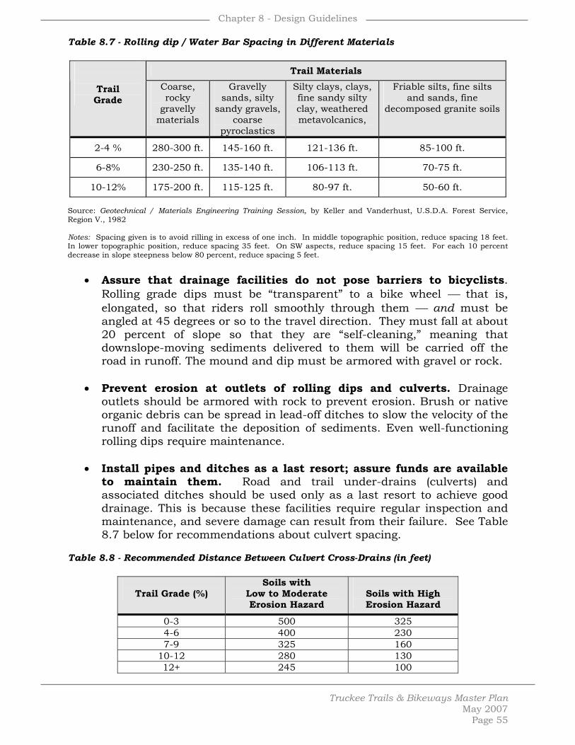
Chapter 8 - Design Guidelines
Truckee Trails & Bikeways Master Plan
May 2007 Page 55
Table 8.7 - Rolling dip / Water Bar Spacing in Different Materials
Trail Materials
Trail Grade
Coarse, rocky
gravelly materials
Gravelly sands, silty
sandy gravels, coarse
pyroclastics
Silty clays, clays, fine sandy silty clay, weathered metavolcanics,
Friable silts, fine silts and sands, fine
decomposed granite soils
2-4 % 280-300 ft. 145-160 ft. 121-136 ft. 85-100 ft.
6-8% 230-250 ft. 135-140 ft. 106-113 ft. 70-75 ft.
10-12% 175-200 ft. 115-125 ft. 80-97 ft. 50-60 ft. Source: Geotechnical / Materials Engineering Training Session, by Keller and Vanderhust, U.S.D.A. Forest Service, Region V., 1982 Notes: Spacing given is to avoid rilling in excess of one inch. In middle topographic position, reduce spacing 18 feet. In lower topographic position, reduce spacing 35 feet. On SW aspects, reduce spacing 15 feet. For each 10 percent decrease in slope steepness below 80 percent, reduce spacing 5 feet.
• Assure that drainage facilities do not pose barriers to bicyclists.
Rolling grade dips must be “transparent” to a bike wheel ⎯ that is, elongated, so that riders roll smoothly through them ⎯ and must be angled at 45 degrees or so to the travel direction. They must fall at about 20 percent of slope so that they are “self-cleaning,” meaning that downslope-moving sediments delivered to them will be carried off the road in runoff. The mound and dip must be armored with gravel or rock.
• Prevent erosion at outlets of rolling dips and culverts. Drainage
outlets should be armored with rock to prevent erosion. Brush or native organic debris can be spread in lead-off ditches to slow the velocity of the runoff and facilitate the deposition of sediments. Even well-functioning rolling dips require maintenance.
• Install pipes and ditches as a last resort; assure funds are available
to maintain them. Road and trail under-drains (culverts) and associated ditches should be used only as a last resort to achieve good drainage. This is because these facilities require regular inspection and maintenance, and severe damage can result from their failure. See Table 8.7 below for recommendations about culvert spacing.
Table 8.8 - Recommended Distance Between Culvert Cross-Drains (in feet)
Trail Grade (%)
Soils with Low to Moderate Erosion Hazard
Soils with High Erosion Hazard
0-3 500 325 4-6 400 230 7-9 325 160
10-12 280 130 12+ 245 100

Chapter 8 - Design Guidelines
Truckee Trails & Bikeways Master Plan
May 2007 Page 56
Source: Low Volume Road Engineering Best Management Practices Field Guide Keller and Sherar, USFS. Jan. 2001.
• Avoid long sustained grades. Avoid long, sustained grades that
concentrate flows. Install grade breaks to get stormwater off the trail and to allow trail users a rest.
• Avoid discharging trail runoff onto fill slopes and unprotected soils.
Concentrated runoff from trails can cause damage to fill slopes and to unprotected soils adjacent to the trail. Discharge sites need to be carefully selected so that runoff velocity is slowed and sediments settle out. Fill slopes should be armored where runoff is discharged onto them, or the runoff should be conveyed in a down drain to a location where sediments can be deposited and the flow infiltrated.
• Don’t let watercourses run down the trail. Descend to a water crossing
from both sides of the channel so that streamflow cannot run down the road or trail.
• Avoid floodplain stream crossings. Cross streams at narrow spots
where there is enough root support for bridge footings, the span will be out of reach of flood waters and the trail will not be subject to floodplain dynamics.
• Select pipe sizes based on hydrologic data. All culvert sizes should be
prescribed based on the size of the contributing watershed and best hydrologic data available. If data are not available and the size of the contributing sub-watershed is 20 acres or less, add the number of acres in the sub-watershed to 8, then round up to the nearest even inch to estimate the culvert size.
• Avoid maintenance activities that generate sediments. To prevent
the generation of sediments from runoff, only road surfaces that need to be reshaped should be bladed and only ditches that are plugged with sediments should be cleaned.
• Season of work. Maintenance work that results in disturbed earth
should be delayed until after the wet season. Blading should be done when the trail surface materials are moist, but not dry.
• Experienced contractors. Maintenance activities should be carried out
by experienced contractors who have had input into the maintenance contracts, attended a pre-work site meeting, have had training, and are familiar with practices to protect the local water resources.
• Disposal of excess earth materials. Areas for disposal of excess earth
materials generated during maintenance activities should be designated in the maintenance plan.

Chapter 8 - Design Guidelines
Truckee Trails & Bikeways Master Plan
May 2007 Page 57
• Management of spoils piles. Excess earth materials that must be
stored on slopes or where runoff from them can reach wetlands, riparian areas, streams or other sensitive resources, should be surrounded covered with plastic or a thick layer of wood chips.
• Stabilize disturbed earth. Areas of disturbed earth should be seeded
with native plant materials and mulched as soon as possible after disturbance.
Disabled Access Guidelines The Americans with Disabilities Act (ADA) of 1990 prohibits discrimination against people with disabilities. As a general rule, it is desirable to maximize accessibility along any public trail system. Specific standards have been developed for buildings and efforts are being made to develop standards for trails. However, it is recognized that constructing trails outdoors may have limitations that make meeting ADA standards difficult and sometimes prohibitive. Prohibitive impacts include harm to significant cultural or natural resources, a significant change in the intended purpose of the trail, requirements of construction methods that are against federal, state or local regulations, or presence of terrain characteristics that prevent compliance. See the following Table 8.9 providing guidelines for development of accessible trails. Simple details to be considered in the planning and design process can greatly enhance accessibility to and within the planned system. Breaks in long grades, consideration of the user’s eye level, minimizing grades at drainage crossings, providing areas to get off the trail, and appropriately designed seating walls are examples of simple accessible improvements. Consultation with the physically challenged on specific design issues prior to the planning and design of trails or trailhead facilities can be very beneficial and is encouraged for every accessible project. Details to ensure a barrier free, safe and enjoyable project for the physically challenged can best be provided by a physically challenged individual(s). Table 8.9 - ADA Trail Development Guidelines
Item
Recommended Treatment Purpose
Trail Surface Hard surface such as, asphalt, concrete, wood, compacted gravel
Provide a smooth surface that accommodates wheelchairs
Trail Gradient Maximum of 5% Greater than 5% is too strenuous
Trail Cross Slope 2% maximum Provide positive trail drainage, but avoid excessive gravitational to side of trail
Trail Width 5’ Minimum Accommodate a wide variety of users

Chapter 8 - Design Guidelines
Truckee Trails & Bikeways Master Plan
May 2007 Page 58
Trail Amenities, phones, drinking fountains, ped. Actuated buttons
Place no higher than 4’ off ground
Provide access within reach of wheelchair users
Detectable pavement changes at curb ramp approaches
Place at top of ramp before entering roadways
Provide visual cues for visually impaired
Trailhead Signage Accessibility information such as trail gradient/profile, distances, tread conditions, location of drinking fountains and rest stops
User convenience and safety
Parking Provide at least one accessible parking area at each trailhead
User convenience and safety
Rest Areas On trails specifically designated as accessible, provide rest areas/widened areas on the trail optimally at every 300’
User convenience and safety
Illustrated Design Guidelines A number of illustrations with accompanying text descriptions have been included within the Plan to graphically detail the design intent for specific situations and physical conditions. The illustrated design guidelines are intended to supplement the text design guidelines contained within this Chapter and to be provided the same flexibility in their interpretation and application. The illustrated design guidelines provide additional general guidance for the design and planning process by providing illustrated concepts or schematics, not construction specifications. The construction details for each individual trail project must be custom tailored based upon the specific needs of each project and environmental conditions.
List of Figures – Chapter 8, Design Guidelines 8.1 – Class I, II & III Bikeway Classifications 8.2 – Class I Bike Path 8.3 – Shared Class I Bike Path 8.4 – At-Grade Crossing 8.5 – Regulatory & Safety Bikeway Signs 8.6 – Class II Bike Lane with Narrow Travel Lane 8.7 – Trail Adjacent to Street 8.8 – Trail Parallel to Roadway 8.9 – Trail in Relation to Street, Residence & Stream 8.10 – Trail Adjacent to Development 8.11 – Trail Concept Through Clustered Subdivision 8.12 – Trail Adjacent to Railroad 8.13 – Creek Trail on Slope 8.14 – Trail Side-Slope Treatments 8.15 – Tread Construction, Stabilization & Steps 8.16 – Infiltration 8.17 – Gabion & Geo-Web 8.18 – Trail Adjacent to Environmentally Sensitive Area 8.19 – Major Crossing of Stream or Drainage 8.20 – Bridge 8.21 – Boardwalk 8.22 – Culverts 8.23 – Log Water Bar 8.24 – Fences 8.25 – Bicycle Racks 8.26 – Informational Signage 8.27 – Information Kiosk 8.28 – Interpretive Sign 8.29 – Trailhead without Parking 8.30 – Trailhead with Parking Area

Chapter 8 - Design Guidelines
Truckee Trails & Bikeways Master Plan
May 2007 Page 59
Figure 8.1 – General Bikeway Classifications Three basic classes of on-street bikeways are contained within the Plan and routinely used throughout the state as the basis for bikeway planning and design. Unlike the off-street recreational trail guidelines contained within the Plan, these three classes of on-street bikeways and the guidelines and standards for each established by the California Department of Transportation are afforded much less flexibility. Consistency with the state-established guidelines and standards is necessary to provide safe bicycling opportunities and cohesive connections with adjoining bikeway networks.
Figure 8.2 - Class I Bike Path Pavement width may vary dependent upon the type and intensity of traffic anticipated, provided a minimum 8’ paved section is constructed for dedicated Class I facilities. Centerline striping should be placed as noted, with the option of a centerline stripe the length of the bikeway if desired and warranted based upon high volume and / or high speed use of a particular bikeway segment.
Figure 8.3 - Shared Class I Bike Path A Class I bike path with a separated soft surface trail creates the best opportunity for the most types of users. A 4-6’ width is appropriate and necessary for equestrian use. A 2’ wide soft surface is adequate to accommodate walkers and joggers. In either case, a 2’ separation should be provided to minimize user conflicts and keep any loose material from entering the paved surface. Tighter turns, shorter sightlines, more grade changes and a less linear alignment are all encouraged for the soft surface trail to provide a more interesting experience.

Chapter 8 - Design Guidelines
Truckee Trails & Bikeways Master Plan
May 2007 Page 60
Figure 8.4 - At-Grade Trail Crossing Although to be avoided when feasible, roadway crossings will be necessary for some planned segments. Use of existing roadway crossings are encouraged at controlled road intersections in lieu of new crossings and the associated need for new crossing control improvements. Low volume / speed crossings are preferred. Consideration for adequate sight-lines and vehicular stopping distances is important. Trail crossings of private driveways require particular attention to user safety, requiring either caution or yield (either trail user to driveway user or vice-versa) signs and / or cautionary pavement striping.
Figure 8.5 - Regulatory & Safety Bikeway Signs Regulatory signs inform bicyclists, pedestrians, equestrians and motorists of laws or regulations which are not always obviously apparent to the user. Safety signs provide warning or caution of a possible hazardous condition, like the ‘caution: downhill’ bicycle sign show at right. They should be erected at the point of their applicability (50’ prior for a hazard warning), clearly indicate the requirement and be easily visible and legible. They should be conservatively used to avoid excess signage and the resultant loss of effectiveness. Uniformity in size, height, location, design and colors throughout the system is essential to convey a clear, simple message to all users. All signs should be reflectorized and sized appropriately based upon the type of message for the intended user(s).
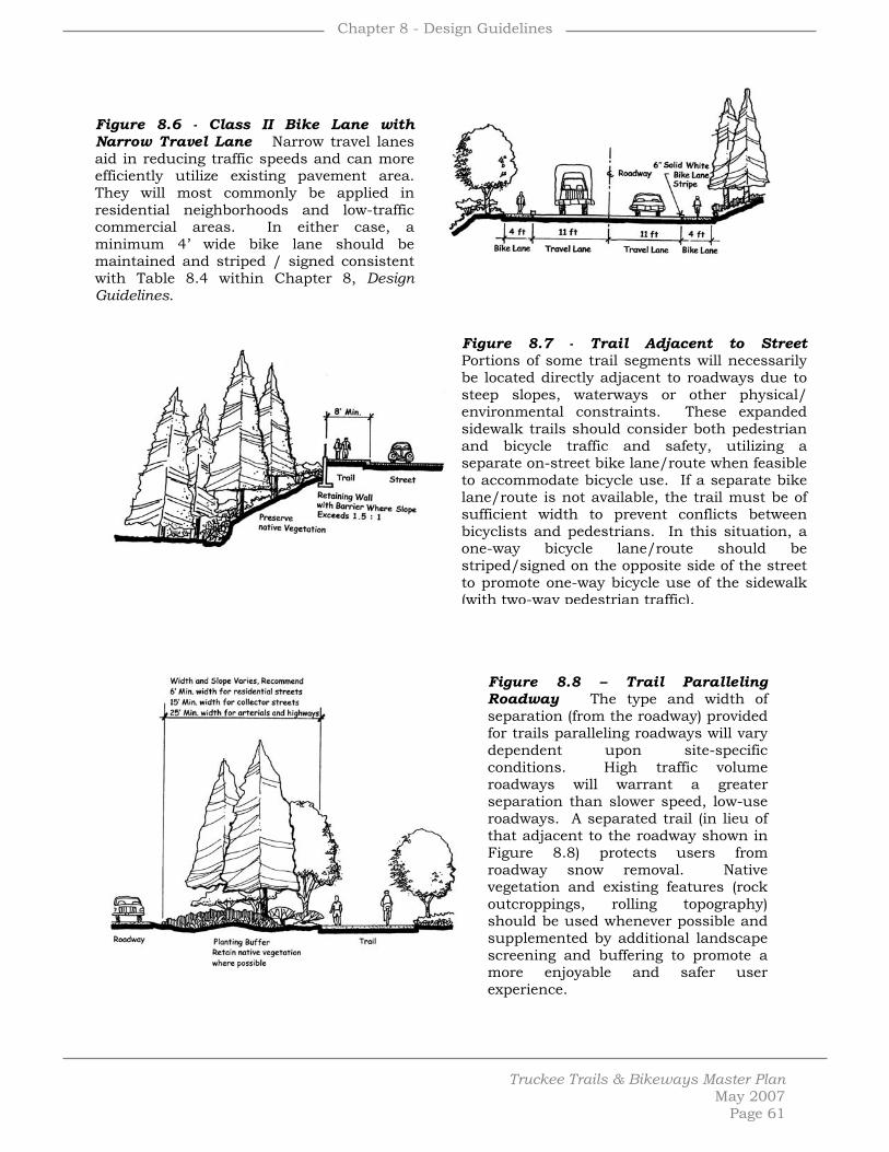
Chapter 8 - Design Guidelines
Truckee Trails & Bikeways Master Plan
May 2007 Page 61
Figure 8.6 - Class II Bike Lane with Narrow Travel Lane Narrow travel lanes aid in reducing traffic speeds and can more efficiently utilize existing pavement area. They will most commonly be applied in residential neighborhoods and low-traffic commercial areas. In either case, a minimum 4’ wide bike lane should be maintained and striped / signed consistent with Table 8.4 within Chapter 8, Design Guidelines.
Figure 8.7 - Trail Adjacent to Street Portions of some trail segments will necessarily be located directly adjacent to roadways due to steep slopes, waterways or other physical/ environmental constraints. These expanded sidewalk trails should consider both pedestrian and bicycle traffic and safety, utilizing a separate on-street bike lane/route when feasible to accommodate bicycle use. If a separate bike lane/route is not available, the trail must be of sufficient width to prevent conflicts between bicyclists and pedestrians. In this situation, a one-way bicycle lane/route should be striped/signed on the opposite side of the street to promote one-way bicycle use of the sidewalk (with two-way pedestrian traffic).
Figure 8.8 – Trail Paralleling Roadway The type and width of separation (from the roadway) provided for trails paralleling roadways will vary dependent upon site-specific conditions. High traffic volume roadways will warrant a greater separation than slower speed, low-use roadways. A separated trail (in lieu of that adjacent to the roadway shown in Figure 8.8) protects users from roadway snow removal. Native vegetation and existing features (rock outcroppings, rolling topography) should be used whenever possible and supplemented by additional landscape screening and buffering to promote a more enjoyable and safer user experience.

Chapter 8 - Design Guidelines
Truckee Trails & Bikeways Master Plan
May 2007 Page 62
Figure 8.9 - Trail in Relation to Street, Residence & Stream Existing natural and man-made features should be used as a buffer between trails and private property. Where possible locate trails adjacent to the front yards streets and / or public open spaces rather than adjacent to private back yards.
Figure 8.10 - Trail Adjacent to Development New trail segments located adjacent or in close proximity to existing developed property (particularly residential) should utilize grade separations, landscaping and / or fencing to help buffer and screen the trail corridor from existing development, to minimize the possibility of trespass onto private property and to ensure the maintenance of privacy and security.
Figure 8.11 - Trail Concept Through Clustered Subdivision When designing the trail system, consider the alignment of a primary through-trail with secondary spur trails providing access to individual development clusters. Multiple connections from each individual residential unit with the primary / main trail should be discouraged through a well-designed and easily accessible spur trail(s). Open space areas created with clustered development provide the best opportunity for linear recreational opportunities such as bike paths and recreational trails.

Chapter 8 - Design Guidelines
Truckee Trails & Bikeways Master Plan
May 2007 Page 63
Figure 8.12 - Trail Adjacent to Railroad A minimum 15’ foot separation from the centerline of the track to the edge of the trail must be maintained and a greater separation preferred for aesthetic and safety purposes. The amount of grade separation will be an important element in determining minimum separation requirements. Vegetation should be retained and enhanced to act as a natural visual, noise and safety barrier between the railroad tracks and trail. Fencing can be used when necessary.
Figure 8.13 - Creek Trail on Slope Locating the trail on the top of the creek bank is the preferred location when possible. When trail segments adjacent to waterways must be located on a slope, the less steep the better. Steep slopes should be avoided. Slope cuts should be minimized and existing vegetation preserved to the extent possible by utilizing the natural topography of the site without creating large undulations in the trail surface / grade / profile. Guardrails should only be installed when warranted due to safety concerns.
Figure 8.14 - Trail Side-Slope Treatments Topographic conditions should be carefully considered to maximize protection of the trail, minimize supporting trail structures (ie: retention devices) and protect the surrounding environment. Trail surfaces should be constructed to sheet flow from the inside to the outside of the trail (ie: outslope) without creating concentrated flows on the down side of the trail. Crowning can be utilized for steep trails. Side swales and berms can also be used to prevent water from reaching the trail surface and provide a lower place on the trail to drain. An inside swale is only necessary when concentrated or heavy flows may wash onto the trail. Grade breaks, considering the existing natural topography and utilizing the natural topography, creating low points in longer stretches of trail on grades can prevent washouts.

Chapter 8 - Design Guidelines
Truckee Trails & Bikeways Master Plan
May 2007 Page 64
Figure 8.15 - Tread Construction,
Stabilization & Steps The stabilization of cuts / fills created with new trail construction is necessary to prevent erosion, protect water quality and to maintain the trail surface. Use of existing vegetation and revegetation to supplement edge stabilization and retention devices will aid in preventing erosion and create a more natural trail corridor. Revegetation with native species (unless temporary irrigation is provided) will be necessary for steep disturbed slopes. Slope stabilization materials can consist of wood, rock or indigenous or natural materials designed to blend with the natural surroundings. Vertical retention devices should only be used when necessary. Railroad tie (or other suitable natural material such as stone) steps can be used fro short, steep grades. Shared use trails should utilize a larger tread versus a reduced 8” tread for pedestrian trails. Wooden stairs should be constructed of pressure treated or an approved rot resistant timber.
Figure 8.16 - Infiltration Careful consideration of water runoff and treatment in the trail design and construction process is crucial to prevent impacts to water quality and to protect the stability of the trail surface and edges. Infiltration trenches for impermeable trail surfaces (shown in figure) can be used on a single (side slope) side or both (crowned) sides of a trail dependent upon the design and construction utilized for a particular trail segment. Trenches can be used in conjunction with or supplemented by catch basins located on lower sections of a trail segment.

Chapter 8 - Design Guidelines
Truckee Trails & Bikeways Master Plan
May 2007 Page 65
Figure 8.17 - Gabion Trail Concept & Geo Web Rock-filled wire gabion construction should be used when more-natural rock rip-rap or other retention treatment is not feasible due to physical conditions or where native rock is too small or too round for stacking. They can be stacked into walls or laid into revetment. They are low cost, easily constructed, compatible with aquatic environments and habitat, require little foundation preparation and are permeable to water.
Figure 8.18 - Trail Adjacent to Environmentally Sensitive Area Wetlands, floodplains and other environmentally sensitive areas should be avoided if at all feasible and provided some degree of separation from the trail. A minimum of 50’ is recommended. Existing vegetated areas are preferred to create the most natural and compatible buffer. Fences or other physical barriers should only be used to protect a particularly sensitive environmental resource. Figure 8.19 – Major Crossing of Stream or
Drainage Bridges (in lieu of culvers or boardwalks) should be used to cross natural or man-made continual running water, areas of riparian or wildlife value or when they provide a user interest and enjoyment. They must be designed for each individual situation and be solid, sturdy and grounded. Due to their association and proximity to water, only galvanized hardware, bolts with washers and pressure treated lumber should be used. Handrails being the exception, requiring a smooth finish. The design should be pleasing to users and compatible with the surrounding environs. Abutments should be located as high on the walls of the channel as possible to decrease their visibility and minimize obstruction of the channel. Bridges should span the entire 100-year floodway.

Chapter 8 - Design Guidelines
Truckee Trails & Bikeways Master Plan
May 2007 Page 66
Figure 8.20 - Bridges Bridge surfacing can vary dependent upon anticipated user needs (equestrians, bicyclists). Natural materials and finishes are encouraged to best complement and blend with the surrounding environment. Tread width and surfacing may vary dependent upon user(s) needs, particularly for equestrian use and / or disabled access necessitating wider widths and better traction surfacing. A recycle rubber surface can be used when heavy equestrian use is anticipated.
Figure 8.21 - Boardwalk Concept
Sectional View Natural materials should be used to be compatible with the sensitive environment commonly associated with the use of boardwalks. Railing should be used only when necessary to prevent trespass onto sensitive or unsafe areas, otherwise a 4”x4” curb will suffice. Railings should be smooth. Stepping stones can also be used for low-traffic, pedestrian only trails to cross stable areas in short stretches, typically no longer than 25’.
Figure 8.22 - Trail Culverts Drainage crossings should be carefully designed to avoid the destructive effects upon the trail of concentrated water flows. Culverts should be adequately sized to accommodate projected water volumes and include native stone rock rip-rap headwalls / outfalls to protect the edges of the trail and downhill land area. Under certain conditions an unimproved swale crossing (very low flows), concrete swale (w/in built environment), stone paving (naturally rocky area, low use) and channelization (occasionally wet areas) can be used in lieu of culverts. These treatments should only be used for pedestrian trails and carefully consider the impact upon the surrounding wetland ecology.

Chapter 8 - Design Guidelines
Truckee Trails & Bikeways Master Plan
May 2007 Page 67
Figure 8.23 - Log Water Bar Rolling dips can be used in lieu of log water bars, particularly when mountain bicycle use is anticipated as they divert water off of the trail with minimal affect on trail users. In both cases, installation must carefully consider the cross slope of the trail and topography of the surrounding area. Rubber water bars can also be used for high volume multiple use trails. See also the spacing specifications contained in Table 8.6.
Figure 8.24 - Fence Types Fences should be used sparingly throughout the system and only when providing a specific benefit to adjoining private or environmentally sensitive lands. A segment-by-segment fence analysis should accompany each project proposal. Fence design should directly relate to its intended function – a solid wood fence for screening and buffering, a split rail fence for property or trail delineation. Fences should be supplemented with existing and / or new native landscaping. Small fence sections can be used to prevent short-cutting or draw a user to a specific focal point. A low-lying single rail fence can be used as a reminder for users to stay on the established trail. Long stretches of fencing should be avoided to prevent narrow corridors and, where possible, be located on only one side of the trail. Fences should be no closer than 5’ to the trail edge and a minimum width of 20’ provided when fences are on both sides of the trail.
Figure 8.25 - Bicycle Racks A wide variety of bicycle parking devices are available and acceptable. Bicycle racks should be designed to adequately support and secure bicycles, be a minimum of 5’ in width (each) and be paved. Racks should be located in easily accessible and safe locations in close proximity to the entrances of both commercial and residential developments. A physical separation or barrier should be placed between bicycle parking facilities and automobile parking areas. An enclosed bicycle locker system can also be used for outside longer-term bicycle parking.

Chapter 8 - Design Guidelines
Truckee Trails & Bikeways Master Plan
May 2007 Page 68
Figure 8.26 - Informational Signs These signs are intended to be used both as trailhead markers and internally throughout the system. When used as a trailhead marker (in lieu of an information kiosk), the sign should be constructed to a 5’-8’ height (dependent upon visibility) with either single or double supporting wood posts. Signs should be constructed of painted metal with a wood backing and finished with a consistent font, background color and contrasting border color. Small signs should be 18”x24”, large signs 30”x42” (exterior dimensions, excluding logo). Smaller ‘bollard type’ information signs should be used within the system to provide distance, direction and user information. They can also be used for small trailheads in lieu of either the post mounted or kiosk signs. The 3” square information symbols provided within each of the two bollard type signs (12” and 6” square shown) should be constructed of either carsonite or metal, recessed ½” deep and epoxyed into place.
Figure 8.27 - Information Kiosk Kiosks should be placed at major trailhead locations (ie: those with parking) and occasionally throughout the system to provides educational opportunities. They should be designed and constructed with natural materials and colors to best complement the surrounding environment. Height and mass should be minimized to that necessary to adequate convey the intended message or information.
Figure 8.28 - Interpretive Sign
Signs educating trail users about environmental resources or historic place / events should be used often throughout the system. Interpretive signs should be placed in close proximity to the area of the message being conveyed, maintain an aesthetic backdrop and be anchored to the site with vertical elements such as larger trees or rocks.

Chapter 8 - Design Guidelines
Truckee Trails & Bikeways Master Plan
May 2007 Page 69
Figure 8.29 – Trailhead without Parking Trailheads without parking delineate an entrance into the trail network within areas of nearby public parking or within residential subdivisions where parking areas are not necessary or would be incompatible with the surrounding neighborhood. A user information area should be provided for any informational signs or other supporting facilities, backed with native vegetation, rocks and fencing if necessary.
Figure 8.30 – Trailheads with Parking Area Parking areas should be visible from the adjoining roadway, but not a dominating or degrading aesthetic feature. Sites should be chosen based upon their ability to accommodate a parking area considering its size, topography, environmental sensitivity and proximity to surrounding land uses. Parking layout should be organized in a logical and space-saving manner, varying in design from a simple roadside parking area to a one-way looped parking area with diagonal parking dependent upon the anticipated demand. Consideration for equestrian use, including trailer parking and maneuvering, should be made when designing trailhead parking areas for trail segments accommodating equestrian use. Graveled or paved parking areas provide superior snow removal and lessen impact to air quality and should be used in lieu of a dirt surface for larger parking areas.

Truckee Trails & Bikeways Master Plan
May 2007 Page 70
Chapter
9 Design & Development Recreational Trail Proposal & Evaluation Process The Master Plan aims to provide a consistent and recognizable system throughout Truckee, while at the same time promoting unique and interesting trail designs and user experiences considering the site(s), trail, user and purpose of the proposed trail segment within the larger context of the Plan’s goals and policies. All trail projects within the incorporated boundaries of the Town of Truckee will be required to demonstrate consistency with the objectives of the Master Plan through an application to the Town of Truckee and / or Truckee Donner Recreation and Park District. The proposal will be evaluated by a technical review committee appointed by the both the Truckee Town Council and Truckee Donner Recreation and Park District. The technical review committee is responsible for ensuring consistency and implementation of the Master Plan and formulating a recommendation on trail-specific proposals to the Town Council and / or Truckee Donner Recreation and Park District for formal consideration and action. Consideration of possible social impacts upon the greater community and neighboring properties will also be a role of the technical review committee to ensure the recreational trail segment is compatible with the not only the physical environment, but also the human environment including litter, vandalism, privacy and noise. The evaluation process is intended to guide the development of trails from the conceptual planning stage to the final detailed trail alignment and construction specification stage. Initial consultation with the technical review committee is strongly encouraged. A project proposal addressing all of the planning, development and management issues of the Master Plan will be necessary. An outline of the evaluation process, project submittal requirements and Master Plan consistency checklist (including mitigation measures contained with the Environmental Impact Report) will be made available for all proponents of a specific recreational trail project. The technical review committee is also responsible for reviewing and making a recommendation to the Town Council and / or Truckee Donner Recreation and Park District on the adequacy of the environmental documentation necessary for each individual project. Public notice will be provided for all trail proposals, based upon the state mandated noticing timelines of the California Environmental Quality Act associated with the type of environmental document necessary in support of the trail proposal. A ‘decision tree’ illustrating the recreational trail proposal and evaluation process has been made part of the Master Plan as Appendix B, Exhibit 4.
Chapter 9 – Design & Development
Truckee Trails & Bikeways Master Plan
May 2007
What Type of Trail? The Master Plan does not plan for a specific type of design for each of the 43 individual recreational trail segments contained within the Plan. The Plan relies on the evaluation process to determine the most appropriate alignment and design considering the objectives and guidelines of the Plan and the ideas, thoughts and concerns of the community. Community participation in the evaluation process will be critical to ensure the development of a particular trail segment best suited for the site, anticipated users and surrounding community. Preferred Recreational Trail Segments Prioritization of the many planned recreational trail segments has not been made an element of the Master Plan. It is the intent of the Master Plan to facilitate the incremental implementation of the system as new proposals and new development proposals provide opportunities to do so. No proposal implementing the goals of the Master Plan will be discouraged. Some segments, however, have been identified by the community, staff and Town Council to provide a greater community-wide recreational and / or alternative transportation benefit than other segments. All things being equal, following are the segments afforded the highest implementation priority (not in priority order) based upon the public benefit derived from each respective trail:
Segment 33 – Downtown to Glenshire
Segment 34 – Downtown to Sports Park
Segment 14 & 9 – Downtown to Donner Lake
Segment 22 – Downtown to 89 North Corridor
On-Street Bikeway Proposal & Evaluation Process A ‘decision tree’ for the on-street bikeway proposal process is illustrated within Appendix B, Exhibit 5 of the Master Plan. Most on-street bikeway projects, with the exception of CalTrans initiated projects on state highways, will be initiated by the Town of Truckee. The town staff is responsible for implementing the on-street bikeway proposal and evaluation process, involving a varying degree of public notification and environmental review dependent upon the scope of the proposed on-street bikeway project. Many on-street bikeway projects will entail only striping and / or signing of the existing roadway, a scope of work not subject to the review requirements of the California Environmental Quality Act (CEQA) and provided public notification and review as a component of the Master Plan public hearings, workshops and advertisements. Simple signing and / or striping of the existing roadway to
Page 71

Chapter 9 – Design & Development
Truckee Trails & Bikeways Master Plan
implement the Class II and Class III bikeway contained within the Master Plan will involve no additional formal public notification. Implementation of other Class II and Class III bikeways will necessitate road widening, intersection improvements or drainage improvements warranting specific formal public notification and CEQA review. An analysis of the potential environmental impacts associated with the specific on-street bikeway project will be conducted by the town staff and, if not exempt from CEQA, the appropriate environmental document prepared, noticed and circulated. The Town Council will be the decision body to approve, disapprove or modify the project and make the final environmental determination. For projects involving widening, street improvements or private property impacts, construction notice to all property owners adjacent to the project roadway will be provided by door hangers and / or informational signage prior to the start of construction. For all on-street bikeway projects, the Town is committed to following a ‘good neighbor’ policy. On-street bikeway projects involving physical impact to private property owner improvements will be personally contacted by the town staff as these impacts are identified in the field. This contact is not only intended to provide notice to property owners of upcoming roadway improvements, but also to open dialogue with property owners about reasonably available solutions to limit impacts upon existing improvements. The need for additional public notification will always be considered for every on-street bikeway project on a case-by-case basis by the town staff. Preferred On-Street Bikeway Segments Implementation of the planned on-street bikeway system will occur concurrent with roadway improvements projects initiated by the Town of Truckee, private development, and the California Department of Transportation. All efforts should be made to implement the planned on-street bikeway system concurrent with road improvement and enhancement projects within the Town. The planned Donner Pass Road Class II bike lane, from Historic Downtown Truckee to the west end of Donner Lake, should receive the highest priority. This bike lane provides the most significant alternative transportation opportunity for the largest number of people in the community. The planned Donner Pass Road bike lane in the Donner Lake area also creates a needed bike route to accommodate the large volumes of bicycle traffic currently utilizing the roadway. The second highest priority should be given to those bikeways providing a continued alternative transportation link from Donner Pass Road to outlying residential communities. The planned Class II bike lanes on Northwoods Boulevard and Glenshire Drive will provide needed bicycle facilities on roadways connecting Donner Pass Road with two of the largest residential areas in the Truckee community and provide a safer environment for bicyclists currently utilizing these two roadways. A third, equally important, alternative
May 2007 Page 72

Chapter 9 – Design & Development
Truckee Trails & Bikeways Master Plan
transportation connection is needed the length of State Highway 89 North between Historic Downtown Truckee / Donner Pass Road and the Prosser area. Similarly, creation of this bicycle facility will provide a connection with a major residential area(s) and coinciding with a commonly used bicycle route on the state highway. The next highest priority should be given to those bikeway facilities providing links to major commercial and residential areas and recreational opportunities. Internal connections within each of the many residential subdivisions planned as Class III bike routes should receive the lowest implementation priority as a supplemental, not integral, component of the Plan.
May 2007 Page 73

Truckee Trails & Bikeways Master Plan
May 2007 Page 74
Chapter
10 Private Lands
Overview Successful implementation of the Master Plan will require the protection of existing trail connections and the reservation of planned trail connections throughout Town. Although many of the trail corridors are intended to utilize public lands consistent with the goals and policies of the Plan, acquisition of trail corridors on private lands will be necessary to successfully implement the Plan. Many options are available to the Town, public agencies, non-profits and private landowners to ensure the protection / reservation of these critical trail corridors. The objective of the Master Plan is to provide a menu of available options to both public agencies and private landowners, promoting flexibility and creativity in the negotiation process. Careful crafting of transactions between private landowners and public agencies can and should produce mutually beneficial results. New Development – Reservations & Dedications The preservation of trail corridors in conjunction with or independent of the open space areas required to be created with new residential development is a requirement of the Town Development Code. Right-of-way reservations for pedestrian paths, bikeways and multiple use trails will be required of new residential development consistent with the General Plan Circulation Element, Public Improvement and Engineering Standards and / or this Plan. An offer of dedication is required when a reasonable relationship is demonstrated between the need for the dedication and the characteristics and impacts of the proposed development. In all cases, a 40’ wide area should be used as a beginning guideline for new development with flexibility provided for the necessary width dependent upon the site or project specific trail needs, including possible maintenance, buffering, fencing and landscaping. The Town Development Code also provides incentives to new development to encourage implementation of the Plan. Reductions in required open space area and fee waivers are two specific incentives offered within the Development Code for public trail reservations and dedications beyond that required of any new development. Additional flexibility is provided for new development within the Planned Development provisions of the Development Code, promoting the highest quality development in concert with the public need and benefit derived from creative and innovative development proposals. The Planned Development provisions provide flexibility for the Town Planning Commission and Town Council in adjusting or modifying any development standard where justified based upon a resultant superior development project than that which

Chapter 10 – Private Lands
Truckee Trails & Bikeways Master Plan
May 2007
would have occurred with the strict application of these standards. Reductions in required project parking and flexibility in internal project circulation layout are two examples specifically cited within the Planned Development provisions and potentially justified with the reservation / dedication of lands in support of the planned recreational trail and on-street bikeway network. Existing Development In cases where trail corridors shown on the Master Plan intersect with existing developed areas, the acquisition of lands will be necessary to create connectivity with adjoining trail corridors. Acquisition can be accomplished through a variety of forms – outright purchase of property, purchase of easements, donations or condemnation. All varieties of acquisition will be employed, however always seeking the most cost effective method to secure appropriate public interest when necessary and warranted. Public – private negotiations for outright purchase of private lands will be necessary in some instances, however the purchase of easements or partial / restricted property right at less cost to the public will be encouraged. Condemnation Policy Statement Condemnation, a mechanism provided to government entities by state law for the purpose of acquiring lands necessary to implement or complete a public need, is an acquisition tool available to the Town of Truckee and other local government entities. Although condemnation will remain an available option to the Town, it is not the preferred or desirable path to implementation of any component of the Plan. Condemnation is a tool to be used a “last resort” in the event good faith negotiation is unsuccessful and the private land area in question is vital to the Plan. If condemnation is a method of land acquisition supported by the Town Council or other local government entity with condemnation authority, fair market value should be paid for the property to be condemned. Beyond the statutory limitations and procedures for the use of condemnation under existing California law, the Town Council has imposed upon themselves additional local procedural limitations to ensure property owners are being treated fairly and that ongoing communication is established and maintained. These additional procedural steps include:
• Requirements for face-to-face meeting with the property owner(s) and representatives, the Town’s designated negotiator, and the appraiser before the appraisal process starts at the property to ‘walk through’ the process, solicit any valuation information the property owner desires to have considered, and set a date by which the Town valuation process will be concluded.
Page 75

Chapter 10 – Private Lands
Truckee Trails & Bikeways Master Plan
May 2007 Page 76
• Provide a ‘plain English’ guide to the process for distribution with a specific individual to answer questions on behalf of the Town.
• Establish an ad hoc ‘Appraisal and Acquisition’ advisory committee to
work with staff, the appraiser, and the property owner consisting of a Town Council member, a local banker, and a local real estate broker to act as a ‘reality check’ on the process.
• Establish as policy in this Master Plan that the condemnation will
process will only be instituted after:
- The property owner has received the Town’s offer and a copy of the appraisal upon which it is based and a meeting has been held with the property owner in an attempt to resolve any concerns.
- The property owner’s appraisal (if prepared) will be fully and fairly considered in the course of such a meeting and good faith negotiations conducted based upon the two appraisals.
- If no agreement is reached, the advisory committee will be asked to review the positions of the parties and make a recommendation as to the appropriate valuation to be provided to the Town Council concurrently with its condemnation of any condemnation resolution.
- Offer the opportunity for mediation using a jointly selected professional, prior to Town Council consideration of a condemnation resolution, assuming doing so will not unreasonably delay the proposed project.

Truckee Trails & Bikeways Master Plan
May 2007 Page 77
Chapter
11 Maintenance, Monitoring & Security Introduction As the trail system is implemented, a high standard of maintenance is a key ingredient to a successful trail system that cannot be over stressed. Beyond the need for safe environment, the psychological effects of good maintenance can be a highly effective deterrent to vandalism and littering. As a new neighbor to the various communities in which the planned trail and bikeway system will pass, the managing agency(s) has an ongoing relationship with those communities and the quality and commitment of maintenance along the trail is an important reflection of that relationship. The Master Plan does not identify a single maintenance or managing entity for the expanse of trails bikeways included within the Plan. With few, if any, exceptions, Class II bike lanes and Class III bike routes will be the maintenance responsibility of the Town of Truckee as the land owner (ie: rights-of-way) of most on-street bikeways. Class I bike paths and recreational trails will be managed and maintained by a number of different public, private and / or non-profit entities. The intent of this chapter is to outline the options for maintenance and management and to identify the specific needs for the different types of recreational trails, on-street bikeways and supporting facilities contained within the Plan. In all cases, consistent with Management Goal 2, a responsible maintenance and management entity must be identified and secured prior to construction of any new trail or bike path segment. Property Management Non-trail use needs arise such as utility installations, private driveway accesses, and roadways, that will impact the trail system. A separate set of policies and procedures that outline the details of property management for the planned system should be developed and implemented in order to protect the quality of the user’s experience. Key elements of this policy are summarized below: Roadways Each motorized vehicle crossing of the trail presents an interruption to the trail user and a potential hazard. For this reason, approval for new crossing agreements should be limited to those that are absolutely necessary, such as land locked parcels with no alternative access available. Existing crossings should be formalized with new agreements, and where possible, consolidated

Chapter 11 – Maintenance, Monitoring & Security
Truckee Trails & Bikeways Master Plan
May 2007 Page 78
with other crossings. Where anticipated automobile volumes are high, grade separation of new crossings should be pursued. Encroachments Given the public nature of the planned system, private encroachments should not be overlooked. Resolving encroachment issues to minimize their impact on future trails and bikeways should be a priority for all effected parties. Utilities / Shared Usage Compatible utility and shared usage agreements may be of benefit to both the planned system and the requesting party. For example, underground fiber optic cables will not interrupt use of the trail while providing an annual rental fee for maintenance of the trail. Utilities should not be granted exclusive use of the right-of-way but would be expected to share use with other compatible and even competing utilities. It is strongly recommended that a utility corridor be defined and conduits running the length of the corridor be installed as each phase of paved trail is built. This will minimize construction and design impacts to the trail as future utilities are installed. Under-grounding of utilities is encouraged whenever feasible. Rules In general, the initial set of rules proposed for the trail will stress courtesy and cooperation with others rather than a restrictive set of edicts. The rules are outlined below:
• Motorized vehicles prohibited except emergency and maintenance vehicles
• Keep pets on a leash and scoop up after them • Stay to the right except when passing • Give a clear, audible warning signal before passing • As a courtesy to other trail users and neighbors, refrain from loitering
near adjacent homes • Cyclists yield to pedestrians and equestrians. Pedestrians yield to
equestrians. • When entering or crossing the trail, yield to those on the trail. • Help keep the trail clean. Pack it in, pack it out. • Exercise caution and obey all traffic laws at all intersections • Equestrians, please clean up after your horses
This set of rules is based upon successful projects in other areas. At this time, it is not proposed to adopt a speed limit or a set of hours for the trail to be opened. Trailheads, however, should be designed with the ability to close them, typically with a sunset to sunrise closure policy. These rules should be posted conspicuously at trailhead and other major access points along the

Chapter 11 – Maintenance, Monitoring & Security
Truckee Trails & Bikeways Master Plan
May 2007 Page 79
trail. Development of a trail brochure with a map and trail rules should be pursued. Enforcement The most effective and most visible enforcement on the trail will be other trail users. Getting as many “eyes on the trail” is a key deterrent to undesirable activity along the trail. There are several components to accomplishing this as outlined below: • Provide good access to the trail – Wherever feasible, public access should be
provided. Access ranges from providing conveniently located trailheads along the trail, building sidewalk linkages at intersections, to accommodating access from private developments adjacent to the trail. Access point should be inviting and signed so as to welcome the public onto the trail.
• Good visibility from adjacent neighbors – Neighbors adjacent to the trail
potentially provide 24-hour surveillance of the trail and can become the public agency’s biggest ally. Though some screening of the trail is needed for privacy of adjacent neighbors, complete blocking out of the trail from neighborhood view should be discouraged. This eliminates the potential of neighbor’s “eyes on the trail,” and could result in a “tunnel effect” on the trail.
• High level of maintenance - A well maintained trail sends a message to the
public that the community really cares about this place. This message by itself will discourage undesirable activity along the trail.
• Programmed events – Events along the trail will help increase public
awareness of the trail and thereby bring more people to the trail. A friends group in support of the development of the trail has already been formed. This group can help initiate numerous public events along the trail in an effort to raise public awareness and increase support for the trail. Events might include a day-long trail clean up or a series of short interpretive walks led by the friends group.
• Community projects – The support generated through the friends group
could be further capitalized on my involving neighbors and friends of the trail in a community project along the trail. Ideas for community projects that have been successful on other trail projects include volunteer planting events, art projects (often associated with adjacent schools), interpretive research projects, or even bridge-building events. These community projects are the strongest means of creating a sense of ownership along the trail which is perhaps the strongest single deterrent to undesirable activity along the trail.

Chapter 11 – Maintenance, Monitoring & Security
Truckee Trails & Bikeways Master Plan
May 2007 Page 80
• Local law enforcement agency staff – Local law enforcement staff must be in tune to the trail and development plans for the trail. As each segment of trail is developed, early involvement of law enforcement staff is critical. Trail projects often do not follow the city grid, and law enforcement staff often have difficulty responding to a call because no one can reference a location along the trail, or local law enforcement staff may think the call site is in someone else’s jurisdiction. To overcome this obstacle, law enforcement staff should be involved early in the design process and give a basic orientation of the trail. They should be invited to join the friends group on any planned events on the site.
• Input should be sought as to the best public safety measures that can be
taken along the trail. This might include physical improvements along the trail such as emergency call boxes and lighting, and might also include maintenance practices such as vegetative pruning to allow easy surveillance of “trouble spots” along the trail. Local law enforcement staff may also have key knowledge of unique challenge areas along the trail and then addressed through appropriate design solutions.
• Adopt-a-Trail Program – Numerous business and residential communities
abut the trail. As neighbors to the trail, they often see the benefit of their involvement in the trail development and maintenance. Many developments may view the trail as an integral piece of their campus and taking on some level of responsibility for the trail becomes a source of civic pride. Creation of an adopt-a-trail program should be explored to capitalize on this opportunity.
Corridor Maintenance Maintenance is as important in property management as property acquisition is to development. It includes such activities as pavement stabilization, landscape maintenance, facility upkeep, sign replacement, fencing, mowing, litter removal, painting, and pest control. However, the effects of a good maintenance program are not limited to the physical and biological features of the trail:
• A high standard of maintenance is an effective way of helping advertise and promote the trail as a regional and state recreational resource;
• The psychological effects of good maintenance can be an effective deterrent to vandalism, litter, and encroachments;
• Good maintenance is necessary to preserve positive public relations between the adjacent land owners and government;
• Good maintenance can help make enforcement of regulations on the trail more efficient. Local clubs and interest groups will take pride in “their” trail and will be more apt to assist in protection of the trail system.

Chapter 11 – Maintenance, Monitoring & Security
Truckee Trails & Bikeways Master Plan
May 2007 Page 81
A successful maintenance program requires continuity and a high level of citizen involvement. Regular, routine maintenance on a year-round basis will not only improve trail safety, but will also prolong the life of the trail. Maintenance activities required for safe trail operations should always receive top priority. The following should be part of the maintenance checklist: Paved Surface Maintenance Cracks, ruts and water damage will have to be repaired periodically. In addition, vegetation control will be necessary on a regular basis. Where drainage problems exist along the trail, ditches and drainage structures will need to be keep clear of debris to prevent wash outs along the trail. Checks for erosion along the trail should be made monthly during the wet season, and immediately after any storm that brings flooding to the local area. The trail surface should be kept free of debris, especially broken glass and other sharp objects, loose gravel, leaves and stray branches. Trail surfaces should be swept periodically. Pest and Vegetation Management The trail system moves through a variety of landscape setting ranging from low scrub vegetation, meadows and dense forested areas. Some basic measures should be taken to best protect the trail investment. This includes an annual mowing along both sides of the trail to prevent invasion of plants into the pavement area. Wherever possible, weed control should be accomplished by mechanical means. This is especially true along drainage ways crossing the trail. Innovative weed control methods such as grazing and steaming should be explored. Use of chemical sprays should be limited to use only on those plants that are harmful to the public. In addition, vegetation that intrudes on the equestrian trail must be controlled. A minimum of 10’ vertical clearance must be maintained. Litter and Illegal Dumping Litter along the Corridor should be removed by staff or volunteer effort. Litter receptacles should be placed at access points such as trailheads. Litter should be picked up twice a week (usually just before and after the weekend ) and after any special events held on the trail. Illegal dumping should be controlled by vehicle barriers, regulatory signage and fines as much as possible. When it does occur, it must be removed as soon as possible in order to prevent further dumping. Neighborhood volunteers, friends groups, alternative community service crews and inmate labor should be used in addition to maintenance staff.

Chapter 11 – Maintenance, Monitoring & Security
Truckee Trails & Bikeways Master Plan
May 2007 Page 82
Signage Signage will be replaced along the trail on an as-needed basis. A monthly check on the status of signage should be performed with follow-up as necessary. Bridges A structural engineer should be retained to assess the integrity of all existing bridges and inspections of bridge structures should take place at regular intervals based upon the structural engineers recommendations. Fencing Use of fencing for border control (for residential security) is strongly discouraged. The first preference will be to plant shrubs, trees and use temporary fencing to establish privacy. As the need arises, fencing requests should be evaluated on a case-by-case basis. Property lines should be clearly surveyed and field marked in a way that is useful for the maintenance staff and the trail neighbors. Trailheads The specialized facilities at trailheads will require frequent inspections and maintenance. Restrooms must be cleaned on a daily basis. Site furniture and lighting should be kept in good repair. Maintenance / Operations Implications Volunteer assistance should be sought to assist with maintenance of the trail system. Though volunteer effort will most likely be ongoing, it is not intended to be a long-term solution to trail maintenance. A trails maintenance position should be created by the Town of Truckee and / or Truckee Donner Recreation and Park District with primary duties to include coordination of volunteer efforts and trail maintenance. A seasonal laborer and necessary equipment should be assigned under this position. The maintenance personnel should be based at a central trailhead location, providing a known staff presence. On-going maintenance could be partially offset if adequate utility lease agreements are arranged, or licenses or easement fees are available. Other possibilities include “adopt-a-trail sections by adjacent businesses, business associations, residential communities, or community service organizations.

Truckee Trails & Bikeways Master Plan
May 2007 Page 83
Chapter
12 Funding & Financing Opportunities Often times, the single most difficult hurdle in the creation of a local system of trails and bikeways is securing adequate funding. Funding sources are needed for the acquisition, development, operation and maintenance of a trail system; therefore a combination of creative methods and sources must be explored in order to achieve the goals set out in the Master Plan. As stated in Development Goal 2, the Town of Truckee is committed to identifying and diligently pursuing all available funding and financing sources that will contribute to implementation of the Plan. A multitude of funding possibilities are available in support of implementation of the planned system. Funding might be obtained from grants made by federal, state or local government, as well as from private sources. The details of the many funding opportunities can be found in Appendix B, Exhibit 2. As a palette of options, this matrix allows the strategic planning for funding according to the grant type and as well as the benefit derived from each individual trail or bikeway segment. Grant funding opportunities for individual projects providing an alternative transportation benefit are more numerous than those available for projects design solely for recreational use. The grant funding opportunities provided through the federal Transportation Enhancement Act of the Twenty-First Century (TEA-21) is the most representative example of a funding source for alternative transportation. Although the funding availability or opportunities should not be the driving force behind the design (ie: surfacing, widths) of a new trail or bikeway project, this should always be considered in the planning and design process to ensure eligibility for the broadest range of funding opportunities. Appendix B, Exhibit 2 provides a comprehensive approach to looking at the many available funding opportunities. The table is organized by the following funding streams: Federal, State, Local and Private Funding Opportunities. Each source is then identified by the name of the sponsoring agency or organization, the specific program name, and the funding type / typical award amounts. Additionally, each funding opportunity listed includes a brief description of the program, who is eligible to apply, timeframes for application, information about possible matching funds requirements, and important contact information.

Chapter 12 – Funding & Financing
Truckee Trails & Bikeways Master Plan
May 2007
The appendix is current as of the initial adoption of this Plan. As the longevity of most grants and funding opportunities is often unpredictable, it is wise to inquire directly to the appropriate funding entity for the most up-to-date information. Non-Profit / Foundation Opportunities Forming a New Organization In keeping with Management Goal 1, options related to the formation of a non-profit 501(c)3 organization or other community partnership options should be explored. Such an entity can be more flexible and innovative than any publicagency. A private, non-profit organization has the ability to raise funds for the implementation and maintenance of these trails and can serve as a vehicle for community support and advocacy. The long-term success of the system could hinge upon the formation of an ongoing, private non-profit organization, commonly referred to as “friends” groups or trail foundations. The single most important function of a foundation or friends organization is to act as an advocate for the system, defending it when necessary and promoting it the rest of the time. These independent organizations provide many other services to trails including: physical labor such as “adopt-a-trail” clean-ups and minor repair and construction, surveillance and reporting of any problems or safety concerns taking place on or near the trail, fundraising to pay for structures, amenities or threatened adjacent properties of great environmental significance, maps, newsletters and educational information for users and the promotion of the trail as a tourist destination for the region. Appendix B, Exhibit 3 includes five case studies of different non-profit organizations and/or foundations that might serve as examples for a similar group to be formed for the purpose of spearheading the community stewardship component of the Truckee Trails & Bikeway system according to this Plan. Working with Existing Organizations The Truckee-Donner Land Trust, as the region’s local private land trust, could play a significant role in acquiring, assembling and configuring parcels of land for the dedication to the Truckee Trails & Bikeways System. There are several factors that have contributed to the recent rise in popularity of local private land trusts as partners to local governments interested in improving their parks and recreational facilities. Those factors include an increasing lack of federal financial support for local parks, an unfortunate tendency of cities to cut park budgets, and a need for the rejuvenation of urban parks.
Page 84

Chapter 12 – Funding & Financing
Truckee Trails & Bikeways Master Plan
May 2007 Page 85
The Truckee Donner Land Trust could assist with a number of critical pieces of the Plan. They have the expertise and ability to undertake the complexities of assembling urban parkland. They could also raise money and administer financial transactions in order to quickly expedite the land transfer process. Public-Private Partnerships It has become a growing belief in recreation planning circles that the most successful parks emerge from broad community participation. Those parks will contribute significant value not only to the community health and spirit but also bankable value to nearby residential and commercial districts. Successful park partnerships have the widest range of stakeholders: the most common of which are government, business, and non-profit foundations. Public-private partnerships can be established for the purpose of ongoing coordination, joint development, and the funding of a trail system. Often such successful trail partnerships are created through a structured association of public agencies, community groups, businesses and individuals who are dedicated to the purpose of developing and maintaining a trail system. Through the oversight of an administrative body such as an Advisory Council, partnerships work as both coordinator and advocate for a project. The Advisory Council can facilitate communication between agencies and community partners as well as assist with the coordination of trail planning, development, and implementation of the partnerships’ goals and objectives. Partnerships with private developers are highly encouraged and will be sought throughout the life of the Plan. Financing Techniques Like many other small local communities, Truckee cannot afford to immediately dedicate all the required resources to pay for the implementation of every aspect of the Truckee Trails & Bikeways Master Plan. It will be important to consider the link between open space and economic development and to take advantage of opportunities to acquire or reserve critical pieces of property as they become available. In order to do so, there are a number of different financing options to consider throughout this process. Appendix B, Exhibit 3 provides a list of financing opportunities, including long-term bonds, short-term debt instruments, and alternative financing techniques such as assessment districts and endowment funds.

Chapter
13 Environmental Document
Program EIR – What is it? A “first-tier” Environmental Impact Report (EIR) has been prepared by the professional firm of Alta Transportation Consultants under contract with the Town of Truckee in support of the Master Plan consistent with the requirements of the California Environmental Quality Act (CEQA). Known as a Program EIR it relies, in part, upon the “big picture” environmental analysis prepared in support of the 1996 Town of Truckee General Plan EIR and the 1997 Town of Truckee Downtown Specific Plan EIR. A Program EIR (in lieu of other types of EIR’s) has been prepared to avoid redundant analysis and to reduce costs while at the same time achieving a high level of environmental review and protection. The EIR is designed to “pre-mitigate” many of the potential impacts associated with implementation of the planned system. The EIR is contained within a separate bound volume available from the Town of Truckee Community Development Department. Relationship to Future Projects / Environmental Review The Program EIR is designed to be both comprehensive and specific. The document concentrates on the potential cumulative long-term impacts associated with implementation of the Master Plan, but also contains adequate detail to anticipate and analyze the many subsequent activities within the scope of the Master Plan. The Program EIR is intended to provide adequate detail and analysis to satisfy the CEQA review requirements for most subsequent projects contained within the scope of the Master Plan. All projects implementing the Master Plan (ie: development of a specific trail segment) will be analyzed to determine whether the project impacts have been fully and adequately analyzed within the Program EIR. If the impacts of a specific project will have no impact beyond those analyzed within the Program EIR as documented within the project environmental initial study, no further CEQA compliance will be necessary. Some projects implementing the Master Plan will require additional environmental review to satisfy the requirements of CEQA. These projects typically involve disturbance within flood-plains, areas of archaeological / cultural importance, or wetland areas and warrant a more detailed environmental review. Projects involving potential impacts beyond that analyzed in the Program EIR will be subject to the appropriate “second-tier” EIR or Negative Declaration process as appropriate, dependent upon the extent, type, or potential for an impact(s) to the environment consistent with
Truckee Trails & Bikeways Master Plan
May 2007 Page 86

Chapter 13 – Environmental Document
Truckee Trails & Bikeways Master Plan
May 2007
the requirements of CEQA. In either case, the environmental document will focus on the issue or issues found to have a potential impact upon the environment and include methods to mitigate this impact(s) to less than significant levels. In all cases, public notice of a proposed CEQA determination by the lead agency will be provided to the community. This notification will most commonly accompany the necessary public notice for the recreational trail proposal and evaluation process described in Chapter 8, Trail Design & Development. EIR Scope The EIR prepared for the Master Plan contains all of the necessary components required of a Program EIR, following the standard organizational format recommended by the CEQA Guidelines. The Plan includes an analysis of the range of potential environmental impacts of the Plan, as well as proposed alternatives to the proposed Plan. Specifically, the following potential environmental impacts associated with implementation of the Plan have been analyzed:
• Land Use • Transportation / Circulation • Biological Resources • Cultural Resources • Geology & Soils • Safety & Security
• Public Facilities & Services • Visual Quality • Air Quality • Hydrology & Water Quality • Noise
Summary of Conclusions The EIR evaluated all potential environmental impacts that could result from implementation of the Plan and, where an impact is determined to be significant or potentially significant, mitigation measures are identified to address these impacts. The EIR includes seventy mitigation measures for the various potential impacts identified within the environmental analysis, either identified within the EIR analysis or within the Master Plan. Implementation of the Plan will have varying degrees of impact upon the environment, however, none of the impacts have been determined to be significant or cumulatively significant with the incorporation of these mitigation measures into the Plan and future project proposals. Chapter 2, Executive Summary, of the EIR provides a summary of the Master Plan’s significant impacts, mitigation measures and the level of significance after incorporation of these mitigation measures.
Page 87

Chapter 13 – Environmental Document
Truckee Trails & Bikeways Master Plan
May 2007 Page 88
The EIR also concludes that the Plan does not create a growth-inducing impact. The Master Plan provides for a network of interconnected recreational trails and on-street bikeways designed to link existing developed areas of the Town or areas planned for future development under the General Plan. The Plan does not result in any new housing or the expansion of major roadways or utility infrastructure into undeveloped areas of Town. Three alternatives to the proposed Plan were evaluated within the EIR: a ‘no project’ alternative, an ‘existing trail’ alternative and an ‘on-street’ alternative. The ‘on-street’ alternative is the environmentally superior alternative, resulting in the greatest reduction of impacts due to the scope of new trail and bikeway projects being limited to existing roadways. This alternative would however, significantly reduce and limit the size and effectiveness of the planned system and compromise the most fundamental objectives of the Plan. A complete discussion of the project alternatives evaluated within the EIR is contained within Chapter 5, Alternatives, of the EIR.
![Explaining Design Dimensions of Ecological Greenways · greenways [15], different functions such as Bicycling, skating, walking[16] and environmental protection [17] have been allocated](https://img.pdfslide.net/doc/110x75/5f07d1967e708231d41ee7cb/explaining-design-dimensions-of-ecological-greenways-greenways-15-different-functions.jpg)