Embed Size (px)
Citation preview
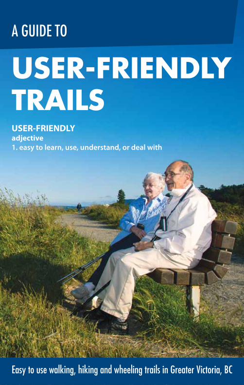
USER-FRIENDLYadjective
1. easy to learn, use, understand, or deal with
Easy to use walking, hiking and wheeling trails in Greater Victoria, BC
USER-FRIENDLY TRAILS
A GUIDE TO
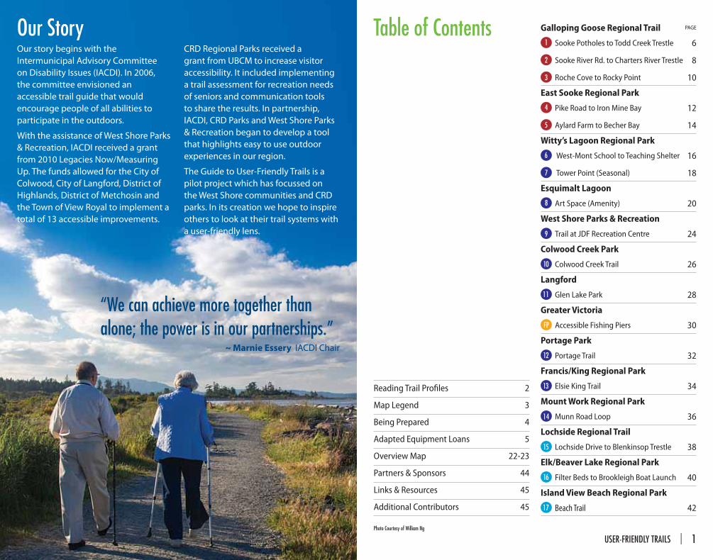
Table of Contents Galloping Goose Regional Trail PAGE
1 Sooke Potholes to Todd Creek Trestle 6
2 Sooke River Rd. to Charters River Trestle 8
3 Roche Cove to Rocky Point 10
East Sooke Regional Park
4 Pike Road to Iron Mine Bay 12
5 Aylard Farm to Becher Bay 14
Witty’s Lagoon Regional Park
6 West-Mont School to Teaching Shelter 16
7 Tower Point (Seasonal) 18
Esquimalt Lagoon
8 Art Space (Amenity) 20
West Shore Parks & Recreation
9 Trail at JDF Recreation Centre 24
Colwood Creek Park
10 Colwood Creek Trail 26
Langford
11 Glen Lake Park 28
Greater Victoria
FP Accessible Fishing Piers 30
Portage Park
12 Portage Trail 32
Francis/King Regional Park
13 Elsie King Trail 34
Mount Work Regional Park
14 Munn Road Loop 36
Lochside Regional Trail
15 Lochside Drive to Blenkinsop Trestle 38
Elk/Beaver Lake Regional Park
16 Filter Beds to Brookleigh Boat Launch 40
Island View Beach Regional Park
17 Beach Trail 42
Reading Trail Profi les 2
Map Legend 3
Being Prepared 4
Adapted Equipment Loans 5
Overview Map 22-23
Partners & Sponsors 44
Links & Resources 45
Additional Contributors 45
Our story begins with the
Intermunicipal Advisory Committee
on Disability Issues (IACDI). In 2006,
the committee envisioned an
accessible trail guide that would
encourage people of all abilities to
participate in the outdoors.
With the assistance of West Shore Parks
& Recreation, IACDI received a grant
from 2010 Legacies Now/Measuring
Up. The funds allowed for the City of
Colwood, City of Langford, District of
Highlands, District of Metchosin and
the Town of View Royal to implement a
total of 13 accessible improvements.
CRD Regional Parks received a
grant from UBCM to increase visitor
accessibility. It included implementing
a trail assessment for recreation needs
of seniors and communication tools
to share the results. In partnership,
IACDI, CRD Parks and West Shore Parks
& Recreation began to develop a tool
that highlights easy to use outdoor
experiences in our region.
The Guide to User-Friendly Trails is a
pilot project which has focussed on
the West Shore communities and CRD
parks. In its creation we hope to inspire
others to look at their trail systems with
a user-friendly lens.
Photo Courtesy of William Ng
Our Story
“We can achieve more together than alone; the power is in our partnerships.”
~ Marnie Essery IACDI Chair
USER-FRIENDLY TRAILS | 1
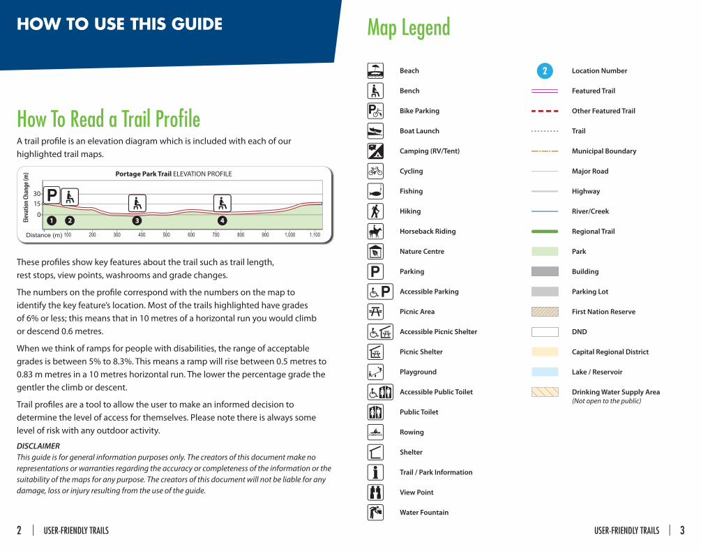
Map LegendHOW TO USE THIS GUIDE
How To Read a Trail Profi leA trail profi le is an elevation diagram which is included with each of our
highlighted trail maps.
These profi les show key features about the trail such as trail length,
rest stops, view points, washrooms and grade changes.
The numbers on the profi le correspond with the numbers on the map to
identify the key feature’s location. Most of the trails highlighted have grades
of 6% or less; this means that in 10 metres of a horizontal run you would climb
or descend 0.6 metres.
When we think of ramps for people with disabilities, the range of acceptable
grades is between 5% to 8.3%. This means a ramp will rise between 0.5 metres to
0.83 m metres in a 10 metres horizontal run. The lower the percentage grade the
gentler the climb or descent.
Trail profi les are a tool to allow the user to make an informed decision to
determine the level of access for themselves. Please note there is always some
level of risk with any outdoor activity.
DISCLAIMERThis guide is for general information purposes only. The creators of this document make no
representations or warranties regarding the accuracy or completeness of the information or the
suitability of the maps for any purpose. The creators of this document will not be liable for any
damage, loss or injury resulting from the use of the guide.
Beach
Bench
Bike Parking
Boat Launch
Camping (RV/Tent)
Cycling
Fishing
Hiking
Horseback Riding
Nature Centre
Parking
Accessible Parking
Picnic Area
Accessible Picnic Shelter
Picnic Shelter
Playground
Accessible Public Toilet
Public Toilet
Rowing
Shelter
Trail / Park Information
View Point
Water Fountain
2 Location Number
Featured Trail
Other Featured Trail
Trail
Municipal Boundary
Major Road
Highway
River/Creek
Regional Trail
Park
Building
Parking Lot
First Nation Reserve
DND
Capital Regional District
Lake / Reservoir
Drinking Water Supply Area
(Not open to the public)
2 | USER-FRIENDLY TRAILS USER-FRIENDLY TRAILS | 3
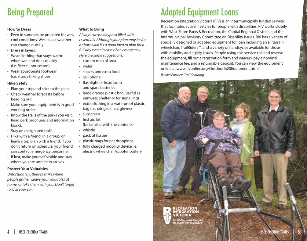
Being Prepared
How to Dress
• Even in summer, be prepared for wet,
cool conditions. West coast weather
can change quickly.
• Dress in layers.
• Wear clothing that stays warm
when wet and dries quickly
(i.e. fl eece - not cotton).
• Wear appropriate footwear
(i.e. sturdy hiking shoes).
Hike Safely
• Plan your trip and stick to the plan.
• Check weather forecasts before
heading out.
• Make sure your equipment is in good
working order.
• Know the trails of the parks you visit.
Read park brochures and information
kiosks.
• Stay on designated trails.
• Hike with a friend, in a group, or
leave a trip plan with a friend. If you
don’t return on schedule, your friend
can contact emergency personnel.
• If lost, make yourself visible and stay
where you are until help arrives.
Protect Your Valuables
Unfortunately, thieves strike where
people gather. Leave your valuables at
home, or take them with you. Don’t forget
to lock your car.
What to Bring
Always carry a daypack fi lled with
essentials. Although your plan may be for
a short walk it’s a good idea to plan for a
full day event in case of an emergency
Here are some suggestions:
• current map of area
• water
• snacks and extra food
• cell phone
• fl ashlight or head lamp
and spare batteries
• large orange plastic bag (useful as
rainwear, shelter or for signalling)
• extra clothing in a waterproof plastic
bag (i.e. raingear, hat, gloves)
• sunscreen
• fi rst aid kit
(be familiar with the contents)
• whistle
• pack of tissues
• plastic bags for pet droppings
• fully charged mobility device, ie:
electric wheelchair/scooter battery
Facilitating active lifestylesfor people with disabilities
Adapted Equipment LoansRecreation Integration Victoria (RIV) is an intermunicipally funded service
that facilitates active lifestyles for people with disabilities. RIV works closely
with West Shore Parks & Recreation, the Capital Regional District, and the
Intermunicipal Advisory Committee on Disability Issues. RIV has a variety of
specially designed or adapted equipment for loan including an all terrain
wheelchair, TrailRiders™, and a variety of handcycles available for those
with mobility and agility issues. People using this service call and reserve
the equipment, fi ll out a registration form and waivers, pay a nominal
maintenance fee, and a refundable deposit. You can view the equipment
online at www.rivonline.org/Outdoor%20Equipment.html
Below: Partners Trail Scouting
USER-FRIENDLY TRAILS | 54 | USER-FRIENDLY TRAILS
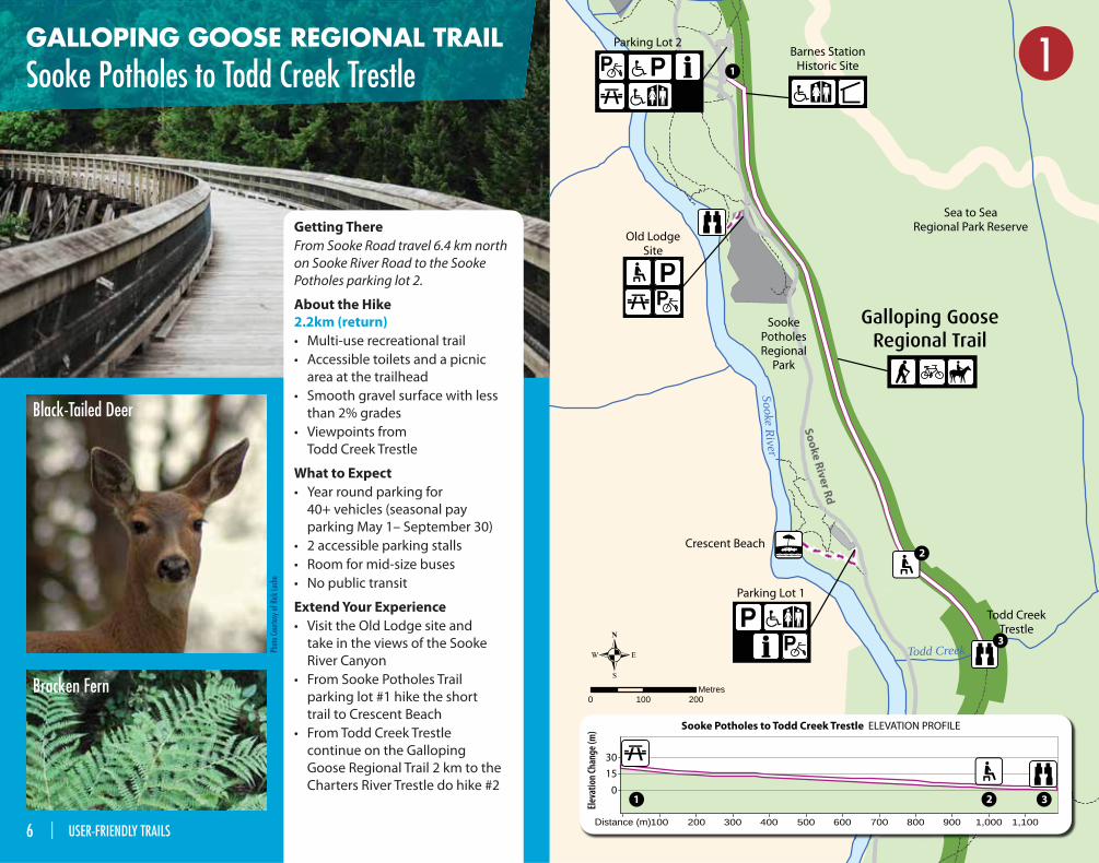
GALLOPING GOOSE REGIONAL TRAIL
Sooke Potholes to Todd Creek TrestleParking Lot 2
Todd CreekTrestle
Parking Lot 1
Old LodgeSite
Barnes StationHistoric Site
Sea to SeaRegional Park Reserve
SookePotholesRegional
Park
Crescent Beach
So
ok
e R
ive
r Rd
Todd Creek
Sook
e R
i ver
Sooke River
0 100 200Metres
Galloping GooseRegional Trail
SoSSo k
ekR
i ver
Eleva
tion C
hang
e (m
)
Distance (m)
30
15
0
1,1001,000900800700600500400300200100
3
3
2
2
1
1
Sooke Potholes to Todd Creek Trestle ELEVATION PROFILE
1
Phot
o Co
urte
sy o
f Rick
Lech
e
Black-Tailed Deer
Bracken Fern
Getting There
From Sooke Road travel 6.4 km north
on Sooke River Road to the Sooke
Potholes parking lot 2.
About the Hike
2.2km (return)
• Multi-use recreational trail
• Accessible toilets and a picnic
area at the trailhead
• Smooth gravel surface with less
than 2% grades
• Viewpoints from
Todd Creek Trestle
What to Expect
• Year round parking for
40+ vehicles (seasonal pay
parking May 1– September 30)
• 2 accessible parking stalls
• Room for mid-size buses
• No public transit
Extend Your Experience
• Visit the Old Lodge site and
take in the views of the Sooke
River Canyon
• From Sooke Potholes Trail
parking lot #1 hike the short
trail to Crescent Beach
• From Todd Creek Trestle
continue on the Galloping
Goose Regional Trail 2 km to the
Charters River Trestle do hike #2
6 | USER-FRIENDLY TRAILS
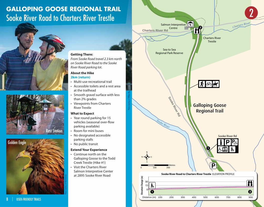
GALLOPING GOOSE REGIONAL TRAIL
Sooke River Road to Charters River Trestle
Getting There:
From Sooke Road travel 2.3 km north
on Sooke River Road to the Sooke
River Road parking lot.
About the Hike
2km (return)
• Multi-use recreational trail
• Accessible toilets and a rest area
at the trailhead
• Smooth gravel surface with less
than 2% grades
• Viewpoints from Charters
River Trestle
What to Expect
• Year round parking for 15
vehicles (seasonal over-fl ow
parking available)
• Room for mini buses
• No designated accessible
parking stalls
• No public transit
Extend Your Experience
• Continue north on the
Galloping Goose to the Todd
Creek Trestle (Hike #1)
• Visit the Charters River
Salmon Interpretive Center
at 2895 Sooke River Road
Sea to SeaRegional Park Reserve
Galloping GooseRegional Trail
Charters RiverTrestle
Sooke River Rd
Salmon InterpretiveCentre
Sooke River Rd
Charters River Rd
Sooke River
Charters River
0 100 200Metres
Distance (m)
30
15
0
900800700600500400300200100
2
2
1
1
Sooke River Road to Charters River Trestle ELEVATION PROFILE
Eleva
tion C
hang
e (m
)
2
Phot
o Co
urte
sy o
f Phi
l Pet
erse
n
Golden Eagle
Phot
o Co
urte
sy o
f Will
iam
Ng
Rest Station
8 | USER-FRIENDLY TRAILS
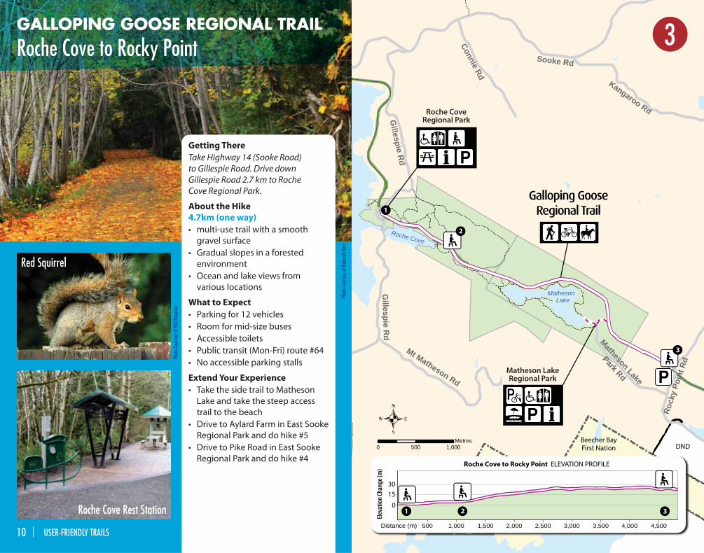
GALLOPING GOOSE REGIONAL TRAIL
Roche Cove to Rocky Point
Getting There
Take Highway 14 (Sooke Road)
to Gillespie Road. Drive down
Gillespie Road 2.7 km to Roche
Cove Regional Park.
About the Hike
4.7km (one way)
• multi-use trail with a smooth
gravel surface
• Gradual slopes in a forested
environment
• Ocean and lake views from
various locations
What to Expect
• Parking for 12 vehicles
• Room for mid-size buses
• Accessible toilets
• Public transit (Mon-Fri) route #64
• No accessible parking stalls
Extend Your Experience
• Take the side trail to Matheson
Lake and take the steep access
trail to the beach
• Drive to Aylard Farm in East Sooke
Regional Park and do hike #5
• Drive to Pike Road in East Sooke
Regional Park and do hike #4
Matheson LakeRegional Park
Roche CoveRegional Park
Beecher BayFirst Nation DND
Connie Rd
Sooke Rd
Gillespie R
d
Sutia
cum
Rd
Kangaroo Rd
Gillespie R
d
Mt Matheson Rd
Matheson Lake
Park Rd
Rock
y Po
int R
d
Roche Cove
Matheson Lake
BEECHER BAY FIRST NATION
0 500 1,000Metres
SSutia
cum
Rd
BAY BEECHER BAY F TFIRST NATION
Distance (m) 500 1,000 1,500 2,000 2,500 3,000 3,500 4,000 4,500
30
15
03
3
2
2
1
1
Roche Cove to Rocky Point ELEVATION PROFILE
Galloping GooseRegional Trail
Eleva
tion C
hang
e (m
)
3
Phot
o Co
urte
sy o
f Phi
l Pet
erse
n
Red Squirrel
Roche Cove Rest Station
Phot
o Co
urte
sy o
f Deb
orah
Ker
r
10 | USER-FRIENDLY TRAILS
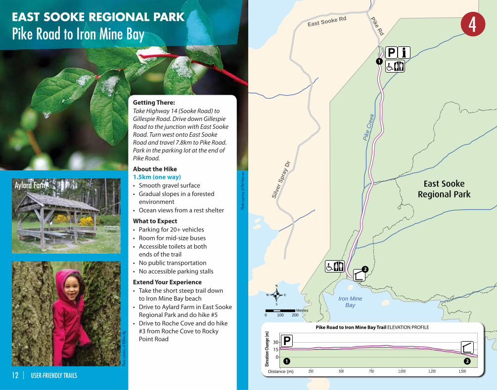
EAST SOOKE REGIONAL PARK
Pike Road to Iron Mine Bay
Getting There:
Take Highway 14 (Sooke Road) to
Gillespie Road. Drive down Gillespie
Road to the junction with East Sooke
Road. Turn west onto East Sooke
Road and travel 7.8km to Pike Road.
Park in the parking lot at the end of
Pike Road.
About the Hike
1.5km (one way)
• Smooth gravel surface
• Gradual slopes in a forested
environment
• Ocean views from a rest shelter
What to Expect
• Parking for 20+ vehicles
• Room for mid-size buses
• Accessible toilets at both
ends of the trail
• No public transportation
• No accessible parking stalls
Extend Your Experience
• Take the short steep trail down
to Iron Mine Bay beach
• Drive to Aylard Farm in East Sooke
Regional Park and do hike #5
• Drive to Roche Cove and do hike
#3 from Roche Cove to Rocky
Point Road
Pike Rd
East Sooke Rd
Silv
er S
pray
Dr
Iron MineBay
Pike
Cre
ek
0 100 200Metres
Distance (m)
30
0
1,5001,2501,000750500250
15
2
2
1
1
Pike Road to Iron Mine Bay Trail ELEVATION PROFILE
East SookeRegional Park
Eleva
tion C
hang
e (m
)
4
Phot
o Co
urte
sy o
f Phi
l Pet
erse
n
Aylard Farm
Phot
o Co
urte
sy o
f Will
iam
Ng
12 | USER-FRIENDLY TRAILS
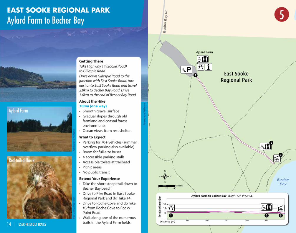
EAST SOOKE REGIONAL PARK
Aylard Farm to Becher Bay
BecherBay
Bec
her B
ay R
d
0 20 40Metres
Distance (m)
30
15
0
25020015010050
3
3
2
2
1
1
Aylard Farm to Becher Bay ELEVATION PROFILE
East SookeRegional Park
Eleva
tion C
hang
e (m
)
Aylard Farm
5
Phot
o Co
urte
sy o
f Vea
rl Br
own
Phot
o Co
urte
sy o
f Phi
l Pet
erse
n
Red-tailed Hawk
Aylard Farm
Phot
o Co
urte
sy o
f Phi
l Pet
erse
n
Getting There
Take Highway 14 (Sooke Road)
to Gillespie Road.
Drive down Gillespie Road to the
junction with East Sooke Road, turn
east onto East Sooke Road and travel
2.0km to Becher Bay Road. Drive
1.6km to the end of Becher Bay Road.
About the Hike
300m (one way)
• Smooth gravel surface
• Gradual slopes through old
farmland and coastal forest
environments
• Ocean views from rest shelter
What to Expect
• Parking for 70+ vehicles (summer
overfl ow parking also available)
• Room for full-size buses
• 4 accessible parking stalls
• Accessible toilets at trailhead
• Picnic areas
• No public transit
Extend Your Experience
• Take the short steep trail down to
Becher Bay beach
• Drive to Pike Road in East Sooke
Regional Park and do hike #4
• Drive to Roche Cove and do hike
#3 from Roche Cove to Rocky
Point Road
• Walk along one of the numerous
trails in the Aylard Farm fi elds14 | USER-FRIENDLY TRAILS
TeachingShelter
Sitting LadyFalls
West-MontMontessori
School
Metchosin Rd
Witty'sLagoon
Ruby Creek
0 20 40Metres
Distance (m)
30
15
0
30025020015010050
2
2
1
1
West-Mont School to Teaching Shelter ELEVATION PROFILE
Witty’s LagoonRegional Park
Eleva
tion C
hang
e (m
)
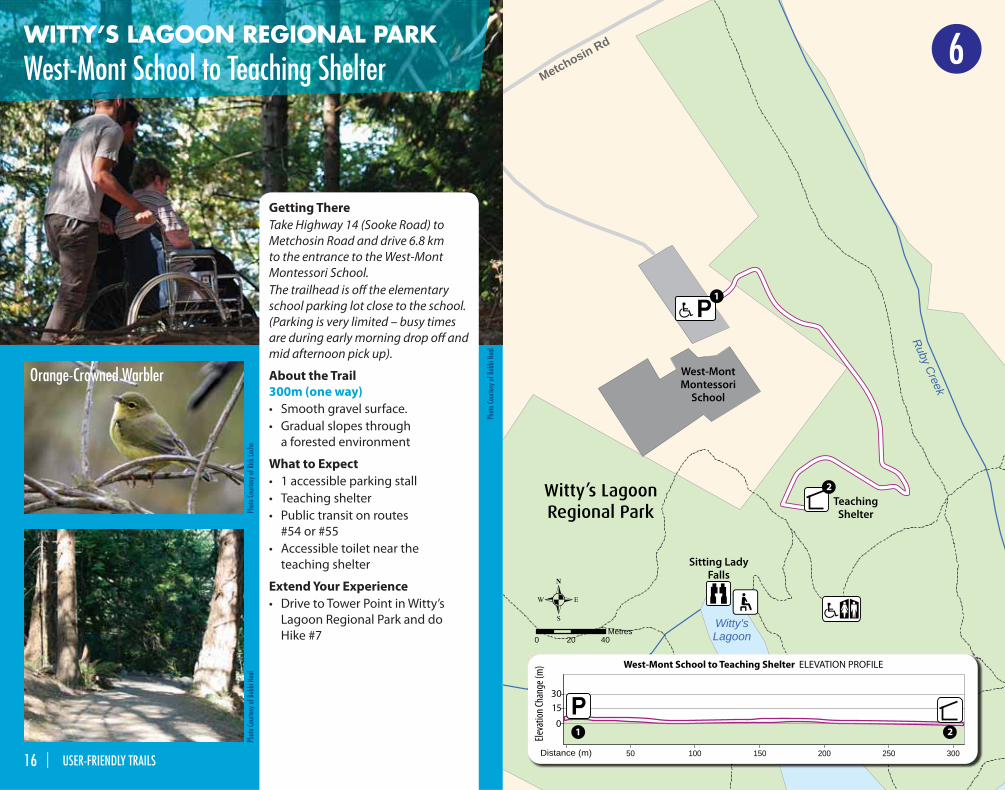
WITTY’S LAGOON REGIONAL PARK
West-Mont School to Teaching Shelter
Getting There
Take Highway 14 (Sooke Road) to
Metchosin Road and drive 6.8 km
to the entrance to the West-Mont
Montessori School.
The trailhead is off the elementary
school parking lot close to the school.
(Parking is very limited – busy times
are during early morning drop off and
mid afternoon pick up).
About the Trail
300m (one way)
• Smooth gravel surface.
• Gradual slopes through
a forested environment
What to Expect
• 1 accessible parking stall
• Teaching shelter
• Public transit on routes
#54 or #55
• Accessible toilet near the
teaching shelter
Extend Your Experience
• Drive to Tower Point in Witty’s
Lagoon Regional Park and do
Hike #7
6
Phot
o Co
urte
sy o
f Rick
Lech
ePh
oto
Cour
tesy
of B
obbi
Nea
l
Orange-Crowned Warbler
Phot
o Co
urte
sy o
f Bob
bi N
eal
16 | USER-FRIENDLY TRAILS
Parry Bay
Tower Point
Bra
dene
Rd
Olympic View Dr
0 30 60Metres
Witty’s LagoonRegional Park
50045040035030025020015010050Distance (m)
Eleva
tion C
hang
e (m
)
30
15
03
3
2
2
1
1
Tower Point Trail ELEVATION PROFILE
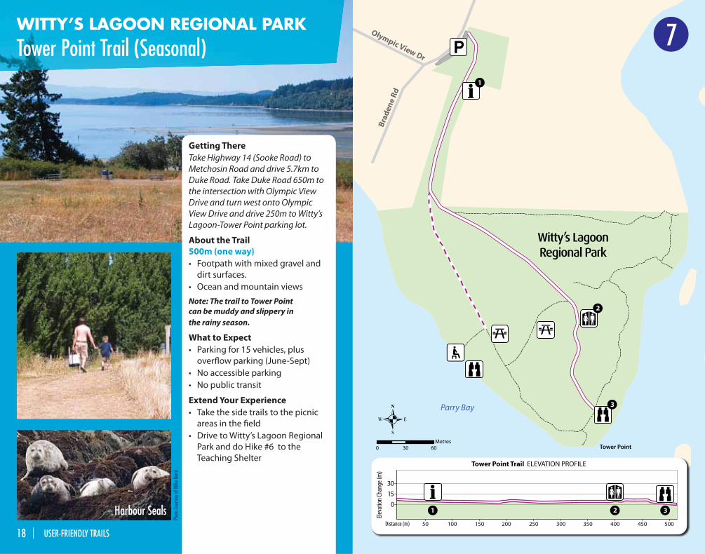
7WITTY’S LAGOON REGIONAL PARK
Tower Point Trail (Seasonal)
Phot
o Co
urte
sy o
f MIk
e Ba
ird
Getting There
Take Highway 14 (Sooke Road) to
Metchosin Road and drive 5.7km to
Duke Road. Take Duke Road 650m to
the intersection with Olympic View
Drive and turn west onto Olympic
View Drive and drive 250m to Witty’s
Lagoon-Tower Point parking lot.
About the Trail
500m (one way)
• Footpath with mixed gravel and
dirt surfaces.
• Ocean and mountain views
Note: The trail to Tower Point can be muddy and slippery in the rainy season.
What to Expect
• Parking for 15 vehicles, plus
overfl ow parking (June-Sept)
• No accessible parking
• No public transit
Extend Your Experience
• Take the side trails to the picnic
areas in the fi eld
• Drive to Witty’s Lagoon Regional
Park and do Hike #6 to the
Teaching Shelter
Harbour Seals
18 | USER-FRIENDLY TRAILS
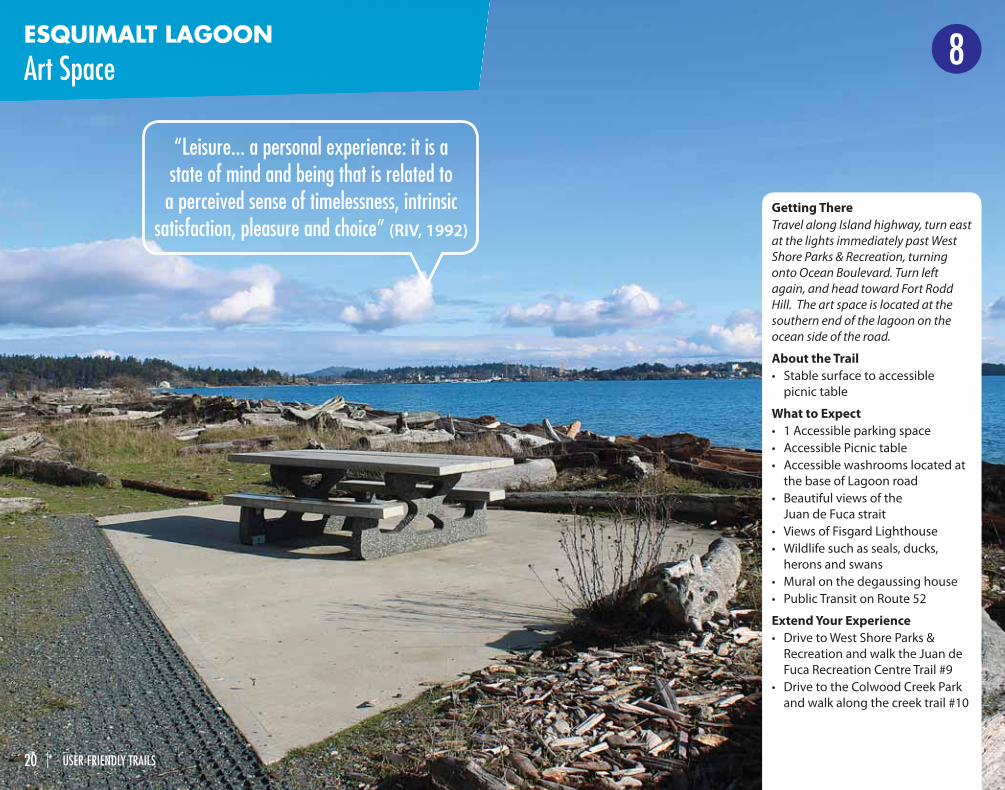
ESQUIMALT LAGOON
Art Space 8
Getting There
Travel along Island highway, turn east
at the lights immediately past West
Shore Parks & Recreation, turning
onto Ocean Boulevard. Turn left
again, and head toward Fort Rodd
Hill. The art space is located at the
southern end of the lagoon on the
ocean side of the road.
About the Trail
• Stable surface to accessible
picnic table
What to Expect
• 1 Accessible parking space
• Accessible Picnic table
• Accessible washrooms located at
the base of Lagoon road
• Beautiful views of the
Juan de Fuca strait
• Views of Fisgard Lighthouse
• Wildlife such as seals, ducks,
herons and swans
• Mural on the degaussing house
• Public Transit on Route 52
Extend Your Experience
• Drive to West Shore Parks &
Recreation and walk the Juan de
Fuca Recreation Centre Trail #9
• Drive to the Colwood Creek Park
and walk along the creek trail #10
“Leisure... a personal experience: it is a state of mind and being that is related to
a perceived sense of timelessness, intrinsic satisfaction, pleasure and choice” (RIV, 1992)
20 | USER-FRIENDLY TRAILS
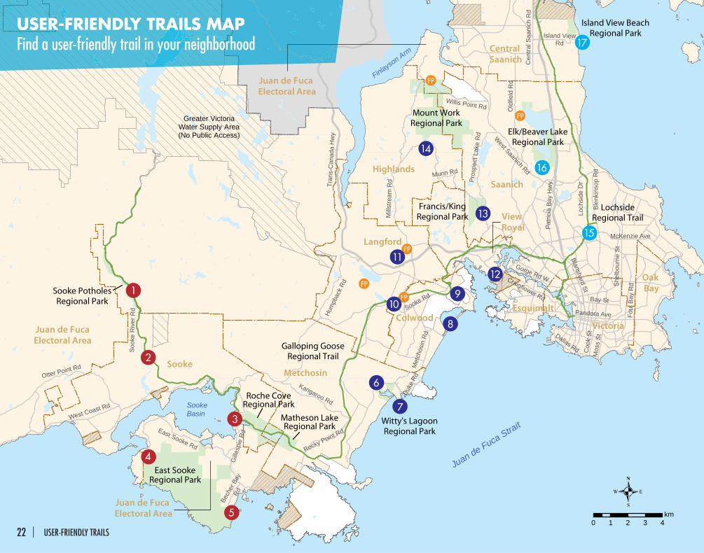
Juan de FucaElectoral Area
Saanich
SookeMetchosin
Langford
Highlands
Central Saanich
Victoria
Juan de Fuca Electoral Area
Colwood
View Royal
Oak Bay
Esquimalt
Juan de Fuca Electoral Area
Greater VictoriaWater Supply Area(No Public Access)
Juan de Fuca Strait
Finlayson Arm
SookeBasin
14
17
16
15
13
12
1
2
3
6
7
8
910
11
4
5
Sooke Rd
Pat
ricia
Bay
Hw
y
East Sooke Rd
West Saanich Rd
Otter Point Rd
West Coast Rd
Bay St
She
lbou
rne
St
Coo
k StDallas Rd
Gille
spie
Rd
Old
field
Rd
Tran
s-C
anad
a H
wy
Foul
Bay
Rd
Kangaroo Rd
Willis Point Rd
Cen
tral S
aani
ch R
d
Rocky Point Rd
Mos
s St
Hum
pbac
k Rd
Blanshard St
Craigflower Rd
Gorge Rd W
McKenzie Ave
Pandora Ave
Soo
ke R
iver
Rd
Met
chos
in R
d
Munn Rd
Island ViewRd
Pros
pect
Lak
e R
d
Duke
Rd
Loch
side
Dr
Bech
er B
ayRd
Ble
nkin
sop
Rd
Mills
tream
Rd
East SookeRegional Park
Mount WorkRegional Park
Elk/Beaver LakeRegional Park
Francis/KingRegional Park
Island View BeachRegional Park
Witty's LagoonRegional Park
LochsideRegional Trail
Galloping GooseRegional Trail
Sooke PotholesRegional Park
Roche CoveRegional Park
Matheson LakeRegional Park
0 1 2 3 4km
USER-FRIENDLY TRAILS MAPFind a user-friendly trail in your neighborhood
22 | USER-FRIENDLY TRAILS
WEST SHORE PARKS & RECREATION
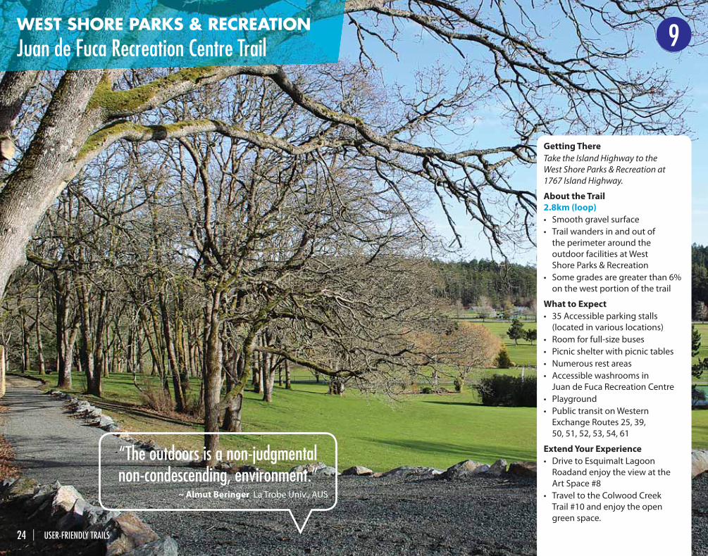
Juan de Fuca Recreation Centre Trail 9
Getting There
Take the Island Highway to the
West Shore Parks & Recreation at
1767 Island Highway.
About the Trail
2.8km (loop)
• Smooth gravel surface
• Trail wanders in and out of
the perimeter around the
outdoor facilities at West
Shore Parks & Recreation
• Some grades are greater than 6%
on the west portion of the trail
What to Expect
• 35 Accessible parking stalls
(located in various locations)
• Room for full-size buses
• Picnic shelter with picnic tables
• Numerous rest areas
• Accessible washrooms in
Juan de Fuca Recreation Centre
• Playground
• Public transit on Western
Exchange Routes 25, 39,
50, 51, 52, 53, 54, 61
Extend Your Experience
• Drive to Esquimalt Lagoon
Roadand enjoy the view at the
Art Space #8
• Travel to the Colwood Creek
Trail #10 and enjoy the open
green space.
“The outdoors is a non-judgmental non-condescending, environment.”
~ Almut Beringer La Trobe Univ., AUS
24 | USER-FRIENDLY TRAILS
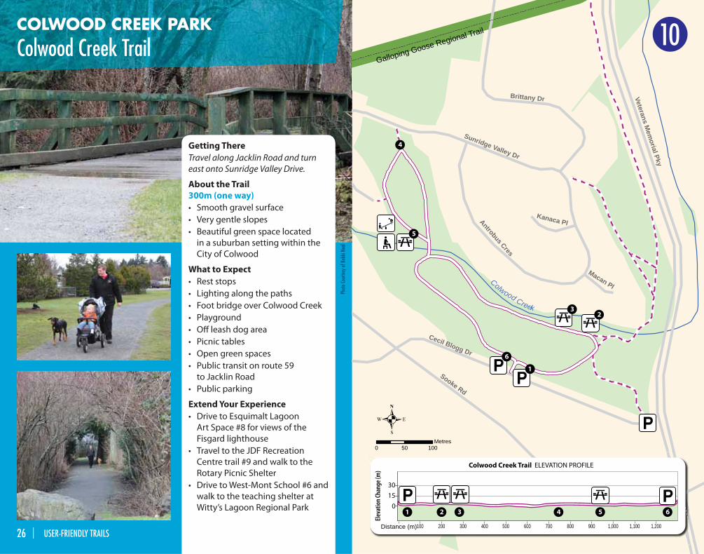
COLWOOD CREEK PARK
Colwood Creek TrailGalloping Goose Regional Trail
Sooke Rd
Veterans Mem
orial Pky
Cecil Blogg Dr
Sunridge Valley Dr
Antrobus Cres
Kanaca Pl
Macan Pl
Brittany Dr
Colwood Creek
0 50 100Metres
Colwood Creek Trail Elevation Profile
Ele
vation (
m)
80
75
70
65
60
55
50
CCCollwoodd CCCreekk TTraiill EEEEllleevvaattiion PProfffiille
Ele
vation
(m)
80
75
70
65
60
55
50
Distance (m)
30
0
1,2001,000800600400200 1,100900700500300100
15
6
6
54
4
5
2
2
3
3
1
1
Colwood Creek Trail ELEVATION PROFILE
Eleva
tion C
hang
e (m
)
10
Getting There
Travel along Jacklin Road and turn
east onto Sunridge Valley Drive.
About the Trail
300m (one way)
• Smooth gravel surface
• Very gentle slopes
• Beautiful green space located
in a suburban setting within the
City of Colwood
What to Expect
• Rest stops
• Lighting along the paths
• Foot bridge over Colwood Creek
• Playground
• Off leash dog area
• Picnic tables
• Open green spaces
• Public transit on route 59
to Jacklin Road
• Public parking
Extend Your Experience
• Drive to Esquimalt Lagoon
Art Space #8 for views of the
Fisgard lighthouse
• Travel to the JDF Recreation
Centre trail #9 and walk to the
Rotary Picnic Shelter
• Drive to West-Mont School #6 and
walk to the teaching shelter at
Witty’s Lagoon Regional Park
Phot
o Co
urte
sy o
f Bob
bi N
eal
26 | USER-FRIENDLY TRAILS
LANGFORD
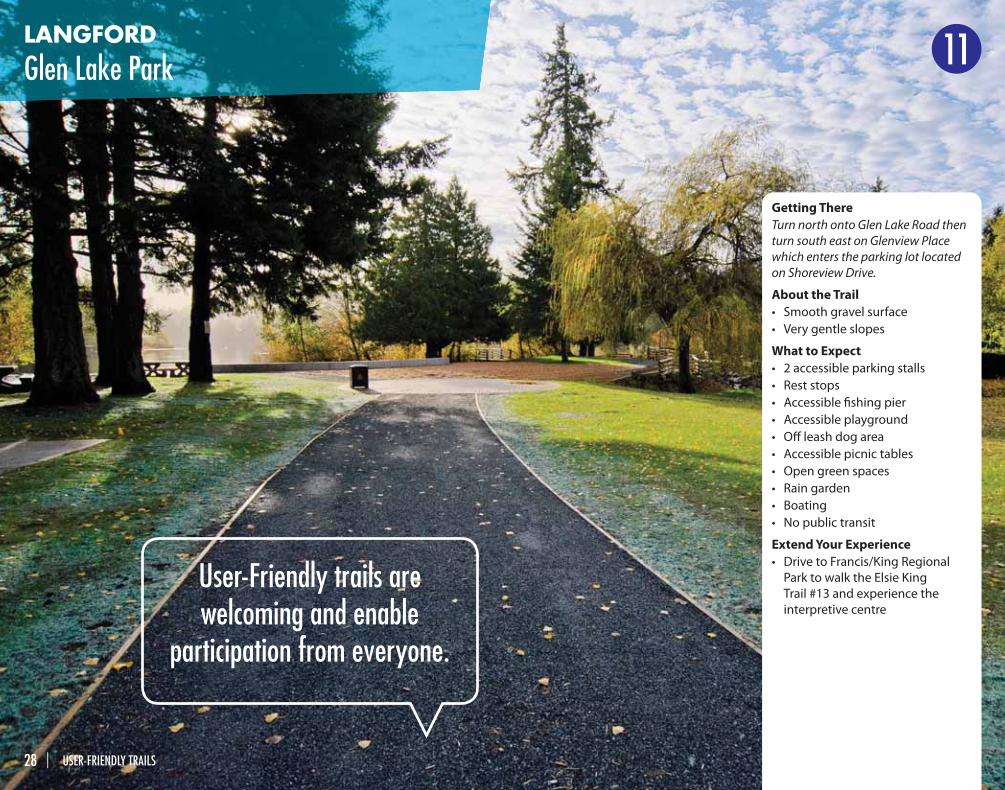
Glen Lake Park 11
Getting There
Turn north onto Glen Lake Road then
turn south east on Glenview Place
which enters the parking lot located
on Shoreview Drive.
About the Trail
• Smooth gravel surface
• Very gentle slopes
What to Expect
• 2 accessible parking stalls
• Rest stops
• Accessible fi shing pier
• Accessible playground
• Off leash dog area
• Accessible picnic tables
• Open green spaces
• Rain garden
• Boating
• No public transit
Extend Your Experience
• Drive to Francis/King Regional
Park to walk the Elsie King
Trail #13 and experience the
interpretive centre
User-Friendly trails are welcoming and enable
participation from everyone.
28 | USER-FRIENDLY TRAILS
GREATER VICTORIA
Accessible Fishing Piers
Visit accessible fi shing piers at
1. Durrance Lake
2. Elk/Beaver Lake Trail #16
3. Florence Lake,
4. Glen Lake on Trail #11
5. Langford Lake, Ed Nixon Trail
See page 22-23 for locations
FP
Parks and trails provide opportunities to connect
with nature and our neighbors; they contribute to the overall quality of life and well being of all residents of the region.
30 | USER-FRIENDLY TRAILS
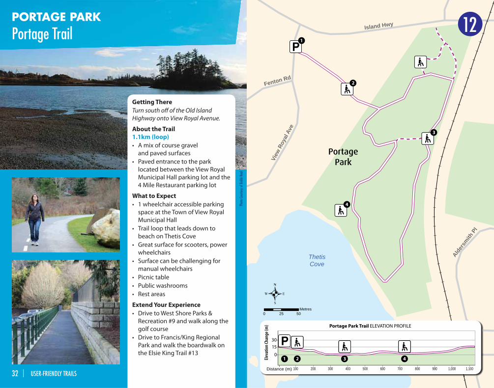
PORTAGE PARK
Portage Trail
Alders
mith P
l
Fenton Rd
Island Hwy
View
Roy
al A
ve
ThetisCove
0 25 50Metres
PortagePark
Eleva
tion C
hang
e (m
)
Distance (m)
30
15
0
900 1,000 1,100800700600500400300200100
4
4
3
3
2
2
1
1
Portage Park Trail ELEVATION PROFILE
12
Getting There
Turn south off of the Old Island
Highway onto View Royal Avenue.
About the Trail
1.1km (loop)
• A mix of course gravel
and paved surfaces
• Paved entrance to the park
located between the View Royal
Municipal Hall parking lot and the
4 Mile Restaurant parking lot
What to Expect
• 1 wheelchair accessible parking
space at the Town of View Royal
Municipal Hall
• Trail loop that leads down to
beach on Thetis Cove
• Great surface for scooters, power
wheelchairs
• Surface can be challenging for
manual wheelchairs
• Picnic table
• Public washrooms
• Rest areas
Extend Your Experience
• Drive to West Shore Parks &
Recreation #9 and walk along the
golf course
• Drive to Francis/King Regional
Park and walk the boardwalk on
the Elsie King Trail #13
Phot
o Co
urte
sy o
f Bob
bi N
eal
32 | USER-FRIENDLY TRAILS
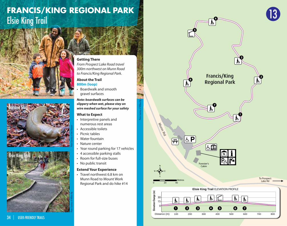
FRANCIS/KING REGIONAL PARKElsie King Trail
Getting There
From Prospect Lake Road travel
300m northwest on Munn Road
to Francis/King Regional Park.
About the Trail
800m (loop)
• Boardwalk and smooth
gravel surfaces
Note: boardwalk surfaces can be slippery when wet, please stay on wire meshed surface for your safety
What to Expect
• Interpretive panels and
numerous rest areas
• Accessible toilets
• Picnic tables
• Water fountain
• Nature center
• Year round parking for 17 vehicles
• 4 accessible parking stalls
• Room for full-size buses
• No public transit
Extend Your Experience
• Travel northwest 6.8 km on
Munn Road to Mount Work
Regional Park and do hike #14
Munn Rd
Forester'sCabin
To ProspectLake Rd
0 20 40Metres
Distance (m)
0
Elsie King Trail ELEVATION PROFILE
100 200 300 400 500 600 700 800
30
15
7
7
6
6
5
5
4
4
3
3
2
2
1
1
Francis/KingRegional Park
Eleva
tion C
hang
e (m
)
13
Phot
o Co
urte
sy o
f Deb
Thie
ssen
Phot
o Co
urte
sy o
f Will
iam
Ng
Banana Slug
Elsie King Trail
Phot
o Co
urte
sy o
f Will
iam
Ng
34 | USER-FRIENDLY TRAILS
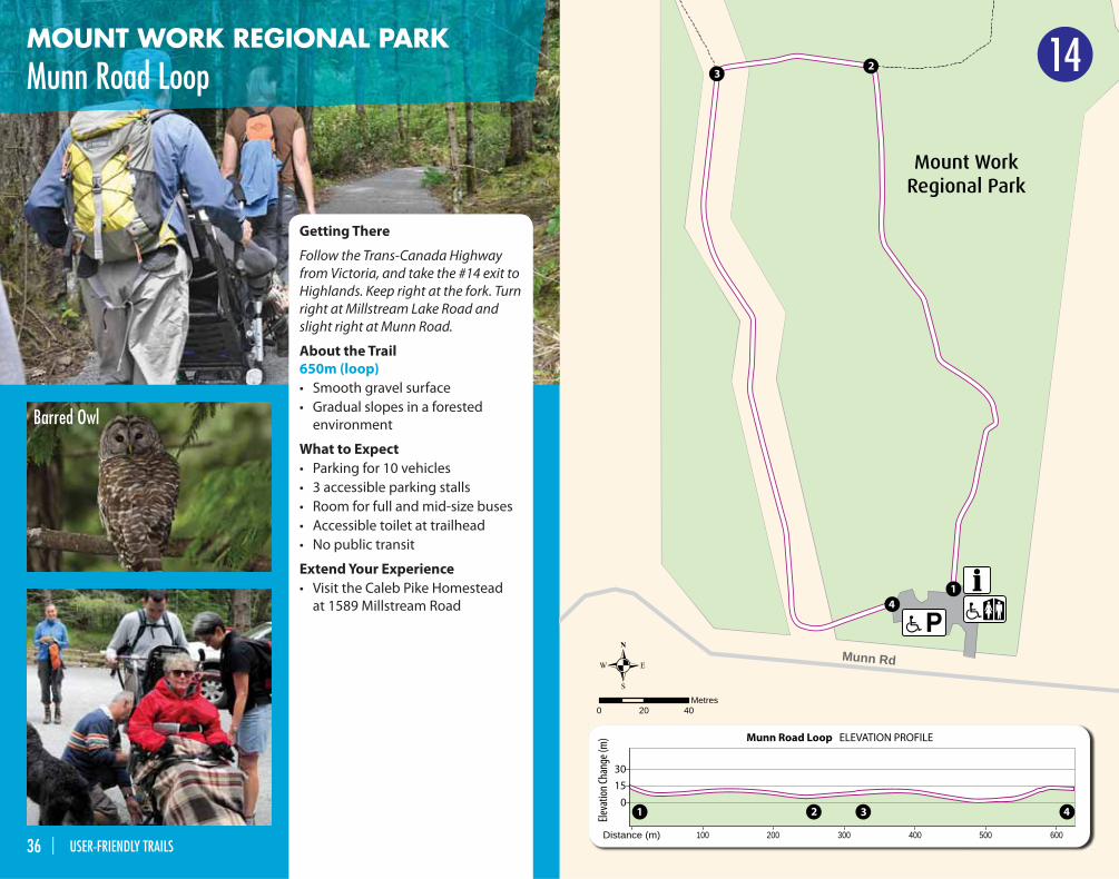
MOUNT WORK REGIONAL PARK
Munn Road Loop
Getting There
Follow the Trans-Canada Highway
from Victoria, and take the #14 exit to
Highlands. Keep right at the fork. Turn
right at Millstream Lake Road and
slight right at Munn Road.
About the Trail
650m (loop)
• Smooth gravel surface
• Gradual slopes in a forested
environment
What to Expect
• Parking for 10 vehicles
• 3 accessible parking stalls
• Room for full and mid-size buses
• Accessible toilet at trailhead
• No public transit
Extend Your Experience
• Visit the Caleb Pike Homestead
at 1589 Millstream Road
Munn Rd
0 20 40Metres
Distance (m)
30
15
0
600500400300200100
4
4
3
3
2
2
1
1
Munn Road Loop ELEVATION PROFILE
Mount WorkRegional Park
Eleva
tion C
hang
e (m
)
Barred Owl
14
36 | USER-FRIENDLY TRAILS
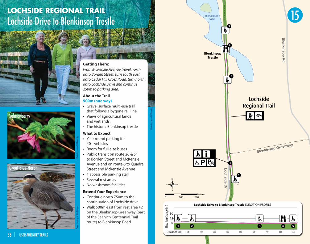
LOCHSIDE REGIONAL TRAIL
Lochside Drive to Blenkinsop Trestle
BlenkinsopTrestle
LochsideRegional Trail
Blenkinsop R
d
Loch
side
Dr
Lochside Dr
Blenkinsop Greenway
Blenkinsop Lake
0 100 200Metres
Loch
side
DLo
chsi
de D
r
oocLoch
side
DDrDDr
Distance (m)
Eleva
tion C
hang
e (m
)
30
15
0
900800700600500400300200100
Lochside Drive to Blenkinsop Trestle ELEVATION PROFILE
4 5
5
4
3
3
2
2
1
1
Getting There:
From McKenzie Avenue travel north
onto Borden Street, turn south east
onto Cedar Hill Cross Road, turn north
onto Lochside Drive and continue
250m to parking area.
About the Trail
900m (one way)
• Gravel surface multi-use trail
that follows a bygone rail line
• Views of agricultural lands
and wetlands.
• The historic Blenkinsop trestle
What to Expect
• Year round parking for
40+ vehicles
• Room for full-size buses
• Public transit on route 26 & 51
to Borden Street and McKenzie
Avenue and on route 6 to Quadra
Street and Mckenzie Avenue
• 1 accessible parking stall
• Several rest areas
• No washroom facilities
Extend Your Experience
• Continue north 750m to the
continuation of Lochside drive
• Walk 500m east from rest area #2
on the Blenkinsop Greenway (part
of the Saanich Centennial Trail
route) to Blenkinsop Road
15
Phot
o Co
urte
sy o
f Will
iam
Ng
Phot
o Co
urte
sy o
f Deb
Thie
ssen
Great Blue Heron
Salmonberry
Phot
o Co
urte
sy o
f Will
iam
Ng
38 | USER-FRIENDLY TRAILS
BeaverBeach
Hamsterly Beach
Brookleigh Boat Launch
Fishing PierEagle Beach
NorthBeach
Filter Beds
EquestrianCentre
Ski Beach
Elk Lake
Beaver Lake
0 250 500Metres
Distance (m) 500 1,000 1,500 2,000 2,500 3,000 3,500 4,000 4,500 5,000
30
15
08
8
7
7
6
6
5
5
4
4
3
3
2
2
1
1
Filter Beds to Brookleigh Boat Launch ELEVATION PROFILE
BeaverBeach
NorthBeach
EagleBeach
HamsterlyBeach
Brookleigh
Elk/Beaver LakeRegional Park
Eleva
tion C
hang
e (m
)
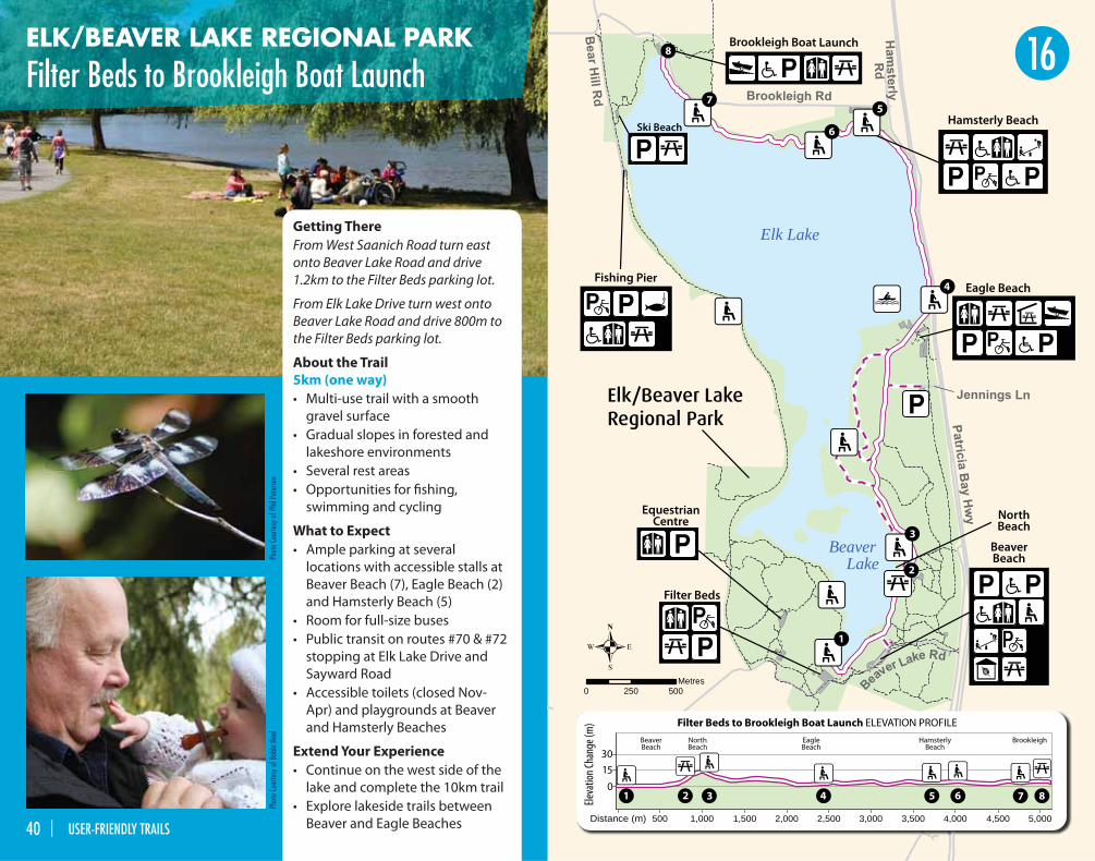
ELK/BEAVER LAKE REGIONAL PARK
Filter Beds to Brookleigh Boat Launch
Getting There
From West Saanich Road turn east
onto Beaver Lake Road and drive
1.2km to the Filter Beds parking lot.
From Elk Lake Drive turn west onto
Beaver Lake Road and drive 800m to
the Filter Beds parking lot.
About the Trail
5km (one way)
• Multi-use trail with a smooth
gravel surface
• Gradual slopes in forested and
lakeshore environments
• Several rest areas
• Opportunities for fi shing,
swimming and cycling
What to Expect
• Ample parking at several
locations with accessible stalls at
Beaver Beach (7), Eagle Beach (2)
and Hamsterly Beach (5)
• Room for full-size buses
• Public transit on routes #70 & #72
stopping at Elk Lake Drive and
Sayward Road
• Accessible toilets (closed Nov-
Apr) and playgrounds at Beaver
and Hamsterly Beaches
Extend Your Experience
• Continue on the west side of the
lake and complete the 10km trail
• Explore lakeside trails between
Beaver and Eagle Beaches
Phot
o Co
urte
sy o
f Bob
bi N
eal
Phot
o Co
urte
sy o
f Phi
l Pet
erse
n
16
40 | USER-FRIENDLY TRAILS
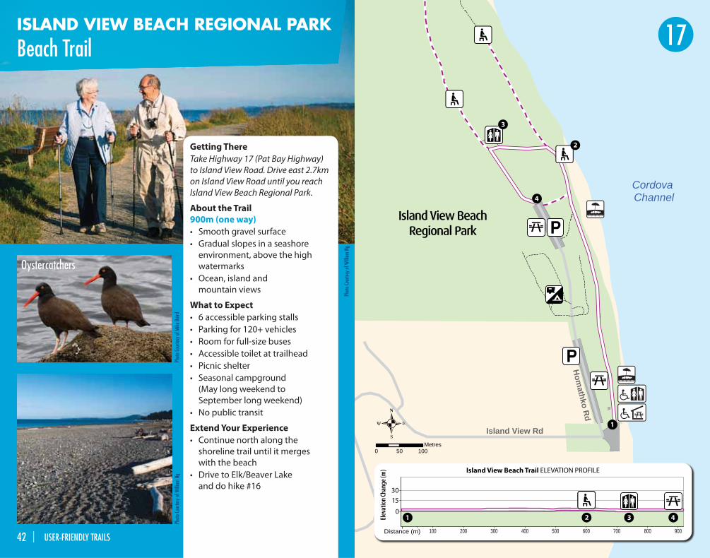
ISLAND VIEW BEACH REGIONAL PARK
Beach Trail
Hom
athko Rd
Island View Rd
Cordova Channel
0 50 100Metres
Eleva
tion C
hang
e (m
)
30
15
0
1
Distance (m) 900800700600500400300200100
43
3
4
2
2
1
1
Island View Beach Trail ELEVATION PROFILE
Island View BeachRegional Park
Phot
o Co
urte
sy o
f Will
iam
Ng
Phot
o Co
urte
sy o
f Mik
e Ba
irdPh
oto
Cour
tesy
of W
illia
m N
g
Oystercatchers
Getting There
Take Highway 17 (Pat Bay Highway)
to Island View Road. Drive east 2.7km
on Island View Road until you reach
Island View Beach Regional Park.
About the Trail
900m (one way)
• Smooth gravel surface
• Gradual slopes in a seashore
environment, above the high
watermarks
• Ocean, island and
mountain views
What to Expect
• 6 accessible parking stalls
• Parking for 120+ vehicles
• Room for full-size buses
• Accessible toilet at trailhead
• Picnic shelter
• Seasonal campground
(May long weekend to
September long weekend)
• No public transit
Extend Your Experience
• Continue north along the
shoreline trail until it merges
with the beach
• Drive to Elk/Beaver Lake
and do hike #16
17
42 | USER-FRIENDLY TRAILS

CRD Regional Parks
www.crd.bc.ca/parks
250-478-3344
Intermunicipal Advisory Committee
on Dissability Issues (IACDI)
www.colwood.ca
250-478-5999
West Shore Parks & Recreation
www.westshorerecreation.ca
250-478-8384
Measuring Up
Progressive, Inclusive, Community
Legacies 2012
www.2010legaciesnow.com
UBCM
Union of British Columbia MunicipalitiesProvincial funding administered by UBCM
Government of British Columbia
BCRPA
BC Recreation and Parks Association’s
Active Communities® Initiative
Active Living Alliance for
Canadians with a Disability
www.ala.ca/content/home.asp
Active Living Coalition
for Older Adults
www.alcoa.ca
British Columbia Recreation
and Parks Association
www.bcrpa.bc.ca
Caleb Pike Heritage Park
www.calebpikeheritagepark.org
Canada’s Physical Activity Guide
www.paguide.com
Canadian Association for the
Advancement of Women and
Sport and Physical Activity
www.caaws.ca
Canadian Fitness and Lifestyle
Research Institute
www.cfl ri.ca
Canadian Institutes of
Health Research
www.cihr-irsc.gc.ca
Coalition for Active Living
www.activeliving.ca
CRD Regional Parks
www.crd.bc.ca/parks/accessibility.htm
www.crd.bc.ca/parks/events
Greater Victoria Active Communities
www.fi tinfi tness.ca
Juan de Fuca Pathfi nders
Walking Club
www.jdfpathfi nders.ca
Metchosin Community House
www.metchosincommunityhouse.com
Public Health Agency of
Canada’s Healthy Living Unit
www.phac-aspc.gc.ca
SPARC BC
www.sparc.bc.ca
Union of British Columbia
Municipalities
www.ubcm.ca
Victoria Airport
www.victoriaairport.com/news
Victoria Volkssport
www.vvpf.ca
Walk Victoria
www.walk-victoria.com
Recreation Integration Victoria
www.rivonline.org
Power to Be
www.powertobe.ca
City of Colwood
www.colwood.ca
City of Langford
www.cityofl angford.ca
District of Highlands
www.highlands.ca
District of Metchosin
www.district.metchosin.bc.ca
Town of View Royal
www.viewroyal.ca
Check out the trails and parks in each municipality.
Links & Resources
Sponsors
PROJECT PARTNERS Additional Contributors
Thank you to all whom have contributed their time and eff ort to “A Guide to User Friendly Trails”.
For more information about the User–Friendly Trails project contact:
44 | USER-FRIENDLY TRAILS USER-FRIENDLY TRAILS | 45
Front Cover Photo Courtesy of William Ng / Back Cover Photo Courtesy of Bobbi Neal
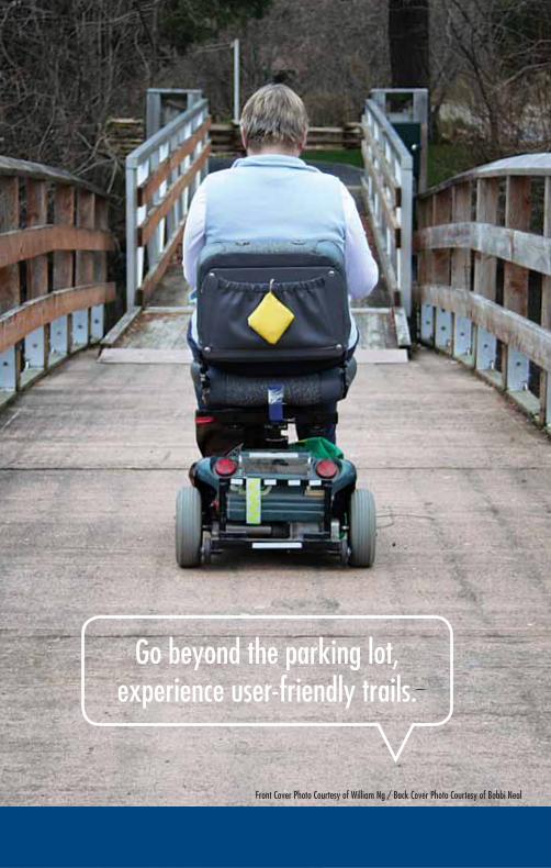
Go beyond the parking lot, experience user-friendly trails.