Embed Size (px)
Citation preview

ANNEX IV
TRANSBOUNDARY DIAGNOSTIC ANALYSIS (TDA)
INCLUDING ROOT CAUSE ANALYSIS
CONTENTS
INTRODUCTION ..........................................................................................................................i
SECTION 1. PERCEIVED MAJOR PROBLEMS AND THEIR ROOT CAUSES ..................1
SECTION 2. ANALYSIS OF THE PROBLEMS AND THEIR ROOT CAUSES ....................3
SECTION 3. RELEVANT INFORMATION AND DETAILED ANALYSIS OF THE PROBLEMS ........................................................................................................15
3.1 Sources of degradation in the San Juan River Basin and its Coastal Zone ................... 15
3.1.1 Problems related to soil degradation and sedimentation ..................................16
3.1.2 Problems related to ecosystem degradation......................................................19
3.1.3 Problems related to water quality .....................................................................21
3.1.4 Problems related to water resource use.............................................................25
3.1.5 Problems related to overexploitation of natural resources ...............................28
3.1.6 Problems related to the political, legal, and institutional framework for the integrated management of the SJRB.................................................................32
3.1.7 Problems related to economic development .....................................................33
3.1.8 Problems related to the social areas..................................................................35
3.2 Centers of pollution and sensitive areas .......................................................................37
3.2.1 Urban Centers ...................................................................................................37
3.2.2 Lake Nicaragua .................................................................................................37
3.2.3 Caño Negro .......................................................................................................37
3.2.4 San Juan River and its Coastal Zone ................................................................38
3.2.5 Indio Maíz River Biological Reserve ..............................................................38
3.2.6 Tortuguero Canals.............................................................................................38
ANNEX 1. LOCATION MAP .................................................................................................39
ANNEX 2. FIGURES...............................................................................................................40
ANNEX 3. TABLES ................................................................................................................43
ANNEX IV – TRANSBOUNDARY DIAGNOSTIC ANALYSIS (TDA)
INTRODUCTION
The San Juan River basin and its coastal zone1 is located in the area that drains into the Caribbean Sea and covers a large part of the territory of Costa Rica and Nicaragua and constitutes an important part of the natural capital of both countries. It contains a variety of ecosystems and highly valuable water resources. This transboundary diagnostic analysis (TDA) is the result of studies conducted within the SJRB using funds provided in part through a Project Preparation and Development Facility (PDF) Block B grant of the Global Environment Facility (GEF). The TDA is designed to identify and evaluate the major environmental problems that face, or may face, the SJRB and to determine their root causes. In addition, the TDA seeks to identify the cause-effect chain underlying the identified problems, and to determine their relationship with the deterioration of the basin’s water resources. The TDA emphasizes the transboundary aspect of the SJRB, and represents a potential contribution to the development of the GEF’s operational strategy in international waters.
Information from major sources, such as the Diagnostic Study of the San Juan River Basin and Guidelines for an Action Plan2, as well as the validation of its main findings and the acquisition of new information through the conduct of various national and binational workshops held before and during the execution of the PDF-B planning program, have been a starting point for detecting the most salient transboundary elements of the environmental problems in the SJRB. Particular attention was given to the coastal-marine zone, as the previous study did not include that area. The PDF-B document for the Integrated Management of Water Resources and the Sustainable Development of the SJRB indicates that the major environmental problems were initially perceived to be as follows:
a. Soil erosion originating in the lack of effective soil management practices, in the development of agriculture in areas not suited to cultivation, and in accelerated and intensive deforestation at a national rate of over 150,000 hectares per year in Nicaragua and 18,500 hectares per year in Costa Rica.
b. Pollution of water bodies as a result of the inappropriate use of agro-chemicals and the uncontrolled disposal of municipal and industrial waste water and solid waste.
In the process of executing the PDF-B planning program, a number of other problems, in addition to those mentioned above, were identified. The three major problems identified are:
a. Accelerating degradation of transboundary ecosystems.
b. Overexploitation of valuable natural resources.
c. High vulnerability to natural hazards.
This document takes a closer look at the particular areas of the SJRB where the environmental problems indicated are identified as most severe, applying the methodology used by the GEF projects for the identification of “hot spots”, or critical points, or for manifestations that are even more specific and concentrated than the so-called “hot spots” that have been identified at the basin scale.
1 Hereinafter, the SJRB. 2 UNEP-OAS, 1997.
IV - i
The TDA is formulated on the premise that when the goods and services provided by ecosystems are not appropriately used, they become stressed, often to a critical point, by demands from socioeconomic sectors, which causes the loss of potential water and biodiversity resources. This situation worsens to the extent that the institutions in charge of the regulation and control of the use of natural resources have technical, legal, and/or economic limitations that prevent them from exercising the necessary control to avoid reaching extreme situations. This situation is schematically illustrated in Figures 1 and 2 of Annex 2. In this regard, the technical group, responsible for the preparation of the TDA, reached the decision to combine the analysis of aspects related to water resources and their biotic interactions with an analysis in which the social and economic aspects, together with the biological ones, are integrated to form a more comprehensive environmental approach that would reflect the things that affect a number of the components of sustainable development. This methodology better reflects both the nature and the manifestations of the major environmental problems, in view of the fact that there are poverty-stricken human settlements in the basin area and its coastal zone.
The TDA presented here was produced through a participatory process, directed by an environmental consultant, with contributions by all the members of the national technical teams working on the project in both countries and participation by various international consultants. In this way, it was possible to combine the knowledge of the territory possessed by the national consultants in each country with the honed experience of international consultants. Participating in the project and in the TDA formulation were specialists in the following disciplines: coastal management, hydrology, environmental economics, ecology, sociology, natural resource management, forestry, agronomy, administration of transboundary projects, and institutional development and strengthening. The work of the TDA also benefited from the wealth of views expressed through public participation in four workshops: two held in each of the countries, and two held at the binational or transboundary level. At these events, members of central government bodies, local governments, producer associations, the academic community, the private sector, and non-governmental organizations participated and shared their experiences.
The content of this TDA is an attempt to address environmental problems, their causes and effects, and to identify possible solutions in the SJRB or at more specific locations. Notwithstanding, it is a work in progress that will constitute an integral part of the proposed Strategic Action Program (SAP), in which the transboundary dimension will be more clearly represented, once further participation by the public and citizenry, and basin-wide data and information for analysis provide a better appreciation of that dimension.
The TDA is presented in three sections:
Section 1: Perceived major problems and their root causes. This section summarizes the main environmental problems perceived, the transboundary elements they encompass, their root causes, and the proposed action areas.
Section 2: Analysis of the problems and their root causes. This section presents in table format the perceived problems, actors involved, their effects, short- and long-term causes, possible solutions, and potential transboundary benefits.
Section 3: Relevant information and detailed analysis of the problems. This section presents information relevant to the problems analyzed in greater detail, for those interested in obtaining the available quantitative information.
IV - ii
In addition, in order to identify areas of work for the formulation of the SAP, and using an integrated design for the development and use of natural resources, action areas for the implementation of environmental investment projects were determined. Nevertheless, a constant limiting factor in the preparation of this TDA has been the lack of basin-wide information on natural resources, socio-economics, and environment from within the SJRB, which has made it impossible to better quantify most of the problems identified here.
IV - iii

SECTION 1
PERCEIVED MAJOR PROBLEMS AND THEIR ROOT CAUSES
IV - 1
IV - 2
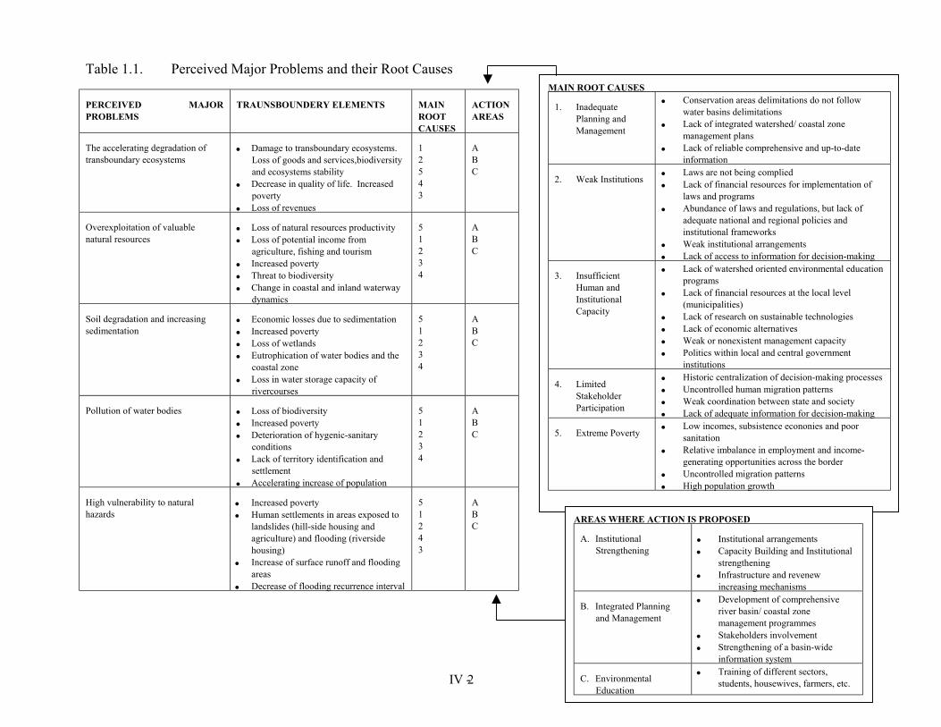
Table 1.1. Perceived Major Problems and their Root Causes
PERCEIVED MAJORPROBLEMS
TRAUNSBOUNDERY ELEMENTS MAIN ROOT CAUSES
ACTION AREAS
The accelerating degradation of transboundary ecosystems
• Damage to transboundary ecosystems. Loss of goods and services,biodiversity and ecosystems stability
• Decrease in quality of life. Increased poverty
• Loss of revenues
1 2 5 4 3
A B C
Overexploitation of valuable natural resources
• Loss of natural resources productivity • Loss of potential income from
agriculture, fishing and tourism • Increased poverty • Threat to biodiversity • Change in coastal and inland waterway
dynamics
5 1 2 3 4
A B C
Soil degradation and increasing sedimentation
• Economic losses due to sedimentation • Increased poverty • Loss of wetlands • Eutrophication of water bodies and the
coastal zone • Loss in water storage capacity of
rivercourses
5 1 2 3 4
A B C
Pollution of water bodies • Loss of biodiversity • Increased poverty • Deterioration of hygenic-sanitary
conditions • Lack of territory identification and
settlement • Accelerating increase of population
5 1 2 3 4
A B C
High vulnerability to natural hazards
• Increased poverty • Human settlements in areas exposed to
landslides (hill-side housing and agriculture) and flooding (riverside housing)
• Increase of surface runoff and flooding areas
• Decrease of flooding recurrence interval
5 1 2 4 3
A B C
tions do not follow
d/ coastal zone
ive and up-to-date
d for implementation of
lations, but lack of al policies and
ents n for decision-making environmental education
at the local level
ble technologies es ement capacity tral government
MAIN ROOT CAUSES
1. Inadequate Planning and Management
• Conservation areas delimitawater basins delimitations
• Lack of integrated watershemanagement plans
• Lack of reliable comprehensinformation
2. Weak Institutions • Laws are not being complie• Lack of financial resources
laws and programs • Abundance of laws and regu
adequate national and regioninstitutional frameworks
• Weak institutional arrangem• Lack of access to informatio
3. Insufficient Human and Institutional Capacity
• Lack of watershed oriented programs
• Lack of financial resources (municipalities)
• Lack of research on sustaina• Lack of economic alternativ• Weak or nonexistent manag• Politics within local and cen
institutions
4. Limited Stakeholder Participation
• Historic centralization of decision-making processes • Uncontrolled human migration patterns • Weak coordination between state and society • Lack of adequate information for decision-making
5. Extreme Poverty • Low incomes, subsistence econonies and poor sanitation
• Relative imbalance in employment and income-generating opportunities across the border
• Uncontrolled migration patterns • High population growth
AREAS WHERE ACTION IS PROPOSED
A. Institutional Strengthening
• Institutional arrangements • Capacity Building and Institutional
strengthening • Infrastructure and revenew
increasing mechanisms
B. Integrated Planning and Management
• Development of comprehensive river basin/ coastal zone management programmes
• Stakeholders involvement • Strengthening of a basin-wide
information system
C. Environmental Education
• Training of different sectors, students, housewives, farmers, etc.
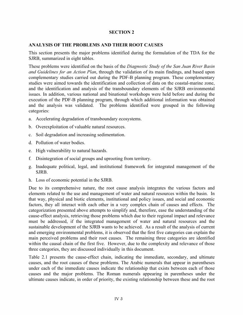
SECTION 2
ANALYSIS OF THE PROBLEMS AND THEIR ROOT CAUSES
This section presents the major problems identified during the formulation of the TDA for the SJRB, summarized in eight tables.
These problems were identified on the basis of the Diagnostic Study of the San Juan River Basin and Guidelines for an Action Plan, through the validation of its main findings, and based upon complementary studies carried out during the PDF-B planning program. These complementary studies were aimed towards the identification and collection of data on the coastal-marine zone, and the identification and analysis of the transboundary elements of the SJRB environmental issues. In addition, various national and binational workshops were held before and during the execution of the PDF-B planning program, through which additional information was obtained and the analysis was validated. The problems identified were grouped in the following categories:
a. Accelerating degradation of transboundary ecosystems.
b. Overexploitation of valuable natural resources.
c. Soil degradation and increasing sedimentation.
d. Pollution of water bodies.
e. High vulnerability to natural hazards.
f. Disintegration of social groups and uprooting from territory.
g. Inadequate political, legal, and institutional framework for integrated management of the SJRB.
h. Loss of economic potential in the SJRB.
Due to its comprehensive nature, the root cause analysis integrates the various factors and elements related to the use and management of water and natural resources within the basin. In that way, physical and biotic elements, institutional and policy issues, and social and economic factors, they all interact with each other in a very complex chain of causes and effects. The categorization presented above attempts to simplify and, therefore, ease the understanding of the cause-effect analysis, retrieving those problems which due to their regional impact and relevance must be addressed, if the integrated management of water and natural resources and the sustainable development of the SJRB wants to be achieved. As a result of the analysis of current and emerging environmental problems, it is observed that the first five categories can explain the main perceived problems and their root causes. The remaining three categories are identified within the causal chain of the first five. However, due to the complexity and relevance of those three categories, they are discussed individually in this document.
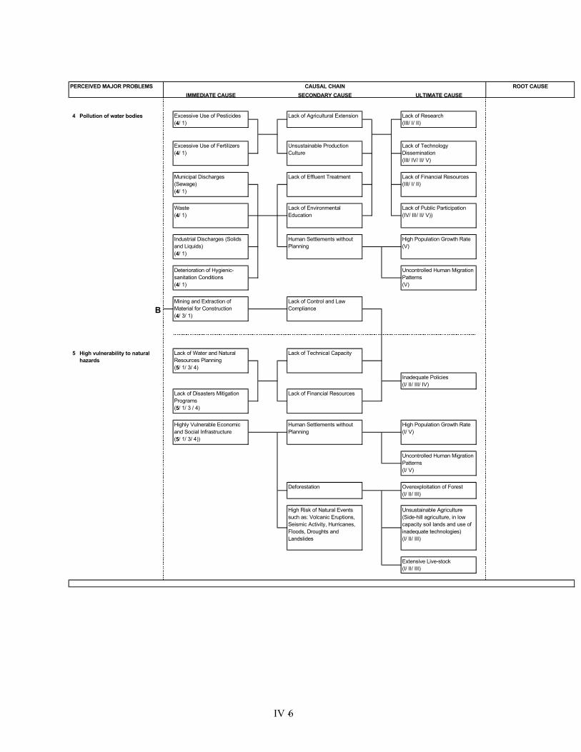
Table 2.1 presents the cause-effect chain, indicating the immediate, secondary, and ultimate causes, and the root causes of these problems. The Arabic numerals that appear in parentheses under each of the immediate causes indicate the relationship that exists between each of those causes and the major problems. The Roman numerals appearing in parentheses under the ultimate causes indicate, in order of priority, the existing relationship between these and the root
IV - 3
causes of the problems. In this table, it should be noted that the three additional problems, grouped in the following categories, are part of the five major problems previously identified: Disintegration of social groups and uprooting from territory; Inadequate political, legal, and institutional framework for integrated management of the SJRB; and Loss of economic potential in the SJRB.
Further, the presence of the same causes-effects and/or root causes in two or more major problem areas shows the complexity of the cause-effect-root chain, which is in turn a result of the dependence of water resources on the condition of the ecosystems forming the SJRB, for which reason the integrated management of water resources involves proper management of all the natural resources and ecosystems present in the basin.
IV - 4
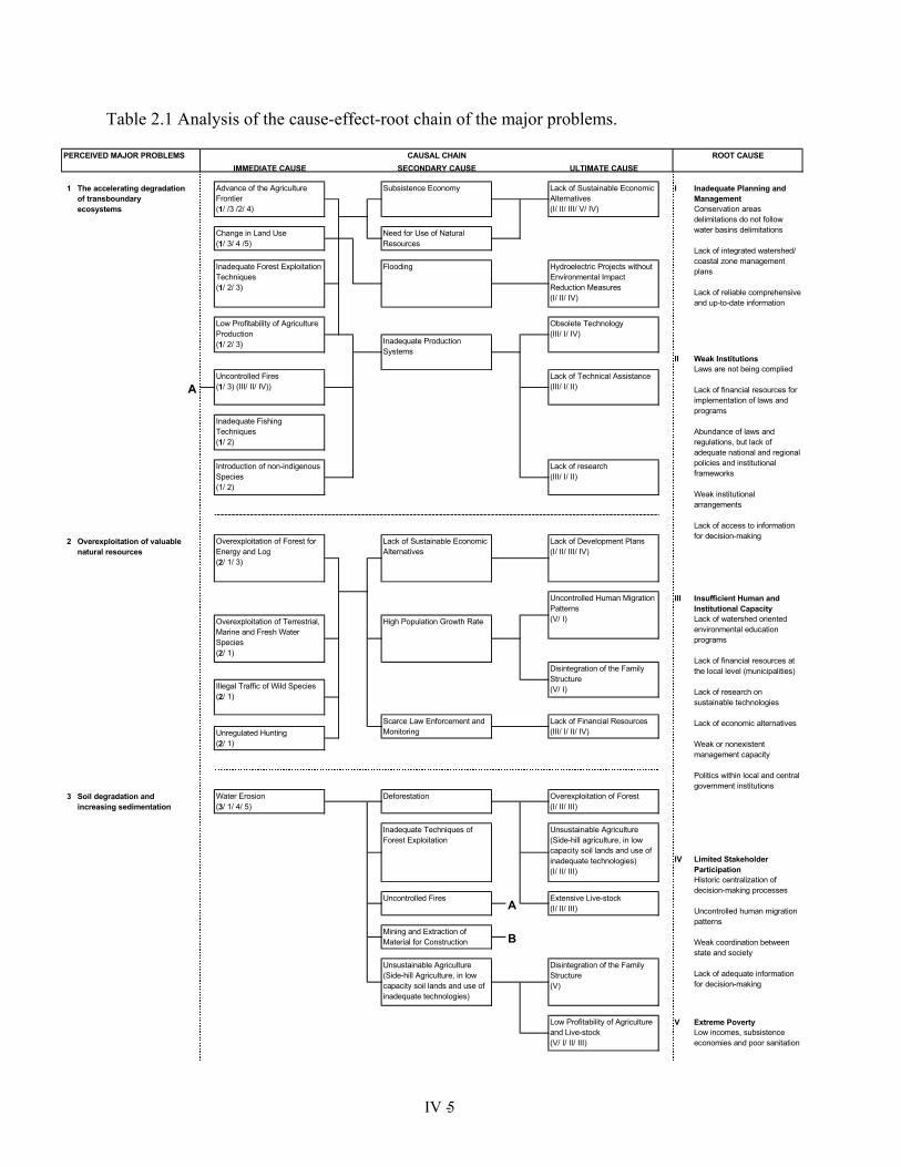
Table 2.1 Analysis of the cause-effect-root chain of the major problems.
IMMEDIATE CAUSE SECONDARY CAUSE ULTIMATE CAUSE
1 I
II
2
III
3
IV
V Extreme PovertyLow incomes, subsistence economies and poor sanitation
R l ti i b l i
Inadequate Planning and ManagementConservation areas delimitations do not follow water basins delimitations
Lack of integrated watershed/ coastal zone management plans
Lack of reliable comprehensive and up-to-date information
Weak InstitutionsLaws are not being complied
Lack of financial resources for implementation of laws and programs
Abundance of laws and regulations, but lack of adequate national and regional policies and institutional frameworks
Weak institutional arrangements
Lack of access to information for decision-making
Insufficient Human and Institutional CapacityLack of watershed oriented environmental education programs
Lack of financial resources at the local level (municipalities)
Lack of research on sustainable technologies
Lack of economic alternatives
Weak or nonexistent management capacity
Politics within local and central government institutions
Limited Stakeholder ParticipationHistoric centralization of decision-making processes
Uncontrolled human migration patterns
Weak coordination between state and society
Lack of adequate information for decision-making
Uncontrolled Human Migration Patterns(V/ I)
Disintegration of the Family Structure(V/ I)
Deforestation
Overexploitation of Terrestrial, Marine and Fresh Water Species(2/ 1)
Overexploitation of valuable natural resources
Soil degradation and increasing sedimentation
The accelerating degradation of transboundary ecosystems
PERCEIVED MAJOR PROBLEMS
B
High Population Growth Rate
Illegal Traffic of Wild Species(2/ 1)
Unregulated Hunting(2/ 1)
Advance of the Agriculture Frontier(1/ /3 /2/ 4)
Change in Land Use(1/ 3/ 4 /5)
A
A
Introduction of non-indigenous Species(1/ 2)
Uncontrolled Fires(1/ 3) (III/ II/ IV))
Lack of Sustainable Economic Alternatives(I/ II/ III/ V/ IV)
Overexploitation of Forest(I/ II/ III)
ROOT CAUSE
Inadequate Fishing Techniques(1/ 2)
Lack of Sustainable Economic Alternatives
Lack of Development Plans(I/ II/ III/ IV)
FloodingInadequate Forest Exploitation Techniques(1/ 2/ 3)
Low Profitability of Agriculture Production(1/ 2/ 3)
Overexploitation of Forest for Energy and Log(2/ 1/ 3)
Unsustainable Agriculture (Side-hill Agriculture, in low capacity soil lands and use of inadequate technologies)
Uncontrolled Fires
CAUSAL CHAIN
Mining and Extraction of Material for Construction
Water Erosion(3/ 1/ 4/ 5)
Obsolete Technology(III/ I/ IV)
Lack of Technical Assistance(III/ I/ II)
Hydroelectric Projects without Environmental Impact Reduction Measures(I/ II/ IV)
Lack of research(III/ I/ II)
Subsistence Economy
Need for Use of Natural Resources
Inadequate Production Systems
Scarce Law Enforcement and Monitoring
Inadequate Techniques of Forest Exploitation
Low Profitability of Agriculture and Live-stock(V/ I/ II/ III)
Extensive Live-stock(I/ II/ III)
Lack of Financial Resources(III/ I/ II/ IV)
Unsustainable Agriculture (Side-hill agriculture, in low capacity soil lands and use of inadequate technologies)(I/ II/ III)
Disintegration of the Family Structure(V)
������������������������������������������������������
�����������������������������������������������������
��������������������������������������������������������������������������������������������������������������������������������������������������������������
IV - 5
IMMEDIATE CAUSE SECONDARY CAUSE ULTIMATE CAUSE
4
5
High Risk of Natural Events such as: Volcanic Eruptions, Seismic Activity, Hurricanes, Floods, Droughts and Landslides
Lack of Technical Capacity
Lack of Financial Resources
Inadequate Policies(I/ II/ III/ IV)
Unsustainable Agriculture (Side-hill agriculture, in low capacity soil lands and use of inadequate technologies)(I/ II/ III)
Overexploitation of Forest(I/ II/ III)
High Population Growth Rate(V)
Uncontrolled Human Migration Patterns(V)
Lack of Control and Law Compliance
Human Settlements without Planning
Human Settlements without Planning
Highly Vulnerable Economic and Social Infrastructure (5/ 1/ 3/ 4))
Uncontrolled Human Migration Patterns(I/ V)
High Population Growth Rate(I/ V)
Industrial Discharges (Solids and Liquids)(4/ 1)
Excessive Use of Pesticides(4/ 1)
CAUSAL CHAIN ROOT CAUSE
Excessive Use of Fertilizers(4/ 1)
Lack of Financial Resources(III/ I/ II)
Lack of Research(III/ I/ II)
Lack of Technology Dissemination(III/ IV/ II/ V)
Lack of Agricultural Extension
Lack of Public Participation(IV/ III/ II/ V))
Lack of Effluent Treatment
Unsustainable Production Culture
Municipal Discharges (Sewage)(4/ 1)
Waste(4/ 1)
Lack of Environmental Education
PERCEIVED MAJOR PROBLEMS
Extensive Live-stock(I/ II/ III)
B
Pollution of water bodies
High vulnerability to natural hazards
Lack of Water and Natural Resources Planning(5/ 1/ 3/ 4)
Lack of Disasters Mitigation Programs(5/ 1/ 3 / 4)
Deterioration of Hygienic-sanitation Conditions(4/ 1)
Deforestation
Mining and Extraction of Material for Construction(4/ 3/ 1)
��������������������
�������������������������������������������������������������������������������������������������������������������
��������������������������
���������������������������������������������
����������������������������������������������������
IV - 6
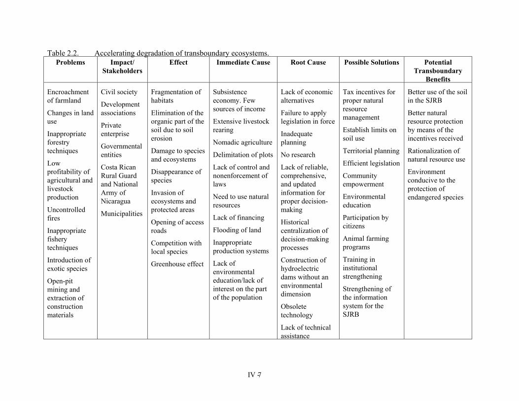
Table 2.2. Accelerating degradation of transboundary ecosystems. Problems Impact/
Stakeholders Effect Immediate Cause Root Cause Possible Solutions Potential
Transboundary Benefits
Encroachment of farmland
Changes in land use
Inappropriate forestry techniques
Low profitability of agricultural and livestock production
Uncontrolled fires
Inappropriate fishery techniques
Introduction of exotic species
Open-pit mining and extraction of construction materials
Civil society
Development associations
Private enterprise
Governmental entities
Costa Rican Rural Guard and National Army of Nicaragua
Municipalities
Fragmentation of habitats
Elimination of the organic part of the soil due to soil erosion
Damage to species and ecosystems
Disappearance of species
Invasion of ecosystems and protected areas
Opening of access roads
Competition with local species
Greenhouse effect
Subsistence economy. Few sources of income
Extensive livestock rearing
Nomadic agriculture
Delimitation of plots
Lack of control and nonenforcement of laws
Need to use natural resources
Lack of financing
Flooding of land
Inappropriate production systems
Lack of environmental education/lack of interest on the part of the population
Lack of economic alternatives
Failure to apply legislation in force
Inadequate planning
No research
Lack of reliable, comprehensive, and updated information for proper decision-making
Historical centralization of decision-making processes
Construction of hydroelectric dams without an environmental dimension
Obsolete technology
Lack of technical assistance
Tax incentives for proper natural resource management
Establish limits on soil use
Territorial planning
Efficient legislation
Community empowerment
Environmental education
Participation by citizens
Animal farming programs
Training in institutional strengthening
Strengthening of the information system for the SJRB
Better use of the soil in the SJRB
Better natural resource protection by means of the incentives received
Rationalization of natural resource use
Environment conducive to the protection of endangered species
IV - 7

Table 2.3. Overexploitation of valuable natural resources. Problem Impact/
Stakeholders Effect Immediate Cause Root Cause Possible Solutions Potential
Transboundary Benefits
Overexploitation of forests for wood and energy
Overexploitation of land, marine, & fresh water species
Illegal trafficking of wildlife species
Unregulated hunting
Civil society:
–fishermen
–farmers
–hunters
–loggers
Private enterprise
Ranchers
Industry in general
Exploitations/ Plantations
Conservationist Associations
Government agencies
Loss of natural habitats, ecosystems, and their biodiversity
Destruction of wetlands
Disappearance of species
Decline in fisheries and food chain problems
Reduction in ichthyic fauna in rivers
Reduction in the flow rates of rivers
Erosion
Pollution of water bodies
Lack of sustainable economic alternatives
Institutional weakness. Lack of technical capacity and economic resources
Little police presence or patroll-ing of the zone
Little attention to coastal and marine zones
Unscientific artisanal fishing
Difficulty controlling land use
Undue tilling and use of the soil
Lack of marine-coastal area management programs
High population growth
Little interest in the exploitation of marine-coastal zones
Lack of economic resources in the municipalities
Private sector land holdings in zones adjacent to or inside protected areas
Land planning and basin management plans
Institutional arrangements for resource management
Integrated Marine-Coastal Zone Management jointly with both countries
Studies on population dyna-mics of species to ensure their sustainable use
Controls for efficient natural resource use by the state, through continuous patrols
Strengthening of an information system for the SJRB
Involvement of civil society
Sustainable use of resources
Preservation of endangered species
Better use of natural resources
IV - 8
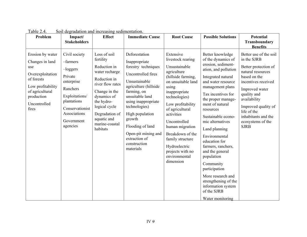
Table 2.4. Soil degradation and increasing sedimentation. Problem Impact/
Stakeholders Effect Immediate Cause Root Cause Possible Solutions Potential
Transboundary Benefits
Erosion by water
Changes in land use
Overexploitation of forests
Low profitability of agricultural production
Uncontrolled fires
Civil society
–farmers
–loggers
Private enterprise
Ranchers
Exploitations/ plantations
Conservationist Associations
Government agencies
Loss of soil fertility
Reduction in water recharge
Reduction in river flow rates
Change in the dynamics of the hydro-logical cycle
Degradation of aquatic and marine-coastal habitats
Deforestation
Inappropriate forestry techniques
Uncontrolled fires
Unsustainable agriculture (hillside farming, on unsuitable land using inappropriate technologies)
High population growth
Flooding of land
Open-pit mining and extraction of construction materials
Extensive livestock rearing
Unsustainable agriculture (hillside farming, on unsuitable land using inappropriate technologies)
Low profitability of agricultural activities
Uncontrolled human migration
Breakdown of the family structure
Hydroelectric projects with no environmental dimension
Better knowledge of the dynamics of erosion, sediment-ation, and pollution
Integrated natural and water resource management plans
Tax incentives for the proper manage-ment of natural resources
Sustainable econo-mic alternatives
Land planning
Environmental education for farmers, ranchers, and the general population
Community participation
More research and strengthening of the information system of the SJRB
Water monitoring
Better use of the soil in the SJRB
Better protection of natural resources based on the incentives received
Improved water quality and availability
Improved quality of life of the inhabitants and the ecosystems of the SJRB
IV - 9
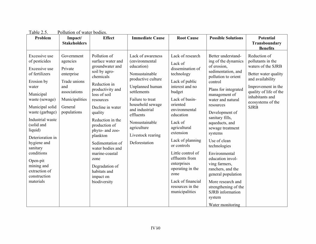
Table 2.5. Pollution of water bodies. Problem Impact/
Stakeholders Effect Immediate Cause Root Cause Possible Solutions Potential
Transboundary Benefits
Excessive use of pesticides
Excessive use of fertilizers
Erosion by water
Municipal waste (sewage)
Municipal solid waste (garbage)
Industrial waste (solid and liquid)
Deterioration in hygiene and sanitary conditions
Open-pit mining and extraction of construction materials
Government agencies
Private enterprise
Trade unions and associations
Municipalities
General populations
Pollution of surface water and groundwater and soil by agro-chemicals
Reduction in productivity and loss of soil resources
Decline in water quality
Reduction in the production of phyto- and zoo-plankton
Sedimentation of water bodies and marine-coastal zone
Degradation of habitats and impact on biodiversity
Lack of awareness (environmental education)
Nonsustainable productive culture
Unplanned human settlements
Failure to treat household sewage and industrial effluents
Nonsustainable agriculture
Livestock rearing
Deforestation
Lack of research
Lack of dissemination of technology
Lack of public interest and no budget
Lack of basin-oriented environmental education
Lack of agricultural extension
Lack of planning or controls
Little control of effluents from enterprises operating in the zone
Lack of financial resources in the municipalities
Better understand-ing of the dynamics of erosion, sedimentation, and pollution to orient control
Plans for integrated management of water and natural resources
Development of sanitary fills, aqueducts, and sewage treatment systems
Use of clean technologies
Environmental education invol-ving farmers, ranchers, and the general population
More research and strengthening of the SJRB information system
Water monitoring
Reduction of pollutants in the waters of the SJRB
Better water quality and availability
Improvement in the quality of life of the inhabitants and ecosystems of the SJRB
IV - 10
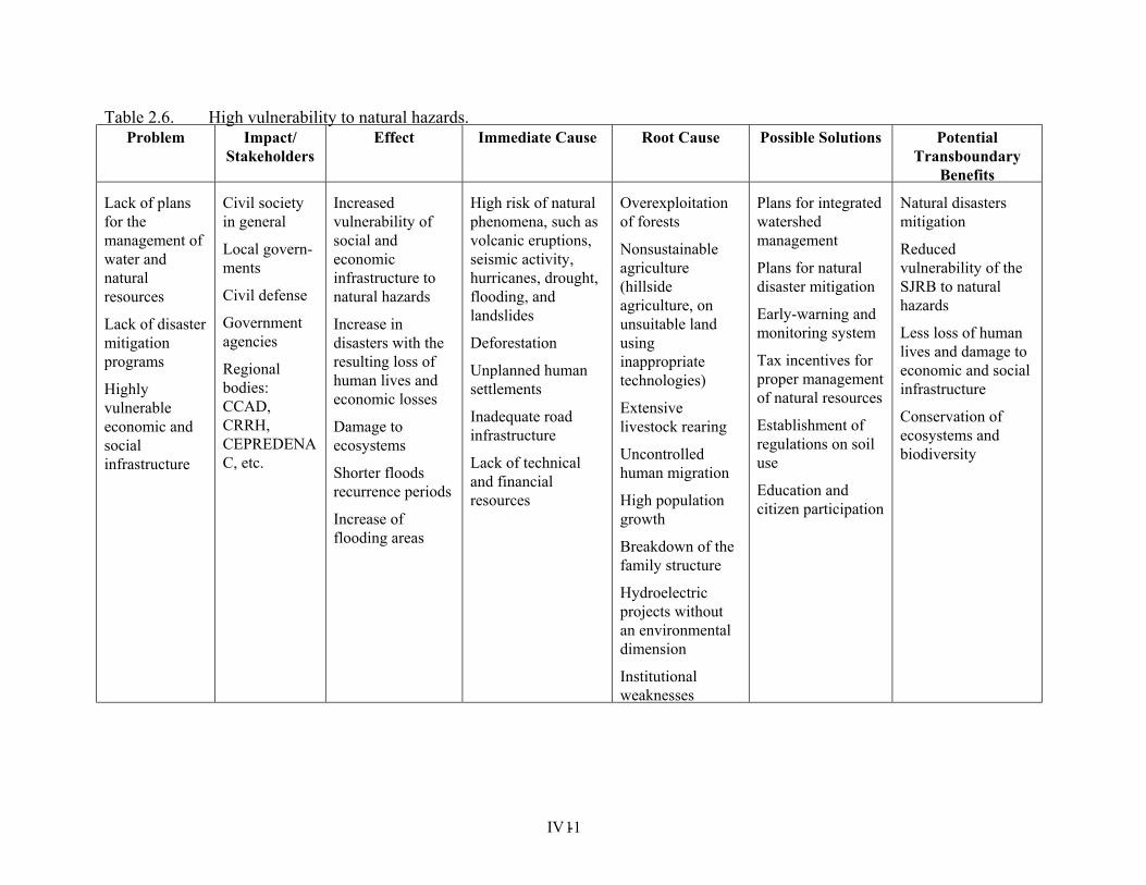
Table 2.6. High vulnerability to natural hazards. Problem Impact/
Stakeholders Effect Immediate Cause Root Cause Possible Solutions Potential
Transboundary Benefits
Lack of plans for the management of water and natural resources
Lack of disaster mitigation programs
Highly vulnerable economic and social infrastructure
Civil society in general
Local govern-ments
Civil defense
Government agencies
Regional bodies: CCAD, CRRH, CEPREDENAC, etc.
Increased vulnerability of social and economic infrastructure to natural hazards
Increase in disasters with the resulting loss of human lives and economic losses
Damage to ecosystems
Shorter floods recurrence periods
Increase of flooding areas
High risk of natural phenomena, such as volcanic eruptions, seismic activity, hurricanes, drought, flooding, and landslides
Deforestation
Unplanned human settlements
Inadequate road infrastructure
Lack of technical and financial resources
Overexploitation of forests
Nonsustainable agriculture (hillside agriculture, on unsuitable land using inappropriate technologies)
Extensive livestock rearing
Uncontrolled human migration
High population growth
Breakdown of the family structure
Hydroelectric projects without an environmental dimension
Institutional weaknesses
Plans for integrated watershed management
Plans for natural disaster mitigation
Early-warning and monitoring system
Tax incentives for proper management of natural resources
Establishment of regulations on soil use
Education and citizen participation
Natural disasters mitigation
Reduced vulnerability of the SJRB to natural hazards
Less loss of human lives and damage to economic and social infrastructure
Conservation of ecosystems and biodiversity
IV - 11
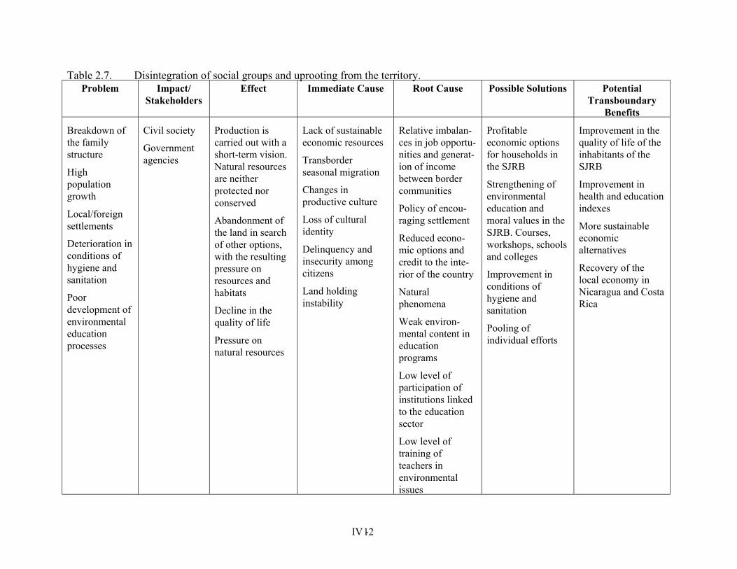
Table 2.7. Disintegration of social groups and uprooting from the territory. Problem Impact/
Stakeholders Effect Immediate Cause Root Cause Possible Solutions Potential
Transboundary Benefits
Breakdown of the family structure
High population growth
Local/foreign settlements
Deterioration in conditions of hygiene and sanitation
Poor development of environmental education processes
Civil society
Government agencies
Production is carried out with a short-term vision. Natural resources are neither protected nor conserved
Abandonment of the land in search of other options, with the resulting pressure on resources and habitats
Decline in the quality of life
Pressure on natural resources
Lack of sustainable economic resources
Transborder seasonal migration
Changes in productive culture
Loss of cultural identity
Delinquency and insecurity among citizens
Land holding instability
Relative imbalan-ces in job opportu-nities and generat-ion of income between border communities
Policy of encou-raging settlement
Reduced econo-mic options and credit to the inte-rior of the country
Natural phenomena
Weak environ-mental content in education programs
Low level of participation of institutions linked to the education sector
Low level of training of teachers in environmental issues
Profitable economic options for households in the SJRB
Strengthening of environmental education and moral values in the SJRB. Courses, workshops, schools and colleges
Improvement in conditions of hygiene and sanitation
Pooling of individual efforts
Improvement in the quality of life of the inhabitants of the SJRB
Improvement in health and education indexes
More sustainable economic alternatives
Recovery of the local economy in Nicaragua and Costa Rica
IV - 12
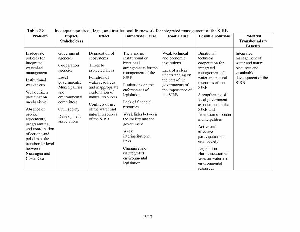
Table 2.8. Inadequate political, legal, and institutional framework for integrated management of the SJRB. Problem Impact/
Stakeholders Effect Immediate Cause Root Cause Possible Solutions Potential
Transboundary Benefits
Inadequate policies for integrated watershed management
Institutional weaknesses
Weak citizen participation mechanisms
Absence of precise agreements, programming, and coordination of actions and policies at the transborder level between Nicaragua and Costa Rica
Government agencies
Cooperation agencies
Local governments: Municipalities and environmental committees
Civil society
Development associations
Degradation of ecosystems
Threat to protected areas
Pollution of water resources and inappropriate exploitation of natural resources
Conflicts of use of the water and natural resources of the SJRB
There are no institutional or binational arrangements for the management of the SJRB
Limitations on the enforcement of legislation
Lack of financial resources
Weak links between the society and the government
Weak interinstitutional links
Changing and unintegrated environmental legislation
Weak technical and economic institutions
Lack of a clear understanding on the part of the governments of the importance of the SJRB
Binational technical cooperation for integrated management of water and natural resources of the SJRB
Strengthening of local government associations in the SJRB and federation of border municipalities
Active and effective participation of civil society
Legislation Harmonization of laws on water and environmental resources
Integrated management of water and natural resources and sustainable development of the SJRB
IV - 13
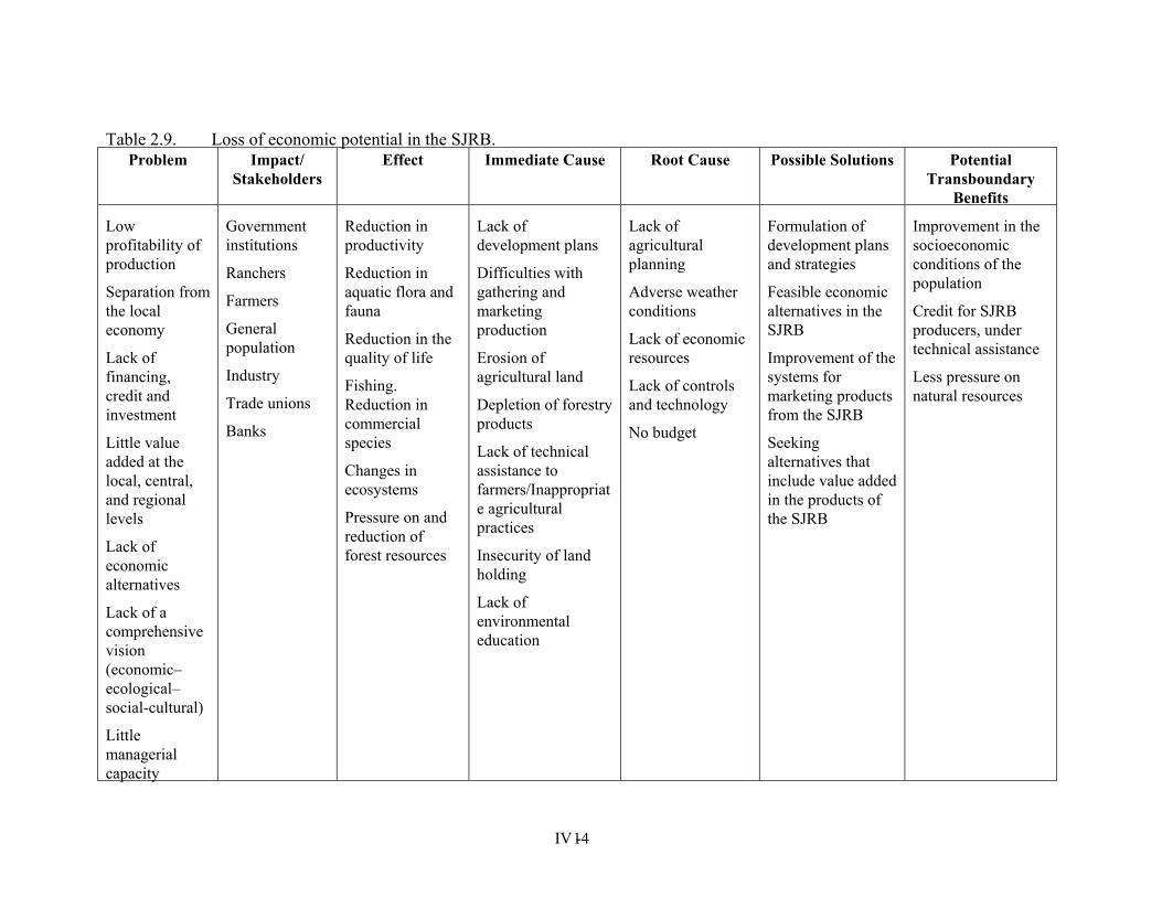
Table 2.9. Loss of economic potential in the SJRB.
Problem Impact/Stakeholders
Effect Immediate Cause Root Cause Possible Solutions PotentialTransboundary
Benefits
Low profitability of production
Separation from the local economy
Lack of financing, credit and investment
Little value added at the local, central, and regional levels
Lack of economic alternatives
Lack of a comprehensive vision (economic–ecological–social-cultural)
Little managerial capacity
Government institutions
Ranchers
Farmers
General population
Industry
Trade unions
Banks
Reduction in productivity
Reduction in aquatic flora and fauna
Reduction in the quality of life
Fishing. Reduction in commercial species
Changes in ecosystems
Pressure on and reduction of forest resources
Lack of development plans
Difficulties with gathering and marketing production
Erosion of agricultural land
Depletion of forestry products
Lack of technical assistance to farmers/Inappropriate agricultural practices
Insecurity of land holding
Lack of environmental education
Lack of agricultural planning
Adverse weather conditions
Lack of economic resources
Lack of controls and technology
No budget
Formulation of development plans and strategies
Feasible economic alternatives in the SJRB
Improvement of the systems for marketing products from the SJRB
Seeking alternatives that include value added in the products of the SJRB
Improvement in the socioeconomic conditions of the population
Credit for SJRB producers, under technical assistance
Less pressure on natural resources
IV - 14
IV - 15
SECTION 3
RELEVANT INFORMATION AND DETAILED ANALYSIS OF THE PROBLEMS
3.1 Sources of degradation in the San Juan River Basin and its Coastal Zone The SJRB comprises four subsystems: Lake Nicaragua, the San Juan River, the Indio-Maíz River Biological Reserve, and the Tortuguero Plains Conservation Area. These last two subsystems comprise four small but very important basins integrated naturally in the San Juan River hydrological system. These are the basins of the Indio and Maíz rivers in Nicaragua and Colorado and Tortuguero rivers in Costa Rica, shown on Map 1 of Annex 1.
The Lake Nicaragua subsystem--with a surface area of 23,848 km² from its headwaters to its outlet in the vicinity of San Carlos, source of the San Juan River--has three sectors with very different features:
a. The sub-basins of the rivers on the eastern side, where the rivers go progressively from an intermittent flow to a permanent one as they approach the southern side, owing to increased rainfall.
b. The sub-basins of the rivers on the western side, which are characterized by short distance courses and gradual slopes.
c. The sub-basins of the rivers on the southern side, which originate in Costa Rican territory and only a part of their courses crosses Nicaraguan territory. This sector also includes several wetlands, habitat of migratory and local species of great ecological value. Caño Negro wetlands, a RAMSAR site, is among them.
In addition, although not included in the project area, Lake Managua, located on the northwest, has been connected at times with Lake Nicaragua.
The San Juan River subsystem is the only surface outlet from Lake Nicaragua. With a surface area of approximately 10,937 km², the San Juan River Basin has a climate characteristic of the area that drains in the Caribbean Sea, with annual average rainfall gradually increasing from 2,000 mm close to San Carlos to some 6,000 mm in North San Juan. This subsystem is divided into two sectors:
a. North Sector, with an approximate surface area of 2,347 km², whose tributaries flow down from elevations of some 400 to 600 masl. All the rivers that flow into the San Juan River from this sector cross Nicaraguan territory only.
b. South Sector, with a surface area of approximately 8,590 km², is the source of the main tributaries of the San Juan River. Some of these originate in the Costa Rican territory at elevations of some 3,000 masl, in the Central Volcanic Cordillera, and have more extensive drainage areas than the North Sector tributaries. This subsystem is characterized by steep slopes and high rainfall, which give the rivers a heavy flow.
The Indio-Maíz River Biological Reserve subsystem has a surface area of approximately 2,463 km² and is one of the areas in Nicaragua with the most biodiversity. However, is also one of the most fragile areas in the basin due to its ecological characteristics, which include very high rainfall, soils with limited capacity, and deficient drainage; an abundance of wetlands and water bodies; a predominance of extraordinarily diverse forests for which the conditions of exploitation are fragile, posing regeneration problems because of the close
IV - 16
interconnectedness of its ecological systems through hydrological flows and environmental humidity; and its extraordinary biological diversity. Seven hundred forty-five plant species, 110 species of birds, 32 species of mammals, and over 32 species of crustaceans and fish have been identified within this subsystem. It is one of the national areas where virgin forest is preserved.
The Tortuguero Plains Conservation Area subsystem has a surface area of approximately 1,321 km². Like the Indio-Maíz River Biological Reserve, this area that falls within Costa Rican territory is one of the zones marked by the greatest biodiversity and ecological fragility in the South Sector of the Basin, owing to its ecological features. These features include: very high rainfall, soils with limited capacity, and deficient drainage; an abundance of wetlands and water bodies; a predominance of extraordinarily diverse forests for which the conditions of exploitation are fragile, posing regeneration problems because of the close interconnectedness of its ecological systems through hydrological flows and environmental humidity; and its extraordinary biological diversity.
This section of the TDA explains in detail the current and emerging environmental problems of the basin, as well as their causes. It should be noted, however, that the order in which these are presented in each case does not indicate either priority or the importance of the problems.
During the process of identification of the main current and emerging environmental problems, which limit, reduce, and/or pose a threat to the possibility of integrated management of water resources and the sustainable development of the SJRB, a number of issues were identified. As previously noted, these were grouped into eight categories. The first five represent the perceived major environmental problems, as shown in Table 1.1. The last three categories further explain the interactions (causes and effects) of institutional, social and economic aspects with the five major perceived problems. The problems grouped in these categories relate to:
a. Soil degradation and sedimentation b. Ecosystem degradation c. Water quality d. Water resource use e. Overexploitation of natural resources f. Political, legal and Institutional framework for the integrated management of the SJRB. g. Economic development. h. Social areas.
3.1.1 Problems related to soil degradation and sedimentation Soil degradation directly affects the economy of producers due to the fact that it dramatically reduces their productivity as a direct consequence of the loss of the fertile layer of topsoil. Further, sedimentation, or processes related to the movement and deposition of eroded soils within the hydrologic system, affects processes like increased turbidity, color, and other processes that are strictly mechanical in nature, such as erosion, and silting up of the river beds and other water bodies and coastal zones. The sedimentation processes make the river waters turbid, preventing sunlight from penetrating and limiting the production of primary producers (plants) for aquatic life to consume. This affects the reproduction and survival of some
IV - 17
economic species, including fish. In the coastal zone, sedimentation affects the populations of reefs, ecosystems that involve and are crucially important to the reproduction of marine species with a high commercial value.
The soil of the basin is fertile and can be farmed using mechanized agricultural techniques. Generally speaking, the soil in the North of Costa Rica and the area bordering Lake Nicaragua and the eastern part of the Basin is poorly drained in the lower areas, with drainage improving at higher altitudes. The volcanic characteristics of the region have provided soils with a high content of ash, hence richer. However, the natural processes of erosion and soil loss, compounded by inappropriate (unsustainable) agricultural practices, inappropriate forestry techniques, and the lack of soil and water conservation practices have resulted in major losses of fertile topsoil in different parts of the basin. Similarly, erosion is accompanied by a decline in the replenishment of aquifers which, in addition to reducing the availability of underground water, alters the hydrological regime of water bodies, producing greater and increasingly frequent floods during the rainy season and low flow rates during the dry season. Changes in land use, without taking into account its potential, such as the extension of commercial agriculture and overexploitation of forests for wood exacerbate the erosion problems facing the SJRB. In much less degree, traditional land clearing practices in preparation for agricultural work, such as slash and burn practices, are also contributors to the increase of erosion processes in the SJRB.
The sedimentation process affects the basin’s water resources to a large extent, both in terms of the quality and in terms of its aquatic flora and fauna. However, it is not possible to quantify this problem because there is very little information available on the environment of the entire SJRB. Historically, the San Juan River has undergone a natural process of sedimentation, which has led to discharges through two sites: the North San Juan Bay or Lagoon in Nicaragua, which is high in sediment, and the mouth of the Colorado River in Costa Rica, which produces the highest flow rate discharge. Nevertheless, the upper and mid-level parts of the San Carlos River sub-basin are the most critical in terms of sedimentation, mainly because they have volcanic soil associated with a mountainous terrain, very rugged residual soil, hilly residual terrain, in addition to torrential rainfall and inappropriate soil use.
The particular production of sediment in suspension in this portion of the Basin has been determined at the Terrón Colorado station, where the figures reached 817 ton/km2/year; at the Peñas Blancas station, the figures were 700 ton/km2/year; and at the Puerto Viejo and Veracruz stations on the Sarapiquí River where the figures are close to 216 ton/km²/year. While these latter figures are significantly lower than those assessed for the San Carlos River basin, they are significant in terms of turbidity. According to comments from farmers in the Los Chiles canton, about 15,000 hectares of soil are farmed using mechanized agricultural techniques each year for crop development. Erosion is reported to be visible in these agricultural areas, and production is reported to be decreasing.
The upper part of the Frío River sub-basin has residual soils with hilly relief and a high risk of erosion, compounded by the implementation of unsustainable agricultural practices in the area, which excludes soil and water conservation practices. The specific production of sediment calculated at the Guatuso station was 298 ton/km²/year and 181 ton/km²/year at the Venado station. These amounts are less than the input from the San Carlos River sub-basin but have the
IV - 18
same implications for turbidity.
The upper part of the Zapote River sub-basin is made up of very rugged residual soil and very shallow soil on mountainous terrain. The sediment transported in this sub-basin is deposited at the outlet of Lake Nicaragua, where the San Juan River is formed. Although the turbidity of the waters indicates a high level of solids in suspension, the specific production of sediment in this sub-basin has not been estimated because no information is available.
In the north of the San Juan River subsystem, overuse of the soil by the extension of commercial agriculture, overexploitation of forests for wood, weather, land, and topographic conditions combine to cause severe erosion by water in certain areas, which affects the sustainability of the resources in the zone and increases the transport of sediment toward the San Juan River basin. The zones considered to be critical areas in this sector of the sub-basin are the Negra, Sábalos and Santa Cruz rivers. There are no measurements of the sediment deposited in these rivers, hence the inability to quantify the specific sediment deposits.
Lake Nicaragua acts as a reservoir for sediment and a sink for most of the pollutants that reach its waters; because of the large size of the lake, much of the sediment that reaches it is deposited there and does not reach the San Juan River. Also, because of the lake’s great dilution capacity, the concentration of pollutants is considerably reduced. The problems of erosion and of sediment carried to the lake are significant, mainly due to deforestation and the practice of unsustainable agriculture, even though it does not reach the levels indicated for the former sub-basins. This is fundamentally due to the fact that the terrain is less rugged and rainfall levels are lower.
Nevertheless, as a result of this situation, many tons of soil are lost annually, thereby diminishing the productivity of agricultural land through the loss of fertile topsoil as a result of the rains.
The same situation occurs in livestock rearing, in which case the erosion caused by water is accentuated by the movement of herds through pastures, since most of these farms rear stock on a large scale and do not practice livestock rotation. This is exacerbated by the general practice of turning forestry land into pastures.
Erosion by water also seriously affects rural roads, resulting in bad roads for marketing agricultural products, thereby increasing the price of transporting products to markets. Quite often, it is not possible to get production to retail outlets, causing severe economic losses for producers. In the Lake Nicaragua subsystem, these problems of erosion by water occur on the slopes of the Mombacho volcano, and extend to the vicinity of Nandaime, in the sub-basins of the Ochomogo, Malacatoya, Tecolostote, Mayales, and Acoyapa rivers. However, the specific production of sediment in this subsystem has not been estimated, as the necessary information is not available. Additional, inappropriate road design and construction also contributes to the acceleration of the erosion processes.
The sediment from the upper and middle sectors of the basin rises mainly through the San Carlos and Sarapiquí rivers. Human activities exacerbate this natural process. Comparing aerial photographs taken in different years, one observes islets formed during the past five years as a result of the sedimentation process. It is well known that during the dry season, places in the San Juan River are not navigable by the small craft or rowboats used to transport
IV - 19
people in the region, owing to the heavy sedimentation taking place. The soil degradation process becomes more acute as a result of population pressure. As population growth is high, wider areas are claimed for unsustainable agricultural activities. The construction of waterworks like dams or microdams, and mining, without incorporating the environmental variable, places additional stress on the fragile land and accelerates erosion processes.
At the transboundary level, sedimentation is a major problem given that the accelerated erosion process that is occurring in the basin affects the San Juan river and the coastal area of the basin, due to the fact that these areas receive the sediment. To halt, reduce, and control this erosion process, and consequently reduce the problems caused by sedimentation, it is necessary to develop soil and water conservation programs that would allow for the integration of these practices into the agricultural activities being developed in the basin. The creation of tax incentives for those producers who appropriately manage natural resources could be a motivation to halt and control the erosion and sedimentation process occurring in the SJRB.
Land use planning and the preparation of plans for basin management are also necessary. These plans should seek to develop socioeconomic activities based on land use capacity, and encourage the acquisition of more precise information on the dynamics of erosion, sedimentation, and pollution of water bodies, as guidelines for control. These actions can hardly be successful without the involvement of producers and civil society as a whole, through environmental education programs, the creation of economic alternatives, and the development of monitoring and information systems that provide a better awareness of the actions being advocated.
3.1.2 Problems related to ecosystem degradation The degradation of ecosystems is an environmental problem that diminishes the capacity of species to survive. This degradation occurs in different ways and is manifested in a reduction in the richness of the ecosystems as well as their biological diversity, and in the goods and services they can offer, thereby affecting indigenous and/or migratory species. The degradation of ecosystems due to overexploitation of their resources, though serving a short-term economic goal, has had direct negative effects on social welfare in the medium and long terms. As long as the ecosystem is not degraded, it represents a source of wealth for society, hence the importance of keeping it in good condition.
One of the main causes that contributes to the degradation of ecosystems is the deforestation due to the advance of the agriculture frontier and inappropriate forest exploitation. More lands are deforested for commercial agriculture and live-stock rearing, and due to overexploitation of forest for wood and energy. In Nicaragua deforestation rates reach over 150,000 hectares per year and in Costa Rica over 18,500 hectares per year.
At a lower scale, another problem is the uncontrolled fires used to prepare land for agricultural activities or to remove forest for the development of stock rearing areas. This practice eliminates the organic covering of the land, making it more susceptible to erosion by both wind and water. In addition, the fires cause health problems and detract from the aesthetic value of the landscape.
Accidental or natural fires are another case in point. They affect areas of natural forest. In the Upala and Los Chiles cantons, in Costa Rica, some 10,000 hectares were burned between 1998
IV - 20
and 1999. This problem is even more serious in the Nicaraguan territory of the basin. Equipment is lacking and communities need to be organized to control these fires as one of the main barriers to the burning of large areas.
The construction of roads without proper drainage measures or in territories subject to penetration and settlement are high-stress factors for ecosystems, especially those which are highly fragile as a result of their weather conditions and the nature of their soil and water.
Mining and the extraction of construction materials without taking measures to cushion the impact cause drastic changes in the natural landscape while degrading its valuable ecosystems.
Wetlands are very fragile ecosystems that are being severely affected, causing a reduction in the number and diversity of the species of terrestrial flora, birds, reptiles, mammals, fish, and crustaceans. This problem results from excessive exploitation of wildlife species either to feed the population, to trade their furs, or to trade live species, and from sedimentation, which causes changes in water quality, thereby significantly affecting the reproduction of aquatic species that live and/or reproduce in the wetlands.
The SJRB wetlands are very valuable ecosystems, which regulate the hydrological cycle and provide food and shelter for hundreds of species, including large quantities of migratory birds. One major cause of the deterioration of this ecosystem is the draining of wide areas of wetlands to give access to agricultural zones or human settlements. Aerial photographs of the Caño Negro sector show how the pools of water have diminished over time, due in part to the drainage of wetlands for agricultural purposes and to the sedimentation occurring in recent years in the basin. Owing to the deterioration of these areas and the pressure of the neighboring communities on the use of the natural resources of the wetlands, it is necessary to draw up management plans to outline the socioeconomic characteristics of users and guidelines for usage, since people are highly dependent on these resources for their survival. A large portion of the ecological problems of the wetlands is due to ignorance of their benefits.
The use of inappropriate fishing techniques endangers the existence of certain species, altering the food chain of aquatic fauna and consequently deteriorating the aquatic ecosystems. This is the case of the bull shark that is now hard to find in Lake Nicaragua or in the San Juan River. In some cases, the introduction of exotic species endangers the existence of indigenous species with a high cultural value. Such is the case of the guapote, whose numbers are being reduced by the introduction of tilapias. The deterioration of ecosystems is exacerbated by the lack of an institutional presence in the territory, be it for technical or economic reasons, or a combination of both. As a result, laws on the regulation and control of natural resource use are not enforced. The participation of civil society in controlling the use and exploitation of natural resources is limited and, in many cases, very timid or markedly apathetic.
One aspect that has not been evaluated in the degradation of the ecosystems is the incidence of different phenomena on these systems. The geographic location of the SJRB and the various geographic accidents encountered there render it susceptible to the impact of various events of this kind. In the SJRB there are a number of active volcanoes, which spew gas and ash causing damage to the plant life, the soil, polluting water bodies, and causing severe damage to entire populations. These volcanoes include the Masaya, the Maderas, and the Irazú. Another natural phenomenon in the SJRB is landslides which, though located in specific areas, cause damage
IV - 21
to the ecosystems, the soil, pollute water bodies, damage infrastructure and entire settlements. The Maderas volcano on the island Ometepe is a case in point.
Similarly, during the last century, the SJRB has suffered the destructive effects of at least three hurricanes which, with their heavy rainfall, cause flooding damaging ecosystems, eroding soil, diverting river courses, causing severe damage to infrastructure and entire populations, resulting in the loss of human lives. Other natural phenomena that have caused damage to the ecosystems of the SJRB are the droughts that have occurred as a result of the El Niño and seismic activity, which have changed river courses, particularly in the case of the Tipitapa River that provided a permanent connection between the Managua and Nicaragua lakes. As a result of an earthquake during the last century, the riverbed rose in a certain sector cutting off the existing connection between the two lakes.
The degradation of the ecosystems makes the economic and social infrastructure of the SJRB more vulnerable and increases the potential impact on the population. This vulnerability is reflected in shorter periods between the occurrence of floods or droughts and the soil becomes more unstable. Possible solutions to the problem of deterioration of the ecosystems include developing formal and informal environmental education programs to make farmers more aware of their actions; increasing enforcement of the existing legislation; promoting proper natural resource management; and promoting the organization of grassroots groups to control burning from the outset. To prevent or mitigate the damage caused by extreme conditions, such as flooding and droughts and other effects of natural phenomena, it is necessary to set up and early warning system about possible swelling of water bodies and to monitor hydrometeorological behavior. It is also necessary to set up a seismographic network to monitor the behavior of volcanoes and tectonic faults. Similarly, social organization is necessary to design and test emergency plans for natural phenomena, to reduce the damage they cause.
Institutions responsible for the control and regulation of natural resource use must be strengthened, both technically and economically, and be given the means for their mobilization. This would enable them to have a real presence in the territory. It is also necessary to create mechanisms for enforcing the current legislation.
3.1.3 Problems related to water quality The lack of a historical series of basic data on the physical, chemical, and biological properties of the basin’s waters makes it impossible to interpret results on the quality of the waters with any reasonable degree of accuracy and coverage. From studies conducted by the CIRA/UNAN in Lake Nicaragua in 1993 and 1994, the lake was found to have oligomesotrophic characteristics. It was found that the supply of oxygen dissolved into the lake through photosynthetic processes was very low, and that the oxygenation of a great portion of the water mass was mechanical, mainly due to the supply of atmospheric oxygen by the wind and rainfall, and by simple diffusion through the interface of water and air. Nevertheless, this study indicated that the possibility of eutrophication in areas receiving chemical and biological pollutants from discharges of municipal and industrial waste water should not be disregarded, as shown by the concentrations of phosphorous which were present at high levels of between 50 and 62 mg/l (62 and 50 µg/l in March and April 1993, respectively). Agricultural activities carried out in the drainage area of the lake were also reported to contribute to erosion,
IV - 22
increasing turbidity and the concentration of insecticides and agrochemicals in the waters of the lake and its runoff.
From the information in Tables 2 and 3 of Annex 3, the waters of the lake were found to have the following characteristics: • total alkalinity varied little, indicating that the waters of the lake have a good acid
regulatory capacity; • there were high levels of boron in the form of sodium and/or calcium borate; • high levels of total coliforms and low concentrations of fecal coliforms were present,
which allow the water to be used for irrigation, bathing, and recreation; • there was a low level of chloride; • DQO and fluoride levels were low, • phosphorous levels were higher than those permitted for surface waters used for human
consumption; • total dissolved solids, due to discharges of urban and industrial effluents and soil
erosion, were below the permissible limits for first class surface waters.
Analysis of sediment taken from Lake Nicaragua showed levels of pesticides in excess of the amounts permitted for the protection of fresh water organisms. This situation must be studied in greater depth given the impact that pesticides can have on the quality of the water in the lake and its ecosystem.
One source of pollution of Lake Nicaragua that has not been evaluated is the possible runoff from Lake Managua into Lake Nicaragua, through the Tipitapa River when the water from Lake Managua rises to 41.30 masl. During this century, this transfer has occurred on four occasions: in 1933 when it reached its highest historical level (43.44 masl), in 1955 when it reached the second highest level (42.36 masl), in 1982, and in October 1998 when, as a result of Hurricane Mitch, it rose to 42.10 masl. During the last episode, the volume of water transferred increased with the rainy season in 1999, when the waters of Lake Managua reached a height of 42.17 masl in mid-October. This extreme elevation is expected to exceed the 1955 level before the current rainy season is over, increasing the flow of water to Lake Nicaragua even further. According to the figures published by the Nicaraguan Institute of Territorial Studies, the current flow rate of the runoff is some 80 m³/sec. These flows are polluted by municipal and industrial wastewater and solid waste from Managua; by a natural salination process, which increases with the accelerated erosion in the drainage basin; and by the runoff of agricultural chemicals used in farming. In 1990, the concentration of dissolved salt was some 1,400 mg/l; in 1972 the concentration was less than 1,000 mg/l. Studies also indicate the presence of heavy metals in samples of water and in fish taken from the lake. It should be noted that a very important action in the Lake Managua sanitation program promoted by the government is the construction of a spillway to regulate the outflow of water from this lake to Lake Nicaragua and maintain the volume of Lake Managua at a prescribed level. With the building of this spillway, there would be a constant outflow of the polluted waters of Lake Managua into Lake Nicaragua through the Tipitapa River. The environmental impact of this work has not yet been evaluated.
IV - 23
In respect of the San Juan River, the studies carried out by CIRA/UNAN show that the turbidity of the water, which prevents the sunlight from penetrating, has inhibited the production of phytoplankton. The low levels of primary productivity and limited biomass as expressed by chlorophyll-a concentrations were observed at their lowest levels in the Sarapiquí River and at their highest levels in the San Juan River delta. The latter site had the highest total concentration of phosphorous and above-average levels of nitrate. From the information in Table 4 of Annex 3 it can be deduced that the waters of the San Juan River have the following characteristics: • although total concentration of solids is lower than the prescribed international standard
(i.e. those adopted by Brazil and Canada), the turbidity levels exceed the maximum admissible limits, mainly in the Melchora, Bartola, Zapote, Medio Queso, San Carlos, Poco Sol, and Sarapiquí rivers and in the San Juan River delta, possibly as a result of soil erosion, and the absence of protective forests in the corridors along those rivers;
• the concentrations of iron exceed the maximums recommended for human intake, the rivers on the right bank of the San Juan River being in the most critical condition;
• the high bicarbonate alkalinity, reflected by high pH and hardness values in the water, indicate a high tendency to incrustation or aggressive waters;
• the high concentration in phosphorous detected in the Sarapiquí, San Carlos and San Juan River deltas can be associated with the use of phosphates to fertilize the soil;
• no pollutants were detected in the samples of sediment from the San Juan River and its tributaries.
Erosion by water is a problem in most areas of the basin. Owing to the heavy rainfall, parts of the soil act like liquids and are lost as a resource, being transported to, and deposited in the receiving rivers, thereby diminishing the quality of the water both for consumption and for aquatic flora and fauna. Soil erosion also transports the fertilizers and pesticides used in agricultural activities and the contaminants leached from municipal and industrial solid wastes, which are usually deposited in open dumps within settlements and in the industrial zones located in the SJRB. The final disposal and proper management of wastes is a problem in most of the urban centers in the SJRB. Few centers have adequate disposal facilities for solid wastes, although Ciudad Quesada, the largest urban center on the Costa Rican side of the SJRB, does have a sanitary fill. Technical studies on pollution, particularly on leachates which could have a negative effect on the environment and on surface and ground waters, are lacking. In Nicaragua, the towns located in the basin that produce the largest volumes of solid waste are Granada, Masaya, Rivas, Boaco, Juigalpa and San Carlos. In the small towns, the garbage collection system is deficient and trash is usually dumped in open areas. It is rarely removed or covered, resulting in putrid odors and a proliferation of flies and other problems. Only 32% of the population in the basin has a solid waste collection system. The majority of the scattered, rural population mostly digs pits for its solid waste. In most cases, when the pits fill up, they are set alight or sometimes covered and new ones dug to dump more trash. In some cases, the solid waste is dumped directly on the ground or in riverbeds and gullies. There is generally little awareness or education about solid waste disposal; everywhere trash can be found on the ground, on the roads, and in rivers. In the larger centers in the Nicaraguan sector of the basin, garbage collection systems cover about 45% of the population. In all cases, the solid waste
IV - 24
collected is dumped in open areas. There are very few towns in which solid waste is used to produce organic fertilizer.
The excessive use of pesticides is a general problem in most agricultural activities. With the exception of subsistence agriculture, agricultural chemicals are widely used. In the project area, 92% of the farmers are small farmers. Subsistence agriculture represents only 6.5% of the surface area and does not use significant quantities of agricultural chemicals for economic reasons. Likewise, the excessive use of fertilizers can have negative effects on both surface and ground water sources. As a result of the deposition of nitrogenous fertilizers in water bodies, the aquatic flora multiplies causing ecological imbalances with negative consequences (including high consumption of oxygen as the organisms die and decompose) within the aquatic ecosystem. This problem is caused in part by the exhaustion of the natural fertility of the soil and its continued use, requiring the artificial supply of the nutrients necessary for normal crop development. Due to the fact that the regulations related to the use of pesticides and fertilizers are very weak or nonexistent, these agrochemicals are used irrationally, far in excess of the real demands of cultivation, with inefficient application and poor handling. This affects the biota in general, polluting the surface and ground waters, and creating occupational health problems. On the other hand, there are crops in the basin area that require high agrochemical use, such as bananas, vegetables, root crops, and sugar cane. Table 5 of Annex 3 shows the main crops produced in the SJRB and the most widely used chemicals. The geographic areas where this situation occurs are mostly the wetlands, Malacatoya, Medio Queso, Guacalillo, Ochomogo, Palo Ralos, Río Zapote, where banana plants (Pococí), citrus (San Carlos CR) and sugar cane, common to a number of localities in the basin, are grown.
Industrial wastewater has traditionally been a problem both in Nicaragua and in Costa Rica. The lack of norms to regulate effluents from industries and institutional weaknesses (technical and financial) have severely limited the ability to oblige industries to treat their wastewater. In many cases, because there are no controls on these waters, companies do not use treatment techniques that would raise production and operating costs. Businessmen view this measure as an expense and not as a requirement for sustainable development. Given the range of industrial operations in the basin, the composition of wastewaters may vary considerably depending on the type of industry. In most industries, these waters have been diverted to the rivers and streams to save economic resources. The critical points where the problem of pollution with industrial waste water arises are in the capitals of cantons and major municipalities, where industries are established, the banana-growing areas, fishing zones, sugar plantations, coffee plantations, and citrus and dairy processing plants.
In Costa Rica, attempts have been made to control this situation. Coffee plantations, for example, have made strides in the treatment of their wastewater with oxidation lagoons. Cane plantations, slaughterhouses, pig farms, and other businesses are doing the same. The discharge from these companies is analyzed by the Ministry of Health, which establishes ranges for different substances and compounds, though it faces serious restrictions in terms of controlling effluents. The Ministry of Environment and Energy, MINAE, is responsible for the administration of water resources within the entire national territory of Costa Rica, through. the Department of Waters located at the National Meteorological Institute.
In Nicaragua, MARENA is responsible for controlling pollution through the General
IV - 25
Directorate of Environmental Quality. The Ministry of Health and the INAA focus on the quality of the water supply for human consumption. The CIRA is a specialized center of the Universidad Nacional Autónoma de Nicaragua (UNAN), which has laboratories for various analyses of water quality. There is a National Water Resource Commission to coordinate these activities.
The most densely populated towns in the SJRB are Masaya, Granada, Boaco, Juigalpa and San Carlos. Ciudad Quesada is the largest urban area on the Costa Rican side. The Nicaraguan urban population in the basin makes up 45% of the total (354,834 inhabitants), while on the Costa Rican side, the urban population amounts to 32% (91,530 inhabitants) of the total. As a result, both rural and urban wastewater volumes are significant, resulting in a high pollution potential; the same can be said for human excrement. The major urban centers have sewage treatment systems. Most of the rural population lacks the minimal basic sanitation services and conditions. The problem of wastewater is accentuated due to the unplanned spread of human settlements, which have no basic services whatsoever and so increase the stress on the existing ones. An analysis conducted by the WHO (World Health Organization) concludes that the Nicaraguan sector of the basin, because of its denser population, can potentially generate some 3.5 to 7.7 times more municipal wastewater pollution than the Costa Rican sector of the basin. Table 6 of Annex 3 estimates the pollution potential of the human settlements based in the basin.
Actions to help improve the quality of surface and ground waters include the promotion of programs on soil conservation, integrated pest management, construction of proper sanitary fills, and treatment of municipal and industrial wastewater. It will also be necessary to develop technical assistance programs for the management and use of agricultural chemicals and their dangers to health and the environment. Other actions include technical assistance, refraining from the use of fertilizers in zones near rivers, reforestation or regeneration of the natural vegetation on river banks, reduction in the dosage of fertilizers or their application in smaller doses, covering the fertilizer to prevent it from being washed away by rain, and establishing environmental education programs indicating the negative effects of fertilizers on the environment and aquatic ecosystems, both fresh water and marine. It is necessary to develop systematic programs to monitor the quality of water in order to verify the progress made in controlling the pollution of water bodies. In addition, research programs are required to better ascertain the dynamics of erosion, sedimentation, and pollution and so provide guidelines for their control. Other actions that will help mitigate and control this problem are the development of plans and strategies for integrated management of water resources and other natural resources.
3.1.4 Problems related to water resource use Lake Nicaragua is one of the largest reservoirs of fresh water in the Americas. Its outflow through the San Juan River (averaging 475 m³/sec), as well as its capacity for storage, high water quality, its geographic location, and its connection with the Caribbean Sea through the San Juan River are features that render it attractive for a number of purposes, such as navigation, energy production, irrigation, potable water supply, tourism, recreation, and fishing, to name the principal ones. For many years, transportation on the San Juan River and Lake Nicaragua has been an important factor in the socioeconomic and political development
IV - 26
of Nicaragua. Interest in the construction of an inter-oceanic route tapping the potential of the San Juan River and Lake Nicaragua dates back to Spanish colonial times. The first historical data records that the San Juan River and Lake Nicaragua were used to transport the riches discovered on the western coasts of South America and shipped to Spain during the conquest of the continent. History shows that since 1504, Nicaragua has made over 10 attempts to construct an inter-oceanic canal. To date, however, none of the projects has come to fruition.
With the discovery of gold in California (1848), transiting North Americans sought a faster route to the gold mines through the San Juan River and Lake Nicaragua. Reports from that time indicate that in 1853 some 20,800 traveled from the East Coast to the West Coast of the United States using that route. Other data show that at that time some 2,000 passengers were transported via that route on a monthly basis. However, an earthquake that occurred in July 1863 increased sedimentation in the San Juan River mouth, greatly increasing the difficulties of navigating that part of the river. Later, the construction of the transcontinental railway across the US in 1869 put an end to the great demand for passenger transport through Nicaragua.
Nevertheless, at the beginning of this century, interest in commercial navigation through Lake Nicaragua resumed. Of the studies conducted since the 1900s on the construction of an inter-oceanic canal, the following are noteworthy:
• Isthmian Canal Commission, 1899-1901 • U.S. Army Corps of Engineers, 1929-1931 • Canal Study Commission, 1970 • Japanese Commission, 1989
Further projects related to the construction of an inter-oceanic canal have been presented more recently, using either the waters of the San Juan River and Lake Nicaragua or building a railway connecting the Caribbean Sea to the Pacific Ocean, or a combination of the two.
A number of boats operated on Lake Nicaragua and in the San Juan River and its tributaries, facilitate the trading of goods with the Pacific region of the country and the transport of passengers to towns located in the western sector of the lake and in the Pacific zone. In some communities like North San Juan, existing water-based transportation routes between communities in Costa Rica is well known. Practically all the trade in between these communities takes place through Puerto Viejo in the Sarapiquí canton. Also, emergency medical attention and sometimes other basic services, such as telephone communications with Nicaragua and education, are obtained through Costa Rica, along the waterways.
The main port facilities located in the SJRB are the following: San Juan del Norte, El Castillo, and Sábalos, located on the San Juan River; Granada, San Jorge, San Carlos, and San Miguelito, located on the banks of Lake Nicaragua; and Moyogalpa, Altagracia, and Solentiname, located on Ometepe Island and in the Solentiname Archipelago, respectively. Los Chiles, Puerto Viejo, and Barra Colorado are ports situated on the tributaries flowing from the southern sector of the basin. A feasibility study of the local transportation system in Lake Nicaragua and in the San Juan River conducted in 1970 found that the economic and financial benefit of the project was positive. Since then, however, there have been no new estimates on local navigation in these water bodies.
IV - 27
Navigation on the San Juan River and in Lake Nicaragua are affected by the progressive sedimentation of both water bodies. Navigation is also an important source of pollution of the water resources, due to the fact that boats are washed and serviced in both water bodies. The waterbodies, therefore, become depositaries of hydrocarbon residue, agricultural chemicals, basic grains, pigs, domesticated animals, and other products that are transported across these bodies of water.
The basin’s water resources have great potential for hydroelectric generation. The considerable flow rates, combined with significant altitude changes within the basin, have led to the development of this type of project in the SJRB. To date, there are four known hydroelectric development proposals to use the average flow rate at which Lake Nicaragua empties into the San Juan River as the source of the power supply. None of these options have been discarded as yet. The projects are: Tipitapa-Tamarindo, Brito, Brito Residual, and Interlagos.
The construction of any of these projects will mean substantive changes in the average flow rate of the San Juan River, reducing it by some 36%. This will undoubtedly have a strong impact on navigation in the river. Aspects to be considered if these projects are implemented should be their effects on the aquatic life in the San Juan River and Lake Nicaragua, the flora and fauna existing in the area to be inundated by the proposed dams, and the environmental impact that will result from all the associated construction works.
In addition to the large projects discussed above, there are currently several public and private hydroelectric projects in the southern sector of the SJRB, which are at different stages of development. The private projects are approved by the ICE and carried out by private firms.
The possible conflicts in water use are one of the aspects evoked whenever an option for hydroelectric power or inter-oceanic canal construction is presented, especially since between 300 and 400 m³/sec of the existing river flows abstracted to meet the requirements for potable water and irrigation water supplying suitable farmland in the Pacific Region of Nicaragua.
On the banks of lakes Managua and Nicaragua and in the León-Chinandega plain, there are 742,000 hectares of land suitable for irrigation (152,000 ha in the Lake Managua zone, 432,000 ha in the area of Lake Nicaragua, and 158,000 distributed in the León-Chinandega area). The potential, available water in the León-Chinandega plain and along the banks of the lakes is approximately 745 MMC. This volume could provide the water supply to irrigate approximately 138,000 ha, resulting in a shortfall in the amount needed to irrigate some 600,000 ha. To make up for this shortfall, a number of different alternative projects have been proposed, all of them drawing on Lake Nicaragua as the source. The most recent study, “Irrigation Strategy for Pacific Nicaragua”, envisaged damming the waters of the San Juan River at San Isidro, maintaining the water level of Lake Managua at 32 masl, draining water from Lake Nicaragua into Lake Managua by constructing a canal on the Tipitapa River, and pumping the water available up to the 100 masl mark. This scheme would then irrigate, using gravity, the 600,000 ha needing irrigation that are below this elevation. This project envisages generating power through the Tamarindo River, the replenishing of Lake Managua and the provision of drinking water supplies to towns requiring this service, including Managua.
Like the hydroelectric projects, this project will change the average flow rate of the San Juan River, which, in turn, will impact heavily on navigation of the river. Aspects to be considered
IV - 28
with this project should be the effects on aquatic life related to the San Juan River, lakes Nicaragua and Managua, the existing flora and fauna in the area to be flooded by the proposed dam, and the environmental impact of the construction and all related works. There is conflict in the use of water for this irrigation project because, the wider the area irrigated, the less water available for power generation and the drinking water supply.
Though the drinking water supply is a problem in the basin, it does not place any particular pressure on the resource because of the size of the demand. However, municipal and industrial wastewater does indeed pose a threat to water quality. Due to the fact that most of the population deposits its used water in riverbeds, streams, or directly in the lake or river with no prior treatment, the quality of the water of those bodies of water has noticeably deteriorated. Critical points are San Miguelito, San Jorge, Granada, Juigalpa, San Carlos, El Castillo, Sábalos and San Juan del Norte.
3.1.5 Problems related to the over-exploitation of natural resources The overexploitation of natural resources is one of the major environmental problems in the SJRB. It results from the combination of economic, social, and institutional factors. These problems arise from the overexploitation of species with a high commercial value, without taking into account the breeding periods, size and population of the species, and/or their appropriate use, as in the case of the land. Table 7 of Annex 3 shows the main threats to biodiversity and presents specific recommendations for addressing them. These threats result in reductions in the populations of flora and fauna below viable levels sometimes and below commercial levels at times. This has considerable transboundary effect, because the species know no borders and are exploited in both Costa Rica and Nicaragua. Although the SJRB has been fished for long time, and mostly in ecological equilibrium with the existing populations, signs that the balance is being undermined are surfacing and reducing both the number and biological diversity of the species.
Subsistence fishing predominated for a long time, but now is being combined with commercial fishing. There are now markets for different fresh water and salt water species in both Nicaragua and Costa Rica. Although poorly regulated, there are certain regulations governing fishing in the San Juan River, such as prohibitions on the use of trammel nets. Few data have been collected on the techniques used in the marine environment. Fishing in this basin has been artisanal and indiscriminate, with no knowledge of the renewal capacity of species. Both in the rivers and in the coastal marine areas, fishing is carried out with no awareness of population dynamics, there is little institutional presence in the zone, and specialized techniques are hardly used. This is due to the lack of institutional resources to supervise the proper use of fishing resources, in terms of the cultural, geographic, and historical aspects. In both countries, Nicaragua and Costa Rica, there is little supervision of the coastal marine zone, resulting in anarchic situations in fisheries in both countries. This situation is exacerbated by the fact that there are few studies on the population dynamics of the various species with economic value to the people living in the zone.
In the case of turtles, the regulations include, for example, limiting the number of individuals that can fish them per year. But these figures are not respected and there are always fishermen who evade the authorities to obtain their catch. Despite the existence of specific prohibitions to prevent the marketing of turtles and their parts, these are sold quite freely on local markets,
IV - 29
creating a culture of consumption of this type of food.
Owing to the lack of control and police presence, situations arise that threaten the safety of fishermen, who in some cases are victims of robberies of equipment, such as trammel nets, electronic floats, etc. Foreign craft take advantage of this situation to fish without the necessary permits. Inappropriate fishing techniques are used specifically in Barra del Colorado, Tortuguero, the upper basin of the San Juan River, Solentiname, Guatusos, the Frío River and the entire coastal zone of the basin. The main species subject to overexploitation are lobsters, fresh water shrimp, guapote, shad, sea bass, gaspar, alligators, manatees, green and carey turtles—though some regulations have been established for the hunting and exploitation of the latter. Sharks and swordfish are endangered species in the waters of Lake Nicaragua and the San Juan River, as a result of trammel net fishing in the Colorado River, which prevents them from reaching Lake Nicaragua from the Caribbean Sea via the San Juan River. The areas where this problem is particularly acute vary depending on the species, since each species is observed in its own habitat. For example, the swordfish is fished in Barra del Colorado, at the mouth of the San Juan and the Ometepe; crocodiles are found in Barra del Colorado; sharks in Barra del Colorado, the mouth of the San Juan River, Ometepe and Zapatera. Green turtles are found on the Continental Shelf and in Tortuguero. Shads are fished in Caño Negro, Ometepe, the Frío and Sábalos rivers; sea bass is fished in Barra del Colorado, Tortuguero, and the Pocosol River.
The coasts of both countries in the sector covered by the project are for the most part under some kind of protective regime, though these areas do not include the marine zone per se. As a tentative solution, one might consider breeding in captivity species like the turtle and alligator, for subsequent release into the wild. Agouti (Dasyprocta punctata) and paca (Agouti paca) are being bred in captivity commercially in some areas of the SJRB, thereby relieving the pressure on their natural environment. Some habitats have been reconstructed, such as that of the red lapa, which is being reared with a view to releasing specimens. It is also necessary to conduct research on the population dynamics of species with economic value and to regulate their exploitation. However, nothing will come of this unless the communities become actively involved in solving the problem.
Like aquatic fauna, land-dwelling wildlife is under threat in most of the basin, with the exception of some protected areas that are properly supervised. Part of the problem can be attributed to the destruction and degradation of habitats. Table 8 of Annex 3 shows a list of some of the species largely present in the SJRB. Table 9 of Annex 3 shows the protected areas of the basin together and their main permitted uses. Tables 10 and 11 of Annex 3 show the protected areas of the SJRB, indicating which ones are in Costa Rican or Nicaraguan territory.
Hunting is a problem everywhere in the basin, mainly in the rural areas, in the mountains, and even in some protected areas. It is practiced without any knowledge of the population dynamics of wildlife. There are hunting bans or periods of protection for some species, which are often not respected by hunters. Some birds like the lapas are protected, as are the almond trees in which they nest. Even so, they are still the prey of hunters, who traffic in wild species, particularly in Pococí and San Carlos (Costa Rica). In Nicaragua, different types of birds are also hunted to be kept in captivity and marketed. Trafficking in wildlife species is common in the basin. The respective authorities try to curtail such trafficking, but the persons responsible for such acts evade the law and sell the wildlife for pets, consumption, or for their feathers and
IV - 30
skins.
The transboundary effect becomes one in which the basin’s wildlife in general is being depleted for a number of reasons, with the resulting impoverishment of the species making up the ecosystem and the quality of life of the inhabitants. This is the case of the lapas, turtles, manatees, etc. Some of the possible solutions are environmental education to encourage consumption of species reared on farms; studies of population dynamics and hunting using scientific knowledge; imposition of sanctions on persons trading or trafficking in wild animals; proper supervision of protected areas and the economic resources to ensure effective supervision.
Regarding forestry resources, throughout the SJRB this resource has been overexploited for various reasons, from plowing mountains for agriculture and livestock farming, to the felling of timber and firewood as a useful resource. The extraction of timber is the start of a series of problems, such as the opening of roads through virgin forest, noise, pressure on plant and animal resources, and the subsequent establishment of agricultural and human settlements. When these situations arise, habitats are fragmented and some species do not survive.
In the institutional environment, the problem is that, despite the proliferation of legislation on natural, forestry, and environmental resources existing in both countries, few laws are implemented or have effective enforcement mechanisms due to the lack of economic and financial resources. In Nicaragua, forest mass is reduced by 150,000 hectares every year. According to recent data, deforestation in Costa Rica is running at 18,500 hectares per year. This pressure is mainly a result of the increased demand for timber for industry and energy production, the expansion of agriculture and livestock, and the establishment of human settlements. The supply of cut wood in the project area is shown in Table 12 of Annex 3. Similarly, Tables 13 and 14 of Annex 3 show the demand for cut wood for industrial purposes in the Nicaraguan and Costa Rican sectors of the basin, respectively.
In terms of dendroenergy, in Nicaragua, 2.5 times more wood is used for firewood than for industry. In 1991, 35% of the national territory suffered a deficit in the supply of firewood, facing situations qualified as extremely critical. In Costa Rica, the situation is not as critical because there are other sources of power, such as hydroenergy, which cover 90% of the demand. Notwithstanding, in rural areas, 37% of households use firewood as a source of energy.
The main areas where precious woods are exploited are in the settlements in IDA, Boca de Sábalos, the border zones, and Camastro. The energy-producing woods are consumed in the upper part of the basin and the banks of the San Juan River. The demand for wood poses a transboundary problem in that some Costa Rican businessmen go to Nicaragua to buy cheap wood and bring it into Costa Rica illegally. Owing to the lack of research on forest species and their exploitation techniques, forest use has been chaotic for nature. Only a few years ago was some attempt made to establish order in the forestry sector, but the task has been arduous for a number of reasons.
In accordance with the current legislation, forestry exploitation requires a forest management plan. Most forestry ventures do have this, despite the numerous requirements. However, the irregularities practiced are difficult to control. Tables 15 and 16 of Annex 3 show the installed
IV - 31
capacity actually used in the timber industry in Nicaragua and Costa Rica, respectively, while 17 and 18 set out the annual supply of wood under conditions of sustainable exploitation, by type of forest. Both in Costa Rica and in Nicaragua, there are standards, constitutional mandates, and laws that regulate the exploitation of forestry resources. That notwithstanding, incorrect practices continue to be employed throughout the SJRB, including deforestation and changes in land use. In Costa Rica, deforestation in the basin has diminished due to the scarcity of forests outside the protected areas. By contrast, in the Nicaraguan part of the basin, there are still extensive wooded areas subject to exploitation and degradation. The San Juan River is an excellent medium of transport for logs, hence the latent danger of increased deforestation of the woods on the Nicaraguan side of the basin. Table 19 of Annex 3 shows the types of woods existing in the SJRB.
Inappropriate techniques include the elimination of natural forests (changes in use), inefficient forest use, and ignorance of the potential of the forest. The institutional reality is such that loggers have very little incentives to exploit the forest rationally. At the same time, the lack of economic resources to regulate this activity makes the task a complicated one to solve, with the resulting reduction and degradation of forestry resources. The areas most sensitive to or affected by this problem are Sábalo-Santa Cruz, the upper part of the Tule River and the Camastro River, the inaccessible mountainous areas of the basin. The impact on the water system is considerable, including sedimentation, erosion, and the loss of hydrological potential of the forest. The effects are also clearly transboundary because they occur and are evident in both countries.
The lack of planning and budget for the efficient construction of highways and roads—which are sometimes built on an empirical basis—has negative consequences for the environment and for the population in general. Many of the roads are built on paths, tracks, or animal trails, which are usually unsuitable for vehicular traffic. This makes the environmental impact even worse. A significant amount of the sediment going into the rivers comes from these roads, which are regularly washed by the rain, thereby polluting the rivers. Such informal roadways also lead to disorderly settlement of the basin. This problem is widespread throughout the SJRB, especially in the wetland zones and in the Tortuguero National Park.
Lake Nicaragua is the main body of fresh water in the SJRB and the largest in the Central America Isthmus. It has a surface area of approximately 8,000 Km2, i.e., 21% of the project area. Its mouth at the source of the San Juan River has an average annual flow rate of 475 m³/sec. The second largest body of water in the SJRB is the San Juan River, which has an average flow rate of de 1,308 m³/sec at the mouth of the Sarapiquí River.
Four aquifers have been identified in the Nicaraguan sector of the SJRB, with an overall potential of about 994 MMC a year. The underground water potential in Costa Rican territory is estimated at 994 cubic hectometers. However, sufficient information is not available to determine the extent of the exploitation of this resource. This problem is reflected more in its quality than its quantity, because the resource is being used as a recipient of municipal and industrial wastewater and solid waste, pesticide- and fertilizer-laden sediment, and mainly organic material.
Regarding underground water, the aquifers in the Nicaraguan sector of the basin are probably being overexploited, mainly for irrigation purposes. The most critical aquifers are those of
IV - 32
Tipitapa-Malacatoya and Nandaime-Rivas. Care of the aquifers in the area under study is of major importance in maintaining an optimum quality of life and sustainable development in the area under study. Table 22 of Annex 3 shows the main characteristics of the aquifers on the Nicaraguan side of the study area.
Mining and extraction of construction materials is another factor that degrades the habitats in the basin. Although there are currently no major mining projects under way (the few identified sites are still in the exploration stages), there is the possibility that this type of activity could start up in the medium term on a scale that would involve serious damage to the landscape and ecosystems of the SJRB. The necessary precautions should therefore be taken from the project design stage, to prevent environmental damage.
3.1.6 Problems related to the political, legal, and institutional framework for the integrated management of the SJRB
Unfortunately, due to the lack of institutional resources (institutional weakness), there is little or no community participation in decision-making relating to the use of environmental resources. Often this is not forthcoming because of the apathy of communities to these things, frequently associated with the lack of education or motivation to solve the most pressing problems, precisely because economic resources are scarce. Perhaps one of the greatest difficulties for integrated basin management is precisely the institutional weakness of the state entities in charge of natural resource management. Underfunded budgets, staff shortages, excessive workloads, etc. are some of the challenges to more effective management these institutions face. One must also mention the lack of coordination between state entities, which do not pool resources with other agencies operating in the same region. This has limited the effectiveness of state action in the region. In some cases, the projects promoted by different agencies overlap, due to false notions of independence and institutional jealousies. In practice, activities in the region are not coordinated. This situation is exacerbated by dissonances in the environmental legal frameworks in both countries, and by the lack of binational institutional arrangements, which pose greater problems for integrated action. Costa Rica has laws like the Forestry Law, Organic Law on the Environment, and the Biodiversity Law, which reveal various intersecting powers and guidelines, with no clear description of the functions of each institution responsible for their application. The same is true of water resources, which actually fall under the purview of the MINAE, though the Water and Sewerage authority as well as the ICE (Costa Rican Electricity Institute) carry out a number of activities without any meaningful consultation on these matters.
The SJRB lacks the strategic institutional vision that would enable a long-term environmental management policy to be implemented to valorize the basin’s water resources. Without this vision, the political decisions within the framework of the basin are inconsistent. As there is no vision for the basin, the services derived from the natural resources existing in the basin, particularly the water resources, are not placed in strategic perspective. This view therefore ultimately includes the services currently provided and not the potential services that it could provide.
There is no active participation of forces operating in the basin, with respect to central decisions related to the basin’s resources, with the result that policies are easily changed as there are no community control mechanisms. In addition to this, the local authorities are often
IV - 33
not consulted by the national authorities when major decisions are made. The direct and indirect effects of the weak political, legal, and institutional framework prevailing in SJRB is reflected in the accelerated degradation of ecosystems, actions that endanger protected areas, use natural resources inappropriately and pollute water bodies, causing usage conflicts. The possible solutions to this problem will be geared toward the establishment of official mechanisms for binational technical cooperation; the strengthening of local government associations and municipal border federations; incentives to active and effective participation by civil society; harmonization of the existing environmental laws in both countries, particularly in those that directly impact on the integrated management of water resources.
3.1.7 Problems related to economic development The relationship between income and environmental damage has been repeatedly highlighted but it is not always clear. For example, higher income levels can result from both situations in which environmental damage is great and ones in which the environment is protected. The results are case-specific. In the case of the SJRB, the issue of poverty is very important because it spreads across both countries and has an effect on the manner in which natural resources are used. Two situations therefore arise. On the one hand, there are populations with very low incomes and a predatory approach to resources, resulting in the overexploitation and degradation of the habitat. On the other, there is the need to develop the zone to reduce the incidence of poverty, which can cause more pollution, increased energy consumption, and damage to the environment if measures are not taken to prevent, control, and reduce the environmental impact of such activities. The fundamental problem in economic terms is the existing low income in the basin for various reasons. A number of these causes are presented below.
A large part of the territory of the SJRB is rural and much of the population lives on agriculture. The small producers generally obtain little profitability due to such factors as low production, obsolete technology or lack of it, difficulties in obtaining credit, problems with harvesting and marketing, and low prices for their products. Subsistence agricultural products, such as rice, beans, corn, etc. have the lowest profit margins for output. To improve income levels, some farmers plant these crops on a larger scale or area despite the low profitability levels. Some products, such as coffee, sugar cane, citrus, and pineapple have a higher profit margin, but depend on international prices and high investment for maintenance and farming. Livestock has low area unit profitability, especially in fattening farms. Prospects worsen when technology is outdated and rearing is carried out on a large scale. Deficiencies in the marketing and planning of production result in low profitability due to overproduction and the lack of markets. At the same time, a lack of organization between producers results in unequal prices.
Although there are economic resources available for financing, these are generally not available in suitable forms, which is one of the main concerns of the inhabitants of the SJRB. In light of this lack of resources, options for capital generation are limited. Subsistence farmers receive no kind of credit for their activities. Small farmers exceptionally receive some type of credit for production, but at relatively high interest rates for the sector, with the result that very few are willing to take the risk. Commercial producers who can be classified as medium-sized producers operate with the financing offered to this sector, while agroindustrial producers frequently operate with foreign capital. In Nicaragua, the financial system makes funding
IV - 34
available for particular products, but the requirements for granting credit are very strict for small producers and the interest rate, together with the depreciation of the córdoba in relation to the dollar, makes production costs higher than market costs, thereby restricting development of agricultural activity. In Costa Rica, there are a number of entities that provide financing for the agricultural sector. These include cooperatives, the National Bank of Costa Rica, Banco de Costa Rica, Banco Crédito Agrícola de Cartago, Caja Agraria del Instituto de Desarrollo Agrario, Cooperativa de Ahorro y Crédito de Venecia y de San Carlos, etc. The situation in the Costa Rican sector of the basin is such that most farms are engaged in livestock rearing as a traditional and easy alternative in rural areas, given the lack of economic options. This situation occurs on an even larger scale in remote areas, where diversification of production is difficult, sometimes because of the distance and difficulty in accessing markets. Nicaragua faces a similar situation, worsened by the fact that the economy is damaged by a number of political and environmental factors.
In the case of agricultural products, most of the ones produced in the SJRB have little value added, since most of them are subsistence products like rice, corn, beans, root crops, etc. Some export products like bananas, sugar cane, and coffee have some value added due to the industrial processing involved. The lack of initiative on the part of the civilian population and the government and the lack of a market vision are some of the reasons for such situations, compounded by the lack of capital and financing for the development of new economic options.
In the case of forestry, another downstream industry has come out of the primary timber industry, thereby providing some value added for wood. For example, doors, frames, electricity posts, handicraft, and other items are produced. This occurs in both countries, but is more developed in Costa Rica. This sector employs about 5,000 in Nicaragua as opposed to 15,000 in Costa Rica. The SJRB has a number of sizeable population centers located in the municipal or cantonal capitals. But the rest of the basin is made up of small and scattered settlements, with little access to academic training. In this way, a large portion of the rural population barely obtains primary education far less secondary. As a result of the remoteness of education centers, the poor condition of roads, the transportation system, and the economic hardships faced by the population, studies are not viewed as a primary necessity.
The population in general manages business and economic activities empirically, with little or no accounting or business management skills. This prevents their integration into an increasingly competitive economy. There is a very common tendency to analyze problems in isolation and not in a holistic manner. It is in this way that natural resource degradation can be seen as having repercussions on the quality of life of the population and other species. To be effective or accurate about the policies to be followed, it is necessary to be well versed in a number of disciplines in order to have a comprehensive view of the problems and to seek more appropriate solutions for the different sectors. The formation of interdisciplinary commissions is a step toward a comprehensive solution to the problems of a particular area, which would cover most of the components of human development and environmental conservation.
Some population centers are located far away from the rest of the economy in both sectors of the basin. In cantons like Upala and Los Chiles in the Costa Rican sector of the basin, the inhabitants find themselves in a situation where they do not know which consumer goods to
IV - 35
produce, because they have little or no comprehensive or business outlook. In these cantons, farmers produce mainly basic grains and root crops, for which profitability is low because their mass production and market prices do not generate wide profit margins. Many farmers have no means of marketing their produce. Middlemen take advantage of this situation, buying the produce at low prices, often causing the farmer to incur a loss or to barely break even. These problems are accentuated due to the lack of regional development programs and strategies, severe weather conditions, accelerated degradation of the soils and ecosystems, exhaustion of forestry products, lack of technical assistance to farmers resulting in the use of inappropriate agricultural practices, and lack of environmental education programs.
Possible solutions include the formation of farmer and producer organizations, seeking outlets for products, establishing regulated quantities of production so as not to cause a glut, seeking other production and financing options for groups of farmers. It would also be necessary to formulate development plans and strategies consonant with the goods and services provided by the ecosystems, leading to the creation of feasible economic alternatives for the population of the SJRB.
3.1.8 Problems related to the social area The various consultants’ reports on the social and economic aspects of the SJRB all portray the region as an area in which most of the population lives in extreme poverty. Poverty is demonstrated and corroborated by the different indices of population growth, health, education, etc., and by the poor condition, lack, or nonexistence of basic services. Furthermore, these populations survive by exerting heavy pressure on natural resources through a predominantly subsistence economy, which is a counterpoint to the extensive agribusiness economy and agroindustrial and industrial processes using polluting technologies in one sector of the basin. This is a region that has been subject to ecological intervention through anthropomorphic action, and is clearly trending toward a worsening of the social and environmental situation, if the efforts and actions currently being undertaken to mitigate the problem are not given sufficient technical and financial backing, and if institutional and organizational capacities are not jointly developed with civil society and local governments, thereby helping to solve the environmental problems in a comprehensive manner. Natural resources are clearly of great value from the social point of view, but few settlers view these resources as a production input having any economic value. In terms of the ecological value of natural resources, it could be pointed out that this valorization is demonstrated by the persons involved in natural resource management at the technical level and by the communities organized around conservation and resource protection projects.
The basin receives a flow of migrants from mainly the western and central zones of Nicaragua. This occurs chiefly as a result of the following developments: the current economic crisis in Nicaragua, the natural phenomena that have occurred in that country, and the development of human settlements in natural reserve areas as a result of the planning processes begun in the early 1990s. Most of this migrant population, in search of subsistence, settles on the fringes of the agricultural areas, developing their own productive patterns brought from their place of origin. Others cross the border into Costa Rica in search of employment opportunities on the big plantations (coffee, banana, sugar cane) and in the services sector. Migration is a constant problem in the SJRB. Labor is a mobile factor, which tends to shift in the event of relative
IV - 36
scarcity or uneven distribution of work. In this case the movement is from Nicaragua to Costa Rica. The migratory flow is significant during the sugar cane harvest, the coffee and banana crop seasons, the citrus harvest, and has tended to become permanent and therefore a source of concern to both countries, which are making efforts to control it. In studies on rural poverty in the Costa Rican sector of the basin, cantonal comparisons between 1973 and 1984 show no significant change in the indices for meeting basic needs. The agricultural sector is the hardest hit by poverty.
Twenty five percent of the population gets its water from wells that represents 99% of the scattered, rural population. It is estimated that the condition of the wells of 10% of the population is poor and that 4% of the population uses rain or river water to meet its needs. surface waters have a high degree of pollution from municipal and household used water, the infiltration of sewage water, and contamination from solid and agroindustrial waste. Sixty four percent of the population in the Nicaraguan sector of the basin has a supply of water for human consumption. Ninety three percent de of them figure lives in urban areas and 39% belongs to the rural sector. Sixty one percent of the households have septic tanks, 38% with latrines, and 0.5% lack any type of system for the disposal of excrement. Latrines may pollute the groundwater through fluctuations in the freatic level. The national sewerage network covers only 34% of the territory and only 8 of the 19 existing systems have treatment plants functioning below par.
In the Nicaraguan sector, it was determined that 70% of the population lives in conditions of extreme poverty. Twenty six percent of the infant population between 6 and 9 years old is suffering from stunted growth and child malnutrition in the area is close to 6%. The causes of this phenomenon are different in Costa Rica and Nicaragua, but the common denominator is the lack of education of the population, which makes people used to these sanitary conditions. The lack of resources on the part of the government and the municipalities makes it impossible to address this social problem. Tables 21 and 22 of Annex 3 show the main social indicators in the Costa Rican and Nicaraguan sectors of the basin, respectively.
The population’s lack of environmental education is one of the major causes of the environmental problems of the SJRB, due to the fact that civil society is unaware of many of the goods and services that the ecosystems can offer and of the restrictions on their use. The lack of interest on the part of civil society and the technical and economic limitations of government institutions is aggravating environmental problems, which are becoming increasingly difficult to solve. Unawareness of the negative environmental effects of certain human practices is part of this lack of environmental education. Environmental education in the primary and secondary education programs is needed so that youth will grow up with a concept of rational use of the environment surrounding them. Environmental courses should be introduced for primary and secondary school teachers to enable them to speak and teach about environmental issues. In this regard, the process of construction-structuring of a sustainable culture should promote the valorization of natural resources, particularly water resources, not only as a free, infinite, and renewable resource but also as a social value. This should be affirmed through formal, nonformal, and informal education.
Environmental education for the population contributes to the improvement of the environment itself, based on the observation and analysis of which practices can be beneficial or harmful to
IV - 37
the environment. Without education, it is very difficult for individuals to realize that certain activities they carry out are prejudicial to the environment. Both the encroachment of farming and transborder migrations (caused by natural, political, and economic factors) influence population growth in a catalytic and tangible way. By farming new areas, organized or nonorganized groups fight for concessions of land for agricultural or livestock production. In some cases, these persons are marginalized because of the lack of integral development of these new areas.
Nicaraguan migration to Costa Rica has been occurring since the 1970s when the political problems in Nicaragua deepened, causing economic recession, unemployment, and a lack of social guarantees conducive to migration. Other major sources have fed the migratory process from the Nicaraguan sector of the basin, namely the natural disasters occurring in recent years, which have strongly impacted on the region’s economy. This accelerating population growth in the southern sector of the basin has prevented public services from adapting to the situation and places sudden pressure on natural resources. This obviously leads to environmental degradation.
To mitigate these problems, it is necessary to create profitable economic alternatives for producers in the SJRB; to improve the conditions of hygiene and sanitation by building systems to supply drinking water and treat waste water, at both the municipal and industrial levels; to develop programs for the proper management and disposal of solid waste; and to strengthen technical assistance and environmental education programs.
3.2 Centers of pollution and sensitive areas All the environmental problems occur in different spaces in the basin and to different degrees. So far the problems have been analyzed pointing out the key areas in each case from the various environmental angles. This section presents those centers of pollution or sensitive areas identified as priority areas.
3.2.1 Urban centers The urban centers in the SJRB are the location of many of the environmental problems and their sources. It can be asserted that most of these population centers have problems with industrial and household solid waste and wastewater. The towns of Granada, Masaya, Rivas, Nandaime, Juigalpa, San Jorge, El Castillo, and San Carlos in Nicaragua and Ciudad Quesada, Guápiles, and Sarapiquí in Costa Rica are sources of pollution. Even though the levels are not yet seriously high, they are beginning to be problematic. Regular features are solid waste that is not properly treated, inadequate sewerage systems, and industries dumping their effluents in streams, rivers, lakes, and lagoons. The basin’s water resources are seriously affected and their quality could drastically decline in the future if no action is taken to reduce the pollution from these urban centers.
3.2.2 Lake Nicaragua Clearly, Lake Nicaragua is a sensitive and very important area of the basin. It is the largest fresh water reservoir in Central America and has a high potential for navigation, fishing, and tourism. Though pollution has not yet reached critical levels, this is a latent danger considering the population growth and agricultural and industrial activities occurring in the basin. It is very important to know the status of the different ecological systems in this lake, particularly since
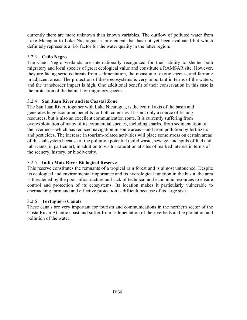
IV - 38
currently there are more unknown than known variables. The outflow of polluted water from Lake Managua to Lake Nicaragua is an element that has not yet been evaluated but which definitely represents a risk factor for the water quality in the latter region.
3.2.3 Caño Negro The Caño Negro wetlands are internationally recognized for their ability to shelter both migratory and local species of great ecological value and constitute a RAMSAR site. However, they are facing serious threats from sedimentation, the invasion of exotic species, and farming in adjacent areas. The protection of these ecosystems is very important in terms of the waters, and the transborder impact is high. One additional benefit of their conservation in this case is the protection of the habitat for migratory species.
3.2.4 San Juan River and its Coastal Zone The San Juan River, together with Lake Nicaragua, is the central axis of the basin and generates huge economic benefits for both countries. It is not only a source of fishing resources, but is also an excellent communication route. It is currently suffering from overexploitation of many of its commercial species, including sharks, from sedimentation of the riverbed—which has reduced navigation in some areas—and from pollution by fertilizers and pesticides. The increase in tourism-related activities will place some stress on certain areas of this subsystem because of the pollution potential (solid waste, sewage, and spills of fuel and lubricants, in particular), in addition to visitor saturation at sites of marked interest in terms of the scenery, history, or biodiversity.
3.2.5 Indio Maíz River Biological Reserve This reserve constitutes the remnants of a tropical rain forest and is almost untouched. Despite its ecological and environmental importance and its hydrological function in the basin, the area is threatened by the poor infrastructure and lack of technical and economic resources to ensure control and protection of its ecosystems. Its location makes it particularly vulnerable to encroaching farmland and effective protection is difficult because of its large size.
3.2.6 Tortuguero Canals These canals are very important for tourism and communications in the northern sector of the Costa Rican Atlantic coast and suffer from sedimentation of the riverbeds and exploitation and pollution of the water.
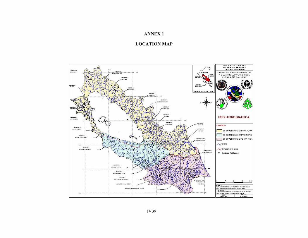
IV - 39
ANNEX 1
LOCATION MAP

IV - 40
ANNEX 2
FIGURES
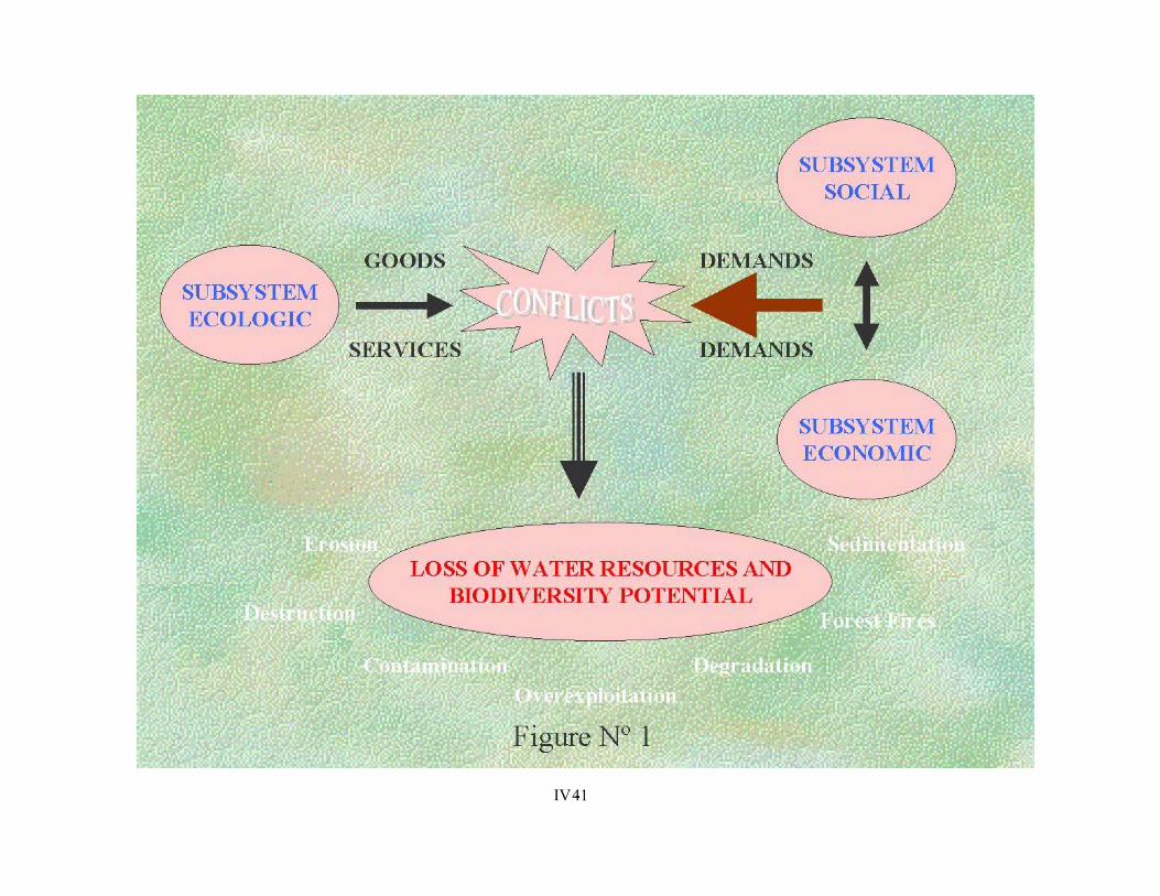
IV - 41
IV - 42

IV - 43
ANNEX 3
TABLES
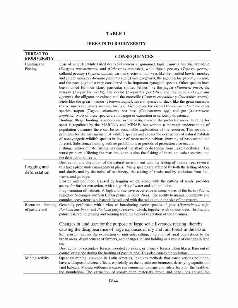
IV - 44
TABLE 1
THREATS TO BIODIVERSITY
THREAT TO BIODIVERSITY CONSEQUENCES Hunting and Fishing
Loss of wildlife: white tailed deer (Odoicoleus virginianus), tapir (Tapirus bairdii), armadillo (Dasypus novemcinctus) and (Cabassous centralis), white-lipped peccary (Tayassu pecari), collared peccary (Tayassu tajacu), various species of monkeys like the mantled howler monkey and spider monkey (Alouatta palliata) and (Ateles geoffroyi), the agouti (Dasyprocta punctata) and the paca (Agouti paca); considered to be important cynegetic species. Other species have been hunted for their skins, particular spotted felines like the jaguar (Panthera onca), the margay (Leopardus weidii), the ocelot (Leopardus pardalis), and the oncilla (Leopardus tigrinus), the alligator or caiman and the crocodile (Caiman crocodilus y Crocodilus acutus). Birds like the great tinamou (Tinamus major), several species of duck like the great currasow (Crax rubra) and others are used for food. Fish include the cichlid Cichlasoma dovil and other species, tarpon (Tarpon atlanticus), sea bass (Centropamus spp) and gar (Atractosteus tropicus). Most of these species are in danger of extinction or seriously threatened. Hunting: Illegal hunting is widespread in the basin, even in the protected areas. Hunting for sport is regulated by the MARENA and MINAE, but without a thorough understanding of population dynamics there can be no sustainable exploitation of the resource. This results in problems for the management of wildlife species and causes the destruction of natural habitats of noncynegetic wildlife species in favor of more usable habitats (burning of pastureland and forests). Subsistence hunting with no prohibitions or periods of protection also occurs. Fishing: Indiscriminate fishing has caused the shark to disappear from Lake Cocibolca. The worst problem afflicting the maritime zone is also the fishing of shark and other species, and the destruction of reefs.
Logging and deforestation
Destruction and disruption of the natural environment with the felling of mature trees (even if this takes place under management plans). Many species are affected by both the felling of trees and shrubs and by the noise of machinery, the cutting of roads, and by pollution from fuel, waste, and garbage. Erosion and pollution: Caused by logging which, along with the cutting of roads, provides access for further extraction, with a high risk of water and soil pollution. Fragmentation of habitats: A high and intensive occurrence in some zones of the basin (Pacific region of Nicaragua and San Carlos plains in Costa Rica). The ability to maintain complete and complex ecosystems is substantially reduced with the reduction in the size of the reserve.
Recurrent burning of pastureland
Generally performed with a view to introducing exotic species of grass (Hyparrhemia rufa, Panicum maximun, and Panicum purpurescens), which, together with various trees, shrubs, and palms resistant to grazing and burning form the typical vegetation of the savannas.
Changes in land use: for the purpose of large scale livestock rearing, thereby causing the disappearance of large expanses of dry and rain forest in the basin. Soil erosion: causes the exhaustion of nutrients, silting, migration of rural populations to the urban areas, displacement of farmers, and changes in land holding as a result of changes in land use. Destruction of secondary forests, wooded corridors, or primary forests when blazes flare out of control or escape during the burning of pastureland. This also causes air pollution.
Mining activity Opencast mining, common in Latin America, involves methods that cause serious pollution, have widespread adverse effects, especially on the aquatic environment, destroying aquatic and land habitats. Mining settlements cause environmental damage and side effects for the health of the population. The extraction of construction materials (stone and sand) has caused the
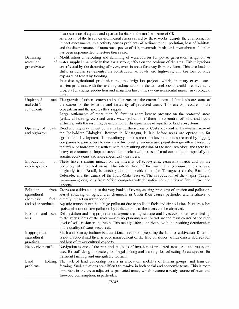
IV - 45
disappearance of aquatic and riparian habitats in the northern zone of CR. As a result of the heavy environmental stress caused by these works, despite the environmental impact assessments, this activity causes problems of sedimentation, pollution, loss of habitats, and the disappearance of numerous species of fish, mammals, birds, and invertebrates. No plan has been implemented to restore these sites.
Damming or rerouting of groundwater
Modification or rerouting and damming of watercourses for power generation, irrigation, or water supply is an activity that has a strong effect on the ecology of the area. Fish migrations are affected by the damming of rivers, even in areas far away from the dams. This also leads to shifts in human settlements, the construction of roads and highways, and the loss of wide expanses of forest by flooding. Intensive agricultural production requires irrigation projects which, in many cases, cause erosion problems, with the resulting sedimentation in the dam and loss of useful life. Hydraulic projects for energy production and irrigation have a heavy environmental impact in ecological terms.
Unplanned and makeshift settlements
The growth of urban centers and settlements and the encroachment of farmlands are some of the causes of the isolation and insularity of protected areas. This exerts pressure on the ecosystems and the species they support. Large settlements of more than 30 families exert intense pressure on the protected areas (unlawful hunting, etc.) and cause water pollution, if there is no control of solid and liquid effluents, with the resulting deterioration or disappearance of aquatic or land ecosystems.
Opening of roads and highways
Road and highway infrastructure in the northern zone of Costa Rica and in the western zone of the Indio-Maíz Biological Reserve in Nicaragua, is laid before areas are opened up for agricultural development. The resulting problems are as follows: the roads are used by logging companies to gain access to new areas for forestry resource use; population growth is caused by the influx of non-farming settlers with the resulting division of the land into plots; and there is a heavy environmental impact caused the mechanical process of road construction, especially on aquatic ecosystems and more specifically on rivers.
Introduction of exotic species
These have a strong impact on the integrity of ecosystems, especially inside and on the periphery of protected areas. The introduction of the water lily (Eichhornia crrassipes) originally from Brazil, is causing clogging problems in the Tortuguero canals, Barra del Colorado, and the canals of the Indio-Maíz reserve. The introduction of the tilapia (Tilapia mossambica) originally from Africa, competes with the native communities of fish in lakes and lagoons.
Pollution from agricultural chemicals, fuels and other products
Crops are cultivated up to the very banks of rivers, causing problems of erosion and pollution. Aerial spraying of agricultural chemicals in Costa Rica causes pesticides and fertilizers to directly impact on water bodies. Aquatic transport can be a huge pollutant due to spills of fuels and air pollution. Numerous hot spots and more diffuse pollution by fuels and oils in the rivers can be observed.
Erosion and soil loss
Deforestation and inappropriate management of agriculture and livestock—often extended up to the very shores of the rivers—with no planning and control are the main causes of the high level of soil erosion in the basin. This mainly affects the rivers, with the resulting deterioration in the quality of water resources.
Inappropriate agricultural practices
Slash and burn agriculture is a traditional method of preparing the land for cultivation. Rotation is not practiced and there is poor management of the land on slopes, which causes degradation and loss of its agricultural capacity.
Heavy river traffic Navigation is one of the principal methods of invasion of protected areas. Aquatic routes are used for trafficking in species, for illegal fishing and hunting, for collecting forest species, for transient farming, and unregulated tourism.
Land holding problems
The lack of land ownership results in relocation, mobility of human groups, and transient farming. Such situations are difficult to resolve in both social and economic terms. This is more important in the areas adjacent to protected areas, which become a ready source of meat and firewood consumption, in particular.
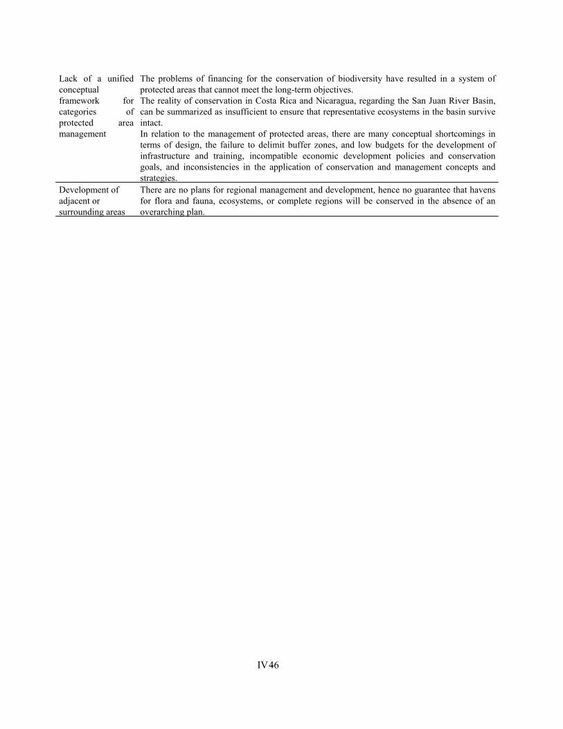
IV - 46
Lack of a unified conceptual framework for categories of protected area management
The problems of financing for the conservation of biodiversity have resulted in a system of protected areas that cannot meet the long-term objectives. The reality of conservation in Costa Rica and Nicaragua, regarding the San Juan River Basin, can be summarized as insufficient to ensure that representative ecosystems in the basin survive intact. In relation to the management of protected areas, there are many conceptual shortcomings in terms of design, the failure to delimit buffer zones, and low budgets for the development of infrastructure and training, incompatible economic development policies and conservation goals, and inconsistencies in the application of conservation and management concepts and strategies.
Development of adjacent or surrounding areas
There are no plans for regional management and development, hence no guarantee that havens for flora and fauna, ecosystems, or complete regions will be conserved in the absence of an overarching plan.
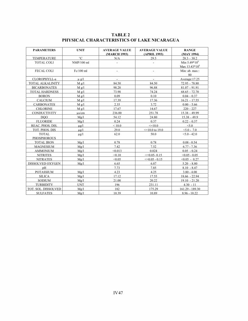
IV - 47
TABLE 2 PHYSICAL CHARACTERISTICS OF LAKE NICARAGUA
PARAMETERS UNIT AVERAGE VALUE
(MARCH 1993) AVERAGE VALUE
(APRIL 1993) RANGE
(MAY 1994) TEMPERATURE °C N/A 29.5 28.3 – 30.2
TOTAL COLI NMP/100 ml - - Min 5.49*106 Max 13.43*106
FECAL COLI Fc/100 ml - - Min: ab. max:: 80
CLOROPHYLL-a µ g/l - - Average:17.25 TOTAL ALKALINITY M g/l 84.50 84.50 72.95 – 78.80
BICARBONATES M g/l 98.28 96.88 81.07 – 91.91 TOTAL HARDNESS M g/l 73.98 74.24 68.65 – 72.70
BORON M g/l 0.09 0.10 0.04 – 0.37 CALCIUM M g/l 17.39 17.36 16.21 – 17.55
CARBONATES M g/l 2.35 3.72 0.00 – 5.66 CHLORINE M g/l 17.67 14.67 220 – 227
CONDUCTIVITY µs/cm 236.00 251.78 15.38 – 49.99 DQO Mg/l 54.12 24.80 15.38 – 49.9
FLUORIDE Mg/l 0.24 0.37 0.22 – 0.37 REAC. PHOS. DIS. µg/l < 10.0 <=10.0 <5.0 TOT. PHOS. DIS µg/l 29.0 <=10.0 to 19.0 <5.0 - 7.0
TOTAL PHOSPHOROUS
µg/l 62.0 50.0 <5.0 - 42.0
TOTAL IRON Mg/l 0.78 0.78 0.08 - 0.54 MAGNESIUM Mg/l 7.42 7.52 6.77 - 7.36 AMMONIUM Mg/l <0.013 0.024 0.05 - 0.24
NITRITES Mg/l <0.10 <=0.05- 0.15 <0.05 - 0.05 NITRATES Mg/l <0.05 <=0.05 - 0.15 <0.05 - 0.27
DISSOLVED OXYGEN Mg/l 6.65 6.87 5.20 - 8.80 pH 7.73 7.85 8.10 - 8.47
POTASSIUM Mg/l 4.23 4.25 3.80 - 4.00 SILICA Mg/l 17.12 17.55 18.66 - 22.94
SODIUM Mg/l 21.00 20.22 19.10 - 21.20 TURBIDITY UNT 196 231.11 4.30 - 11
TOT. SOL. DISSOLVED Mg/l 182 175.29 161.29 - 189.30 SULFATES Mg/l 10.39 10.89 8.96 - 10.22
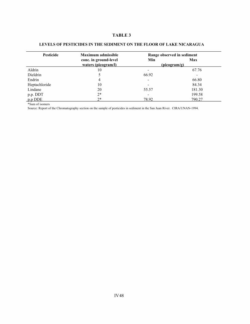
IV - 48
TABLE 3
LEVELS OF PESTICIDES IN THE SEDIMENT ON THE FLOOR OF LAKE NICARAGUA
Pesticide Maximum admissible conc. in ground-level waters (picogram/l)
Range observed in sediment Min Max
(picogram/g) Aldrin 10 - 67.76 Dieldrin 5 66.92 - Endrin 4 - 66.80 Heptachloride 10 - 84.34 Lindane 20 55.57 181.30 p.p. DDT 2* - 199.58 p.p DDE 2* 78.92 790.27 *Sum of isomers Source: Report of the Chromatography section on the sample of pesticides in sediment in the San Juan River. CIRA/UNAN-1994.
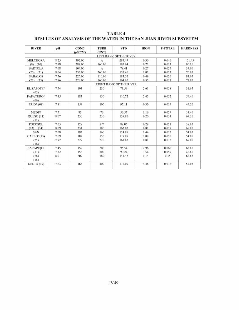
IV - 49
TABLE 4 RESULTS OF ANALYSIS OF THE WATER IN THE SAN JUAN RIVER SUBSYSTEM
RIVER pH COND
(µS/CM) TURB (UNT)
STD IRON P-TOTAL HARDNESS
LEFT BANK OF THE RIVER MELCHORA
(9) (10) 8.25 7.99
392.00 284.00
A 160.00
284.47 197.64
0.36 0.73
0.046 0.033
151.45 90.10
BARTOLA (20) (21)
7.68 8.04
104.00 233.00
A 260.00
78.41 157.46
0.27 1.02
0.027 0.023
37.00 70.05
SABALOS (22) (23)
7.76 7.86
226.00 228.00
110.00 160.00
183.55 164.65
0.49 0.55
0.026 0.031
84.05 71.05
RIGHT BANK OF THE RIVER EL ZAPOTE*
(05) 7.74 103 230 73.59 2.61 0.058 31.65
PAPATURO* (06)
7.45 183 150 110.72 2.45 0.052 59.40
FRIO* (08) 7.81 154 100 97.11 0.30 0.019 49.50
MEDIO QUESO (11)
(12)
7.71 8.07
83 230
76 230
56.57 159.85
1.16 0.20
0.029 0.034
14.40 67.30
POCOSOL (13) (14)
7.65 8.09
128 231
8.7 180
89.06 163.02
0.29 0.81
0.021 0.029
38.65 68.05
SAN CARLOS(15)
(25) (16)
7.69 7.69 7.92
192 187 227
160 150 220
124.89 119.88 161.63
1.44 2.08 0.81
0.035 0.055 0.032
54.05 54.05 67.05
SARAPIQUI (17) (26) (18)
7.45 7.32 8.01
159 153 209
200 300 180
95.54 90.24 141.45
2.96 3.54 1.14
0.060 0.059 0.35
62.65 48.65 62.65
DELTA (19) 7.63 166 400 117.09 4.46 0.076 52.05
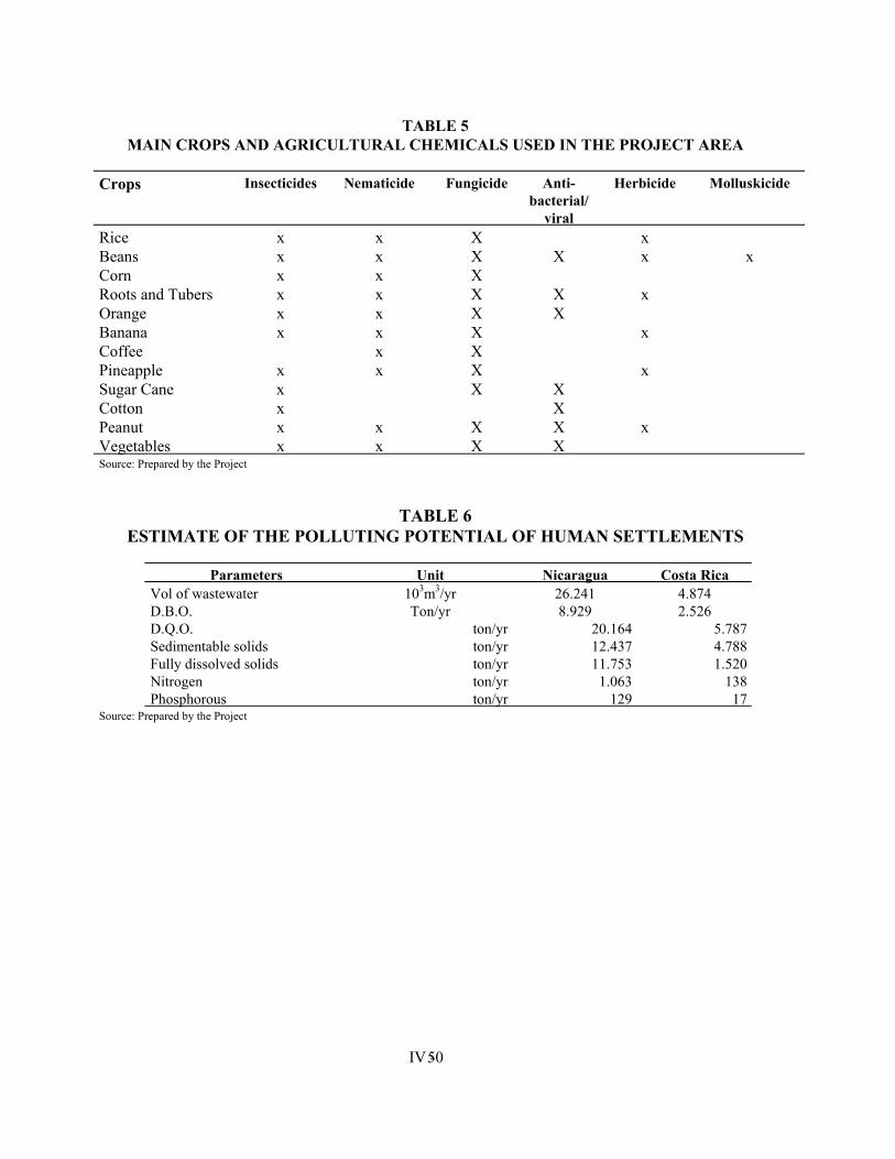
IV - 50
TABLE 5 MAIN CROPS AND AGRICULTURAL CHEMICALS USED IN THE PROJECT AREA
Crops Insecticides Nematicide Fungicide Anti-
bacterial/ viral
Herbicide Molluskicide
Rice x x X x Beans x x X X x x Corn x x X Roots and Tubers x x X X x Orange x x X X Banana x x X x Coffee x X Pineapple x x X x Sugar Cane x X X Cotton x X Peanut x x X X x Vegetables x x X X Source: Prepared by the Project
TABLE 6 ESTIMATE OF THE POLLUTING POTENTIAL OF HUMAN SETTLEMENTS
Parameters Unit Nicaragua Costa Rica
Vol of wastewater 103m3/yr 26.241 4.874 D.B.O. Ton/yr 8.929 2.526 D.Q.O. ton/yr 20.164 5.787 Sedimentable solids ton/yr 12.437 4.788 Fully dissolved solids ton/yr 11.753 1.520 Nitrogen ton/yr 1.063 138 Phosphorous ton/yr 129 17
Source: Prepared by the Project
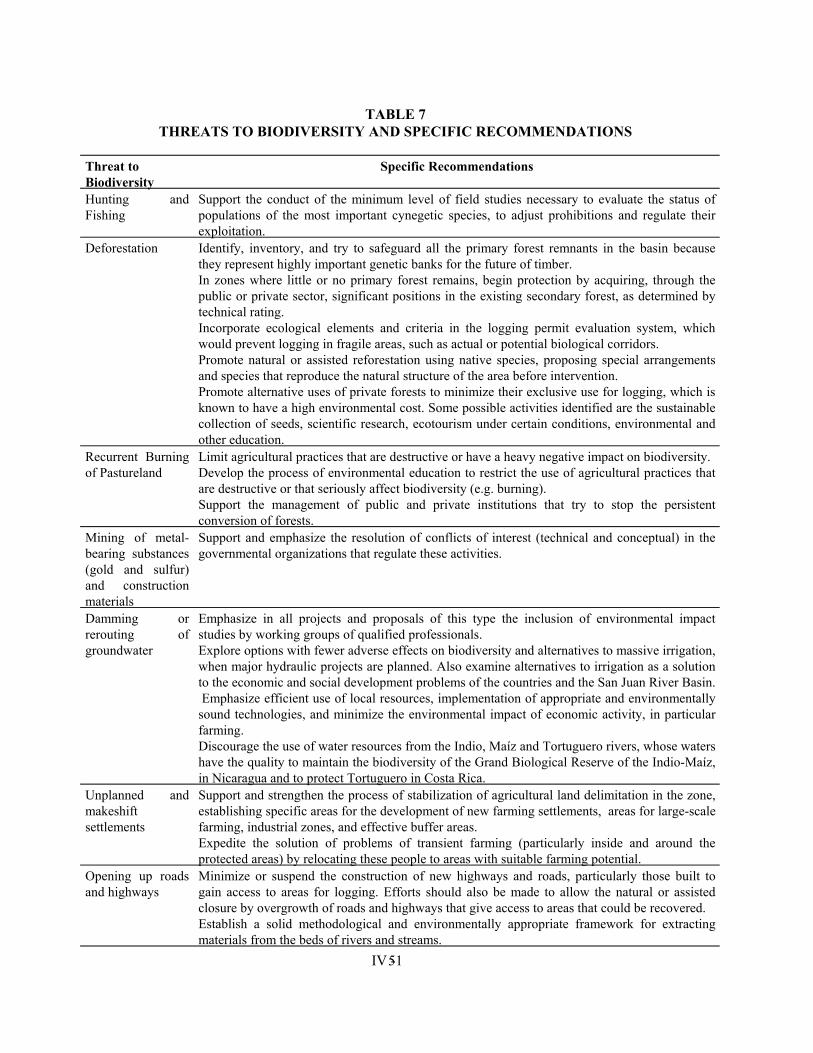
IV - 51
TABLE 7 THREATS TO BIODIVERSITY AND SPECIFIC RECOMMENDATIONS
Threat to Biodiversity
Specific Recommendations
Hunting and Fishing
Support the conduct of the minimum level of field studies necessary to evaluate the status of populations of the most important cynegetic species, to adjust prohibitions and regulate their exploitation.
Deforestation Identify, inventory, and try to safeguard all the primary forest remnants in the basin because they represent highly important genetic banks for the future of timber. In zones where little or no primary forest remains, begin protection by acquiring, through the public or private sector, significant positions in the existing secondary forest, as determined by technical rating. Incorporate ecological elements and criteria in the logging permit evaluation system, which would prevent logging in fragile areas, such as actual or potential biological corridors. Promote natural or assisted reforestation using native species, proposing special arrangements and species that reproduce the natural structure of the area before intervention. Promote alternative uses of private forests to minimize their exclusive use for logging, which is known to have a high environmental cost. Some possible activities identified are the sustainable collection of seeds, scientific research, ecotourism under certain conditions, environmental and other education.
Recurrent Burning of Pastureland
Limit agricultural practices that are destructive or have a heavy negative impact on biodiversity. Develop the process of environmental education to restrict the use of agricultural practices that are destructive or that seriously affect biodiversity (e.g. burning). Support the management of public and private institutions that try to stop the persistent conversion of forests.
Mining of metal-bearing substances (gold and sulfur) and construction materials
Support and emphasize the resolution of conflicts of interest (technical and conceptual) in the governmental organizations that regulate these activities.
Damming or rerouting of groundwater
Emphasize in all projects and proposals of this type the inclusion of environmental impact studies by working groups of qualified professionals. Explore options with fewer adverse effects on biodiversity and alternatives to massive irrigation, when major hydraulic projects are planned. Also examine alternatives to irrigation as a solution to the economic and social development problems of the countries and the San Juan River Basin. Emphasize efficient use of local resources, implementation of appropriate and environmentally sound technologies, and minimize the environmental impact of economic activity, in particular farming. Discourage the use of water resources from the Indio, Maíz and Tortuguero rivers, whose waters have the quality to maintain the biodiversity of the Grand Biological Reserve of the Indio-Maíz, in Nicaragua and to protect Tortuguero in Costa Rica.
Unplanned and makeshift settlements
Support and strengthen the process of stabilization of agricultural land delimitation in the zone, establishing specific areas for the development of new farming settlements, areas for large-scale farming, industrial zones, and effective buffer areas. Expedite the solution of problems of transient farming (particularly inside and around the protected areas) by relocating these people to areas with suitable farming potential.
Opening up roads and highways
Minimize or suspend the construction of new highways and roads, particularly those built to gain access to areas for logging. Efforts should also be made to allow the natural or assisted closure by overgrowth of roads and highways that give access to areas that could be recovered. Establish a solid methodological and environmentally appropriate framework for extracting materials from the beds of rivers and streams.
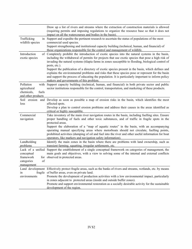
IV - 52
Draw up a list of rivers and streams where the extraction of construction materials is allowed (requiring permits and imposing regulations to organize the resource base so that it does not impact on all the watercourses and bodies in the basin).
Trafficking in wildlife species
Support and expedite the pertinent research to ascertain the status of populations of the most commercial used species. Support strengthening and institutional capacity building (technical, human, and financial) of those organizations responsible for the control and management of wildlife.
Introduction of exotic species
Completely prohibit the introduction of exotic species into the natural systems in the basin, including the withdrawal of permits for projects that use exotic species that pose a high risk of invading the natural systems (tilapia farms in zones susceptible to flooding, biological control of pests, etc.). Support the publication of a directory of exotic species present in the basin, which defines and explains the environmental problems and risks that these species pose or represent for the basin and support the process of educating the population. It is particularly important to inform policy makers and governments of this problem.
Pollution with agricultural chemicals, fuels and other products
Support capacity building (technical, human, and financial) in both private sector and public sector institutions responsible for the control, transportation, and marketing of these products.
Soil erosion and loss
Develop as soon as possible a map of erosion risks in the basin, which identifies the most affected spots. Develop a plan to control erosion problems and address their causes in the areas identified as critical or highly susceptible.
Commercial navigation
Take inventory of the main river navigation routes in the basin, including fuelling sites. Ensure proper handling of fuels and other toxic substances, and of traffic in fragile spots in the protected areas. Support the elaboration of a “map of aquatic routes” in the basin, with an accompanying operating manual specifying areas where motorboats should not circulate, fuelling points, prohibited activities (dumping of oil and fuel into the river and other useful information for boat operators, like markers and navigation safety information).
Landholding problems
Identify the main zones in the basin where there are problems with land ownership, such as transient farming, squatting, irregular settlements, etc.
Lack of a unified conceptual framework for categories of management
Support the establishment of a single conceptual framework on categories of management, the main goals and objectives, with a view to solving some of the internal and external conflicts observed in protected areas.
Land development in fragile environments
Effectively protect fragile areas, such as the banks of rivers and streams, wetlands, etc. by means of buffer areas, even on private land. Promote the development of production activities with a low environmental impact, particularly in zones adjacent to protected areas (inside and outside buffer zones). Promote and support environmental restoration as a socially desirable activity for the sustainable development of the region.
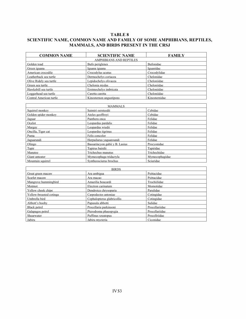
IV - 53
TABLE 8 SCIENTIFIC NAME, COMMON NAME AND FAMILY OF SOME AMPHIBIANS, REPTILES,
MAMMALS, AND BIRDS PRESENT IN THE CRSJ
COMMON NAME SCIENTIFIC NAME FAMILY AMPHIBIANS AND REPTILES
Golden toad Bufo periglenes Bufonidae Green iguana Iguana iguana Iguanidae American crocodile Crocodylus acutus Crocodylidae Leatherback sea turtle Dermochelys coriacea Chelonidae Olive Ridely sea turtle Lepidochelys olivacea Cheloniidae Green sea turtle Chelonia mydas Cheloniidae Hawksbill sea turtle Eretmochelys imbricata Cheloniidae Loggerhead sea turtle Caretta caretta Cheloniidae Central American turtle Kinosternon angustipons Kinosternidae
MAMMALS Squirrel monkey Saimiri oersteedii Cebidae Golden spider monkey Ateles geoffroyi Cebidae Jaguar Panthera onca Felidae Ocelot Leopardus pardalis Felidae Margay Leopardus wiedii Felidae Oncilla, Tiger cat Leopardus tigrinus Felidae Puma Felis concolor Felidae Jaguarundi Herpailurus yaguaroundi Felidae Olingo Bassarincyon gabii y B. Lasius Procyonidae Tapir Tapirus bairdii Tapiridae Manatee Trichechus manatus Trichechidae Giant anteater Mymecophaga tridactyla Mymecophagidae Mountain squirrel Syntheosciurus brochus Sciuridae
BIRDS Great green macaw Ara ambigua Psittacidae Scarlet macaw Ara macao Psittacidae Mangrove hummingbird Amazilia boucardi Trochiilidae Motmot Electron carinatum Momotidae Yellow cheek chipe Dendroica chrysoparia Parulidae Yellow-breasted cotinga Carpodectes antoniae Cotingidae Umbrella bird Cephalopterus glabricollis Cotingidae Abbott’s booby Papasula abbotti Sulidae Black petrel Procellaria parkinsoni Procellariidae Galapagos petrel Pterodroma phaeopygia Procellariidae Shearwater Puffinus xreatopus Procellriidae Jabiru Jabiru mycteria Ciconidae
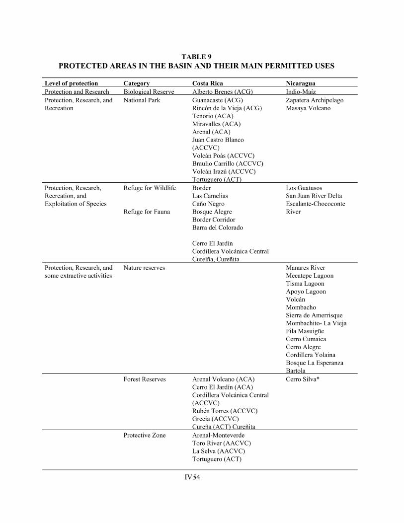
IV - 54
TABLE 9 PROTECTED AREAS IN THE BASIN AND THEIR MAIN PERMITTED USES
Level of protection Category Costa Rica Nicaragua Protection and Research Biological Reserve Alberto Brenes (ACG) Indio-Maíz Protection, Research, and Recreation
National Park Guanacaste (ACG) Rincón de la Vieja (ACG) Tenorio (ACA) Miravalles (ACA) Arenal (ACA) Juan Castro Blanco (ACCVC) Volcán Poás (ACCVC) Braulio Carrillo (ACCVC) Volcán Irazú (ACCVC) Tortuguero (ACT)
Zapatera Archipelago Masaya Volcano
Protection, Research, Recreation, and Exploitation of Species
Refuge for Wildlife Refuge for Fauna
Border Las Camelias Caño Negro Bosque Alegre Border Corridor Barra del Colorado Cerro El Jardín Cordillera Volcánica Central Curelña, Cureñita
Los Guatusos San Juan River Delta Escalante-Chococonte River
Protection, Research, and some extractive activities
Nature reserves Manares River Mecatepe Lagoon Tisma Lagoon Apoyo Lagoon Volcán Mombacho Sierra de Amerrisque Mombachito- La Vieja Fila Masuigüe Cerro Cumaica Cerro Alegre Cordillera Yolaina Bosque La Esperanza Bartola
Forest Reserves Arenal Volcano (ACA) Cerro El Jardín (ACA) Cordillera Volcánica Central (ACCVC) Rubén Torres (ACCVC) Grecia (ACCVC) Cureña (ACT) Cureñita
Cerro Silva*
Protective Zone Arenal-Monteverde Toro River (AACVC) La Selva (AACVC) Tortuguero (ACT)
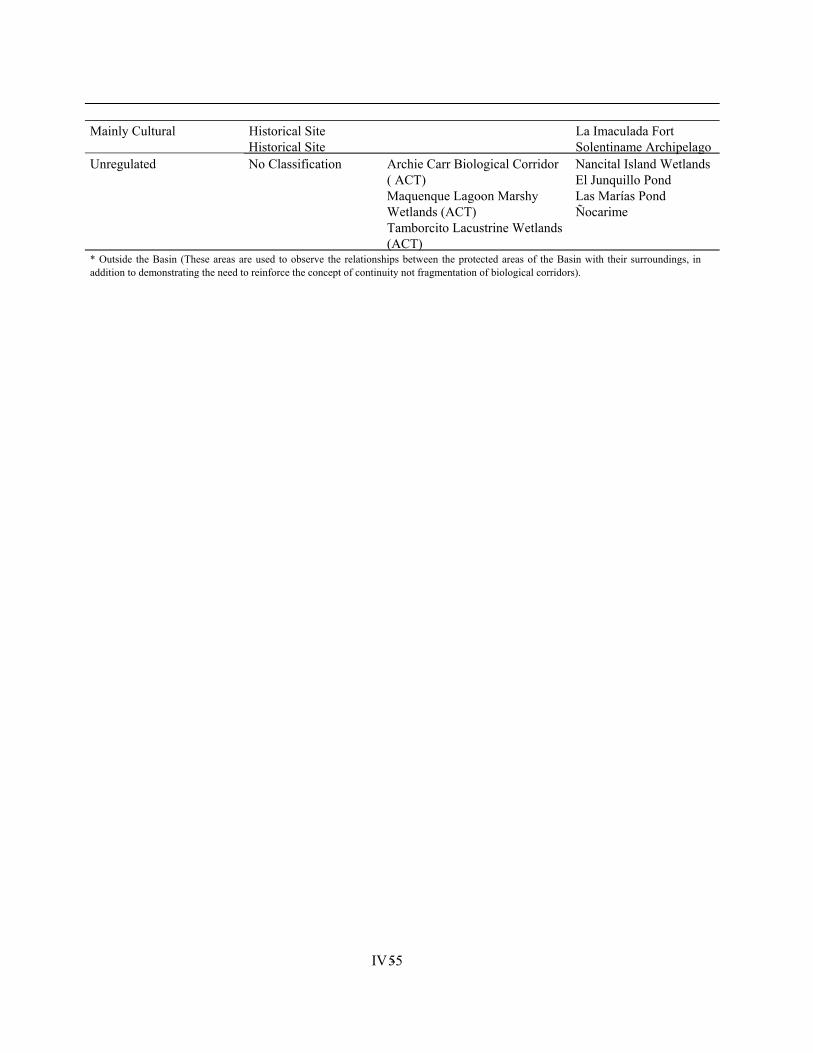
IV - 55
Mainly Cultural Historical Site La Imaculada Fort Historical Site Solentiname Archipelago Unregulated No Classification Archie Carr Biological Corridor
( ACT) Maquenque Lagoon Marshy Wetlands (ACT) Tamborcito Lacustrine Wetlands (ACT)
Nancital Island Wetlands El Junquillo Pond Las Marías Pond Ñocarime
* Outside the Basin (These areas are used to observe the relationships between the protected areas of the Basin with their surroundings, in addition to demonstrating the need to reinforce the concept of continuity not fragmentation of biological corridors).
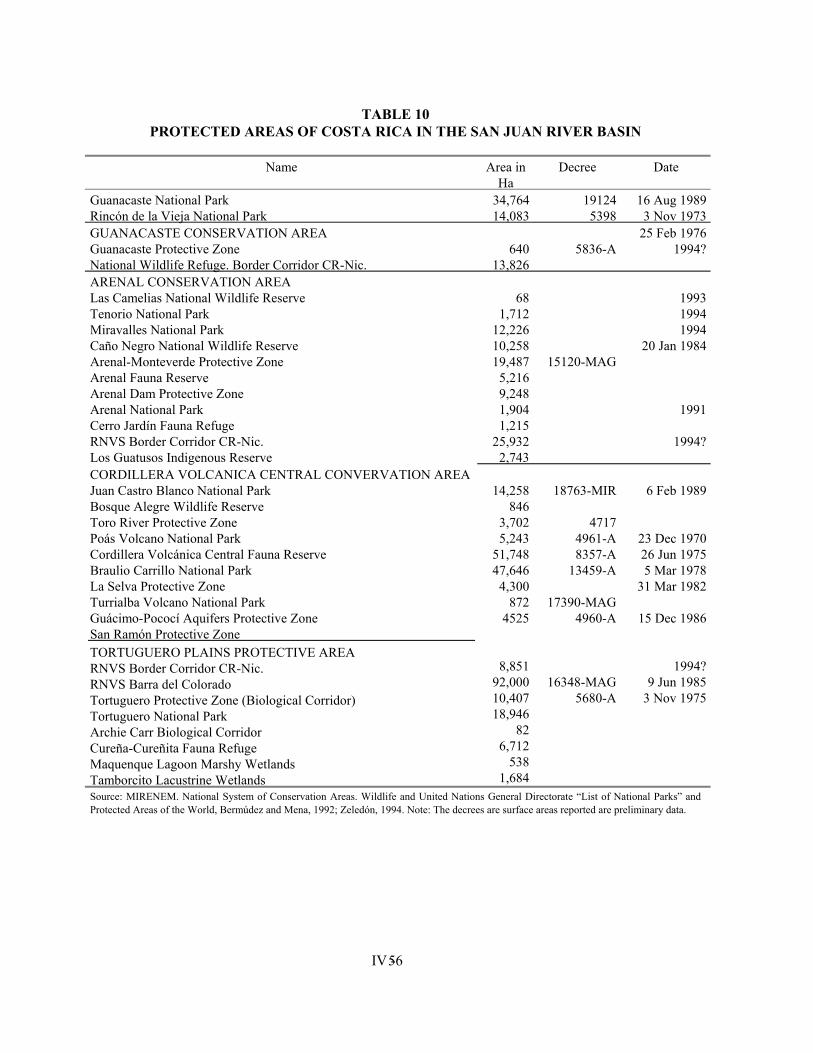
IV - 56
TABLE 10 PROTECTED AREAS OF COSTA RICA IN THE SAN JUAN RIVER BASIN
Name Area in
Ha Decree Date
Guanacaste National Park 34,764 19124 16 Aug 1989 Rincón de la Vieja National Park 14,083 5398 3 Nov 1973 GUANACASTE CONSERVATION AREA Guanacaste Protective Zone National Wildlife Refuge. Border Corridor CR-Nic.
640
13,826
5836-A
25 Feb 1976 1994?
ARENAL CONSERVATION AREA Las Camelias National Wildlife Reserve Tenorio National Park Miravalles National Park Caño Negro National Wildlife Reserve Arenal-Monteverde Protective Zone Arenal Fauna Reserve Arenal Dam Protective Zone Arenal National Park Cerro Jardín Fauna Refuge RNVS Border Corridor CR-Nic. Los Guatusos Indigenous Reserve
68
1,712 12,226 10,258 19,487
5,216 9,248 1,904 1,215
25,932 2,743
15120-MAG
1993 1994 1994
20 Jan 1984
1991
1994?
CORDILLERA VOLCANICA CENTRAL CONVERVATION AREA Juan Castro Blanco National Park Bosque Alegre Wildlife Reserve Toro River Protective Zone Poás Volcano National Park Cordillera Volcánica Central Fauna Reserve Braulio Carrillo National Park La Selva Protective Zone Turrialba Volcano National Park Guácimo-Pococí Aquifers Protective Zone San Ramón Protective Zone TORTUGUERO PLAINS PROTECTIVE AREA RNVS Border Corridor CR-Nic. RNVS Barra del Colorado Tortuguero Protective Zone (Biological Corridor) Tortuguero National Park Archie Carr Biological Corridor Cureña-Cureñita Fauna Refuge Maquenque Lagoon Marshy Wetlands Tamborcito Lacustrine Wetlands
14,258
846 3,702 5,243
51,748 47,646
4,300 872
4525
8,851 92,000 10,407 18,946
82 6,712
538 1,684
18763-MIR
4717
4961-A 8357-A
13459-A
17390-MAG 4960-A
16348-MAG 5680-A
6 Feb 1989
23 Dec 1970 26 Jun 1975 5 Mar 1978
31 Mar 1982
15 Dec 1986
1994? 9 Jun 1985
3 Nov 1975
Source: MIRENEM. National System of Conservation Areas. Wildlife and United Nations General Directorate “List of National Parks” and Protected Areas of the World, Bermúdez and Mena, 1992; Zeledón, 1994. Note: The decrees are surface areas reported are preliminary data.
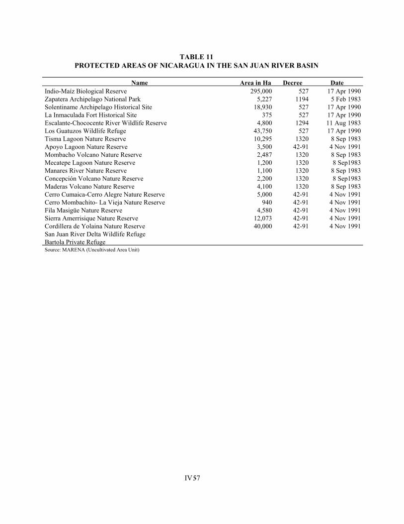
IV - 57
TABLE 11 PROTECTED AREAS OF NICARAGUA IN THE SAN JUAN RIVER BASIN
Name Area in Ha Decree Date
Indio-Maíz Biological Reserve 295,000 527 17 Apr 1990 Zapatera Archipelago National Park 5,227 1194 5 Feb 1983 Solentiname Archipelago Historical Site 18,930 527 17 Apr 1990 La Inmaculada Fort Historical Site 375 527 17 Apr 1990 Escalante-Chococente River Wildlife Reserve 4,800 1294 11 Aug 1983 Los Guatuzos Wildlife Refuge 43,750 527 17 Apr 1990 Tisma Lagoon Nature Reserve 10,295 1320 8 Sep 1983 Apoyo Lagoon Nature Reserve 3,500 42-91 4 Nov 1991 Mombacho Volcano Nature Reserve 2,487 1320 8 Sep 1983 Mecatepe Lagoon Nature Reserve 1,200 1320 8 Sep1983 Manares River Nature Reserve 1,100 1320 8 Sep 1983 Concepción Volcano Nature Reserve 2,200 1320 8 Sep1983 Maderas Volcano Nature Reserve 4,100 1320 8 Sep 1983 Cerro Cumaica-Cerro Alegre Nature Reserve 5,000 42-91 4 Nov 1991 Cerro Mombachito- La Vieja Nature Reserve 940 42-91 4 Nov 1991 Fila Masigüe Nature Reserve 4,580 42-91 4 Nov 1991 Sierra Amerrisique Nature Reserve 12,073 42-91 4 Nov 1991 Cordillera de Yolaina Nature Reserve 40,000 42-91 4 Nov 1991 San Juan River Delta Wildlife Refuge Bartola Private Refuge Source: MARENA (Uncultivated Area Unit)
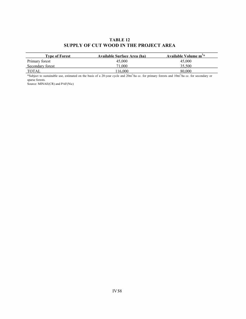
IV - 58
TABLE 12
SUPPLY OF CUT WOOD IN THE PROJECT AREA
Type of Forest Available Surface Area (ha) Available Volume m3* Primary forest 45,000 45,000 Secondary forest 71,000 35,500 TOTAL 116,000 80,000 *Subject to sustainable use, estimated on the basis of a 20-year cycle and 20m3/ha cc. for primary forests and 10m3/ha cc. for secondary or sparse forests. Source: MINAE(CR) and PAF(Nic)
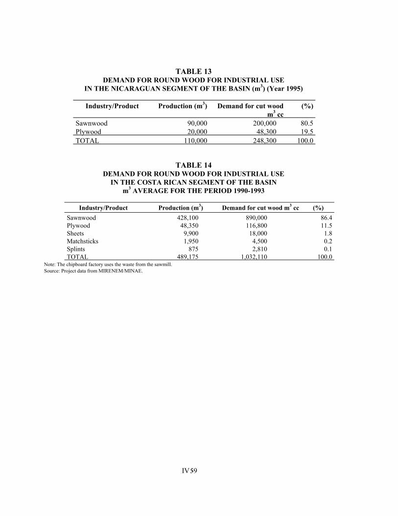
IV - 59
TABLE 13 DEMAND FOR ROUND WOOD FOR INDUSTRIAL USE
IN THE NICARAGUAN SEGMENT OF THE BASIN (m3) (Year 1995)
Industry/Product Production (m3) Demand for cut wood m3 cc
(%)
Sawnwood 90,000 200,000 80.5 Plywood 20,000 48,300 19.5 TOTAL 110,000 248,300 100.0
TABLE 14 DEMAND FOR ROUND WOOD FOR INDUSTRIAL USE
IN THE COSTA RICAN SEGMENT OF THE BASIN m3 AVERAGE FOR THE PERIOD 1990-1993
Industry/Product Production (m3) Demand for cut wood m3 cc (%)
Sawnwood 428,100 890,000 86.4 Plywood 48,350 116,800 11.5 Sheets 9,900 18,000 1.8 Matchsticks 1,950 4,500 0.2 Splints 875 2,810 0.1 TOTAL 489,175 1,032,110 100.0
Note: The chipboard factory uses the waste from the sawmill. Source: Project data from MIRENEM/MINAE.
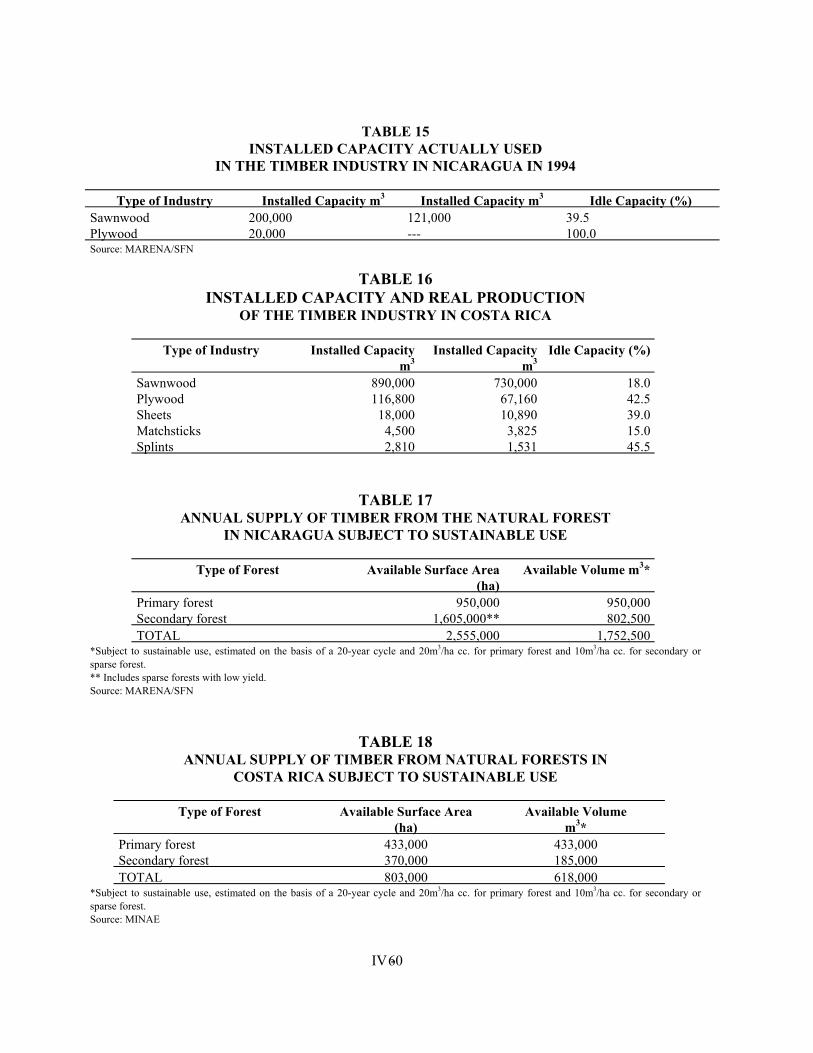
IV - 60
TABLE 15
INSTALLED CAPACITY ACTUALLY USED IN THE TIMBER INDUSTRY IN NICARAGUA IN 1994
Type of Industry Installed Capacity m3 Installed Capacity m3 Idle Capacity (%)
Sawnwood 200,000 121,000 39.5 Plywood 20,000 --- 100.0 Source: MARENA/SFN
TABLE 16 INSTALLED CAPACITY AND REAL PRODUCTION
OF THE TIMBER INDUSTRY IN COSTA RICA
Type of Industry Installed Capacity m3
Installed Capacity m3
Idle Capacity (%)
Sawnwood 890,000 730,000 18.0 Plywood 116,800 67,160 42.5 Sheets 18,000 10,890 39.0 Matchsticks 4,500 3,825 15.0 Splints 2,810 1,531 45.5
TABLE 17 ANNUAL SUPPLY OF TIMBER FROM THE NATURAL FOREST
IN NICARAGUA SUBJECT TO SUSTAINABLE USE
Type of Forest Available Surface Area (ha)
Available Volume m3*
Primary forest 950,000 950,000 Secondary forest 1,605,000** 802,500 TOTAL 2,555,000 1,752,500
*Subject to sustainable use, estimated on the basis of a 20-year cycle and 20m3/ha cc. for primary forest and 10m3/ha cc. for secondary or sparse forest. ** Includes sparse forests with low yield. Source: MARENA/SFN
TABLE 18 ANNUAL SUPPLY OF TIMBER FROM NATURAL FORESTS IN
COSTA RICA SUBJECT TO SUSTAINABLE USE
Type of Forest Available Surface Area (ha)
Available Volume m3*
Primary forest 433,000 433,000 Secondary forest 370,000 185,000 TOTAL 803,000 618,000
*Subject to sustainable use, estimated on the basis of a 20-year cycle and 20m3/ha cc. for primary forest and 10m3/ha cc. for secondary or sparse forest. Source: MINAE
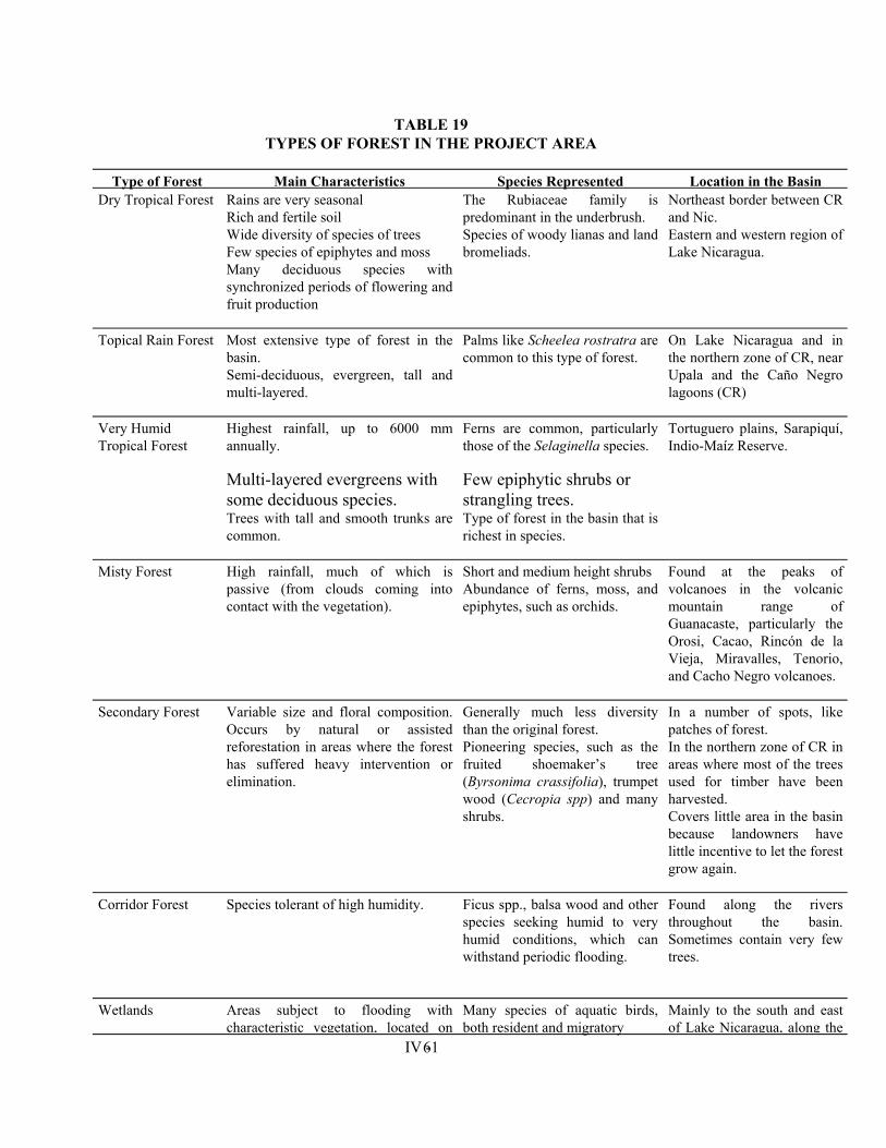
IV - 61
TABLE 19 TYPES OF FOREST IN THE PROJECT AREA
Type of Forest Main Characteristics Species Represented Location in the Basin
Dry Tropical Forest Rains are very seasonal Rich and fertile soil Wide diversity of species of trees Few species of epiphytes and moss Many deciduous species with synchronized periods of flowering and fruit production
The Rubiaceae family is predominant in the underbrush. Species of woody lianas and land bromeliads.
Northeast border between CR and Nic. Eastern and western region of Lake Nicaragua.
Topical Rain Forest Most extensive type of forest in the basin. Semi-deciduous, evergreen, tall and multi-layered.
Palms like Scheelea rostratra are common to this type of forest.
On Lake Nicaragua and in the northern zone of CR, near Upala and the Caño Negro lagoons (CR)
Very Humid Tropical Forest
Highest rainfall, up to 6000 mm annually.
Multi-layered evergreens with some deciduous species. Trees with tall and smooth trunks are common.
Ferns are common, particularly those of the Selaginella species.
Few epiphytic shrubs or strangling trees. Type of forest in the basin that is richest in species.
Tortuguero plains, Sarapiquí, Indio-Maíz Reserve.
Misty Forest High rainfall, much of which is passive (from clouds coming into contact with the vegetation).
Short and medium height shrubs Abundance of ferns, moss, and epiphytes, such as orchids.
Found at the peaks of volcanoes in the volcanic mountain range of Guanacaste, particularly the Orosi, Cacao, Rincón de la Vieja, Miravalles, Tenorio, and Cacho Negro volcanoes.
Secondary Forest Variable size and floral composition. Occurs by natural or assisted reforestation in areas where the forest has suffered heavy intervention or elimination.
Generally much less diversity than the original forest. Pioneering species, such as the fruited shoemaker’s tree (Byrsonima crassifolia), trumpet wood (Cecropia spp) and many shrubs.
In a number of spots, like patches of forest. In the northern zone of CR in areas where most of the trees used for timber have been harvested. Covers little area in the basin because landowners have little incentive to let the forest grow again.
Corridor Forest Species tolerant of high humidity. Ficus spp., balsa wood and other species seeking humid to very humid conditions, which can withstand periodic flooding.
Found along the rivers throughout the basin. Sometimes contain very few trees.
Wetlands Areas subject to flooding with characteristic vegetation, located on
Many species of aquatic birds, both resident and migratory
Mainly to the south and east of Lake Nicaragua, along the
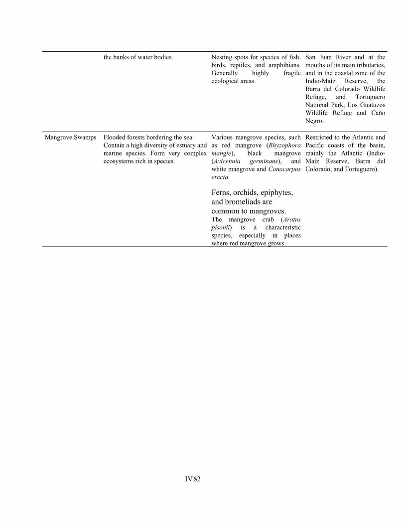
IV - 62
the banks of water bodies. Nesting spots for species of fish, birds, reptiles, and amphibians. Generally highly fragile ecological areas.
San Juan River and at the mouths of its main tributaries, and in the coastal zone of the Indio-Maíz Reserve, the Barra del Colorado Wildlife Refuge, and Tortuguero National Park, Los Guatuzos Wildlife Refuge and Caño Negro.
Mangrove Swamps Flooded forests bordering the sea. Contain a high diversity of estuary and marine species. Form very complex ecosystems rich in species.
Various mangrove species, such as red mangrove (Rhyzophora mangle), black mangrove (Avicennia germinans), and white mangrove and Conocarpus erecta.
Ferns, orchids, epiphytes, and bromeliads are common to mangroves. The mangrove crab (Aratus pisonii) is a characteristic species, especially in places where red mangrove grows.
Restricted to the Atlantic and Pacific coasts of the basin, mainly the Atlantic (Indio-Maíz Reserve, Barra del Colorado, and Tortuguero).
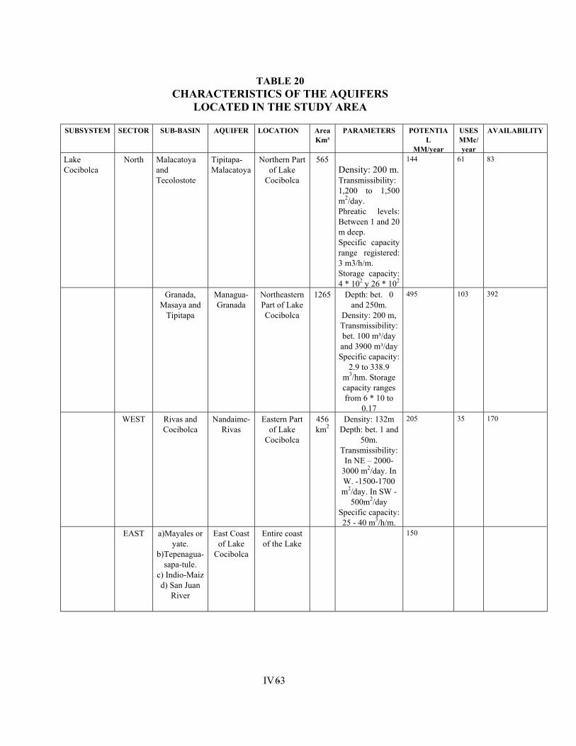
IV - 63
TABLE 20 CHARACTERISTICS OF THE AQUIFERS
LOCATED IN THE STUDY AREA
SUBSYSTEM SECTOR SUB-BASIN AQUIFER LOCATION Area Km³
PARAMETERS POTENTIAL
MM/year
USES MMc/year
AVAILABILITY
Lake Cocibolca
North Malacatoya and Tecolostote
Tipitapa-Malacatoya
Northern Part of Lake
Cocibolca
565 Density: 200 m. Transmissibility: 1,200 to 1,500 m2/day. Phreatic levels: Between 1 and 20 m deep. Specific capacity range registered: 3 m3/h/m. Storage capacity: 4 * 102 y 26 * 102
144 61 83
Granada, Masaya and
Tipitapa
Managua-Granada
Northeastern Part of Lake Cocibolca
1265 Depth: bet. 0 and 250m.
Density: 200 m, Transmissibility: bet. 100 m³/day and 3900 m³/day Specific capacity:
2.9 to 338.9 m3/hm. Storage capacity ranges from 6 * 10 to
0.17
495 103 392
WEST Rivas and Cocibolca
Nandaime-Rivas
Eastern Part of Lake
Cocibolca
456 km2
Density: 132m Depth: bet. 1 and
50m. Transmissibility:
In NE – 2000- 3000 m2/day. In W. -1500-1700 m2/day. In SW -
500m2/day Specific capacity: 25 - 40 m3/h/m.
205 35 170
EAST a)Mayales or yate.
b)Tepenagua-sapa-tule.
c) Indio-Maiz d) San Juan
River
East Coast of Lake
Cocibolca
Entire coast of the Lake
150
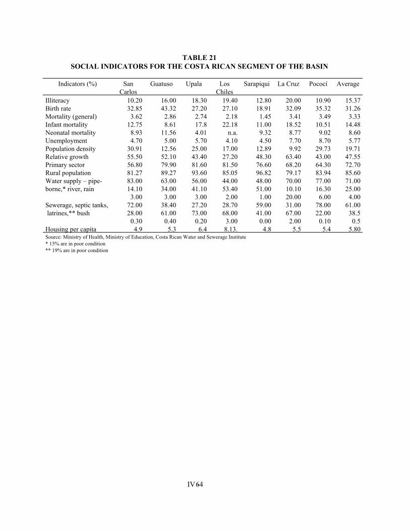
IV - 64
TABLE 21 SOCIAL INDICATORS FOR THE COSTA RICAN SEGMENT OF THE BASIN
Indicators (%) San
Carlos Guatuso Upala Los
Chiles Sarapiqui La Cruz Pococí Average
Illiteracy 10.20 16.00 18.30 19.40 12.80 20.00 10.90 15.37 Birth rate 32.85 43.32 27.20 27.10 18.91 32.09 35.32 31.26 Mortality (general) 3.62 2.86 2.74 2.18 1.45 3.41 3.49 3.33 Infant mortality 12.75 8.61 17.8 22.18 11.00 18.52 10.51 14.48 Neonatal mortality 8.93 11.56 4.01 n.a. 9.32 8.77 9.02 8.60 Unemployment 4.70 5.00 5.70 4.10 4.50 7.70 8.70 5.77 Population density 30.91 12.56 25.00 17.00 12.89 9.92 29.73 19.71 Relative growth 55.50 52.10 43.40 27.20 48.30 63.40 43.00 47.55 Primary sector 56.80 79.90 81.60 81.50 76.60 68.20 64.30 72.70 Rural population 81.27 89.27 93.60 85.05 96.82 79.17 83.94 85.60 Water supply – pipe-borne,* river, rain
83.00 14.10
3.00
63.00 34.00
3.00
56.00 41.10
3.00
44.00 53.40
2.00
48.00 51.00
1.00
70.00 10.10 20.00
77.00 16.30
6.00
71.00 25.00
4.00 Sewerage, septic tanks, latrines,** bush
72.00 28.00
0.30
38.40 61.00
0.40
27.20 73.00
0.20
28.70 68.00
3.00
59.00 41.00
0.00
31.00 67.00
2.00
78.00 22.00
0.10
61.00 38.5
0.5 Housing per capita 4.9 5.3 6.4 8.13. 4.8 5.5 5.4 5.80 Source: Ministry of Health, Ministry of Education, Costa Rican Water and Sewerage Institute * 15% are in poor condition ** 19% are in poor condition
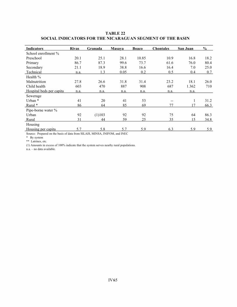
IV - 65
TABLE 22 SOCIAL INDICATORS FOR THE NICARAGUAN SEGMENT OF THE BASIN
Indicators Rivas Granada Masaya Boaco Chontales San Juan % School enrollment % Preschool Primary Secondary Technical
20.1 86.7 21.1 n.a.
25.1 87.3 18.9
1.3
28.1 99.6 38.8 0.05
10.85
73.7 16.6
0.2
10.9 61.6 16.4
0.5
16.8 76.0
7.0 0.4
18.2 80.4 25.0
0.7 Health % Malnutrition Child health Hospital beds per capita
27.8 603 n.a.
26.6 470 n.a.
31.8 887 n.a.
31.4 908 n.a.
23.2 687 n.a.
18.1
1.362 n.a.
26.0 710
Sewerage Urban * Rural *
41 86
20 64
41 85
53 69
--
77
1
17
31.2 66.3
Pipe-borne water % Urban Rural
92 31
(1)103
44
92 59
92 25
75 35
64 15
86.3 34.8
Housing Housing per capita
5.7
5.8
5.7
5.9
6.3
5.9
5.9
Source: Prepared on the basis of data from SILAIS, MINSA, INIFOM, and INEC * By system ** Latrines, etc. (1) Amounts in excess of 100% indicate that the system serves nearby rural populations. n.a. – no data available.
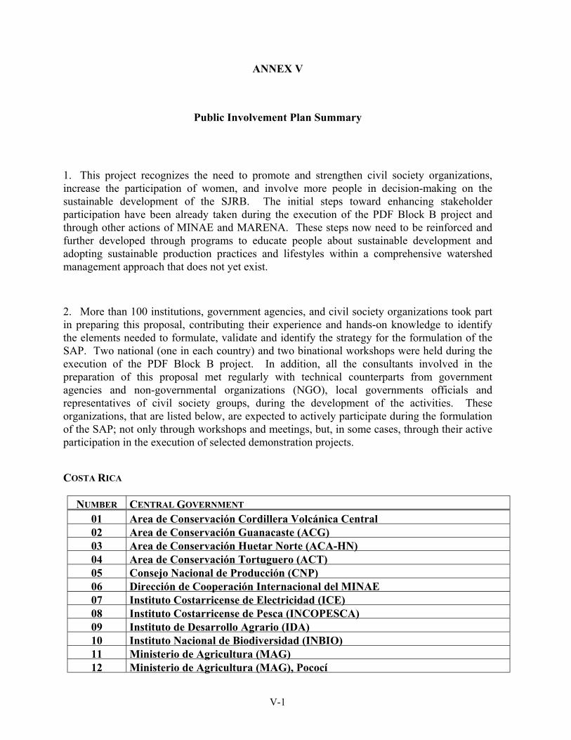
ANNEX V
Public Involvement Plan Summary
1. This project recognizes the need to promote and strengthen civil society organizations, increase the participation of women, and involve more people in decision-making on the sustainable development of the SJRB. The initial steps toward enhancing stakeholder participation have been already taken during the execution of the PDF Block B project and through other actions of MINAE and MARENA. These steps now need to be reinforced and further developed through programs to educate people about sustainable development and adopting sustainable production practices and lifestyles within a comprehensive watershed management approach that does not yet exist.
2. More than 100 institutions, government agencies, and civil society organizations took part in preparing this proposal, contributing their experience and hands-on knowledge to identify the elements needed to formulate, validate and identify the strategy for the formulation of the SAP. Two national (one in each country) and two binational workshops were held during the execution of the PDF Block B project. In addition, all the consultants involved in the preparation of this proposal met regularly with technical counterparts from government agencies and non-governmental organizations (NGO), local governments officials and representatives of civil society groups, during the development of the activities. These organizations, that are listed below, are expected to actively participate during the formulation of the SAP; not only through workshops and meetings, but, in some cases, through their active participation in the execution of selected demonstration projects.
COSTA RICA
NUMBER CENTRAL GOVERNMENT 01 Area de Conservación Cordillera Volcánica Central 02 Area de Conservación Guanacaste (ACG) 03 Area de Conservación Huetar Norte (ACA-HN) 04 Area de Conservación Tortuguero (ACT) 05 Consejo Nacional de Producción (CNP) 06 Dirección de Cooperación Internacional del MINAE 07 Instituto Costarricense de Electricidad (ICE) 08 Instituto Costarricense de Pesca (INCOPESCA) 09 Instituto de Desarrollo Agrario (IDA) 10 Instituto Nacional de Biodiversidad (INBIO) 11 Ministerio de Agricultura (MAG) 12 Ministerio de Agricultura (MAG), Pococí
V-1
13 Ministerio de Agricultura (MAG), San Carlos 14 Ministerio de Agricultura (MAG), Upala 15 Ministerio de Ambiente y Energía (MINAE) 16 Ministerio de Educación Pública (MEP), Los Chiles 17 Ministerio de Educación Pública (MEP), San Carlos 18 Ministerio de la Presidencia 19 Ministerio de Planificación 20 Ministerio de Relaciones Exteriores y Culto 21 Programa Nacional para el Desarrollo 22 Secretaría Técnica Ambiental (SETENA) 23 Sistema Nacional de Areas de Conservación (SINAC)
LOCAL GOVERNMENTS – MUNICIPALITIES
24 Municipalidad de Guatuzo, San Carlos, Alajuela 25 Municipalidad de La Cruz, Guanacaste 26 Municipalidad de Los Chiles, San Carlos, Alajuela 27 Municipalidad de Pococí, Limón 28 Municipalidad de San Carlos, San Carlos, Alajuela 29 Municipalidad de Sarapiquí, Heredia 30 Municipalidad de Upala, San Carlos , Alajuela
ASSOCIATIONS OF MUNICIPALITIES
31 Asociación de Municipalidades de la Zona Norte
NON-GOVERNMENTAL ORGANIZATIONS (NGO) 32 Amigos de la Tierra Río San Juan 33 Asociación Acueducto Sonafluja Fort 34 Asociación Ambiental Huetar Norte 35 Asociación Bienestar Ambiental Sarapiquí 36 Asociación Central de Capacitación del Nor Atlántico (ASECAN) 37 Asociación de Agricultores de Quebrada Grande 38
Asociación de Desarrollo Guatuso (ASD-G) 39
Asociación de Productores Agropecuarios de Santa Elena 40 Asociación de Productores de Guatuso 41 Asociación de Productores de San Marcos (APROSAMA) 42 Asociación para el Desarrollo Sostenible del Area de Conservación Huetar
Norte (ASAHNOR) 43 Cooperativa Llano Azul 44 Corporación de Desarrollo Forestal 45 Mesa Nacional Campesina 46 Organismo Internacional Regional de Sanidad Agropecuaria (OIRSA) 47 Unión Productores Agropecuarios (UPA)
V-2
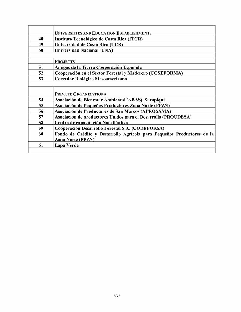
UNIVERSITIES AND EDUCATION ESTABLISHMENTS
48 Instituto Tecnológico de Costa Rica (ITCR) 49 Universidad de Costa Rica (UCR) 50 Universidad Nacional (UNA)
PROJECTS
51 Amigos de la Tierra Cooperación Española 52 Cooperación en el Sector Forestal y Maderero (COSEFORMA) 53 Corredor Biológico Mesoamericano
PRIVATE ORGANIZATIONS 54 Asociación de Bienestar Ambiental (ABAS), Sarapiquí 55 Asociación de Pequeños Productores Zona Norte (PPZN) 56 Asociación de Productores de San Marcos (APROSAMA) 57 Asociación de productores Unidos para el Desarrollo (PROUDESA) 58 Centro de capacitación Noratlántico 59 Cooperación Desarrollo Forestal S.A. (CODEFORSA) 60 Fondo de Crédito y Desarrollo Agrícola para Pequeños Productores de la
Zona Norte (PPZN) 61 Lapa Verde
V-3
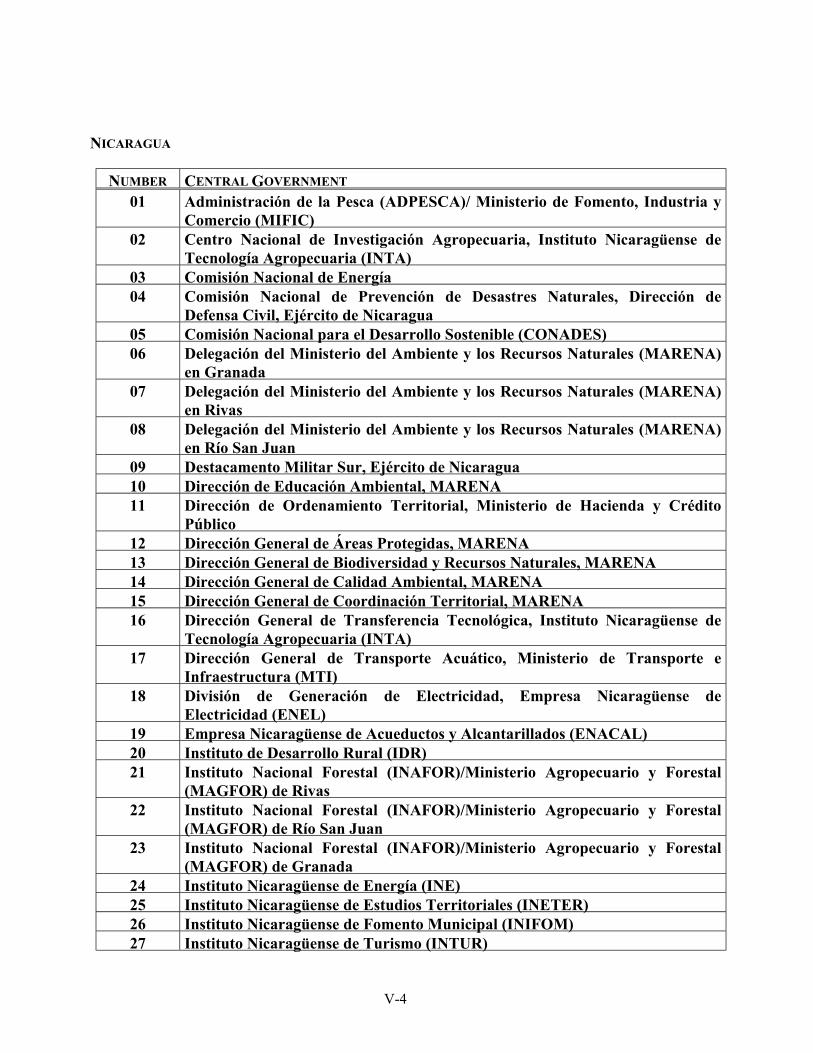
NICARAGUA
NUMBER CENTRAL GOVERNMENT 01 Administración de la Pesca (ADPESCA)/ Ministerio de Fomento, Industria y
Comercio (MIFIC) 02 Centro Nacional de Investigación Agropecuaria, Instituto Nicaragüense de
Tecnología Agropecuaria (INTA) 03 Comisión Nacional de Energía 04 Comisión Nacional de Prevención de Desastres Naturales, Dirección de
Defensa Civil, Ejército de Nicaragua 05 Comisión Nacional para el Desarrollo Sostenible (CONADES) 06 Delegación del Ministerio del Ambiente y los Recursos Naturales (MARENA)
en Granada 07 Delegación del Ministerio del Ambiente y los Recursos Naturales (MARENA)
en Rivas 08 Delegación del Ministerio del Ambiente y los Recursos Naturales (MARENA)
en Río San Juan 09 Destacamento Militar Sur, Ejército de Nicaragua 10 Dirección de Educación Ambiental, MARENA 11 Dirección de Ordenamiento Territorial, Ministerio de Hacienda y Crédito
Público 12 Dirección General de Áreas Protegidas, MARENA 13 Dirección General de Biodiversidad y Recursos Naturales, MARENA 14 Dirección General de Calidad Ambiental, MARENA 15 Dirección General de Coordinación Territorial, MARENA 16 Dirección General de Transferencia Tecnológica, Instituto Nicaragüense de
Tecnología Agropecuaria (INTA) 17 Dirección General de Transporte Acuático, Ministerio de Transporte e
Infraestructura (MTI) 18 División de Generación de Electricidad, Empresa Nicaragüense de
Electricidad (ENEL) 19 Empresa Nicaragüense de Acueductos y Alcantarillados (ENACAL) 20 Instituto de Desarrollo Rural (IDR) 21 Instituto Nacional Forestal (INAFOR)/Ministerio Agropecuario y Forestal
(MAGFOR) de Rivas 22 Instituto Nacional Forestal (INAFOR)/Ministerio Agropecuario y Forestal
(MAGFOR) de Río San Juan 23 Instituto Nacional Forestal (INAFOR)/Ministerio Agropecuario y Forestal
(MAGFOR) de Granada 24 Instituto Nicaragüense de Energía (INE) 25 Instituto Nicaragüense de Estudios Territoriales (INETER) 26 Instituto Nicaragüense de Fomento Municipal (INIFOM) 27 Instituto Nicaragüense de Turismo (INTUR)
V-4
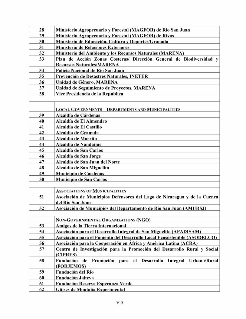
28 Ministerio Agropecuario y Forestal (MAGFOR) de Río San Juan 29 Ministerio Agropecuario y Forestal (MAGFOR) de Rivas 30 Ministerio de Educación, Cultura y Deportes/Granada 31 Ministerio de Relaciones Exteriores 32 Ministerio del Ambiente y los Recursos Naturales (MARENA) 33 Plan de Acción Zonas Costeras/ Dirección General de Biodiversidad y
Recursos Naturales/MARENA 34 Policía Nacional de Río San Juan 35 Prevención de Desastres Naturales, INETER 36 Unidad de Género, MARENA 37 Unidad de Seguimiento de Proyectos, MARENA 38 Vice Presidencia de la República
LOCAL GOVERNMENTS – DEPARTMENTS AND MUNICIPALITIES 39 Alcaldía de Cárdenas 40 Alcaldía de El Almendro 41 Alcaldía de El Castillo 42 Alcaldía de Granada 43 Alcaldía de Morrito 44 Alcaldía de Nandaime 45 Alcaldía de San Carlos 46 Alcaldía de San Jorge 47 Alcaldía de San Juan del Norte 48 Alcaldía de San Miguelito 49 Municipio de Cárdenas 50 Municipio de San Carlos
ASSOCIATIONS OF MUNICIPALITIES
51 Asociación de Municipios Defensores del Lago de Nicaragua y de la Cuenca del Río San Juan
52 Asociación de Municipios del Departamento de Río San Juan (AMURSJ)
NON-GOVERNMENTAL ORGANIZATIONS (NGO) 53 Amigos de la Tierra Internacional 54 Asociación para el Desarrollo Integral de San Miguelito (APADISAM) 55 Asociación para el Fomento del Desarrollo Local Ecosostenible (ASODELCO) 56 Asociación para la Cooperación en África y América Latina (ACRA) 57 Centro de Investigación para la Promoción del Desarrollo Rural y Social
(CIPRES) 58 Fundación de Promoción para el Desarrollo Integral Urbano/Rural
(FORJEMOS) 59 Fundación del Río 60 Fundación Jalteva 61 Fundación Reserva Esperanza Verde 62 Güises de Montaña Experimental
V-5
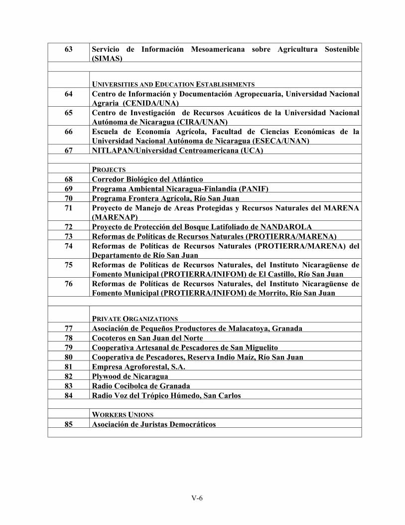
63 Servicio de Información Mesoamericana sobre Agricultura Sostenible (SIMAS)
UNIVERSITIES AND EDUCATION ESTABLISHMENTS 64 Centro de Información y Documentación Agropecuaria, Universidad Nacional
Agraria (CENIDA/UNA) 65 Centro de Investigación de Recursos Acuáticos de la Universidad Nacional
Autónoma de Nicaragua (CIRA/UNAN) 66 Escuela de Economía Agrícola, Facultad de Ciencias Económicas de la
Universidad Nacional Autónoma de Nicaragua (ESECA/UNAN) 67 NITLAPAN/Universidad Centroamericana (UCA)
PROJECTS
68 Corredor Biológico del Atlántico 69 Programa Ambiental Nicaragua-Finlandia (PANIF) 70 Programa Frontera Agrícola, Río San Juan 71 Proyecto de Manejo de Areas Protegidas y Recursos Naturales del MARENA
(MARENAP) 72 Proyecto de Protección del Bosque Latifoliado de NANDAROLA 73 Reformas de Políticas de Recursos Naturales (PROTIERRA/MARENA) 74 Reformas de Políticas de Recursos Naturales (PROTIERRA/MARENA) del
Departamento de Río San Juan 75 Reformas de Políticas de Recursos Naturales, del Instituto Nicaragüense de
Fomento Municipal (PROTIERRA/INIFOM) de El Castillo, Río San Juan 76 Reformas de Políticas de Recursos Naturales, del Instituto Nicaragüense de
Fomento Municipal (PROTIERRA/INIFOM) de Morrito, Río San Juan
PRIVATE ORGANIZATIONS
77 Asociación de Pequeños Productores de Malacatoya, Granada 78 Cocoteros en San Juan del Norte 79 Cooperativa Artesanal de Pescadores de San Miguelito 80 Cooperativa de Pescadores, Reserva Indio Maíz, Río San Juan 81 Empresa Agroforestal, S.A. 82 Plywood de Nicaragua 83 Radio Cocibolca de Granada 84 Radio Voz del Trópico Húmedo, San Carlos
WORKERS UNIONS
85 Asociación de Juristas Democráticos
V-6
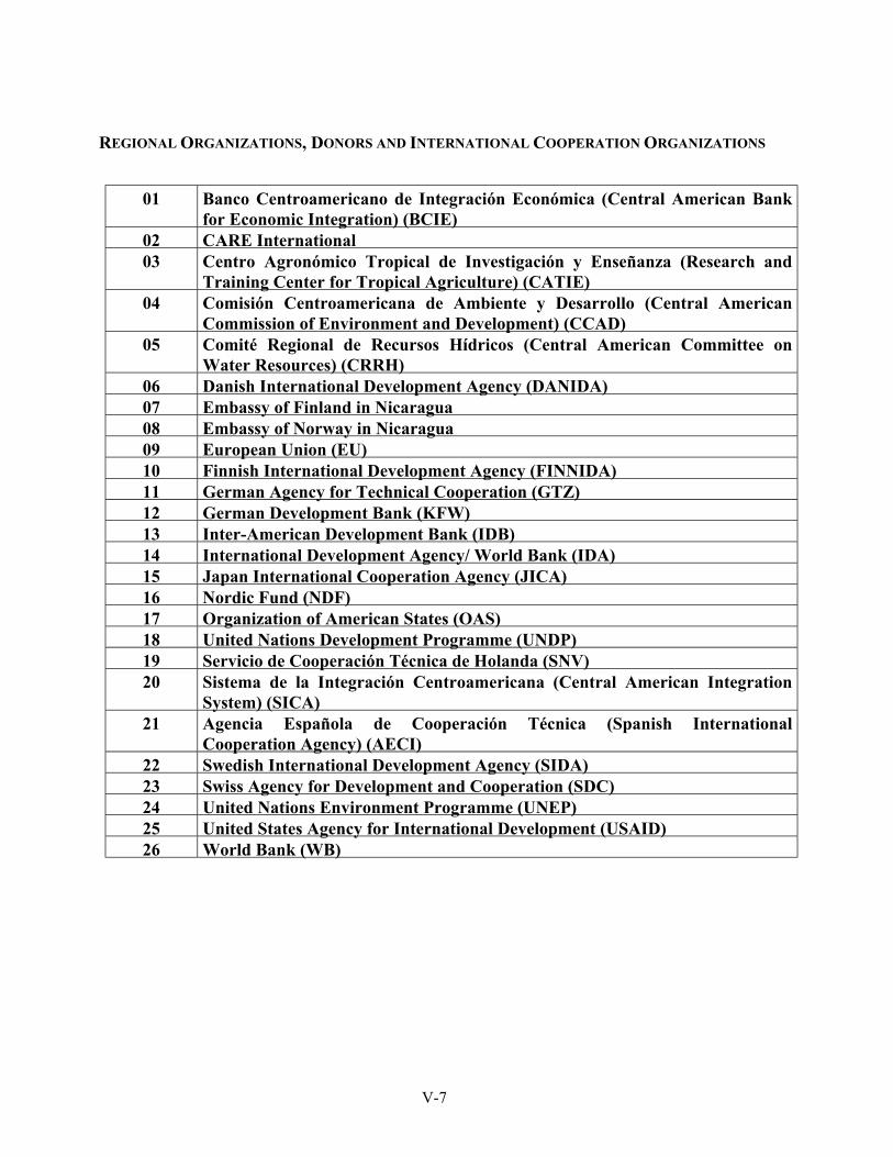
REGIONAL ORGANIZATIONS, DONORS AND INTERNATIONAL COOPERATION ORGANIZATIONS
01 Banco Centroamericano de Integración Económica (Central American Bank
for Economic Integration) (BCIE) 02 CARE International 03 Centro Agronómico Tropical de Investigación y Enseñanza (Research and
Training Center for Tropical Agriculture) (CATIE) 04 Comisión Centroamericana de Ambiente y Desarrollo (Central American
Commission of Environment and Development) (CCAD) 05 Comité Regional de Recursos Hídricos (Central American Committee on
Water Resources) (CRRH) 06 Danish International Development Agency (DANIDA) 07 Embassy of Finland in Nicaragua 08 Embassy of Norway in Nicaragua 09 European Union (EU) 10 Finnish International Development Agency (FINNIDA) 11 German Agency for Technical Cooperation (GTZ) 12 German Development Bank (KFW) 13 Inter-American Development Bank (IDB) 14 International Development Agency/ World Bank (IDA) 15 Japan International Cooperation Agency (JICA) 16 Nordic Fund (NDF) 17 Organization of American States (OAS) 18 United Nations Development Programme (UNDP) 19 Servicio de Cooperación Técnica de Holanda (SNV) 20 Sistema de la Integración Centroamericana (Central American Integration
System) (SICA) 21 Agencia Española de Cooperación Técnica (Spanish International
Cooperation Agency) (AECI) 22 Swedish International Development Agency (SIDA) 23 Swiss Agency for Development and Cooperation (SDC) 24 United Nations Environment Programme (UNEP) 25 United States Agency for International Development (USAID) 26 World Bank (WB)
V-7
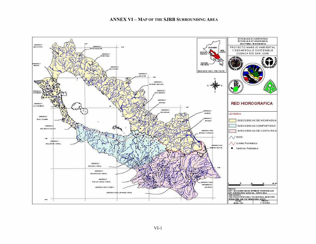
ANNEX VI – MAP OF THE SJRB SURROUNDING AREA
VI-1
ANNEX VII DEFINITION OF TERMS
DELTA Low, nearly flat alluvial land deposited at or near the mouth of a river - commonly forming a triangular or fan shaped plain of considerable area and crossed by numerous distributaries (as opposed to tributaries). INTEGRATED MANAGEMENT (a management approach which applies the Dublin principles and implements the water initiatives in Agenda 21) Generally, a management approach to water resources which is characterized by a multidisciplinary, multisectoral approach to managing land and water resources that takes into account multiple objectives of land and water resources development, especially the environmental impacts of development; considers all water sources (ground water, surface water, and their interaction); water demands by all sectors, including withdrawal and non-withdrawal uses of water and recognizes the needs of fish and wildlife as a legitimate beneficial use of water; and involves civil society in the decision making process. INTERNATIONAL WATERS (GEF Glossary E/F/S, Author: World Bank) One of the four focal areas that the GEF focuses on. Defined as the seas, shared river basins and lake basins and shared estuaries and wetlands and shared groundwater aquifers. The distinguishing feature is that more than one nation has access to or makes use of them.
WATERSHED/ RIVER BASIN/ DRAINAGE BASIN Watershed (US and several international agencies usage). The region drained by or contributing to a stream or lake. Often used in place of drainage basin. (British and correct usage) -- the line or ridge separating two drainage basins (drainage basin divide). Thus the term is ambiguous and confusing when used alone. Note that a drainage basin includes all the area contributing to stream flow. Thus, areas beyond a drainage divide which recharge ground water that eventually flows to the stream is part of the drainage basin. Some hydrologists speak of surface water drainage basin divides and ground water drainage divides. River basin. Entire area drained by a river and its tributaries (including areas contributing to ground water which discharges to the streams). Equivalent to drainage basin. In common US usage watersheds and river basins are used interchangeably. Usually, watershed is used with small drainage basins and river basins refers to larger rivers -- streams drainage watersheds and rivers drain river basins.
VII-1
VIII-1
ANNEX VIII PROPOSED WORK PROGRAM,
AND DESCRIPTIONS OF SPECIFIC STUDIES AND DEMONSTRATION PROJECTS
PROJECT NUMBER Project number not yet assigned (GF/8400-00-#) PROJECT NAME Formulation of a Strategic Action Program for the
Integrated Management of Water Resources and the Sustainable Development of the San Juan River Basin and its Coastal Zone
DURATION 3 years IMPLEMENTING AGENCY United Nations Environment Program (UNEP) EXECUTING AGENCY General Secretariat of the Organization of American
States (OAS) REQUESTING COUNTRIES Costa Rica and Nicaragua ELIGIBILITY Eligible under paragraph 9(b) of the Instrument GEF FOCAL AREA International waters GEF PROGRAMMING FRAMEWORK Operational Program Number 8, Water Body-based PROPOSED WORK PROGRAM, AND DESCRIPTIONS OF SPECIFIC STUDIES AND DEMONSTRATION PROJECTS 1. The purpose of this request is to procure financing for the formulation of a Strategic Action Program for the Integrated Management of Water Resources and the Sustainable Development of the San Juan River Basin and its Coastal Zone. The ultimate objective of the SAP is to ensure the availability of the goods and services provided by water resources for conserving natural ecosystems and social and economic development in order to satisfy present and future demands as agreed by all parties involved. In this way conflicts related to the use of the goods and services generated by SJRB ecosystems will be minimized through a coordinated program of action conducted jointly by the two countries. The major components of the SAP formulation include: i) the strengthening of a basin-wide information system that provides the mechanisms for gathering and dissemination of data adequate to the needs of decision-making for the integrated management of the basin; ii) the creation of a well-coordinated bilateral planning process for the SJRB; iii) the implementation of a gender oriented public participation process; iv) the strengthening of public institutions and private organizations; and v) the formulation and implementation of environmental education activities. 2. Coordination between the two countries is an important mechanism that can help to improve the quality of life of the inhabitants and protect the ecosystem. This cooperation will support the coordination of research and transboundary management. It will permit the interaction of government institutions and NGOs, strengthening both and making possible a more integrated – and thus more sustainable – development.
VIII-2
3. The SAP will create a framework for future action and a timetable of activities for the protection and use of the numerous goods and services offered by the water resources and ecosystems of the SJRB. It will thus promote the sustainable development of the region. The SAP will lay out a series of measures to reduce and/or eliminate current and emerging problems affecting the conservation and development of the SJRB. It will enhance the transboundary and global benefits obtained when development is both integrated and participatory, and when environmental education, technology transfer, and institutional strengthening are key elements of a program. 4. The SAP will address priority transboundary needs and focus on long-term solutions to the current and emerging problems facing the SJRB. Furthermore, it will propose a series of projects based on experience gathered from demonstrations of new technologies, taking into account their real costs and the capacity of the institutions and organizations involved to execute them. 5. The formulation of the SAP will be supported by the cost assessments and feasibility studies described below, and according to the budget shown in Table 1 and the proposed Work Program shown in Figure 1. 6. Component 1: Formulation of the SAP
Project Management and SAP Formulation. Costa Rica and Nicaragua (US $ 702,000). Deriving from the TDA, and building on the cost assessments and feasibility studies to be conducted at specific locations within the SJRB, as described below, the project team will oversee the project and facilitate development of a SAP. The SAP will identify and outline specific actions to be taken for the integrated and sustainable management of the SJRB. Integrated management entails the coordinated management of land and water resources at the local or community level within the context of the cumulative impacts and effects of those actions on the basin as a whole, including the coastal zone.
7. Component 2: SJRB information system
(a) Hydrometeorological and Water Quality Monitoring in the SJRB. Costa Rica and Nicaragua (US$290,000). The long-term objective is to create a reliable body of data on water quality, flow volumes and rainfall patterns in the SJRB. For the formulation of the SAP it is necessary to define basic patterns of water discharge, sediment transport and water quality at key points in Lake Nicaragua and the San Juan River and at another set points on tributaries of the San Juan. The exact number of sampling points will be determined at the outset of the study together with the type of monitoring protocols to be employed, laboratory methods and quality assurance and quality control to be used. Monitoring will include both fixed site and "survey" techniques. Institutional capacity in the two countries will be a major consideration and will include
VIII-3
training in monitoring, analysis and data interpretation. For Lake Nicaragua the objective will be to define the status of those key physical, chemical and biological parameters that can be used to assess lake response relative to development options for the lake basin. River data will be used to define those parts of the basin that have critical problems in regards to point and non-point sources including rural land use. This initial phase will provide the basis for a component of the SAP that will define a comprehensive and cost-effective bi-national hydrometric and water quality monitoring program consisting of a data network, laboratory programs, quality assurance, data analysis and interpretation, and communication, using approaches that are more suitable to developing countries. Selected existing hydro-meteorological stations will be incorporated and improved.
(b) Hydrographic survey of Lake Nicaragua and the San Juan River. Nicaragua (US$125,000). To be carried out by the Hydrographic Department of the National Water Resources Bureau of INETER, this project consists of a bathymetric survey of Lake Nicaragua and the San Juan River and the setting up of four limnological stations on the former and five on the latter. Twenty-one hydrographic charts will be produced and depths readings will be taken in both the lake and the river. The purpose is to update information collected between 1968 and 1970.
(c) Determination of the plume of sedimentation in the coastal area. Costa Rica and Nicaragua (US$100,000). The main purpose of the study is to establish the extent and rate of sedimentation from the San Juan Basin in coast, and to describe the behavior of coastal currents. The magnitude and geographical influence of freshwater inflows will be measured using remote sensors, with the results checked in situ. The condition of certain coastal sea habitats will also be studied.
(d) Information for the sustainable management of critical aquatic habitats. Costa Rica and Nicaragua (US$100,000). This project will use research and theses of university students who will study the structure, function, and distribution of critical aquatic habitats and ways to best manage them and their populations. By bringing in educational and research centers, the project seeks to gain better scientific knowledge for the management of threatened or overexploited species, including Atractosteus tropicus, Joturus pichardi, Centropomus Parallelus, Tarpon Atlanticus and Carcharinus leucas.
(e) Study of the coastal and marine resources of the Tortuguero Conservation Area and the Indio-Maíz Reserve. Costa Rica and Nicaragua (US$100,000). This is a coordinated bilateral study to be executed by the Tortuguero Conservation Area of SINAC/MINAE of Costa Rica and MARENA of Nicaragua. The purpose is to gauge current conditions and monitor coastal marine species that are being commercially exploited and species that are being
VIII-4
over exploited. An effort will be made to identify other options and resource potentials to improve the life of these communities. Basic knowledge of the coastal ecosystem generated by the proposed study will contribute to conserving its biodiversity. The participation of local communities on both sides of the border is an essential part of this project.
(f) Zoning to reduce vulnerability to natural hazards. Costa Rica and Nicaragua (US$75,000). This project will identify risks and propose specific strategies to minimize the vulnerability of economic and social infrastructure. Priority attention will be given to the most densely populated areas (schools, housing, health centers, etc.) or areas with infrastructure such as irrigation systems and dams. The subbasin of the Malacatoya River, which flows into Lake Nicaragua, has been chosen as a pilot area for the implementation of an early warning system and vulnerability reduction measures.
(g) A study of transborder migration and new settlements. Costa Rica and
Nicaragua (US$75,000). The purpose of this study is to determine the causes, forms, and extent of current migration between Costa Rica and Nicaragua and toward new settlement outposts, and how this influences the use of natural resources in the SJRB. Problems will be identified and solutions proposed. Socioeconomic and cultural elements will be studied with the participation of university teachers and students. These studies will be a part of the wider research efforts described under Component 1.
(h) Information System. Costa Rica and Nicaragua (US$60,000). It is not the
intention of this project to develop new environmental information systems (EIS) for the SJRB. Rather the intention is to strengthen the existing information system to, a) provide comprehensive information for the basin, that is, go from an Information System based on discrete data to a basin-wide information system, and b) develop the mechanisms for information sharing and exchange to support decision-making at all levels: local, national and binational. However certain steps must be taken to deal cost-effectively with the acquisition, integration, manipulation, and communication of the various types of information as noted in Component 2. At the outset of the project, existing capabilities such as GIS will be evaluated, together with other functionalities needed for SAP formulation. System(s) sustainability once the project is completed will be essential. Systems requirements and architecture, communications protocols and data security will be defined and availability of suitable low-cost public domain systems investigated.
8. Component 3: Strategic actions with stakeholder involvement
(a) Conflict management for the La Virgen hydroelectric project. Costa Rica (US$25,000). MINAE-SINAC will execute this project, whose purpose is to identify conflicts, at a national level, generated by the La Virgen hydroelectric
VIII-5
plant and apply conflict management methods to resolve them. This experience then be used in formulating a strategy in the SAP section on involving stakeholders in conflict resolution. In addition, it will aid in obtaining more accurate information on the incremental costs of designing, building, and operating such plants and what global benefits are involved.
(b) Fund for the development of agroforestry activities in Cárdenas
Municipality. Nicaragua (US$40,000). The purpose of this demonstration project is to create and test community financing of agroforestry activities in the municipality of Cárdenas. A revolving fund will be formed for small-scale producers who want to raise indigenous commercial species of trees in deforested areas. An economically viable strategy for the sustainable use of local natural resources will be formulated, with the purpose of halting the migration of small farmers toward as yet uncultivated lands or into Costa Rica. The project will be executed by a committee of representatives of civil society, and will be coordinated by the mayor’s office.
(c) Sustainable use and rehabilitation of the Río Frío subbasin. Costa Rica
(US$100,000). This project will be executed by Productores Unidos para el Desarrollo (Producers United for Development, an NGO based in the cantons of Guatuso and Los Chiles). It will support the actions to conserve and rehabilitate the basin of the Río Frío, which flows into Lake Nicaragua. Plans for the management of second-growth forest and the creation of model farms will be drawn up. Also, ways to make these efforts financially sustainable, such as through the payment for environmental services, will be identified and three nurseries for native species will be created. Indigenous groups and women will take part in this project.
(d) Restoration and management of the banks of the Sarapiquí and Sucio
rivers. Costa Rica (US$58,000). The aim is the reforestation of the degraded banks in the lower subbasins of both rivers. This will be approached by making boatsmen engaged in ecotourism, farmers, and nearby communities aware of the problem, and then getting them organized and committed. In this way the quality of the local ecosystems can be better controlled and monitored. Through MINAE, appropriate economic mechanisms and incentives will be designed for the payment of an environmental services fee by landowners benefiting from the project.
9. Component 4: Public Participation
(a) Conservation of the Las Camelias Wildlife Refuge. Costa Rica ($US75,000).
The purpose of the project is to study a co-management scheme between MINAE/Arenal-Huetar Norte Conservation Area and the community of the Las Camelias Wetlands Wildlife Refuge. An effort will be made to reclaim the basins of the Gaucaliti and Pizotillo rivers, which nourish the wetlands, by
VIII-6
formulating a plan to reduce sedimentation and multiply the economic opportunities and technical skills of the local people in the productive management of natural resources. This activity will be complemented by project 9(c) to be carried out in Nicaragua.
(b) Community organization and education for the control of fires. Costa Rica
(US$35,000) and Nicaragua (US$5,000). The purpose of this pilot project is to foster community participation and test new methods to prevent and control forest fires in Costa Rica, and then share this experience with Nicaragua. Project execution will be shared by the Guanacaste Conservation Area of MINAE and the towns in the subbasins to the south of Lake Nicaragua and to the north of the protected areas of Costa Rican Cordillera Volcánica. One aim is to prevent forest fires occurring outside of national parks and reserves, and thus their possible impact on those areas. Another is to train the local populations of countries to use fire as a tool without causing unnecessary harm to conservation areas or contravening the principles of sound natural resource management.
(c) Reclamation of the Tepenaguasapa River subbasin. Nicaragua (US$80,000).
The aim of this project is to facilitate and test different schemes for community organization and management in the area of subbasin rehabilitation. A local NGO, Fundación del Río (the River Foundation) will execute it in concert with 8 communities. Fundación del Río has initiated reclamation project for several tributaries of the San Juan River. This project will try to help local communities take responsibility for the recovery and management of the Tepenaguasapa River sub-basin. It will establish a monitoring program, foster alternative land uses and training, and design a reclamation plan. This demonstration project will be coordinated with project 9(a) in Costa Rica.
(d) Ara ambigua and Dipterix panamensis habitat recovery. Costa Rica and
Nicaragua (US$32,000). This demonstration project will bring together civil society groups from both countries and both sides of the San Juan River in an effort to reclaim and save the gallery forest habitat that is home to the green macaw (Ara ambigua), a highly endangered species that nests in the almond trees (Dipterix panamensis) that grow on river banks and are appreciated for their hard wood. Reclaiming this habitat would also help to conserve the undergrowth and root systems that protect the river. This pilot project will be carried out in the subbasins of the Cureña and Cureñita rivers in Costa Rica and some of the forests of the Indo-Maíz Biological Reserve in Nicaragua. The executing bodies will be ASCOMAFOR in Costa Rica and Fundación del Río in Nicaragua.

VIII-7
10. Component 5: Local, national and bi-national level institutional arrangements
Costa Rica and Nicaragua (US $ 158,720). This component is designed to remedy shortcomings in institutions working at the local and national levels, and to encourage enhancement of binational coordination between institutions within the SJRB as well as to ensure that the SAP prescribed actions are incorporated into national policies. Technical meetings, bringing together MINAE and MARENA personnel and cooperative research efforts between universities and other institutions of both countries, will be promoted. Current institutional arrangements and the role they play in the management of the San Juan River Basin will be reviewed. This component is complementary to component 6.
11. Component 6: Capacity building and institutional strengthening
(a) Support for local environmental management. Costa Rica (US$75,000). This project responds to the need to develop new management models to attack the problems of transboundary pollution. Its purpose is to develop and test a system that brings municipal authorities and representatives of civil society together. The focus will be on planning for the prevention of pollution and ways to handle and treat industrial and household solid waste and wastewater in critical subbasins and micro-basins. The Association of Municipalities of the San Juan River Basin and local civil society groups will participate in its execution. The proposal includes the design of economic mechanisms to help the town of San Carlos; at the pilot level, to recover costs and obtain additional resources to build management capacities. This activity is complementary to demonstration project 11(b).
(b) Reclamation of the Oyate River Subbasin. Nicaragua (US$75,000). To be
executed by the Association of Municipalities of the San Juan River (AMURS), this project aims to establish a basin committee in the Oyate River subbasin in order to foster reclamation actions. One of the major components of this project will be the active participation of the Municipal Sustainable Development Commission of Morrito in a pilot project that can serve as a model for other subbasins. The experience will be shared with San Carlos, Costa Rica (see 11(a)). Information will be shared between two projects and later examined in a bilateral workshop in which all the municipalities of the SJRB will be invited to participate.
12. Component 7: Education and training in conservation and the sustainable use of
natural resources
(a) Environmental education in the municipality of San Carlos. Nicaragua (US$50,000). This education project will be executed by the MARENA delegation in San Carlos, Department of San Juan, and will focus on learning by doing. It is targeted at children, women, and youth and is directed towards on
VIII-8
real environmental problems–deforestation, pollution, inappropriate use of agrochemicals, sustainable development of biodiversity, the true value of water, and lost economic opportunities. The municipal government, schools, and local NGOs will all participate. Nurseries for native species and organic compost heaps will be established, community tree planting and reforestation projects carried out, and sound financial management practices will be instituted to assure the profitability of the activities. The experience gained will be shared with Costa Rica in the framework of the demonstration project described under 12(b), through direct contacts and through the Federation of Local Governments of border town.
(b) Environmental education in San Carlos Canton. Costa Rica (US$100,000).
The municipal government of San Carlos Canton will execute this project, and its results will be applicable to the entire basin. Its purpose is to create educational programs showing the unique nature and importance of the basin and its ecosystems and natural resources. It aims at various social levels and–children, schools, adults, women, farmers and business people. The groups themselves will participate in the research, design, and production of study materials under the leadership of specialists in environmental education and watershed management. This project is complementary to 12(a) and the lessons learned will be shared through the Federation of Local Border Town Governments.
(c) Students for a clean Oro River. Nicaragua (US$20,000). This demonstration
project aims to show the benefits of involving secondary-school students in community-based efforts to clean up the river, and how this contributes to their education and to the overall environmental awareness of the community. Students from Rivas, San Jorge, and neighboring communities will come together to study the situation and propose and carry out activities aimed at cleaning up the Oro River, currently polluted by wastewater and solid waste. The loss of canopy forest and inappropriate land use have altered the hydrological system of the river, whose mouth is at San Jorge, the second largest resort on Lake Nicaragua.
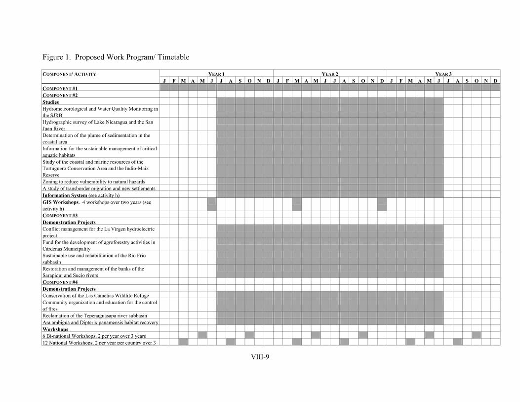
VIII-9
Figure 1. Proposed Work Program/ Timetable
YEAR 1 YEAR 2 YEAR 3 COMPONENT/ ACTIVITY J F M A M J J A S O N D J F M A M J J A S O N D J F M A M J J A S O N D
COMPONENT #1 COMPONENT #2 Studies Hydrometeorological and Water Quality Monitoring in the SJRB
Hydrographic survey of Lake Nicaragua and the San Juan River
Determination of the plume of sedimentation in the coastal area
Information for the sustainable management of critical aquatic habitats
Study of the coastal and marine resources of the Tortuguero Conservation Area and the Indio-Maiz Reserve
Zoning to reduce vulnerability to natural hazards A study of transborder migration and new settlements Information System (see activity h) GIS Workshops. 4 workshops over two years (see activity h)
COMPONENT #3 Demonstration Projects Conflict management for the La Virgen hydroelectric project
Fund for the development of agroforestry activities in Cárdenas Municipality
Sustainable use and rehabilitation of the Rio Frio subbasin
Restoration and management of the banks of the Sarapiqui and Sucio rivers
COMPONENT #4 Demonstration Projects Conservation of the Las Camelias Wildlife Refuge Community organization and education for the control of fires
Reclamation of the Tepenaguasapa river subbasin Ara ambigua and Dipterix panamensis habitat recovery Workshops 6 Bi-national Workshops, 2 per year over 3 years 12 National Workshops, 2 per year per country over 3
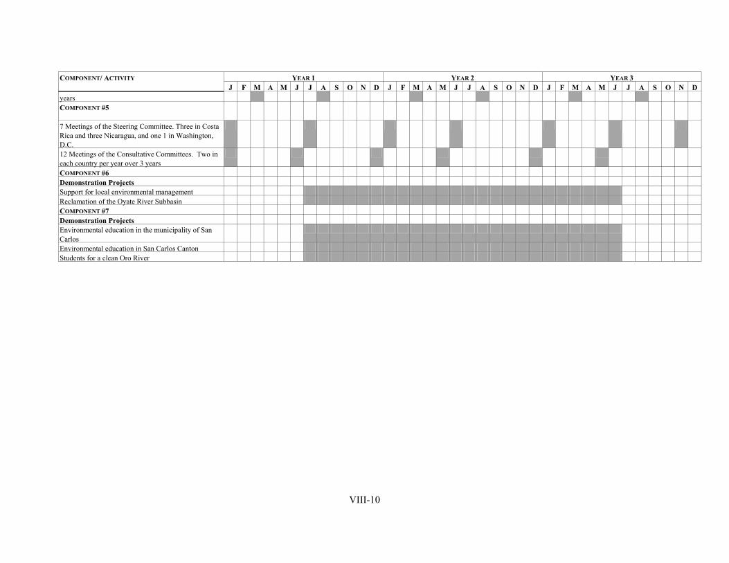
YEAR 1 YEAR 2 YEAR 3 COMPONENT/ ACTIVITY
J F M A M J J A S O N D J F M A M J J A S O N D J F M A M J J A S O N Dyears COMPONENT #5
7 Meetings of the Steering Committee. Three in Costa Rica and three Nicaragua, and one 1 in Washington, D.C.
12 Meetings of the Consultative Committees. Two in each country per year over 3 years
COMPONENT #6 Demonstration Projects
Support for local environmental management Reclamation of the Oyate River Subbasin COMPONENT #7
Demonstration Projects Environmental education in the municipality of San Carlos
Students for a clean Oro River
Environmental education in San Carlos Canton
VIII-10
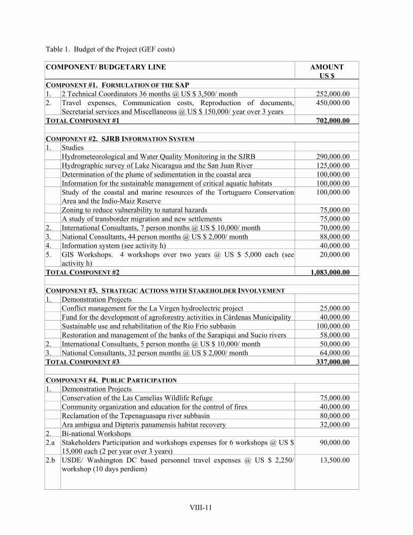
Table 1. Budget of the Project (GEF costs) COMPONENT/ BUDGETARY LINE
US $ AMOUNT
COMPONENT #1. FORMULATION OF THE SAP 1. 2 Technical Coordinators 36 months @ US $ 3,500/ month 252,000.00 2. Travel expenses, Communication costs, Reproduction of documents,
Secretarial services and Miscellaneous @ US $ 150,000/ year over 3 years 450,000.00
TOTAL COMPONENT #1 702,000.00
COMPONENT #2. SJRB INFORMATION SYSTEM 1. Studies Hydrometeorological and Water Quality Monitoring in the SJRB 290,000.00 Hydrographic survey of Lake Nicaragua and the San Juan River 125,000.00 Determination of the plume of sedimentation in the coastal area 100,000.00 Information for the sustainable management of critical aquatic habitats 100,000.00 Study of the coastal and marine resources of the Tortuguero Conservation
Area and the Indio-Maiz Reserve 100,000.00
Zoning to reduce vulnerability to natural hazards 75,000.00 A study of transborder migration and new settlements 75,000.00 2. International Consultants, 7 person months @ US $ 10,000/ month 70,000.00 3. National Consultants, 44 person months @ US $ 2,000/ month 88,000.00 4. Information system (see activity h) 40,000.00 5. GIS Workshops. 4 workshops over two years @ US $ 5,000 each (see
activity h) 20,000.00
TOTAL COMPONENT #2 1,083,000.00
COMPONENT #3. STRATEGIC ACTIONS WITH STAKEHOLDER INVOLVEMENT 1. Demonstration Projects Conflict management for the La Virgen hydroelectric project 25,000.00 Fund for the development of agroforestry activities in Cárdenas Municipality 40,000.00 Sustainable use and rehabilitation of the Rio Frio subbasin 100,000.00 Restoration and management of the banks of the Sarapiqui and Sucio rivers 58,000.00 2. International Consultants, 5 person months @ US $ 10,000/ month 50,000.00 3. National Consultants, 32 person months @ US $ 2,000/ month 64,000.00 TOTAL COMPONENT #3 337,000.00
COMPONENT #4. PUBLIC PARTICIPATION 1. Demonstration Projects Conservation of the Las Camelias Wildlife Refuge 75,000.00 Community organization and education for the control of fires 40,000.00 Reclamation of the Tepenaguasapa river subbasin 80,000.00 Ara ambigua and Dipterix panamensis habitat recovery 32,000.00 2. Bi-national Workshops 2.a Stakeholders Participation and workshops expenses for 6 workshops @ US $
15,000 each (2 per year over 3 years) 90,000.00
2.b USDE/ Washington DC based personnel travel expenses @ US $ 2,250/ workshop (10 days perdiem)
13,500.00
VIII-11
COMPONENT/ BUDGETARY LINE AMOUNT US $
3. National Workshops 3.a 12 National Workshops @ US $ 5,000 each, 2 per year over 3 yrs in each
country 60,000.00
4. International Consultants, 3 person months @ US $ 10,000/ month 30,000.00 5. National Consultants, 32 person months @ US $ 2,000/ month 64,000.00 TOTAL COMPONENT #4 484,500.00 COMPONENT #5. LOCAL, NATIONAL & BINATIONAL LEVEL INSTITUTIONAL ARRANGEMENTS 1. 7 Meetings of the Steering Committee. Three in Costa Rica and three
Nicaragua, and one 1 in Washington, D.C. 54,720.00
2. International Consultants , 4 person months @ US $ 10,000/ month 40,000.00 3. National Consultants, 17 person months @ US $ 2,000/ month 34,000.00 4. 12 Meetings of the Consultative Committees. Two in each country per year
over 3 years @ US $ 2,500 each 30,000.00
TOTAL COMPONENT #5 158,720.00
COMPONENT #6. CAPACITY BUILDING AND INSTITUTIONAL STRENGTHENING 1. Demonstration Projects Support for local environmental management 75,000.00 Reclamation of the Oyate River Subbasin 75,000.00 2. International Consultants, 4 person months @ US $ 10,000/ month 40,000.00 3. National Consultants 12 person months @ US $ 2,000/ month 24,000.00 TOTAL COMPONENT #6 214,000.00
COMPONENT #7. EDUCATION AND TRAINING IN CONSERVATION AND SUSTAINABLE USE OF
NATURAL RESOURCES 1. Demonstration Projects Environmental education in the municipality of San Carlos 50,000.00 Environmental education in San Carlos Canton 100,000.00 Students for a clean Oro River 20,000.00 2. International Consultants, 4 person months @ US $ 10,000/ month 40,000.00 3. National Consultants, 22 person months @ US $ 2,000/ month 44,000.00 TOTAL COMPONENT #7 254,000.00
TOTAL PROJECT 3,233,220.00
ADMINISTRATIVE COSTS 413,600.00
PDF BLOCK B 283,000.00
GRAND TOTAL 3,929,820.00
VIII-12