Embed Size (px)
Citation preview
CHAPTERV
Transboundary Water Resource Management in Ganga
Brahmaputra Basin: Opportunities and Challenges
The Ganga- Brahmaputra basin region covering India, Bangladesh, Nepal
and Bhutan is one of the largest river basins of the world. The basin
regwn is endowed with vast natural diversity, large alluvial land and
water resources. Yet there is endemic poverty, socio-economic
backwardness and environmental degradation across the riparian t'
countries. The major problems of the Ganga- Brahmaputra basin region
are the population explosion, poverty, unemployment, imbalanced
regional development and lack of capital and technological capabilities for
rapid economic growth. There is shortage of infrastructures in terms of
adequate energy production transportation and connectivity.
The region also suffers from natural and manmade hazards like floods,
drought, deforestation, landslides, soil erosion and sedimentation. On the
other hand there are immense possibilities for the development of the
region, based on shared natural resources. Integrated management of
water resources of the region can mitigate the problems. It can meet the
growing needs of food production, energy production, transport
infrastructure etc. that are vital for improving the quality of life of the
people of region. The transboundary water resource of the region, if
efficiently managed can increase the productivity of land, water and other
resources leading to poverty alleviation and sustained socio-economic
development of the region. The transboundary waters establish the
natural inter country linkages and may be harnessed as the resource of
the future. There is natural diversity and complimentarity in the
patterns and potential of the water resources development among the
npanan countries. Thus, there are need-based compulsions for
formulating a framework for regional cooperation for integrated
development of the water resource of the region. The integrated
development and management of Ganga- Brahmaputra basin water can
176
meet the multipurpose requirements for the common benefit of the co
basin partners.
There are some basic requirements for the integrated management of
transboundary water resources of the basin. Firstly, it should aim at
optimum and sustainable development, effective management and
efficient utilization of the water resources. Secondly, it should be
multisectoral in nature (infrastructure development, natural hazard
management, environmental management, etc). Thirdly, it should be
based on the basin approach to planning, integrated and conjunctive use
of water. The idea of integrated management is multi dimensional. The
facets of integrated management would include integration of approaches
and actions, integration of micro and macro policies and development of
various socio-economic sectors.
The riparian countries should try to co-operate in order to build on the
complementarities and diversities, particularly in case of hydropower
development and exchange, navigation, flood and drought management,
water quality management. Beyond water resource cooperation it should
have long-term planning in other areas such as industry and trade,
energy sector (oil, natural gas), communications and social sectors
(education, training and health). Thus transboundary water resource
based cooperation can arguably become the most potent and dependable
option for the future development of the Ganga- Brahmaputra basin.
Cooperation over Hydropower Development in Ganga- Brahmaputra
Basin
Energy IS the critical infrastructure for economic development. The
. energy consumption pattern is used as an index of national or regional
level of development. The Ganga- Brahmaputra basin region has one of
the lowest per capita energy consumption.
177
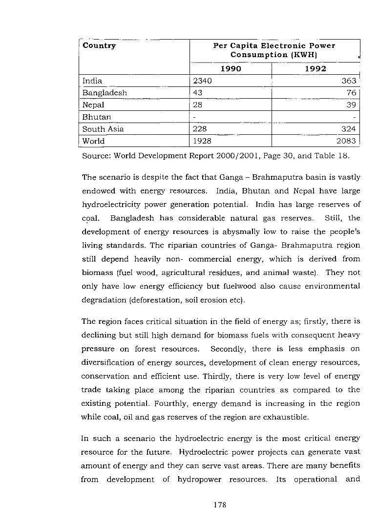
Country Per Capita Electronic Power Consumption (KWH) •
1990 1992
India 2340 363
Bangladesh 43 76
Nepal 28 39
Bhutan - -
South Asia 228 324
World 1928 2083
Source: World Development Report 2000/2001, Page 30, and Table 18.
The scenario is despite the fact that Ganga- Brahmaputra basin is vastly
endowed with energy resources. India, Bhutan and Nepal have large
hydroelectricity power generation potential. India has large reserves of
coal. Bangladesh has considerable natural gas reserves. Still, the
development of energy resources is abysmally low to raise the people's
living standards. The riparian countries of Ganga- Brahmaputra region
still depend heavily non- commercial energy, which is derived from
biomass (fuel wood, agricultural residues, and animal waste). They not
only have low energy efficiency but fuelwood also cause environmental
degradation (deforestation, soil erosion etc).
The region faces critical situation in the field of energy as; firstly, there is
declining but still high demand for biomass fuels with consequent heavy
pressure on forest resources. Secondly, there is less emphasis on
diversification of energy sources, development of clean energy resources,
conservation and efficient use. Thirdly, there is very low level of energy
trade taking place among the riparian countries as compa-red to the
existing potential. Fourthly, energy demand is increasing in the region
while coal, oil and gas reserves of the region are exhaustible.
In such a scenario the hydroelectric energy is the most critical energy
resource for the future. Hydroelectric power projects can generate vast
amount of energy and they can serve vast areas. There are many benefits
from development of hydropower resources. Its operational and
178
maintenance cost are low as compared to thermal and nuclear power. It
is clean and renewable source of energy. 11t is a major component of the
multipurpose projects besides irrigation, flood control, navigation etc. It
also exhibits a declining unit cost of generation over time, even though
initial capital expenditure is very high. However, the large-scale HEP
generation has also some adverse impacts like submergence,
displacement and threat of seismicity-induced hazards. But benefits
substantially out weighs the negative aspects.
The Eastern Himalayan region of the Ganga- Brahmaputra basin has
vast potential for hydropower generation. It can not only produce huge
amount of HEP but also give additional benefits of irrigation and flood
management. 2 The past efforts of HEP development have been within the
boundaries of nation particularly meeting the domestic demand of the
energy. These efforts should be supplemented with cooperative approach
of riparian states of the Ganga-Brahmaputra basin. Such projects can
develop complementarities among nations as well as help each other
solving problems of flood management, sedimentation and salinity
intrusion, migration and displacement. The early endeavors of
cooperative development of energy (like Kosi and Gandak projects) are too
small as compared to vast potential that exists in the region.
The rivers originating in Himalayan and sub-Himalayan ranges have
steep topographical slopes and are almost perennial. Thus they have
tremendous hydropower generation potential. Although there are varying
estimates, the generally accepted figures are that India has 45,635 MW
(economically exploitable), Nepal has 83,000 MW (estimated) and 42,000
MW (economically exploitable) and Bhutan has 21,000 MW potential for
the HEP generation. As compared to the potential the developed installed
capacities are meager. This may be seen from the figures of installed
capacity in India [3,525 MW], Nepal (244 MW), Bhutan [336 MW] and
M.H. Qureshi, India Resources and Regional Development, NCERT, Saraswati Press, New Delhi, 1990, p.15.
2 C.K. Sharma. Water and Energy Res_ources of the Himalayan Block, Navana Printing Works, Calcutta, 1983, pp. 94-96.
179
Bangladesh [230 MW]. Thus total hydropower installed capacity m the
entire basin region is only 4,335 MW; which is about 5 per cent of
economically exploitable potential. 3
The figure suggests that there 1s tremendous scope for future
development of hydropower generations. Nepal and Bhutan have water
source as the most precious natural resource for economic growth.
These two countries can supply energy to India where large market
exists. Thus entire Ganga - Brahmaputra basin can benefit from
industrial and agricultural development. This vision can be actualized by
regional cooperation.
Indo-Nepal cooperation on Hydro Power Generation and
Transmission
The Kosi and the Gandak are the two projects, which India and Nepal
undertook in 1950's. These projects, had agreement over supply of power
to the border towns and villages in Nepal leading to development of
interconnections between the Nepalese and Indian power systems. After a
long gap Mahakali treaty was signed in 1996. The Treaty proposes to
build a high dam and two underground powerhouses - one on each bank
and share the power generation equally between India and Nepal. The
joint detailed project report is yet to be finalized over the Pancheswar
project. India and Nepal have also signed a Power Trade Agreement
( 1996) under which India has agreed to buy power from Nepal and also
allow transmission access to the third country. The agreement also
facilitates power trading between India and Nepal, by both public and
private sectors. Various other project are also under discussion stage like
(a) Karnali Chisapani (10800MW) multipurpose project (b) Sapta Kosi
high dam multipurpose project (3000MW) (c) Burhi Gandaki
Hydroelectric project (600 MW)[d] West Seti hydro electric project (750
MW). The power exchange facilities between India and Nepal have been
3 R.B Shah, "Ganges Brahmaputra: The Outlook For the Twenty First Century", in Asit K. Biswas and Juha I. Uitto [eds.] Sustainable Development of The Ganga Brahmaputra Meghna Basin, United Nations University Press, Tokyo, 2000, p.23.
1RO

enhanced by the proposed Tanakpur [India] and Mahendra Nagar [Nepal]
transmission line.
India and Nepal also have institutional arrangements like India -Nepal
Power Exchange Committee (1992) which has functions like [1]
monitoring the existing arrangements/facilities for power exchanges, [2]
evolving proposals for promoting power exchanges in the future, [3]
recommending principles of tariff for such power exchanges, etc.
Indo -Nepalese cooperation over hydro electricity generation has been
very slow. Political mistrust has been the major cause. Nepal complains
that it didn't get fair deal in Kosi and Gandak agreements. Further, the
issue of sharing the benefits and costs on equitable basis among the
regional partners has been the issue of disagreement. Nepal believes that
most of benefits (such as flood control, Irrigation, navigation) including
the availability of surplus clean energy to fuel industrialisation from the
construction of large dams are bound to accrue to the down stream
countries (India and Bangladesh), whereas the associated costs (loss of
cultivable land, natural flora and fauna, displacement etc.) of such
development projects would be imposed on Nepal. 4 The hydro electricity
projects have been debated hotly in the domestic political as well as
academic circles of Nepal. In Nepal, the general opinion is "no deal is
better than a bad deal".
Many experts have also questioned the feasibility of huge multipurpose
projects. The water resource experts view that domestic energy needs will
be met by utilising small and medium hydropower schemes. The high
dam projects come with inherent issues like environmental degradation,
silt deposition, seismic activities etc. Purther high dam projects are also
very expensive and large investments made on such schemes are actually
diversion from the other competing sectors like education, health
4 Kamal Rijal, "Role of Nepalese Water Resources for Meeting Energy Needs in South Asia", in Sridhar Khatri (ed.) Energy policy National and Regional ImplicatioTJ.$, Modern Printing Press, Kathmandu, 2002, pp.lOl-102.
181
sanitation etc. At the same time Nepal wants to extract its reasonable
benefits from the proposed high dam projects.
Nepal has developed West Seti hydroelectric project (750 MW) with an
agreement signed with a private developer, the Snowy Mountain
Engineering corporation (SMEC) of Australia with the sole intention of
exporting the substantial power to the Indian market.s The Karnali
project is one of the largest multipurpose projects under consideration
since 1960's. The private developer Enron has shown interest in
developing the Chisapani dam of the Karnali project. Recently after
several discussion and presentation made by Enron, permission was
withheld pending more enquiries. The Kosi High dam, a multipurpose
project has been under discussion between India and Nepal for a long
time.
India Bhutan Cooperation over Hydro Electricity
The Bhutan forms part of Brahmaputra basin. The maJor nvers of
Bhutan are Torsa, Raidak, Sunkosh, Mao, Manas and Dhansiri.The
physiographic characteristic endows Bhutan large potential for
hydroelectric power generation. Yet so far only 1.7 per cent of the total
estimated theoretical potential of 20,000 MW has been harnessed.
Bhutan can generate electricity not only for its own economic
development but can also trade it with India and Bangladesh.
Bhutan at present has 11 hydroelectric stations with an installed
capacity of 341.75MW. The Chukha station alone generates 336MW. The
Chukha hydroelectric project was developed with Indian assistance. The
220 KW lines from Chukha to Birpara provide the link between the
Bhutanese system and Easter regional power grid of India. The operat~on
of the Chukha plant is coordinated with the eastern regional grid of
s Iswer R.Onta, "Harnessing the Himalayan Waters of Nepal; A case for Partnership for the Ganges Basin", in Asit K Biswas and Juha I. Uitto [eds.]Sustainable Development of the Ganges Brahmaputra Meghna Basins, United Nations University Press, Tokyo, 2000, P. 119.
182
India. The 1000MW Tala project on the Raidak River (downstream of
Chukha) is the extension of Indo Bhutanese HEP energy cooperation.
The Power Master plan of Bhutan in 1991 listed 89 sites from a desktop
study of topographical maps, with a potential of approximately 12,00MW
of hydroelectricity. Further, the Power Master Plan (PSMP) report of 1992
listed 24 sites, which are economically feasible and have a commutative
identified potential of 10,988 MW. Most of the schemes are run of the
river type with the exception of a few reservoir schemes, mainly along the
southern border. The PSMP figure was revised later, as the envisaged
capacity of quite a few identified projects have been increased. For
example, the Tala project is being constructed with an ultimate capacity
of 1,625MW instead of 265MW as planned earlier. Another project under
consideration Sunkosh project has also undergone an upward revision.
An agreement on the construction of a 1525MW hydel power project on
the Sunkosh was signed on January 4 1993,making a notable advance in
the lndo-Bhutanese water resource cooperation. The Chukha3 project on
the Wangchu River is also under consideration. The experts view that
Bhutan can be major supplier of electricity to its energy starved
neighbour i.e., India. India has also agreed to purchase all the energy
available.6 The harnessed power from water resources can generate the
additional revenue required. Infact, a major portion of Bhutan's revenue
comes from export of power from Chukha.
As much as 45 percent of Bhutan's annual revenue now comes from
Chukha, with upward tariff revisions since its inception. The availability
of electricity has eased the pressure on kerosene imports as well as the
deforestation has been controlled. The per capita income of Bhutan is
growing as energy intensive industries are being developed at the
southern border of Bhutan.
6 Sangeeta Thapliyal,"Water and Conflict: The South A!iian Scenario", Strategic Analysis ,October 1996,p.1048.
183
Bhutan has followed cautious approach towards large-scale
hydroelectricity generation. The environmental degradation, loss of bio
diversity and displacement of populations are the major concerns of
Bhutan. The needs of socio-economic development for growing population
in Bhutan are bound to rise in the future. Bhutan can opt for HEP based
revenue for it socio economic development. The careful selection of sites
and advanced technology for HEP generation can minimize the associated
damages.
Indo Bangladesh Power Cooperation
Much possibility exists between India and Bangladesh for power systems
interconnection, which have been discussed ever since Bangladesh came
into existence. Many lines have been identified like (1) Durgapur (India)
Bheramara (Bangladesh), Jeerhat (India) - Jessore (Bangladesh) with an
aim to export power to Bangladesh from India. (2) Sylhet (Bangladesh) to
Kumarghat (India) where Eastern Bangladesh can - export power to
Northeast India. Both countries have recognised importance of inter
connections of their power systems for mutual benefit. The discussion
can include Nepal for long term planning for regional energy
interconnections.
The interconnections of energy systems of the npanan countries of
Ganga- Brahmaputra basin can become crucial agent of economic and
social development of the entire region. The regional collaboration on
energy based on economical and reliable interconnections promises
multiple benefits like savings accrued from load diversity, hydrologic
complimentarity, transfer of periodic surplus of power, economies of scale
in building large HEP projects with sharing of investments, savings on
power generation investments and operation costs etc. The efforts in joint
development activities can facilitate mobilisation of financial resources.7
7 Shanker K. Malia, Energy Cooperation in South Asia, Institute for Integrated Development Studies Publication, Kathmandu, 2002, p. 14.
184
Challenges in cooperation over Interconnections of Energy system
in Ganga- Brahmaputra Region
Various barriers exist at policy level, technical level, institutional level
and financial level in the development of interconnection of energy sector
in the region.
The Institutional Issues: The hitherto prevailing ideology of economic
self-sufficiency hinders the energy cooperation and trade among riparian
countries. The major economic power of the region, India focused in
meeting the demand through inter regional power transfer within the
country. The basin state governments have inward looking energy policy
based on Electricity Acts, Regulations and regulatory mechanisms. While
cross border power trading has been merely a marginal interest. Bhutan
is the only country where cross border power trade is the national
priority. Nepal- India cooperation has been victim of mistrust and
historical baggage. There is a need to gradually build up confidence
among the riparian countries along with the gradual harmonization of
macro policies in the energy sector. The psyche of hydroelectricity being
perceived, as "strategic" commodity should be shed away if the region
aims at collaborative development and management of water resources.
Further, the historical debates of bilateralismjmultilateralism,
augmentation, upper riparian and lower riparian rights should not cast
unnecessary shadow on the vision of regional power trade.s
Technical Issues: The countries have adopted their own norms and
standards in planning and design of their power systems. Differences
exists in their standards. which may act as impediment in their
interconnections. The sizes of the systems, voltages, adopted,
inadequacies in generation and transmission facilities, varying structure
of the electricity supply and operating system poses the technical
challenges in interconnections. Different countries have different mix of
s Santa Bahadur Pun, "Electric Power Trading in the SAARC Region", in Sridhar. K. Khatri (ed.) Energy Policy National and Regional Implications, Modern Printing Press, Kathmandu, 2000, pp. 34-35.
185
public and private sector participation and they are gomg through
decentralisation, unbundling and deregulation in the power sector. Thus
integration on various technical issues will be required.
Institutional Issues: Different institutional regulation and control has
been developed over the period to oversee the implementation of treaties/
negotiations over water resource development for example - Mahakali
Commission, Power Trading Corporation, etc. Their integration and
smooth operation will be required. Further, the individual countries have
their own load dispatch and system operations, monitoring and control
facilities and operations. An institutional mechanism to coordinate the
operation and control of inter connected system will be required to
ensure smooth operations confirming to principles and ethics of
integrated operations.
Financial Issues: The financial barriers in terms of tariff (both
generation and transmission) limit the ability to identify and evaluate the
real delivered cost of power. The riparian countries of the Ganga
Brahmaputra region are developing countries, which are facing resource ,.. .
crunch. Besides internal resource generation they depend on foreign
direct and indirect investments which many times complicates the issue.
The power trading is often treated on political lines rather than on
commercial considerations. The deal should be left to commercial
decision making specifically to ensure its long-term sustainability and for
ensuring transparency and accountability.
Regional Energy Grid in the Ganga- Brahmaputra Region
Though cooperation on interconnection of power system development in
the Ganga- Brahmaputra region is at present at preliminary level, a long
term vision of establishing a regional energy grid in the region can be
realised. The riparian countries Bhutan, Bangladesh, Nepal and India
can take advantage of resource complementarities, demand diversity and
geographic proximity. Three of the four countries have border around a
lRfl
narrow 20 to 40 km wide stretch of India territory.9 This umque
geography provides a viable basis for establishing inter-connection
among all four countries. This unique geography provides a viable basis
for establishing interconnections among all four countries. Many
opportunities and challenges exist for realising the regional grid.
The following factors will justify the establishment of inter-connections,
which could be located within the corridor:
1. Transmission line originating from Bhutan, Chukha, Anarmani
(Nepal), Thakurgaon (Bangladesh) can provide the linkage. The
implementation of proposed HEP projects for example, Arun, Kosi high
dam project, Sunkosh project, say by year 2015 can create a
hydroelectric power pool (banking) of up to 6,000MW which can be
supplied to the markets of India and Bangladesh.
2. All these generating stations and inter connecting ties will become an
integral part of India's Eastern Regional Power Grid - the prime
beneficiary. The resulting trans-country power grid will substantially
improve the peaking capacity of the Eastern Grid of India and also
help in meeting the demands of the Western Bangladesh.
3. The regional grids of India has already been inter connected. The
Power Grid Corporation of India can play a major role m
transportation and wheeling of the large quantum of electricity and
establishing interconnections.
4. The major challenge lies in the implementation of the projects
although institutions such as Power Grid Corporation of India,
Bangladesh Power Development Board and Nepal Electricity Authority
are enthusiastic. The major initiative needs to be taken by the
respective governments.
9 Regional Energy Grid in the GBM Region, Water Resources Development Series; Institute for Integrated Development Studies Publication, Kathmandu, 2000, pp.28-__ , 30
187
Flood Management
The Ganga- Brahmaputra basin is recurrently affected by natural
disasters like flood since the ancient times. Due to the geographical
factors India and Bangladesh suffer from flood disasters more than
Nepal. Bangladesh being the lowermost riparian country, situated at the
deltaic portion of the basin, acts as the funnel for the enormous run off
generated mostly outside its boundaries faces the brunt of fury of the
floods. About 60 per cent of the country's geographical area is prone to
floods and every year almost one third of the area gets inundated in the
monsoon season. The riparian countries of the Ganga- Brahmaputra
basin belong to low income group where natural disasters like floods
cause huge loss of life, property and infrastructure. The low-income
group of the society is usually the most common victim in the basin area.
In India, the middle riparian country, the floods are usually caused by
excessive precipitation, inadequate river channels, cyclonic storms,
drainage congestions because of the construction of settlements and rail
road infrastructure in the river channels, heavy siltation, erosion of the
river banks, etc. The Brahmaputra River is more prone to flooding
because of heavy rainfall, over bank spilling, landslides, inundation of
braided channels, banks erosion and change of river course.
In Nepal, the mountain rivers Sapt Kosi, Gandaki, Karnali enter the plain
(Terai) area of Nepal. During the monsoon period, the heavy runoff
generated by rivers does not drain out quickly, resulting into floods. The
hill valleys also suffer from floods due to sudden localized cloudbursts
and landslides.
Bangladesh is most affected by flood hazard. The maJor causes of
recurrent floods are huge catchments area, low gradient of the rivers,
sedimentation of channel, pondage effects and frequent meanders in the
channels. 10The other reasons are, peaking of most of interconnected
10 Rob Abdur Khan and Nazem Islam Nurul, "Abundance and Scarcity of Water in Bangladesh: Issues Revisited", BliSS Journal, Vol.9, No.4, 1988, p. 465.
188
rivers in the same time, braided channels swelling, synchronisation with
the tidal effects, cyclonic storms surges etc. The floods of 1988 and 1999
caused colossal damage to life, property, crop and infrastructure.
Flood Management Techniques
The countries of the Ganga- Brahmaputra basin have mainly depended
on structural measure for the flood management which includes (a)
construction of reservoirs for storing monsoon flows (b]) construction of
embankments to prevent spill over (c) improving flow conditions in the
channel (d) prevention of bank erosions(e)improving drainage
congestions.
There are geographical opportunities and constrains in the region for
applying the structural measures. Nepal has adequate facilities for
construction of reservoirs for water storage.ll In Bangladesh, on account
of its deltaic location, there is hardly any possibility of constructing any
reservoir. In India and Bangladesh the thrust under the structural
approach has been largely on the construction of embankments
particularly along the vulnerable reaches of the rivers. In India, in the
Ganges- Brahmaputra basin about 10,500 km embankments have
already been constructed. Bangladesh has constructed about 8,300 km
of embankments for protection.
Water resources experts have questioned the long-term efficacy of
embankments for flood management. The embankments are poorly
managed and damage through breaches and overtopping are more
serious. Embankments though provide locational protection; they
adversely affect the natural flow and postpone the flood to downstream
regwn.
India and Bangladesh have emphasized upon the long term planning for
reservoir based flood management, however lack of potential sites have
II Bhekh B. Thapa and Bharat B.Pradhan, Water Resources_ Development Nepalese Perspective, Konark Publishers, Kathmandu, 1995, p. 138.
189
caused the dependence on Nepal. India and Nepal have been negotiating
for Sapt Kosi project for flood mitigation in the Bihar Plains.l2 India
proposed for the Bara Kshetra Dam in Nepal while Nepal has shown little
interest over the issue. Major storage facilities have been planned under
Tipaimukh multi purposes project (on Barak), Dihang and the Subansari
project between India and Bangladesh. While these reservoir based
structural measures remains distant dream, focus needs to be shifted
towards non-structural measures.
The non-structural measures can play the complimentary role to
structural measures. The non-structural measures of flood control and
damage mitigation includes: [ 1] Flood plain management measures like,
flood plain zoning and flood proofing, [2] Flood forecasting and warning
services. [3] Disaster relief and flood fighting etc.
Flood Plain Management: Flood plain management is based on the twin
concepts of flood plain zoning and flood proofing. The concepts recognise
the flood plain of river as a natural region where flow of river should be
given priority. Different zones are demarcated for probable flooding in
different seasons and magnitude and human activities are regulated
accordingly. It minimizes the damage caused by the flood. India and
Bangladesh have planned to discourage unregulated habitation and
constructions in the flood prone areas. However, necessary legislation
and administrative measures are yet to be taken. Flood proofing
measures require settling the villages above pre determined flood levels.
Further, frequency analyses of floods are carried out to identify flood
prone area and priority areas for project implementation are chosen
accordingly. Few projects have been taken up in India in states of Assam
and West Bengal for flood proofing.
The improvement of existing natural drainage_ system is essential in
India, Nepal and Bangladesh. The reclamation and improvement of old
12 Bhim Subba, "Water Nepal and India", Kanak Mani Dixit (ed.) State of Nepal, Himal Books, 2002, Lalitpur, p.245.
190
river channels which functions, as spillway in the rainy season should be
taken up on priority basis. Different countries of the basin can share
experiences, expertise on different aspects of flood plain management.
Flood Forecasting in the Ganga- Brahmaputra Region
Flood forecasting and warning system can play major role in the Ganga -
Brahmaputra region in saving the lives and property by extending
advance intimation, timely evacuation, and other rescue and relief
operations, particularly in the unprotected areas. The major emphasis
lies on the early forecast and information, which requires technological
capabilities and inter country cooperation.
Different countries of the basin have evolved data collection and relay
centers. India has developed large infrastructure for the flood forecasting;
157 stations are operational of which 132 stations are for water stage
forecast and 25 for inflow forecast. 109 out of the 157 stations lie in the
Ganga -Brahmaputra region. Although many of stations require
upgrading and modernization, their track record in the accuracy of the
forecasting has been satisfactory. The large network of river gauging and
rainfall stations also supports the flood forecasting stations. India and
Bangladesh, under a bilateral agreement cooperate on the flood
forecasting. India is transmitting ( 1) actual and forecast river level data to
Bangladesh from five station - Farakka, Goalpara, Dhubri, Domahani,
Silchar (2) Rainfall data from Goalpara, Dhubri, Tura, Coochbihar,
Siliguri, Jalpaiguri and Agartala to Bangladesh.
Bangladesh has also set up a network for flood forecasting. The
Bangladesh Water Development Board established a Flood Forecasting
and Warning centre in 1972, which functions for collection of
hydrological data, transmission and subsequent analysis for forecasting
191

purpose. Bangladesh is also modernizing the flood forecasting system by
adopting advanced techniques and equipments. 13
Nepal is yet to establish a flood forecasting and warning system of its own
though it provides data to India on hydrology and meteorology from 34
such stations on real time basis. However, with the occurrence of
catastrophic flood in July 1993 in central region, it is strongly felt that
there should be reliable flood forecasting and warning systems.
Consequently proposal has been drawn upto provide the facility in the
central region. Efforts should be gradually made to cover flood prone
areas on priority basis.
Cooperation over Flood Forecasting
Flood situation is grim in the riparian states of the Ganga-Brahmaputra
basin. The countries share common perception to lay analysis on flood
forecasting as method to control the damage caused by flood. The
geographical characteristics of the basin requires regional cooperation for
developing reliable, modern and efficient flood forecasting system.
The riparian countries have agreed on some existing mechanism for
bilateral cooperation for sharing hydro- meteorological data. In March
1988, India and Nepal launched a project to install real time data
transmission system at 25 rainfall and 20 river gauging and rainfall
stations in Nepal.l4 The transmission system will be used to supply data
for India in real time basis and to receive similar data from two
downstream points from India on a reciprocal basis. The data thus
exchanged will be used to support flood forecasting and warning system
to people in Northern India.
t3 Q.K. Ahmad and K.B.S Rasheed, "Flood Management in Bangladesh: Issues and Prospects - GBM Regional Perspective", in Q.K. Ahmad (ed.) Bangladesh Water Vision, Masro Printers, Dhaka, 2000, pp. 66-67.
14 Flood Forecasting and Warning and Disaster Management, Water Resources Development Phase II Series, Institute of Integrated Development Studies, Kathmandu, 2001, p.l6.
192
In the development of facilities at the stations, Nepal will have to incur
the expenditures on civil work while India is to provide the equipments.
The two countries have also agreed to upgrade and modernise the
network and increase the density and coverage of stations. It will help in
better assessment, utilization and management of water resources.
In Bhutan, a comprehensive scheme of collection and transmission of
real time hydro-meteorological data is being set by on the selected sites
on the tributaries of Brahmaputra. This scheme is being implemented in
association with India. Bhutan and Nepal, the two upper catchments
area of the Ganga-Brahmaputra basin are developing hydrological
networks, which would not only benefit these countries but also help the
lower riparian countries namely India and Bangladesh.
Bangladesh is the lower most riparian countries. It has 57 transboundary
rivers, having the major part of their drainage area outside the country.
Since 93 percent of the total catchments area lies outside Bangladesh, it
essentially requires real time water level data of trans boundary rivers and
rainfall data of the key observation stations form upper riparian
countries for effective and accurate flood forecasting. Bilateral agreement
already exists between India and Bangladesh for sharing flood warning
and other relevant data. Both countries are using similar technologies for
data observation and transmission and share the methods for processing
data for the issue of flood forecasts. Both the countries are modernising
their existing infrastructure and network for increasing the accuracy of
flood forecasting.
In view of the recurrent flood problem in the region, flood forecasting
should be taken as priority programme. Major challenge lies in the
confidence building among the riparian countries for free exchange of
data and information. Apprehensions about the misuse of data and
practice of maintaining the secrecy of data hinder the spirit and process
of cooperation. The integrated management of transboundary water
resources development requires generation of data inventory and free
191
exchange of in formations among the npanan countriesls. Mutual
Institutional arrangements should be developed to facilitate frequents
meetings at both technical and political levels. Nepal, Bhutan and
Bangladesh must take advantage of technical expertise available in India,
besides taking international assistance. Flood management 1s a
noncontroversial area of mutual cooperation, which can benefit the large
population in the Ganga- Brahmaputra region.
Need of Storage Capacities
The management of transboundary water resources m the Ganga
Brahmaputra basin requires large storage of monsoon flows and
snowmelts and redistribute over space and time when and where
required. These storage capacities are necessary for multipurpose
projects for generation of hydroelectricity, flood management, irrigation
facilities etc. The multipurpose development of the water resources can
bring about a socio economic transformation of the region. The
harnessil'lg of the water resources calls for the construction of dams m
the Himalayas. The run of the river projects can produce blocks of
valuable energy but do not store water. Large dams, storing waters within
large catchments, provide for greater insurance against water distress
during periods of dry weather.l6
Various national and international studies have identified 28 potential
reservoir sites in Nepal. Nine of them are classified as large dams (storage
more than 5 BCM each). The feasibility studies of reservoirs need to be
firmly established after adequate investigation, studies and discussions,
with the involvement of different parties. The majors project under
considerations like Pancheshwar, Karnali and Kosi high dams have been
under investigation and study for many years, similarly India has special
IS United Nations, ESCAP Guidelines On Water and Sustainable Development Principles and Policy Options, Water Resource Series No. 77, New York, 1997,p.134.
16 Ramaswamy R.Iyer, "The Debate Regarding Large projects", in B.G. Verghese arid Ramaswamy R. Iyer, Harnessing The Eastern Himalayan Rivers"Konark Publishers, New Delhi, 1993,p.213.
lOLl
interest in construction of reservoirs m Nepal for HEP as well as flood
management.
In 1954 a dam on Kosi River was planned to cope with the devastating
annual floods in north Bihar and Nepal. The Kosi caused recurrent floods
due to heavy siltation and shifting of the courses. Major floods of the
region cause activation of the project intermittently, however, the Kosi
project never went beyond the barrage construction and embankment
stage. The Gandak project later also entailed mere diversion barrages.
The Karnali project is still under discussion stage. Bangladesh in 1978-
84 proposed a series of mega dams in Nepal to augment the dry season
flows of the Ganges.
The Mahakali treaty of 1996 proposed the construction of a large
reservoir under Pancheshwar project.17 The Mahakali River runs in major
stretches along the western boundary of Nepal with India. India and
Nepal will equally share the total energy generated at the twin
powerhouse of similar capacity to be built on the either bank. The costs
will be shared in proportion to the benefits accruing to either side. India
and Nepal are jointly investigating Sapt Kosi high dam project and
detailed project report is to be prepared under the terms of joint Indo
Nepal Memorandum of understanding. Nepal argues that as the saving
cost on power envisaged under the Pancheswar project India should also
consider financial compensations to Nepal in lieu of flood related savings
that big reservoirs in Nepal will generate for the downstream.
The upper catchment of the Brahmaputra has limited scope for storages.
All the future storages identified in India and Bhutan would together
harness a little more than 10 per cent of its annual flows. The
Brahmaputra Master plan has identified 18 storage dams. However, only
five of these are large. Only one large storage has been identified in
Barak/ Meghna sub basin at Tipaimukh. Dihang and Subansiri are the
17 Dr. Hari Bans Jha, Mahakali Treaty Implications for Nepals Development, Foundation for Economic and Social Change Publication, Kathmandu, 1996,p.6.
195
two other potential sites were feasibility studies have been completed.
The Tipaimukh, Dihang and Subansiri projects have been facing
opposition on the account of adverse impacts on the environment.
Concerns Regarding Dams: Large storage capacities are required for
development of water resources of the Ganga Brahmaputra- region but
they are not free from adverse impact on human beings and environment.
Three major issues associated with the dams and multipurpose projects
are (1) Safety of Dams (2) environmental considerations (3) Resettlement
and Rehabilitation.
Dam Safety
The construction of dams in the Himalayan is very complex. The
Himalayas is the seat of an active earthquake belt, which has produced
four great earthquakes in the past ~00 years.1s The Himalayas lies in the
active plate interaction site, which makes the zone prone to seismicity.
Besides the region is characterized by flash floods, landslides and high
level of sedimentation. There is lack of adequate and reliable data in the
hydrology-geology and seismicity of the region in general. Thus there is
utmost need to take care of dam safety in all stages of large-scale water
resource development.
Before the construction of dam various risk assessments should be made
m quantative terms as well as qualitative terms. It requires
considerations of extreme natural events like earthquake, unexpected
floods, landslides or even possible man made hazards. The safety is
directly related to quality of construction material used, design selection
as well the availability of sophisticated tools of analysis.
The basic inventory of data is created during investigation of geological
and hydrological situation of the region. The Himalayas show complex
18 K. N. Khatri, "Seismic Hazards in the Himalaya", in B.G. Verghese and Ramaswamy. R. Iyer (eds.), Harnessing the Eastern Himalayan Rivers Regional Cooperation in South Asia, Konark Publishers, New Delhi, 1993, p.231.
196
geological as well hydrological features, which are unique to the region,
thus the feasibility studies must be carried in various stages as well as
by multiple organizations. Geological and geotechnical investigations are
carried out for site selection and design of dams and appurtances to
collect data for evaluation of various parameters. Data on earthquake
occurrences over a wide region with epicentral locations, fault plane
solutions and isoseismals of damaging earthquakes are collected for
study.l9
Sedimentation 1s the major problem in the safe design and the
functioning of dams. The Himalayan Rivers are perennial and fed by
glaciers; the rivers bring a vast amount of eroded sediments. Weak rock
foundations coupled with high sediment loads can cause dam safety
hazards. The sedimentation is the product of multiple factors like storm
patterns, topographic features, vegetation cover, land use pattern; soil
erosion etc. The soil erosion, landslides and other mass movements can
be checked by watershed management practices. Further the dam
designs are to be selected on the basis potential geological hazards,
topographic features of the valley etc. The dam safety requires regular
monitoring of repair, maintenance and rehabilitation. A constant
checklist is maintained for every defect or deterioration. The dams are
designed for a certain life. Thorough examination needs to be conducted
after the completion of its life. If potential hazards is considered to be
beyond the acceptable limit the dam can be decommissioned to eliminate
the safety hazard and restoration of the environment.
Environmental Concerns: The large-scale water resources projects have
considerable environmental consequences. The construction of dam
involves. regulation of water flow and upstream inundation leading to
degradation of catchment areas, threat of backwater build-ups and
consequent floods and destruction at the upstream of the dam.
19 L.K. Srivastava, 'Seismic Considerations in Design of High Dams", in B. G. Verghese and Ramaswamy R. lyer [eds.], Harnessing the Eastern Himalayan Rivers Regional Cooperation In South Asia ,Konark Publishers ,New Delhi, 1993,pp249-252.
197
Large-scale deforestation takes place during the construction of dam. In
India building a dam means destroying the surrounding forests. Timber
is used to build the dam itself and to supply workers with housing and
firewood. When the dam is completed, water inundates any remaining
forest areas. This accelerated deforestation can lead to increased soil
erosion and landslides in the already fragile mountains surrounding the
reservoir, causing even more sediment to build up behind the dam.2o One
analysis of the Tehri Dam in the Northern India indicates that the useful
life of the dam may be less than the half of its projected life of 100 years
because of the already active erosion on the southern slopes of the
central Himalayas. Rivers draining this region carry large amount of silt
eight months out of the year and many of the hillsides have already been
stripped out of vegetation.
The water resource projects alters the natural flow of water affecting the
upstream because of the impoundment of water and other project related
activities and the downstream because of changes in water flows. In both
the causes there is adverse impact on the aquatic ecosystem and bio
diversity. The dam creates the barriers in the natural flow, thus some of
the aquatic life like fish ecology is seriously disturbed, as the migration of
certain fish species will be inhibited. The study reveals that construction
of fish ladders will not be possible in the high dams constructed in
Nepal. 21
In the upstream reg10n, the creation of reservoir causes ground water
level to rise in the reservoir fringe areas. Though the downstream will be
free from flooding the reduced supply of freshwater can directly affect the
fish population and other aquatic flora and fauna. The storage of large
volume of stagnant water behind a dam may become a good source for
mosquito breeding. The groundwater levels and recharge may be affected
20 Ravi Chopra, "The Social and Environmental Impact of Big Dams", in Walter Fernandez [ed.) Forests, Environment and People, Indian Social Institute Publications, New Delhi, 1983.pp.57-58.
21 United Nations, ESCAP, Towards an Environmentally Sound and Sustainable Development of Water Resources in AsiGl and the Pacific, Water Resources Series 71, New York, 1992, p. 159.
198
both upstream and down river. The canal networks could have similar
impacts on the command area.
Water resource management projects now require study of impact on the
environment. The riparian countries have guidelines and manuals for
conducting Environmental Impact assessment (EIA) studies with detailed
guidelines. EIA studies are increasingly becoming mandatory in the
funding and the execution of all major projects. Water resource
development experiences from different parts of the world have been
included to formulate the guidelines to ensure that environmental
consequences are not ignored. EIA studies are multidisciplinary and
numerous agencies are involved in it. EIA is major integral part of the
project itself with its own demand of funding, specialists and interfaces.
The EIA studies regarding Narmada Valley projects, Tehri Dam project in
India and Flood Action plan in Bangladesh have been the subject matter
of national and international debate.
The Environment Impact Assessment refer to the studies and statement
which firstly attempt to produce future environmental changes
attributable to proposed action, and secondly attempt to suggest the
likely impact of these changes on man's future well being.22 It is a
method of evaluating environmental consequences, which are likely to
cause by the proposed land use changes like - construction of dams,
reservoirs, railroad bridges, etc. The major steps in the EIA are (1)
Describe the present environment (the baseline conditions) (2) Describe
the project including purposes and needs (3) Describe the effects (4)
Describe the impacts, both short term and long term (5) Suggest and
compare alternatives (6) Provide a projection of the future of the site with
and without the p~oject (7) Suggest remedial measures.
The development projects are required to be developed in harmony with
the nature. The countries of the Ganga- Brahmaputra basin should
22 • Savindra Singh, Environmental Geography, Prayag Pustak Bhawan, Allahabad, 1991,p491.
199
develop effective and efficient policy frameworks to ensure sound
utilization of water resources and mitigating negative environmental
impacts of water resource management projects. The environment related
laws and regulations regarding safeguarding critically fragile ecological
zones, national heritage sites, pollution control are extremely necessary.
The consultation of the all the stakeholders and project affected peoples
should become mandatory for all the water resource development related
projects.
Resettlement and Rehabilitation[R & R] of the Project Affected
Peoples
Large water resource project have adverse social impact also. The
construction of dams inundates the lands and villages in the reservoir
area that often creates a social problem with the loss of homes and social
life in these areas. The people who lived there are normally relocated to
new social and physical environment, which they often have difficulty ~
adjusting to. 23 The involuntary displacement of the population is not only
a physical phenomenon but also entails economic, social, moral, and
psychological and community dislocation. The local people are uprooted
from the ecology and livelihood resources to which they have adjusted for
many generations. This IS always traumatic. Resettlement and
Rehabilitation (R&R) of these people not only is an economic task but
also requires social-ecological and psychological understanding while
transferring them to new environment. The large water resources should
not only be seen as economic benefits to downstream people but also
from the view point of local project affected people.
The displacement caused by water resource related development projects
in the last few decades has caught the central attention particularly due
to the moral and legal issues involved. In early projects scant attention
has been paid to the R&R, which can be attributed to the sheer
callousness of the state. The major victims of the project were low-income
23 n. 21,p.l72.
200
group people belonging to the marginal section of the society, mostly
tribes. Growing awareness, about social and political rights of project
affected people have made the issue central one. Resettlement and
rehabilitation of project affected people had have been the most
contentious issue in the recent past, which was vehemently argued and
defended, discussed and deliberated at many forum. This issue though
had caused deferment of some projects, slowed down progress of some
ongoing projects or even caused relegation of some projects; it had
brought forth many issues to the attention of policy makers and planners
causing attitudinal changes in their outlook towards this problem.24 The
Sardar Sarovar project in India has been seriously hampered due to
issues of rehabilitation by the environmentalists. In Nepal the Arun III
was stopped altogether in the wake of agitation backed by some social
workers, environmentalists and local people. The international donor
agencies have become particular about project linked R&R programme.
The domestic opinion has become greatly volatile over the displacements,
which is increasingly being seen as major human right violation issue.
Project Related Displacements in India: India since independence
carried out large-scale water resource development projects for expansion
of agriculture and energy production.2s These hydroelectricity and
irrigation projects are the largest source of displacement and destruction
of the habitat. In the scenario of development and displacement the
majority of the affected are the tribal people who have historically been
dependent on the natural resources base for their subsistence and lived
in relatively isolated areas. A significant point to be noted is that the
tribal communities are roughly 8 per cent of the total population of the
country yet over 50 per cent of those displacement belong to this section
of India's population. The implication is obvious the tribal people are
disproportionately affected by the development policies and the resultant
2 4 M.A.Chitale, Water for 2Jst Century, Global Water Partnership, South Asia Publication, New Delhi, 2001, p.12.
25 Ohlsson Leif, Hydropolitics Conflicts Over Water as a Development Constraint, University Press Limited, Dhaka, 1996,p.124.
displacement.26 The social activists are raising the question why tribes
should be involuntarily displaced at all, especially when costs are born by
them whereas the benefits goes to the others downstream.
Displacements in Nepal
Most of the projects in Nepal have been the run of the river schemes with
limited storages, which has caused limited displacements. However, the
proposed Karnali project in Nepal, which proposes the construction of
270-metre high dam at Chisapani, will cause displacement. The water
will spread over 339 square kilometers within the Karnali and Bheri
Valleys. The reservoir is likely to displace 40,000 to 60,000 people, the
upper limit being reached by the end of a gestation period of about 10
years when the dam in closed and the lake begins to fill. About 7, 730
hectare of agricultural land will be inundated on the valley floor.27 Most
of the displaced people are proposed to be rehabilitated on the degraded
forestland in the lower Karnali basin of the Terai region. The resettlement
area in sparsely populated and the introduction of irrigated agriculture is
expected to improve the living standards of those being relocated. The
capital cost of the resettlement programme is placed around 108 million
US dollar inclusive of infrastructure, housing and · irrigation farm
development at a rough per capita outlay of 1,800 US dollar.
The resettlement policy has not been uniform in the region. The cash
compensation approach followed earlier was not effective. The simple
tribes or peasants folks squandered away the cash quickly. Later land for
land policy was adopted. Usually the land allotted was of poor quality
and uneconomic size. The project-affected people faced many other socio
cultural problems. The existing inhabitants of the area of resettlement
may be hostile to the new inmigrants. In Sardar Sarovar project of India
well-defined guidelines were formulated for the first time to rehabilitate
28 Dewan Ashraf Mahmood and N. Nizammuddin "Impact of Ganges Water Diversion on the Southeastern part of Bangladesh: A Perception study" BIIS Journal, Vol. 20, No.2, 1999,p. 174.
202
the project-affected people. The principle was laid down that water
resource development project should be utilized for the amelioration and
betterment of life of the affected people. They should get jobs in the
project area and planned efforts are to be made to provide them basic
amenities of health, education drinking water facilities besides the
economic assets. Thus rehabilitation and resettlement policy has to be a
linked to another concept of community and area development. Besides
family welfare approach has been adopted in place of compensating the
victims individually.
The Mahakali project region provides an opportunity on both sides of
border of India and Nepal to implement Area Development Approach. The
region lies in the remote inaccessible and backward are of the Himalayas.
Water resource development project will require infrastructural
development which can act as nucleus for community development.
Social and economic public goods can be provided to the local people in
different stages of project development, which can include education,
health, vocational training, institutionalized credit, besides the facilities
for improved agricultural pl-actices. Local people should be involved in
the economic ventures of fisheries in the reservoir, tourism and market
gardening. The fund can be created from the project as well as small
surcharge or cess on the energy or irrigation facilities availed
downstream.
The legislative and legal provision should be formulated as soon as
possible in different riparian countries to give fair treatment to the
victims of water resource development projects. The legal provision
should cover land acquisition policy, adequacy of compensation,
employment opportunities to the local people and area development
programmes that can envisage the projects as the opportunity to improve
the quality of life of the affected people.
203
Inland Water Transport in the Ganga - Brahmaputra Region
Inland water transport [IWT] is an efficient mode of transportation. It
plays major role in trade and commerce. The unique advantages of inland
water transport are energy efficiency, cost effectiveness and environment
friendliness. Besides being a very cheap mode of transportation IWT has
the advantage of moving goods and equipments that are bulky and
oversized. They play complimentary role to other means of transport
namely roads and railways.
Inland water transport has been maJor means of transport for many
centuries in the Ganga- Brahmaputra basin region. In the last century,
with the growth of roadways and railways, inland water transport was
neglected. Emphasis on roads and railways, faulty alignments of rail lines
led to the decline of inland water transport. The rivers can play major role
in transportation in the Ganga-Brahmaputra basin if they are developed
in the integrated and coordinated manner with other means of transport.
Inland Water Transport in Bangladesh
Bangladesh is situated at the deltaic part of the Ganga- Brahmaputra
basin, thus, is criss crossed by river streams, distributaries etc.
Bangladesh dense network of river, canals, creeks have traditionally
provided a vital means of transportation to large part of the country.
Water transport carries about 50 per cent of the arterial freight traffic
and around the fourth of the passenger traffic. It is the only feasible
means of transport in some areas of the Bangladesh, especially
southwestern part of the country. 28Inland water is the dependable
source of transport particularly in remote area of the country where
roads are non-existent or in extremely poor condition and in many other
28 Dewan Ashraf Mahmood and N. Nizammuddin "Impact of Ganges Water Diversion on the Southeastern part of Bangladesh: A Perception study" BIIS Journal, Vol. 20, No.2, 1999, p. 174.
204
areas during the monsoon period when alternative transportation
network becomes unusable due to floods.
Bangladesh has got about 5222 kilometers of perennial waterways and
with additional 3211 kilometers of seasonal waterways, the total come to
about 8433 kilometers. Thus, Inland water transport offers wide
connectivity to rural and urban centers. Both public and private sectors
provide inland water transport. Although Bangladesh Inland Water
Transport Corporation (BIWTC) was formed in 1972 in the public sector;
its role has declined over the years as result of the government's decision
to accelerate privatization of inland water transport. Out of 5391
registered vessels operating during 1984-85, 90 per cent belonged to the
private sector. Inland water transport services are now dominated by the
private sector and within that by non-mechanized country boats and
small-mechanized vessel operators. The country boats provide nearly 60
percent of all employment in the transport sector as a whole. The country
boats play the most important part of the private sector inland water
transport. Non-mechanized water transport 1s the backbone of
Bangladesh water transport system, although mechanized vessels (both
passenger and cargo) are fast increasing in importance. In the non
mechanized sector the country boats accounts for over 60 percent of all
employment in transport.
The inland water transport remams maJor means of transport as the
Bangladesh Railways are in decline and losing heavily. The arterial roads
construction cost is high and they are expensive to maintain. The stone
is not easily available for metalling. IWT is very competitive but despite
its salience it has not received financial allocations consummarate with
its potential and cost advantages.
The waterways link the country's two main ports at Chittagong (Mongla)
with five major inland ports at Dhaka, Narayanganj, Chandpur, Barisal
and Khulna and also serve the rural hinterland. The ports suffer from
physical constraints as well as management and operational problems.
205
The up gradation and development of these two seaports will complement
the growth of the IWT sector and the river ports of the country.
The inland water transport has vast potential in Bangladesh smce the
Ganga-Brahmaputra basin rivers enter the country from three directions
and merge into single outlet within the country. A bilateral agreement
between Bangladesh and India already exists for cross-national and
transit water borne traffic though the Ganga-Brahmaputra system. These
routes are (a) Calcutta-Mangla-Chandpur-Chilmari-Dhubri (b) Calcutta -
Chandpur- Bhairab- Zaluganj. The volume of traffic along these water
routes is extremely low, due to heavy siltation and lack of channel depth,
bank erosion and shifting channels. Still, the development potential is
enormous, specially, if viewed form the perspective of an integrated
intermodal network encompassing the system of India, Nepal, Bhutan,
with Chittagong and Mongla envisioned as entry j exit ports for maritime
trade.29
Bangladesh Government is trying to upgrade the capacities of maJor
ports by constructing container ports, renovation and maintenance,
developing complimentary over land transport such as Rupsa Bridge near
Khulna and Paksey Bridge on the Ganges.
Bangladesh can become the hub of sub regional trade for Nepal, Bhutan
as well as the North Eastern part of India by developing deep-water ports
at the coastal region. The potential locations for deep water, under
consideration are (a) St. Martin Island (b) Mahesh Khali Island (c)
Sonadia Island (d) North patches. The proposed deep water can serve
upto Calcutta, coastal parts of Orissa in India, besides serving
Chittagong, Mongla and Dhaka.
29 K.D.Adhikary et. al. [eds.J Cooperation. On The Eastern Himalayan rivers Opportunities and Challenges, Konark Publishers,New Delhi,2000,pp 140-143.
206
Inland Water Transport in Nepal
Inland water transport has not developed in Nepal despite the apparent
potential. Few hundred country boasts, ranging from the dug out canoes
to the bigger boats of 20 to 25 tonnes capacity ply in the lower areas of
three major river systems of Kosi, Gandak and Kankai. IWT has vast
possibility in Nepal by interlinking the inland waterway with India
waterway extending to the seaport. The major river basins and their
potential for navigation are discussed here. In the Gandak River system
navigation is possible only at the upper reaches. This water way is
important for central Nepal as well as for the western part of the Indian
states of Bihar and eastern Uttar Pradesh for linking it with India's
National Waterway No. 1 [extending from Allahabad to Haldia]. Due care
should be taken for possible navigation while increasing the use of
Gandak for irrigation in dry seasons.
The Karnali (called the Ghaghra in India) is identified as the best river
among the three major rivers originating in Nepal for navigation, right
from Terai region till it confluence with the Ganga.
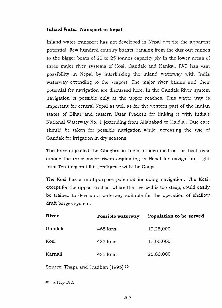
The Kosi has a multipurpose potential including navigation. The Kosi,
except for the upper reaches, where the riverbed is too steep, could easily
be trained to develop a waterway suitable for the operation of shallow
draft barges system.
River Possible waterway Population to be served
Gandak 465 kms. 19,25,000
Kosi 435 kms. 17,00,000
Karnali 435 kms. 20,00,000
Source: Thapa and Pradhan [1995].30
30 n.ll,p.192.
207
In Nepal, river transport development programme was first incorporated
in the sixth plan ( 1980-85). Apart from the studies of navigation in Kosi,
Karnali and Narayani River, a number of test trial runs by jet barges were
carried out along certain stretches on the Karnali and Arun rivers under
the technical assistance from the UNDP and World Bank.
The Narayani River in the Narayanghat- Tribeni sector is attractive for
developing inland water transport. The stretch from the Tribeni to the
Nepal-India border is navigable by development of modified long tail
boasts. A stretch of 30 Km upstream of the Narayani River from the
border is navigable during the low water seasons by boasts. The Karnali
River, at a stretch from Chisapani to Seti confluence, is reported to be
technically feasible but requires further survey to confirm the findings.
The Inland navigation can play supplementary role to surface transport
in Nepal external trade traffic at different Indo-Nepal land border
checkpoints. Biratnagar, Birgunj, Bhairwa are the major entry- exist
points in respect of the trade volume. The Narayani River seems to be
attractive for water transportation as both Birgunj and Bhairwa are close
to the Narayani. It is suggested that from a long term perspective the
development of the Kosi for navigation may be much more economically
beneficial. This is because the distance of Calcutta port from the Indo
Nepal border of the Kosi is much less than from the Narayani and the
Karnali.31
The development of inland waterway in Nepal to facilitate navigation
requires planned efforts for (1) rehabilitation of the river courses like
breaking the stones, widening and deepening of river channels,
provisions of spurs, (2) river bank protection to prevent the erosion of the
weak portion of the bank, (3) provision of special types of boats, ships
and barges which can safely operate in the turbulent condition of the
river (rapids, falls and high water) and (4) navigational facilities like
loading, unloading and handling facility. The development of navigation
3 1 S.K Malia, S.K. Shrestha and M.M Sainju, "Nepal Water Vision and the GBM Basin Framework", in Q.K.Ahmed et. al. [eds.] Ganges Brahmaputra Meghna Region A Framework for Sustainable Development, University Press Limited, Dhaka, 2001,pp183-184.
208
hinges upon careful planning, modifications, dredging or mega storage
projects upstream.
Nepal has prepared plans for (1) the development of waterways inside the
borders wherever technically feasible like- Ramdighat, Narayani,
Bhaisalotan section, Narayanghat - Balmikinagar section (Gandak),
stretches of Arun, Sunkosi, Seti, Sheri rivers (2)the interlinking the
internal waterways with Indian water ways.
Nepal Access to the Sea
The real value of the inland navigation to the land locked Nepal is the
access to the sea through the inland waterway in India and
Bangladesh.32 Nepal is vitally interested in the transit to third countries
and the sea. It has trade and transit treaties with India for access to the
Calcutta port, which is the entreport for not merely all of eastern,
northeastern, and east central India but Nepal and Bhutan as well. Nepal
has concluded a separate treaty with Bangladesh, however, it overseas
trade is channelised mainly through the port of Calcutta in India. The
port of Calcutta is a lifeline for Nepalese overseas traffic.
India and Nepal signed the Kosi Study Agreement 1997 to study
feasibility to construct 165 km long navigation canal out of which 120
km long section would be in India territory. The proposed navigation
canal should be linking Nepal with the sea port though the Ganges,
Bhagirathi and Hooghly rivers. The government of India has decided to
bear the entire cost of feasibility studies of the Kosi navigational canal.33
The proposed canal will be linked with the National Waterway No. 1 of
India (Allahabad-Haldia). As conceived under the plan the 165 km long
navigational canal will take off from Chatra and out falling near Kursella,
and a river port at Sunsari, located near the East West highway would be
developed. There are two stretches first 45 km upper reach between the
Chatra and Birpur (near Indo-Nepal border) and second the 120 km long
lower reach between the Birpur and the Ganges. The upper reach will
32 Dipak Gyawali, Water in Nepal, Himal Books, Kathmandu, 2001, p. 232. 33 A.B.Thapa, "Kosi Navigational Canal and the Hoogly River", Spotlight, January 9,
2004, p. 9.
209
entirely be in Nepalese territory.34 The lower reach Kosi canal, lying in
India territory, will have a drop of about 40 meters in north- south
distance of 120 kms. It might be necessary to provide three to four locks
to negotiate this drop. These drops could also be used for power
generation. Similarly the navigation channel running to the Ganges could
also be used for delivering water for irrigation.
Inland Water Transport in India
India has about 14,352 km of navigable waterways of which 5,200 km
are navigable by mechanized draft. Of these only 1, 700 km and 331 km
of rivers and canals are actually used for the purpose. The most
important waterways in the country are Ganga and Brahmaputra rivers
and their tributaries. Before the advent of railway, most of the country's
trade particularly in northern India was carried over by the rivers. A great
bulk of traffic was carried in country boats plying from India and Nepal
Border upto Assam. At its peak in 1876-77 Calcutta registered 1, 78,627
boats and Patna 1,24,354 boats.35 The decline of water transport began
with construction of the railways during the middle of 19th century. The
nature of layout of railways as well as withdrawal of water for irrigation
in numerous canals (which was responsible for of decline of water m
rivers like Ganga) led to decline of Inland waterway transport.
The Ganga holds a great potential for inland navigation as it is perennial
and traverses some of the most densely populated parts of India. Its main
channel still has a depth of more than 10 meters from Patna
downstream. Steamers ply regularly on the river upto Buxar near Patna.
River Hoogly, an important distributary of the Ganga in its delta course is
one of the most intensively navigated waterways in India. The
Brahmaputra is another important waterway in India, many leading
towns and cities of Assam are situated along this river[ Pandu,
34 A.B.Thapa, "China India Trade and Kosi Waterway", Spotlight, February 13, 2004, p.9.
35 0. Coutinho and T.C. Sharma, Economic and Commercial Geography of India, Vikash Publishing House Pvt. Ltd., New Delhi, 1992, p.350.
210
Jogighopa, Diksugarh are the leading port towns]. The river continued to
serve as a major artery of trade between Calcutta and Assam even after
194 7 (for tea, jute and oil). The services were discontinued in 1965 and
1970 on account of hostility between India and Pakistan. It was resumed
after 1972 after a transit trade agreement was signed between India and
Bangladesh.
The river is navigable by steamers throughout the year upto Dibrugarh,
1,280 km inland. However, large number of islands in the riverbed and
strong current in its channel during the monsoon season, hinder
navigation to a certain extent.
Realising the importance of inland waterway the Inland Water Transport
Corporation was set up as public undertaking in May 1967. It is mainly
engaged in the transportation of goods by Inland waterways in Ganga,
Bhagirathi, Hoogly, Sunderban and the Brahmaputra River. It is
operating regular cargo services between Calcutta and Karimganj
(Assam), Calcutta and Bangladesh and between Haldia and Patna. 36
The Inland Waterways Authority of India (IWAI) has been constituted on
27th October 1986 as a statuary body. It is entrusted with responsibility
of development, maintenance and regulation of national waterways. IWAI
has identified ten important waterways to declare them as national
waterways to promote the development of inland navigation in the
country. The Ganga-Bhagirathi Hooghly river system from Haldia to
Allahabad (1,620 km) has been declared as National Waterway No. 1 and
Brahmaputra river between Dhubri and Sadiya (891 km) as National
Waterway No.2.
Inland water transport in India particularly in the Ganga -Brahmaputra
basin region is constrained by insufficient water depths, non-availability
of adequate navigational aids, inadequate and shifting channels.
36 R.C.Tiwary, Geography of India, Prayag Pustak Bhawan, Allahabad, 2003, p.179.
211
Cooperative Development of Inland Waterway Transport in the
Ganga -Brahmaputra Basin region
The transboundary rivers of the Ganga-Brahmaputra basin regwn are
the natural assets, which can play a significant role towards the
expansion of trade and transportation, provided the three countries plan
an integrated and coordinated scheme for the development and
utilisation of the water resources.
India and Bangladesh are cooperating over navigation, which can further
be expanded. The river services to North -East have to ply through
Bangladesh waterways. The Central Inland Water Transport Corporation
of India, operating services from Calcutta to Guwahati and Calcutta to
Karimganj, has plans to extend the services on the Brahmaputra up to
Dibrugarh and Tezpur. The Brahmaputra River has sufficient draft year
around in Bangladesh though some conservancy works may be necessary
to canalise the lean season flow. The Kushiriya and Barak will have vast
navigational possibilities after the completion of proposed Tipaimukh
project. Tipaimukh dam is to be constructed on the Barak about 250 km.
upstream of Karimganj.
India and Bangladesh reviewed the protocol on transit and trade between
in 1997. Both sides recognized the need to include more ports of call and
transshipment stations. The early existing port of call Narayanganj ghat
is facing the problem of congestion and bunching, restricting the growth
inter country traffic movement. There is need to develop other riverine
stations namely Khulna, Mongla, Ashuganj, Sirajganj as the ports of call.
The existing embargo prohibiting movements of inter country traffic from
the Brahmaputra and Barak Valleys to Bangladesh needs to be reviewed.
Vast possibilities remains unutilised between India and Nepal inland
water transport. The proposed Karnali, Kosi and Pancheswar high dams
can be boon for the development of deep waterways connecting Nepal
with the Ganges. The proposed Kosi navigation channel canal promises
to be very attractive because it can provide the shortest waterway access
212
to the seaports. IWT vessels inside Hooghly-Bhagirathi-Ganga stretch
may very conveniently carry a part of cargo that Nepal transports from
Haldia/Calcutta port by rail/road regularly. From Patna, the cargo may
be transported by road to Nepal via Raxaul - Birgunj border. The
governments of India, Nepal Bangladesh must develop an understanding
on the IWT mode based on the successful international models.
The Ganga- Brahmaputra basin waterways require on coordinated plan
for better linkages of waterway with rail, road, air, coastal shipping for
the multimodal approach for the movement of goods. The complimentary
and coordinated transport means can contribute in reduction of
transport costs. The models of multimodal transport with
containerisations [container services with strategically located container
depots) from developed countries can be implemented in Ganga
Brahmaputra basin for the transnational transportation. The typical river
regimes of the Ganga- Brahmaputra basin require specific fleet design,
cargo facilities, along with modernisation and upgradation of existing
craft's propulsion system.
The coordinated development of Inland waterway in Ganga- Brahmaputra
basin should be planned and implemented by a transnational institution.
This institution constituted by experts of riparian countries, will function
as an apex body for coordination and promotion of water transport in the
region. It may perform functions regarding (1) preparing the Master Plan
with specific schemes and recommendation for various governments, (2)
research and development for suitable vessels for different waterways, (3)
creation of regional data inventory on hydrography, etc, (4) channel
improvement and bank stabilization, (5) development of Inland ports and
container depots, (6) infrastructure development and training facilities,
(7) navigational aids, (8) harmonisation of legal frameworks concerning
the transnational transportation etc.
213

Water Quality in the Ganga- Brahmaputra Basin
Water is the lifeline of the people of Gaga- Brahmaputra basin region. It
has extensively been utilised for drinking, agricultural and industrial
purposes. Over the years, the quality of both surface and ground water
has deteriorated to such an extent that it has become matter of serious
concern in all the countries of the region. The surface and ground water
interact, the quality of water in one region has implications for the other.
Since, the rivers of the basin are transboundary in nature, deterioration
in quality of water affects the human life and environment across the
international boundary. The major causes of deterioration of quality of
water have been intense and unsustainable use of water resources for
agricultural purposes, rapid urbanisation and industrial pollution, poor
civic amenities, lack of awareness etc.
Water Pollution in Bangladesh
Bangladesh 1s facing water pollution due to urbanization,
industrialization and agricultural development. Though Bangladesh is
characterized by low urbanization, population pressure in gradually
increasing in urban centers, compounded by unplanned growth and
inadequate civic and physical facilities. The Dhaka city stands on the
bank of river Buriganga .The River has been heavily polluted due to rapid
urbanisation. The population of Dhaka city was 0.43 million in 1950,
which increased to 7 million in 1991. Buriganga receives huge amount of
waste discharges through a number of drains. The contamination load
has reached unsustainable situation.
The industrial pollution mainly occurs in the three main industrial zones
concentrated around the three principal urban centres of Dhaka,
Chittagong and Khulna.37 Other important industrial areas such as
Pabna, Tangail and Camilla also contribute to an extent to this process.
Most industrial units discharge liquid effluents into flowing rivers, canals
37 Q.K.Ahmed, et. al. (eds.) Resources, Environment and Development in Bangladesh, Academic Publishers, Dhaka; 1994, p.lOS.
214
and lagoons. These effluents contain ammonia, chromium and other
heavy metals from fertilizer and tanneries, mercury from chloralkali
units, and phenols from pulp and paper refinery, plastic,
pharmaceuticals and part industries. Unfortunately, very few industries
take any steps to alleviate the pollution they cause. Water quality tests of
four major river systems, namely, the Karnaphully, Buriganga, Sitalkhya
and Bhairab have shown that waters of these rivers are highly polluted.
There have been localised fish deaths, spread of skin diseases due to
untreated discharge from urea fertilizer units, distilleries and tanneries.
The agro chemical pollution has been caused by excessive use of
chemical fertilizes to boost up crop production as well as use of
pesticides. River water is a sink for these agrochemicals. However, no
institutional data are available on the extent of pollution from these
sources.
The pollution caused by industrial effluents, agrochemicals and domestic
wastes get diluted in the monsoon, but often rise to alarming proportion
in the low flow season.
In Bangladesh there is an additional problem of arsenic content in the
groundwater. For drinking purposes, over 97 per cent of households in
Bangladesh use ground water, most of which is abstracted by hand
tubewells from shallow layer. In recent times, it has been reported that
the ground water thus abstracted contains arsenic concentrations above
the safe limit of 0.05mg/litre in as many as 59 districts of 64 districts of
Bangladesh. In many areas, especially in the South-Western parts of the
country, tube well water samples have been found to contain iron and
other metals ions at concentration higher than the limits set by
Bangladesh standard for drinking water quality.38 This has serious
implications for domestic water supply as well as for the agriculture
sector because of possible transfer of arsenic into the food chain though
irrigated crops. The Bangladesh government has launched a four year
38 Ahmed U. Ahsan, "Bangladesh Towards 2025: Environmental Issues in Water Management", in Q.K. Ahmad (ed.) Bangladesh Water Vision 2025 Towards A Sustainable Water World, Masro Printing, Dhaka, 2000, p.49.
215
Bangladesh Arsenic Mitigation Water Supply Project with a v1ew to
providing arsenic free water supply to rural and urban communities.
Experts from Bangladesh claim that due to decrease in water volume in
major rivers during the dry season, the salinity increases substantially in
the rivers like Passur.
Water Pollution in Nepal
The water pollution in Nepal 1s confined near the urban industrial
centres. Rapidly growing population, unplanned settlement, lack of
awareness, lack of waste disposal facilities and poor sanitation
management in the Kathmandu have increased the rate of pollution of
the Bagmati River over the past few years. Not only is the river highly
polluted with sewage effluent, it is also contaminated near the source by
washing clothes and utensils and by being used as a latrine.39
The water pollution caused by industries has also reached significant
level. Industries usually dispose the effluents untreated in the rivers. Out
of the total 125 industries surveyed in Nepal 50,35,30 and 2 industries
were found to have low, medium, high and very high levels of pollution
respectively. The findings imply that even with Nepal's relatively little
industrialization the magnitude of industrial pollution has already
reached a significant level. The volume of effluent generated by most
industries is not large, but the concentration of pollutants is remarkably
high.
Outside the Kathmandu valley other river stretches have shown
significant level of pollution like Narayani in Chitwan area, Karra river in
Hetauda, Sirsiya in Birgunj, Kesliya in Biratnagar; where polluted rivers
cause gastro-intestinal diseases and they are unfit for use by livestock
and irrigation purpose.
39 Quality of Water in the GBM Region, Water Resources Development Phas.e-II Series, Institute of Integrated Development Studies, Kathmandu, 2001, p.26.
216
Water Pollution in India
The river Ganga in India has been badly polluted particularly due to
sewer drains from urban areas located on the river banks, industrial
effluents carrying waste water, suspended and dissolved materials, toxic
chemicals from various industries, human excreta, chemical fertilizers
pesticides, insecticides and herbicides etc. It may be pointed out that
point pollution in responsible for most of pollution of the Ganga because
many sewage drains from riverine cities and industries drain into the
river at specific points and these pollute the water beyond the permissible
limit. Such point pollution is done by many big cities and industrial
towns located on either banks of the river such as Kanpur, Allahabad,
Varanasi, Patna, Barauni, Calcutta, and Mokama. The water quality of
the Ganga in many segments of the river is found to be rather poor for
bathing. There is lack of adequate information on the state of pollution in
the Brahmaputra River.
The Ganga Action Plan was launched in 1985 to control the pollution of
the river and improve the quality of water.40 The major aim of the project
was to intercept and treat the raw sewage flowing directly into the river
causing gross pollution, to ensure and enforce proper effluent treatment
of industrial wastes, providing facilities for bathing sanitation, relocation
of dhobi ghats, construction of electric crematoria etc. Another important
task is the monitoring the river for water quality throughout its length.
There is an improving trend in the overall water quality. Desired
standards of Biological Oxygen Demand are observed upstream of
Kanpur since June 1987 and at Allahabad since May 1988.
Various legislative provisions have been enacted to safeguard water from
pollution like Prevention and Control of Pollution Act, 1974; Water Cost
Act, 1977; The Environment Protection Act; 1986 etc.
40 India 2002 A Reference Manual, Publication Division, Government of India, New Delhi, 2002,p.l97.
217
Generally speaking, the quality of water in all the three countries of the
Ganga-Brahmaputra basin is unsatisfactory, particularly in terms of
their microbiological parameters. This industrial effluents, and run off
from agricultural fields, domestic waste, have seriously affected the water
quality locally in the region. The laws regarding pollution are inadequate
and their enforcement is poor. The monitoring of the water quality is not
extensive except for the Bagmati in Kathmandu valley, Buriganga in
Bangladesh and Ganga in India.
The riparian countries of the basin need to set uniform standards of
water quality parameters giving due consideration to the international
standards. There is a need to review their own water quality and
pollution laws with a view to removing the inadequacies and making
them enforceable.
Transboundary water resource management based on regional
cooperation can contribute substantially towards the betterment of
quality of life of the people in the basin area. Integrated resource
development, efficient utilisation, comprehensive and multi sectoral use
of resource and environmental sustainability should be the basic tenets
of the management of transboundary water resources.
Till now riparian countries have followed fragmented, issue based, site
specific approach of water resource management, which were mostly
based on bilateral agreement and negotiations m sectors like
hydroelectricity generation, storage, flood control, sedimentation, inland
water transport etc. There is no bilateral or multi lateral agreement on
water quality or environmental health of water bodies. These facts reflect
an ad hoc approach and shortsightedness in the water resource
management. The river systems integrate the multiple users in an
interdependent system. Thus, optimum and sustainable benefits can only
be accrued if these rivers are managed and developed within an
integrated regional framework. The countries need to play complimentary
role in management of water resources.
218
Transboundary water resource management in Ganga- Brahmaputra
basin poses many challenges at political, technical, policy operational
and institutional level. The countries of the basin require greater and
sincere political will to overcome challenges of cooperative water
management. They need to share the common vision of the shared
development. The atmosphere of trust, positive outlook and willingness to
cooperate are the motivating forces for the management.
Most of projects that have been taken up till now are based on the
bilateral framework. The bilateral linkages provide the necessary
groundwork to build upon the regional networks. The riparian now need
to move towards multilateral approach, shared institutional
organisations, integrated planning and regional framework.
There is need to strengthen the infrastructure for creating data inventory
for hydrological, climatological, geological, environmental status, land
use, pollution etc. India can support technical and infrastructural
facilities of data creation in other basin countries. Besides, there should
be free exchange of data among the countries of Ganga -Brahmaputra
basin in transparent manner. There is a need to establish a regional
network and database for hydrometeorology using uniform methods and
tools.
The countries of the basin need to create an appropriate institutional
structure for initiating and carrying forward both conceptual and
practical aspects of the cooperative management of the transboundary
water resources. The functions may entail developing concrete priorities,
facilitating cooperation and coordination among the user agencies, policy
formulation, harmonisation of legal provisions and speedy
implementation of the projects.
The different countries need to develop water resource policy based on
multi level planning (local, state/province, national) regarding use,
management and conservation of the water resources. The plans and
policies will include improving the efficiency of water use, allocation of
219
water among different sector, cropping and land use patterns, health and
sanitation, maintenance and modernisation of the technologies.
Appropriate measures needs to be taken for formulating policies and
strengthening existing laws regarding conservation of environment. The
riparian countries should develop proper legislative framework in their
country with an aim of holistic management of water at basin level as
effects of water scarcity and pollution are carried across the boundary.
The basin countries should develop ways and means of sharing the cost
and benefits of operational aspects of the water resources management.
India has greater role to play in the basin region due to its relatively
stronger economical, technological and institutional capacities. Detailed
study should be done on possible long-term effects of the operational
structures on the different sections of the basin. Prior information and
consultation will remove the atmosphere of mistrust and enhance
credibility. A monitoring and evaluation programme should be followed
for assessing social and environmental impact of the planned
development. The monitoring and analysis method should be harmonised
nationally and internationally.
The participation and interaction of stake holders, activists, civil society
and the governments could serve as trust enhancing mechanisms to
create a climate for garnering resources and finding areas of cooperation
on water resource sharing, development and management.