Embed Size (px)
Citation preview
Mechthild Roth / Ralph Nobis / Valentin Stetsiuk / Ivan Kruhlov (Eds)
Transformation processes in the Western UkraineConcepts for a sustainable land use
Bibliographic information published by Die Deutsche BibliothekDie Deutsche Bibliothek lists this publication in the Deutsche Nationalbibliografie; detailed bibliographic data are available in the Internet at http://dnb.ddb.de.
ISBN
©Weißensee Verlag, Berlin 2008Kreuzbergstraße 30, 10965 BerlinTel. 0 30/9 12 [email protected]
Photos: S., Fig. : Helmut Brückner; S., Fig. : Lydia Tasenkevych; S., Fig. : Valentin Stetsyuk; S., Fig. : Olena Krushynska; S., Fig.: Olena Krushynska; all others: Dick J. C. Klees, www.studiowolverine.com
All rights reserved
Printed in Germany
Editors: Prof. Dr. Mechthild Roth, Dipl.-Landschaftsökologe Ralph Nobis, Dresden University of Technology, Institute of Forest Botany and Forest Zoology, Dr. Ivan Kruhlov, Ivan-Franko National University Lviv (Ukraine), Chair of Physical Geography; Valentin Stetsyuk, Tovarystvo Lewa, Lviv, (Ukraine)
This book is based on the results of a project with the project number , founded by the Federal Ministry of Education and Research and run under the patronage of UNESCO.The authors are responsible for the content of this publication.
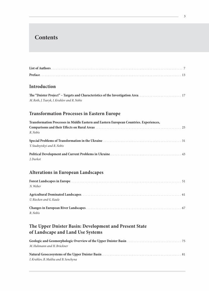
Contents
List of Authors . . . . . . . . . . . . . . . . . . . . . . . . . . . . . . . . . . . . . . . . . . . . . . . . . . . . . . . . . . . . . . . . . . . . . . . . . . . . . . . . . . . 7
Preface . . . . . . . . . . . . . . . . . . . . . . . . . . . . . . . . . . . . . . . . . . . . . . . . . . . . . . . . . . . . . . . . . . . . . . . . . . . . . . . . . . . . . . . . . 13
IntroductionThe “Dnister Project” – Targets and Characteristics of the Investigation Area . . . . . . . . . . . . . . . . . . . . . . . . . . . 17M.Roth, J.Tsaryk, I.Kruhlov and R.Nobis
Transformation Processes in Eastern EuropeTransformation Processes in Middle Eastern and Eastern European Countries. Experiences, Comparisons and their Effects on Rural Areas . . . . . . . . . . . . . . . . . . . . . . . . . . . . . . . . . . . . . . . . . . . . . . . . . . . . . . 25R.Nobis
Special Problems of Transformation in the Ukraine . . . . . . . . . . . . . . . . . . . . . . . . . . . . . . . . . . . . . . . . . . . . . . . . . 31Y.Stadnytskyi and R.Nobis
Political Development and Current Problems in Ukraine . . . . . . . . . . . . . . . . . . . . . . . . . . . . . . . . . . . . . . . . . . . . . 43J.Durkot
Alterations in European LandscapesForest Landscapes in Europe . . . . . . . . . . . . . . . . . . . . . . . . . . . . . . . . . . . . . . . . . . . . . . . . . . . . . . . . . . . . . . . . . . . . . . 51N.Weber
Agricultural Dominated Landscapes . . . . . . . . . . . . . . . . . . . . . . . . . . . . . . . . . . . . . . . . . . . . . . . . . . . . . . . . . . . . . . . 61U.Riecken and G.Kaule
Changes in European River Landscapes . . . . . . . . . . . . . . . . . . . . . . . . . . . . . . . . . . . . . . . . . . . . . . . . . . . . . . . . . . . . 67R.Nobis
The Upper Dnister Basin: Development and Present State of Landscape and Land Use SystemsGeologic and Geomorphologic Overview of the Upper Dnister Basin . . . . . . . . . . . . . . . . . . . . . . . . . . . . . . . . . . 75M.Huhmann and H.Brückner
Natural Geoecosystems of the Upper Dnister Basin . . . . . . . . . . . . . . . . . . . . . . . . . . . . . . . . . . . . . . . . . . . . . . . . . . 81I.Kruhlov, B.Mukha and B.Senchyna
Transformation processes in the Western Ukraine – Concepts for a sustainable land use
Topoclimate of the Upper Dnister Basin: Consequences for Crop Cultivation . . . . . . . . . . . . . . . . . . . . . . . . . . . 99B.Mukha
Late Pleistocene and Holocene Landscape Evolution of the Upper Dnister Valley . . . . . . . . . . . . . . . . . . . . . . . 105M.Huhmann and H.Brückner
The Hydrologic Regime of the Upper Dnister Basin . . . . . . . . . . . . . . . . . . . . . . . . . . . . . . . . . . . . . . . . . . . . . . . . . 113I.Kovalchuk and A.Mykhnovych
Current Problems of Water Management in the Upper Dnister Basin . . . . . . . . . . . . . . . . . . . . . . . . . . . . . . . . . 125I.Kovalchuk, A.Mykhnovych, J.Quast, J.Steidl and V.Ehlert
Utilisation and Over-exploitation of Fish Resources in Selected Areas of the Upper Dnister Basin . . . . . . . . 137V.Lesnik and E.Korte
Land Use History . . . . . . . . . . . . . . . . . . . . . . . . . . . . . . . . . . . . . . . . . . . . . . . . . . . . . . . . . . . . . . . . . . . . . . . . . . . . . . . 145V.Stetsyuk
Current Land Use Structure of the Upper Dnister Basin and Recent Changes in the Model Communities . . . . . . . . . . . . . . . . . . . . . . . . . . . . . . . . . . . . . . . . . . . . . . . . . . . . . . . . . . . . . . . . . . . . . . 155R.Ressl, W.Endlicher, S.Lehmann, B.Baruth, B.Bosch and G.Rosenthal
Effects of Transformation Processes in Crop Cultivation . . . . . . . . . . . . . . . . . . . . . . . . . . . . . . . . . . . . . . . . . . . . 171P.Kazmir, M.Drozdyak†, M.Kit and L.Kazmir
Recommendations for the Development of Animal Husbandry and Pasture Management in the Model Community Verkhniy Luzhok: Economical and Socioeconomical Aspects . . . . . . . . . . . . . . . . . 181O.Bitter, M.Bomba, Y.Tsaryk, L.Buhryn and B.Bulka
Soil Erosion: Possibilities for Soil Protection. . . . . . . . . . . . . . . . . . . . . . . . . . . . . . . . . . . . . . . . . . . . . . . . . . . . . . . 191M.Huhmann, M.Kit, H.Brückner, S.Poznyak and I.Shpakivska
Chemical Pollution and Environmental Standards . . . . . . . . . . . . . . . . . . . . . . . . . . . . . . . . . . . . . . . . . . . . . . . . . 207W.Kuhrt
The State of Forests from a Vegetational and Silvicultural Point of View and their Evaluation with Regard to Nature Conservation . . . . . . . . . . . . . . . . . . . . . . . . . . . . . . . . . . . . . . . . . . . . . . . . . . . . . . . . . . . . . . 223P.A.Schmidt, P.T.Yashchenko, T.Glaser, M.V.Cherniavskyi and Y.V. Henyk
Species and Functional Diversity of Soil-dwelling Invertebrates in Forest Ecosystemsof the Upper Dnister Basin – Evaluation of Anthropogenic Effects . . . . . . . . . . . . . . . . . . . . . . . . . . . . . . . . . . . . 235M.Roth, M.Kozlowsky, V.Rizun, N.Bräsicke
Assessment of the Current Status of Forests in the Upper Dnister Basin as a Base for the Development of Concepts for a Multifunctional Forestry . . . . . . . . . . . . . . . . . . . . . . . . . . . . . . . . . . . . . . . . . . . . . . . . . . . . . . . . 251A.W.Bitter and B.Koffinke
Evaluation of the Nature Conservation Values of Habitat Types in the Cultural Landscape of the Upper Dnister Basin – Grasslands . . . . . . . . . . . . . . . . . . . . . . . . . . . . . . . . . . . . . . . . . . . . . . . . . . . . . . . . . . 263G.Rosenthal and L.Tasenkevych
Contents
Evaluation of the Nature Conservation Values of Habitat Types in the Cultural Landscape of the Upper Dnister Basin – Ecotones . . . . . . . . . . . . . . . . . . . . . . . . . . . . . . . . . . . . . . . . . . . . . . . . . . . . . . . . . . . . 277R.Nobis, U.Riecken, A.Donning and M.Roth
Grazing Effects on the Nature Conservation Value of Pastures in the Carpathians . . . . . . . . . . . . . . . . . . . . . . 291J.Tsaryk, V.Kyyak, I.Horban, I.Tsaryk and O.Reshetylo
The Effects of Anthropogenic Changes on Breeding Birds and Amphibians in the Upper Dnister Basin . . . 297I.Horban, A.Bokotey, L.Horban and M.Roth
Protected Areas and an Action Plan for Nature Conservation in the Upper Dnister Basin. . . . . . . . . . . . . . . . 309S.Stojko
Ukrainian Tribes in the Ukrainian Carpathians and their Traditions . . . . . . . . . . . . . . . . . . . . . . . . . . . . . . . . . 321V.Stetsiuk
Social and Demographical Aspects in Rural Areas of Carpathians and Precarpathians . . . . . . . . . . . . . . . . . . 329B.Bosch, V.Kravtsiv and W.Endlicher
The Natural Potential and Problems of Sustainable Development of the Carpathian Region . . . . . . . . . . . . . 341I.Kolodiychuk
Sectoral Concepts for Sustainable Land Use Systems and Integrative PlanningGoals of Landscape Development and Nature Conservation . . . . . . . . . . . . . . . . . . . . . . . . . . . . . . . . . . . . . . . . . 345G.Rosenthal, I.Yatsiv, I.Horban, V.Kravtsiv, M.Roth and R.Nobis
Perspectives of a Sustainable Forestry from Ecological and Economical Points of View . . . . . . . . . . . . . . . . . 355A.W.Bitter, P.A.Schmidt, A.M.Deineka, T.Glaser, B.Koffinke, P.T.Yashchenko, M.V.Cherniavskyi and Y.V.Henyk
Scaled Agro-ecological Classification of the Ukraine AEC-UA. . . . . . . . . . . . . . . . . . . . . . . . . . . . . . . . . . . . . . . . 371M.Kit, B.Holz and I.Shpakivska
The Sustainability of Agricultural Land Use. . . . . . . . . . . . . . . . . . . . . . . . . . . . . . . . . . . . . . . . . . . . . . . . . . . . . . . . 389
Opening up Additional Branches of Agriculture: Recommodations for the Model Communities . . . . . . . . . 409I.Yatsiv
Economic Use of Ecotones with High Nature Conservation Value . . . . . . . . . . . . . . . . . . . . . . . . . . . . . . . . . . . . . 419R.Nobis, U.Riecken, I.Yatsiv and I.Horban
Concepts of the Sustainable Water Use and Flood Protection in the Upper Dnister Floodplain . . . . . . . . . . . 431I.Kovalchuk, J.Quast, A.Mykhnovych, J.Steidl, V.Ehlert and Y.Andreychuk
From Sector Evaluation to Integrated Land Use Planning . . . . . . . . . . . . . . . . . . . . . . . . . . . . . . . . . . . . . . . . . . . 441G.Kaule and B.Holz
The Potential of Tourism in Western Ukraine . . . . . . . . . . . . . . . . . . . . . . . . . . . . . . . . . . . . . . . . . . . . . . . . . . . . . . 473W.Kuhrt
Transformation processes in the Western Ukraine – Concepts for a sustainable land use
General Framework and Technical Tools for the Implementation of Sustainability Concepts in the Western UkraineLegislative and Administrative Structures in Ukraine in the Context of the Implementation of Concepts for Sustainable Land Use . . . . . . . . . . . . . . . . . . . . . . . . . . . . . . . . . . . . . . . . . . . . . . . . . . . . . . . . . . . . . 491V.Kravtsiv
The Future Development of Agriculture in the Western Ukraine: Ukraine Joining the WTOand European Integration . . . . . . . . . . . . . . . . . . . . . . . . . . . . . . . . . . . . . . . . . . . . . . . . . . . . . . . . . . . . . . . . . . . . . . . 499I.Yatsiv
The Adaptation of Ukrainian Legislation to the Law of the European Union with Regard to Environmental Protection. . . . . . . . . . . . . . . . . . . . . . . . . . . . . . . . . . . . . . . . . . . . . . . . . . . . . . . . . . . . . . . . . . . . . 509W.Kuhrt
Regional-political Structures and Administrative Organisation in Ukraine . . . . . . . . . . . . . . . . . . . . . . . . . . . . 523V.Kravtsiv and M.Dolishniy
The Dnister GIS: Design, Applications and Proposal in Regard to its Further Implementation and Development. . . . . . . . . . . . . . . . . . . . . . . . . . . . . . . . . . . . . . . . . . . . . . . . . . . . . . . . . . . . . . . . . . . . . . . . . . . . . . . 529E.Tcherkezova
References . . . . . . . . . . . . . . . . . . . . . . . . . . . . . . . . . . . . . . . . . . . . . . . . . . . . . . . . . . . . . . . . . . . . . . . . . . . . . . . . . . . . . 541
Subject index . . . . . . . . . . . . . . . . . . . . . . . . . . . . . . . . . . . . . . . . . . . . . . . . . . . . . . . . . . . . . . . . . . . . . . . . . . . . . . . . . . 579
Contents of the CD . . . . . . . . . . . . . . . . . . . . . . . . . . . . . . . . . . . . . . . . . . . . . . . . . . . . . . . . . . . . . . . . . . . . . . . . . . . . . 599
List of Authors
Dr. Y. AndreychukIvan-Franko National University LvivChair of Constructive Geography and Cartographyvul. Doroshenka 4179000 LvivUkraine
Prof. Dr. A. W. BitterTechnische Universität DresdenInstitute of Forest Management and PlanningPiennerstraße 2301735 [email protected]
Dr. Oleksandr BitterNational University of Agriculture LvivChair of Statistic and AnalysisDublianyZhovkva district80381 Lviv regionUkraine
Dr. Andriy BokoteyNatural History MuseumUkrainian National Academy of Sciencevul. Teatralna 1879008 [email protected]
Prof. Dr. Myroslav BombaNational University of Agriculture LvivChair of AgricultureDublianyZhovkva district80381 Lviv regionUkraine
Dr. Barbara BoschHumboldt-Universität zu BerlinInstitute of GeographyUnter den Linden 610099 [email protected]
Dipl.-Forstwirt. Nadine BräsickeTechnische Universität DresdenInstitute of Forest Botany and Forest ZoologyPiennerstraße 701737 [email protected]
Dr. Liubomyr BuhrynInstitute of Agriculture and Livestock Farming of Western UkraineUkrainian National Academy of ScienceObroshynoPustomyty district81115 Lviv [email protected]
Dr. Bohdan BulkaInstitute of Agriculture and Livestock Farming of Western UkraineUkrainian National Academy of ScienceObroshynoPustomyty district81115 Lviv [email protected]
Transformation processes in the Western Ukraine – Concepts for a sustainable land use
Prof. Dr. Helmut BrücknerPhilipps-Universität MarburgInstitute of GeographyDeutschhausstraße 1035032 MarburgGermanyh.brueckner@staff
Dr. Mykola V. CherniavskyiNational University of Forestry and Wood Technology LvivChair of Ecologyvul. Kobylianskoi 179005 [email protected]
Dr. Anatoli M. DeinekaState Forestry Union LvivLisvul. Javornitskogo 8b79054 LvivUkraine
Prof. Dr. Maryan DolishniyInstitute of Regional Development and PolicyUkrainian National Academy of Sciencevul. Kozelnytska 479026 [email protected]
Axel DonningEFTAS remote sensing technology transferOstmarkstraße 9248145 Mü[email protected]
Dr. Myron Drozdyak †Ivan-Franko National University LvivChair of Regional PlanningDublianyZhovkva district80381 Lviv regionUkraine
Juri Durkotvul. Laserenka 27/3979026 [email protected]
Dipl.-Ing. Volker EhlertLeibniz Centre for Agricultural Landscape Research (ZALF) e.V.Institute of Landscape HydrologyEberswalder Straße 8415374 Mü[email protected]
Prof. Dr. Wilfried EndlicherHumboldt-Universität zu BerlinInstitute of GeographyUnter den Linden 610099 [email protected]
Dipl.-Forstwirt Thomas GlaserTechnische Universität DresdenInstitute of Land Improvement and Nature ConservationPiennerstraße 701737 [email protected]
Dr. Yaroslav HenykNational University of Forestry and Wood Technology LvivChair of Landscape Architecture, Horticulture and Urban Ecologyvul. Kobylianskoi 179005 LvivUkraine
Brigitte HolzOffice for Landscape Planning and EcologyWollgrasweg 4970599 [email protected]
List of Authors
Dr. Ihor HorbanIvan-Franko National University LvivChair of Zoologyvul. Hrushevskoho 479005 [email protected]
Liubov HorbanNature Reserve „Roztochia“Ivano-FrankoveYavoriv district80004 Oblast Lviv [email protected]
Dr. Mirko HuhmannPhilipps-Universität MarburgInstitute of GeographyDeutschhausstraße 1035032 [email protected]
Prof. Dr. Giselher KauleUniversity StuttgartInstitute of Landscape Planning and EcologyKeplerstraße 1170174 [email protected]
Dr. Ihor KaprusNatural History MuseumUkrainian National Academy of Sciencevul. Teatralna 1879008 [email protected]
Prof. Dr. Pavlo KazmirNational University of Agriculture LvivChair of Land Use ProjectingDublianyZhovkva district80381 Lviv [email protected]
Dipl. Ing. Liubomyr KazmirInstitute of Regional Development and PolicyUkrainian National Academy of Sciencevul. Kozelnytska 479026 [email protected]
Prof. Dr. Myron KitIvan-Franko National University LvivChair of Soil Science and Soil Geographyvul. Doroshenka 4179000 [email protected]
Dipl.-Forstwirt Björn KoffinkeTechnische Universität DresdenInstitute of Forest Management and PlanningPiennerstraße 2301735 TharandtGermanybjö[email protected]
Dr. Iryna KolodiychukInstitute of Regional Development and PolicyUkrainian National Academy of Sciencevul. Kozelnytska 479026 LvivUkraine
Dr. Egbert KorteOffice for Ecological Studies on FishPlattenhof64560 [email protected]
Transformation processes in the Western Ukraine – Concepts for a sustainable land use
Prof. Dr. habil. Ivan KovalchukIvan-Franko National University LvivChair of Constructive Geography and Cartographyvul. Doroshenka 4179000 [email protected]
Dr. Mykola KozlowskyInstitute of Ecology of the CarpathiansUkrainian National Academy of Sciencevul. Kozelnytska 479026 [email protected]@mail.lviv.ua
Dr. Vasyl KravtsivInstitute of Regional Development and PolicyUkrainian National Academy of Sciencevul. Kozelnytska 479026 [email protected]
Dr. Ivan KruhlovIvan-Franko National University LvivChair of Physical Geographyvul. Doroshenka 4179000 [email protected]
Winfried KuhrtHerbergerweg 414167 [email protected]
Dr. Volodymyr KyyakInstitute of Ecology of the CarpathiansUkrainian National Academy of Sciencevul. Kozelnytska 479026 [email protected]
Dipl.-Geogr. Steffi LehmannDLR German Remote Data Center (DFD)Kalkhorstweg 5317235 [email protected]
Dipl.-Biol. Volodymyr LesnikIvan-Franko National University LvivChair of Zoologyvul. Hrushevskoho 479005 LvivUkraine
Dr. Volodymyr MelamudNatural History MuseumUkrainian National Academy of Sciencevul. Teatralna 1879008 LvivUkraine
Dr. Bohdan MukhaIvan-Franko National University LvivChair of Physical Geographyvul. Doroshenka 4179000 [email protected]
Dr. Andriy MykhnovychIvan-Franko National University LvivChair of Constructive Geography and Cartographyvul. Doroshenka 4179000 [email protected]
Dipl.-Landschaftsökol. Ralph NobisTechnische Universität DresdenInstitute of Forest Botany and Forest ZoologyPiennerstraße 701737 [email protected]
List of Authors
Prof. Dr. Stepan PoznyakIvan-Franko National University LvivChair of Soil Science and Soil Geographyvul. Doroshenka 4179000 [email protected]
Prof. Dr. Joachim QuastLeibniz Centre for Agricultural Landscape Research (ZALF) e.V.Institute of Landscape HydrologyEberswalder Straße 8415374 Mü[email protected]
Dr. Ostap ReshetyloNatural History MuseumUkrainian National Academy of Sciencevul. Teatralna 1879008 [email protected]
Rainer ResslDLR German Remote Data Center (DFD)Kalkhorstweg 5317235 [email protected]
Dr. Uwe RieckenGerman Federal Agency for Nature Conservation (BfN)Konstantinstraße 11053179 [email protected]
Dr. Volodymyr RizunNatural History MuseumUkrainian National Academy of Sciencevul. Teatralna 1879008 [email protected]
PD Dr. habil. Gert RosenthalUniversity StuttgartInstitute of Landscape Planning and Ecology70174 [email protected]
Prof. Dr. Mechthild RothTechnische Universität DresdenInstitute of Forest Botany and Forest ZoologyPiennerstraße 701737 [email protected]
Prof. Dr. Dr. h. c. P. A. SchmidtTechnische Universität DresdenInstitute of Land Improvement and Nature ConservationPiennerstraße 701737 [email protected]
Dr. Bogdana SenchynaIvan-Franko National University LvivChair of Rational Use and Nature Conservationvul. Doroshenka 4179000 LvivUkraine
Dr. Iryna ShpakivskaInstitute of Ecology of the CarpathiansUkrainian National Academy of Sciencevul. Kozelnytska 479026 [email protected]@ukr.net
Prof. Dr. Yuriy StadnytskyiInstitute of Regional Development and PolicyUkrainian National Academy of Sciencevul. Kozelnytska 479026 LvivUkraine
Transformation processes in the Western Ukraine – Concepts for a sustainable land use
Dr. Joachim SteidlLeibniz Centre for Agricultural Landscape Research (ZALF) e.V.Institute of Landscape HydrologyEberswalder Straße 8415374 Mü[email protected]
Dipl.-Ing. Valentin StetsyukTovarystvo Lewavul. Drogobycha 6/1079000 [email protected][email protected]
Prof. Dr. Dr. h. c. Stepan StojkoInstitute of Ecology of the CarpathiansUkrainian National Academy of Sciencevul. Kozelnytska 479026 [email protected]
Dr. Lidia TasenkevychNatural History MuseumUkrainian National Academy of Sciencevul. Teatralna 1879008 [email protected]
Dr. Emilia TcherkezovaUniversity StuttgartInstitute of Landscape Planning and EcologyKeplerstraße 1170174 [email protected]
Prof. Dr. Yosyf TsarykIvan-Franko National University LvivChair of Zoologyvul. Hrushevskoho 479005 LvivUkraine
Dr. Inna TsarykInstitute of Ecology of the CarpathiansUkrainian National Academy of Sciencevul. Kozelnytska 479026 [email protected]
Prof. Dr. Norbert WeberTechnische Universität DresdenInstitute of Forest Management and PlanningPiennerstraße 2301737 [email protected]
Dr. Pavlo YashchenkoInstitute of Ecology of the CarpathiansUkrainian National Academy of Sciencevul. Kozelnytska 479026 [email protected]
Dr. Ihor YatsivNational University of Agriculture LvivChair of Statistic and AnalysisDublianyZhovkva district80381 Lviv regionUkraine
Dipl.-Biol. Vasyl YavornytskyiInstitute of Ecology of the CarpathiansUkrainian National Academy of Sciencevul. Kozelnytska 479026 LvivUkraine
Preface
The cooperation of German and Ukrainian nature scientists has a long tradition and a changeful his-tory. During the Soviet regime contacts of Ukrain-ian scientists with research institutes of e.g. West-ern Europe had been restricted and were strongly controlled. With the political changes, initiated by Gorbatchovs “Perestrojka” also the scientific communication started to increase. On the envi-ronmental sector especially the nuclear catastro-phe of Chernobyl promoted the need for an ex-change of knowledge. As a consequence of radi-oactive environmental contaminations the Soviet government agreed also to the foundation of non-governmental organisations.
One of the first, that was founded in Ukraine in 1987 was Tovarystvo Lewa. Due to severe pol-lutions of the Dnister in Western Ukraine caused by emissions of a chemical plant some years ago, Tovarystvo Lewa focused their activities also on the protection of this river ecosystem. To receive international public awareness this NGO organ-ised since 1988 nature conservation expeditions on the river Dnister. One guidance of this expedi-tions carried out by float was Valentin Stetsyuk.
In 1993, Stephan Niemeier, a German activ-ist of environmental movements and a student of nature conservation at Philipps-Universität Mar-burg participated in this expedition and met with Valentin Stetsyuk. This meeting was the starting point for a long lasting personal friendship and gave rise to the idea of a German-Ukrainian re-search-project on the ecology of the river Dnister. Returning back to Marburg with enthusiastic feel-ings for the unique landscape of the Dnister val-ley it was easy for Stephan Niemeier to convince his supervisor, Prof. Dr. Harald Plachter, who is always fascinated by the idea to make impossible things possible, of the realisation of a binational nature conservation project. Without doubt, it is
the honourable merit of Harald Plachter to give the idea of a German-Ukrainian research-project first scientific contents and above all to open up the necessary financial resources for the realisa-tion of a nature conservation research project in the Western Ukraine. Thus, in 1995 a pilot study, financed by the “Stifterverband für die deutsche Wissenschaft” and supported by the “Ukrainian Ministry of Nature Conservation” started. Due to the successful results of the pilot project, Har-ald Plachter succeeded to spark the interest of the German Ministry of Education and Research in the German-Ukrainian scientific cooperation.
Starting with April 1997 the German Ministry of Education and Research funded the binational interdisciplinary research-network with three phases (Tab. 1). Thus, the editors and all other co-workers are indebted to the BMBF. Without the financial support, it would not have been possi-ble to realise the project. Special tribute has to be payed to Beate Schütze, Dr. Ingo Fitting, Katha-rina Sempf and Dr. Joachim Kutscher from the Project Management Organisation Jülich in the Jülich Research Centre for their efforts in realising the research project. The research project was run under the patronage of the UNESCO. We have to express our gratitude to Mr. Vefa Moustafaev and Mr. Mustafa El Tayeb.
Additional support was given by the German Academic Exchange Service (DAAD), which is greatfully acknowledged.
The results of the first two project phases, that were run under the coordination of Philipps-Uni-versität Marburg, documented the unique value of the cultural landscape of the Dnister valley, which is caused by manifold landscape attributes and a high level of biodiversity. On the other hand the transformation processes starting in the 90s have lead to severe alterations of economical condi-
Transformation processes in the Western Ukraine – Concepts for a sustainable land use
tions and put high pressure on the ecological sta-tus of the landscape. Thus, it was a big challenge for a collective of Ukrainian and German scien-tists to develop in the third project phase, that was coordintated by Technische Universität Dres-den, sustainability concepts for selected model re-gions of the rural landscapes of the Dnister catch-ment. Besides Dr. Winfried Kuhrt, Berlin (former Senior Legal Secretary, Ministry of the Environ-ment, Lower Saxony), numerous Ukrainian and German scientists from the following institutions contributed to the results of the third project phase, that are published in this book:
Technische Universität Dresden:▷ Institute of Forest Management and Planning:
Prof. Dr. Andreas Walter Bitter, Prof. Dr. Nor-bert Weber, Björn Koffinke, Jenny Postler
▷ Institute of Forest Botany and Forest Zoology: Nadine Bräsicke, Michael Elmer, Gisela Förster, Ralph Nobis, Prof. Dr. Mechthild Roth
▷ Institute of Land Improvement and Nature Con-servation: Thomas Glaser, Prof. Dr. Dr. h. c. Peter Adam Schmidt
German Aerospace Center (DLR):▷ German Remote Sensing Data Center (DFD),
Neustrelitz: Erik Borg, Steffi Lehmann, Rainer Ressl
German Federal Agency for Nature Conservation:▷ Dr. Uwe Riecken
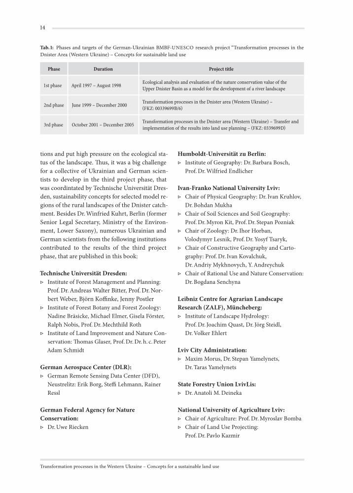
Tab. : Phases and targets of the German-Ukrainian BMBF-UNESCO research project “Transformation processes in the Dnister Area (Western Ukraine) – Concepts for sustainable land use
Phase Duration Project title
1st phase April 1997 – August 1998 Ecological analysis and evaluation of the nature conservation value of the Upper Dnister Basin as a model for the development of a river landscape
2nd phase June 1999 – December 2000 Transformation processes in the Dnister area (Western Ukraine) – FKZ: 00339699B/6
3rd phase October 2001 – December 2005 Transformation processes in the Dnister area (Western Ukraine) – Transfer and implementation of the results into land use planning – FKZ: 0339699D
Humboldt-Universität zu Berlin:▷ Institute of Geography: Dr. Barbara Bosch,
Prof. Dr. Wilfried Endlicher
Ivan-Franko National University Lviv:▷ Chair of Physical Geography: Dr. Ivan Kruhlov,
Dr. Bohdan Mukha▷ Chair of Soil Sciences and Soil Geography:
Prof. Dr. Myron Kit, Prof. Dr. Stepan Pozniak▷ Chair of Zoology: Dr. Ihor Horban,
Volodymyr Lesnik, Prof. Dr. Yosyf Tsaryk,▷ Chair of Constructive Geography and Carto-
graphy: Prof. Dr. Ivan Kovalchuk, Dr. Andriy Mykhnovych, Y. Andreychuk
▷ Chair of Rational Use and Nature Conservation: Dr. Bogdana Senchyna
Leibniz Centre for Agrarian Landscape Research (ZALF), Müncheberg:▷ Institute of Landscape Hydrology:
Prof. Dr. Joachim Quast, Dr. Jörg Steidl, Dr. Volker Ehlert
Lviv City Administration:▷ Maxim Morus, Dr. Stepan Yamelynets,
Dr. Taras Yamelynets
State Forestry Union LvivLis:▷ Dr. Anatoli M. Deineka
National University of Agriculture Lviv:▷ Chair of Agriculture: Prof. Dr. Myroslav Bomba▷ Chair of Land Use Projecting:
Prof. Dr. Pavlo Kazmir
Preface
▷ Chair of Regional Planning: Dr. Myron Drozdiak†
▷ Chair of Statistic and Analysis: Dr. Oleksandr Bitter, Dr. Ihor Yatsiv
National University of Forestry and Wood Technology Lviv:▷ Chair of Ecology: Dr. Mykola V. Cherniavskyi▷ Chair of Landscape Architecture, Horticulture
and Urban Ecology: Dr. Yaroslav V. Henyk
Office for Ecological Studies on Fish, Riedstadt-Erfelden:▷ Dr. Egbert Korte
Office for Landscape Planning and Ecology, Stuttgart:▷ Brigitte Holz
Philipps-Universität Marburg:▷ Institute of Geography:
Prof. Dr. Helmut Brückner, Dr. Mirko Huhmann
Tovarystvo Lewa:Dipl.-Ing. Valentin Stetsyuk
Ukrainian National Academy of Science:▷ Institute of Agriculture and Livestock Farming:
Dr. Liubomyr Bugryn, Dr. Bohdan Bulka▷ Institute of Ecology of the Carpathians:
Dr. Mykola Kozlowsky, Dr. Volodymyr Kyiak, Prof. Dr. Dr. h. c. Stepan Stojko, Dr. Inna Tsaryk, Dr. Irina Shpakivska, Dr. Pavlo T. Yashchenko, Vasyl Yavornytskyi
▷ Institute of Regional Development and Policy: Prof. Dr. Maryan Dolischniy, Dr. Liubomyr Kazmir, Dr. Irina Kolodiychuk, Dr. Vasyl Kravtsiv, Prof. Dr. Yuriy Stadnytskyi,
▷ Natural History Museum: Dr. Andriy Bokotey, Dr. Ihor Kaprus, Dr. Volodymyr Melamud, Dr. Ostap Reshetylo, Dr. Volodymyr Rizun, Dr. Lidia Tasenkevych
University Stuttgart:▷ Institute of Landscape Planning and Ecol-
ogy: Prof. Dr. Giselher Kaule, Dr. habil. Gert Rosenthal, Dr. Hans-Georg Schwarz-v. Raumer, Dr. Emilia Tcherkezova
The implementation of the results in land use planning was supported by a variety of Ukrainian authorities. Specical tribute has to be paid to:
▷ National Ministry of Education and Science;▷ National Academy of Sciences;▷ Oblast Lviv State Administration;▷ Oblast Lviv Authority of Economy;▷ Oblast Lviv Authority of Ecology and Nature
Ressources;▷ Oblast Lviv Authority of Soil Resources;▷ Oblast Lviv Authority of Hydrology;▷ Lvivlis – State Department of Forestry.
A lot of other persons contributed to the suc-cessful publication of this book. Thus, we have to thank Wieland Schmidt (TU Dresden) for his translations of several chapters of the book in English language and Dennis O’Connell (Execu-tive Language Services, Stuttgart) for proof read-ing the English manuscripts. A lot of layout-work was done by Gisela Förster, Carolin Werthschütz and Richard Georgi. Moreover we have to pay tribute to Natalia Weselowska and Olessia Stepan-yshyn who did an excellent work in the project office in Lviv and as interpreters of all German-Ukrainian communications.
The same applies to the GIS-working group in Lviv (Dr. Stepan Yamelynets, Dr. Taras Yame-lynets, Maxim Morus).
Finally I would like to dedicate this book to the late Dr. Myron Drozdiak and Dr. Hans-Erich Gramatzki. With his profound knowledge on crop cultivation Dr. Drozdiak gave essential ideas for the development of sustainability concepts in ag-riculture. Dr. Hans-Erich Gramatzki made helpful suggestions for structuring the socio-economic part of the project.
On behalf of the editorsM. Roth
The “Dnister Project” – Targets and Characteristics of the Investigation AreaM. Roth, J. Tsaryk, I. Kruhlov and R. Nobis
As a result of the Earth Summit (UNCED: United Nations Conference on Environment and Devel-opment) held in June 1992 in Rio de Janeiro, 170 countries have signed the Agenda 21, a wide rang-ing action plan to improve the conditions of the environment and to ensure the sustainable devel-opment based on the rational use of natural re-sources. A basic approach of the Agenda 21 for a development that meets the needs of the present without compromising the ability of future gen-erations to meet their own needs is the integra-tion of environmental aspects in all other fields of politics. Thus, a sustainable development has to be based on the harmonisation of ecological, eco-nomical and social factors of development.
In economically well developed countries the guidelines for the future development which is in
accordance with the needs of sustainability are mostly defined. Partly due to the long lasting and complex processes of restructuring economy and administration transformation countries are still standing at the beginning of the process which re-sults in the implementation of principles of sus-tainability in the further development of the so-ciety.
This applies for Ukraine too, despite the fact that on the national level several laws and ordi-nances of the ministerial cabinet and the presi-dent concerning the sustainable development have been passed. Their successful implementa-tion on subordinate geographic levels depends to a large part on the regional and local peculiari-ties of the transformation processes that occur in society, economy and policy as well as on the ac-
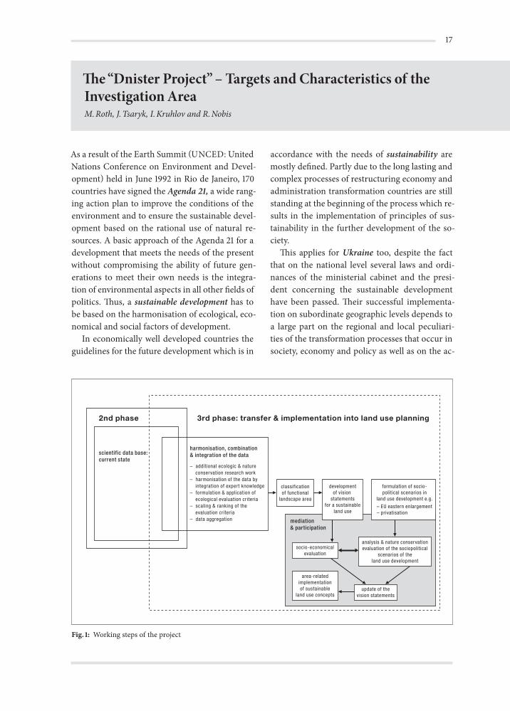
Fig. : Working steps of the projectIntr
oduc
tion
Transformation processes in the Western Ukraine – Concepts for a sustainable land use
ceptance by local, regional and national decision makers and state-run financial support. Moreo-ver, one of the most important factors that cause the slow pace of the implementation process is the lack of scientifically based concepts for the sus-tainable use of natural resources which simulta-neously ensure the economic wealth of the popu-lation. Of special importance in this context are the rural cultural landscapes of Ukraine that are characterised by agricultural use and forestry and on the other hand a high nature conservation value and that will probably undergo severe alter-ations due to an increasing influence of a global market economy.
Based on a broad spectrum of scientifically as-sessed data on natural site conditions (e.g. geol-ogy, hydrology, and climate), botanical and fauna biodiversity, land use systems, and socio-demog-raphy, the German-Ukrainian research-network aimed at the development of concepts for the sus-
tainable development of rural cultural landscapes in the western part of the transformation coun-try Ukraine. The focus of the research project was laid on the effects of the transformation processes on the sectors agricultural land use, forestry and flood regime including their economic aspects. Starting with the aggregation of the ecological, so-cio-economic and agricultural data regionally dif-ferentiated goals for a sustainable land use were developed and harmonised with the scenarios for the future development of Ukraine in an iterative process (Fig. 1). The investigations were carried out in close cooperation with Ukrainian decision makers on the local, regional and national level and with corporate organisations of agriculture and forestry to ensure the practical realisation of the concepts of sustainability. For the evaluation and visualisation of the results a GIS based data base adapted to the investigation area was gen-erated.
The investigation area
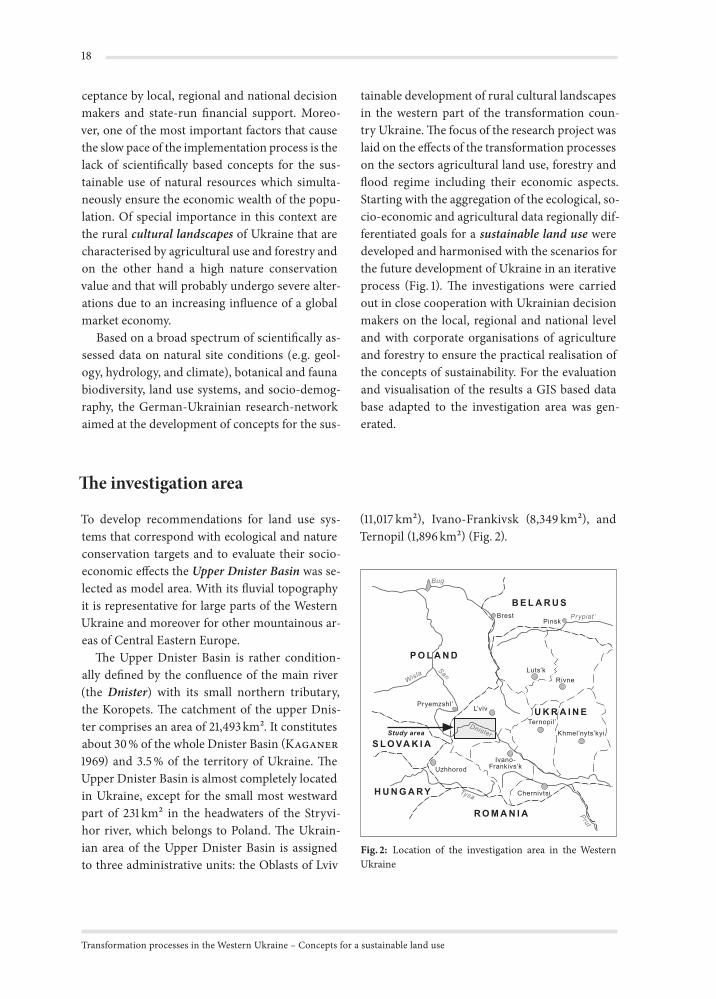
To develop recommendations for land use sys-tems that correspond with ecological and nature conservation targets and to evaluate their socio-economic effects the Upper Dnister Basin was se-lected as model area. With its fluvial topography it is representative for large parts of the Western Ukraine and moreover for other mountainous ar-eas of Central Eastern Europe.
The Upper Dnister Basin is rather condition-ally defined by the confluence of the main river (the Dnister) with its small northern tributary, the Koropets. The catchment of the upper Dnis-ter comprises an area of 21,493 km2. It constitutes about 30 % of the whole Dnister Basin (Kaganer1969) and 3.5 % of the territory of Ukraine. The Upper Dnister Basin is almost completely located in Ukraine, except for the small most westward part of 231 km2 in the headwaters of the Stryvi-hor river, which belongs to Poland. The Ukrain-ian area of the Upper Dnister Basin is assigned to three administrative units: the Oblasts of Lviv
(11,017 km2), Ivano-Frankivsk (8,349 km2), and Ternopil (1,896 km2) (Fig. 2).
Bug
San
Wisla
Dnister
Tysa
Prut
Prypiat’BrestPinsk
Luts’kRivne
L’vivPryemzshl’
UzhhorodIvano-
Frankivs’k
Ternopil’
Khmel’nyts’kyi
Chernivtsi
P O L A N D
B E L A R U S
U K R A I N E
S L O VA K I A
H U N G A R Y
R O M A N I A
Study area
Fig. : Location of the investigation area in the Western Ukraine
The “Dnister Project”– Targets and Characteristics of the Investigation Area
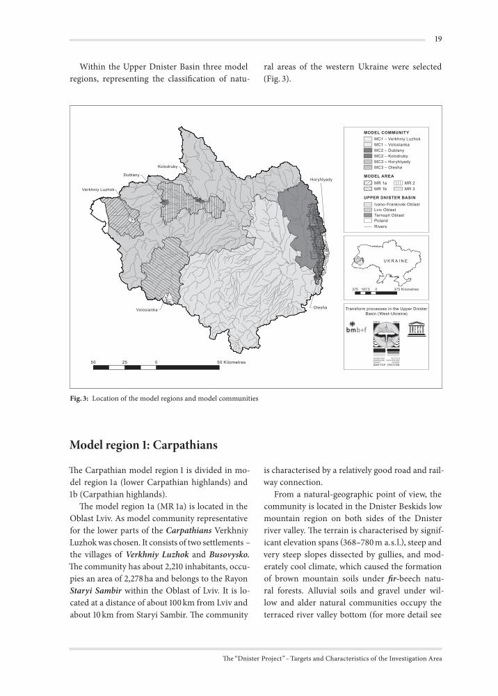
Within the Upper Dnister Basin three model regions, representing the classification of natu-
50 025 50 Kilometres
U K R A I N E
375 0 375187,5 Kilometres
MR 1aMR 1b
MR 2MR 3
MODEL AREA
UPPER DNISTER BASINIvano-Frankivsk OblastLviv OblastTernopil OblastPolandRivers
MODEL COMMUNITY
MC3 – HoryhlyadyMC2 – KolodrubyMC2 – Dublany
MC1 – Verkhniy LuzhokMC1 – Volosianka
MC3 – Olesha
Transform processes in the Upper DnisterBasin (West-Ukraine)
Horyhlyady
Kolodruby
Dublany
Verkhniy Luzhok
Volosianka Olesha
Fig. : Location of the model regions and model communities
ral areas of the western Ukraine were selected (Fig. 3).
Model region : Carpathians
The Carpathian model region 1 is divided in mo-del region 1a (lower Carpathian highlands) and 1b (Carpathian highlands).
The model region 1a (MR 1a) is located in the Oblast Lviv. As model community representative for the lower parts of the Carpathians Verkhniy Luzhok was chosen. It consists of two settlements – the villages of Verkhniy Luzhok and Busovysko.The community has about 2,210 inhabitants, occu-pies an area of 2,278 ha and belongs to the Rayon Staryi Sambir within the Oblast of Lviv. It is lo-cated at a distance of about 100 km from Lviv and about 10 km from Staryi Sambir. The community
is characterised by a relatively good road and rail-way connection.
From a natural-geographic point of view, the community is located in the Dnister Beskids low mountain region on both sides of the Dnister river valley. The terrain is characterised by signif-icant elevation spans (368–780 m a.s.l.), steep and very steep slopes dissected by gullies, and mod-erately cool climate, which caused the formation of brown mountain soils under fir-beech natu-ral forests. Alluvial soils and gravel under wil-low and alder natural communities occupy the terraced river valley bottom (for more detail see
Transformation processes in the Western Ukraine – Concepts for a sustainable land use
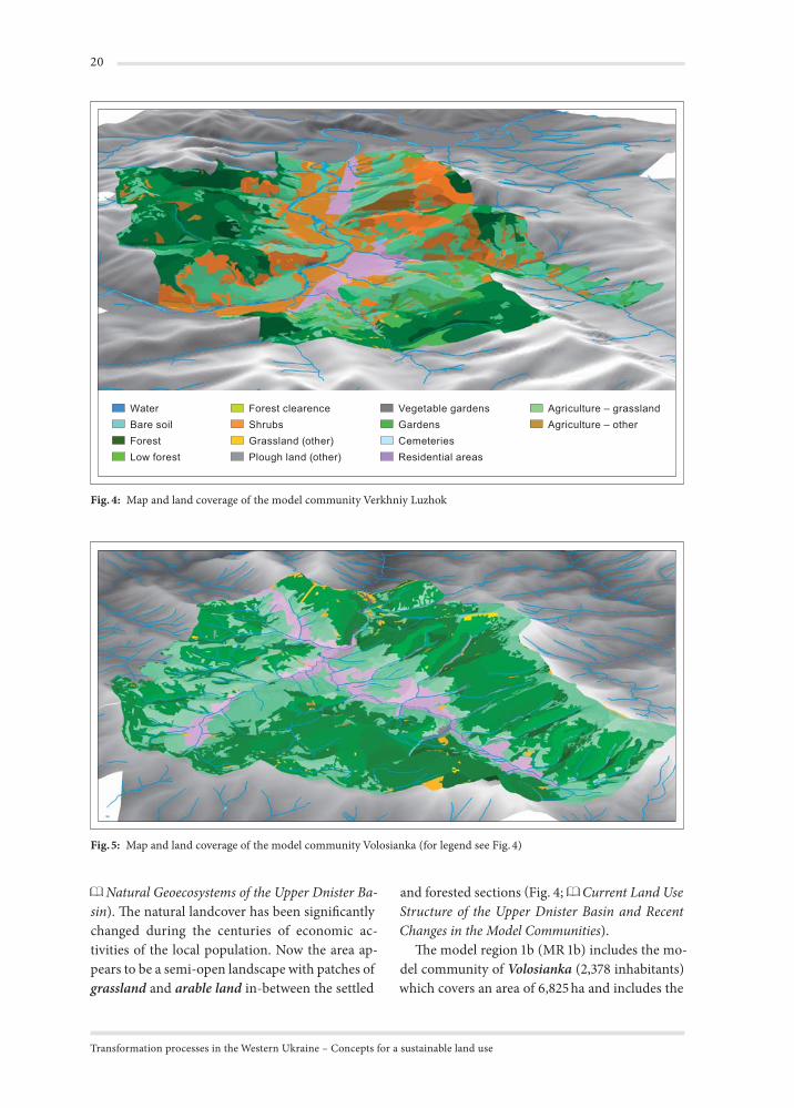
Forest clearenceShrubsGrassland (other)Plough land (other)
Vegetable gardensGardensCemeteriesResidential areas
Agriculture – grasslandAgriculture – other
WaterBare soilForestLow forest
Fig. : Map and land coverage of the model community Verkhniy Luzhok
Fig. : Map and land coverage of the model community Volosianka (for legend see Fig. )
Natural Geoecosystems of the Upper Dnister Ba-sin). The natural landcover has been significantly changed during the centuries of economic ac-tivities of the local population. Now the area ap-pears to be a semi-open landscape with patches of grassland and arable land in-between the settled
and forested sections (Fig. 4; Current Land Use Structure of the Upper Dnister Basin and Recent Changes in the Model Communities).
The model region 1b (MR 1b) includes the mo-del community of Volosianka (2,378 inhabitants) which covers an area of 6,825 ha and includes the
The “Dnister Project”– Targets and Characteristics of the Investigation Area
larger village of Volosianka as well as the smaller villages of Yalynkuvate and Hashchovanya. The community belongs to the Rayon Skole of Lviv Oblast and is located at the very periphery of the administrative units – at the border with Tran-scarpathians and Ivano-Frankivsk Oblasts. The location is a kind of cul-de-sac formed by moun-tain ridges with only one bad mud road of about 7 km leading to Slavske – a well-known national mountain ski resort and the nearest railway sta-tion. The distance is about 150 km to get from Slavske to Lviv and about 25 km to Skole.
The community of Volosianka is located in the internal ecoregion of the Eastern Carpathians called Verchovyna. These are low and middle flysch mountains with the elevation span of 620–1,250 m
within the community territory, steep slopes dis-sected by gullies, and cool climate which caused the formation of brown mountain soils under spruce-beech natural forests (for more detail see
Natural Geoecosystems of the Upper Dnister Ba-sin). The settlements are located in relatively nar-row valleys, and the natural landcover has been significantly changed during the centuries of the economic activities of the local population. On the present day semi-open landscape has patches of grassland and clear-cuts in the matrix of sec-ondary forests with the domination of spruce(Fig. 5; Current Land Use Structure of the Upper Dnister Basin and Recent Changes in the Model Communities).
Model region : Precarpathians
The model region of 584 km2 is located in Lviv Oblast and embraces the so-called Upper Dnis-ter Depression. Its western part belongs to Sambir and Drohobych Rayons, while the eastern part is shared by Horodok and Mykolaiv Rayons. There are about 40 villages in the region. Lviv is located to the north-east at a distance of about 40 km, whilst there are several towns to the south-west: Sambir, Drohobych, and Stryi.
The model region occupies the wide (up to 8 km) Dnister valley filled with peat and allu-vial deposits as well as wavy uplands with gen-tle slopes and loess cover forming the southern limit of the valley. The uplands are separated by relatively wide (1.5–3 km) secondary river valleys. The elevation span is 240–370 m a.s.l. The natural vegetation is represented by alder forests and wet meadows in the valley bottoms, and by oak-horn-beam forests on the uplands (for more detail see
Natural Geoecosystems of the Upper Dnister Ba-sin). Today, this is primarily an agricultural region occupied by grassland and arable land.
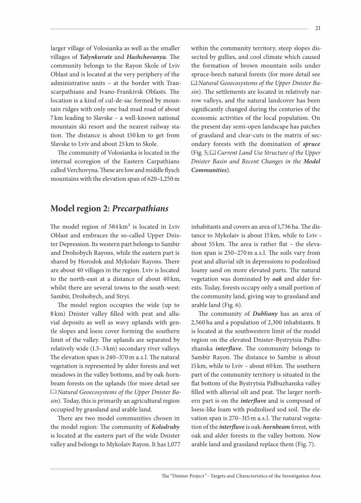
There are two model communities chosen in the model region: The community of Kolodrubyis located at the eastern part of the wide Dnister valley and belongs to Mykolaiv Rayon. It has 1,077
inhabitants and covers an area of 1,736 ha. The dis-tance to Mykolaiv is about 15 km, while to Lviv – about 55 km. The area is rather flat – the eleva-tion span is 250–270 m a.s.l. The soils vary from peat and alluvial silt in depressions to podzolised loamy sand on more elevated parts. The natural vegetation was dominated by oak and alder for-ests. Today, forests occupy only a small portion of the community land, giving way to grassland and arable land (Fig. 6).
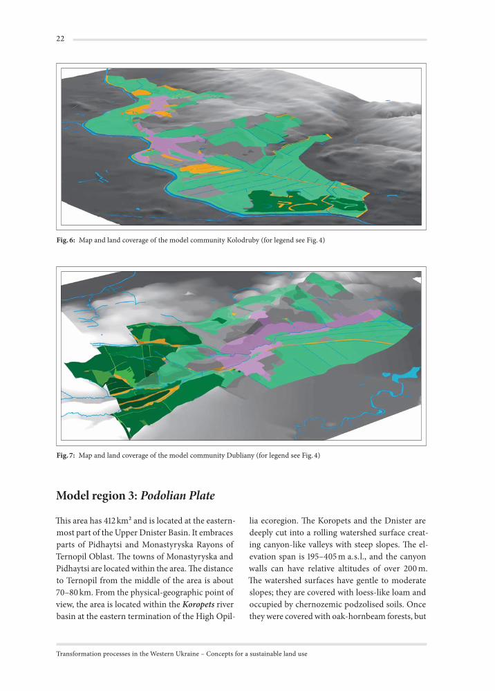
The community of Dubliany has an area of 2,560 ha and a population of 2,300 inhabitants. It is located at the southwestern limit of the model region on the elevated Dnister-Bystrytsia Pidbu-zhanska interfluve. The community belongs to Sambir Rayon. The distance to Sambir is about 15 km, while to Lviv – about 60 km. The southern part of the community territory is situated in the flat bottom of the Bystrytsia Pidbuzhanska valley filled with alluvial silt and peat. The larger north-ern part is on the interfluve and is composed of loess-like loam with podzolised sod soil. The ele-vation span is 270–315 m a.s.l. The natural vegeta-tion of the interfluve is oak-hornbeam forest, with oak and alder forests in the valley bottom. Now arable land and grassland replace them (Fig. 7).
Transformation processes in the Western Ukraine – Concepts for a sustainable land use
Fig. : Map and land coverage of the model community Kolodruby (for legend see Fig. )
Fig. : Map and land coverage of the model community Dubliany (for legend see Fig. )
Model region : Podolian Plate
This area has 412 km2 and is located at the eastern-most part of the Upper Dnister Basin. It embraces parts of Pidhaytsi and Monastyryska Rayons of Ternopil Oblast. The towns of Monastyryska and Pidhaytsi are located within the area. The distance to Ternopil from the middle of the area is about 70–80 km. From the physical-geographic point of view, the area is located within the Koropets river basin at the eastern termination of the High Opil-
lia ecoregion. The Koropets and the Dnister are deeply cut into a rolling watershed surface creat-ing canyon-like valleys with steep slopes. The el-evation span is 195–405 m a.s.l., and the canyon walls can have relative altitudes of over 200 m. The watershed surfaces have gentle to moderate slopes; they are covered with loess-like loam and occupied by chernozemic podzolised soils. Once they were covered with oak-hornbeam forests, but
The “Dnister Project”– Targets and Characteristics of the Investigation Area
now they are used as arable land. The steep slopes of the valleys with calcareous rock outcrops are covered with beech-hornbeam forests (for more detail see Natural Geoecosystems of the Upper Dnister Basin).
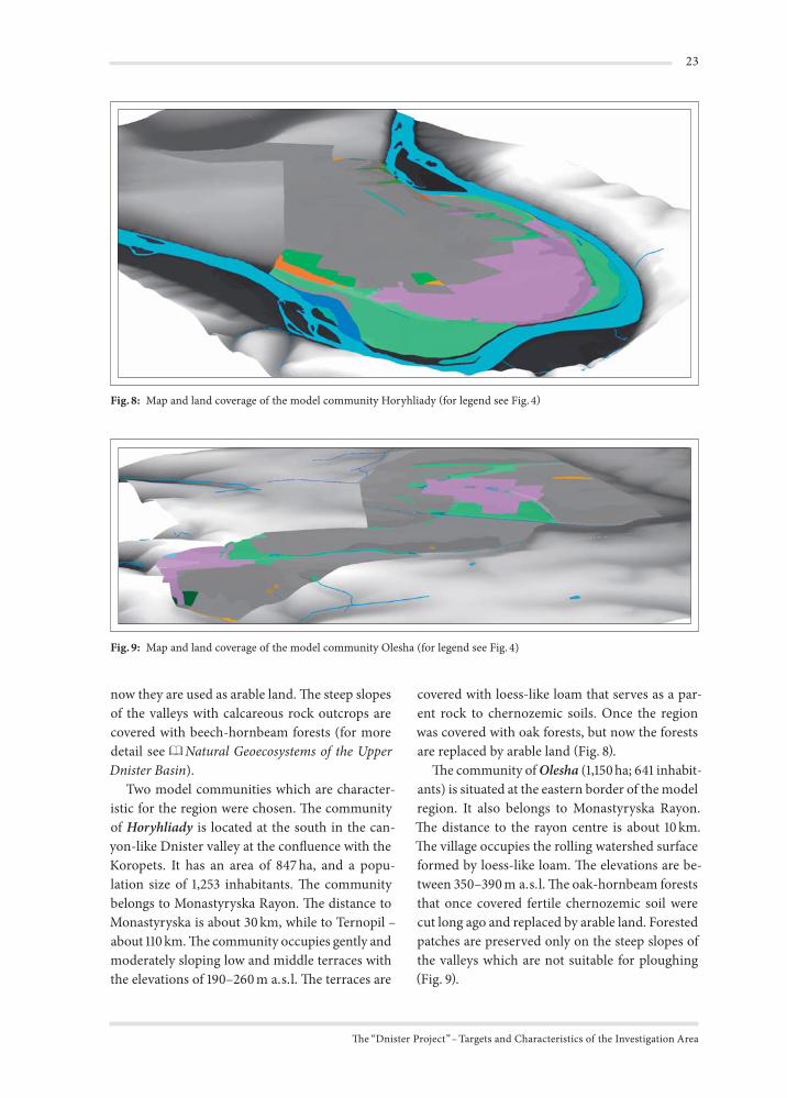
Two model communities which are character-istic for the region were chosen. The community of Horyhliady is located at the south in the can-yon-like Dnister valley at the confluence with the Koropets. It has an area of 847 ha, and a popu-lation size of 1,253 inhabitants. The community belongs to Monastyryska Rayon. The distance to Monastyryska is about 30 km, while to Ternopil – about 110 km. The community occupies gently and moderately sloping low and middle terraces with the elevations of 190–260 m a.s.l. The terraces are
covered with loess-like loam that serves as a par-ent rock to chernozemic soils. Once the region was covered with oak forests, but now the forests are replaced by arable land (Fig. 8).
The community of Olesha (1,150 ha; 641 inhabit-ants) is situated at the eastern border of the model region. It also belongs to Monastyryska Rayon. The distance to the rayon centre is about 10 km. The village occupies the rolling watershed surface formed by loess-like loam. The elevations are be-tween 350–390 m a.s.l. The oak-hornbeam forests that once covered fertile chernozemic soil were cut long ago and replaced by arable land. Forested patches are preserved only on the steep slopes of the valleys which are not suitable for ploughing (Fig. 9).
Fig. : Map and land coverage of the model community Horyhliady for legend see Fig.
Fig. : Map and land coverage of the model community Olesha (for legend see Fig. )