Embed Size (px)
Citation preview

DESIGN ELEMENTS OF EFFECTIVE TRANSIT INFORMATION MATERIALS
State of Florida Department of Transportation
605 Suwannee Street Tallahassee, FL 32399 – 0450
National Center for Transit Research
Center for Urban Transportation Research University of South Florida
4202 E. Fowler Avenue, CUT100 Tampa, FL 33620 – 5375
(813) 974 – 3120
Principle Investigator: Alasdair Cain
Senior Research Associate
November 2004

TECHNICAL REPORT STANDARD TITLE PAGE 1. Report No.
NCTR Project 527-12; FDOT Project BD 544 - 2
2. Government Accession No.
3. Recipient's Catalog No.
5. Report Date
November 2004
4. Title and Subtitle
Design Elements of Effective Transit Information Materials 6. Performing Organization Code
7. Author(s)
Cain, Alasdair
8. Performing Organization Report No.
10. Work Unit No.
9. Performing Organization Name and Address
National Center for Transit Research (NCTR) University of South Florida, CUT 100 4202 East Fowler Avenue, Tampa, FL 33620
11. Contract or Grant No.
2117 – 566LO 13. Type of Report and Period Covered
12. Sponsoring Agency Name and Address
Florida FDOT 605 Suwannee Tallahassee Florida, 32399
14. Sponsoring Agency Code
15. Supplementary Notes
16. Abstract
This report presents the latest phase of research into public comprehension of printed transit information materials. Building on the findings of a study conducted in 2001, this study investigated in more detail how the general public perform in the planning of a transit trip using printed transit information materials. One hundred and eighty people participated in the study, which was conducted at three mall sites in the Tampa Bay area in August 2004. The study found that there was a high success rate (above 90 percent) in the sample’s ability to identify the origin and destination of a specified trip on a transit system map, and to use this map to select two bus routes required to travel from the origin to the destination. These tasks represented the first two stages of a five stage trip planning process. The next three stages involved working with individual route maps and schedules (timetables). It was found that the sample’s ability at the third trip planning stage (identification of bus stops) was also relatively good, but that the sample had most difficulty with the last two stages in the trip planning process, with almost half the participants unable to correctly identify the four required bus times using the tabular schedules. The study also tested a range of different route map and schedule design elements. Test results showed that most of the different design variants did not have a significant impact on the public’s trip planning ability. However, it was found that separating the bus time information for different days of the week into separate tables had a significant positive impact. The study lists the various problems encountered by participants at each trip planning stage and provides suggestions for potential solutions. Two thirds of participants stated that they were now more confident about using transit following the exercise, and around 20 percent, including non-transit users, stated that they would now use transit more often. This suggests that providing instructions and / or education to members of the public on how to use transit information materials could
crease ridership. in 17. Key Words
Transit information materials, bus schedules, route maps, transit trip planning, public comprehension
18. Distribution Statement
19. Security Classif. (of this report)
Unclassified
20. Security Classif. (of this page)
Unclassified
21. No. of pages
22. Price
Form DOT F 1700.7 (8-69)
i
Design Elements of Effective Transit Information Materials – Final Report
State of Florida Department of Transportation
Public Transit Office 605 Suwannee Street
Tallahassee, FL 32399-0450 (850) 414-4500
Project Manager: Tara Bartee, Planning Administrator
National Center for Transit Research Center for Urban Transportation Research
University of South Florida 4202 E. Fowler Avenue, CUT 100
Tampa, FL 33620-5375 (813) 974-3120
Project Director: Dennis Hinebaugh, Transit Program Director Principle Investigator: Alasdair Cain, Senior Research Associate
Project Staff: Jennifer Perone, Research Associate Lisa E. Tucker, Research Associate
Chandra C. Foreman, Research Associate Anthony Thorn, Graduate Research Assistant
Jennifer Flynn, Graduate Research Assistant Martin Catala, Senior Research Associate The opinions expressed in this publication are those of the authors and not necessarily those of the U.S. Department of Transportation or the State of Florida Department of Transportation.
ii

TABLE OF CONTENTS 1. INTRODUCTION .................................................................................................................... 1
1.1 BACKGROUND .................................................................................................................. 1 1.2 STUDY OBJECTIVES.......................................................................................................... 1 1.3 REPORT STRUCTURE........................................................................................................ 2
2. TEST MATERIAL DEVELOPMENT PROCESS.................................................................... 3 2.1 INTRODUCTION ................................................................................................................. 3 2.2 PHASE I – “ASSESSMENT OF TRANSIT INFORMATION MATERIALS…”.................................... 3 2.3 PHASE II – MATERIAL DESIGN APPRAISAL.......................................................................... 5 2.4 DESIGN ELEMENT VARIANT SELECTION ............................................................................. 7 2.5. FIELD TESTING PROCEDURE AND MATERIALS .................................................................... 8
2.5.1 Basic Field Testing Methodology............................................................................... 8 2.5.2 The Field Testing Process ......................................................................................... 9 2.5.3 Test Materials and Test Instruments ....................................................................... 11
3. SAMPLING METHODOLOGY AND DATA COLLECTION................................................. 12 3.1 INTRODUCTION ............................................................................................................... 12 3.2 EXPERIMENTAL DESIGN .................................................................................................. 12 3.3 SELECTING THE SAMPLE RECRUITMENT TECHNIQUE........................................................ 13 3.4 NON-PROBABILITY SAMPLING.......................................................................................... 13 3.5 CALCULATION OF REQUIRED SAMPLE SIZE ...................................................................... 14 3.6 GEOGRAPHICAL COVERAGE OF THE FIELD TEST .............................................................. 14 3.7 IDENTIFYING SUITABLE SHOPPING MALLS ........................................................................ 14 3.8 DETERMINING REQUIRED NUMBER OF INTERVIEWERS AND INTERVIEW DAYS ..................... 15 3.9 THE PILOT TEST ............................................................................................................. 16 3.10 SAMPLE CHARACTERISTICS AND QUOTA ASSESSMENT..................................................... 17
4. ANALYSIS OF AGGREGATE ASSIGNMENT PERFORMANCE....................................... 19 4.1 INTRODUCTION ............................................................................................................... 19 4.2 OVERALL ASSIGNMENT SCORE........................................................................................ 20 4.3 TOTAL TIME TAKEN ON ASSIGNMENT ............................................................................... 22
5. WORKING WITH THE SYSTEM MAP................................................................................. 24 5.1 INTRODUCTION ............................................................................................................... 24 5.2 MEASURES OF PARTICIPANT PERFORMANCE.................................................................... 24 5.3 INTERVIEWER OBSERVATIONS......................................................................................... 25 5.4 PARTICIPANT COMMENTS ON THE SYSTEM MAP ............................................................... 26 5.5 STAGE 1 - LOCATING THE ORIGIN AND DESTINATION ........................................................ 27 5.6 STAGE 2 - IDENTIFYING THE BUS ROUTES ON THE SYSTEM MAP ....................................... 28
6. WORKING WITH THE ROUTE MAP / SCHEDULE ............................................................ 31 6.1 INTRODUCTION ............................................................................................................... 31 6.2 MEASURES OF PARTICIPANT PERFORMANCE.................................................................... 31
6.2.1 Overall Performance................................................................................................ 31 6.2.2 Stage 3 - Locating Bus Stops .................................................................................. 32 6.2.3 Stages 4 and 5 – Using the Schedule ..................................................................... 33
6.3 INTERVIEWER OBSERVATIONS......................................................................................... 34 6.4 PARTICIPANT COMMENTS................................................................................................ 37 6.5 DESIGN ELEMENT VARIANT ANALYSIS.............................................................................. 39
6.5.1 Introduction .............................................................................................................. 39 6.5.2 Design Element A - Front / Back Layout.................................................................. 40 6.5.3 Design Element B – Schedule Alignment ................................................................ 42 6.5.4 Design Element C - Day Scheduling ....................................................................... 44
iii

6.5.5 Design Element D - Time Scheduling...................................................................... 46 6.5.6 Design Element E - Map Details – Points of Interest............................................... 49 6.5.7 Design Element F - Map Details - Road Detail ........................................................ 51 6.5.8 Design Element G - Legend .................................................................................... 52
7. ARE TRANSIT INFORMATION MATERIALS A BARRIER TO TRANSIT USE?............... 55 7.1 INTRODUCTION ............................................................................................................... 55 7.2 CHARACTERISTICS OF CURRENT TRANSIT INFORMATION MATERIAL USE ........................... 55 7.3 IMPACT OF STUDY PARTICIPATION ON TRANSIT USE......................................................... 57 7.4 BARRIERS TO TRANSIT USE ............................................................................................ 60
8. COMPARISON OF STUDY FINDINGS WITH THE FINDINGS OF THE 2001 STUDY ...... 62 8.1 INTRODUCTION ............................................................................................................... 62 8.2 AGGREGATE PARTICIPANT PERFORMANCE COMPARISON ................................................. 63 8.3 DEMOGRAPHIC VARIABLE ANALYSIS ................................................................................ 64 8.4 DESIGN ELEMENT ANALYSIS – SCHEDULE ALIGNMENT ..................................................... 65 8.5 BUS SERVICE CHARACTERISTICS .................................................................................... 65
9. CONCLUSIONS AND RECOMMENDATIONS.................................................................... 66 9.1 INTRODUCTION ............................................................................................................... 66 9.2 AGGREGATE ANALYSIS ................................................................................................... 66 9.3 STAGES IN THE TRIP PLANNING PROCESS........................................................................ 67
9.3.1 Stage 1 – Identifying Trip Origin and Destination .................................................... 67 9.3.2 Stage 2 – Selecting Bus Routes and Transfer Point ............................................... 68 9.3.3 Stage 3 – Locating Bus Stops / Transfer Bus Stop ................................................. 69 9.3.4 Stage 4 – Identifying the Correct Section of the Schedule...................................... 70 9.3.5 Stage 5 – Using the Schedule ................................................................................. 72
9.4 TRANSIT INFORMATION MATERIALS AND TRANSIT USE...................................................... 74 9.5 RECOMMENDATIONS FOR FUTURE RESEARCH.................................................................. 74 9.6 CONCLUSIONS AND RECOMMENDATIONS SUMMARY TABLE............................................... 76
APPENDIX I – TEST INSTRUMENTS.......................................................................................... 77 APPENDIX II – TEST MATERIALS*............................................................................................. 92
iv

1. INTRODUCTION
1.1 Background A major research project was conducted in 2001 to identify different operational barriers to transit use1. Three major barriers were identified – (i) safety and security, (ii) transit information and marketing, and (iii) service availability and convenience. Barrier (ii) was investigated further by recruiting members of the general public to participate in a field test that assessed transit trip planning ability using different transit information materials. The study found that public comprehension of how to use transit information materials to plan transit trips was low, particularly on “complex trips” featuring multiple routes and transfers. The study made a series of recommendations, including one that additional research be conducted in order to isolate the impact of individual information material design elements on public transit trip planning ability – so that the most effective design element variations could be determined. This project, titled “Design of Effective Transit Information Materials”, has been commissioned to address the additional research requirements identified in the 2001 study. An intermediate study, conducted in 2003, began this process by evaluating a wide-range of potential transit information material design elements against different field-test feasibility criteria2.
1.2 Study Objectives At the outset of the study, two major objectives were identified:
− To identify those design elements of printed transit information materials that provide the greatest utility to non-users and users when participating in transit trip planning
− To incorporate those design elements into prototype materials to serve as a model to transit agencies
As the study progressed, other objectives were added:
− To isolate individual stages in the trip planning process and investigate the general public’s ability to undertake each of these stages
− Gain an understanding of the main areas of difficulty at each trip planning stage, on the trip planning task as a whole, and offer suggested improvements in each case
1 Hardin, J., L. Tucker, L. Callejas. (2001). Assessment of Operational Barriers and Impediments to Transit Use. National Center for Transit Research, CUTR. 2 Foreman, C., and L, Tucker. (2003). Assessment of Transit Information Materials and Development of Criteria for Prototype Transit Materials. National Center for Transit Research, CUTR.
1

− Investigate the characteristics of transit trip planning among current transit users, and assess the extent to which transit information materials are a barrier to transit use among non-users.
− Compare the findings of the study to the findings of the original 2001 study, to assess areas consistency and contradiction.
1.3 Report Structure This report begins by explaining the test material development process. Much of the information included in Chapter 2 has been extracted from Technical Memoranda #13. Chapter 3 then discusses the sampling methodology used in the project, providing details of the logistics of the mall intercept surveys that were used to recruit the population sample, and comparing the characteristics of the sample in relation to the target quotas that were set. Much of this information has been extracted from Technical Memorandum #24. The remaining chapters present the results from different aspects of the data analysis stage. Chapter 4 looks at the performance of the sample on the trip planning task as a whole, assessing whether there were any differences in trip planning ability across different criteria such as gender, age and public transit. Chapter 5 focuses on the first two stages of the trip planning task, where participants used a transit system map to identify the correct bus routes to take in order to travel from a specified origin to a specified destination. Chapter 6 then presents the results from the latter three stages of the trip planning task, where participants used individual route maps and schedules to identify bus stops and select bus times from the schedule. Chapter 7 then investigates the characteristics of transit trip planning among current transit users, including the extent to which transit information materials are used, as well as assessing the extent to which transit information materials are a barrier to transit use among current non-users. Chapter 8 then compares the results obtained from this study with the results from the original study conducted in 2001. Chapter 9 presents the study conclusions, and makes recommendations to aid Florida transit agencies in the design of future transit information materials, as well as making some recommendations for future research on this topic.
3 Cain, A. (2004) Technical Memorandum #1 – Test Material and Test Instrument Development Process. National
Center for Transit Research. CUTR. 4 Cain, A. (2004). Technical Memorandum #2 – Sample Recruitment Techniques, Costs and Estimations of
Sample Group Size. National Center for Transit Research. CUTR.
2

2. TEST MATERIAL DEVELOPMENT PROCESS
2.1 Introduction The research study conducted in 2001 used “real-life” transit information materials from all of Florida’s transit agencies to test the general public’s ability to use such materials to plan a transit trip. This wide range of materials allowed researchers to make preliminary conclusions about which designs enhanced people’s ability to plan a trip correctly, and which designs had a negative impact on the trip planning task. However, the fact that there were multiple variations in material design within each agency’s materials meant that it would impossible to make scientifically valid inferences on the performance of individual design elements. For this reason, it was recognized that any future study would have to isolate the individual design elements for separate testing. Identifying the design elements to test in the current study consisted of a two stage process:
Phase I - “Assessment of Transit Information Materials and Development of Criteria for Prototype Transit Materials”. This 2003 study evaluated various design element options under different appraisal criteria, allocating each element to one of three test priority categories.
Phase II - Material Design Appraisal. The different design elements were assessed on a more practical basis, with feasible elements selected for field testing.
2.2 Phase I – “Assessment of Transit Information Materials…” Fifteen design elements were identified from existing transit information materials obtained from transit agencies. Descriptions of each element are provided in Table 2.1 on the next page.
3

TABLE 2.1 – Design Element Descriptions Design Element Design Element Description
Time Scheduling (a.m. or p.m.)
Refers to whether a.m. and p.m. times are differentiated on the route schedule, and if so, the method by which they are differentiated.
Material Format (Schedules and
Maps)
Refers to the way in which information for the entire transit system is presented. Options are (i) a separate system map, along with individual route maps / schedules, or (ii) a Ride Guide, where the system map and route information is all provided in one booklet.
Material Format (Maps)
Refers to whether maps for each individual route are provided, or whether the routes are only shown on the system map.
Front / Back Layout
Refers to whether the schedule and map for an individual route is shown on the same page, or on a different page.
Time Point Identification Refers to whether time points are shown on route maps
Use of Color (Functional)
Refers to whether color is used for functional purposes, such as differentiating routes on the system map.
Map Details Refers to the type of additional detail added to the route maps, such as points of interest, time points, or roads
Stop Alignment Refers to whether the route schedule information is presented in a horizontal format (with bus stops in table rows and time points in table columns), or in vertical format (with bus stops in table columns and time points in table rows).
Day Scheduling
Refers to how schedule information is presented when the level of service varies on different days (normally weekend services run at lower frequencies). Options are to provide separate schedules for days that have different services, or present the information in the same table, using other means to differentiate the different days’ services.
Time Scheduling (Departure Time)
Refers to whether additional information is provided on route schedules to specify that the time points shown are departure times, not arrival times.
Legend Refers to whether a legend is provided on the route map, in order to explain the meaning of the different symbols used.
Directional Symbol Refers to whether a “north arrow” is provided on the route map
Use of Color (Aesthetic) Refers to whether color is used for aesthetic purposes
Transfer Point Identification Refers to whether transfer points are identified on the route or system maps
Font Size Refers to the size of font used in the system maps, route maps and schedules Deciding which elements to select for the field test was determined using an evaluation process composed of four separate evaluation criteria:
Using information from the 2001 field testing
Perceived importance to potential transit users Noted difficulty Feasibility (of conducting a suitable test) Cost (of producing suitable materials)
The following table summarizes the assessment process, indicating whether each element met, or failed to meet, each criteria.
4

TABLE 2.2 – Design Element Selection Matrix*
Element Strong
Perception of Importance
Significant Difficulty in
Original Project
Most Feasible to Test
Inexpensive to Test Tier
Time Scheduling (a.m. or p.m.) X X X X Material Format (Schedules and Maps) X X X Material Format (Maps) X X X Front / Back Layout X X X Time Point Identification X X Use of Color (Functional) X Map Details X
Def
inite
ly
Eva
luat
e
Stop Alignment X X Day Scheduling X X Time Scheduling (Departure Time) X X Legend X X Directional Symbol X X
Pro
babl
y E
valu
ate
Use of Color (Aesthetic) X
Transfer Point Identification X
Font Size Will
Not
E
valu
ate
* Extracted from “Assessment of Transit Information Materials and Development of Criteria for Prototype Transit Materials” Foreman, C., and L, Tucker. (2003). National Center for Transit Research, CUTR.
Table 2.2 shows that the elements were categorized into three categories – “definitely evaluate”, “probably evaluate” and “will not evaluate”. When selecting the elements for each category, priority was given to the two “consumer-relevant” criteria (i.e. those that would be most important to the potential transit user) – “strong perception of importance” and “significant difficultly in original project”. Elements were entered in the “definitely evaluate” category if they met either of the two consumer-relevant criteria. Elements were entered in the “probably evaluate” category if they met both feasibility and cost criteria. Elements entered in the “will not evaluate” category were those that did not meet either of the consumer-relevant criteria and did not meet both of the feasibility and cost criteria.
2.3 Phase II – Material Design Appraisal This stage of the design process compared the design element selections of Phase I against the practical constraints to producing effective test materials. Personnel from CUTR’s GIS team were invited to participate in this phase, and were responsible for the production of the test materials. Having conducted an assessment of feasibility, in terms of resource constraints, GIS software capabilities and the basic test methodology, the selection process was further refined. The following table presents the status of each element following this phase. Where the status changed, the reasoning for doing so is also provided.
5

TABLE 2.3 – Phase II Amendments to Design Element Status Phase I Status
Phase II Status Element Reason for Status Change
Will Evaluate
Time Scheduling (a.m. or p.m.) -
Will not Evaluate
Material Format (Schedules and Maps)
Testing this element would require the production of extensive scheduling material in a “Ride Guide” format, which would not be possible within the project budget, and would not be consistent with the testing methodology
Will not Evaluate
Material Format (Maps)
The testing methodology is based on first providing participants with a system map, with which they select the required routes and transfer point, then providing them with schedule information for each selected route. It is not possible to test system map versus route map using this test methodology
Will Evaluate
Front / Back Layout -
Will not Evaluate
Time Point Identification
Following discussions with several transit agencies, it was decided that time-points are so crucial to transit trip planning that they needed to be provided on all test materials. Therefore, it was decided not to explicitly test this element.
Will not Evaluate
Use of Color (Functional)
It is difficult to design a test that can scientifically test the large number of options available for functional color use within existing resource constraints (a separate study of this element alone would be required). Also, while using color to differentiate bus routes is useful (and almost essential) at the system map level, its value is much less limited at the route map level, as observed in the 2001 field test5.
Def
inite
ly E
valu
ate
Will Evaluate Map Details -
Will Evaluate Stop Alignment -
Will Evaluate Day Scheduling -
Will not Evaluate
Time Scheduling (Departure Time)
This design element refers mainly to whether schedule times are clarified in Ride Guide supporting text as departure times. Therefore, this design element is not suitable for testing in a system map / route map type of test.
Will Evaluate Legend -
Pro
babl
y E
valu
ate
Will not Evaluate
Directional Symbol
Testing this element would be an inefficient use of resources as it is just another minor variation of the Map Details element, which is already being tested.
Will not Evaluate
Use of Color (Aesthetic) -
Will not Evaluate
Transfer Point Identification -
Will
not
E
valu
ate
Will not Evaluate Font Size -
5 Hardin, J., L. Tucker, L. Callejas. (2001). Assessment of Operational Barriers and Impediments to Transit Use, p120. National Center for Transit Research, CUTR.
6

Another design element – “Transfer Points” was originally selected for testing at this stage. However, a decision has been made not to include this element in the field test, for the following reasons:
The route selection decision is made using only the System Map. Therefore, the decision on where to transfer is also made at this stage. With transfer location already identified by the time the participants are given the individual route maps, there is limited value in testing this at the individual route level.
The test materials produced for this test required participants to select a transfer point at the end of the bus route. Using such an obvious transfer location further limits the value of including this test.
The “Legend” design element test is very similar in design to the “Transfer Points” test – with the only difference being that legend used in the “Transfer Points” test only shows transfer points, while the legend used in the “Legend” test shows transfer points in addition to other points of interest. Therefore including both these tests would be an inefficient use of resources.
The previous study identified the “Transfer Points” design element in the “Will not Evaluate” category, due to the fact that the original field test showed that there was not a strong perception of importance among potential transit users, and that it was not associated with significant difficulty.
A further assessment of the Map Details design element was then conducted due to the fact that there are a variety of different types of map detail that could be tested. It was decided to divide this into two individual elements – (i) Map Details – Points of Interest and (ii) Map Details – Roads.
2.4 Design Element Variant Selection The next stage in the process was to consider the different options (known as variants) that would be tested for each design element. The table below shows each element and its corresponding variants.
7

TABLE 2.4 – Selected Design Elements and Their Variants Element
Type Element #. Element Name Variant #.
Material Layout A Front / Back Layout 1. Schedule and map same side
2. Schedule and map opposite side
B Schedule Alignment 1. Vertical alignment 2. Horizontal alignment
C Day Scheduling 1. Same table 2. Separate tables 3. Separate pages
Rou
te S
ched
ule
D Time Scheduling 1. No differentiation (12 hr clock) 2. AM / PM Bold 3. Separate tables
E Map Details - Points of Interest
1. No points of interest 2. Points of interest
F Map Details - Roads
1. Low detail 2. High detail
Rou
te M
ap
G Legend 1. No legend on route maps 2. Legend on route maps
Table 2.4 shows that three of the design elements involve the route schedule, three involve the route map, while the Front – Back Layout element refers to material layout. The following sections discuss the variants associated with each design element. More detailed descriptions of each of these design elements, along with the test results, are provided in Section 6.5.
2.5. Field Testing Procedure and Materials 2.5.1 Basic Field Testing Methodology The first task in this phase was to define the basic methodology for the field test. It was recognized that conducting a scientific “experimental design” field test would require that none of the participants had prior knowledge of the transit materials. Therefore, using materials from existing transit services, as was done in the original field test, would not be possible. In this study, the information materials from one Florida transit agency were used as templates for the test materials, with alterations made to remove any distinguishing features. It was recognized that testing individual design elements at the System Wide level would be problematic, due to the large amount of information presented at this level, which made it difficult to isolate individual design elements. It was also recognized that testing at this level would require the production of materials for the entire transit system, which would not be feasible within the resources of the project. Therefore, it was decided that all design element testing should be conducted at the individual route level – where individual design elements could be effectively isolated. However, it was important that participants planned an entire transit trip. Therefore, a basic test methodology was devised that permitted testing of the participants with system wide materials, while also permitting design element testing at the individual route level. This basic test methodology is defined as follows in Table 2.5:
8
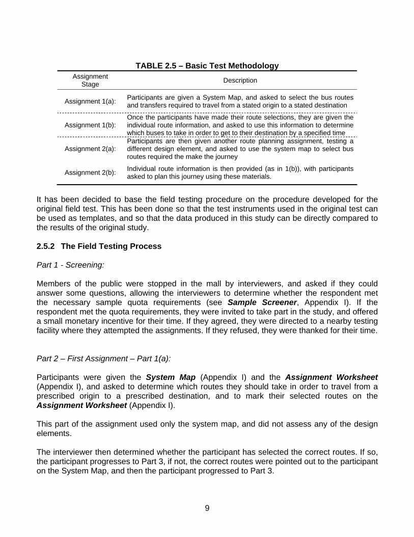
TABLE 2.5 – Basic Test Methodology Assignment
Stage Description
Assignment 1(a): Participants are given a System Map, and asked to select the bus routes and transfers required to travel from a stated origin to a stated destination
Assignment 1(b): Once the participants have made their route selections, they are given the individual route information, and asked to use this information to determine which buses to take in order to get to their destination by a specified time
Assignment 2(a): Participants are then given another route planning assignment, testing a different design element, and asked to use the system map to select bus routes required the make the journey
Assignment 2(b): Individual route information is then provided (as in 1(b)), with participants asked to plan this journey using these materials.
It has been decided to base the field testing procedure on the procedure developed for the original field test. This has been done so that the test instruments used in the original test can be used as templates, and so that the data produced in this study can be directly compared to the results of the original study. 2.5.2 The Field Testing Process Part 1 - Screening: Members of the public were stopped in the mall by interviewers, and asked if they could answer some questions, allowing the interviewers to determine whether the respondent met the necessary sample quota requirements (see Sample Screener, Appendix I). If the respondent met the quota requirements, they were invited to take part in the study, and offered a small monetary incentive for their time. If they agreed, they were directed to a nearby testing facility where they attempted the assignments. If they refused, they were thanked for their time. Part 2 – First Assignment – Part 1(a): Participants were given the System Map (Appendix I) and the Assignment Worksheet (Appendix I), and asked to determine which routes they should take in order to travel from a prescribed origin to a prescribed destination, and to mark their selected routes on the Assignment Worksheet (Appendix I).
This part of the assignment used only the system map, and did not assess any of the design elements. The interviewer then determined whether the participant has selected the correct routes. If so, the participant progresses to Part 3, if not, the correct routes were pointed out to the participant on the System Map, and then the participant progressed to Part 3.
9

The interviewer observed participant behavior during this part of the assignment, noting any observations on the Observation Guide (see Appendix I). Part 3 – First Assignment – Part 1(b): In Part 3, participants were given the route map and schedule information – in the form of one of the design variants - for each bus route, and asked to plan the trip in order to arrive at the destination before a specified time. Participants had to indicate the bus route, bus stop, departure information and arrival information for each route on the Assignment Worksheet (see Appendix I). Again, the interviewer provided details of participant behavior during this part of the assignment in the Observation Guide. Following the completion of the assignment, the interviewer then conducted a Post Test Interview with the participant, following the questions provided on the Post Test Interview Questionnaire (see Appendix I). Part 4 – Second Assignment – Part 2(a): Same as Part 2. Having completed the first assignment, participants were given another assignment to complete. This began with another origin and destination assignment being issued, with participants again required to select two bus routes from the system map. Part 5 – Second Assignment – Part 2(b): Same as Part 3, except a different design element was tested. Part 6 – Self Completion Questionnaire: Finally, participants were asked to fill out the self completion questionnaire (see Appendix I), which asked for various demographic details and information on travel behavior. Having completed this stage, participants were given their incentive and were thanked for their time. Part 7 – Completion of Assignment Score Sheets: Once the participant has handed in the self-completion questionnaire, the interviewer completes the Assignment Score Sheet for each assignment, and then collects all the assignment information together, checking that everything has been properly completed, and noting any further observations on the Observation Guide.
10

2.5.3 Test Materials and Test Instruments The materials used in the test are either test materials or test instruments as summarized in Table 2.6 below:
Table 2.6 – Test Materials and Test Instruments Test Materials Test Instruments
(i) System Map (i) Sample Screener
(ii) Assignment worksheets
(iii) Observation Guide (ii) Route map and schedule combinations for each of the seven tested elements
(iv) Post Test Interview Questionnaire
(v) Assignment Score Sheets
(vi) Self completion questionnaire
The test instruments are provided in Appendix I. The test materials are provided in Appendix II.
11

3. SAMPLING METHODOLOGY AND DATA COLLECTION
3.1 Introduction This chapter discusses the sampling methodology that was devised for the study, and the logistical arrangements that have been made to collect the data. Specific tasks that are addressed in this chapter are as follows:
− To present the underlying sampling methodology − To present the calculation of required sample size − To present the logistical arrangements for mall intercept recruitment − To present the overall outcome of the data collection phase, and compare this to the
sampling targets that were set.
3.2 Experimental Design The first issue to address was which experimental design to select for the study. The two basic types of design are the between-subject design and the within-subject design. Both use different methods to ensure that appropriate scientific control is maintained. The within-subject design compares two or more different treatment conditions by observing or measuring how the same sample of individuals perform on each treatment - under the assumption that any differences in test results are due only to differences in the treatments. For example, the same group of people is given two different tests to complete. Any observed differences in performance on the two tests can then be attributed to the tests themselves. In the between-subject design, different samples are assigned to each treatment. For example, one group of people is given one test to complete, and a different group is given another test to complete. If the samples are statistically equivalent, it can be assumed that any differences in the test results are due to differences in the tests themselves. With each study participant completing two tests in a 30-minute period, it would be unwise to use a within-subject design (where participants would complete two tests, one with each design variant) due to the fact that experience gained on the first test would bias its comparison to performance on the second test (known as “order effects”). The between-subject design was therefore selected so that each variant score was not biased by order effects. However, with this type of experimental design, it was critical that the samples obtained for each variant were equivalent in terms of sample characteristics. Each group had to be:
Created equally Treated equally Composed of equivalent individuals
Three methods were available to ensure that equivalent individuals are selected:
12

Random assignment Matched assignment Holding variables constant
Although randomization is recognized as the best method, the relatively small sample sizes available to this study make pure randomization unsuitable. Also, holding variables constant would rule out certain sections of the population from each variant test. Therefore, the optimum technique for this study was matched assignment, where the samples selected for each variant sample are matched on several key demographic variables.
3.3 Selecting The Sample Recruitment Technique Sampling technique selection was limited by the requirement that each participant was observed by the interviewer over the duration of the exercise. Therefore, remote survey techniques such as telephone surveys, internet surveys and postal self-administration surveys were not feasible. The different techniques available for the face-to-face interview approach depended mainly on the location of the interview. It was decided to utilize the mall-intercept approach for the following reasons:
− Avoided legal issues associated with interviewing in participant homes − Much less costly that the pre-recruitment approach, where participants are contacted
through an existing database and scheduled to participate in the field test. − Participants less likely to be “professional” study participants − Each mall typically has an affiliated market-research firm that can provide testing
facilities and recruiters on the mall floor. − Allows quota sampling criteria to be achieved through selective recruitment of different
socio-economic groups.
3.4 Non-Probability Sampling Having selected the within-subject experimental design, it was important that the two or three groups of participants used to compare design variants were as similar as possible. This was achieved using the technique of non-proportional quota sampling, where the different groups were matched on several different socio-economic criteria. This means that a variety of quotas will be specified at the beginning of sample recruitment, with participants going through a pre-test screening to maximize the likelihood that the different quotas are achieved. This quota system also ensured that sufficient cell sizes were available to allow comparisons to be made across different socio-economic criteria, such as age, gender, income level and aspects of participants’ travel behavior. The one drawback of the non-probability approach is that it is more difficult to make inferences from the study results to the general population. However, the statistical procedure known as “weighting” was used in the data analysis stage to allow population characteristics to be approximated.
13

3.5 Calculation of Required Sample Size Total sample size was constrained by the number of variants to be tested and the minimum sample sizes required for the statistical procedures used to analyze the data. There were a total of 16 variants to test. The main statistical test used to analyze the data was the F-test, which required at least 20 observations per independent group. Therefore, the minimum number of observations required was 320 (=16*20). As each participant is tested on two variants, the minimum number of total participants required was 160 (=320/2). Although 160 participants was the minimum number required, it is good practice to set a sample target slightly higher than this value, to allow for participant drop-out, non-response, or other unforeseen circumstances that could reduce the size of the actual sample obtained. Therefore, the target sample size was set at 180 participants.
3.6 Geographical Coverage of the Field Test The geographical coverage of the study was limited to the Tampa Bay area due to the relatively small total sample size required for the study. Covering a wider area would require a much larger sample, which is not necessary to achieve this study’s objectives. The study materials were developed in the English language only. Future research may want to look at comprehension of transit information materials among people who don’t speak English as a native language (or those people who don’t speak English at all).
3.7 Identifying Suitable Shopping Malls Planning the field test began with contacting a variety of malls in the Tampa Bay area, to determine whether market research is permitted on the premises, and whether suitable facilities to conduct field testing are available. Table 3.1 below shows the malls that were contacted and the outcome of these initial discussions.
14

TABLE 3.1 – Identifying Suitable Malls for Field Study
Mall Location Market Research Agency Outcome
University Mall North Tampa Adam Research Facilities are fully booked until the end of August
Brandon Mall Brandon Cunningham Field and Research Services Facilities available
Westshore Plaza South Tampa - Market research no longer permitted in the mall
Citrus Park Plaza West Tampa Quick Test / Heakin Facilities available
International Plaza West Tampa - Market research not permitted in the mall
Countryside Mall Clearwater Carlene Research Facilities available, but demographics not suitable
Lakeland Square Mall Lakeland Suburban Associates Facilities available
From Table 3.1, it can be seen that two of the malls did not permit market research activities, and these were immediately ruled out. Another mall was fully booked during the proposed data collection period and was also ruled out. Countryside Mall in Clearwater was available, but was ruled out due to insufficient ethnic diversity (94 percent of all visitors to this mall are of caucasian ethic origin). This elimination process left three malls – Brandon, Citrus Park and Lakeland. Each of these was visited to ensure that suitable facilities were available.
3.8 Determining Required Number of Interviewers and Interview Days This section looks at how the number of required interviewers and required interview days was determined. The target sample size for the study was 180. The previous field study used two interviewers for 4 interview days to obtain a sample of 80 participants. Thus, the average interview rate was 10 participants per day per interviewer. Assuming the same rate for this study, a total of 18 interviewer-days were required in total. Having visited the malls, it was apparent that a maximum of three interview stations would be possible in each mall. It was also recognized that using all three malls would maximize the geographic diversity of the sample. Bearing the above conclusions in mind, it was decided to use a total of three interviewers at each mall location, working two full days at each mall. Obtaining a total of 30 participants each day would yield the required sample of 180 participants, with 60 participants recruited at each mall.
15

3.9 The Pilot Test Pilot testing of the test instruments and materials was carried out to address several different objectives:
− Test the field testing process and the design of the test materials and test instruments, allowing improvements to be made if necessary
− Test the data collection and coding procedures − Allow interviewers to gain experience in the field testing process
CUTR staff and students were recruited to participate in the pilot test. A total sample of 16 people participated in the pilot testing, allowing each design variant to be tested twice, and allowing a total of 32 assignments to be completed. The pilot testing was extremely useful in determining which aspects of the test materials performed as planned, and which aspects needed to be redesigned. Some minor changes were made to the materials following completion of pilot testing:
− Design Element labeling changed from numeric (Design Element 1, 2, 3…) to alphanumeric (Design Element A, B, C….) in order to remove confusion between assignment numbering and design element numbering
− Directional symbol (compass) added to each route map − Participant Assignment Sheet amended to include the phrase “You can only get on and
off the bus at scheduled stopping points (as shown on the route schedule – © for example”
− Participant Assignment Sheet amended to include the phrase “…in the shortest possible amount of time”, in order to make it clear that participants should plan their trip to minimize journey time.
− Minor terminology alterations made to script used by interviewers at the start of the assignments.
− The first open-ended question in the post-test questionnaire had the following phrase added “Would you feel more or less confident than before you did the assignment?”, in order to obtain a more concise response from participants.
− A “Don’t Know” response was added to the self-completion questionnaire question on views on local bus service characteristics, as many non-users in the pilot survey were leaving this question blank due to lack of knowledge.
Overall the materials were found to be operating effectively, which could be expected due to the fact that the design of the materials were based on those already used in the 2001 study.
16

3.10 Sample Characteristics and Quota Assessment
The mall intercept surveys were conducted during early August 2004. Target quotas were used by recruiters in the recruitment process. The top section of Table 3.2 below compares these sample demographic quotas against the demographics of the actual sample that was obtained. The lower section of the table presents the number of observations for each design element variant. The required quota for each of these was to obtain at least 20 observations. TABLE 3.2 – Comparison of Target Quotas Versus Achieved Sample
Quota Criteria Category Target Quota
Sample Achieved
Number (%) Comment
Total Sample Size 180 180 (100%) Quota Achieved
Regular bus riders
Use the bus at least once a week (on average)
> 40% < 60% 64 (35.6%) Just below lower
bound of quota
Gender Male Female
> 33.3% > 33.3%
88 (48.9%) 92 (51.1%) Quota Achieved
Ethnicity White Black
Hispanic
> 26.7% > 26.7% > 26.7%
89 (49.4%) 48 (26.7%) 31 (17.2%)
Quota Achieved on White and Black
– low on Hispanic
Age 18-34 35-49
Over 50
> 16.7% > 16.7% > 16.7%
102 (56.7%) 37 (20.6%) 41 (22.8%)
Quota Achieved
Education Level
No high school diploma High school diploma, no college degree
College degree
> 16.7% > 16.7% > 16.7%
19 (10.6%) 124 (68.9%) 36 (20.0%)
Quota achieved on “high school diploma but no college degree” and
“college degree”. Low on “no HS diploma”
Sam
ple
Dem
ogra
phic
s
Personal Income
Under $15,000 – at least 5 Over $75,000 – no more than 10
> 16.7% < 33.3%
72 (40%) 13 (7.2%) Quota achieved
A1 At least 20 21 Quota achieved A2 At least 20 21 Quota achieved B1 At least 20 42 Quota achieved B2 At least 20 22 Quota achieved C1 At least 20 21 Quota achieved C2 At least 20 20 Quota achieved C3 At least 20 21 Quota achieved D1 At least 20 20 Quota achieved D2 At least 20 21 Quota achieved D3 At least 20 21 Quota achieved E1 At least 20 22 Quota achieved E2 At least 20 21 Quota achieved F1 At least 20 22 Quota achieved F2 At least 20 21 Quota achieved G1 At least 20 22 Quota achieved G2 At least 20 20 Quota achieved
Des
ign
Ele
men
t Var
iant
s
Total Variant Observations 358
17

Table 3.2 shows that the overall target sample of 180 participants was achieved. Considering the sample demographic quotas, it can be seen that the majority quota requirements were achieved. Those not achieved included the proportion of regular bus riders (only 35.5 percent compared to a minimum quota of at least 40 percent), proportion of people of Hispanic ethnic origin (only 17.2 percent compared to a target quota of at least 26.7 percent) and proportion of people without a high school diploma (only 10.6 percent compared to a target quota of at least 16.7 percent). Overall, the sample obtained was diverse enough to satisfy cross-tabulation and weighting requirements.
Considering the individual design element variant sample requirements, it can be seen that a minimum sample size of 20 observations was achieved for each variant. Sample sizes between 20 and 22 observations were obtained for all variants except Variant B1, where a larger sample of 42 observations was obtained. This was necessary because Design Element B was designed to test horizontal schedule layout against vertical schedule layout. In order to avoid introducing bias into the other tests, it was necessary to ensure that those participants presented with a horizontal layout also used a horizontal layout in their other assignment, and those presented with a vertical layout also used a vertical layout in their other assignment. This required one other design element to be reformatted to a horizontal layout (as all the other design elements were previously in vertical format). The design selected for horizontal format was Element A. This meant that all participants assigned to Element A had to complete Element B1 as their other assignment. Thus, at least 40 Element B1 observations had to be in order to achieve samples of at least 20 Element A1 observations and at least 20 Element A2 observations.
Table 3.2 also shows that the total number of observations was 358. This is because two participants only attempted one of the two assignments due to personal time constraints.
18

4. ANALYSIS OF AGGREGATE ASSIGNMENT PERFORMANCE
4.1 Introduction This section looks at aggregate assignment performance statistics in order to determine whether there are any independent variables that have a significant influence on overall assignment performance. Any variables that are found to have a significant influence can then be controlled for, so that these influences do not bias the results of the variant testing. A large number of independent variables were assessed. These were divided into three categories:
(i) Demographic variables Variables such as age, gender, ethnicity (ii) Travel behavior variables
Variables such as frequency of public transit use, driving frequency, previous use of transit information materials
(iii) Systematic variables Variables such as interviewer number, survey location and date of survey
Overall assignment performance was assessed using two different variables; (i) overall assignment score, and (ii) the total time taken to complete the assignment. Overall assignment score was taken as participants’ aggregate score on ten different parts of the trip planning exercise. These ten elements were:
− Whether participant selected the correct first bus route − Whether participant selected the correct second bus route − Whether participant selected the correct first route start point − Whether participant selected the correct first bus start time − Whether participant selected the correct first bus route end point − Whether participant selected the correct first route end time − Whether participant selected the correct second route start point − Whether participant selected the correct second route start time − Whether participant selected the correct second route end point − Whether participant selected the correct second route end time
Aggregating each of these ten dichotomous results into a score out of ten allowed this dependent variable to be treated as an interval variable, permitting the use of parametric tests of significance.
For each independent variable, two additional statistics have been calculated to measure statistical significance. Eta is a correlation coefficient that measures the strength of bivariate relationships. In this case it measures the extent to which the variant type influences the
19

performance variables (score and time taken). An eta score of zero means there is no relationship, and the higher the eta value is, towards a maximum of 1, the greater the influence of the variant. The statistical significance statistic (Sig.) is used to assess the probability of the relationship described by the eta value existing in the population as a whole. A significance value of 0.05 indicates that there is a 95 percent probability that the relationship observed in the sample will also exist in the population.
4.2 Overall Assignment Score
The results of this assignment score aggregate testing are shown in Table 4.1 on the next page. Mean scores are provided for each variable category, along with the correlation coefficient and significance level for the variable as a whole. Table 4.1 shows that most of the independent variables did not exert a significant influence on aggregate assignment score (at the 95 percent confidence level). Considering the demographic variables, gender and ethnicity returned significant results. Males scored significantly higher than females (mean of 8.56 versus 8.08). In terms of ethnicity, the Hispanic mean score of 8.70, compared to 8.56 for whites and 7.58 for blacks. The mean scores of Asians and Others are not reported due to small sample sizes. Other demographic variables did not show a significant impact. None of the travel behavior variables exerted a significant impact on assignment scores. Perhaps surprisingly, transit usage and existing experience with transit schedules and maps had no statistically significant effect on assignment score. Three of the systematic variables exerted a significant influence on assignment score. Two of these, interviewer number and survey location, had an impact that was significant at the 99 percent confidence level, while date of survey was only significant at the 95 percent level. On both the date and location variables, mean scores increased over time, suggesting a temporal bias in the survey results. Further testing showed that the date and survey location variables were highly correlated with each other.
20

TABLE 4.1 – Aggregate Assignment Performance - Assignment Score Variable
Type Independent
Variable Category N. Mean Score
Correlation Coefficient (eta)
Significance (* =95%, **=99%)
Gender Male Female
175 183
8.56 8.08 0.107 0.042*
Ethnicity
White Black
Hispanic Asian Other
177 96 61 4 6
8.56 7.58 8.70
- -
0.203 0.006**
Age
18-34 35-49 50-64 65+
203 73 56 26
8.44 7.86 8.25 8.69
0.111 0.225
Education level
No high school diploma High school diploma
Some college College degree
Post-graduate degree
38 129 117 52 20
7.79 8.29 8.59 7.88 8.85
0.138 0.147
Personal Income
<$15,000 $15,000 - $30,000 $30,000 - $50,000 $50,000 - $75,000 $75,000 or more
143 91 66 26 26
8.48 8.18 7.88 8.38 8.92
0.124 0.250
Dem
ogra
phic
First Language
English Other
332 26
8.32 8.15 0.020 0.710
Number of Household Vehicles
None One Two
Three or more
28 122 114 92
8.00 8.12 8.20 8.80
0.130 0.109
Driving frequency
Never or almost never Less than once a month <once / wk, > once /mth One to three times / wk Four or more times / wk
52 6
18 41 241
8.50 8.50 8.67 8.37 8.23
0.057 0.884
Public transit usage frequency
Never or almost never Less than once a month <once / wk, > once /mth One to three times / wk Four or more times / wk
134 38 59 61 66
8.54 8.89 7.81 7.89 8.36
0.159 0.061
Whether regular transit user or not
At least once / wk Less than once / wk or never
127 231
8.09 8.43 0.072 0.175
Trav
el b
ehav
ior
Experience with transit schedules and maps
Previous Experience No previous experience
229 127
8.28 8.37 0.018 0.730
Assignment Order
First Assignment Second Assignment
180 178
8.31 8.31 0.001 0.988
Interviewer Number
Interviewer #1 Interviewer #2 Interviewer #3
103 126 129
6.62 9.01 8.98
0.477 0.000**
Survey Location
Citrus Park (AUG 04, 05) Lakeland (AUG 06, 11) Brandon (AUG 19, 20)
120 120 118
7.83 8.29 8.83
0.182 0.003**
Sys
tem
atic
Date of Survey
8/4/04 8/5/04 8/6/04
8/11/04 8/19/04 8/20.04
82 38 72 48 79 39
7.88 7.71 8.39 8.15 8.94 8.62
0.190 0.024*
21
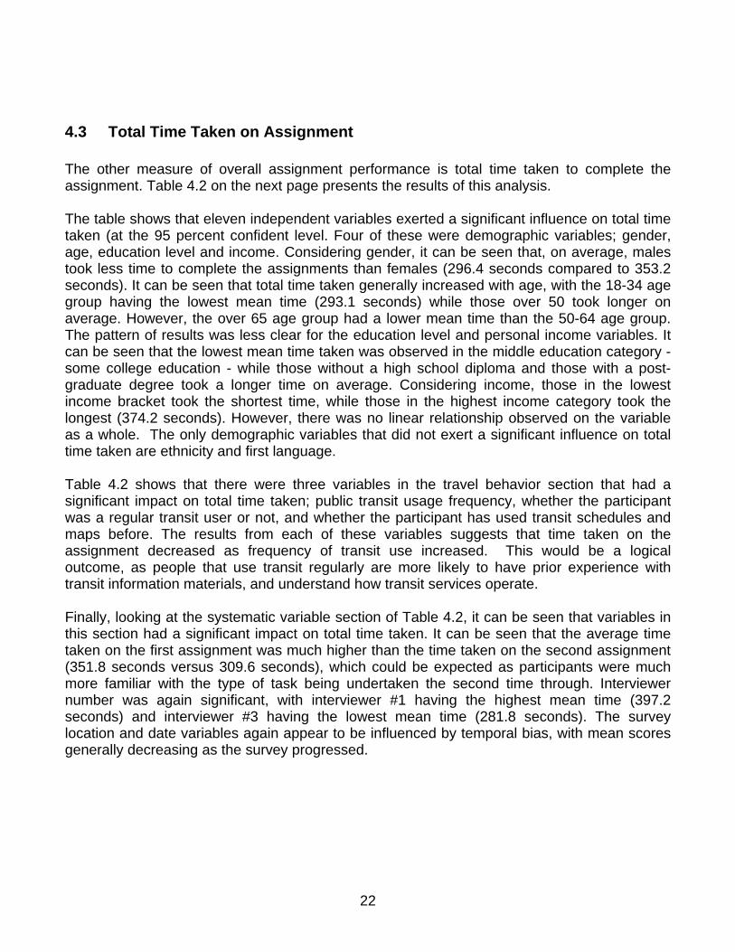
4.3 Total Time Taken on Assignment The other measure of overall assignment performance is total time taken to complete the assignment. Table 4.2 on the next page presents the results of this analysis. The table shows that eleven independent variables exerted a significant influence on total time taken (at the 95 percent confident level. Four of these were demographic variables; gender, age, education level and income. Considering gender, it can be seen that, on average, males took less time to complete the assignments than females (296.4 seconds compared to 353.2 seconds). It can be seen that total time taken generally increased with age, with the 18-34 age group having the lowest mean time (293.1 seconds) while those over 50 took longer on average. However, the over 65 age group had a lower mean time than the 50-64 age group. The pattern of results was less clear for the education level and personal income variables. It can be seen that the lowest mean time taken was observed in the middle education category - some college education - while those without a high school diploma and those with a post-graduate degree took a longer time on average. Considering income, those in the lowest income bracket took the shortest time, while those in the highest income category took the longest (374.2 seconds). However, there was no linear relationship observed on the variable as a whole. The only demographic variables that did not exert a significant influence on total time taken are ethnicity and first language. Table 4.2 shows that there were three variables in the travel behavior section that had a significant impact on total time taken; public transit usage frequency, whether the participant was a regular transit user or not, and whether the participant has used transit schedules and maps before. The results from each of these variables suggests that time taken on the assignment decreased as frequency of transit use increased. This would be a logical outcome, as people that use transit regularly are more likely to have prior experience with transit information materials, and understand how transit services operate. Finally, looking at the systematic variable section of Table 4.2, it can be seen that variables in this section had a significant impact on total time taken. It can be seen that the average time taken on the first assignment was much higher than the time taken on the second assignment (351.8 seconds versus 309.6 seconds), which could be expected as participants were much more familiar with the type of task being undertaken the second time through. Interviewer number was again significant, with interviewer #1 having the highest mean time (397.2 seconds) and interviewer #3 having the lowest mean time (281.8 seconds). The survey location and date variables again appear to be influenced by temporal bias, with mean scores generally decreasing as the survey progressed.
22

TABLE 4.2 – Aggregate Assignment Performance – Total Time Taken Variable
Type Independent
Variable Category N. Mean Time
Taken (seconds)
Correlation Coefficient (eta)
Significance (* =95%, **=99%)
male 175 296.4 gender female 183 353.2 0.174 0.001** white 177 318.3 black 96 319.7
hispanic 61 336.0 asian 4 297.0
ethnicity
other 6 359.2
0.053 0.915
18-34 203 293.1 35-49 73 328.2 50-64 56 416.6 age group
65+ 26 373.9
0.278 0.000**
no high school diploma 38 349.8 high school diploma 129 338.5
some college 117 286.3 college degree 52 369.3
education level
post grad degree 20 305.7
0.186 0.014*
< $15,000 143 297.4 $15,000 - $30,000 91 361.5 $30,000 - $50,000 66 305.8 $50,000 - $75,000 26 348.8
Personal income
Over $75,000 26 374.2
0.188 0.014*
English 332 326.0
Dem
ogra
phic
First language Other 26 317.6 0.013 0.800
none 28 346.5 one 122 318.0 two 114 350.9
Number of household vehicles
three or more 92 297.5
0.132 0.104
never or almost never 52 325.7 less than once a month 6 328.5
< once / wk, > once / mnth 18 318.2 1 - 3 times a week 41 298.3
Driving frequency
4 or more times a week 241 330.5
0.062 0.847
never or almost never 134 347.5 less than once a month 38 337.8
< once a wk; > once a mth 59 344.0 1 to 3 days a week 61 310.2
Public transit usage frequency
4 or more times a week 66 270.9
0.178 0.023*
At least once a wk 127 283.4 Whether Regular Transit User or not Less than once a wk / never 231 348.5 0.191 0.000**
No previous experience 127 351.8
Trav
el B
ehav
ior
Experience with transit schedules / maps Previous experience 229 309.6 0.124 0.020**
First assignment 180 350.1 Assignment Order Second assignment 178 300.5 0.152 0.004**
Interviewer #1 103 397.2 Interviewer #2 126 311.4 Interviewer
Number Interviewer #3 129 281.8 0.289 0.000**
citrus park (AUG 04, 05) 120 359.8 Lakeland (AUG 06, 11) 120 320.1 Survey
location Brandon (AUG 19, 20) 118 295.9 0.161 0.009**
04-AUG-2004 82 342.2 05-AUG-2004 38 397.8 06-AUG-2004 72 313.4 11-AUG-2004 48 330.0 19-AUG-2004 79 286.5
Sys
tem
atic
Date of Survey
20-AUG-2004 39 315.0
0.193 0.019*
23

5. WORKING WITH THE SYSTEM MAP
5.1 Introduction The first part of each assignment required participants to use the system map – a map of the entire town showing all major streets, points of interest and each bus route. The system map was provided to participants on an 11 by 17 inch laminated sheet, a small scale version of which is provided in Appendix I.
Participants used the system map to complete two discrete sub-tasks; Stage 1 - locating the origin and destination of the trip, and Stage 2 - selecting the bus routes required to travel from origin to destination, and the point of transfer. Participant performance on each of these stages is discussed in this section.
5.2 Measures of Participant Performance This section presents three different quantitative measures of participant performance – (i) route identification score, (ii) time taken to identify the origin and destination and select the two routes and (iii) level of difficulty stated by participant at the end of the assignment. The route identification score was zero if the participant did not correctly identify either of the two routes, one if one route was successfully identified and two if both routes were successfully identified.
TABLE 5.1 – Overall Participant Performance on System Map Performance
Score Time Taken (in seconds)
Stated Difficulty
N 358 358 354 Minimum Value 0.00 10.00 1 = extremely easy
Maximum Value 2.00 411.00 7 = extremely difficult
Mean 1.92 95.16 3.36
Table 5.1 shows that the mean score achieved by participants on this section of the test was very high – 1.92. The average time taken to complete the test was 95 seconds (one minute and 35 seconds), with a fastest time of 10 seconds and slowest time of 411 seconds (6 minutes and 51 seconds). The mean level of difficulty stated by participants was 3.36, which corresponds to “somewhat easy” on the 7-point scale. The table below expands on these results, dividing the aggregate sample into participants that achieved route identification scores of 0, 1 and 2.
24

TABLE 5.2 – Aggregate Participant Performance on Stages 1 and 2 N. Percent Mean Time Taken
(seconds) Mean Stated
Difficulty*
No routes correct 4 1.1 162.5 4.75 (somewhat difficult)
One route correct 19 5.3 152.4 3.72 (neither difficult, nor easy)
Both routes correct 335 93.6 91.1 3.32 (somewhat easy)
Total 358 100.0 95.16 3.36
* 1 = extremely easy, 7 = extremely difficult
This table shows that in almost all completed assignments, both routes were successfully identified (93.6 percent), which also means that in almost all cases the trip origins and destinations were successfully identified. In 19 cases only one route was correctly identified, and in 4 cases none of the routes were identified. The mean time taken in assignments where both routes were successfully identified was 91.1 second (1 minute and 31 seconds). Slightly longer mean times were observed in those cases where the two routes were not correctly identified. Mean scores for stated difficulty level also appear to be related to the number of routes successfully identified. These mean scores have been compared to the closest point to each on the original seven-point scale. This suggests that the majority found this part of the trip planning task to be “somewhat easy”. However, the mean difficulty rating for those that got none of the routes correct was “somewhat difficult”
5.3 Interviewer Observations While the participants were working on their trip planning assignments, interviewers were able to observe their behavior and make note of any visual observations and requests for assistance. These qualitative observations have been tabulated into different categories, so that frequency counts could be obtained. Table 5.3 provides the frequency tabulation of the different visual observations that were made, while table 5.4 tabulates the different requests for assistance that were made.
TABLE 5.3 – Visual Observations - System Map
N % Difficulty locating origin / destination 56 41.2% Difficulties with small font size on route numbers 22 16.2% Non-specific difficulty with route identification 17 12.5% Difficulty with transferring / congested transfer area 15 11.0% Difficulty with color scheme / color contrasting on routes 9 6.6% Difficulties with small font size on origin / destination 8 5.9% Difficulty using streets to locate origin / destination 7 5.1% Difficulty due to unfamiliarity with town 1 0.7% Other 1 0.7%
Total 136 100.0%
25

TABLE 5.4 – Requests for Assistance - System Map N %
Required assistance locating origin / destination / had to explain use of street addresses to location o / d. 23 53.5%
Required assistance with route numbers / selection of routes 8 18.6% Required assistance with route transfers 6 14.0% Tried to select more or less than 2 routes 3 7.0% Other 3 7.0%
Total 43 100.0%
These two tables suggest that the main problems encountered at the system map stage of the trip planning process were in locating the origin and destination on the system map, and in coping with the small font sizes on the map. Although less frequently mentioned by participants, there were some problems with selecting the routes, such as locating the transfer point and using the color scheme. However, it should be noticed that there were only a total of 43 requests for assistance, out of a total of 358 assignments. This means that only 12 percent of assignments required interviewer assistance with the system map.
5.4 Participant Comments on the System Map After each assignment, participants were asked for feedback on different aspects of the trip planning task, including which aspects of the assignment were the most difficult, which were the least difficult, and how the information materials could be improved. Participant comments on these issues related both to the system map and to the later part of the exercise using the route map and schedules. Therefore, these comments have been divided into comments relating to the system map, and comments relating to the route map / schedule, with this section presenting comments on the system map only. Table 5.5 presents the different aspects of system maps use that participants found to be the most difficult part of the whole assignment, Table 5.6 presents the aspects of the system map that people found to be the easiest part of the assignment, and Table 5.7 presents suggested improvements related to the system map.
TABLE 5.5 – Most Difficult Aspects of System Map Use N. %
locating origin / destination on system map 40 35.7% identifying routes on system map 14 12.5% font too small on system map 11 9.8% identifying transfer point on system map 10 8.9% poor color contrasting on system map 9 8.0% following system map routes through congested areas 8 7.1% system map, not specific 7 6.3% new town - not familiar 6 5.4% locating streets on system map 5 4.5% poor labelling / lack of comprehensive legend on system map 2 1.8%
TOTAL 112 100.0%
26

TABLE 5.6 – Least Difficult Aspects of System Map Use N. %
Identifying routes on system map 97 39.0% Locating origin and destination on system map 95 38.2% System map, not specific 43 17.3% Using color scheme on system map 13 5.2% Locating transfer point 1 0.4%
TOTAL 249 100.0%
TABLE 5.7 – Possible Improvements to System Map N. %
Blow up transfer center areas to larger scale / show which buses available at each transfer point / label transfer points / improve transfer info 41 20.7% Larger font - not specific / on all maps 34 17.2% Improve / expand legend on system map / separate POIs into different icons 26 13.1% Better street definition / connect streets / show more streets on system map 18 9.1% Larger font on system map 17 8.6% Better color contrasting on system map 15 7.6% Bigger system map 11 5.6% Put grid over system map and provide co-ordinates for each POI 11 5.6% Bold points of interest / streets names / route numbers on system map 10 5.1% Better consistency between system and route maps 7 3.5% Make materials simpler / less information 6 3.0% Mark bus stops on system map 1 0.5% Mark route numbers several times along route on system map 1 0.5%
TOTAL 198 100.0% Discussion of the qualitative data shown in Tables 5.5, 5.6, 5.7 is incorporated into Sections 5.5 and 5.6 below.
5.5 Stage 1 - Locating the Origin and Destination Table 5.5 provides insight into the aspects of system map use that participants found to be most difficult. By far the most frequently cited comment was difficulty in locating the origin and destination on the system map, with this being reported as the most difficult aspect of the whole assignment in 41 cases. This observation is consistent with the results provided in Tables 5.3 and 5.4, where locating the origin and destination was again found to be the primary source of system map difficulties. Although small font size contributed to origin / destination location difficulties, the main source of these difficulties were as follows:
27

− The town featured in the system map was new to participants. This lack of existing knowledge about the layout of the town meant that participants took much longer to familiarize themselves with the town.
− All potential origins and destinations (points of interest) were marked in the same blue color.
− Assignment instructions (see Appendix I) provided a street address for each origin and destination. Most specified origins and destinations could be located using these street addresses, but for some of the points of interest, the specific streets intersecting the points were not provided.
Strategies used by participants to locate the points of interest were either to use the street address to “home in” on the area of the map that the point was located, or simply to scan the map from one side to the other until the point was found. Those using the street addresses were generally more successful, while those scanning the entire map at random sometimes took a long time to locate the points, and sometimes required assistance. It should be noted that for many people, finding the origin and destination was very straightforward, and Table 5.6 shows that in 95 cases this was cited as the easiest part of the exercise. Given the difficulties that some participants experienced in locating the origin and destination, it is useful to observe their suggestions for making this task easier. Table 5.7 show that suggested improvements include:
− Use larger font / bold points of interest − Providing a more detailed legend, with different icons or colors for different point of
interest categories, such as public buildings, restaurants, hotels, etc. − Provide better / more extensive street definition, so that all points of interest can be
located directly using their street address. − Put a grid over the system map and provide a table at the side of the map listing each
point of interest and its corresponding grid reference. This type of system is commonly used on road maps.
5.6 Stage 2 - Identifying the Bus Routes on the System Map Table 5.5 shows that although locating the origin / destination was the most frequently cited area of difficulty, most of the remaining reported areas of difficulty centered around the identification of the bus routes. These difficulties included non-specific route identification problems (14 cases), problems at transfer points (10 cases), problems caused by poor color contrasting (9 cases), as well as problems caused by small font sizes on the routes themselves (11 cases). Besides the problem of small font size, the source of most route identification problems was difficulty in accurately following the bus route’s path through the town. This was not difficult when there was only one route running along a street, but when two or more routes were shown running along the same street, some participants became confused, particularly if the colors were similar. This problem was most extreme when the path
28

of multiple routes came together in the same small area, such as a transfer center. An example of this is shown in Figure 5.1 below:
FIGURE 5.1 – Example of Route Congestion at Transfer Center Figure 5.1 clearly shows how difficult it can be to follow the path of a route through such a “congested area”, and also illustrates how lack of clear color contrasting contributes to these difficulties. Two routes running through the above transfer area are shown in green, which are relatively distinct when separated, but difficult to distinguish when running on close proximity. Another problem related more specifically to transferring between routes. Participants were unclear as to where it was feasible to transfer, and the system map did not specifically show transfer points. Some participants thought that transferring was only possible at transfer centers. An example of such confusion is shown in Figure 5.2 below.
FIGURE 5.2 – Example of Transfer Related Confusion
29

Figure 5.2 shows the main Downtown Plaza transfer center and surrounding area. In one of the assignments, participants were required to select one route to travel from their origin to the Downtown Plaza, where they were to transfer to Route 24 to get to their destination. However, several participants were unsure about whether it was actually feasible to switch to Route 24, as it was not clear whether it went close enough to the transfer center to permit a transfer. Table 5.7 shows that there were a variety of suggestions put forward by participants for making the route selection stage easier. The most frequently cited suggestion was for improvements in transfer point identification. A popular suggestion was to provide an additional inset for each of the congested transfer areas at a larger scale, making it easier to see the path of each route and to allow more detail to be provided. It was also clear that participants wanted to be able to know exactly where transfers between routes could be made. A transfer icon at each transfer point, referenced in the map legend, was suggested. An additional suggestion on this theme was to also provide the route numbers of the buses that it was possible to transfer to at each transfer point. Better color contrasting was also mentioned, making sure that none of the colors were too similar, particularly when in close proximity. One color blind participant stated that it was better to use bold, deep shades as lighter shades were harder to differentiate.
30

6. WORKING WITH THE ROUTE MAP / SCHEDULE
6.1 Introduction Having selected the two bus routes required to travel from origin to destination on the system map, participants were provided with the route maps and schedule for each route, and proceeded with the next three stages of the trip planning process. Table 6.1 provides a description of each stage below:
TABLE 6.1 – Stages in Trip Planning Process
Stage Description Information Materials Used
1 Locating Origin and Destination on System Map System Map
2 Selecting bus routes and transfer point System Map
3 Locating closest bus stops (time points) and transfer bus stop System Map / Route Map
4 Identifying correct section of schedule Route Map / Schedule
5 Using schedule Schedule
Table 6.1 shows that Stage 3 involves using both the system map and route maps to locate the closest bus stops, also known as time points, to the origin and destination, and a suitable transfer point. Stage 4 then consists of locating the correct section of the schedule to use, which requires that participants correctly identify the day of travel, the direction of travel (north / east / west / south) and whether the trip is in the morning or afternoon. Once this has been completed, the participants proceed to Stage 5, where the schedule itself is used to identify boarding and alighting times for each bus. This section looks first at overall participant performance in working with the route maps and schedules (Sections 6.2, 6.3, 6.4), and then assesses the results of the various variant tests that were a major objective of the study (Section 6.5). The final section of the study looks at Stages 3, 4 and 5 individually to assess problem areas and possible solutions.
6.2 Measures of Participant Performance 6.2.1 Overall Performance Table 6.2 below provides three quantitative measures of participant performance; performance score, time taken and stated difficulty. The performance score is measured out of a maximum of eight points, which is composed of four points for each bus stop (first route start and end point, second route start and end point) and four points for each bus time (first route start and end time, second route start and end time).
31

TABLE 6.2 – Overall Participant Performance on Route Map / Schedule Performance
Score Time Taken (in seconds)
Stated Difficulty
N 358 353 353 Minimum Value 0.00 33.00 1 = extremely easy
Maximum Value 8.00 824.00 7 = extremely difficult
Mean 6.39 233.53 3.63
Table 6.2 shows that the overall mean performance score for this part of the exercise was 6.39. The mean time taken was 233.53 seconds (3 minutes and 54 seconds), which is considerably longer than the time taken to complete the first two stages of the trip planning process (one minute and 35 seconds, as shown in Table 5.1). The mean stated difficulty was 3.63, which is only slightly higher than the 3.36 mean stated difficulty score for the first two trip planning stages. 6.2.2 Stage 3 - Locating Bus Stops This stage involved using both the system map and route maps to locate the closest bus stops (also known as time points) to the trip origin and destination and to determine a suitable transfer bus stop. There are therefore four separate bus stops to locate – first route start point, first route end point, second route start point and second route end point. Table 6.3 below assesses how participants performed in locating these bus stops.
TABLE 6.3 – Performance on Stage 3
– Locating Bus Stops Number of Bus Stops
Correctly Identified N. Percent
0 6 1.7
1 9 2.5
2 29 8.1
3 52 14.5
4 262 73.2
Total 358 100.0 This table shows that in almost three-quarters of all assignments, all four bus stops were correctly identified (73.2 percent). Another 14.5 percent correctly identified three of the four stops and 8.1 percent identified two of the four stops.
32

6.2.3 Stages 4 and 5 – Using the Schedule Once bus stops have been identified, the next task is to locate the correct portion of the schedule to use (Stage 4). This task involves identifying the direction of travel (eastbound, westbound, northbound, eastbound), the day of travel (Monday to Friday or weekend), and the time of travel (am or pm). All these issues affect which section of the schedule should be used, as shown in Figure 6.1 below
FIGURE 6.1 – Stage 4 - Locating the Correct Section of the Schedule
Eastbound, PM, Saturday Service
Westbound, PM, Monday to Friday
Service
Eastbound, AM, Monday to Friday
Service
Once this stage is completed, the schedule can then be used to identify the times at which the buses will be at the different bus stops. Performance on these stages can be assessed by considering whether the participants selected the correct times for the different sections of their trip – first route start time, first route end time, second route start time and second route end time.
33

TABLE 6.4 – Performance on Stages 4 and 5 – Identifying the Correct Section of Schedule / Using Schedule
Number of Bus Times Correctly Identified N. Percent
0 64 17.9 1 21 5.9 2 23 6.4 3 51 14.2 4 199 55.6
Total 358 100.0 Table 6.4 shows that only just over half of all cases successfully identified all four times (55.6 percent). Of those that did not, 14.2 percent got 3 of the four times correct, while 17.9 percent did not get any of the times correct.
6.3 Interviewer Observations This section presents the observational data that was collected during the route map / schedule sections of the trip planning assignments. Table 6.5 provides details of visual observations, while Table 6.6 provides details of requests for assistance.
TABLE 6.5 – Visual Observations - Route Map / Schedule
Comment
on Specific Variant
N %
- Difficulty with direction (compass points). Reading wrong section of schedule 37 21.6% Non-specific problems with schedule / timetable - 30 17.5% Difficulty with AM / PM times. Reading wrong section of timetable D 26 15.2% Participant using correct time planning method (working backwards from specified arrival time) 13 7.6%
Difficulty locating bus stops / finding closest bus stops to O-Ds E 11 6.4% E 9 5.3% Difficulty location origin / destination on route map B 7 4.1% Difficulty with horizontal schedule alignment
Confusion with labeling - numbers and letters on schedules / maps - what do the labels mean? G 6 3.5%
- 5 2.9% Intentional planning trip to arrive early, anticipating delays Confused by white / grey shading - 4 2.3% Time planning by guessing / trial and error - 4 2.3% Using wrong route map - 4 2.3% Difficulty with day of travel. Using wrong part of schedule C 3 1.8% Difficulty with arrival departure times of buses - 3 1.8% Difficulty with schedule font size - 2 1.2% Difficulty with transfers on route map - 2 1.2% Other - 2 1.2% Difficulty planning transfers using schedules - 1 0.6% Time planning by estimating bus travel times - 1 0.6% Difficulty with streets on route maps F 1 0.6%
total 171 100.0%
34

TABLE 6.6 – Requests for Assistance - Route Map / Schedule
Comment
on Specific Variant
N %
Assistance with direction - 16 23.2% Non-specific request for assistance on schedule - 13 18.8% Assistance with locating bus stops / explaining the concept of bus stops. Linking bus stop on schedule with bus stop on route map - 10 14.5%
Assistance with use of AM / PM part of schedule D 8 11.6% Assistance with locating origin / destination on route map E 6 8.7% Assistance with transferring - 3 4.3% Explaining assumption of no delay on trip, so no need to leave early - 3 4.3% Assistance with schedule alignment (horizontal) B 2 2.9% Participant looking at wrong route - 2 2.9% Other - 2 2.9% Asked when to start in order to arrive on time - 1 1.4% Explaining that the schedule shading has no significance - 1 1.4% Explaining significance of day of travel when using schedule C 1 1.4% Explaining arrival / departure issue on schedule - 1 1.4%
Total 69 100.0% Looking at the most frequency cited observations and requests for assistance in Tables 6.5 and 6.6, it can be seen that in both tables the most frequently reported comments related to difficulties determining direction of travel (37 observations and 16 requests for assistance), which is a Stage 4 task. There are several different sources of difficulty related to identifying direction:
− Understanding the concept of traveling north, south, east or west − Matching the direction of travel on the route map to the appropriate section of the
schedule. Addressing the first of these issues is difficult. Some people simply were not able to understand the concept of applying compass based directions to their trip. Two ways to address this are either to provide a landmark based alternative or use an inbound / outbound approach. The second issue is more related to the design of the materials. Some people understood the concept of compass directions, but did not locate the correct section of the schedule. This could potentially be addressed by more clear differentiation of information relating to different directions on the schedule. Another identified problem was instances where the directions marked on the schedule did not clearly correspond to the directions of the required trip. Two examples of this are shown below.
35

FIGURE 6.2 – Examples of Potentially Confusing Direction Labeling
The section of the “Route 2” route map from bus stop A to bus stop C is clearly running in a north / south direction, while the bus stops from C to E are in the opposite north / south direction. However, the direction labeling on the schedule is defined as “eastbound” and “westbound”, due to the fact that the route overall runs from west to east. This map caused confusion among several participants. The “Route 6” route map presents a different kind of problem. Here, the route runs north from bus stop A to NW 45th Ave, then runs southbound to its termination at downtown plaza. Several participants were confused on this route because in traveling from bus stop A to bus stop E, they initially had to travel northbound, and then travel southbound – so which part of the schedule should they use? Although it is obvious for some people which directions these labels refer to, there is clearly potential for incorrect interpretations. The “Route 6” route map also included points of interest, such as the city hall and the community college. If these landmarks were also referred to on the schedule, it may allow people to navigate successfully without having to understand compass directions and having to try to interpret what the direction labels mean.
36

Other frequently cited comments also involved the schedule, with interviewers reporting non-specific difficulties with the schedule (30 observations, 13 requests for assistance) as well as other Stage 4 tasks such as determining whether to use the AM or PM section of the schedule (26 observations, 8 requests for assistance). Other comments related to the route map, with both observations and requests for assistance in locating the origin and destination on the route map, and then determining the closest bus stops. Some of these comments related specifically to design element variants, which are discussed further in Section 6.5.
6.4 Participant Comments Following each assignment, participants were asked for feedback on different aspects of the trip planning task, including which aspects of the assignment were the most difficult, which were the least difficult, and how the information materials could be improved. Participant comments on these issues related both to the system map and to the later part of the exercise using the route map and schedules. The comments provided here are those given by participants on the route maps and schedules only. Table 6.7 presents the different aspects of route map / schedule use that participants found to be the most difficult part of the whole assignment, Table 6.8 presents the aspects of route map / schedule use that people found to be the easiest part of the assignment, and Table 6.9 presents suggested improvements to the route map or schedule materials.
TABLE 6.7 – Most Difficult Aspects of Route Map / Schedule Use
Comment
on Specific Variant
N. %
Using schedule 104 39.7% Using schedule to get times 58 22.1% Getting correct direction on schedule 30 11.5% Getting correct direction on route map 17 6.5% Locating closest bus stops on route map E 13 5.0% Having to flip between route map and schedule A 7 2.7% Getting AM / PM times on schedule D 6 2.3% Working backwards on schedule 5 1.9% Schedule alignment (horizontal) B 4 1.5% Route map - not specific 4 1.5% Getting correct day of travel C 2 0.8% Shading on schedule 2 0.8% Arrival / departure times issue on schedule 2 0.8% Locating origin / destination on route maps E 2 0.8% Lack of route map labeling / bus stop labeling G 2 0.8% Comparing system map with route maps - less detail on system map 2 0.8% Schedule font too small 1 0.4% Font too small on route maps 1 0.4%
Total 262 100.0%
37

TABLE 6.8 – Least Difficult Aspects of Route Map / Schedule Use Comment on
Specific Variant N. %
Using schedules to identify bus times 34 35.1% Using schedules, not specific 30 30.9% Using route maps, not specific 16 16.5% Identifying closest bus stops on route map E 10 10.3% Locating bus stops on schedule E 4 4.1% Using route maps to get direction of travel 2 2.1% Identifying AM / PM times on schedule D 1 1.0%
Total 97 100.0%
TABLE 6.9 – Possible Improvements to Route Map / Schedule
Comment
on Specific Variant
N %
Differentiate / label AM and PM parts of schedule D 54 20.0% Use color to identify routes on route map 34 12.6% Larger font - not specific / on all maps 34 12.6% Mark points of interest on route maps E 30 11.1% Improve direction labeling / clarify what directions are referring to 12 4.4% Better / clearer transfer info on route maps 11 4.1% Color code bus stops on schedule and map 10 3.7% Charge schedule alignment (to vertical format) B 10 3.7% Reorganize schedule to make easier - not specific 10 3.7% Put schedule and map on same page A 8 3.0% Better schedule labeling 8 3.0% Better consistency between system and route maps 7 2.6% Make schedule font larger 6 2.2% Make materials simpler / less information 6 2.2% Larger font on route maps 4 1.5% Mark times at each bus stop on route map 4 1.5% Remove light / dark shading on schedule 4 1.5% Add a key / legend to route maps G 3 1.1% Separate different directions to different tables 3 1.1% Separate / make more clear Saturday times from Monday to Friday C 3 1.1% Provide instructions on how to use schedule 3 1.1% Show arrival and departure times on schedule 2 0.7% Provide information at bus stops 2 0.7% Better street definition / connect streets / show more streets on route map F 1 0.4% Indicate how long journey will take on schedule / route map 1 0.4%
Total 270 100.0% Discussion of the results provided in Tables 6.7, 6.8 and 6.9 is presented in the following section (6.5), along with the results of individual design element variant tests.
38

6.5 Design Element Variant Analysis 6.5.1 Introduction A major objective of this study was to scientifically test participant performance using different route map / schedule designs, to determine whether certain designs had a significant impact on participant comprehension. Seven different design elements were selected, as shown in Table 6.10 below:
TABLE 6.10 – Selected Design Elements and Their Variants* Element
Type Element #. Trip
Planning Stage
Element Name Variant #.
Material Layout A** 3 / 4 Front / Back
Layout
1. Schedule and map same side 2. Schedule and map opposite side
B 4 / 5 Schedule Alignment
1. Vertical 2. Horizontal
C 4 Day Scheduling
1. Same table 2. Separate tables 3. Separate pages
Rou
te S
ched
ule
D 4 Time Scheduling
1. No differentiation (12 hr clock) 2. AM / PM Bold 3. Separate tables
E 3 Map Details - Points of Interest
1. No points of interest 2. Points of interest
F 3 Map Details - Roads
1. Low detail 2. High detail
Rou
te M
ap
G 3 Legend 1. No legend on route maps 2. Legend on route maps
* Extracted from Technical Memorandum # 1 – Test Material and Test Instrument Development Process, National Center for Transit Research, CUTR, July 2004
** Element numbering has been changed from numeric to alphanumeric following the pilot testing phase to improve testing clarity
The analysis presented in Section 4.3 showed that a total of five variables had a statistically significant impact on assignment score, while eleven variables had a significant effect on total time taken. Given this finding, it is important to ensure that these impacts do not result in bias being introduced into the individual design element tests. In order to do this, a weighting process has been carried out. This process adjusts individual assignment results to remove potential bias. Another benefit of the weighting process is that the sample’s demographic characteristics can be adjusted to reflect the characteristics of the total population – therefore allowing the study findings to be used to make population level inferences.
39

The weighting process resulted in the production of three separate weighting factors.
− A Demographic Weighting Factor used to neutralize the impact of demographic
variables that had a significant impact on aggregate assignment performance, such as gender and ethnicity. This factor used Florida population statistics (extracted from the 2000 Census) to adjust the sample data to reflect population characteristics.
− A Travel Behavior Weighting Factor used to neutralize the impact of prior transit
experience on the design element tests.
− A Systematic Weighting Factor used to neutralize the impact of systematic biases in the raw data.
6.5.2 Design Element A - Front / Back Layout This element refers to how the route map and schedule are orientated relative to each other. Two variants of this element were tested; one with the route map and schedule on the same page (Variant A1), and one with the route map and schedule on the opposite sides of the page (Variant A2). Appendix II provides examples of the test materials that were used. Table 6.10 shows that this design element influences Stage 3 and 4 of the trip planning process, as participants have to work with both the route map and schedule when selecting bus stops (Stage 3), and when deciding which section of the schedule to use (Stage 4). With Variant A1, all the required information is on the same page, while on Variant A2, participants were required to “flip” between the route map on one side of the page and the schedule on the other. Table 6.11 provides quantitative test results for Design Element A. The table is divided into four main sections, one for each weighting factor discussed above, as well as the “raw” unweighted data analysis results. Within each of these four sections, three separate mean performance scores are shown for each variant, one for the bus stop identification (Stage 3), and one for bus time identification (Stages 4 and 5), and one total score, which is a summation of the previous two scores. Also provided for each variant are the mean time taken and stated difficulty level on the route map / schedule section of the assignment. For each variant performance measure, two additional statistics have been calculated to measure statistical significance. Eta is a correlation co-efficient that measures the strength of bivariate relationships. In this case it measures the extent to which the variant type influences the performance variables (score and time taken). An eta score of zero means there is no relationship, and the higher the eta value is, towards a maximum of 1, the greater the influence of the variant. The statistical significance statistic (Sig.) is used to assess the probability of the relationship described by the eta value existing in the population as a whole. A significance value of 0.05 indicates that there is a 95 percent probability that the relationship observed in the sample will also exist in the population.
40

TABLE 6.11 – Design Element A – Front / Back Layout – Test Results Assignment Performance Mean Score
Stage 3 (Locating Bus Stops)
(max = 4)
Stages 4 and 5 (Determining Times)
(Max = 4)
Overall (Max = 8)
Mean Time Taken
Mean Stated
Difficulty
A1 – Same Side 3.81 2.48 6.29 269.3 3.43 A2 – Opposite Sides 3.52 2.90 6.43 184.4 3.95
Eta 0.236 0.140 0.037 0.469 0.149 No
weighting
Sig. 0.132 0.378 0.814 0.002** 0.351 A1 – Same Side 3.89 2.555 6.45 281.9 3.54 A2 – Opposite Sides 3.62 3.140 6.76 180.9 3.96
Eta 0.25 0.19 0.08 0.531 0.13
Demographic Adjustment Weighting
Sig. 0.111 0.220 0.593 0.000** 0.430 A1 – Same Side 3.77 2.39 6.16 263.7 3.40 A2 – Opposite Sides 3.53 2.92 6.45 186.9 3.92
Eta 0.197 0.172 0.076 0.421 0.148
Travel Behavior
Adjustment Weighting Sig. 0.212 0.277 0.631 0.007** 0.356
A1 – Same Side 3.80 2.18 5.99 272.6 3.56 A2 – Opposite Sides 3.18 1.91 5.09 212.3 4.60
Eta 0.408 0.083 0.209 0.331 0.300
Systematic Adjustment Weighting
Sig. 0.005** 0.584 0.163 0.034* 0.054
Looking at the results for Stage 3 of the trip planning process (locating the bus stops) shows that in all cases the score was higher for Element A1 (route map and schedule on same side) compared to Element A2 (route maps and schedule on opposite sides. In the case of the systematic adjustment weighting, the different between the two means was found to be statistically significant at the 99 percent confident level, with the corresponding eta value of 0.408 suggesting a moderate to strong influence of front / back layout type on participant ability to successfully locate bus stops. No statistically significant differences were observed on the Stages 4 and 5 of the exercise, suggesting that front / back layout has no impact on participants’ ability to select the correct bus times. This is logical because most of the route map / schedule interaction is at the bus stop selection stage and there is much less need to refer to both materials once this stage has been completed. No statistically significant differences were observed at the overall score level, which suggests that overall trip planning ability is not affected by this design element. Results of design element influence on time taken to complete Stages 3, 4 and 5 show that in all cases significant results were returned, with the average time taken to complete the task with the route map and schedule on the same side being longer than with the map and schedule on different sides. This is an unusual result which contradicts the logic that having the materials on the same side should make it quicker to plan the trip. Further research would be required to understand why this result occurred. Results for participant’s Stated Difficulty on this part of the task show that in all cases the stated difficulty on the opposite side variant was higher that on the same side variant.
41

However, these mean differences were not found to be statistically significant. Mean difficulty for the same side variant ranged from 3.40 (somewhat easy) to 3.56 (neither difficult nor easy), while mean difficulty for the opposite side variant ranged from 3.92 (neither difficult nor easy) to 4.60 (somewhat difficult). Overall, results from these design variant tests suggest that whether the route map and schedule is on the same page or not does not significantly affect participants ability to use route maps / schedules to plan a transit trip. However, it was found that this element made it more difficult to successfully locate the correct bus stops (Stage 3) which was found to be significant for one of the weighting factors. Participant comments from Section 6.3 also need to be taken into account, as Table 6.7 shows that 7 people thought that having to flip between the route map and schedule was the hardest part of the exercise, while Table 6.9 shows that 8 people suggested that the route map and schedule should be on the same page. Considering the fact that only 21 people used the opposite side layout, these comments show that around one third of those using the opposite side layout thought it should be changed. 6.5.3 Design Element B – Schedule Alignment This design element refers to whether the schedule information is presented with the bus stops / time points aligned vertically or horizontally. Examples of these two formats are provided in Figure 6.3 below with the full test material versions provided in Appendix II.
Variant 2 – Horizontal Schedule Alignment
Variant 1 – Vertical Schedule Alignment
FIGURE 6.3 – Examples of Horizontally and Vertically Aligned Schedules
42
Test result for this design variant are provided in Table 6.12 below.
TABLE 6.12 – Design Element B – Stop Alignment – Test Results Assignment Performance Mean Score
Weighting Factor
Variant Means and Bivariate Statistics
Stage 3 (Locating Bus Stops)
(max = 4)
Stages 4 and 5 (Determining Times)
(Max = 4)
Overall (Max = 8)
Mean Time Taken
Mean Stated
Difficulty
B1 – Vertical 3.69 2.90 6.60 254.2 3.71 B2 – Horizontal 3.05 2.50 5.55 239.7 3.55
Eta 0.281 0.109 0.194 0.055 0.045 No
weighting
Sig. 0.024 0.389 0.125 0.673 0.728 B1 – Vertical 3.77 3.129 6.900 257.0 3.69 B2 – Horizontal 2.99 2.464 5.456 233.0 3.42
Eta 0.339 0.188 0.272 0.093 0.08
Demographic Adjustment Weighting
Sig. 0.006 0.137 0.029 0.473 0.533 B1 – Vertical 3.65 2.85 6.50 247.1 3.77 B2 – Horizontal 2.97 2.35 5.32 242.0 3.48
Eta 0.128 0.125 0.035 0.188 0.150
Travel Behavior
Adjustment Weighting Sig. 0.298 0.309 0.780 0.131 0.223
B1 – Vertical 3.55 2.40 5.94 269.7 3.98 B2 – Horizontal 3.25 2.88 6.13 217.4 3.42
Eta 0.128 0.125 0.035 0.188 0.150
Systematic Adjustment Weighting
Sig. 0.298 0.309 0.780 0.131 0.223 Table 6.12 shows that participant performance scores were generally higher on the vertically aligned schedules for almost all the weighting scenarios. The only exception to this was the systematic adjustment weighting results, where the Stage 4 / 5 score and the overall score was slightly higher on the horizontal alignment. For the unweighted data and the demographic adjusted data, the difference between the mean scores was statistically significant at the 95 percent confidence level. Looking at the time taken to complete this part of the assignment, it can be seen that, on average, participants took longer to complete the tasks using the vertically aligned schedules, although these mean differences were not statistically significant. Similarly, in terms of stated difficulty, in each case the mean stated difficulty was higher on the vertically aligned schedules, but these differences were again not statistically significant. Data on the issue of schedule alignment were also reported in the interviewer observations and participant comments sections (Sections 6.3 and 6.4). Table 6.5 shows that 7 participants reported difficulties with the vertical schedule alignment, while table 6.6 shows that two people required assistance on this issue. Table 6.7 shows that four people found the vertical alignment to be the most difficult aspect of the task while Table 6.9 shows that 10 people suggested that the vertical alignment be changed to a horizontal alignment. The fact that people had problems with the vertical alignment suggested that they normally used a different format. Further investigations found that almost all the participants who had problems with this format had already had experience with using transit schedules. This suggests that the
43

schedules they were accustomed to using were in the horizontal format. These qualitative observations are consistent with the longer times taken and higher stated difficulties associated with the vertical schedules, but are not consistent with the fact that higher mean scores were observed on the vertically aligned schedules. Clearly, further research is required to fully understand why the vertical format was less popular with participants, but received higher mean scores than the horizontal format. 6.5.4 Design Element C - Day Scheduling Transit schedule information often varies from day to day, with lower frequency services being common on weekends. Examples of the first two design variants are provided in Figure 6.4 below, with the full versions provided in Appendix II.
Variant 2 – Saturday Information in Separate Table
Variant 1 – Saturday Information in Same Table
FIGURE 6.4 – Examples of Day Scheduling Variants 1 and 2
44

As shown in Figure 6.4, the first variant provided all the information in the same table, with Saturday services simply marked with an “S” in the table. The second variant separated the Saturday services into a separate table, just below the Monday-Friday service table, while the third variant was similar to the second variant except the Saturday service information table was positioned on a completely different page, with its own route map. It should be noted that the assignment was designed so that participants had to travel on a Saturday. Thus, their ability to differentiate the Saturday part of the schedule was crucial to correctly identifying the correct bus times. The results of the different variant tests are shown in Table 6.13 below:
TABLE 6.13 – Design Element C – Day Scheduling – Test Results Assignment Performance Mean Score
Stage 3 (Locating Bus Stops)
(max = 4)
Stages 4 and 5 (Determining Times)
(Max = 4)
Overall (Max = 8)
Mean Time Taken
Mean Stated
Difficulty
C1 – Same table 3.24 0.90 4.14 268.81 3.62 C2 – Separate Table 3.30 2.00 5.30 296.00 4.10 C3 – Separate Sheet 3.76 3.14 6.90 300.10 3.67
Eta 0.249 0.504 0.484 0.098 0.124
No weighting
Sig. 0.152 0.000** 0.000** 0.752 0.634 C1 – Same table 3.39 1.16 4.55 268.88 3.20 C2 – Separate Table 3.25 2.07 5.32 300.27 3.92 C3 – Separate Sheet 3.77 3.24 7.01 290.04 3.64
Eta 0.226 0.459 0.418 0.100 0.166
Demographic Adjustment Weighting
Sig. 0.219 0.001** 0.004** 0.745 0.443 C1 – Same table 3.24 0.88 4.12 267.61 3.79 C2 – Separate Table 3.31 2.10 5.41 271.37 4.02 C3 – Separate Sheet 3.77 3.23 7.01 275.93 3.37
Eta 0.268 0.536 0.518 0.025 0.153
Travel Behavior
Adjustment Weighting
Sig. 0.111 0.000** 0.000** 0.981 0.496 C1 – Same table 3.09 0.77 3.86 272.35 3.74 C2 – Separate Table 3.48 2.03 5.51 264.79 4.05 C3 – Separate Sheet 3.68 2.90 6.58 291.70 3.72
Eta 0.267 0.490 0.484 0.084 0.087
Systematic Adjustment Weighting
Sig. 0.113 0.000** 0.000** 0.812 0.799 Table 6.13 shows that the way in which the day scheduling information was presented had a clear impact on participant performance. In the score section it can be seen that the there were no statistically significant differences in the mean scores for Stage 3 of the trip planning process. This is logical as the bus stop information is the same for each variant. A statistically significant influence was observed for Stages 4 and 5 at the 99 percent confidence level, with eta values in the range of 0.459 to 0.536, indicating a moderate to strong correlation between day scheduling variant and assignment score. In each case it can be seen that participants given the Saturday service information in the same table performed the most poorly, getting only around 1 of the 4 bus times correct, followed by those given the Saturday information in a separate table, who got around 2 of the four bus times correct. Those that performed the best on Stages 4 and 5 were those that were provided with the Saturday information on a separate sheet, on average these participants got around 3 of the four bus times correct. It can be seen
45

that the impact of the different variants on bus time selection also had a significant impact on overall assignment score. It can be seen that the mean time taken to complete the assignment was relatively similar for each variant, and no statistically significant differences were observed. Similar results were observed for the mean stated difficulty, with average results generally in the 3.5 to 4.5 range, which equate to a difficulty rating of “neither difficult, nor easy”. The fact that some participants performed so poorly on Stage 4 and 5, but still rated the task as “neither difficult nor easy” suggests that these participants were not aware that they were performing the task incorrectly. Given the obvious differences in performance described above, it is interesting to note that there were relatively few mentions of day scheduling in the interviewer’s observations or participant comments. Table 6.7 shows only 2 instances of day scheduling being the most difficult part of the exercise and Table 6.9 has only three mentions of separating the days of travel as a possible improvement. This reinforces the conclusion that participants were not aware that they were getting the exercise wrong. In a “real-life” setting, this kind of event would result in people waiting indefinitely for a bus that they thought the schedule said would arrive, potentially leading to trip abortion and / or complaints directed at the transit agency. 6.5.5 Design Element D - Time Scheduling Transit schedules contain both AM and PM information. This design variant tested different ways of differentiating AM and PM times. As shown in Figure 6.5 on the next page, the first variant was simply to provide no differentiation. The second variant highlighted PM times in bold. In the third variant AM and PM times were separated into different labeled tables.
46

Variant 1 – No Differentiation Variant 1 – No Differentiation
Variant 2 – PM Times in Bold Variant 2 – PM Times in Bold
Variant 3 – Separate Tables Variant 3 – Separate Tables
47
FIGURE 6.5 – Examples of Time Scheduling Variants
47
Test results on this variant are provided in Table 6.14 below.
TABLE 6.14 – Design Element D – Time Scheduling – Test Results Assignment Performance Mean Score
Stage 3 (Locating Bus Stops)
(max = 4)
Stages 4 and 5 (Determining Times)
(Max = 4)
Overall (Max = 8)
Mean Time Taken
Mean Stated
Difficulty
D1 – No differentiation 3.65 2.95 6.60 251.05 3.90 D2 – PM in Bold 3.48 2.71 6.19 221.43 4.05 D3 – Separate Table 3.57 3.00 6.57 223.14 2.95
Eta 0.083 0.086 0.089 0.107 0.259
No weighting
Sig. 0.816 0.804 0.790 0.713 0.138 D1 – No differentiation 3.80 3.17 6.97 243.81 3.89 D2 – PM in Bold 3.33 2.67 5.99 227.52 4.12 D3 – Separate Table 3.55 2.97 6.53 219.85 2.93
Eta 0.196 0.145 0.180 0.078 0.271
Demographic Adjustment Weighting
Sig. 0.314 0.535 0.380 0.836 0.117 D1 – No differentiation 3.46 2.58 6.04 243.20 3.88 D2 – PM in Bold 3.58 2.55 6.13 189.10 4.03 D3 – Separate Table 3.57 2.97 6.54 218.67 2.83
Eta 0.063 0.124 0.100 0.184 0.273
Travel Behavior
Adjustment Weighting
Sig. 0.888 0.632 0.745 0.361 0.111 D1 – No differentiation 3.55 2.83 6.38 259.69 3.94 D2 – PM in Bold 3.36 2.65 6.01 222.50 4.07 D3 – Separate Table 3.50 2.89 6.39 235.26 3.02
Eta 0.089 0.067 0.078 0.117 0.240
Systematic Adjustment Weighting
Sig. 0.789 0.873 0.831 0.660 0.178 Table 6.14 shows that there were no statistically significant differences between the means of any of the scores, time taken or stated difficulty. The lowest mean scores generally occurred on Variant 2, where the PM times were bolded. The highest difficulty rating also occurred on this Variant. However, the longest mean times occurred on Variant 1, no differentiation. There were numerous references in the interviewer observations and participant comments sections to this design element. Table 6.5 shows that there were 26 instances where participants were observed to be having difficulties with AM / PM times and were reading the wrong section of the schedule, and Table 6.6 shows 8 requests for assistance. There were 6 references to identifying AM / PM times as the most difficult aspect of the whole assignment (Table 6.7) while Table 6.9 shows that the most frequently cited improvement (54 separate comments) was for better differentiation / labeling of AM and PM times. Although it should be noted that all the other design element’s schedules featured a “no differentiation” design, which accounts for the large volume of comments, it is clear that many participants thought that AM and PM times should be more clearly labeled. However, the results of participant performance shown in Table 6.14 suggest that although some people would prefer to have clearer labeling, the level of differentiation makes little difference to the actual trip planning task.
48

6.5.6 Design Element E - Map Details – Points of Interest Points of interest were marked on the System Map, and participants used these to identify their ultimate origin and destination. This design element tested whether marking the same points of interest on the route maps had any impact on trip planning ability. Two variants were tested; Variant 1 - no points of interest, and Variant 2, points of interest included, as shown in Figure 6.6 below.
Variant 1 – No Points of Interest
Variant 2 – Points of Interest
FIGURE 6.6 – Variants for Design Element E – Points of Interest
49

In the case where no points of interest were provided, participants were required to either transpose the points of interest from the system map to the route map, or to use street addresses to locate the closest bus stops to their origin and destination. Results are provided in Table 6.15 below.
TABLE 6.15 – Design Element E – Map Details, Points of Interest – Test Results
Assignment Performance Mean Score
Stage 3 (Locating Bus Stops)
(max = 4)
Stages 4 and 5 (Determining Times)
(Max = 4)
Overall (Max = 8)
Mean Time Taken
Mean Stated
Difficulty
E1 – No points of interest 3.73 3.18 6.91 234.9 3.14 E2 – Points of Interest 3.76 3.67 7.43 230.3 3.19
Eta 0.023 0.198 0.143 0.020 0.018 No
weighting
Sig. 0.883 0.203 0.360 0.897 0.910 E1 – No points of interest 3.79 3.123 6.909 224.4 2.97 E2 – Points of Interest 3.83 3.715 7.550 237.9 3.49
Eta 0.04 0.23 0.18 0.055 0.17
Demographic Adjustment Weighting
Sig. 0.816 0.129 0.238 0.728 0.272 E1 – No points of interest 3.81 3.02 6.83 213.2 3.04 E2 – Points of Interest 3.83 3.72 7.55 212.7 2.93
Eta 0.017 0.264 0.207 0.002 0.037
Travel Behavior
Adjustment Weighting Sig. 0.915 0.088 0.182 0.989 0.816
E1 – No points of interest 3.83 3.28 7.11 215.3 3.02 E2 – Points of Interest 3.80 3.73 7.52 211.3 3.09
Eta 0.025 0.190 0.126 0.020 0.024
Systematic Adjustment Weighting
Sig. 0.873 0.217 0.417 0.897 0.875 Table 6.15 shows that there were no statistically significant differences on any of the tested variables. Mean scores on Stage 3 were almost identical for the two variants, while scores on Stages 4 and 5 were consistently higher for the “points of interest included” variant, although not significantly higher. Results in the time taken and stated difficulty sections were again very similar. Several references to this design element were made in the interviewer observations section and participant comments section. In considering this data it should be noted that all route map materials, with the exception of Variant E2 and Variant G2, did not provide points of interest on the route maps. Therefore, comments made on the lack of points of interest could have been made on any of these tests, not just on this particular design element. Table 6.5 shows that eleven people had difficulty locating the closest bus stops to their origin and destination, and nine people had difficulty locating their origin and destination on the route maps. Table 6.6 shows that six people had to be given assistance in finding the origin and destination on the route map. Table 6.7 shows that 13 people found locating the closest bus stops on the route map to be the most difficult part of the exercise, while a further two people stated that locating the origin and destination on the route map was the most difficult aspect of the task. All these comments relate directly to not having points of interest provided on the route maps. Further analysis confirmed that all these comments were made by people that had completed
50

assignments where points of interest were not provided on the route maps. Furthermore, Table 6.9 shows that a total of 30 people thought that a possible improvement to the materials would be to add points of interest to the route maps. Taking both the qualitative and quantitative results into account, it appears that while many participants would prefer to have points of interest included on the route maps, their inclusion does not impact participant ability to successfully plan a transit trip, nor does it allow the trip to be planned in a shorter period of time. 6.5.7 Design Element F - Map Details - Road Detail This design variant tested whether the level of road detail provided on the route maps had an impact on participant street planning ability. In the low detail variant, shown in Figure 6.7 below, streets were identified only in the areas immediately surrounding the route itself. In the high detail variant, streets were identified over a much wide area. Appendix II provides the full examples of these two variants. Variant 1 – Low Road Detail Variant 2 – High Road Detail
FIGURE 6.7 - Variants for Design Element F – Road Detail
51

Results of the variant testing are provided in Table 6.16 below.
TABLE 6.16 – Design Element F – Map Details, Road Detail – Test Results Assignment Performance Mean Score
Stage 3 (Locating Bus Stops)
(max = 4)
Stages 4 and 5 (Determining Times)
(Max = 4)
Overall (Max = 8)
Mean Time Taken
Mean Stated
Difficulty
F1 – Low road detail 3.55 3.32 6.86 179.0 3.05 F2 – High road detail 3.57 3.38 6.95 173.8 3.81
Eta 0.021 0.041 0.035 0.035 0.218 No
weighting
Sig. 0.894 0.796 0.824 0.825 0.166 F1 – Low road detail 3.48 3.213 6.696 178.6 3.03 F2 – High road detail 3.51 3.256 6.770 185.3 3.78
Eta 0.02 0.03 0.03 0.047 0.21
Demographic Adjustment Weighting
Sig. 0.894 0.871 0.871 0.780 0.213 F1 – Low road detail 3.63 3.37 7.01 177.8 2.82 F2 – High road detail 3.61 3.45 7.06 167.5 3.66
Eta 0.025 0.053 0.020 0.074 0.241
Travel Behavior
Adjustment Weighting Sig. 0.872 0.736 0.898 0.637 0.124
F1 – Low road detail 3.64 3.43 7.07 189.3 3.21 F2 – High road detail 3.64 3.44 7.08 169.7 3.85
Eta 0.006 0.013 0.005 0.115 0.192
Systematic Adjustment Weighting
Sig. 0.968 0.933 0.975 0.464 0.224 Table 6.16 shows that there were no statistically significant differences in the assignment performance measures of each variant. The main area where a difference could have been expected would be the Stage 3 score, as locating the bus stops was the main task that could be aided by a higher level of street detail. However, locating the bus stops only really required street information around the bus stops themselves, and even the low detail variant provided this basic information. Therefore, the only advantage of having the high level of street detail was in aiding basic orientation of the route map in relation to the town as a whole. The qualitative data collected through interviewer observations and participant comments reinforces the conclusion that level of street detail does not influence participant trip planning ability. Table 6.5 shows only one comment relating difficulties with street addresses on the route map, and Table 6.9 shows only one comment relating to improving this level of street detail. 6.5.8 Design Element G - Legend This design element was designed to test whether the provision of a legend on the route map had any impact on participant trip planning ability. Two variants were tested, one with no legend provided (Variant 1), and one with a legend provided (Variant 2). As shown in Figure 6.8 on the next page (full versions in Appendix II), both variants provided points of interest, bus
52

stops and transfer points on the route map. However, only Variant 2 provided a legend explaining what these symbols meant. Therefore, people working on the Variant 1 assignment would have to guess, or use prior experience, to determine what the symbols referred to.
FIGURE 6.8 - Variants for Design Element G – Legend Table 6.17 on the next page provides the results of the variant testing.
53

TABLE 6.17 – Design Element G – Legend – Test Results Assignment Performance Mean Score
Stage 3 (Locating Bus Stops)
(max = 4)
Stages 4 and 5 (Determining Times)
(Max = 4)
Overall (Max = 8)
Mean Time Taken
Mean Stated
Difficulty
G1 – No legend 3.36 2.95 6.32 207.9 3.73 G2 – Legend 3.65 3.30 6.95 186.4 4.25
Eta 0.153 0.130 0.150 0.115 0.170 No
weighting
Sig. 0.332 0.413 0.343 0.474 0.282 G1 – No legend 3.30 3.13 6.43 208.79 4.19 G2 – Legend 3.64 3.25 6.88 191.38 4.23
Eta 0.184 0.047 0.112 0.089 0.014
Demographic Adjustment Weighting
Sig. 0.262 0.776 0.497 0.595 0.933 G1 – No legend 3.37 2.95 6.32 209.6 3.72 G2 – Legend 3.66 3.33 6.99 183.4 4.16
Eta 0.160 0.143 0.161 0.139 0.141
Travel Behavior
Adjustment Weighting Sig. 0.310 0.366 0.307 0.385 0.372
G1 – No legend 2.84 2.07 4.91 230.5 3.98 G2 – Legend 3.34 2.85 6.19 189.1 4.49
Eta 0.214 0.263 0.259 0.214 0.154
Systematic Adjustment Weighting
Sig. 0.154 0.077 0.082 0.173 0.306 Table 6.17 shows that there were no statistically significant differences on the variant means for the different performance measures. This suggests that the provision of a legend has no real impact on participant trip planning ability. Although no statistically significant results were returned, it can be seen that for each of the stage scores, and for the overall score participants working with the legend achieved higher scores. Similarly the time taken on assignments where a legend was provided was lower in each case. However, stated difficulty levels were higher for the legend included assignments. Some interviewer observations were made on the theme of this design element. Table 6.5 shows that 6 people were observed to have difficulty with the lack of labeling on the route maps, while Table 6.7 showed that two people found the lack of route map labeling to be the most difficult part of the assignment. Table 6.9 shows that three people suggested the addition of a legend to the route map as a possible improvement. Overall, the numbers of comments are limited and this reinforces the above finding that the provision of a route map legend does not have a significant impact on participant trip planning ability.
54

7. ARE TRANSIT INFORMATION MATERIALS A BARRIER TO TRANSIT USE?
7.1 Introduction The objectives of this section are to investigate the characteristics of transit information material use among current transit users, and to determine the extent to which transit information materials are a barrier to transit use among non-transit users.
7.2 Characteristics of Current Transit Information Material Use Study participants were asked to indicate, in the post-test self completion questionnaire, whether they had ever used transit schedules or maps before participating in the study. Their responses are provided in Table 7.1 below, stratified by their stated current frequency of transit use.
TABLE 7.1 – Level of Previous Experience with Transit Information Materials by Transit User Status
Transit Users Non-Transit Users Whether Participant has Previous Experience with Transit Information Materials N. % N. %
No Previous Experience 30 26.8 34 50.7
Previous Experience 82 73.2 33 49.3
TOTAL 112 100 67 100
As would be expected, Table 7.1 shows that the level of previous experience with transit schedules and maps is different for transit users and non-users. The majority of transit users (73.2 percent) had previous experience with transit information materials, while only around half of non-transit users (49.3 percent) had previous experience. It is interesting to note that over one quarter of sampled transit users (26.8 percent) did not have previous experience. This suggests that there are a significant number of transit users that do not use maps and schedules to plan their transit trips. This issue is investigated further below in Figure 7.1, which presents transit users’ responses to a question that asked for the main method that they used to plan their transit trips.
55

Main Method Used by Transit Users to Plan Transit Trips
0.0%
5.0%
10.0%
15.0%
20.0%
25.0%
30.0%
35.0%
40.0%
45.0%
50.0%
use schedules/ maps
call center /helpline
ask driver ask friend /relative / other
rider
just know /experience
don't plan trip,just wait at bus
stop
FIGURE 7.1 – Main Method Used by Transit Users to Plan Transit Trips
Figure 7.1 shows that just under half of transit users in this sample used transit schedules and maps to plan their transit trips, which makes it by far the most popular method overall, meaning that over half of the transit users did not use transit information materials to plan their transit trips. Alternatives included calling a helpline (16 percent) or asking the bus driver (9 percent), both of which require transit agency resources. Improving transit user ability to plan their own trips would allow drivers to complete their routes in less time, and would mean that less staff resources would have to be spent answering requests for assistance from customers. Just over 10 percent stated that they didn’t need any method to plan their trip as they simply knew from experience where and when the transit services ran. A small proportion of the sample did not employ any trip planning, and simply stood at the bus stop until a bus came. Further analysis was conducted to assess whether there was any variation in trip planning method used across different frequencies of transit use. Table 7.2 below shows the results of this analysis:
Table 7.2 – Main Transit Trip Planning Method by Frequency of Transit Use Use
schedules / maps
Call center / helpline
Ask Driver
Ask Friend / Relative
Just know / experience
Don’t plan trip, just wait at bus stop
Current Frequency of Transit Use
N. % N. % N. % N. % N. % N. % less than once a month 6 11.5% 4 22.2% 2 20.0% 3 17.6% 1 8.3% 0 0.0%
< once a wk; > once a mth 11 21.2% 3 16.7% 3 30.0% 7 41.2% 1 8.3% 1 50.0% 1 to 3 days a week 15 28.8% 5 27.8% 3 30.0% 5 29.4% 5 41.7% 1 50.0%
4 or more times a week 20 38.5% 6 33.3% 2 20.0% 2 11.8% 5 41.7% 0 0.0% TOTAL 52 100.0% 18 100.0% 10 100.0% 17 100.0% 12 100.0% 2 100.0%
56

Table 7.2 shows that the majority of those that use schedules and maps to plan their transit trips are frequent transit users, with 38.5 percent using the bus four or more times a week and 28.8 percent using the bus one to three days a week. Similar results were observed for people that call a helpline, with again over half using the bus at least once a week. Frequency’s are more evenly spread for people that ask the driver or ask a friend / relative, while almost all those that stated they knew the transit services from experience were also frequent transit users.
7.3 Impact of Study Participation on Transit Use This section looks at how participation in the study impacted participant’s confidence with using transit information materials, and their likelihood of using transit. At the end of the exercise, participants were asked whether participation in the exercise had increased their confidence in planning a transit trip. Results are shown below, stratified by whether the participants had previous experience with transit information materials.
TABLE 7.3 – Impact of Study Participation on Transit Trip Planning Confidence Whether Participant has Previous Experience
with Transit Information Materials
No Previous Experience
Previous Experience
“Has your participation today resulted in greater confidence related to planning a
trip on the public bus?”
N. %. N. %. No 15 23.4 29 25.2 Yes 45 70.3 76 66.1 Don’t Know 4 6.3 10 8.7 TOTAL 64 100 115 100
Table 7.3 shows that around two thirds of study participants stated that participation had improved their trip planning confidence. Furthermore, it appears that whether the participant had previous experience with such materials did not have an effect on this - almost as many participants with previous experience stated a positive impact (66.1 percent) as those who had never used such materials before (70.3 percent). This suggests that even people who already use such materials could benefit from further training or instruction. However, around one quarter of the participants from each group stated that participation had not increased their confidence. Further analysis looked at how participants’ performance varied by their stated level of confidence at the end of the exercise. The results of this analysis are shown in Table 7.4 below.
57

TABLE 7.4 – Participant Performance by Stated Confidence Level Following Assignment
Overall
Performance Score
Total Time Taken to Complete Assignment
Stated Difficulty on Stages 1 and 2
Stated Difficulty on Stages 3, 4 and 5
Mean 8.34 324.8 3.55 3.69 Less Confident N 87 87 87 87
Mean 8.33 327.6 3.26 3.58 More Confident N 243 243 239 238
Mean 8.04 308.3 3.57 3.93 Don't know N 28 28 28 28
Mean 8.31 325.4 3.36 3.63 Total N 358 358 354 353
Eta 0.036 0.031 0.079 0.058 Inferential Statistics Sig. 0.795 0.839 0.334 0.557
This table shows that there were no significant differences in the performance of those that were more confident following the survey, and those that were less confident. Indeed, in most cases, the scores of all three groups are very similar. This shows that actual assignment performance is not related to how confident participants felt after the assignments were completed. Participants were then asked whether their use of public transit would change following participation in the survey. Table 7.5 below compares participant’s current transit use frequency with their stated future transit use frequency. The information is presented in a matrix format, with current frequency in the table rows and future frequency in the table columns.
TABLE 7.5 – Impact of Survey Participation on Transit Usage Future Transit Usage Frequency
never or almost never
less than once a month
< once a wk; > once a mth
1 to 3 days a week
4 or more times a week
Total
never or almost never 53 8 3 3 0 67less than once a month 0 16 3 0 0 19< once a wk; > once a mth 0 2 23 2 3 301 to 3 days a week 0 0 1 20 10 31
Current Transit Usage
Frequency 4 or more times a week 0 1 3 1 28 33
Total 53 27 33 26 41 180 The numbers shown in bold in Table 7.5 indicate the number of participants that would not change their frequency of transit use. Summing these bold numbers indicates that a total of 140 people (77.8 percent) would not change their frequency of transit use. Some participants did indicate that their frequency of transit use would change. Of the 67 participants that currently never or almost never use transit, 14 stated that they would use transit in future. This means that 21 percent of non-transit users stated they would now use transit having obtained experience of working with transit information materials. Eight of these stated that they would now use transit less than once a month, 3 stated they would use it between once a month and
58
once a week, and 3 stated they would now use transit one to three days a week. Some participants who currently use transit also stated that they would increase their future use – of the 31 people who currently use transit one to three days a week, 10 stated that they would now use transit four or more times a week. In total, 32 people stated that their transit use would increase, which equates to 17.8 percent of the total sample. A total of 8 people (4.4 percent) stated that they would use transit with less frequency following the survey exercise. This suggests that these people had a negative experience in conducting the assignments which reduced their confidence in planning a transit trip. Although there can be no way of assessing whether participants’ statements on future frequency of transit use are consistent with their actual future travel behavior, overall these results suggest that, at least for some people, gaining experience with transit information materials would have a positive impact on their transit use. This suggests that providing instructions and / or educating people on how to use transit information materials may be a way of increasing ridership. A further investigation was carried out to investigate whether there was any link between participants performance on the assignment and their future frequency of transit use. Table 7.6 below compares the performance of three groups; those that stated they would use transit with less frequency that before, those that would not change their transit use and those that stated they would use transit with greater frequency.
TABLE 7.6 – Assessment of Participant Performance by Stated Change in Future Transit Frequency
Current versus future transit use
Overall Performance
Score
Total Time Taken to Complete Assignment
Stated Difficulty on Stages 1 and 2
Stated Difficulty on Stages 3, 4 and 5
Mean 8.44 304.9 4.38 3.81 lower frequency that current N 16 16 16 16
Mean 8.28 328.0 3.41 3.75 same frequency as current N 279 279 275 275
Mean 8.44 319.2 2.89 3.08 higher frequency than current N 63 63 63 62
Mean 8.31 325.4 3.36 3.63 Total N 358 358 354 353
Eta 0.031 0.034 0.170 0.148 Inferential Statistics Sig. 0.845 0.814 0.006** 0.021*
Table 7.6 shows that there were no significant differences in the performance of the three groups in terms of overall score and total time taken on the assignments. However, significant differences were observed in terms of stated difficulty, for both Stages 1 and 2 and Stages 3, 4, and 5. In each case, the highest stated difficulties were observed among those stating that they would now use transit less, and the lowest stated difficulty among those stating that they would now use transit more. The mean score for people that would now use transit more equated to a difficulty rating of “somewhat easy”, while the mean scores for the other two
59

groups equated to a difficulty rating of “neither difficult nor easy”. Clearly, even though their overall performance was the same, the people that found the assignments easier were more likely to state that they would use transit more in future.
7.4 Barriers to Transit Use Results from the previous sections have suggested that many transit users do not use transit information materials to plan their transit trips. Furthermore, while the majority of the sample stated that participation in the exercise had increased their confidence in planning a transit trip, less than one fifth thought that they would now use transit services more often. This suggests that lack of comprehension of transit information materials is not a primary barrier to transit use. These observations lead to the question – why do non-transit users not use transit? Non-users were asked this question in the self-completion questionnaire at the end of the survey assignments. Responses are provided in Figure 7.2 below:
FIGURE 7.2 – Main Reason Why Non-Transit Users Do Not Use Transit
Please State the Main Reason Why You Do Not Use Public Bus Transit?
0
10
20
30
40
50
60
70
80
have a car / carmore convenient
service notconvenient / takes
too long / notdependable
transit service notavailable where I
live
transit not safe have children,need vehicle
Per
cent
age
From Figure 7.2 it can be clearly seen that the primary reason for non-transit use among non-users is that they have access to a private vehicle (70 percent of non-users), which is clearly preferred to using transit. Other reasons given were that transit services are not convenient enough, dependable enough or quick enough (10 percent), or that there simply isn’t a service available for use (15 percent). In discussions with interviewer following the survey exercise, several transit users stated that while weekday services were adequate, there was often no service whatsoever on Sundays and public holidays. Complete lack of service is clearly a major barrier to transit use. In reference to this particular investigation, it should be noted that none of the participants cited transit information materials as a reason for non-transit use.
60

All participants were then asked to give their views on the public bus service where they lived. Responses to this question are provided in Table 7.7 below, divided into the views of transit users and non-transit users. “Don’t know” responses have been screened out of the data, which is why the sample of non-user data is so small.
TABLE 7.7 - Participant Views on Different Aspects of Their Local Bus Services Convenience Comfort Dependability Personal
Safety Transit
Information Flexibility Availability VehicleSafety
Mean 3.58 3.82 3.68 3.64 3.48 3.15 3.17 3.74 Non-User N 26 22 25 22 23 20 24 23
Mean 3.69 3.85 3.70 3.83 4.01 3.51 3.47 4.07 Transit User N 110 110 110 109 111 108 108 109
Mean 3.67 3.84 3.70 3.79 3.92 3.45 3.42 4.02 Total N 136 132 135 131 134 128 132 132
Eta 0.040 0.011 0.007 0.070 0.215 0.112 0.094 0.143 Inferential Statistics Sig. 0.641 0.899 0.934 0.430 0.013 0.208 0.282 0.102
Table 7.7 shows that the mean scores of users and non-users were very similar, but the sample of transit users mean scores were consistently higher than those of non-users. Average ratings for convenience, comfort, dependability, personal safety and vehicle safety were in the 3.5 to 4.5 range for both groups, equating to a rating of “good”. The lowest ratings by both groups were on the categories of flexibility and availability, where an average rating of “neither good nor bad” was returned. It is interesting to note that the one category where the views of users and non-users was significantly different was the category of “Transit Information”.
61

8. COMPARISON OF STUDY FINDINGS WITH THE FINDINGS OF THE 2001 STUDY
8.1 Introduction This chapter compares the results and findings of this study with those obtained from the 2001 investigation into public comprehension of transit information materials6. Before the results are compared, it is important to note the differences between the two studies, and the effects that these difference could have on respective results. Table 8.1 below presents the major differences between the two studies.
TABLE 8.1 – Methodology Comparison 2001 Study 2004 Study
Type of Task Assessment of Simple and Complex Tasks Assessment of Complex Tasks only
Sample Sample composed primarily
of people with little or no experience of transit
Sample composed of both regular transit users and non regular users / non-users
Materials Actual transit information
materials from different transit agencies around Florida
Prototype materials developed specifically for the study
Scoring Scheme
Scores computed for trip planning task as a whole, with weights applied on
certain aspects of the task
Scoring divided into different stages of the trip planning task
Experimental Design
Loosely based on a “within-subject” design
Based on “between-subject” design, with different sub-samples for each test variant
Sampling Assumptions
Random sample assumed, no corrective weights
applied to the “raw” data
Non-probability sampling assumed. Corrective weights applied to the data to adjust for the
introduction of potential sample bias Table 8.1 shows that there are a number of significant differences between the two studies. The 2001 study looked at both “simple” tasks defined as a journey from origin to destination on one bus only, and “complex” tasks, where a transfer between two separate bus routes was required. The 2001 study sample was composed primarily of people without transit experience, due to the fact that this study’s major objective was to assess transit information materials as a barrier to transit use among people who do not use transit. The 2004 study sample was composed of both transit users and non-users, in order to compare the performance of these two groups and assess the level of information material usage among current users. Different scoring schemes were used in the two studies, with the 2001 study considering the trip planning task as a whole, while the 2004 study broke the scoring down to individual trip planning stages. Aspects of study design were also significantly different with the 2001 study
6 Hardin, J., L. Tucker, L. Callejas. (2001). Assessment of Operational Barriers and Impediments to Transit Use. National Center for Transit Research, CUTR.
62

employing a “within-subject” style of design, with an assumption of data randomization, while the 2004 study employed a between-subject design and assumed that the sample was of the non-probability type. Despite these differences, it is still useful to compare the results of the two studies to determine whether there are any areas of consistency or contradiction.
8.2 Aggregate Participant Performance Comparison This section looks at overall participant performance. The scoring scheme employed on the 2001 study has been applied to the 2004 data-set so that the results can be directly compared. Total time taken is also provided for both studies, while both Stage 1 and 2 stated difficulty rating and Stage 3, 4, 5 difficulty rating are provided for comparison with the overall difficulty rating obtained in the 2001 study. Only the “complex” task results are presented from the 2001 study.
TABLE 8.2 – Comparison of Aggregate Participant Performance 2001 Study
(Complex Only) 2004 Study Measure N. Mean N. Mean
Compos1a Scoring 72 7.03 358 16.5
Compos2a Scoring 72 7.95 358 19.1
Total Time Taken (seconds) 38 404.4 358 325.4
354 (Stage 1,2) 3.36 Task Difficulty Rating 72 5.19 353 (Stage 3,4,5) 3.63
Table 8.2 shows that there are considerable differences in participant performance across the two studies. Participant scores on the 2001 study were much lower (7.03 and 7.95) compared to 16.5 and 19.1 on the 2004 study. Similarly, mean time taken on the 2001 study was longer than on the 2004 study, and difficulty ratings for the 2001 study were higher. In the 2001 study, a mean difficulty of 5.19 was returned, equating to the “somewhat difficult” difficulty rating, while in 2004 the mean difficulty rating for Stages 1 and 2 (working with the system map) was 3.36, equating to “somewhat easy”, while the rating for the Stages 3, 4 and 5 (working with system map and schedule) was 3.63, “neither difficult nor easy”. So why was participant performance so different? Part of the difference is likely to be due to the different composition of the samples. The 2001 study sample employed only non-transit users. Tables 4.2 and 4.3 show that while transit users did not achieve higher scores compared to non-users, they did complete the assignments in shorter periods of time. The other main source of the discrepancy is likely to be the fact that actual transit agency information materials were used in 2001, which were often in the form of comprehensive ride guides including every route in the agency’s system, while the 2004 study materials were all in the single route map / schedule style. The 2004 study also employed standardized formats for all materials, while in the 2001 study participants were made to conduct separate assignments using vastly contrasting formats.
63

8.3 Demographic Variable Analysis Both the 2001 and 2004 studies assessed overall participant performance across different demographic variables. Table 8.3 below provides summary assignment performance results from each study for each of these variables.
TABLE 8.3 – Comparison of Assignment Performance By Demographic Variables 2001 Study
(Complex Only) 2004 Study Demographic
Variable Overall Score Time Taken Stated
Difficulty Overall Score
Time Taken
Stated Difficulty*
Description of Observed
Relationship
Males scored higher
Males took longer
Females rated task
more difficult
Males scored higher
Females took
longer
Females rated task more
difficult Gender
Statistically Significant? no no no yes yes yes
Description of Observed
Relationship
No significant differences observed
Hispanics scored highest,
Blacks scored lowest
No significant differences observed Ethnicity
Statistically Significant? no no no yes no no
Description of Observed
Relationship
No significant differences observed
No significant differences observed
Time taken generally
increased with age
No significant differences observed Age
Statistically Significant? no no no no yes no
Description of Observed
Relationship
No significant differences observed
No significant differences observed
Non-linear relationship
No significant differences observed Education
Level Statistically Significant? no no no no yes no
Description of Observed
Relationship
No significant differences observed
No significant differences observed
Non-linear relationship
No significant differences observed Personal
Income Statistically Significant? No no no no yes no
Description of Observed
Relationship
zero vehicle people scored lowest
zero vehicle people took
the least time
zero vehicle people
rated task more
difficult
zero vehicle people scored
lowest
No significant differences observed
No significant differences observed
Number of
Vehicles Available
Statistically Significant? No yes yes no no no
* The same pattern of results were observed for both Stages 1, 2 and Stages 3,4,5 Summary results from Table 8.3 show that similar results were obtained from each study on the gender variable, with males scoring higher and rating the task less difficult than females in both studies (the 2001 study results were, however, not statistically significant). However, females took less time, on average, in the 2001 study, while males took less time on average in the 2004 study.
64

Besides the gender variable, there were no other consistent results across the two studies. While there were many other instances of statistical significant differences in the 2004 study, these were not observed in the 2001 study. Overall, it appears that the general public’s ability to plan a transit trip using information materials is relatively homogenous across the different demographic variables tested in these two studies.
8.4 Design Element Analysis – Schedule Alignment Both the 2001 study and the 2004 study conducted assessments of individual design elements. However, only one design element was tested in both studies – Schedule Stop Alignment. In the 2001 study it was found that, for complex trips, higher mean scores were obtained from horizontally aligned schedules compared to vertically aligned schedules, and that these mean differences were statistically significant at the 95 percent confidence level. In contrast, in the 2004 study higher mean scores were generally observed on vertically aligned schedules. However, interviewer observations and participant comments during the 2004 showed that many current transit users were used to working with schedules in the horizontal format, and did not like having to change to a different format.
8.5 Bus Service Characteristics Both studies asked their respective participants to rate different aspects of bus services in their local area. Table 8.4 below provides a comparison of the results obtained from the two studies.
TABLE 8.4 - Participant Views on Different Aspects of Their Local Bus Services Convenience Comfort Dependability Personal
Safety Transit
Information Flexibility Availability VehicleSafety
Mean 3.53 3.44 3.62 3.52 3.38 3.11 3.51 3.82 2001 Study
Total Sample N 73 73 47 73 72 72 72 72
Mean 3.58 3.82 3.68 3.64 3.48 3.15 3.17 3.74 Non-User N 26 22 25 22 23 20 24 23
Mean 3.69 3.85 3.70 3.83 4.01 3.51 3.47 4.07 Transit User N 110 110 110 109 111 108 108 109
Mean 3.67 3.84 3.70 3.79 3.92 3.45 3.42 4.02
2004 Study
Total Sample N 136 132 135 131 134 128 132 132
It should be noted that the 2001 study sample was composed primarily of non-transit users, and therefore is probably more similar to the 2004 non-user sample. Table 8.4 shows that the average ratings given to each aspect are relatively similar across the two studies, falling mainly in the “neither good nor bad” category (between 3.5 and 4.5). In both studies, the highest mean rating was in the vehicle safety category, and the lowest mean rating as in the flexibility category. The transit information materials category achieved a mean rating of 3.38 in 2001 and 3.48 from non-transit users in 2004.
65

9. CONCLUSIONS AND RECOMMENDATIONS
9.1 Introduction A research study conducted in 2001 found that the general public has particular difficulty planning “complex” transit trips, which are defined as trips involving more that one bus route, thus requiring at least one transfer point. The 2001 study recommended that further research be carried out, isolating individual information material design elements to determine if there were any particular design variants that significantly increase public ability to successfully plan such complex trips. This report presents the results of this further research, testing seven individual design elements, as well as investigating in greater depth the different stages of the trip planning process and specific problems and improvements that could be made at each stage. A major part of the study was using statistical tests of significance to determine whether any design element had a significant impact on trip planning ability. Results of these tests showed that in most cases, the different tested variants had no statistically significant impact on trip planning ability. Despite lack of statistical significance, data from qualitative sources (participant comments and interviewer observations) provided a rich source of information on which design variants were preferred over others. The following conclusions and recommendations have been made taking account of the statistical tests, as well as the interviewer observations and participant comments.
9.2 Aggregate Analysis The first stage in the data analysis process was to investigate whether there were any aggregate differences in trip planning ability across a range of different independent factors. This analysis found that sample assignment scores were relatively homogenous across a range of different demographic and travel behavior variables. Only the gender and ethnicity variables showed statistically significant differences, with males scoring higher than females, on average, and Hispanics scoring higher that Whites, who in turn scored higher than blacks. Perhaps surprisingly, previous experience of using transit, and transit information materials, had no impact on the samples assignment scores. Certain systematic variables were found to have a significant impact. Mean assignment scores from different interviewers were found to be significantly different, suggesting that each interviewer’s technique differed in the way they explained the exercise and the level of assistance provided. There was also found to be significant temporal bias in the data collection process with mean scores generally increasing as the exercise progressed. This source of bias is also likely to be the interviewers, with increasing interviewer familiarity with the exercise and the materials resulting in higher sample assignment scores. The other aggregate measure of performance was total time taken to complete the exercise. Here, more statistically significant influence were observed. Among the demographic variables,
66

gender, age group, education level and income level all exerted significant influences. Some of these relationships were difficult to decipher, but it was possible to conclude that, on average, females took longer to complete the assignments and time taken generally increased with age. It was found that previous use of transit and previous experience with transit information materials did have a significant impact on time taken, with transit users taking less time, on average, to complete the assignments, probably due to a higher level of familiarity with this type of material. As with assignment scores, time taken was significantly impacted by the various systematic variables. The three different interviewers again had statistically different mean scores and the same temporal bias was observed, with time taken reducing over the data collection period. Also, it was found that participants took less time to complete the second of the two assignments, probably due to the fact that they were now familiar with the materials and the test format. Overall, it is concluded that aggregate differences in performance across the different demographic and travel behavior factors were generally negligible, and not significant enough to merit customization of information material designs to specific market segments.
9.3 Stages in the Trip Planning Process During the course of the data collection process, it became clear that the task of planning a transit trip can be broken down into a series of five discrete stages. This section looks at each of these stages in turn, summarizing how participants performed, what problems were encountered, and what potential improvements could be made to address these problems. 9.3.1 Stage 1 – Identifying Trip Origin and Destination The first stage in the planning of any trip is determining the trip’s origin and destination. For this study, this meant locating the specified trip origin and destination on the system map. For most participants, this was a straightforward task, and the two points were located either by using the street addresses provided, or simply scanning the map at random until the points were found. Despite this high level of success, some participants did have difficulty locating the points, taking a considerable amount of time. Sources of difficulties included the fact that the font sizes used to identify the points of interest were relatively small, the fact that all the points of interest were shown in the same blue color, and the fact that some street intersections used to identify the points were not shown on the system map. There are several potential solutions to these issues, as summarized in Table 9.1 below:
67

TABLE 9.1 – Stage 1: Problems and Potential Solutions Problem Potential Solution
Font size too small Increase font size. Specify a minimum font size.
Points of interest all the same color. No differentiation
Divide points of interest into different categories (restaurants, public buildings, hotels, malls, etc), identify each category with
a different icon (different shape / different color) and provide a legend.
Intersecting streets not provided at some points of interest.
Ensure that named intersecting streets are provided at each point of interest
Difficulty locating approximate area of map where point of interest is
located.
Road map style grid. Superimpose a grid over the system map and provide co-ordinates for each point in a table at the side of the map.
Elaborating on the issue of font size, guidelines are available on minimum font sizes for printed transit information materials. A study sponsored by the Federal Transit Administration7 noted that elderly people and people with visual disabilities are a significant segment of transit ridership on many systems, and are likely to be more transit-dependent. This report recommended that 10 point be the minimum font size for text on maps and other printed materials. Another report from the United Kingdom8, produced by the Association of Transport Co-ordinating Officers, stated that a 14 point or larger font size was preferable, but that under no circumstances should font sizes be lower than 8 point. Inspection of the system map materials used in this study showed that a 7-point font size was used for points of interest descriptions and street names. Clearly, participant responses and published guidelines concur that this font size is too small. It should be noted that while these potential solutions may make this stage easier or quicker to execute, high success rates with the existing materials suggest that these improvements are not essential to successful trip planning. 9.3.2 Stage 2 – Selecting Bus Routes and Transfer Point Having correctly identified their origin and destination on the system map, participants then had to determine which bus routes to use for their trip. This involved locating different color coded routes adjacent to origin and destination, following the routes through the town and decided where to transfer. It was found that both routes were correctly identified in 93.6 percent of assignments (Table 5.2), showing that there was a high level of success at this stage. However, some problems were identified at this stage. These are summarized below, along with potential solutions in each case.
7 Transit Cooperative Research Program. (1999). TCRP Report 45: Passenger Information Services: A Guidebook for Transit Systems. Transportation Research Board, National Research Council, National Academy Press, Washington D.C. 8 Information and Ticketing Sub-Committee. (2002). Printed Public Transport Information – A Code of Good Practice. Association of Transport Co-ordinating Officers, United Kingdom.
68

TABLE 9.2 – Stage 2: Problems and Potential Solutions Problem Potential Solution
Font size too small on route numbers Increase font size. Specify a minimum font size.
Poor color contrasting on adjacent routes
Ensure that contrasting colors are used for each route, particularly on adjacent routes
Identifying locations where transfers can be made between
routes
Provide an transfer icon on the system map where transfers are possible, perhaps also providing the numbers of the routes available to
transfer to at each of these points
Following routes through “congested” areas such as transfer centers
Where a large number of routes come together in one area, provide an inset of this area at a larger scale at the side of the main map, to allow
people to follow the routes accurately through this area. As with the previous stage, it should be noted that overall success at identifying the correct routes was almost 100 percent, and therefore most people were able to correctly identify the routes with the materials as they were. These improvements are therefore not essential, but would probably make this trip planning stage easier and quicker to accomplish. 9.3.3 Stage 3 – Locating Bus Stops / Transfer Bus Stop Having identified the routes required for their trip, participants were then provided with the route maps and schedules for each of these routes, and asked to use these to identify the bus stops and times for boarding and disembarking each bus. The first part of this process was to identify the four bus stops (first route start point, first route end point, second route start point and second route end point). In most cases, the points of interest shown on the system map were not provided on the route maps, so participants had to refer to both the system map and route maps to locate the origin and destination points on the route maps. Once this was achieved, the closest bus stop to these points could be determined, as well as the bus stop at which a transfer could be made. Aggregate performance at this stage was also good. Almost three-quarters of the sample correctly identified all four bus stops (73.2 percent, see Table 6.3), while another 14.5 percent got three of the four stops correct. Table 9.3 below summarizes the main problems and potential solutions at each stage.
69

TABLE 9.3 – Stage 3: Problems and Potential Solutions Problem Potential Solution
Difficulty locating origin and destination on route map Provide points of interest on route map
Difficulty locating closest bus stops to origin and destination on route
map Provide points of interest on route map
Identifying locations where transfers can be made between
routes
(1) Provide a transfer icon on the route maps to show where transfers are possible
(2) Provide the numbers of the routes available to transfer to at each of these points
(3) Show other routes on route map in grayscale, to make it easy to see where routes intersect.
Problems at this stage mainly related to locating the origin, destination and transfer point relative to the closest bus stops, which was difficult when the origin and destination points were not shown on the route maps. An obvious solution to this problem would be to also provide the points of interest on the route maps, so that the system map would not have to be referred to at all during this stage. However, statistical analysis on the Design Element E (Map Details, Points of Interest) showed that there was no significant difference in assignment scores between those that had the points of interest included on the route maps and those that did not. There was also no statistically significant difference between performance on those route maps that provided a legend (which highlighted each transfer point) and those that did not. This suggests that while the improvements suggested above may help people in completing this design stage, or may reduce the time required to complete the task, they are not essential to improving public ability on this stage. 9.3.4 Stage 4 – Identifying the Correct Section of the Schedule Having identified the four bus stops, participants were then required to begin the task of identifying the time at which they would board and disembark from each bus. The first stage in this process was determining which section of the schedule to use. As shown on Figure 6.1, there were three different issues to address at this stage; (i) in what direction were they required to travel, (ii) what day were they required to travel on, and (iii) whether they were traveling in the morning or afternoon. Each issue affected the determination of which part of the schedule to use, and all three issues caused difficulties to different study participants. A frequently cited area of difficulty was the determination of direction of travel. As discussed in Section 6.3, one source of difficulty here was that some people simply did not understand the compass point based concept of direction. They clearly were not used to using the terms east, west, etc in their current trip planning method and were therefore not able to use this format in the assignment. The other source of difficultly was in applying the correct direction of travel to the schedule. In several cases, the labels used to define directions of travel were ambiguous and often counter-intuitive to the direction that participants actually wanted to travel in. Some examples of this are provided in Figure 6.2. In addition, lack of differentiation between the
70

different direction sections of the schedules caused some participants to simply read the times off the wrong section. These problems, and potential solutions, are summarized in Table 9.4 below. A final point to note on this issue is that females tended to have more problems with compass directions than males. Out of 37 visual observations of difficulty with direction, 24 were from females (65 percent), and out of 16 requests for assistance with direction, 12 were from females (75 percent). Recent studies in the field of psychology have shown that there are fundamental differences in the way in which males and females navigate9. These studies suggests that men are more likely to use global references points, such as compass (cardinal) directions, while women are more likely to rely on landmark based route information. This research suggests that it may be particularly important for women transit users to provide an alternative means of navigating to compass directions. The issue of day of travel was not specifically referenced as many times as the issue of direction. However, this is because in all but one of the design element tests, the day of travel was a weekday, with only the weekday section of the schedule provided. Therefore, day of travel was not an issue. In the one design element test where day of travel was an issue (Design Element C), it was found that the way in which the schedule information was presented had a statistically significant impact on mean assignment scores (see Section 6.4.5). When the Saturday information was presented in the same table as the weekday information, an average of only one of the four time-points was correctly identified. When the Saturday information was presented in a separate table, but on the same sheet as the weekday information, an average of two of the four time points were identified correctly. When the Saturday information was presented on a separate sheet of paper, with its own route map, an average of three time points were correctly identified. The fact that stated difficulty ratings were similar for each of these variants, despite the large difference in score, suggests that most participants were not even aware that they were getting the time points wrong. Clearly, these findings suggest that it is important to separate information for day of travel as much as possible, and that putting the information in the same table will result in may people incorrectly planning their trip. The final issue of whether traveling in the morning or afternoon was frequently cited by both interviewers and participants as an area of difficulty. Indeed, the most frequently cited potential improvement to the schedule was for better differentiation of AM and PM sections of the schedule (see Table 6.9). This is likely to be due to the fact that for all the different design element tests, with the exception of Design Element D, there was no differentiation of AM and PM time points, and the times were simply provided in a 12 hour clock format. However, when three different time scheduling formats were tested in Design Element D, there was found to be no difference in participant performance between designs where AM and PM times were undifferentiated, and designs where they were separated into different tables (see Section 6.5.5). The results of this test suggest that while some form of AM / PM differentiation may make the Stage 4 trip planning task easier, this has little impact on actually trip planning performance.
9 Lawton, C.A. & Kallai, J. (2002). Gender Differences in Wayfinding Strategies and Anxiety About Wayfinding: A Cross-Cultural Comparison. Sex Roles, Vol 47, Nos 9/10.
71

TABLE 9.4 – Stage 4: Problems and Potential Solutions Problem Potential Solution
Difficulty with the concept of compass point based directions
(1) Provide landmark based directions (2) Use inbound / outbound approach
Difficulty matching the direction of travel to the appropriate section of the
schedule
(1) Better differentiation of different direction information in schedule (improved labeling / separation into different tables)
(2) More concise direction labeling in cases where the route travels in more than one direction
Difficulty identifying correct day of travel on schedule Separate information for different days of travel into different tables.
Difficulty differentiating morning and afternoon travel times
Differentiate AM / PM information through clear labeling or separation into different tables
9.3.5 Stage 5 – Using the Schedule The final stage in the trip planning process was to use the schedule to identify the correct bus times for boarding and disembarking from each bus. Overall, this stage was found to be the most difficult, with only just over half of the sample getting all four bus times correct (see Table 6.4), meaning that just under half the sample got at least one bus time wrong. It should be noted that correct bus time identification depends on successful completion of Stage 4 as well as Stage 5 in the trip planning process, and that the problems discussed in the previous section could also have contributed to low mean scores at this stage. However, in 104 cases, “using the schedule” was stated as the most difficult aspect of the assignment, while in a further 58 cases “using the schedule to get times” was stated as the most difficult aspect. The sum of these numbers is 162, which is almost half of all completed assignments, further reinforcing the fact that almost half the sample had difficulty using the schedule. So why did such a large number of people have problems at this stage? One reason is that many people were simply not able to work with numerical information in a tabular format, and did not understand how the times listed in the table related to their trip planning. Data from the National Adult Literacy Survey also found that many people are unable to successfully use a tabular bus schedule10. This survey tests adult literacy levels in three separate categories; prose comprehension, document literacy and quantitative literacy. In the document literacy section, only 37.6 of adults between 21 and 25 years old were able to successfully use a bus schedule to select an appropriate bus departure time. As such, using a bus schedule was rated at level 4 on a five-point scale, with Level 1 being the easiest and Level 5 being the most difficult. This suggests that either the tabular format is not suitable for presenting such information to the general public, or that clear instructions need to be provided as to how to use the schedule.
10 Kirsch, I et al. (2001). Technical Report and Data File Users Manual for the 1992 National Adult Literature Survey. National Center for Education Statistics, US Department of Education, NCES 2001-457
72

One alternative to the tabular format is the “clock face” format, where the times during any given hour when a bus is scheduled are shown on a “clock face” beside each bus stop. Drawbacks to this approach are that it can only be used if the times at each stop are the same each hour. Having a clock face at each bus stop also adds “clutter” to the route map and requires more space. Other alternative solutions may also be possible, and further research efforts may be able to identify such designs. For those with prior experience with transit schedules, additional difficulties were caused when the schedule was presented in a vertical stop alignment format instead of the horizontal format they were used to. Despite these complaints about the vertical format, the results of Design Element B testing, which compared participant performance on the two formats, showed that, on most test results, there was no difference between performance on the two formats. Indeed, a small number of test results found that performance on the vertically aligned schedules was significantly better. Overall, this is clearly an issue where retaining consistency is key. A 2001 survey of transit agency materials across Florida found that the vast majority of schedules across the state were in the horizontal format, which explains why the transit users surveyed in this study were more familiar with this format. Given that most agencies use this format already, it would seem logical to recommend that this format is adopted as a state standard.
TABLE 9.5 – Stage 5: Problems and Potential Solutions Problem Potential Solution
Difficulties / unfamiliarity with tabular information
(1) Put time point information in a different format, such as the “clock face” format
(2) Provide an explanation within the information materials as to how to use the tabular format schedule
Confusion caused by existence of both vertical and horizontally aligned
schedules
Standardize stop alignment to the horizontal format across Florida to retain consistency
Overall, the testing process showed that participant ability varied considerably across the five different trip planning stages. While the majority of participants were able to use the system map to identify the routes required to travel from specified origin to specified destination, only just over half were able to correctly identify the four bus times. This study has been able to further the level of understanding as to why this is the case – many members of the public are not comfortable with using the tabular format schedule. As only tabular style schedules were tested in the study, it has not been possible to determine whether any other alternative schedule formats are feasible.
73

9.4 Transit Information Materials and Transit Use It was found that many transit users do not even use transit information materials to plan their trips. Just under half of those with no previous experience with such materials were transit users. Although printed information materials were the most popular method of trip planning for transit users overall, other alternative methods included calling a helpline, asking the driver or asking a friend, relative or other transit user. Whether these people used these methods because of the difficulties they had using printed information materials, or whether they simply preferred these other methods, is not known. However, it is known that information material use was more prevalent among regular transit users. Overall, most participants (around two thirds) stated that their participation in the study had increased their level of confidence in using transit information materials, and those that performed better on the assignments were more likely to have increased their confidence level. When asked how this would affect their transit use, the majority (77.8 percent) stated that their frequency of use would not change. However, 17.8 percent of the total sample stated that their frequency of transit use would increase, with 21 percent of non-transit users stating that they would now use transit in future. These figures suggest that familiarity and confidence with transit information materials could lead to greater transit usage, and that some instruction or education on how to use the materials may be a way to increase ridership levels. However, there are more influential barriers to transit use. This study’s results showed that by far the most common reason that non-transit users do not use transit is that they already have a car. Other reasons include the fact that the transit service in their local area is not convenient, or that a service simply does not exist.
9.5 Recommendations for Future Research One objective of this study was to produce prototype materials to serve as a model to transit agencies. Prototype materials have not been developed in this study because it is felt that there are still a large number of research questions that need to be addressed before such materials can be produced. While this study has shown that there are certain enhancements that could be made to make the trip planning process easier, many of these enhancements have not been tested scientifically. Furthermore, many of the suggested improvements are to the system map and route map materials, which aggregate testing shows do not cause a problem for most people. Therefore, while these improvements may be helpful, it appears that that will have limited impact in actual trip planning performance. Conversely, almost half the sample had difficulty using the tabular schedule, with the source of the problem in many cases being the tabular format itself. Clearly, there is a need to test other schedule formats to see if these can improve public ability to select the correct bus times. A major reason for using the tabular schedule in the first place is that a large amount of information can be presented in a small area. Clearly, all transit materials have to address the
74

trade-off between ease of understanding and efficient use of space. Although it has been found that placing weekend schedule information on a different page with its own route map had a significant positive impact on participant performance, it may not be possible to allocate multiple pages to one route. Clearly, this trade-off must be kept in mind when designing prototype materials that are both effective and use space resources efficiently. In order to permit the development of prototype materials, the following areas of future research have been identified: − Conduct further research into alternatives for the presentation of time-point / schedule
information − Evaluate the improvements suggested by participants and determine which should be
incorporated into the prototype materials. − Address the trade-off between ease of understanding and efficient use of space − Make use of national and international guidelines on the publication of printed transit
information materials to produce prototype materials that conform to established standards. − Conduct an inventory of material designs currently used by transit agencies across Florida.
Such an inventory would be used to compare knowledge of which designs are effective (and which are not) against which designs are actually in use, and to determine which design elements are already widely used, and which are rarely used.
Addressing the points presented above in a future research study would permit the production of a comprehensive transit information material design manual. The manual would contain specific standards as well as prototype material examples. The manual would allow individual transit agencies across Florida to compare their materials with state standards, in order to identify ways in which their designs could be improved. Furthermore, developing state-wide standards would allow a level of consistency in material design to be achieved, which would be likely to enhance ease of trip planning among those who travel on multiple transit systems across the state. As a supplement to the manual, the production of a prototype “How to….” leaflet, explaining how to correctly use the information materials, may also be of use to transit agencies looking to increase information material awareness.
75

9.6 Conclusions and Recommendations Summary Table The following table summarizes all the major study conclusions and recommendations.
TABLE 9.6 – Conclusions and Recommendations Summary Table
Finding / Conclusion Recommendation
− The 2001 study found that the general public have significant difficulty planning a “complex trip”
− This study has narrowed down the primary area of difficulty to specific stages of the trip planning task that involve using the schedule / timetable
Critical need to improve participant ability to use schedule, either through:
− Improved tabular schedule design − Alternative to tabular schedule − Provision of instructions / education on how to use
the materials − Statistical design variant testing showed that one design
element – day scheduling – had a statistically significant impact on trip planning ability
− Scheduling information for different days should be separated into different tables and clearly labeled
− Although only seven design elements were subjected to statistical testing, a much larger collection of design elements did feature in the study. Interviewer observations and participant comments identified a number of different problems and potential improvements at each trip planning stage
− Evaluate the improvements suggested by participants at each trip planning stage and determine which should be included in prototype materials.
− Two-thirds of study participants stated that they were more confident at transit trip planning having participated in the study
− Around one fifth stated that they would now use transit more often, including those who currently never use transit
− This suggests that ridership gains could be made by providing instruction / education to potential and current transit users on how to use the materials
− Further research should investigate different ways of providing instruction / education to potential and current transit users.
− Other sources of information, such as published guidelines on information material design, would be useful when considering the development of prototype materials
− Conduct further work to produce a design manual that focuses on clear guidelines for the production of effective transit information materials and incorporates prototype material examples.
− This manual could be written in a less technical format, presenting clear instructions on how to design effective information materials
− All transit agencies have to balance clarity of information against the constraint of available space. Therefore, recommended designs must meet both “effectiveness” and “space efficiency” criteria
− Develop prototype designs that are both effective and make efficient use of space
− Developing a useful design manual for Florida also requires an understanding of the designs that are currently in use, in order to determine which designs are widely used, and which designs are rarely used.
− Conduct an inventory of Florida transit agency information materials
76

APPENDIX I – TEST INSTRUMENTS
77
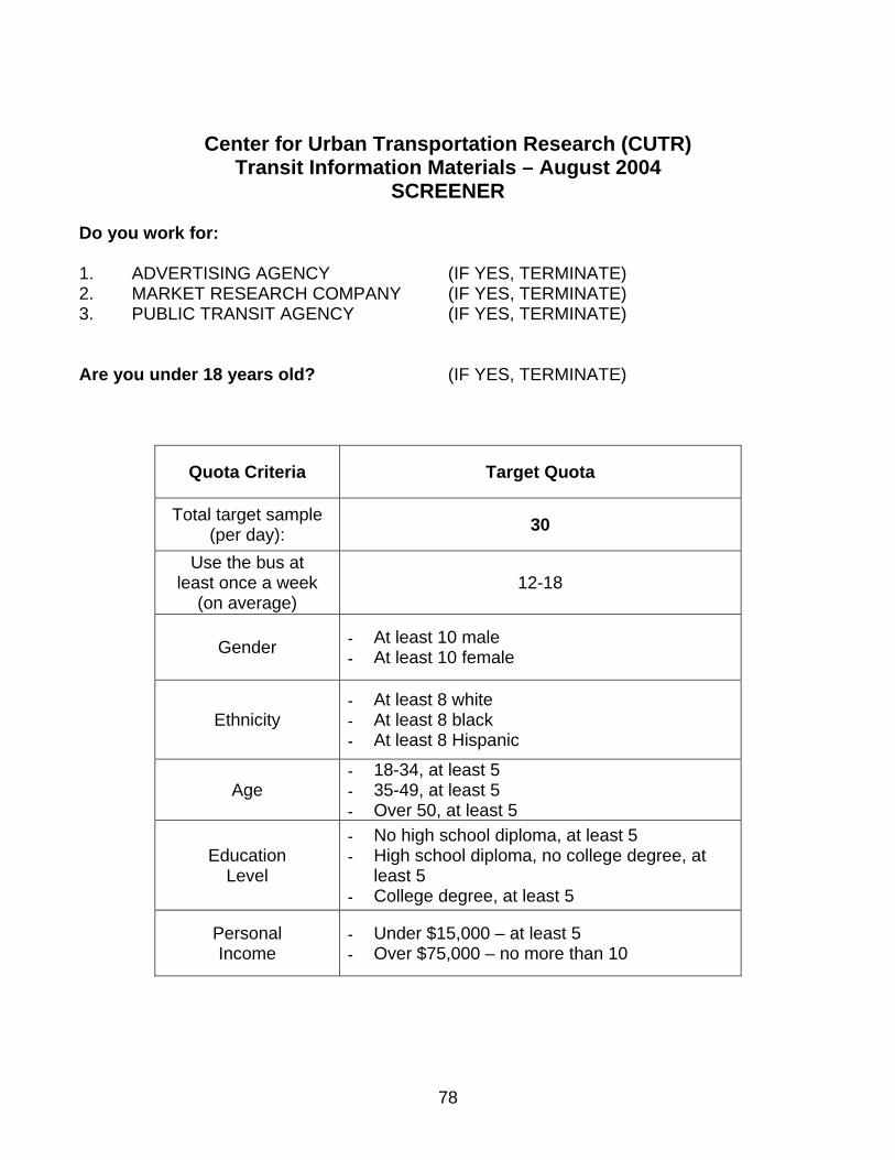
Center for Urban Transportation Research (CUTR) Transit Information Materials – August 2004
SCREENER Do you work for: 1. ADVERTISING AGENCY (IF YES, TERMINATE) 2. MARKET RESEARCH COMPANY (IF YES, TERMINATE) 3. PUBLIC TRANSIT AGENCY (IF YES, TERMINATE) Are you under 18 years old? (IF YES, TERMINATE)
Quota Criteria Target Quota
Total target sample (per day): 30
Use the bus at least once a week
(on average) 12-18
Gender At least 10 male At least 10 female
Ethnicity At least 8 white At least 8 black At least 8 Hispanic
Age 18-34, at least 5 35-49, at least 5 Over 50, at least 5
Education Level
No high school diploma, at least 5 High school diploma, no college degree, at
least 5 College degree, at least 5
Personal Income
Under $15,000 – at least 5 Over $75,000 – no more than 10
78

TRIP PLANNING WORKSHEET DESIGN ELEMENT - A
You are at the Regional Medical Center (NW 8th Avenue and NW 62nd Street) on a Tuesday. You need to get to Robinson Heights (SE 15th Street at SE 41st Avenue) by 2:30 p.m. Route Selection:
What is the most direct way to get from your current location to your destination by bus? You may need to take more than once bus, but try to minimize the number of times you have to transfer to another bus. Please enter the most direct bus route or routes below. First Route Number: Second Route Number (if necessary): Once you have selected your route or routes, please ask your interviewer for the required route schedules. Which bus or buses should you take in order to get to your destination on time, in the shortest possible amount of time? You can only get on and off the bus at scheduled stopping points (as shown on the route schedules – © for example). Please note any required transfers. Please choose the bus that arrives closest to the required destination time. Assume that you are on time if you arrive on or before the destination time. First Route Information: Route: Trip Start Point (Bus Stop): Trip Start Time: Trip End Point (Bus Stop): Trip End Time: Second Route Information (if necessary): Route: Trip Start Point (Bus Stop): Trip Start Time: Trip End Point (Bus Stop): Trip End Time:
79

TRIP PLANNING WORKSHEET DESIGN ELEMENT - B
You are at the Humane Zoo (NW 23rd Ave and NW 83rd Street) on a Monday. You need to get to the Job Corp Office (Waldo Road and NE 53rd Street) by 4:30 p.m. Route Selection:
What is the most direct way to get from your current location to your destination by bus? You may need to take more than once bus, but try to minimize the number of times you have to transfer to another bus. Please enter the most direct bus route or routes below. First Route Number: Second Route Number (if necessary): Once you have selected your route or routes, please ask your interviewer for the required route schedules. Which bus or buses should you take in order to get to your destination on time, in the shortest possible amount of time? You can only get on and off the bus at scheduled stopping points (as shown on the route schedules – © for example). Please note any required transfers. Please choose the bus that arrives closest to the required destination time. Assume that you are on time if you arrive on or before the destination time. First Route Information: Route: Trip Start Point (Bus Stop): Trip Start Time: Trip End Point (Bus Stop): Trip End Time: Second Route Information (if necessary): Route: Trip Start Point (Bus Stop): Trip Start Time: Trip End Point (Bus Stop): Trip End Time:
80

TRIP PLANNING WORKSHEET DESIGN ELEMENT - C
You are at the Ramada (13th Street and University Avenue) on a Saturday. You need to get to Linton Oaks (SW 61st Street and SW 11th Place) by 12:30 p.m. Route Selection:
What is the most direct way to get from your current location to your destination by bus? You may need to take more than once bus, but try to minimize the number of times you have to transfer to another bus. Please enter the most direct bus route or routes below. First Route Number: Second Route Number (if necessary): Once you have selected your route or routes, please ask your interviewer for the required route schedules. Which bus or buses should you take in order to get to your destination on time, in the shortest possible amount of time? You can only get on and off the bus at scheduled stopping points (as shown on the route schedules – © for example). Please note any required transfers. Please choose the bus that arrives closest to the required destination time. Assume that you are on time if you arrive on or before the destination time. First Route Information: Route: Trip Start Point (Bus Stop): Trip Start Time: Trip End Point (Bus Stop): Trip End Time: Second Route Information (if necessary): Route: Trip Start Point (Bus Stop): Trip Start Time: Trip End Point (Bus Stop): Trip End Time:
81

TRIP PLANNING WORKSHEET DESIGN ELEMENT - D
You are at Butler Library (SW 35th Boulevard and Windmeadows Boulevard) on a Tuesday. You need to get to Penn Homes (SE 15th Street and SE 12th Avenue) by 7:20 p.m. Route Selection:
What is the most direct way to get from your current location to your destination by bus? You may need to take more than once bus, but try to minimize the number of times you have to transfer to another bus. Please enter the most direct bus route or routes below. First Route Number: Second Route Number (if necessary): Once you have selected your route or routes, please ask your interviewer for the required route schedules. Which bus or buses should you take in order to get to your destination on time, in the shortest possible amount of time? You can only get on and off the bus at scheduled stopping points (as shown on the route schedules – © for example). Please note any required transfers. Please choose the bus that arrives closest to the required destination time. Assume that you are on time if you arrive on or before the destination time. First Route Information: Route: Trip Start Point (Bus Stop): Trip Start Time: Trip End Point (Bus Stop): Trip End Time: Second Route Information (if necessary): Route: Trip Start Point (Bus Stop): Trip Start Time: Trip End Point (Bus Stop): Trip End Time:
82

TRIP PLANNING WORKSHEET DESIGN ELEMENT - E
You are at Regional Mall (NW 39th Avenue and NW 13th Street) on a Friday. You need to get to Croften High School (NE 27th Street near East University Avenue) by 8:30 a.m. Route Selection:
What is the most direct way to get from your current location to your destination by bus? You may need to take more than once bus, but try to minimize the number of times you have to transfer to another bus. Please enter the most direct bus route or routes below. First Route Number: Second Route Number (if necessary): Once you have selected your route or routes, please ask your interviewer for the required route schedules. Which bus or buses should you take in order to get to your destination on time, in the shortest possible amount of time? You can only get on and off the bus at scheduled stopping points (as shown on the route schedules – © for example). Please note any required transfers. Please choose the bus that arrives closest to the required destination time. Assume that you are on time if you arrive on or before the destination time. First Route Information: Route: Trip Start Point (Bus Stop): Trip Start Time: Trip End Point (Bus Stop): Trip End Time: Second Route Information (if necessary): Route: Trip Start Point (Bus Stop): Trip Start Time: Trip End Point (Bus Stop): Trip End Time:
83
TRIP PLANNING WORKSHEET DESIGN ELEMENT - F
You are at Regional Mall (NW 39th Avenue and NW 13th Street) on a Thursday. You need to get to Croften High School (NE 27th Street near East University Avenue) by 7:30 a.m. Route Selection:
What is the most direct way to get from your current location to your destination by bus? You may need to take more than once bus, but try to minimize the number of times you have to transfer to another bus. Please enter the most direct bus route or routes below. First Route Number: Second Route Number (if necessary): Once you have selected your route or routes, please ask your interviewer for the required route schedules. Which bus or buses should you take in order to get to your destination on time, in the shortest possible amount of time? You can only get on and off the bus at scheduled stopping points (as shown on the route schedules – © for example). Please note any required transfers. Please choose the bus that arrives closest to the required destination time. Assume that you are on time if you arrive on or before the destination time. First Route Information: Route: Trip Start Point (Bus Stop): Trip Start Time: Trip End Point (Bus Stop): Trip End Time: Second Route Information (if necessary): Route: Trip Start Point (Bus Stop): Trip Start Time: Trip End Point (Bus Stop): Trip End Time:
84

TRIP PLANNING WORKSHEET DESIGN ELEMENT - G You are at Britemore High School (NW 23rd Avenue and 43rd Street) on a Wednesday. You need to get to the Aquatics Center (NW 34th Street near NW 39th Ave) by 8:40 a.m. Route Selection: What is the most direct way to get from your current location to your destination by bus? You may need to take more than once bus, but try to minimize the number of times you have to transfer to another bus. Please enter the most direct bus route or routes below. First Route Number: Second Route Number (if necessary): Once you have selected your route or routes, please ask your interviewer for the required route schedules. Which bus or buses should you take in order to get to your destination on time, in the shortest possible amount of time? You can only get on and off the bus at scheduled stopping points (as shown on the route schedules – © for example). Please note any required transfers. You can transfer wherever two routes intersect. Please choose the bus that arrives closest to the required destination time. Assume that you are on time if you arrive on or before the destination time. First Route Information: Route: Trip Start Point (Bus Stop): Trip Start Time: Trip End Point (Bus Stop): Trip End Time: Second Route Information (if necessary): Route: Trip Start Point (Bus Stop): Trip Start Time: Trip End Point (Bus Stop): Trip End Time:
85

86
ASSIGNMENT 1 – Observation Guide Present transit information materials and written task instructions to participant. Verbally explain the task that the participant is being asked to complete. Ask the participant if she/he has any questions. Instruct the participant to begin the activity. (No more than 10 minutes for Assignment).
TIME ACTIVITY STARTED:
ASSIGNMENT 1(a) – SYSTEM MAP ASSIGNMENT1(b)-ROUTE MAPS
Visual Observations: Please note areas where the participant appears to be having difficulty with the activity (be specific – e.g., Difficulty understanding timetable; difficulty locating destination, etc.) _____ Did the participant display any of the following emotions while completing the task? (Please check all that apply)
Frustration Irritation Anger Distress Laughter Nervousness
Please note the content of any requests for assistance. _ Participant completed activity within allotted time:
Yes No TIME ACTIVITY COMPLETED:_________
TIME ACTIVITY STARTED: Visual Observations: Please note areas where the participant appears to be having difficulty with the activity (be specific – e.g., Difficulty understanding timetable; difficulty locating destination, etc.) ___________________________________ Did the participant display any of the following emotions while completing the task? (Please check all that apply)
Frustration Irritation Anger Distress Laughter Nervousness
Please note the content of any requests for assistance. Participant completed activity within allotted time:
Yes No TIME ACTIVITY COMPLETED:

ASSIGNMENT 1 - Post-Test Interview
How would you rate the task that you were asked to complete in terms of difficulty?
Assignment 1(a) – System Map Assignment 1(b) – Route Maps Extremely difficult Extremely difficult Moderately difficult Moderately difficult
Somewhat difficult Somewhat difficult Neither difficult, nor easy Neither difficult, nor easy Somewhat easy Somewhat easy Moderately easy Moderately easy Extremely Easy Extremely Easy Based on your experience with this assignment, how would you feel if you were actually planning to take a trip by bus? Would you feel more or less confident than before you did this assignment? ______________________________________________________________________________________________________________________________________________________________________________________________________________________________ What is your general impression of the information materials? (E.g., colors, map, clear info, etc.) ______________________________________________________________________________________________________________________________________________________________________________________________________________________________ What was the most difficult and/or the least understandable part of using these materials? ______________________________________________________________________________________________________________________________________________________________________________________________________________________________ What was the least difficult and/or most understandable part of using these materials? ______________________________________________________________________________________________________________________________________________________________________________________________________________________________ How do you think these information materials could be improved? ______________________________________________________________________________________________________________________________________________________________________________________________________________________________ Do you think your experience with this assignment will have any effect on your use of public transit?
Yes No (If Yes, please specify how you think your public transit use will change): ______________________________________________________________________________________________________________________________________________________________________________________________________________________________
87

88
ASSIGNMENT 2 – Observation Guide Present transit information materials and written task instructions to participant. Verbally explain the task that the participant is being asked to complete. Ask the participant if she/he has any questions. Instruct the participant to begin the activity. (No more than 10 minutes for Assignment).
TIME ACTIVITY STARTED:
ASSIGNMENT 2(A) – SYSTEM MAP ASSIGNMENT 2(B) - ROUTE MAPS
Visual Observations: Please note areas where the participant appears to be having difficulty with the activity (be specific – e.g., Difficulty understanding timetable; difficulty locating destination, etc.) _______________________________________________________________________________________________________________ Did the participant display any of the following emotions while completing the task? (Please check all that apply)
Frustration Irritation Anger Distress Laughter Nervousness
Please note the content of any requests for assistance. _______________________________________________________________________________________________________________ Participant completed activity within allotted time:
Yes No
TIME ACTIVITY COMPLETED:
TIME ACTIVITY STARTED: _______ Visual Observations: Please note areas where the participant appears to be having difficulty with the activity (be specific – e.g., Difficulty understanding timetable; difficulty locating destination, etc.) _______________________________________________________________________________________________________________ Did the participant display any of the following emotions while completing the task? (Please check all that apply)
Frustration Irritation Anger Distress Laughter Nervousness
Please note the content of any requests for assistance. _______________________________________________________________________________________________________________ ___ Participant completed activity within allotted time:
Yes No
TIME ACTIVITY COMPLETED:

ASSIGNMENT 2 - Post-Test Interview How would you rate the task that you were asked to complete in terms of difficulty?
Assignment 2(a) – System Map Assignment 2(b) – Route Maps Extremely difficult Extremely difficult
Moderately difficult Moderately difficult Somewhat difficult Somewhat difficult Neither difficult, nor easy Neither difficult, nor easy
Somewhat easy Somewhat easy Moderately easy Moderately easy Extremely Easy Extremely Easy Based on your experience with this assignment, how would you feel if you were actually planning to take a trip by bus? Would you feel more or less confident than before you did this assignment? ______________________________________________________________________________________________________________________________________________________________________________________________________________________________ What is your general impression of the information materials? (E.g., colors, map, clear info, etc.) ______________________________________________________________________________________________________________________________________________________________________________________________________________________________ What was the most difficult and/or the least understandable part of using these materials? ______________________________________________________________________________________________________________________________________________________________________________________________________________________________ What was the least difficult and/or most understandable part of using these materials? ______________________________________________________________________________________________________________________________________________________________________________________________________________________________ How do you think these information materials could be improved? ______________________________________________________________________________________________________________________________________________________________________________________________________________________________ Do you think your experience with this assignment will have any effect on your use of public transit?
Yes No (If Yes, please specify how you think your public transit use will change): ______________________________________________________________________________________________________________________________________________________________________________________________________________________________
89

Thank you for choosing to participate in our research. Please answer the following questions as accurately as possible. Your responses will be used for statistical purposes only. Your name will not be connected to these responses in any way and all information you provide shall remain confidential at all times. 1. On average, how often do you currently drive? (please check one)
Four or more days a week Less than once a week, Less than once a month One to three days a week but at least once a month Never or almost never
2. Have you used public transportation in the past six months? (please check one) Yes No If yes, where? _________________ 3. On average, how often do you currently use public bus transit? (please check one)
4 or more days a week Less than once a week, Less than once a month One to three days a week but at least once a month Never or almost never
4. If you answered “never or almost never” in Qu3, please state the main reason why you DO NOT use public bus transit:
______________________________________________________________________________________________________________________________________________________________________________________________________________________________ 5. If you DO you use public bus transit, please state the main method you use to plan
your trips by bus: ______________________________________________________________________________________________________________________________________________________________________________________________________________________________
6. Have you ever used public transit schedules or route maps before participating in this activity?
Yes No If yes, where? 7. Has your participation today resulted in greater confidence related to planning a trip
on the public bus? (please check one) Yes No Don’t know
8. Approximately how often do you think you will use public bus transit now that you
have completed today’s activities? (please check one)
4 or more days a week Less than once a week, Less than once a month One to three days a week but at least once a month Never or almost never
90

91 Thank you again for your time and participation.
Please return this questionnaire to your interviewer.
9. Based on your general feelings and opinions about the public bus service where you live, how would you rate the following aspects of bus service, based on a scale from 1 to 5 with 5 being the highest rating and 1 the lowest rating? (Please check one box in each row)
Very Good Good Neither good Bad Very Bad Don’t
Nor bad Know Convenience 5 4 3 2 1 0 Comfort 5 4 3 2 1 0 Dependability 5 4 3 2 1 0 Personal Safety 5 4 3 2 1 0 Transit Information 5 4 3 2 1 0 Flexibility 5 4 3 2 1 0 Availability 5 4 3 2 1 0 Vehicle Safety 5 4 3 2 1 0 What is your: 10. Sex: Male Female
11. Age (please check one of the following ranges): 18 – 34 35 – 49 50 – 64 65 and older 12. Ethnicity: _____________________________________
13. Education Level (check last grade level completed):
Less than High School Diploma Some College Post - Graduate High School Diploma or GED College Graduate
14. How many personal vehicles are available in your household? (please check one) 0 1 2 3 or more 15. Where do you live? Name of town or city: State:
16. Is English your first language? Yes No Don’t know
If not, please enter your first language: ___________
17. Personal income (please check one of the following ranges) Less than $15,000 $30,000 to $49,999 $75,000 or more $15,000 to $29,999 $50,000 to $74,999

APPENDIX II – TEST MATERIALS*
*All the test materials presented here have been reduced in size to fit into this report.
92

93

94
DES
IGN
ELE
MEN
T A
– F
RO
NT
/ BA
CK
LA
YOU
T
Varia
nt1
–R
oute
Map
and
Sche
dule
onSa
me
Side

95
DES
IGN
ELE
MEN
T A
– F
RO
NT
/ BA
CK
LA
YOU
T
Varia
nt2
–R
oute
Map
and
Sche
dule
onO
ppos
iteSi
des

96
DES
IGN
ELE
MEN
T B
– S
TOP
ALI
GN
MEN
T
Varia
nt1
-Ver
tical
Stop
Alig
nmen
tVa
riant
2-
Hor
izon
talS
top
Alig
nmen
t

97
DES
IGN
ELE
MEN
T C
– D
AY
SCH
EDU
LIN
G
Va
riant
1-S
ame
Tabl
eVa
riant
2–
Sepa
rate
Tabl
es

98
DES
IGN
ELE
MEN
T C
– D
AY
SCH
EDU
LIN
G
Va
riant
3–
Sepa
rate
Page
s

99
DES
IGN
ELE
MEN
T D
– T
IME
SCH
EDU
LIN
G
Va
riant
1–
No
Diff
eren
tiatio
nVa
riant
2–
AM
/PM
Bol
d

100
DES
IGN
ELE
MEN
T D
– T
IME
SCH
EDU
LIN
G
Va
riant
3–
Sepa
rate
Tabl
es

101
DES
IGN
ELE
MEN
T E
– M
AP
DET
AIL
S –
PON
TS O
F IN
TER
EST
Va
riant
1–
No
Poin
tsof
Inte
rest
Varia
nt2
–Po
ints
of

102
DES
IGN
ELE
MEN
T F
– M
AP
DET
AIL
S –
RO
AD
S
Varia
nt1
–Lo
wR
oad
Det
ail
Varia
nt2
–H
igh
Roa
dD
etai
l

103
DES
IGN
ELE
MEN
T G
– L
EGEN
D
Va
riant
1–
No
Lege
ndVa
riant
2–
Lege
nd

104