Embed Size (px)
Citation preview
TRANSPORT STRATEGY FOR THE
DEVELOPMENT OF COLOMBO CITY
Amal S Kumarage
and
Achala Nanayakkkara
Urban Development Authority
NOVEMBER 2001
Transport Strategy for the Development of Colombo City Amal S. Kumarage
TABLE OF CONTENTS
CHAPTER 1 : INTRODUCTION __________________________________________ 1-1
1.1 Terms Of Reference _______________________________________________ 1-1
1.2 Study Area _______________________________________________________ 1-1
1.3 Study Team ______________________________________________________ 1-2
1.4 Acknowledgements _______________________________________________ 1-2
CHAPTER 2 : BACKGROUND ___________________________________________ 2-1
2.1 The Present Transport Network ______________________________________ 2-3
2.1.1 Railway Network _______________________________________________ 2-3
2.1.2 Highway Network _______________________________________________ 2-3
2.1.3 Bus Network ___________________________________________________ 2-4
2.1.4 Bus Terminals and Railway Stations ________________________________ 2-5
2.2 Colombo Metropolitan Regional Structure Plan (CMRSP) ________________ 2-7
2.3 Colombo Urban Transport Study Stage–2 (CUTS-2) _____________________ 2-9
2.3.1 Vehicle Ownership ______________________________________________ 2-9
2.3.2 Public Transport _______________________________________________ 2-11
2.3.3 New Public Transit Systems _____________________________________ 2-11
2.3.4 Road Development ____________________________________________ 2-12
2.4 Nature of the Present Transport Demand _____________________________ 2-12
2.4.1 Growth in Travel on Radial Corridors _______________________________ 2-12
2.4.2 Growth of Orbital Traffic Patterns__________________________________ 2-14
2.4.3 Traffic Circulation within the City __________________________________ 2-16
2.5 On-Going Development Projects ____________________________________ 2-16
2.5.1 Urban Development Authority ____________________________________ 2-16
2.5.2 Road Development Authority _____________________________________ 2-17
CHAPTER 3 : PRESENT ISSUES ________________________________________ 3-1
3.1 Urban Sprawl _____________________________________________________ 3-2
3.2 Development and Increased Activity along the Corridors ________________ 3-3
3.3 Deterioration of Public Transport ____________________________________ 3-3
3.4 A Mode of Public Transport for circulation within Colombo ______________ 3-4
3.5 Disappearing Bus Terminals and Interchange Facilities _________________ 3-5
3.6 Inappropriate Bus Routing __________________________________________ 3-6
Transport Strategy for the Development of Colombo City Amal S. Kumarage
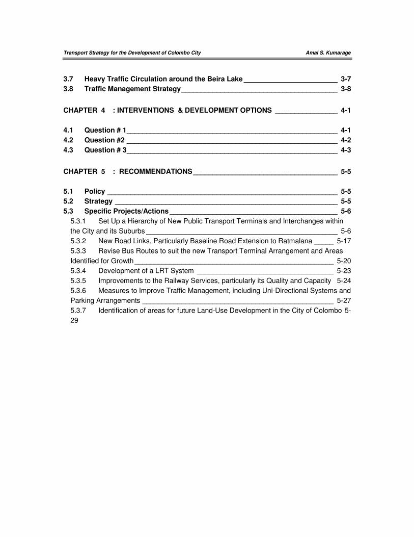
3.7 Heavy Traffic Circulation around the Beira Lake ________________________ 3-7
3.8 Traffic Management Strategy ________________________________________ 3-8
CHAPTER 4 : INTERVENTIONS & DEVELOPMENT OPTIONS ________________ 4-1
4.1 Question # 1 ______________________________________________________ 4-1
4.2 Question #2 ______________________________________________________ 4-2
4.3 Question # 3 ______________________________________________________ 4-3
CHAPTER 5 : RECOMMENDATIONS _____________________________________ 5-5
5.1 Policy ___________________________________________________________ 5-5
5.2 Strategy _________________________________________________________ 5-5
5.3 Specific Projects/Actions ___________________________________________ 5-6
5.3.1 Set Up a Hierarchy of New Public Transport Terminals and Interchanges within
the City and its Suburbs _________________________________________________ 5-6
5.3.2 New Road Links, Particularly Baseline Road Extension to Ratmalana _____ 5-17
5.3.3 Revise Bus Routes to suit the new Transport Terminal Arrangement and Areas
Identified for Growth ___________________________________________________ 5-20
5.3.4 Development of a LRT System ___________________________________ 5-23
5.3.5 Improvements to the Railway Services, particularly its Quality and Capacity 5-24
5.3.6 Measures to Improve Traffic Management, including Uni-Directional Systems and
Parking Arrangements _________________________________________________ 5-27
5.3.7 Identification of areas for future Land-Use Development in the City of Colombo 5-
29
Transport Strategy for the Development of Colombo City Amal S. Kumarage
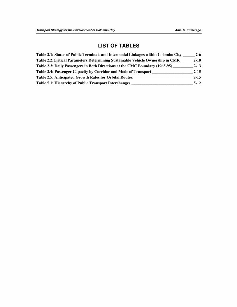
LIST OF TABLES
Table 2.1: Status of Public Terminals and Intermodal Linkages within Colombo City ______ 2-6
Table 2.2:Critical Parameters Determining Sustainable Vehicle Ownership in CMR ______ 2-10
Table 2.3: Daily Passengers in Both Directions at the CMC Boundary (1965-95) __________ 2-13
Table 2.4: Passenger Capacity by Corridor and Mode of Transport ____________________ 2-15
Table 2.5: Anticipated Growth Rates for Orbital Routes. _____________________________ 2-15
Table 5.1: Hierarchy of Public Transport Interchanges ______________________________ 5-12
Transport Strategy for the Development of Colombo City Amal S. Kumarage
LIST OF FIGURES
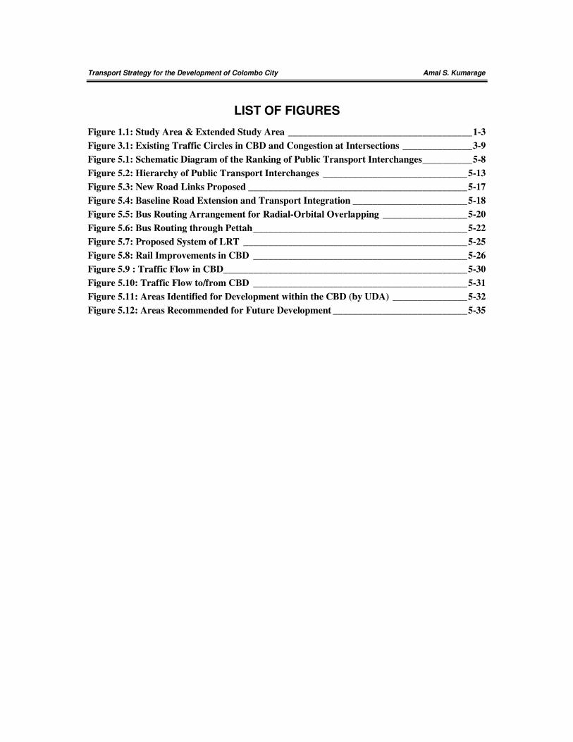
Figure 1.1: Study Area & Extended Study Area _____________________________________ 1-3
Figure 3.1: Existing Traffic Circles in CBD and Congestion at Intersections ______________ 3-9
Figure 5.1: Schematic Diagram of the Ranking of Public Transport Interchanges __________ 5-8
Figure 5.2: Hierarchy of Public Transport Interchanges _____________________________ 5-13
Figure 5.3: New Road Links Proposed ____________________________________________ 5-17
Figure 5.4: Baseline Road Extension and Transport Integration _______________________ 5-18
Figure 5.5: Bus Routing Arrangement for Radial-Orbital Overlapping _________________ 5-20
Figure 5.6: Bus Routing through Pettah ___________________________________________ 5-22
Figure 5.7: Proposed System of LRT _____________________________________________ 5-25
Figure 5.8: Rail Improvements in CBD ___________________________________________ 5-26
Figure 5.9 : Traffic Flow in CBD_________________________________________________ 5-30
Figure 5.10: Traffic Flow to/from CBD ___________________________________________ 5-31
Figure 5.11: Areas Identified for Development within the CBD (by UDA) _______________ 5-32
Figure 5.12: Areas Recommended for Future Development ___________________________ 5-35
Transport Strategy for the Development of Colombo City Amal S. Kumarage
i
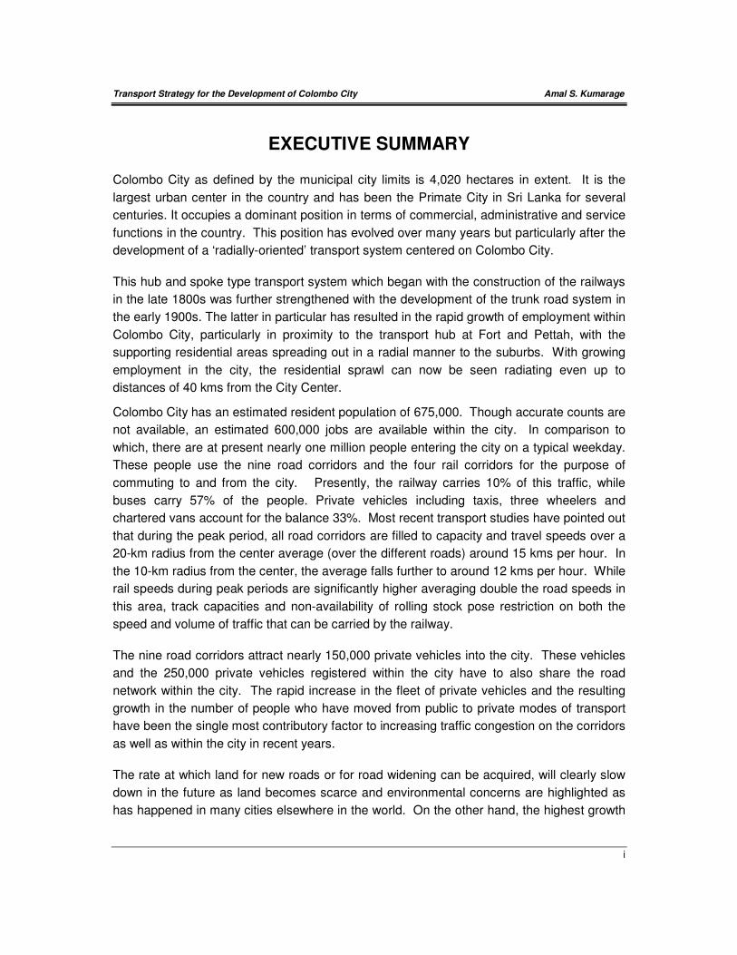
EXECUTIVE SUMMARY
Colombo City as defined by the municipal city limits is 4,020 hectares in extent. It is the
largest urban center in the country and has been the Primate City in Sri Lanka for several
centuries. It occupies a dominant position in terms of commercial, administrative and service
functions in the country. This position has evolved over many years but particularly after the
development of a ‘radially-oriented’ transport system centered on Colombo City.
This hub and spoke type transport system which began with the construction of the railways
in the late 1800s was further strengthened with the development of the trunk road system in
the early 1900s. The latter in particular has resulted in the rapid growth of employment within
Colombo City, particularly in proximity to the transport hub at Fort and Pettah, with the
supporting residential areas spreading out in a radial manner to the suburbs. With growing
employment in the city, the residential sprawl can now be seen radiating even up to
distances of 40 kms from the City Center.
Colombo City has an estimated resident population of 675,000. Though accurate counts are
not available, an estimated 600,000 jobs are available within the city. In comparison to
which, there are at present nearly one million people entering the city on a typical weekday.
These people use the nine road corridors and the four rail corridors for the purpose of
commuting to and from the city. Presently, the railway carries 10% of this traffic, while
buses carry 57% of the people. Private vehicles including taxis, three wheelers and
chartered vans account for the balance 33%. Most recent transport studies have pointed out
that during the peak period, all road corridors are filled to capacity and travel speeds over a
20-km radius from the center average (over the different roads) around 15 kms per hour. In
the 10-km radius from the center, the average falls further to around 12 kms per hour. While
rail speeds during peak periods are significantly higher averaging double the road speeds in
this area, track capacities and non-availability of rolling stock pose restriction on both the
speed and volume of traffic that can be carried by the railway.
The nine road corridors attract nearly 150,000 private vehicles into the city. These vehicles
and the 250,000 private vehicles registered within the city have to also share the road
network within the city. The rapid increase in the fleet of private vehicles and the resulting
growth in the number of people who have moved from public to private modes of transport
have been the single most contributory factor to increasing traffic congestion on the corridors
as well as within the city in recent years.
The rate at which land for new roads or for road widening can be acquired, will clearly slow
down in the future as land becomes scarce and environmental concerns are highlighted as
has happened in many cities elsewhere in the world. On the other hand, the highest growth
Transport Strategy for the Development of Colombo City Amal S. Kumarage
ii
rate in the demand for owning private vehicles is to be expected over the next 10 to 20 years
in the Colombo Metropolitan Region. Thus the clear indication is that the road network will
increasingly become congested over time. However, unacceptable travel delays and
associated costs resulting from this will eventually lead to a gradual migration of employment
and commercial activities away from the CBD areas of the city. Thus increasing use of the
private vehicle in the future will eventually lead to less employment and less activity within
Colombo City. The consequences of such a situation can even lead to a collapse of the
urban core and disperse activities located in the core areas across an entire region, thus
increasing the burden of servicing a much wider and less concentrated area.
Another noteworthy feature in the present transport system is the centrality of Pettah in
public transport service operations. Even though administrative centers have relocated to
Kotte MC areas and new employment areas have opened up away from the traditional
centers of Fort and Pettah in recent years, public transport services have not adjusted
adequately over time. For instance, of the 15,000 bus trips made in to the city daily, still
nearly 60% either terminate or pass through Pettah. All train operations are also routed
through the Fort station at Pettah.
The recommendations of this study are set out in this Chapter 5. They are designed to
address the issues raised in Chapter 3 and the rationale and strategy set out through the
dissuasions in Chapter 4. The recommendations are set out under the headings of (a)
policy, (b) strategy and (c) programs required achieving the desired objectives. This
approach is intended to convey the need to address these issues at all levels of planning,
preparation and decision making.
Transport Strategy for the Development of Colombo City Amal S. Kumarage
iii
POLICY
The specific policy recommendations made under this study with respect to the further
development of Colombo City are:
1. To rationalize further land development within Colombo City after ensuring that the
balance between development and transport capacity is maintained.
2. To intervene in the provision of new transport infrastructure and to re-plan existing
services and public transport terminals to account for the recent changes that have
occurred in the development of Colombo City and also to encourage urban development
planned for the future.

Transport Strategy for the Development of Colombo City Amal S. Kumarage
iv
STRATEGY
The strategic recommendations following the above policies are as follows:
(1) To rationalize the re-development of State owned lands made vacant with the relocation
of the defense establishments and the wholesale market so that a balance can be
maintained between land development and transport infrastructure and service provision.
Such balance should take into consideration the entire city in general and the specific
areas (such as the CBD) in particular. This would follows overall guidelines for the city
development and provide for the following.
(a) Relocating all activities that have little contribution to, or integration with, activities
that are aimed at promoting the CBD as the financial center of Colombo.
(b) Making part or all of such lands available for relocating on-street parking, LRT
systems, dedicated bus lanes and providing pedestrian facilities in areas where
existing road space is inadequate to provide for the transport requirements.
(c) Where land is not required for additional transport provision, by making more land
available for residential purposes.
(d) To provide for further commercial developments only in areas where exiting transport
needs can be met satisfactorily and also the needs resulting from such developments
can be met and sustained over the long-term.
(2) To decentralize the public transport transfer function presently focused on Pettah to
another three locations due north-east, east and south-east of the city respectively, so
that the CBD ceases to be the only major transfer location for public transport in
Colombo. The long-distance and local bus services should then be re-routed so that the
centralized transfer function which presently puts tremendous pressure on the CBD area,
is decentralized at least in part to the peripheral areas. Thus the city would be serviced
from the periphery as well as from the center, thereby reducing the need for transfers,
reducing travel times, and most importantly reducing the number of buses entering,
terminating and parking in the CBD area.
(3) To develop a set of public transport terminals and interchanges with the rail stations (a)
on the periphery of the city and (b) in suburban areas. Buses could then be re-routed
between these new termini, so that they pass through the city without terminating and
thereby avoid the blight of parked buses spread all over the city.
(4) To develop a major north-south transport artery with a number of inter-modal transfer
locations so that
(a) There is a good by-pass road avoiding the city and CBD areas for traffic that does
not need to enter the city.
Transport Strategy for the Development of Colombo City Amal S. Kumarage
v
(b) Public Transport services can use this artery as a major corridor and serve the city
from the periphery of the city inwards, and along which the new transport terminals
can be located and
(c) There is a transport artery that can distribute traffic eastwards to the City of Colombo
and westwards to the administrative area of Kotte.

Transport Strategy for the Development of Colombo City Amal S. Kumarage
vi
SPECIFIC PROJECTS/ACTIONS
The following Specific Actions and Projects are recommended following the strategies listed
above:
PROJECT #1: SET UP A HIERARCHY OF NEW PUBLIC TRANSPORT TERMINALS/
INTERCHANGES WITHIN THE CITY AND SUBURBS
Under this proposal, the functions of the present transport interchange at Pettah would be
de-centralized to three new termini for long distance buses and a hierarchy of smaller termini
and public transport interchanges. So that the need for buses to terminate at the city center
and for transferring there would reduce considerably. This will significantly reduce the
present congestion caused by all bus services hubbing at Pettah’.
Terminals within Colombo City
The Pettah terminal should be moved closer to Fort and form a single interchange, if
required on two levels. This we will call Fort-Pettah. This will ease much pedestrian traffic
across Olcott Mawatha and throughout Pettah area.
The Dematagoda terminal can be built on land adjacent to the railway station and a
reasonably good access is available through the old Baseline Road below the overpass at
this point. There are center median openings for U-turns as well as the width of the center
median below the bridge can also accommodate some terminal facilities as well.
The Narahenpita terminal can either be constructed (a) adjacent to the existing railway
station after the relocation of the informal settlements that are to be found in the vicinity or
(b) as a new railway cum bus terminal adjacent to the Nawala Road (where the rail crossing
is available, perhaps with an overpass like Dematagoda to avoid the problems of queuing
due to longer gate closures close to stations). The bus terminals presently located next to
the Labour Secretariat and also on-Baseline Road need to be brought here.
The terminal at Borella may be located adjacent to the Cotta Road Railway Station.
However, this may be difficult as, the land is occupied by commercial and residential
buildings. Thus, a better location would be adjacent to the Parliament Road near the
Welikada railway crossing. Here too an overpass can be built and the terminal that can
accommodate both buses and provide a railway station can be built. Land can be made
available as informal settlements and State lands are most predominant here.
The Grandpass terminal can be located on land that could be made available with the
resettlement of informal housing in that vicinity, while in the case of Pamankade, the former
GOBU of Wellawatte Spinning & Weaving Mills site is a most suitable location. The latter site
can generate access from Galle Road (either through High Street Wellawatte or through an
Transport Strategy for the Development of Colombo City Amal S. Kumarage
vii
extension along the Canal of Dharmarama Road (opposite Savoy Cinema) and it is after the
point of merger of both the Horana Road and High Level Road. This 14-acre site though
handed over to the BOI for mixed development should be reconsidered, so that at least a
part of it is developed as a bus Terminal. The UDA in 1997 has made a conceptual plan for
developing this site as a bus terminal for operating a Park and Ride as well.
Terminal Points on the Periphery of the City
Adequate land could be found at Kelaniya, Battaramulla and Kotikawatte for setting up
altogether new transfer locations adjacent to the existing railway stations. However in the
case of Nugegoda and Dehiwela, there are presently bus terminals already located
alongside railway stations. However in both these cases, the bus terminals could be further
developed and perhaps integrated in to a single building incorporating the railway station, so
that more bus platforms could be provided.
Terminal Points Outside the Periphery of the City
These would be major turn around terminals and would generally require a fairly large extent
of land for parking and waiting etc. Thus new land should be taken over for this purpose.
These terminals would be the terminal bus routes such as Ragama to Ratmalana or
Dehiwela to Kadawatha or Grandpass to Pannipitiya routes. These would essentially be
cross-town routes where the terminal outside the city would provide the facilities for waiting
and parking. The recommended locations are Ragama, Pannipitiya, Ratmalana,
Kadawatha, Kaduwela, Athurugiriya and Borelesgamuwa.
PROJECT #2: NEW ROAD LINKS, PARTICULARLY BASELINE ROAD EXTENSION TO
RATMALANA
The most important linkage required for this new transport hierarchy is a high quality north-
south link between Kelaniya and Ratmalana. The RDA in the form of the Baseline Road
extension has proposed this, but which has now run in to protest over land acquisition. This
linkage should be pursued with all vigor as it provides the spinal chord to serve Colombo
City from its eastern periphery. It will also serve the two most adjacent and key suburbs of
Colombo namely the Sri-Jayawardenapura-Kotte MC and the Dehiwela-Mt Lavinia MC that it
will border. As shown in the figure, it is this road that will provide the locations for the many
points of interchange for public transport and its absence will drastically affect the proposed
strategy and constrain the growth of the entire region. The proposed new links are indicated
in the Figure I and II and are outlined as follows:
(a) Completion of the Base Line Road up to Ratmalana
(b) Link connecting T. B. Jayah Mawatha and Vauxhall Street
Transport Strategy for the Development of Colombo City Amal S. Kumarage
viii
(c) Additional Link near Lake House Building connecting Olcott Mawatha and D.R.
Wijewardena Mawatha over the railway line
(d) Overpass or Underpass near the Slave Island Railway Station
(e) Link from Slave Island Railway Station to Olcott Mawatha across the Beira Lake
and the Main Railway Line
(f) Development of Pradeepa Mawatha as a Six Lane East-West Artery:
(g) Widening of Stace Road:
(h) Widening of Park Road and Redesigning intersection with Havelock Road
(i) Link between Baladaksha Mawatha and Lotus Road.
PROJECT #3: REVISE BUS ROUTES TO SUIT THE NEW TRANSPORT TERMINAL
ARRANGEMENT AND AREAS IDENTIFIED FOR GROWTH
Presently, much of the congestion in the city center arises out of a large number of buses
terminating and parking at the city center. Under the proposed hierarchy of terminals and
transfers, only a fraction of these services need to terminate at the center as most services
including some long-distance buses can either run through Pettah or terminate at Peripheral
Terminals. The re-routing of local bus services through these termini will lead to a reduction
of travel that is presently made through the city center only for the purpose of transfer.
PROJECT #4: DEVELOPMENT OF A LRT SYSTEM
The LRT or Tram system will provide sustainability for the strategy in the long-term. In this
respect, even though this is an expensive project, it can be built up in stages. The primary
function of this system would be to attract the car user to a high-quality public transport
mode. The routes that have been identified for the LRT in CUTS 2, provide a good
arrangement of collector-distributor features between the radial corridors and different parts
in the city. It is also integrated with the bus and railways to the fullest extent possible.
Transport Strategy for the Development of Colombo City Amal S. Kumarage
ix
PROJECT #5: IMPROVEMENTS TO THE RAILWAY SERVICES, PARTICULARLY ITS
QUALITY AND CAPACITY
The railway will be increasingly required to provide a fast commuting link between residential
areas and employment centers. It is even presently well located for this purpose. But
improvements in service provision in the form of higher capacity (both track and rolling
stock), reliability and good interchange with bus (and LRT in the future) would be necessary.
A new link to form a radial in the eastern direction to serve the Rajagiriya, Kotte and
Pelawatte areas seems viable. Upgrading the Secretariat Halt and introducing a new halt
between Fort and Maradana may be necessary.
PROJECT #6: MEASURES TO IMPROVE TRAFFIC MANAGEMENT, INCLUDING UNI-
DIRECTIONAL SYSTEMS AND PARKING ARRANGEMENTS
Traffic Management is a favored approach in many cities world-wide as opposed to attempts
to build new roads or widen existing roads. This proposal entails the revision of traffic flows
particularly on a uni-directional that would reduce conflicts at intersections. This is a
preferred option in a city where interchanges (fly-overs) are not compatible with the
landscape. It also means the reduction of on-street parking and the re-design of roads and
intersections in the city center to allow a smoother flow of vehicles at a moderate speed. It
would also include the construction of missing links in the road network such as a connection
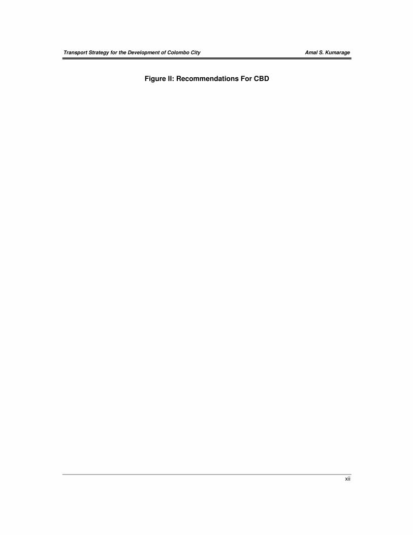
over the Beira (Figure II). This link in particular will have a significant impact as the present
traffic congestion is dominant around the four corners of the Beira Lake and a through route
will relieve areas such as Town Hall, Slave Island, Maradana and Lake House Roundabout
of traffic congestion.
PROJECT #7: IDENTIFICATION OF AREAS FOR FUTURE LAND-USE DEVELOPMENT
IN THE CITY OF COLOMBO
Within the Colombo Business District, it is possible to identify several locations for further
land use development. The level and the type of development that is suitable for these
locations will depend on various factors such as the present land use pattern, close proximity
to water bodies and other recreational functions and the capacities of the transportation
networks. If the above measures are implemented together with the other Policy and
Strategy recommendations, some more development could be allowed within the city. The
extent of this depends on the policies that are adopted. However, the following
recommendations are made to the suitability of lands available with respect to access and
circulation.
− On either sides of Baladaksha Mawatha. This area will be available after the
proposed relocation of the Army Head Quarters. This location is fairly isolated from
most of the transport corridors compared to other areas is within a very short
Transport Strategy for the Development of Colombo City Amal S. Kumarage
x
distance from the sea front and other recreational areas. Therefore the location is
more suitable for high-rise buildings with luxury apartments.
− Area around the Slave Island railway station. This area will be available after the
proposed relocation of the present informal settlements. This location is more
suitable for high risers with high-density commercial activity mainly due to its close
proximity with the Slave Island railway station and the proposal for a transfer
interchange there. Also new road infrastructure is proposed so that the road capacity
in the local areas will increase.
− On either sides of D.R.Wijewardena Mawatha. This stretch is also very suitable for
high risers with very high-density commercial activity due to its close proximity with
the proposed multi-modal transport terminal. The link across the railway will provide
the required road capacity.
− Area adjoining T.B.Jayah Mawatha and Deans Road. More suitable for medium
density commercial activity.
− Area adjoining Union Place and Vauxhall Street. More suitable for medium density
commercial activity.
− Area within Union Place, Dharmapala Mawatha and Sir James Peiris Mawatha. More
suitable for mixed luxury residential and medium density commercial activity.
− Area within Perahera Mawatha, Dharmapala Mawatha and the railway line. More
suitable for mixed luxury residential and medium density commercial activity.
Transport Strategy for the Development of Colombo City Amal S. Kumarage
xi
Figure I: Recommendations For CMC & Environs
Transport Strategy for the Development of Colombo City Amal S. Kumarage
xii
Figure II: Recommendations For CBD
Transport Strategy for the Development of Colombo City Amal S. Kumarage
1-1
CHAPTER 1 : INTRODUCTION
This report is initiated given the possibility that some lands within Colombo City would be
made available after the relocation program for the defense establishments, the wholesale
establishment in Pettah and the re-development of informal housing under the sustainable
townships program. Thus the intention of this report is to investigate the manner in which
such lands may be developed so that there would be a desirable equilibrium between land
use development and transport access and mobility within the city.
References for this study have been the broad development guidelines given for the
Colombo Metropolitan Region (CMR) and in particular the proposals for the Capital Territory
as set out in the Colombo Metropolitan Regional Structure Plan (CMRSP) formulated by the
UDA in 1998. The study also takes as a guideline, the Masterplan for the Development of
Transport in the CMR, Working Paper #25 of the Colombo Urban Transport Study (CUTS)
Stage 2, carried out by WS Atkins in Association with the University of Moratuwa, for the
Ministry of Transport in 1999. No specific surveys or collection of data has been carried out
for this study.
1.1 Terms Of Reference
The Terms of Reference of this study are as follows:
1. Derive a conceptual plan for handling the public transport in Colombo City with special
reference to:
(a) Scope for passenger demand and interchange at Pettah
(b) Scope for satellite terminals and interchanges.
2. Investigate transport supply capacity for developing different sites as identified by the
UDA, with special emphasis on:
(a) Road capacity and traffic movement
(b) Requirement for LRT and any other forms of transport services.
3. Investigate the modal integration between different transport modes and land use
distribution within Colombo City for recommendations made in (1) and (2) above.
1.2 Study Area
The area of study for this assignment is the Colombo City. However, the locational
requirements of the transport services required by the city, extends beyond the city limits in
Transport Strategy for the Development of Colombo City Amal S. Kumarage
1-2
some instances. Hence, areas as far as Kelaniya to the north, Battaramulla to the east and
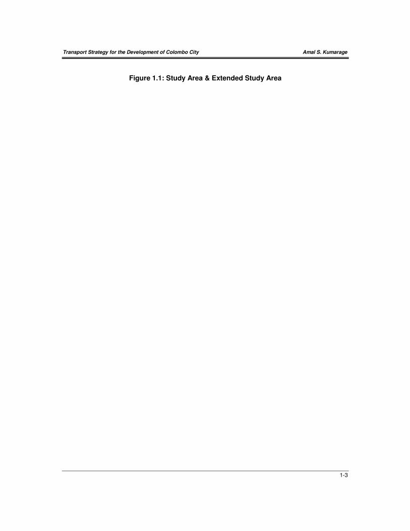
Ratmalana to the south have been included. The Figure 1.1 shows the study area and the
extended area considered. However, the specific requirements of these extended areas
have not been fully dealt, within this study. For example, the needs arising out of the defense
and other State establishments moving to the Kotte area and other transport sector projects
such as the Outer Circular Road all of which have only limited impact for the Colombo City
development, have not been discussed at length here.
1.3 Study Team
This study was led by Amal S. Kumarage, B.Sc. (Eng.), Ph.D., FCIT (UK), Senior Lecturer
and Head/ Transportation Engineering Division, University of Moratuwa and was assisted by
Research Assistant, Mr. AGAN Nanayakkara, B.Sc. (Eng.) who also compiled the drawings
with assistance from Mr. Nuwan Kodagoda and Ms. Pradeepa Jayaratne.
1.4 Acknowledgements
Discussions were held with several officers of the UDA in formulating the strategies set out is
this report. The study wishes to specifically acknowledge the contributions made by Mr. K.V.
Dharmasiri (Deputy Director General -Planning), Mr. Prasanna Silva (Deputy Director
General -Projects), Mr. Ragi Kadirgamar (Consultant), Dr. Malal Athauda and Mrs. Preethi
Fernando. The study team also gratefully acknowledges the logistical assistance provided by
Mr. Gunatileke Banda, Head of the Transportation Unit of the UDA.
Transport Strategy for the Development of Colombo City Amal S. Kumarage
1-3
Figure 1.1: Study Area & Extended Study Area

Transport Strategy for the Development of Colombo City Amal S. Kumarage
2-1
CHAPTER 2 : BACKGROUND
History reveals that Colombo was established and indeed grew to be the Primate City in Sri
Lanka during the period of Colonial rule. The present day road and rail networks date back
to the early 20th century and were clearly set out to create Colombo as a dominant seat of
administration. It was also the commercial center backed by the Port of Colombo as the
foremost international port of entry for non-agricultural imports to the country and agricultural
exports from the country. As a result the City also provided the transport center for the
country.
This position has grown in strength over the years, with the addition of the international
airports and more lately of the location of many industries in close proximity to the city. The
city itself had grown to a moncentric urban area extending way beyond its originally intended
limits by the end of the British rule. Thus the suburbs have gradually become highly
residential areas, as more and more land within the city got utilized for commercial and
administrative purposes. Thus the numbers entering the city for employment and business
activities have grown faster than the resident population. Even in more recent years this
trend has been evident, where it is noted that while the city’s population has increased by
around 25 percent in the last 15 years, the number of people entering the city daily has
nearly doubled over the same period.
This change in land use in Colombo is evident, when one compares that over 1,000,000
(one million) persons are presently entering the city daily, as opposed to the 675,000 that
are resident within the city. Even though accurate values do not exist, the analysis of
transport flow data indicates that around 600,000 jobs are possibly made available within the
city. However over 50 percent of these people are judged to travel to work from outside of
the city. These persons commuting to and from the city daily are mostly resident in urban
centers located along the main road and rail corridors radiating from the city. Commuting
distances range up to 40 kms from the center.
Presently, 90 percent of these people enter the city by road. The proportion using private
vehicles has also steadily increased from around 10 percent in 1965 to 35 percent by 1995.
Due to increasing traffic levels, mostly resulting from the rapid increase in private vehicles,
most radial road corridors to Colombo City have been widened or improved during the last
two decades. In spite of these improvements, travel time on all the radial roads, including
those that have been recently widened, keeps falling to unsatisfactory level. Congested flow
conditions exits for most of the day. There is therefore pressure brought upon the authorities
to widen roads even further or construct new roads, to keep up with the ever increasing
traffic levels. However, road widening is quickly becoming a virtual impossibility as high rise
structures and historic buildings that are spread throughout the city, border existing roads
and further widening proves to be costly as well as disruptive of the features that represent
the historic character of the city. The other factor that prevents widening of existing roads is
the rate at which the vehicle fleet is increasing. The rapid rate at which the vehicle fleet
increases, far out strips the legal and institutional capacity available for road widening.
Transport Strategy for the Development of Colombo City Amal S. Kumarage
2-2
Railway capacity on the other hand has not been increased in significant terms in recent
times and though some sections reach capacity during peak periods, there is still some
potential for increasing the capacity on these radial rail lines.
The demand for road space grew in particular after the deterioration of the public transport
from the mid 1980s. The influx of motorcycles, followed by vans and three wheelers
accounts for over 50 percent of road space used at present. Bus or rail could have
transported most of these users if the quality and quantity of public transport could have
been maintained.
However, the congestion resulting from the influx of many private vehicles, has caused
severe constraints on accessing the commercial core of the city, traditionally located in the
Fort and Pettah. Not only is there congestion on the approaches, there is a shortage of
parking space as well. The last decade or so have seen the gradual relocation of several key
business establishments from the center to more accessible areas such as Slave Island,
Kollupitiya, and Cinnamon Gardens as well as to the suburbs. In the meanwhile, the gradual
relocation of government offices from the Fort to Battaramulla, Pelawatte areas within the
Kotte MC has also led to changes in travel patterns. As a result, congestion is now seen all
over the city, and at all times of the working day and often even at night times. Problems
regarding inadequate intersection control, inadequate parking and lack of adequate access
control for main roads have all contributed to poor facility for travel and circulation within
most parts of the city.
Thus it is evident that two specific transport problems have surfaced at present in the City of
Colombo. On the one hand, the corridors to the city have slowed down and as such,
accessing the city center has become extremely difficult. Secondly, mobility within the city
has also slowed down due to haphazard migration of businesses and lack of integrated
planning with transport facilities required.
The CMRSP identifies the emerging new role for the Fort area as the Financial District of the
city. Along with the several five-star hotels and the new commercial space added through
the World Trade Center development, its is seen as having the potential to remain
competitive and continue to attract adequate commercial activity and employment within the
CBD. Administration centers have inmost part left Fort and a number of businesses are
relocating away from the Fort area, the exodus having been triggered in particular following
the bombing of the Central Bank in 1996. Presently there is an effort to move out the
defense establishments located in Fort as well as the President’s House. Therefore, the
CBD’s traditional role, as the center of commerce, administration and employment has
already begun to change. Moreover, the planned relocation of the wholesale activities from
the Pettah will also cause major changes to its character as the center of freight transport.
These activities should also result in changes to the passenger transport services. However,
Colombo’s ‘CBD centered’ passenger transport pattern has still not seen a change. It
Transport Strategy for the Development of Colombo City Amal S. Kumarage
2-3
continues todate as the focal point of nearly 700,000 passenger trips most of whom arrive in
the CBD only for purpose of transferring from one bus route to another.
2.1 The Present Transport Network
The transport infrastructure that serves Colombo City is made up of the road network and
the railway network. Though there are remnants of the network of water transport routes
widely used in the 17th and 18th centuries, it is hardly put to use today. Colombo does not
have a rapid transit system, even though it did have a tram system disbanded in 1959.
There are sidewalks on most streets, but no specifically deigned pedestrian areas or malls.
Dedicated facilities for bicycles are almost non-existent. Colombo does however have an
extensive bus route network, with over 17,000 bus trips entering the city daily. Of these, 56%
(that is all 2,000 long distance buses and 7,500 of the 15,000+ suburban and local buses)
touch the CBD, of which number 92% (that is all the 2,000 long-distance buses and over
6,700 of the suburban and local buses) terminate at Pettah. This clearly shows the present
focus on Pettah as the center of all bus transport operations and transfers. The status of the
rail, road and bus networks may be summarized as follows:
2.1.1 Railway Network
The railway network at present consists of four radial lines centered on Fort railway station
at Pettah. These lines serve, the northern, north-eastern, north-western and southern
quadrants of the city. However, the eastern parts of the city is not served by rail. Therefore
the network does not serve areas such as Battaramulla, Malambe, Kaduwela, Biyagama etc.
Presently, around 100,000 passengers are brought into the city daily on these four lines.
Even though the railway enjoys a faster speed of travel, delays and cancellations have made
the railway use mostly confined to peak periods. Within the city there are only nine railway
stations. Most of these are located on the coastal line and are poorly accessible. Thus the
railway is not widely used as a means of travel within the city. It is used mostly by the
commuters to the city traveling 20 or more kms.
2.1.2 Highway Network
The highway network at present provides an adequate connection from the Colombo city to
the suburbs, with several radial links. It is possible to identify ten such radially oriented links
namely the Colombo-Galle Road, Pamankade-Horana Road, Colombo-Ratnapura (High-
Level) Road, Narahenpita-Nawala-Nugegoda Road, Cotta Road, Kollupitiya -Sri
Jayawardenapura - Kaduwela (Parliament) Road, Colombo-Hanwella (Low-Level) Road,
Kolonnawa Road, Kandy Road and Negombo Road. These roads provide a direct
connection between many suburban centers and the CBD in Colombo. However there are
exceptions. For example, the Narahenpita - Nugegoda radial does not extend beyond
Nugegoda, though there are roads that can connect it to Hokandara and Athurugiriya. Thus
a proper radial link is not available to the area lying in between High-Level Road and Low-
Level Road. Due to this reason, places like Hokandara, Athurugiriya etc. are not radially
connected to the Colombo City. The ten radial roads account for carrying around 900,000
Transport Strategy for the Development of Colombo City Amal S. Kumarage
2-4
persons daily in to the city. Of this number, 750,000 are brought by 17,000 buses, while the
balance 150,000 persons are carried in by nearly 75,000 assorted vehicles ranging from
motor cycles to charter vans. It is noted that private vehicle take up 80 percent of the
available road space but carry only 20 percent of the passengers. The roads in the orbital
direction have only recently been developed. Most of these are limited to two lane or even
sub-standard (less-than) two lane highways. Most such links are only present in segments
and are not aligned in a suitable manner to function as a complete orbital link.
2.1.3 Bus Network
Compared to the 750,000 passengers crossing the city limits in 17,000 buses, the CBD is
also crossed by 367,000 bus passengers in nearly 9,500 buses. This clearly shows that the
bus routing is strongly radial and has not kept up with the migratory patterns within the city in
recent times. Furthermore, surveys in CUTS Stage 2 show that of these buses arriving at
the CBD over 92 percent terminate at Pettah. That means nearly 9,000 buses terminate their
trips at Pettah. This includes the 2,000 long-distance buses. However, a large proportion of
local and suburban buses also terminate at Pettah. This latter action is a relatively recent
development, mostly due to the reluctance of private bus operators to move out of the CBD
at times when passenger patronage is low. They terminate operations and are parked for
long durations. Studies have found that at any given time during a normal weekday there are
300 to 500 buses parked either within the CBD or just outside.
Another reason for buses parking in the CBD is the gradual elimination of, or crowding out of
suburban terminals. The space available at termini such as Kadawatha, Mt Lavinia,
Bambalapitiya, Kollupitiya, Nugegoda, Maharagama has actually reduced with land earlier
used for parking, being developed for supermarkets, shopping complexes, parking areas etc.
No new space has been added in the last two decades for bus terminal or parking space
within the city or in its suburbs with the exception of Pettah! Furthermore many on-street
terminals such as at York Street-Fort, Lotus Road-Fort, Khan Clock Tower, Torrington, Town
Hall etc have also been abandoned due to increased traffic flows on these roads. All these
factors shave led to the congregation of buses in the CBD area.
Another acute problem is in the lack of adequate orbital and cross-town bus routes. Before
the period of private sector dominance of the bus market, there were many cross-town
routes such as Maharagama-Kadawatha; Moratuwa- Kotahena etc. These were buses that
operated through Pettah but terminated at two suburban terminals. But Private bus operators
have for revenue purposes, truncated these routes in order to cause transfers and thereby to
collect the ‘step-on-fare’ added on when a transfer is made from bus to bus. This means that
most such passengers alight and re-board at the Pettah bus terminal in order to get
connecting buses (transfers). This has resulted in the expansion of the bus terminal facilities
in Pettah to three different off-street locations and also on street along Olcott Mawatha.
There is as a result of passengers transferring between buses, a very large pedestrian
activity generated that makes the area around the 5th Cross Street, Bodhirajah Mawatha and
Olcott Mawatha extremely busy and congested during any hour of the day.
Transport Strategy for the Development of Colombo City Amal S. Kumarage
2-5
From the data available, the following breakdown is worked out for the numbers and type of
bus passengers who is found to arrive within the CBD every working day.
For Employment within CBD (Fort and Pettah) 70,000
For Business/Shopping etc within the CBD 128,000
Transfer Passengers 169,000
• Long Distance �� Long Distance 4,500
• Long Distance �� Local (Colombo City) 87,500
• Long Distance �� Suburbs 30,000
• Suburbs �� Suburbs 18,500
• Suburbs �� Local 20,000
• Local �� Local 8,500
Total (all passengers) 367,000
This table clearly shows that only around 46 percent of boarding passengers at the Pettah
Terminal are transit (transfer) passengers. Thus a clear need exist for a terminal in Pettah
and/or Fort for those passengers (i.e. around 200,000 passengers) arriving to the CBD for
work, shopping, business etc. There is therefore no question of relocating the Pettah termini
in its entirety. Of the transfers, it can also be observed that the proportion of passengers
transferring from long distance to long distance is relatively low, while the majority of
transfers take place from long distance to local buses. While a strong linkage is shown to
exist with long distance bus passengers at Pettah, transfer from suburban to local buses and
even local-to-local also appears quite significant. The latter in particular shows the deficiency
in not having adequate through routes within the city. This clearly demonstrates a dominant
transfer center in Pettah, where bus trips from out station areas as well as suburbs are
brought in only for the purpose of distributing them out again. These passengers could
however, be also handled at one or more peripheral terminals and conveyed to their
destination even within the city, provided a set of local bus routes of a high frequency can be
made to also serve these terminals.
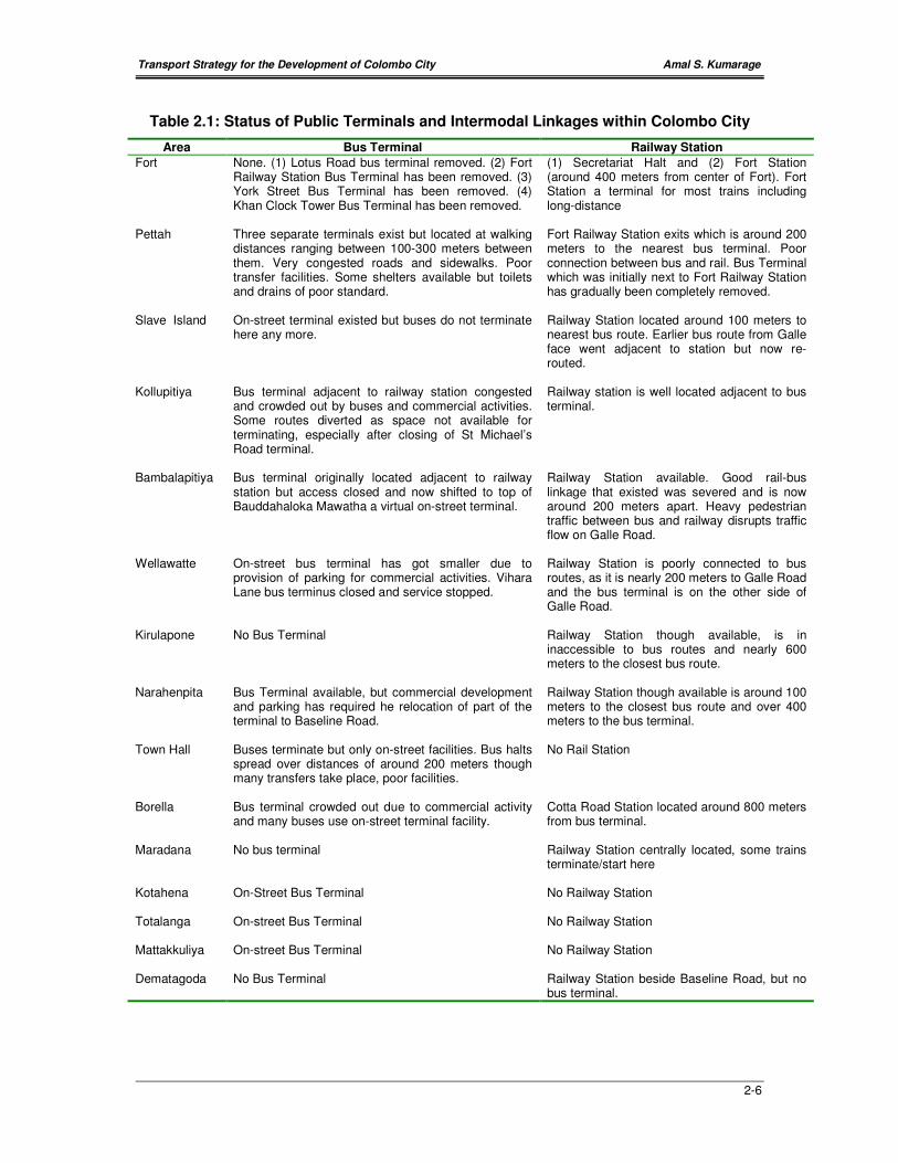
2.1.4 Bus Terminals and Railway Stations
There are presently eleven bus terminals and nine railway stations within Colombo City.
However these Railway Stations and Bus Terminals have not been developed or improved
in many decades. As the Table 2.1 shows, in fact, some terminal facilities that once existed
for buses have now been withdrawn (e.g. Railway Station Fort, Lotus Road-Fort, Vihara
Lane-Wellawatte). The space once available for passengers and buses have in other cases
been utilized for commercial activities and bus terminal activities have got crowded out (e.g.
Kollupitiya, Borella, Wellawatte, Narahenpita). Moreover, no efforts have been taken to
strengthen the linkages between bus and rail where such connections have been poor (e.g.
Cotta Road, Narahenpita, Wellawatte). To the contrary, bus terminals located close to the
stations (such as at Fort, Bambalapitiya) have been removed in total. In some cases (e.g.
Slave Island, bus routes have been diverted away from the railway station).
Transport Strategy for the Development of Colombo City Amal S. Kumarage
2-6
Table 2.1: Status of Public Terminals and Intermodal Linkages within Colombo City
Area Bus Terminal Railway Station
Fort None. (1) Lotus Road bus terminal removed. (2) Fort Railway Station Bus Terminal has been removed. (3) York Street Bus Terminal has been removed. (4) Khan Clock Tower Bus Terminal has been removed.
(1) Secretariat Halt and (2) Fort Station (around 400 meters from center of Fort). Fort Station a terminal for most trains including long-distance
Pettah Three separate terminals exist but located at walking distances ranging between 100-300 meters between them. Very congested roads and sidewalks. Poor transfer facilities. Some shelters available but toilets and drains of poor standard.
Fort Railway Station exits which is around 200 meters to the nearest bus terminal. Poor connection between bus and rail. Bus Terminal which was initially next to Fort Railway Station has gradually been completely removed.
Slave Island On-street terminal existed but buses do not terminate here any more.
Railway Station located around 100 meters to nearest bus route. Earlier bus route from Galle face went adjacent to station but now re-routed.
Kollupitiya Bus terminal adjacent to railway station congested and crowded out by buses and commercial activities. Some routes diverted as space not available for terminating, especially after closing of St Michael’s Road terminal.
Railway station is well located adjacent to bus terminal.
Bambalapitiya Bus terminal originally located adjacent to railway station but access closed and now shifted to top of Bauddahaloka Mawatha a virtual on-street terminal.
Railway Station available. Good rail-bus linkage that existed was severed and is now around 200 meters apart. Heavy pedestrian traffic between bus and railway disrupts traffic flow on Galle Road.
Wellawatte On-street bus terminal has got smaller due to provision of parking for commercial activities. Vihara Lane bus terminus closed and service stopped.
Railway Station is poorly connected to bus routes, as it is nearly 200 meters to Galle Road and the bus terminal is on the other side of Galle Road.
Kirulapone No Bus Terminal Railway Station though available, is in inaccessible to bus routes and nearly 600 meters to the closest bus route.
Narahenpita Bus Terminal available, but commercial development and parking has required he relocation of part of the terminal to Baseline Road.
Railway Station though available is around 100 meters to the closest bus route and over 400 meters to the bus terminal.
Town Hall Buses terminate but only on-street facilities. Bus halts spread over distances of around 200 meters though many transfers take place, poor facilities.
No Rail Station
Borella Bus terminal crowded out due to commercial activity and many buses use on-street terminal facility.
Cotta Road Station located around 800 meters from bus terminal.
Maradana No bus terminal Railway Station centrally located, some trains terminate/start here
Kotahena On-Street Bus Terminal No Railway Station
Totalanga On-street Bus Terminal No Railway Station
Mattakkuliya On-street Bus Terminal No Railway Station
Dematagoda No Bus Terminal Railway Station beside Baseline Road, but no bus terminal.

Transport Strategy for the Development of Colombo City Amal S. Kumarage
2-7
2.2 Colombo Metropolitan Regional Structure Plan
(CMRSP)
The formulation of the CMRSP was initiated by the UDA in 1996. This type of integrated
planning approach was seen as a resumption of planned regional development after a break
of over two decades. The Colombo Metropolitan Regional Structure Plan (CMRSP) is
described as a rational land-use and infrastructure strategy to facilitate a planned
development of the CMR. In this context it must be mentioned that the CMRSP has
addressed one of the most important aspects affecting both land use and transport
development in the region, namely, the absence of a linkage between the two sectors.
The CMRSP identifies three undesirable features of the current development practice that
has arisen due to a lack of a planned approach between land-use and transport.
(a) Extensive ribbon development along the main trunk roads (transport corridors);
(b) Under-utilization of land between the radial corridors and
(c) Inadequate transport infrastructure within Colombo City to sustain the increasing use
of private vehicles.
In addressing these issues, the CMRSP has proposed a new land-use and transport linkage
and urban structure. Satellite cities linked to each other and to the CBD are proposed as
growth centres to encourage development away from the corridors to presently under
developed areas between corridors. It has also identified several transport facilities
alongside other infrastructure required to achieve a strategically determined development of
the region. The growth promoted by Colombo is expected to be diverted to these ‘counter
magnet’ townships thus reducing the pressure on land use and transport in the city center.
This strategy is a move away from Colombo being a monocentric city and aims at
developing the CMR on the basis of polycentric urban agglomeration concept.
The CMRSP notes that the population of the CMR was 4.6 million in 1996. Although this was
25% of the population of the entire country, the land area coming under the CMR amounted
to only 5.6%. According to the projections in the CMRSP, this population is estimated to
increase to 6.5 million by the year 2010. During this same period, it is anticipated that the
share of urban population of the CMR would increase from 51% to 74%. However, Colombo
City, which had a population of 638,700 in 1996, is expected to grow by 1.38 % p.a. to
774,400 by 2010. The other existing urban centres of over 100,000 population in the CMR
are Kotte, Battaramulla, Negombo, Gampaha, Homagama, Dehiwela-Mt-Lavinia and
Moratuwa. With the gradual relocation of administrative functions to Kotte the CMRSP
further envisages the development of an area called the Capital Territory, by combining the
existing City of Colombo as the banking and financial Center and Greater Kotte is ear
marked to become the administrative center. The plan also proposes the development of six
Growth Centres as the satellite cities in the suburban areas of Gampaha, Negombo,
Biyagama, Homagama, Horana and Matugama. These are centers, even at present

Transport Strategy for the Development of Colombo City Amal S. Kumarage
2-8
experience a higher than average growth in population primarily due to the availability of
land in adequately close proximity to both Colombo as well as to industries scattered
throughout the CMR. The combined population of the six growth centres is expected to grow
by a rate of around 3.66% p.a. (on average) from 875,000 in 1996 to 1,461,000 by 2010.
The CMRSP has proposed the above land use changes after considering, trends in urban
sprawl, rapid conversion of agricultural land- for residential use, increasing transport costs,
spread of industrial locations throughout the CMR and the difficulties of providing
infrastructure facilities for new urban and industrial development mushrooming everywhere.
For example, the CMRSP notes that ‘incompatible land use and ribbon development along
the principal trunk roads in the region has led to traffic congestion and delays in passenger
travel’. It notes that ‘as a result, the cost component of transport in the production of goods
and services is rapidly escalating in the region’. This means that the CMR as well as
Colombo City will gradually loose the competitive edge for commercial and industrial
production within their respective areas. The combined land use- transport strategy adopted
in the CMRSP aims to provide for more space efficient modes of transport, whereby more
people can be commuted to employment in urban centers without constraining the transport
system to an extent of unacceptable levels of congestion on the one hand or on the other
hand having to cause extensive demolition of buildings for road widening or new roads
required to accommodate demand for new travel.
The CMRSP proposals to develop the core area as a mixed high-density land use and to
facilitate the planned formation of six satellite city centers can be considered as a pragmatic
approach. The fact that these six cities are chosen on the basis of centres experiencing
rapid growth at the present times give it added strength. However, the success of these
centers will depend on the quality of transport access that will be available to boost their
natural growth pattern. To achieve the strategic development objectives for the CMR, the
CMRSP, proposes the following transport sector strategies:
(a) to provide a high- mobility (higher speed) oriented limited access road network for inter-
regional transport requirements for those travel ling through the CMR;
(b) to redesign the existing radially-oriented corridors of the CMR by improving the facilities
and particularly the quality of public transport, in order to maximize limited transport
right-of-way within the region and thereby to increase speeds and flow along these
corridors;
(c) to provide improved access between the under developed areas of the CMR and
peripheral growth centres, and industrial centres in order to facilitate their rapid
development as planned cities and
(d) to develop a multi-modal transport system for the inner city (within Colombo City) that will
be socially acceptable, economically viable and environmentally sustainable.
Transport Strategy for the Development of Colombo City Amal S. Kumarage
2-9
2.3 Colombo Urban Transport Study Stage–2 (CUTS-2)
The Ministry of Transport with assistance from the World Bank undertook an extensive study
called the Colombo Urban Transport Study between 1995 and 1999. This was carried out in
two stages and many proposals for different improvements to road, rail and bus transport
have been made in this study. However most of these proposals are not based on any
overall transport plan or strategy and has little reference to future changes in land use in
Colombo City the region. However, Working Paper #25 of CUTS Stage 2 that is titled ‘A
Masterplan for the Development of the Colombo Metropolitan Region’ attempts to formulate
such a strategic transport plan based on the CMRSP. It identifies a number of transport-
related issues that will constrain the urban and regional development strategy set out in the
CMRSP. These issues are listed as:
(a) Managing the Increase in Vehicle Ownership (and Fleet);
(b) Arresting the deteriorating Public Transport and Improving its Quality and Supply
(c) Introduction of New Modes of Mass Transit and
(d) Rationalizing the Road Development Program.
It may be useful to summarize these four issues and the proposals that CUTS Working
Paper # 25 proposes. These are:
2.3.1 Vehicle Ownership
Worldwide, private vehicle ownership is associated with increase in personal incomes. It
represents freedom of personal choice and flexibility to individual travel needs. All
indications are that vehicle ownership in Sri Lanka too will grow at between 4 to 8 percent
per annum. This will be higher than the increase in GDP and in fact much higher than the
growth in population. Increases in vehicle ownership and the consequent increase in the
vehicle fleet and increased usage, will require more road space, parking space and
measures to control air pollution, road accidents etc. The inability to provide these will cause
congestion, pollution and further aggravate the land use issues that have been raised in the
CMRSP. Therefore, vehicle ownership in Sri Lanka and particularly that of the CMR needs to
be understood and managed through a strategic plan so that the development plan for the
Colombo City and the CMR can be achieved and sustained.
The fact that the CMR will continue to be developed as the most commercialized and
industrialized region in the country will mean that the incomes in the CMR will always be
considerably higher than the rest of the country. The average income within the CMC
therefore, would be expected to be the highest. This feature is expected to continue in to the
foreseeable future and until large-scale regional development programs change the present
income distributions. Such a scenario can be sustained only if the road density is adequately
high to begin with and can be kept up by continuing road-building programs. For road
building to be sustainable, land should be available, which means that to begin with, the
population density should be low. Thus cities with low road densities and high population
Transport Strategy for the Development of Colombo City Amal S. Kumarage
2-10
densities would only be able to sustain relatively lower levels of traffic and correspondingly,
lower use particularly of the private vehicle.
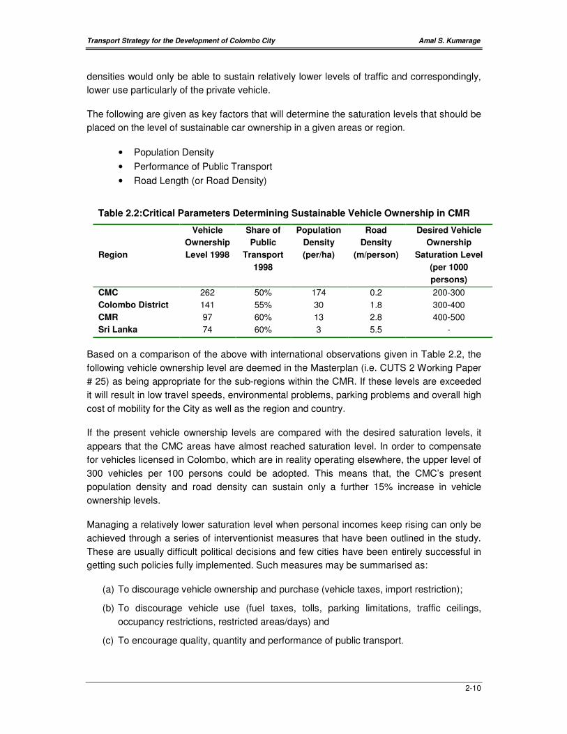
The following are given as key factors that will determine the saturation levels that should be
placed on the level of sustainable car ownership in a given areas or region.
• Population Density
• Performance of Public Transport
• Road Length (or Road Density)
Table 2.2:Critical Parameters Determining Sustainable Vehicle Ownership in CMR
Region
Vehicle
Ownership
Level 1998
Share of
Public
Transport
1998
Population
Density
(per/ha)
Road
Density
(m/person)
Desired Vehicle
Ownership
Saturation Level
(per 1000
persons)
CMC 262 50% 174 0.2 200-300
Colombo District 141 55% 30 1.8 300-400
CMR 97 60% 13 2.8 400-500
Sri Lanka 74 60% 3 5.5 -
Based on a comparison of the above with international observations given in Table 2.2, the
following vehicle ownership level are deemed in the Masterplan (i.e. CUTS 2 Working Paper
# 25) as being appropriate for the sub-regions within the CMR. If these levels are exceeded
it will result in low travel speeds, environmental problems, parking problems and overall high
cost of mobility for the City as well as the region and country.
If the present vehicle ownership levels are compared with the desired saturation levels, it
appears that the CMC areas have almost reached saturation level. In order to compensate
for vehicles licensed in Colombo, which are in reality operating elsewhere, the upper level of
300 vehicles per 100 persons could be adopted. This means that, the CMC’s present
population density and road density can sustain only a further 15% increase in vehicle
ownership levels.
Managing a relatively lower saturation level when personal incomes keep rising can only be
achieved through a series of interventionist measures that have been outlined in the study.
These are usually difficult political decisions and few cities have been entirely successful in
getting such policies fully implemented. Such measures may be summarised as:
(a) To discourage vehicle ownership and purchase (vehicle taxes, import restriction);
(b) To discourage vehicle use (fuel taxes, tolls, parking limitations, traffic ceilings,
occupancy restrictions, restricted areas/days) and
(c) To encourage quality, quantity and performance of public transport.
Transport Strategy for the Development of Colombo City Amal S. Kumarage
2-11
There is also the chicken and egg debate as whether to improve public transport first or to
impose restrictions first. Most successful examples from around the world appear to have
done both in concert.
2.3.2 Public Transport
Although basic bus and rail fares are considered as generally affordable for the vast majority
of the population, the quality of public transport is considered inadequate and deteriorating
further. Increase in bus travel times, over loading, lingering at bus stops, speeding, and
discourteous crews are regular complaints of the bus passenger. The Bus Transport Policy
Report envisages maintaining the present bus modal share in the CMR through a series of
measures aimed at improving both quality and quantity of bus transport. These include
improvements to the regulatory functions of routing and scheduling and management of
buses and operations as well.
In the railways at present, the Main Line carries between 20-30% of all passenger
movements on that corridor. The Coastal Line carried between 15-20% shares. Both the
Negombo and Kelani valley lines carry less than 4% of the traffic on their respective
corridors. Improvements identified for the railways include more rolling stock (i.e. schedule
more trains) and improvements to track capacity. The six-year development plan envisages
the railway attempting to double its passenger ridership by the year 2004. However, even
with new rolling stock put in to operation in the past few months, little progress has been
achieved todate.
One problem that is surfacing is the absence of good quality terminals and inter-modal
transfer locations (interchanges) for public transport users. Space that existed in many
suburban town centers has been utilized for supermarkets and shopping complexes. The
facilities for bus passengers and buses have deteriorated at all such terminals. Not even
toilets are found in many such terminals. The poor planning of bus routes have also made
such terminals literal bus parks, with little or no space for the needs of passengers. No
attention has been paid to strengthening inter-modal ties. In fact bus terminals that were
adjoining rail stations have been shifted wholly or in part (e.g. Bambalapitiya, Kollupitiya,
Dehiwela etc).
2.3.3 New Public Transit Systems
The CMRSP has proposed a People Mover System for Colombo City as a means of
improving public transport as well as introducing a higher level of service in public transport.
This is essential if pubic transport is to be a viable alternative for people whose incomes are
increasing. With increasing incomes people look for quality in public transport. If they do not
find adequate quality, then the desire to own and then use a private vehicle would be un-
stoppable. Therefore, the need for a new public transit system has a wider connotation than
its immediate financial viability. It should be a part of a strategic plan of managing mobility in
the CMR. The CUTS Working Papers # 11 and # 25 pay attention to this suggestion and
proceeds to recommend that Light Rapid Transit (LRT) as the most appropriate mode of
Transport Strategy for the Development of Colombo City Amal S. Kumarage
2-12
transport. These are short-distance electric trains that can use either separate right-of-way
or share existing road space and can also make stops at short intervals similar to a bus.
Such systems are increasingly deployed in cities around the world and popularly used for
circulation within city areas as well as for commuting passengers for distances of up to 10-15
kms.
2.3.4 Road Development
The Masterplan notes that transportation network within the area of Colombo city and the
Colombo Business District predominantly consists of a set of major radial corridors focused
towards the Colombo city and several minor orbital links. During the past, Colombo city has
been functioned as the administrative capital and the commercial capital of the country and
most of the activities were confined to the city center. Therefore these radial corridors had
served the Colombo city adequately in the past and the demand for orbital links was
insignificant. However with the development of the suburban centers as well as the shifting
of the administrative capital to Kotte, the existing transportation patterns has gradually
changed. It is anticipated that there will be a slowing down of the growth of traffic on the
radial corridors coupled with an increase in growth rates in the orbital routes.
Therefore the approach to road widening in the Working Paper # 25 of CUTS 2 is
understandably cautious. It identifies some road corridors for widening but also recommends
that corridor widening should be for purpose of introducing public transport based projects
such as bus-lanes, that would enable more people to travel to Colombo City rather than just
more vehicles. However, major scale road widening is recommended for orbital type roads
around Colombo. This is in anticipation that traffic in the orbital patterns will continue to
increase rapidly. With the formation of satellite cities this will increase even further. Thus
connecting sections of link roads in to one or two well developed orbital roads is
encouraged. The Masterplan argues that due to the present low levels, such traffic needs to
be accommodated initially on the roads and rail links, though necessary to sustain long-term
development, may have to be constructed somewhat later when demand for such travel
increases.
2.4 Nature of the Present Transport Demand
2.4.1 Growth in Travel on Radial Corridors
The trends in the demand for travel to Colombo along the radial transport corridors can be
studied from the year 1965. There are a total of eight corridors for which data is available
over this time period. The combined road and rail daily passenger flows on each corridor for
the years 1965; 1985 and 1995 have been calculated and tabulated in Table 2.3. These
have been measured at the CMC boundary. The corresponding average annual growth rates
(AAGR) for the intervening periods 1965-85; 1985-95; 1995-99) have also been shown
therein. It can be observed that, while the overall growth of passenger travel to and from the
city has grown steadily, different corridors have grown at different rates depending on
improvements to the transport (mostly roads) in those corridors.

Transport Strategy for the Development of Colombo City Amal S. Kumarage
2-13
Table 2.3: Daily Passengers in Both Directions at the CMC Boundary (1965-95)1
Corridor 1965 (000s) AAGR2
(65-85)
1985 (000s) AAGR
(85-95)
1995 (000s)
Galle 91 5.8% 279 1.7% 331
Negombo/Kandy 118 6.2% 400 3.6% 607
Ratnapura 62 4.2% 141 3.9% 206
Cotta Rd/SJP Rd 45 3.5% 893 10.8% 249
Horana Rd 21 5.2% 58 8.1% 126
Kolonnawa Rd 38 2.0% 56 0.1% 59
Narahenpita Rd 12 6.2% 40 (0.1%) 35
Low Level Rd - - 32 12.0% 63
TOTAL 387 5.3% 1,095 4.4% 1,676
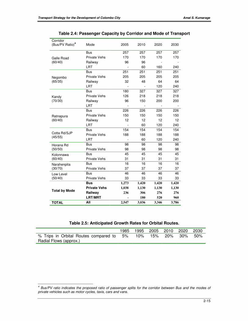
Working paper # 25 of CUTS 2 sets out the capacities along the corridors that can be
accommodated under the provision of different transport modes. This is set out in Table 2.4
and shows a possible increase in number of passengers up to nearly 3.8 million trips by the
year 2030. It should be noticed however that this increase comes from the introduction of
radial LRT lines on five of the major corridors that would account for around 50 percent of
the increase, while the balance would come from improvements to the railway (around 5
percent); improvements to bus transport – including bus lanes (25 percent) and increase in
private vehicles through new roads and road widening (20 percent). If all these new transport
infrastructure can be provided over the next 30 years, the number of persons coming into
Colombo could increase to 1.9 million per day, a doubling of the present. The annual growth
rate of 2.3 percent per annum would of course be much less than what has been
experienced in the last 30 years.
However, three questions dominate this calculation. These are:
(a) Can the investment, land etc required for such transport projects be mobilized over
the next decade or so?
(b) Does Colombo City have the scope to attract a near doubling of employment over
this period and
(c) Can Colombo City provide the facilities including transport for circulation for twice as
much people within the city?
Table 2.4 clearly shows that if a public-transport-based urban development policy is
adopted, Colombo City’s employment and activity level could even be doubled. However, if a
private-transport based policy is adopted, (as has been the de facto the practice over the last
two decades) then, even the existing employment may not be sustainable in the future. This
1
1965 data; based on the surveys from the Ceylon Traffic Study (Wilbur Smith Associates, 1966), 1985 data ; based on the surveys from the Sri Lanka Transport Sector Study & RDA counts (Louis Berger, 1988; RDA, 1988) and 1995 data: based on the surveys from the Colombo Traffic Study (University of Moratuwa, 1995). 2 AAGR- Average Annual Growth Rate- taken as the annual rate of increase in traffic volume for the period
between the two survey years. 3
Adjusted for Cotta Road, for which counts do not exist.
Transport Strategy for the Development of Colombo City Amal S. Kumarage
2-14
is because migration from public transport to cars and vans will take up all possible capacity
increments from any possible road widening etc.
2.4.2 Growth of Orbital Traffic Patterns
The traffic flowing in orbital directions around Colombo City have been comparatively much
smaller compared with radial flows. There are no counts or surveys that can provide trends
of past growth. However, rates of increase of around 5-7% p.a. have been generally
observed on these roads over the last decade. This is to be anticipated- with radial flows
reaching saturation, the land between radial corridors gets developed and an increasing
share of travel within the metropolis is therefore becoming inter-radial or orbital in nature.
Therefore, CUTS Stage 2 estimates that orbital traffic will increase much faster than the
radial traffic and will comprise a significant proportion in the longer term. Table 2.5 illustrates
traffic growth and estimates the passenger flow levels that could be estimated for such a
scenario.
Accordingly, Working Paper # 25 of CUTS 2 has identified a number of roads that could be
developed to accommodate this traffic. CMRSP also proposes a Loop Railway that could
accommodate a part of this demand.
Transport Strategy for the Development of Colombo City Amal S. Kumarage
2-15
Table 2.4: Passenger Capacity by Corridor and Mode of Transport
Corridor (Bus/PV Ratio)
4
Mode
2005
2010
2020
2030
Galle Road (60/40)
Bus 257 257 257 257
Private Vehs 170 170 170 170
Railway 96 96 - -
LRT - 60 160 240
Negombo (65/35)
Bus 251 251 251 251
Private Vehs 205 205 205 205
Railway 32 48 64 64
LRT - - 120 240
Kandy (70/30)
Bus 180 327 327 327
Private Vehs 126 218 218 218
Railway 96 150 200 200
LRT - - - -
Ratnapura (60/40)
Bus 226 226 226 226
Private Vehs 150 150 150 150
Railway 12 12 12 12
LRT - 60 120 240
Cotta Rd/SJP (45/55)
Bus 154 154 154 154
Private Vehs 188 188 188 188
LRT - 60 120 240
Horana Rd (50/50)
Bus 98 98 98 98
Private Vehs 98 98 98 98
Kolonnawa (60/40)
Bus 45 45 45 45
Private Vehs 31 31 31 31
Narahenpita (30/70)
Bus 16 16 16 16
Private Vehs 37 37 37 37
Low Level (50/40)
Bus 46 46 46 46
Private Vehs 33 33 33 33
Total by Mode
Bus 1,273 1,420 1,420 1,420
Private Vehs 1,038 1,130 1,130 1,130
Railway 236 306 276 276
LRT/MRT - 180 520 960
TOTAL All 2,547 3,036 3,346 3,786
Table 2.5: Anticipated Growth Rates for Orbital Routes.
1985 1995 2005 2010 2020 2030
% Trips in Orbital Routes compared to Radial Flows (approx.)
5% 10% 15% 20% 30% 50%
4 Bus/PV ratio indicates the proposed ratio of passenger splits for the corridor between Bus and the modes of
private vehicles such as motor cycles, taxis, cars and vans.
Transport Strategy for the Development of Colombo City Amal S. Kumarage
2-16
2.4.3 Traffic Circulation within the City
The most recent transport data that provides an understanding of the extent and nature of
travel taking place exclusively within the City of Colombo is to be found in the Colombo
Traffic Study carried out by the University of Moratuwa in 1995. This study reveals that
(a) There were in 1995, 440,000 vehicle trips made exclusively within the city- daily. There
were over 60,000 vehicle trips beginning or ending in Pettah (trip ends), 39,000 trip ends
in Pettah, 41,000 in Kollupitiya, 51,000 in Slave Island and 49,000 in Maradana. These
five zones combine to account for over 50 percent of all private vehicle trips made within
the city. Since these areas are predominantly commercial, it clearly shows that much of
the traffic circulating within the city is related to commercial activity and is therefore
concentrated in such areas.
(b) It also reveals that the purpose for making these trips are as follows:
• To/From Work – 34 percent
• To/From School and other education trips – 8 percent
• Personal trips (shopping, medical, business etc) - 52 percent
• Social, recreational & chauffeur only and other trips – 6 percent
(c) The corresponding number of bus passenger trips made exclusively within the city is
estimated at 623,000 per day. Unlike in the case of private vehicles, the largest number
of trip ends made by bus passengers are observed in both mixed development areas
such as Borella (72,000), Maradana (55,000), Fort (55,000), and Bambalapitiya (55,000).
Based on these estimates, it is evident that even in 1995, less than 50 percent of the travel
within Colombo City was made by public transport. This clearly shows the inability of the
bus routes to satisfactorily meet the short distance travel needs of circulatory travel within
Colombo. Therefore, much of the traffic congestion within the city can be avoided if a good
quality public transport is provided based on the newly forming travel patterns and the needs
of the modern urban business traveler and shopper. However, it is probable that unless a
high quality mode of public transport is made available in Colombo, the condition of
congested roads will prevail and only worsen in the future. Therefore, the introduction of a
well planned bus service and the LRT as proposed would be the only manner in which and
increase (up to doubling) of the activities within the city.
2.5 On-Going Development Projects
2.5.1 Urban Development Authority
There are a number of development activities in and around Colombo City that are pursed
by the UDA and other agencies under the Ministry of Housing & Urban Development. These
may be summarized as follows:

Transport Strategy for the Development of Colombo City Amal S. Kumarage
2-17
• Shifting of Manning Market to Orugodawatte: Land has been identified for this
purpose. Presently designs are being drawn for the relocation of all wholesale activities
being carried out at the Manning Market as well as the 4th and 5th Cross Streets in
Pettah.
• Shifting of President’s House and Defense Establishments to Pelawatte: Land has
been identified and designs are in progress.
• Sustainable Townships Program: Some areas with informal housing have been
selected for re-development as townships within the city. Trough a program of exchange
of residential land for commercial and residential developments, several such townships
are planned for the future.
2.5.2 Road Development Authority
The major projects handled by the RDA in the Colombo City and environs are as follows:
Colombo-Katunayake Expressway: This expressway is under construction and is
expected to provide four lanes of traffic parallel to the A3 highway from the New Kelani
Bridge up to the airport at Katunayake. Once operational it will form a strong link between
the northern end of the city and the International Airport at Katunayake. The CKE however,
has very little potential for regional development, as it is located between the ocean and the
already developed A3 (Negombo Road) corridor.
Baseline Project: Under this project the key north-south orbital serving the city on its
eastern boundary is being redeveloped as a six-lane highway. The first stage from New
Kelani Bridge has been completed, while the second stage up to Kirulapone is under
construction. The crucial third stage, which will complete the link and connect it to the Galle
Road at Ratmalana, is still not approved as it has run to protest over land acquisition.
Widening of Pelawatte-Pannipitiya Road: This will be an outer orbital that will serve the
Battaramulla-Pelawatte-Kotte areas and provide a good orbital road link as suggested in the
CUTS 2. This will strengthen the accessibility for the new administrative areas in Kotte MC.
Transport Strategy for the Development of Colombo City Amal S. Kumarage
3-1
CHAPTER 3 : PRESENT ISSUES
Colombo City and the CBD have experienced a considerable level of urban development
during the recent past. Most of this development has been carried out without an overall
strategy. This lack of integrated planning has given rise to a number of issues that appear to
constrain further growth in most areas of the city. There are therefore several issues that
have arisen over the possibility and potential of future development within the City of
Colombo and its environs. These issues can be summarized as follows:
(a) Due to Urban Sprawl, the commuting distances between employment and business
activities within the city and its residential areas are increasing.
(b) Due to uncontrolled roadside activities, available capacity on major radial road corridors
is restricted and travel speeds are deteriorating especially for travel between home and
work.
(c) Due to the apparent inability of public transport to improve quality and supply, increasing
incomes of the residents in Colombo and the employees in Colombo have led to a rapid
shift of commuters to private vehicles, outstripping road widening programs and causing
heavy peak period congestion on all road corridors.
(d) The inability to provide a good public transport service for travel within Colombo City has
resulted in heavy dependence on private vehicles for short-distance travel within the city
causing high demand for roadside parking and severe congestion during the work day
particularly in the commercial areas of the city.
(e) Bus Terminals and parking areas within the city and in the suburbs have gradually been
taken over for commercial purposes. Inter-modal linkages particularly between rail and
bus have also been considerably weakened right across the city. The most serious is in
Fort where at least four bus terminals that were in operations have been closed entirely.
As a result of the non-development of new terminals and closure of existing bus
terminals in other parts of the city has led to increased pressure on Pettah.
Consequently, a large number of bus and rail passengers travel to the center of the city
purely for the purpose of transferring from one bus to another or between train and bus.
There are now at least four bus terminals and the railway station spread across a vast
area, and the resulting pedestrian traffic between these causes much congestion and
chaos within Pettah.
(f) Bus services have not adapted to change with the expanding city. Nearly 60 percent of
buses entering the city still terminate at the city center causing a huge burden of parking
and circulation particularly in the Pettah area.
(g) The business activities once concentrated in the CBD having migrated to areas such as
Slave Island, Town Hall, Maradana has resulted in large day time traffic flows on the
roads around the Beira Lake and congestion is experienced particularly at the
intersections of these roads.
Transport Strategy for the Development of Colombo City Amal S. Kumarage
3-2
(h) There is no traffic management strategy for Colombo that ensures roads and
intersections are managed to their maximum available capacity. Lack of such a strategy
has resulted in allowing developments that generate traffic volumes far in excess of the
facilities for parking and movement available in the locality. Most areas within the city are
becoming intensely motorised and thereby the land use and street activities are being
changed in a subtle but steady manner. There is also no clear policy on traffic
management. For example, no strategies have been formulated to deal with effects of
major trip generators such as schools, shopping centres etc.
These issues and their impact on the future growth of Colombo and possible solutions are
further elaborated in the following sections.
3.1 Urban Sprawl
‘Due to Urban Sprawl, the commuting distances between employment and
business activities within the city and its residential areas are increasing’.
Urban sprawl results from a trade-off between land prices and transport costs. When urban
centers develop and more area is occupied for residential purposes, space within the city for
residential purposes diminishes. Subsequently more and more employees have to travel to
work from peripheral areas, thus setting off the forces of urban sprawl. If transport costs
(inclusive of time cost) are low, then the sprawl will progress rapidly and keep extending
further away from the city center. In the case of Colombo, it is common to find large
commuter traffic flows from distances of up to 40 kms from the center. The subsidized
season ticket travel has encouraged this very much. Thus, the number of persons entering
the boundary of the Western Province (CMR) every day is around 250,000, approximately
25 percent of the number of persons entering the Colombo City. The CMR boundary being
at distances of between 40 to 65 kms from the city, this clearly indicates the heavy long-
distance commuting profile.
If there are further developments in and around the City of Colombo, there will be more
pressure to extend the residential areas even further. Then employees will have to travel that
much further and the cost of travel (both fare plus time) will increase causing concerns to the
economic viability of sustaining employment activities in the center of the city. The CMRSP
proposal to encourage satellite cities clearly suggests that new employment activities will be
diverted to these centers. Thus Colombo’s future development should look particularly at a
scenario whereby the greater proportion of the employees base will reside say within 20 kms
or one hours’ travel from the city center during peak period. Thus a plan for the development
of Colombo should ensure that this constraint is met so that Colombo remains large enough
to attract urban activity but is not too large that sustaining a reasonable efficiency in getting
employees to work is difficult.

Transport Strategy for the Development of Colombo City Amal S. Kumarage
3-3
3.2 Development and Increased Activity along the
Corridors
‘Due to uncontrolled roadside activities, available capacity on major radial
corridors is restricted and travel speeds are deteriorating especially for trips
made between home and work’
This situation is evident along most of the corridors within the area, though to different
extents and it is critical along all radial corridors such as A1 (Kandy Road), A2 (Galle Road),
A3 (Negombo Road) and A4 (High-Level Road). This discourages people from seeking work
in Colombo City, particularly the CBD areas that are increasingly becoming inaccessible.
The vehicular movement along these corridors has been severely affected by the activity on
either side resulting in very low travel speeds along them. Too many right turns conflicting
with the main flow of traffic and the friction to the main flow by on street parking, roadside
trading are the major contributing factors in this issue. The increase of pedestrian
movements due to the urban development also causes friction to the vehicular movement
along the corridors resulting in a reduction of travel speed on the corridors.
Due to the high level of development on either side of these corridors, further widening of
these corridors to keep pace with the increase of demand has become difficult. This situation
is most evident and in fact critical at suburban towns where main radial corridors intersect
the orbital links such as at Nugegoda, Maharagama, Dehiwela, Borella, Kadawatha etc. As
most of these towns are located along main radial corridors, this increase of activity has a
severe impact on the vehicular movement along these corridors resulting in a ‘bottle-neck
effect’. This impacts the further development of Colombo City, as the catchment area for
employees cannot be maintained unless the transport corridors can provide faster travel. In
fact the railway is better suited at delivering passengers from longer distances. Hence, the
sustainability of Colombo’s employment base will be dependent on improving the commuter
railways as well as developing the road corridors for high mobility, especially with priority for
the most space-efficient mode of road transport –the bus.
3.3 Deterioration of Public Transport
‘Due to inability of public transport to improve quality and supply, the increasing
incomes have translated to a rapid shift of commuters to private vehicles,
outstripping road widening and causing heavy peak period congestion on all road
corridors’.
Deterioration of public transport is most evident in the fact that it is continuing to loose the
share of the market in commuting people to Colombo City and more so for travel within the
city. Many have moved to private modes of transport such as motor cycles, chartered vans
and private cars. Even though socially, it maybe considered as denoting prosperity, in
reality, such a migration from private to public modes of transport puts tremendous pressure
on the roads and the environment as has been experienced in Colombo over the last two
decades.
Transport Strategy for the Development of Colombo City Amal S. Kumarage
3-4
According to data available, the period between 1985 to 1995 saw the reduction of the share
of passengers brought in to Colombo by public modes of transport from 82 percent to 67
percent. Their share of passengers carried within Colombo City is well below 50 percent.
This includes both bus and rail. The rapid increase in traffic congestion over this period is
mostly attributed to the migration of these passengers to less space-efficient modes of
transport referred to earlier. Continuing deterioration of public transport will erode this share
even further, posing a major threat to the accessibility of Colombo City and the CBD in
particular. Hence, the need for a strong public transport service to serve Colombo City is
critical. For example, there are five rail tracks and a total of thirty four lanes of road traffic
presently feeding (in and out) Colombo City. Thus on average a rail track carries 40,000
passengers a day, while a lane of road traffic is carrying around 50,000. If the share of public
transport drops further to say 60 percent from the present 67 percent, it will lead to an
increase in the demand for road space by 20 percent. This translates to the requirement for
seven additional lanes of traffic to and from the city. Clearly, such increases cannot be
provided in the short term. Even long-term possibilities are limited, since most road corridors
cannot be widened any further and new roads such as the Colombo-Katunayake
Expressway are both costly and also generates much public protest over land acquisition
and environmental issues.
Therefore, if the further development of Colombo means that more employment and
business activities are to be generated within the city, then such an objective can only be
met and sustained if the quality and supply of public transport services can be maintained. If
not, and if indeed more migration takes place, it is conceivable that Colombo City will even
loose some employment to other growth areas such as the satellite cities suggested in the
CMRSP.
3.4 A Mode of Public Transport for circulation within
Colombo
‘The inability to provide a good public transport service for travel within Colombo
City has resulted in heavy dependence on private vehicles for short-distance
travel within the city causing high demand for roadside parking and severe
congestion during the work day particularly in the commercial areas of the’.
The migration of business activities from Fort and Pettah to surrounding areas over the last
decade has resulted in changes in the travel needs of people as well as for different forms of
goods transport between these areas. As distances between different offices and
establishments increase, trips that could have been made walking or by a bicycle have now
become motorised. As such, there is a high movement of traffic between the commercial
areas of Fort, Pettah, Maradana, Slave Island, Town Hall, Borella, Kollupitiya and Cinnamon
Gardens. The railway is ill suited for providing for these trips and even though buses provide
an extensive route coverage, the directness of routes and the deteriorating quality of service
has not made it popular for this type of travel. Presently, three wheeler taxis, taxis and
private cars provide much of the personal travel requirements. These vehicles however,
Transport Strategy for the Development of Colombo City Amal S. Kumarage
3-5
cause many problems of parking and retards the main travel flows on the major corridors by
stopping, making turns and other similar movements typical of short distance travel.
The need for a high quality people mover system, similar to those in operation in cities such
as Manila, Singapore or Hong Kong is quite evident in Colombo and has been highlighted in
the CMRSP. The recommendation made in the CUTS 2 study, is for a Light Rapid Transit,
with the specific intent of attracting short-distance commuters, aimed particularly at those
who can afford to travel by private modes of transport. Such a system will give much
development potential to the city, as many streets can be cleared of parking and stopping
vehicles and replaced with LRT systems. This would increase the spread of the employment
within Colombo City so that travel between areas would not create traffic blocks. Such a
move would also improve the air quality within the city, making it more attractive for
residential facilities, tourists, shopping and leisure activities etc. Such a reduction of traffic
would also promote and perhaps cause a return of more retail type shopping into areas,
which are now highly motorised and thus unattractive for leisurely shopping activities.
3.5 Disappearing Bus Terminals and Interchange
Facilities
‘Bus Terminals and parking areas within the city and in the suburbs have
gradually been taken over for commercial purposes. Inter-modal linkages
particularly between rail and bus have also been considerably weakened right
across the city. The most serious is in Fort where at least four bus terminals that
were in operations have been closed entirely. As a result of the non-development
of new terminals and closure of existing bus terminals in other parts of the city
has led to increased pressure on Pettah. Consequently, a large number of bus
and rail passengers travel to the center of the city purely for the purpose of
transferring from one bus to another or between train and bus. There are now at
least four bus terminals and the railway station spread across a vast area, and
the resulting pedestrian traffic between these causes much congestion and
chaos within Pettah’.
Colombo City presently has eleven bus terminals and nine railway stations. These
have not been developed for many years. In fact their value has been ill understood by
planners and decision makers, as many of them have been moved out of prime inter-
modal locations to make space for commercial development, parking of private
vehicles and other reasons. The lack of a proper custodian of bus terminals (after the
dissolving the CTB) and the lack of an integrated approach to transport planning has
resulted in the neglect of public terminals that are an important national asset.
There is therefore the urgent need to think of setting up a set of public transport
terminals and interchange facilities on a planned basis. They should not be thought of
purely for making existing facilities bigger or better. What is required is to plan out a
hierarchy of public transport terminals after taking into consideration the new land use
Transport Strategy for the Development of Colombo City Amal S. Kumarage
3-6
activities and the travel patterns that are generated by them. The following objectives
may be worthwhile pursuing in such an exercise:
(a) Gathering the presently dispersed terminals (for bus and rail) in the Pettah area
and the chaotic transfer activities between them in to one central location.
(b) Eliminating all of the suburban and local routes presently terminating in Pettah
and getting them to operate through the CBD but to terminate at either (a) the
periphery of the city or (b) at a suburban location.
(c) Splitting the long distance routes that are terminating at Pettah, to three other
locations within the City located due north-east, east and south-east of Pettah
respectively.
(d) To strengthen the linkages between bus terminals and the railway stations by
either relocating bus terminals or routes or by relocating stations or opening
new stations closer to bus routes and terminals.
(e) To identify locations where a set of terminals can be developed at the periphery
of the city, so that all local bus services that require to serve the city would
terminate only here, thus leaving the center of the city (the CBD in particular)
and other areas free of parked buses.
(f) To identify locations in suburban areas, where suburban bus services can
terminate. Preferably locations that would have strong inter-change facilities
with the railway or with inter-regional road connections. There would also be a
value for providing park and ride areas at some of these locations.
(g) To develop roadside bus stops across the city, with better facilities for buses as
well as passengers.
3.6 Inappropriate Bus Routing
‘Bus services have not adapted to change with the expanding city. Nearly 60
percent of buses entering the city still terminate at the city center causing a huge
burden of parking and circulation particularly in the Pettah area’.
Even though the land use patterns within Colombo and its environs have changed drastically
over the last two decades, very few changes have been made to the bus routing system,
which is the main provider of transport to the city. As a result over 60 percent of the 17,000
buses that enter the city daily, arrive at Fort or Pettah, which was in earlier times the center
of employment. But with employment locations having changed, direct routes are now not
available, as changes to bus routes have not been affected even though new developments
have been made. As a result, passengers who travel by bus are highly inconvenienced, as
they have to make several transfers to complete a trip. Studies have shown that 60 percent
of all bus trips ending within the city are made with at least one transfer. Furthermore, with
Pettah still functioning as the central transport transfer point, large numbers of passengers
are required to get through to the center of the city every day, a journey that is often very
slow. With over 375,000 bus passengers arriving in the Pettah everyday it is clear that a

Transport Strategy for the Development of Colombo City Amal S. Kumarage
3-7
large percentage of them are brought to the center by bus routes converging at the center,
merely to transfer and be taken away by another route radiating from the center. This causes
tremendous pressure on the center and also on the roads leading up to it. The continuing
location of Pettah as the only bus terminus will result in an unhealthy dominance of the
congregation of bus routes to Fort and Pettah as is seen today. As a result, hundreds of
buses are found parked and moving around at any given time, thus making the areas highly
unsatisfactory for retail trade and pedestrian based activities.
There must be specific consideration on alternative termini that can divert some of this
transfer traffic. There is also the need for bus routes to be restructured so that the city is
served from the periphery as well as from the center, rather than from the center alone, as is
the case now. This will reduce much congestion in Pettah both in terms of pedestrian traffic
and vehicular traffic both of which are in unmanageable proportions now. Furthermore, new
bus routes that reflect travel patterns and can ply between the new set of termini as
recommended in the proceeding section, would also be necessary.
3.7 Heavy Traffic Circulation around the Beira Lake
‘The business activities once concentrated in the CBD having migrated to areas
such as Slave Island, Town Hall, Maradana has resulted in large day time traffic
flows on the roads around the Beira Lake and congestion is experienced
particularly at the intersections of these roads.’
The new commercial areas in Colombo appear to be spreading mostly on to the lands
adjacent to the roads around the Beira Lake. That is Vauxhall Street, Union Place, Darley
Road and D.R Wijewardena Mawatha are presently absorbing most of the migratory
relocations and are also earmarked for future development for commercial purposes. As
such, the traffic circulation around the lake has to be very good. At present, the intersections
at Lake House, Slave Island, Ibbanwela (Darley Road/Union Place) is often congested.
These are the three of the four intersections around the Beira Lake. Similar to this set of
roads around the Beira Lake, a different set of roads forms another traffic circle around the
railway line between Fort and Maradana, which cannot be crossed between Lake House and
Maradana. Like the roads around the lake, Olcott Mawatha, Maradana Road are also
attracting business and thus Maradana junction, Technical junction are also congested in a
similar manner (Figure 3.1).
While in the short-term, better traffic management may be adequate to solve this problem, a
long-term solution would be to bridge the lake and the railway together in an acceptable
manner so that there is a direct link between say, the Fort-Pettah Transport Terminal and
Slave Island. Such a road link will accentuate the visibility of the main Beira Lake (which is
hardly seen from any of the present roads). These road connections should complement the
LRT system that was referred to earlier and should ensure that the commercial activities
remain within this area. Or else, there is a danger that commercial activities could spill over
to the more residential areas such as Cinnamon Gardens, Borella and Kollupitiya and that
the resulting transport problems will further isolate the Fort and Pettah area and also cause
the spread of traffic congestion throughout the city.
Transport Strategy for the Development of Colombo City Amal S. Kumarage
3-8
3.8 Traffic Management Strategy
‘There is no traffic management strategy for Colombo that ensures roads and
intersections are managed to their maximum available capacity. Lack of such a
strategy has resulted in allowing developments that generate traffic volumes far
in excess of the facilities for parking and movement available in the locality. Most
areas within the city are becoming intensely motorised and thereby the land use
and street activities are being changed in a subtle but steady manner. There is
also no clear policy on traffic management. For example, no strategies have
been formulated to deal with effects of major trip generators such as schools,
and shopping complexes’.
There is no clear policy on land use and transport within Colombo City. Many other cities
have ear-marked areas that are pedestrian and free of traffic and combined those with retail,
shopping leisure, culture and other activities that are best suited to be done on foot. Major
traffic generators are situated well away from the main traffic arteries and restrictions on
parking and turning are placed to give priority to roads that carry through traffic. The
absence of such a policy will also hamper the free flow of vehicular as well as pedestrian
traffic. The city also needs to reconsider the traffic flow pattern. Reducing conflicts at
intersections by a system of one-way streets is a low-cost option. Building over passes is a
more costly but effective way provided the aesthetic aspects of the city are not hindered.
Transport Strategy for the Development of Colombo City Amal S. Kumarage
3-9
Figure 3.1: Existing Traffic Circles in CBD and Congestion at Intersections

Transport Strategy for the Development of Colombo City Amal S. Kumarage
4-1
CHAPTER 4 : INTERVENTIONS & DEVELOPMENT
OPTIONS
‘An interventionist policy aims at changing the present course of events to something
considered better and therefore more desirable. Any change in course requires two
simple rules of navigation. In the first instance there is the need to know the path that is
being taken at present and where such a course is heading. The second salient feature is
to know what direction is best to take’.
This chapter attempts to set out a discussion on the strategic proposals required for a
change of course that would provide for the future, a balance between land use and
transport in Colombo City. The discussion is intended to establish the rationale for an
interventionist policy in this regard, following the discussion in Chapter 3 of the limitations of
the existing trends and issues that will dominate the future.
Accordingly, an attempt is made to pose several questions on possible development options
for land use and the transport constraints and problems they pose and the potential solutions
for Colombo City. The intention of this exercise is to eventually evolve a well-integrated
strategic approach to the question on, if and how Colombo can be developed both in terms
of land use and transport infrastructure and services required for such land use. Only such
an approach can create a strong and sustainable urban center that will have the potential to
provide a competitive commercial center that will in turn create a gateway for other urban
and rural areas in Sri Lanka to successfully compete within a shrinking global market.
4.1 Question # 1
‘An extensive area of land within the City of Colombo is presently occupied by
the defense establishments, as well as numerous informal residential
settlements. There is also land owned by the Sri Lanka Railways in the CBD
area. The UDA proposes to relocate all the defense establishments to Pelawatte
and also redevelop the lands that presently occupy informal housing. Both these
actions will release considerably large amounts of land for alternate
development. The question arising from this possibility is that, given the present
experience of ever increasing problems of congestion in travel to and from
Colombo, as well as in circulation within it, would such a move to re develop
vacating land be sustainable in the long-term, especially when it is known that as
incomes increase, the use of private vehicles will also increase thus further
burdening the existing road network’.
Discussion: The logical approach to such a dilemma is to investigate the possible transport
based solutions to counter the problems outlined in the question. These would include
attempts to
Transport Strategy for the Development of Colombo City Amal S. Kumarage
4-2
(a) Encourage at least a part of the existing traffic flows to be re-directed away from
congested areas of the CBD (such as through the decentralizing of the transfer
terminal in Pettah and the relocation of the wholesale markets)
(b) To provide more transport capacity where ever possible (such as in the introduction
of LRT, parking complexes etc)
(c) To encourage the growth in the use of more space efficient modes of transport (by
improving the quality and supply of public transport, even to the extent of restraining
private vehicles).
Clearly the above measures require almost radical policy interventions. Unless a strong pro-
public transport policy can be supported then it is not recommended that more employment
be encouraged within the City. However, more employment may be planned to the extent
that more capacity for passenger movements can be provided as shown above and that the
financial and political support that is required for such endeavors is there.
4.2 Question # 2
‘Therefore if one were to assume that all or some of these transport based solutions (to
Question # 1) are possible to some extent, then there is the possibility that Colombo City
can attract and retain some more development-even up to doubling it present level of
activity. In which case, we should know what type of development is best suited for
Colombo City and where it should be located’.
Discussion: It was shown that large numbers of employees are commuting to Colombo
daily. Those who can afford and use private vehicles to travel take the most amount of road
space (per employee) to get to the city. In this case, it would be useful to use at least part of
the land becoming available for residential purposes particularly for those employees who
are most likely to use private transport. These may be located even within or in close
proximity to the CBD, so that the retail trade and pedestrian linkages can also be further
strengthened with a resident population using it at night and over weekends.
With respect to Commercial development, they would be best located where
• New transport infrastructure can be provided
• It is possible to improve the efficiency of the present transport infrastructure
• It is envisaged that vehicular access can be restricted and public transport services can
be strengthened.
As such, the areas that are being made vacant should be put to careful use in
redevelopment. They should not be developed for purposes that would further strain the
transport system. Using some of the land for new transport infrastructure would be a start.
Increasing the residential stock would be another.
Transport Strategy for the Development of Colombo City Amal S. Kumarage
4-3
4.3 Question # 3
‘In order to achieve the above, does Colombo need an interventionist policy with regards
to Land Use and Transport? Alternately, is what is required a policy of providing more
of what has been provided in the past, in terms of the widening of existing roads,
improving railway lines, providing more buses and trains or the rebuilding of existing
terminals and stations and indeed developing land areas that are already in high
demand?’
Discussion: There are interventionist moves that should be made in both the urban
development and the transport sectors. There are two singular most important transport
sector interventions that would have a clearly influential impact on land use and transport
patterns.
The first is a change in the pattern of public transport within Colombo City. This relates to the
decentralizing of the function of the main Transport Terminal at Pettah. Rather than
providing for a new terminal to replace the existing termini, relocation of part of the terminal
to strategically located peripheral terminals would be the single most interventionist move
that can be set in motion to re-adjust transport patterns in line with present land-use patterns
and also to set the course for future development patterns. The setting up of a hierarchy of
public transport terminals and the rerouting of buses would provide a strong impetus to
intervene in changing the haphazard manner in which the city is developing today.
The second intervention would be in the formation of a strong north-south link on the eastern
periphery of the city so that the city can be served from the periphery inwards rather than the
present pattern of outwards from the center. Completion of Baseline Phase III would be
critical in this respect so that a proper linkage of adequate quality and capacity for the future
is available. This would provide the required peripheral linkage and also provide a western
approach to the on-going development areas in Kotte MC area.
The third interventionist transport move should be to adopt a policy of encouraging public
transport as the primary mode of transport to the city. This is required to determine the level
at which the city needs to be developed. If more employment is to be generated such a
policy would be a pre-requisite.
On the land use sector, relocating traditional functions in the CBD to peripheral areas would
provide an opportunity of addressing the issues of existing imbalances between land use
and transport in the Colombo City and the CBD in particular. As such, the relocation and re-
development program should have several objectives:
• Removing travel made to the center of the city (CBD) which has little contribution or
integration with activities that are aimed at promoting the CBD as a financial center.
• Making more land available for relocating of existing on-street parking to off-street
facilities and providing more pedestrian areas

Transport Strategy for the Development of Colombo City Amal S. Kumarage
4-4
• Making more land available for residential purposes
However it should clearly be pointed out that the past practice of converting any available
land in prime locations, for more commercial activities should be stopped forthwith. Such
activities should be allowed only at locations where the capacity exist for providing the
required transport infrastructure and services (as discussed under the suitability of
development sites for Question # 2 above). In instances where such land is released in
areas where transport capacity is found to be deficient, then such land should be utilized to
provide more transport infrastructure and services as may be desired.
Transport Strategy for the Development of Colombo City Amal S. Kumarage
5-5
CHAPTER 5 : RECOMMENDATIONS
The recommendations of this study are set out in this chapter. They are designed to address
the issues raised in Chapter 3 and the rationale and strategy set out through the discussions
in Chapter 4. The recommendations are set out under the headings of (a) policy, (b) strategy
and (c) programs required achieving the desired objectives. This approach is intended to
convey the need to address these issues at all levels of planning, preparation and decision-
making.
5.1 Policy
The specific policy recommendations made under this study with respect to the further
development of Colombo City are:
(1) To rationalize further land development within Colombo City by ensuring that the balance
between development and transport capacity is maintained.
(2) To intervene in the provision of new transport infrastructure and to re-plan existing
services and public transport terminals to suit the recent changes that has occurred in
the development of Colombo City.
5.2 Strategy
The strategic recommendations following the above policies are as follows:
(1) To rationalize the re-development of State owned lands made vacant with the relocation
of the defense establishments and the wholesale market so that a balance can be
maintained between land development and transport infrastructure and service provision.
Such balance should take into consideration the entire city in general and the specific
areas (such as the CBD) in particular. This would follows overall guidelines for the city
development and provide for the following.
(a) Relocating all activities that have little contribution to, or integration with,
activities that are aimed at promoting the CBD as the financial center of
Colombo.
(b) Making part or all of such lands available for relocating on-street parking, LRT
systems, bus lanes and providing pedestrian facilities in areas where existing
road space is inadequate to provide for the transport requirements.
(c) Where land is not required for transport provision, by making more land
available for residential purposes.
(d) To provide for further commercial developments only in areas where exiting
transport needs can be met satisfactorily and also the needs resulting from
such developments can be met and sustained over the long-term.
Transport Strategy for the Development of Colombo City Amal S. Kumarage
5-6
(2) To decentralize the public transport transfer function presently focused on Pettah to
another three locations due north-east, east and south-east of the city respectively, so
that the CBD ceases to be the only major transfer location for public transport in
Colombo. The long-distance and local bus services should then be re-routed so that the
centralized transfer function, which presently puts tremendous pressure on the CBD
area, is decentralized at least in part to the peripheral areas. Thus the city would be
serviced from the periphery as well as from the center, thereby reducing the need for
transfers, reducing travel times, and most importantly reducing the number of buses
entering, terminating and parking in the CBD area.
(3) To develop a set of public transport terminals and interchanges with the rail stations (a)
on the periphery of the city and (b) in suburban areas. Buses could then be re-routed
between these new termini, so that they pass through the city without terminating and
thereby avoid the blight of parked buses spread all over the city.
(4) To develop a major north-south transport artery with a number of inter-modal transfer
locations so that
(a) There is a good by-pass road avoiding the city and CBD areas for traffic that
does not need to enter the city.
(b) Public Transport services can use this artery as a major corridor and serve
the city from the periphery of the city inwards, and along which the new
transport terminals can be located and
(c) There is a transport artery that can distribute traffic eastwards to the City of
Colombo and westwards to the administrative area of Kotte.
5.3 Specific Projects/Actions
The following Specific Actions and Projects are recommended following the strategies listed
above:
5.3.1 Set Up a Hierarchy of New Public Transport
Terminals/Interchanges within the City
‘Under this proposal, the functions of the present transport interchange at Pettah
would be de-centralized to three new termini for long distance buses and a
hierarchy of smaller termini and public transport interchanges. So that the need
for buses to terminate at the city center and for transferring there would reduce
considerably. This will significantly reduce the present congestion caused by all
bus services hubbing at Pettah’.
A terminal is where a bus route or rail service would terminate. That is where there would a
complete emptying of the vehicle before a return trip or new trip is made. An interchange or
transfer point is where some passengers in a vehicle would transfer from one mode to
another (e.g. rail to bus) or between buses (long-distance to suburban). All terminals would

Transport Strategy for the Development of Colombo City Amal S. Kumarage
5-7
by definition require to be transfer locations. However all transfer locations need not be
terminals. The location of terminals will determine where the other non-terminal transfer
locations would occur. Thus it is best to formulate a hierarchy of interchanges as defined
below and illustrated in Figure 5.1.
• 1st Order: An interchange providing terminal facilities for long-distance buses and rail,
which provides the highest form of interchange between all types of bus trips and with
rail. In addition it will provide terminal facilities for some suburban and local routes.
• 2nd Order: An interchange that will have railway connection, but would not be a terminal
for long-distance buses, but it will provide transfer facility to/from long distance to all local
and suburban bus routes but without railway. It will provide terminal facilities for
suburban and local routes but unlike the 1st Order interchanges, no long distance buses
will terminate here.
• 3rd Order: An interchange that will not have railway connection, and will provide only
interchange between suburban and local bus services but without being served by long
distance buses. Similar to 2nd order interchanges, it will provide terminal facilities only for
suburban and local buses.
• 4th Order: No buses or trains will terminate here. These are interchanges where rail bus
transfers are possible.
• 5th Order: Locations not served by rail, but only for bus to bus transfer. No buses will
terminate here.
Transport Strategy for the Development of Colombo City Amal S. Kumarage
5-8
Figure 5.1: Schematic Diagram of the Ranking of Public Transport Interchanges
Transport Strategy for the Development of Colombo City Amal S. Kumarage
5-9
For a proper arrangement of inter-modal transfer points and terminals in Colombo (or for that
matter in any city), a number of factors will have to be considered. It is therefore necessary
to identify the required characteristics of an efficient transfer point so that suitable locations
with such characteristics can be selected. These are listed as follows:
(a) The different transportation modes should be available at close proximity to each other.
Thereby the passengers will be able to transfer efficiently from one network of a
particular mode of transportation to another.
(b) The location should be able to provide a strong collector distributor function. That is, it
should have the capacity to provide and efficient transfer between collector modes such
as rail or long-distance bus and distribute to local bus or LRT (or vice versa).
(c) The location should be able to provide for a frequency of transport services that is high
enough to make the transfer point adequately served by existing services. That is, it
should not be too far from existing transport routes and traffic generators.
(d) In-order to justify a high frequency of service the level of land use development in the
area surrounding the transfer point should high but it should not be to a level that bus
and train services are in conflict with the transport needs of the immediate area.
(e) As a transfer point will generate considerable amount of traffic, the capacity of the
transportation network within the immediate area surrounding the transfer point should
be adequate to handle such traffic.
(f) Sufficient amount of land should be available to accommodate the functions of the
transfer point. The facilities required can be identified as,
• Terminal buildings with adequate facilities for the passengers
• Enough space to handle the circulation of a large number of road vehicles of
different types
(g) Parking space for vehicles such as three, wheelers, taxies and preferably a park
and ride system
PASSENGER MOVEMENT IN RELATION TO TRANSFER POINTS
It is also necessary to identify the type of passenger transfers that occur, so that different
types of interchange and transfer facilities can be provided at different locations. When
analyzing the available data (see summary in Section 2.1.3) on bus passenger movements
within the CBD area, one can identify several different types of movements.
Transport Strategy for the Development of Colombo City Amal S. Kumarage
5-10
(a) Long distance passengers whose trip origins and destinations (trip ends) are both
outside the CMR Area– These are long distance to long distance transfer passengers
(e.g. Kandy to Galle) and accounts for only a very small (2%) proportion of the total
passenger movement in Pettah at present. The transfer of these trips can take place
anywhere, provided that a high frequency of long-distances buses can be maintained
and if a railway station is in the locality. Presently there are nearly 2,000 long-distance
buses terminating at Pettah. This is a large operation, even if one were to consider a
single terminal for long distance buses only (which cannot be, as feeder services are
also necessary). Thus it would be most advantageous to allow long-distance in several
locations.
(b) Long distance passengers who have one trip outside the CMR and the other trip
within Colombo or the Suburbs – These are transfer passengers from long distance to
local or suburban routes and vice-versa (e.g. Kurunegala to Ratmalana or Kurunegala to
Wellawatte). In this case, the transfers should occur at a place that will minimize the
distance and travel time of the passenger. Therefore it would be useful to have long-
distance passengers who have trip ends within the Colombo City transfer both at the
center of the city (i.e. Pettah) as well as at peripheral locations, as they can obtain the
most convenient local connection. In the case of those who have their trip ends in
suburban areas, it would be definitely more convenient to avoid having to go to the
center of the city and having to come back out again. Thus locating long-distance to local
and suburban transfer terminals at the center (Pettah) as well as two peripheral locations
would be most strategic. However a high frequency of local and suburban routes should
be providable at all such transfer terminals
(c) Suburban bus passengers who have both their trip ends located within the CMR
but not within Colombo City – These are transfer passengers from one suburb or
another suburb (e.g. Moratuwa to Ragama) of Colombo, but those who presently
transfer at Pettah. For these types of passengers there should be a bus route network
that can carry them directly without congesting the CBD of the City. As it is not practical
to provide routes to connect all possible points, it is necessary to have a number of
transfer points at suitable locations. The transfer points well suited for this should be
well away from the center of the city and preferably at the periphery.
(d) Passengers who have at least one-trip end within the City of Colombo – A
significant proportion of the passenger movements within the CBD accounts for this
category. However, much of this is short-distance and a number of strategically located
bus to rail and bus to bus transfer locations would help these trips. In addition well
planned routing would help in eliminating transfers all together.
This demonstrates the need to have the terminals performing different transfer functions
distributed across the city and its environs according to a specific order. Three clear criterion
appear to evolve from this analysis.
Transport Strategy for the Development of Colombo City Amal S. Kumarage
5-11
Within City Transfer & Terminal Points: Several transfer only locations (4th and 5th Order)
locations should be located within the Colombo City and provide for transfer of people who
have their trip ends within Colombo. In addition, a few 1st,2nd and 3rd order terminal should
be identified at places that are most suitable for terminating such services. This will be
mostly for long-distance services, while suburban and local services will be encouraged to
run through to Peripheral and Outside Terminals (see below).
Peripheral Transfer & Terminal Points: Several transfer only locations should be located
just outside the city and provide for the transfer of persons travelling from radial to orbital
directions and vice versa. Such transfer points will reduce persons arriving into the city for
the purpose of making just a transfer. Some of these, with at least one on every entry point
to the city and particularly those where good railway connection can be provided, should be
developed in to a Terminal so that some of the buses running through the city can terminate
and turn around.
Outside City Transfer & Terminal Points: Many transfer only locations may be spread
throughout the region. These should be located well outside the city in suburbs where
sufficient bus traffic exists. Some of these transfer points, particularly where good railway
connections can be provided should be made in to a terminal so that buses running through
the city can terminate here are well.
SUITABLE LOCATIONS FOR TRANSFER POINTS
After considering the above-mentioned requirements, several locations that are found to
possess these some of these characteristics have been identified. Table 5.1 and Figure 5.2
gives a possible arrangement within a hierarchy as discussed earlier. The following features
will result from implementing this hierarchy.
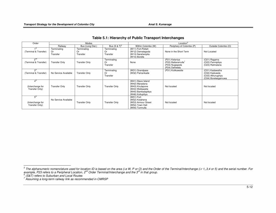
Transport Strategy for the Development of Colombo City Amal S. Kumarage
5-12
Table 5.1: Hierarchy of Public Transport Interchanges
Order Modes Location5
Railway Bus (Long Dist.) Bus (S & T)6 Within Colombo (W) Periphery of Colombo (P) Outside Colombo (O)
1st
(Terminal & Transfer) Terminating Or Transfer
Terminating Or Transfer
Terminating Or Transfer
(W11) Fort-Pettah (W12) Dematagoda (W13) Narahenpita (W14) Borella
None in the Short Term
Not Located
2nd
(Terminal & Transfer) Transfer Only
Transfer Only
Terminating Or Transfer
None
(P21) Kelaniya (P22) Battaramulla
7
(P23) Nugegoda (P24) Dehiwela
(O21) Ragama (O22) Pannipitiya (O23) Ratmalana
3rd
(Terminal & Transfer)
No Service Available
Transfer Only
Terminating Or Transfer
(W31) Grandpass (W32) Pamankade
(P31) Kotikawatte (O31) Kadawatha (O32) Kaduwela (O33) Athurugiriya (O34) Borelesgamuwa
4th
(Interchange for Transfer Only)
Transfer Only
Transfer Only
Transfer Only
(W41) Slave Island (W42) Maradana (W43) Kirulapone (W44) Wellawatte (W45) Bambalapitiya (W46) Kollupitiya
Not located
Not located
5th
(Interchange for Transfer Only)
No Service Available
Transfer Only
Transfer Only
(W51) Fort (W52) Kotahena (W53) Armour Street (W54) Town Hall (W55) Tunmulla
Not located
Not located
5 The alphanumeric nomenclature used for location ID is based on the area (i.e W, P or O) and the Order of the Terminal/Interchange (i.r 1,,3,4 or 5) and the serial number. For
example, P23 refers to a Peripheral Location, 2nd
Order Terminal/Interchange and the 3rd
in that group. 6 (S&T) refers to Suburban and Local Routes
7 Assuming a long-term railway link as recommended in CMRSP
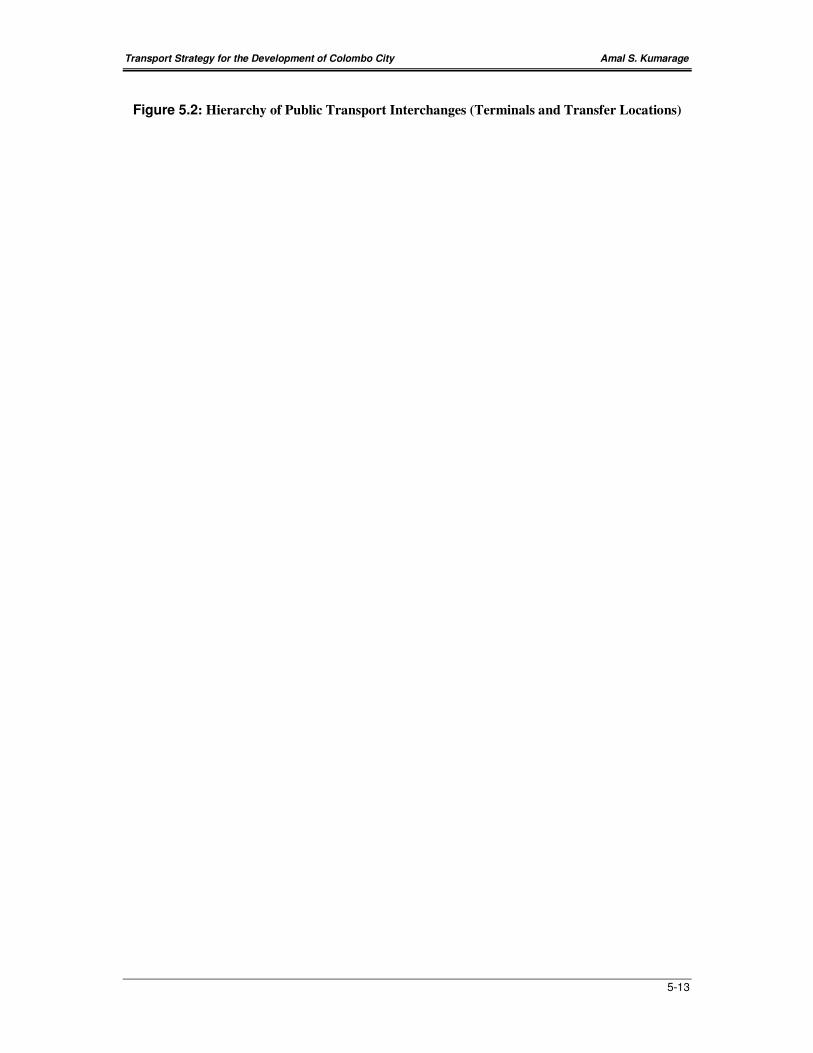
Transport Strategy for the Development of Colombo City Amal S. Kumarage
5-13
Figure 5.2: Hierarchy of Public Transport Interchanges (Terminals and Transfer Locations)
Transport Strategy for the Development of Colombo City Amal S. Kumarage
5-14
A. Transfer & Terminal Points Within City.
The following transfer and terminal points are recommended for the City of Colombo.
Terminals
• Four Nos. of 1st Order terminals at Fort-Pettah, Dematagoda, Borella and
Narahenpita
• Two Nos. of 3rd Order terminals at Grandpass and Pamankade
• No other terminals would be allowed within the city.
• Six Nos. of 4th Order transfer locations adjacent to the railway stations at Maradana,
Slave Island, Kirulapone, Wellawatte, Bambalapitiya and Kollupitiya. In other words
all railway stations within the city should be developed as strong transfer only
locations. This means that buses arriving at such locations should only be allowed to
wait till their schedule departure for the return trip and they should not be allowed to
terminate and idle so that they get back to the Peripheral or Outside terminals to end
their round trip.
• Five Nos. of 5th Order transfer locations where bus-to-bus transfers can be made
should also be developed. These have been identified at Fort, Kotahena, Armour
Street, Town Hall and Tunmulla. In this case, buses would not be allowed to even
wait (as an 4th Order transfer locations).
Fort-Pettah (W11): The Pettah terminal should be moved closer to Fort and form a single
interchange, if required on two levels. This we will call Fort-Pettah. This will ease much
pedestrian traffic across Olcott Mawatha and throughout Pettah area.
These additional features of this terminal will be that:
• The suburban and local buses will be discouraged from terminating here and thus they
will be routed through cross-town to other Within (W), Peripheral (P) and Outside (O)
terminals. This will prevent the road congestion due to a large numbers of parked buses
resulting from local and suburban buses terminating n Pettah.
• Only around 50% of the long –distance buses (i.e. around 1,000) buses will terminate
here (compared to the nearly 9,000 at present) and parking requirements would be
limited to around 100 buses (from between 300 to 500) now.
Dematagoda (W12), Narahenpita (W13) and Borella (W14): The Dematagoda terminal
can be built on land adjacent to the railway station and a reasonably good access is
available through the old Baseline Road below the overpass at this point. There are center
median openings for U-turns as well as the width of the center median below the bridge can
also accommodate some terminal facilities as well.
The Narahenpita terminal can either be constructed (a) adjacent to the existing railway
station after the relocation of the informal settlements that are to be found in the vicinity or
(b) as a new railway cum bus terminal adjacent to the Nawala Road (where the rail crossing
is available, perhaps with an overpass like Dematagoda to avoid the problems of queuing
Transport Strategy for the Development of Colombo City Amal S. Kumarage
5-15
due to longer gate closures close to stations). The bus terminals presently located next to
the Labour Secretariat and also on-Baseline Road needs to be brought here.
The terminal at Borella may be located adjacent to the Cotta Road Railway Station.
However, this may be difficult as, the land is occupied by commercial and residential
buildings. Thus, a better location would be adjacent to the Parliament Road near the
Welikada railway crossing. Here too an overpass can be built and the terminal that can
accommodate both buses and provide a railway station can be built. Land can be made
available as informal settlements and State lands are most predominant here.
The additional features and changes to the public transport service would be:
• These three terminals are designed to absorb the termination of the balance half
(after Pettah-Fort) of the long-distance buses (i.e. around 1,000 for all three). The
route and termination points would be so selected that the buses run through either
the center of the city or its periphery and terminate at the end furthest to their point of
entry to the city. For example, a bus from Kandy would enter the City at the New
Kelani Bridge run through Dematagoda and say terminates at Narahenpita-the
furthers of the terminals. It could even run through Fort-Pettah and terminate at
Narahenpita or Borella. There is sufficient flexibility since the termination points are
close to each other and to Fort-Pettah and the road network is dense enough to route
buses through different terminals so that the transfer to local and suburban buses is
streamlined. Under this arrangement a passenger taking a bus to Kandy could get in
at either Fort-Pettah or at Narahenpita or at Borella. In the future as reserved seating
facilities are introduced, passengers could board and occupy seats at the
Dematagoda terminal as well, if the bus is routed through it.
• These three terminals are also well located to route many suburban and local routes
through them. With the opening up of Baseline Road, buses plying on any radial
corridor can be routed via the Baseline Road either to run through these terminals or
to terminate at one of them. For example, there could be services such as Panadura
to Borella via Ratmalana and the Baseline Road extension. It could run through both
Narahenpita and Borella terminals. Or else, a service between Hanwella to
Narahenpita can operate via the Low Level Road passing the terminals at
Dematagoda and Borella.
• This would result in developing the Baseline Road as a major bus corridor with both
long-distance and suburban/local buses overlapping as they run north-south on the
Baseline Road. This is an ideal situation as east-west to north-south transfers can be
made through the three terminals at Dematagoda, Borella and Narahenpita.
Grandpass (W31) and Pamankade (W32): The Grandpass terminal can be located on land
that could be made available with the resettlement of informal housing in that vicinity, while
in the case of Pamankade, the former GOBU of Wellawatte Spinning & Weaving Mills site is
a most suitable location. The latter site can generate access from Galle Road (either through
High Street Wellawatte or through an extension along the Canal of Dharmarama Road
(opposite Savoy Cinema) and it is after the point of merger of both the Horana Road and
Transport Strategy for the Development of Colombo City Amal S. Kumarage
5-16
High Level Road. This 14-acre site though handed over to the BOI for mixed development
should be reconsidered, so that at least a part of it is developed as a Bus Terminal. The
UDA in 1997 has made a conceptual plan for developing this site as a bus terminal for
operating a Park and Ride as well.
Grandpass and Pamankade are two points of entry that would not have 1st order terminal
facilities within the city. They do not have railway connections and hence can only be
classified as a lower order. But these two locations are strategically placed to effect transfers
at points of entry to Colombo City. These will complement the Terminals at Dematagoda,
Borella and Narahenpita. The Grandpass Terminal can be used by buses approaching from
the Kandy and Negombo Corridors, while the Pamankade Terminal can be used by buses
arriving on the Galle Road, Horana Road and High Level Road Corridors.
B. Terminal Points on the Periphery of the City
• Four Nos. 2nd Order Terminals at Kelaniya (P21), Battaramulla (P22), Nugegoda
(P23) and Dehiwela (P24) &
• One Nos. 3rd Order Terminal at Kotikawatte (P31)
These terminals represent one each for the five major radial corridors. The terminals are
recommended for setting up at the Periphery of the city so that buses plying through the city
can terminate at the periphery of the city. Locations just outside the city are important to
allow buses to turn around for a second short-run peak period trip in the opposite direction.
These terminals would not have long distance buses starting, however, the 2nd Order
transfer locations would be well integrated with the railway, while the 3rd Order center is
distinct in that it does not have a railway connection. In the case of Battaramulla, even
though it does not have a rail connection at present, it shall be identified as one having such
in the future, as a rail line extending eastwards of the city is recommended in the CMRSP
and elsewhere in this report (see section 5.3.5).
Adequate land could be found at Kelaniya, Battaramulla and Kotikawatte for setting up
altogether new transfer locations adjacent to the existing railway stations. However in the
case of Nugegoda and Dehiwela, there are presently bus terminals already located
alongside railway stations. However in both these cases, the bus terminals could be further
developed and perhaps integrated in to a single building incorporating the railway station, so
that more bus platforms could be provided.
C. Terminal Points on the Outside of the Periphery of the City
• Three Nos. 2nd Order Terminals at Ragama (O21), Pannipitiya (O22) and Ratmalana
(O23) and
• Three Nos. 3rd Order Terminals at Kadawatha (O31) Kaduwela (O32) and
Athurugiriya (O33) are recommended in the areas outside the Periphery of the City.
These would be major turn around terminals and would generally require a fairly large extent
of land for parking and waiting etc. Thus new land should be taken over for this purpose.
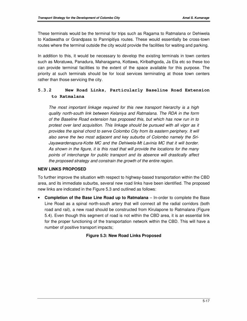
Transport Strategy for the Development of Colombo City Amal S. Kumarage
5-17
These terminals would be the terminal for trips such as Ragama to Ratmalana or Dehiwela
to Kadawatha or Grandpass to Pannipitiya routes. These would essentially be cross-town
routes where the terminal outside the city would provide the facilities for waiting and parking.
In addition to this, it would be necessary to develop the existing terminals in town centers
such as Moratuwa, Panadura, Maharagama, Kottawa, Kiribathgoda, Ja Ela etc so these too
can provide terminal facilities to the extent of the space available for this purpose. The
priority at such terminals should be for local services terminating at those town centers
rather than those servicing the city.
5.3.2 New Road Links, Particularly Baseline Road Extension
to Ratmalana
The most important linkage required for this new transport hierarchy is a high
quality north-south link between Kelaniya and Ratmalana. The RDA in the form
of the Baseline Road extension has proposed this, but which has now run in to
protest over land acquisition. This linkage should be pursued with all vigor as it
provides the spinal chord to serve Colombo City from its eastern periphery. It will
also serve the two most adjacent and key suburbs of Colombo namely the Sri-
Jayawardenapura-Kotte MC and the Dehiwela-Mt Lavinia MC that it will border.
As shown in the figure, it is this road that will provide the locations for the many
points of interchange for public transport and its absence will drastically affect
the proposed strategy and constrain the growth of the entire region.
NEW LINKS PROPOSED
To further improve the situation with respect to highway-based transportation within the CBD
area, and its immediate suburbs, several new road links have been identified. The proposed
new links are indicated in the Figure 5.3 and outlined as follows:
• Completion of the Base Line Road up to Ratmalana – In-order to complete the Base
Line Road as a spinal north-south artery that will connect all the radial corridors (both
road and rail), a new road should be constructed from Kirulapone to Ratmalana (Figure
5.4). Even though this segment of road is not within the CBD area, it is an essential link
for the proper functioning of the transportation network within the CBD. This will have a
number of positive transport impacts;
Figure 5.3: New Road Links Proposed
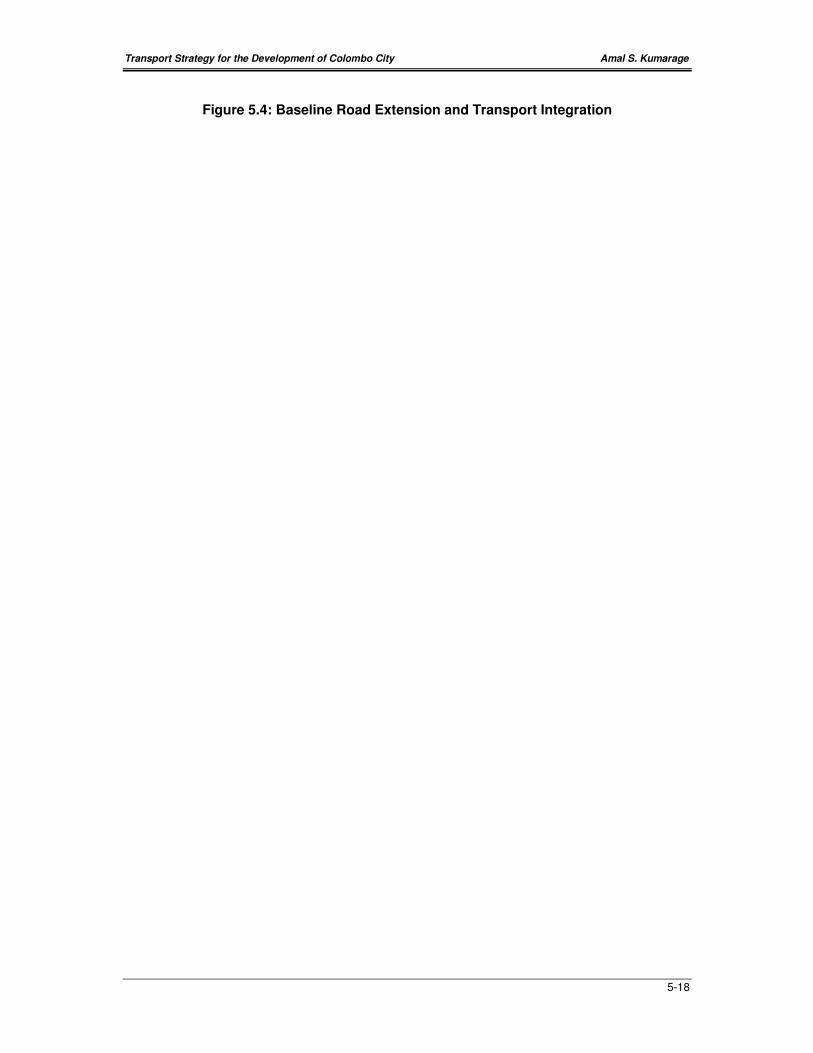
Transport Strategy for the Development of Colombo City Amal S. Kumarage
5-18
Figure 5.4: Baseline Road Extension and Transport Integration

Transport Strategy for the Development of Colombo City Amal S. Kumarage
5-19
a) significantly reduce traffic bypassing the city;
b) provide a connection for feeding the proposed 1st order public transport terminals at
Narahenpita, Borella and Dematagoda all located on the Baseline Road and
c) provide a spinal artery that will distribute traffic on the east to the Kotte UC area and
on the wets to CMC.
• Link connecting T. B. Jayah Mawatha and Vauxhall Street – This link has been
proposed with the objective of reducing the traffic congestion on the junction connecting
the Union Place and T.B. Jayah Mawatha (Ibbanwela). This link is also important if the
area is to be considered for an one-way road network.
• Additional Link near Lake House Building connecting Olcott Mawatha and D.R.
Wijewardena Mawatha over the railway line – This link is an essential connection in-
order to have a conflict free flow in the surrounding area. Without this link a complex set
of elevated structures will be necessary to have such a conflict free flow or several
conflicting intersections controlled by traffic lights will be necessary. This section will be
in grade as it has to cross the railway line. But the level difference between the two roads
would reduce the amount of grade required.
• Overpass or Underpass near the Slave Island Railway Station – At present the
vehicular flow through the level crossing at-grade, near the Slave Island Railway Station
is frequently disturbed by the rail operations. This problem will be further worsened when
the frequency of the railway operations increases and with relaxation of the security
restrictions within the area. The area surrounding the Slave Island Railway Station has
also been identified as an area for further land use development. Therefore an
over/under pass will be essential to facilitate a smooth flow of traffic from the Galle Road
corridor to Slave Island area and vice versa.
• Link from Slave Island Railway Station to Olcott Mawatha across the Beira Lake
and the Main Railway Line - This link will provide a direct connection from the NE of
Beira to the SW of Beira and vice versa and also a connection between the D.R.
Wijewardena Mawatha and Olcott Mawatha. Therefore it will significantly reduce the
congestion experienced at the road intersections at the four corners of the Beira Lake.
However to have such a link, some of the informal settlements within the area of Slave
Island will have to be re-located. This will also create a new image for the city, with a
road section crossing the Beira so that the water body and the CBD area can be seen
from this section of road.
• Development of Pradeepa Mawatha as a Six Lane East-West Artery: This road can
be properly designed as a six-lane artery connecting Baseline Road to Pettah and
Maradana via Panchikawatte roundabout. Due to the heavy flow of buses that will ply on
this road between Pettah-Fort terminal and Dematagoda, it is advisable to construct a
dedicated bus lane on this road.
• Widening of Stace Road: The State Road another east-west corridor should be
widened to a proper four lane road from Baseline Road to Jetawana Road via Layards
Broadway. This will provide for the increased east-west traffic flows that will result with
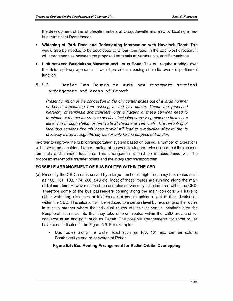
Transport Strategy for the Development of Colombo City Amal S. Kumarage
5-20
the development of the wholesale markets at Orugodawatte and also by locating a new
bus terminal at Dematagoda.
• Widening of Park Road and Redesigning intersection with Havelock Road: This
would also be needed to be developed as a four-lane road, in the east-west direction. It
will strengthen ties between the proposed terminals at Narahenpita and Pamankade
• Link between Baladaksha Mawatha and Lotus Road: This will require a bridge over
the Beira spillway approach. It would provide an easing of traffic over old parliament
junction.
5.3.3 Revise Bus Routes to suit new Transport Terminal
Arrangement and Areas of Growth
Presently, much of the congestion in the city center arises out of a large number
of buses terminating and parking at the city center. Under the proposed
hierarchy of terminals and transfers, only a fraction of these services need to
terminate at the center as most services including some long-distance buses can
either run through Pettah or terminate at Peripheral Terminals. The re-routing of
local bus services through these termini will lead to a reduction of travel that is
presently made through the city center only for the purpose of transfer.
In-order to improve the public transportation system based on buses, a number of alterations
will have to be considered to the routing of buses following the relocation of public transport
terminals and transfer locations. This arrangement should be in accordance with the
proposed inter-modal transfer points and the integrated transport plan.
POSSIBLE ARRANGEMENT OF BUS ROUTES WITHIN THE CBD
(a) Presently the CBD area is served by a large number of high frequency bus routes such
as 100, 101, 138, 174, 200, 240 etc. Most of these routes are running along the main
radial corridors. However each of these routes serves only a limited area within the CBD.
Therefore some of the bus passengers coming along the main corridors will have to
either walk long distances or interchange at certain points to get to their destination
within the CBD. This situation will be reduced to a certain level by re-arranging the routes
in such a manner where the individual routes will split at certain locations after the
Peripheral Terminals. So that they take different routes within the CBD area and re-
converge at an end point such as Pettah. The possible arrangements for some routes
have been indicated in the Figure 5.5. For example:
- Bus routes along the Galle Road such as 100, 101 etc. can be split at
Bambalapitiya and re-converge at Pettah.
Figure 5.5: Bus Routing Arrangement for Radial-Orbital Overlapping
Transport Strategy for the Development of Colombo City Amal S. Kumarage
5-21
- Bus routes along the High-Level Road such as 138, 122, 125 etc can be split at
Tunmulla Junction and re-converge at Pettah.
- Bus routes coming from Battaramulla to the CBD such as 170, 174, 175, 177,
190 etc. can be split at Borella and re-converge at Pettah and Bambalapitiya.
- Bus routes along the A1 (Kandy Road) and A3 (Negombo Road) such as 200,
240 etc can be split at Peliyagoda and re-converge at Pettah.
(b) Presently most of the bus routes operating within the CBD area terminate at Pettah and
only a few bus routes run through Pettah requiring some of the passengers to transfer at
Pettah in-order to get to their destinations. This situation could be reduced to a certain
level by arranging the bus routes to run through Pettah to the other side of the CBD. This
can be arranged by combining the certain routes running in different directions from the
CBD. Further, this arrangement will reduce the number of buses terminating and the
requirement for parking at the center of the CBD. The possible arrangements have been
indicated in the Figure 5.6.
POSSIBLE ARRANGEMENT OF BUS ROUTES OUTSIDE THE CBD
Presently the service provided by public transportation on orbital roads is considerably low
compared to the radial roads, mainly due to the low demand for orbital direction. This
situation could be reduced to a certain extent by combining some of the services in the radial
direction with orbital directions. These could be services starting and ending at different (O)
type terminals located outside the city (e.g. between Ratmalana and Battaramulla). Also the
Peripheral Terminals can be used for this purpose. Some other examples of such services
are:
− Homagama – Maharagama – Borelesgamuwa – Dehiwela – Colombo.
− Homagama – Nugegoda – Kalubowila - Colombo.
− Homagama – Kirulapone – Wellawatte – Colombo.
− Homagama – Pannipitiya – Battaramulla – Borella – Colombo.
− Homagama – Kirillapone - Borella – Colombo.
− Homagama – Delkanda – Old Kesbewa Rd – Nawala Rd – Narahenpita – Kirula Rd
– Thimbirigasyay Rd - Thummulla – Colombo.
− Horana – Piliyandala – Katubedda – Colombo.
− Horana - Borelesgamuwa – Kalubowila – Colombo.
− Horana – Kirulapone – Wellawatte – Colombo.
− Horana – Piliyandala – Maharagama – Pannipitiya-Battaramulla.
− Horana – Rattanapitiya – Delkanda – Colombo.
− Panadura – Ratmalana – (Base-Line) – Borella - Colombo.
− Panadura – Ratmalana –(Base-Line) - Kirillapone – Colombo.
− Panadura – Wellawatte – Kirulapone – Colombo.
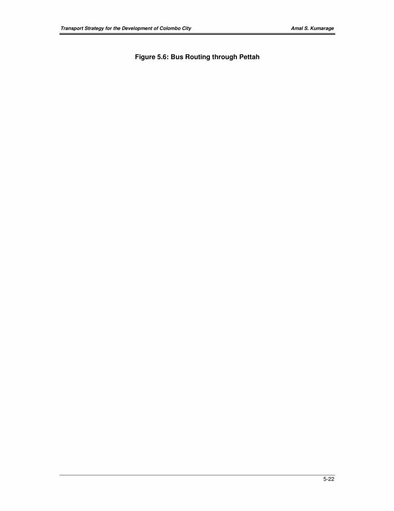
Transport Strategy for the Development of Colombo City Amal S. Kumarage
5-22
Figure 5.6: Bus Routing through Pettah
Transport Strategy for the Development of Colombo City Amal S. Kumarage
5-23
5.3.4 Development of a LRT System
‘The LRT or Tram system will provide sustainability for the strategy in the long-
term. In this respect, even though this is an expensive project, it can be built up
in stages. The primary function of this system would be to attract the car user to
a high-quality public transport mode. The routes that have been identified for the
LRT in CUTS 2 provide a good arrangement of collector-distributor features
between the radial corridors and different parts in the city. It is also integrated
with the bus and railways to the fullest extent possible’.
Light Rapid Transit (LRT) is a rail guided tram system that can operate with or without a
separate right of way. In the former case, they are relatively inexpensive. But, they are
slower and carry lower volumes of passengers. LRT, when grade separated can carry
substantial volumes. Many cities worldwide are adopting rapid transit systems to supplement
bus and railways. They usually offer a high quality ride and offer a potential for attracting
private vehicular traffic as well as short distance traffic in town centers.
For circulatory movement within Colombo City (particularly in the orbital directions), the LRT
can be recommended as a street operation. This would be more consistent with the lower
level of demand, shorter trip lengths and the intrinsically lower demand for speed for orbital
travel. The circulatory LRTs within the CMC would then be mostly a combined radial-orbital
type. They would be at-grade systems utilizing existing street space or along canal banks
such as the possibility for linking Narahenpita and Wellawatte.
However, in the case of the radial transport demands for Colombo, the volumes necessary
to support MRT or Grade-separated LRT volumes would, according to the Masterplan of
CUTS 2 be achieved in the next 20 years in four of the corridors. These four corridors have
been identified as
− Galle Road (up to Ratmalana)
− Kotte/Parliament Road (up to Battaramulla/Pelawatte)
− High Level Road (up to Pannipitiya)
− Negombo Road (up to Negombo/Airport)
A LRT system on the radial corridors will then complement the orbital LRT system. Hence a
single system can operate both the corridors and the circulation within the city. For these
four corridors, grade separated LRTs appear to be the most logical alternative. All other
modes of transport cannot provide the ultimate comfort, access, capacity and speed that
modern urban transport requires. In this case, it may be considered prudent to invest in such
a system straight away, rather than experiment with systems that are essentially viable only
for a short duration.
In such a light, LRT can be supported over MRT, Bus Lanes, Improved Rail and indeed
more roads on four corridors. This is except where the suburban rail is well established to
Transport Strategy for the Development of Colombo City Amal S. Kumarage
5-24
provide a competitive service as discussed before. There are three corridors namely the
Galle Road Corridor; Sri Jayawardenapura corridor and the High Level Corridor that appear
to justify a LRT within the next 10 years.
In the case of the Galle Road, the demand base is essentially there even at present. In the
case of the Sri Jayawardenapura corridor, the demand levels are still not adequate for
financial considerations. However, the fact remains that there is no rail service as yet in this
direction. As a first step to increase the demand, the present road maybe widened to six
lanes. Alternately, a rail link can also be developed from Dematagoda to Pannipitiya (as
discussed elsewhere in this report). Then as demand grows, LRT could be introduced
together with traffic restraint measures to divert road traffic to LRT.
The High Level Road on the other hand, has sufficient demand to justify a LRT in the next 10
years. Thus it seems most prudent for a LRT to replace the KV Line. Up to say Pannipitiya.
Such a line can take the route from Fort via Maradana to Borella (on Maradana Road), then
Baseline Road to Narahenpita, then KV Line right of Way to Pannipitiya. (So that the new KV
railway line is connected to Colombo from Pannipitiya via Battaramulla, Rajagiriya and
Dematagoda- as recommended in Section 5.3.5). This reason further justifies the choice of
LRT over MRT, as the poor alignment of the existing KV line would not support a MRT.
The proposed system of LRT for the corridors and the CMC are given in Figure 5.7.
5.3.5 Improvements to the Railway Services, particularly
its Quality and Capacity
‘The railway will be increasingly required to provide a fast commuting link between
residential areas and employment centers. It is even presently well located for this purpose.
But improvements in service provision in the form of higher capacity (both track and rolling
stock), reliability and good interchange with bus (and LRT in the future) would be necessary.
A new link to form a radial in the eastern direction to serve the Rajagiriya, Kotte and
Pelawatte areas seems viable. Relocation of stations in the CBD may also be necessary’

Transport Strategy for the Development of Colombo City Amal S. Kumarage
5-25
Figure 5.7: Proposed System of LRT
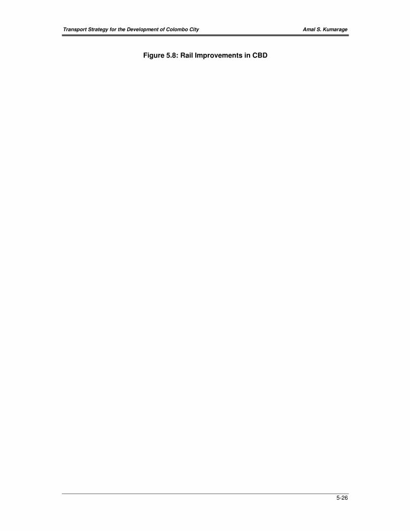
Transport Strategy for the Development of Colombo City Amal S. Kumarage
5-26
Figure 5.8: Rail Improvements in CBD
Transport Strategy for the Development of Colombo City Amal S. Kumarage
5-27
Even though the rail system has lost its passenger share over the years, it continues to
possess the essential competitive features especially on the Main and the Coastal Lines.
Thus improving both the track, signaling and having more rolling stock will provide an
opportunity of increasing the carriage of rail passengers. The double tracking of the line to
Negombo will also provide more capacity. The Kelani Valley Line on the other hand, has
extremely poor geometry. It is single track. Double tracking or improving its geometry does
not appear to give adequate returns in increase of passenger carrying capacity or increased
speeds. This track does not have the potential to compete adequately with road transport in
this corridor. It is more amenable to use this right of way for a LRT where it is found to be
suitable.
Thus a new ‘Loop Railway’ has been proposed in the CMRSP. This is to commence in
Ratmalana and head eastwards to Pannipitiya where it will take a route via Battaramulla,
Rajagiriya to Dematagoda. A part of the railway line exists up to the oil refinery at
Sapugaskande. This will be an important long-term connection that would transform the
railway in part to an orbital cum radial network rather than having all lines terminating at Fort.
However, in the short-term the most important link would be the radial extension from
Dematagoda to Pannipitiya via Battaramulla, where the KV line can be met. So that this
journey which now takes nearly one hour can be done in half that time. The existing KV line
between Dematagoda and Pannipitiya can then be converted to a LRT.
As discussed in section 5.3.1, the Fort-Pettah bus/rail station should be a strong nexus. The
present location is more suited for serving Pettah. It does not provide easy access to areas
such as Fort, Parsons Road, Gunasinghapura. Thus the following recommendations are
made.
(a) Develop Fort Rail Station Area eastwards to integrate with a Bus Terminal.
(b) Develop the secretarial Halt to serve the Fort and Parsons Road areas.
(c) Investigate the potential for a new halt between Fort and Maradana to serve
Gunasinghapura area and D.R. Wijewardena/Beira Lake development.
5.3.6 Measures to Improve Traffic Management, including
One-way and Parking Arrangements
‘Traffic Management is a favored approach in many cities world-wide as opposed
to attempts to build new roads or widen existing roads. This proposal entails the
revision of traffic flows particularly on a uni-directional that would reduce conflicts
at intersections. This is a preferred option in a city where interchanges (fly-overs)
are not compatible with the landscape. It also means the reduction of on-street
parking and the re-design of roads and intersections in the city center to allow a
smoother flow of vehicles at a moderate speed. It would also include the
construction of missing links in the road network such as a connection over the
Beira 2. This link in particular will have a significant impact as the present traffic
congestion is dominant around the four corners of the Beira Lake and a through

Transport Strategy for the Development of Colombo City Amal S. Kumarage
5-28
route will relieve areas such as Town Hall, Slave Island, Maradana and Lake
House Roundabout of traffic congestion’.
A proper highway based transportation plan is extremely important for an efficient
transportation system for the Colombo city and the CBD area. The improvement of the
highway based transportation system could be broadly categorized into different sections.
IMPROVEMENTS TO EXISTING HIGHWAY NETWORK
At present the capacity of most of the roads within the CBD area is not sufficient to meet the
traffic demand. This situation is critical especially during the morning peak and the evening
peak. There are several measures that could be taken to improve the condition of traffic flow.
• Restricting on-street parking – Presently the two outer-most lanes of most roads within
the CBD area have been used for on-street parking. By restricting such parking it is
possible to increase the capacity by increasing the number of lanes by two on most of
the roads within the area, thus making them either six lane or four lane roads. However,
with this restriction it is also necessary to provide facilities for parking by alternative
means such as under ground or multi-level car parks at several locations within the area.
• Off-street Parking Facilities- For the traffic flow arrangement recommended in the next
section (and shown in Figure 5.9), the parking within the Fort area would be best located
inside of the ring road -around 150 meters would be optimum. The amount of parking
spaces to be provided should also be carefully considered. For the present level of land-
use activity in Fort, a total of not more than 3,000 spaces are recommended. Some
suitable locations where land for such could also be found are shown in Figure 5.9.
• Provide better facilities for Pedestrians – Presently due to various reasons, some of
the space available for vehicles is being used by pedestrians on certain roads within the
CBD area. It is possible to increase the capacity and the free flow on the roads
significantly, by providing separated facilities for pedestrians and for vehicles, so that the
friction between them is reduced.
• Reducing turning conflicts and introducing one-way systems – The capacity of the
road network within the CBD area could be significantly improved by reducing conflicts in
vehicular movements. This can be achieved by either restricting right turns to a certain
extent, controlling the intersections with traffic lights and introducing conflict free
arrangements with one-way systems.
• Widening the existing roads – The capacity could be also increased by widening the
roads within the CBD area and for some roads this is more important than others.
However, the ability to widen the roads within the area is limited due to the high level of
land use development on either side of the roads.
ARRANGEMENT OF TRAFFIC FLOW
Presently the Colombo city and the CBD area experience a considerable level of congestion
especially during the peak period. Too many conflicting intersections are one of the main
Transport Strategy for the Development of Colombo City Amal S. Kumarage
5-29
reasons for this situation. Therefore to reduce this certain areas within the CBD could be
considered for conflict free one-way road network. A possible arrangement is indicated in the
Figure 5.9.
5.3.7 Identification of areas for future Land-Use
Development in Colombo
‘Within the Colombo Business District, it is possible to identify several locations
for further land use development. The level and the type of development that is
suitable for these locations will depend on various factors such as the present
land use pattern, close proximity to water bodies and other recreational functions
and the capacities of the transportation networks’.
The regions that the UDA has provided for consideration (in this study) for development
includes Colombo-2 (Slave Island), Colombo-3 (Kollupitiya) and a part of Colombo-10
(Maradana). These are land to be made available from the relocation of the defense
establishments and informal housing, and some railway lands.
In-order to consider for the type and level of development, sustainable from a point of view of
accessibility and mobility, this region has been further sub-divided according to their different
characteristics. These different areas are indicated in Figure 5.10 given below.
Colombo-2 (Slave Island)
− 2A - Area adjoining Chittampalam Gardiner Mawatha.
− 2B – Area between the Beira Lake and Chittampalam Gardiner Mw.
− 2C - Area around the Slave Island railway station.
− 2D - Area adjoining Union Place and Vauxhall Street.
− 2E - Area within Union Place, Dharmapala Mw. and Sir James Peiris Mw.
Colombo-3 (Kollupitiya)
− 3A - On either side of Baladaksha Mawatha.
− 3B - Area within Perahera Mw., Dharmapala Mw. and the railway line.
Part of Colombo-10 (Maradana)
− 10A - On either side of D.R. Wijewardena Mawatha.
− 10B - Area adjoining T.B.Jayah Mawatha and Deans Road.
Transport Strategy for the Development of Colombo City Amal S. Kumarage
5-30
Figure 5.9 : Traffic Flow in CBD
Transport Strategy for the Development of Colombo City Amal S. Kumarage
5-31
Figure 5.10: Traffic Flow to/from CBD
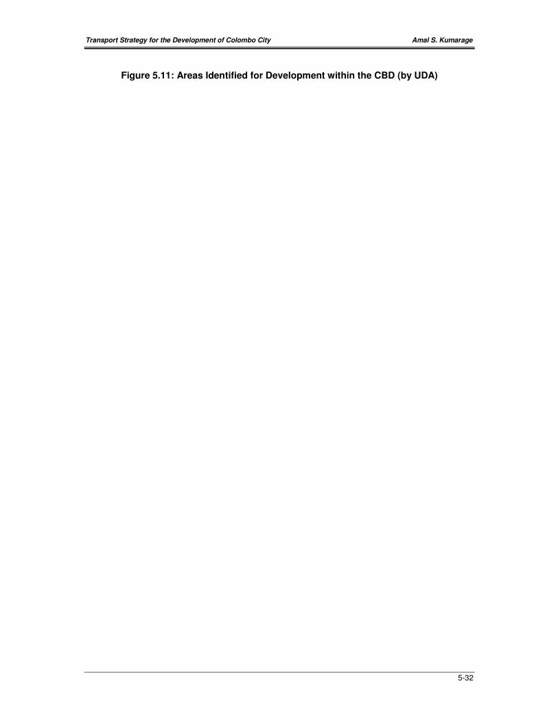
Transport Strategy for the Development of Colombo City Amal S. Kumarage
5-32
Figure 5.11: Areas Identified for Development within the CBD (by UDA)
Transport Strategy for the Development of Colombo City Amal S. Kumarage
5-33
The proposed development will generate new employment within the area and as a result
more traffic could be expected. This will cause a number of problems both within the area
under consideration and outside the area.
• Say, if 100,000 new trips were generated with this new development it possible to
assume that approximately 20,000 will be using private vehicles. This will add at least
12,000 private vehicles to the existing corridors if all of them are coming from outside the
area under consideration and as a result travel speed on the corridors will further reduce.
• The increased traffic will add to the congestion that is already existing at the junction
connecting Union Place, Sir James Peiris Mawatha and Kumaran Ratnam Road,
intersections near Town hall, intersections near Maradana Railway station and
intersections near the Lake House building.
• The main reason for this expected congestion within the area is the presence of the
Beira Lake separating the proposed locations of development. For the traffic to access
locations north of Beira Lake such as the proposed development on either side of
D.R.Wijewardena Mawatha from the southern part of the city will have to go around the
Lake and vise versa.
In-order to avoid or reduce the expected problems, several proposals can be considered.
(i) Maintaining the balance between employment and housing along with the
proposed development. The people who will consider using these luxury apartments
within the city mostly would be working in the city and also are very unlikely to use
public transportation. Therefore if this balance is maintained along with the proposed
development, the adverse effects that could be expected along the main corridors due
to private vehicles will be reduced.
(ii) Introducing a new link from Slave Island railway station to Olcott Mawatha
across Beira Lake. This will significantly reduce the expected congestion at the
junctions that were identified earlier, as the traffic from the southern part of the city can
access north of Beira Lake through this link, by passing the junctions. This will also
create a new image for the city. (This has been discussed and recommended earlier in
Section 5.3.2)
(iii) Shifting the activity of the main railway station eastwards and in to the proposed
bus terminal. This will strongly connect the two modes of transport and will be able
offer the capital city a new ultra modern multi-model transport terminal. This will also
significantly improve the link between the proposed high density development on either
side of the D.R.Wijewardena Road and the proposed transport terminal due to its
central location in relation to the considered area for such development. This too has
been recommended in Section 5.3.1.
(iv) Upgrading the Secretariat halt and introducing a new halt between Fort and Maradana
will allow the areas in their close proximity to be developed for high density commercial
land use.
Transport Strategy for the Development of Colombo City Amal S. Kumarage
5-34
RECOMMENDED LAND FOR FUTURE DEVELOPMENT
If the above measures are implemented together with the other Policy and Strategy
recommendations, some more development could be allowed within the city. The extent of
this depends on the policies that are adopted. However, the following recommendations are
made to the suitability of lands available.
(a) On either sides of Baladaksha Mawatha. This area will be available after the proposed
relocation of the Army Head Quarters. This location is fairly isolated from most of the
transport corridors compared to other areas is within a very short distance from the sea
front and other recreational areas. Therefore the location is more suitable for high-rise
buildings with luxury apartments.
(b) Area around the Slave Island railway station. This area will be available after the
proposed relocation of the present informal settlements. This location is more suitable for
with high-density commercial activity mainly due to its close proximity with the Slave
Island railway station and the proposal for a transfer interchange there. Also new road
infrastructure is proposed so that the road capacity in the local areas will increase.
(c) On either sides of D.R.Wijewardena Mawatha. This stretch is also very suitable for
high-density commercial activity due to its close proximity with the proposed multi-modal
transport terminal. The link across the railway will provide the required road capacity.
The proposed new railway halt will provide rail access.
(d) Area adjoining T.B.Jayah Mawatha and Deans Road. More suitable for medium
density commercial activity.
(e) Area adjoining Union Place and Vauxhall Street. More suitable for medium density
commercial activity as no direct rail access is available.
(f) Area within Union Place, Dharmapala Mawatha and Sir James Peiris Mawatha.
More suitable for mixed luxury residential and medium density commercial activity.
(g) Area within Perahera Mawatha, Dharmapala Mawatha and the railway line. More
suitable for mixed luxury residential and medium density commercial activity.

Transport Strategy for the Development of Colombo City Amal S. Kumarage
5-35
Figure 5.12: Areas Recommended for Future Development