Embed Size (px)
Citation preview

TRANSPORT, TRANSFORMATION, AND EFFECTS OF SELENIUM AND CARBON IN THE DELTA
OF THE SACRAMENTO-SAN JOAQUIN RIVERS: IMPLICATIONS FOR ECOSYSTEM RESTORATION
Ecosystem Restoration Program Agreement No. 4600001955
Project No. ERP-01-C07
Prepared by:
Lisa Lucas and Robin Stewart U.S. Geological Survey, Menlo Park, CA

Se and C in the Delta Cloern/Lucas/Stewart
Page 2 of 406 ACKNOWLEDGEMENTS
This project was made possible in accordance with the funds appropriated through Proposition 204 for the Ecosystem Restoration Program activities beginning with Division 24 of the California Water Code beginning with Section 78684, entitled CALFED Bay-Delta Ecosystem Restoration Program. The proposal for this project “Transport, transformation and effects of Se and C in the Delta: Implications for ERP” was submitted in May 2000 for the CALFED Ecosystem Restoration Program 2001 Proposal Solicitation Process (PSP) and approved for funding by the Resources Agency.
COST SHARE PARTNERS U.S. Geological Survey (Menlo Park and Sacramento District office) and U.S. Geological Survey Place-Based Program (Suisun Bay), UC Berkeley, Old Dominion University, Stanford, and State University of New York (Stony Brook) provided funds, staffing resources and equipment as its cost share contribution towards the completion of this project.
Se and C in the Delta Cloern/Lucas/Stewart
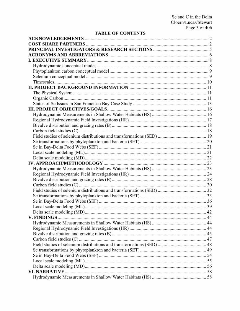
Page 3 of 406 TABLE OF CONTENTS
ACKNOWLEDGEMENTS ......................................................................................................... 2 COST SHARE PARTNERS ........................................................................................................ 2 PRINCIPAL INVESTIGATORS & RESEARCH SECTIONS ............................................... 5 ACRONYMS AND ABBREVIATIONS..................................................................................... 6 I. EXECUTIVE SUMMARY ....................................................................................................... 8
Hydrodynamic conceptual model ............................................................................................... 8 Phytoplankton carbon conceptual model .................................................................................... 9 Selenium conceptual model ........................................................................................................ 9 Timescales................................................................................................................................. 10
II. PROJECT BACKGROUND INFORMATION.................................................................. 11 The Physical System................................................................................................................. 11 Organic Carbon......................................................................................................................... 11 Status of Se Issues in San Francisco Bay Case Study .............................................................. 13
III. PROJECT OBJECTIVES/GOALS.................................................................................... 16 Hydrodynamic Measurements in Shallow Water Habitats (HS) .............................................. 16 Regional Hydrodynamic Field Investigations (HR) ................................................................. 17 Bivalve distribution and grazing rates (B) ................................................................................ 18 Carbon field studies (C) ............................................................................................................ 18 Field studies of selenium distributions and transformations (SED) ......................................... 19 Se transformations by phytoplankton and bacteria (SET) ........................................................ 20 Se in Bay-Delta Food Webs (SEF) ........................................................................................... 21 Local scale modeling (ML)....................................................................................................... 21 Delta scale modeling (MD)....................................................................................................... 22
IV. APPROACH/METHODOLOGY ....................................................................................... 23 Hydrodynamic Measurements in Shallow Water Habitats (HS) .............................................. 23 Regional Hydrodynamic Field Investigations (HR) ................................................................. 24 Bivalve distribution and grazing rates (B) ................................................................................ 28 Carbon field studies (C) ............................................................................................................ 30 Field studies of selenium distributions and transformations (SED) ......................................... 32 Se transformations by phytoplankton and bacteria (SET) ........................................................ 33 Se in Bay-Delta Food Webs (SEF) ........................................................................................... 36 Local scale modeling (ML)....................................................................................................... 39 Delta scale modeling (MD)....................................................................................................... 42
V. FINDINGS .............................................................................................................................. 44 Hydrodynamic Measurements in Shallow Water Habitats (HS) .............................................. 44 Regional Hydrodynamic Field Investigations (HR) ................................................................. 44 Bivalve distribution and grazing rates (B) ................................................................................ 45 Carbon field studies (C) ............................................................................................................ 47 Field studies of selenium distributions and transformations (SED) ......................................... 48 Se transformations by phytoplankton and bacteria (SET) ........................................................ 49 Se in Bay-Delta Food Webs (SEF) ........................................................................................... 54 Local scale modeling (ML)....................................................................................................... 55 Delta scale modeling (MD)....................................................................................................... 56
VI. NARRATIVE ........................................................................................................................ 58 Hydrodynamic Measurements in Shallow Water Habitats (HS) .............................................. 58

Se and C in the Delta Cloern/Lucas/Stewart
Page 4 of 406 Regional Hydrodynamic Field Investigations (HR) ................................................................. 64 Bivalve distribution and grazing rates (B) ................................................................................ 77 Carbon field studies (C) ............................................................................................................ 78 Field studies of selenium distributions and transformations (SED) ......................................... 84 Se transformations by phytoplankton and bacteria (SET) ........................................................ 88 Se in Bay-Delta Food Webs (SEF) ........................................................................................... 89 Local scale modeling (ML)....................................................................................................... 92 Delta scale modeling (MD)....................................................................................................... 95
VII. RECOMMENDATIONS.................................................................................................... 97 Hydrodynamic Measurements in Shallow Water Habitats (HS) .............................................. 97 Regional Hydrodynamic Field Investigations (HR) ................................................................. 98 Bivalve distribution and grazing rates (B) ................................................................................ 99 Carbon field studies (C) .......................................................................................................... 100 Se transformations by phytoplankton and bacteria (SET) ...................................................... 101 Se in Bay-Delta Food Webs (SEF) ......................................................................................... 101 Local scale modeling (ML)..................................................................................................... 102 Delta scale modeling (MD)..................................................................................................... 102
VIII. CONCLUSIONS.............................................................................................................. 103 Hydrodynamic Measurements in Shallow Water Habitats (HS) ............................................ 103 Regional Hydrodynamic Field Investigations (HR) ............................................................... 103 Bivalve distribution and grazing rates (B) .............................................................................. 104 Carbon field studies (C) .......................................................................................................... 104 Field studies of selenium distributions and transformations (SED) ....................................... 105 Se transformations by phytoplankton and bacteria (SET) ...................................................... 105 Se in Bay-Delta Food Webs (SEF) ......................................................................................... 106 Local scale modeling (ML)..................................................................................................... 106 Delta scale modeling (MD)..................................................................................................... 107
IX. REFERENCES ................................................................................................................... 109 A. List of products .................................................................................................................. 109 B. Service to Calfed and Bay-Delta Community.................................................................... 119 C. Bibliography....................................................................................................................... 121
X. EXHIBITS………………………………………………………………………………….130 A. Tables……………………………………………………………………………………..131 B. Figures…………………………………………………………………………………….200
XI. ATTACHMENTS………………………………………………………………………...407 A. Selenium Monitoring Proposal B. Monsen et al. (in prep.)

Se and C in the Delta Cloern/Lucas/Stewart
Page 5 of 406 PRINCIPAL INVESTIGATORS & RESEARCH SECTIONS Hydrodynamic Measurements in Shallow Water Habitats (Section HS)
Mark Stacey, Deanna Sereno and Seungjin Baek University of California, Berkeley, CA
Regional Hydrodynamic Field Investigations (Section HR) Jon Burau U.S. Geological Survey, Sacramento, CA Bivalve distribution and grazing rates (Section B)
Janet Thompson and Francis Parchaso U.S. Geological Survey, Menlo Park, CA
Carbon field studies (Section C)
Lisa Lucas, Jim Cloern, Tara Schraga and Cary Lopez U.S. Geological Survey, Menlo Park, CA
Field studies of selenium distributions and transformations (Section SED)
Greg Cutter, Lynda Cutter and Martina Doblin Old Dominion University, Norfolk, VA
Se transformations by phytoplankton and bacteria (Section SET)
Stephen Baines and Nick Fisher State University of New York, Stony Brook
Se in Bay-Delta Food Webs (Section SEF)
Robin Stewart U.S. Geological Survey, Menlo Park, CA
Local scale modeling (Section ML)
Lisa Lucas, Nancy Monsen, U.S. Geological Survey, Sacramento, CA Deanna Sereno, Seungjin Baek, Mark Stacey University of California, Berkeley, CA
Delta scale modeling (Section MD) Nancy Monsen and Lisa Lucas U.S. Geological Survey, Menlo Park, CA

Se and C in the Delta Cloern/Lucas/Stewart
Page 6 of 406 ACRONYMS AND ABBREVIATIONS AAS Atomic absorption spectroscopy ADV Acoustic Doppler Velocimeters AFDW Ash-free-dry-weight BDOC bioavailable dissolved organic carbon BPOC bioavailable particulate organic carbon C Carbon CBL Concentration boundary layer CDFG California Department of Fish and Game CDWR California Department of Water Resources chl a chlorophyll a CTD Conductivity, temperature and depth DCC Delta Cross Channel DIC Dissolved inorganic carbon DO Dissolved oxygen DOC Dissolved organic carbon FR Filtration rate FT Frank’s Tract GOTM General Ocean Turbulence Model GR Grazing rate HORB Head of Old River Barrier IEP Interagency Ecological Program MI Mildred’s Island MILS sampling station in the southeast corner of Mildred Island NIST National Institute of Standards and Technology NOPN sampling station at the north opening of Mildred Island OC organic carbon PB phytoplankton biomass POC particulate organic carbon PP phytoplankton primary productivity PPres residual primary productivity Pμ phytoplankton specific growth rate SAV Submerged Aquatic Vegetation SC specific conductivity SCUFA Self-contained underwater fluorescence apparatuses Se Selenium SFB San Francisco Bay SJR San Joaquin River SL Shell length SPM Suspended particulate matter SWP State Water Project T water temperature THM trihalomethane USBR U.S. Bureau of Reclamation USEPA U.S. Environmental Protection Agency

Se and C in the Delta Cloern/Lucas/Stewart
Page 7 of 406 USFWS U.S. Fish and Wildlife Service VCF ZB zooplankton biomass ZG zooplankton grazing rate

Se and C in the Delta Cloern/Lucas/Stewart
Page 8 of 406 I. EXECUTIVE SUMMARY Hydrodynamic conceptual model Our Delta hydrodynamic conceptual model addresses hydrodynamics and transport on four different scales: 1) the Delta-scale, 2) the regional scale (i.e. encompassing more than one shallow water habitat or channel), 3) shallow water habitat-channel exchange locations, and 4) the scale of/within one shallow water habitat. Figure E1 describes the predominant forcings underlying hydrodynamics on the Delta scale. River hydrology and operations (e.g. pumps, gates, Delta Cross channel, barriers, reservoir releases) primarily govern residual (net) hydrodynamics and transport in the northern and southern Delta. The central Delta is a region of intense mixing, with tides---and their interaction with the complex, interconnected Delta geometry---playing a significant role.
Figure E2 describes the north-south freshwater corridor (FWC) through the Delta. This phenomenon is regulated by the interplay between the fresh Sacramento and salty San Joaquin river flows and the situation of the Delta to the east of the oceanic source of salt. This FWC fluctuates in dimension on both seasonal and spring-neap timescales. Due to the large wintertime Sacramento contributions of freshwater, the Delta is typically all or largely fresh during January-March. In the Spring, Summer, and early Fall, Sacramento flows decrease, allowing the contributions of saltwater from the SJR and SFB to contract the FWC. The FWC is at its narrowest around November-December, due to further decreased Sacramento River flows and, consequently, a large ratio of SJR to Sacramento flows. The dimension of the FWC fluctuates also on the spring/neap cycle, narrowing during spring tide due to increased tidal excursion, tidal prism, and import of oceanic salt, and widening during neap.
Regional scale hydrodynamics and transport (see Figure E3) depend on the relative lengths of channels/habitats (Lc), advective length scales (Lu, e.g. tidal excursion), and the tidal propagation length scale (Lt). If the channel or habitat length is longer that the advective and tidal propagation length scales, then the regional system acts like a river. If the advective length scale is greater than the channel/habitat length, then tidal excursions exceed the habitat dimension, mixing generally occurs once a water parcel has exited the far end of the habitat, and material that returns on the succeeding tidal phase is different in character from that which previously passed. This is a highly dispersive situation. Phasing of currents and stage can become complicated when interconnected channels and habitats of different lengths and depths thus result in the tidal wave splitting and taking different lengths of time to reach the same point via different routes.
Exchange between broad shallow habitats and deeper channels to some degree follows the classic tidal pumping paradigm, with water entering the shallow habitat as a jet and leaving as a radial potential flow (see Figure E4). In Delta habitats, this classic exchange paradigm is altered by the details of the environment: 1) geometry (i.e. exact location, size of levee breaches), 2) vegetation (SAV can constrain a jet), and 3) meteorology (wind and heating driven baroclinic flows can cause dispersion and redirection of jet and radial flows.
At the within-habitat scale (Fig. E5), physical environments like Mildred Island and Franks Tract are affected by a combination of tides (dominant at the levee breeches and, to some degree, in the interior), atmospheric forcing (wind and baroclinic flows can be significant players in basin scale transport, as well as export from quiescent corners and coves), geometry, and SAV. SAV reduces velocities, bed stresses and horizontal exchange.

Se and C in the Delta Cloern/Lucas/Stewart
Page 9 of 406 Phytoplankton carbon conceptual model Our conceptual model for phytoplankton addresses hydrodynamics and transport on three different scales: 1) the Delta-scale, 2) the regional scale (i.e. encompassing more than one shallow water habitat or channel), and 3) the scale of/within one shallow water habitat. Jassby and Cloern (2000) showed that the balance between within-Delta autochthonous production of phytoplankton and river import shifts seasonally (see Figure E6). During Spring, Summer, and Fall, sources of Delta phytoplankton biomass are dominated by within-Delta production; whereas, in the Winter, riverine import dominates the sources of biomass. Through our Delta-scale measurements of benthic biomass and phytoplankton biomass, we have learned that Delta scale variations in phytoplankton biomass are somewhat inversely related to the presence of invasive clams (e.g. chl a is high but clam biomass low in the San Joaquin River upstream of Stockton, but generally lower phytoplankton biomass in the central Delta where clam biomass is overall higher, see Figure E7). Phytoplankton variability at the regional scale (i.e. that encompassing more than one adjacent habitat) contains sharp gradients in growth-consumption conditions, biomass, and transport. For example, the interior of Mildred Island contains very few benthic grazers and is thus a local net source of phytoplankton biomass; the adjacent river channels are associated with large abundances of clams and lower depth averaged light, resulting in negative effective phytoplankton growth rates in the channels (see Figure E8). Tidally driven dispersive exchange between the shallow and deep environments, as well as residual flows driven by operations and hydrology, can cause the phytoplankton produced within MI to be shared with the less productive channels, supporting zooplankton secondary production in the channels. Without this hydrodynamic connection, consumers in the channels may be more severely food limited. The opposite configuration between donor and recipient habitats appears to be present in the Franks Tract region, with the interior lake being heavily colonized with clams but most of the outside channels uncolonized (Figure E9). Our calculations suggest that Franks Tract is a net phytoplankton sink while most of its adjacent channels are net phytoplankton sources. These channels may serve as donor habitats to the interior of Franks Tract. Ongoing work will quantitatively test this hypothesis. At the within-habitat scale, atmospheric forcing is critical in governing transport, especially between quiescent coves and the open water. Tides are dominant at the levee openings. The relationships between phytoplankton and SAV is not yet well understood, but we have learned that horizontal exchange is diminished significantly by SAV. Selenium conceptual model The selenium conceptual models shown in Figures E10-E12 illustrate the differences in Se concentrations and bioavailability that occur in the San Francisco Bay/Delta as well as within-habitat transformations. A more detailed conceptual model of Se transformations and cycling is described in Section SED (Figure SED1). At the Delta-scale total dissolved Se concentrations (µg L-1) are highest in the inflowing San Joaquin River near Stockton (Figure E10). Concentrations of dissolved Se are approximately 8 times lower in the Sacramento River (at Rio Vista) and at Antioch, near the confluence of the Sacramento and San Joaquin Rivers. These distributions suggest the elevated dissolved Se

Se and C in the Delta Cloern/Lucas/Stewart
Page 10 of 406 concentrations are progressively diluted by the Sacramento River and possibly Bay water. Our research has shown that Se is predominantly accumulated by organisms via the diet and furthermore that Se bioavailability can vary by orders of magnitude between sediment and phytoplankton. Consequently, total particulate Se concentrations critical in understanding uptake by organisms can be misleading since phytoplankton and bacteria contribute a relatively small amount of mass to the total particulates (Figure E11). As a result we illustrate differences in bioavailable particulate Se by normalizing the Se content of the suspended particulate material by carbon content on a molar basis. Figure E11 shows that bioavailable Se varies both seasonally and spatially. In early summer (June) bioavailable Se is slightly higher in the San Joaquin River than the Sacramento River or Antioch. Alternatively, in the fall we observe the highest bioavailable Se particulate concentrations nearest the estuary (Antioch). The higher bioavailable Se concentrations correspond to the elevated Se concentrations observed in Potamocorbula amurensis in the fall at Carquinez St. At the within-habitat scale in the Delta Se shows marked cycling and transformations. Figure E12 shows a conceptual model for Se uptake and regeneration in the southwestern Mildred’s Island during the 2001 process study. The southwestern corner of Mildred’s Island is characterized by high phytoplankton concentrations and limited transport (although transport does occur), which allowed us to examine in situ Se transformation processes. Under these relatively quiescent conditions dissolved Se is taken up by phytoplankton late in the day and by bacteria at night and released by phytoplankton during the day. Laboratory uptake experiments (see Section SET) and cycling during field study (see SED4-8) suggest that dissolved organo-selenide is utilized by the phytoplankton and rapidly exchanges with the Selenite pool. Timescales Important timescales governing within-Delta selenium distributions, transformations, and export to San Francisco Bay are shown in the graphic in Figure E13. Monsen has shown with hydrodynamic modeling that cross-Delta transport from Vernalis to the confluence takes on the order of a few weeks. Within the Delta, selenium is undergoing transformations, including those which package dissolved Se into edible particulate form and those which pass Se through the food web. Dissolved Se is “stripped” or taken up by phytoplankton, which repackages Se into a form which can be consumed by upper trophic levels. The timescale associated with this uptake process depends on how much phytoplankton biomass is present: this timescale is a few days in high-phytoplankton biomass environments like southern Mildred Island but more like weeks where phytoplankton biomass and productivity are low, as in less productive Delta channels. Where the uptake timescales are short, residence times may be comparable (e.g. southern Mildred Island), rendering uptake and transport of comparable importance. Phytoplankton growth timescales are on the order of days. Phytoplankton is then consumed by benthic grazers (clams) and pelagic grazers (zooplankton), passing incorporated Se as well as carbon and other elements on to the consumers. Where clam grazing rates are rapid (e.g. Franks Tract), the water column turnover time by the clams can be on the order of hours; where clams are absent, that turnover time is infinity (southern Mildred Island). Zooplankton consumption timescales are on the order of days. The time scales for Se consumed to be reflected in the tissues of the consumers is on the order of a month.
Se and C in the Delta Cloern/Lucas/Stewart
Page 11 of 406 II. PROJECT BACKGROUND INFORMATION The Physical System
The Sacramento-San Joaquin River Delta (hereafter “Delta”) is a complex physical system that transitions from a strictly riverine regime at its landward margin to a tidally oscillating interconnected network of channels and open water areas. Situated at the head of San Francisco Bay and encompassing the confluence of California’s two largest rivers (the Sacramento and the San Joaquin), this freshwater ecosystem is subject to numerous physical influences. Operating over timescales ranging from hours to months, these influences are both natural and anthropogenic. Natural influences include: primarily semidiurnal tides (the tidal wave propagates from the Pacific Ocean upstream through San Francisco Bay), river and stream inflow, wind stress, solar radiation, density variations due to salinity and temperature gradients, and fluctuations in atmospheric pressure. The complex interconnected and channelized geometry of the Delta, coupled with the oscillatory nature of the tidal currents, result in a large degree of dispersion of water and transported particles and substances. This interconnectedness also results in a system with relatively limited numbers of locations with long residence times.
The Delta drains a 153,000 km2 watershed that captures runoff from winter-spring rainfall in the Central Valley and coastal range and spring snowmelt in the Sierra Nevada mountains (Monsen et al. In prep.). The Delta was a 1,400-km2 wetland (Atwater and others (1979)) that has been transformed into a patchwork of agricultural tracts surrounded by leveed channels, tidal lakes and remnant patches of marsh. The Delta is also the hub of a water-development infrastructure that captures 7.1 km3 of runoff during the wet season and transfers water from the water-rich north to the arid south and coast, for use during the dry summer-autumn (CDWR 1998). Reservoir releases are routed across the Delta to provide drinking water for 22 million people in coastal cities, and supply water to over 18,000 km2 of irrigated farmland producing crops valued at over $13 billion annually (CALFED 2000; CDFA 2002). These interbasin transfers are made as pumped exports from the south Delta by the State Water Project (SWP) and the Central Valley Project (CVP) whose combined capacity is 360 m3 s-1.
Over 2200 diversions from Delta channels also supply water for local municipalities and irrigation of local farmland (Herren and Kawasaki 2001). Multiple demands for water transiting the Delta are satisfied through the operation of several man-made structures using a complex suite of flow manipulations and diversions both upstream and within the Delta. A large fraction of the freshwater inflow to the Delta (up to 65% during the dry season in some years) is exported via the SWP and CVP pumps to meet agricultural and municipal demands. The Delta Cross Channel (DCC), a man-made channel and gates, connects the SAC with natural channels east of the SAC to transfer high-quality fresh water into the central Delta mixing zone for export by the SWP and CVP. A rock barrier is constructed at the head of Old River during spring and autumn to improve conditions for Chinook salmon migrating through the Delta via the SJR. Three other temporary barriers are constructed each spring and removed each autumn to increase water depth for irrigation intakes within south Delta channels. Each hydraulic manipulation directly alters the regional flow paths or rates and indirectly changes the source mixture and quality of water across the Delta landscape.
Organic Carbon

Se and C in the Delta Cloern/Lucas/Stewart
Page 12 of 406 Previous work on sources, quantity and quality of organic carbon (OC) in the Delta helped shape the work described in this report.
Jassby and Cloern (2000) performed a budget of sources and quantities of OC, showing that tributary-borne load of detritus is the largest OC source on an average annual Delta-wide basis. Dissolved organic carbon (DOC) is the largest OC pool in the Delta, and its bioavailable component (BDOC) is important in supporting ecosystem metabolism (i.e. bacterial production, Sobczak et al.(2002; 2005)). DOC, however, contributes little to production of forage biota for fish (e.g. copepods, rotifers, cladocerans, insect larvae) because even the bioavailable portion needs to be repackaged in particulate form---with significant losses to heterotroph growth inefficiency---before it becomes available to the metazoan food web (Jassby and Cloern 2000, Sobczak et al. (2002; 2005)). The bulk particulate organic carbon (POC) pool is small relative to the DOC pool and is dominated by low-value detritus, rendering the bioavailable portion (BPOC) a third or less of the total POC (Sobczak et al. (2002; 2005)).
A typically small component of the POC pool in the Delta is phytoplankton biomass; this is the component that has been shown to support production of forage biota for fish. Phytoplankton derived organic matter was shown by Sobczak et al. (2002; 2005) to be a large and important component of the BPOC. Detrital POC is a large component of POC but a small component of BPOC. Sobczak et al. (2002) concluded that the Delta’s planktonic food web may be highly reliant on phytoplankton production although this organic matter source represents a small amount of the ecosystem’s potential energy to higher trophic levels. Detrital linkages to the planktonic food web are relatively weak even under the best-case scenarios.
Zooplankton growth experiments by Mueller-Solger et al. (2003) supported the hypothesized trophic linkage between the Delta’s planktonic food web and phytoplankton production. Assays with the cladoceran Daphnia magna showed that zooplankton growth and fecundity were strongly related to phytoplankton biomass and unrelated to the amount of detrital matter. This relationship is strongest for chl a concentrations from 0-10 ug/L, suggesting that Delta zooplankton may be food-limited when chl a < 10 ug/L. Concentrations rarely exceed 10 ug chl a/L through most of the Delta (San Joaquin River is an exception). This suggests that the Delta’s zooplankton may be routinely food limited. This also suggests that the Delta’s phytoplankton, although routinely low in biomass, is generally of high nutritional quality.
This collective previous work indicates that planktonic food webs in low-productivity estuarine and riverine ecosystems may be especially sensitive to changes in phytoplankton production, although phytoplankton bmass represents a small fraction of the flux of organic matter through many rivers and estuaries.
Although phytoplankton primary production (PP) represents an important energy supply to pelagic and benthic food webs, other ecologically important food webs are supported by other sources (e.g. epiphytes amphipods).
Jassby et al. (2002) showed that, although the Delta is generally very high in nutrient concentrations, PP is low. Moreover, PP has decreased 43% over the past 3 decades. These findings further indicate chronic food limitation of pelagic and benthic consumers. A concomitant decline in Delta zooplankton stocks has also been observed over the past three decades. Long-term declines in Delta phytoplankton, native zooplankton, and native fish suggest a potential trophic linkage (Bennett and Moyle 1996).
The Delta is a turbid system, so phytoplankton growth rates are light-limited; however, water clarity has increased over time while phytoplankton biomass has decreased, so turbidity

Se and C in the Delta Cloern/Lucas/Stewart
Page 13 of 406 cannot explain the downward decadal trend in phytoplankton biomass and productivity. Invasion by the clam Potamocorbula amurensis in 1986 is implicated as one factor contributing to the decline in phytoplankton biomass and productivity (Jassby et al. 2002).
Lucas et al. (2002) showed that effective phytoplankton growth and delivery to pelagic consumers can vary dramatically between similar shallow Delta environments, depending on benthic consumption and hydrodynamics. For example, Mildred Island (mostly uncolonized by clams) acts as a net producer of phytoplankton biomass and Franks Tract (heavily colonized by clams) functions as a net consumer. In this way, similar habitats may function in opposite ways and generic functionalities should not be assigned to or expected of all habitats within a habitat category. Residence time (or flushing time) is an important habitat or sub-habitat characteristic that can govern net phytoplankton biomass accumulation; residence time is determined by the local geometry, tides, meteorology, hydrology, and operations.
Other previous numerical modeling work highlighted the importance of considering phytoplankton as Lagrangian particles that react to a range of growth-consumption environments along their tidal trajectories (Lucas et al. (1999b)). This fluctuating exposure of phytoplankters to different conditions---and not necessarily the average condition---can determine whether phytoplankton biomass grows or declines in the long-term.
In summary, phytoplankton do not only represent a potential nuisance, as in systems such as the Chesapeake, where excessive amounts of phytoplankton biomass result in hypoxic conditions; in low-productivity systems such as the Delta, phytoplankton represent a scarce but ecologically critical food resource for the pelagic and benthic food webs. They also represent a critical entry point for contaminants such as selenium and mercury into those food webs.
Status of Se Issues in San Francisco Bay Case Study Selenium contamination in the Bay-Delta is a complex, but serious, threat to CALFED’s proposals to restore important populations of species of concern. That threat could grow under some of the scenarios for both restoration and water management. Selenium is hazardous because it is biomagnified through food webs (Stewart et al. 2004) and it is strongly toxic to reproduction in upper trophic level organisms.
Concern about Se contamination in the Bay-Delta watershed started in the mid-1980’s with an episode of overt toxicity to birds and fish at Kesterson Reservoir (adjacent to Kesterson National Wildlife Refuge). Water from the San Luis Drain was discharged to the reservoir and the high concentrations of Se in that water caused widespread deformities and reproductive failure in birds and the extirpation of most fish species. Concern about San Francisco Bay followed shortly thereafter, when high Se concentrations were found in some predators. Selenium contamination in the tissues of some species was sufficient to threaten reproduction (> 10 μg Se/g in tissue). The most threatened species appear to include, but may not be restricted to, white sturgeon (Acipenser transmontaus), Sacramento splittail (Pogonichthys macrolepidotas), starry flounder (Platichthys stellatus), Dungeness crab (Cancer magister), surf scoter (Melanitta perspicillata), and greater and lesser scaup (Aythya marilla and Aythya affinis) (Ohlendorf et al. 1986; Urquhart and Regalado 1991; Ohlendorf et al. 1989). In 1990, Se concentrations in scoter tissues were 10 times the threshold level for avian reproductive toxicity (Skorupa 1998). Sturgeon flesh exceeded the threshold for reproductive threat by fivefold (CDFG, Mary Dunne, personal communication, December, 1996). Portions of the Bay-Delta are listed by regulatory agencies as known toxic hotspots of high priority due to Se. Portions of the

Se and C in the Delta Cloern/Lucas/Stewart
Page 14 of 406 San Joaquin River (SJR) are designated as water quality limited due to Se. A biological opinion (USFWS and National Marine Fisheries Service, 1998; amended, 2000) on USEPA’s proposed California Toxics Rule (Proposed Rule for the Promulgation of Water Quality Standards: Establishment of Numeric Criteria for Priority Toxic Pollutants for the State of California) found that the USEPA standard for Se jeopardizes several Bay-Delta or SJR fish, birds and amphibians/reptiles.
The sources of selenium contamination in the Bay-Delta are well-known. The main watershed source is agricultural drainage from the San Joaquin Valley (SJV). The USBR is obligated to sustain agriculture by draining salts and Se from saline soils in the valley and dispose of the collected subsurface drainage. However, the reservoir of Se on the west side of the Central Valley is immense, and the original plans for a drain to San Francisco Bay raise a high likelihood of severe risk to wildlife (Luoma and Presser 2000). Water-quality in the San Joaquin River has degraded significantly since the 1940’s, partly because of de-watering and partly because of disposal of agricultural wastewater in the river. So it is not clear how to resolve the drainage issue, without further degrading the SJR and/or transferring that degradation to the Delta or the Bay. A second selenium source is oil refiners who discharge waste to the Suisun Bay from processing Se-enriched crude oil that originates from the SJV and adjacent Coast Ranges (Linville and Luoma In press). This was the primary source of Se to the Bay until studies identifying that source (Cutter 1989; Johns et al. 1988; Luoma et al. 1992) led to regulation of that discharge in the mid- to late-1990’s.
Concentrations of Se in the various water bodies differ depending upon their proximity to these sources. A sixteen year record of concentrations in the uncontaminated Sacramento River shows a remarkably constant concentration: 0.071 ± 0.021 µg Se/L (Cutter and Cutter 2004). Selenium concentrations in the San Joaquin River are 18 times higher than this at Vernalis: 1.25 ± 0.83 µg Se/L, reflecting inputs from the SJV that vary in intensity from year-to-year. Water from the SJR historically was recycled back to the San Joaquin Valley before it reached the Bay; so, in the 1980’s this was not an important source to the Delta or the Bay. The Delta also traps Se before it gets to the Bay (Meseck 2002). Concentrations of Se in the Delta are highly variable. In 8 transects they varied from 0.08 – 0.91 µg Se/L, depending upon flow conditions and the time of year (dilution of SJR water by Sacramento River water is probably a major factor in the Delta). Particulate concentrations in the Delta are also highly variable in space and time. Some places such concentration are low during all flow regimes (< 1 µg Se/ g SPM; Mildred’s Island). But in areas near the main channel of the San Joaquin River (e.g. Venice Cut) very high particulate concentrations are observed during some low flow regimes (5 – 8 µg Se/ g SPM).
Concentrations of Se in Bay waters are lower than in the San Joaquin River: 0.2 – 0.5 µg Se/L. Refinery inputs of Se to the Bay were reduced by half after 1998. Disappearance of a peak in selenite concentrations, once typical of Carquinez Straits area, occurred after the reductions. Suspended particulate concentrations in the Bay are also variable (0.3 – 2.5 µg Se/ g SPM), but usually relatively low. Selenium in sediments is typically < 1 µg Se g-1 wherever it has been determined. Particulate Se is the most important source of bioavailable Se to the food web. There is a general consensus that particulate concentrations from 2 – 4 µg Se/ g could be problematic, but concentrations > 4 µg Se g-1 are likely a source of risk for Se toxicity in the food web. Despite the low Se concentrations in solution in the system, periodic high particulate concentrations in both the Bay and Delta raise the likelihood that at least some species could be threatened.

Se and C in the Delta Cloern/Lucas/Stewart
Page 15 of 406 The specific bioaccumulation pathway from sediment and suspended biomass to consumer organisms to predators (bottom feeding fish, diving ducks, and Dungeness crab) is the most important route of Se transfer to the upper trophic levels in the estuary. The reason for the problems in the Bay-Delta, despite relatively low Se concentrations in water, is that some food webs are particularly vulnerable to moderate Se contamination. Analyses in 1982-1996 showed that the animals with the highest Se concentrations from the North Bay (i.e., Suisun Bay, Carquinez Strait, and San Pablo Bay) all eat bivalves (Corbicula fluminea prior to 1986 and Potacorbula amurensis in subsequent samplings) as a major component of their diet. Bivalves accumulate 5 times more Se than zooplankton in the Bay (Schlekat et al. 2004), because physiological loss rates from bivalves are much slower than loss rates from crustacean zooplankton. So bivalve predators, like sturgeon and splittail, are much more at risk than water column predators, like striped bass or Chinook salmon (Stewart et al. 2004).
Selenium concentrations in the predominant bivalve in the Bay-Delta were higher in the mid-1990’s (Linville and Luoma In press) than in 1977 through 1990 (Cutter 1989; Johns et al. 1988). One contributing factor might be that a new species (Potamocorbula amurensis) became predominant in the Bay (Linville et al. 2002) after 1986. P. amurensis is somewhat more effective at bioaccumulating Se than was the previously dominant species, Corbicula fluminea. Levels in P. amurensis reached 20 μg Se g-1 dry weight in the North Bay in October, 1996, exceeding by twofold the threshold in food for predators (> 10 μg Se g-1 dry weight) that result in adverse effects.
Se concentrations in the liver of white sturgeon appear to have declined modestly since the refinery inputs declined. But it is not clear that Se concentrations in bivalves declined in the Bay after the reduction of inputs from the refineries. Limited data exists for P. amurensis from the period before the refineries reduced their inputs; there was a 10 year hiatus when no support was available for study of the element in the Bay. Direct comparisons with the same species before and after refinery reductions should, therefore, be made cautiously. Se in P. amurensis can be compared to Se in C. fluminea. Selenium concentrations in P. amurensis living in Grizzly Bay are now lower than concentrations were in C. fluminea, but only during periods of high Sacramento River inflows. In fall, Se concentrations in P. amurensis reach the high levels described above; much higher than the maximum of ~6 μg Se/g dry weight observed in C. fluminea. Thus predators that occupy the Bay during spring and summer are probably less at risk from Se contamination as a result of the treatment of the refinery discharges. But predators that are present during fall and winter (~Nov. – March) are more at risk. Many of the predator species described as threatened above are migratory, and, unfortunately spend fall and early winter in the Bay. The strong seasonal cycle in Potamocorbula Se content requires more analysis before drawing conclusions about long term trends.
Several explanations for the temporal trends in bivalve Se concentrations (which did not exist in the 1980’s) are possible. One possibility is that refinery inputs of selenium have been replaced by San Joaquin River inputs. Models indicate that if SJR inflows to the Bay increase, as they may have in recent years with barrier management, particulate Se concentrations in the Bay could double, even with no increase in irrigation drainage inputs to the SJR (Fig. 1; Meseck (2002)). The fall increase in Se in P. amurensis also occurs during the time period when the ratio of SJR/Sac River inflow is highest. Further changes in water management could exacerbate these trends. Other explanations for the bivalve Se concentrations are also possible, however (see attached Calfed Potamocorbula Monitoring Proposal 2005).

Se and C in the Delta Cloern/Lucas/Stewart
Page 16 of 406 Experimental studies conducted in the last few years have verified the threat suggested by high tissue concentrations in some of the native fishes. White sturgeon produce a high proportion of damaged embryos, when Se concentrations in their reproductive tissues are similar to those found in the Bay (Linville In prep). Teratogenic (deformed) Sacramento splittail were recently discovered in Suisun Marsh (cause unknown). Experiments show that a diet of Se-contaminated yeast can cause deformities in juvenile splittail, at about the Se concentration found in bivalves (the food of older splittail living in Suisun Marsh; (Stewart et al. 2004; Ohlendorf et al. 1989; Teh 2004). Currently, populations and catches per unit effort (where applicable) of all the predator species mentioned above are either in decline, or periodically reach very low numbers. A number of causative factors could contribute to the latter observation, but the weight of evidence suggests that Se is likely to be one of the important causes of stress.
Major restoration is planned for shallow water habitats and wetlands in the Delta and upper Bay (e.g. Suisun Marsh, North Delta and Dutch Slough). Studies clearly demonstrate that Delta and Central Valley wetlands, and some kinds of shallow water habitats, can trap and recycle selenium (Cutter et al In prep; (Presser and Ohlendorf 1987)), ultimately releasing it in forms that can threaten food webs. Recent work conclusively shows that existing levels of selenium contamination already threaten some native fishes that spend time in or near such habitats, notably Green and White Sturgeon, and Sacramento splittail (Stewart et al. 2004; Teh 2004; Linville In prep.), along with a number of migratory bird species. Greater recycling of Se in restored wetlands could accentuate effects of greater inputs. If so, the gains made by creation of restored habitat and reduction of refinery inputs would be reversed. One location of these cumulative impacts is likely to be Suisun Bay, a key habitat for many native species at the head of the estuary (Luoma and Presser 2000) and a key focus for CALFED restoration efforts.
Studies through the last 8 years show that Se is not a hypothetical, but a real threat to the Bay-Delta. We understand what species are threatened and why. Monitoring the fate of Se in the Bay and Delta seems an important adaptive management need as water management changes and restoration of the Bay-Delta proceed. Management of the Delta, the Bay and the Westside of the San Joaquin Valley will all be changing in the years ahead as a result of changes in water management plans. These programs must consider the fate of Se. It is especially important to understand whether San Joaquin inputs of Se are now important in the Bay, and whether or not those inputs are increasing. An on-going monitoring program will require a cost-effective approach to be sustainable. That will require resolving some of the questions remaining from the previous years of work on Se; and persistently tracking the fate and effects of this contaminant. Continued funding of Se studies seems essential. We have attached a proposal for follow-on funding, from our earlier work. The appropriate route to take for such funding is unclear, given the focused nature of ERP solicitations. So we attach the proposal to this final report in hopes the need will be appreciated (Calfed Potamocorbula Monitoring Proposal 2005).
III. PROJECT OBJECTIVES/GOALS Hydrodynamic Measurements in Shallow Water Habitats (HS) In this section of the report, we present results from our detailed observational program that focused on the hydrodynamics in the interiors of shallow water habitats in the Delta. Further, we

Se and C in the Delta Cloern/Lucas/Stewart
Page 17 of 406 consider the implications of these interior dynamics on channel-shallow exchange and scalar transport. Specific questions that we addressed included:
(1) What are the dominant dynamics in the interior of shallow water habitats? How important is atmospheric (wind and heating/cooling) forcing to the internal dynamics of shallow habitats in the Delta?
(2) What is the nature of shallow-channel exchange? What are the dominant processes in establishing this exchange?
(3) What is the role of submerged aquatic vegetation (SAV) in the hydrodynamics of these shallow habitats? What are the implications for flow and transport throughout the annual cycle of vegetation development?
Regional Hydrodynamic Field Investigations (HR) The purpose of regional hydrodynamic field investigations were to 1) identify and understand crucial Delta transport/export processes; 2) provide the data necessary to verify DELTA-TRIM’s ability to capture the dominant transport processes (see Sections ML and MD); 3) provide hydrodynamic information for interpreting measured temporal and spatial variability of selenium and carbon (see Sections C, SED, and SET).
The regional scale hydrodynamic field investigations were designed to provide the regional context for the detailed studies of Mildred Island and Franks Tract because Delta-scale natural and anthropogenic variability strongly influences transport into and within these Island habitats. And, to a somewhat lesser degree, these investigations were aimed at gaining an understanding of how Island/channel exchange processes and internal dynamics influence Delta-scale variability. Franks Tract, in particular, plays a crucial role in governing salinity intrusion into the central Delta from the bay (Figure HR1). From a strictly water management perspective, the influence that Mildred Island and Franks Tract have on water supply, water quality and ecosystem function in the Delta as a whole is of greatest interest. Therefore, the Regional Hydrodynamic Field Investigations component of this overall effort was aimed at placing Mildred Island and Franks Tract within the Delta-scale landscape. The hydrodynamics internal to these environments is discussed in Section HS. In so far as we are aware, the data sets described in this report represents the first comprehensive field assessment of transport in the Mildred Island and Franks Tract regions.
Mildred Island and Franks Tract were chosen as study sites because they represent two hydrodynamically distinct flooded island habitats. Franks Tract is a large flooded Island (12.65 km^2) located in the central Delta, it is relatively shallow with mean tide depths on the order of 2 m (and thus a mean tide volume of 28.74 km^3), its geometry is characterized by numerous levee breaches, it is strongly tidally forced and is susceptible to landward salinity intrusion from the bay on its western boundary. Moreover, Franks Tracts eastern shore provides the critical connection between the fresh Sacramento River water supplies that enter the central Delta through the Mokelumne River and the pumping facilities in the southern Delta; the so called “fresh water corridor” (Figure HR2). Mildred Island, on the other hand, is much smaller (3.82 km^2), is relatively deep with a mean tide water depth of roughly 6 m (a mean tide volume of 22.9x10^6 m^3), it has two major openings instead of many, is less strongly tidally forced, and has higher salinities on its southern boundary from the San Joaquin River and agricultural sources in the southern Delta. Mildred Island is located within the central core of the Fresh

Se and C in the Delta Cloern/Lucas/Stewart
Page 18 of 406 water corridor along Middle River, and because of its size, may mediate transport of San Joaquin River derived salinity through the central Delta to the export facilities. Bivalve distribution and grazing rates (B) The clam Corbicula fluminea was hypothesized to represent a dominant sink for phytoplankton and thus to be a recipient of particulate Se in the delta. Therefore for the Delta-scale physical-biogeochemical model to accurately reflect sources and sinks of carbon and particulate Se, we needed to measure the grazing rate of this bivalve. The benthic grazing rate of a second bivalve, the euryhaline Corbicula amurensis (previously known as Potamocorbula amurensis), was also estimated at the estuarine boundary. Assessment of benthic grazing rates was performed at the Delta scale, regional scale (i.e. Mildred Island and Franks Tract regions), and the within-channel scale. Both spatial and temporal variability were examined. Carbon field studies (C) The “Carbon Field Study” portion of the project focuses primarily on phytoplankton biomass because it is the most important source of fuel to the Delta’s pelagic food web and a major route for Se transfer to upper trophic levels. This work consists of three primary parts: 1) a component of the larger multidisciplinary 2001 process study at Mildred Island (with surrounding channels); 2) a component of the larger multidisciplinary 2002 process study at Franks Tract (with surrounding channels); and 3) a component of the 2003 Delta-scale “Benthic Boogie” effort. This carbon work at MI and FT was conducted in an intricately coordinated fashion with the simultaneous hydrodynamic and selenium related measurements in those environments. As such, the goals of the carbon work were to 1) understand the physical-biological processes governing variability in phytoplankton biomass in a range of environments in the Delta (i.e. the various components of the mass balance); 2) provide biological context and process information for the concurrent selenium work; 3) provide a comparison between conservative transported water quality constituents (specific conductivity, temperature) and a reactive constituent (phytoplankton biomass, as represented by the proxy chlorophyll a) to better understand transport processes in the Delta and how transport interfaces with reactions; 4) provide detailed spatial-temporal information to assist the development and refinement of a coupled hydrodynamic-biological model. The goal of the 2003 Delta-scale carbon related measurements was to 1) provide spatially detailed coverage of phytoplankton biomass measurements for a snapshot in time at locations coincident with benthic biomass measurements; 2) obtain turbidity and nutrient information on a Delta scale for better understanding and modeling Delta-scale phytoplankton dynamics; 3) comparing USGS and DWR chlorophyll a analysis methods for identifying potential discrepancies and providing context for the future use of DWR fluorescence and chlorophyll measurements for modeling.

Se and C in the Delta Cloern/Lucas/Stewart
Page 19 of 406 Field studies of selenium distributions and transformations (SED) Selenium is an essential, but also toxic, trace element whose chemical speciation (form) and concentration affect this dual role (e.g., (Harrison et al. 1988; Ohlendorf et al. 1989). The biogeochemical cycle of selenium and its chemical forms have been examined in the oceans (e.g., Cutter and Bruland (1984)), estuaries including the San Francisco Bay (Cutter 1989; Cutter and Cutter 2004), and freshwaters (see review by Cutter (1989)). However, the work described here was the first to examine selenium biogeochemistry in the highly dynamic interface between freshwater ecosystems and estuaries – tidal freshwaters that are the Sacramento-San Joaquin River Delta.
Dissolved selenium exists as the oxyanions selenate (Se+6 as SeO42-) and selenite (Se+4
as SeO32-+HSeO3
-), and as organic selenides (Se-2), primarily in the form of dissolved free amino acids and soluble peptides (Cutter 1982). In the particulate state, Se can be found as adsorbed selenate and selenite, particulate organic selenide, and as insoluble elemental selenium (Se0). Based on marine and estuarine studies, a conceptual model for Se biogeochemical cycling (i.e., fate and transport) in the Delta is depicted in Figure SED1. This cycle includes the multistep regeneration of particulate organic selenide to dissolved selenate (via dissolved organic selenide and selenite) that is analogous to nitrification in the nitrogen cycle, and the selective uptake of dissolved Se species (organic selenide = selenite >selenate) by autotrophs (phytoplankton) and perhaps heterotrophic bacteria. In the process of uptake, selenite and selenate are reduced to particulate organic selenides. This organic selenide can be recycled as above, transferred to grazers such as zooplankton or benthic invertebrates, or deposited in the underlying sediments. Dissolved Se can also exchange with the sediments via diffusion (depending on the concentration gradient), with reducing sediments producing elemental Se via the dissimilatory reduction of selenate and selenite (Figure SED1; (Oremland et al. 1989). Of course all of this cycling is superimposed upon physical transport processes driven by river and tidal flows, and dispersion that are major features of the Delta ecosystem (Monsen 2001).
The findings discussed here are particularly relevant to the San Francisco Bay system since any effects of San Joaquin River selenium inputs to the Bay depend critically on transformations and removal in the Delta. This Delta effect is amply demonstrated in a simulation model of selenium biogeochemistry and transport in the SF Bay by Meseck (2002). These simulations show that increasing the San Joaquin flow will increase both dissolved and particulate selenium in the mid estuary (Suisun Bay and Carquinez Strait); the amount of these increases is a function of the relative input to, and removal rates in, the Delta. Once dissolved selenium is taken up by phytoplankton or bacteria, it can move through the food web (trophic transfer from phytoplankton and bacteria eventually to higher organisms such as fish or waterfowl). Thus, biogeochemical processes in the Delta affect selenium transport to the San Francisco Bay estuary where its cycling affects trophic transfer and adverse ecological effects. Although refinery effluents were a major source of dissolved selenium (largely as selenite) to the estuary prior to 1998, these discharges have dropped by 66%, making river inputs the largest fluxes of selenium to the Bay except during very low flow periods (Cutter and Cutter 2004). Because the San Joaquin River has selenium concentrations at least 10 times those of the Sacramento (Cutter and Cutter 2004), future CALFED restoration efforts that increase San Joaquin flows into the Delta may cause the dissolved selenium concentrations in the estuary to rise again (Cutter and Cutter 2004). Hence, it is critically important to fully and quantitatively

Se and C in the Delta Cloern/Lucas/Stewart
Page 20 of 406 describe the processes affecting selenium cycling in these tidal freshwaters. In consideration of the above, the major objectives of the selenium field studies were to:
1) Investigate the Delta-wide distributions and speciation of dissolved and suspended particulate selenium by sampling seasonally (and different river flow conditions) from Carquinez Strait to Stockton and Rio Vista.
2) Collect monthly dissolved and particulate selenium samples at bivalve monitoring stations in the Suisun Bay to evaluate the relationship between selenium dynamics in the water column and that in bivalve consumers.
3) Conduct detailed process studies at Mildred Island to: identify critical biogeochemical processes affecting Se in the Delta; measure in situ rates of transformations between dissolved and particulate selenium forms; and measure sediment-water fluxes of dissolved and particulate Se.
4) Obtained representative sediment cores (box and gravity) at multiple sites in the Delta to derive a historical record of Se inputs and cycling in the Delta
Se transformations by phytoplankton and bacteria (SET) Our general goal was to develop and parameterize models describing the bioaccumulation of dissolved selenium by phytoplankton of the San Joaquin/Sacramento River Delta (the Delta) and San Francisco Bay (SFB). Our efforts were focused on the uptake of two forms, inorganic selenite and dissolved organic selenide. Our efforts can be divided into four components.
1) Estimating selenite uptake by algae in the Delta and SFB. Marine algal species differ dramatically in their ability to bioaccumulate selenite (Baines and Fisher 2001). We were interested in determining whether similar variability occurs among freshwater algal species that are typical of those in the Bay-Delta ecosystem. Such information is important for assessing uncertainty in models of uptake and possibly in designing appropriate monitoring schemes. We were also interested in comparing algae from the two environments to determine if uptake differed systematically between the two groups. Moreover, we wanted to describe the dependence of selenite uptake on ambient selenite concentrations in the two environments so that uptake could be modeled more appropriately.
2) Estimating the uptake of organic selenides by phytoplankton. Organic selenides are readily produced by phytoplankton through excretion, or as a result of cell lysis. Where algal productivity is high, this labile dissolved organic Se can be an alternate source of Se to phytoplankton. We assessed uptake of mixed DOSe by a range of phytoplankton in the lab to determine its bioavailability. We also interpreted field data in this respect.
3) Evaluating effects of ambient chemistry on selenite uptake by a range of freshwater and marine algae. Ambient conditions such as ionic strength of the media, pH, phosphate concentration and sulfate concentration have been implicated in Se bioaccumulation (Riedel et al. 1991; Riedel and Sanders 1996; Riedel et al. 1996). Because many of the variables vary spatially across the Delta and SFB ecosystem and temporally due to variation in water sources and movements, we studied the effect of each of these on the uptake of selenite from solution by both marine and freshwater algae.

Se and C in the Delta Cloern/Lucas/Stewart
Page 21 of 406 4) Measurement of selenium concentrations in phytoplankton in situ. As is generally the
case with rivers and estuaries, most of the suspended particulate material within the Delta and SFB is non-living. This non-living material can be inorganic particles or organic detritus derived from terrestrial plants or algae. Se associated with such non-living material may not be as bioavailable to consumers as Se associated with living particles (Schlekat et al. 2000). Moreover, living organisms selectively ingest living particles over non-living particles. If the Se concentrations in this living material are different than those in non-living particles, standard chemistry may not reflect the true exposure of consumer organisms to dietary Se. Methods are needed to assess the Se content of live phytoplankton cells to address this issue.
5) Uptake of selenite and organic selenide by bacteria. During the course of the study it became clear that bacteria could potentially be an important source of Se to organisms in the SJR/SR-Delta and SFB. So a fourth line of research developed looking at the uptake of selenite and organic selenide by bacteria. We did this under both laboratory and field conditions.
Results from these experiments were designed to better parameterize models of Se transformations in the Delta for the purposes of predicting Se availability to different parts of the Bay/Delta food web. Se in Bay-Delta Food Webs (SEF) The goal of the food web group was to conduct studies to better understand mechanisms of Se transfers within the food webs of the Bay-Delta and examine the importance of trophic dynamics. Our specific objectives were to:
1) Quantify Se concentrations in food webs of the Delta and identify species at risk for Se toxicity.
2) Identify pathways of Se exposure in Delta food webs. 3) Identify linkages between Se exposure and carbon source to food webs. 4) Identify Se hotspots in Delta and suggest possible mechanisms that explain hotspots
(hydrodynamics, Se cycle). During the course of this study we observed Se concentrations in Corbicula fluminea to vary throughout the Delta as a function of growth and not significant changes in Se bioavailability. As a result we use this opportunity (constant Se bioavailability) to develop and refine a Corbicula Se model for the Delta. Local scale modeling (ML) Residence time in shallow water habitats. We wanted to understand the mechanisms by which San Joaquin River water exchanged between Delta channels and shallow water habitats, without considering chemical reactions. Toward this goal, we used a hydrodynamic model to characterize the residence times and exposure times of non-reactive particles within the shallow water habitats.

Se and C in the Delta Cloern/Lucas/Stewart
Page 22 of 406 A literature search revealed several different approaches to parameterize “residence time.” Several different approaches were applied to Mildred Island and we published the results in Limnology and Oceanography. The goals of this paper were to: (1) compare three transport time scales commonly used to measure the retention of water or scalar quantities transported with water, (2) identify the underlying assumptions associated with each time scale, (3) describe procedures for computing these time scales in idealized cases, and (4) identify pitfalls when real-world systems deviate from these idealizations. Our purpose was to stimulate critical thinking in the application of transport time concepts and in the computation of these time scales where hydrodynamics are more complex than idealized cases. (Please see Monsen (2002) for more information.) Franks Tract---The effect of SAV on hydrodynamics. The objective of this modeling effort was to develop a numerical model of the vertical structure of flow in the presence of submerged aquatic vegetation (SAV) using the Franks Tract observations described in the Section HS. Franks Tract---Regional hydrodynamics. The goal of this modeling component was to develop a hydrodynamic base model for the Franks Tract region at a regional scale (i.e. including neighboring channel environments). The time period for this base model is April 2002, the same as for the Franks Tract Process Study discussed elsewhere in this report. Mildred Island—Modeling with reactions. The goals of this modeling component were to 1) develop a numerical tool that links hydrodynamics, biology, and geochemistry for the Mildred Island region; 2) build on and synthesize multidisciplinary measurements from the 2001 Mildred Island field experiment; 3) develop and test methodologies to be implemented at the Delta scale; 4) understand process interactions governing the spatial and temporal variability of phytoplankton biomass and selenium relevant to upper trophic levels. Delta scale modeling (MD) Hydrodynamic modeling. This task was designed to understand what influences the transport of San Joaquin derived water as it traverses the Delta beginning at Vernalis through the Delta towards Suisun Bay without considering any chemical reactions. We wanted to understand the mechanisms by which San Joaquin River water was distributed through the various Delta channels and exchanged with the shallow water habitats of the Delta. There were two major efforts within this task: First, based on modeling and observations we developed an understanding (and conceptual model) of the influence of barriers, gate, and pump operations on circulation at a Delta scale. Second, we developed simulations in conjunction with field data that showed the influence of gate, barrier and pump operations on the distribution of different water sources in the Delta. Understanding the influence of barriers, gate, and pump operations on source distribution. Multiple demands for water transiting the Delta are satisfied through the operation of several man-made structures using a complex suite of flow manipulations and diversions both upstream

Se and C in the Delta Cloern/Lucas/Stewart
Page 23 of 406 and within the Delta. Local-scale water diversions are designed to modify the routings of water from the different fresh water sources. In the process, regional-scale flow paths are transformed to an extent that they alter system wide fluxes of water, salt, nutrients and contaminants, migration routes of anadromous fish, and quality of water delivered to municipalities. We use a simplified schematic of water sources and transport paths linked to the central Delta mixing zone (Figure MD1, inset) to illustrate hydraulic alterations of individual diversions and their significance to the Delta ecosystem. Our purpose was to encourage a broader framework for water-resource management that explicitly recognizes the interconnections between hydrologic manipulations, water quality, and life-support functions provided by aquatic ecosystems. These findings are in a manuscript that will be re-submitted to Water Resources Research after revision. Please see Monsen ( In prep.) for more information. Source distribution through the Delta. The goal of the source distribution simulations was to understand how changes in the operations affect the distribution of individual water sources throughout the Delta. For example, the purpose of operating the Delta Cross Channel is to direct Sacramento water into the central Delta. Our simulations demonstrate how this gate operation changes the mixture of Sacramento and San Joaquin throughout the Delta landscape. Modeling with reactions. The goals of this modeling component were to 1) develop a numerical tool that links hydrodynamics, biology, and geochemistry at the Delta scale; 2) build on and synthesize multidisciplinary measurements from various field campaigns; 3) understand process interactions governing the spatial and temporal variability of phytoplankton biomass and selenium relevant to upper trophic levels. IV. APPROACH/METHODOLOGY Hydrodynamic Measurements in Shallow Water Habitats (HS) The work we describe here was carried out in two contrasting shallow water habitats: Franks Tract (FT), which is characterized by dense SAV development and numerous levee breaches between the shallows and the channel, and Mildred Island (MI), which is relatively clear of SAV and has 1 primary channel-shallow opening. The Mildred Island experiment was carried out in August-September of 2001 and consisted of a combination of moored instrumentation and boat-mounted surveys of the northern end of the basin. The moored instrumentation we discuss here is primarily from the south island station (MILS, Figure HS1), and consisted of two conductivity-temperature-depth sensors (one near-bed and one mid-column) and an acoustic Doppler current profiler to measure velocity profiles. In Franks Tract, a series of five experiments near one of the northern levee breaches (see Figure HS2) spanning the period of vegetation development, from March through September, were carried out. In each experiment, a set of acoustic Doppler velocimeters (ADVs) were deployed in a vertical array on a sawhorse frame (see Figure HS3). In each case, the instruments were deployed inside a bed of SAV, and we attempted to return to the same site for each experiment. In one of the experiments, a second frame was deployed in the open water adjacent to the vegetated site. Each experiment lasted for at least one spring-neap cycle (2 weeks), and

Se and C in the Delta Cloern/Lucas/Stewart
Page 24 of 406 boat-mounted surveys captured the spatial variation in the flows several times within each study period (an example appears in Figure HS12, discussed below). See Table HS1 for a summary of these experiments. In order to evaluate the important forcing mechanisms for the hydrodynamics of Delta shallow water habitats, a field-based observation program was required. In the development of field studies to evaluate processes, there is always a tradeoff between spatial and temporal resolution. Due to the large horizontal scales in these habitats, and the expectation of a local, vertical balance dominating the hydrodynamics, we focused our activity on the collection of time series data at carefully chosen points within the habitats. Further, instruments were arrayed in the vertical in order to capture the vertical structure. In Mildred Island, sites were chosen to be representative of the two extremes of the system: the strongly tidal north island, and the more isolated south island. In Franks Tract, we selected study sites that were along a well-known area of SAV development so that we could track the seasonal flow changes in response to SAV growth. In each case, the instrumentation deployed was state-of-the-art, including as many as 6 acoustic Doppler velocimeters. This provided us with the most accurate measurements possible of flows in these low-energy environment. With this approach, we have successfully resolved currents as small as just a few centimeters per second – and have reliably estimated vertical shears in these environments. Regional Hydrodynamic Field Investigations (HR) General Experimental Design. A combination of Eulerian (fixed site) and Lagrangian measurements were used in Mildred Island and Franks Tract to study the regional hydrodynamics.
The Eulerian measurements were used in to monitor the exchange of water, temperature, salt (and sometimes Chl-a) past key locations within the islands, in levee breaches and in the surrounding channels (Figure HR3 and HR4, respectively). Each Eulerian sampling station consisted of an upward-looking Acoustic Doppler Currrent Profiler (ADCP), a conductivity-temperature-depth (CTD) probe, and, sometimes, a SCUFA (which monitors Cl-a and turbidity) (Figure HR5). Specifically, at each sampling location, six distinct time series were collected on three separate pieces of equipment: (1) sea level measured with a pressure sensor at depth, (2) velocity consisting of a depth-averaged magnitude and direction (at some stations, a velocity profile was collected), (3) water temperature, (4) conductivity, (5) fluorescence, and (6) turbidity. At each of the channel stations, and within the breaches, a sequence of discharge measurements were made over a twelve hour flood-ebb tidal cycle, so that the ADCP measurements could be used as an index to compute the mass flux, or discharge, at each station. These mass fluxes are then used to compute conductivity, temperature, chl-a, and turbidity fluxes at each station location (see Fluxes – Uses, Computation below). We achieved a perfect data return rate in both of these studies: every single sensor on every single piece of equipment gave viable data (See Cuetara and others, in prep.).
Finally, a meteorological station was deployed during each study that measured atmospheric pressure, wind speed and direction, air temperature, and visible light. These data were used to understand phytoplankton dynamics, thermal stratification and atmospheric pressure and wind induced transports.

Se and C in the Delta Cloern/Lucas/Stewart
Page 25 of 406 Eulerian Measurements. Mildred Island study design. ADCP’s were deployed in the major breaches (station NOPN, SOPN), within the interior of the Island (stations MILN, MILS) and within the key connecting channels (Stations CON, MIDCON, MIDCOL, LATH) for a ~ 3 month period from 8/23/2001 to 11/13/2001 (Figure HR3). Velocity profilers were specifically used in the interior to measure the effects of temperature stratification and wind shear (Section HS). A low-profile depth-average velocity meters (SONTEK Argonaut) was deployed in the southern breach. The breaches along Mildred Island’s southeast levee were not monitored. All of the velocity meters, with the exception of those in the Islands interior, were flow calibrated using moving boat discharge measurements (see Calculation of Discharge section below). Near-bed CTD’s were deployed adjacent to each velocity sensor to monitor sea-level variations and to measure specific conductance. Two high precision pressure sensors were deployed across Mildred Island to examine the barotropic pressure gradient. Franks Tract study design. The Franks Tract levee system has a large number of significant levee breaches on its north-western flank and the north-east levee is virtually non-existent (Figure HR4). This physical configuration made it impractical to directly monitor the exchange between Franks Tract and its surrounding channels. Instead, we decided to monitor exchanges between Franks Tract and the Delta by instrumenting the major channels that exchange with the Franks Tract as a whole (Stations FALSE, FISH, OLDR, MAN, HOL, SMS). Within the interior of Franks Tract, low-profile depth-average velocity meters (Argonauts) were deployed (FRW, FRW). All of the velocity meters, with the exception of those in the Islands interior, were flow calibrated using moving boat discharge measurements (see calculation of discharge section below). Near-bed CTD’s and SCUFA’s were deployed adjacent to each velocity sensor to monitor sea-level variations, temperature, specific conductance, turbidity and chl-a. Data were collected from April 10, 2002 through August 27, 2002 in Franks Tract; > 4.5 months of data (See Cuetara and others, in prep.). Flow station network. The Mildred Island and Franks Tract instruments were placed in the context of a USGS-run permanent flow station network (Figure HR6). The data from the flow station network were combined with the roughly 3-month detailed studies in Mildred Island and Franks Tract to address Delta-scale interactions. Specifically, the data from stations JPT, TMS, DCH, OLD and MID were used as part of the Franks Tract study. Data collection/processing - Calculation of Discharge. At each station in the flow network (Figure HR6) and at most of the data collection locations in the Mildred and Franks Tract experiments, the index velocity, discharge, and stage data were measured at 15-minute intervals. Discharge, flow, or mass flux, Q, is a computed quantity involving the product of the cross-sectional area, A, and mean velocity, V: Q=VA. Unfortunately, the area and mean velocity cannot be easily measured directly; particularly in the tidally affected channels common in the Delta (Ruhl and Simpson, 2005). Therefore, stage and an index velocity are used as surrogates on which the discharge is computed. Calibration relations for the area and the mean velocity must be developed for each station based on stage and index velocity, respectively, in what is referred to as the “rating process”.

Se and C in the Delta Cloern/Lucas/Stewart
Page 26 of 406 Over the last several decades, many advances have been made in the field of hydroacoustic technology and a wide range of instruments are commercially available that can measure index velocities (Rantz, 1982; Morlock and others, 2002). Examples of equipment used in the Sacramento-San Joaquin Delta perminant flow monitoring network (Figure HR6) for measuring index velocities include Ultrasonic Velocity Measurement (UVMs) and sideward-looking ADCPs (both single-bin and profiling). Upward-looking ADCP’s were used in both the Mildred Island and Franks Tract field investigations. Index velocities are related to discharge through the “rating” process where actual discharge measurements are made using a boat-mounted downward-looking ADCP at each station location. The procedures used to collect the calibration discharge measurements are described in detail in Simpson and Oltmann (1993), Morlock (1994), and Simpson (2001). In tidally affected environments, it is important to collect discharge measurements that adequately characterize the high frequency variability of the tides as well as the seasonal variability associated with the annual variations in the hydrologic cycle (Simpson and Bland, 1999), and in the case of the south Delta, annual variations in export rates. Tidal variability in the calibration data sets is captured by collecting 50 to120 discharge measurements over a 12- to 13-hour period and seasonal variability by collecting data (10 to 20 measurements) during periods that cover the full range of hydrologic cycle variability (such as extreme high or low flow events) at a given site. The final relationship for discharge is based on a least-squares regression between the index velocity collected at the gage station and mean velocity based on the boat-mounted downward-looking ADCP discharge measurement system. A wide range of relationships have been developed in the Bay and Delta region. Most relationships are linear; however, more complex ratings also are possible. In the Delta, we have documented several higher-order polynomial ratings; loop ratings that are indicative of ebb-flood asymmetries in the current structures at the measurement location causing a different relationship between the flood-to-ebb transition versus the ebb-to-flood transition; and occasionally we have found a bimodal relationship. Computation of tidally averaged flow – the need for high accuracy tidal timescale measurements. Based on the frequency content (power spectral density estimates) of historical sea level, flow, and salinity data collected in the Delta it is clear that transport in the Delta occurs at two distinct timescales: the tidal and tidally averaged, or residual timescales (Dyer, 1974; Fischer et.al., 1979; Walters and Gartner, 1984)(Figure HR7A). Because of this, sea level, flow, and salinity data can be separated into tidal and tidally averaged components. This separation is useful because the influence of the rivers and water project operations on water movements in the Delta occurs primarily at the tidally averaged, residual or net timescale. This time separation suggests a linearity that somewhat oversimplifies the dynamics and mixing that occurs within this system; particularly when one considers the reduction in the tidal current magnitudes and concomitant reduction in tidal timescale mixing of constituents that can accompany periods of high net flows. Nonetheless, the net flows are a useful construct that have helped us understand and manage the Delta for several decades and are therefore computed as a routine procedure for each station in the network.
The net flows for this report were computed using a digital tidal filter after Walters and Heston, 1982; and Wang and Cheng, 1993. Digital filters have been widely used in this estuary (Lacy et.al., 1996, Ruhl et.al. 1999, Warner et.al., 1997) and in estuaries around the world (Dronkers and Van De Kreeke, 1996; Geyer and Nepf, 1996). The tidally averaged flow is often

Se and C in the Delta Cloern/Lucas/Stewart
Page 27 of 406 less than 5% of the tidal flows (Figure HR7B), which places extremely rigorous demands on the accuracy of the measured flows. The net flow is essentially the difference between the ebb and flood tidal flows. Therefore, small inaccuracies in the often very large measured tidal flows can easily dominate the calculated net flow. High frequency random measurement errors are of little concern in the computation of the net flows since the tidal filter effectively removes these errors, however, ebb/flood bias errors in the measured flows can be problematic. Many of the standard operating procedures and quality assurance measures used in the collection and processing of discharge data are in place specifically to minimize bias errors (Ruhl and Simpson, 2005). Simpson and Bland (1999) discuss bias errors and their implications in the computation of net discharge in tidally affected environments. Fluxes – Uses, Computation. Fluxes are Eulerian measures that integrate, and thus simplify, in a local regional sense, processes that fundamentally occur in a Lagrangian reference frame. The flux of a constituent measured past a given point encapsulates a combination of advective and dispersive mixing processes that occur within a tidal excursion of the measurement location. Fluxes therefore help us get at mechanisms in a way that simply looking at time-series of constituent variations cannot.
One of the key variables used to manage transport in the Delta is the mass flux (or discharge or flow), , typically computed as the total amount of water passing a given cross section. From a management perspective, the tidally averaged discharges are generally considered – tidal timescale discharges are virtually ignored as a management tool. Although less used for management purposes, but potentially of greater use, is the flux of constituents of interest through a given cross section, such as salinity, temperature, chlorophyll, organic carbon, etc. If one assumes that the cross-channel variation in a generic constituent, , is negligible, which is mostly true in the predominantly narrow channels in the Delta, then the constituent flux,
, is simply the product of the mass flux and concentration, .
)(tQ
)(tC
)(tC& )()()( tCtQtC =&
Flux Decomposition. Constituent flux decompositions, which allow us to separate advective from dispersive transport mechanisms, have been used extensively to understand the processes that control transport in estuaries throughout the world (Geyer and Nepf (1996), Jay et.al. (1997), Dyer (1974), Dronkers and Van De Kreeke, (1986), Fischer, (1979)) and in the San Francisco Bay and Delta (Lacy et.al. (1996), Ruhl et.al. (1999), McKee et.al. (2002), Warner et.al. (1997)).
In both field and modeling studies, mass and constituent fluxes are typically computed at key cross sections within the Delta. As an example, Figure HR4 shows the locations where mass and salt fluxes were measured in Franks Tract in summer/fall 2002 and in Mildred Island in Figure HR3. Constituent fluxes can be decomposed into advective and dispersive components to understand transport mechanisms, at least in a bulk, or regional sense. Flux decompositions are accomplished by first separating the concentration and mass fluxes into tidal (primed terms) and tidally averaged components (bracketed, < >), C(t) = C’(t) + <C(t)>, Q(t) = Q’(t) + <Q(t)>, respectively (theory section justifies this time separation). These relations are used to decompose the total tidally averaged constituent flux into advective and dispersive components through a number of simplifying assumptions as
><+>><>=<>=<< )(')(')()()()()( tCtQtCtQtCtQtC&
DispAdv tCtCtC ><+>>=<< )()()( &&&

Se and C in the Delta Cloern/Lucas/Stewart
Page 28 of 406 where and are the advective and dispersive flux components, respectively.
>><=<>< )()()( tCtQtC Adv& >=<>< )(')(')( tCtQtC Disp
&
The advective flux represents the transport of the tidally-averaged concentration of a constituent through a given cross-section (or point). The dispersive flux, on the other hand, represents the transport of a constituent that occurs when and where the tidal discharge and tidal concentrations are correlated. For example, the dispersive flux will be large and in the flood direction in situations where higher concentrations occur on (are correlated with) flood tides over ebbs. Similarly, in situations where higher concentrations occur on ebbs over floods, the dispersive flux will be in the ebb direction. Mechanistically, flood/ebb concentration differences occur whenever the concentration within a tidal excursion of a sampling location is mixed as it travels along its tidal excursion trajectory. Mixing, in tidally forced systems, is primarily due to velocity shears created by bathymetric variability. Generally, then, the greater the bathymetric variability within a tidal excursion of a given sampling location, the greater the mixing and concomitant dispersive flux. The dispersive flux can therefore be thought of as a bulk measure of the amount of mixing (dispersion) that occurs within a tidal excursion of a given sampling location, for a given spatial concentration gradient. Lagrangian Measurements. Lagrangian measurements were also made in both Mildred Island and in Franks Tract. Transport of constituents and non-motile or feeble-swimming biota in the tidally forced regions of the Delta is a fundamentally Lagrangian process, yet unfortunately Lagrangian measures are man-power intensive and difficult to obtain in the field. Nonetheless, we conducted several drifter studies using underwater sails fitted with differential GPS receivers (Figure HR8) to measure tidal excursions within channels and mixing characteristics within the Islands. Drifters are generally placed in the water at key locations during slack water and measure water movements for a complete tidal cycle (~ 12 hour period). Bivalve distribution and grazing rates (B) Delta Scale Benthic Grazing Rates for Use in Models. The study was designed to assess bivalve grazing within the Delta-scale model domain during late spring after spring recruitment of bivalves, but before the exponential growth phase of the Egeria densa beds began, which can make sampling in some shallower system difficult. We had hoped that careful location of samples would allow us to assign a regional/habitat average that could be used in future field and model investigations. To this end stations were located within strata (Figure B1) that were based on average temperature and electrical conductivity of each region; data collected by the California Department of Water Resources, California Fish and Game, and the Bureau of Reclamation since 1977 and furnished to us by Alan Jassby (UC Davis) and Wim Kimmerer (Romberg Tiburon Center) were used to establish these strata. Stations were assigned to a habitat type within each stratum based on the type of river or enclosure and the designation of the habitat as natural or man-made. Types of river and slough were assigned a degree classification relative to their connections to Suisun Bay and the San Joaquin and Sacramento Rivers which were assigned degree 4 to make the designations consistent between the bay and rivers (Figure B2).

Se and C in the Delta Cloern/Lucas/Stewart
Page 29 of 406 Modeling and scaling exercises prior to the Mildred Island and Franks Tract process
studies revealed the importance of the channels surrounding the flooded island habitat. Therefore we chose to sample that habitat in great detail during those process studies and our conclusions on the delta-scale distribution of C. fluminea will reflect a combination of those studies and the delta-scale study (summary of stations shown in Table B1).
Our first delta-wide sampling in May 2003 (Figure B3, Table B2) revealed a predominance of young clams (see below). For that reason we sampled about a third of the stations again in October 2003 (Table B3) to determine if the pattern that we observed was consistent through the year or if those young clams grew sufficiently through the summer and fall to change their grazing rates.
Samples were collected with a 0.05 m2 van Veen grab in all of our studies. Samples were sieved on a 0.5mm screen, preserved in 10% formalin, and transferred to 70% ethyl alcohol stained with Rose Bengal at 1-2 weeks. All C. fluminea and C. amurensis were removed from the samples and the longest dimension of the shell (SL) measured to the nearest 0.1 mm using Vernier calipers. Animals from the full size range of bivalves available in as many samples as possible (based on availability of clams in the sample) were removed live and frozen for conversion to dry tissue weight. Bivalves in the frozen subsample were sorted into 1-mm SL size groups. The clams were weighed then ashed in a 500°C muffle furnace to determine the average ash-free-dry tissue weight (AFDW) of the clams in each 1-mm size group, ie the dry weight of the tissue. These data were used to calculate a regression equation relating SL to AFDW for each site. Both SL and AFDW were log-transformed for the regressions (p < 0.05, r2 > 0.9 for all regressions). AFDW of bivalves in the preserved samples was estimated using the SL to AFDW regressions. A summation of the AFDW in each sample represents the biomass of C. fluminea in each sample (/0.05m2).
Dry weight was used to estimate temperature corrected pumping rates. Pumping rate per unit weight (PRwt) was derived from data published by Foe and Knight (1985) for C. fluminea from the Delta: PRwt (ml (mg AFDM)-1 hr-1 ) = 0.4307 e 0.1113 (temp). This equation is valid for temperatures between 16˚ and 30˚C. Pumping rates for C. amurensis were based on the conversion of 400L/g AFDW/day (Cole et al. 1992) that was adjusted for seasonal changes in water temperature using coefficients (Q10) from studies of M. edulis: Q10 of 2.2 at 5˚C, 1.2 at 10˚C , 1 at 15˚-20˚C (Winters 1978). Pumping rate for each individual clam was then calculated as PR (L/d) = ( PRwt )(AFDW). The population filtration rate at each site was based on summed individual pumping rates.
Grazing rate (GR) at each site was estimated assuming a maximum effect of a concentration boundary layer (CBL) by decreasing filtration rate (FR) using two refiltration relationships: (1) C.fluminea: , derived by O’Riordan et al.(1995) for Venerupis japonica, a bivalve with a pumping rate (≈ 8 ml mg
)//(3max odsn =-1 hr-1) similar to C. fluminea, and (2) C.
amurensis: , derived by O’Riordan et al. (1995) for this species. The refiltration proportion n
)//(5.2max odsn =
max is that proportion of water previously filtered by a square meter of bivalves (GR= FR (1- nmax )). The parameter s is the distance between siphon pairs (decreases with clam density) and do is the average diameter of the excurrent siphon of the animals collected at each site (a measure of animal size). Benthic grazing rates calculated in this manner represent the minimum grazing rates because they assume that the near bottom boundary layer is depleted of suspended algae and mixing of the water column is inadequate to replenish that lower layer with biomass from above. The final assumption is that the animals are feeding all of the time.

Se and C in the Delta Cloern/Lucas/Stewart
Page 30 of 406 Temperatures used in the benthic grazing estimates were based on measured temperatures during the studies: 17˚C in May and 26˚C in October in the Delta and 17˚C in May and 20˚C in October in Suisun Bay. Regional Scale Benthic Grazing Rates for Process Studies – Mildred Island Process Studies. C. fluminea was sampled at 36 locations within the island and at 26 stations in the external channels (Figure B11, Table B4) using the techniques described above. Biomass and grazing rate was calculated as described in the previous section. Pumping rate estimates were based on temperatures (23-24˚C) measured in the bottom water during the process study. Channel Scale Benthic Grazing Rates – Is There a Distribution Pattern? Based on our findings on the importance of channel processes in and around flooded islands and our interest in the habitat quality of fast-moving river channels, we designed a study to determine if C. fluminea are an important sink for particulate Se and phytoplankton in these habitats, and if it was possible to predict where the largest populations might occur. We hypothesized that based on their ability to be transport as bedload, small C. fluminea were likely to accumulate in hydrodynamic “dead zones” or at the least in areas with relatively low current velocities. Based on our knowledge of hydrodynamics, we would expect the largest numbers of small animals, and potentially of adults, to occur on the inside of bends and on the banks of the deep channels in the straight sections of the rivers. Our sample locations were therefore oriented as transects running perpendicular to the axial flow (Figures B16a, B16b, and B17a, Table B6). Spatial Variability in Benthic Grazing Rates – Franks Tract Processes. Stations were located within a tidal excursion of Franks Tract (Figure B20) for this process study due to the hypothesized importance of the surrounding channels to the production of phytoplankton inside the island. We sampled 24 stations inside the island, 6 in False River, 14 in the San Joaquin River, 5 in Middle River, 30 in Old River and 29 in the connecting sloughs and flooded islands around the Tract (Table B8) for a total of 108 stations. Grazing rates were calculated using temperatures that were recorded inside and around the island by in situ thermometers. Temporal Variability in Benthic Grazing Rates – Franks Tract Processes. Two stations within the island (FTI09 and FTI17, Figure B23) were sampled for a year to examine the temporal variability in grazing rates within the island. We also sampled monthly at stations coincident with in situ fluorometers at False River, Taylor Slough, Sandmound Slough, Holand Tract, Mandeville Tract, Old River and Fishermans Cut to determine changes in grazing rates in those locations during the time that the meters were in place. An additional 7 stations were sampled between the internal island stations, along a transect, to determine phytoplankton loss along this mid-island advective channel. Carbon field studies (C) Mildred Island. Several methodologies were employed to gather data relevant to phytoplankton carbon in the Mildred Island region. Spatial mapping of phytoplankton biomass was performed during a 30-hour field study inside MI and in its surrounding channels using two research vessels with continuous water flow-through systems that measured chlorophyll a fluorescence, water

Se and C in the Delta Cloern/Lucas/Stewart
Page 31 of 406 temperature, specific conductivity, turbidity, and dissolved oxygen. Five such spatial maps were performed, temporally centered on five consecutive slack tides. In order to calibrate instruments, discrete water samples (chlorophyll a, suspended particulate matter [SPM], dissolved oxygen [DO]) were taken within and outside MI. Sampling for nutrients (nitrate, nitrite, phosphate, silicate), zooplankton, phytoplankton community, and the underwater light field was also conducted throughout the 30-hour study at locations within and outside MI. Several vertical profiles of conductivity, temperature, chlorophyll fluorescence, and dissolved oxygen were obtained in different locations and on different tidal phases. Measurements of primary productivity were performed in a lab van using samples gathered during the 30-hour study. Weekly discrete sampling was conducted four times on dates surrounding the 30-hour study; during these sampling expeditions, chlorophyll, zooplankton, SPM, and irradiance were measured at locations within MI and its adjacent channels (see Fig. C1). High frequency time series of chlorophyll fluorescence were obtained with two pair of SCUFAs (self-contained underwater fluorescence apparatuses) which were deployed for approximately one month during the period of the weekly sampling and 30-hour study; SCUFAs were collocated with ADCPs (for velocity) and CTDs (for conductivity, temperature, depth) at the main northern entrance (see NOPN, Fig. HS1) and in the southeast interior near the location of maximum chlorophyll (see MILS, Fig. HS1). At the chlorophyll max, a bottom DO sensor was deployed to assess the potential for DO limitation of benthic herbivores. Much of this work was in addition to what was originally proposed, e.g. expansion of mapping from MI interior into the channels, deployment of SCUFAs and DO sensor, weekly sampling, sampling of nutrients, zooplankton, phytoplankton community, SPM, and irradiance.
Irradiance and turbidity were measured to aid the assessment and modeling of light-limited phytoplankton growth, as the Delta is a turbid environment; nutrients were measured to confirm conclusions from past studies that suggested that phytoplankton in the Delta are rarely if ever nutrient-limited. Zooplankton taxa, abundances, and biomass were assessed to illuminate a potentially significant sink for phytoplankton in the water column (zooplankton grazing). Temperature was measured because it can regulate phytoplankton growth as well. Measurement of these various quantities over space and time, and across gradients in bathymetry and flow, together with measured benthic biomass, allow for a thorough assessment of the local sources and sinks for phytoplankton biomass, both in situ and for future use in models. Phytoplankton community provides information relevant to species succession, selenium uptake rates (i.e. different phytoplankton species take up selenium at different rates, see Baines and Fisher (2001)), sinking/floating/swimming, and food quality for upper trophic levels. Detailed measurements in several peripheral channels allowed for assessment of not only isolated channel dynamics but also of flooded island-channel connectivity; such assessment is enhanced by the coordinated hydrodynamic and fluorescence time series (SCUFA) measurements at the main northern levee opening. Given the relatively “open” nature of the Delta’s flooded islands with their many levee breaks and connections to tidal channels, as well as the ultra-connectedness of the Delta in general, a study that spanned the interface between habitats was critical to better understanding the Delta overall. The temporal design of our sampling captured hourly (diel/tidal) variability, weekly variability (e.g. spring/neap), and the summer-fall transition. Franks Tract. As in the case of Mildred Island, our study of carbon in the Franks Tract region involved a multi-pronged measurement strategy. In this case, we deployed 9 SCUFAs to characterize variability in phytoplankton biomass within FT and in each of the 7 primary

Se and C in the Delta Cloern/Lucas/Stewart
Page 32 of 406 channels connecting to it (see Fig. C2). These instruments were collocated with ADCPs and CTDs described under Section HF and were in the water between April and August. Four expeditions occurred at 2-3 week intervals between May and July to conduct discrete sampling, instrument servicing, and chlorophyll mapping. Discrete samples included chlorophyll a, SPM, phytoplankton community, irradiance, zooplankton, and dissolved inorganic carbon (DIC). Water samples were taken near surface and at depth, at stations coinciding with instruments inside and outside FT, and at additional stations further up the adjoining channels. As in the case of Mildred Island, the additional discrete samples allowed for assessment of local sources and sinks for phytoplankton biomass. Chlorophyll mapping was conducted across FT (as far as Egeria densa beds would allow) and along and across adjoining channels for assessing spatial gradients in phytoplankton biomass. The SCUFA, zooplankton, light, phytoplankton community, SPM, DIC and zooplankton measurements transcended the measurements originally proposed, as did the inclusion of multiple connected channels and the weekly-scale sampling work. As at MI, the concurrent study of shallow water habitat and adjacent channels---including relevant physical and biological processes in each---allows for a more thorough understanding of this specific region and also of the Delta in general due to the pervasiveness of interhabitat connectivity in the system. The temporal design of our sampling captured hourly (diel/tidal) variability, weekly-monthly variability (e.g. spring/neap), environmental shifts due to the annual development of dense Egeria densa beds, and the spring-summer transition, when zooplankton are most food limited and larval fish are most dependent on zooplankton for forage. Delta scale. 2003 measurements of Delta-scale phytoplankton biomass involved discrete chlorophyll measurements at 75 stations throughout the Delta, Suisun Bay, the Sacramento River, and the San Joaquin. Additional point measurements included 75 nutrient samples and 132 Secchi disk readings, for conversion to light extinction coefficient. This sampling was not originally proposed but was deemed crucial for obtaining a detailed snapshot of chlorophyll spatial variability coinciding with the detailed variability in benthic grazers, and for potentially using CDWR/IEP’s monitoring data for driving models. Nutrients and Secchi readings were necessary for estimating the growth rates of phytoplankton in the Delta-scale coupled model. Field studies of selenium distributions and transformations (SED) Water samples were acquired with 5 L Go-Flo bottles deployed on a Kevlar cable and triggered with a plastic messenger 1 m below the surface. After recovery, the bottle was pressurized with 8 psi nitrogen and water directed through a precleaned and tared 142 mm diameter, 0.4 μm polycarbonate membrane held in a Teflon filter holder (filters frozen for particulate analyses). Filtered water was placed in 1 L borosilicate bottles (Teflon-lined caps), acidified to pH 1.6 with HCl, and stored in the dark until analysis for Se speciation. Filtered water was also placed in 125 mL borosilicate bottles for salinity/chlorinity determinations, and 125 mL polyethylene bottles that were immediately frozen for nutrients. Sediment and pore water samples were collected using box and gravity corers off the RV David Johnson. From each box core, one sub-core was taken for sediment sectioning and two sub-cores were taken to obtain pore water samples. Sediment sub-cores (20 cm deep) were obtained with an acrylic core tube (o.d. of 5.7 cm). Within an hour of collection, the sediment sub-core was sectioned in 1 cm intervals up to 5 cm,
Se and C in the Delta Cloern/Lucas/Stewart
Page 33 of 406 and below this depth, in 2 cm intervals. All sediment samples were placed in polyethylene bags and immediately frozen until processing.
High-resolution pore water samples were collected using the whole-core squeezer method described by Bender et al. (1987). The acrylic sub-core tube (o.d. of 7.7 cm) was inserted into the box core sediments, and the top piston, fitted with a 3.5 cm porous polyethylene disk on the bottom, and three-way valve to extract pore water was placed in the top of the sub-core tube before removal. Once removed, the bottom piston was quickly inserted into the bottom of the core. The sub-core was placed in a rack that held the core tube and top piston in place, while a hydraulic jack pushed the bottom piston up, causing the sediment to move to the upper piston of the squeezer. Water was pre-filtered through the porous polyethylene disk and glass fibre filter paper (nominal pore size 0.7 µm) before it was transferred through a three-way valve into a gas-tight glass syringe (Zhang et al. 1998). After 10 mL of pore water were taken, the three-way valve was closed, another syringe attached, and the extraction process continued. The sample was directly filtered through a 0.4 μm membrane filter into pre-cleaned glass vials. Due to low concentrations of dissolved selenium, pore waters from two sub-cores were combined. Pore water samples were immediately acidified to pH of 1.5 and refrigerated. Sub-cores were also taken to determine sediment porosity in order to convert the volume of pore water collected to depth intervals (Bender et al. 1987).
The speciation of dissolved Se was determined using the selective hydride generation/atomic absorption detection method described by Cutter (1978; 1982; 1983). The standard additions method of calibration was used to ensure accuracy, and all samples are analyzed in triplicate to quantify precision (typically < 4% for concentrations above 0.4 nmol l-1). Detection limits were 0.02 nmol l-1 for all dissolved forms of Se. The concentration of total particulate Se on filters or sediments was determined using wet oxidative digestion followed by selective hydride generation atomic absorption spectroscopy (Cutter 1985). Selective leaches on filters or sediments were conducted for determination of particulate Se speciation (elemental Se, (Velinsky and Cutter 1990); SeIV + SeVI, (Cutter 1985)). Accuracy was evaluated using the digestion and analysis of standard reference material (NIST 1566 or 1566b oyster tissue. The detection limit for particulate Se was 0.005 nmol L-1, with precision (relative standard deviation) of <5%. Nutrients were determined using the standard colorimetric procedures of Parsons et al. (1984) adapted for use on an Alpkem Rapid Flow Analyzer. Chloride concentrations were determined using ion chromatography with a detection limit of 0.03 µmol l-1 and a precision better than 3% (relative standard deviation). Filters for organic C and N analyses were dried at 40°C and processed using a Carlo Erba 1500 Elemental Analyzer (Cutter and Radford-Knoery 1991). The concentrations of chlorophyll and phaeophytin on a glass fiber filter were determined using solvent extraction and fluorometric analysis (Parsons et al. 1984). Se transformations by phytoplankton and bacteria (SET) Culture studies of dissolved selenium uptake by phytoplankton. To measure uptake of selenium by phytoplankton, we have conducted experiments measuring uptake of radiolabeled selenite by algae in laboratory cultures. The use of a radiotracer allows us to easily measure the movement of Se between water and particles at concentration approximating natural background levels. Radioisotope was added only as 75Se labeled dissolved selenite, the most bioavailable form of

Se and C in the Delta Cloern/Lucas/Stewart
Page 34 of 406 selenium. While we intended to study the uptake of selenate as well, our source for radiolabeled selenite (Los Alamos National Laboratory) discontinued production in 2001 and we have not yet been successful in synthesizing pure selenate from our selenite stocks. Pure selenate is essential for these experiments because the algae could take up any remaining selenite much more efficiently, possibly causing our uptake measurements to be badly biased. Despite lacking data on selenate, we believe that our results are very relevant to the Bay-Delta ecosystem. Based on current concentrations of selenate in the Bay-Delta ecosystem, this form of inorganic Se is unlikely to be the major source of Se to algae, although this situation may not hold under future scenarios for drainage of contaminated waters of the central valley since they may increase selenate concentrations significantly. In comparison, we have found that algae are able to accumulate selenite very effectively at the concentrations typically observed in the Bay-Delta ecosystem. Radioisotope based estimates of Se:C ratios in a region dominated by phytoplankton agreed well with standard chemical measurements, suggesting that selenite was the predominant source of Se to algae in the delta (Baines et al. 2004)
The algal cultures used include both marine species and freshwater species, including a species isolated by us from the Delta and several genera representative of those in the Bay-Delta ecosystem. Marine species can vary a great deal in their ability to concentrate selenite from solution. We selected algae that varied widely in their ability to accumulate selenite. Purely synthetic media were used for both freshwater (WCL-1, Guillard (1975)) and marine (Aquil, Price (1988)) experiments to attain complete control over chemistry. Selenite concentrations in experiments ranged between 0.05 nM and 10 nM, or 4 times lower and >5 times higher than has been observed in the Bay-Delta ecosystem over the last 20 years (Cutter 1989; Cutter and Cutter 2004). Uptake as a function of added selenite concentration was measured over 1-4 h periods to estimate gross uptake rates. The accumulation of selenite was also followed until the cells attained a stable concentration of Se, allowing us to estimate the equilibrium Se concentrations attained by the cells at that concentration of ambient selenite. These experiments were stopped before selenite was depleted by >20% so that changing concentration of selenite did not affect uptake during the experiments. The media used for the standard uptake experiments were amended with f/40 nutrients since this approximated the concentrations of phosphate, nitrate and ammonia present in the Bay-Delta. The pH was corrected to 7.5 and 8.1 in the freshwater and marine cultures respectively, as these values are typical of the Delta and Bay respectively. The effect of water chemistry was only assayed for short term selenite uptake under the assumption that equilibrium cellular selenium concentrations would reflect the same trends. In experiments assessing the role of phosphate, nitrate and silicate on uptake of selenite, we compared uptake of selenite by species that differ in their ability to concentrate selenite. Uptake in a nutrient poor treatment (F/200 nutrient levels) was compared to uptake in media containing F/2 levels of each of the nutrients in turn. The effect of these nutrients in controlled adsorption onto dead particles was also assessed. Each nutrient was varied independently and uptake was monitored. The effect of pH on uptake of selenite was only assessed for freshwater algae since only in freshwater does pH vary significantly. The media pH was adjusted between 6.5 and 9.0 by adding NaOH to the media and letting it come to equilibrium with the atmosphere at the experimental temperature. Culture studies of dissolved selenium uptake by bacteria. We also conducted studies on the accumulation of both selenite and dissolved organic selenium by marine bacteria. Natural bacteria were used in these experiments so as to evaluate the response of an intact community to

Se and C in the Delta Cloern/Lucas/Stewart
Page 35 of 406 the experimental conditions. This also avoided biases associated with using a small subset of bacteria that can be cultured. Water collected from Stony Brook harbor was filtered through 0.8 µm pore size filter. This pore size allows some bacteria through while removing all eukaryotes, including small flagellates that feed on the bacteria. To this solution we then added glucose as a carbon source for bacteria. To determine the effect of nutrient levels on uptake, nitrate and phosphate were added in a factorial design. Selenium was added as either radiolabeled selenite, or lysates of algae grown up in the presence of radiolabeled selenite. Incorporation into particles > 0.2um in size was then followed over time. Killed controls consisted of a microwaved treatment and a treatment with formalin added at 0.25%. Estimation of selenium uptake and Se:C ratios in native phytoplankton and bacteria using radioisotopes. To estimate the Se:C ratio in newly produced living material in the field, we developed a new method that involved measuring the simultaneous uptake of radiolabeled selenite and bicarbonate into particles. By simultaneously measuring the uptake of selenite and C into particles and corrected for non-biological uptake using killed controls, this method provides a way of measuring the Se content of newly produced living material. Consumers preferentially ingest this living material over the non-living material and Se associated with living material is frequently more bioavailable to consumers. Thus, it is important to know if this living material has a different signature than the bulk material, and what that signature is. We were also interested in whether algae and bacteria concentrated Se to different degrees. Our measurements were made within the framework of a large intensive study of Se transformation and bioaccumulation in Mildred Island on Sept 6-9, 2001. Data on stable Se and C content of particles was therefore available on the same samples for comparison. This allowed us to compare our measurements with those determined using standard chemistry. Also, because particles at one of the sites were predominately living, we could assess whether measurements of Se:C ratios based on selenite uptake alone could yield reasonable estimates of Se:C ratios in situ.
In the morning and afternoon water was collected from the main river channel 1 mile N of Mildred Island where algal biomass was low (2-3 µg Chl a L-1) and from the Southwest corner where algal biomass was highest (13-30 µg Chl a L-1). Radiolabeled selenite and bicarbonate were added to water samples at tracer concentrations. Samples were exposed to seven light levels and uptake into particles followed over 6-8 hours in a custom made incubator kept at constant temperature. We measured uptake into both the >0.2-µm and the >1.0-µm size fractions in an attempt to determine if there was a bacterial (0.2-1.0 µm size class) component to selenite uptake. We also measured uptake in the dark and onto particles killed using a microwave treatment to assess adsorption. As a cross-check, our C uptake measurements were compared to others conducted by Brian Cole using standard methods and a photosynthetron. Filtered samples were then prepared for radioanalysis and assayed for beta and gamma emissions at USGS in Menlo Park. Daily depth integrated Se uptake was normalized to daily depth integrated C-fixation and bacterial production, estimated to be 28% of primary production (Sobczak et al. 2002).
Development of a method for estimating cellular Se concentration in individual protist cells. We have also developed a means of measuring Se content of individual phytoplankton cells using synchrotron based x-ray fluorescence microscopy (SXRF). This method allows one to measure elemental content of specific particle types and, thus, it can be used to estimate the Se content of living cells as opposed to non-living material (Twining et al. 2003; Twining et al.
Se and C in the Delta Cloern/Lucas/Stewart
Page 36 of 406 2004a; Twining et al. 2004b). It also allows one to measure Se concentrations in different types of living cells, which is important since different species of algae can concentrate selenite to very different degrees. Use of this method in the future may provide a means of testing models of Se incorporation developed using lab experiments more directly in the field. It also will allow us to distinguish the Se content of living, non-living and inorganic material (see attached proposal Calfed Potamocorbula Monitoring Proposal 2005).
In SXRF a focused excitation x-ray beam (in this case with a spatial resolution of about 1 µm) is moved across a specimen and the fluorescent x-rays that are then emanated by excited atoms are collected, producing a spectrum of such x-rays (Fig. SET1). At an excitation wavelength of 13 keV, the concentration of elements ranging in atomic number from Si to Se can be determined by modeling the spectra of fluorescent x-rays summed over the entire region of the cell. To test this method, we grew cells of several marine and freshwater species in culture media containing selenite and prepared them for analysis according to (Twining et al. 2003). Cells were analyzed at the 2-ID-E beamline at Argonne National Laboratory's Advanced Photon Source. Measurements of Se content in cells were compared to measurements made using radioisotopes. Measurements of particulate Se measurements of filters collected during the experiment have not been completed but are planned to provide further verification of the method. Se in Bay-Delta Food Webs (SEF) Analytical methodology Stable Isotope Analysis. Individual fish muscle, soft tissues of clams, and pooled whole invertebrates (e.g. zooplankton, amphipods) were analysed for δ13C and δ15N at the Stable Isotope Facility, University of California, Davis using a Europa Scientific Hydra 20/20 continuous flow isotope ratio mass spectrometer and Europa ANCA-SL elemental analyzer to convert organic C and N into CO2 and N2 gas. Results are presented as deviations from standards, expressed as δ13C and δ15N:
δX = [Rsample/Rstandard – 1] x 103
where X is 13C or 15N and R is 13C/12C or 15N/14N. The standard for C is Peedee Belemnite, and for N it is atmospheric diatomic nitrogen. Instrument precision was 0.1‰ for carbon and 0.3‰ for nitrogen based on replicate analyses of standard reference materials. Selenium Analyses. Analyses were conducted on individual fish muscle and pooled livers due to insufficient sample mass for Se analysis, except for striped bass. Invertebrates were analyzed whole. Samples of large mass (fish, clams) were analyzed using oxidative digest and selective hydride generation atomic absorption spectroscopy (AAS). Samples (stored at -30 °C for < 6 months) were dried at 40°C, weighed, and subsequently digested in concentrated nitric and perchloric acids at 200°C, reconstituted in hydrochloric acid, and then stored until analysis. Quality control was maintained by frequent analysis of blanks, analysis of NIST standard reference materials with each analytical run, and internal comparisons with prepared quality control standards. Samples of small mass (zooplankton, amphipod) were also determined using

Se and C in the Delta Cloern/Lucas/Stewart
Page 37 of 406 oxidative digest and selective hydride generation atomic absorption spectroscopy (AAS), but with a three-step nitric-perchloric acid reflux procedure (Cutter 1985). After evaporation of the nitric acid, the residue was redissolved in 4M HCl and stored until final Se analysis. To determine Se concentrations, 1-2 ml aliquots of digest solution were diluted to 40 ml with distilled water in a 400 ml glass beaker to which Teflon boiling stones, 0.5 ml of 2% (w/v) persulfate solution and 22 ml concentrated HCl were added. The beaker was covered with a watch glass, and the solution brought to a boil for 30 min, with the heat being reduced to the minimum capable of sustaining boiling. After cooling overnight, the samples were analyzed using hydride generation. The standard additions method of calibration was used to ensure accuracy, and all determinations were made in triplicate to establish precision. In addition to the standard addition method, accuracy was verified using the digestion and determination of Se in NIST Oyster Tissue with each group of ten samples. All sample weights were corrected for salt content by measuring Na concentrations using flame AAS. Monthly sampling of Potamocorbula at Carquinez Strait. Monthly sampling of Se in Potamocorbula amurensis (n = 3 composite of ~20-50 individuals) at Carquinez Strait was conducted according to methods described in (Linville et al. 2002). This is an extension of Se monitoring in bivalves in Suisun Bay since 1995. In addition to Se concentrations, clam soft tissues were analyzed for stable isotopes of carbon and nitrogen to examine changes in food sources for the clams. Field studies of Se in Corbicula in the Delta. In order to evaluate the relationships between selenium dynamics and phytoplankton dynamics and their relationship to Se uptake by herbivores at the consumer level we conducted a series of spatially intensive field studies of Se in Corbicula in the Delta. Clam collections were done in conjunction with measurements of Se distributions (see Section SED), benthic community status (see Section B) and phytoplankton dynamics (see Section C). The field studies were
1. Mildred Island Process Study – August 28-29, 2001, 22 sites 2. Frank’s Tract Process Study – April 1-4, 2002, 8 sites 3. Delta Boogie – May 12-15, 2003, 7 sites 4. Overlap – September 11 & October 9, 2002, 1 site, Corbicula fluminea and
Potamocorbula amurensis. Locations of the sampling sites are shown in Figure SEF1. Replicate samples of Corbicula (n = 3 composites of 5 individuals) were collected at each site and analyzed for Se and stable isotopes of carbon and nitrogen. Additional clams were collected monthly at stations FT17 and FT09 in Frank’s Tract from April 2002 through May 2003 in conjunction with benthic community measurements. Se distributions in Delta food webs. Selenium concentrations and stable isotopes of carbon and nitrogen were measured in biota from Mildred’s Island (November 1999 and September 2001) and Frank’s Tract (2002) (Figure SEF1). A wide variety of invertebrates and fish were collected according to the methods described in Croteau et al. (2005). Using stable isotopes of carbon and nitrogen trophic relationships were determined and food webs identified. Selenium concentrations in biota were related to food web dynamics and carbon source.

Se and C in the Delta Cloern/Lucas/Stewart
Page 38 of 406 Kinetics of Se bioaccumulation. Kinetic model constants. Biodynamic constants for Se bioaccumulation in a large variety of consumer organisms and predators that inhabit the Bay-Delta determined using a dynamic multipathway bioaccumulation model (DYMBAM) were compiled (Luoma and Fisher 1997; Schlekat et al. 2001). Model parameters were obtained through laboratory experiments and through a search of the literature. Clam Se model. Using the biodynamic constants determined by Lee et al. (In prep.), ingestion rates estimated from Corbicula community grazing rates and biomass measured in this study (see Section B), estimated site specific Corbicula growth rates (Foe 2002), and a Se phytoplankton food factor determined through field and laboratory studies by Baines (see Section SET) we developed a clam Se model for Corbicula in the Delta. The model predicts Se accumulation from dietborne uptake (waterborne uptake is assumed to be negligible (Luoma et al. 1992)), and is expressed as [Seclam]SF = (food) – (efflux + growth) = (AE x (IRPHYTOC/COM x FSF))/(ke + kg) where, AE is the assimilation efficiency (%),IRPHYTOC/COM is the ingestion rate estimated from community consumption of chlorophyll and community biomass ((Pumping Rate (m3 m-2 d-1) x Chlorophyll a (µg L-1))/ Bed biomass (Tissue Ash-free Dry weight g m-2)) adjusted for a phytoplankton C to chlorophyll ratio of 32 (Lopez et al. In press)) (g C g-1 d-1) , FSF combines the bioavailable particulate Se per unit phytoplankton carbon (constant of 4.6) and Se per unit bacterial carbon (constant of 56 multiplied by a factor accounting for bacterial :phytoplankton biomass ratios (Sobczak et al. 2002)) developed by Baines (µg g C-1), ke is the efflux rate from dietborne Se (d-1) and kg is the loss due to growth (d-1). We also ran the model using IRSPM which is the ingestion rate estimated from site specific SPM (0.137[SPM mg L-1]0.421 x Filtration Rate (temperature specific (Foe and Knight 1986; Reinfelder et al. 1998) (g g-1 d-1). Corbicula Se concentrations were predicted at 24 sites in the Delta where chlorophyll (discrete and SCUFA, see Lucas) and benthic community data had also been collected. Sensitivity of the model was tested by varying the model parameters including IR (IRSPM and IRPHYTOC/COM) AE (30 and 70 %), FSF (4.6 – assumes Se from phytoplankton alone and 9.08 – assumes Se from phytoplankton and bacteria and a bacterial: phytoplankton biomass ratio of 8%). The purpose of this model was to test: 1) how well the laboratory based model parameters fit field measured Se concentrations in clams, 2) the assumption that Se: phytoplankton + bacteria C ratios are constant throughout the Delta, 3) the accuracy of the Se: phytoplankton + bacteria C ratios measured by Greg Cutter and Stephen Baines in the south eastern corner of Mildred’s Island in predicting clam Se concentrations throughout the Delta.

Se and C in the Delta Cloern/Lucas/Stewart
Page 39 of 406 We compared the results of the clam Se food factor model to a similar biodynamic model that uses bulk particulate Se concentrations measured in the field (see Section SED) and IRSPM. The model is expressed as [Seclam]SPM = (food) – (efflux + growth) = (AE x (IRSPM x CF))/(ke + kg) where CF is the Se concentration in bulk food (e.g. phytoplankton, suspended particulate matter, sediment) (µg g-1). This model assumes that all of the bulk particulate Se is equally assimilated by the clams. Local scale modeling (ML) Residence time in shallow water habitats. To illustrate the concepts of flushing time, age, and residence time for Mildred Island, the trajectories of neutrally-buoyant conservative particles were calculated from the velocity field produced by the hydrodynamic model. (Although these particular studies were focused on particular Delta sub-regions, they were conducted using the Delta-scale hydrodynamic model described below under Section MD). We focused on low-flow conditions of June 1999, a period for which results of drifter experiments and water-quality mapping are available for model validation. Flows and particle trajectories from these simulations were used to calculate of flushing time, age and residence time (and exposure time) for Mildred Island. Our intent was not a direct comparison of the calculated values but rather to illustrate and compare various approaches used to estimate transport times and to select the most appropriate transport timescale for the application to Mildred Island. Please see Monsen et al. (2002) for more information. Franks Tract---The effect of SAV on hydrodynamics. The model used to explore relationships between SAV and hydrodynamics is GOTM (the General Ocean Turbulence Model, www.gotm.org). GOTM simulates a vertical water column under the assumption of horizontal homogeneity. We drive the model with a specified barotropic pressure gradient and adjust the frictional coefficients to calibrate the model. GOTM resolves both bed stresses and allows for the inclusion of distributed drag elements to approximate the effects of vegetation. Two modeling approaches are presented here. The first is the traditional approach to modeling vegetation, which involves specifying an elevated bed drag coefficient. The second approach to modeling the effects of SAV involves the use of a distributed drag parameterization, with the resistance to flow being applied throughout the portion of the water column filled with SAV. This exploration of modeling approaches was considered a critical step toward accurately modeling scalar transport in Delta environments that are riddled with SAV (e.g. Franks Tract). SAV appears to increase heterogeneities in mixing and scalar concentrations in all three dimensions, turning a relatively two-dimensional (e.g. vertically well-mixed) environment into a very much three-dimensional environment. Such complexities and heterogeneities can have

Se and C in the Delta Cloern/Lucas/Stewart
Page 40 of 406 significant consequences for production and vertical and horizontal transport of phytoplankton and associated particulate Se, as well as the delivery of those items to grazers. Franks Tract---Regional hydrodynamics. Although this particular component was focused on a particular Delta sub-region, it was conducted using the Delta-scale hydrodynamic model described below in Section MD. This work used hydrologic, tidal, and operational input data from the April 2002 (i.e. Franks Tract Process Study) time period to drive the hydrodynamics. The approach involves using detailed time series measurements of velocity and stage to calculate flow rate at high frequency at several locations in the channels surrounding Franks Tract and refine the model such that it performs well in capturing phase and amplitude. The data compared to are described in the Section HF. Mildred Island—Modeling with reactions. TRIM3D forms the hydrodynamic basis of this model, “TRIM-MILLIE,” which in this case is applied to the physical domain of Mildred Island and its surrounding channels (Latham Slough, Connection Slough, northern and southern Middle River, and Empire Cut). The version of TRIM3D used in this case is that adapted by colleagues at UC Berkeley (Baek, Stacey), who added atmospheric forcing to the tidally and river driven version previously adapted by E. Gross. This model uses the same base model implemented by Monsen at the Delta-scale. The newly included atmospheric forcing includes wind and its effects on advection and vertical turbulent mixing, as well as diurnal heating and resultant baroclinic flows, vertical density stratification, and its effects on turbulent mixing. (The addition of atmospheric forcing to TRIM3D has been conducted as part of a companion project funded under a separate CALFED grant.) Because hydrodynamic field experiments at Mildred Island revealed the significance of wind and heating influences on hydrodynamics there (see Section HS), we then decided to use UC Berkeley’s TRIM adaptation for the coupled modeling of phytoplankton, physics, and selenium in that region. The domain of TRIM-MILLIE is shown in Figure ML1. There are approximately 53,000 wet grid cells in the horizontal dimension (i.e. if run in depth-averaged mode); however, the Mildred-scale simulations discussed here were fully three-dimensional, with vertical grid spacing of 0.5 m and total wet cells in 3D numbering about 510,000. Measured time series of wind speed at Mildred Island (this study), solar radiation and other atmospheric variables (CIMIS), and velocity for the September 2001 process study period were used to drive the physics of this model. Colleagues at UC Berkeley carefully calibrated and validated the model against measured spatial and temporal patterns of water temperature during the process study; this model performs extremely well in replicating observations of the physics.
Phytoplankton dynamics were added to this model in a manner similar to the approaches used in (Lucas and Cloern 2002; Lucas et al. 1999a; Lucas et al. 1999b), except for the fact that those implementations were for a depth-averaged water column; TRIM-MILLIE is fully 3D, with a fine vertical discretization of the domain, necessitating a modified approach that calculates vertically variable biological processes. Phytoplankton growth is a function primarily of water column irradiance, zooplankton grazing, benthic grazing, and respiration loss. Photosynthesis follows the expression of Verity (1981) and requires photosynthesis-irradiance parameters that were measured using C14 incubations during the process study. Calculation of water column irradiance necessitates a time varying surface irradiance (converted from measured solar radiation, CIMIS) and a light extinction coefficient, which is derived from measured irradiance profiles, SPM, and chlorophyll a. Zooplankton grazing rate was calculated using

Se and C in the Delta Cloern/Lucas/Stewart
Page 41 of 406 measured abundance, taxa, individual size, phytoplankton biomass, and water temperature (Lopez et al. In press); although horizontally variable, zooplankton grazing is assumed to be uniform over the depth. Benthic grazing rates were calculated by Thompson, based on 2001 measurements of bivalve abundance and biomass (see Section B); benthic grazing rate within the model may be non-zero only at the bottom cell of a local water column. Conversion from photosynthetic rate to growth rate requires a cellular carbon-to-chlorophyll ratio, taken as 32 based on measured nutrients, light, and temperature in the Mildred Island environment (Lopez et al. In press; Cloern et al. 1995). Ten sub-areas of the model domain were defined based on environmental characteristics; each sub-area was assigned a typical zooplankton grazing rate, benthic grazing rate, and light attenuation coefficient based on process study and weekly measurements in the region (see Fig. ML1 for area definitions and associated values).
Modeled phytoplankton are treated as a continuous (dissolved) concentration field, not as individual particles. As such, photosynthesis, growth, respiration, and grazing are all functions of local conditions in space, including in some cases the local instantaneous phytoplankton biomass (e.g. augmentation of the light attenuation coefficient by biomass itself, or “self shading”). Irradiance, photosynthesis, growth, and respiration are calculated at computational cell centers (horizontal and vertical) so that within each cell, and during each time step, the biomass change within the cell is a function of simultaneous three dimensional transport (advection and mixing), growth, respiration, and grazing. The currency used for calculating phytoplankton biomass in the model is carbon, which is converted to chlorophyll a for comparison with measurements using the C:Chl of 32.
Modeling of edible particulate selenium is based on relationships developed by Baines (see Section SET) derived from measurements of selenium uptake during the Mildred Island process experiment. Selenium and carbon were observed to be taken up by phytoplankton in a ratio of 4.6 ug/g and by bacteria in a ratio of 56 ug/g. If we assume that the loss functions for C and Se from cells are similar or minimal, we then can make the assumption that the phytoplankton and bacterial cellular Se:C ratios matched the uptake ratios. This assumption is also bolstered by the strong relationship between Se measured in clams and the percent nitrogen in the clam tissue, i.e. the implication that Se exposure is relatively invariant (see Section SEF). Furthermore, as shown in Baines et al. (2004), the Se:C ratio derived from uptake rates matched the ratio of measured particulate Se to particulate organic carbon for the MI environment. The order-of-magnitude difference in bacteria and phytoplankton cellular ratios suggests that bacterial uptake of Se may be very important for delivery of edible particulate Se to upper trophic levels, even if the standing stock of bacteria is much smaller than the standing stock of phytoplankton. Measurements by Sobczak et al. (2002) showed that bacterial biomass in the water column can range from about 8% (e.g. upper San Joaquin River) to about 30% (e.g. Franks Tract, the Sacramento River). Therefore, although the potential importance of bacterial uptake of Se was surprising and the assessment of bacterial biomass and production not part of this proposal, we can use those previous measurements, coupled with Baines’ cellular ratios, to bound the total edible particulate Se available to primary consumers at our study sites and within our modeling domains. Minimum total edible particulate Se (“ ” in pg/L) may be estimated as phytoplankton carbon (ug/L) multipled by 4.6 (assuming only phytoplankton are consumed); maximum may be estimated as phytoplankton carbon multiplied by 21.4 (i.e. 4.6 + 0.30*56). This is the method implemented with TRIM-MILLIE.
edpSe
edpSe

Se and C in the Delta Cloern/Lucas/Stewart
Page 42 of 406 The initial condition for phytoplankton biomass is a north-to-south linear increase in
concentration from 128 ug C/L to 384 ug C/L, based on observed overall north-south gradients during the 2001 process study (see Fig. C3 for these measurements). Inflowing boundary conditions were set at 96 ug C/L for Connection Slough and Northern Middle River, 224 ug C/L for Empire Cut, and 128 ug C/L for Southern Middle River. These values were based on average observed chlorophyll a in the five mapping transects performed during the 2001 process study. Additional modeling that occurred: Understanding the circulation and mixing of Mildred Island and Franks Tract. Simulations were also created to support the field experiments in this project in addition to the modeling done in support of the efforts outlined above. Particle tracking simulations using June 1999 hydrology were used to assist in the development of the Mildred Island and Franks Tract field studies. These simulations were a tool used to determine the location of field instruments and to determine when certain sampling efforts should occur. For instance, the model was used as a tool by the field scientists to help visualize the circulation patterns around Franks Tract prior to the experiment. Simulations of the Fall 2001 and Spring/Summer 2002 hydrology have been developed to assist in the analysis of data. Observations from these simulations will also be incorporated in the next version of the paper to be resubmitted to Water Resources Research Monsen et al. ( In prep.) to support findings from field and monitoring data. Delta scale modeling (MD) Hydrodynamic modeling. The numerical modeling tool used for all simulations in this task was Delta TRIM3D, a multi-dimensional hydrodynamic and scalar transport model. The core of the hydrodynamic model was developed by Casulli and Cattani (1994), and the associated scalar transport routines were incorporated by Gross et al. (1999). The model has been applied to the bathymetry of the Delta and then calibrated and compared against measured stage, flow and salinity (Monsen 2001). The numerical model is driven at the western boundary with measured tides at the western side of Suisun Bay (Martinez) (Figure MD1), and the river boundaries are specified with measured flows on the Sacramento and San Joaquin Rivers. Results presented here were calculated using the model in two-dimensional depth-averaged mode, with a grid resolution of 50 m and a 40 second time step. Understanding the influence of barriers, gate, and pump operations on source distribution. Model simulations from many different simulation periods created for the purpose of this research and previous modeling efforts allowed us to make hypotheses about how diversion operations affected source distributions. We used field monitoring data to support the model-based hypotheses. We developed a simplified schematic of water sources and transport paths linked to the central Delta mixing zone (Figure MD1, inset) to illustrate hydraulic alterations of individual diversions and their significance to the Delta ecosystem. The dark blue arrows on the schematic perimeter represent the outer boundaries of the Delta (north: Sacramento @ Freeport, south: San Joaquin @ Vernalis) and export pump operations in the southwest corner of the Delta. The bi-directional
Se and C in the Delta Cloern/Lucas/Stewart
Page 43 of 406 arrow on the left hand side of the diagram represents tidal exchange between the Delta (at the junction of the SAC and SJR) and SFB. Without exports from the system, all freshwater would tidally exchange with SFB at this boundary. The network of channels and open-water regions within the Delta are represented as a central mixing zone with a series of channels that transport water to and from that region. We developed schematics illustrating how each diversion in our examples alters flow routing through the Delta (Figure MD2). Red denotes the significant flow change caused by each diversion. (a) Keeping the DCC gates open enhances the transfer of SAC water to the central Delta mixing zone. (b) Closing the gates at the DCC redirects flow down the SAC towards SFB rather than flowing into the central Delta mixing zone. (c) Placement of the HORB directs SJR flow towards the central Delta mixing zone rather than flowing through the south Delta towards the export pumps. (d) Placement of all four temporary barriers creates a temporary storage region in the south Delta. (Please see Monsen ( In prep.) for more information.) Source distribution through the Delta. To identify how Delta Cross Channel operations change source water distribution throughout the Delta, the numerical model was run for September 2001 with three separate passive scalars introduced in the Sacramento at Freeport, in the San Joaquin downstream of Vernalis near Mossdale Landing, and at the agricultural return points within the Delta. Each passive scalar tracks the distribution of water that originates at the three source boundaries. Concentrations of each of the passive scalars were recorded throughout the Delta throughout the two month simulation. In one simulation, the DCC gates were opened and closed with the same timing as had actually occurred in September, 2001. In a second simulation, the model kept the gates closed for the entire period. Modeling with reactions. Very similar phytoplankton and selenium relationships were incorporated into Monsen’s Delta-scale hydrodynamic model (Delta TRIM3D) as in TRIM-MILLIE, with some slight modifications due to the depth-averaged nature of Delta TRIM3D in its current state of use. (Since photosynthesis and irradiance are highly non-linear functions of elevation in the water column, numerical depth-averaging of photosynthesis was performed in the Delta-scale model, as opposed to simple computation of photosynthesis in the vertical center of the computational cell/water column.) Monsen’s April 2002 simulation was used as the hydrodynamic basis of the coupled Delta scale model. Primary input parameters (benthic grazing rate, light attenuation coefficient) for the biological part of the model were based on May 2003 measurements during the “Benthic Boogie” effort. Light attenuation coefficient was calculated using an algebraic conversion from the Secchi measurements. Individual point measurements were clustered into regions with similar parameter values, and one model input parameter value was used to represent each region (see Figure MD3 for input parameter regions and values). Zooplankton grazing rate, photosynthesis-irradiance parameters, and C:Chl ratio were all specified based on 2001 and 2002 measurements in the Mildred Island and Franks Tract regions. Boundary conditions were specified according to discrete chlorophyll a measurements on the Sacramento River, San Joaquin River, near Clifton Court and Martinez. The initial condition for phytoplankton biomass used an east-to-west gradient that accommodated the boundary conditions, to avoid numerical instabilities at the boundaries due to sharp spatial gradients. Time series of chl a, minimum , ed
pSe

Se and C in the Delta Cloern/Lucas/Stewart
Page 44 of 406 and maximum were saved at several locations throughout the Delta, corresponding to locations where measurements of chl a and Se in clams were taken (see Figure MD4).
edpSe
V. FINDINGS Hydrodynamic Measurements in Shallow Water Habitats (HS) Detailed discussion of the analysis and scientific conclusions are included under “Narrative,” but here we summarize the key findings:
• The dynamics in southern Mildred Island are dominated by wind and atmospheric heating/cooling
• In northern Mildred Island, the hydrodynamics are produced by mixture of tidal and atmospheric forcing
• The importance of atmospheric forcing in MI is particularly pronounced when considering flushing times for sub-habitats along the perimeter of the island.
• Franks Tract circulation is set by a combination of local forcing (from local openings) and larger-scale forcing (the background tidal pressure gradient)
• The circulation in Franks Tract is strongly influenced by the seasonal development of SAV, which ‘channelizes’ the basin
• The vertical structure of flows in the presence of SAV is characterized by a strong shear layer at the top of the SAV canopy
• Channel-shallow exchange is strongly tidal, but the traditional tidal pumping structure is modified by:
o The orientation of the ambient tidal gradient relative to the opening (MI and FT) o The presence of multiple opening (FT) o The presence of SAV (FT) o Atmospheric forcing (MI)
Regional Hydrodynamic Field Investigations (HR) Our major findings include:
• The concept of the fresh water corridor, a region defined by the salt field, extending from the Mokelumne River system to the South delta export facilities, is introduced and discussed as a useful conceptual paradigm for understanding salinity time series and as a potential management tool.
• Dispersive processes are not as spatially ubiquitous as was once thought; transport of constituents through dispersive mechanisms occur primarily in the tidally influenced regions of the Delta and can be significant in regions that have the following three geometric features: (1) junctions, (2) locations where the channel length < tidal excursion, and (3) where shallow/channel exchange processes occur.
• Franks Tract plays a significant role in intrusion of salinity into the central Delta. Specifically, tidal timescale exchange and mixing of high saline water from False River into Franks Tract greatly increases the rate of intrusion of salinity into the fresh water corridor and ultimately elevates salinities at the south Delta pumps. Modeling studies,

Se and C in the Delta Cloern/Lucas/Stewart
Page 45 of 406 conducted following our field investigations, clearly show that changes in Franks Tracts geometry can significantly change the salt field, and, in some cases, reduce salinities at the export facilities in the southern Delta ((Resource Management Associates, 2005b)).
• The Mildred Island levee system is extremely porous. • Mildred Island is not an isolated flooded island habitat, but is an important conveyance
pathway within the fresh water corridor. • Northern Mildred Island is very efficient at mixing constituents. • The net flow through Connection Slough is toward Franks Tract which reduces salinity
from mixing into the fresh water corridor through interactions with Mildred Island. • Salinity time series suggest that the location of Mildred Island’s northern opening on the
northeast side of the Island likely keeps Mildred Island fresher than it would have been had the opening been on the Connection Slough (west) side of the island. Moreover, had the opening been on the west side of the Island, Mildred Island would likely contribute to increases in salinity at the export facilities to a greater extent than it does now. Therefore, breach location and geometry are critical to the exchange and long-term transport of constituents such as salinity within the Island and regionally.
• Residual circulation, in particular, and transport of constituents in general in the Mildred Island region would be very different in the absence of pumping in the south Delta.
Bivalve distribution and grazing rates (B) Delta Scale Benthic Grazing Rates for Use in Models.
• C. fluminea abundance did not show a consistent pattern in May 2003 that could be related to habitat or strata (Table B2, Figure B4).
• C. fluminea biomass in May 2003 was low everywhere except inside and around Franks Tract and in the Middle River north of and along side Mildred Island.
• Patterns changed in October 2003 with C. fluminea density being uniformly high in most places sampled and biomass increasing substantially except in the San Joaquin River south of Empire Tract, Middle River south of Bacon Island, and the Mokelumne River (Table B3, Figures B5, B6, and B7)
• Largest populations and biomass of C. fluminea were found in the central delta strata with 20.5 to 22˚C water temperatures and <2500 μS (EC) in spring. This distribution pattern persisted into fall when those temperatures and EC were much different.
• Grazing rates followed the biomass patterns and were thus higher over a large area in October than May. The grazing rates were elevated in October due to the much higher pumping rates resulting from the increased temperature (Figure B8).
• A comparison of grazing rates and chlorophyll a concentration (Figure B9 and B10) shows phytoplankton biomass to be low in the central delta where grazing rates are highest, low in the Sacramento River where grazing rates were low in May but elevated in October, and higher in the southern San Joaquin where grazing rates were consistently low.
Regional Scale Benthic Grazing Rates for Process Studies – Mildred Island Process Studies.

Se and C in the Delta Cloern/Lucas/Stewart
Page 46 of 406 • C. fluminea occupy few locations within the island and the largest numbers and biomass
occurs near the northern opening (Figure B12, Table B5) • All individuals found within the lake were large (SL>10mm) • Boundary channels had larger populations than within the lake with the eastern boundary
(Latham Slough) having larger populations than the western slough. • Largest populations and grazing rates (Figure B13a) were seen in Middle River north and
south of the Island (some in excess of 30 m/d) • C. fluminea population structure can be used as an indicator of the relative food
availability if we compare populations with similar densities and biomass (ie similar crowding or competition for food) and assume that predation is similar within the environments examined. If we examine the size of the oldest year class (Figure B13b) or the size frequency distributions of the clams in the boundary channels (Figure B14) or in the connecting channels (Figure B15), we see that: (1) although the biomass is similar along the eastern boundary channel, the clams show a
southerly increase in size within each population, (2) the locations within the lake with reasonable sized populations, which are still an
order of magnitude smaller than populations in the boundary channels, have very large clams,
(3) Connection Slough, with relatively small populations and thus presumably little competition for food between clams, when compared to the other connecting rivers and sloughs (Figure B15), has some of the smallest animals,
(4) animal size increases with closer proximity to Mildred Island in Middle River north of the island,
(5) animal size increases in the Middle River south of Mildred Island with increasing distance from Mildred Island although animal crowding increases coincidently with the apparent increase in animal size
(6) Empire Cut, a highly channelized man-made canal had very low numbers of C. fluminea but those that lived there were some of the largest individuals seen.
Channel Scale Benthic Grazing Rates – Is There a Distribution Pattern?
• The largest abundance of clams frequently occurred in the deep channels in the San Joaquin River (Figure B17b, Tables B6 and B7).
• The largest abundance of clams occurred on the edges of the deep channels in the Sacramento River.
• The largest abundance of clams occurred on the edges and within the sharp curve of Threemile Slough, on the external edge of the curve. Large accumulations were also seen at the entrance of Threemile Slough into the Sacramento River.
• The abundance distribution patterns described above for all systems were determined by bivalves less than 10mm in shell length (Figure B18).
• Biomass and grazing rate were low in all environments with maximum grazing rates (2 m/d) occurring in the Sacramento River and on the external edge of the sharpest bend in Threemile Slough (Figure B19).
Spatial Variability in Benthic Grazing Rates – Franks Tract Processes.

Se and C in the Delta Cloern/Lucas/Stewart
Page 47 of 406 • Abundance of C. fluminea was rarely less than 50/m2 with highest densities occurring
within the island and in the areas south and southeast of the Tract (Figure B21, Table B9).
• Biomass and grazing rate were highest in southern Old River, Middle River north of Mildred Island as seen in the previous year, on the San Joaquin River north-northeast of the Tract and within the island (Figure B21 and B22).
Temporal Variability in Benthic Grazing Rates – Franks Tract Processes.
• Grazing Rates at the two stations sampled for the year showed some seasonal patterns but changes were on the order of doubling of grazing rates at the most (Figure B24). Maximum grazing rates were seen in summer at both locations.
• Annual average grazing rates at the western end of the transect (FTI09 : 2.7 ±.4 m/d) were not significantly different (p>0.17) than those at the eastern end of the transect (FTI17 : 3.5 ±.4 m/d).
• Grazing rates were consistently >0.5 m/d at stations on the eastern and southern meter stations (Figure B25 and B26) with peaks in grazing of the same order as those seen at the stations within the island. Grazing rates at Mandeville Island and Sandmound Slough increased through the spring into summer, peaking at 8-10 m/d.
• Grazing rates in False River were lower and much more variable than the stations mentioned above (Figure B27).
• Grazing rates mostly increased from spring into summer in Old River with a peak occurring in July (>1 m/d, Figure B28)
• Lowest grazing rates were seen at locations that were “one slough removed” from Franks Tract. Fishermans Cut, connected to False River and the San Joaquin River is a man-made canal with very low clam densities (Figure B28). Taylor Slough, conjoined with a southern arm of False river and running outside the southwestern levee of Franks Tract had similarly low grazing rates (Figure B28)
Carbon field studies (C) Our major findings include:
• Phytoplankton biomass and production are only weakly related to phytoplankton specific growth rate and habitat depth. Other processes such as transport and consumption are important, sometimes dominant, controls on biomass and production. Therefore, shallow habitats do not necessarily sustain high algal biomass, despite fast phytoplankton population growth.
• Colonization by the invasive clam Corbicula fluminea will determine a habitat’s value to the pelagic foodweb. In this way, invasive species can act as over-riding controls of habitat function.
• Habitats colonized by Corbicula fluminea function as food (phytoplankton) sinks (e.g. deep channels outside Mildred Island); surplus primary production in uncolonized shallow habitats (e.g. Mildred Island interior) provides potential subsidies to neighboring consumer habitats. Thus, zooplankton in deeper habitats may be supported by the food exported from donor habitats.

Se and C in the Delta Cloern/Lucas/Stewart
Page 48 of 406 • The benefits of some ecosystem functions are displaced by water movements.
Specifically, transport of phytoplankton biomass by advection and tidal dispersion is important in providing communication between donor and recipient habitats. In the absence of transport, biomass would accumulate in the producing habitats and become depleted in the consuming habitats.
• Measurements of dynamics at and beyond habitat interfaces are as important as measurements within habitat interiors.
• Phytoplankton biomass provides no information about governing processes such as transport and grazing, so biomass alone is a weak indicator of the ecological value of aquatic habitats.
• From the perspective of carbon consumption, as well as the uptake of phytoplankton-associated particulate selenium into the upper trophic levels, “similar looking” flooded islands and their associated channel systems can function in opposite ways (with clam-dominated consumption/uptake inside and zooplankton-dominated consumption outside, or vice versa).
• Water quality in the Delta’s flooded islands, in channels, and at habitat interfaces varies with large amplitude and high (hourly) frequency. The period of variability can vary between constituents (e.g. conductivity, temperature, chlorophyll), across short spatial scales (even within one small water body), and over time. The reasons for this variability in periodicity are not always easily apparent. This high frequency variability has significant implications for monitoring and for process understanding.
• New scaling relationships allow us to estimate the contributions of individual physical and biological processes in generating observed high frequency variability in water quality.
• Strong diel variability in phytoplankton biomass and other water quality constituents may be governed by physics as much or more than biology or chemistry.
• Despite the Delta being a strongly tidal and river-driven system, wind-driven vertical mixing and horizontal advection are surprisingly significant forcings on water quality and biota in some (esp. broad, open water) environments.
• Despite the large degree of connectivity between Delta habitats, even proximal regions can function very differently on physical and biological levels.
Field studies of selenium distributions and transformations (SED) The major findings from this research include:
• The Delta transects show that selenium is clearly cycled in the Delta; selenium concentrations and speciation in Suisun Bay are not the same as those in the Sacramento and San Joaquin Rivers. Furthermore, higher flow periods show less dissolved removal in Delta, consistent with a residence time effect. This “Delta Removal Effect” is an important component of the Bay model developed by Meseck (2002).
• Similarly, the monthly samples from Suisun show a rough correlation between the concentrations of particulate selenium and San Joaquin River inputs (with ca. 10x more dissolved Se than the Sacramento River). This trend was predicted by the Bay model simulations.
Se and C in the Delta Cloern/Lucas/Stewart
Page 49 of 406 • Results from the Mildred Island study show that we can resolve in situ processes from
advective ones, dissolved selenium is rapidly cycled in such an embayment, and sediments are an important repository of particulate selenium in the Delta. The major question is whether these results can be extrapolated to other habitats in the Delta?
• Historical cores show periods of higher and lower selenium deposition (the net result of inputs and cycling), with the highest concentrations occurring in the last 30 years and perhaps during the mid 19th century (gold mining activities?).
Se transformations by phytoplankton and bacteria (SET) Field measurements of selenite uptake. i) When algal biomass was high, uptake by particles was capable of removing a significant fraction of the dissolved selenite pool daily. Selenite was removed from solution at a rate of 0.11 nmol L-1 d-1 in the southwest corner of Mildred Island where phytoplankton biomass ranged between 12.4 - 30 ug chl-a L-1 (Fig. SET1). That uptake rate amounts to >30% of the dissolved selenite pool daily, and corresponds roughly to the observed net change in stable dissolved selenite concentrations observed over the first 48 h of the experiment. Where algal biomass was low, uptake by particles was small relative to the amount of dissolved selenite available. Only about 5% of the dissolved selenite was taken up by particles daily in the Channel where chlorophyll concentrations were only 2-3 µg Chl a L-1 Table SET1). ii) Rates of selenite uptake increased with primary production in both sites sampled. 75Se accumulated in particles linearly over time, allowing us to calculate uptake rates at specific light levels based on the slope of regressions of particulate Se vs. time (Fig. SET2). Selenite uptake rates, much like rates of C fixation, increased with irradiance until reaching an asymptote at relatively low light levels (Fig. SET3). Maximum absolute selenite uptake rates varied between the Mildred Island (Chlmax) and Middle River (Channel) sites in direct proportion to the amount of algal biomass at those sites. Consequently, chlorophyll normalized rates of selenite uptake varied far less among sites than non-normalized values. Chlorophyll-normalized uptake of selenite into particles also declined significantly from morning to afternoon at the Chlmax site (Fig. SET3), as did rates of chlorophyll normalized C-fixation possibly in response to C-limitation (Fig. SET4). This suggested that uptake of selenite into particles can be partly modeled as a function of light, much like primary production. iii) However, a significant fraction of the overall selenite uptake into particles occurred in the absence of light. Dark uptake of selenite amounted to 40-60% of the maximum uptake of selenite at saturating light intensities (Fig. SET3). Integrated across depth and over the course of a day, dark uptake account for about to 80% of the total uptake of selenite into suspended particles in both the Channel and the Chlmax sites (Table SET1). This uptake may be due to either phytoplankton or bacteria or both. Modeling of this important component of selenite represents a continuing challenge. Long-term average primary productivity within a site as well as the supply of allochthonous organic matter may be good predictors of this component of uptake.

Se and C in the Delta Cloern/Lucas/Stewart
Page 50 of 406 iv) A significant fraction of selenite uptake also occurred into the bacteria size fraction (0.2-1.0 µm). Uptake of selenite into this fraction was not related to light, whereas uptake into the >1.0µm size fraction was positively related to light (Fig. SET5). 40-70% of the dark selenite uptake was due to this size fraction, suggesting that most if not all of the dark selenite uptake was due to bacteria. Integrated over the course of a day, the bacterial size fraction accounted for 50% of the areal selenite uptake in both sites (Table SET1). v) The radiotracer method for estimating Se:C in recently produced particulate matter using dual isotope tracers agreed well with stable chemical measurements. Stable chemical measurements of Se:C ratios (weight:weight) in particulate matter averaged about 12 µg Se g-1 C in the Southwest corner of Mildred Island where living material dominated the suspended particulate organic matter. Se:C uptake ratios integrated over the day indicated a ratio of 15.1 µg Se g-1 C which was within the range of error for the chemical measurements (Fig. SET6). This suggests that the primary source of selenium accumulating in biomass was selenite, rather than selenate and organic selenide. This result is surprising considering the large fluctuations in organic selenide during the course of the experiment, which suggested that this fraction was bioavailable. vi) Bacteria are potentially a very important source of Se to consumers compared to phytoplankton. Estimates of the bacterial Se:C ratio in the Southwest corner of Mildred Island were made by assuming either that only selenite uptake in the < 1.0 fraction was due to bacteria, or that all dark selenite uptake was due to bacteria. The resulting estimates of bacteria Se:C ratios were 33 µg Se g-1 C, and 58 µg Se g-1 C, respectively. The phytoplankton uptake under the same assumptions were 11 µg Se g-1 C and 3.7 µg Se g-1 C, or 3- 13-fold lower (Fig. SET6). Thus, even though bacteria are not considered an important source of C and energy to higher trophic levels in the Bay-Delta ecosystem (Sobczak et al. 2002), they may be important as vectors of selenium. Lab experiments on selenite uptake. Freshwater phytoplankton. vii) Cultured freshwater phytoplankton species isolated from sites other than the Bay-Delta ecosystem behaved like native phytoplankton with respect to selenite. Two findings support this notion. First, the species which we isolated from Mildred Island (MI-34, unidentified chlorophyte), exhibited similar uptake rates to similar sized species isolated from other localities (Table SET2). Moreover, the Se:C ratios estimated for the cultured phytoplankton species > 4µm in size closely resembled the Se:C uptake ratios measured on intact phytoplankton communities in Mildred Island (Table SET2, Fig. SET6). In fact, Se:C ratios predicted for the phytoplankton in Mildred Island based on a relationship between cell size and Se:C in freshwater cultures fell within the range of Se:C estimates for phytoplankton based on the field radioisotope uptake experiments (see item xii below). viii). Like marine phytoplankton (Baines et al. 2001), cultured freshwater phytoplankton vary a great deal in their ability to accumulate selenite from solution under conditions similar to those in the Delta. Rates of initial uptake ranged by more than two orders of magnitude among the