Embed Size (px)
Citation preview

1
TRS1903 August 2019
360-DEGREE POINT CLOUD TECHNOLOGY FOR BUILDING MANAGEMENT Prepared by Barritt Lovelace, P.E. Collins Engineers, Inc. Introduction
The ability to collect and utilize large amounts of data is transforming our world. Industries like healthcare, finance, energy, communication and transportation are finding ways to utilize data to improve people’s lives. The Minnesota Department of Transportation (MnDOT) and Collins Engineers, Inc. (Collins) have been utilizing drones and other imaging equipment to collect and process large amounts of data during asset inspections with the goal of improving the quality and ability of asset owners to make risk-based, data driven decisions. Processing software and inspection specific asset management platforms are giving asset owners the ability to utilize this data to accelerate their ability to effectively manage these important assets. MnDOT and Collins have become leaders not only in drone technology, but more specifically in creating and utilizing 3D modeling to communicate inventory and inspection data.
Overview
The Building Services Section (BSS) owns and operates 888 individual buildings at 269 sites throughout Minnesota. BSS is exploring ways collect, process and communicate as-built data for their sites and buildings with imaging and scanning technology. The data can be collected with spherical cameras, handheld cameras, laser scanners and drones or any combination of these technologies. This research phase gathered information on the capabilities available to help MnDOT move into implementation. This Transportation Research Synthesis documents the state of the industry, identifies previous research and implementation regarding 360-degree point cloud and reality modeling technology for building management.

2
Technical Advisory Panel (TAP)
Barritt Lovelace P.E., Regional Manager, Principal Investigator Collins Engineers, Inc. Christopher Bjork, Building Process Coordinator, Technical Liaison Minnesota Department of Transportation Lisa Jansen, State Planning & Research Project Coordinator, Project Coordinator Minnesota Department of Transportation Christopher Moates Minnesota Department of Transportation, Technical Advisory Panel Member David Schilling Minnesota Department of Transportation, Technical Advisory Panel Member Michael Ligday Minnesota Department of Transportation, Technical Advisory Panel Member The purpose of this TRS is to serve as a synthesis of pertinent completed research to be used for further study and evaluation by MnDOT, Implementation, and the Local Road Research Board. This TRS does not represent the conclusions of the authors, MnDOT or LRRB.

3
Executive Summary
This project includes reviewing existing research and technologies and also leveraging relationships with technology companies and other Department of Transportations (DOTs) to determine the state of the industry. A survey was sent to agencies that own buildings to gather information on how building owners are utilizing and/or planning to utilize scanning technology to document existing facilities. This technology can be used to digitally document both building sites and exteriors, and also building interiors. The technologies include hardware such as drones, cameras, lidar, and lasers. Software is available to process the data into deliverables and cloud platforms exist to share this information across project teams. This report reviewed the existing state of technologies and identified possible solutions that can be implemented into project workflows. The technology review and literature review revealed a relatively new, but tested technologies to meet MnDOT’s goals of improving data reliability and saving project costs. A survey of other agencies suggests the technology has not been widely adopted but, that there is interest in implementation.
Literature Review
A literature review was performed to determine past recent research, articles and relevant case studies. 3D Modeling of Building Indoor Spaces and Closed Doors from Imagery and Point Clouds
https://www.ncbi.nlm.nih.gov/pubmed/25654723
Díaz-Vilariño L, Khoshelham K, Martínez-Sánchez J, and Arias P present a pipeline of techniques used for the reconstruction and interpretation of building interiors based on point clouds and images. The methodology analyses the visibility problem of indoor environments and goes in depth with door candidate detection. The presented approach is tested in real data sets showing its potential with a high door detection rate and applicability for robust and efficient envelope reconstruction.
Enhanced RGB-D Mapping Method for Detailed 3D Indoor and Outdoor Modeling
https://www.ncbi.nlm.nih.gov/pmc/articles/PMC5087378/
Shengjun Tang, Qing Zhu, Wu Chen, Walid Darwish, Bo Wu, Han Hu and Min Chen present a novel approach to geometrically integrate the depth scene and RGB scene to enlarge the measurement distance of RGB-D sensors and enrich the details of model generated from depth images.
BIM for Existing Buildings (A Study of Terrestrial Laser Scanning and Conventional Measurement Technique)
https://www.theseus.fi/handle/10024/134598
This thesis by Musa Raza contributes to the knowledge of TLS by presenting a real-time example of how BIM and TLS be integrated for the existing buildings for any required purpose. This provides a development idea and model for the future users and researchers to undertake the process improvement by using this example as a practical guide for understanding the feasibility of TLS and BIM for different existing buildings.
Indoor Scene Point Cloud Registration Algorithm Based on RGB-D Camera Calibration
https://www.ncbi.nlm.nih.gov/pmc/articles/PMC5579576/

4
In this paper by Chi-Yi Tsai and Chih-Hung Huang, an automatic point cloud registration algorithm is proposed to efficiently handle the task of 3D indoor scene reconstruction using pan-tilt platforms on a fixed position. The proposed algorithm aims to align multiple point clouds using extrinsic parameters of the RGB-D camera obtained from every preset pan-tilt control point.
City Wide Scanning Helps with ADA Compliance
https://read.nxtbook.com/bnp/point_of_beginning/january_2019/city_wide_scanning_helps_ada_.html
This article by Larry Trojak describes the successful effort to use 3D scanning to help the City of Tulsa with ADA compliance.
Incredible 3D Laser Scans Saved in 2015 Could Help Rebuild the Notre Dame
https://www.sciencealert.com/before-the-fire-an-art-historian-had-taken-amazing-3d-scans-of-notre-dame
This article by Natalie Coleman documents the scanning of Notre Dame Cathedral before the fire in 2019 and how the scanning will play an important role in rebuilding the historic church.
Conclusion
The literature review discovered previous research related to the technology available to perform indoor and outdoor scanning. Previous research that identifies the application and implementation of scanning was not found suggesting that while the technology has matured enough to make scanning feasible there has not been adoption of the technology in the public sector and no studies were available that demonstrate implementation of scanning for buildings.
Industry Survey
A survey was sent to 130 building professionals throughout Minnesota and the United States to help understand the state of the industry when it comes to building management and 3D scanning. The survey included 10 questions and was fully answered by 20 agencies. The survey was sent to both public and private building owners but no responses from private agencies were received. The following questions were included in the survey along with the results. The survey was available and open for entry for 6 weeks.
Question 1
Please enter the name of your organization.
Responses
Minnesota State Historic Preservation Office
Florida Department of Transportation
MN DNR
South Dakota DOT
South Carolina Department of Transportation
Arizona Department of Transportation
NJDOT
State of VT Highway Division
Louisiana Department of Transportation and Development
Connecticut Dept of Transportation
Mississippi Department of Transportation
Kansas Department of Transportation
Minnesota Department of Administration

5
Louisiana Department of Transportation and Development
CT DOT - Highway Facilities
New Mexico Department of Transportation
Dakota County
Tennessee Department of Transportation TDOT
CA Dept of Transportation
Georgia Department of Transportation
Figure 1: Map of Survey Responses Nationally

6
Question 2
How many buildings does your organization own and manage?
Question 3
How does your organization store as built data? (Choose more than one if necessary)
Figure 3: Data Storage of Organizations
Figure 2: Number of buildings managed and owned by respondents.

7
Question 4
What software is your organization using to manage their buildings?
Summary of Specific Software Types Used by Survey Participants Software State/Agency
CADD Florida Department of Transportation
VFA Facility Georgia Department of Transportation
Inspection Connecticut Department of Transportation
SAP Louisiana Department of Transportation and Development
Archibus Minnesota Department of Administration - State Historic Preservation Office
Bentley InspectTech Connecticut Department of Transportation
Audit Mate South Dakota Department of Transportation
Archibus Minnesota Department of Natural Resources
Figure 5: Specific Software Types by Respondents
Figure 4: Data Storage of Organizations & Software Types

8
Question 5
What method is your organization using to document your buildings exteriors after construction? (Choose more than one answer if necessary)
Other responses included:
• We document the exterior finishes during physical inspections; building assets are located via google earth mapping built into InspectTech
• As-builts • Pictures, personal assessment
Figure 6: Methods of Documentation of Building Exteriors after Construction:
9
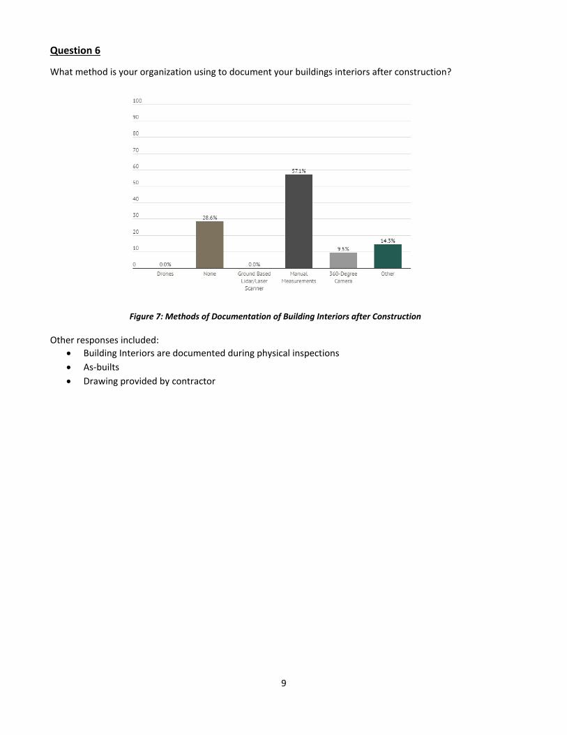
Question 6
What method is your organization using to document your buildings interiors after construction?
Other responses included: • Building Interiors are documented during physical inspections • As-builts • Drawing provided by contractor
Figure 7: Methods of Documentation of Building Interiors after Construction

10
Question 7
What software does your organization use to create digital twins of your buildings?
Other responses included:
• AutoCAD
Question 8
If your organization is not currently using technology to scan your buildings do you plan on using in the future?
Figure 9: Percentage of Organizations that Plan on Using Technology to Scan Buildings
Figure 8: Software Used to Create a Digital Twin of Buildings

11
Question 9
What is your organization’s main goal for using digital scanning for buildings? (Choose more than one answer if necessary)
Figure 10: Organization’s Main Goal for Using Digital Scanning for Buildings
Other responses included:
• N/A • No plans • we aren't utilizing digital scanning of buildings • existing conditions documentation • N/A • We do not use digital scanning of buildings but I'm curious what benefits you hope to achieve from
them. Although expensive, I'm an advocate for physical inspections so CTDOT has been contracting out our building inspection assignments to the consultant community.

12
• Not currently panning to use digital scanning • No current plans • no plans for this technology • Unaware of us moving this direction • assessing climate controls and effect on employee environment • N/A
Question 10
Would you like to receive the survey results by email when complete?
Survey Conclusions
The survey respondents consisted mostly of State DOTs of which the majority manage over 500 buildings. While the technology itself has matured making implementation possible there are very few respondents using the technology and few have plans to use it in the future. Survey participants that are planning to use the technology state maintenance, repair, additions and building modifications repair as the most common goals for the technology.
Technology Review
Currently there are many technologies available to collect, process and communicate information on assets including buildings and building sites. This technology is transforming the way we manage these assets and is giving building owners the information they need to make better decisions on how to maintain, manage and improve their assets. The technology is generally hardware for collection, software for processing collected data and web-based platforms to communicate information. Below is a summary of some of the more popular technologies available.
Data Collection Hardware
There are many types of hardware available to collect building data including drones, lidar, 360 cameras, and other imaging equipment.
Figure 11: Percentage of Survey Participates who want to Receive Survey Results.

13
Drones
The use of drones to collect exterior building information has evolved quickly in recent years. The technology is well established and is underutilized but, growing in use. Purpose-built commercial drones are available that can collect data manually or with pre-programmed autonomous flights. The collected data is typically in the form of high-resolution images, but drone payloads can also include lidar. Information collected can be processed into 3D point clouds and triangular meshes that are dimensionally correct.
Figure 12: Intel Falcon 8+ Commercial Drone
Figure 13: Autonomous Drone Flight Plan of MnDOT Central Office

14
360 Cameras and Imaging Equipment
Consumer Grade Cameras
There are numerous 360-degree cameras on the market that can capture 360 video and images of interior spaces. These cameras can be used simply to create imagery for reference or can take images to be processed into 3D models. These cameras are generally cheap and easy to use and implement.
Professional 360 Degree Cameras
Professional level 360 imaging equipment also exists that can scan interior spaces into 3D models. Matterport is one example and the technology is popular in both the real estate industry and commercial type applications. With professional level equipment, measurements can be made, and floor plans extracted.
Figure 14: Commercial Drone Collecting Site Data
Figure 15: Ricoh Theta Z1 360 Camera

15
Lidar/Laser Scanning
Lidar and laser scanning are additional popular technologies that can be used to scan and model exterior and interior spaces. These technologies tend to be more expensive but produce quality professional level results.
Figure 16: Matterport 3D Scan of Interior Space
Figure 17: Stationary and Mobile Scanners

16
Data Processing Software
Data collection is the first step in the workflow with data processing being the next step. Data that is collected in the field generally needs to be processed into deliverables that can include 3D point clouds, 3D textures meshes, orthomosaic maps, and orthoplanes. The software platforms are typically referred to as reality modeling. There are many reality modeling platforms that are designed to process this data including but not limited to:
• Agisoft Photoscan • Autodesk Recap • Bentley Context Capture • Pix4D
Figure 18: Laser Scan of Building Interior
17
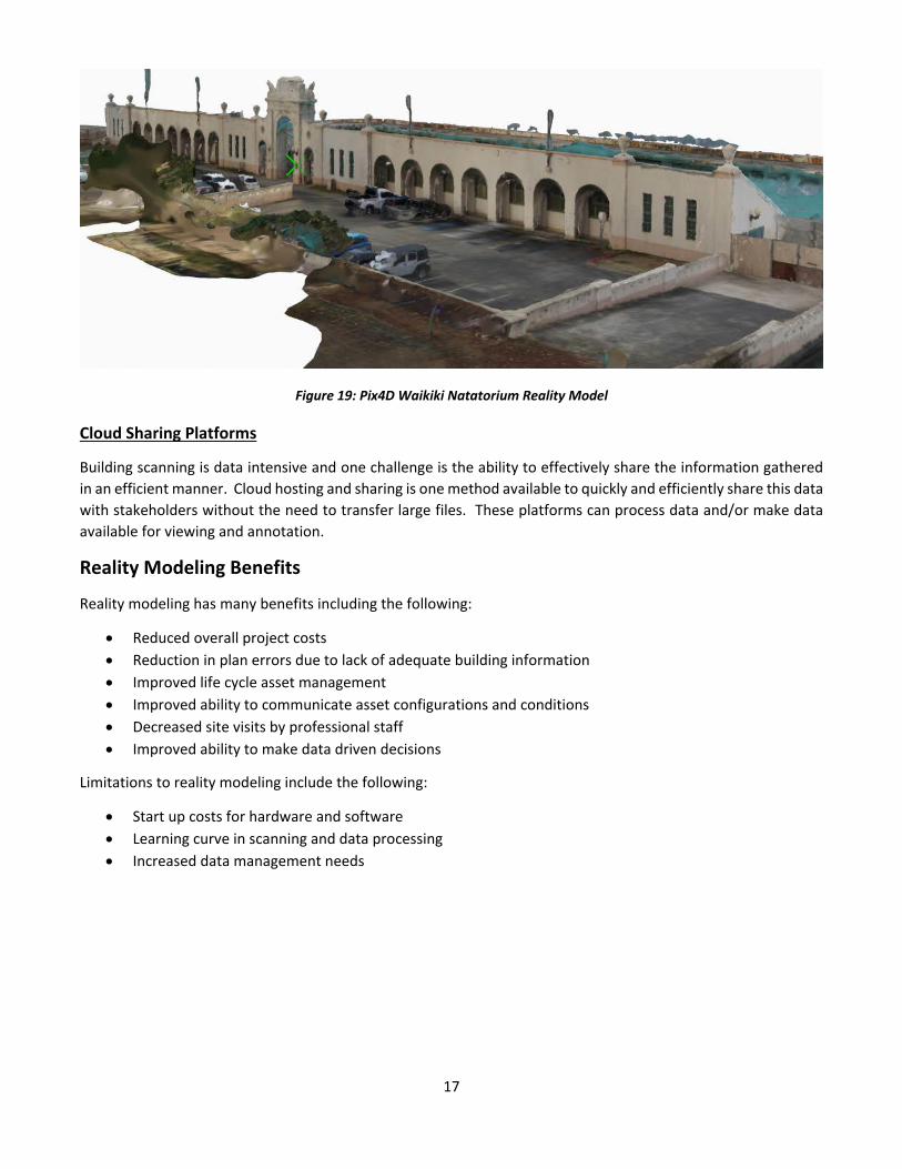
Figure 19: Pix4D Waikiki Natatorium Reality Model
Cloud Sharing Platforms
Building scanning is data intensive and one challenge is the ability to effectively share the information gathered in an efficient manner. Cloud hosting and sharing is one method available to quickly and efficiently share this data with stakeholders without the need to transfer large files. These platforms can process data and/or make data available for viewing and annotation.
Reality Modeling Benefits
Reality modeling has many benefits including the following:
• Reduced overall project costs • Reduction in plan errors due to lack of adequate building information • Improved life cycle asset management • Improved ability to communicate asset configurations and conditions • Decreased site visits by professional staff • Improved ability to make data driven decisions
Limitations to reality modeling include the following:
• Start up costs for hardware and software • Learning curve in scanning and data processing • Increased data management needs
18
Conclusion
The world is changing, and these changes are being driven by big data and the ability for people to effectively use, share and to make better decisions in a wide range of industries including asset management. 360 Scanning and reality modeling is giving asset owners unprecedented information to improve project outcomes while reducing costs and decreasing errors, omissions and change orders. MnDOT should consider continuing with implementation and should consider the wide range of technologies from low cost consumer level hardware and software to more expensive professional solutions.
Lessons Learned
• There is a wide variety of scanning technologies available from low cost consumer level to higher cost professional level technologies.
• There is evidence that private sector companies are using scanning technology but little documentation is available due to no-public sector entities desire to protect their competitive advantages.
• Drone based outdoor scanning is more developed and established than indoor scanning. • DOT’s have not adopted indoor scanning technologies but have understood the benefits. • Startup costs are a barrier to adoption for public agencies. • Indoor scanning has the potential to decrease project costs and increase quality. • Building scanning technology can extended beyond buildings to other applications including bridges,
ancillary structures and transit structures.
Next Steps
• A research or implementation project could confirm the efficiency gains predicted for indoor scanning and could evaluate the following:
o Hardware Costs o Software Costs o Cost Savings and Efficiencies o Training Requirements
• A research or implementation project would be pioneering among State DOT’s and a study would benefit all DOT’s and similar public agencies.
• A great deal of work has been completed as part of the MnDOT Bridge Drone Research and much of the items learned can be transferred to building scanning.

19
Appendix A
MnDOT 360 Degree Point Cloud Technology for Building Management
This survey was sent to state departments of transportation, other state agencies, and private corporations to examine which may have experience and/or interest in digital technology for building management.
1. Please enter the name of your organization.
2. How many buildings does your organization own and manage? o 0-10 o 10-100 o 100-500 o Over 500
3. How does your organization store as built data? (Choose more than one if necessary.)
o Do not have as-built data for buildings o Paper files o Electronic version of paper as-builts o Original CAD files o Post construction digital twin or reality model
4. What software is your organization using to manage their buildings?
o Do not use building management software o Specify Software Package
5. What method is your organization using to document your buildings exteriors after construction? (Choose more
than one answer if necessary) o Drones o None o Ground Based Lidar/Laser Scanner o Manual Measurements o 360 Degree Camera o Other
6. What method is your organization using to document your buildings interiors after construction?
o Drones o Ground Based Lidar/Laser Scanner o None o Manual Measurements o 360 Degree Camera o Other
7. What software does your organization use to create digital twins of your buildings?
o None, we have not created digital models. o Pix4D o Bentley Context Capture o Autodesk Recap

20
o Agisoft Photoscan o Other (please specify)
8. If your organization is not currently using technology to scan your buildings do you plan on using in the future?
o Yes, within the next year. o Yes, within 5 years. o No plans to use scanning technology.
9. What is your organizations main goal for using digital scanning for buildings? (Choose more than one answer if
necessary) o Building maintenance and repair planning. o Building additional and modifications o Building safety analysis o Other (please specify)
10. Would you like to receive the survey results by email when complete?