Embed Size (px)
Citation preview

TRANSPORTATION,SAFETY ANd HEALTH
A look At how perceptions of sAfety, crime And violence
impAct Active trAnsportAtion in Bedford-stuyvesAnt

TRANSPORTATION, SAFETY ANd HEALTH 2
The Dr. Carl henry naChT FellowshipThe Dr. Carl Henry Nacht Health Fellowship was founded by Mary Beth Kelly in honor of her husband Dr. Carl Henry Nacht. Henry used New York City’s public spaces to stay healthy: walking its neighborhoods, running its streets and bicycling to his office, the hospital and to homebound patients. The Fellowship honors Henry’s dedication to improving people’s lives by promoting the city as a place for New Yorkers to engage in healthy activity. The Transportation, Safety and Health Assessment began as the first Nacht Fellow project.
Anca Giurgiulescu, Master of Public Health candidate at Columbia University, was the first Dr. Carl Henry Nacht Fellow in the spring of 2011.
Special thanks to the following community partners who helped design and administer the survey:
CommuniTy parTnersBedford-Stuyvestant WIC Center and its extremely helpful and supportive staff, especially Ms. Juliet Campbell, Ms. Fiona and Ms. Marie
Boys and Girls High School, especially Mr. O’Brien and his Student Government class
Brooklyn Alliance for Safer Streets, especially State Committeeman, District Leader 56th Assembly District, Mr. Robert E. Cornegy Jr.
Common Grounds coffee house, especially Ms. Tremaine Wright
Dr. Cody and Family and Consulting Services
Fulton Bikes, especially Mr. Philip Han
Middle School 35/Beacon Center, especially Mr. Anthony Melendez
Ms. Joyce Smith of Salem Missionary Baptist Church (Flatbush)
Ms. Yonette Fleming of Hattie Carthan Community Garden
NYC Department of Health and Mental Hygiene, Brooklyn District Public Health Office, especially Ms. Kim Bylander, Ms. Yoreel Fraser and Mr. Phil Noyes
NYC Department of Health and Mental Hygiene, Office of Minority Health, especially Mr. Nana Aboagye and Moses Mansu
NYC Food and Fitness Partnership, especially Ms. Sharon Wong and Reverends Robert and DeVanie Jackson (Brooklyn Rescue Mission)
AcknowledGements
TRANSPORTATION, SAFETY ANd HEALTH 3
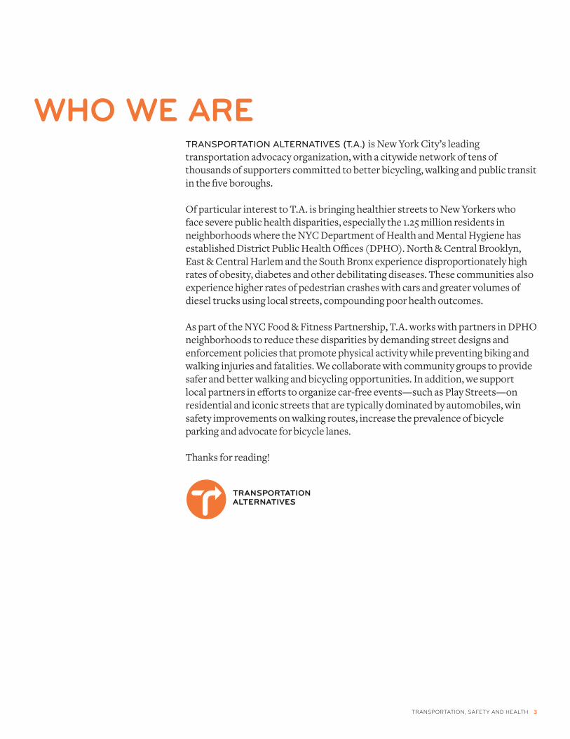
who we Are TransporTaTion alTernaTives (T.a.) is New York City’s leading transportation advocacy organization, with a citywide network of tens of thousands of supporters committed to better bicycling, walking and public transit in the five boroughs.
Of particular interest to T.A. is bringing healthier streets to New Yorkers who face severe public health disparities, especially the 1.25 million residents in neighborhoods where the NYC Department of Health and Mental Hygiene has established District Public Health Offices (DPHO). North & Central Brooklyn, East & Central Harlem and the South Bronx experience disproportionately high rates of obesity, diabetes and other debilitating diseases. These communities also experience higher rates of pedestrian crashes with cars and greater volumes of diesel trucks using local streets, compounding poor health outcomes.
As part of the NYC Food & Fitness Partnership, T.A. works with partners in DPHO neighborhoods to reduce these disparities by demanding street designs and enforcement policies that promote physical activity while preventing biking and walking injuries and fatalities. We collaborate with community groups to provide safer and better walking and bicycling opportunities. In addition, we support local partners in efforts to organize car-free events—such as Play Streets—on residential and iconic streets that are typically dominated by automobiles, win safety improvements on walking routes, increase the prevalence of bicycle parking and advocate for bicycle lanes.
Thanks for reading!

TRANSPORTATION, SAFETY ANd HEALTH 4
contentsINTROducTION
PROjEcT BAckgROuNd
SNAPSHOT: BEdFORd-STuYvESANT
kEY FINdINgS
REcOmmENdATIONS
cONcLuSION
APPENdIx: cRASH mAP
REFERENcES
5
6
7
8-10
12
13
14
11
TRANSPORTATION, SAFETY ANd HEALTH 5
T.a. works wiTh CommuniTy-baseD organizaTions throughout New York City, and we frequently hear partners identify violence and crime as impediments to walking, biking and imagining the street as a place to engage in healthy activity. The goal of the Transportation, Health and Safety Assessment is to identify how “active design” changes to the built environment that promote walking and biking can also address community concerns about crime and violence while increasing opportunities to use streets for healthy physical activity.
According to our survey results, many Bedford-Stuyvesant residents walk, bike or take transit on a weekly basis; some do so out of utility and convenience, others for pleasure, exercise or recreation. But many residents said a number of barriers keep them from doing so more often, or at night. While this assessment does not draw a conclusive link between active design and crime reduction, it does show that residents want to spend more time out on neighborhood streets (by themselves and with their children), and that they would feel safer doing so with more “eyes on the street,” better lighting, more bike lanes, and enforcement of laws against reckless driving.
Only 18 percent of respondents said that they own a car, while more than double (37 percent) said they own a bike. So there is great potential for, and interest in, developing active design to make walking and biking more accessible while simultaneously addressing community concerns about safety, crime and violence.
introduction
TRANSPORTATION, SAFETY ANd HEALTH 6
project BAckGround aCTive TransporTaTion, suCh as walking, biking anD Taking TransiT, can help reduce obesity and improve cardiovascular and respiratory health by increasing rates of individual physical activity. It also provides access to jobs, social connections, nutritious food, health care and leisure activities. Often, a pre-requisite for engaging in active transportation is feeling safe from crime.
In a 2010 report, Addressing the Intersection: Preventing Violence and Promoting Healthy Eating and Active Living, the Prevention Institute identified the multi-dimensional constraints upon healthy and active living choices that are caused by violence and fear of violence. At the individual level, people who experience or witness violence on the streets or in their neighborhood are less physically active and spend less time outdoors; they are also less capable and motivated to be active due to psychological impacts of having witnessed violence. At the community level, violence and fear of violence in a neighborhood lead to decreased social cohesion and, consequently, underutilization of local assets such as community centers, walking paths, and parks.i Community social factors such as crime rates are important determinants in residents’ ability to engage in active transportation safely and consistently, yet these factors are often not addressed in detail in neighborhood walkability and transport accessibility studies.
methods: transportation, health and safety Assessment we DevelopeD a CommuniTy survey to further identify how perceptions and actual rates of crime and violence impact ability and desire to walk, bike and preceive the street as a place hospitable to healthy activity.
With support from community partners, we surveyed 274 residents in May 2011. Of these, 177 surveys were from Bedford-Stuyvesant residents; others live in nearby Brooklyn neighborhoods. Surveys were administered in neighborhood hubs, ranging from Boys and Girls High School to neighborhood coffee house Common Grounds.
Broadly, survey respondents identified:• How often do they engage in active transportation? • What prevents them from spending time outside?• What changes they would like to see in their neighborhood that would
facilitate participation in active transportation?
Based on this feedback, we developed policy and design recommendations to suggest how changes to the built environment can potentially address safety and crime concerns while improving access to active transportation.

TRANSPORTATION, SAFETY ANd HEALTH 7
snApshot: Bedford-stuyvesAnt, Brooklyn
beDForD-sTuyvesanT is a preDominanTly resiDenTial neighborhooD, well-known for historic brownstones with small front yards and stoops, churches and small businesses. Among public health professionals, it is also known as a neighborhood where health medtrics indicate among the highest health and illness burdens in all of Brooklyn and New York City. In 2007, the NYC Department of Health and Mental Hygiene (DOHMH) created a District Public Health Office (DPHO) for North and Central Brooklyn to address the disparate rates of activity and diet related chronic diseases. A NYC DOHMH 2008 study found the following health disparities in this DPHO area: ii
• Thirtypercent of adults report not participating in any physical activity over the last 30 days, versus 15percentof adults in wealthier neighborhoods
• Thirtyonepercentof adults are obese, versus 23percent of adults citywide
• Fifteenpercent report having diabetes, versus 10percent of adults citywide.
Crime is also a concern in Brooklyn. While crime rates have decreased significantly citywide in the last two decades, Brooklyn reported the highest increase in overall crime amongst all five boroughs, up 2.58 percent from last year at this time, with 8,027 total reported crimes across the borough.iii In 2007 Bedford-Stuyvesant stood out among other neighborhoods in Brooklyn with the highest number of crimes per 100,000 residents. iv
survey responDenT DemographiCs* All graphs represent the number of respondents in a given category
gender
age
length of residence
0
30
60
90
120
150
OtherFemalemale
0
10
20
30
40
50
60
60+46-5931-45 19-30 10-18
0
10
20
30
40
50
60
15+ years11-15 years6-10 years1-5 years< 1 year
vehicle ownership
carBike0
20
40
60
80
100
120
NoYesNoYes
Brooklyn Community Board 3 (CB3) encompasses the community of Bedford-Stuyvesant
manhattanQueens
TheBronx
BrooklynStatenIsland
cB 3
location map
TRANSPORTATION, SAFETY ANd HEALTH 8
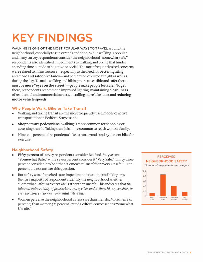
key findinGswalking is one oF The mosT popular ways To Travel around the neighborhood, especially to run errands and shop. While walking is popular and many survey respondents consider the neighborhood “somewhat safe,” respondents also identified impediments to walking and biking that hinder spending time outside to be active or social. The most frequently sited concerns were related to infrastructure—especially to the need for betterlighting and moreandsaferbikelanes—and perception of crime at night as well as during the day. To make walking and biking more accessible and safer there must be more“eyesonthestreet”—people make people feel safer. To get there, respondents recommend improved lighting, maintaining cleanliness of residential and commercial streets, installing more bike lanes and reducingmotorvehiclespeeds.
why people walk, Bike or take transit• Walking and taking transit are the most frequently used modes of active
transportation in Bedford-Stuyvesant.
• Shoppersarepedestrians. Walking is more common for shopping or accessing transit. Taking transit is more common to reach work or family.
• Nineteen percent of respondents bike to run errands and 25 percent bike for exercise.
neighborhood safety• Fiftypercent of survey respondents consider Bedford-Stuyvesant
“SomewhatSafe,” while seven percent consider it “Very Safe.” Thirty three percent consider it to be either “Somewhat Unsafe” or “Very Unsafe”. Ten percent did not answer this question.
• But safety was often cited as an impediment to walking and biking even though a majority of respondents identify the neighborhood as either “Somewhat Safe” or “Very Safe” rather than unsafe. This indicates that the inherent vulnerability of pedestrians and cyclists makes them highly sensitive to even the most subtle environmental deterrents.
• Women perceive the neighborhood as less safe than men do. More men (30 percent) than women (21 percent) rated Bedford-Stuyvesant as “Somewhat Unsafe.”
perCeiveD neighborhooD saFeTy
0
20
40
60
80
100
very unsafe
Somewhat unsafe
Somewhat Safe
very Safe
* Number of respondents per category
TRANSPORTATION, SAFETY ANd HEALTH 9
key findinGs
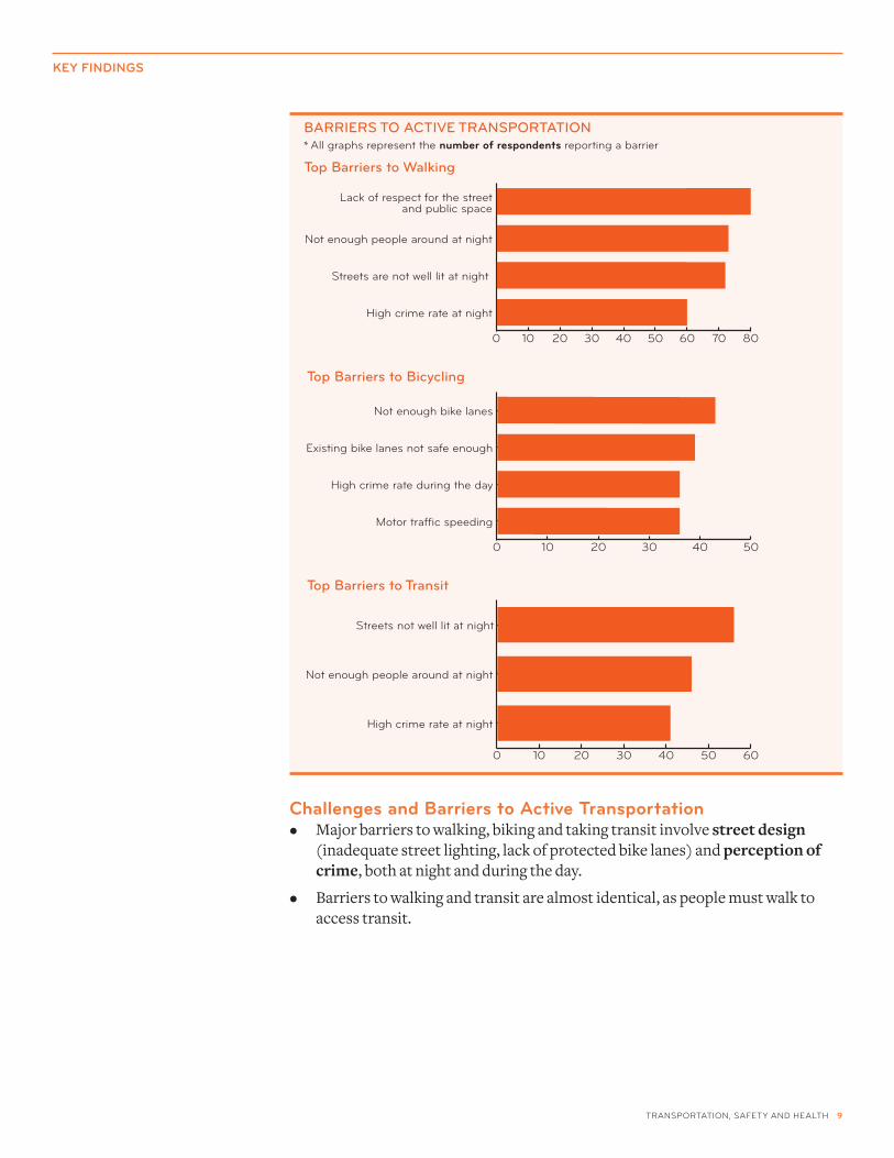
challenges and Barriers to Active transportation • Major barriers to walking, biking and taking transit involve streetdesign
(inadequate street lighting, lack of protected bike lanes) and perceptionofcrime, both at night and during the day.
• Barriers to walking and transit are almost identical, as people must walk to access transit.
High crime rate during the day
Existing bike lanes not safe enough
Not enough bike lanes
High crime rate at night
Not enough people around at night
Streets not well lit at night
Top barriers to walking
Top barriers to bicycling
Top barriers to Transit
barriers To aCTive TransporTaTion* All graphs represent the number of respondents reporting a barrier
TRANSPORTATION, SAFETY ANd HEALTH 10
key findinGs
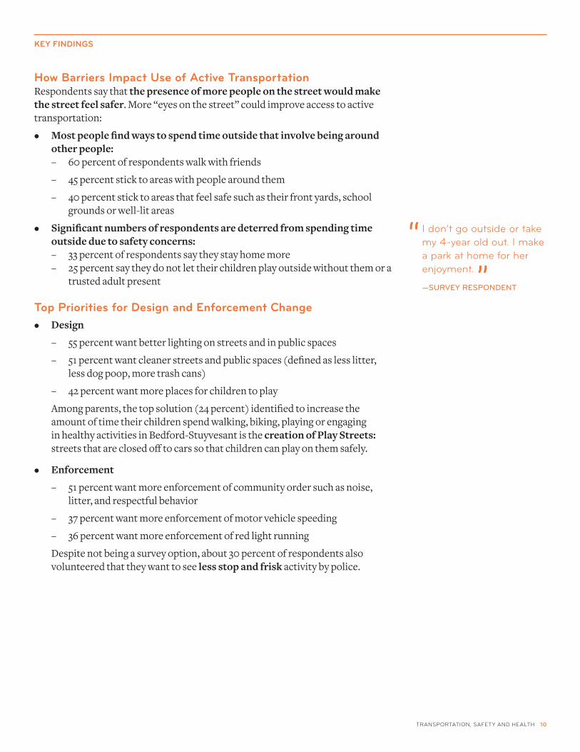
how Barriers impact use of Active transportationRespondents say that thepresenceofmorepeopleonthestreetwouldmakethestreetfeelsafer. More “eyes on the street” could improve access to active transportation:
• Mostpeoplefindwaystospendtimeoutsidethatinvolvebeingaroundotherpeople:
– 60 percent of respondents walk with friends
– 45 percent stick to areas with people around them
– 40 percent stick to areas that feel safe such as their front yards, school grounds or well-lit areas
• Significantnumbersofrespondentsaredeterredfromspendingtimeoutsideduetosafetyconcerns:
– 33 percent of respondents say they stay home more – 25 percent say they do not let their children play outside without them or a
trusted adult present
top priorities for design and enforcement change• Design
– 55 percent want better lighting on streets and in public spaces
– 51 percent want cleaner streets and public spaces (defined as less litter, less dog poop, more trash cans)
– 42 percent want more places for children to play
Among parents, the top solution (24 percent) identified to increase the amount of time their children spend walking, biking, playing or engaging in healthy activities in Bedford-Stuyvesant is the creationofPlayStreets:streets that are closed off to cars so that children can play on them safely.
• Enforcement
– 51 percent want more enforcement of community order such as noise, litter, and respectful behavior
– 37 percent want more enforcement of motor vehicle speeding
– 36 percent want more enforcement of red light running
Despite not being a survey option, about 30 percent of respondents also volunteered that they want to seelessstopandfrisk activity by police.
I don’t go outside or take my 4-year old out. I make a park at home for her enjoyment.
—survey responDenT
“
”

TRANSPORTATION, SAFETY ANd HEALTH 11
perCepTions oF saFeTy on neighborhooD sTreeTs strongly impact whether residents view the street as a place that supports healthy activity, and how frequently they engage in active transportation. These findings demonstrate the need for crime prevention initiatives and programs to incorporate active design improvements, such as bicycle and pedestrian infrastructure and Play Streets, that increase the presence of “eyes on the street.”
dot, dohmh, dcp, ddc and dos: When presenting to communities about design and infrastructure projects, considerhowagencyinitiativesandprogramscanrelatetocrimeandviolenceprevention and how local concerns, like lighting, can be incorporated into projects. Though this study was specific to Bedford-Stuyvesant, the safety problems and solutions local residents identify should be considered in all neighborhoods where crime and violence are prevalent, and incorporated into active design projects.
nypd, dohmh and dot: Collaborate with community-based partners to developabefore/afterstudy to examine how strategic enforcement and street design that support safer walking and biking can influence crime and violence reduction. This would illustrate that walking and biking are more than transportation options; these behaviors also facilitate safe and healthy communities.
dohmh, dot and nypd: ContinuetosupportimplementationofPlayStreets; make the program more sustainable and accessible. Residents want more safe places for their kids to play and more “eyes on the street”—Play Streets support both goals. In the 2011 update to PlaNYC 2030—the Mayor’s sustainability plan—the DOHMH and NYPD are charged with increasing the number of Play Streets annually. An accessible online portal should be created where community groups can learn about Play Streets and submit applications. Grant opportunities should be created for local Play Street organizers to buy equipment and hire local staff to manage the street.
nypd: Prioritizeenforcementofunsafeandunhealthystreetconditions, and educate officers about the public safety benefits of active transportation. Use recently released NYPD crash data to identify where speeding and lawless driving occur most frequently and increase enforcement of careless driving behaviors. Work with residents to identify solutions to reducing litter and dog poop. Train officers in surveillance of people walking and biking on neighborhood streets in ways that do not involve stop and frisk.
Play Streets activate the street and provide safe, supervised places for children to play.
recommendAtions
recommendAtions
major nyc Agency players dOHmH: department of Health and mental Hygiene dcP: department of city Planning dOT: department of Transportation ddc: department of design and construction dOS: department of Sanitation NYPd: New York Police department
TRANSPORTATION, SAFETY ANd HEALTH 12
aCTive TransporTaTion proviDes busy, city-dwelling residents opportunities to engage in healthy activity during their daily commutes and errands—to use New York City as their gym. Opportunities for active transportation also connect people to their surrounding neighborhood and the social networks and services they need to lead fulfilling and productive lives through jobs, schools, shopping, family and friends, parks and public spaces.
Survey findings show that the main challenges preventing residents from walking, biking or taking transit more often relate to both infrastructure and public safety. Better lighting on streets, more spaces for children to play, and protected bike lanes are key infrastructure priorities. Clean streets and more people on the streets keeping an eye on safe and respectful behavior are key public safety priorities, which is also be supported by respectful and positive behavior from police officers. Police presence and better lighting are even more critical at night to deter negative activity, as fewer people are out at night to maintain an “eyes on the street” presence.
Community organizations and leaders can use the recommendations in this report to advocate to city agencies for healthier and safer streets, and city agencies should use these findings to evaluate what more they can and must do to support active transportation for safe and healthy communities.
conclusion

TRANSPORTATION, SAFETY ANd HEALTH 13
Appendixdata visualization: motor vehicle crashes with pedestrians and Bicyclists in Brooklyn community Board 3, 1995-2009Brooklyn Community Board 3 (representing Bedford-Stuyvesant) has some of the most dangerous intersections for pedestrians and bicyclists in New York City.
In particular, FultonStreet—a major shopping destination with several bus and subway routes, but no bicycle lanes—includes sevenofthetenhighestcrashintersectionsinBedford-Stuyvesant. High crash rates like these are barriers to walking, biking and imagining the street as a place to engage in physical activity.
Gates Av
Fulton St
Putnam Av
Quincy St
Atlantic Av
Halsey St
Macon St
Madison StMonroe St
Greene Av
Hancock St
Park Av
De Kalb Av
Jefferson Av
Lewis Av
Marcy Av
Lexington Av
Hart St
Throop Av
Myrtle Av
Lafayette AvB
edford Av
Decatur St
Tompkins Av
Pulaski St
Nostrand Av
Kosciuszko St
Vernon Av
Mac Donough St
Patchen Av
Herkimer St
Stuyvesant Av
Kent Av
Bainbridge St
Willoughby Av
Clifton Pl
Taaffe Pl
Skillman St
Franklin Av
Spencer StVan Buren St
Walw
orth St
Malcolm
X B
lvd
Ellery St
Hopkins St
Sandford St
Sumpter St
Mac Dougal St
Utica A
v
Marion St
Flushing Av
Lefferts Pl
Warsoff P
lB
uffa
lo A
v Hull St
Saratoga Av
Ralph Av
Malcolm
X B
lvd
Marion St
Classon Av
Franklin Av
Chauncey St
Broadway
Ralph Av
Marcus G
arvey Blvd
0 1,000500
Feet
Map Key
Public Housing
Motor Vehicle Crasheswith Pedestrians andBicyclists
High crash area
Low crash areaBike Routes
Local Traffic StreetsArterial Streets
High Crash Intersections
Myrtle Ave. & Broadway ......................Fulton St. & Nostrand Ave. ................Flushing Ave. & Broadway .................Fulton St. & Bedford Ave. ..................Fulton St. & Brooklyn Ave. ..................Fulton St. & Albany Ave. ..................... Fulton St. & Marcy Ave. .......................Fulton St. & Marcus Garvey Blvd. ......Fulton St. & Throop Ave. ....................Myrtle Ave. & Nostrand Ave. ..............
77605955473934343332
1.2.3.4.5.6.7.8.9.10.
Rank of Intersections with Most CrashesBrooklyn Community Board 3
ManhattanQueens
TheBronx
BrooklynStatenIsland
CB 3
Location Map
Motor Vehicle Crashes with Pedestrians and BicyclistsBrooklyn Community Board 3, 1995-2009

TRANSPORTATION, SAFETY ANd HEALTH 14
referencesi Cohen L, Davis R, Lee V, Valdovinos E. Addressing the Intersection: Preventing Violence and
Promoting Healthy Eating and Active Living. May 2010.
ii Noyes P, Fung L, Lee KK, Grimshaw V, Maybank KA, DiGrande L. Cycling in Bedford-Stuyvesant: A Look at Cycling and Driving Behaviors. New York, NY: New York City Department of Health and Mental Hygiene, 2010.
iii Simino J. Crime in the Stuy: A look at the neighborhood. Bed-Stuy Patch, April 25, 2011. Accessed at http://bed-stuy.patch.com/articles/crime-in-the-stuy-a-look-at-the-neighborhood
iv Mathis-Liley B. What a safer city really looks like. Crime Map. New York Magazine, January 14, 2008. Accessed at http://nymag.com/docs/08/01/080114crimemaps.pdf

discover more trAnsportAtion & heAlth reseArch At trAnsAlt.orG/newsroom/reports