Embed Size (px)
Citation preview
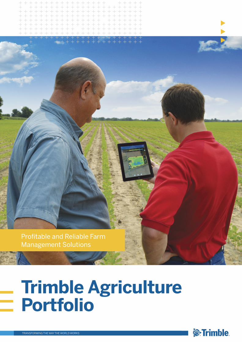
Trimble Agriculture Portfolio
Profitable and Reliable Farm Management Solutions
TRANSFORMING THE WAY THE WORLD WORKS
TransformingTHE WORK OF AGRICULTURE
CONNECTED FARM
Farmers and advisors who use Trimble’s Connected Farm™ can monitor real-time information from their office, smartphone, or tablet. Accessing the farm data in a timely manner can improve decision making on crop input usage, fleet utilisation, and water applications. The benefits of combining precision agriculture and Connected Farm extend well beyond the increased efficiency, safety, and profitability of farming operations. The reduced use of fuel, water, chemicals, and other inputs means more food can be produced on less land, with fewer resources and reduced environmental impact.
TRIMBLE AGRICULTURE
Trimble Agriculture addresses challenges at each stage of the crop production cycle with solutions on which you can rely and profit. Our solutions cover all seasons, crops, terrains, and farm sizes, and our brand-agnostic strategy allows you to easily deploy the solutions on your equipment—regardless of manufacturer. From land prep to harvest, Trimble solutions will help you maximise your efficiency and lower your costs of doing business.
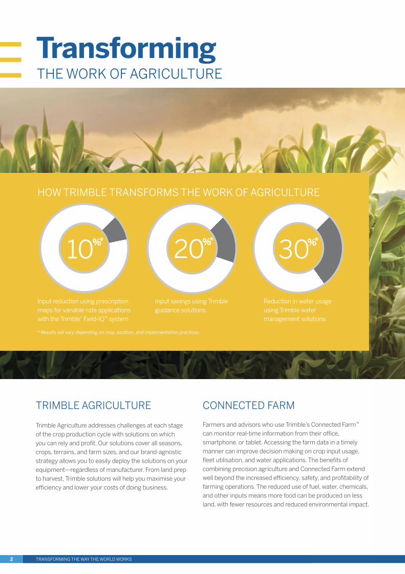
HOW TRIMBLE TRANSFORMS THE WORK OF AGRICULTURE
Input reduction using prescription maps for variable-rate applications with the Trimble® Field-IQ™ system
Input savings using Trimble guidance solutions
Reduction in water usage using Trimble water management solutions
* Results will vary depending on crop, location, and implementation practices.
20%*
30%*
10%*
TRANSFORMING THE WAY THE WORLD WORKS2
TABLE OF CONTENTS
CONNECTED FARM 4–11
Overview 5Data Management for the Grower 6–8Connected Farm Apps 9Tools for the Trusted Advisor 10–11
GUIDANCE & STEERING SOLUTIONS 12–21
Guidance Displays 13Trimble App Central 14Trimble Ag Developer Network 15TMX-2050™ Display & MMX-070 Display 16FmX® Integrated Display, CFX-750™ Display & EZ-Guide® 250 System 17Autopilot™, EZ-Steer®, & EZ-Pilot® Steering Systems 18NextSwath™ Technology 19TrueTracker™ & TrueGuide™ Systems 19Correction Services 20–21
FLOW & APPLICATION CONTROL 22–25
GreenSeeker® & WeedSeeker® Sensors 23Field-IQ System 24–25
HARVEST SOLUTIONS 26–27
Row Guidance & Yield Monitoring 27
WATER SOLUTIONS 28–34
WM-Form™ Land Forming Solution 29FieldLevel™ II System 30WM-Topo™ Survey System 30–31WM-Drain® Farm Drainage Solution 31Irrigate-IQ™ Precision Irrigation Solution 32–33Laser Transmitters 34Grade Control Systems 34
RESELLER PAGE 35
TRANSFORMING THE WAY THE WORLD WORKS 3
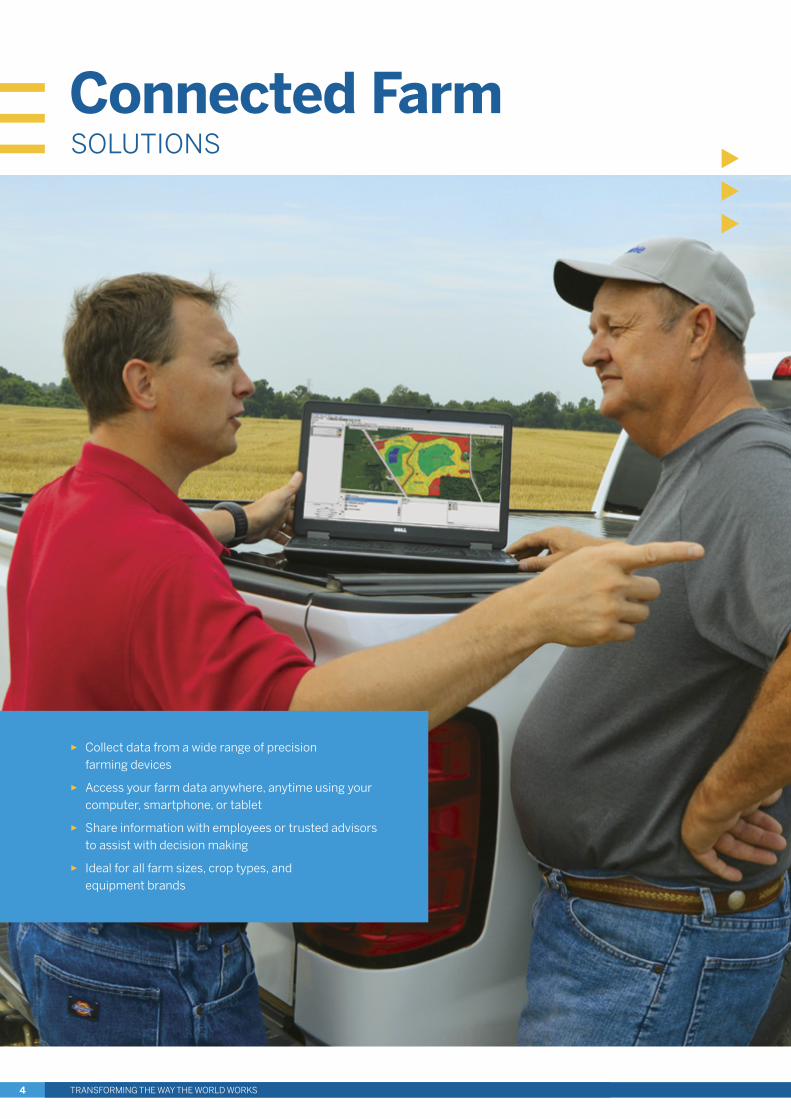
► Collect data from a wide range of precision farming devices
► Access your farm data anywhere, anytime using your computer, smartphone, or tablet
► Share information with employees or trusted advisors to assist with decision making
► Ideal for all farm sizes, crop types, and equipment brands
Connected FarmSOLUTIONS
TRANSFORMING THE WAY THE WORLD WORKS4
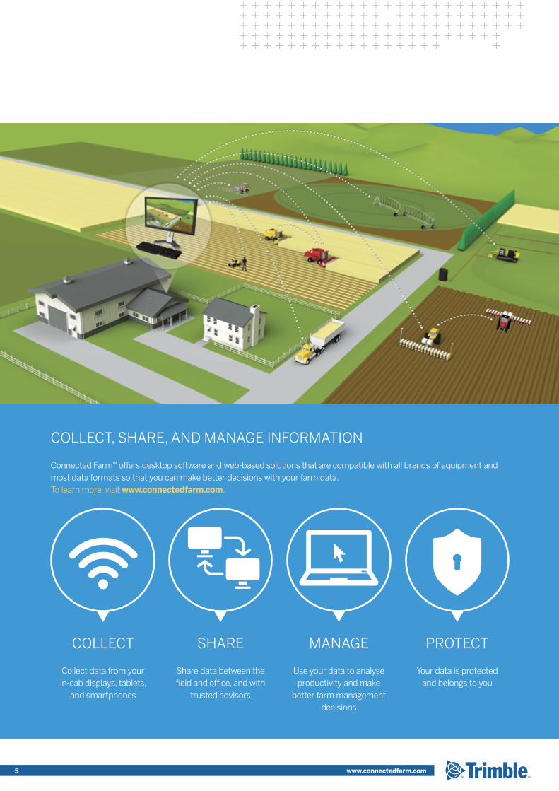
COLLECT, SHARE, AND MANAGE INFORMATION
Connected Farm™ offers desktop software and web-based solutions that are compatible with all brands of equipment and most data formats so that you can make better decisions with your farm data. To learn more, visit www.connectedfarm.com.
COLLECT
Collect data from your in-cab displays, tablets,
and smartphones
SHARE
Share data between the field and office, and with
trusted advisors
MANAGE
Use your data to analyse productivity and make
better farm management decisions
PROTECT
Your data is protected and belongs to you
TRANSFORMING THE WAY THE WORLD WORKS 5 www.connectedfarm.com
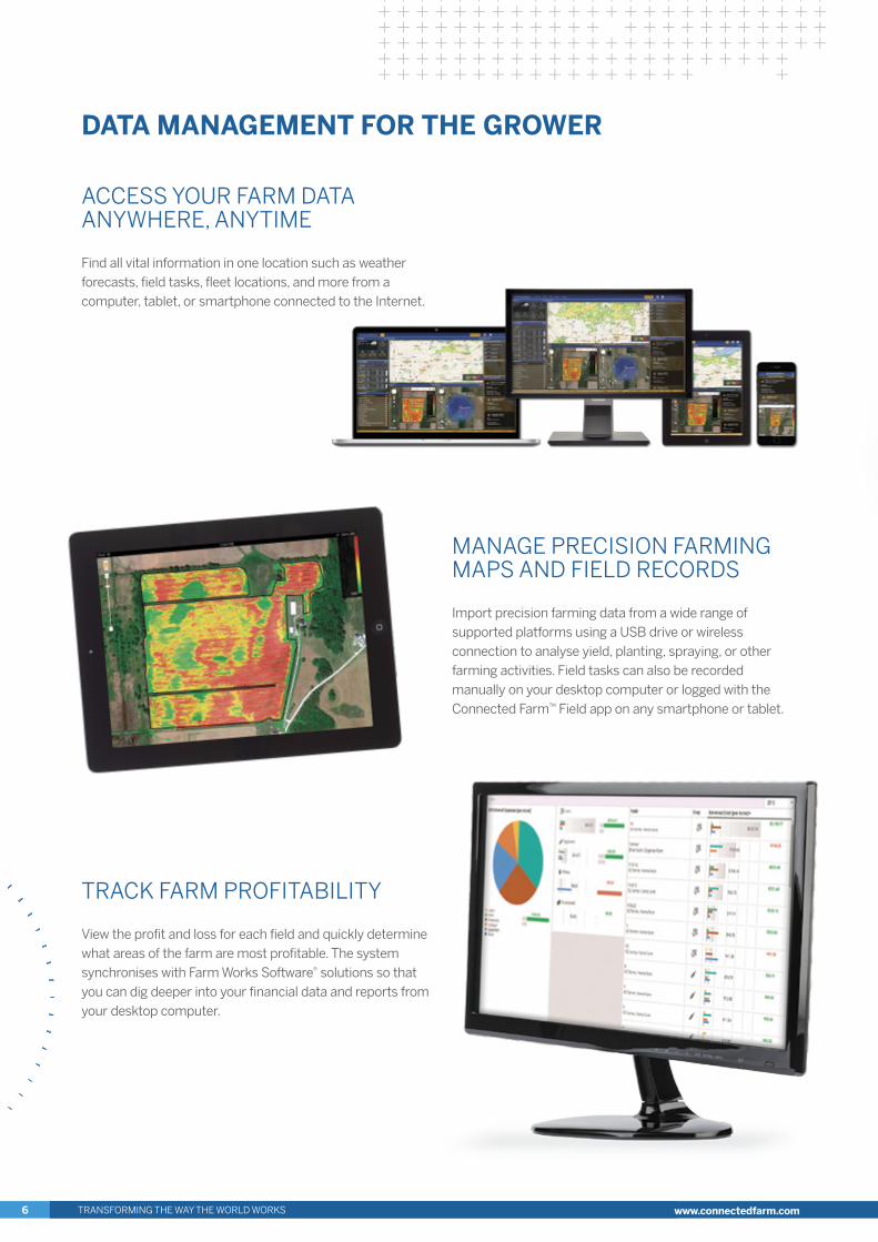
ACCESS YOUR FARM DATA ANYWHERE, ANYTIME
Find all vital information in one location such as weather forecasts, field tasks, fleet locations, and more from a computer, tablet, or smartphone connected to the Internet.
TRACK FARM PROFITABILITY
View the profit and loss for each field and quickly determine what areas of the farm are most profitable. The system synchronises with Farm Works Software® solutions so that you can dig deeper into your financial data and reports from your desktop computer.
MANAGE PRECISION FARMING MAPS AND FIELD RECORDS
Import precision farming data from a wide range of supported platforms using a USB drive or wireless connection to analyse yield, planting, spraying, or other farming activities. Field tasks can also be recorded manually on your desktop computer or logged with the Connected Farm™ Field app on any smartphone or tablet.
DATA MANAGEMENT FOR THE GROWER
TRANSFORMING THE WAY THE WORLD WORKS6 www.connectedfarm.com
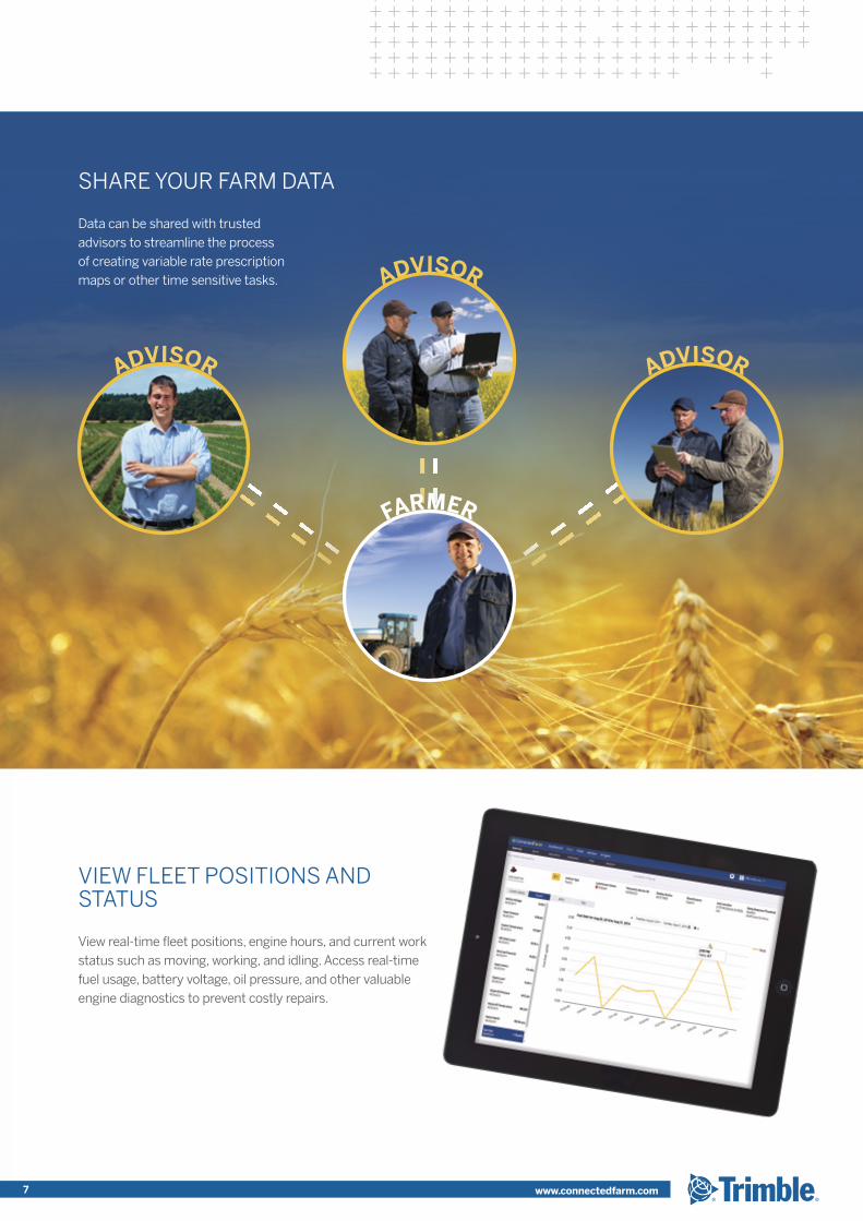
SHARE YOUR FARM DATA
Data can be shared with trusted advisors to streamline the process of creating variable rate prescription maps or other time sensitive tasks.
VIEW FLEET POSITIONS AND STATUS
View real-time fleet positions, engine hours, and current work status such as moving, working, and idling. Access real-time fuel usage, battery voltage, oil pressure, and other valuable engine diagnostics to prevent costly repairs.
ADVISOR ADVISOR
ADVISOR
FARMER
7 www.connectedfarm.com
DATA MANAGEMENT FOR THE GROWER
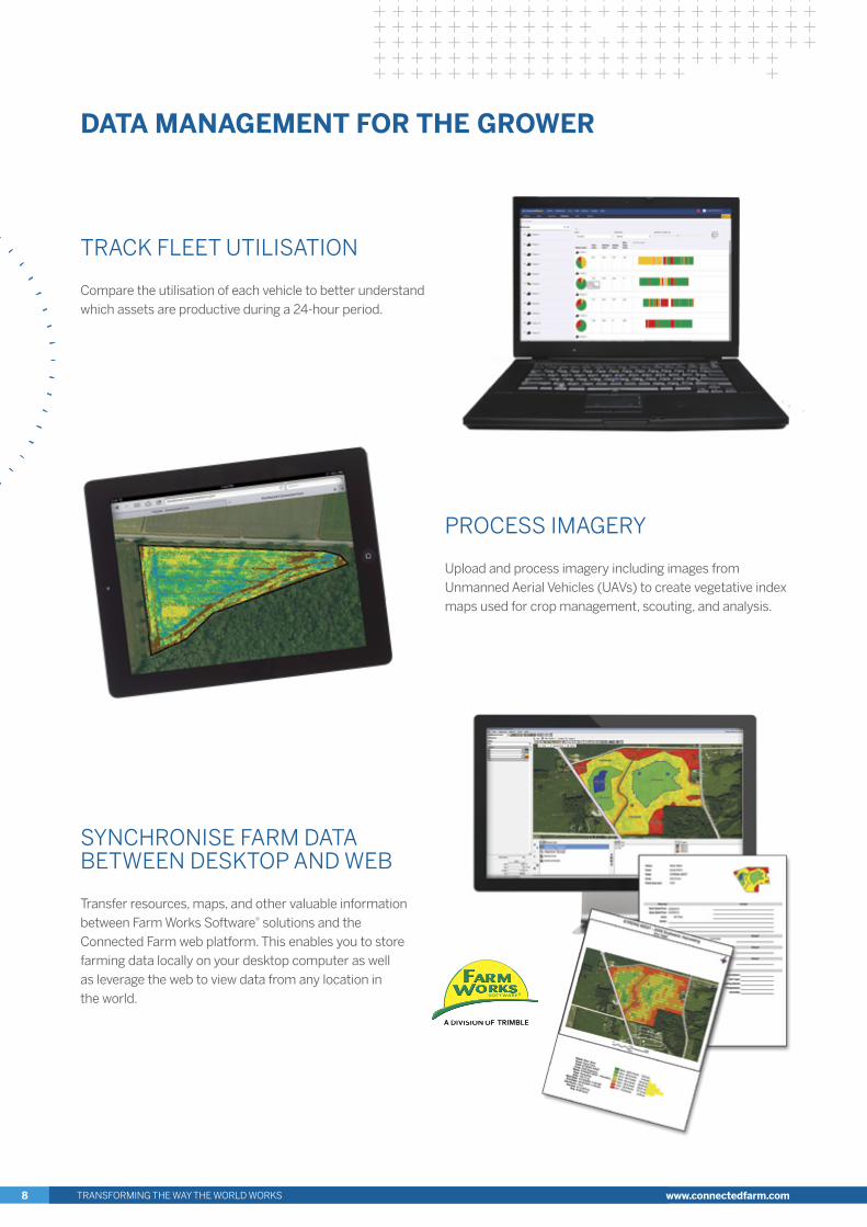
PROCESS IMAGERY
Upload and process imagery including images from Unmanned Aerial Vehicles (UAVs) to create vegetative index maps used for crop management, scouting, and analysis.
SYNCHRONISE FARM DATA BETWEEN DESKTOP AND WEB
Transfer resources, maps, and other valuable information between Farm Works Software® solutions and the Connected Farm web platform. This enables you to store farming data locally on your desktop computer as well as leverage the web to view data from any location in the world.
TRACK FLEET UTILISATION
Compare the utilisation of each vehicle to better understand which assets are productive during a 24-hour period.
TRANSFORMING THE WAY THE WORLD WORKS8 www.connectedfarm.com
CONNECTED FARM APPS
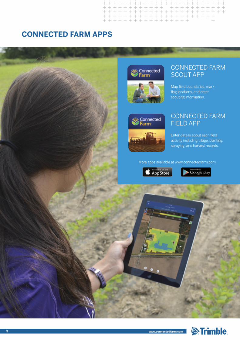
CONNECTED FARM SCOUT APP
Map field boundaries, mark flag locations, and enter scouting information.
CONNECTED FARM FIELD APP
Enter details about each field activity including tillage, planting, spraying, and harvest records.
More apps available at www.connectedfarm.com
9 www.connectedfarm.com
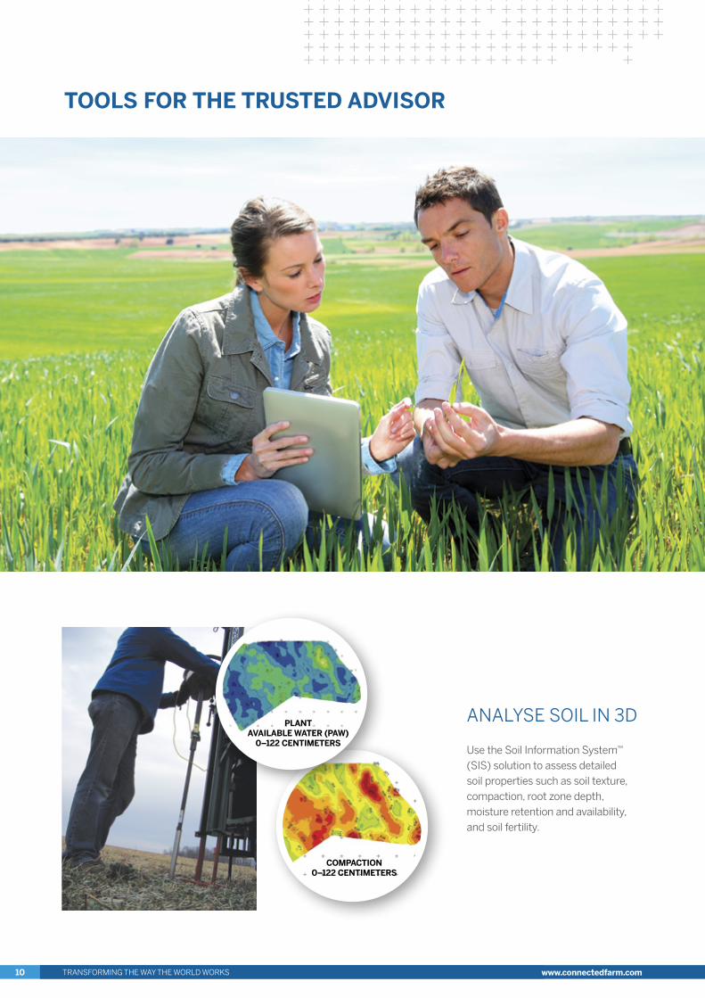
ANALYSE SOIL IN 3D
Use the Soil Information System™ (SIS) solution to assess detailed soil properties such as soil texture, compaction, root zone depth, moisture retention and availability, and soil fertility.
TOOLS FOR THE TRUSTED ADVISOR
COMPACTION 0–122 CENTIMETERS
PLANT AVAILABLE WATER (PAW)
0–122 CENTIMETERS
TRANSFORMING THE WAY THE WORLD WORKS10 www.connectedfarm.com
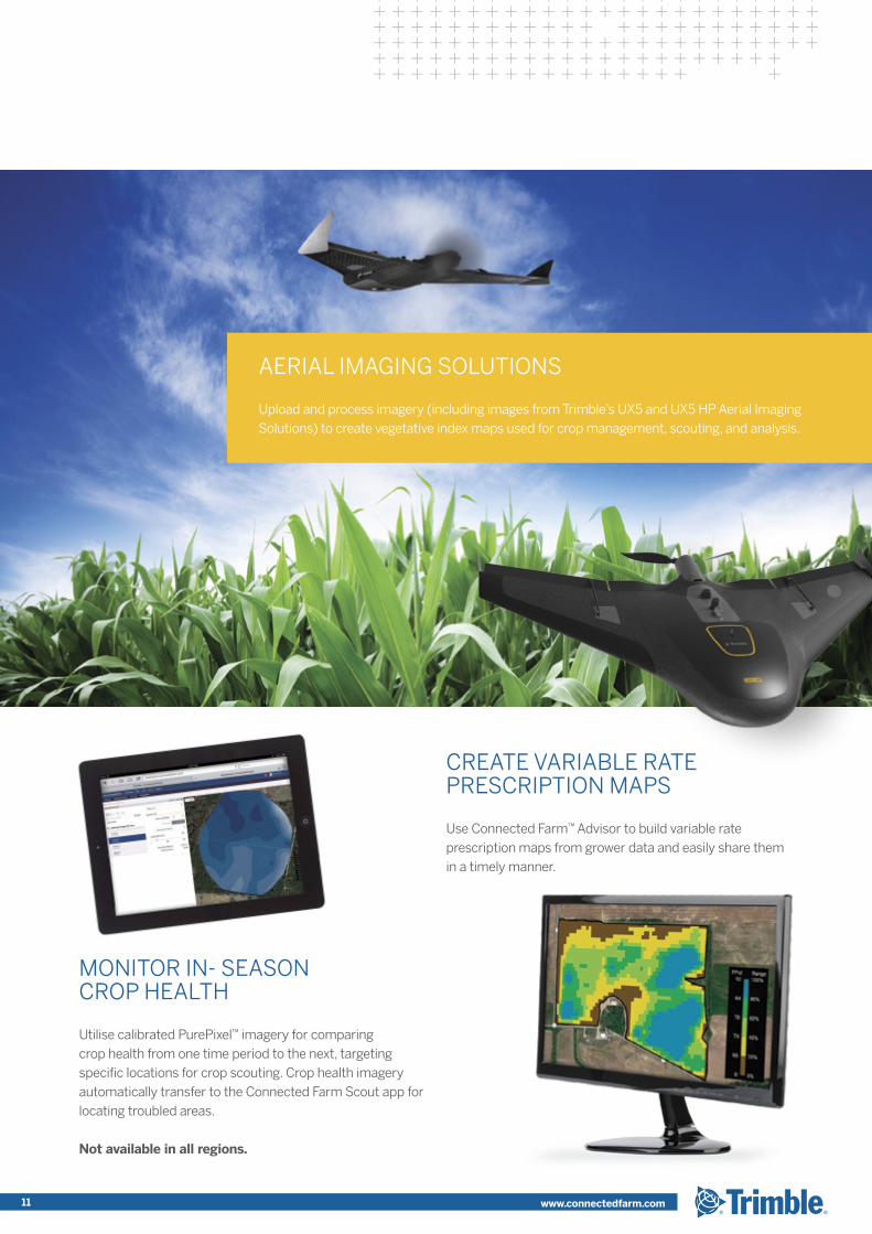
MONITOR IN- SEASON CROP HEALTH
Utilise calibrated PurePixel™ imagery for comparing crop health from one time period to the next, targeting specific locations for crop scouting. Crop health imagery automatically transfer to the Connected Farm Scout app for locating troubled areas.
Not available in all regions.
AERIAL IMAGING SOLUTIONS
Upload and process imagery (including images from Trimble’s UX5 and UX5 HP Aerial Imaging Solutions) to create vegetative index maps used for crop management, scouting, and analysis.
CREATE VARIABLE RATE PRESCRIPTION MAPS
Use Connected Farm™ Advisor to build variable rate prescription maps from grower data and easily share them in a timely manner.
11 www.connectedfarm.com
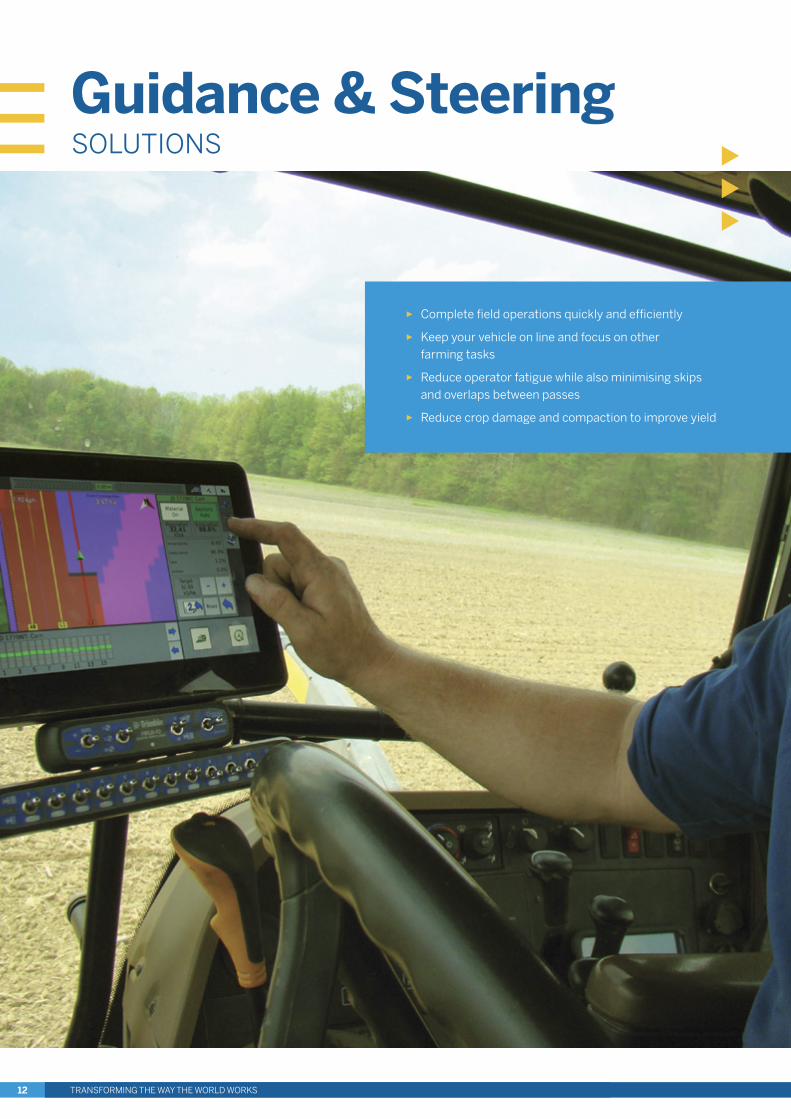
► Complete field operations quickly and efficiently
► Keep your vehicle on line and focus on other farming tasks
► Reduce operator fatigue while also minimising skips and overlaps between passes
► Reduce crop damage and compaction to improve yield
Guidance & SteeringSOLUTIONS
TRANSFORMING THE WAY THE WORLD WORKS12
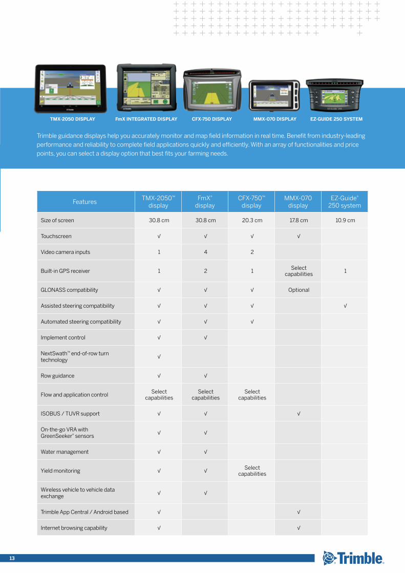
FeaturesTMX-2050™
displayFmX®
displayCFX-750™
displayMMX-070
displayEZ-Guide®
250 system
Size of screen 30.8 cm 30.8 cm 20.3 cm 17.8 cm 10.9 cm
Touchscreen √ √ √ √
Video camera inputs 1 4 2
Built-in GPS receiver 1 2 1 Select capabilities 1
GLONASS compatibility √ √ √ Optional
Assisted steering compatibility √ √ √ √
Automated steering compatibility √ √ √
Implement control √ √
NextSwath™ end-of-row turn technology
√
Row guidance √ √
Flow and application control Select capabilities
Select capabilities
Select capabilities
ISOBUS / TUVR support √ √ √
On-the-go VRA with GreenSeeker® sensors
√ √
Water management √ √
Yield monitoring √ √ Select capabilities
Wireless vehicle to vehicle data exchange
√ √
Trimble App Central / Android based √ √
Internet browsing capability √ √
FmX INTEGRATED DISPLAYTMX-2050 DISPLAY CFX-750 DISPLAY EZ-GUIDE 250 SYSTEM MMX-070 DISPLAY
Trimble guidance displays help you accurately monitor and map field information in real time. Benefit from industry-leading performance and reliability to complete field applications quickly and efficiently. With an array of functionalities and price points, you can select a display option that best fits your farming needs.
TRANSFORMING THE WAY THE WORLD WORKS 13
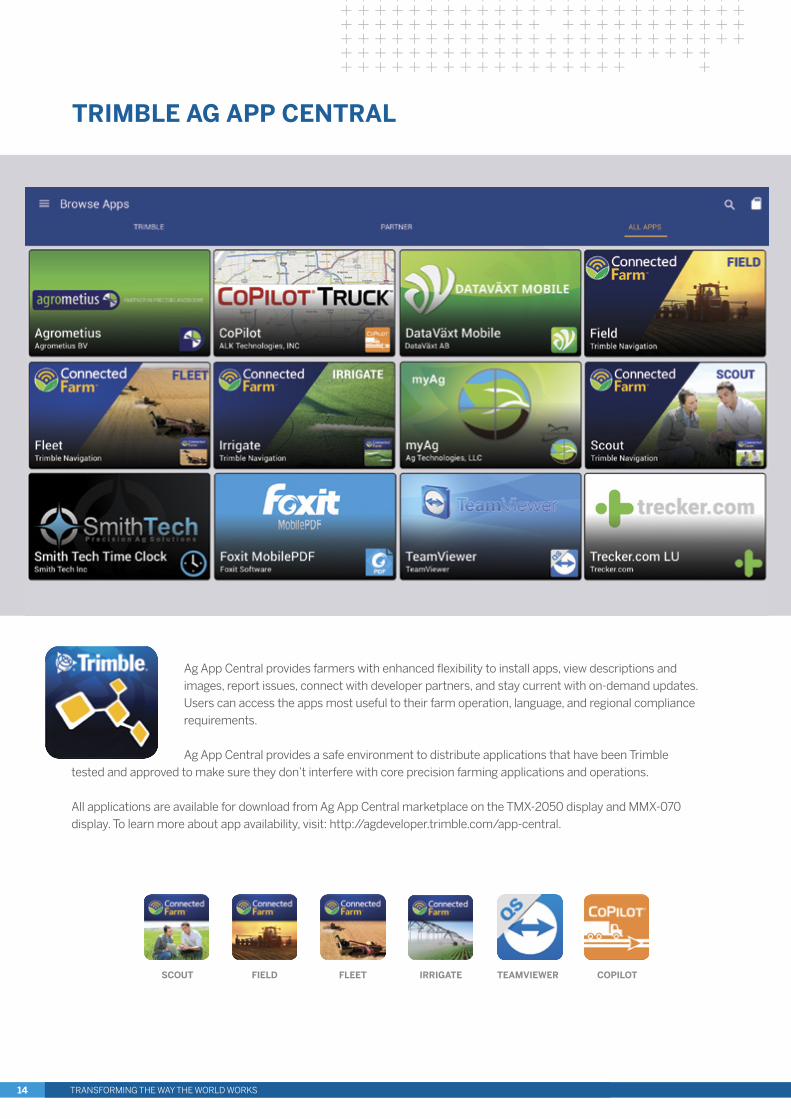
Ag App Central provides farmers with enhanced flexibility to install apps, view descriptions and images, report issues, connect with developer partners, and stay current with on-demand updates. Users can access the apps most useful to their farm operation, language, and regional compliance requirements.
Ag App Central provides a safe environment to distribute applications that have been Trimble tested and approved to make sure they don’t interfere with core precision farming applications and operations.
All applications are available for download from Ag App Central marketplace on the TMX-2050 display and MMX-070 display. To learn more about app availability, visit: http://agdeveloper.trimble.com/app-central.
TRIMBLE AG APP CENTRAL
SCOUT FIELD FLEET IRRIGATE TEAMVIEWER COPILOT
TRANSFORMING THE WAY THE WORLD WORKS14
IN-CAB DISPLAY APPLICATIONS
The Ag Developer Network enables developers to collabourate with Trimble to create Android-based applications that address more specialized and regional precision farming needs. Third-party mobile applications are available for download from App Central marketplace on the TMX-2050 display and MMX-070 display.
CONNECTED FARM INTEGRATION
Customers and developers are able to engage with Connected Farm Application Program Interfaces (APIs). Third-party developers can use the APIs to send data files between their applications and Connected Farm including prescription files, as-applied maps, boundaries, and other precision farming data.
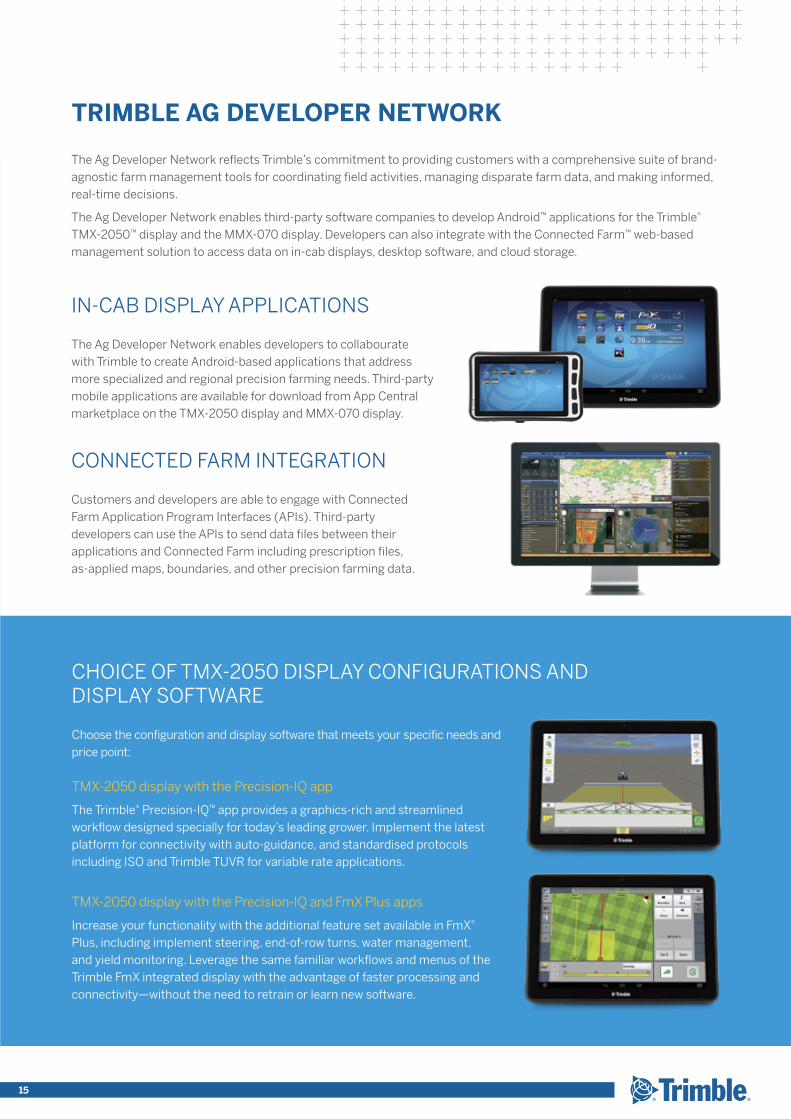
CHOICE OF TMX-2050 DISPLAY CONFIGURATIONS AND DISPLAY SOFTWARE
Choose the configuration and display software that meets your specific needs and price point:
TMX-2050 display with the Precision-IQ app
The Trimble® Precision-IQ™ app provides a graphics-rich and streamlined workflow designed specially for today’s leading grower. Implement the latest platform for connectivity with auto-guidance, and standardised protocols including ISO and Trimble TUVR for variable rate applications.
TMX-2050 display with the Precision-IQ and FmX Plus apps
Increase your functionality with the additional feature set available in FmX® Plus, including implement steering, end-of-row turns, water management, and yield monitoring. Leverage the same familiar workflows and menus of the Trimble FmX integrated display with the advantage of faster processing and connectivity—without the need to retrain or learn new software.
TRIMBLE AG DEVELOPER NETWORK
The Ag Developer Network reflects Trimble’s commitment to providing customers with a comprehensive suite of brand-agnostic farm management tools for coordinating field activities, managing disparate farm data, and making informed, real-time decisions.
The Ag Developer Network enables third-party software companies to develop Android™ applications for the Trimble® TMX-2050™ display and the MMX-070 display. Developers can also integrate with the Connected Farm™ web-based management solution to access data on in-cab displays, desktop software, and cloud storage.
15
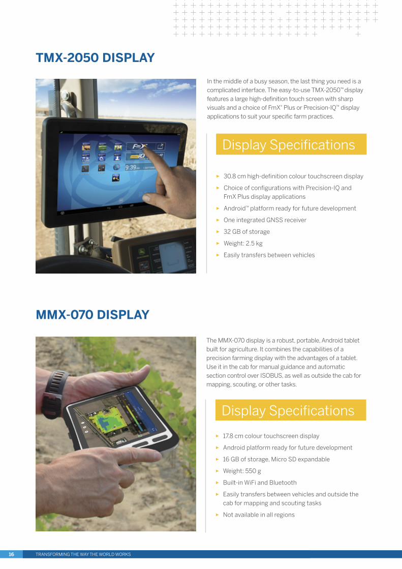
The MMX-070 display is a robust, portable, Android tablet built for agriculture. It combines the capabilities of a precision farming display with the advantages of a tablet. Use it in the cab for manual guidance and automatic section control over ISOBUS, as well as outside the cab for mapping, scouting, or other tasks.
► 17.8 cm colour touchscreen display
► Android platform ready for future development
► 16 GB of storage, Micro SD expandable
► Weight: 550 g
► Built-in WiFi and Bluetooth
► Easily transfers between vehicles and outside the cab for mapping and scouting tasks
► Not available in all regions
Display Specifications
MMX-070 DISPLAY
In the middle of a busy season, the last thing you need is a complicated interface. The easy-to-use TMX-2050™ display features a large high-definition touch screen with sharp visuals and a choice of FmX® Plus or Precision-IQ™ display applications to suit your specific farm practices.
► 30.8 cm high-definition colour touchscreen display
► Choice of configurations with Precision-IQ and FmX Plus display applications
► Android™ platform ready for future development
► One integrated GNSS receiver
► 32 GB of storage
► Weight: 2.5 kg
► Easily transfers between vehicles
Display Specifications
TMX-2050 DISPLAY
TRANSFORMING THE WAY THE WORLD WORKS16
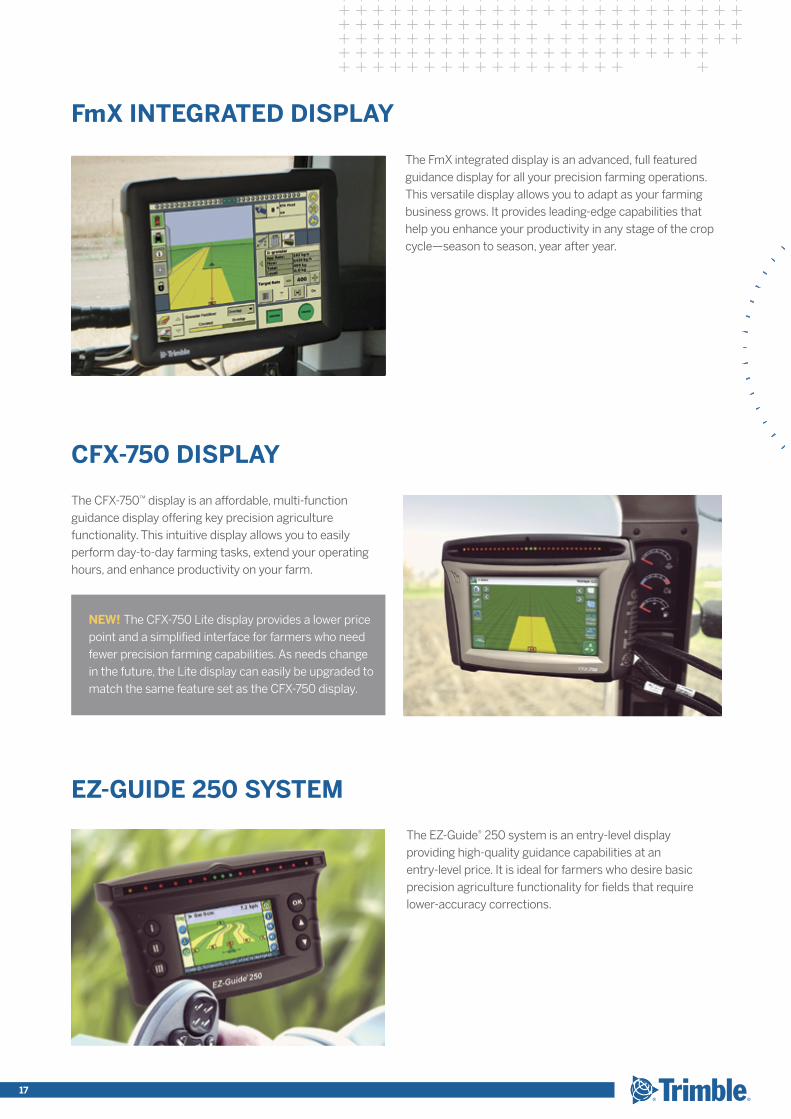
The FmX integrated display is an advanced, full featured guidance display for all your precision farming operations. This versatile display allows you to adapt as your farming business grows. It provides leading-edge capabilities that help you enhance your productivity in any stage of the crop cycle—season to season, year after year.
The EZ-Guide® 250 system is an entry-level display providing high-quality guidance capabilities at an entry-level price. It is ideal for farmers who desire basic precision agriculture functionality for fields that require lower-accuracy corrections.
FmX INTEGRATED DISPLAY
EZ-GUIDE 250 SYSTEM
CFX-750 DISPLAY
The CFX-750™ display is an affordable, multi-function guidance display offering key precision agriculture functionality. This intuitive display allows you to easily perform day-to-day farming tasks, extend your operating hours, and enhance productivity on your farm.
NEW! The CFX-750 Lite display provides a lower price point and a simplified interface for farmers who need fewer precision farming capabilities. As needs change in the future, the Lite display can easily be upgraded to match the same feature set as the CFX-750 display.
17
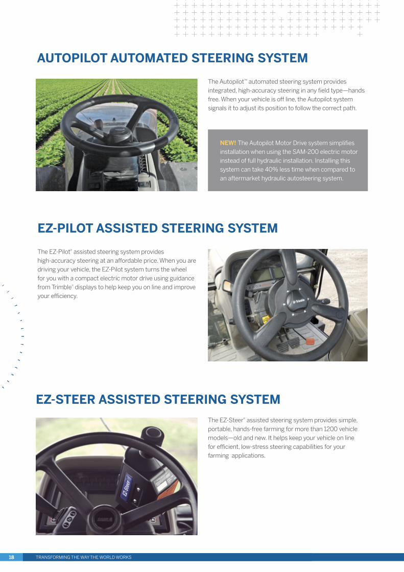
AUTOPILOT AUTOMATED STEERING SYSTEM
The EZ-Pilot® assisted steering system provides high-accuracy steering at an affordable price. When you are driving your vehicle, the EZ-Pilot system turns the wheel for you with a compact electric motor drive using guidance from Trimble® displays to help keep you on line and improve your efficiency.
EZ-PILOT ASSISTED STEERING SYSTEM
The EZ-Steer® assisted steering system provides simple, portable, hands-free farming for more than 1200 vehicle models—old and new. It helps keep your vehicle on line for efficient, low-stress steering capabilities for your farming applications.
EZ-STEER ASSISTED STEERING SYSTEM
NEW! The Autopilot Motor Drive system simplifies installation when using the SAM-200 electric motor instead of full hydraulic installation. Installing this system can take 40% less time when compared to an aftermarket hydraulic autosteering system.
The Autopilot™ automated steering system provides integrated, high-accuracy steering in any field type—hands free. When your vehicle is off line, the Autopilot system signals it to adjust its position to follow the correct path.
TRANSFORMING THE WAY THE WORLD WORKS18
The TrueTracker™ implement steering system is an active implement guidance system that keeps your tractor and implement on the same guidance line.
► Provides high-accuracy control on difficult terrain with terrain compensation technology on the implement
The TrueGuide™ implement guidance system is a passive implement guidance system that monitors and corrects the position of your implement by moving the tractor.
► Low-cost solution best suited for cereal crop farming applications
TRUETRACKER & TRUEGUIDE STEERING SYSTEMS
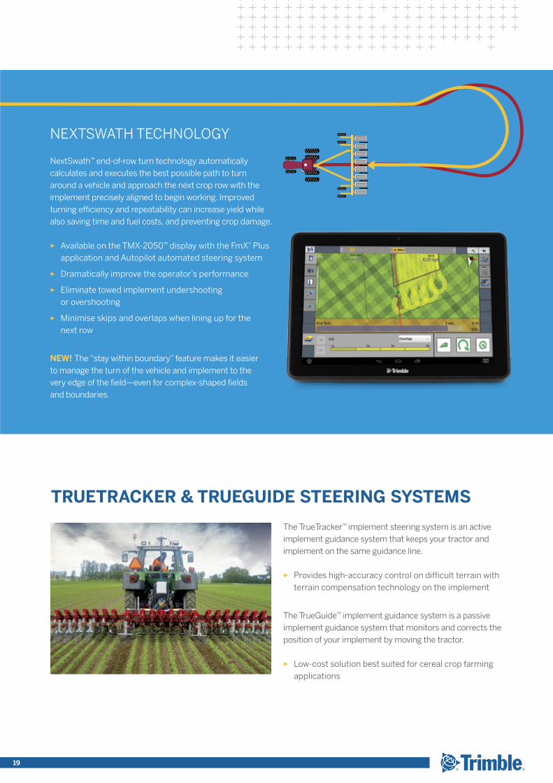
NEXTSWATH TECHNOLOGY
NextSwath™ end-of-row turn technology automatically calculates and executes the best possible path to turn around a vehicle and approach the next crop row with the implement precisely aligned to begin working. Improved turning efficiency and repeatability can increase yield while also saving time and fuel costs, and preventing crop damage.
► Available on the TMX-2050™ display with the FmX® Plus application and Autopilot automated steering system
► Dramatically improve the operator’s performance
► Eliminate towed implement undershooting or overshooting
► Minimise skips and overlaps when lining up for the next row
NEW! The “stay within boundary” feature makes it easier to manage the turn of the vehicle and implement to the very edge of the field—even for complex-shaped fields and boundaries.
19
xFILL IS INCLUDED WITH ALL RTK-BASED TECHNOLOGY!
► Increase your uptime by receiving supplemental Trimble xFill™ signals when an RTK or VRS signal is lost
► Up to 20 minutes of extended RTK operation keeps users in the field longer with fewer interruptions
CENTERPOINT RTK
Accuracy < 2.5 cm
Initialisation/Convergence < 1 min
Receive the highest accuracy correction service within 12.87 km of an established RTK base station or base station network. Add a Trimble® RTK base station as part of a network or as a single mobile base station for on-farm use.
CENTERPOINT VRS™
Accuracy < 2.5 cm
Initialisation/Convergence Instant
► Instant access to real time kinematic (RTK) corrections
► Centimeter-level RTK accuracy
► Built-in redundancy
► No base station required
RTK-BASED TECHNOLOGY
Trimble has been the leader in the GPS industry for over 30 years. Our correction services are second-to-none, and are the backbone of every precision agriculture solution we offer. Substantial increases in yield can be achieved by using any level of correction, from sub-meter to 2.5 cm. No matter where you are located or the size of your operation, Trimble has a correction service solution for your farm.
► Range of correction services to meet all your precision agriculture needs based on crop, terrain and location
► Save time, fuel and money and increase output
► Receive accurate, high-performance positioning no matter where you are located
CORRECTION SERVICES
TRANSFORMING THE WAY THE WORLD WORKS20
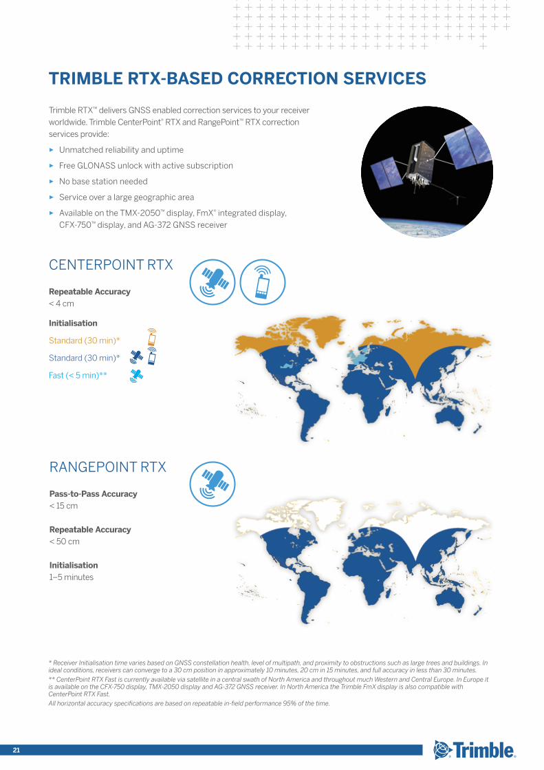
Trimble RTX™ delivers GNSS enabled correction services to your receiver worldwide. Trimble CenterPoint® RTX and RangePoint™ RTX correction services provide:
► Unmatched reliability and uptime
► Free GLONASS unlock with active subscription
► No base station needed
► Service over a large geographic area
► Available on the TMX-2050™ display, FmX® integrated display, CFX-750™ display, and AG-372 GNSS receiver
TRIMBLE RTX-BASED CORRECTION SERVICES
RANGEPOINT RTX
Pass-to-Pass Accuracy < 15 cm
Repeatable Accuracy< 50 cm
Initialisation1–5 minutes
CENTERPOINT RTX
Repeatable Accuracy < 4 cm
Initialisation
Standard (30 min)*
Standard (30 min)*
Fast (< 5 min)**
* Receiver Initialisation time varies based on GNSS constellation health, level of multipath, and proximity to obstructions such as large trees and buildings. In ideal conditions, receivers can converge to a 30 cm position in approximately 10 minutes, 20 cm in 15 minutes, and full accuracy in less than 30 minutes.
** CenterPoint RTX Fast is currently available via satellite in a central swath of North America and throughout much Western and Central Europe. In Europe it is available on the CFX-750 display, TMX-2050 display and AG-372 GNSS receiver. In North America the Trimble FmX display is also compatible with CenterPoint RTX Fast.
All horizontal accuracy specifications are based on repeatable in-field performance 95% of the time.
21
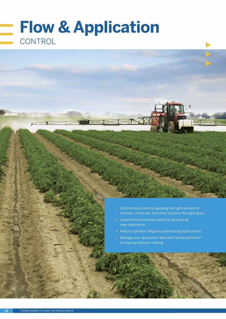
► Control input costs by applying the right amount of fertiliser, chemicals, and other inputs in the right place
► Lessen environmental impact by decreasing over-application
► Reduce operator fatigue by automating applications
► Manage your application data with Connected Farm™ to improve decision making
Flow & ApplicationCONTROL
TRANSFORMING THE WAY THE WORLD WORKS22
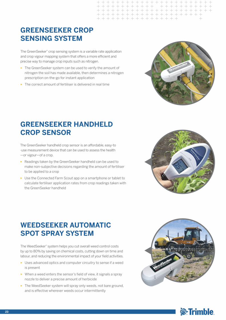
The GreenSeeker® crop sensing system is a variable rate application and crop vigour mapping system that offers a more efficient and precise way to manage crop inputs such as nitrogen.
► The GreenSeeker system can be used to verify the amount of nitrogen the soil has made available, then determines a nitrogen prescription on-the-go for instant application
► The correct amount of fertiliser is delivered in real time
The WeedSeeker® system helps you cut overall weed control costs by up to 80% by saving on chemical costs, cutting down on time and labour, and reducing the environmental impact of your field activities.
► Uses advanced optics and computer circuitry to sense if a weed is present
► When a weed enters the sensor’s field of view, it signals a spray nozzle to deliver a precise amount of herbicide
► The WeedSeeker system will spray only weeds, not bare ground, and is effective wherever weeds occur intermittently
The GreenSeeker handheld crop sensor is an affordable, easy-to -use measurement device that can be used to assess the health —or vigour—of a crop.
► Readings taken by the GreenSeeker handheld can be used to make non-subjective decisions regarding the amount of fertiliser to be applied to a crop
► Use the Connected Farm Scout app on a smartphone or tablet to calculate fertiliser application rates from crop readings taken with the GreenSeeker handheld
GREENSEEKER CROP SENSING SYSTEM
GREENSEEKER HANDHELD CROP SENSOR
WEEDSEEKER AUTOMATIC SPOT SPRAY SYSTEM
TRANSFORMING THE WAY THE WORLD WORKS 23

FIELD-IQ CROP INPUT CONTROL SYSTEM
Trimble’s Field-IQ™ crop input control system is a section control and variable rate application control system that prevents seed and fertiliser overlap, controls the rate of material applications, monitors seed delivery or fertiliser blockage, and controls the height of spray booms. The Field-IQ system runs on the TMX-2050™ display, FmX® integrated display, and CFX-750™ display. Each of these displays supports a different combination of Field-IQ functionality—giving you the ability to choose the interface option that fits your needs.
► As-applied mapping records where you’ve applied inputs and automates record keeping
► Adjust your seed population, fertiliser rates, or spray application manually or automatically using a prescription created with Farm Works Software® (desktop) solutions or Connected Farm™ Advisor (web) solutions
► Automatically control spinner speed of spreader application systems to evenly distribute nutrients
► Simultaneously control the application rate of up to six different materials when using the TMX-2050 display or FmX integrated display, including seed, granular seed, granular fertiliser, liquid, and anhydrous ammonia in different combinations
► Two material rate control capability when using the CFX-750 display, and single material rate control when using the TMX-2050 display for spraying
► Variable rate control of materials can be achieved with a prescription VRA map or in real time with a GreenSeeker® system for more efficient fertiliser utilisation
VARIABLE RATE APPLICATION CONTROL
TRANSFORMING THE WAY THE WORLD WORKS24
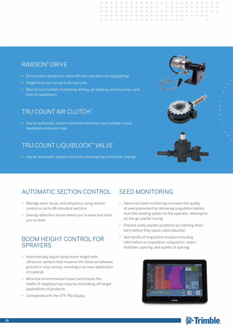
SEED MONITORING
► Advanced seed monitoring increases the quality of seed placement by delivering singulation details from the seeding system to the operator, allowing for on-the-go planter tuning
► Prevent costly planter problems by catching them early before they cause yield reduction
► See results of singulation analysis including information on population, singulation, skips/multiples, spacing, and quality of spacing
AUTOMATIC SECTION CONTROL
► Manage seed, liquid, and anhydrous using section control on up to 48 individual sections
► Overlap detection shows where you’ve been and what you’ve done
BOOM HEIGHT CONTROL FOR SPRAYERS
► Automatically adjust spray boom height with ultrasonic sensors that measure the distance between ground or crop canopy, resulting in an even application of material
► Minimise environmental impact and ensure the health of neighbouring crops by eliminating off-target applications of products
► Compatible with the CFX-750 display
RAWSON® DRIVE
► Drives piston pumps for more efficient operation during planting
► Single drive can run up to 24 row units
► Mounts to a number of planting, drilling, air seeding, piston pumps, and strip till applicators
TRU COUNT AIR CLUTCH®
► Use for automatic section control to eliminate seed overlap in your headlands and point rows
TRU COUNT LIQUIBLOCK™ VALVE
► Use for automatic section control to eliminate liquid fertiliser overlap
25
HarvestSOLUTIONS
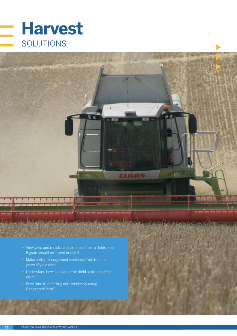
► View yield and moisture data in real time to determine if grain should be stored or dried
► Make better management decisions from multiple years of yield data
► Understand how seed and other field activities affect yield
► Save time transferring data wirelessly using Connected Farm™
TRANSFORMING THE WAY THE WORLD WORKS26
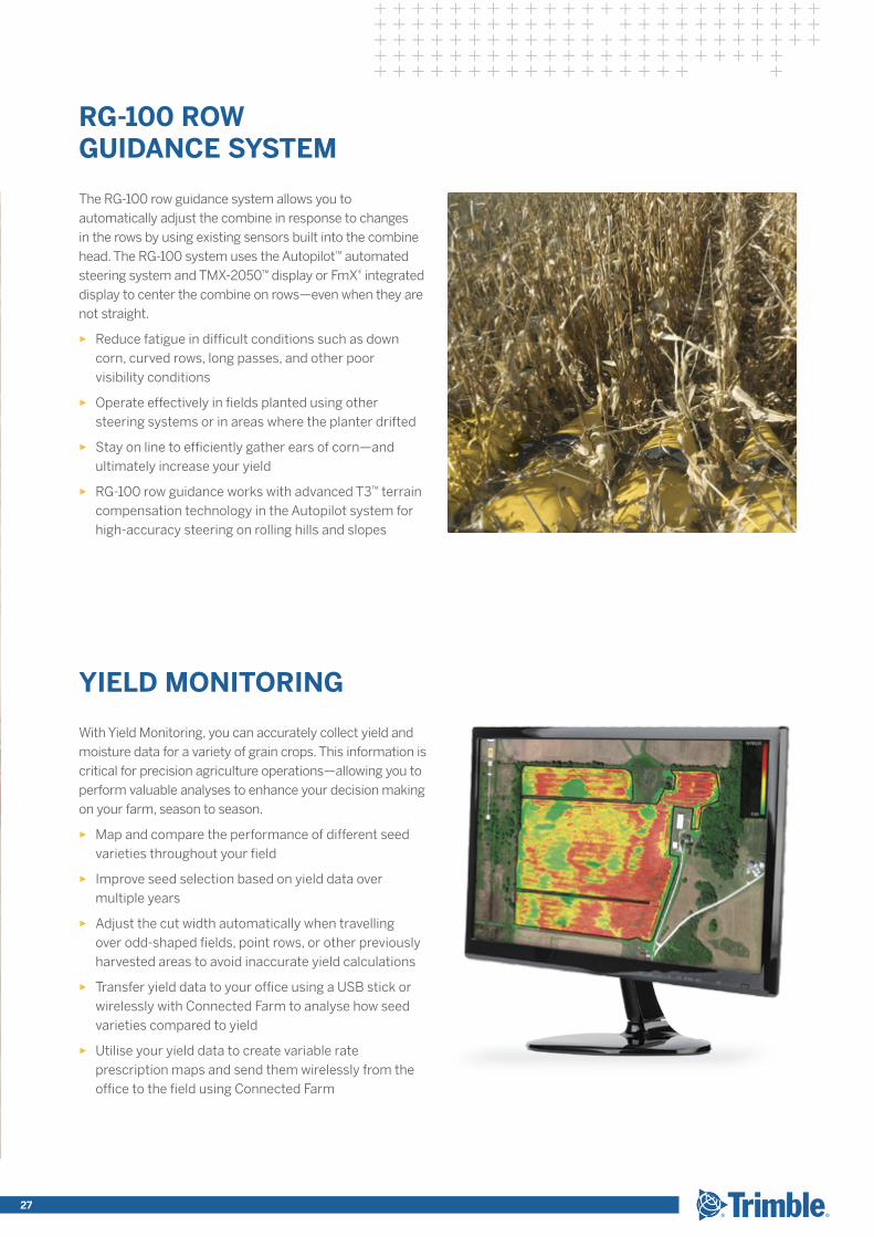
The RG-100 row guidance system allows you to automatically adjust the combine in response to changes in the rows by using existing sensors built into the combine head. The RG-100 system uses the Autopilot™ automated steering system and TMX-2050™ display or FmX® integrated display to center the combine on rows—even when they are not straight.
► Reduce fatigue in difficult conditions such as down corn, curved rows, long passes, and other poor visibility conditions
► Operate effectively in fields planted using other steering systems or in areas where the planter drifted
► Stay on line to efficiently gather ears of corn—and ultimately increase your yield
► RG-100 row guidance works with advanced T3™ terrain compensation technology in the Autopilot system for high-accuracy steering on rolling hills and slopes
With Yield Monitoring, you can accurately collect yield and moisture data for a variety of grain crops. This information is critical for precision agriculture operations—allowing you to perform valuable analyses to enhance your decision making on your farm, season to season.
► Map and compare the performance of different seed varieties throughout your field
► Improve seed selection based on yield data over multiple years
► Adjust the cut width automatically when travelling over odd-shaped fields, point rows, or other previously harvested areas to avoid inaccurate yield calculations
► Transfer yield data to your office using a USB stick or wirelessly with Connected Farm to analyse how seed varieties compared to yield
► Utilise your yield data to create variable rate prescription maps and send them wirelessly from the office to the field using Connected Farm
RG-100 ROW GUIDANCE SYSTEM
YIELD MONITORING
TRANSFORMING THE WAY THE WORLD WORKS 27
► Make every drop count by responsibly utilising precious water resources
► Apply the right amount of water where your crop needs it to improve quality and yield
► Optimise the field surface in preparation for optimal water distribution
► Benefit from Trimble’s 30+ years of water management experience
WaterSOLUTIONS
TRANSFORMING THE WAY THE WORLD WORKS28
► Open up more hectares to be farmed
► Enable optimal water distribution and drainage
► Minimise disturbance of valuable topsoil
► Reduce erosion and minimise flooding by effectively channelling water in the right direction
► Create more uniform production and increase yield
► Minimise the amount of earthworks and reduce land forming time and costs
Benefits
WM-FORM LAND FORMING SOLUTION
Flexible Designs
The WM-Form software enables you to design variable-shaped fields based on existing topography, the water needs of individual crops, and your own farming practices.
► Level fields with single or multiple planes using a best-fit or custom plane, or with multiple hinges
► Drain water in any direction or to a linear feature such as a ditch or existing drainage system
► Create multi-direction variable slope designs to optimise the surface for furrow irrigation
Leverage your 3D design created in the WM-Form software to form the field using the FieldLevel™ II system—and improve the performance of your crops.
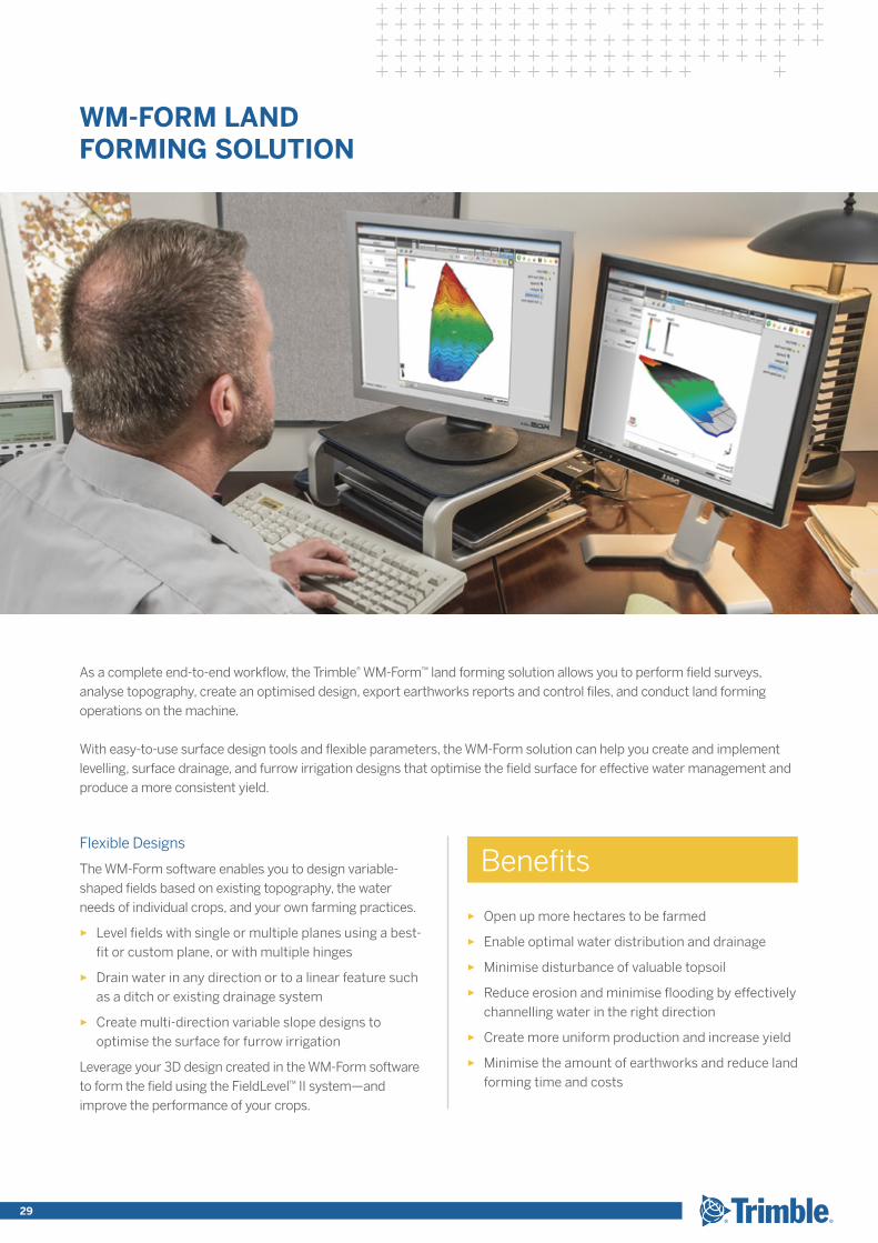
As a complete end-to-end workflow, the Trimble® WM-Form™ land forming solution allows you to perform field surveys, analyse topography, create an optimised design, export earthworks reports and control files, and conduct land forming operations on the machine.
With easy-to-use surface design tools and flexible parameters, the WM-Form solution can help you create and implement levelling, surface drainage, and furrow irrigation designs that optimise the field surface for effective water management and produce a more consistent yield.
TRANSFORMING THE WAY THE WORLD WORKS 29
The FieldLevel™ II system utilises lessons learned from more than 30+ years of industry leadership in high-precision GNSS applications and land levelling. The FieldLevel II system streamlines the survey, design, and grading steps required for land levelling and land forming.
LAND Levelling
Survey
Map your fields with RTK measurements and create boundaries, interior points, and sections.
Design
Use WM-Form™ software to optimise land levelling designs or create a best-fit surface using Autoplane technology.
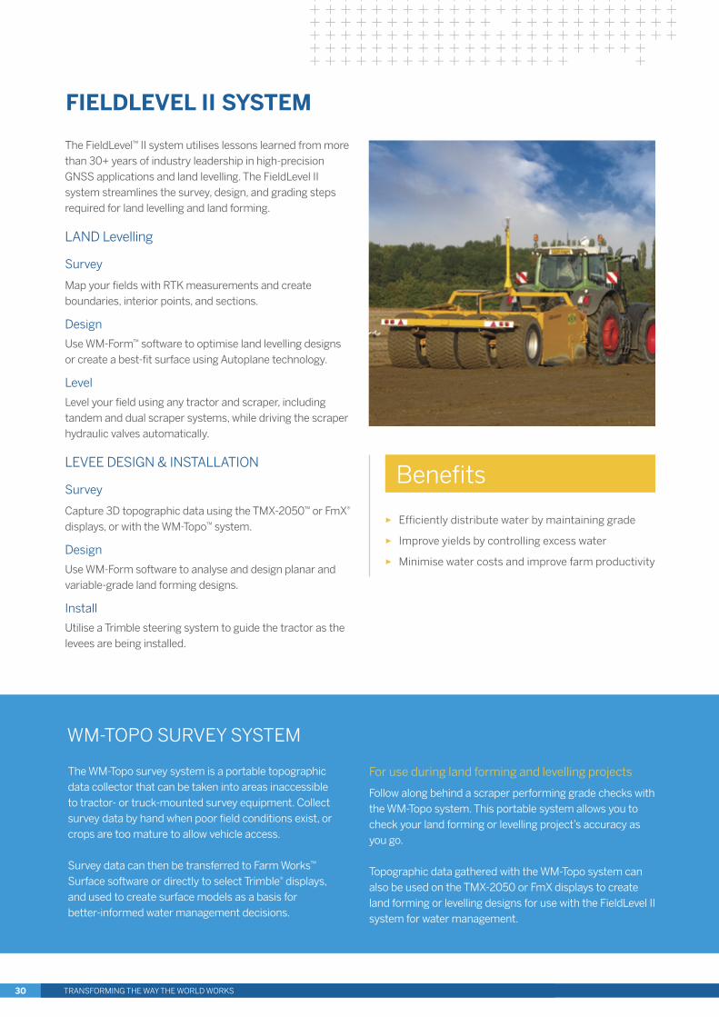
Level
Level your field using any tractor and scraper, including tandem and dual scraper systems, while driving the scraper hydraulic valves automatically.
LEVEE DESIGN & INSTALLATION
Survey
Capture 3D topographic data using the TMX-2050™ or FmX® displays, or with the WM-Topo™ system.
Design
Use WM-Form software to analyse and design planar and variable-grade land forming designs.
Install
Utilise a Trimble steering system to guide the tractor as the levees are being installed.
FIELDLEVEL II SYSTEM
WM-TOPO SURVEY SYSTEM
For use during land forming and levelling projects
Follow along behind a scraper performing grade checks with the WM-Topo system. This portable system allows you to check your land forming or levelling project’s accuracy as you go.
Topographic data gathered with the WM-Topo system can also be used on the TMX-2050 or FmX displays to create land forming or levelling designs for use with the FieldLevel II system for water management.
► Efficiently distribute water by maintaining grade
► Improve yields by controlling excess water
► Minimise water costs and improve farm productivity
Benefits
The WM-Topo survey system is a portable topographic data collector that can be taken into areas inaccessible to tractor- or truck-mounted survey equipment. Collect survey data by hand when poor field conditions exist, or crops are too mature to allow vehicle access.
Survey data can then be transferred to Farm Works™ Surface software or directly to select Trimble® displays, and used to create surface models as a basis for better-informed water management decisions.
TRANSFORMING THE WAY THE WORLD WORKS30
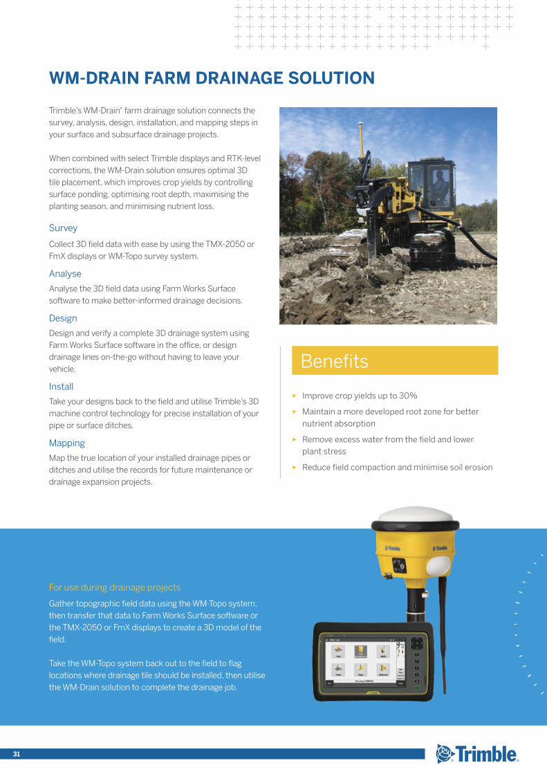
Trimble’s WM-Drain® farm drainage solution connects the survey, analysis, design, installation, and mapping steps in your surface and subsurface drainage projects.
When combined with select Trimble displays and RTK-level corrections, the WM-Drain solution ensures optimal 3D tile placement, which improves crop yields by controlling surface ponding, optimising root depth, maximising the planting season, and minimising nutrient loss.
Survey
Collect 3D field data with ease by using the TMX-2050 or FmX displays or WM-Topo survey system.
Analyse
Analyse the 3D field data using Farm Works Surface software to make better-informed drainage decisions.
Design
Design and verify a complete 3D drainage system using Farm Works Surface software in the office, or design drainage lines on-the-go without having to leave your vehicle.
Install
Take your designs back to the field and utilise Trimble’s 3D machine control technology for precise installation of your pipe or surface ditches.
Mapping
Map the true location of your installed drainage pipes or ditches and utilise the records for future maintenance or drainage expansion projects.
WM-DRAIN FARM DRAINAGE SOLUTION
► Improve crop yields up to 30%
► Maintain a more developed root zone for better nutrient absorption
► Remove excess water from the field and lower plant stress
► Reduce field compaction and minimise soil erosion
Benefits
For use during drainage projects
Gather topographic field data using the WM-Topo system, then transfer that data to Farm Works Surface software or the TMX-2050 or FmX displays to create a 3D model of the field.
Take the WM-Topo system back out to the field to flag locations where drainage tile should be installed, then utilise the WM-Drain solution to complete the drainage job.
31
► Improve crop quality and yield
► Optimise water resources and water use efficiency
► Minimise input costs of water, fertigation, or effluent
► Reduce energy costs for fuel and electricity
► Ensure even application to reduce run-off and leaching
► Reduce trips to the field
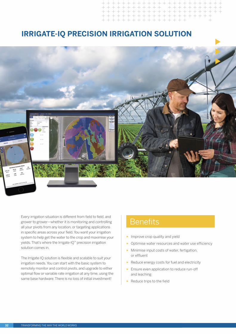
Every irrigation situation is different from field to field, and grower to grower—whether it is monitoring and controlling all your pivots from any location, or targeting applications in specific areas across your field. You want your irrigation system to help get the water to the crop and maximise your yields. That’s where the Irrigate-IQ™ precision irrigation solution comes in.
The Irrigate-IQ solution is flexible and scalable to suit your irrigation needs. You can start with the basic system to remotely monitor and control pivots, and upgrade to either optimal flow or variable rate irrigation at any time, using the same base hardware. There is no loss of initial investment!
Benefits
IRRIGATE-IQ PRECISION IRRIGATION SOLUTION
TRANSFORMING THE WAY THE WORLD WORKS32

IRRIGATE-IQ MONITOR AND CONTROL
Monitor and control your irrigation system from any computer, smart phone, or tablet—so you don’t have to waste time going out to the field.
► Use any device to remotely monitor and control your irrigation systems
► Utilise the system on mixed fleets and view status information all in one place
► Receive text alerts about pivot status to provide confidence it is operating as expected
► Easily upgrade to variable rate irrigation or optimal flow as needs require
IRRIGATE-IQ OPTIMAL FLOW
Incorporate no spray areas within your irrigation plan, even if you do not have a variable frequency drive irrigation pump, while keeping the pressure regulated across the pivot.
► Employ no spray areas to focus water resources on areas that need it
► Ensure pressure and flow rate are within optimal, safe ranges
► Reduce the risk of damaging equipment due to significant pressure changes
► Utilise standard pump equipment that you already own
IRRIGATE-IQ VARIABLE RATE IRRIGATION
Perform highly targeted application of water, fertigation, or effluent by varying the rate of application across your pivot.
► Create VRI plans that compensate for variations across the field
► Manage exclusion zones to ensure water is not being wasted in areas that don’t need it
► Control individual nozzles to apply the right depth in the right spot
► Meet environmental regulations by controlling and reporting on where and how much you irrigate
33
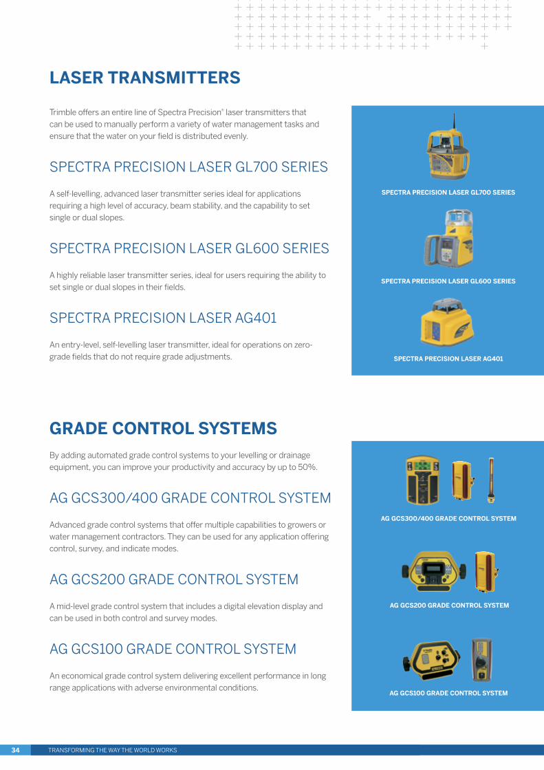
LASER TRANSMITTERS
Trimble offers an entire line of Spectra Precision® laser transmitters that can be used to manually perform a variety of water management tasks and ensure that the water on your field is distributed evenly.
SPECTRA PRECISION LASER GL700 SERIES
A self-levelling, advanced laser transmitter series ideal for applications requiring a high level of accuracy, beam stability, and the capability to set single or dual slopes.
SPECTRA PRECISION LASER GL600 SERIES
A highly reliable laser transmitter series, ideal for users requiring the ability to set single or dual slopes in their fields.
SPECTRA PRECISION LASER AG401
An entry-level, self-levelling laser transmitter, ideal for operations on zero-grade fields that do not require grade adjustments.
AG GCS200 GRADE CONTROL SYSTEM
AG GCS100 GRADE CONTROL SYSTEM
AG GCS300/400 GRADE CONTROL SYSTEM
SPECTRA PRECISION LASER GL600 SERIES
SPECTRA PRECISION LASER GL700 SERIES
SPECTRA PRECISION LASER AG401
GRADE CONTROL SYSTEMS By adding automated grade control systems to your levelling or drainage equipment, you can improve your productivity and accuracy by up to 50%.
AG GCS300/400 GRADE CONTROL SYSTEM
Advanced grade control systems that offer multiple capabilities to growers or water management contractors. They can be used for any application offering control, survey, and indicate modes.
AG GCS200 GRADE CONTROL SYSTEM
A mid-level grade control system that includes a digital elevation display and can be used in both control and survey modes.
AG GCS100 GRADE CONTROL SYSTEM
An economical grade control system delivering excellent performance in long range applications with adverse environmental conditions.
TRANSFORMING THE WAY THE WORLD WORKS34

Reseller NetworkWORLDWIDE
► Products and services supported by the best reseller network in the industry
► Available in more than 130 countries
► On-the-spot attention backed by the Trimble support team—24 hours a day, 7 days a week
► Find your local reseller today by visiting http://dealerlocator.trimble.com
35
Trimble Agriculture solutions enable you to maximise efficiency and reduce chemical and fertiliser inputs while also protecting natural resources and the environment. Trimble’s precision agriculture solutions cover all seasons, crops, terrains, and farm sizes, and its brand-agnostic strategy allows you to use Trimble products on most vehicles in your fleet—regardless of manufacturer. To enable better decision making, Trimble offers the Connected Farm™ solution which allows you to collect, share, and manage information across your farm in real time. To optimise water use, Trimble provides water solutions for irrigation, drainage, and land levelling. Trimble’s product suite includes vehicle and implement guidance and steering, as well as a portfolio of correction options that are the most versatile of their kind in the industry. Additional solutions include an unmanned aircraft system (UAS) for aerial imaging and mapping; agri-services; application control for seed, liquid, and granular products; a harvest solution; and farm management software.
For more information visit www.trimble.com/agriculture, or contact your local reseller.
About Trimble Agriculture
TRIMBLE AGRICULTURE DIVISION10368 Westmoor DriveWestminster, CO 80021USA+1-720-887-6100 Phone+1-720-887-6101 Fax
TRIMBLE NAVIGATION LIMITEDCorporate Headquarters935 Stewart DriveSunnyvale, CA 94085USA+1-408-481-8000 Phone+1-408-481-7740 Fax
Contact your Trimble Ag Reseller today
© 2005–2016, Trimble Navigation Limited. All rights reserved. Trimble, the Globe & Triangle logo, CenterPoint, EZ-Guide, EZ-Pilot, EZ-Steer, Farm Works Software, FmX, GreenSeeker, RainWave, Rawson, Spectra Precision, Tru Count Air Clutch, WeedSeeker, and WM-Drain are trademarks of Trimble Navigation Limited, registered in the United States and in other countries. Autopilot, CFX-750, Connected Farm, Farm Works, Field-IQ, FieldLevel, Irrigate-IQ, NextSwath, Precision-IQ, PurePixel, RangePoint, Soil Information System, T3, TMX-2050, Tru Count LiquiBlock, TrueGuide, TrueTracker, VRS, WM-Form, WM-Topo, and xFill are trademarks of Trimble Navigation Limited. Android is a trademark of Google Inc. Apple, the Apple logo, iPad, iPhone, and iPod touch are trademarks of Apple Inc., registered in the U.S. and other countries. App Store is a service mark of Apple Inc. Google Play is a trademark of Google Inc. Microsoft, and Windows are either registered trademarks or trademarks of Microsoft Corporation in the United States and/or other countries. All other trademarks are the property of their respective owners. PN 022503-078K-1-UK (03/16)
TRANSFORMING THE WAY THE WORLD WORKS
FOLLOW US ON:
TRIMBLE GERMANY GMBHAm Prime Parc 1165479 RaunheimGERMANY+49-6142-2100-0 Phone+49-6142-2100-140 Fax