Embed Size (px)
Citation preview

Trimble
Marine Construction Systems
A Complete Solution for Marine Construction
TRANSFORMING THE WAY THE WORLD WORKS
2
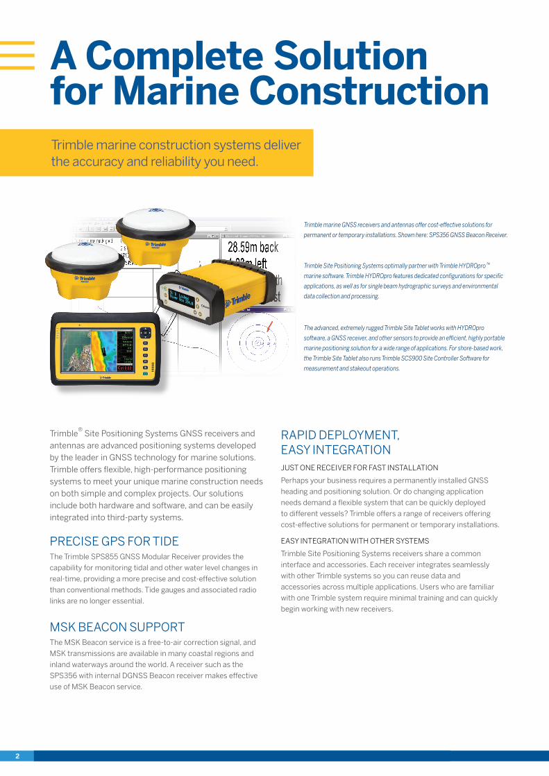
Trimble marine construction systems deliver the accuracy and reliability you need.
A Complete Solutionfor Marine Construction
Trimble® Site Positioning Systems GNSS receivers and antennas are advanced positioning systems developed by the leader in GNSS technology for marine solutions. Trimble offers flexible, high-performance positioning systems to meet your unique marine construction needs on both simple and complex projects. Our solutions include both hardware and software, and can be easily integrated into third-party systems.
PRECISE GPS FOR TIDEThe Trimble SPS855 GNSS Modular Receiver provides the
capability for monitoring tidal and other water level changes in
real-time, providing a more precise and cost-effective solution
than conventional methods. Tide gauges and associated radio
links are no longer essential.
MSK BEACON SUPPORTThe MSK Beacon service is a free-to-air correction signal, and
MSK transmissions are available in many coastal regions and
inland waterways around the world. A receiver such as the
SPS356 with internal DGNSS Beacon receiver makes effective
use of MSK Beacon service.
RAPID DEPLOYMENT, EASY INTEGRATIONJUST ONE RECEIVER FOR FAST INSTALLATION
Perhaps your business requires a permanently installed GNSS
heading and positioning solution. Or do changing application
needs demand a flexible system that can be quickly deployed
to different vessels? Trimble offers a range of receivers offering
cost-effective solutions for permanent or temporary installations.
EASY INTEGRATION WITH OTHER SYSTEMS
Trimble Site Positioning Systems receivers share a common
interface and accessories. Each receiver integrates seamlessly
with other Trimble systems so you can reuse data and
accessories across multiple applications. Users who are familiar
with one Trimble system require minimal training and can quickly
begin working with new receivers.
The advanced, extremely rugged Trimble Site Tablet works with HYDROpro
software, a GNSS receiver, and other sensors to provide an efficient, highly portable
marine positioning solution for a wide range of applications. For shore-based work,
the Trimble Site Tablet also runs Trimble SCS900 Site Controller Software for
measurement and stakeout operations.
Trimble marine GNSS receivers and antennas offer cost-effective solutions for
permanent or temporary installations. Shown here: SPS356 GNSS Beacon Receiver.
Trimble Site Positioning Systems optimally partner with Trimble HYDROpro™
marine software. Trimble HYDROpro features dedicated configurations for specific
applications, as well as for single beam hydrographic surveys and environmental
data collection and processing.

A Complete Solutionfor Marine Construction
HIGH-PRECISION HEADING… FASTDUAL FREQUENCY ANTENNAS: KEY TO PRECISION, FLEXIBILITY
The Trimble SPS361 and SPS461 DGPS Heading Receivers with
MSK Beacon are modular, dual-frequency solutions employing
separate plug-in dual-frequency antennas. This antenna
configuration offers significant benefits over single-frequency
and fixed baseline systems:XX More precise GNSS heading—flexible antenna separation
enables users to maximize precision.XX Dual-frequency ensures faster initialization and re-acquisition
of satellites.
EASILY DETERMINE THE POSITION OF OTHER SENSORS ON A VESSELONE SYSTEM DELIVERS POSITION, HEADING, AND ATTITUDE
The dual antennas of the Trimble
GNSS receivers provide vessel
position, heading, and pitch or roll.
So just one cost-effective system
is needed. You can then use Trimble
HYDROpro software in combination
with the receiver data and other sensors, for example, an
echosounder, to determine real-time position, heading,
and precise elevation of the target surface.
THE POSITION ACCURACY YOU NEEDFLEXIBLE, SCALABLE, UPGRADABLE
Trimble GNSS receivers provide a range of accuracy upgrades to
meet your project needs. Simply upgrade to the level of precision
you require. The portfolio of Site Positioning Systems receivers
supports the following correction types:XX Precision GNSS (RTK) base stationXX Trimble Internet Base Station Service (IBSS)XX Virtual Reference Station (VRS)XX CenterPoint RTX (for inland waterways and port applications)XX MarineSTAR VBS, XP, or HP (for inland waterways and
port applications)XX MSK Beacon (free-to-air)XX DGPS using UHF radio links (RTCM)XX Satellite-based Augmentation Systems such as WAAS,
EGNOS, MSAS, and QZSS
Corrections are accessible via internal radio, internal
demodulator, external radio, and cellular/Internet
connectivity. The Trimble TDL 450 Series Radios provide
robust UHF frequency solutions for use as repeaters or
for work at longer ranges.
Quickly and easily determine vessel position,
heading, and pitch or roll.
PUT TRIMBLE TECHNOLOGY AND EXPERIENCE TO WORKTrimble marine systems meet the demands of a wide range
of marine construction and hydrographic survey applications,
including:XX Precise placement of marine structures such as breakwaters,
bridges, caissons, piles, marina piers and coastal defencesXX Dredge vessel positioningXX Positioning and tracking of barges, tugs and other
construction vesselsXX Offshore-rig-positioning and anchor-handling applicationsXX Hydrographic surveys for applications such as channel
maintenance, dredging progress, environmental surveys,
and bed erosion
Trimble heading receivers provide precise
navigation that is vessel-centric. Marine
operators receive simple forward/back, port/
starboard, and clockwise/anti-clockwise
guidance, which allows them to position the
vessel quickly and efficiently.
Driving piles into a seabed requires great
accuracy in a harsh environment. Trimble Site
Positioning Systems utilize precision GNSS
heading sensors, and integrated software to
get the job done right.
The Trimble Site Positioning Systems
provide the 3D position of the dredge head
and displays it with the channel design.
Precise information gives marine operators
“eyes under water”, to see exactly where
material should be dredged.
Trimble Site Positioning Systems support
a diverse range of hydrographic surveys,
including port and harbor maintenance,
environmental, cable and pipe maintenance,
and buoy mooring.

Precise, rugged, and flexible positioning solutions for the most challenging environments. Talk to your local Trimble Marine distributor for more information on the system integration potential of Trimble receivers.
Trimble Marine Construction Systems
© 2016, Trimble Navigation Limited. All rights reserved. Trimble and the Globe & Triangle, Trimble and the Globe & Triangle logo are trademarks of Trimble Navigation Limited, registered in the United States and other countries. HYDROpro and Zephyr are trademarks of Trimble Navigation Limited. MarineSTAR is a trademark of Fugro. PN 022482-1623E-4 (03/16)
TRANSFORMING THE WAY THE WORLD WORKS
Trimble Civil Engineering and Construction10368 Westmoor DriveWestminster, Colorado 80021 USA800-361-1249 (Toll Free)+1-937-245-5154 [email protected]
1 * Some correction services require a certain level of precision capability and also may require a subscription. Contact your local Trimble Marine Dealer for more information.
SPS356 SPS361 SPS461 SPS555H SPS855 BX982 SPS585 SPS985
Precision Capability Precise RTK Rover O O O O O
Precise RTK Base O O
Limited Rover (10/2) O O O O O
Limited Rover (10/10) O O O Y O
Limited Rover (30/30) Y Y Y Y O
DGPS/DGNSS Base O O
Heading/Moving Base Y Y Y O Y Y O
Frequency Single Frequency Y Y Y Y Y Y Y Y
Dual Frequency O Y Y Y Y Y
Triple Frequency O O Y O
Constellation GLONASS Y Y O Y Y O
Galileo Y Y O O Y O
BeiDou Y Y O O Y O
QZSS Y Y Y Y Y Y Y Y
SBAS Y Y Y Y Y Y Y
Correction Services* xFill Y Y Y
CenterPoint RTX Y Y Y Y
MarineSTAR VBS Y Y Y Y Y
MarineSTAR HP/XP O Y Y Y
Beacon Y Y Y
General Options Data logging O O O O O O O
1PPS Y Y Y Y Y Y
VRS/IBSS/NTRIP Y Y Y Y Y Y Y
Max Data rate 10 Hz 20 Hz 20 Hz 20 Hz 20 Hz 20 Hz 5 Hz 20 Hz
Wi-Fi Y Y Y
HYDROpro Navigation
HYDROpro Construction
Terramodel HDMS
Business Center-HCE
Navigation / Survey Y Y
Dredging Y Y
Piling Y
Rig/Barge Y
NavEdit Y Y Y
Chart Plotting Y O
Channel design Y O
Volume calculations Y Y
PRODUCTS IN THE COMPLETE MARINE SOLUTION FROM TRIMBLE
TRIMBLE SITE POSITIONING SYSTEM RECEIVERS
GA830 Zephyr™ 2Zephyr 2 Rugged
Zephyr 2 Geodetic
Beacon Y
SBAS Y Y Y Y
CenterPoint RTX (MSS) Y Y Y Y
MarineSTAR (MSS) Y Y Y Y
Dual/Triple Frequency Y Y Y Y
GLONASS Y Y Y Y
Galileo Y Y Y Y
BeiDou Y Y Y Y
QZSS Y Y Y Y
TRIMBLE ANTENNAS
HYDROpro APPLICATIONS
Y – Yes O – OptionalMSS - Mobile Satellite Services