Embed Size (px)
Citation preview
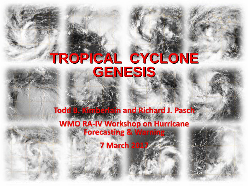
Todd B. Kimberlain and Richard J. Pasch
WMO RA-IV Workshop on Hurricane Forecasting & Warning
7 March 2017
TROPICAL CYCLONE GENESIS
Outline / Topics
• Climatology
• Large-scale conditions associated with tropical cyclone (TC) formation
• Relation to ENSO, intraseasonal variability
• Theories of genesis
• Meso-scale aspects of genesis
• TC genesis in global models
• Web sites of genesis parameters
• Operational (NHC) genesis forecasting
• Forecast exercise
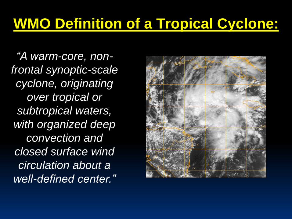
WMO Definition of a Tropical Cyclone:
“A warm-core, non-
frontal synoptic-scale
cyclone, originating
over tropical or
subtropical waters,
with organized deep
convection and
closed surface wind
circulation about a
well-defined center.”
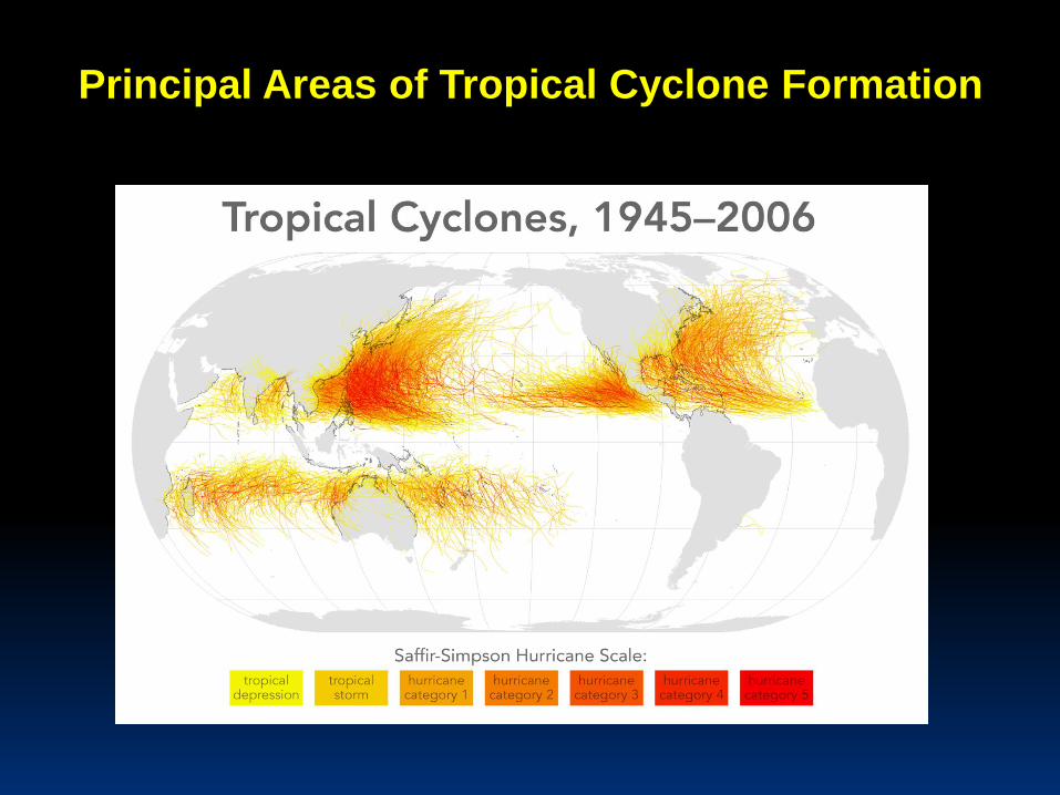
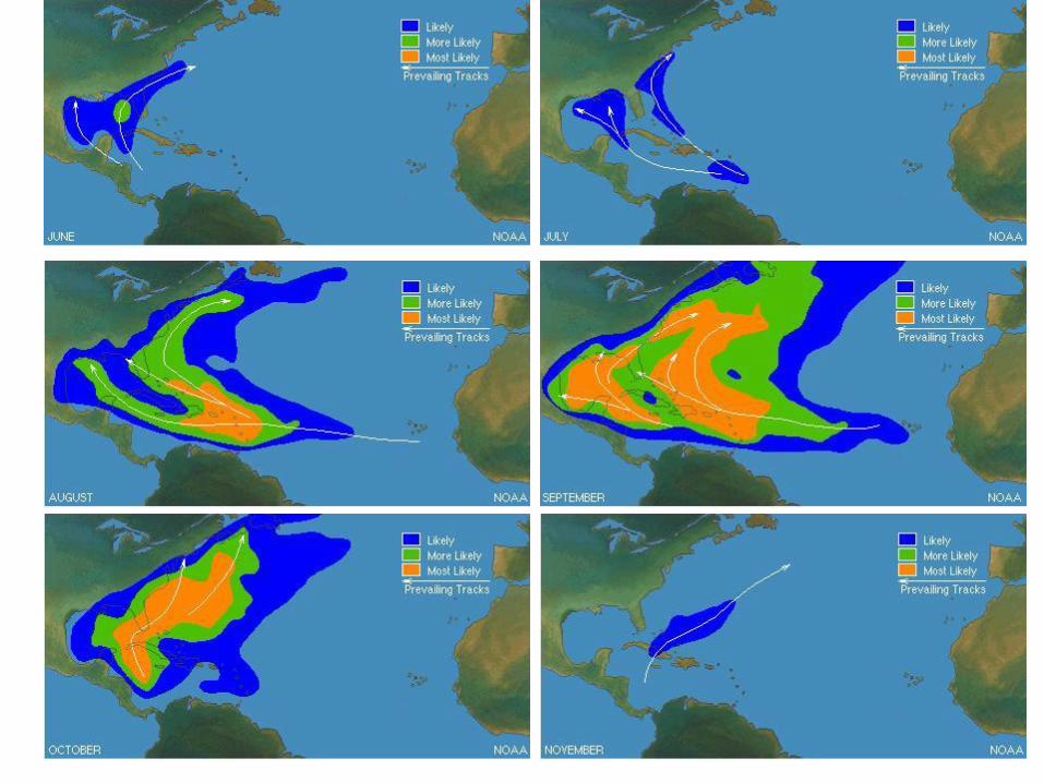
Principal Areas of Tropical Cyclone Formation
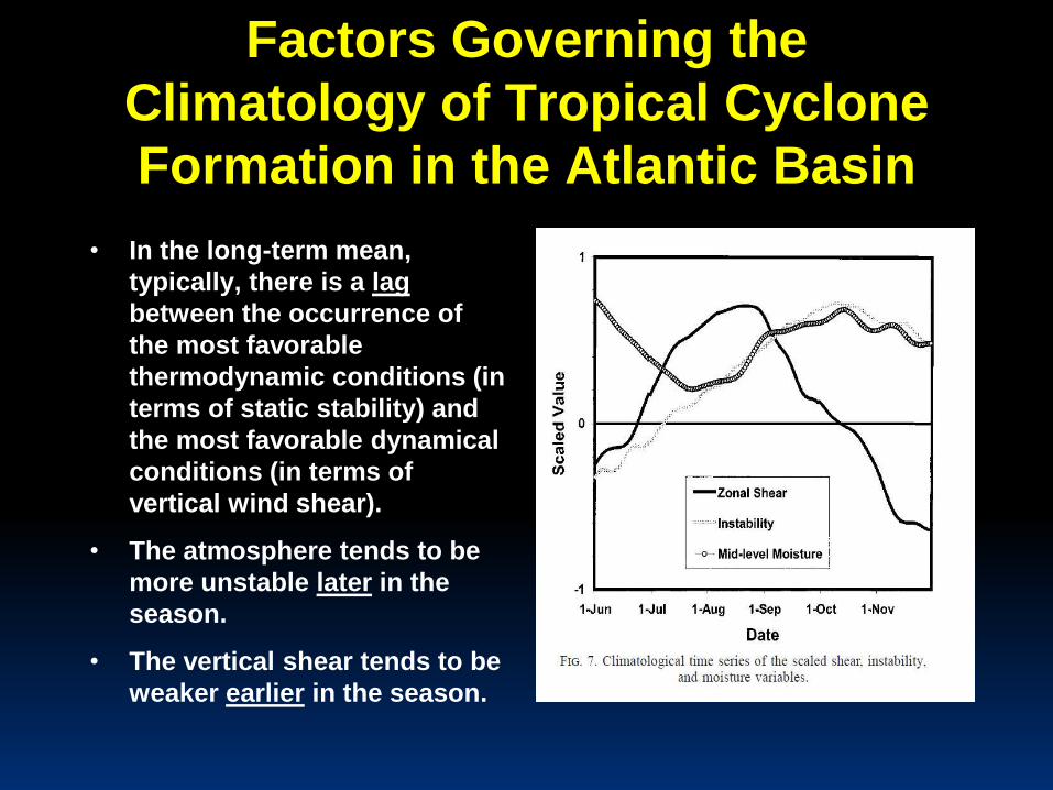
Factors Governing the
Climatology of Tropical Cyclone
Formation in the Atlantic Basin
• In the long-term mean,
typically, there is a lag
between the occurrence of
the most favorable
thermodynamic conditions (in
terms of static stability) and
the most favorable dynamical
conditions (in terms of
vertical wind shear).
• The atmosphere tends to be
more unstable later in the
season.
• The vertical shear tends to be
weaker earlier in the season.
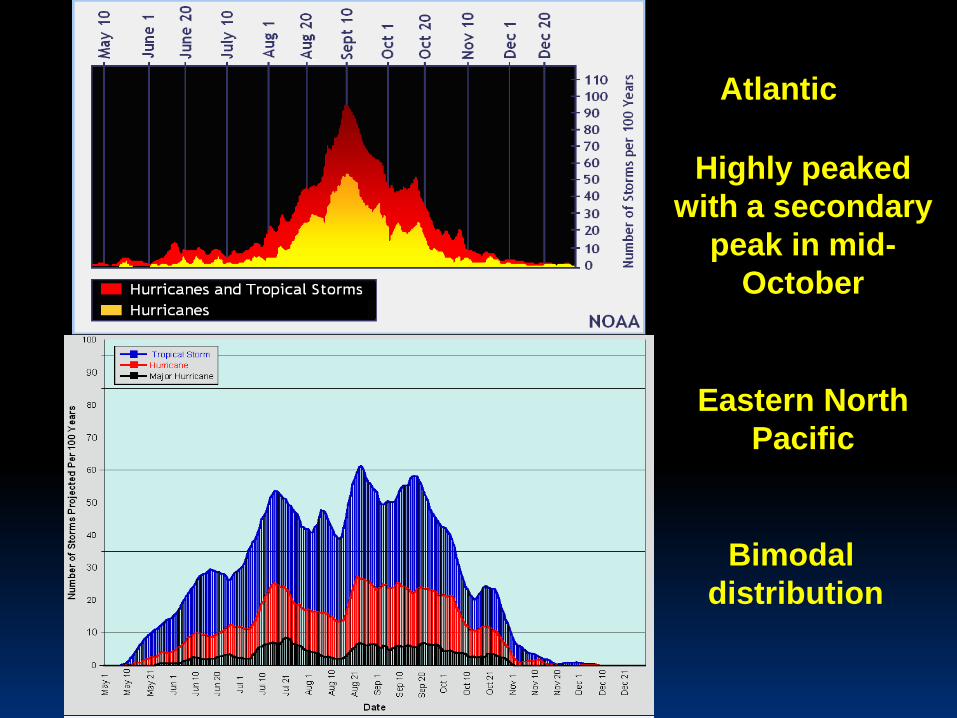
Atlantic
Eastern North
Pacific
Highly peaked
with a secondary
peak in mid-
October
Bimodal
distribution
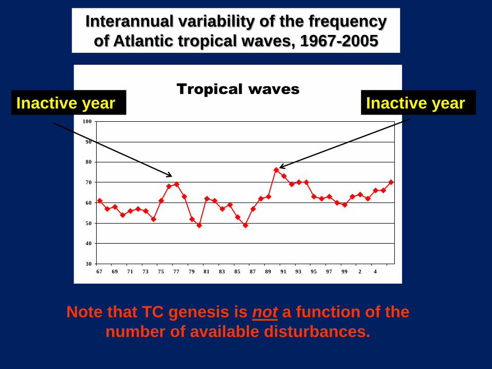
Note that TC genesis is not a function of the
number of available disturbances.
Interannual variability of the frequency
of Atlantic tropical waves, 1967-2005
Very quiet seasons
Tropical waves
30
40
50
60
70
80
90
100
67 69 71 73 75 77 79 81 83 85 87 89 91 93 95 97 99 2 4
Inactive year Inactive year
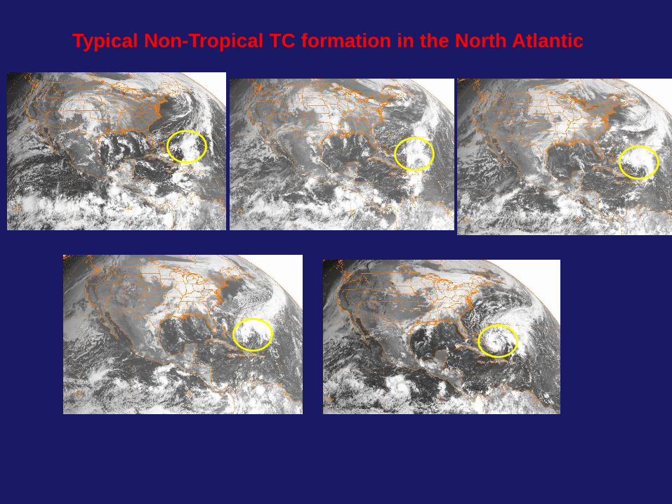
Typical Non-Tropical TC formation in the North Atlantic
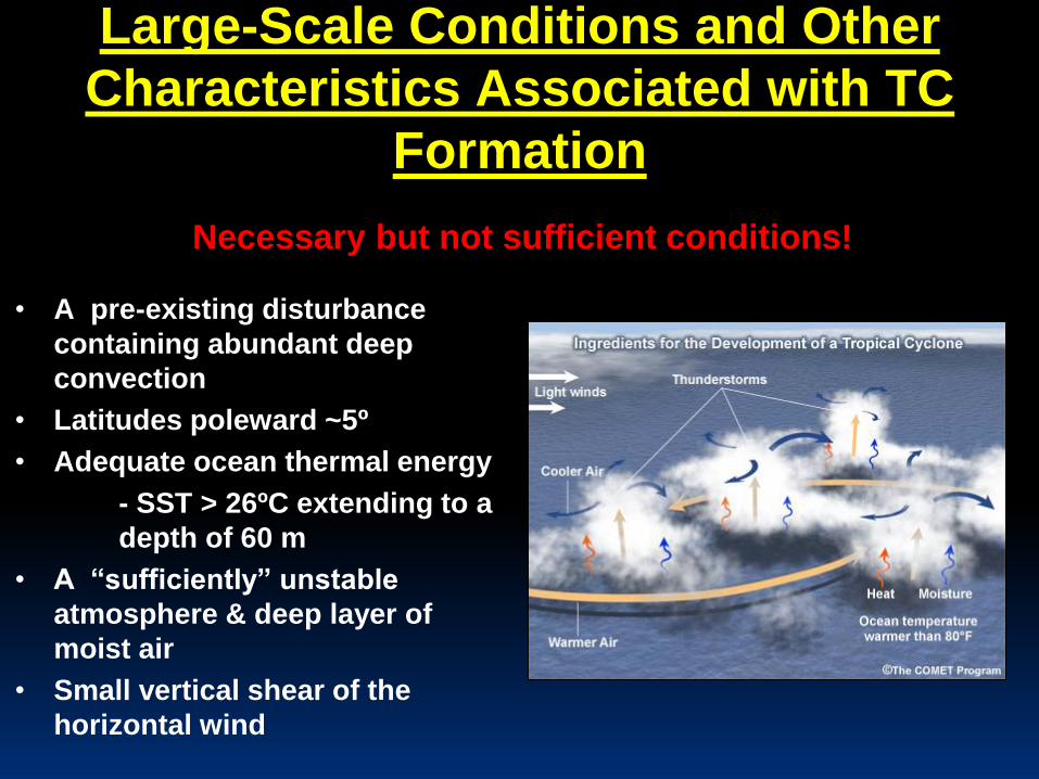
Large-Scale Conditions and Other
Characteristics Associated with TC
Formation
• A pre-existing disturbance
containing abundant deep
convection
• Latitudes poleward ~5º
• Adequate ocean thermal energy
- SST > 26ºC extending to a
depth of 60 m
• A “sufficiently” unstable
atmosphere & deep layer of
moist air
• Small vertical shear of the
horizontal wind
Necessary but not sufficient conditions!
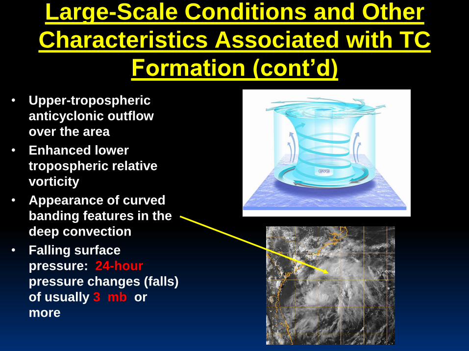
Large-Scale Conditions and Other
Characteristics Associated with TC
Formation (cont’d)
• Upper-tropospheric
anticyclonic outflow
over the area
• Enhanced lower
tropospheric relative
vorticity
• Appearance of curved
banding features in the
deep convection
• Falling surface
pressure: 24-hour
pressure changes (falls)
of usually 3 mb or
more
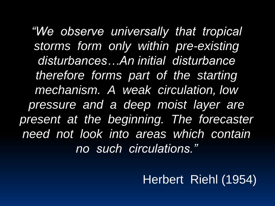
“We observe universally that tropical
storms form only within pre-existing
disturbances…An initial disturbance
therefore forms part of the starting
mechanism. A weak circulation, low
pressure and a deep moist layer are
present at the beginning. The forecaster
need not look into areas which contain
no such circulations.”
Herbert Riehl (1954)
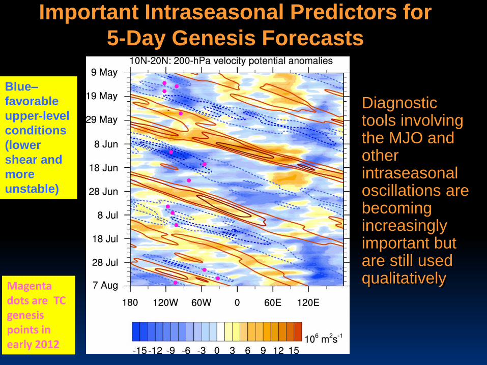
Important Intraseasonal Predictors for
5-Day Genesis Forecasts
• Diagnostic tools involving the MJO and other intraseasonal oscillations are becoming increasingly important but are still used qualitatively
Blue–
favorable
upper-level
conditions
(lower
shear and
more
unstable)
Magenta dots are TC genesis points in early 2012
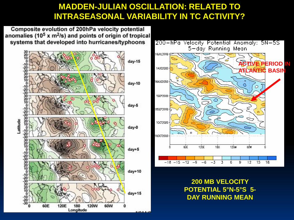
MADDEN-JULIAN OSCILLATION: RELATED TO
INTRASEASONAL VARIABILITY IN TC ACTIVITY?
200 MB VELOCITY
POTENTIAL 5°N-5°S 5-
DAY RUNNING MEAN
ACTIVE PERIOD IN
ATLANTIC BASIN
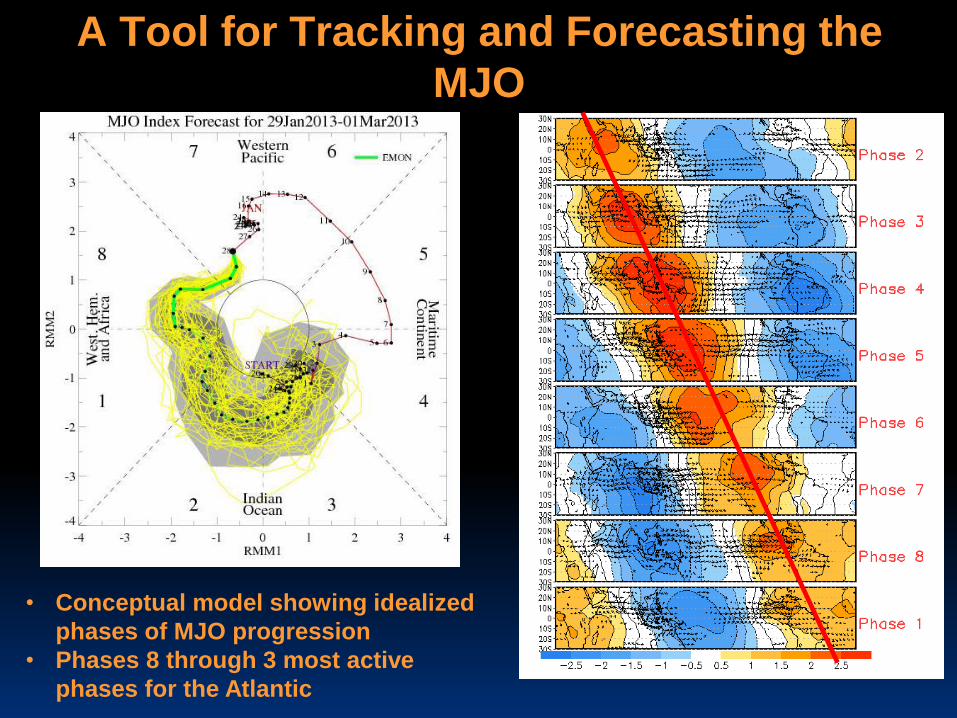
A Tool for Tracking and Forecasting the
MJO
• Conceptual model showing idealized
phases of MJO progression
• Phases 8 through 3 most active
phases for the Atlantic
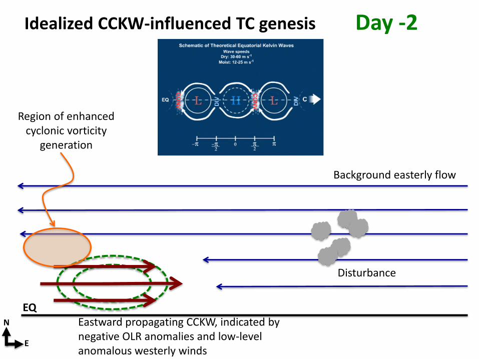
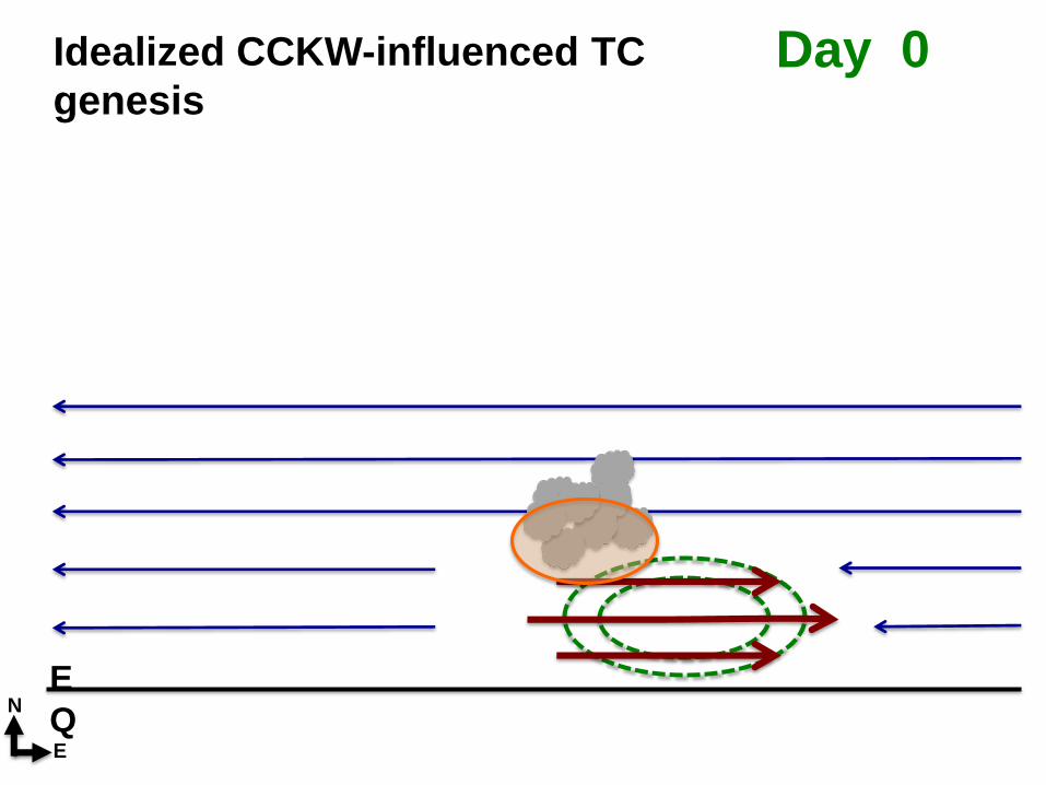
Idealized CCKW-influenced TC genesis
EQEastward propagating CCKW, indicated by negative OLR anomalies and low-level anomalous westerly winds
Disturbance
Background easterly flow
N
E
Region of enhanced cyclonic vorticity
generation
Day -2
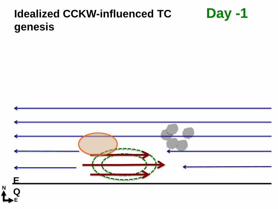
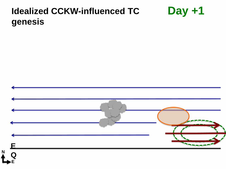
Idealized CCKW-influenced TC
genesis
E
QN
E
Day -1
Idealized CCKW-influenced TC
genesis
E
QN
E
Day 0
Idealized CCKW-influenced TC
genesis
E
QN
E
Day +1
Idealized CCKW-influenced TC
genesis
E
QN
E
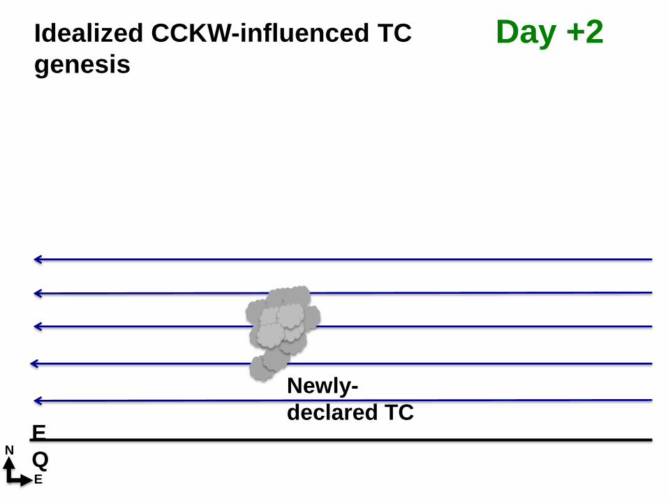
Day +2
Newly-
declared TC
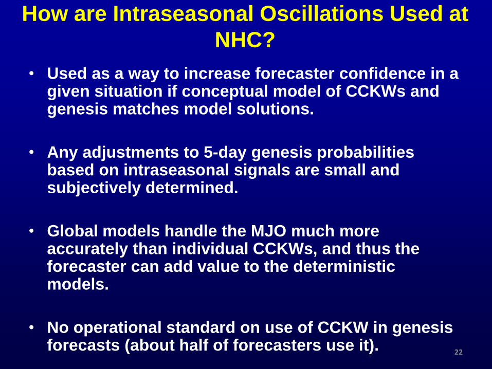
• Used as a way to increase forecaster confidence in a given situation if conceptual model of CCKWs and genesis matches model solutions.
• Any adjustments to 5-day genesis probabilities based on intraseasonal signals are small and subjectively determined.
• Global models handle the MJO much more accurately than individual CCKWs, and thus the forecaster can add value to the deterministic models.
• No operational standard on use of CCKW in genesis forecasts (about half of forecasters use it).
How are Intraseasonal Oscillations Used at
NHC?
22
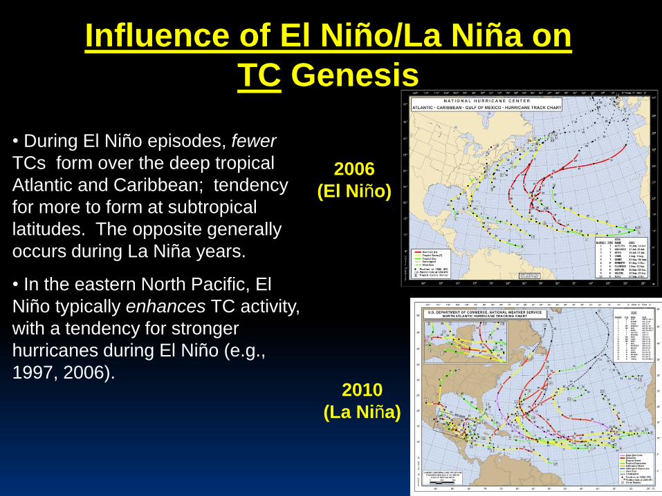
Influence of El Niño/La Niña on
TC Genesis
• During El Niño episodes, fewer
TCs form over the deep tropical
Atlantic and Caribbean; tendency
for more to form at subtropical
latitudes. The opposite generally
occurs during La Niña years.
• In the eastern North Pacific, El
Niño typically enhances TC activity,
with a tendency for stronger
hurricanes during El Niño (e.g.,
1997, 2006).
2006
(El Niño)
2010
(La Niña)
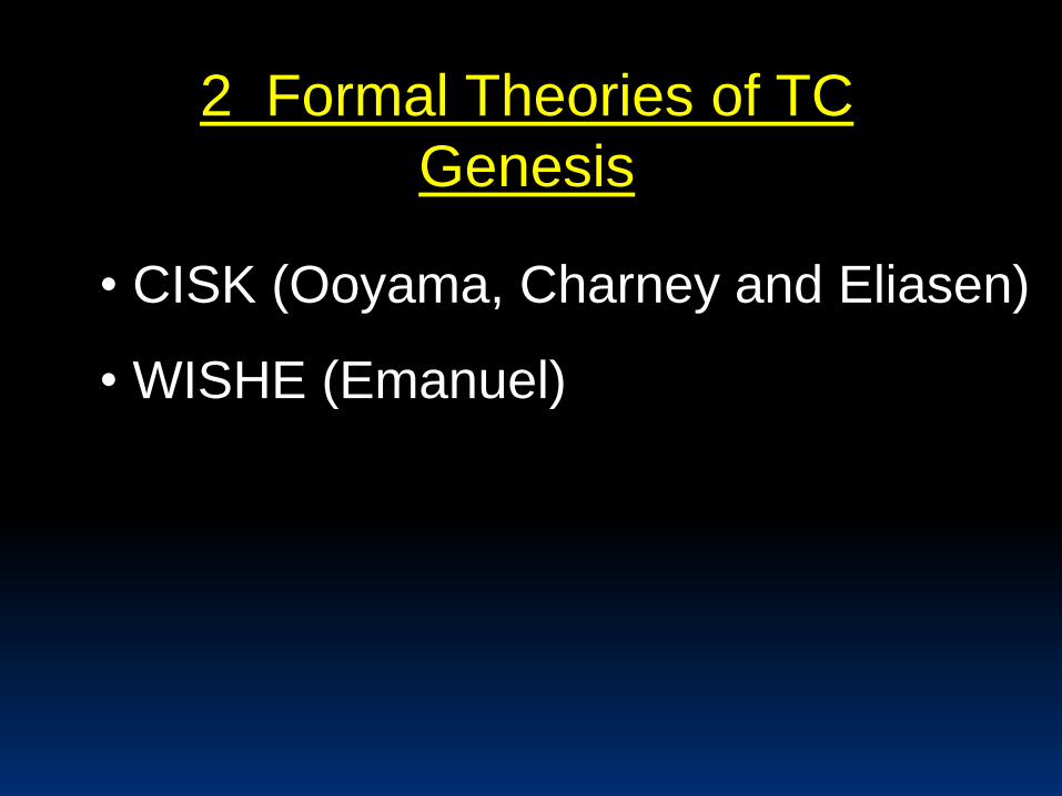
2 Formal Theories of TC
Genesis
• CISK (Ooyama, Charney and Eliasen)
• WISHE (Emanuel)
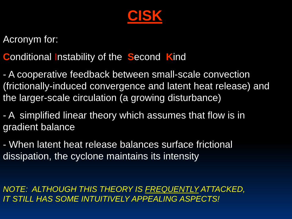
CISK
Acronym for:
Conditional Instability of the Second Kind
- A cooperative feedback between small-scale convection
(frictionally-induced convergence and latent heat release) and
the larger-scale circulation (a growing disturbance)
- A simplified linear theory which assumes that flow is in
gradient balance
- When latent heat release balances surface frictional
dissipation, the cyclone maintains its intensity
NOTE: ALTHOUGH THIS THEORY IS FREQUENTLY ATTACKED,
IT STILL HAS SOME INTUITIVELY APPEALING ASPECTS!
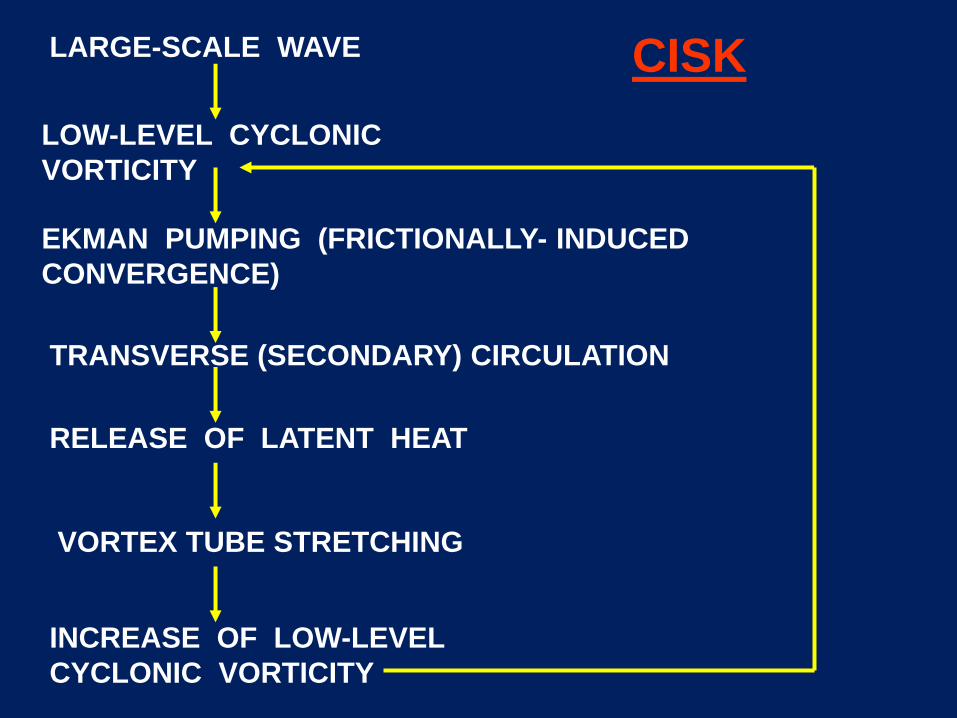
LARGE-SCALE WAVE
LOW-LEVEL CYCLONIC
VORTICITY
EKMAN PUMPING (FRICTIONALLY- INDUCED
CONVERGENCE)
RELEASE OF LATENT HEAT
TRANSVERSE (SECONDARY) CIRCULATION
VORTEX TUBE STRETCHING
INCREASE OF LOW-LEVEL
CYCLONIC VORTICITY
CISK
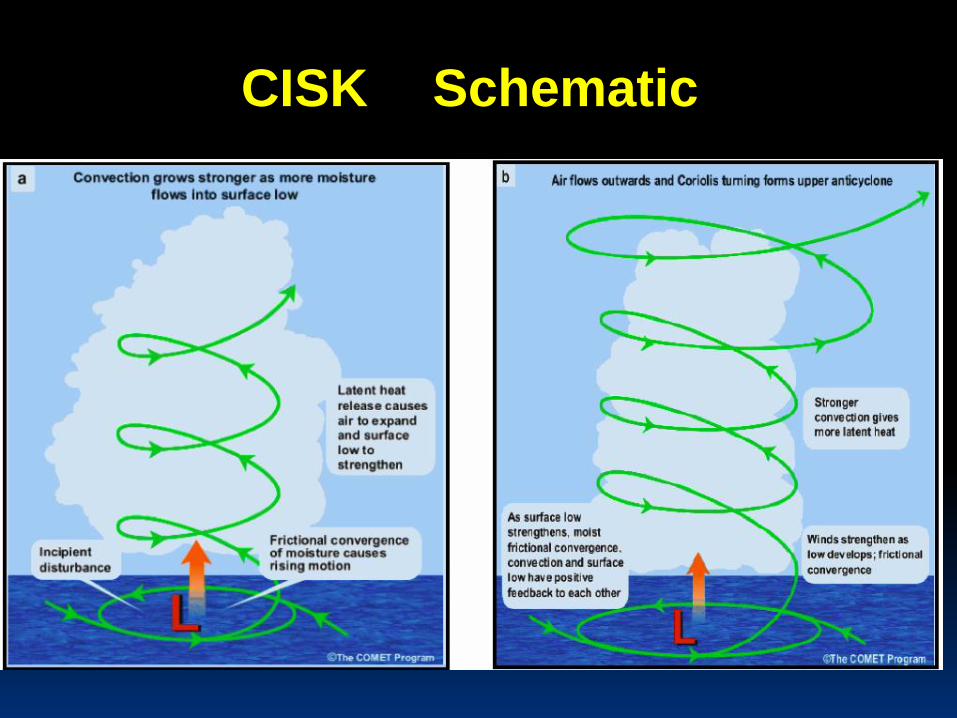
CISK Schematic
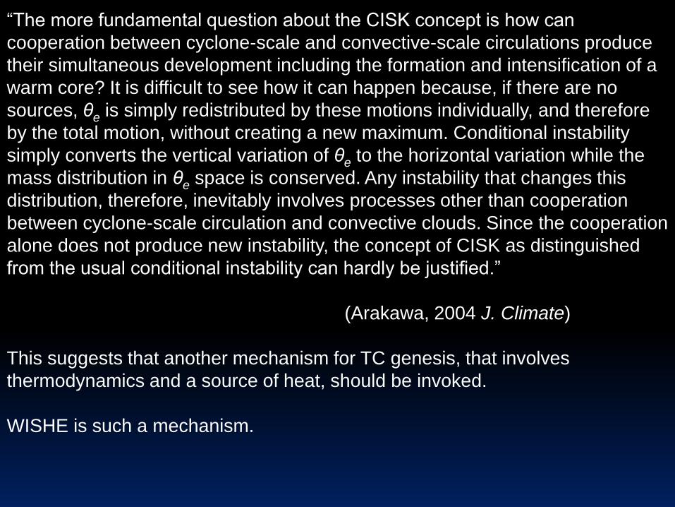
“The more fundamental question about the CISK concept is how can
cooperation between cyclone-scale and convective-scale circulations produce
their simultaneous development including the formation and intensification of a
warm core? It is difficult to see how it can happen because, if there are no
sources, θe is simply redistributed by these motions individually, and therefore
by the total motion, without creating a new maximum. Conditional instability
simply converts the vertical variation of θe to the horizontal variation while the
mass distribution in θe space is conserved. Any instability that changes this
distribution, therefore, inevitably involves processes other than cooperation
between cyclone-scale circulation and convective clouds. Since the cooperation
alone does not produce new instability, the concept of CISK as distinguished
from the usual conditional instability can hardly be justified.”
(Arakawa, 2004 J. Climate)
This suggests that another mechanism for TC genesis, that involves
thermodynamics and a source of heat, should be invoked.
WISHE is such a mechanism.
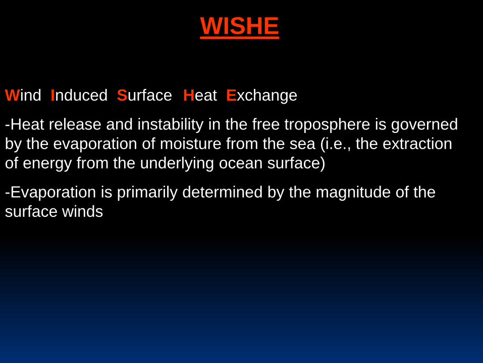
WISHE
ACRONYM FOR:
Wind Induced SurfaceEHeat ExchangeE
-Heat release and instability in the free troposphere is governed
by the evaporation of moisture from the sea (i.e., the extraction
of energy from the underlying ocean surface)
-Evaporation is primarily determined by the magnitude of the
surface winds
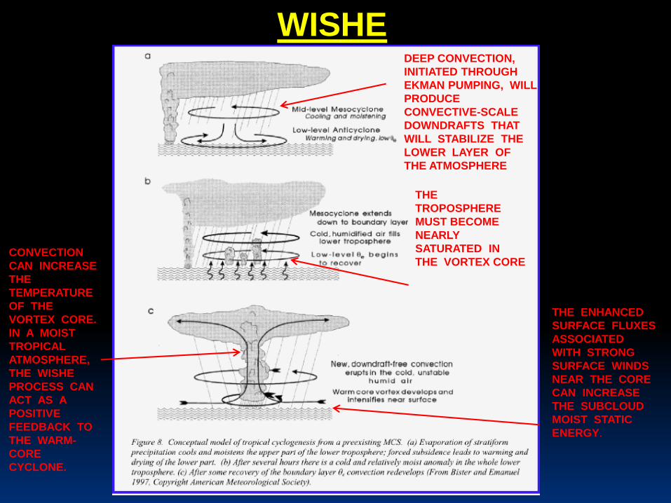
WISHEDEEP CONVECTION,
INITIATED THROUGH
EKMAN PUMPING, WILL
PRODUCE
CONVECTIVE-SCALE
DOWNDRAFTS THAT
WILL STABILIZE THE
LOWER LAYER OF
THE ATMOSPHERE
THE
TROPOSPHERE
MUST BECOME
NEARLY
SATURATED IN
THE VORTEX CORE
THE ENHANCED
SURFACE FLUXES
ASSOCIATED
WITH STRONG
SURFACE WINDS
NEAR THE CORE
CAN INCREASE
THE SUBCLOUD
MOIST STATIC
ENERGY.
CONVECTION
CAN INCREASE
THE
TEMPERATURE
OF THE
VORTEX CORE.
IN A MOIST
TROPICAL
ATMOSPHERE,
THE WISHE
PROCESS CAN
ACT AS A
POSITIVE
FEEDBACK TO
THE WARM-
CORE
CYCLONE.
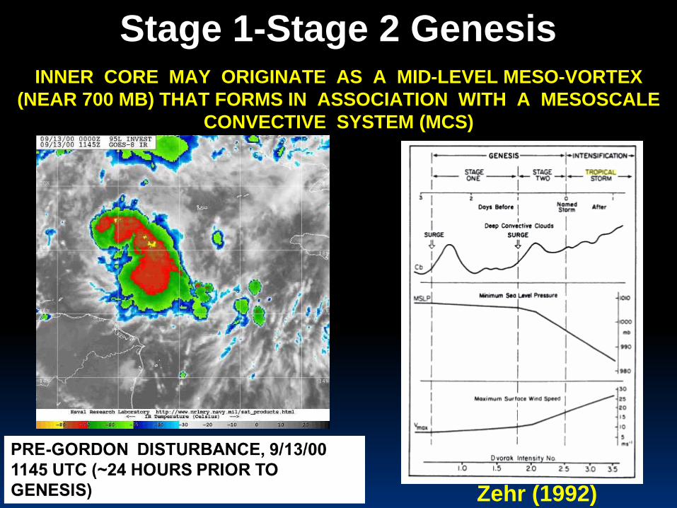
INNER CORE MAY ORIGINATE AS A MID-LEVEL MESO-VORTEX
(NEAR 700 MB) THAT FORMS IN ASSOCIATION WITH A MESOSCALE
CONVECTIVE SYSTEM (MCS)
Stage 1-Stage 2 Genesis
Zehr (1992)
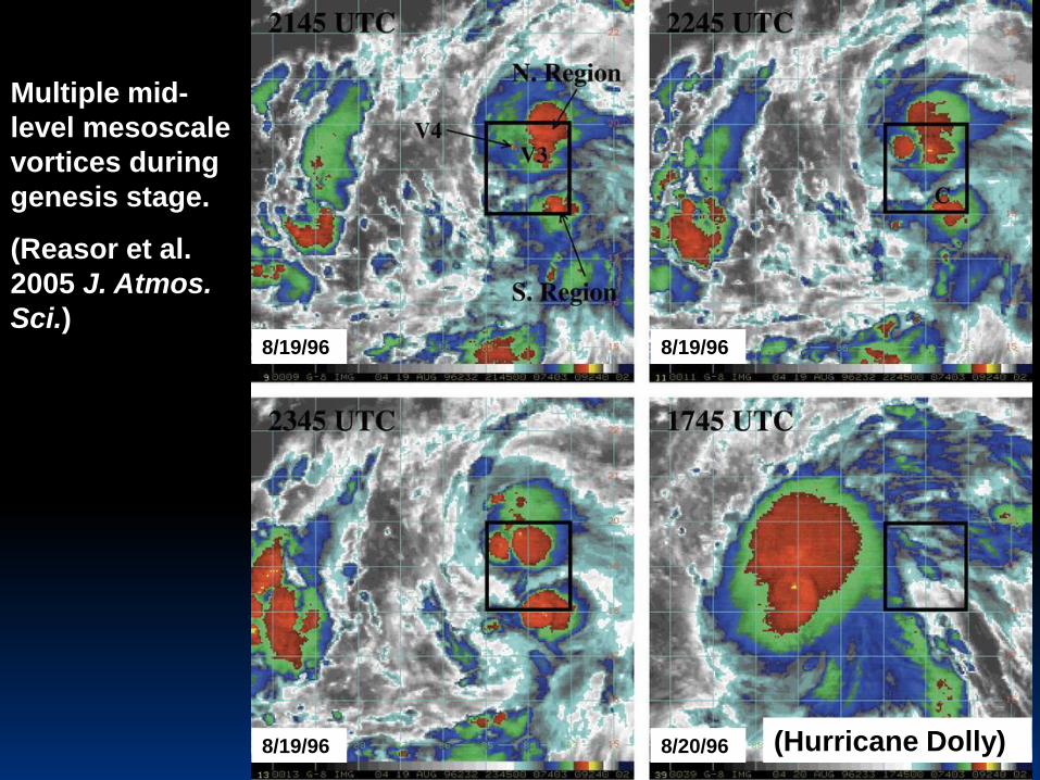
8/19/96 8/19/96
8/19/96 8/20/96 (Hurricane Dolly)
Multiple mid-
level mesoscale
vortices during
genesis stage.
(Reasor et al.
2005 J. Atmos.
Sci.)
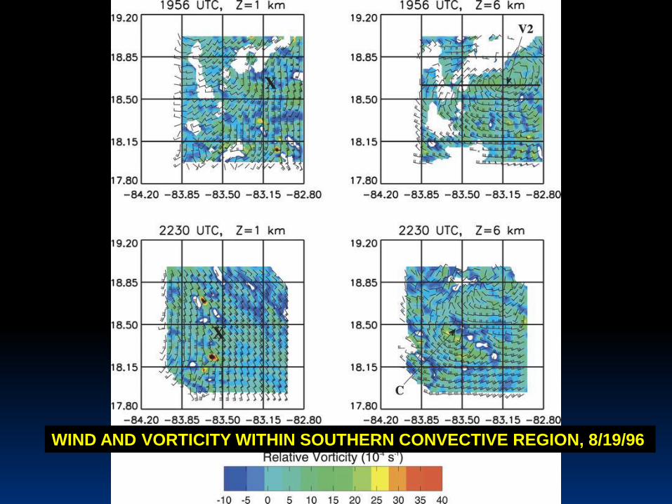
WIND AND VORTICITY WITHIN SOUTHERN CONVECTIVE REGION, 8/19/96
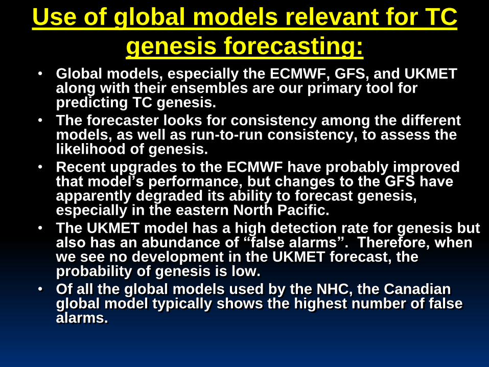
Use of global models relevant for TC
genesis forecasting:• Global models, especially the ECMWF, GFS, and UKMET
along with their ensembles are our primary tool for predicting TC genesis.
• The forecaster looks for consistency among the different models, as well as run-to-run consistency, to assess the likelihood of genesis.
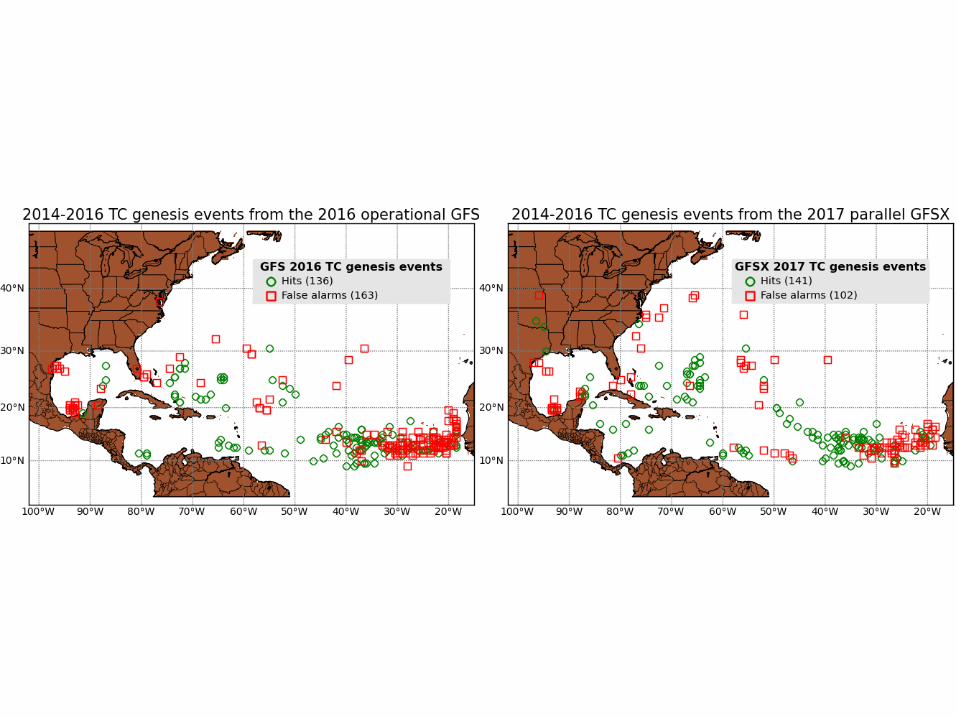
• Recent upgrades to the ECMWF have probably improved that model’s performance, but changes to the GFS have apparently degraded its ability to forecast genesis, especially in the eastern North Pacific.
• The UKMET model has a high detection rate for genesis but also has an abundance of “false alarms”. Therefore, when we see no development in the UKMET forecast, the probability of genesis is low.
• Of all the global models used by the NHC, the Canadian global model typically shows the highest number of false alarms.
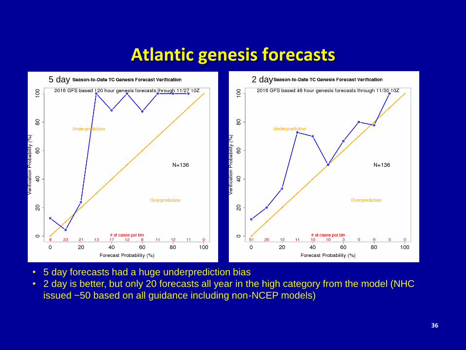
Atlantic genesis forecasts
36
• 5 day forecasts had a huge underprediction bias
• 2 day is better, but only 20 forecasts all year in the high category from the model (NHC
issued ~50 based on all guidance including non-NCEP models)
2016
5 day 2 day
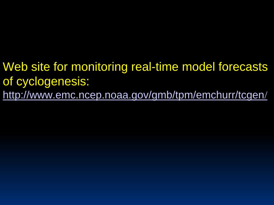
Web site for monitoring real-time model forecasts
of cyclogenesis:http://www.emc.ncep.noaa.gov/gmb/tpm/emchurr/tcgen/
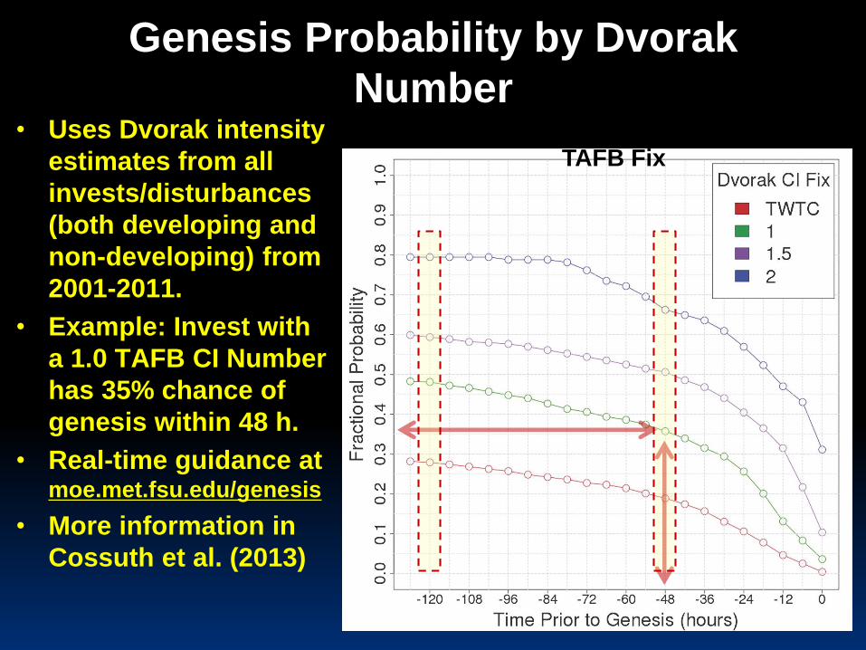
Genesis Probability by Dvorak
Number• Uses Dvorak intensity
estimates from all
invests/disturbances
(both developing and
non-developing) from
2001-2011.
• Example: Invest with
a 1.0 TAFB CI Number
has 35% chance of
genesis within 48 h.
• Real-time guidance at moe.met.fsu.edu/genesis
• More information in
Cossuth et al. (2013)
Atlantic TC Genesis Probability by
TAFB Fix
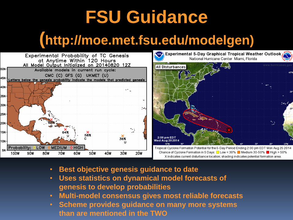
FSU Guidance
(http://moe.met.fsu.edu/modelgen)
• Best objective genesis guidance to date
• Uses statistics on dynamical model forecasts of
genesis to develop probabilities
• Multi-model consensus gives most reliable forecasts
• Scheme provides guidance on many more systems
than are mentioned in the TWO
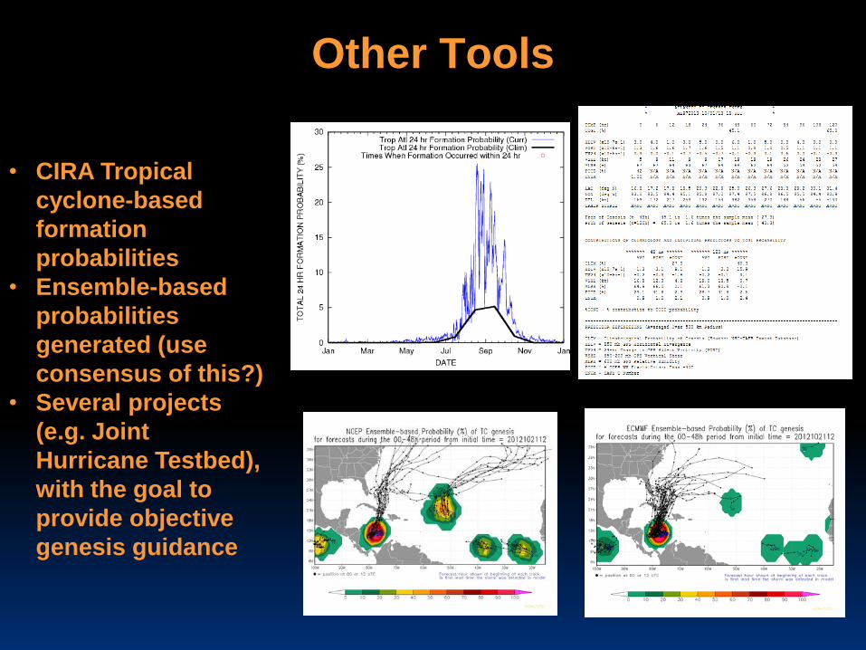
Other Tools
• CIRA Tropical
cyclone-based
formation
probabilities
• Ensemble-based
probabilities
generated (use
consensus of this?)
• Several projects
(e.g. Joint
Hurricane Testbed),
with the goal to
provide objective
genesis guidance
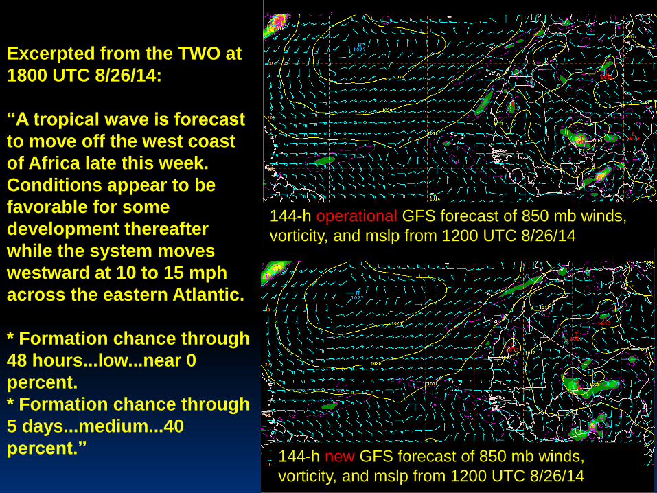
Excerpted from the TWO at
1800 UTC 8/26/14:
“A tropical wave is forecast
to move off the west coast
of Africa late this week.
Conditions appear to be
favorable for some
development thereafter
while the system moves
westward at 10 to 15 mph
across the eastern Atlantic.
* Formation chance through
48 hours...low...near 0
percent.
* Formation chance through
5 days...medium...40
percent.” 144-h new GFS forecast of 850 mb winds,
vorticity, and mslp from 1200 UTC 8/26/14
144-h operational GFS forecast of 850 mb winds,
vorticity, and mslp from 1200 UTC 8/26/14
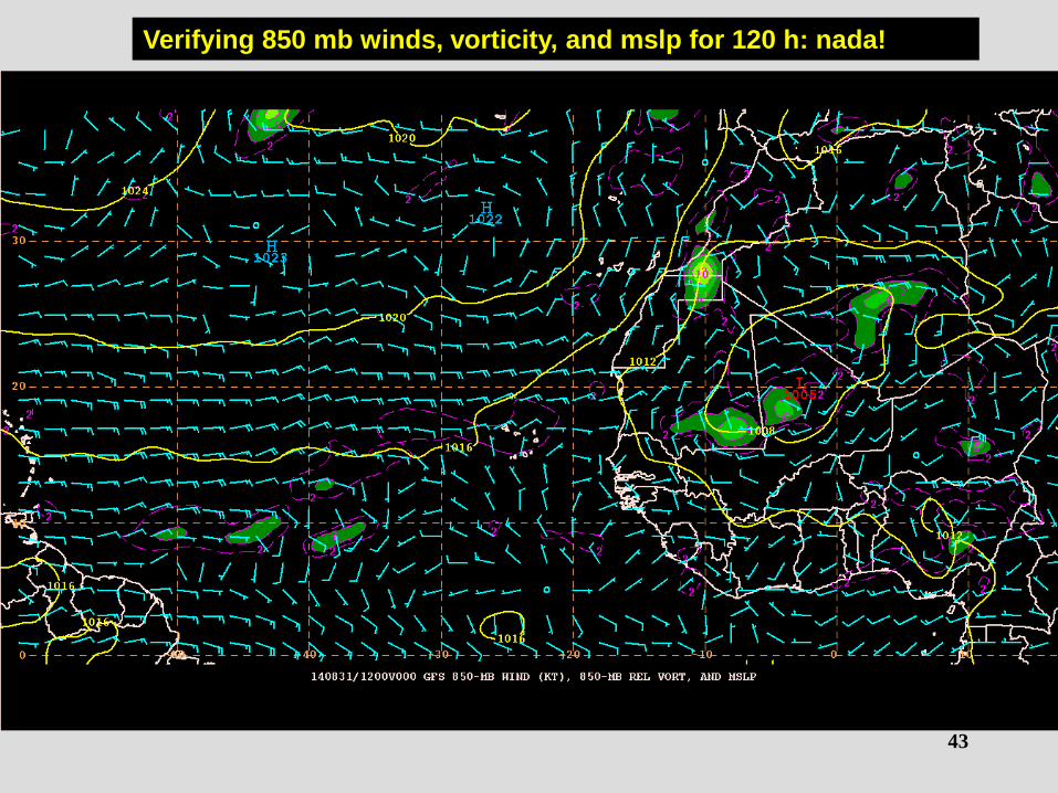
43
Verifying 850 mb winds, vorticity, and mslp for 120 h: nada!
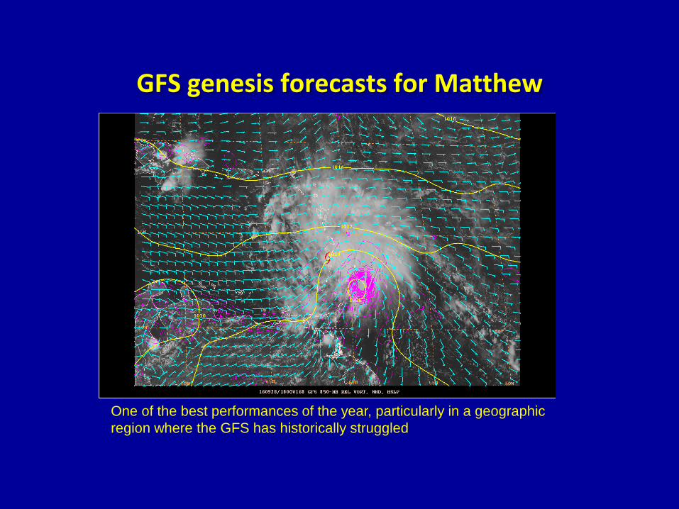
GFS genesis forecasts for Matthew
One of the best performances of the year, particularly in a geographic
region where the GFS has historically struggled
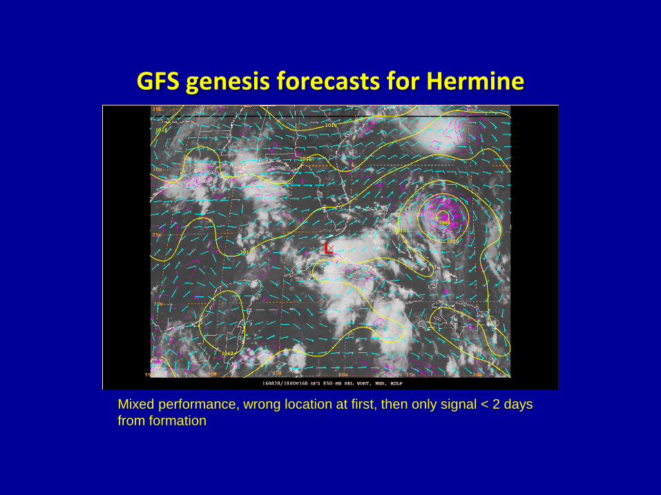
GFS genesis forecasts for Hermine
Mixed performance, wrong location at first, then only signal < 2 days
from formation
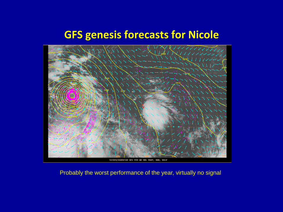
GFS genesis forecasts for Nicole
Probably the worst performance of the year, virtually no signal
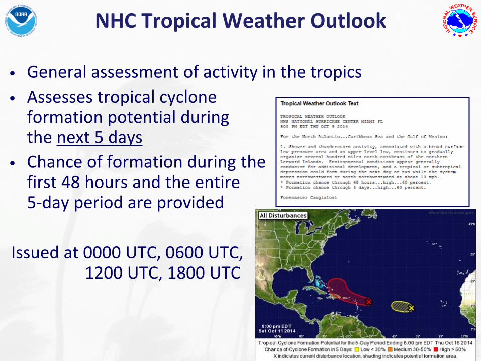
• General assessment of activity in the tropics
• Assesses tropical cycloneformation potential duringthe next 5 days
• Chance of formation during thefirst 48 hours and the entire 5-day period are provided
Issued at 0000 UTC, 0600 UTC,1200 UTC, 1800 UTC
NHC Tropical Weather Outlook
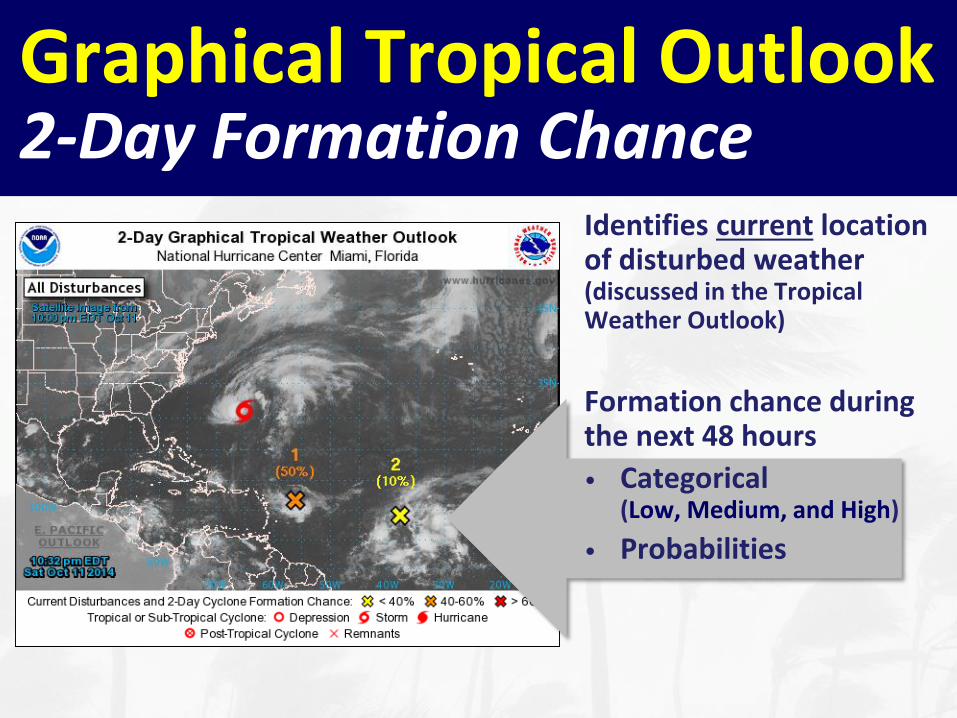
Graphical Tropical Outlook2-Day Formation Chance
Identifies current location of disturbed weather(discussed in the Tropical Weather Outlook)
Formation chance during the next 48 hours
• Categorical(Low, Medium, and High)
• Probabilities
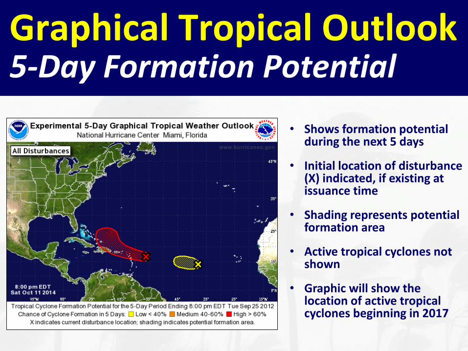
• Shows formation potential during the next 5 days
• Initial location of disturbance (X) indicated, if existing at issuance time
• Shading represents potential formation area
• Active tropical cyclones not shown
• Graphic will show the location of active tropical cyclones beginning in 2017
Graphical Tropical Outlook5-Day Formation Potential
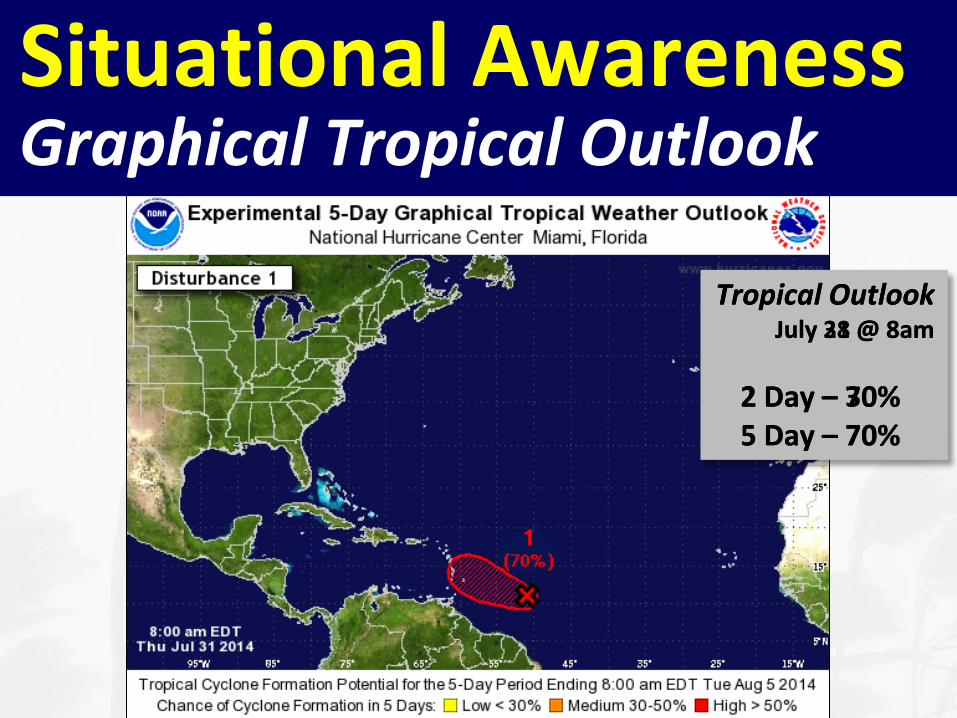
Situational AwarenessGraphical Tropical Outlook
Tropical OutlookJuly 28 @ 8am
2 Day – 30%5 Day – 70%
Tropical OutlookJuly 31 @ 8am
2 Day – 70%5 Day – 70%
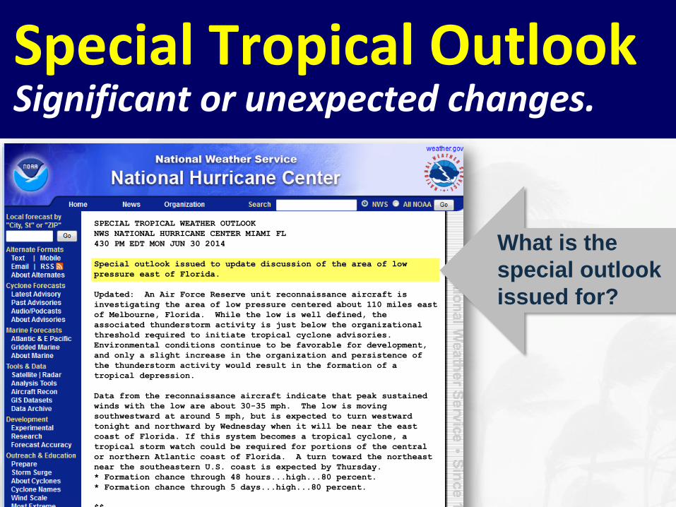
Special Tropical OutlookSignificant or unexpected changes.
What is the
special outlook
issued for?
SPECIAL TROPICAL WEATHER OUTLOOK
NWS NATIONAL HURRICANE CENTER MIAMI FL
430 PM EDT MON JUN 30 2014
Special outlook issued to update discussion of the area of low
pressure east of Florida.
Updated: An Air Force Reserve unit reconnaissance aircraft is
investigating the area of low pressure centered about 110 miles east
of Melbourne, Florida. While the low is well defined, the
associated thunderstorm activity is just below the organizational
threshold required to initiate tropical cyclone advisories.
Environmental conditions continue to be favorable for development,
and only a slight increase in the organization and persistence of
the thunderstorm activity would result in the formation of a
tropical depression.
Data from the reconnaissance aircraft indicate that peak sustained
winds with the low are about 30-35 mph. The low is moving
southwestward at around 5 mph, but is expected to turn westward
tonight and northward by Wednesday when it will be near the east
coast of Florida. If this system becomes a tropical cyclone, a
tropical storm watch could be required for portions of the central
or northern Atlantic coast of Florida. A turn toward the northeast
near the southeastern U.S. coast is expected by Thursday.
* Formation chance through 48 hours...high...80 percent.
* Formation chance through 5 days...high...80 percent.
$$
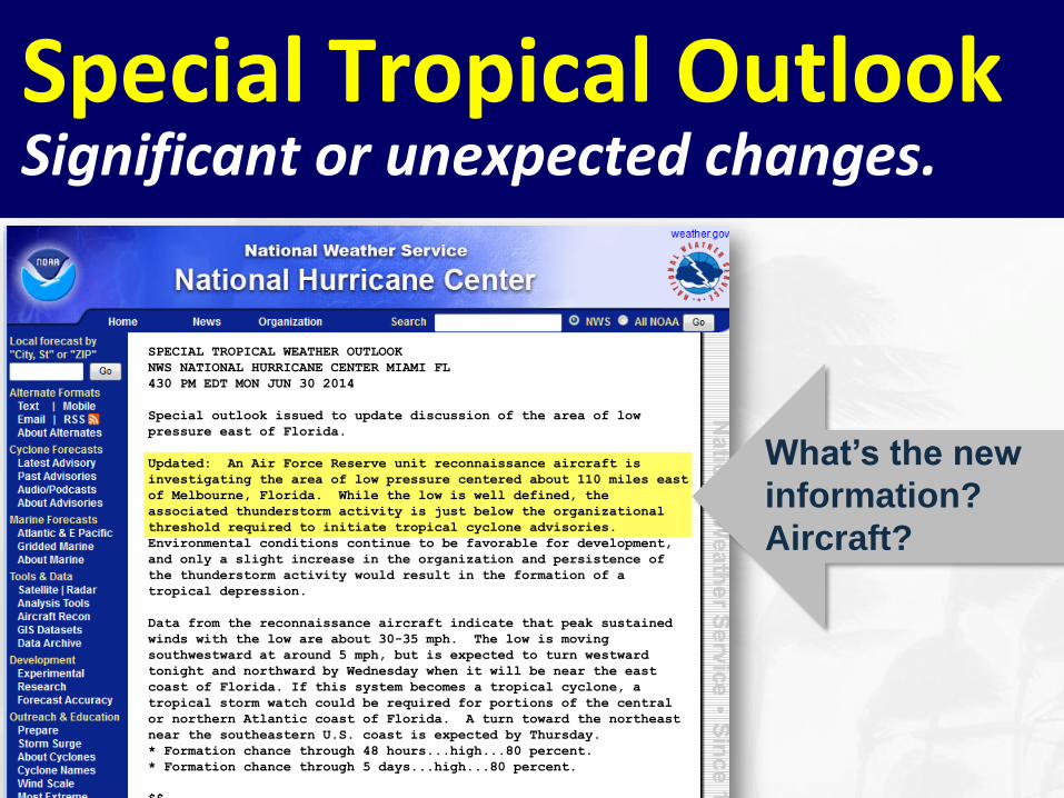
Special Tropical OutlookSignificant or unexpected changes.
What’s the new
information?
Aircraft?
SPECIAL TROPICAL WEATHER OUTLOOK
NWS NATIONAL HURRICANE CENTER MIAMI FL
430 PM EDT MON JUN 30 2014
Special outlook issued to update discussion of the area of low
pressure east of Florida.
Updated: An Air Force Reserve unit reconnaissance aircraft is
investigating the area of low pressure centered about 110 miles east
of Melbourne, Florida. While the low is well defined, the
associated thunderstorm activity is just below the organizational
threshold required to initiate tropical cyclone advisories.
Environmental conditions continue to be favorable for development,
and only a slight increase in the organization and persistence of
the thunderstorm activity would result in the formation of a
tropical depression.
Data from the reconnaissance aircraft indicate that peak sustained
winds with the low are about 30-35 mph. The low is moving
southwestward at around 5 mph, but is expected to turn westward
tonight and northward by Wednesday when it will be near the east
coast of Florida. If this system becomes a tropical cyclone, a
tropical storm watch could be required for portions of the central
or northern Atlantic coast of Florida. A turn toward the northeast
near the southeastern U.S. coast is expected by Thursday.
* Formation chance through 48 hours...high...80 percent.
* Formation chance through 5 days...high...80 percent.
$$
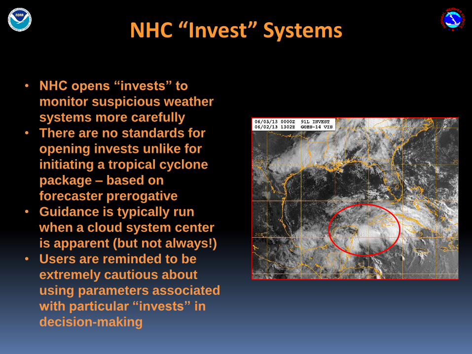
NHC “Invest” Systems
• NHC opens “invests” to
monitor suspicious weather
systems more carefully
• There are no standards for
opening invests unlike for
initiating a tropical cyclone
package – based on
forecaster prerogative
• Guidance is typically run
when a cloud system center
is apparent (but not always!)
• Users are reminded to be
extremely cautious about
using parameters associated
with particular “invests” in
decision-making
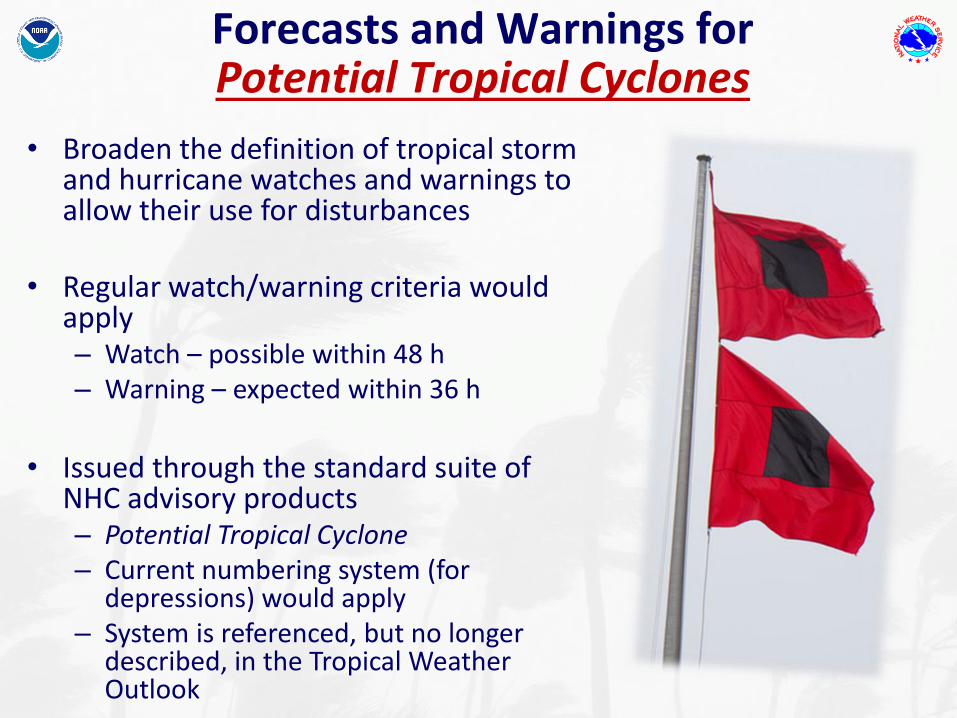
Forecasts and Warnings for Potential Tropical Cyclones
• Broaden the definition of tropical storm and hurricane watches and warnings to allow their use for disturbances
• Regular watch/warning criteria would apply– Watch – possible within 48 h– Warning – expected within 36 h
• Issued through the standard suite of NHC advisory products– Potential Tropical Cyclone– Current numbering system (for
depressions) would apply– System is referenced, but no longer
described, in the Tropical Weather Outlook
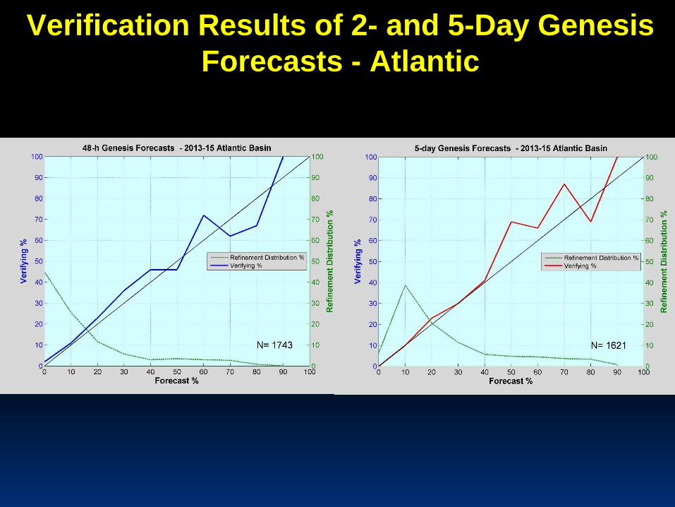
Verification Results of 2- and 5-Day Genesis
Forecasts - Atlantic
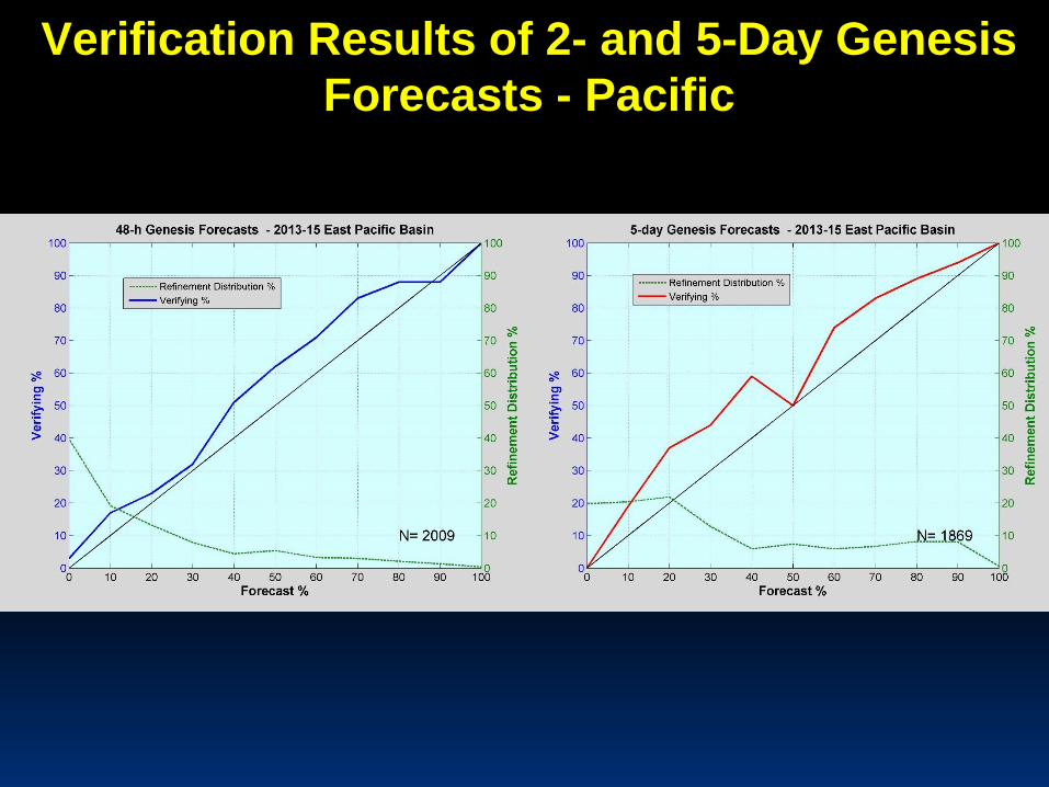
Verification Results of 2- and 5-Day Genesis
Forecasts - Pacific
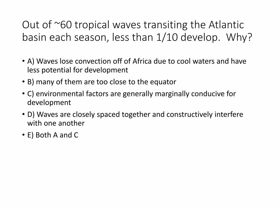
Out of ~60 tropical waves transiting the Atlantic basin each season, less than 1/10 develop. Why?
• A) Waves lose convection off of Africa due to cool waters and have less potential for development
• B) many of them are too close to the equator
• C) environmental factors are generally marginally conducive for development
• D) Waves are closely spaced together and constructively interfere with one another
• E) Both A and C
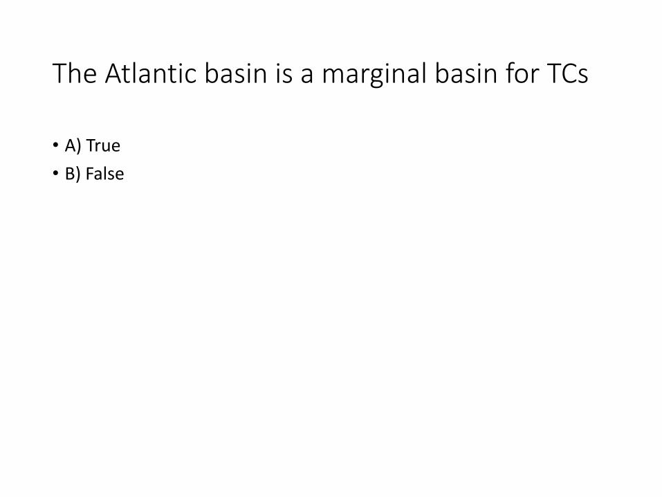
The Atlantic basin is a marginal basin for TCs
• A) True
• B) False
The instability over the Atlantic basin is greatest:
• A) Late in the hurricane season
• B) Early in the hurricane season
• C) Early to mid hurricane season
• D) None of the above
As a general rule, pressures falls of what magnitude, associated with a tropical disturbance, are indicative that TC genesis is imminent ?
• A) 1 mb/24 h
• B) 2 mb/24 h
• C) 3 mb/24 h or more
• D) 0.5 mb/24 h
Stage 1 of TC genesis results in the formation of what phenomenon:
• A) Disorganized convection
• B) An upper-level anticyclone
• C) Often a large burst of convection
• D) A mesoscale convective vortex
• E) C and D
If the 2- and 5-day genesis probabilities are equal in the TWO, what does this mean?
• A) TC genesis, if it occurs, is likely to occur within 2 days
• B) TC genesis, if it occurs, is likely to occur within 5 days
• C) TC genesis, if it occurs, is likely to occur within 3 to 5 days
• D) TC genesis, if it occurs, is likely to occur in a few hours
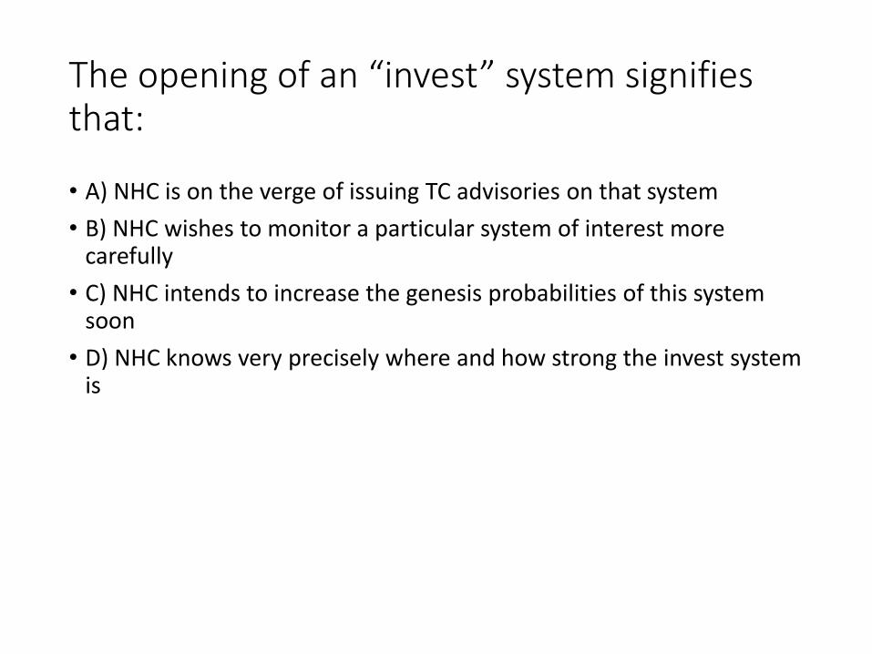
The opening of an “invest” system signifies that:
• A) NHC is on the verge of issuing TC advisories on that system
• B) NHC wishes to monitor a particular system of interest more carefully
• C) NHC intends to increase the genesis probabilities of this system soon
• D) NHC knows very precisely where and how strong the invest system is
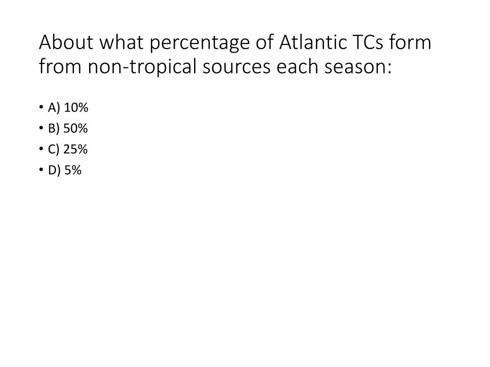
About what percentage of Atlantic TCs form from non-tropical sources each season:
• A) 10%
• B) 50%
• C) 25%
• D) 5%
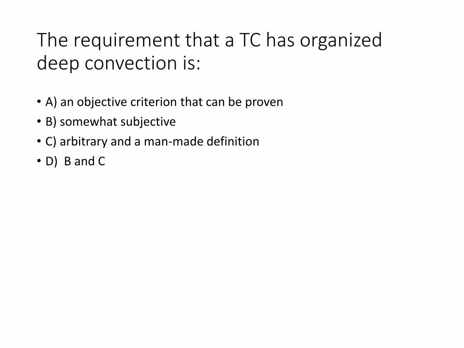
The requirement that a TC has organized deep convection is:
• A) an objective criterion that can be proven
• B) somewhat subjective
• C) arbitrary and a man-made definition
• D) B and C
Forecast Exercise