Embed Size (px)
Citation preview
Tropical cyclone wind speed constraints fromresultant storm surge deposition: A 2500 yearreconstruction of hurricane activity from St.Marks, FL
Christine M. Brandon and Jonathan D. WoodruffDepartment of Geosciences, 611 N. Pleasant St., 233 Morrill Science Center,University of Massachusetts Amherst, Amherst, Massachusetts, 01003, USA ([email protected])
D. Phil Lane and Jeffrey P. DonnellyDepartment of Geology and Geophysics, Woods Hole Oceanographic Institution, Woods Hole,Massachusetts, USA
[1] Recent work suggests that the patterns of intense (�category 3 on the Saffir-Simpson scale) hurricanestrikes over the last few millennia might differ from that of overall hurricane activity during this period.Prior studies typically rely on assigning a threshold storm intensity required to produce asedimentological overwash signal at a particular coastal site based on historical analogs. Here, weimprove on this approach by presenting a new inverse-model technique that constrains the most likelywind speeds required to transport the maximum grain size within resultant storm deposits. As a casestudy, the technique is applied to event layers observed in sediments collected from a coastal sinkhole innorthwestern Florida. We find that (1) simulated wind speeds for modern deposits are consistent with theintensities for historical hurricanes affecting the site, (2) all deposits throughout the �2500 year recordare capable of being produced by hurricanes, and (3) a period of increased intense hurricane frequency isobserved between �1700 and �600 years B.P. and decreased intense storm frequency is observed from�2500 to �1700 and �600 years B.P. to the present. This is consistent with prior reconstructions fromnearby sites. Changes in the frequency of intense hurricane strikes may be related to the degree ofpenetration of the Loop Current in the Gulf of Mexico.
Components: 11,207 words, 8 figures, 1 table.
Keywords: tropical cyclones; paleotempestology; paleoclimate; holocene; inverse-modeling; sedimentology.
Index Terms: 4564 Tsunamis and storm surges: Oceanography: Physical; 4558 Sediment transport : Oceanography: Phys-ical; 1862 Sediment transport: Hydrology; 4304 Oceanic: Natural Hazards; 4302 Geological : Natural Hazards; 1641 Sealevel change: Global Change.
Received 29 April 2013; Revised 1 July 2013; Accepted 1 July 2013; Published 22 August 2013.
Brandon, C. M., J. D. Woodruff, D. Phil Lane, and J. P. Donnelly (2013), Tropical cyclone wind speed constraints from re-sultant storm surge deposition: A 2500 year reconstruction of hurricane activity from St. Marks, FL, Geochem. Geophys.Geosyst., 14, 2993–3008, doi:10.1002/ggge.20217.
© 2013. American Geophysical Union. All Rights Reserved. 2993
Article
Volume 14, Number 8
22 August 2013
doi: 10.1002/ggge.20217
ISSN: 1525-2027
1. Introduction
[2] The number of studies pertaining to tropicalcyclone (called ‘‘hurricane’’ in the North AtlanticOcean) proxies preserved within the geologicrecord have increased rapidly over the last twodecades. This relatively new field of paleotempes-tology is fueled by a growing appreciation for theapplication of these records in hurricane riskassessments [e.g., Murnane et al., 2000; Nott,2004; Elsner et al., 2008] and in identifying pastlong-term shifts in hurricane climatology [e.g.,Mann et al., 2009]. Many studies have been con-ducted to extend the hurricane strike record at var-ious locations in the western North Atlantic byidentifying deposits in the sediment record left byhurricane storm surges and wave run-up [Liu andFearn, 1993, 2000; Donnelly et al., 2001a, 2001b;Donnelly and Woodruff, 2007; Scileppi and Don-nelly, 2007; Woodruff et al., 2008b; Boldt et al.,2010; Wallace and Anderson, 2010; Lane et al.,2011]. Other proxies of paleo-hurricane activityinclude extreme-precipitation events associatedwith hurricanes using �18O records from speleo-thems [Malmquist, 1997; Frappier et al., 2007]and tree rings [Miller et al., 2006]; increased riverrun-off and its effect on the growth and lumines-cence of coral [Lough, 2007; Nyberg et al., 2007];and coarse deposits interpreted as intense terres-trial flooding events [Noren et al., 2002; Besonenet al., 2008]. Together, these proxy records pro-vide an increasing body of knowledge of paleo-hurricane history in the Gulf of Mexico and theNorthwestern Atlantic Ocean.
[3] In prior work, past geologic reconstructions oftropical cyclone activity have mainly documentedchanges in the reoccurrence rates of hurricanesabove some assumed threshold based on moderncalibration. In addition to documenting eventoccurrences, grain size distributions within hurri-cane deposits also provide information on the in-tensity of flooding by past hurricane strikes[Woodruff et al., 2008b]. However, the overallflooding magnitude at a location is influenced byfactors in addition to the storm intensity. Forexample, a category 1 storm that directly hits asite could produce a similar storm surge as a cate-gory 5 storm making landfall much farther away.Accurate methods for back-calculating hurricanewind speed from resultant deposits must thereforeaccount for these uncertainties.
[4] In this study, we present a new �2500 yearreconstruction of hurricane occurrences based onevent-deposits preserved within a coastal sinkhole
in western Florida. We use a series of nested mod-eling techniques to develop relationships betweenstorm intensity and the maximum grain size thatthe resulting flows can carry to the site (i.e., trans-port competence). The obtained wind speed/trans-port competence relationship is then used toconstrain the likely wind speed required to trans-port the maximum grain size observed within eachindividual deposit and to provide a reconstructionof hurricane intensity at the site.
2. Regional Setting and SiteDescription
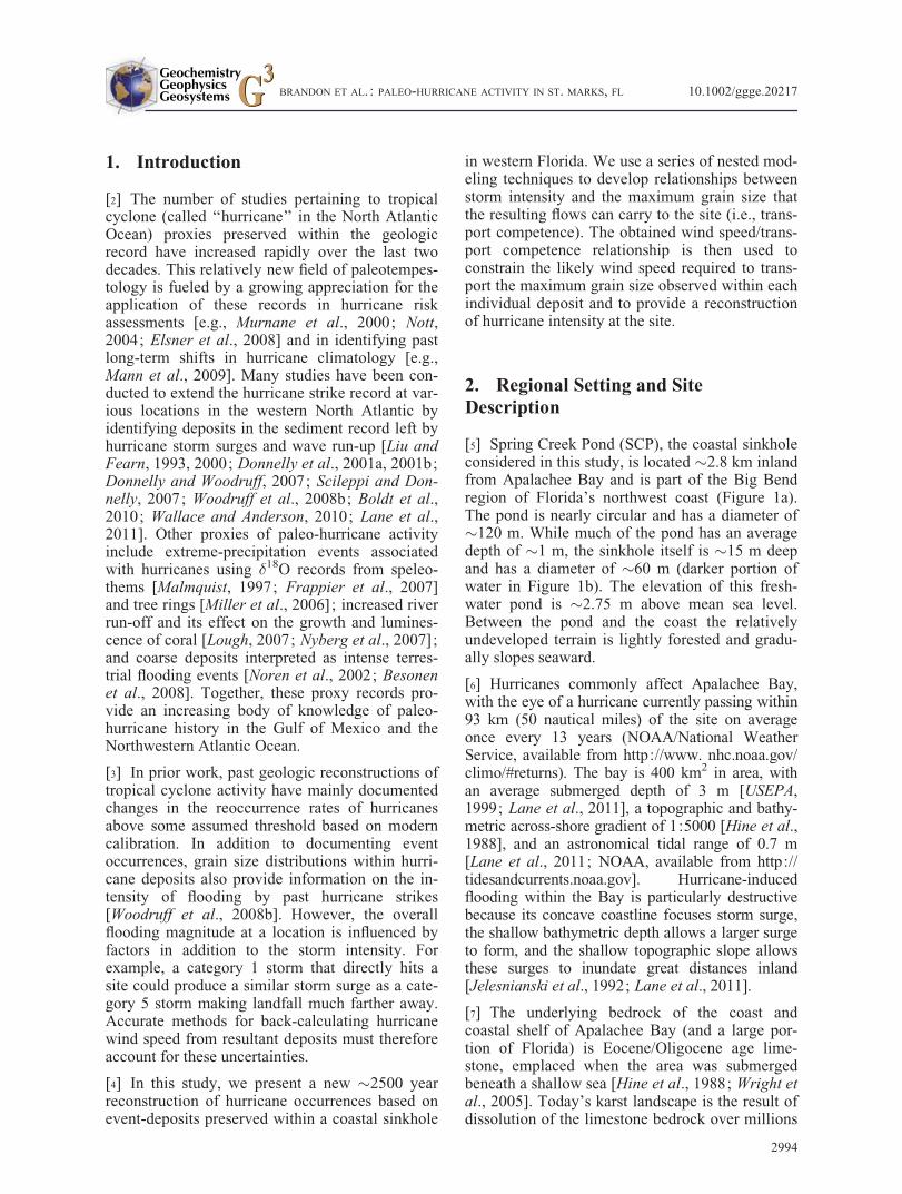
[5] Spring Creek Pond (SCP), the coastal sinkholeconsidered in this study, is located �2.8 km inlandfrom Apalachee Bay and is part of the Big Bendregion of Florida’s northwest coast (Figure 1a).The pond is nearly circular and has a diameter of�120 m. While much of the pond has an averagedepth of �1 m, the sinkhole itself is �15 m deepand has a diameter of �60 m (darker portion ofwater in Figure 1b). The elevation of this fresh-water pond is �2.75 m above mean sea level.Between the pond and the coast the relativelyundeveloped terrain is lightly forested and gradu-ally slopes seaward.
[6] Hurricanes commonly affect Apalachee Bay,with the eye of a hurricane currently passing within93 km (50 nautical miles) of the site on averageonce every 13 years (NOAA/National WeatherService, available from http://www. nhc.noaa.gov/climo/#returns). The bay is 400 km2 in area, withan average submerged depth of 3 m [USEPA,1999; Lane et al., 2011], a topographic and bathy-metric across-shore gradient of 1:5000 [Hine et al.,1988], and an astronomical tidal range of 0.7 m[Lane et al., 2011; NOAA, available from http://tidesandcurrents.noaa.gov]. Hurricane-inducedflooding within the Bay is particularly destructivebecause its concave coastline focuses storm surge,the shallow bathymetric depth allows a larger surgeto form, and the shallow topographic slope allowsthese surges to inundate great distances inland[Jelesnianski et al., 1992; Lane et al., 2011].
[7] The underlying bedrock of the coast andcoastal shelf of Apalachee Bay (and a large por-tion of Florida) is Eocene/Oligocene age lime-stone, emplaced when the area was submergedbeneath a shallow sea [Hine et al., 1988; Wright etal., 2005]. Today’s karst landscape is the result ofdissolution of the limestone bedrock over millions
BRANDON ET AL. : PALEO-HURRICANE ACTIVITY IN ST. MARKS, FL 10.1002/ggge.20217
2994
of years. Sinkhole formation is an ongoing processand readily occurs in the saltwater/freshwatercoastal mixing zone [Randazzo and Jones, 1997].During the Miocene, another time when this areawas submerged, quartz sands from the erosion ofthe Appalachian Mountains were overlain on thelimestone bedrock [Hine et al., 1988]. Today, thissand is available for mobilization by hurricanestorm surge and deposition in sinkhole ponds.Many of these ponds are deep and steep-sidedthereby preventing remobilization of sediment af-ter deposition.
[8] Mullet Pond, a sinkhole which was previouslyused in a paleotempest study [Lane et al., 2011],lies �20 km to the south of SCP (Figure 1). Theauthors reconstructed a �4500 year, decadallyresolved, storm history of the area. This recordwas further analyzed for differences between‘‘low-threshold’’ storm layers (i.e., the thresholdabove which most %coarse anomalies were identi-fied as storm related) and ‘‘high-threshold’’ storm
layers (storms which left deposits exceeding thehighest %coarse anomaly left by a historic storm,in this case, Hurricane Elena in 1985 Common Era(C.E.)). Little variability was observed in low-threshold deposits at 95% confidence, but high-threshold deposits show periods of increased stormactivity �3800 calibrated years before present(B.P.) (�300 year period), �3550 years B.P.(�100 year period), �3300 years B.P. (�100 yearperiod), 2800–2300 years B.P., 1200 years B.P.(50–100 year period), 900 years B.P. (�50 yearperiod), 700 years B.P. (�100 year period) anddecreased activity around 1800, 1650, 350, and150 years B.P. This finding is somewhat differentfrom earlier findings by Liu and Fearn [2000] forWestern Lake located �150 km to the west.Results from Western Lake show a drop in hurri-cane activity beginning �1000 years ago [Liu andFearn, 2000], but this could be related to coastalbarrier dynamics changing the sensitivity of thesite to overwash [Otvos, 2001]. Additional records
Figure 1. (a) Location of Spring Creek and Mullet Ponds on the coast of Apalachee Bay, Florida. Insetshows location of this area along Florida’s coast. (b) Spring Creek Pond (light blue) and its sinkhole (darkblue). The two red lines correspond to sonar transects. Locations of cores SCP D1 and SCP D2 are shown. (c)Subbottom profile along line A-A0. Cores are shown at their proper location and depth. (d) Subbottom profilealong transect B-B0. Cores are shown at their proper location and depth. ‘‘Multiple’’ refers to an instrument ar-tifact and not a real subsurface feature.
BRANDON ET AL. : PALEO-HURRICANE ACTIVITY IN ST. MARKS, FL 10.1002/ggge.20217
2995
from the Apalachee region are nonethelessrequired to evaluate whether the patterns in over-wash described by Lane et al. [2011] can be repro-duced at nearby sites.
[9] Changes in relative sea level can greatlyimpact the occurrence of hurricane overwash at asite and therefore warrant consideration. Severalstudies have reconstructed sea-level curves for theGulf of Mexico [Stapor et al., 1991; Tanner,1992; Morton et al., 2000; Törnqvist et al., 2004;Wright et al., 2005; Donnelly and Giosan, 2008;Milliken et al., 2008]; however, there is some dis-agreement among these results. Some authors pro-pose that sea level has continuously risenthroughout the Holocene, with the rate of sea-levelrise decreasing over time [Otvos, 2001; Törnqvistet al., 2004; Wright et al., 2005; Donnelly andGiosan, 2008; Milliken et al., 2008]. Others haveproposed more complicated sea-level curveswhich include sea level ‘‘highstands’’ or periods oftime when sea level was higher than it is today[Stapor et al., 1991; Tanner, 1992; Morton et al.,2000; Blum et al., 2002]. Proponents of mid-Holocene highstands use geomorphic observationsand radiocarbon data from beach ridges to supportthe idea that these features were formed by wavedeposition, and due to their heights, must havebeen formed at a time of higher-than-present sealevel. Donnelly and Giosan [2008] offer an alter-native explanation, that these ridges were formedduring times of increased storm activity in theGulf of Mexico, which increased the overall waveclimate, leading to construction and preservationof these ridges. Further, Lane et al. [2011] foundno indication of open marine sequences within thesediments and foraminifera assemblages at MulletPond, which refutes a mid-Holocene highstand insea level. We rely on the sea-level rise data ofWright et al. [2005] and Törnqvist et al. [2006]which indicates a continuously, nearly linear risingsea-level rate of �0.4 mm/yr for the region overthe last �3000 years.
3. Methods
3.1. Field Work
[10] Spring Creek Pond was visited during a fieldcampaign in November 2011. The site was ini-tially surveyed with a hand-held depth sounderand subbottom sonar profiles operating at 10 kHz(although the presence of gas resulted in limitedsubbottom sonar penetration within sediments). Topreserve the sediment-water interface an initial
306 cm surface drive was obtained using a modi-fied Vohnout/Colinvaux piston corer (i.e., SCPD1), following methods similar to Donnelly andWoodruff [2007]. Core SCP D1 was followed witha deeper piston vibracore (i.e., SCP D2) extendingfrom 138 to 443 cm below the sediment-waterinterface. Both cores were obtained from approxi-mately the center of the sinkhole (30�5.8920N,84�19.6810W 6 3 m for SCP D1, and 30�5.8910,84�19.6810W 6 3 m for SCP D2, Figure 1b).These cores were then shipped to the University ofMassachusetts Amherst where they were split,described, and stored at 4�C refrigeration.
3.2. Analysis of Sediment Cores
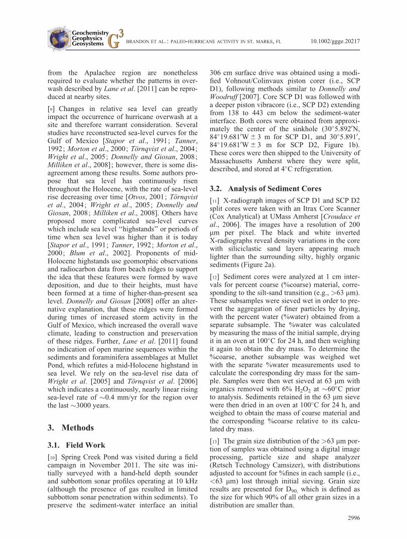
[11] X-radiograph images of SCP D1 and SCP D2split cores were taken with an Itrax Core Scanner(Cox Analytical) at UMass Amherst [Croudace etal., 2006]. The images have a resolution of 200mm per pixel. The black and white invertedX-radiographs reveal density variations in the corewith siliciclastic sand layers appearing muchlighter than the surrounding silty, highly organicsediments (Figure 2a).
[12] Sediment cores were analyzed at 1 cm inter-vals for percent coarse (%coarse) material, corre-sponding to the silt-sand transition (e.g., >63 mm).These subsamples were sieved wet in order to pre-vent the aggregation of finer particles by drying,with the percent water (%water) obtained from aseparate subsample. The %water was calculatedby measuring the mass of the initial sample, dryingit in an oven at 100�C for 24 h, and then weighingit again to obtain the dry mass. To determine the%coarse, another subsample was weighed wetwith the separate %water measurements used tocalculate the corresponding dry mass for the sam-ple. Samples were then wet sieved at 63 mm withorganics removed with 6% H2O2 at �60�C priorto analysis. Sediments retained in the 63 mm sievewere then dried in an oven at 100�C for 24 h, andweighed to obtain the mass of coarse material andthe corresponding %coarse relative to its calcu-lated dry mass.
[13] The grain size distribution of the >63 mm por-tion of samples was obtained using a digital imageprocessing, particle size and shape analyzer(Retsch Technology Camsizer), with distributionsadjusted to account for %fines in each sample (i.e.,<63 mm) lost through initial sieving. Grain sizeresults are presented for D90, which is defined asthe size for which 90% of all other grain sizes in adistribution are smaller than.
BRANDON ET AL. : PALEO-HURRICANE ACTIVITY IN ST. MARKS, FL 10.1002/ggge.20217
2996
3.3. Radiometric Dating
[14] Cesium-137 (137Cs) and lead-210 (210Pb)were used to constrain modern deposition ratesand the ages of historic storm deposits. The onsetof 137Cs in the sediment record is concurrent withthe start of atmospheric nuclear weapons testing in1954 C.E., with the peak in 137Cs activity datingto 1963 C.E. [Pennington et al., 1973] just beforethe signing of the Nuclear Test Ban Treaty. 210Pbages were obtained using techniques similar tothose described in Woodruff et al. [2012]. First,excess (unsupported) 210Pb activity (210Pbex) wasobtained by subtracting the supported 210Pb, asmeasured by the activity of 214Pb [Chen et al.,2004] from the total 210Pb activity. Next, a best-fitlinear regression of the logarithm of 210Pb excessversus the depth in the sediment was calculated[Faure, 1986; Koide et al., 1973; Robbins andEdgington, 1975], with the slope equal to the radi-oactive decay constant of 210Pb (0.03114 yr�1)divided by the average sedimentation rate. Dis-crete ages for individual 210Pb measurements were
obtained with the age-to-activity relationshipdescribed by Appleby and Oldfield [1978] whenassuming a constant initial concentration of210Pbex. Sediment samples were analyzed for137Cs and 210Pb using a Canberra GL2020R LowEnergy Germanium Detector at the University ofMassachusetts Amherst. Each �1.5–2.0 g driedsample was placed in a 6 cm diameter plastic jarand counted for 48–96 h. 137Cs activities werecomputed spectroscopically using the 661.7 keVphotopeak, 210Pb activities were calculated usingthe 46.5 keV photopeak, and 214Pb activities wereobtained with the combined 74.8, 77.11, 87.3,295.2, and 351.9 keV photopeaks.
[15] Carbon-14 (14C) was used to date sedimentsolder than the 210Pb and 137Cs derived age. Plantmaterial at selected depths in the core was datedusing Accelerator Mass Spectrometry (AMS) at theNational Ocean Sciences Accelerator Mass Spec-trometry Facility (NOSAMS) in Woods Hole, MA(Table 1). All radiocarbon ages were converted toyears before present (B.P.) using IntCal09 [Reimer
Figure 2. (a) Combined X-radiograph image of the SCP D1 and SCP D2 cores (separated by the dashed redline) extracted from Spring Creek Pond, showing density variations (lighter colors are denser). Arrows indi-cate inundation deposits. (b) Percentage of coarse material (grain size> 0.063 mm) sampled at 1 cm intervals.Peaks in %coarse (indicated with arrows) correlate with denser layers in X-radiograph. (c) Grain sizes at the90th percentile (D90), sampled at 1 cm intervals. The vertical dashed line at 0.063 mm indicates the silt-sandtransition. (d) D90 grain size of the hurricane inundation layers. The vertical width of the bar is equal to thethickness of the deposit (as determined by the width of the D90 peak). 14C data are shown with the yellow tri-angles, 137Cs data with the red triangle, and the date of extraction (2011 C.E.) with the green triangle.
BRANDON ET AL. : PALEO-HURRICANE ACTIVITY IN ST. MARKS, FL 10.1002/ggge.20217
2997
et al., 2004], where ‘‘present’’ is defined as 1950C.E. by convention. Anomalously old radiocarbonsamples resulting in age reversals were excludedfrom the age chronology (see Table 1).
3.4. Numerical Modeling of StormInundation
[16] Numerical simulations were performed toconstrain the range of hurricanes with the compe-tence to transport the observed grain sizes intoSpring Creek Pond under modern hurricane clima-tology. We then assume that this relationship pro-vides a reasonable representation for thecombination of storm characteristics (includingwind speed, storm size, landfall location, intensity,forward translation speed, angle of approach, etc.),for hurricanes impacting the site prior to theinstrumental record. To overcome restrictionsassociated with the limited number of historicaloverwash events affecting the site, we employedthe model described by Emanuel et al. [2006], andhereafter referred to as the MIT model. The MITmodel is a coupled ocean-atmosphere, beta andadvection hurricane model that generates a data-base of tropical cyclones that pass a set distancefrom a site under modern climatic conditions. Inthe MIT model, a synthetic storm is created byfirst generating a storm track (the location of thestorm’s eye with a temporal resolution of 6 h)using a combination of historical storm track dataand a synthetic wind field that conforms tomonthly climatological means. Then, the storm’sintensity is allowed to change based on a deter-ministic, coupled atmosphere-ocean model drivenby shear derived from the synthetic wind field,monthly means of upper-ocean thermal structure,and potential intensity (the theoretical maximumintensity that a storm can achieve given certainenvironmental factors; see Emanuel et al. [2004]).
[17] The Sea, Lake, and Overland Surges fromHurricanes (SLOSH) model [Jelesnianski et al.,1992] was used with the Apalachicola (APC) gridto evaluate storm surge at the coast near SpringCreak Pond for each storm simulation from theMIT model. The National Weather ServiceSLOSH model simulates coastal inundation bysolving differential equations (using finite-difference methods) which govern fluid motion.The hurricane, which is the driving force of thefluid motion, is modeled as a time-varying surfacewind field and pressure gradient body force[Jelesnianski et al., 1992]. Of the 10,000 stormsgenerated by the MIT model, 152 produced storm
surges at the coastal grid cell closest to SpringCreek Pond that met or exceeded the 2.75 m eleva-tion required to inundate the Spring Creek site.SLOSH simulations of time-varying water-level atthis cell were extracted for each of these 152storms.
[18] Simulations of onshore inundation were per-formed using the Regional Ocean Modeling Sys-tem (ROMS) [Warner et al., 2008] with a 2-Duniformly sloping grid and driven at its openboundary with water-level time series obtainedfrom the 152 SLOSH simulations. ROMS is a nu-merical model that calculates the movement ofwater and sediment in various ocean and riverineenvironments [Warner et al., 2008]. It was used tomodel inundation at the Spring Creek site becauseit has a much finer horizontal resolution than theSLOSH model (10s of meters as opposed to 10s ofkilometers for the SLOSH model) and is capableof resolving vertically varying flow fields, as wellas resultant bottom shear stresses. While ROMShas the capability of creating a three-dimensionaltopography and bathymetry only a two-dimensionalmodel was used here because of uncertainties asso-ciated with changing shoreline shape due to sealevel rise over the course of the Holocene [Staporet al., 1991; Morton et al., 2000; Törnqvist et al.,2004; Wright et al., 2005]. The coastline at the siteis therefore not known over the later Holocene inthe detail needed to warrant the use of a three-dimensional model.
[19] The landscape between the field site and thecoast was modeled with a constant slope of 9.24 �10�4 (as measured using USGS digital elevationmodels), and a constant quadratic drag coefficientof 0.0025. This drag coefficient was chosen from
Table 1. List of 14C Ages
SampleDepth in
Core (cm) MaterialMass(g)
Age 6 Error(14C year B.P.)
CalibratedAge
(year B.P.)
1a 170 Bark 11.8 1300 6 20 1270 6 152b 172 Grass
blade3.6 240 6 25 295 6 10
3c 174.5 Leaf 1.3 95 6 25 235 6 154a 180 Bark 16.3 480 6 25 520 6 105a 209 Bark 3.3 390 6 15 485 6 156a 225 Bark 8.9 735 6 25 675 6 107 254 Bark 17.3 735 6 25 675 6 108 307 Bark 9.3 1260 6 15 1220 6 209 355 Twig 4.7 1680 6 30 1575 6 3510 441.5 Bark 4.6 2500 6 20 2565 6 30
aExcluded from chronology due to anomalously old age.bUsed the oldest 2-� age of 415 6 5 years B.P.; see text for
discussion.cAge inconsistent with 210Pb and 137Cs chronology.
BRANDON ET AL. : PALEO-HURRICANE ACTIVITY IN ST. MARKS, FL 10.1002/ggge.20217
2998
the results of a ROMS model calibration usingsurge simulations produced by Hurricane Dennisin 2005 [see Dukhovskoy and Morey, 2011], andadjusted such that water levels reached, but didnot exceed, Spring Creek Pond during the event(an observation consistent with first-hand accountsby local residents during the event). The ROMSmodel was given a horizontal resolution of 88 mand a vertical topographic resolution of 7.7 cmwhich were chosen as a balance between modelingspeed and accuracy of results. The vertical resolu-tion of the surge is variable such that there ishigher resolution close to the bed and lower reso-lution closer to the water’s surface [Warner et al.,2008]. Calculations were performed with a timestep of 30 s with results saved at 20 minincrements.
[20] Among its many outputs, ROMS calculates thebottom shear stress along the path of inundation atevery time step. The maximum bottom shear stressat the grid cell corresponding to the field site wasextracted and used in the Shields equation to calcu-late the competence for transport at the site:
� ¼ �c �s � �wð ÞgD90 ð1Þ
where � is the bottom shear stress, �c is the nondi-mensional critical shields parameter, �s is the den-sity of the sediment (2650 kg/m3 for quartz sand),�w is the density of water (1000 kg/m3), g is theacceleration due to gravity, and D90 is taken as themaximum grain size that can be mobilized by theflow [Soulsby, 1997]. Here, we use a value of0.047 for �c [Meyer-Peter and M€uller, 1948;Julien and Wargadalam, 1995; Tjerry andFreds�e, 2005]. When combined, derived compe-tence for transport for each of the 152 syntheticstorms provides a relationship between the D90
grain size measured in deposits at SCP and themost likely hurricane intensity responsible foreach deposit, with data dispersion constraining theuncertainty in this relationship.
[21] The distance between the coast and the sitehas likely decreased over the last few millennia asa result of sea-level rise. This leads to an increasein the sensitivity of the site to storm overwash andthe maximum grain size advected to the site to-ward present. To account for these changes, therelationship between D90 grain size and windspeed is derived at the grid cell correlating to theelevation of the site above sea level at the time ofdeposition for each deposit within the SpringCreek Pond reconstruction. The data from Wrightet al. [2005] and Törnqvist et al. [2006] were used
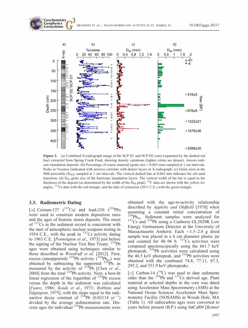
to calculate a sea-level rise curve for this area,yielding an approximately linear rise of 0.4 mm/yr(Figure 3). Since the vertical topographic resolu-tion is 7.7 cm, the virtual site was moved to thenext up-slope grid cell every 7.7 cm/0.04 cm/yr¼ 192.5 years, which is equivalent to a sea-levelfall from the present to the past.
4. Results
4.1. Sediment Chronology
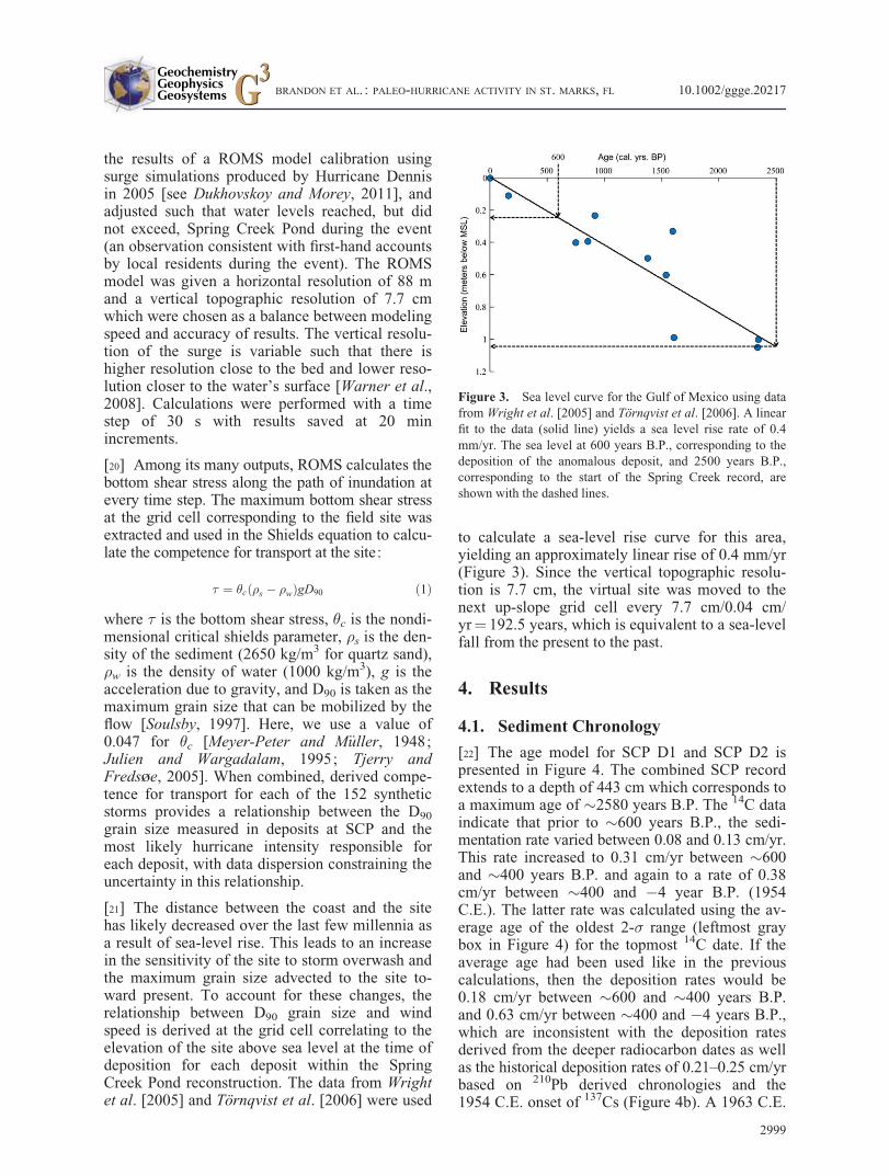
[22] The age model for SCP D1 and SCP D2 ispresented in Figure 4. The combined SCP recordextends to a depth of 443 cm which corresponds toa maximum age of �2580 years B.P. The 14C dataindicate that prior to �600 years B.P., the sedi-mentation rate varied between 0.08 and 0.13 cm/yr.This rate increased to 0.31 cm/yr between �600and �400 years B.P. and again to a rate of 0.38cm/yr between �400 and �4 year B.P. (1954C.E.). The latter rate was calculated using the av-erage age of the oldest 2-� range (leftmost graybox in Figure 4) for the topmost 14C date. If theaverage age had been used like in the previouscalculations, then the deposition rates would be0.18 cm/yr between �600 and �400 years B.P.and 0.63 cm/yr between �400 and �4 years B.P.,which are inconsistent with the deposition ratesderived from the deeper radiocarbon dates as wellas the historical deposition rates of 0.21–0.25 cm/yrbased on 210Pb derived chronologies and the1954 C.E. onset of 137Cs (Figure 4b). A 1963 C.E.
Figure 3. Sea level curve for the Gulf of Mexico using datafrom Wright et al. [2005] and Törnqvist et al. [2006]. A linearfit to the data (solid line) yields a sea level rise rate of 0.4mm/yr. The sea level at 600 years B.P., corresponding to thedeposition of the anomalous deposit, and 2500 years B.P.,corresponding to the start of the Spring Creek record, areshown with the dashed lines.
BRANDON ET AL. : PALEO-HURRICANE ACTIVITY IN ST. MARKS, FL 10.1002/ggge.20217
2999
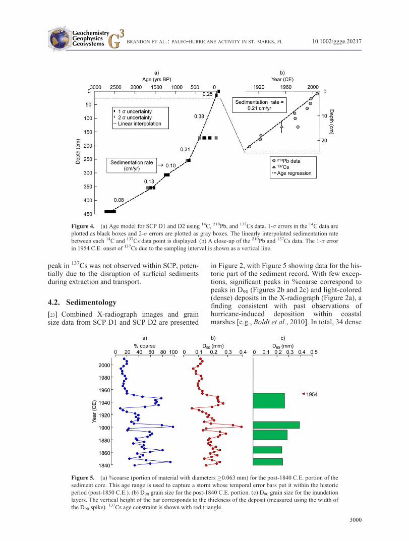
peak in 137Cs was not observed within SCP, poten-tially due to the disruption of surficial sedimentsduring extraction and transport.
4.2. Sedimentology
[23] Combined X-radiograph images and grainsize data from SCP D1 and SCP D2 are presented
in Figure 2, with Figure 5 showing data for the his-toric part of the sediment record. With few excep-tions, significant peaks in %coarse correspond topeaks in D90 (Figures 2b and 2c) and light-colored(dense) deposits in the X-radiograph (Figure 2a), afinding consistent with past observations ofhurricane-induced deposition within coastalmarshes [e.g., Boldt et al., 2010]. In total, 34 dense
Figure 4. (a) Age model for SCP D1 and D2 using 14C, 210Pb, and 137Cs data. 1-� errors in the 14C data areplotted as black boxes and 2-� errors are plotted as gray boxes. The linearly interpolated sedimentation ratebetween each 14C and 137Cs data point is displayed. (b) A close-up of the 210Pb and 137Cs data. The 1-� errorin 1954 C.E. onset of 137Cs due to the sampling interval is shown as a vertical line.
Figure 5. (a) %coarse (portion of material with diameters �0.063 mm) for the post-1840 C.E. portion of thesediment core. This age range is used to capture a storm whose temporal error bars put it within the historicperiod (post-1850 C.E.). (b) D90 grain size for the post-1840 C.E. portion. (c) D90 grain size for the inundationlayers. The vertical height of the bar corresponds to the thickness of the deposit (measured using the width ofthe D90 spike). 137Cs age constraint is shown with red triangle.
BRANDON ET AL. : PALEO-HURRICANE ACTIVITY IN ST. MARKS, FL 10.1002/ggge.20217
3000
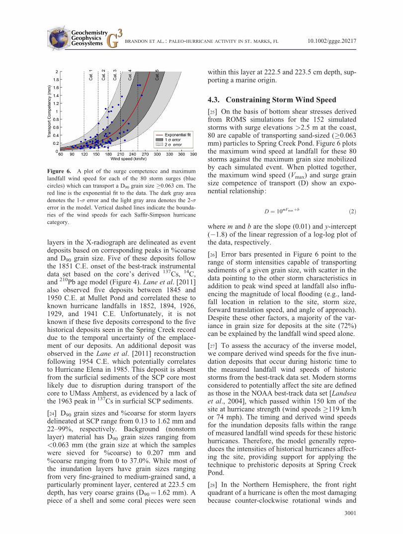
layers in the X-radiograph are delineated as eventdeposits based on corresponding peaks in %coarseand D90 grain size. Five of these deposits followthe 1851 C.E. onset of the best-track instrumentaldata set based on the core’s derived 137Cs, 14C,and 210Pb age model (Figure 4). Lane et al. [2011]also observed five deposits between 1845 and1950 C.E. at Mullet Pond and correlated these toknown hurricane landfalls in 1852, 1894, 1926,1929, and 1941 C.E. Unfortunately, it is notknown if these five deposits correspond to the fivehistorical deposits seen in the Spring Creek recorddue to the temporal uncertainty of the emplace-ment of our deposits. An additional deposit wasobserved in the Lane et al. [2011] reconstructionfollowing 1954 C.E. which potentially correlatesto Hurricane Elena in 1985. This deposit is absentfrom the surficial sediments of the SCP core mostlikely due to disruption during transport of thecore to UMass Amherst, as evidenced by a lack ofthe 1963 peak in 137Cs in surficial SCP sediments.
[24] D90 grain sizes and %coarse for storm layersdelineated at SCP range from 0.13 to 1.62 mm and22–99%, respectively. Background (nonstormlayer) material has D90 grain sizes ranging from<0.063 mm (the grain size at which the sampleswere sieved for %coarse) to 0.207 mm and%coarse ranging from 0 to 37.0%. While most ofthe inundation layers have grain sizes rangingfrom very fine-grained to medium-grained sand, aparticularly prominent layer, centered at 223.5 cmdepth, has very coarse grains (D90¼ 1.62 mm). Apiece of a shell and some coral pieces were seen
within this layer at 222.5 and 223.5 cm depth, sup-porting a marine origin.
4.3. Constraining Storm Wind Speed
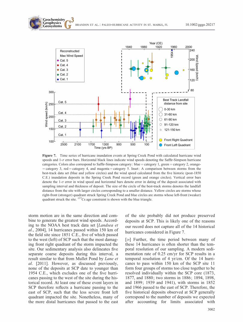
[25] On the basis of bottom shear stresses derivedfrom ROMS simulations for the 152 simulatedstorms with surge elevations >2.5 m at the coast,80 are capable of transporting sand-sized (�0.063mm) particles to Spring Creek Pond. Figure 6 plotsthe maximum wind speed at landfall for these 80storms against the maximum grain size mobilizedby each simulated event. When plotted together,the maximum wind speed (Vmax) and surge grainsize competence of transport (D) show an expo-nential relationship:
D ¼ 10mVmaxþb ð2Þ
where m and b are the slope (0.01) and y-intercept(�1.8) of the linear regression of a log-log plot ofthe data, respectively.
[26] Error bars presented in Figure 6 point to therange of storm intensities capable of transportingsediments of a given grain size, with scatter in thedata pointing to the other storm characteristics inaddition to peak wind speed at landfall also influ-encing the magnitude of local flooding (e.g., land-fall location in relation to the site, storm size,forward translation speed, and angle of approach).Despite these other factors, a majority of the var-iance in grain size for deposits at the site (72%)can be explained by the landfall wind speed alone.
[27] To assess the accuracy of the inverse model,we compare derived wind speeds for the five inun-dation deposits that occur during historic time tothe measured landfall wind speeds of historicstorms from the best-track data set. Modern stormsconsidered to potentially affect the site are definedas those in the NOAA best-track data set [Landseaet al., 2004], which passed within 150 km of thesite at hurricane strength (wind speeds �119 km/hor 74 mph). The timing and derived wind speedsfor the inundation deposits falls within the rangeof measured landfall wind speeds for these historichurricanes. Therefore, the model generally repro-duces the intensities of historical hurricanes affect-ing the site, providing support for applying thetechnique to prehistoric deposits at Spring CreekPond.
[28] In the Northern Hemisphere, the front rightquadrant of a hurricane is often the most damagingbecause counter-clockwise rotational winds and
Figure 6. A plot of the surge competence and maximumlandfall wind speed for each of the 80 storm surges (bluecircles) which can transport a D90 grain size �0.063 cm. Thered line is the exponential fit to the data. The dark gray areadenotes the 1-� error and the light gray area denotes the 2-�error in the model. Vertical dashed lines indicate the bounda-ries of the wind speeds for each Saffir-Simpson hurricanecategory.
BRANDON ET AL. : PALEO-HURRICANE ACTIVITY IN ST. MARKS, FL 10.1002/ggge.20217
3001
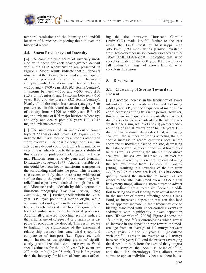
storm motion are in the same direction and com-bine to generate the greatest wind speeds. Accord-ing to the NOAA best track data set [Landsea etal., 2004], 14 hurricanes passed within 150 km ofthe field site since 1851 C.E., five of which passedto the west (left) of SCP such that the most damag-ing front right quadrant of the storm impacted thesite. Our sedimentary analysis also delineates fiveseparate coarse deposits during this interval, aresult similar to that from Mullet Pond by Lane etal. [2011]. However, as discussed previously,none of the deposits at SCP date to younger than1954 C.E., which excludes one of the five hurri-canes passing to the west of the site during the his-torical record. At least one of these event layers inSCP therefore reflects a hurricane passing to theeast of SCP, such that the less severe front leftquadrant impacted the site. Nonetheless, many ofthe more distal hurricanes that passed to the east
of the site probably did not produce preserveddeposits at SCP. This is likely one of the reasonsour record does not capture all of the 14 historicalhurricanes considered in Figure 7.
[29] Further, the time period between many ofthese 14 hurricanes is often shorter than the tem-poral resolution of our sampling. A modern sedi-mentation rate of 0.25 cm/yr for SCP results in atemporal resolution of 4 yr/cm. Of the 14 hurri-canes to pass within 150 km of the SCP site 11form four groups of storms too close together to beresolved individually within the SCP core (1873,1877, and 1880; two storms in 1886; 1894, 1898,and 1899; 1939 and 1941), with storms in 1852and 1966 passed to the east of SCP. Therefore, thefive historical deposits observed at SCP generallycorrespond to the number of deposits we expectedafter accounting for limits associated with
Figure 7. Time series of hurricane inundation events at Spring Creek Pond with calculated hurricane windspeeds and 1-� error bars. Horizontal black lines indicate wind speeds denoting the Saffir-Simpson hurricanecategories. Colors also correspond to Saffir-Simpson category: blue¼ category 1, green¼ category 2, orange-¼ category 3, red¼ category 4, and magenta¼ category 5. Inset: A comparison between storms from thebest-track data set (blue and yellow circles) and the wind speed calculated from the five historic (post-1850C.E.) inundation deposits in the Spring Creek Pond record (green and orange circles). Vertical error barsdenote the 1-� error in wind speed and horizontal bars denote error in dating of the deposit associated withsampling interval and thickness of deposit. The size of the circle of the best-track storms denotes the landfalldistance from the site with larger circles corresponding to a smaller distance. Yellow circles are storms whoseright-front (stronger) quadrant struck Spring Creek Pond and blue circles are storms whose left-front (weaker)quadrant struck the site. 137Cs age constraint is shown with the blue triangle.
BRANDON ET AL. : PALEO-HURRICANE ACTIVITY IN ST. MARKS, FL 10.1002/ggge.20217
3002
temporal resolution and the intensity and landfalllocation of hurricanes impacting the site over thehistorical record.
4.4. Storm Frequency and Intensity
[30] The complete time series of inversely mod-eled wind speed for each coarse-grained depositwithin the SCP reconstruction are presented inFigure 7. Model results indicate that all depositsobserved at the Spring Creek Pond site are capableof being produced by storms with hurricanestrength winds. One storm was detected between�2500 and �1700 years B.P. (0.1 storms/century),14 storms between �1700 and �600 years B.P.(1.3 storms/century), and 19 storms between �600years B.P. and the present (3.2 storms/century).Nearly all of the major hurricanes (category 3 orgreater) seen in this record occur during the periodof activity from �1700 to �600 years B.P. (10major hurricanes or 0.91 major hurricanes/century)and only one occurs post-600 years B.P. (0.17major hurricanes/century).
[31] The uniqueness of an anomalously coarselayer at 220 cm or �600 years B.P. (Figure 2) mayindicate that it was formed by a process other thanstorm overwash. One possible origin of this unusu-ally coarse deposit could be from a tsunami; how-ever, this is unlikely due to the seismic stability ofthis area and its protection by Cuba and the Baha-mas Platform from remotely generated tsunamis[Randazzo and Jones, 1997]. Another possible ori-gin could be from heavy rainstorms transportingthe surrounding sand into the pond. This scenarioalso seems unlikely since there is no evidence ofsurface flow to the pond and the surrounding low-relief landscape is well drained through the surfi-cial Miocene sands underlain by fairly permeablelimestone topography [Puri and Vernon, 1964;Lane et al., 2011]. Further, shells within the �600year B.P. layer point to a marine origin, whilewell-rounded sand grains in the deposit are indica-tive of beach material that has undergone somelevel of initial weathering by coastal processes.Additionally, inverse modeling results indicatethat a hurricane of category 4 or 5 intensity is ca-pable of producing the deposit. This result servesto highlight the significance of the exponentialrelationship between hurricane wind speed andcompetence of transport (i.e., Figure 6), withmajor hurricanes transporting grains of signifi-cantly greater sizes than less intense events. Windspeed estimates for the �600 year B.P. event are272 6 40 km/h (169 6 25 mph). This is far greaterthan the intensity for historical hurricanes affect-
ing the site, however, Hurricane Camille(1969 C.E.) made landfall further to the eastalong the Gulf Coast of Mississippi with306 km/h (190 mph) winds [Unisys, availablefrom http://weather.unisys.com/hurricane/atlantic/1969/CAMILLE/track.dat], indicating that windspeed estimate for the 600 year B.P. event doesfall within the range of known landfall windspeeds in the region.
5. Discussion
5.1. Clustering of Storms Toward thePresent
[32] A notable increase in the frequency of lowerintensity hurricane events is observed following�600 years B.P., but the frequency of major hurri-canes decreases during this same period. However,this increase in frequency is potentially an artifactdue to (i) a change in sensitivity of the site to over-wash due to rising sea level and (ii) greater under-counting of actual events prior to 600 years B.P.due to lower sedimentation rates. First, with risingsea level, the number of storms affecting the siteshould increase in recent centuries because theshoreline is moving closer to the site, decreasingthe distance storm-induced floods must travel overland, as well as lowering the site’s altitude abovesea level. The sea level has risen �1 m over thetime span covered by this record (calculated usingthe sea level curve from Donnelly and Giosan[2008]), resulting in a lowering of the site from�3.75 to 2.75 m above sea level. This has conse-quently caused the shoreline to move �1 kmcloser to the site (calculated from USGS digitalbathymetry maps) allowing storm surges to advectlarger sediment grains to the site. Second, in addi-tion to rising sea level leading to an actual increasein the number of storms affecting Spring CreekPond, an increasing deposition rate can also leadto an apparent increase in their frequency due tobiasing associated with under-counting events insediments with significantly slower depositionrates [Woodruff et al., 2008a]. Figure 4 shows the14C, 210Pb, and 137Cs chronologies which revealan increase in the deposition rate toward the mod-ern age from an average of 1.0 mm/yr between�2500 years B.P. and 600 years B.P. (calculatedwith the 14C ages) to an average of 2.9 mm/yrbetween 600 years B.P. and the present (averagingthe deposition rates from the ages of the youngesttwo 14C samples, the 1954 C.E. onset of 137Cs,and the 210Pb chronology). This allows morestorms to appear individually because there is less
BRANDON ET AL. : PALEO-HURRICANE ACTIVITY IN ST. MARKS, FL 10.1002/ggge.20217
3003
time represented in each centimeter of sedimentwith many deposits older than 600 years B.P. pos-sibly being amalgamations of two or more storms.
[33] An increase in sedimentation rate toward thepresent is common to lacustrine and lagoonalsediments along the Gulf of Mexico and the NorthAtlantic coasts due to increased connectivity ofthese systems to the sea as sea-level rises, resultingin an increase in the amount of marine sourcedmaterial introduced to these back-barrier environ-ments [Donnelly and Bertness, 2001; Donnellyet al., 2004; Gehrels et al., 2005; Woodruff et al.,2008a]. Spring Creek Pond, however, is �3 kminland and is not part of a coastal marsh system.Therefore, we do not believe that sea-level rise hascontributed to the increased sedimentation rate atthis site. Additional explanations include increasedproduction from eutrophication and the compac-tion of older sediments. The underlying cause ofthe increased rate of sedimentation remainsunclear. However, due to their concurrent timing,the increase in frequency of low-intensity hurri-cane events following 600 years B.P. is at least inpart governed by the three-fold increase in sedi-mentation rate in the most recent centuries. It ispossible that the frequency of low-intensity hurri-cane landfalls at the site has also increased overthis time period; however, biasing associated withchanges in sedimentation make it difficult toassess the significance of any potential changes inthe frequency of lower-intensity events during thismost recent interval.
5.2. Changes in Major HurricaneFrequency
[34] Changes in the landfall frequency of all hurri-cane categories are difficult to assess at SCP dueto significant changes in rates of sedimentation.Trends in intensity for higher magnitude events,however, show additional patterns less affected byundercounting biases associated with changes insedimentation rate. This is because, (i) theseevents occur less frequently and can be betterresolved in a record of lower temporal resolutionand (ii) more intense storms transport larger sedi-ment grain sizes such that the maximum grain sizewithin any deposit that is an amalgamation of sev-eral storms of different intensities will register asthe most intense of these flood events.
[35] In the SCP reconstruction, the frequency ofmajor hurricane strikes decreases from 0.91storms/century between �1700 and �600 yearsB.P. to 0.17 storms/century between �600 years
B.P. and the present. This transition does notappear to be an artifact associated with an increasein sedimentation rate toward modern since theassociated increase in temporal resolution shouldincrease the number of deposits delineated in therecord rather than decrease it. The drop in intensehurricane occurrences at 600 years B.P. is alsoinconsistent with increased sensitivity of the siteto hurricane flooding from rising sea level. Wetherefore conclude that the decrease in the numberof major hurricanes at �600 years B.P. representsa real drop in the frequency of these more intenseevents at SCP.
5.3. Paleoclimate Comparisons
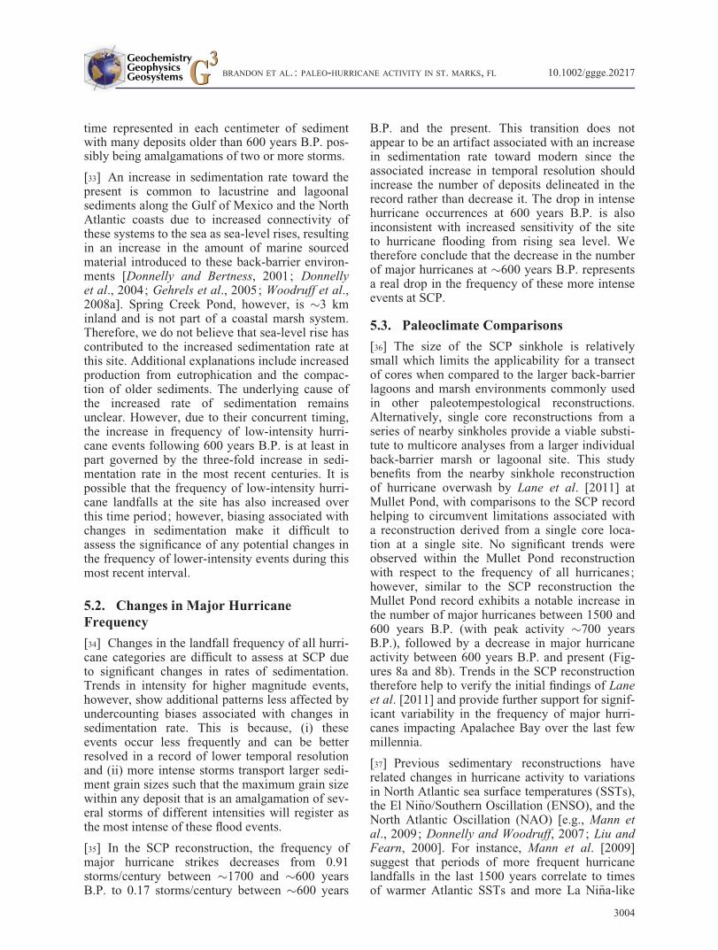
[36] The size of the SCP sinkhole is relativelysmall which limits the applicability for a transectof cores when compared to the larger back-barrierlagoons and marsh environments commonly usedin other paleotempestological reconstructions.Alternatively, single core reconstructions from aseries of nearby sinkholes provide a viable substi-tute to multicore analyses from a larger individualback-barrier marsh or lagoonal site. This studybenefits from the nearby sinkhole reconstructionof hurricane overwash by Lane et al. [2011] atMullet Pond, with comparisons to the SCP recordhelping to circumvent limitations associated witha reconstruction derived from a single core loca-tion at a single site. No significant trends wereobserved within the Mullet Pond reconstructionwith respect to the frequency of all hurricanes;however, similar to the SCP reconstruction theMullet Pond record exhibits a notable increase inthe number of major hurricanes between 1500 and600 years B.P. (with peak activity �700 yearsB.P.), followed by a decrease in major hurricaneactivity between 600 years B.P. and present (Fig-ures 8a and 8b). Trends in the SCP reconstructiontherefore help to verify the initial findings of Laneet al. [2011] and provide further support for signif-icant variability in the frequency of major hurri-canes impacting Apalachee Bay over the last fewmillennia.
[37] Previous sedimentary reconstructions haverelated changes in hurricane activity to variationsin North Atlantic sea surface temperatures (SSTs),the El Ni~no/Southern Oscillation (ENSO), and theNorth Atlantic Oscillation (NAO) [e.g., Mann etal., 2009; Donnelly and Woodruff, 2007; Liu andFearn, 2000]. For instance, Mann et al. [2009]suggest that periods of more frequent hurricanelandfalls in the last 1500 years correlate to timesof warmer Atlantic SSTs and more La Ni~na-like
BRANDON ET AL. : PALEO-HURRICANE ACTIVITY IN ST. MARKS, FL 10.1002/ggge.20217
3004
conditions. However, the active interval forintense hurricanes at Mullet and SCP ending ataround 600 years B.P. is not predicted with thebasin-wide statistical model of Mann et al. [2009].This may indicate that variability in the MulletPond and SCP reconstructions represent changesmore specific to the northeastern Gulf of Mexico,and in turn potentially forced by more regionalforms of environmental change.
[38] Alternatively, discrepancies between the com-bined SCP/Mullet Pond reconstructions and theMann et al. [2009] proxy record may indicate thatother factors in addition to SST, ENSO, and theNAO are more dominant drivers of past changes
in hurricane activity in the Gulf of Mexico. Forinstance, a better metric for the stability of the freetroposphere, which in part governs the theoreticalmaximum wind speed that hurricanes can attain, isdescribed by the difference between SST and tem-perature of the upper troposphere relative to SSTrather than absolute SST alone [Emanuel, 1986,1988]. Further, SST is often assumed to representthe temperature of the upper ocean mixed layer;however, this SST proxy provides very little infor-mation regarding the depth of the mixed layer,which in part determines how quickly cooler waterfrom below can be mixed to the surface during thepassage of a hurricane [Emanuel et al., 2004].
[39] It is possible that past variability in the posi-tion of the Loop Current in the Gulf of Mexicomight explain regional changes in the frequency ofintense hurricane landfalls represented by the SCPand Mullet Pond reconstructions [Lane andDonnelly, 2012]. The Loop Current is a surface-ocean current (part of the North Atlantic WesternBoundary Current) that flows from the CaribbeanSea, northward through the Yucatan Channel intothe Gulf of Mexico, loops to the east, and exitsthrough the Florida Straits to join the Gulf Stream[Poore et al., 2003; Lund and Curry, 2004]. It isdifficult to identify the Loop Current in the Gulfwith SST alone; however, the importance of theLoop Current in controlling intense hurricanelandfall frequency resides in how the currentchanges the Gulf’s oceanic thermal structure ratherthan SST. In general, the mixed layer of ambientwarm surface waters in the Gulf of Mexico has arelatively shallow average depth of 30–40 m[Chouinard et al., 1997]. As storms intensify, theyquickly mix up cooler waters from below [Price,1981; Sriver and Huber, 2007], and this processlimits further storm development [Emanuel et al.,2004]. In the Loop Current, however, the mixedlayer can be as deep as 200 m below the surfaceproviding several times more available energy todeveloping cyclones by limiting the role of storm-induced upwelling [Goni and Trinanes, 2003].
[40] The deep, warm waters of the Loop Currentoccasionally meander northward into the easternGulf of Mexico and make a clockwise loop beforeexiting. These meanders periodically break offfrom the flow to form anticyclonic warm coreeddies that propagate westward as they dissipate.The frequency of eddy formation and the extent towhich the Loop Current penetrates into the Gulf isthought to be aperiodic on subdecadal time scales;however, lower-frequency variations in windstress may drive periodicities on longer time scales
Figure 8. (a) Hurricane strike record at Spring Creek Pondspanning the past �2500 years, compared to (b) the recon-structed frequency of intense hurricane events from thenearby site at Mullet Pond (MP) by Lane et al. [2011]. Thecolor scheme in ‘‘a’’ is the same as in Figure 7 and the y axisof the MP record is intense (�category 3) hurricane frequency(storms/century). (c) The relative abundance of G. sacculiferin the Pygmy Basin over the last �1500 years. Increasing rel-ative abundance of G. sacculifer corresponds to greater pene-tration of the Loop Current into the Gulf of Mexico. Thehorizontal dashed lines represent the mean value of G. saccu-lifer abundance, showing an abrupt decrease at 600 years B.P.(vertical dashed line), as presented by Richey et al. [2007]. (d)SST record, reconstructed from foraminiferal Mg/Ca ratios inthe Pygmy Basin over the past �1500 years [Richey et al.,2007]. The arrow indicates the drop in SST �1000 years B.P.identified by the authors.
BRANDON ET AL. : PALEO-HURRICANE ACTIVITY IN ST. MARKS, FL 10.1002/ggge.20217
3005
[Sturges and Leben, 2000]. The relative abundanceof the foraminifer Globigerinoides sacculifer inmarine cores taken from the Pigmy Basin in thenorthern Gulf has been offered as a proxy for theextent and/or frequency of Loop Current incur-sions into the Gulf [Poore et al., 2003, 2004,2011; Richey et al., 2007]. Though not contempo-raneous with regional SST cooling in Pigmy Basinat 1000 years B.P. as derived by Mg/Ca recon-structions, the significant decline in intense hurri-cane frequency occurring around 600 cal yearsB.P. at both SCP and Mullet Pond is concurrentwith an abrupt decrease in G. sacculifer abundanceat the Pigmy site [Richey et al., 2007]. The declinein G. sacculifer has been interpreted to reflectreduced advection of Caribbean surface watersinto the Gulf of Mexico and a shoaling of the ther-mocline caused by a more southerly residence ofthe Loop Current [Poore et al., 2004]. A transitionto less penetration of the Loop Current into theGulf following 600 years B.P. would lower theocean heat content available to tropical cyclonesin the northeastern Gulf and might help to explainthe 600 years B.P. drop in intense hurricane fre-quency observed both at SCP and Mullet Pond.Additional reconstructions are required, however,to confirm the hypothesized Loop Current proxyderived from Pigmy Basin.
6. Conclusions
[41] Sediments recovered from Spring CreekPond, a coastal sinkhole located in northwest Flor-ida, contain a �2500 year record of hurricane ac-tivity in this area. We identify and date 34 stormslayers and analyze each for %coarse material andD90 grain size. An inverse modeling technique isdeveloped to constrain the landfall wind speed ofthe storms from the D90 grain size of their result-ant deposits. We find that (1) applying the inversemodel to the sediment deposits from the historic(post-1851 C.E.) record results in landfall windspeeds that are consistent with storms reported inthe best-track data set, (2) all deposits throughoutthe �2500 year record are capable of being pro-duced by hurricanes, including a seemingly anom-alous layer dated to 600 years B.P., and (3) theSCP time series of intense hurricane occurrence isconsistent with a nearby reconstruction previouslyobtained from Mullet Pond, with both recordsindicating a period of increased intense hurricanefrequency between �1700 and �600 years agoand decreased intense storm frequency from�2500 to �1700 and �600 years ago to the pres-
ent. The variation in intense hurricane strike fre-quency, particularly the drop in of activity at 600years B.P., is potentially the result of inferredshifts in Loop Current penetration into the Gulf ofMexico.
Acknowledgments
[42] This work was supported by the National Science Foun-dation. We thank J. Elsner and J. Warner for valuable model-ing assistance; K. Emanuel for sharing the data from the MITmodel and his insightful comments and edits to an earlier ver-sion of the text; and S. Ahmed, A. Hawkes, D. MacDonald,S. Madsen, S. Moret, A. Sheldon, R. Sullivan, M. Toomey, P.van Hengstum, and S. Zipper for their field and laboratory as-sistance. This article benefited from constructive reviews byM. Huber, J. Anderson, and one anonymous reviewer.
References
Appleby, P. G., and F. Oldfield (1978), The calculation oflead-210 dates assuming a constant rate of supply of unsup-ported 210Pb to the sediment, Catena, 5(1), 1–8,doi :10.1016/S0341–8162(78)80002-2.
Besonen, M. R., R. S. Bradley, M. Mudelsee, M. B. Abbott,and P. Francus (2008), A 1,000-year, annually-resolved re-cord of hurricane activity from Boston, Massachusetts, Geo-phys. Res. Lett., 35, L14705, doi:10.1029/2008GL033950.
Blum, M. D., A. E. Carter, T. Zayac, and R. Gobel (2002),Middle Holocene sea-level and evolution of the Gulf ofMexico coast, J. Coastal Res., 36, 65–80.
Boldt, K. V., P. Lane, J. D. Woodruff, and J. P. Donnelly(2010), Calibrating a sedimentary record of overwash fromSoutheastern New England using modeled historic hurricanesurges, Mar. Geol., 275(1–4), 127–139, doi:10.1016/j.margeo.2010.05.002.
Chen, Z., Y. Saito, Y. Kanai, T. Wei, L. Li, H. Yao, and Z.Wang (2004), Low concentration of heavy metals in theYangtze estuarine sediments, China: A diluting setting, Es-tuarine Coastal Shelf Sci., 60(1), 91–100, doi:10.1016/j.ecss.2003.11.021.
Chouinard, L., C. Liu, and C. Cooper (1997), Model for sever-ity of hurricanes in Gulf of Mexico, J. Waterw. Port CoastalOcean Eng., 123, 120–129, doi:10.1061/(ASCE)0733–950X(1997)123:3(120).
Croudace, I. W., A. Rindby, and R. G. Rothwell (2006),ITRAX: Description and evaluation of a new multi-functionX-ray core scanner, Geol. Soc. Spec. Publ., 267, 51–63.
Donnelly, J. P., and M. D. Bertness (2001), Rapid shorewardencroachment of salt marsh cordgrass in response to acceler-ated sea-level rise, Proc. Natl. Acad. Sci. U. S. A., 98(25),14,218–14,223, doi:10.1073/pnas.251209298.
Donnelly, J. P., and L. Giosan (2008), Tempestuous highs andlows in the Gulf of Mexico, Geology, 36(9), 751–752.
Donnelly, J. P., and J. D. Woodruff (2007), Intense hurricaneactivity over the past 5,000 years controlled by El Ni~no andthe West African monsoon, Nature, 447(7143), 465–468,doi :10.1038/nature05834.
Donnelly, J. P., S. S. Bryant, J. Butler, J. Dowling, L. Fan, N.Hausmann, P. Newby, B. Shuman, J. Stern, and K. Westover(2001a), 700 yr sedimentary record of intense hurricane
BRANDON ET AL. : PALEO-HURRICANE ACTIVITY IN ST. MARKS, FL 10.1002/ggge.20217
3006
landfalls in southern New England, Geol. Soc. Am. Bull.,113(6), 714–727.
Donnelly, J. P., S. Roll, M. Wengren, J. Butler, R. Lederer,and T. Webb III (2001b), Sedimentary evidence of intensehurricane strikes from New Jersey, Geology, 29(7), 615–618.
Donnelly, J. P., J. Butler, S. Roll, M. Wengren, and T. Webb(2004), A backbarrier overwash record of intense stormsfrom Brigantine, New Jersey, Mar. Geol., 210(1), 107–121.
Dukhovskoy, D. S., and S. L. Morey (2011), Simulation of thehurricane Dennis storm surge and considerations for verticalresolution, Nat. Hazards, 58(1), 511–540.
Elsner, J. B., T. H. Jagger, and K. Liu (2008), Comparison ofhurricane return levels using historical and geologicalrecords, J. Appl. Meteorol. Climatol., 47(2), 368–374.
Emanuel, K. A. (1986), An air-sea interaction theory for tropi-cal cyclones, Part I: Steady-state maintenance, J. Atmos.Sci., 43(6), 585–605, doi:http://dx.doi.org/10.1175/1520-0469(1986)043<0585:AASITF>2.0.CO;2.
Emanuel, K. A. (1988), The maximum intensity of hurricanes,J. Atmos. Sci., 45(7), 1143–1155.
Emanuel, K. A., C. DesAutels, C. Holloway, and R. Korty(2004), Environmental control of tropical cyclone intensity,J. Atmos. Sci., 61(7), 843–858.
Emanuel, K. A., S. Ravela, E. Vivant, and C. Risi (2006), Astatistical deterministic approach to hurricane risk assess-ment, Bull. Am. Meteorol. Soc., 87(3), 299–314.
Faure, G. (1986), Principles of Isotope Geology, John Wiley,New York.
Frappier, A. B., D. Sahagian, S. J. Carpenter, L. A. Gonz�alez,and B. R. Frappier (2007), Stalagmite stable isotope recordof recent tropical cyclone events, Geology, 35(2), 111–114.
Gehrels, W. R., J. R. Kirby, A. Prokoph, R. M. Newnham, E.P. Achterberg, H. Evans, S. Black, and D. B. Scott (2005),Onset of recent rapid sea-level rise in the western AtlanticOcean, Quat. Sci. Rev., 24(18), 2083–2100.
Goni, G., and J. Trinanes (2003), Ocean thermal structuremonitoring could aid in the intensity forecast of tropicalcyclones, Eos Trans. AGU, 84(51), 573–580.
Hine, A. C., D. F. Belknap, J. G. Hutton, E. B. Osking, and M.W. Evans (1988), Recent geological history and modern sed-imentary processes along an incipient, low-energy, epiconti-nental-sea coastline: Northwest Florida, J. Sediment. Res.,58(4), 567–579.
Jelesnianski, C. P., J. Chen, and W. A. Shaffer (1992),SLOSH: Sea, Lake, and Overland Surges from Hurricanes,U.S. Dep. of Commer., Natl. Oceanic and Atmos. Admin.,Natl. Weather Serv., Silver Spring, Maryland.
Julien, P. Y., and J. Wargadalam (1995), Alluvial channel ge-ometry: Theory and applications, J. Hydraul. Eng., 121(4),312–325.
Koide, M., K. W. Bruland, and E. D. Goldberg (1973), Th-228/Th-232 and Pb-210 geochronologies in marine andlake sediments, Geochim. Cosmochim. Acta, 37(5),1171–1187.
Landsea, C. W., C. Anderson, N. Charles, G. Clark, J. Dunion,J. Fernandez-Partagas, P. Hungerford, C. Neumann, and M.Zimmer (2004), The Atlantic hurricane database re-analysisproject : Documentation for the 1851–1910 alterations andadditions to the HURDAT database, in Hurricanes andTyphoons: Past, Present and Future, edited by R. Murnaneand K. Liu, pp. 177–221, Columbia Press, New York.
Lane, P., and J. P. Donnelly (2012), Hurricanes and typhoons:Will tropical cyclones become stronger and more frequent?,PAGES Newslett., 20(1), 32–33.
Lane, P., J. P. Donnelly, J. D. Woodruff, and A. D. Hawkes(2011), A decadally-resolved paleohurricane recordarchived in the late Holocene sediments of a Florida sink-hole, Mar. Geol., 287(1–4), 14–30.
Liu, K. B., and M. L. Fearn (1993), Lake-sediment record oflate Holocene hurricane activities from coastal Alabama,Geology, 21(9), 793–796.
Liu, K., and M. L. Fearn (2000), Reconstruction of prehistoriclandfall frequencies of catastrophic hurricanes in northwest-ern Florida from lake sediment records, Quat. Res., 54(2),238–245.
Lough, J. M. (2007), Tropical river flow and rainfall recon-structions from coral luminescence: Great Barrier Reef,Australia, Paleoceanography, 22, PA2218, doi:10.1029/2006PA001377.
Lund, D. C., and W. B. Curry (2004), Late Holocene variabili-ty in Florida current surface density: Patterns and possiblecauses, Paleoceanography, 19, PA4001, doi:10.1029/2004PA001008.
Malmquist, D. (1997), Oxygen isotopes in cave stalagmites asa proxy record of past tropical cyclone activity, in 22nd Con-ference on Hurricanes and Tropical Meteorology, Am.Meteorol. Soc., Fort Collins, Colo.
Mann, M. E., J. D. Woodruff, J. P. Donnelly, and Z. Zhang(2009), Atlantic hurricanes and climate over the past 1,500years, Nature, 460(7257), 880–883.
Meyer-Peter, E., and R. M€uller (1948), Formulas for bed-loadtransport, paper presented at the 2nd Meeting of theInternational Association for Hydraulic Structures Research,International Association of Hydraulic Research,Stockholm, Sweden, June 7, 1948.
Miller, D. L., C. I. Mora, H. D. Grissino-Mayer, C. J. Mock,M. E. Uhle, and Z. Sharp (2006), Tree-ring isotope recordsof tropical cyclone activity, Proc. Natl. Acad. Sci. U. S. A.,103(39), 14,294–14,297.
Milliken, K., J. B. Anderson, and A. B. Rodriguez (2008), Anew composite Holocene sea-level curve for the northernGulf of Mexico, response of Gulf coast estuaries to sea-levelrise and climate change, Geol. Soc. Am. Spec. Pap., 443,1–11.
Morton, R. A., J. G. Paine, and M. D. Blum (2000), Responsesof stable bay-margin and barrier-island systems to Holocenesea-level highstands, western Gulf of Mexico, J. Sediment.Res., 70(3), 478–490.
Murnane, R. J. et al. (2000), Model estimates hurricane windspeed probabilities, Eos Trans. AGU, 81(38), 433–438.
Noren, A. J., P. R. Bierman, E. J. Steig, A. Lini, and J. Southon(2002), Millennial-scale storminess variability in the north-eastern United States during the Holocene epoch, Nature,419(6909), 821–824.
Nott, J. (2004), Paleotempestology: The study of prehistorictropical cyclones—A review and implications for hazardassessment, Environ. Int., 30(3), 433–447.
Nyberg, J., B. A. Malmgren, A. Winter, M. R. Jury, K. H. Kil-bourne, and T. M. Quinn (2007), Low Atlantic hurricane ac-tivity in the 1970s and 1980s compared to the past 270 years,Nature, 447(7145), 698–701.
Otvos, E. G. (2001), Assumed Holocene highstands, Gulf ofMexico: Basic issues of sedimentary and landform criteria:Discussion, J. Sediment. Res., 71(4), 645–647.
Pennington, W., T. Tutin, R. Cambray, and E. Fisher (1973),Observations on lake sediments using fallout 137Cs as atracer, Nature, 242, 324–326, doi :10.1038/242324a0.
Peterson, L., J. Overpeck, N. Kipp, and J. Imbrie (1991), Ahigh-resolution late quaternary upwelling record from the
BRANDON ET AL. : PALEO-HURRICANE ACTIVITY IN ST. MARKS, FL 10.1002/ggge.20217
3007
anoxic Cariaco Basin, Venezuela, Paleoceanography, 6(1),99–119.
Poore, R., H. Dowsett, S. Verardo, and T. M. Quinn (2003),Millennial-to century-scale variability in Gulf of MexicoHolocene climate records, Paleoceanography, 18(2), 1048,doi:10.1029/2002PA000868.
Poore, R., T. Quinn, and S. Verardo (2004), Century-scalemovement of the Atlantic Intertropical Convergence Zonelinked to solar variability, Geophys. Res. Lett., 31, L12214,doi:10.1029/2004GL019940.
Poore, R. Z., S. Verardo, J. Caplan, K. Pavich, and T. Quinn(2011), Planktic foraminiferal relative abundance and trendsin Gulf of Mexico holocene sediments: Records of climatevariability, in Gulf of Mexico: Its Origins, Waters, Biota,and Human Impact, Geology, vol. 3, 1st ed., edited byNoreen A. Buster and C. W. Holmes, pp. 367–379, TexasA&M Univ. Press, College Station, Tex.
Price, J. F. (1981), Upper ocean response to a hurricane, J.Phys. Oceanogr., 11(2), 153–175, doi:http://dx.doi.org/10.1175/1520-0485(1981)011<0153:UORTAH>2.0.CO;2.
Puri, H. S., and R. O. Vernon (1964), Summary of the Geologyof Florida and a Guidebook to the Classic Exposures,Special Publication No. 5, Fla. Geol. Surv., Tallahassee,Florida.
Randazzo, A. F., and D. S. Jones (1997), The Geology of Flor-ida, 327 pp., Univ. Press of Fla., Gainesville, Fla.
Reimer, P. J. et al. (2004), IntCal04 terrestrial radiocarbon agecalibration, 0–26 cal kyr BP, Radiocarbon, 46(3), 1029–1058.
Richey, J. N., R. Z. Poore, B. P. Flower, and T. M. Quinn(2007), 1400 yr multiproxy record of climate variabilityfrom the northern Gulf of Mexico, Geology, 35(5), 423–426.
Robbins, J. A., and D. N. Edgington (1975), Determination ofrecent sedimentation rates in Lake Michigan using Pb-210and Cs-137, Geochim. Cosmochim. Acta, 39(3), 285–304.
Scileppi, E., and J. P. Donnelly (2007), Sedimentary evidenceof hurricane strikes in western Long Island, New York, Geo-chem. Geophys. Geosyst., 8, Q06011, doi:10.1029/2006GC001463.
Soulsby, R. (1997), Dynamics of Marine Sands: A Manual forPractical Applications, Thomas Telford, London.
Sriver, R. L., and M. Huber (2007), Observational evidencefor an ocean heat pump induced by tropical cylones, Nature,447, 577–580, doi :10.1038/nature05785.
Stapor, F. W., Jr., T. D. Mathews, and F. E. Lindfors-Kearns(1991), Barrier-island progradation and Holocene sea-levelhistory in southwest Florida, J. Coastal Res., 7(3), 815–838.
Sturges, W., and R. Leben (2000), Frequency of ring separa-tions from the Loop Current in the Gulf of Mexico: A re-vised estimate, J. Phys. Oceanogr., 30(7), 1814–1819,doi :http://dx.doi.org/10.1175/1520-0485(2000)030<1814:FORSFT>2.0.CO;2.
Tanner, W. F. (1992), 3000 years of sea level change, Bull.Am. Meteorol. Soc., 73(3), 297–303.
Tjerry, S., and J. Freds�e (2005), Calculation of dune mor-phology, J. Geophys. Res., 110, F04013, doi:10.1029/2004JF000171.
Törnqvist, T. E., J. L. Gonz�alez, L. A. Newsom, K. van derBorg, A. F. de Jong, and C. W. Kurnik (2004), DecipheringHolocene sea-level history on the US Gulf Coast : A high-resolution record from the Mississippi Delta, Geol. Soc. Am.Bull., 116(7–8), 1026–1039.
Törnqvist, T. E., S. J. Bick, K. van der Borg, and A. F. de Jong(2006), How stable is the Mississippi Delta?, Geology,34(8), 697–700.
USEPA (1999), Ecological condition of estuaries in the Gulfof Mexico, Rep. EPA 620-R- 98-004, pp. 80, U.S. Environ-mental Protection Agency, Office of Research and Develop-ment, National Health and Environmental Effects ResearchLaboratory, Gulf Ecology Division, Gulf Breeze, Florida.
Wallace, D. J., and J. B. Anderson (2010), Evidence of similarprobablility of intense hurricane strikes for the Gulf of Mex-ico over the late Holocene, Geology, 38(6), 511–514.
Warner, J. C., C. R. Sherwood, R. P. Signell, C. K. Harris, andH. G. Arango (2008), Development of a three-dimensional,regional, coupled wave, current, and sediment-transportmodel, Comput. Geosci., 34(10), 1284–1306.
Woodruff, J. D., J. P. Donnelly, K. Emanuel, and P. Lane(2008a), Assessing sedimentary records of paleohurricane ac-tivity using modeled hurricane climatology, Geochem. Geo-phys. Geosyst., 9, Q09V10, doi:10.1029/2008GC002043.
Woodruff, J. D., J. P. Donnelly, D. Mohrig, and W. R. Geyer(2008b), Reconstructing relative flooding intensities respon-sible for hurricane-induced deposits from Laguna PlayaGrande, Vieques, Puerto Rico, Geology, 36(5), 391–394.
Woodruff, J. D., A. Martini, E. Elzidani, T. Naugton, D.Kekacs, and D. G. MacDonald (2012), Off-river waterbodieson tidal rivers: Human impact on rates of infilling and theaccumulation of pollutants, Geomorphology, 184, 38–50.
Wright, E. E., A. C. Hine, S. L. Goodbred, and S. D. Locker(2005), The effect of sea-level and climate change on the de-velopment of a mixed siliciclastic–carbonate, deltaic coast-line: Suwannee River, Florida, USA, J. Sediment. Res.,75(4), 621–635.
BRANDON ET AL. : PALEO-HURRICANE ACTIVITY IN ST. MARKS, FL 10.1002/ggge.20217
3008