Embed Size (px)
Citation preview
Indonesian Journal of Geology, Vol. 7 No. 1 March 2012: 55 - 66
55
Tsunami Characteristics along The Coast of Biak Island based on the 1996 Biak Tsunami Traces
Karakteristik Tsunami sepanjang Pantai Pulau BiakBerdasarkan Jejak Tsunami Biak 1996
Yudhicara
Geological Agency, Jln. Diponegoro No. 57, Bandung, Indonesia
AbstrAct
Identification on tsunami traces had been conducted along the coast of Biak Island, Papua, to recognize the character of tsunami potential in this region, referring to the 1996 tsunami event. This study is to observe the influence of tsunami to the environment and tsunami character itself which can be learned from tsunami deposit. According to the 1996 Biak tsunami run up distributions, it can be observed that the maximum tsunami run up was found at the coast which has an undulating to steep morphology rather than other places which has a relatively flat one. The 1996 Biak Tsunami arrival times were approximately between 10 and 15 minutes, such as at the northern and southern coasts of Biak, except for the western one which is about 1 to 5 minutes. This was influenced by the local bathymetry and another possible source triggering tsunami such as a local submarine landslide. The number of tsunami waves were between 2 and 4, and the second one was usually the highest. Based on a sedimentological analysis, the 1996 tsunami deposit is characterized by the dominant coarse sand, while grain size distribution curve shows a character of transportation process similar to an ordinary beach process dominated by saltation current. The foraminifera fossil content tends to indicate that the tsunami deposit was derived from > 200 m seafloor depth (bathyal zone).
Keywords: 1996 Biak tsunami, tsunami deposit, grain size analysis, fossil
Sari
Identifikasi jejak tsunami telah dilakukan di sepanjang kawasan pantai Pulau Biak, dalam rangka mem-pelajari karakteristik tsunami yang berpotensi untuk terjadi di masa yang akan datang di wilayah ini, dengan merujuk pada peristiwa tsunami tahun 1996. Penelitian ini akan melihat bagaimana pengaruh tsunami terhadap lingkungan dan ciri-ciri tsunami itu sendiri yang dapat dipelajari dari endapannya. Berdasarkan distribusi ketinggian run up tsunami, teramati bahwa ketinggian tsunami maksimum terdapat di kawasan pantai yang memiliki morfologi bergelombang hingga curam dibandingkan dengan tempat lainnya yang memiliki morfologi landai. Waktu tiba gelombang tsunami pada peristiwa tsunami Biak 1996 berkisar antara 10 dan 15 menit, seperti yang terdapat di pantai utara dan selatan Biak, sedangkan kawasan pantai barat Biak memiliki waktu tiba 1 hingga 5 menit. Hal ini dipengaruhi oleh kondisi batimetri setempat dan kemungkinan sumber lain yang dapat memicu terjadinya tsunami di kawasan ini, yaitu longsoran bawah laut lokal. Gelombang tsunami yang datang berjumlah antara dua hingga empat dan yang tertinggi biasanya yang kedua. Berdasarkan analisis sedimentologi, endapan tsunami 1996 memiliki tekstur butiran yang didominasi oleh pasir kasar, sedangkan kurva distribusi ukuran butir memperlihatkan karakter proses transportasi yang mirip dengan pengendapan pasir pantai biasa yang didominasi oleh arus saltasi. Berdasarkan kandungan fosilnya, endapan tsunami yang berada di pantai berasal dari kedalaman lebih dari 200 m (zona batial).
Kata kunci: Tsunami Biak 1996, endapan tsunami, analisis besar butir, fosil
Manuscript received: November 27, 2011, final acceptance: March 12, 2012Correspending Author: +6281809168799/[email protected]
56 Indonesian Journal of Geology, Vol. 7 No. 1 March 2012: 55 - 66
IntroductIon
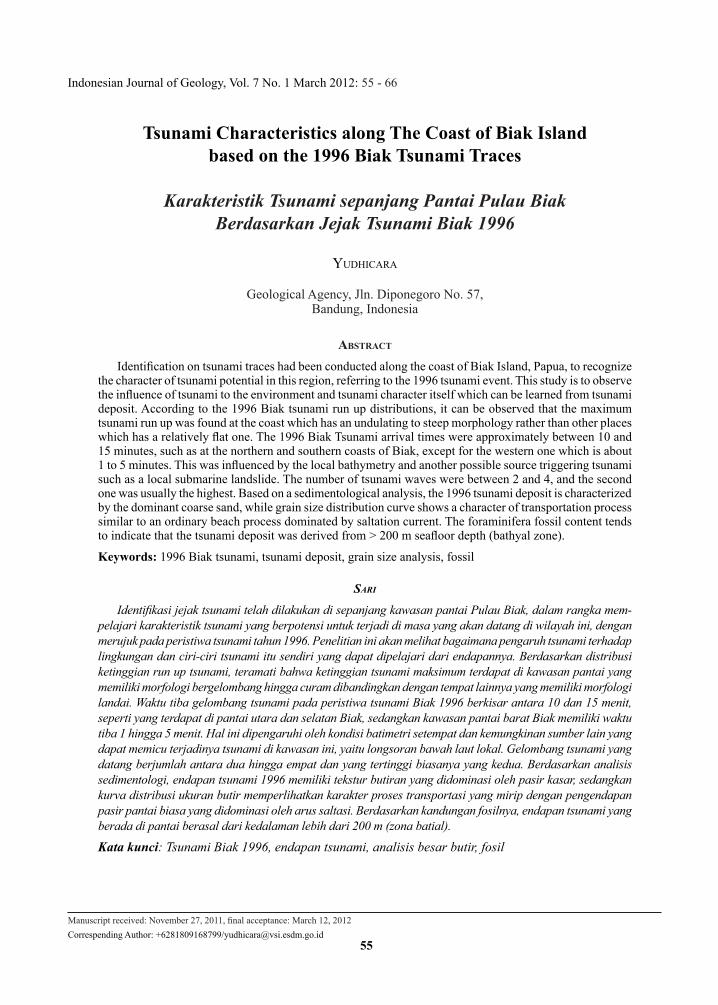
On 17 Februari 1996, there was a big earthquake occurred about 60 km northeast of Biak Island with magnitude of Mw 8.2 at 14:59 local time. This earthquake was followed by a tsunami with the maximum height of 7.7 m above sea level at Madori, western Biak and 5.4 m at Korem, northern Biak. This earthquake and tsunami had killed 107 people, missed 51 people, badly injured 55 people, and de-stroyed more than 2,700 houses (Puspito, 1996). In order to recognize the characteristic of tsunami in this region that may potentially occur in the future, a study was carried out to identify and analyze the tsunami deposits left by a previous tsunami and how the environment affected to the tsunami. The study was conducted along the coastal area of Biak Island (Figure 1).
O
141 30’ E
o24
5’
S
PAPUA ISLAND
O142 15’ E
o24
5’
So 2 00
’ S
O142 15’ E
O
214’
S
O
142 04’ E
O21
0’
S
O142 04’ E
O
141 57’ E
O
21 0
’ S
O21
4’
S
O
141 57’ E
o20
0’
S
o141 30’ E
BIAK
YAPEN
BIAK ISLAND
0 20 40 km
N180m
10-15m
300m
500m
100m
Marsam
2
Sauri
Arnini
10
9
2
5 5
BiakOwi Is Padaido Islels
Songo5 5
Resaidon
I IFPAS C
EAN OC
N
KorimMardori
Warari
RayoriSansundi
PASIFIC OCEAN
Figure 1. Locality map of studied area.
GenerAl revIew
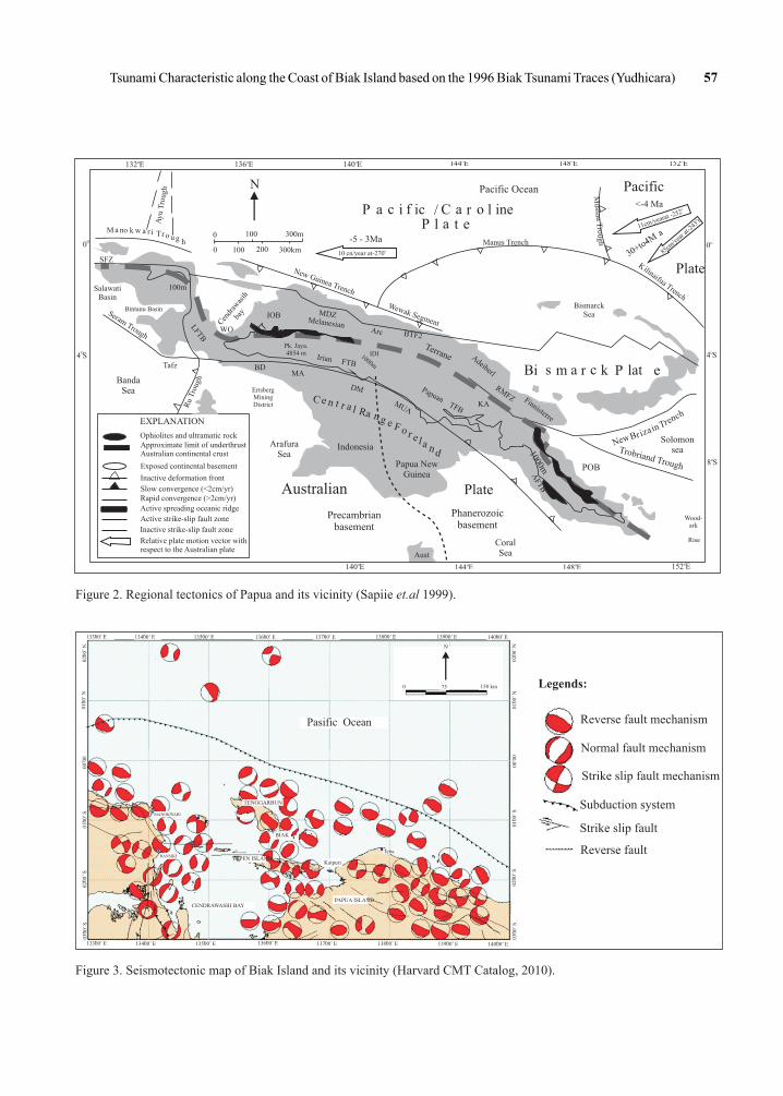
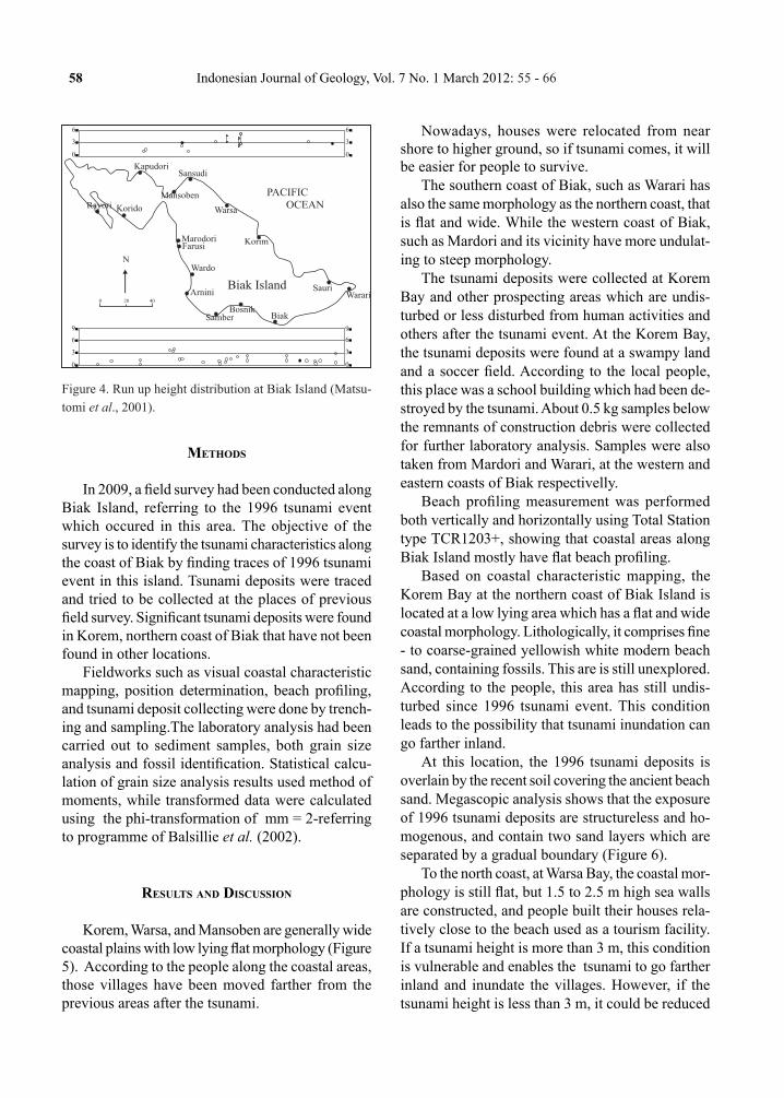
Tectonics and Seismicity Based on the regional tectonics of Papua and its
vicinity (Figure 2), Biak Island is influenced by New
Guinea trench in the north and Yapen strike-slip fault system in the south. Tsunami could be associated with the New Guinea trench in the north which is dominated by reverse fault mechanisms, shown on the seismotectonic map (Figure 3).
Tsunami potential caused by earthquake could be generated by dip-slip mechanism both normal and reverse faults. According to its focal mechanism, the fault plane has a trend of northwest-southeast direction affected by the maximum compression coming from northeast-southwest.
Tsunamigenic earthquake could be the main source of tsunami generation, but other sources could also be possible to generate tsunami, such as sub-marine landslide which had ever occurred in 1996.
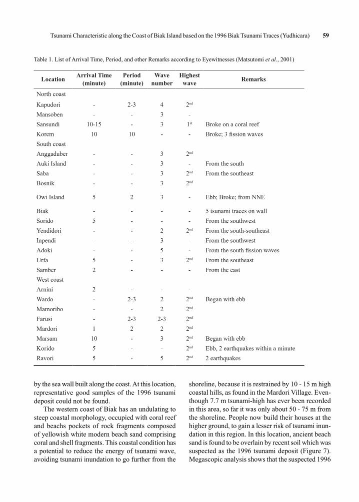
The 17 February Biak TsunamiOn the basis of a field survey conducted by the
International Tsunami Survey Team (ITST), it is observed that the total length of the coast with run up height of more than 4 m is 20 km, starting from Korem to Warsa in the north coast, and some parts in Farusi (Mardori) west coast of Biak (Figure 4). In general, coastal morphology of the Biak Island is relatively flat, causing a wide inundated area, even for 2 m run up height can cause a large inundated area, for instance in Mansoben that could extend about 120 m inland (Matsutomi et al., 2001).
Run up height of 7.7 m was found at Farusi (Mar-dori). This village is in the opposite of another coast which has directly been affected by the tsunami. This run up height is higher than in the other coasts. It is assumed to have been caused by a submarine landslide which was triggered by an earthquake. The highest run up at Korem is 5.4 m at a narrow bay perpendicular to the tsunami source. It was measured at a house wall at 270 m from the shoreline, while 2.5 m run up height was measured at the distance of 450 m from the shoreline, whereas at the southern coast, the run up height is about 2.9 m at 50 m from the shoreline (Table 1).
Table 1 shows that the tsunami went inland three up to five times. The second wave is the highest, started by the ebb tide followed by a subsidence of 0.1 - 0.3 m at Sansudi, northern coast of Biak. The first tsunami arrival time at the northern coast observed in Korem was 10 - 15 minutes after the earthquake, with the wave period of 10 minutes. While at the southern and western coast 1 - 5 minutes arrival time and the wave period of 2 - 3 minutes were observed (Matsutomi et al., 2001).
Tsunami Characteristic along the Coast of Biak Island based on the 1996 Biak Tsunami Traces (Yudhicara) 57
O152 EO148 EO144 EO140 E
O132 E O136 E O140 EO144 E O148 E O152 E
O0
O4 S
O0
O8 S
Australian
Precambrianbasement
ArafuraSea
CoralSea
Phanerozoicbasement
Plate
Wood-ark
Rise
POB
Solomon seaTrobriand Trough
hcnerTB
i
New n
ariz
P eBi m r k latas c
BismarckSea
Plate
Pacific<-4 Ma
3+t -
a
0o4M
o
11cm/y arat 2e - 52
o
85c/y
ea at
-243 t
m
r
r lP a i ic C inec f a o/l tP ea
Pacific Ocean
-5 - 3Mao
10 cn/year at-270
0
0
100
100 200 300km
300m
Ay
Tro
ugu
h
kM noa w a r i rT o u g h
New Guinea Trench
Wewak S gmente
Manus Trench
BandaSea
Tafz
ug
R T
rou
h
SalawatiBasin
SFZ
ErtsbergMiningDistrict
Cn
rw
ih
ed
aas
bay
WO
Kia
uT
enh
linif
a rc
Indonesia
Papua NewGuinea
artl
ne
nRa
C
g e F o r ela nd
Aust
IOB
MA
DM
MUA
pPa uan TFBKA
Irian FTB
01 00mFT
BA
Bintanu BasinSer Trough
am
LFTB
Pk. Jaya.4854 m 1000m
IDI
MDZM la es ane n i
rcA BTF2
anTerr
e Adib
rl
ee
RMFZ F
nter
inis
re
BD
Mussau
Tugh
ro
100m
Ophiolites and ultramatic rockApproximate limit of underthrustAustralian continental crust
Exposed continental basement
Inactive deformation front
Slow convergence (<2cm/yr)
Active spreading oceanic ridge
Rapid convergence (>2cm/yr)
Active strike-slip fault zone
Inactive strike-slip fault zone
Relative plate motion vector withrespect to the Australian plate
EXPLANATION
N
O4 S
Reverse fault mechanism
Normal fault mechanism
Strike slip fault mechanism
Subduction system
Strike slip fault
Reverse fault
Legends:
Focal Mechanism Solution from Harvard CMT Catalog
Reverse fault mechanism
Normal fault mechanism
Strike slip fault mechanism
Subduction system
Strike slip fault
Reverse fault
Legends:
Pasific Ocean
150 km750
N
PAPUA ISLAND
Kaipuri
Teba
CENDRAWASIH BAY
RANSIKI YAPEN ISLAND
BIAK
TENGGARBUN
MANOKWARI
o13300’ E o13400’ E o13500’ E o13600’ E
o13700’ Eo
13800’ E o13900’ E o14000’ E
o13300’ E o13400’ E o13500’ E
o13600’ E o13700’ E
o13800’ E o13900’ E 0
14000’ E
o03
00’
So
0200
’ S
o01
00’
S0
00 0
0o
0100
’ N
o02
00’
N
o02
00’
No
0100
’ N
o00
00
o01
00’
So
0200
’ S
o03
00’
S
Figure 2. Regional tectonics of Papua and its vicinity (Sapiie et.al 1999).
Figure 3. Seismotectonic map of Biak Island and its vicinity (Harvard CMT Catalog, 2010).
58 Indonesian Journal of Geology, Vol. 7 No. 1 March 2012: 55 - 66
Methods
In 2009, a field survey had been conducted along Biak Island, referring to the 1996 tsunami event which occured in this area. The objective of the survey is to identify the tsunami characteristics along the coast of Biak by finding traces of 1996 tsunami event in this island. Tsunami deposits were traced and tried to be collected at the places of previous field survey. Significant tsunami deposits were found in Korem, northern coast of Biak that have not been found in other locations.
Fieldworks such as visual coastal characteristic mapping, position determination, beach profiling, and tsunami deposit collecting were done by trench-ing and sampling.The laboratory analysis had been carried out to sediment samples, both grain size analysis and fossil identification. Statistical calcu-lation of grain size analysis results used method of moments, while transformed data were calculated using the phi-transformation of mm = 2-referring to programme of Balsillie et al. (2002).
results And dIscussIon
Korem, Warsa, and Mansoben are generally wide coastal plains with low lying flat morphology (Figure 5). According to the people along the coastal areas, those villages have been moved farther from the previous areas after the tsunami.
Nowadays, houses were relocated from near shore to higher ground, so if tsunami comes, it will be easier for people to survive.
The southern coast of Biak, such as Warari has also the same morphology as the northern coast, that is flat and wide. While the western coast of Biak, such as Mardori and its vicinity have more undulat-ing to steep morphology.
The tsunami deposits were collected at Korem Bay and other prospecting areas which are undis-turbed or less disturbed from human activities and others after the tsunami event. At the Korem Bay, the tsunami deposits were found at a swampy land and a soccer field. According to the local people, this place was a school building which had been de-stroyed by the tsunami. About 0.5 kg samples below the remnants of construction debris were collected for further laboratory analysis. Samples were also taken from Mardori and Warari, at the western and eastern coasts of Biak respectivelly.
Beach profiling measurement was performed both vertically and horizontally using Total Station type TCR1203+, showing that coastal areas along Biak Island mostly have flat beach profiling.
Based on coastal characteristic mapping, the Korem Bay at the northern coast of Biak Island is located at a low lying area which has a flat and wide coastal morphology. Lithologically, it comprises fine - to coarse-grained yellowish white modern beach sand, containing fossils. This are is still unexplored. According to the people, this area has still undis-turbed since 1996 tsunami event. This condition leads to the possibility that tsunami inundation can go farther inland.
At this location, the 1996 tsunami deposits is overlain by the recent soil covering the ancient beach sand. Megascopic analysis shows that the exposure of 1996 tsunami deposits are structureless and ho-mogenous, and contain two sand layers which are separated by a gradual boundary (Figure 6).
To the north coast, at Warsa Bay, the coastal mor-phology is still flat, but 1.5 to 2.5 m high sea walls are constructed, and people built their houses rela-tively close to the beach used as a tourism facility. If a tsunami height is more than 3 m, this condition is vulnerable and enables the tsunami to go farther inland and inundate the villages. However, if the tsunami height is less than 3 m, it could be reduced
PACIFIC OCEAN
KapudoriSansudi
Mansoben
Warsa
MarodoriFarusi
Wardo
Korim
SauriWarariArnini
SamberBosnik
Biak
Biak Island
KoridoRayori
0 20 40
N
6
6
9
6
6
9
3
3
3
3
0
0
0
0
Figure 4. Run up height distribution at Biak Island (Matsu-tomi et al., 2001).
Tsunami Characteristic along the Coast of Biak Island based on the 1996 Biak Tsunami Traces (Yudhicara) 59
Location Arrival Time(minute)
Period(minute)
Wave number
Highest wave Remarks
North coast
Kapudori - 2-3 4 2nd
Mansoben - - 3 -Sansundi 10-15 - 3 1st Broke on a coral reefKorem 10 10 - - Broke; 3 fission wavesSouth coastAnggaduber - - 3 2nd
Auki Island - - 3 - From the southSaba - - 3 2nd From the southeastBosnik - - 3 2nd
Owi Island 5 2 3 - Ebb; Broke; from NNE
Biak - - - - 5 tsunami traces on wallSorido 5 - - - From the southwestYendidori - - 2 2nd From the south-southeastInpendi - - 3 - From the southwestAdoki - - 5 - From the south fission wavesUrfa 5 - 3 2nd From the southeastSamber 2 - - - From the eastWest coastArnini 2 - - -Wardo - 2-3 2 2nd Began with ebbMamoribo - - 2 2nd
Farusi - 2-3 2-3 2nd
Mardori 1 2 2 2nd
Marsam 10 - 3 2nd Began with ebbKorido 5 - - 2nd Ebb, 2 earthquakes within a minuteRavori 5 - 5 2nd 2 earthquakes
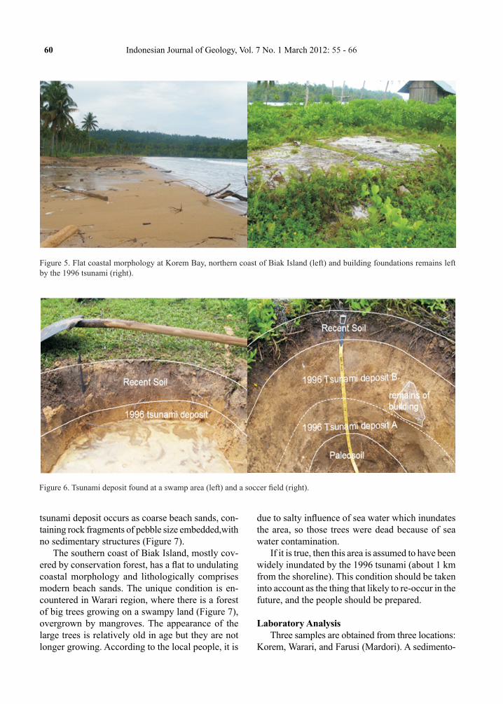
Table 1. List of Arrival Time, Period, and other Remarks according to Eyewitnesses (Matsutomi et al., 2001)
by the sea wall built along the coast. At this location, representative good samples of the 1996 tsunami deposit could not be found.
The western coast of Biak has an undulating to steep coastal morphology, occupied with coral reef and beachs pockets of rock fragments composed of yellowish white modern beach sand comprising coral and shell fragments. This coastal condition has a potential to reduce the energy of tsunami wave, avoiding tsunami inundation to go further from the
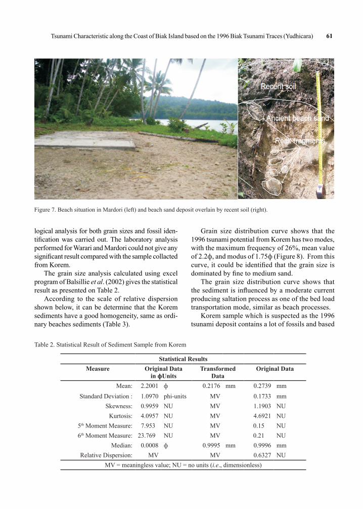
shoreline, because it is restrained by 10 - 15 m high coastal hills, as found in the Mardori Village. Even-though 7.7 m tsunami-high has ever been recorded in this area, so far it was only about 50 - 75 m from the shoreline. People now build their houses at the higher ground, to gain a lesser risk of tsunami inun-dation in this region. In this location, ancient beach sand is found to be overlain by recent soil which was suspected as the 1996 tsunami deposit (Figure 7). Megascopic analysis shows that the suspected 1996
60 Indonesian Journal of Geology, Vol. 7 No. 1 March 2012: 55 - 66
Figure 5. Flat coastal morphology at Korem Bay, northern coast of Biak Island (left) and building foundations remains left by the 1996 tsunami (right).
Figure 6. Tsunami deposit found at a swamp area (left) and a soccer field (right).
tsunami deposit occurs as coarse beach sands, con-taining rock fragments of pebble size embedded,with no sedimentary structures (Figure 7).
The southern coast of Biak Island, mostly cov-ered by conservation forest, has a flat to undulating coastal morphology and lithologically comprises modern beach sands. The unique condition is en-countered in Warari region, where there is a forest of big trees growing on a swampy land (Figure 7), overgrown by mangroves. The appearance of the large trees is relatively old in age but they are not longer growing. According to the local people, it is
due to salty influence of sea water which inundates the area, so those trees were dead because of sea water contamination.
If it is true, then this area is assumed to have been widely inundated by the 1996 tsunami (about 1 km from the shoreline). This condition should be taken into account as the thing that likely to re-occur in the future, and the people should be prepared.
Laboratory AnalysisThree samples are obtained from three locations:
Korem, Warari, and Farusi (Mardori). A sedimento-
Tsunami Characteristic along the Coast of Biak Island based on the 1996 Biak Tsunami Traces (Yudhicara) 61
Figure 7. Beach situation in Mardori (left) and beach sand deposit overlain by recent soil (right).
logical analysis for both grain sizes and fossil iden-tification was carried out. The laboratory analysis performed for Warari and Mardori could not give any significant result compared with the sample collacted from Korem.
The grain size analysis calculated using excel program of Balsillie et al. (2002) gives the statistical result as presented on Table 2.
According to the scale of relative dispersion shown below, it can be determine that the Korem sediments have a good homogeneity, same as ordi-nary beaches sediments (Table 3).
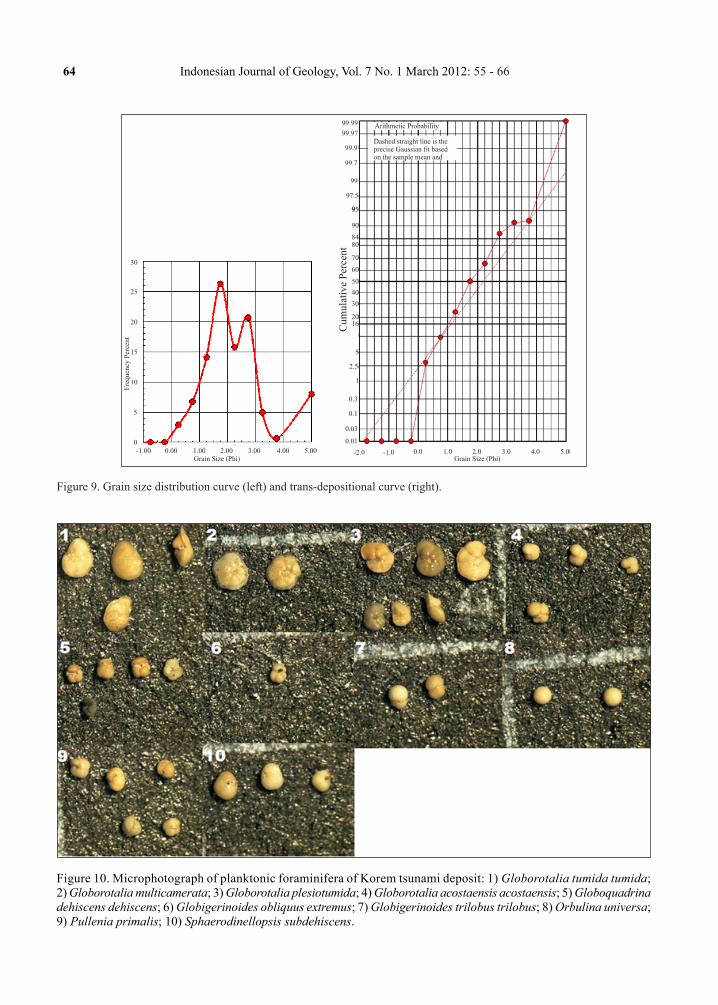
Grain size distribution curve shows that the 1996 tsunami potential from Korem has two modes, with the maximum frequency of 26%, mean value of 2.2ф, and modus of 1.75ф (Figure 8). From this curve, it could be identified that the grain size is dominated by fine to medium sand.
The grain size distribution curve shows that the sediment is influenced by a moderate current producing saltation process as one of the bed load transportation mode, similar as beach processes.
Korem sample which is suspected as the 1996 tsunami deposit contains a lot of fossils and based
Statistical ResultsMeasure Original Data
in фUnitsTransformed
DataOriginal Data
Mean: 2.2001 ф 0.2176 mm 0.2739 mmStandard Deviation : 1.0970 phi-units MV 0.1733 mm
Skewness: 0.9959 NU MV 1.1903 NUKurtosis: 4.0957 NU MV 4.6921 NU
5th Moment Measure: 7.953 NU MV 0.15 NU6th Moment Measure: 23.769 NU MV 0.21 NU
Median: 0.0008 ф 0.9995 mm 0.9996 mmRelative Dispersion: MV MV 0.6327 NU
MV = meaningless value; NU = no units (i.e., dimensionless)
Table 2. Statistical Result of Sediment Sample from Korem

62 Indonesian Journal of Geology, Vol. 7 No. 1 March 2012: 55 - 66
Figure 8. Swampy forest at Warari, southern coast of Biak.
Table 3. Relative Dispersion Scale (Balsillie et al., 2002)
Relative Dispersion Scale
< 0.5 Excellent homogeneity (e.g. beaches)
0.5 to 1.0 Good homogeneity
1.0 to 1.33 Fair homogeneity
> 1.33 Poor homogeneity
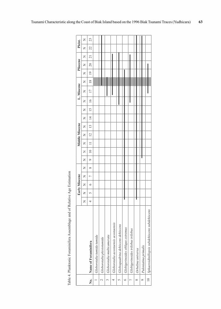
on planktonic foraminifera assemblage (Figure 9; Table 4) its relative age is N18 (Late Miocene). However, this age could not be referred due to the tsunami mechanism which could make those fossils to be mixed.
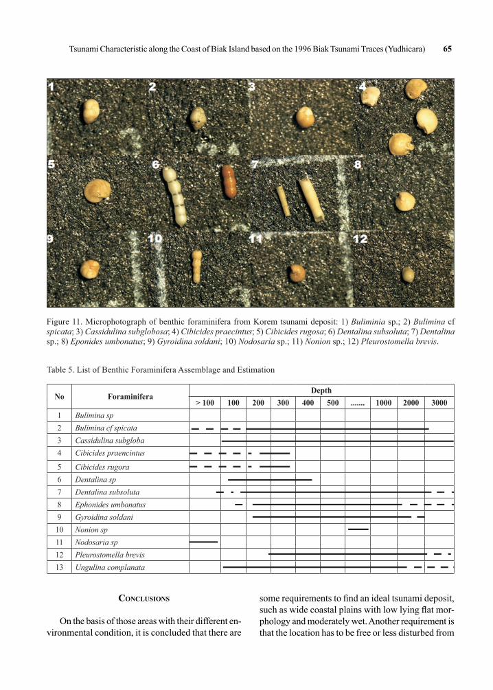
Moreover, on the basis of benthic foraminifera assemblage (Table 5; Figure 10), it is suggested that the foraminifers were derived from a deep sea environment (> 200 m deep); therefore, the Korem tsunami deposits could be estimated to be originated from a shallow marine up to deep sea (bathyal) condition zone.
The 1996 Biak tsunami event was generated by an earthquake having a reverse fault mechanism,
with the source that is located at the northeast of Biak Island. Although the tsunami deposit could be observed just after the event, it could not long be stored at the ground due to the morphological condition and disturbance of human activities and other causes. Some of them has disappeared after a couple of years.
The northern coast of Biak has a wide coastal plain, that is flat morphologically but relatively dry compared with the southern coast of Biak which also has a wide and flat morphology, but very wet (a lot of swamps); while the western coast of Biak has an undulating to steep morphology and also relatively wet.
Tsunami Characteristic along the Coast of Biak Island based on the 1996 Biak Tsunami Traces (Yudhicara) 63
No.
Nam
e of
For
amin
ifera
Ear
ly M
ioce
neM
iddl
e M
ioce
neL
. Mio
cene
Plio
cene
Plei
st.
NN
NN
NN
NN
NN
NN
NN
NN
NN
NN
45
67
89
1011
1213
1415
1617
1819
2021
2223
1G
lobo
rota
lia tu
mid
a tu
mid
a2
Glo
boro
talia
ple
siot
umid
a3
Glo
boro
talia
mul
ticam
erat
a4
Glo
boro
talia
aco
stae
nsis
aco
stae
nsis
5G
lobo
quad
rina
deh
isce
ns d
ehis
cens
6G
lobi
geri
noid
es o
bliq
us e
xtre
mus
7G
lobi
geri
noid
es tr
ilobu
s tri
lobu
s8
Orb
ulin
a un
iver
sa9
Pule
niat
ina
prim
alis
10Sp
haer
oidi
nillo
psis
subd
ehis
cens
subd
ehis
cens
Tabl
e 4.
Pla
nkto
nic
Fora
min
ifera
Ass
embl
age
and
of R
elat
ive A
ge E
stim
atio
n
64 Indonesian Journal of Geology, Vol. 7 No. 1 March 2012: 55 - 66
Figure 10. Microphotograph of planktonic foraminifera of Korem tsunami deposit: 1) Globorotalia tumida tumida; 2) Globorotalia multicamerata; 3) Globorotalia plesiotumida; 4) Globorotalia acostaensis acostaensis; 5) Globoquadrina dehiscens dehiscens; 6) Globigerinoides obliquus extremus; 7) Globigerinoides trilobus trilobus; 8) Orbulina universa; 9) Pullenia primalis; 10) Sphaerodinellopsis subdehiscens.
99.99
99.97
99.9
99.7
99
97.5
995
90
8480
70
60
50
40
30
2016
5
2.5
1
0.3
0.1
0.03
0.01
-2.0 -1.0 0.0 1.0 2.0 3.0 4.0 5.0
Arithmetic Probability
Dashed straight line is theprecise Gaussian fit basedon the sample mean and
Cum
ula
tiv
e P
erce
nt
Fre
quen
cy P
erce
nt
30
25
20
15
10
5
-1.00 0.00 1.00 2.00Grain Size (Phi) Grain Size (Phi)
3.00 4.00 5.000
Figure 9. Grain size distribution curve (left) and trans-depositional curve (right).
Tsunami Characteristic along the Coast of Biak Island based on the 1996 Biak Tsunami Traces (Yudhicara) 65
Figure 11. Microphotograph of benthic foraminifera from Korem tsunami deposit: 1) Buliminia sp.; 2) Bulimina cf spicata; 3) Cassidulina subglobosa; 4) Cibicides praecintus; 5) Cibicides rugosa; 6) Dentalina subsoluta; 7) Dentalina sp.; 8) Eponides umbonatus; 9) Gyroidina soldani; 10) Nodosaria sp.; 11) Nonion sp.; 12) Pleurostomella brevis.
No ForaminiferaDepth
> 100 100 200 300 400 500 ....... 1000 2000 30001 Bulimina sp2 Bulimina cf spicata3 Cassidulina subgloba4 Cibicides praencintus
5 Cibicides rugora6 Dentalina sp7 Dentalina subsoluta8 Ephonides umbonatus9 Gyroidina soldani
10 Nonion sp11 Nodosaria sp12 Pleurostomella brevis13 Ungulina complanata
Table 5. List of Benthic Foraminifera Assemblage and Estimation
conclusIons
On the basis of those areas with their different en-vironmental condition, it is concluded that there are
some requirements to find an ideal tsunami deposit, such as wide coastal plains with low lying flat mor-phology and moderately wet. Another requirement is that the location has to be free or less disturbed from
66 Indonesian Journal of Geology, Vol. 7 No. 1 March 2012: 55 - 66
human, animal, or other activities, in order to make the tsunami deposit to be stored undisturbed. Korem at the northern coast of Biak Island can fulfill those requirements compared with other places, where the tsunami deposit could be found.
The 1996 Biak tsunami deposits, according to the laboratory analysis, are characterized by grain size of 1.75 to 2.2 phi or fine to medium sand, deposited by a saltation process. The fossil identification, indicates that this tsunami deposit was originally derived from a deep sea (bathyal) environment of > 200 m deep.
Acknowledgments---The author would like to express her gratitude to the Head of Center for Volcanology and Geologi-cal Hazard for conducting tsunamigenic survey in Biak on 2010.Thanks are also addressed to the survey team; Imun Maemunah, Heri Isep Rohmana, and Sugiarto, and also to colleagues who gave support in completing the paper.
references
Balsillie, J. H., Donoghue, J. F., Butler, K. M., and Koch, J. L., 2002. Plotting equation for Gaussian, percentiles and a spreadsheet program for generating probability plots. Journal of Sedimentary Research, 72 (6), p. 929-933.
Harvard CMT Catalog, 2010. Global Vontrol Momen Tensor of 1976 – 2010. Harvard University.
Puspito, N.T., 1996. Pelajaran dari Bencana Biak, harian umum Kompas, 16 Maret 1996.
Matsutomi, H., Shuto, H., Imamura, F., and Takahashi, T., 2001. Field Survey of the 1996 Irian Jaya Earthquake, in Biak Island, Natural Hazards, 24, p. 199 - 212, Kluwer Academic Publishers.
Sapiie, B., Natawidjaja, D. H., and Cloos, M., 1999. Strike-slip tectonics of New Guinea: Transform motion between the Caroline and Australian plates: In: Busono, I. and Alam, H. (Eds), Developments in Indonesian Tectonics and Structural Geology; Proceedings of Indonesian Association of Geologist, 28th Annual Convention, Jakarta, I, p. 1-5.