Embed Size (px)
Citation preview

TSUNAMI HEIGHT MEMORIAL POLES IN BANDA ACEH AND RECOMMENDATIONS
FOR DISASTER PREVENTION
Hirokazu IEMURA1, Mulyo Harris Pradono2 , Megumi SUGIMOTO3, Yoshikazu TAKAHASHI4 and Agussalim bin HUSEN5
1 President, Kinki Polytechnic College, [email protected]
2Director of Disaster Prevention, BPPT, Indonesia, [email protected] 3Adjunct Researcher, ERI, University of Tokyo, [email protected]
4Associate Professor, DPRI, Kyoto University, [email protected] 5Syiah Kuala University and Yayasan Umi Abasiah, Banda Aceh, Indonesia (past away)
ABSTRACT: Huge earthquake and tsunami on December 26th, 2004 caused more than 150 thousands casualties around Indian Ocean rim countries especially Banda Aceh city and Aceh Bessar district in Sumatra, Indonesia. Japanese investigation group led by the first author found that the local people’s awareness of tsunami was very low from the results of questionnaires. For disaster education of local people and students, construction of tsunami height memorial poles was proposed by the first author and supported by the local people and the embassy of Japan. Construction of the poles, distribution of the tsunami height and recommendations including education from the investigation team is introduced and discussed in this paper. Key Words: Indian Ocean, tsunami and earthquake, Banda Aceh, Memorial poles,
disaster prevention, education, recommendations
INTRODUCTION Huge earthquake and tsunami on December 26th, 2004 has caused a great number of casualties around Indian Ocean rim countries especially in Banda Aceh city and Aceh Besar Sub-province, in Sumatra Island, Indonesia. Lessons from this huge disaster shall be learnt by locals and people all around the world. In a quick response to the disaster, a Japanese group of researchers led by the first author departed to Banda Aceh and surrounding areas in attempt to study the lessons by the huge earthquake and tsunami. TheIn this paper, the results of the questionnaires distributed in the tsunami affected area, construction of the tsunami height memorial poles, recommendations for disaster prevention including education are introduced.
IMPORTANT RESULT OF QUESTIONNAIRES The questionnaires ware distributed the affected people. They consist of questions asking their
Proceedings of the International Symposium on Engineering Lessons Learned from the 2011 Great East Japan Earthquake, March 1-4, 2012, Tokyo, Japan
1605
experience during and after the earthquake and tsunami. The main aim for collecting information in the questionnaire was to get a basis for planning a safer town under earthquake and tsunami disaster. Except the questionnaires, there were no recorded numerical data in the area. The most important result of the questionnaires is that even if people had started running away just after the big earthquake, the percentage of expected survivors would have been less than 100%, according to the respondents. Fig.1 shows the percentage of survivors ; the upper numbers show the actual percentage in the area and the lower number in the parenthesis show the estimated percentage assuming that local people had started running away just after the earthquake. The practical implication is that education, socialization, escape routes, escape structures, warning system, wave resisting structures are among important factors for people to be safer against future earthquake and tsunami attacks. (Incert figure of the percentage) Fig.1 Actual and Estimated Percentage of Survivors in Banda Aceh
(number in parenthesis shows percentage of survivors if people could have escaped immediately after earthquake)
IMPORTANCE OF TSUNAMI HEIGHT MEMORIAL POLES Since tsunami is a rare event, the future generations may forget the disaster easily. People need encouraging and reminding words that would be written on lasting memorial structures. One of the ideas prompted by the first author to local people is to build poles with the height of tsunami run up
BANDA ACEH CITY
Malaka Strait Aceh Besar Sub-provinc
Aceh Besar Sub-provinc
Aceh Besar Sub-provinc
Ulee Lheue
Krueng Aceh River
Krueng Aceh
North
1500
28% (84%)
8% (80%)
7% (90%)
20% (75%)
13% (60%)
10% (70%)
66% (81%)
30% (70%) 40%
(60%) 50%
(80%) 40%
(90%)
25% (99%)
15% (70%)
17% (72%)
20% (75%)
75% (84%)
Grand Mosque
1606

throughout the affected areas in the city. The poles have many important purposes: (1) to encourage people to be prepared for the next one, (2) to keep the memory of tsunami attack, (3) to educate next generation the important lessons from the tsunami, (4) to mourn the passed away people and to restore and reconstruct Banda Aceh from the disaster, (5) to keep accurate data of tsunami height for future planning, (6) to be escaping sign with the tsunami height, (7) to encourage local people to live with hope and ease under tsunami risk, and (8) to be a symbol of Banda Aceh as the tsunami-attacked city.
CONSTRUCTION OF THE POLES The idea of the construction of many poles in the city area was supported by local people and the Embassy of Japan in the Republic of Indonesia. The Embassy made available a grant up to US $ 91,411 (US $ Ninety one thousand, four hundred-eleven) by March 31, 2006. It contributes to the execution of the construction by the Yayasan Umi Abasiah. The project entitled “The Project for Supporting Education of Tsunami Disaster Prevention in Nanggroe Aceh Darussalam”. The first author also provides technical assistance. The pole structure should be strong and yet reasonably economical and feasible in the material availability point of view. Hybrid structure consisting of masonry and reinforced concrete was finally adopted as the material. The first drawing for designing the poles is shown in Figure 2.
Figure 1. First Drawing of the Pole for Design Purpose Fig.2 First Design of Structures of Low, Medium and High Poles The proposed locations of the poles are as shown in Figure 3. The purpose is for providing evacuees with escaping sign with height, so that the evacuees escape toward the lower poles. Therefore the poles would be built along the evacuation routes. After considering the limitation of the land for construction, the realized location of the poles is as shown in Figure 4. The height of the poles is the inundation of tsunami water, when the tsunami wave was relatively flat/stop and around ten minutes later, the tsunami water returned back to the sea.
1607

Figure 3. Tsunami Height Memorial Poles along the Evacuation Routes for Hazard Data Dissemination
Figure 3. Locations of 85 Tsunami Height Memorial Poles in Banda Aceh and Aceh Besar
Figure 4. Location of actually built Tsunami Height Memorial Poles
3
1
17
7
50 51
52
68
63 61 59
46
13
14 12
11 15
5 4
2
10
8 9 18
19
21
44
23
25
1.5 km
North
TTSSUUNNAAMMII HHEEIIGGHHTT MMEEMMOORRIIAALL PPOOLLEESS BBaannddaa AAcceehh aanndd AAcceehh BBeessaarr,, IInnddoonneessiiaa
Malaka Strait
Yayasan Umi Abasiah Banda Aceh,
Indonesia
in collaboration with
Embassy of Japan in Indonesia
and Kyoto University
Japan
BBAANNDDAA AACCEEHH CCIITTYY
41
48 47 49
54 56 57
58 60
45
40
62
16 28
29
6 31 30
37
65
27 26 20
66
22 24
39
Indian Ocean Jakarta
Singapore
Malaysia
Sumatera Indonesia
Epicenter, 26 Dec. 2004
Simelue Is.
Nias Is. Padang
Medan Banda Aceh
AACCEEHH BBEESSAARR DDIISSTTRRIICCTT
BBAANNDDAA AACCEEHH CCIITTYY
8855 8844
8833
8811
8822
8800
7799 7788
7777
7766 7755 7733
7722
7711
6699 7700
6688
7744
32
36 35
33 34
67 38 42 43
53 55
64
1608

Figure 5. The Firstly Built Tsunami Pole (February 2006) Pole No.: 01, Height: 3.15 m, Distance from Shore: 2.80 km, Location: Gampong Lamdingin, Kecamatan Kuta Alam, Banda Aceh. The placard in front of the pole shows the inundation height, distance from shore, time of tsunami arrival, time of earthquake, location name, words of wisdom, developer, and donor
Figure 6. The Lowest Tsunami Pole
Pole No.: 28, Height: 0.90 m, Distance from Shore: 4.30 km, Location: Dinas Pertanian dan Tanaman
Pangan, Banda Aceh.
Figure 8. The Tallest Tsunami Pole Pole No.: 69, Height: 9.00 m (w), Distance from Shore: 0.50 km, Location: Masjid Lam Tengoh,
Peukan Bada, Banda Aceh. The wave height was justified from
witnesses, because there was no
1155
Figure 7. Tsunami Pole at a School, Pole No.: 15, Height: 1.52 m, Distance from Shore: 3.90 km, Location: SD Negeri 28, Kp. Keuramat, Banda
Figure 9. Tsunami Pole at a School, Pole No.: 49, Height: 3.80 m, Distance from Shore: 3.10 km, Location: SDN 2, Punge Jurong, Banda Aceh
1609

Figure 10. Tsunami Height Memorial Poles as part of Education Tools on Hazard Mitigation
Fig.11 Photo of 85 Constructed Poles and the Site Location
1610

In May 2007, all of the 85 poles were constructed throughout Banda Aceh city and surrounding areas. Some photos are shown in Figures 4 to 10 and the list of the poles is shown in Table 1. The tsunami height memorial poles are also education tools for hazard preparedness. One example is by showing the students the record of the data mentioned in the poles and why they were built as shown in Fig.10. Fig.11 shows the photo of all of the poles and their locations. The enlarged copies of this photo were distributed to the people at all the sites for understanding of the tsunami height distribution.
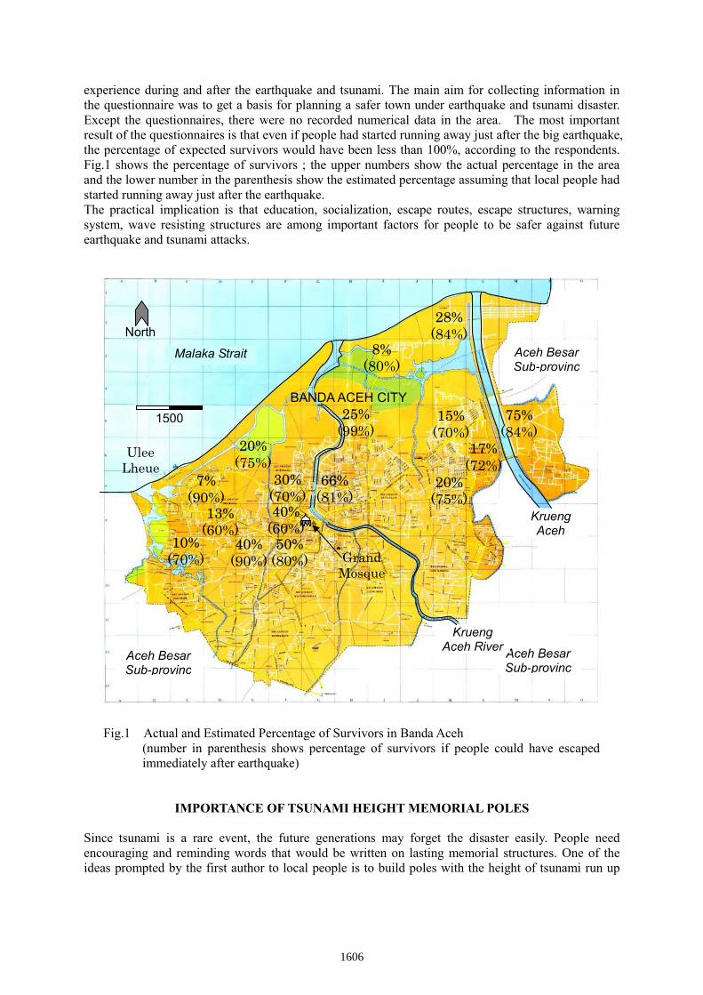
RELATION BETWEEN TSUNAMI HEIGHT AND DISTANCE FROM THE COAST Together with the construction of the poles, three dimensional coordinates (horizontal location and height of the ground from the sea level) were measured by portable GPS system. Construction sites in Banda Aceh city and Aceh Bessar sub-province are plotted in Fig.12 a(a) and (b), respectively. The distance from the nearest coast is calculated from the measured coordinates. The tsunami height and the distance from the coast are listed in Table 1 in the Appendix.
Figure 12 (a). Distribution of Poles in Banda Aceh City (based on GPS Positioning)
In Fig.13 (a), the tsunami height from the ground level against the distance from the coast is plotted, in which relatively good correlation among them is found. Meanwhile, both the height of the ground from the sea level and the tsunami height from the
1611
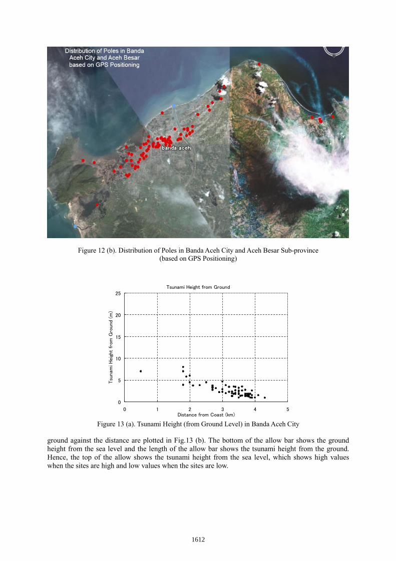
Figure 12 (b). Distribution of Poles in Banda Aceh City and Aceh Besar Sub-province (based on GPS Positioning)
Tsunami Height from Ground
0
5
10
15
20
25
0 1 2 3 4 5Distance from Coast (km)
Tsu
nam
i H
eig
ht
from
Gro
und (
m)
Figure 13 (a). Tsunami Height (from Ground Level) in Banda Aceh City
ground against the distance are plotted in Fig.13 (b). The bottom of the allow bar shows the ground height from the sea level and the length of the allow bar shows the tsunami height from the ground. Hence, the top of the allow shows the tsunami height from the sea level, which shows high values when the sites are high and low values when the sites are low.
1612

0.00
5.00
10.00
15.00
20.00
25.00
0.00 1.00 2.00 3.00 4.00 5.00
Gro
und
and
Pol
e H
eigh
t (m
)
Distance from Coast (km)
Ground & Pole Height (m)
Pole Height (m)
Figure 13 (b). Tsunami Height (from Sea Level) in Banda Aceh City
Tsunami Height from Ground
y = -0.2113x2 - 1.1709x + 7.6074
0
5
10
15
20
25
0 0.5 1 1.5 2 2.5 3 3.5Distance from Coast (km)
Tsu
nam
i Hei
ght
from
Gro
und
(m)
Tsunami Height (m)Poly. (Tsunami Height (m))
Figure 14 (a). Tsunami Height (from Ground Level) in Banda Aceh City (at Meuraxa Ward only)
0.00
5.00
10.00
15.00
20.00
25.00
0.00 0.50 1.00 1.50 2.00 2.50 3.00 3.50
Gro
und
and
Pol
e H
eigh
t (m
)
Distance from Coast (km)
Ground & Pole Height (m)
Pole Height (m)
Figure 14 (b). Tsunami Height (from Sea Level) in Banda Aceh City (at Meuraxa Ward only)
1613

Similar plots are shown in Fig. (a) and (b), limiting the sites only for relatively flat region ;Meuraxa Ward shown in Fig.12 (a) and (b), in which better correlation of tsunami height and distance is found. Tsunami height seems attenuating smoothly with distance even though the land height is going up or down. This suggests that the Tsunami is like the strong stream which runs up the hill easily, and attenuates only with the distance.
RECOMMENDATIOS Besides the construction of the Tsunami Height Memorial Poles, the investigation team proposed following recommendations to Indonesian people and Local Governments. 1) Installation of early warning system for tsunami attack 2) Construction of tsunami evacuation buildings or structures 3) Construction of the tsunami research center for collection of the data, analysis and counter
measures 4) Construction of experimental tsunami simulation water channel 5) Construction of tsunami museum 6) Educational system for scientific study of earthquake and tsunami mechanics 7) Systematic education of disaster reduction Most of the recommendations except the water channel have actively been carried out in Indonesia with worldwide technical and financial cooperation.
CONCLUDING REMARKS The Japanese group of researchers led by the first author made field survey on earthquake and tsunami damage in Banda Aceh and surrounding area using the questionnaires with cooperation of local researchers. In this paper, not only results of the survey but also construction of the memorial poles, analysis of tsunami height distribution and recommendations to local people and governments are introduced and discussed. Each topic can be summarized as follows. (1) One of the important results of the questionnaires on the tsunami disaster is that even if local
people at the coast had started to escape immediately after the earthquake motion, some percentage of the people could not have been saved because of no escape places near by.
(2) The tsunami height memorial poles were built at 85 places in the Banda Aceh and surrounding areas not only to keep the data of the tsunami, but also to be important material for education of disaster mitigation. The poles are expected to last long for present and next generations.
(3) With the analysis of the tsunami height of each site and the GPS data of the ground height from the sea level, and the distance from the coast it is found that the tsunami height attenuates smoothly with the distance from the coast, nevertheless local land height is going up or down.
(4) Depending on the results of the survey, many recommendations on early warning system, education, disaster mitigation programs, construction of research center, museum etc are recommended. Most of them have been actively implemented by local governments and cooperation from oversees countries.
ACKNOWLEDGMENTS The authors would like to express their sincere gratitude to the Embassy of Japan in the Republic of
1614

Indonesia, researchers at the Syiah Kuala University and to the people of Nanggroe Aceh Darussalam, Indonesia for their strong interest and support. The support from the former head of Aceh Besar District, Bapak Sanusi Wahab is also gratefully acknowledged.
APPENDIX
Table 1. List of 85 Tsunami Height Memorial Poles in Banda Aceh and Aceh Besar 1. 3.15 m 2.80 km GPG.
LAMDINGIN KEC. KUTA ALAM
23. 1.75 m 3.50 km ASRAMA MAHASISWA UNSYIAH, DARUSSALAM
45. 2.30 m 3.20 km Kantor Pengadilan Negeri Banda Aceh
67. 1.30 m 3.30 km RUMAH BP. ALAMSYAH UMAR JALAN SYIAH KUALA
2. 2.90 m 3.00 km GPG. LAMBARO SKEP KEC. KUTA ALAM
24. 1.45 m 3.60 km Kantor Rektorat Iain Ar-Raniry, Darussalam
46. 2.00 m 3.50 km Taman Kanak-Kanak YKA Taman Sari
68. 5.70 m 1.50 km MASJID BAITUL MAGHFIRAH PEUKAN BADA
3. 1.40 m 3.75 km MAN 1 25. 2.00 m 3.40 km MAN 3, RUKOH
47. 3.40 m 3.20 km SMA NEGERI 1 BLANG PADANG
69. 9.00 m (w) 0.50 km MASJID LAM TENGOH PEUKAN BADA
4. 1.95 m 3.40 km SMP NEGERI 2
26. 1.00 m 4.00 km SMP NEGERI 18
48. 1.80 m 3.40 km SMPN 17 BLANG PADANG
70. 7.00 m 0.40 km MASJID INDRA PURWA LAMGURON
5. 1.39 m 3.55 km SD NEGERI 25
27. 1.80 m 3.85 km SMP NEGERI 6
49. 3.80 m 3.10 km SDN 2 PUNGE JURONG
71. 2.50 m 2.50 km MEUNASAH TANJONG KEC.LHOKNGA
6. 1.84 m 3.70 km Masjid Agung Al Makmur Bandar Baru
28. 0.90 m 4.30 km DINAS PERTANIAN TANAMAN PANGAN
50. 4.50 m 2.00 km Rumah Ny. Zulkifli Narukaya Blang Oi
72. 5.50 m 2.50 km SDN KAJHU KEC.BAITUSSALAM
7. 2.60 m 3.60 km SMK NEGERI 2/STM NEGERI
29. 1.60 m 3.80 km SMK NEGERI 3
51. 5.80 m 1.90 km MASJID SYECH ABDUL RAUF BLANG OI
73. 7.00 m 2.20 km TANAH WIDARI DAWAM DAWOOD SP, COT PAYA
8. 2.60 m 3.40 km SD NEGERI 80, PRADA
30. 2.45 m 3.50 km Kantor Dekranas Taman Ratu Safiatuddin
52. 7.00 m 0.50 km Rumah Bp. Bachtiar Zakaria Deah Baro
74. 3.50 m 2.70 km SMAN-1 BAITUSSALAM
9. 2.60 m 3.50 km KANWIL KEHAKIMAN DAN HAM
31. 2.65 m 3.40 km KANTOR BAWASDA
53. 3.90 m 1.80 km SMPN 11 LAMJABAT
75. 5.10 m 1.50 km MASJID LAMBADA LHOK BAITUSSALAM
10. 1.55 m 4.10 km DINAS KOPERASI DAN UKM
32. 1.00 m 3.85 km Direktorat Politeknik Kesehatan
54. 3.70 m 2.10 km SDN 95 GAMPONG BARO
76. 4.60 m 2.00 km GAMPONG LABUI BAITUSSALAM
11. 3.20 m 3.50 km SMA NEGERI 2
33. 1.80 m 3.75 km Politekkes NAD Jurusan Keperawatan
55. 2.20 m 2.90 km Masjid Baitul Muqarrabin Punge Blang Cut
77. 4.00 m 1.50 km GAMPONG LAMNGA JALAN KRUENG RAYA
12. 2.70 m 3.70 km SD NEGERI 20, POCUT BAREN
34. 2.00 m 3.40 km SD 35 LAMPRIET
56. 2.20 m 2.90 km SDN 18 PUNGE BLANG CUT
78. 3.40 m 1.30 km MEUNASAH NEUHEUN MASJID RAYA
13. 3.50 m 3.60 km SMP NEGERI 9, PEUNAYONG
35. 1.80 m 3.35 km MASJID JAMIK SILANG RUKOH
57. 3.40 m 2.70 km Universitas Iskandarmuda Surien
79. 2.20 m 0.40 km MEUNASAH DURONG MASJID RAYA
14. 2.57 m 3.90 km KANTOR BKPMD
36. 1.20 m 3.80 km SMP NEGERI 8 DARUSSALAM
58. 2.30 m 3.00 km SDN 97 LAMTEUMEN TIMUR
80. 3.30 m 1.00 km MEUNASAH PAYA KAMENG MASJID RAYA
15. 1.52 m 3.90 km SD NEGERI 28, KP. KEURAMAT
37. 3.40 m 3.40 km SDN 27 GAMPONG MULIA
59. 2.00 m 3.10 km SDN 93 LAMTEUMEN TIMUR
81. 3.40 m 0.50 km MASJID KRUENG RAYA
16. 0.89 m 3.90 km DARUL ULUM, YPUI
38. 3.50 m 3.35 km MIN Merduati Jalan Malahayati, GP.MULIA
60. 1.40 m 3.30 km PGSD FKIP UNSYIAH GOHENG
82. 3.20 m 0.80 km GAMPONG MEUNASAH KULAM
17. 1.52 m 3.70 km SD KARTIKA XIX-I, LAMPRIET
39. 4.60 m 3.00 km MASJID AL MUKARRAMAH GP. MULIA
61. 2.00 m 3.30 km MIN TELADAN LAMTEUMEN
83. 3.20 m 0.80 km GAMPONG MEUNASAH MON
18. 1.91 m 3.40 km Badan Perpustakaan Wilayah
40. 4.50 m 2.50 km Masjid Tgk. Dianjong PEULANGGAHAN
62. 1.00 m 3.50 km RUMAH ZAKARIA ISMAIL LAMTEUMEN
84. 2.50 m 0.30 km MASJID LAMREH KRUENG RAYA
19. 1.80 m 3.80 km MASJID LAMGUGOB
41. 7.00 m 1.80 km SMPN 12 GAMPONG JAWA
63. 2.35 m 3.30 km BIRO LOGISTIK POLDA NAD LAMTEUMEN
85. 3.10 m 0.50 km PASANTREN/DAYAH AL MAHFUZHAH KRUENG
1615

RAYA
20. 1.40 m 3.80 km MIS LAMGUGOB
42. 6.00 m 2.00 km SDN 6 KEUDAH
64. 3.80 m 2.30 km SMPN 15 LAMPOH DAYA
21. 1.00 m 3.90 km STIES/AMBA
43. 8.00 m (w) 1.80 km SDN 8/38 MERDUATI
65. 3.70 m 2.70 km SDN 61 JEULINGKE
22. 1.30 m 3.70 km SD NEGERI 69, DARUSSALAM
44. 2.70 m 2.70 km SD MUHAMMADIYAH LAMPASEH
66. 3.20 m 2.70 km SDN 106 RUKOH
Notes: - Data in [m] is height and data in [km] is distance from shore - Poles 43 & 69 show wave height. Others show inundation height - red in Banda Aceh, blue in Aceh Besar
REFERENCES
Iemura, H., Takahashi, Y., and Pradono, M. H. (2005a). “Earthquake and Tsunami Damage Survey in Banda Aceh.” JSNDS Symposium.
Iemura, H., Takahashi, Y., Sukamdo, P., Pradono, M. H., and Kurniawan, R. (2005b). “Tsunami Questionnaires and Bridge Damage Surveys in Banda Aceh for City Restoration Planning and Urban Design.” Memorial Conference on the 2004 Giant Earthquake and Tsunami in the Indian Ocean, Part I, Workshop.
Iemura, H., Pradono,M.H. and Yoshikazu Takahashi, Y. (2005c). “Report on the tsunami damage of bridges in Banda Aceh and some possible countermeasure” Proceedings of Earthquake Engineering, JSCE, Vol.28, No.214.
Iemura, H., and Pradono, M. H. (2005d). “Vulnerability of Infrastructures against the Sumatra Earthquake and Tsunami and their Restoration Program” Memorial Conference on the 2004 Giant Earthquake and Tsunami in the Indian Ocean, Part II, Symposium.
Iemura, H., Takahashi, Y., Pradono, M. H., and Kurniawan,R.(2006a) “Tsunami Questionnaires in Banda Aceh and Surrounding Areas” 8th National Conference on Earthquake Engineering.
Iemura, H., Pradono, M. H., Husen, A., Jauhari, T. (2006b) “Sugimoto, M., and Fukuwatari, T.: Tsunami Height Memorial Poles in Banda Aceh” International Disaster Reduction Conference (IDRC Davos 2006), GADR, GDIN, UNESCO, UN/ISDR.
Iemura, H., Takahashi, Y., Pradono, M. H., Sukamdo, P., and Kurniawan, R. (2006c) “Earthquake and Tsunami Questionnaires in Banda Aceh and Surrounding Areas” Disaster Prevention and Management, Emerald, Vol. 15, No. 1, pp. 21-30.
Iemura, H., Yasuda,T., M. H. Pradono,M.H. and Tada, T. (2007) “Tsunami Hydrodynamic Force on a Bridge,Survey and Experimental Studies” Proc. 5th International Conference on Seismology and Earthquake Engineering SEE5, 2007
Iemura, H. and Mulyo Harris Pradono, M.H. (2007a) “Earthquake and Tsunami Damage Survey in Indonesia and Recommendation for the Reconstruction” Proc. APRU/AEARU Research Symposium 2007.
Husen, A., Jauhari, T., Iemura,H., Pradono,M.H., Sugimoto,M. and Fuwatari, T. (2007b) “Tsunami Height Memorial Poles in Banda Aceh for Disaster Prevention and Education” Proc. APRU/AEARU Research Symposium 2007.
Iemura,H. Yasuda,T., Pradono,M.H. and Tada, T. (2007c) “Survey and Experiments on Tsunami Hydrodynamic Force on a Bridge,.” Proc. AOGS 2007, 2007
Pradono,M.H., Iemura,H., Yasuda, T. (2008a); “Tsunami Force on Bridge Models and Force Reduction by Mangrove Models. (2008b) Proc. of 14th WCEE, Paper ID 15-0031, 2008.
Iemura,H., Pradono,M.H., Husen,A.H., Jauhari,T. and Sugimoto,M. (2008b) “Information Dissemination for Reality-Based Tsunami Disaster Education.” Proc. of 14th WCEE, Paper ID S22-012, 2008.
1616