Embed Size (px)
Citation preview
Tsunamis: What they are.How they strike.
Harry YehOregon State University
What is tsunami?
• A tsunami is gravity waves generated by animpulsive disturbance in an ocean or lake.
Killer tsunamis are so rare and there were nosignificant tsunamis between the 1964 GreatAlaskan Tsunami and the 2004 Indian OceanTsunami.
True or False?
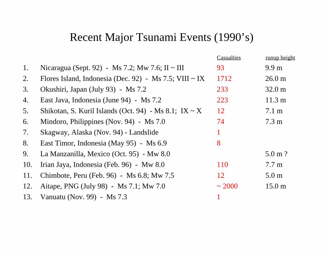
Recent Major Tsunami Events (1990’s)Casualties runup height
1. Nicaragua (Sept. 92) - Ms 7.2; Mw 7.6; II ~ III 93 9.9 m2. Flores Island, Indonesia (Dec. 92) - Ms 7.5; VIII ~ IX 1712 26.0 m3. Okushiri, Japan (July 93) - Ms 7.2 233 32.0 m4. East Java, Indonesia (June 94) - Ms 7.2 223 11.3 m5. Shikotan, S. Kuril Islands (Oct. 94) - Ms 8.1; IX ~ X 12 7.1 m6. Mindoro, Philippines (Nov. 94) - Ms 7.0 74 7.3 m7. Skagway, Alaska (Nov. 94) - Landslide 18. East Timor, Indonesia (May 95) - Ms 6.9 89. La Manzanilla, Mexico (Oct. 95) - Mw 8.0 5.0 m ?10. Irian Jaya, Indonesia (Feb. 96) - Mw 8.0 110 7.7 m11. Chimbote, Peru (Feb. 96) - Ms 6.8; Mw 7.5 12 5.0 m12. Aitape, PNG (July 98) - Ms 7.1; Mw 7.0 ~ 2000 15.0 m13. Vanuatu (Nov. 99) - Ms 7.3 1
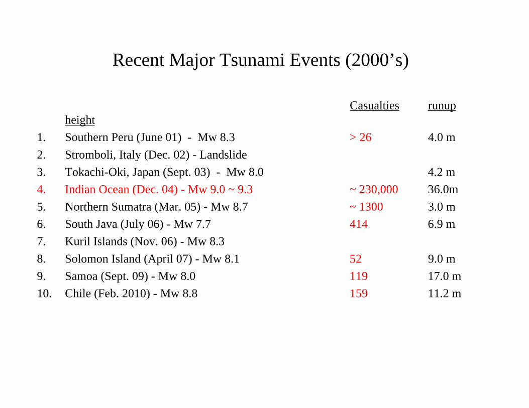
Recent Major Tsunami Events (2000’s)
Casualties runupheight
1. Southern Peru (June 01) - Mw 8.3 > 26 4.0 m2. Stromboli, Italy (Dec. 02) - Landslide3. Tokachi-Oki, Japan (Sept. 03) - Mw 8.0 4.2 m4. Indian Ocean (Dec. 04) - Mw 9.0 ~ 9.3 ~ 230,000 36.0m5. Northern Sumatra (Mar. 05) - Mw 8.7 ~ 1300 3.0 m6. South Java (July 06) - Mw 7.7 414 6.9 m7. Kuril Islands (Nov. 06) - Mw 8.38. Solomon Island (April 07) - Mw 8.1 52 9.0 m9. Samoa (Sept. 09) - Mw 8.0 119 17.0 m10. Chile (Feb. 2010) - Mw 8.8 159 11.2 m
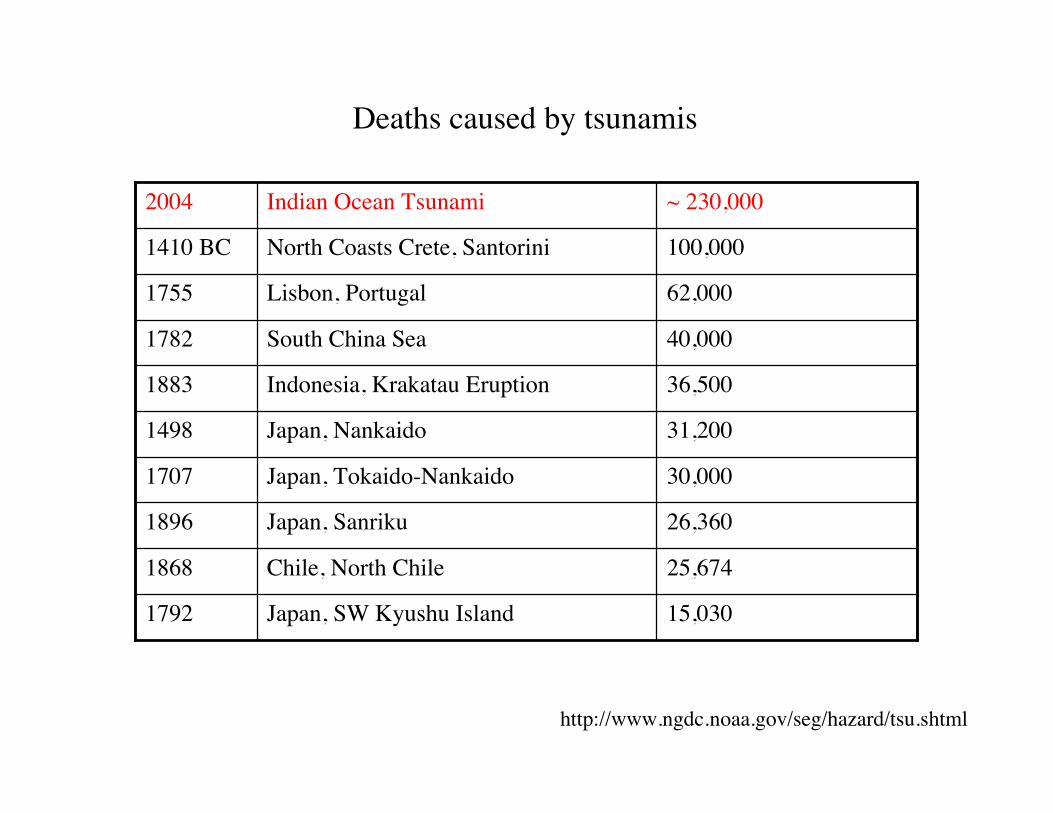
100,000North Coasts Crete, Santorini1410 BC
15,030Japan, SW Kyushu Island1792
25,674Chile, North Chile1868
26,360Japan, Sanriku1896
30,000Japan, Tokaido-Nankaido1707
31,200Japan, Nankaido1498
36,500Indonesia, Krakatau Eruption1883
40,000South China Sea1782
62,000Lisbon, Portugal1755
~ 230,000Indian Ocean Tsunami2004
Deaths caused by tsunamis
http://www.ngdc.noaa.gov/seg/hazard/tsu.shtml
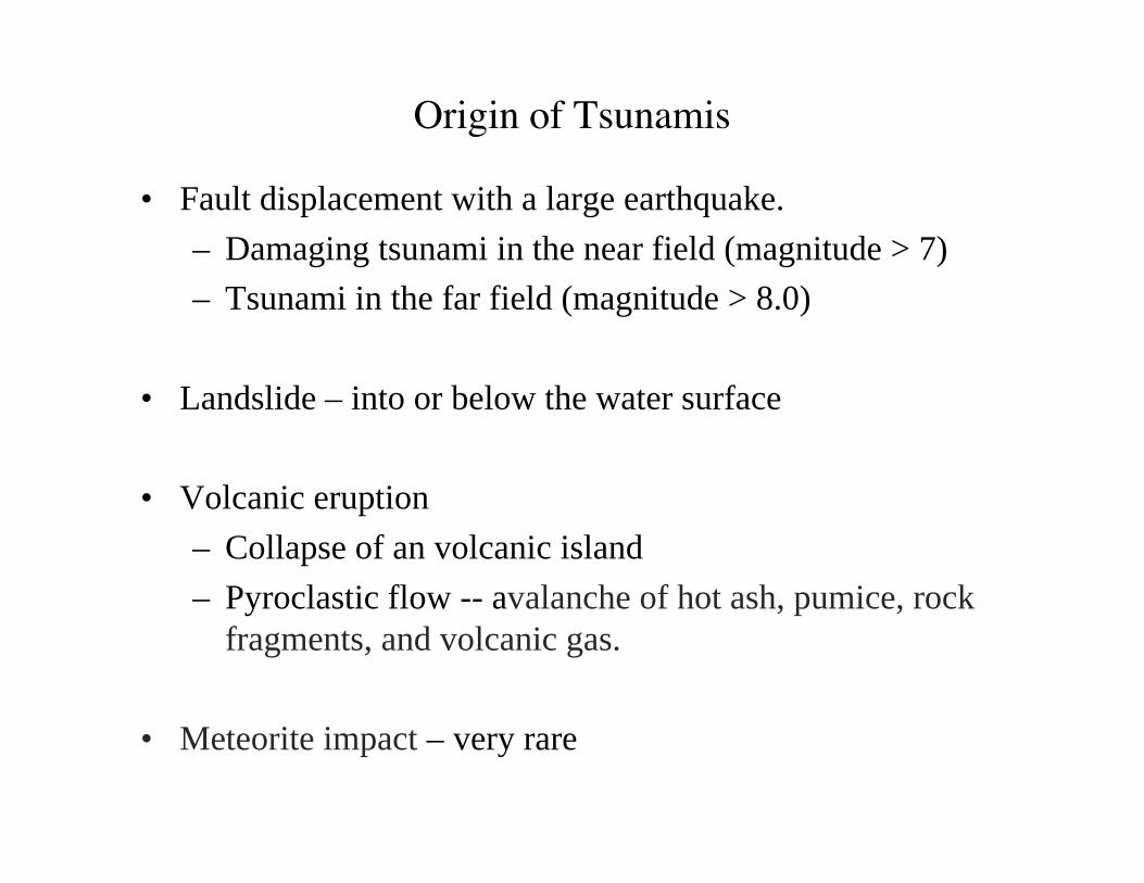
• Fault displacement with a large earthquake.– Damaging tsunami in the near field (magnitude > 7)– Tsunami in the far field (magnitude > 8.0)
• Landslide – into or below the water surface
• Volcanic eruption– Collapse of an volcanic island– Pyroclastic flow -- avalanche of hot ash, pumice, rock
fragments, and volcanic gas.
• Meteorite impact – very rare
Origin of Tsunamis
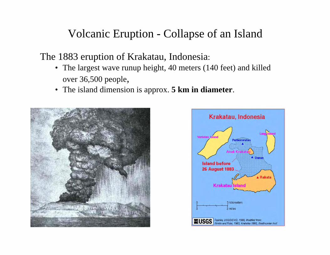
Volcanic Eruption - Collapse of an Island
The 1883 eruption of Krakatau, Indonesia:• The largest wave runup height, 40 meters (140 feet) and killed
over 36,500 people,• The island dimension is approx. 5 km in diameter.
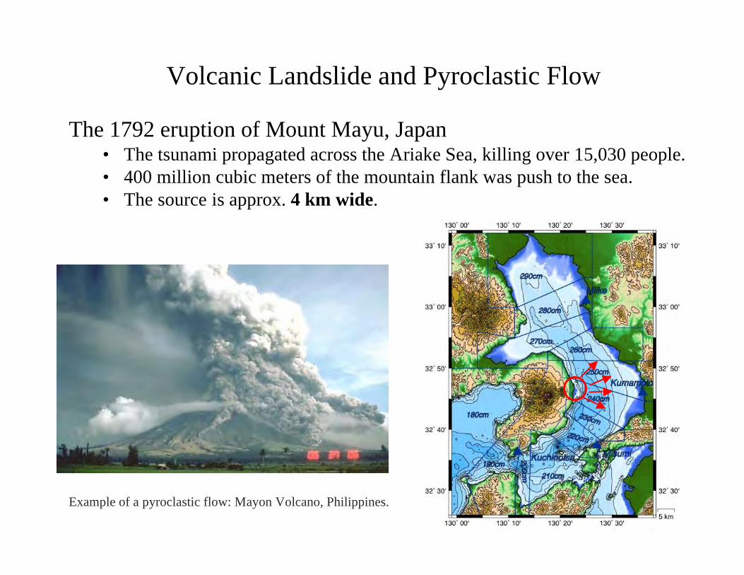
The 1792 eruption of Mount Mayu, Japan• The tsunami propagated across the Ariake Sea, killing over 15,030 people.• 400 million cubic meters of the mountain flank was push to the sea.• The source is approx. 4 km wide.
Volcanic Landslide and Pyroclastic Flow
Example of a pyroclastic flow: Mayon Volcano, Philippines.
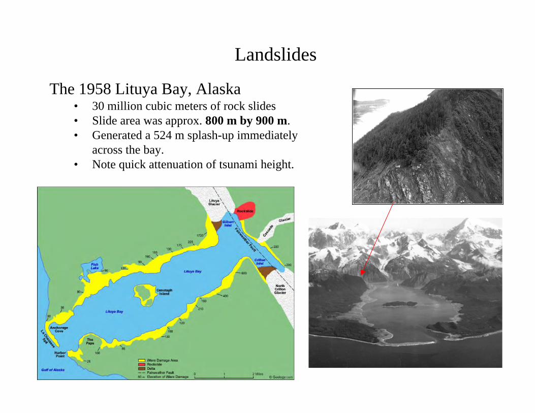
The 1958 Lituya Bay, Alaska• 30 million cubic meters of rock slides• Slide area was approx. 800 m by 900 m.• Generated a 524 m splash-up immediately
across the bay.• Note quick attenuation of tsunami height.
Landslides
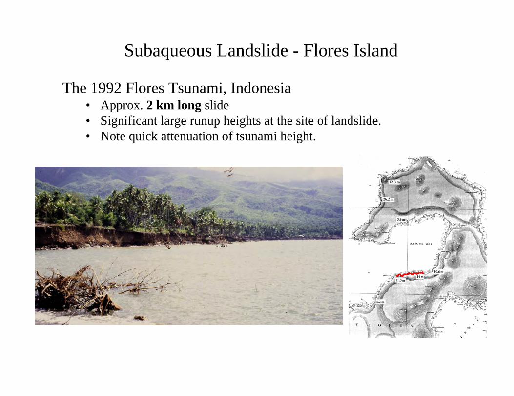
Subaqueous Landslide - Flores Island
The 1992 Flores Tsunami, Indonesia• Approx. 2 km long slide• Significant large runup heights at the site of landslide.• Note quick attenuation of tsunami height.
Co-seismic fault displacement(large earthquake)
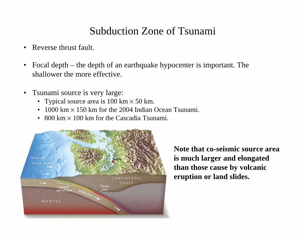
Subduction Zone of Tsunami• Reverse thrust fault.
• Focal depth – the depth of an earthquake hypocenter is important. Theshallower the more effective.
• Tsunami source is very large:• Typical source area is 100 km × 50 km.• 1000 km × 150 km for the 2004 Indian Ocean Tsunami.• 800 km × 100 km for the Cascadia Tsunami.
Note that co-seismic source areais much larger and elongatedthan those cause by volcaniceruption or land slides.
If false, then,can we predict when and where a tsunami formsthe leading depression wave (or receding wave)?
As a precursor of tsunami, the sea always recedesto a considerable distance. True of False?
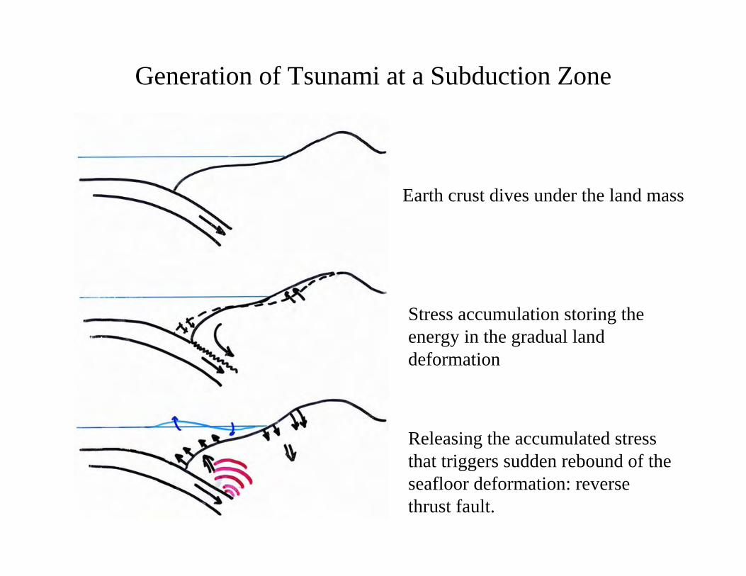
Generation of Tsunami at a Subduction Zone
Earth crust dives under the land mass
Stress accumulation storing theenergy in the gradual landdeformation
Releasing the accumulated stressthat triggers sudden rebound of theseafloor deformation: reversethrust fault.
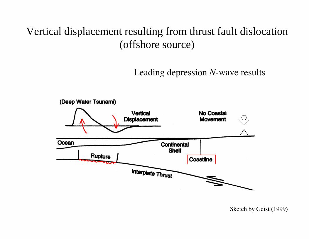
Vertical displacement resulting from thrust fault dislocation(offshore source)
Leading depression N-wave results
Sketch by Geist (1999)
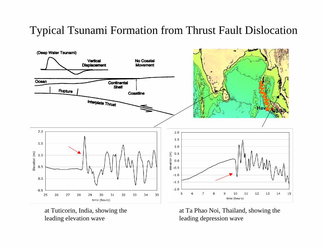
at Ta Phao Noi, Thailand, showing theleading depression wave
at Tuticorin, India, showing theleading elevation wave
Typical Tsunami Formation from Thrust Fault Dislocation
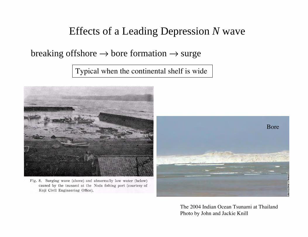
Effects of a Leading Depression N wave
Typical when the continental shelf is wide
breaking offshore → bore formation → surge
Bore
The 2004 Indian Ocean Tsunami at ThailandPhoto by John and Jackie Knill
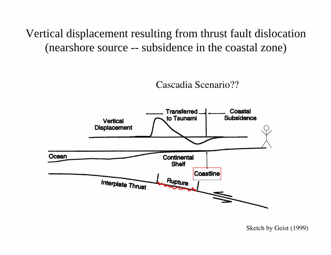
Vertical displacement resulting from thrust fault dislocation(nearshore source -- subsidence in the coastal zone)
Cascadia Scenario??
Sketch by Geist (1999)
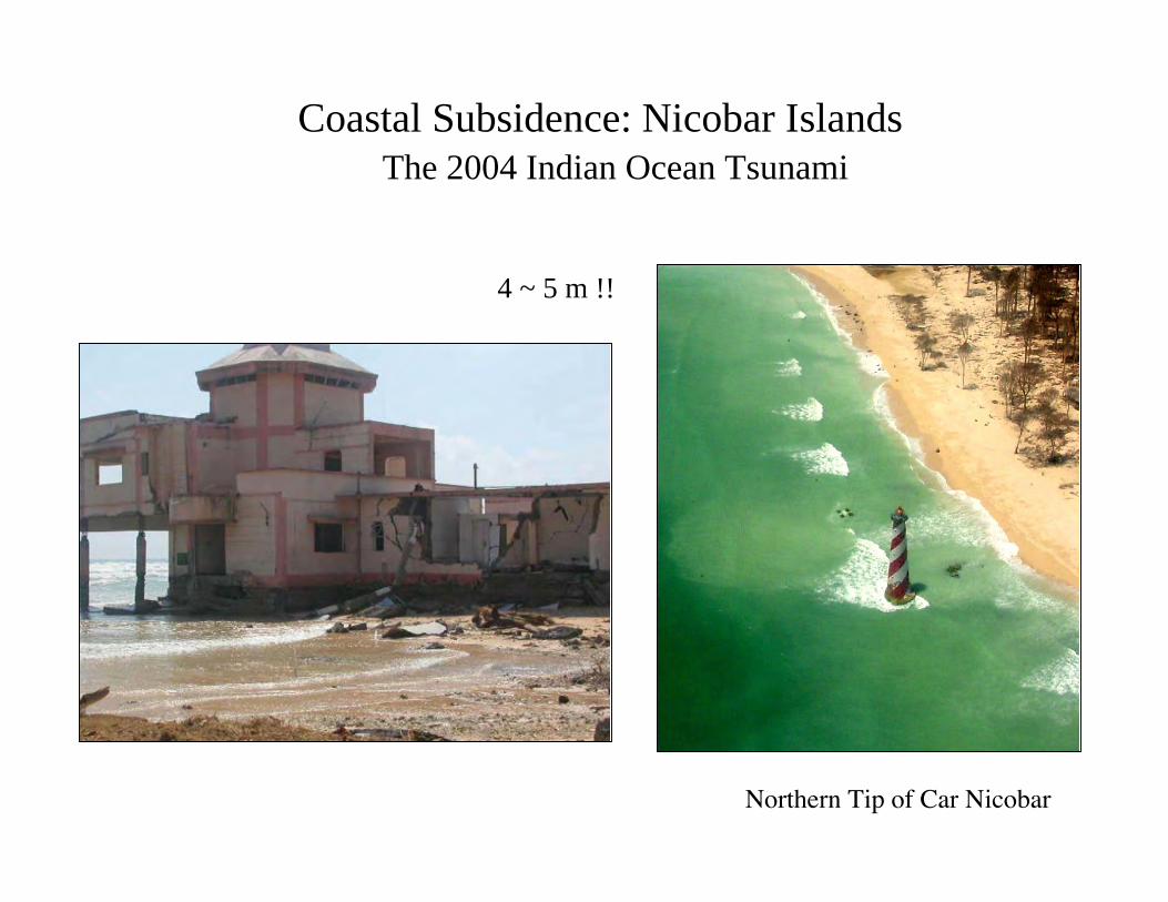
Coastal Subsidence: Nicobar IslandsThe 2004 Indian Ocean Tsunami
Northern Tip of Car Nicobar
4 ~ 5 m !!
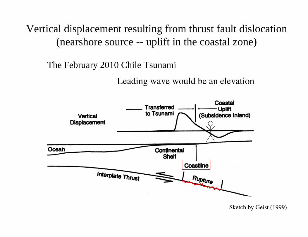
Vertical displacement resulting from thrust fault dislocation(nearshore source -- uplift in the coastal zone)
Leading wave would be an elevation
Sketch by Geist (1999)
The February 2010 Chile Tsunami
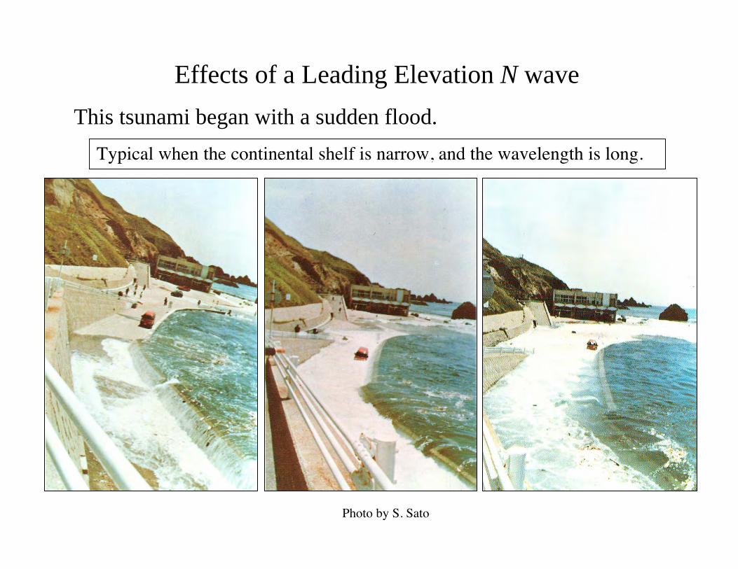
Photo by S. Sato
This tsunami began with a sudden flood.
Effects of a Leading Elevation N wave
Typical when the continental shelf is narrow, and the wavelength is long.
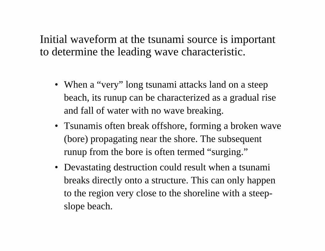
• When a “very” long tsunami attacks land on a steepbeach, its runup can be characterized as a gradual riseand fall of water with no wave breaking.
• Tsunamis often break offshore, forming a broken wave(bore) propagating near the shore. The subsequentrunup from the bore is often termed “surging.”
• Devastating destruction could result when a tsunamibreaks directly onto a structure. This can only happento the region very close to the shoreline with a steep-slope beach.
Initial waveform at the tsunami source is importantto determine the leading wave characteristic.
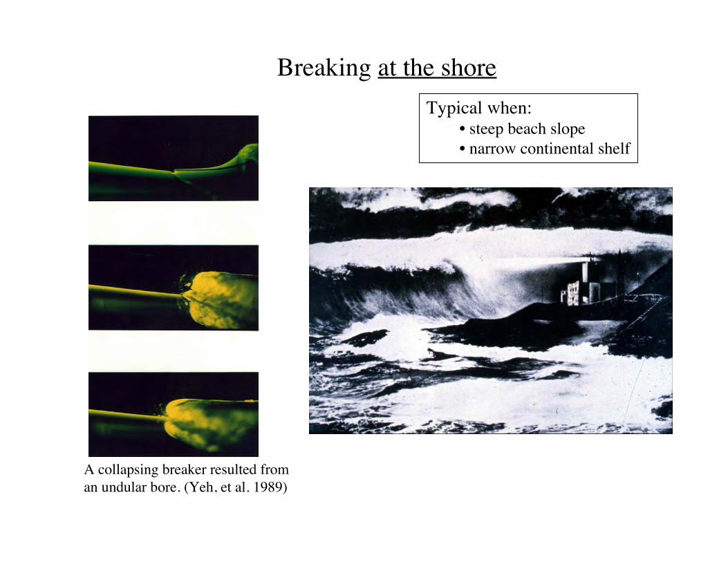
A collapsing breaker resulted froman undular bore. (Yeh, et al. 1989)
Breaking at the shoreTypical when:
• steep beach slope• narrow continental shelf
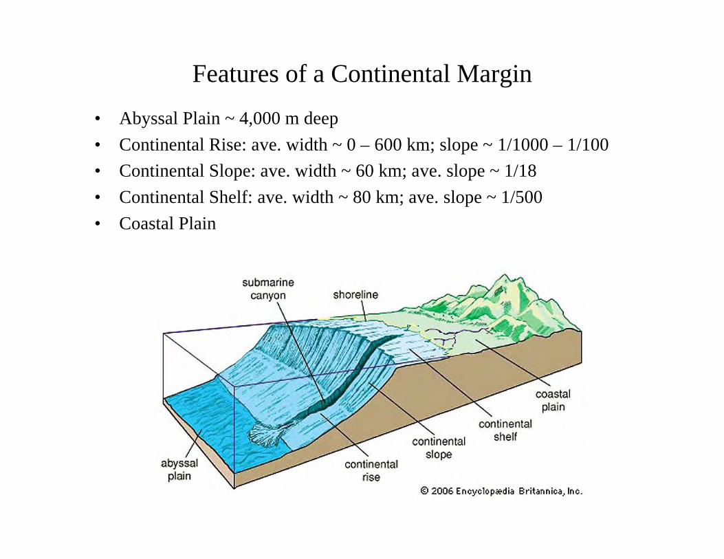
• Abyssal Plain ~ 4,000 m deep• Continental Rise: ave. width ~ 0 – 600 km; slope ~ 1/1000 – 1/100• Continental Slope: ave. width ~ 60 km; ave. slope ~ 1/18• Continental Shelf: ave. width ~ 80 km; ave. slope ~ 1/500• Coastal Plain
Features of a Continental Margin
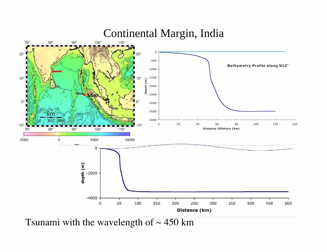
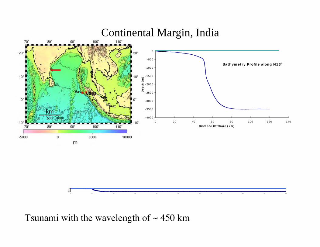
Continental Margin, India
Bathymetry Profile along N13˚
-4000
-3500
-3000
-2500
-2000
-1500
-1000
-500
0
0 20 40 60 80 100 120 140Distance Offshore (km)
Dep
th (
m)
Tsunami with the wavelength of ~ 450 km
Continental Margin, India
Tsunami with the wavelength of ~ 450 km
-4000
-2000
0
0 50 100 150 200 250 300 350 400 450 500
Bathymetry Profile along N13˚
-4000
-3500
-3000
-2500
-2000
-1500
-1000
-500
0
0 20 40 60 80 100 120 140Distance Offshore (km)
Dep
th (
m)
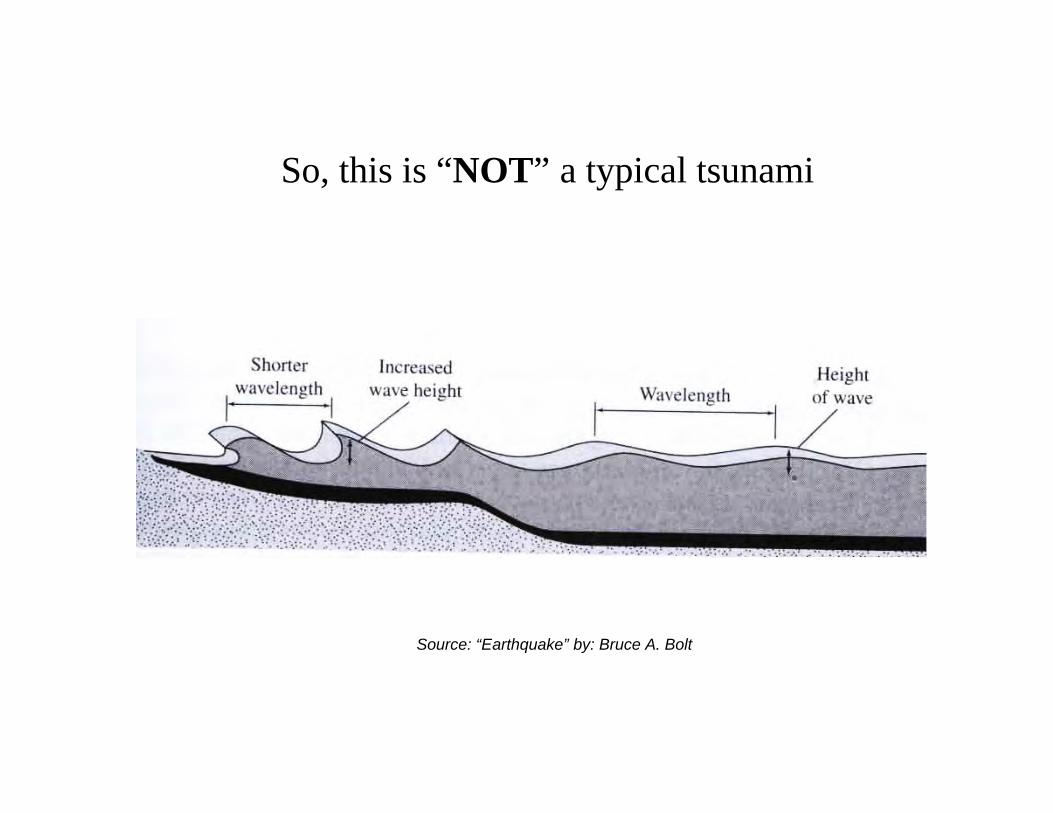
So, this is “NOT” a typical tsunami
Source: “Earthquake” by: Bruce A. Bolt
Why the 2004 Indian Ocean Tsunami could propagateacross the Indian Ocean and beyond withoutsignificant attenuation?
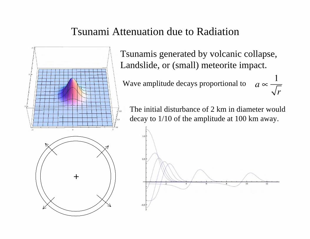
Tsunami Attenuation due to Radiation
a ! 1r
Tsunamis generated by volcanic collapse,Landslide, or (small) meteorite impact.
Wave amplitude decays proportional to
The initial disturbance of 2 km in diameter woulddecay to 1/10 of the amplitude at 100 km away.
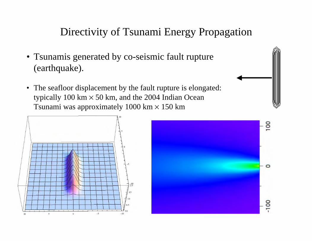
Directivity of Tsunami Energy Propagation
• Tsunamis generated by co-seismic fault rupture(earthquake).
• The seafloor displacement by the fault rupture is elongated:typically 100 km × 50 km, and the 2004 Indian OceanTsunami was approximately 1000 km × 150 km
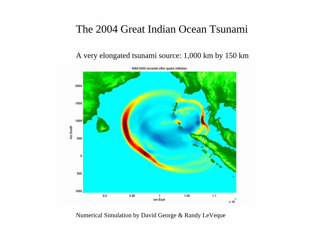
The 2004 Great Indian Ocean Tsunami
Numerical Simulation by David George & Randy LeVeque
A very elongated tsunami source: 1,000 km by 150 km
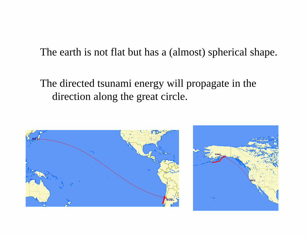
The earth is not flat but has a (almost) spherical shape.
The directed tsunami energy will propagate in thedirection along the great circle.
Difference between short waves and long waves.
• Short waves: those generated by winds, landslides, andvolcanic eruption.
• Long waves: those generated by co-seismic faultdisplacement = tsunamis.
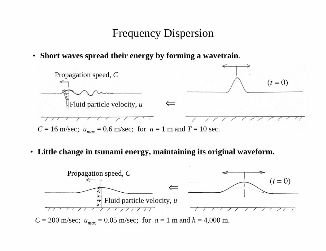
Frequency Dispersion
Propagation speed, C
Propagation speed, C
Fluid particle velocity, u
Fluid particle velocity, u
• Short waves spread their energy by forming a wavetrain.
• Little change in tsunami energy, maintaining its original waveform.
⇐
⇐
(t = 0)
C = 16 m/sec; umax = 0.6 m/sec; for a = 1 m and T = 10 sec.
C = 200 m/sec; umax = 0.05 m/sec; for a = 1 m and h = 4,000 m.
(t = 0)
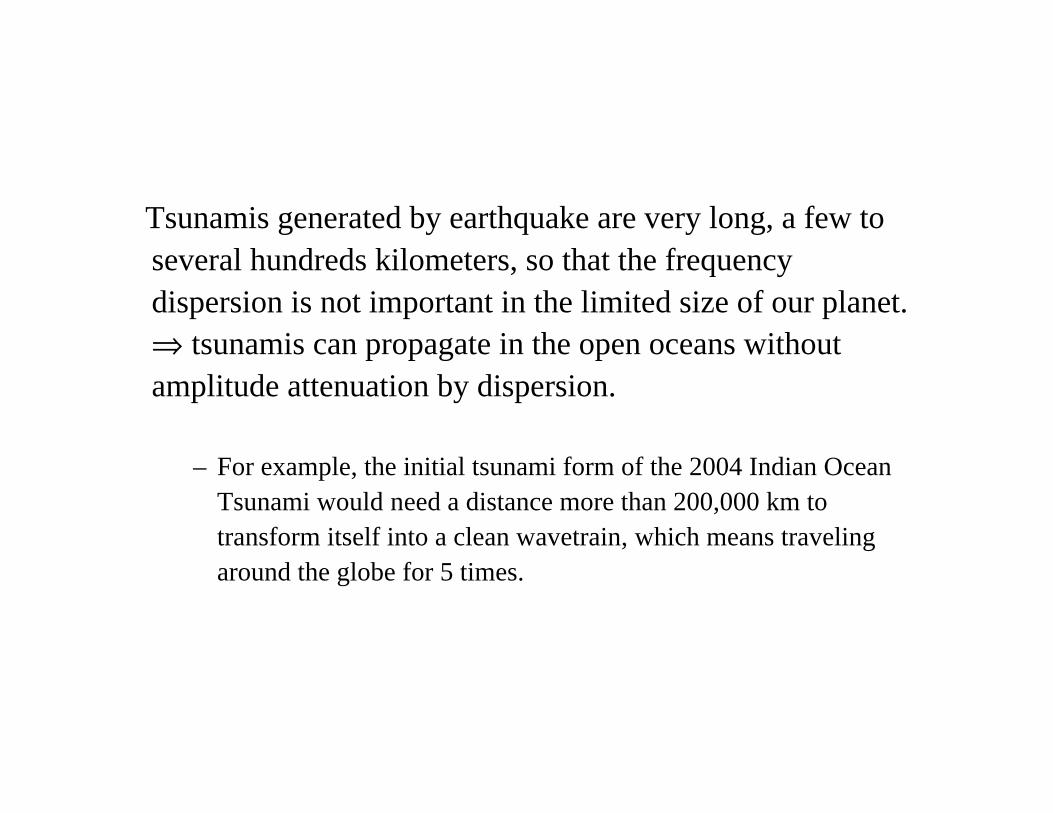
Tsunamis generated by earthquake are very long, a few toseveral hundreds kilometers, so that the frequencydispersion is not important in the limited size of our planet.⇒ tsunamis can propagate in the open oceans withoutamplitude attenuation by dispersion.
– For example, the initial tsunami form of the 2004 Indian OceanTsunami would need a distance more than 200,000 km totransform itself into a clean wavetrain, which means travelingaround the globe for 5 times.
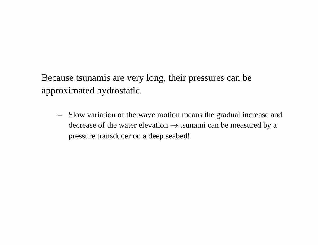
Because tsunamis are very long, their pressures can beapproximated hydrostatic.
– Slow variation of the wave motion means the gradual increase anddecrease of the water elevation → tsunami can be measured by apressure transducer on a deep seabed!
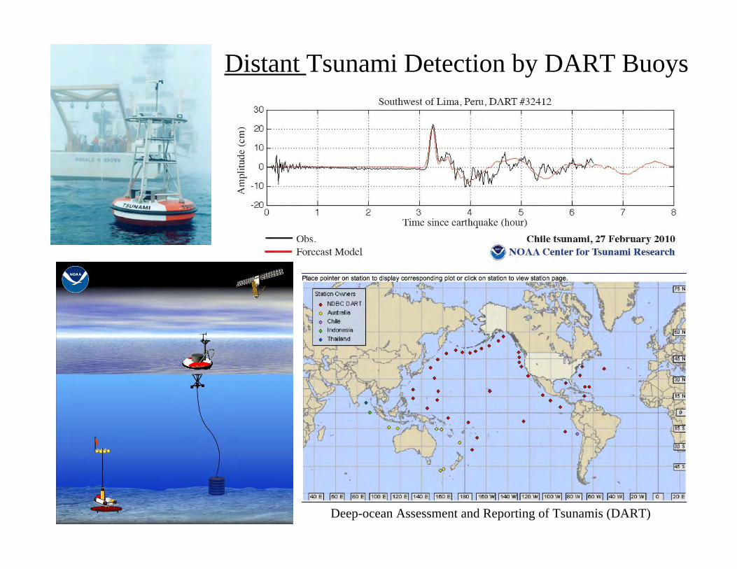
Distant Tsunami Detection by DART Buoys
Deep-ocean Assessment and Reporting of Tsunamis (DART)
Nearshore Effects of Tsunamis
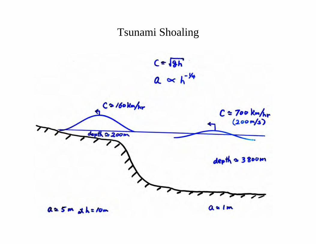
Tsunami Shoaling
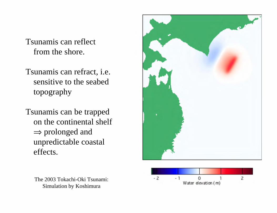
Tsunamis can reflectfrom the shore.
Tsunamis can refract, i.e.sensitive to the seabedtopography
Tsunamis can be trappedon the continental shelf⇒ prolonged andunpredictable coastaleffects.
The 2003 Tokachi-Oki Tsunami:Simulation by Koshimura
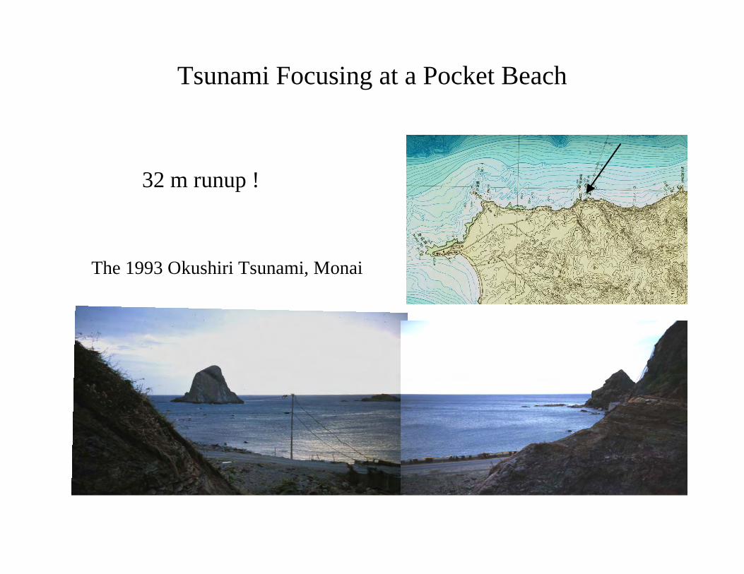
The 1993 Okushiri Tsunami, Monai
Tsunami Focusing at a Pocket Beach
32 m runup !
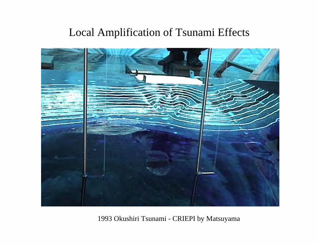
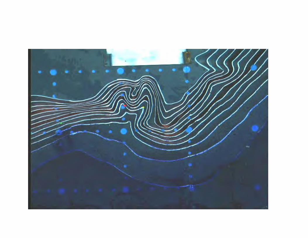
1993 Okushiri Tsunami - CRIEPI by Matsuyama
Local Amplification of Tsunami Effects
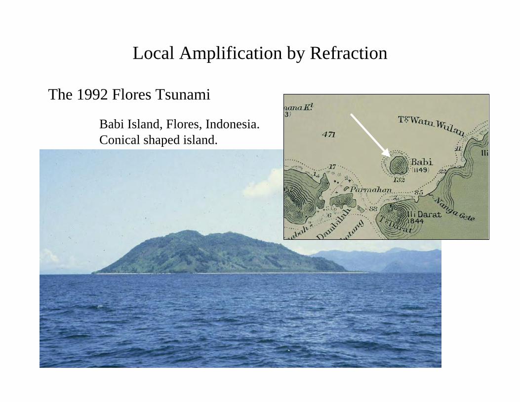
Babi Island, Flores, Indonesia.Conical shaped island.
Tsunami attack
The 1992 Flores Tsunami
Local Amplification by Refraction
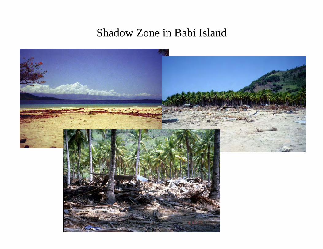
Shadow Zone in Babi Island
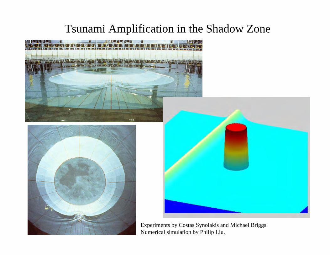
Tsunami Amplification in the Shadow Zone
Experiments by Costas Synolakis and Michael Briggs.Numerical simulation by Philip Liu.
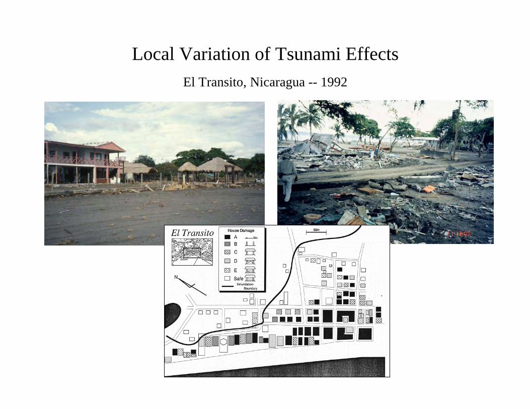
El Transito, Nicaragua -- 1992
Local Variation of Tsunami Effects
Summary
• Origin of Tsunamis– Difference between tsunamis caused by co-seismic fault
displacement and others.
• Tsunami sources: strike-slip, normal, and thrust faults• Subduction Zone Tsunamis• Leading depression or elevation waves; coastal subsidence• Tsunami propagation -- Distant Tsunami: point source v.s
elongated source– Attenuation due to radiation.– Directivity & persistence– Great circle– Dispersion -- tsunamis are very long wave and earth is too small
Summary
• Hydrostatic Pressure and DART Buoys• Tsunamis are 1) amplified by shoaling, 2) reflective, 3)
refractive, 4) trapped• Local Amplifications -- examples a) Monai, 2) Babi. 3) El
Transitro.