Embed Size (px)
Citation preview

TUVALU Meteorological Service (TMS) COUNTRY REPORT
Reporting on National Priority Actions of the Pacific Islands Meteorological Strategy (PIMS) 2012-2021
By: Tauala Katea (Ag.CMO)

1
Table of Contents
1.0 Summary .................................................................................................................................................................................................................. 2
2.0 Background Information .......................................................................................................................................................................................... 3
2.1 Institutional Setup ................................................................................................................................................................................................ 9
2.2 Staffing ............................................................................................................................................................................................................... 12
2.2.1 Staff Qualification ....................................................................................................................................................................................... 12
2.3 Finance ............................................................................................................................................................................................................... 14
2.4 Development ...................................................................................................................................................................................................... 15
3.0 Progress of the NMS .............................................................................................................................................................................................. 20
3.1. Achievements of the NMS from 2011-2013 ..................................................................................................................................................... 20
3.2. Proposed Activities to be Carried out in the Future (2013-2015) .................................................................................................................... 20
4.0. Identify Gaps and Future Needs that would Improve the National Meteorological Services ..................................Error! Bookmark not defined.

2
1.0 Summary The report construct activities and progress being achieved in the last 2 years (2013 & 2014) with regards to the Pacific Island Meteorological Strategy (PIMS 2012 – 2021) and its 14 key outcomes. This report will contribute to;
i. the working papers of the PMC-3 meeting
ii. monitoring the progress of each NMSs against the implementation of the PIMS
iii. the baseline information that will be used to measure the progress of the Pacific Islands Meteorological Strategy (PIMS) 2012-2021
during its mid-term review in 2016.
iv. inform the Work Program of the Pacific Met Desk Partnership (PMDP)
v. identify gaps and needs some of which will be packaged for projects and presented to the Donor Partners
The Tuvalu Meteorological Service provides a good meteorological service to Tuvalu within the limitations of a mixture of old and new
infrastructure and limited training. As with many Pacific Island countries, the most significant meteorological phenomena that affect our people
and their economy are the “Tropical Cyclone” & “Tidal/Storm surges”. It is imperative that activities that serve to mitigate our destructive effects
are being prioritized. This serves to meet our growing public demands for improved weather and climate services and products to ensure safety,
security and general well-being of our people. Thus contributes to achieving sustainable development and set obligations as set out in the Pacific
Islands Meteorological Strategy (PIMS).
Contact of the Tuvalu NMS Alternate Contact
Contact Name: Tauala Katea Division Title: Ag. Chief Meteorological Officer Address: Ministry Communication & Transportation Vaiaku, Funafuti E-mail: [email protected] or [email protected] Work Tel: (688) 20090 & 20736 Mobile: (688) 900 454 Fax: nil
Name: Niko Iona Division Title: Aerology Officer Address: Ministry Communication & Transportation Vaiaku, Funafuti E-mail: [email protected] or [email protected] Work Tel: (688) 20736 & 20095 Mobile: Fax: nil

3
2.0 Background Information
The Tuvalu Meteorological Service (TMS) is the principal Meteorological observatory of Tuvalu and is responsible for providing
weather services to the islands of Tuvalu. A Meteorological office was established on Funafuti at the time the islands of Tuvalu were
administered as parts of the Gilbert and Ellice Islands colony of the United Kingdom. The meteorological office is now an agency of
the Government of Tuvalu.
The main observational office is on Funafuti. TMS operates outstations on Nanumea, Nui and Niulakita. TMS operates or monitors:
4 synoptic stations; 5 rainfall stations; 1 upper air research program; 1 tide gauge with Tsunami warning system; 1 Continuous Global
Positioning System (CGPS) station; 1 Seismic station (USGS).
The TMS publishes weather forecasts, warnings as to tropical cyclones, weather charts and weather satellite images on its website,
with weather forecasts and storm warnings also broadcast by the Tuvalu Media Corporation, which operates Radio Tuvalu.
History
The Meteorological office on Funafuti was established in 1951 under the auspices of the South Pacific Air Transport Council (SPATC).
An upper air observation programme was established in 1960. After the dissolution of SPATC in 1979, the Meteorological Service of
New Zealand Limited supported the upper air programme until the TMS assumed responsibility for the programme, with continuing
support by the New Zealand Ministry of Foreign Affairs and Trade (MFAT)/NZAID. The TMS works with the New Zealand MetService,
the Fiji Meteorological Service, the Australian Bureau of Meteorology, Geoscience Australia, the United States Geological Survey and
the National Weather Service.
Climatology of Tuvalu
Tuvalu participates in the operations of the Secretariat of the Pacific Regional Environment Programme (SPREP). The climate of the
Pacific region at the equator is influenced by a number of factors; the science of which is the subject of continuing research.
Influenced by a number of factors such as trade wind regimes, the paired Hadley cells and Walker circulation,
seasonally varying convergence zones such as the South Pacific Convergence Zone (SPCZ), semi-permanent subtropical

4
high-pressure belts, and zonal westerlies to the south, with the El Niño-Southern Oscillation (ENSO) as the dominant
mode of year to year variability. The Madden-Julian Oscillation (MJO) also is a major mode of variability of the tropical
atmosphere-ocean system of the Pacific on times scales of 30 to 70 days, while the leading mode with decadal time-
scale is the Inter decadal Pacific Oscillation (IPO). A number of studies suggest the influence of global warming could be
a major factor in accentuating the current climate regimes and the changes from normal that come with ENSO events.
The sea level in Tuvalu varies as a consequence of a wide range of atmospheric and oceanographic influences. The 2011 report of
the Pacific Climate Change Science Program published by the Australian Government, describes a strong zonal (east-to-west) sea-
level slope along the equator, with sea level west of the International Date Line (180° longitude) being about a half metre higher
than found in the eastern equatorial Pacific and South American coastal regions. The trade winds that push surface water westward
create this zonal tilting of sea level on the equator. Below the equator a higher sea level can also be found about 20° to 40° south
(Tuvalu is spread out from 6° to 10° south). The Pacific Climate Change Science Program Report (2011) describes the year-by-year
volatility in the sea-level as resulting from the El Niño-Southern Oscillation (ENSO):
ENSO has a major influence on sea levels across the Pacific and this can influence the occurrence of extreme sea levels.
During La Niña events, strengthened trade winds cause higher than normal sea levels in the western tropical Pacific,
and lower than normal levels in the east. Conversely, during El Niño events, weakened trade winds are unable to
maintain the normal gradient of sea level across the tropical Pacific, leading to a drop in sea level in the west and a rise
in the east. Pacific islands within about 10° of the equator are most strongly affected by ENSO-related sea-level
variations.
The Pacific inter-decadal oscillation is a climate switch phenomenon that results in changes from periods of La Niña to periods of El
Niño. This has an effect on sea levels. For example, in 2000 there was a switch from periods of downward pressure of El Niño on sea
levels to an upward pressure of La Niña on sea levels, which upward pressure causes more frequent and higher high tide levels.
The Perigean spring tide (often called a king tide) can result in seawater flooding low lying areas of the islands of Tuvalu.

5
Role of the Tuvalu Meteorological Service
The purpose of the Meteorological programmes operated by the TMS is to gather data in the tropical western Pacific so as to work
to achieve “accurate production of weather forecasts, seasonal and inter-annual climate forecasting (ENSO predictions), and
understanding changes in climate and sea level for Tuvalu and its neighbouring Pacific Islands. Tuvalu lies across a known
development region for tropical cyclones and ENSO activity. It provides crucial data to global weather, climate modelling and
forecasting centres. It also provides the key data used for tropical cyclone and ENSO forecasting.”
Meteorological programmes
The TMS operates 2 meteorological programmes (surface observation programme and upper air programme) and hosts other
climatological research projects.
1) Surface observations
The TMS carries out ground level observations of various weather elements. This data is shared with collaborating partners in
the World Meteorological Organization - World Weather Watch (WWW), the Global Climate Observing System (GCOS) and
the Global Earth Observation System of Systems (GEOSS).
The surface observation programme is made up of hourly, three hourly, six hourly and/or daily observations of various weather
elements. The needs, priorities and systems utilized in the preparation of these reports are formulated and governed under the
auspices of the Global Observing System (GOS), managed by WMO members and collaborating partners. The key components of
GOS are the World Weather Watch (WWW), Global Climate Observing System (GCOS) and the newly launched Global Earth
Observing Systems of Systems (GEOSS). Data generated under GOS is passed immediately to weather forecasting centers around the
Pacific region and the world, via the Global Telecommunication System (GTS). The usefulness of GOS data rapidly diminishes the
greater the length of time involved in getting data to forecasting centers. GCOS data is mainly summarized monthly.
2) Upper air observations
Originally, the upper air observation programme in Funafuti was split into radar and radiosonde observations. Although flown
together from the same weather balloon, the information obtained for each observation is quite different.

6
The radar observation provides essential wind speed and direction data to provide input only into the regular global computer models in
the UK, US, France, Brazil, China, Japan, South Korea, Australia and other forecasting centers, but they are also used for local and
regional aviation forecasts and general weather services and information at Regional Specialized Meteorological Centers (RSMCs) in
Nadi, Wellington, Brisbane, Melbourne and Honolulu. This enables more accurate forecasts to be prepared for Tuvalu and the region.
Radiosonde observations provide information in addition to the radar – temperature, relative humidity and air pressure data.
They are received at the ground station in Funafuti and quickly analyzed to give a profile of weather conditions on the
ground. They are also used to calculate a profile of the “condition” or “status” of the atmosphere relative to both the
surrounding region and the “normal” or standard atmosphere. Such comparisons form the basis of analysis and weather
forecasting techniques in global computer and manual models.
In 1996, the radar was shut down and replaced by a Vaisala DigiCora MW15, allowing both PTU and winds to be measured using a
single system. Originally, winds were calculated using the Omega navigation system, but when this system was shut down worldwide
in 1997, the DigiCora was upgraded to fly RS80-15G GPS radiosondes. A further major upgrade of the Funafuti digicora was carried
out in 2006 to allow the use of RS92-SGP radiosondes
While both observing programmes are primarily for weather forecasting purposes, they also contribute to significant atmospheric (climate/ENSO) research programmes from time to time.
The upper air observation programme in Funafuti makes radiosonde observations to collect upper air weather for weather
forecasting and research. The radiosonde observations use a small, expendable instrument package is suspended below a 2 metres
wide balloon filled with hydrogen. As the radiosonde rises at about 300 meters/minute, sensors on the radiosonde measure profiles
of pressure, temperature, and relative humidity. These sensors are linked to a battery powered radio transmitter that sends the
sensor measurements to a ground receiver. By tracking the position of the radiosonde in flight, information on wind speed and
direction are also obtained.
The data is shared with Regional Specialized Meteorological Centers (RSMCs)
in Nadi, Wellington, Brisbane, Melbourne and Honolulu. The weather modelling carried out by TMS enables more accurate forecasts
to be prepared for Tuvalu and for the tropical western Pacific.

7
Tropical cyclone prediction
The Meteorological observations of the TMS are shared with other regional agencies that attempt to predict how many tropical
cyclones and severe tropical cyclones will develop within the Southern Pacific. New Zealand's National Institute of Water &
Atmospheric Research (NIWA) and collaborating agencies including the Meteorological Service of New Zealand and Pacific Island
National Meteorological Services (including the TMS) issue the "Island Climate Update Tropical Cyclone Outlook" for the Pacific. This
forecast attempts to predict how many tropical cyclones and severe tropical cyclones will develop within the Southern Pacific
between 135°E and 120°W as well as how many will affect a particular island nation. The Fiji Meteorological Service, while
collaborating with NIWA and partners, also publishes its own seasonal forecast for the South Pacific basin between 160°E and
120°W. The Australian Bureau of Meteorology's National Climate Centre forecasts how likely it is that the subregion of the Southern
Pacific will see activity above the average.
Other climatological research programmes and projects
The TMS also hosts other scientific and research programmes, which involves the TMS monitoring:
The tide gauge, which was installed in 1978 by the University of Hawaii.
The SEAFRAME tide gauge, which is modern Aqua-trak acoustic gauge installed in 1993 by the Australian National Tidal
Facility (NTF) as part of the AusAID-sponsored South Pacific Sea Level and Climate Monitoring Project.[15]
TMS participates in research projects including:
Pacific Sea Level Monitoring Project (PSLM): which was developed in 1991 as an Australian Government response to
“concerns raised by member countries of the South Pacific Forum over the potential impacts of human-induced global
warming on climate and sea levels in the Pacific”. This project is conducted in conjunction with Geoscience Australia (GA),
which installed a Continuous Global Positioning System (CGPS) station at the TMS office in 2001. CGPS monitoring the land
movement vertically or horizontally with reference point to the International Terrestrial point.
Climate and Ocean Monitoring and Prediction (COMP) project: which is established by Australian Bureau of Meteorology as
part of the Pacific Islands Climate Prediction Project (PI-CPP).

8
Seasonal Climate Outlooks in Pacific Island Countries (SCOPIC) project: which is a “decision support system for generating
probabilistic predictions (seasonal climate outlooks) for rainfall, temperature or other climate related parameters”.
The Online Climate Outlook Forum (OCOF): also known as the Pacific Islands online Climate Outlook Forum (PICOF) that is a
monthly discussion among Pacific Island National Meteorological Services (NMS) and the Australian Bureau of Meteorology.
The OCOF assists in the implementation of the SCOPIC project and the Climate Adaptation Projects that are supported by the
Australian Bureau of Meteorology.
Membership of Meteorological and Geoscience organizations
TMS participates in the activities of:
The World Meteorological Organization (WMO).
The South Pacific Applied Geoscience Commission (SOPAC).
The Secretariat of the Pacific Regional Environment Programme (SPREP).
SOPAC / SPREP / WMO sponsored meetings of Regional Meteorological Service Directors and Regional Disaster Managers.
The Pacific Meteorological Council (PMC): is a specialized subsidiary body of SPREP, established in July 2011 at the 14th Regional
Meteorological Services Directors meeting in Majuro, Marshall Islands on a bi-annual basis to facilitate and coordinate the scientific
and technical programme and activities of the Regional Meteorological Services.
9
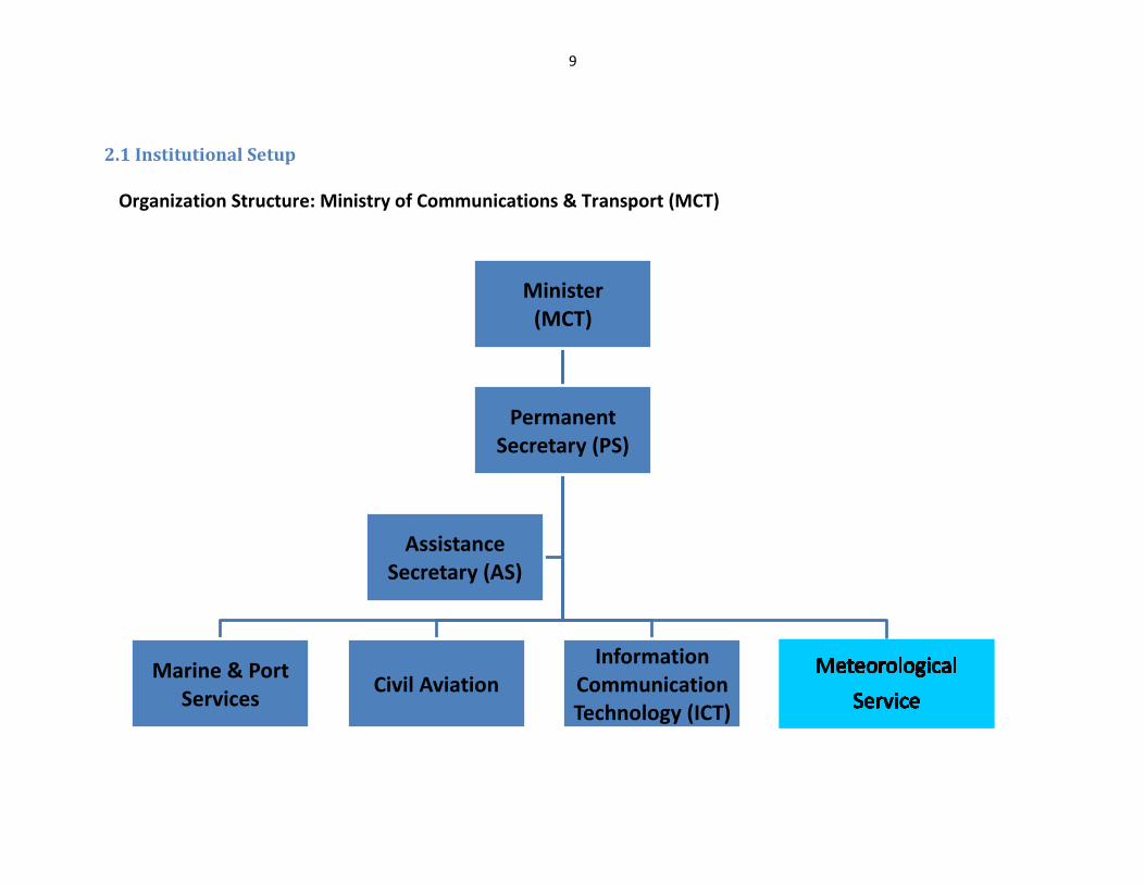
2.1 Institutional Setup
Organization Structure: Ministry of Communications & Transport (MCT)
Minister (MCT)
PermanentSecretary (PS)
Marine & Port Services
Civil AviationInformation
Communication Technology (ICT)
Assistance Secretary (AS)

10
Chief Meteorological OfficerL 4
vacant
Station Technical OfficerL 7/6
Tinapa Faletiute
Aerology OfficerL 7/6
FreezeMarket Center
Current Meteorological Structure (since 1990)
Forecast Section Technical SectionClimate/Operational
Section
Scientific Officer
L 6/5
Tauala Katea
Aerology Officer
L 7/6
vacant (freeze)
Station Technical Officer
L 7/6
Tinapa Faletiute
Assistance Technician
L 8/7
Loposi Pelee
Carpenter
L 10
Tanielu Salesa
Senior Observer
L 8/7
Elifaleti Ene
Observer
L 9/8
Limoni Mativa
Observer
L 9/8
Charles Fiaola
Observer
L 9/8
Polapola Keli
Observer
L 9/8
Richard Gorkrun
Observer
L 9/8
Niko Iona
Observer
L 9/8
vacant (freeze)
Observer
L 9/8
Saleo Kaufiti
Observer
L 9/8
Taumalea Kalepo
Observer
L 9/8
Alamoana Tofuola
Observer
L 9/8
Fiti Ielome

11
Governance Description Update on whether or not your country have a stand-alone Meteorology Act or equivalent or is it part of other government’s legislations to guide the NMHS to perform its role and responsibility? Briefly describe it.
Tuvalu Meteorological Service is in the stage of developing a stand-alone Meteorology Act from the assistance under the WMO Voluntary Co-operation Programme (VCP). Progress thus far: have submitted (Concept Note) and await confirmation for project implementation from WMO this year 2015
Is the Meteorology Act or equivalent includes disaster management or vice-versa? If the Meteorology Act or equivalent does not include diaster management, provide information on your country Disaster Management Act or equivalent(s).
We are still developing our Meteorology Act and definitely will include Disaster Management. Yet, our Disaster Management Act does not include Meteorology and will propose to Disaster Unit to likewise revise their Act to include Meteorology for consistency. Attached in annex our Disaster Management Act.
Is the Meteorology Act or equivalent includes climatatology/climate variability/climate change. If the Meteorology Act or equivalent does not include it provide information on your country legislation or legal instruments related to climatology/climate variability/climate change.
We will include all climatology/climate variability/climate change during our implementation phase of our Meteorology Act.
Strategic Planning Describe how meteorology (weather) and climatology (climate variability and climate change) are featured in the current national development plan, government ministries corporate and implementation/operational plans.
Meteorology and Climate mainly reflected in our National Strategy for Sustainable Development 2005 – 2015 (Te Kakeega II). It doesn’t reflect much within our Ministry Corporate Plan but more less featured in our Ministry Operation Plan. Yet, we still in the developing stage for our Meteorology Strategy and Implementation Plan this year funding under the WMO VCP.
Describe how disaster management and early warning systems are featured in the current national development plan, government ministries corporate and implementation/operational plans.
We have a revised and more detail National Disaster Plan retitled as “Tuvalu National Disaster Risk Management Arrangements (NDRMA)” endorsed in end of 2012. The NDRMA have been prepared under the guidance of the National Disaster Committee. The Arrangements reflects the commitment by the government of Tuvalu to align national development with the Pacific Disaster Risk Reduction and Disaster Management Framework for Action 2005–2015, by providing a holistic framework broadening the disaster response focus of previous plans and reflecting a whole of government approach to Disaster Risk Management. The Arrangements adopt an all hazards approach and is designed to ensure that disaster preparedness and the outcome of disaster events inform sustainable development strategy and accords with the principles enshrined in TE KAKEEGA II, National Strategy for Sustainable Development 2005 – 2015. This involves also in featuring early warning systems and responses mainstreaming and indicating each line Ministries responsibilities in any disaster encounter.

12
Does your NMHS have a strategic plan, implementation/operational plan or equivalent(s)?
We are in the developing stage of our Strategic and Implementation Plan under the assistance of WMO VCP.
Describe how meteorology (weather), climatology (climate variability and climate change), disaster management and early warning systems are feature in your NMHS strategic plan, implementation/operational plan or equivalent(s).
These will all included in our Strategic Plan and be aligned with our National Strategy for Sustainable Development Plan (Te Kakeega II), the PIMS and other equivalents plans in place.
2.2 Staffing
2.2.1 Staff Qualification
(a) UPDATE whether or not your NMHS have its own human resources development strategy or is part of the Ministry’s or the overall
government human resources development strategy. The Tuvalu Meteorological Service aims to support the safety, health and prosperity of Tuvalu’s communities. It does this through the production
and dissemination of climate and weather information to support improved decision-making.
We have a document for our National Meteorological Service called “Learning and Development Plan 2014 – 2016” and “IT Capacity Mapping” available
The TMS has high capacity to deliver observations and fundamentals forecasting on weather and climate predictions from local observations,
models and other information available on the internet. To build on TMS ability to deliver meteorological services, we will focus on developing
the following areas:
1. Upgrading skills and certifications of observations and forecasting staff 2. Upgrading equipment, particularly data management and rescue systems 3. Communicating weather alerts to the public and establishing early warning systems
(b) Provide an updated list of personnel of NMHS, including their level of academic qualification in the matrix below
Staff Qualification Division/Section No. Professional Staff Total
Staff Name (Description the qualification under each division) Example; WMO Class 1-4 or other qualification or professional training)
Responsibility of Staff (Forecast, Climate,
Observation, Administration, etc)
Male Female Total Number of Staff
Chief Meteorological Officer Administration vacant
Scientific Officer - Tauala Katea
1. WMO Class III & IV, 2. Pacific International Forecasting Desk 3. Aviation Forecasting 4. Marine Forecasting
Forecast 1

13
5. Severe weather forecasting 6. Seismology 7. Tsunami Inundation Modelling 8. BSc (Physics & Maths) 9.GIS
Aerology Officer - Niko Iona
1. WMO Class IV 2. BCom (Info Sys & Pub. Admin) 3. Pacific International Forecasting Desk 4. Climsoft Database 5. SCOPIC
Observation & Climate 1
Station Technical Officer - Tinapa Faletiute
1.Dip. (Elec. Engineering) 2.Seismology 3. Tsunami Inundation Modelling 4.Met Equipment Electronics Systems 5.Instruments Calibrations/Maintenance 6.RANET 7.GIS
Technical 1
Meteorological Technician - Loposi Pelee
1.Trade Cert. (Refrigeration & Aircon) 2.Met Equipment Maintenance
Technical 1
Senior Observer - Elifaleti Ene
1. Pacific International Forecasting Desk 2.SCOPIC
Observation & Climate 1
Observer (Headquarter) - Richard Gorkrun
1. Pacific International Forecasting Desk 2. Climate Prediction Applications 3. WMO Class III
Observation & Forecast 1
Observer (Headquarter) - Polapola Keli
` Observation & Forecast 1
Observer (Headquarter) - Alamoana Tofuola
Observation & Forecast 1
Observer (Headquarter) - Fiti Ielomi
Observation & Forecast 1
Observer (Headquarter) - Charles Fiaola
Observation & Forecast 1
Observer (Headquarter) - vacant
Observation & Forecast vacant
Observer (Headquarter) - vacant
Observation & Forecast vacant
Observer (Outer-Station) - Saleo Kaufiti
1.WMO Class III Observation 1
Observer (Outer-Station) - Taumalea Kalepo
Observation 1
Observer (Outer-Station) - Limoni Mativa
Observation 1

14
Workshop Carpenter - Tanielu Salesa
Carpentry & Mechanical 1
2.3 Finance
Description 2012 2013 2014 Funds (AUD) 2014 Total (AUD) Total Budget Total Budget Administration Operation
1) Government Support A$204,180.00 A$210,089.00 A$30,576.00 A$201,295.00 $231,209.00 2) Assistance Climate Officer (Flexible funding - COSPPAC)*
- - - - $47,557.20 (2 yrs project 2014 – 2015 only)
Funafuti Global Upper Air Network support (GUAN) World Weather Watch (WWW)
$20,540.00 $20,540.00 - - $20,540.00 annually
.......
Total (AUD) $299,306.20
* A need to continue in support this recruitment after 2015 - internal or external financially support………………
15
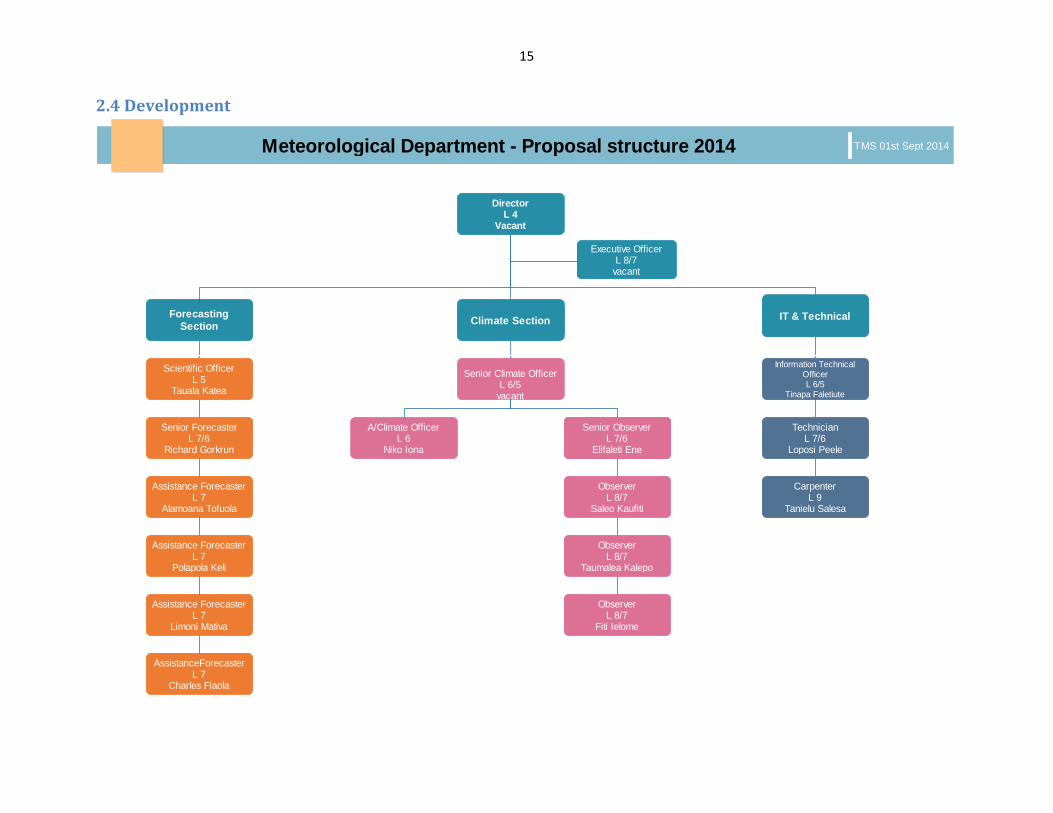
2.4 Development
DirectorL 4
Vacant
Code EnforcementDefault Name
Information Technical OfficerL 6/5
Tinapa Faletiute
Senior Climate Officer L 6/5
vacant
Red Shift A
Scientific OfficerL 5
Tauala Katea
Meteorological Department - Proposal structure 2014 TMS 01st Sept 2014
Climate Section IT & Technical
Senior ForecasterL 7/6
Richard Gorkrun
A/Climate OfficerL 6
Niko Iona
Senior Observer L 7/6
Elifaleti Ene
TechnicianL 7/6
Loposi Peele
Assistance ForecasterL 7
Alamoana Tofuola
Observer L 8/7
Saleo Kaufiti
Observer L 8/7
Taumalea Kalepo
Observer L 8/7
Fiti Ielome
CarpenterL 9
Tanielu Salesa
Assistance ForecasterL 7
Polapola Keli
Assistance ForecasterL 7
Limoni Mativa
AssistanceForecasterL 7
Charles Fiaola
Climate Section IT & TechnicalForecasting Section
Executive OfficerL 8/7
vacant
Senior ObserverL 7/6
Elifaleti Ene
Senior ObserverL 7/6
Elifaleti Ene

16
2.4.1 Buildings Infrastructure
Nil - except for an extension to the ocean side of the main office to accommodate as our Climate Section wind. Spacing within the office
is an issue as more responsibility and demands from the public; Government & Climate Change projects on our services which in turn
out more new instruments, monitoring equipment etc….. continue to deluge our office spacing. However, main office is very old and
deteriorates which subject for full renovation or erects a new one.
2.4.2 Monitoring Stations and Equipments
Station Name (WMO No.)
Operational Status Equipments available in the station
Manual/Automatic (if manual, indicate the number of staff manning the station)
Gaps and Needs
91643 (Funafuti) Synoptic Station
Good Steveson Screen, Wet & dry bulb, Max & min thermometer, Dine raingauge, manual raingauge, Digital Barometer, hydro-graph, evaporation pan, sunshine recorder, AWS, HF system, Tide Gauge, GNSS, Seismic station & Upper Air observation system
Manned (14) - AWS needs to be upgraded and calibrate
- Stevenson screen replacement
- Old Dine rain gauge to be replace
- New serviceable anemometer mast and HF antenna
91631 (Nanumea) Synoptic Station
Good Steveson Screen, Wet & dry bulb, Max & min thermometer, manual raingauge, Barometer & HF system
Manned (1) - No HF radio - Need solar panels - New regulator - Suitable inverter for batt &
solar panels
91636 (Nui) Synoptic Station
Good Steveson Screen, Wet & dry bulb, Max & min thermometer, manual raingauge, Barometer & HF system
Manned (1) - Need new solar panels - New regulator - Suitable inverter for batt &
solar panels - Need serviceable HF antenna

17
91648 (Niulakita) Synoptic Station
Good Steveson Screen, Wet & dry bulb, Max & min thermometer, manual raingauge, Barometer & HF system
Manned (1) - Need new solar panels - Regulator - Station power backup
generator - Need new servicable HF
Antenna
91634 (Nanumaga) Rainfall Station
Not operational Rain gauge only Need to be upgrade to tipping/ data logger rain gauge
91633 (Niutao) Rainfall Station
Not operational Rain gauge only Need to be upgrade to tipping/ data logger rain gauge
91638 (Vaitupu) Rainfall Station
Not operational Rain gauge only Need to be upgrade to tipping/ data logger rain gauge
91641 (Nukufetau) Rainfall Station
Not operational Rain gauge only Need to be upgrade to tipping/ data logger rain gauge
91646 (Nukulaelae) Rainfall station
Not operational Rain gauge only Need to be upgrade to tipping/ data logger rain gauge
(a) Describe the current status of and future plans for lightning detection systems and networks in your country? Who is operating and
managing the systems and network.
- No lightning detection systems or network in Tuvalu. Yet, installing or being in the lightning detection systems network will obviously improve
our severe weather forecasting and preparation.
(b) Describe the current arrangement of and future plans for maintaining and calibrating the meteorological (weather) and climatological (climate variability and climate change) observing equipment in your NMHS. - We conduct annual inspection and calibration on all our instruments within main headquarter and outer islands. This includes our rainfall
stations and manned stations on outer islands. Future plans may propose to install AWS on all rainfall stations and the capital.

18
2.4.3 Update on Communications Infrastructure (to support current and future development)
Details
What is the mode of communication for transmitting data from remote stations
Primary mode: HF radios Secondary: Phone lines & Internet
What is the Mode of transmitting data to the Global Data Network
Data are transmitted to NZ MetService, AFTN & Bureau of Meteorology Australia (BoM) over the internet email who in turn convert data to Global Telecommunication Systems (GTS) format and re-transmit on these circuits network. Likewise, GTS address to Tuvalu Met is converted to internet email format from these circuits network are send to Tuvalu.
What is your Current Internet Speed (inbound and outbound)
Office currently used Internet connection from GNSS VSAT with 3 IPs being provided with a speed of 256bps/256bps uplink/downlink respectively. Other ISP such as Telecommunication with reasonable speed but yet too costly. However, we have a Government ISP but slow and congested which delay our timely obligation needs in sending observation and as well providing weather and climate information/forecasts.
Does your NMS have access to SATAID information
Yes, access to SATAID information via secure username and password upon request to Japan Meteorological Agency (JMA). Also these information available on Low Resolution Images Transmission (LRIT) system installed in office with a view for upgrading to High Resolution Images Transmission (HRIT) when MTSAT replaced by Himawari 8.
Which satellite product do you most rely on and how do you obtain it?
For our weather forecasting, we mostly use NOAA, BoM and JMA satellite products. Most of the products are access via the internet connection and direct link connection via LRIT system.
How many Upper Air Station does your NMSs operate and what is their status
We have only one Upper Air station located in the capital and still operating since 1960. Upper air soundings usually performed twice a day (1100UTC & 2300UTC) but due to funding constrain, been restrict to one flight only per day. The Upper Air programme is fully funded by UK MET Office with SPREP in supplied and manage the funding with technical support continue to provide by NZ MetService on a annual basis.
What is the scope and extent of marine weather services provided by your NMSs and describe your NMSs interaction with your national
We provide public weather forecast with inclusion of sea state within the bulletin. Yet, we provide marine bulletin upon request and during strong wind warning for near shore forecast as for information and guidance. High seas forecast remains in the hands of RSMC Nadi as in providing marine forecast as part of their area of responsibility in the region.

19
marine/port authorities and the marine user communities
We interact closely with our Marine and Port services with the public depends mostly on these products for their information and day-to-day decision making.
What type of marine weather products, warnings, advisories do you provide
We issue marine bulletin upon request from mariners or the public. We provide marine warnings and advisories such as: a) Swell warning, b) Storm surges, c)King Tides d) Seas State
Does your NMS have a Port Meteorological Officer and are they involved in the WMO VOS Programme.
We do not have any Port Meteorological Officer but may need to establish one in near future as increase inbound/outbound fishing vessels. Fishing companies select our lagoons as a safe and good investment for anchorage and discharging their catch to mother ships for quick turn-over delivery.
2.4.4 Training
Training or Workshop Title attended by NMS staff from 2011-2013 Start and End dates
Donor Number of Participants from the NMS
Quality Control Management System (QMS) course 28th -02nd May 14 WMO 1
International Tsunami Information Centre training 18th-29th Aug 14 ITIC/NOAA 1
Climate Science, Statistics, Excel & Communication training 15th-17th Sept 14 COSPPac 10
Lightening Location training 14th-16th Oct 14 FINPAC 1
Weather Observation & Calibration training 5th-16th May 14 COSPPac 1
SCOPIC attachment training 11th-22nd Aug 14 COSPPac 1
Drought Monitoring training 3rd-8th Oct 14 COSPPac 1
COSPPac Regional workshop 16th-27th Jun 14 COSPPac 1
Pacific International Training Desk 16/06-11/07 14 NOAA/NWS 2
Instrument Maintenance & Calibration training 30/10-02/12 14 WMO 1

20
3.0 Progress of the NMS
3.1. UPDATE on Achievements of the NMS from 2013-2014
No. Achievements (Activities) of the NMS (2013-2014) 1 2 3 4 5 6 7 8 9 10 11 12 13 14 1 Quality Control Management System (QMS) course x x x x x x
2 International Tsunami Information Centre training x x x x x
3 Climate Science, Statistics, Excel & Communication training x x x x x x x x
4 Lightening Location training x x x x x
5 Weather Observation & Calibration training x x x x x x x x
6 SCOPIC attachment training x x x x x
7 Drought Monitoring training x x x x
8 COSPPac Regional workshop x x x x x x x x
9 Pacific International Training Desk x x x x x
10 Instrument Maintenance & Calibration training x x x x x
11 Recruiting of Assistance Climate Officer (2 years project) x x x x x
12 Upgrading GNSS - VSAT x x x x x x x
13 CLIDE Database x x x x x
14 Internal networking x x x x
15 Data backup system x x x x x x
3.2. Proposed Activities to be carried out in the Future (2013-2014)
No Proposed Activities to be carried out between 2013-2014 1 2 3 4 5 6 7 8 9 10 11 12 13 14 1 Improve communication systems on outer islands – HF radios, antennas x x x x x x x
2 Improving early warning systems – trial on chatty beetle, RANET etc…. x x x x x x
3 Automatic Weather Stations (AWS) x x x x x x x x x
4 Aviation documentations & competency to ICAO standards (QMS) x x x x x x x x
5 Digitize and archiving data hard copies x x x
6 Shelter for storage climate data hard copies x x
7 Improve/upgrade office network – servers, UPS etc… x x x x x x x
8 Procurement rain gauge to revive the 5 rainfall stations – outer islands x x x
9 Establish formal marine reporting arrangements with shipping operators x x x x x

21
10 WMO GTS Message Switching System/data Acquisition System for AWS observation site
x x x x x x x x
11 Bridge the communications gap between Forecaster and the user x x x x x x x
12 Siren alarm system – Funafuti only x
13 Weather radar x x x x x x x x
14 New Met Office x x x x x x x x x x
4.0 Identify Gaps and future needs
• Improving service quality and delivery
• More in-country scientific research in support CC adaptation & mitigation projects and decision making.
• Strengthening capacity development on weather, climate and IT database & networking
• Improved protection of life and property - early warning services
• Building and enhancing partnerships and cooperation
• Capacity to maintain high standards of observation instruments, equipment and data backup system
• Capability to prepare and deliver high quality early warnings and forecasts of weather, climate and water related hazards.
• Availability of modern infrastructure and adequate well trained and competent human resources to gather, process, archive and
facilitate the rapid exchange of data and products
• Improve and reliable communication systems