Embed Size (px)
Citation preview
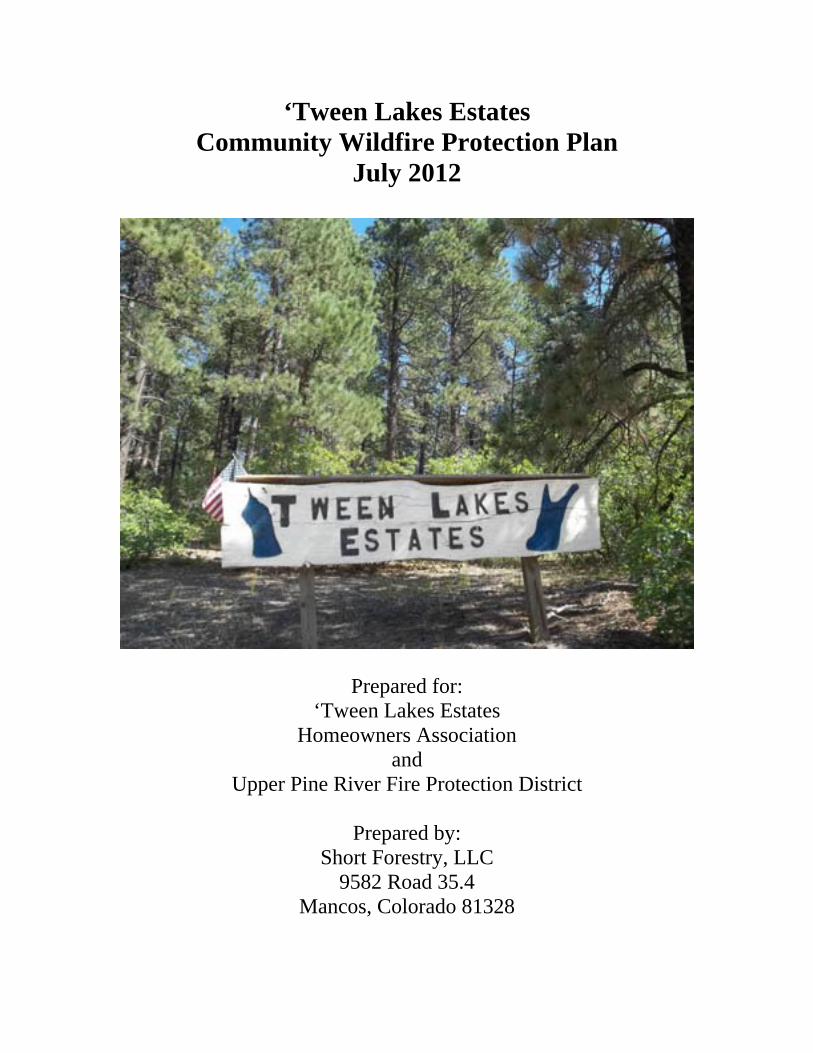
‘Tween Lakes Estates Community Wildfire Protection Plan
July 2012
Prepared for: ‘Tween Lakes Estates
Homeowners Association and
Upper Pine River Fire Protection District
Prepared by: Short Forestry, LLC
9582 Road 35.4 Mancos, Colorado 81328
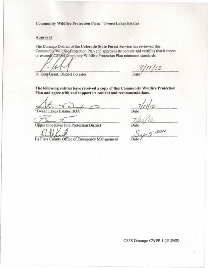
Community Wildfire Protection Plan: 'Tween Lakes Estates
Approval
The Durango District of the Colorado State Forest Service has reviewed thisCommuni ildfir rotection Plan and approves its content and certifies that it meetsor excee SE m unity Wildfire Protection Plan minimum standards.
Date! 7
?/IZ/I2-
The following entities have received a copy of this Community Wildfire ProtectionPlan and agree with and support its content and recommendations.
b-~j'Tween Lakes Estates BOA'
I 7Date
La Plata County Office of Emergency Management
CSFS Durango CWPP-l (3/18/08)
-------
Table of Contents 1. INTRODUCTION......................................................................................................... 3 2. BACKGROUND ........................................................................................................... 3
A. Location..................................................................................................................... 3 B. Community ............................................................................................................... 3 C. Local Fire History .................................................................................................... 5 D. Recent Wildfire Preparedness Activities ............................................................... 5
3. PLAN AREA ................................................................................................................. 5 A. Boundaries ................................................................................................................ 5 B. Private Land Characteristics .................................................................................. 6 C. Public Land Characteristics.................................................................................... 7 D. Fire Protection.......................................................................................................... 7
4. PLANNING PARTNERS AND PROCESS................................................................ 8 A. Partners..................................................................................................................... 8 B. Process ....................................................................................................................... 8 C. Desired Future Condition........................................................................................ 8
5. POLICIES ..................................................................................................................... 9 A. Federal....................................................................................................................... 9 B. State ........................................................................................................................... 9 C. Consolidated County Annual Operating Plan..................................................... 10 D. USFS and BLM Land and Resource Management Plan / Fire Management Plan............................................................................................................................... 10 E. La Plata County CWPP ......................................................................................... 11 F. ‘Tween Lakes Estates ............................................................................................. 11
6. RESOURCE ASSESSMENT AND TRENDS.......................................................... 11 A. Fuels and Fire Hazard ........................................................................................... 11
1. Cover Types ......................................................................................................... 11 3. Slash Treatment .................................................................................................. 13 4. Structural Vulnerability ..................................................................................... 13 5. Environmental Factors ....................................................................................... 14
B. Values At Risk ........................................................................................................ 14 1. Socio/Economic ................................................................................................... 14 2. Ecological ............................................................................................................. 14
C. Protection Capability ............................................................................................. 14 7. MITIGATION ACTION PLAN................................................................................ 16
A. Education and Community Outreach .................................................................. 16 B. Policy ....................................................................................................................... 16 C. Wildfire Mitigation Activities ............................................................................... 16
1. Vegetation/Fuels Management .......................................................................... 16 2. Structure Vulnerability ...................................................................................... 18 3. Safety .................................................................................................................... 19 4. Specific Activity Recommendations and Priorities.......................................... 19
8. MONITORING AND EVALUATION ..................................................................... 20 9. GLOSSARY................................................................................................................. 21 10. LITERATURE CITED ............................................................................................ 23 APPENDICES................................................................................................................. 24
2
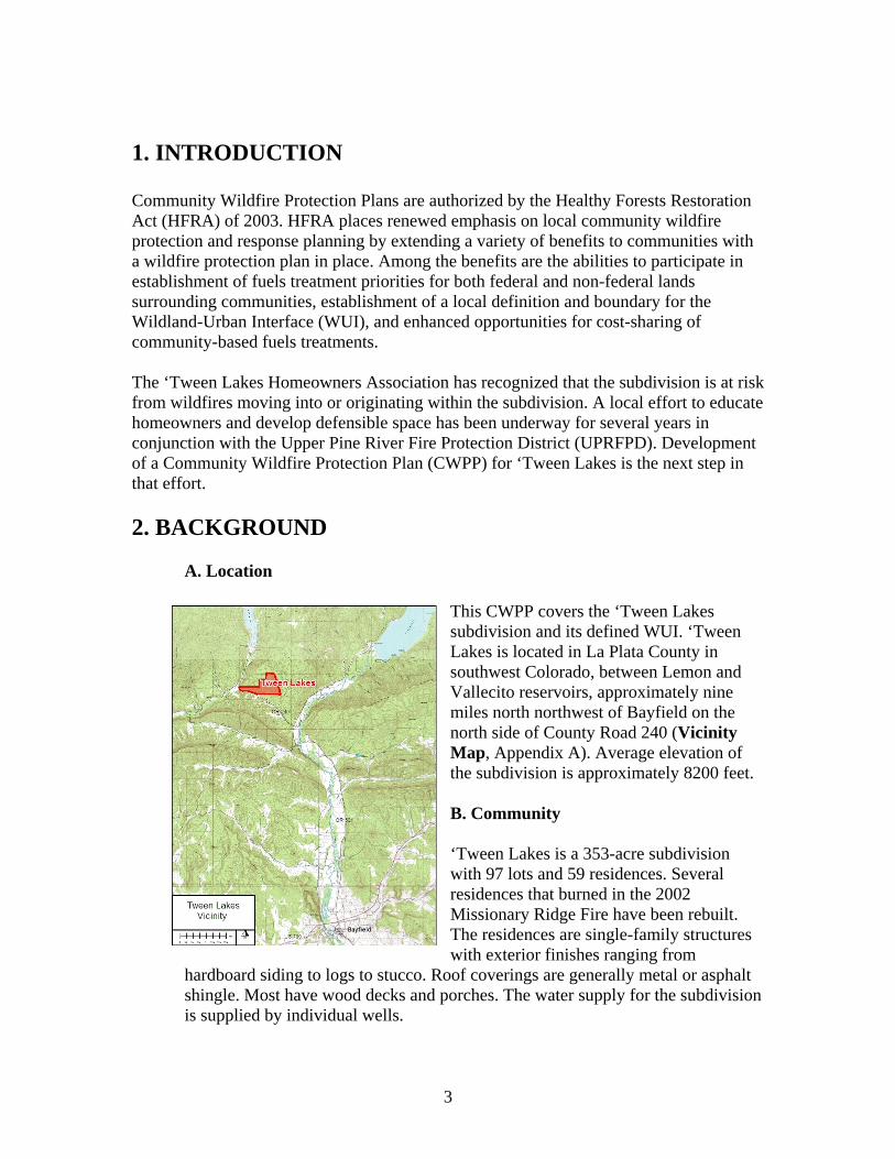
1. INTRODUCTION Community Wildfire Protection Plans are authorized by the Healthy Forests Restoration Act (HFRA) of 2003. HFRA places renewed emphasis on local community wildfire protection and response planning by extending a variety of benefits to communities with a wildfire protection plan in place. Among the benefits are the abilities to participate in establishment of fuels treatment priorities for both federal and non-federal lands surrounding communities, establishment of a local definition and boundary for the Wildland-Urban Interface (WUI), and enhanced opportunities for cost-sharing of community-based fuels treatments. The ‘Tween Lakes Homeowners Association has recognized that the subdivision is at risk from wildfires moving into or originating within the subdivision. A local effort to educate homeowners and develop defensible space has been underway for several years in conjunction with the Upper Pine River Fire Protection District (UPRFPD). Development of a Community Wildfire Protection Plan (CWPP) for ‘Tween Lakes is the next step in that effort.
2. BACKGROUND
A. Location
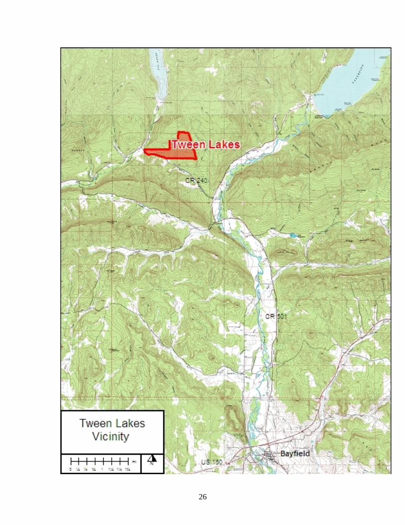
This CWPP covers the ‘Tween Lakes subdivision and its defined WUI. ‘Tween Lakes is located in La Plata County in southwest Colorado, between Lemon and Vallecito reservoirs, approximately nine miles north northwest of Bayfield on the north side of County Road 240 (Vicinity Map, Appendix A). Average elevation of the subdivision is approximately 8200 feet.
B. Community
‘Tween Lakes is a 353-acre subdivision with 97 lots and 59 residences. Several residences that burned in the 2002 Missionary Ridge Fire have been rebuilt. The residences are single-family structures with exterior finishes ranging from
hardboard siding to logs to stucco. Roof coverings are generally metal or asphalt shingle. Most have wood decks and porches. The water supply for the subdivision is supplied by individual wells.
3
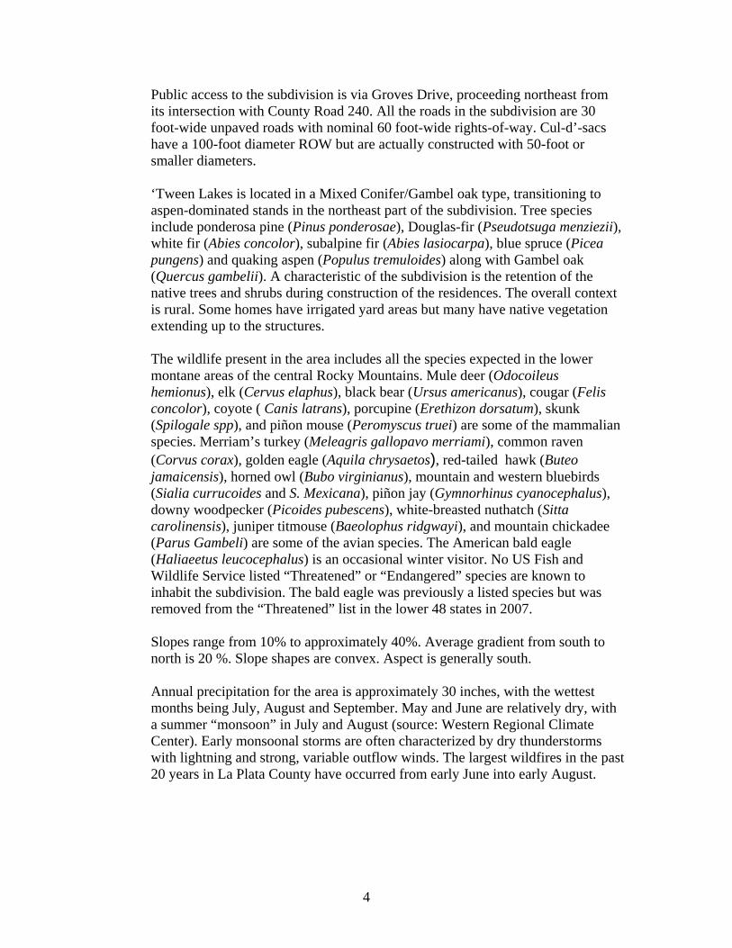
Public access to the subdivision is via Groves Drive, proceeding northeast from its intersection with County Road 240. All the roads in the subdivision are 30 foot-wide unpaved roads with nominal 60 foot-wide rights-of-way. Cul-d’-sacs have a 100-foot diameter ROW but are actually constructed with 50-foot or smaller diameters. ‘Tween Lakes is located in a Mixed Conifer/Gambel oak type, transitioning to aspen-dominated stands in the northeast part of the subdivision. Tree species include ponderosa pine (Pinus ponderosae), Douglas-fir (Pseudotsuga menziezii), white fir (Abies concolor), subalpine fir (Abies lasiocarpa), blue spruce (Picea pungens) and quaking aspen (Populus tremuloides) along with Gambel oak (Quercus gambelii). A characteristic of the subdivision is the retention of the native trees and shrubs during construction of the residences. The overall context is rural. Some homes have irrigated yard areas but many have native vegetation extending up to the structures.
The wildlife present in the area includes all the species expected in the lower montane areas of the central Rocky Mountains. Mule deer (Odocoileus hemionus), elk (Cervus elaphus), black bear (Ursus americanus), cougar (Felis concolor), coyote ( Canis latrans), porcupine (Erethizon dorsatum), skunk (Spilogale spp), and piñon mouse (Peromyscus truei) are some of the mammalian species. Merriam’s turkey (Meleagris gallopavo merriami), common raven (Corvus corax), golden eagle (Aquila chrysaetos), red-tailed hawk (Buteo jamaicensis), horned owl (Bubo virginianus), mountain and western bluebirds (Sialia currucoides and S. Mexicana), piñon jay (Gymnorhinus cyanocephalus), downy woodpecker (Picoides pubescens), white-breasted nuthatch (Sitta carolinensis), juniper titmouse (Baeolophus ridgwayi), and mountain chickadee (Parus Gambeli) are some of the avian species. The American bald eagle (Haliaeetus leucocephalus) is an occasional winter visitor. No US Fish and Wildlife Service listed “Threatened” or “Endangered” species are known to inhabit the subdivision. The bald eagle was previously a listed species but was removed from the “Threatened” list in the lower 48 states in 2007. Slopes range from 10% to approximately 40%. Average gradient from south to north is 20 %. Slope shapes are convex. Aspect is generally south. Annual precipitation for the area is approximately 30 inches, with the wettest months being July, August and September. May and June are relatively dry, with a summer “monsoon” in July and August (source: Western Regional Climate Center). Early monsoonal storms are often characterized by dry thunderstorms with lightning and strong, variable outflow winds. The largest wildfires in the past 20 years in La Plata County have occurred from early June into early August.
4
C. Local Fire History The 76,000 acre Missionary Ridge Fire burned approximately 80 acres within the subdivision in 2002. Approximately half of the acreage burned was stand-replacement and half a moderate to low-intensity underburn. Most of the stand-replacement burned area has regenerated to aspen and Gambel oak. Other large wildfires have occurred in La Plata County over the past twenty years. Examples include the Black Ridge Fire (1994) that burned over 10,000 acres in piñon/juniper approximately 25 miles southwest of the subdivision, the Sambrito 2 Fire (2011) that burned 500 acres of ponderosa pine and piñon/juniper 30 miles southeast of the subdivision, and the Red Creek Fire that burned approximately 45 acres of mixed conifer forest five miles southwest of ‘Tween Lakes in 2010. D. Recent Wildfire Preparedness Activities
1. Reduced fuels in a three-acre demonstration area at the intersection of Groves
Drive and Mark Trail by thinning and pruning in 2011 in conjunction with the UPRFPD.
2. Several homeowners have thinned and pruned in Wildfire Defense Zones 1 and 2 around their residences.
3. Several members of the community are FireWise Ambassadors for the subdivision.
3. PLAN AREA
A. Boundaries
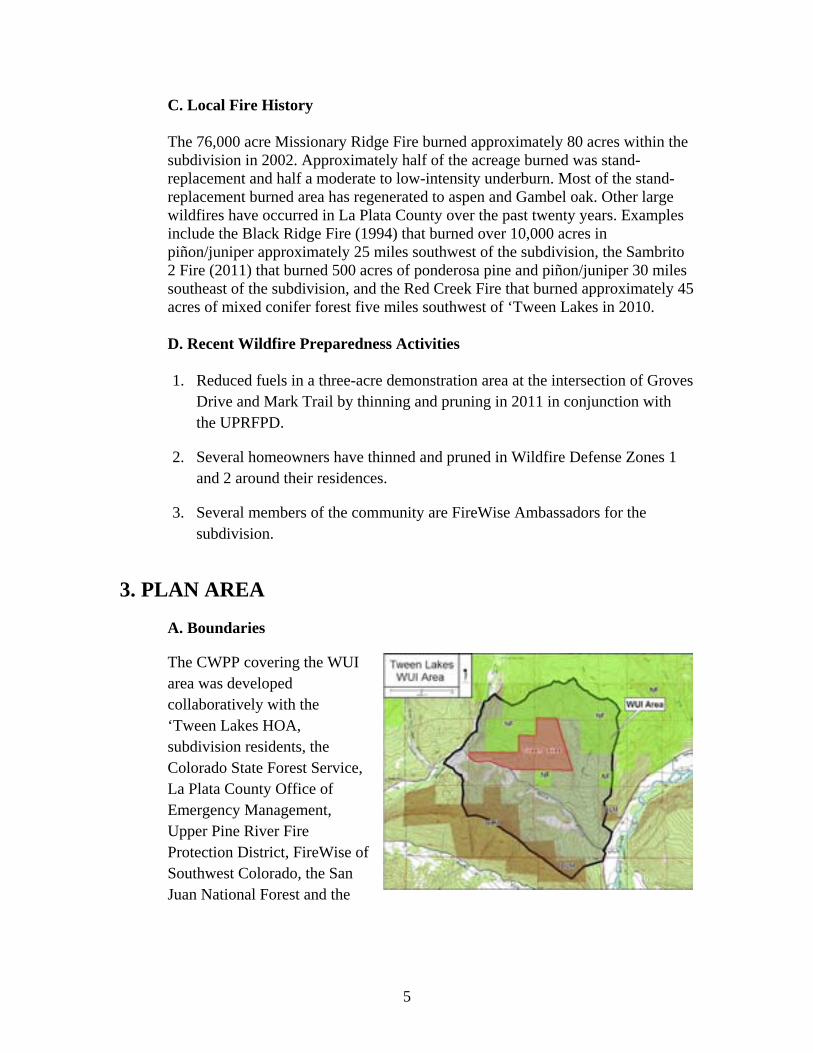
The CWPP covering the WUI area was developed collaboratively with the ‘Tween Lakes HOA, subdivision residents, the Colorado State Forest Service, La Plata County Office of Emergency Management, Upper Pine River Fire Protection District, FireWise of Southwest Colorado, the San Juan National Forest and the
5
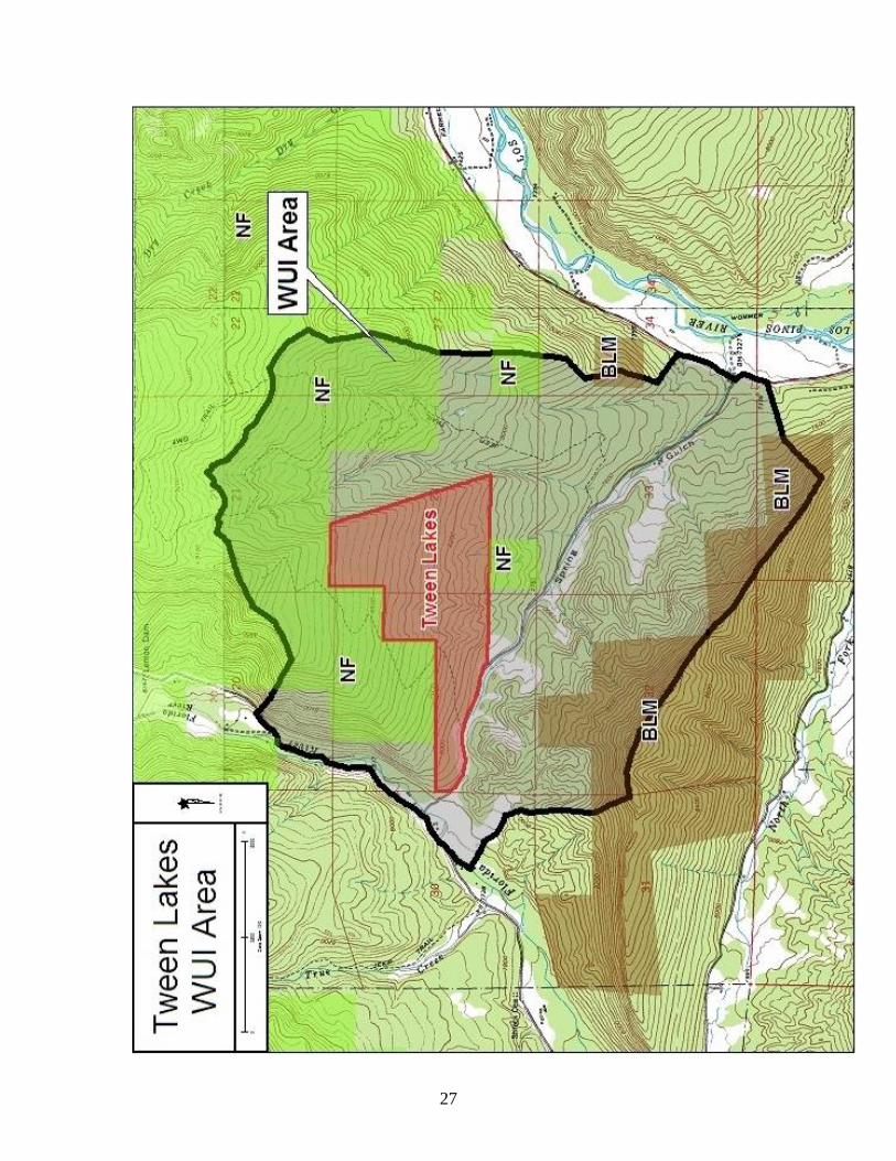
Bureau of Land Management. The WUI area is based on the area centered on the subdivision likely to burn in high fire danger conditions during a single burning period if pushed by 20-mph winds.
The WUI boundaries are from the intersection of the Florida River and CR 240 by “Helen’s Corner” northeast along CR 243 one mile then east up a ridge to a bench at the 9,000 foot elevation, then northeast along the 9,000 foot contour to the head of the tributary to Spring Gulch, then southeast along the 9,000 foot contour to the divide between Spring Gulch and the Los Pinos River, then south along the divide to CR 501, then south along CR 501 past the mouth of Spring Gulch to the top of the divide between Spring Gulch and the West Fork Texas Creek, then northwest along the divide to the Florida River and then north to Helen’s Corner.
Total WUI area is 3,315 acres and is shown on the WUI Map above and in Appendix A. Private land in the WUI covers 2,067 acres. The remaining 1,248 acres are public lands, 345 acres under Bureau of Land Management stewardship and 903 acres within the San Juan National Forest.
B. Private Land Characteristics
The 2,067 acres of private land within the WUI boundary includes the 392-acre ‘Tween Lakes subdivision, the Enchanted Forest subdivision with 83 lots and 47 parcels outside those subdivisions. Parcel sizes range from approximately 0.1 acre to over 250 acres. Many of the private parcels outside ‘Tween Lakes have residences, garages, barns and sheds on them. Land uses are generally residential, agricultural (pasture and hay production) and non-industrial business.
Mixed Conifer Forest
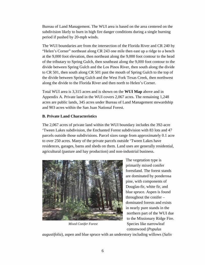
The vegetation type is primarily mixed conifer forestland. The forest stands are dominated by ponderosa pine, with components of Douglas-fir, white fir, and blue spruce. Aspen is found throughout the conifer –dominated forests and exists in nearly pure stands in the northern part of the WUI due to the Missionary Ridge Fire. Species like narrowleaf cottonwood (Populus
augustifolia), aspen and blue spruce with an understory including willows (Salix
6
spp.), horsetail (Equisetum arvense), and chokecherry (Prunus virginiana var. melanocarpa) are found along the Florida River bottom. Grasses include native species like sedges (Caryx spp.), little bluestem (Schizachyrium scoparium) and slender wheatgrass (Agropyron trachycauum). Montane shrubs include Gambel oak, and serviceberry (Amelanchier spp.).
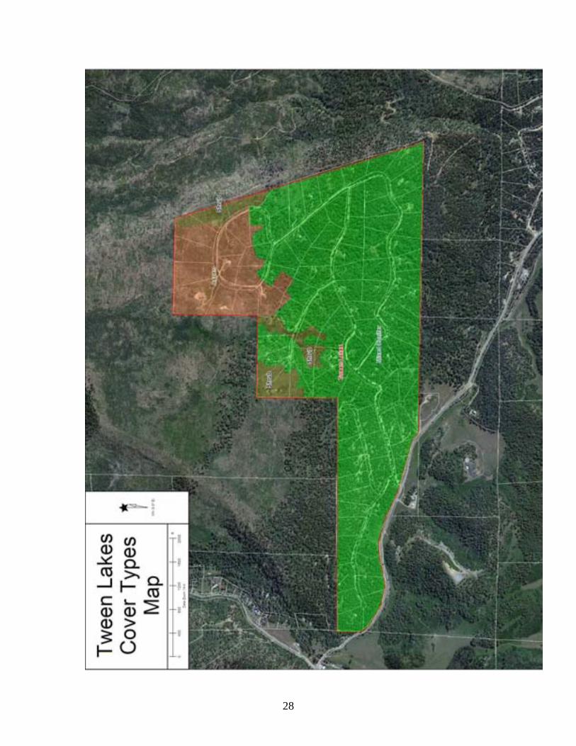
The vegetation cover types are shown in the following table. The cover types are shown in the ‘Tween Lakes Cover Type Map in Appendix A.
Cover Type Acres Percent of Subdivision
Mixed Conifer 309 79%
Aspen 58 15%
Montane Shrub 24 4%
Private lands outside the subdivision within the WUI area have similar cover types.
C. Public Land Characteristics
Public lands in the WUI include 345 acres managed by the USDI Bureau of Land Management located to the south of the subdivision and 903 acres of the San Juan National Forest. Most of the National Forest inside the WUI burned in the 2002 Missionary Ridge Fire, and approximately 80% of the fire in that area was stand replacement. The regenerating forest is dominated by Gambel oak and aspen with scattered ponderosa pine. The remaining National Forest is mixed conifer forest. The BLM lands in the WUI are mixed conifer forest.
D. Fire Protection
Structural and wildland fire protection is provided by the Upper Pine River Fire Protection District. Both structural and wildland fire engines are resources available through the Fire Protection District. Other wildland fire resources are available through Durango Interagency Dispatch Center. Wildland fire resources include engines and crews from the US Forest Service, Bureau of Land Management, Mesa Verde National Park, Colorado State Forest Service, Bureau of Indian Affairs and the Southern Ute and Ute Mountain Ute Tribes. An air tanker base is located at Durango - La Plata Regional Airport and additional aerial wildfire support can be provided by the Mesa Verde National Park initial attack helicopter at Hesperus, the Ute Mountain Ute initial attack helicopter at Towaoc
7
and the Colorado State Forest Service Single Engine Air Tanker at Cortez. The Counties, Federal land management agencies, Colorado State Forest Service and Fire Protection Districts in Southwest Colorado operate under a Consolidated County Annual Operating Plan (AOP) for wildfire protection.
4. PLANNING PARTNERS AND PROCESS A. Partners The HOA has received process and planning assistance and input from the following individuals and organizations: Rich Graeber, Chief, Upper Pine River Fire Protection District
Kent Grant, Durango District Forester, Colorado State Forest Service Craig Goodell, San Juan Public Lands Fuel Mitigation and Education
Specialist Pam Wilson, FireWise Council of Southwest Colorado Butch Knowlton, La Plata County Emergency Manager Jacquelynn Ireland, ‘Tween Lakes homeowner and FireWise Ambassador Connie Damron-Smith, ‘Tween Lakes homeowner and FireWise
Ambassador Peggy Yeiser, ‘Tween Lakes homeowner and FireWise Ambassador Wendy Klemm, ‘Tween Lakes homeowner and FireWise Ambassador Bruce Short, Short Forestry LLC, forest and fire management consultant
B. Process Five of the homeowners are FireWise Ambassadors for the subdivision. They attend the FireWise Council of Southwest Colorado meetings regularly and bring back FireWise information to the HOA members at the regularly scheduled meetings. A Core Team was assembled including representatives from the Colorado State Forest Service, San Juan Public Lands Center, Upper Pine River Fire Protection District, the ‘Tween Lakes HOA, and the FireWise Council of Southwest Colorado. The Team met in September 2011 and developed a list of issues, concerns and potential mitigation treatments that the CWPP should address. A field trip to the subdivision by the Core Team occurred in January 2012 and a meeting with the homeowners occurred in May 2012. C. Desired Future Condition The Desired Future Condition (DFC) for ‘Tween Lakes has been developed through the collaborative CWPP process. The DFC is:
8
‘Tween Lakes is a desirable, rural forested community safer from catastrophic wildfire moving into or through the community. Homes are less vulnerable to wildfire by the use of fire-resistant construction methods and FireWise landscaping. Fuels within 100 feet of residences are maintained at levels which would support only low intensity surface fires, while fuels in the remainder of the landscape in the subdivision would support low to moderate intensity wildfire.
5. POLICIES A. Federal The ‘Tween Lakes CWPP has been developed in response to the Healthy Forests Restoration Act of 2003 (HFRA). This legislation established unprecedented incentives for communities to develop comprehensive wildfire protection plans in a collaborative, inclusive process. Furthermore, this legislation directs the Departments of Interior and Agriculture to address local community priorities in fuel reduction treatments, on both federal and non-federal lands. The HFRA emphasizes the need for federal agencies to collaborate with communities in developing hazardous fuel reduction projects and places priority on treatment areas identified by communities themselves through development of a Community Wildfire Protection Plan (CWPP). Priority areas include the wildland-urban interface (WUI), municipal watersheds, areas impacted by windthrow or insect or disease epidemics, and critical wildlife habitat that would be negatively impacted by a catastrophic wildfire. In compliance with Title 1 of the HFRA, the CWPP requires agreement among local government, local fire departments, and the state agency responsible for forest management i.e., the Colorado State Forest Service. The CWPP must also be developed in consultation with interested parties and the applicable federal agencies managing public lands surrounding the at-risk communities. B. State
The State of Colorado is concerned about the size and intensity of wildfires occurring across the state in recent years. The State Legislature enacted House Bill 1110 in 2008, creating a five-year program running from 2009 to 2014 that allows landowners to deduct a portion of the actual costs of their wildfire mitigation from their state income tax. The program allows each landowner to get credit for fifty percent of the cost of wildfire mitigation up to a total of $2,500. To get the full credit the total mitigation costs must be $5,000 or greater. The work must be done in accord with an existing Community Wildfire Protection Plan to qualify.
9
The Colorado State Forest Service conducted a Statewide Forest Resource Assessment and released a Statewide Forest Resource Strategy in 2010. One of the themes for the Assessment and Strategy is “Protect Forests from Harm”. The identified threats relevant to ‘Tween Lakes Estates are:
o Wildfire in the Wildland-Urban Interface. o Insects and Diseases Affecting Community Forests.
The area around the subdivision has been identified as having High Wildfire Susceptibility based on weather, historic fire occurrence, topography, surface fuels and canopy closure. The applicable strategies identified to address the threats are:
o Focus forest management activities to reduce impacts of wildfire, and forest insects and diseases.
o Coordinate forest management implementation among all parties affected by the CWPP.
o Advocate landscape approaches to protect communities. o Collaborate with land management agencies, fire protection
districts and insurance organizations to develop improved standards that lead to protection of homes in the WUI.
o Expand the use of the Good Neighbor Authority in Colorado. C. Consolidated County Annual Operating Plan
The Counties, Federal land management agencies, Colorado State Forest Service and Fire Protection Districts in Southwest Colorado operate under a Consolidated County Annual Operating Plan (AOP) for wildfire protection. This plan provides for mutual aid to assist with the management of wildfire incidents in southwest Colorado. The plan for mutual aid provides significantly enhanced initial and extended attack capabilities through the rapid convening of fire protection resources for managing a wildfire. The Consolidated County AOP outlines standard operating procedures and the level of participation and available resources of each party under the plan. D. USFS and BLM Land and Resource Management Plan / Fire
Management Plan The San Juan National Forest Land and Resource Management Plan, the Southwest Colorado District-Tres Rios Field Office Resource Management Plan and associated Fire Management Plans describe the role of fire in the native ecosystems in southwest Colorado. These plans outline the strategies that the USFS and BLM will utilize to manage wildland fire and fuels on these federal lands in southwest Colorado. The San Juan National Forest and Southwest Colorado District-Tres Rios Field Office area Fire Management Plan (2007)
10
specifically describes objectives and strategies to manage fire and fuels on federal lands near communities within the wildland-urban interface. . E. La Plata County CWPP The ‘Tween Lakes CWPP tiers to the La Plata County CWPP approved in July 2006. This plan is consistent with the goals and strategies described within the La Plata County CWPP and provides further strategic and tactical direction specific to wildfire protection and mitigation for the ‘Tween Lakes community. . F. ‘Tween Lakes Estates The ‘Tween Lakes covenants are silent on vegetation management. Covenant 10 states that no burning of debris will be permitted.
6. RESOURCE ASSESSMENT AND TRENDS
A. Fuels and Fire Hazard 1. Cover Types The ‘Tween Lakes subdivision has three cover types but the majority of the residences are in the Mixed Conifer cover type. The Cover Type Map is included in Appendix A. The Mixed Conifer cover type covers 309 acres and is approximately 130 years old, reflecting the extensive timber harvests occurring in the lower elevations of La Plata County in the late 1800’s and early 1900’s. Stand densities range from 50 to 220 square feet of basal area per acre and average approximately 150 square feet per acre. Stand densities are too dense for continued good forest health. Ladder fuels are common due to small conifers under large trees, the shrub component and low crown basal heights. Trees are immediately adjacent to most residences. Aspen covers 58 acres in the northern part of the subdivision. This area was mixed conifer and aspen prior to the Missionary Ridge Fire of 2002 and subsequently regenerated to aspen. This area also has considerable large downed woody fuels due to fallen dead trees. The third largest cover type in the subdivision is the Montane Shrub type at 24 acres. This type was present as scattered clumps prior to the Missionary Ridge Fire but the large amount of overstory mortality released the Gambel oak and other shrubs. They now dominate the sites although scattered tree regeneration in present. Large downed woody fuel loads approach 60 tons per acre.
11
2. Fuel Models The La Plata County CWPP (2006) shows the area of ‘Tween Lakes as a “higher” level of concern on the La Plata County Fire Risk Zone Map due to the cover types and fuel loads typically present. The major Fuel Models present across the subdivision by cover type are:
Cover Type NFFL Model (Anderson, 1982)
Standard Fire Behavior Models (Scott
and Burgan, 2005)
Mixed Conifer 9 TU5
Aspen 8 TL2
Montane Shrub 6 SH2
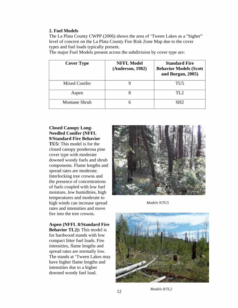
Closed Canopy Long-Needled Conifer (NFFL 9/Standard Fire Behavior TU5: This model is for the closed canopy ponderosa pine cover type with moderate downed woody fuels and shrub components. Flame lengths and spread rates are moderate. Interlocking tree crowns and the presence of concentrations of fuels coupled with low fuel moisture, low humidities, high temperatures and moderate to high winds can increase spread rates and intensities and move fire into the tree crowns.
Models 9/TU5
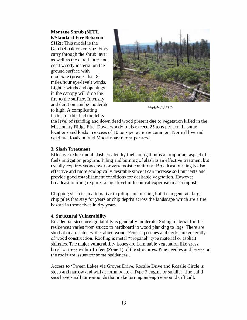
Aspen (NFFL 8/Standard Fire Behavior TL2): This model is for hardwood stands with low compact litter fuel loads. Fire intensities, flame lengths and spread rates are normally low. The stands at ‘Tween Lakes may have higher flame lengths and intensities due to a higher downed woody fuel load.
Models 8/TL2 12
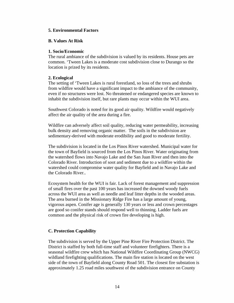
Models 6 / SH2
Montane Shrub (NFFL 6/Standard Fire Behavior SH2): This model is the Gambel oak cover type. Fires carry through the shrub layer as well as the cured litter and dead woody material on the ground surface with moderate (greater than 8 miles/hour eye-level) winds. Lighter winds and openings in the canopy will drop the fire to the surface. Intensity and duration can be moderate to high. A complicating factor for this fuel model is the level of standing and down dead wood present due to vegetation killed in the Missionary Ridge Fire. Down woody fuels exceed 25 tons per acre in some locations and loads in excess of 10 tons per acre are common. Normal live and dead fuel loads in Fuel Model 6 are 6 tons per acre. 3. Slash Treatment Effective reduction of slash created by fuels mitigation is an important aspect of a fuels mitigation program. Piling and burning of slash is an effective treatment but usually requires snow cover or very moist conditions. Broadcast burning is also effective and more ecologically desirable since it can increase soil nutrients and provide good establishment conditions for desirable vegetation. However, broadcast burning requires a high level of technical expertise to accomplish. Chipping slash is an alternative to piling and burning but it can generate large chip piles that stay for years or chip depths across the landscape which are a fire hazard in themselves in dry years. 4. Structural Vulnerability Residential structure ignitability is generally moderate. Siding material for the residences varies from stucco to hardboard to wood planking to logs. There are sheds that are sided with stained wood. Fences, porches and decks are generally of wood construction. Roofing is metal “propanel” type material or asphalt shingles. The major vulnerability issues are flammable vegetation like grass, brush or trees within 15 feet (Zone 1) of the structures. Pine needles and leaves on the roofs are issues for some residences . Access to ‘Tween Lakes via Groves Drive, Rosalie Drive and Rosalie Circle is steep and narrow and will accommodate a Type 3 engine or smaller. The cul d’ sacs have small turn-arounds that make turning an engine around difficult.
13
5. Environmental Factors B. Values At Risk 1. Socio/Economic The rural ambiance of the subdivision is valued by its residents. House pets are common. ‘Tween Lakes is a moderate cost subdivision close to Durango so the location is prized by its residents. 2. Ecological The setting of ‘Tween Lakes is rural forestland, so loss of the trees and shrubs from wildfire would have a significant impact to the ambiance of the community, even if no structures were lost. No threatened or endangered species are known to inhabit the subdivision itself, but rare plants may occur within the WUI area. Southwest Colorado is noted for its good air quality. Wildfire would negatively affect the air quality of the area during a fire. Wildfire can adversely affect soil quality, reducing water permeability, increasing bulk density and removing organic matter. The soils in the subdivision are sedimentary-derived with moderate erodibility and good to moderate fertility. The subdivision is located in the Los Pinos River watershed. Municipal water for the town of Bayfield is sourced from the Los Pinos River. Water originating from the watershed flows into Navajo Lake and the San Juan River and then into the Colorado River. Introduction of soot and sediment due to a wildfire within the watershed could compromise water quality for Bayfield and in Navajo Lake and the Colorado River.. Ecosystem health for the WUI is fair. Lack of forest management and suppression of small fires over the past 100 years has increased the downed woody fuels across the WUI area as well as needle and leaf litter depths in the wooded areas. The area burned in the Missionary Ridge Fire has a large amount of young, vigorous aspen. Conifer age is generally 130 years or less and crown percentages are good so conifer stands should respond well to thinning. Ladder fuels are common and the physical risk of crown fire developing is high. C. Protection Capability The subdivision is served by the Upper Pine River Fire Protection District. The District is staffed by both full-time staff and volunteer firefighters. There is a seasonal wildfire crew which has National Wildfire Coordinating Group (NWCG) wildland firefighting qualifications. The main fire station is located on the west side of the town of Bayfield along County Road 501. The closest fire substation is approximately 1.25 road miles southwest of the subdivision entrance on County
14
Road 240. U.S. Forest Service and Bureau of Land Management fire crews and aerial wildfire support by the Mesa Verde National Park initial attack helicopter at Hesperus and the Ute Mountain Ute initial attack helicopter at Towaoc are available under the mutual aid agreement. Wildland fires occurring on private lands are generally managed for full suppression. Wildfires on National Forest and BLM-managed public lands and Tribal lands in La Plata County are managed with policies that may involve full suppression, point suppression, confinement or containment strategies. The lack of hydrants for engines is a major problem for fire suppression efforts. Water can be drafted from the Florida River approximately ½ mile northwest of the subdivision entrance or from Lemon Reservoir approximately 1.5 miles northwest but turn-around times could be 45 minutes for areas in the north part of the subdivision Evacuation of the subdivision in an emergency could be hampered by the single major access point as well as the narrow roads throughout the subdivision. Evacuation actions are the responsibility of the La Plata County Sheriff’s Office and the La Plata County Emergency Manager.
15
7. MITIGATION ACTION PLAN
A. Education and Community Outreach The audience for the Mitigation Action Plan includes the residents of ‘Tween Lakes, landowners immediately surrounding the subdivision that can benefit from mitigation activities on their properties and in the subdivision; government agencies planning complementary mitigation treatments and/or supplying grants or matching funds to perform mitigation; and emergency responders. Outreach methods may include: Educational information at scheduled community meetings. Educational community workshops which could include subdivision residents
and other community members sponsored by the FireWise Council of Southwest Colorado and/or the Upper Pine River Fire Protection District.
FireWise information mailed to all residents. Ensure landowners are aware of the state tax incentive for wildfire hazard
mitigation (House Bill 1110). Periodic sponsored fuels treatment events with the residents sharing expertise
and equipment. Awareness training on basic wildfire fire behavior and suppression for
interested subdivision residents B. Policy Authority and responsibility for managing vegetation on private property within ‘Tween Lakes Estates rests with the residents. The Homeowners Association has authority and responsibility for managing vegetation on the road rights-of-way. C. Wildfire Mitigation Activities 1. Vegetation/Fuels Management The major vegetation management issues are fuels like trees, shrubs, grass, and leaf and needle litter in close proximity (within Zone 1) to structures. Lack of management like thinning, pruning and downed woody fuel reduction have made the risk of crown fire in Zones 2 and 3 high across the subdivision. Much of the subdivision area that burned in the Missionary Ridge Fire experienced running crown fire and group torching. Forest management has been minimal since the fire. The recommendations below are consistent with Creating Wildfire-Defensible Zones (Dennis 1999a). Flammable vegetation or shrubs are discouraged within 15 feet of residences (Zone 1). If desirable trees, shrubs or other plants are in this area, dead branches, stems and leaf litter should be removed and the zone extended accordingly. Tree
16
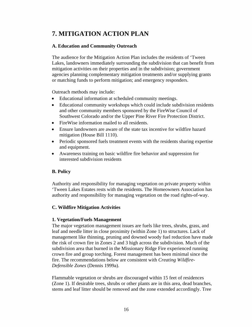
branches should be pruned up at least 10 feet above the ground. Xeriscaping landscaping techniques using plants and materials with low flammability can reduce the risk of flames adjacent to structures. It is recommended that landscaping within three to five feet of structures consist of gravel, rock or other non-flammable materials. Wood chips should not be used as mulch under flammable shrubs within Zone 1.
Demonstration Zone 2 Treatment (Los Ranchitos)
The Zone 2 area is found from 15 to 100 feet of the residence. Here, trees taller than 15 feet should be thinned to a spacing of 10-20 feet between crowns. Trees selected for retention should generally have at least 50% live crowns. Branches lower than five feet from the ground surface should be pruned on trees up to 25 feet tall and 10 feet from the ground on trees taller than 25 feet. Trees shorter than 15 feet tall should be spaced no closer
than five feet from the edge of adjacent tree crown edges. Oak clumps should be spaced no closer than two times shrub height to other clumps or trees. Grasses should be mowed to a maximum of six to eight inches, especially by fall when grasses are dried out.
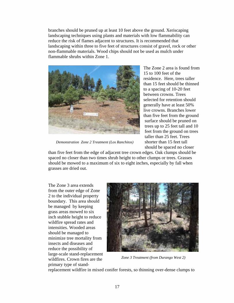
Zone 3 Treatment (from Durango West 2)
The Zone 3 area extends from the outer edge of Zone 2 to the individual property boundary. This area should be managed by keeping grass areas mowed to six inch stubble height to reduce wildfire spread rates and intensities. Wooded areas should be managed to minimize tree mortality from insects and diseases and reduce the possibility of large-scale stand-replacement wildfires. Crown fires are the primary type of stand-replacement wildfire in mixed conifer forests, so thinning over-dense clumps to
17
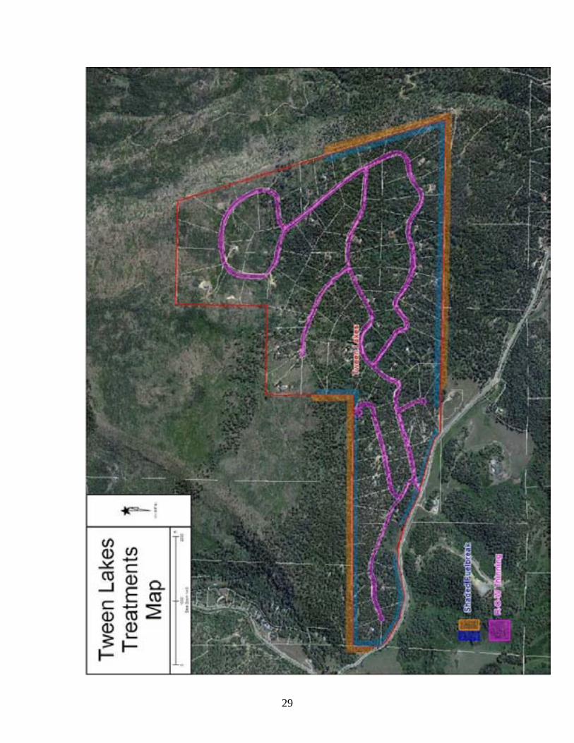
stand densities of no more than 80 trees per acre and reducing downed woody fuels can reduce wildfire risk. Slash from thinning and fuels reduction activities should be chipped and the chips removed from the site or the slash piled for burning when snow is present or soils and surrounding vegetation are damp. All juniper trees within 10 feet of ponderosa pine tree crowns should be removed in the thinning. The interior road system in the subdivision can be used as shaded fuelbreaks by thinning trees to no more than 60 trees per acre, pruning up at least 10 feet, and removing brush and small trees under remaining trees within the 60-foot wide rights-of-way. This type of treatment will also improve driver visibility along the roads, helping traffic safety. Probability of wildfire moving into or out of ‘Tween Lakes can be reduced through implementation and maintenance of a 100 foot-wide shaded fuelbreak in the forests and woodlands along the subdivision boundary. The treatment prescription would be similar to Zone 2, i.e., thinning to no more than 60 trees per acre, crown spacing of 15 to 25 feet between trees, tree clumps or shrub clumps and pruning of tree branches up 10 feet. An adjacent shaded fuelbreak on lands outside the subdivision is recommended as well. These treatment areas are shown on the ‘Tween Lakes Treatments map in Appendix A. 2. Structure Vulnerability Recent research by Jack Cohen (Missoula Fire Science Laboratory) has shown that most homes catch fire from flying embers, not from the flaming fire front. When building and/or remodeling, residents are strongly encourage to consider using fire-resistant materials and follow construction guidelines. Structure construction using unpainted rough wood products including wood shake roof shingles is discouraged since those materials are very receptive to sparks and flame. Roof materials such as metal, cement or cement-fiber shingles and tile are not receptive to sparks, flame and heat. Enclosing soffits with metal also discourages ignition of roofs and eaves. Detailed fire-resistant construction guidelines are found in Firewise Construction, Design and Materials (Slack 1999) in Appendix G. Locate woodpiles and propane tanks at least 30 feet from structures. Clear flammable vegetation at least 10 feet away from woodpiles and propane tanks. Enclose the underside of wood decks and porches so that embers and flames cannot get underneath them. Keep grass or weeds from growing under them. Structural protection can be enhanced by providing cisterns for drafting by engines. This would greatly reduce turn-around times for engines and allow for multi-structure protection. Cisterns located in the northern part of the subdivision
18
would be of most value. Upper Pine River Fire Protection District has agreed to provide location and plumbing assistance. 3. Safety The HOA should work with the La Plata County Emergency Manager to develop an Emergency Evacuation Plan for the subdivision. The plan should include wildland fire safety zone locations, standard evacuee assembly points, communication trees and management action points. Widening the cul d’ sacs to the platted widths of 100 to 120 feet would help emergency vehicle access and response times. Wildland fire behavior, suppression tactics and firefighter safety awareness training should be made available to interested subdivision residents who could be called on for initial attack. Subdivision residents should be offered a general emergency situation safety awareness session annually to update emergency communication trees, evacuation routes and gathering points. 4. Specific Activity Recommendations and Priorities The following mitigation activity and treatment recommendations are listed by priority for the ‘Tween Lakes HOA, the residents and land owners of ‘Tween Lakes, Upper Pine River Fire Protection District and adjoining landowners and cooperators.
Group Activity Year/Priority
Activity/Action Estimated Cost
HOA 2012 / 1 Assist homeowners with individual defensible space creation and fuel mitigation by providing annual information and education programs on effective mitigation techniques.
$100 annually
HOA 2012 /2 Remove fuels such as downed logs and brush from all rights-of-way along roads
$3500/mile
HOA 2013 / 1 Familiarize residents with Evacuation Plan, evacuation routes and protocols.
$100 annually
HOA 2013 / 2 Contact and work with owners of vacant lots to initiate fuels treatments and maintenance
Variable
HOA 2013 - 3 Develop relationships with adjoining landowners to help create and maintain network of fuelbreaks
$1500/acre
HOA 2014 / 1 Widen cul d’ sacs to maximum diameter allowed within ROW’s
$5000/location
HOA / UPR Fire
2012 / 1 Develop a subdivision emergency notification and evacuation plan in consultation with Upper Pine River FPD, La Plata County Emergency Manager and the subdivision residents. The plan would
$5000
19
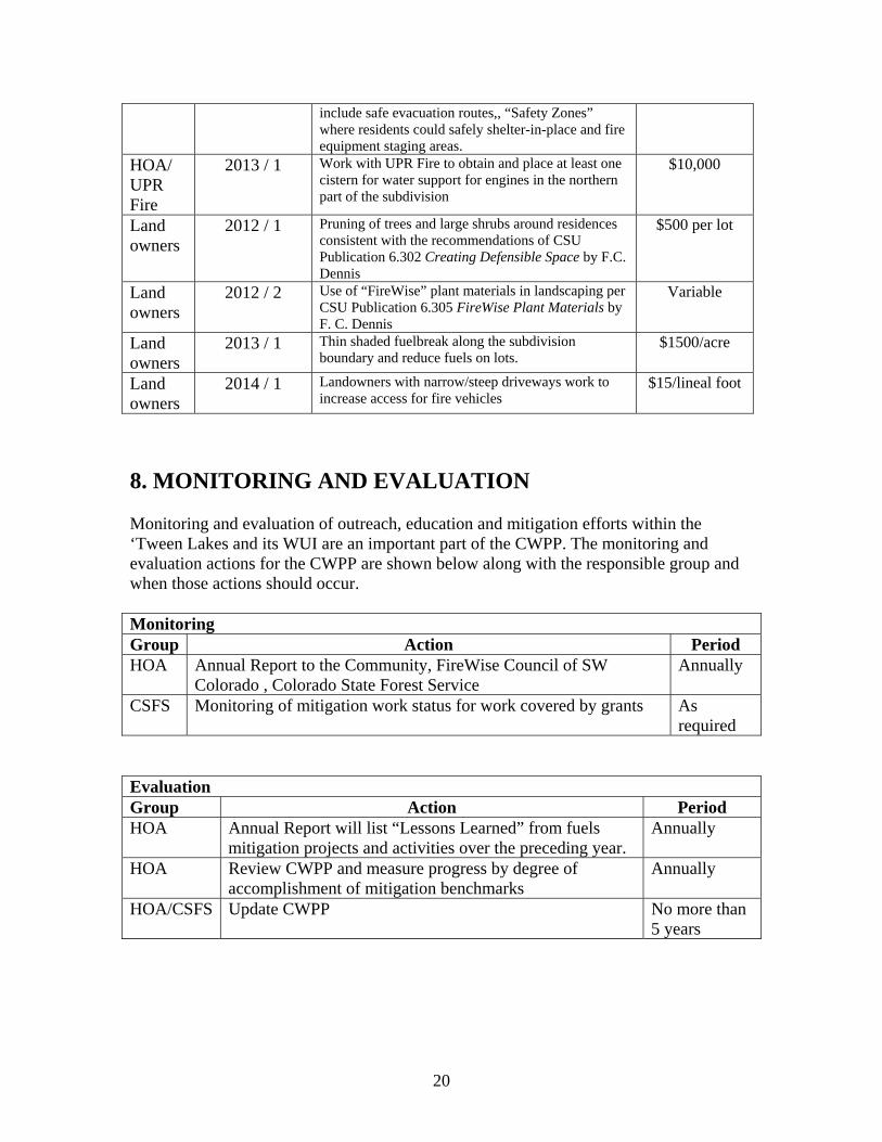
include safe evacuation routes,, “Safety Zones” where residents could safely shelter-in-place and fire equipment staging areas.
HOA/ UPR Fire
2013 / 1 Work with UPR Fire to obtain and place at least one cistern for water support for engines in the northern part of the subdivision
$10,000
Land owners
2012 / 1 Pruning of trees and large shrubs around residences consistent with the recommendations of CSU Publication 6.302 Creating Defensible Space by F.C. Dennis
$500 per lot
Land owners
2012 / 2 Use of “FireWise” plant materials in landscaping per CSU Publication 6.305 FireWise Plant Materials by F. C. Dennis
Variable
Land owners
2013 / 1 Thin shaded fuelbreak along the subdivision boundary and reduce fuels on lots.
$1500/acre
Land owners
2014 / 1 Landowners with narrow/steep driveways work to increase access for fire vehicles
$15/lineal foot
8. MONITORING AND EVALUATION Monitoring and evaluation of outreach, education and mitigation efforts within the ‘Tween Lakes and its WUI are an important part of the CWPP. The monitoring and evaluation actions for the CWPP are shown below along with the responsible group and when those actions should occur. Monitoring Group Action Period HOA Annual Report to the Community, FireWise Council of SW
Colorado , Colorado State Forest Service Annually
CSFS Monitoring of mitigation work status for work covered by grants As required
Evaluation Group Action Period HOA Annual Report will list “Lessons Learned” from fuels
mitigation projects and activities over the preceding year. Annually
HOA Review CWPP and measure progress by degree of accomplishment of mitigation benchmarks
Annually
HOA/CSFS Update CWPP No more than 5 years
20
9. GLOSSARY acre: an area of land containing 43,560 square feet. A square acre would be about 209 feet by 209 feet. A circular acre would have a radius of 117.75 feet. basal area: the cross-sectional area of a single stem, including the bark, measured at breast height (4.5 feet above the ground) For example, the basal area of a tree 13.5 inches in diameter at breast height is about 1 square foot. Basal area = 0.005454 times diameter squared. (b) of an acre of forest: the sum of basal areas of the individual trees on the area. For example, a well stocked pine stand might contain 70 to 90 square feet of basal area per acre. canopy: the foliage formed by the crowns of trees in a stand. defensible space: an area around a structure where fuels and vegetation are treated, cleared or reduced to slow the spread of wildfire towards the structure. diameter at breast height (dbh): the diameter of a stem of a tree at 4 ½ feet above the ground. downed fuels: the accumulated woody and vegetative material on the forest floor from leaf/needle fall, natural pruning and breakage that serves as fuel for wildfire. ecosystem: A spatially explicit, relatively homogenous unit of the earth that includes all interacting organisms (plants, animals, microbes) and components of the abiotic environment within its boundaries. An ecosystem can be of any size: a log, pond, field, forest, or the earth's biosphere. fuel loading: the oven-dry weight of fuel per unit area. ladder fuels: combustible material that provides vertical continuity be’Tween vegetation strata and allow fire to climb into the crowns of trees or shrubs with relative ease. litter: the surface layer of a forest floor that is not in an advanced stage of decomposition, usually consisting of freshly fallen leaves, needles, twigs, stems, bark, and fruits. lop and scatter: a hand method of removing the up-ward branches from tips of felled tress to keep slash low to the ground, to increase rate of decomposition, lower fire hazard, or as a pre-treatment prior to burning. sapling: a usually young tree larger than a seedling but smaller than a pole. shaded fuelbreak: A strategically located strip or block of land (of varying width) depending on fuel and terrain, in which fuel density is reduced, thus improving fire control opportunities. The stand is thinned and remaining trees are pruned to remove
21
ladder fuels. Most brush, heavy ground fuels, snags and dead trees are removed and an open park-like appearance established. silviculture: the art, science, and practice of establishing, tending, and reproducing forest stands of desired characteristics. It is based on knowledge of species characteristics and environmental requirements. slash: the residue of treetops and branches left on the ground after logging or accumulating as a result of storms, fire, girdling or delimbing. snag: a standing, generally unmerchantable dead tree from which the leaves and most of the branches have fallen. stand: a contiguous group of trees sufficiently uniform in age-class distribution, composition, and structure, and growing on a site of sufficiently uniform quality, to be a distinguishable unit. thinning: a cultural treatment made to reduce stand density of trees primarily to improve growth, enhance forest health, or recover potential mortality. Wildland-Urban Interface: The geographical meeting point of two diverse systems - wildland and structures. In the WUI, structures and vegetation are sufficiently close so that a wildland fire could spread to structures or a structure fire could ignite vegetation. Definitions except defensible space, shaded fuelbreak and Wildland-Urban Interface from The Dictionary of Forestry, John A. Helms, editor.
22
10. LITERATURE CITED Anderson, H.E. 1982. Aids to Determining Fuel Models for Estimating Fire Behavior.
USDA Forest Service General Technical Report INT-GTR-122. Intermountain Forest and Range Experiment Station. Ogden, UT. 22 p.
Davis, J., Smith E. and Beck, G. 2007. Cheatgrass and Wildfire. Colorado State
University Cooperative Extension Resource Publication no. 6.310. 3 p. Dennis, F.C. 1999a. Creating Wildfire-Defensible Zones. Colorado State University
Cooperative Extension Resource Publication no. 6.302. 6 p. Dennis, F.C. 1999b Fire-Resistant Landscaping. Colorado State University Cooperative
Extension Resource Publication no. 6.303. 4 p.
Dennis, F.C. 2002. FireWise Plant Materials. Colorado State University Cooperative Extension Resource Publication no. 6.305. 6p.
Dennis, F.C.. Fuel Break Guidelines for Forested Subdivisions & Communities.
Colorado State Forest Service. 8 p. Helms, J.A., ed. 1998. The Dictionary of Forestry. The Society of American Foresters.
Bethesda, MD. 210 p. La Plata County Community Wildfire Protection Plan. 2006. La Plata County,
Colorado. 12 p. Scott, Joe H., Burgan, Robert E. 2005. Standard fire behavior fuel models: a
comprehensive set for use with Rothermel’s surface fire spread model. Gen. Tech. Rep. RMRS-GTR-153. Fort Collins, CO; USDA Forest Service, Rocky Mountain Research Station. 72p.
Slack, P. 1999. Firewise Construction, Design and Materials. Colorado State Forest
Service, Ft. Collins, CO. 38 p.
23
APPENDICES
A. Maps B. Creating Wildfire-Defensible Zones (CSU Extension Pub. 6.302, F. C. Dennis) C. Fuelbreak Guidelines for Forested Subdivisions (F.C. Dennis) D. Fire-Resistant Landscaping (CSU Extension Pub. 6.303, F. C. Dennis) E. FireWise Plant Materials (CSU Extension Pub. 6.305, F. C. Dennis) F. Cheatgrass and Wildfire (CSU Extension Pub 6.310, Davison, Smith and Beck) G. Firewise Construction, Design and Materials (P. Slack)
24
Appendix A
Maps 1. ‘Tween Lakes Vicinity 2. ‘Tween Lakes WUI 3. ‘Tween Lakes Vegetation Cover Types 4. ‘Tween Lakes Treatments
25
26
27
28
29

Appendix B
Creating Wildfire-Defensible Zones
30
1
If your home is located in the natural vegetation of Colorado’s grasslands, shrublands, foothills or mountains, you live in the wildland-urban interface (WUI) and are inherently at risk from a wildfire. The WUI is any area where structures and other human developments meet or intermingle with wildland vegetative fuels. In many vegetation types, it is not a matter of if a wildfire will impact your home, but when.
Wildfires are a natural part of Colorado’s varied forest ecosystems. Many rural communities are located in areas historically prone to frequent natural wildfires. Living in the wildland requires more self-reliance than living in urban areas. It may take longer for a fire engine to reach your area, and a small fire department can easily become overwhelmed during an escalating wildfire. Planning ahead and taking actions to reduce fire hazards can increase your safety and help protect your property. As more people choose to live in areas prone to wildfire, additional homes and lives are potentially threatened every year. Firefighters always do their best to protect rural residents, but ultimately, it is YOUR responsibility to protect your life, family, animals and property from wildfire.
The information contained in this document is for use by individual landowners to help reduce wildfire risk on their property. In order to effectively protect
subdivisions and communities, all landowners must work together to reduce fire hazards within and adjacent to communities. This includes treating individual home sites and common areas within communities, and creating fuelbreaks within and adjoining the community where feasible. This document will focus on actions individual landowners can take to reduce wildfire hazards on their property. For additional information on broader community protection, go to www.csfs.colostate.edu.
In this guide, you’ll read about steps you can take to protect your property from wildfire. These steps focus on beginning work closest to your house and moving outward. Also, remember that keeping your home safe is not a one-time effort – it requires ongoing maintenance. It may be necessary to perform some actions, such as removing pine needles from gutters and mowing grasses and weeds several times a year, while other actions may only need to be addressed once a year. While
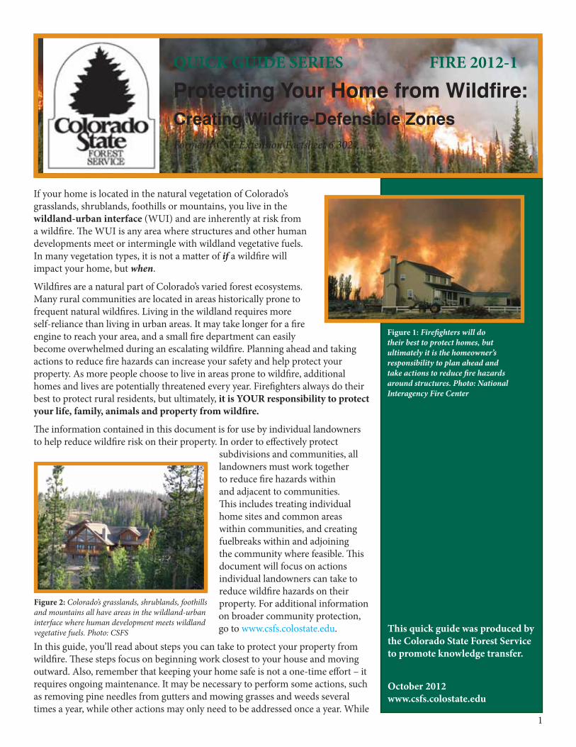
QUICK GUIDE SERIES FIRE 2012-1
Protecting Your Home from Wildfire:Creating Wildfire-Defensible Zones Formerly CSU Extension Factsheet 6.302
This quick guide was produced by the Colorado State Forest Service to promote knowledge transfer.
October 2012www.csfs.colostate.edu
Figure 1: Firefighters will do their best to protect homes, but ultimately it is the homeowner’s responsibility to plan ahead and take actions to reduce fire hazards around structures. Photo: National Interagency Fire Center
Figure 2: Colorado’s grasslands, shrublands, foothills and mountains all have areas in the wildland-urban interface where human development meets wildland vegetative fuels. Photo: CSFS

2
Figure 3: Burning embers can be carried long distances by wind. Embers ignite structures when they land in gaps, crevices and other combustible places around the home. Photo: CSFS
Remember...
• Reducingfuelsaroundahomewillincreasethechancesforsurvivalinawildfire,butthereisnoguarantee.
• Thisquickguideprovidesminimumguidelines.Themorefuelsyouremove,thegreaterthechanceyourhomewillsurvive.
• Workingwithyourneighborsandcommunitywillincreasetheeffectivenessofyourhome’sdefensiblespace.
you may not be able to accomplish ALL of the actions described in this document to prepare your home for wildfire, each completed activity will increase the safety
of your home, and possibly your family, during a wildfire.
(Note: These guidelines are adapted for ponderosa pine, Douglas-fir and mixed-conifer ecosystems below 9,500 feet. See page 9 for guidelines adapted to other forest ecosystems.)
This guide primarily will help design your defensible space. Defensible space is the natural and landscaped area around a home or other structure that has been modified to reduce fire hazard. Defensible space gives your home a fighting chance against an approaching wildfire. Creating defensible space also reduces the chance of a structure fire spreading to the surrounding forest and other homes.
Three factors determine wildfire behavior: fuels, weather and topography. We cannot alter weather or topography, so we must concentrate on altering fuels. Fuels include vegetation, such as trees, brush and grass; near homes, fuels also include
such things as propane tanks, wood piles, sheds and even homes themselves. Some plant species are more flammable than others, and the flammability of vegetative fuels changes depending on the season, recent weather events, and other factors such as drought. Fuel continuity and density also play an important role in wildfire.Wildfire often creates its own weather conditions. Hot rising air and associated winds can carry embers and other burning materials into the atmosphere for long distances, where they can ignite vegetation and structures up to several miles away. Embers have caused the loss of many homes during wildfires.
As you think about protecting your home and property from wildfire, consider how you can manage fuels on your property to prevent fire from spreading to your home and other structures.
For more information on wildfire behavior, please see FireWise Construction: Site Design and Building Materials at www.csfs.colostate.edu.
Fuel Arrangement and TypesWhen fuels are abundant, a fire can be uncontrollable and destructive. But when fuels are scarce, a fire cannot build momentum and intensity, which makes it much easier to control and is more likely to be beneficial to the land.
The more dense and continuous the fuels, the bigger the threat they pose to your home. The measure of fuel hazard refers to its continuity, both horizontal and vertical. Horizontal continuity refers to fuels across the ground, while vertical continuity refers to fuels extending from the ground up into the crowns of trees and shrubs. Fuels with a high degree of both vertical and horizontal continuity are the most hazardous, particularly when they occur on slopes. Mitigation of wildfire hazards focuses on breaking up the continuity of horizontal and vertical fuels.
Heavier fuels, such as brush and trees, produce a more intense fire than light fuels, such as grass. However, grass-fueled fires travel much faster than heavy-fueled fires. Some heavier surface fuels, such as logs and wood chips, are potentially hazardous heavy fuels and also should be addressed.
3
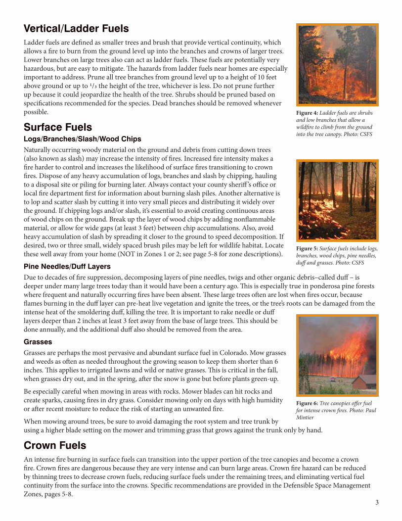
Vertical/Ladder FuelsLadder fuels are defined as smaller trees and brush that provide vertical continuity, which allows a fire to burn from the ground level up into the branches and crowns of larger trees. Lower branches on large trees also can act as ladder fuels. These fuels are potentially very hazardous, but are easy to mitigate. The hazards from ladder fuels near homes are especially important to address. Prune all tree branches from ground level up to a height of 10 feet above ground or up to 1/3 the height of the tree, whichever is less. Do not prune further up because it could jeopardize the health of the tree. Shrubs should be pruned based on specifications recommended for the species. Dead branches should be removed whenever possible.
Surface FuelsLogs/Branches/Slash/Wood ChipsNaturally occurring woody material on the ground and debris from cutting down trees (also known as slash) may increase the intensity of fires. Increased fire intensity makes a fire harder to control and increases the likelihood of surface fires transitioning to crown fires. Dispose of any heavy accumulation of logs, branches and slash by chipping, hauling to a disposal site or piling for burning later. Always contact your county sheriff ’s office or local fire department first for information about burning slash piles. Another alternative is to lop and scatter slash by cutting it into very small pieces and distributing it widely over the ground. If chipping logs and/or slash, it’s essential to avoid creating continuous areas of wood chips on the ground. Break up the layer of wood chips by adding nonflammable material, or allow for wide gaps (at least 3 feet) between chip accumulations. Also, avoid heavy accumulation of slash by spreading it closer to the ground to speed decomposition. If desired, two or three small, widely spaced brush piles may be left for wildlife habitat. Locate these well away from your home (NOT in Zones 1 or 2; see page 5-8 for zone descriptions).
Pine Needles/Duff LayersDue to decades of fire suppression, decomposing layers of pine needles, twigs and other organic debris–called duff – is deeper under many large trees today than it would have been a century ago. This is especially true in ponderosa pine forests where frequent and naturally occurring fires have been absent. These large trees often are lost when fires occur, because flames burning in the duff layer can pre-heat live vegetation and ignite the trees, or the tree’s roots can be damaged from the intense heat of the smoldering duff, killing the tree. It is important to rake needle or duff layers deeper than 2 inches at least 3 feet away from the base of large trees. This should be done annually, and the additional duff also should be removed from the area.
Grasses Grasses are perhaps the most pervasive and abundant surface fuel in Colorado. Mow grasses and weeds as often as needed throughout the growing season to keep them shorter than 6 inches. This applies to irrigated lawns and wild or native grasses. This is critical in the fall, when grasses dry out, and in the spring, after the snow is gone but before plants green-up.
Be especially careful when mowing in areas with rocks. Mower blades can hit rocks and create sparks, causing fires in dry grass. Consider mowing only on days with high humidity or after recent moisture to reduce the risk of starting an unwanted fire.
When mowing around trees, be sure to avoid damaging the root system and tree trunk by using a higher blade setting on the mower and trimming grass that grows against the trunk only by hand.
Crown FuelsAn intense fire burning in surface fuels can transition into the upper portion of the tree canopies and become a crown fire. Crown fires are dangerous because they are very intense and can burn large areas. Crown fire hazard can be reduced by thinning trees to decrease crown fuels, reducing surface fuels under the remaining trees, and eliminating vertical fuel continuity from the surface into the crowns. Specific recommendations are provided in the Defensible Space Management Zones, pages 5-8.
Figure 4: Ladder fuels are shrubs and low branches that allow a wildfire to climb from the ground into the tree canopy. Photo: CSFS
Figure 5: Surface fuels include logs, branches, wood chips, pine needles, duff and grasses. Photo: CSFS
Figure 6: Tree canopies offer fuel for intense crown fires. Photo: Paul Mintier
4
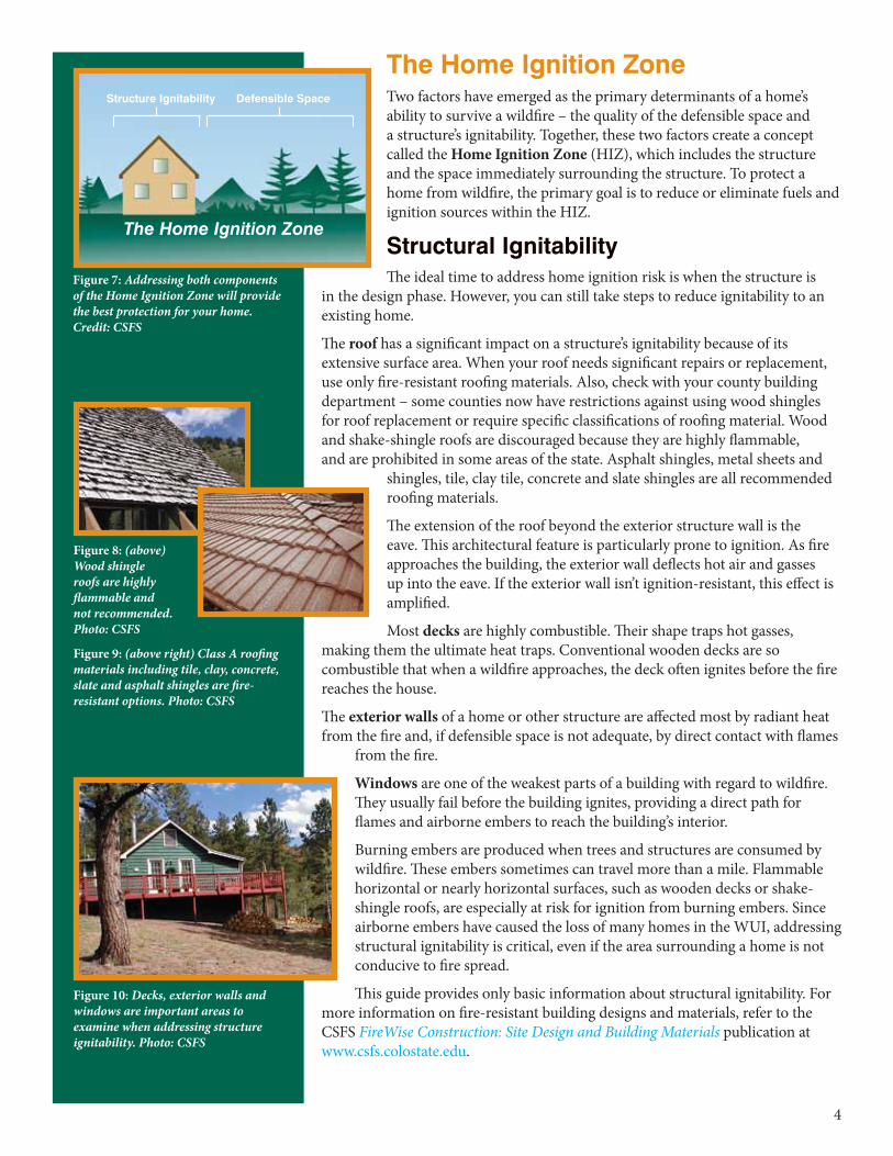
The Home Ignition ZoneTwo factors have emerged as the primary determinants of a home’s ability to survive a wildfire – the quality of the defensible space and a structure’s ignitability. Together, these two factors create a concept called the Home Ignition Zone (HIZ), which includes the structure and the space immediately surrounding the structure. To protect a home from wildfire, the primary goal is to reduce or eliminate fuels and ignition sources within the HIZ.
Structural IgnitabilityThe ideal time to address home ignition risk is when the structure is
in the design phase. However, you can still take steps to reduce ignitability to an existing home.
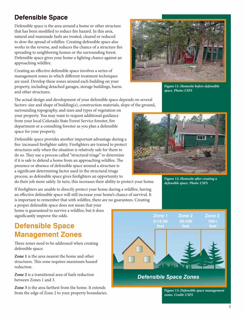
The roof has a significant impact on a structure’s ignitability because of its extensive surface area. When your roof needs significant repairs or replacement, use only fire-resistant roofing materials. Also, check with your county building department – some counties now have restrictions against using wood shingles for roof replacement or require specific classifications of roofing material. Wood and shake-shingle roofs are discouraged because they are highly flammable, and are prohibited in some areas of the state. Asphalt shingles, metal sheets and
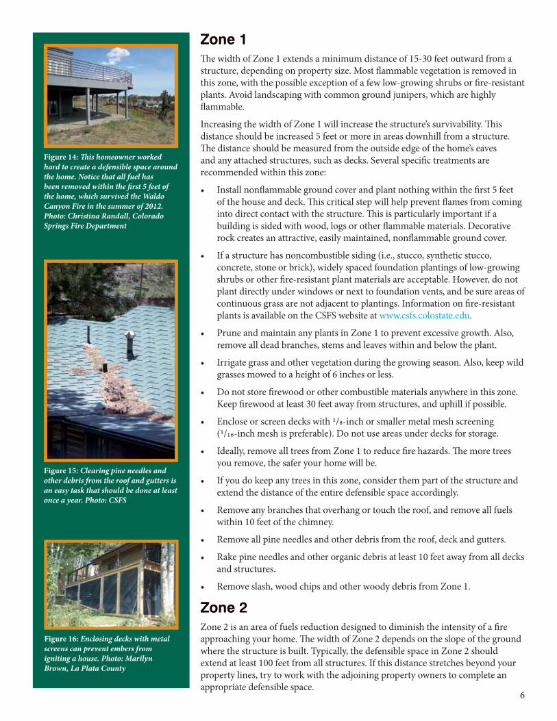
shingles, tile, clay tile, concrete and slate shingles are all recommended roofing materials.
The extension of the roof beyond the exterior structure wall is the eave. This architectural feature is particularly prone to ignition. As fire approaches the building, the exterior wall deflects hot air and gasses up into the eave. If the exterior wall isn’t ignition-resistant, this effect is amplified.
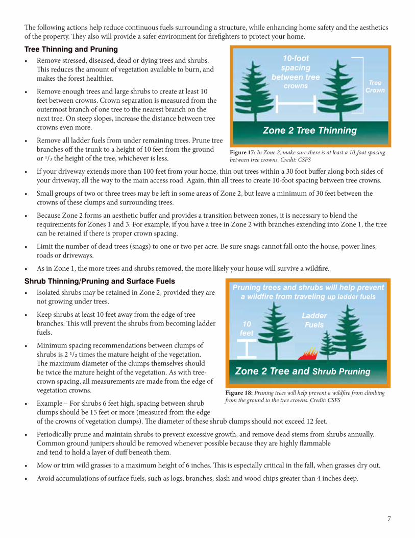
Most decks are highly combustible. Their shape traps hot gasses, making them the ultimate heat traps. Conventional wooden decks are so combustible that when a wildfire approaches, the deck often ignites before the fire reaches the house.
The exterior walls of a home or other structure are affected most by radiant heat from the fire and, if defensible space is not adequate, by direct contact with flames
from the fire.
Windows are one of the weakest parts of a building with regard to wildfire. They usually fail before the building ignites, providing a direct path for flames and airborne embers to reach the building’s interior.
Burning embers are produced when trees and structures are consumed by wildfire. These embers sometimes can travel more than a mile. Flammable horizontal or nearly horizontal surfaces, such as wooden decks or shake-shingle roofs, are especially at risk for ignition from burning embers. Since airborne embers have caused the loss of many homes in the WUI, addressing structural ignitability is critical, even if the area surrounding a home is not conducive to fire spread.
This guide provides only basic information about structural ignitability. For more information on fire-resistant building designs and materials, refer to the CSFS FireWise Construction: Site Design and Building Materials publication at www.csfs.colostate.edu.
TheHomeIgnitionZone
Structure Ignitability Defensible Space
Figure 7: Addressing both components of the Home Ignition Zone will provide the best protection for your home. Credit: CSFS
Figure 8: (above) Wood shingle roofs are highly flammable and not recommended. Photo: CSFS
Figure 9: (above right) Class A roofing materials including tile, clay, concrete, slate and asphalt shingles are fire-resistant options. Photo: CSFS
Figure 10: Decks, exterior walls and windows are important areas to examine when addressing structure ignitability. Photo: CSFS
5
Defensible SpaceDefensible space is the area around a home or other structure that has been modified to reduce fire hazard. In this area, natural and manmade fuels are treated, cleared or reduced to slow the spread of wildfire. Creating defensible space also works in the reverse, and reduces the chance of a structure fire spreading to neighboring homes or the surrounding forest. Defensible space gives your home a fighting chance against an approaching wildfire.
Creating an effective defensible space involves a series of management zones in which different treatment techniques are used. Develop these zones around each building on your property, including detached garages, storage buildings, barns and other structures.
The actual design and development of your defensible space depends on several factors: size and shape of building(s), construction materials, slope of the ground, surrounding topography, and sizes and types of vegetation on your property. You may want to request additional guidance from your local Colorado State Forest Service forester, fire department or a consulting forester as you plan a defensible space for your property.
Defensible space provides another important advantage during a fire: increased firefighter safety. Firefighters are trained to protect structures only when the situation is relatively safe for them to do so. They use a process called “structural triage” to determine if it is safe to defend a home from an approaching wildfire. The presence or absence of defensible space around a structure is a significant determining factor used in the structural triage process, as defensible space gives firefighters an opportunity to do their job more safely. In turn, this increases their ability to protect your home.
If firefighters are unable to directly protect your home during a wildfire, having an effective defensible space will still increase your home’s chance of survival. It is important to remember that with wildfire, there are no guarantees. Creating a proper defensible space does not mean that your home is guaranteed to survive a wildfire, but it does significantly improve the odds.
Defensible Space Management ZonesThree zones need to be addressed when creating defensible space:
Zone 1 is the area nearest the home and other structures. This zone requires maximum hazard reduction.
Zone 2 is a transitional area of fuels reduction between Zones 1 and 3.
Zone 3 is the area farthest from the home. It extends from the edge of Zone 2 to your property boundaries.
DefensibleSpaceZones
Zone 1 Zone 2 Zone 30-15/30
feet30-100
feet100+ feet
Figure 11: Homesite before defensible space. Photo: CSFS
Figure 12: Homesite after creating a defensible space. Photo: CSFS
Figure 13: Defensible space management zones. Credit: CSFS
6
Zone 1 The width of Zone 1 extends a minimum distance of 15-30 feet outward from a structure, depending on property size. Most flammable vegetation is removed in this zone, with the possible exception of a few low-growing shrubs or fire-resistant plants. Avoid landscaping with common ground junipers, which are highly flammable.
Increasing the width of Zone 1 will increase the structure’s survivability. This distance should be increased 5 feet or more in areas downhill from a structure. The distance should be measured from the outside edge of the home’s eaves and any attached structures, such as decks. Several specific treatments are recommended within this zone:
• Install nonflammable ground cover and plant nothing within the first 5 feet of the house and deck. This critical step will help prevent flames from coming into direct contact with the structure. This is particularly important if a building is sided with wood, logs or other flammable materials. Decorative rock creates an attractive, easily maintained, nonflammable ground cover.
• If a structure has noncombustible siding (i.e., stucco, synthetic stucco, concrete, stone or brick), widely spaced foundation plantings of low-growing shrubs or other fire-resistant plant materials are acceptable. However, do not plant directly under windows or next to foundation vents, and be sure areas of continuous grass are not adjacent to plantings. Information on fire-resistant plants is available on the CSFS website at www.csfs.colostate.edu.
• Prune and maintain any plants in Zone 1 to prevent excessive growth. Also, remove all dead branches, stems and leaves within and below the plant.
• Irrigate grass and other vegetation during the growing season. Also, keep wild grasses mowed to a height of 6 inches or less.
• Do not store firewood or other combustible materials anywhere in this zone. Keep firewood at least 30 feet away from structures, and uphill if possible.
• Enclose or screen decks with 1/8-inch or smaller metal mesh screening (1/16-inch mesh is preferable). Do not use areas under decks for storage.
• Ideally, remove all trees from Zone 1 to reduce fire hazards. The more trees you remove, the safer your home will be.
• If you do keep any trees in this zone, consider them part of the structure and extend the distance of the entire defensible space accordingly.
• Remove any branches that overhang or touch the roof, and remove all fuels within 10 feet of the chimney.
• Remove all pine needles and other debris from the roof, deck and gutters.
• Rake pine needles and other organic debris at least 10 feet away from all decks and structures.
• Remove slash, wood chips and other woody debris from Zone 1.
Zone 2Zone 2 is an area of fuels reduction designed to diminish the intensity of a fire approaching your home. The width of Zone 2 depends on the slope of the ground where the structure is built. Typically, the defensible space in Zone 2 should extend at least 100 feet from all structures. If this distance stretches beyond your property lines, try to work with the adjoining property owners to complete an appropriate defensible space.
Figure 14: This homeowner worked hard to create a defensible space around the home. Notice that all fuel has been removed within the first 5 feet of the home, which survived the Waldo Canyon Fire in the summer of 2012. Photo: Christina Randall, Colorado Springs Fire Department
Figure 15: Clearing pine needles and other debris from the roof and gutters is an easy task that should be done at least once a year. Photo: CSFS
Figure 16: Enclosing decks with metal screens can prevent embers from igniting a house. Photo: Marilyn Brown, La Plata County
7
The following actions help reduce continuous fuels surrounding a structure, while enhancing home safety and the aesthetics of the property. They also will provide a safer environment for firefighters to protect your home.
Tree Thinning and Pruning• Remove stressed, diseased, dead or dying trees and shrubs.
This reduces the amount of vegetation available to burn, and makes the forest healthier.
• Remove enough trees and large shrubs to create at least 10 feet between crowns. Crown separation is measured from the outermost branch of one tree to the nearest branch on the next tree. On steep slopes, increase the distance between tree crowns even more.
• Remove all ladder fuels from under remaining trees. Prune tree branches off the trunk to a height of 10 feet from the ground or 1/3 the height of the tree, whichever is less.
• If your driveway extends more than 100 feet from your home, thin out trees within a 30 foot buffer along both sides of your driveway, all the way to the main access road. Again, thin all trees to create 10-foot spacing between tree crowns.
• Small groups of two or three trees may be left in some areas of Zone 2, but leave a minimum of 30 feet between the crowns of these clumps and surrounding trees.
• Because Zone 2 forms an aesthetic buffer and provides a transition between zones, it is necessary to blend the requirements for Zones 1 and 3. For example, if you have a tree in Zone 2 with branches extending into Zone 1, the tree can be retained if there is proper crown spacing.
• Limit the number of dead trees (snags) to one or two per acre. Be sure snags cannot fall onto the house, power lines, roads or driveways.
• As in Zone 1, the more trees and shrubs removed, the more likely your house will survive a wildfire.
Shrub Thinning/Pruning and Surface Fuels• Isolated shrubs may be retained in Zone 2, provided they are
not growing under trees.
• Keep shrubs at least 10 feet away from the edge of tree branches. This will prevent the shrubs from becoming ladder fuels.
• Minimum spacing recommendations between clumps of shrubs is 2 1/2 times the mature height of the vegetation. The maximum diameter of the clumps themselves should be twice the mature height of the vegetation. As with tree-crown spacing, all measurements are made from the edge of vegetation crowns.
• Example – For shrubs 6 feet high, spacing between shrub clumps should be 15 feet or more (measured from the edge of the crowns of vegetation clumps). The diameter of these shrub clumps should not exceed 12 feet.
• Periodically prune and maintain shrubs to prevent excessive growth, and remove dead stems from shrubs annually. Common ground junipers should be removed whenever possible because they are highly flammable and tend to hold a layer of duff beneath them.
• Mow or trim wild grasses to a maximum height of 6 inches. This is especially critical in the fall, when grasses dry out.
• Avoid accumulations of surface fuels, such as logs, branches, slash and wood chips greater than 4 inches deep.
Zone2TreeThinning
10-footspacing
betweentreecrowns Tree
Crown
Figure 17: In Zone 2, make sure there is at least a 10-foot spacing between tree crowns. Credit: CSFS
Figure 18: Pruning trees will help prevent a wildfire from climbing from the ground to the tree crowns. Credit: CSFS
Zone2TreeandShrubPruning
10feet
Pruningtreesandshrubswillhelppreventawildfirefromtravelingupladderfuels
LadderFuels
8
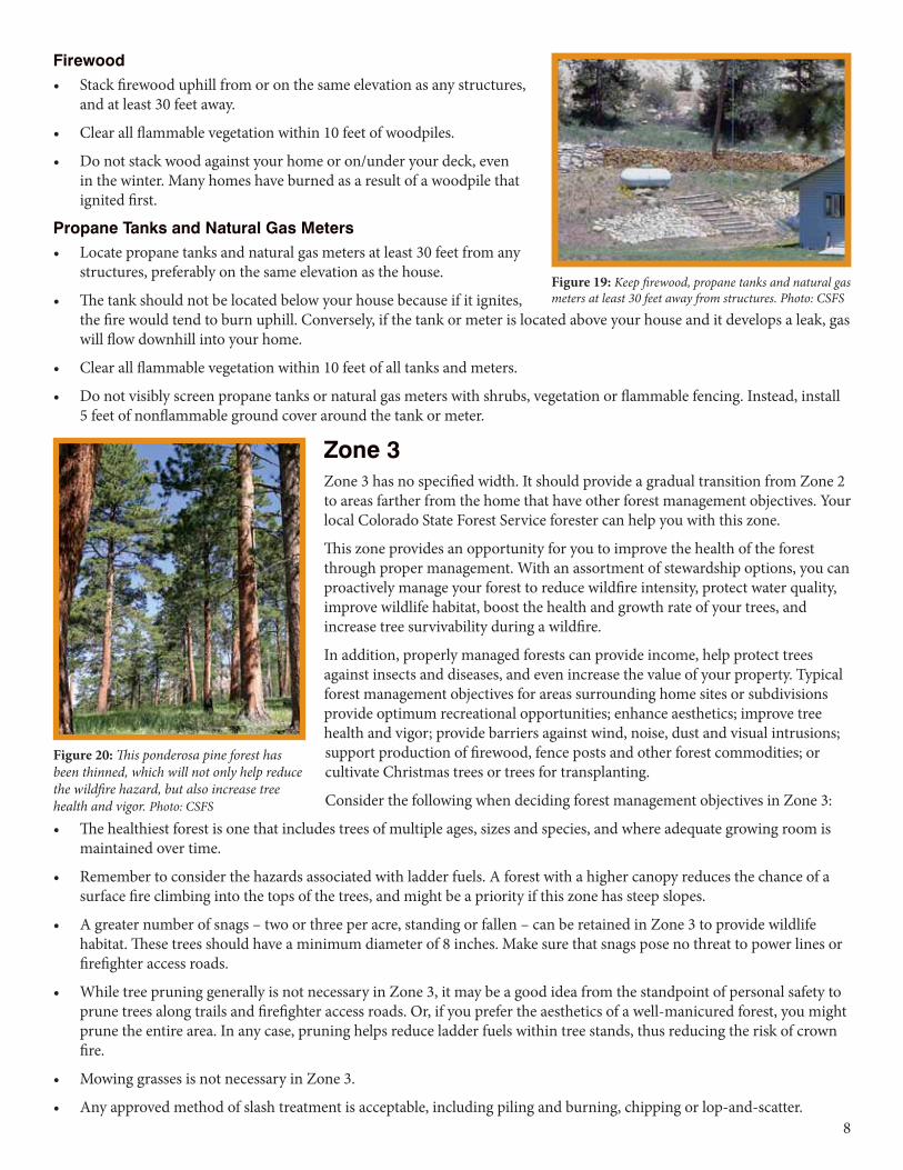
Firewood • Stack firewood uphill from or on the same elevation as any structures,
and at least 30 feet away.
• Clear all flammable vegetation within 10 feet of woodpiles.
• Do not stack wood against your home or on/under your deck, even in the winter. Many homes have burned as a result of a woodpile that ignited first.
Propane Tanks and Natural Gas Meters• Locate propane tanks and natural gas meters at least 30 feet from any
structures, preferably on the same elevation as the house.
• The tank should not be located below your house because if it ignites, the fire would tend to burn uphill. Conversely, if the tank or meter is located above your house and it develops a leak, gas will flow downhill into your home.
• Clear all flammable vegetation within 10 feet of all tanks and meters.
• Do not visibly screen propane tanks or natural gas meters with shrubs, vegetation or flammable fencing. Instead, install 5 feet of nonflammable ground cover around the tank or meter.
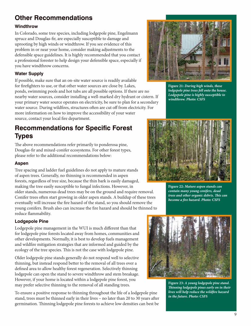
Zone 3Zone 3 has no specified width. It should provide a gradual transition from Zone 2 to areas farther from the home that have other forest management objectives. Your local Colorado State Forest Service forester can help you with this zone.
This zone provides an opportunity for you to improve the health of the forest through proper management. With an assortment of stewardship options, you can proactively manage your forest to reduce wildfire intensity, protect water quality, improve wildlife habitat, boost the health and growth rate of your trees, and increase tree survivability during a wildfire.
In addition, properly managed forests can provide income, help protect trees against insects and diseases, and even increase the value of your property. Typical forest management objectives for areas surrounding home sites or subdivisions provide optimum recreational opportunities; enhance aesthetics; improve tree health and vigor; provide barriers against wind, noise, dust and visual intrusions; support production of firewood, fence posts and other forest commodities; or cultivate Christmas trees or trees for transplanting.
Consider the following when deciding forest management objectives in Zone 3:
• The healthiest forest is one that includes trees of multiple ages, sizes and species, and where adequate growing room is maintained over time.
• Remember to consider the hazards associated with ladder fuels. A forest with a higher canopy reduces the chance of a surface fire climbing into the tops of the trees, and might be a priority if this zone has steep slopes.
• A greater number of snags – two or three per acre, standing or fallen – can be retained in Zone 3 to provide wildlife habitat. These trees should have a minimum diameter of 8 inches. Make sure that snags pose no threat to power lines or firefighter access roads.
• While tree pruning generally is not necessary in Zone 3, it may be a good idea from the standpoint of personal safety to prune trees along trails and firefighter access roads. Or, if you prefer the aesthetics of a well-manicured forest, you might prune the entire area. In any case, pruning helps reduce ladder fuels within tree stands, thus reducing the risk of crown fire.
• Mowing grasses is not necessary in Zone 3.
• Any approved method of slash treatment is acceptable, including piling and burning, chipping or lop-and-scatter.
Figure 20: This ponderosa pine forest has been thinned, which will not only help reduce the wildfire hazard, but also increase tree health and vigor. Photo: CSFS
Figure 19: Keep firewood, propane tanks and natural gas meters at least 30 feet away from structures. Photo: CSFS
9
Other RecommendationsWindthrowIn Colorado, some tree species, including lodgepole pine, Engelmann spruce and Douglas-fir, are especially susceptible to damage and uprooting by high winds or windthrow. If you see evidence of this problem in or near your home, consider making adjustments to the defensible space guidelines. It is highly recommended that you contact a professional forester to help design your defensible space, especially if you have windthrow concerns.
Water SupplyIf possible, make sure that an on-site water source is readily available for firefighters to use, or that other water sources are close by. Lakes, ponds, swimming pools and hot tubs are all possible options. If there are no nearby water sources, consider installing a well-marked dry hydrant or cistern. If your primary water source operates on electricity, be sure to plan for a secondary water source. During wildfires, structures often are cut off from electricity. For more information on how to improve the accessibility of your water source, contact your local fire department.
Recommendations for Specific Forest TypesThe above recommendations refer primarily to ponderosa pine, Douglas-fir and mixed-conifer ecosystems. For other forest types, please refer to the additional recommendations below:
AspenTree spacing and ladder fuel guidelines do not apply to mature stands of aspen trees. Generally, no thinning is recommended in aspen forests, regardless of tree size, because the thin bark is easily damaged, making the tree easily susceptible to fungal infections. However, in older stands, numerous dead trees may be on the ground and require removal. Conifer trees often start growing in older aspen stands. A buildup of these trees eventually will increase the fire hazard of the stand, so you should remove the young conifers. Brush also can increase the fire hazard and should be thinned to reduce flammability.
Lodgepole PineLodgepole pine management in the WUI is much different than that for lodgepole pine forests located away from homes, communities and other developments. Normally, it is best to develop fuels management and wildfire mitigation strategies that are informed and guided by the ecology of the tree species. This is not the case with lodgepole pine.
Older lodgepole pine stands generally do not respond well to selective thinning, but instead respond better to the removal of all trees over a defined area to allow healthy forest regeneration. Selectively thinning lodgepole can open the stand to severe windthrow and stem breakage. However, if your home is located within a lodgepole pine forest, you may prefer selective thinning to the removal of all standing trees.
To ensure a positive response to thinning throughout the life of a lodgepole pine stand, trees must be thinned early in their lives – no later than 20 to 30 years after germination. Thinning lodgepole pine forests to achieve low densities can best be
Figure 22: Mature aspen stands can contain many young conifers, dead trees and other organic debris. This can become a fire hazard. Photo: CSFS
Figure 23: A young lodgepole pine stand. Thinning lodgepole pines early on in their lives will help reduce the wildfire hazard in the future. Photo: CSFS
Figure 21: During high winds, these lodgepole pine trees fell onto the house. Lodgepole pine is highly susceptible to windthrow. Photo: CSFS
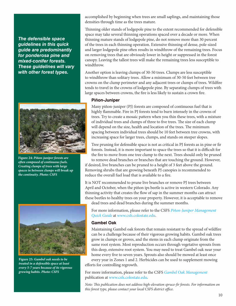
10
accomplished by beginning when trees are small saplings, and maintaining those densities through time as the trees mature.
Thinning older stands of lodgepole pine to the extent recommended for defensible space may take several thinning operations spaced over a decade or more. When thinning mature stands of lodgepole pine, do not remove more than 30 percent of the trees in each thinning operation. Extensive thinning of dense, pole-sized and larger lodgepole pine often results in windthrow of the remaining trees. Focus on removing trees that are obviously lower in height or suppressed in the forest canopy. Leaving the tallest trees will make the remaining trees less susceptible to windthrow.
Another option is leaving clumps of 30-50 trees. Clumps are less susceptible to windthrow than solitary trees. Allow a minimum of 30-50 feet between tree crowns on the clump perimeter and any adjacent trees or clumps of trees. Wildfire tends to travel in the crowns of lodgepole pine. By separating clumps of trees with large spaces between crowns, the fire is less likely to sustain a crown fire.
Piñon-JuniperMany piñon-juniper (PJ) forests are composed of continuous fuel that is highly flammable. Fire in PJ forests tend to burn intensely in the crowns of trees. Try to create a mosaic pattern when you thin these trees, with a mixture of individual trees and clumps of three to five trees. The size of each clump will depend on the size, health and location of the trees. The minimum spacing between individual trees should be 10 feet between tree crowns, with increasing space for larger trees, clumps, and stands on steeper slopes.
Tree pruning for defensible space is not as critical in PJ forests as in pine or fir forests. Instead, it is more important to space the trees so that it is difficult for the fire to move from one tree clump to the next. Trees should only be pruned to remove dead branches or branches that are touching the ground. However,
if desired, live branches can be pruned to a height of 3 feet above the ground. Removing shrubs that are growing beneath PJ canopies is recommended to reduce the overall fuel load that is available to a fire.
It is NOT recommended to prune live branches or remove PJ trees between April and October, when the piñon ips beetle is active in western Colorado. Any thinning activity that creates the flow of sap in the summer months can attract these beetles to healthy trees on your property. However, it is acceptable to remove
dead trees and dead branches during the summer months.
For more information, please refer to the CSFS Piñon-Juniper Management Quick Guide at www.csfs.colostate.edu.
Gambel OakMaintaining Gambel oak forests that remain resistant to the spread of wildfire can be a challenge because of their vigorous growing habits. Gambel oak trees grow in clumps or groves, and the stems in each clump originate from the same root system. Most reproduction occurs through vegetative sprouts from this deep, extensive root system. You may need to treat Gambel oak near your home every five to seven years. Sprouts also should be mowed at least once every year in Zones 1 and 2. Herbicides can be used to supplement mowing
efforts for controlling regrowth.
For more information, please refer to the CSFS Gambel Oak Management publication at www.csfs.colostate.edu.
Note: This publication does not address high-elevation spruce-fir forests. For information on this forest type, please contact your local CSFS district office.
Thedefensiblespaceguidelinesinthisquickguidearepredominantlyforponderosapineandmixed-coniferforests.Theseguidelineswillvarywithotherforesttypes.
Figure 24: Piñon-juniper forests are often composed of continuous fuels. Creating clumps of trees with large spaces in between clumps will break up the continuity. Photo: CSFS
Figure 25: Gambel oak needs to be treated in a defensible space at least every 5-7 years because of its vigorous growing habits. Photo: CSFS
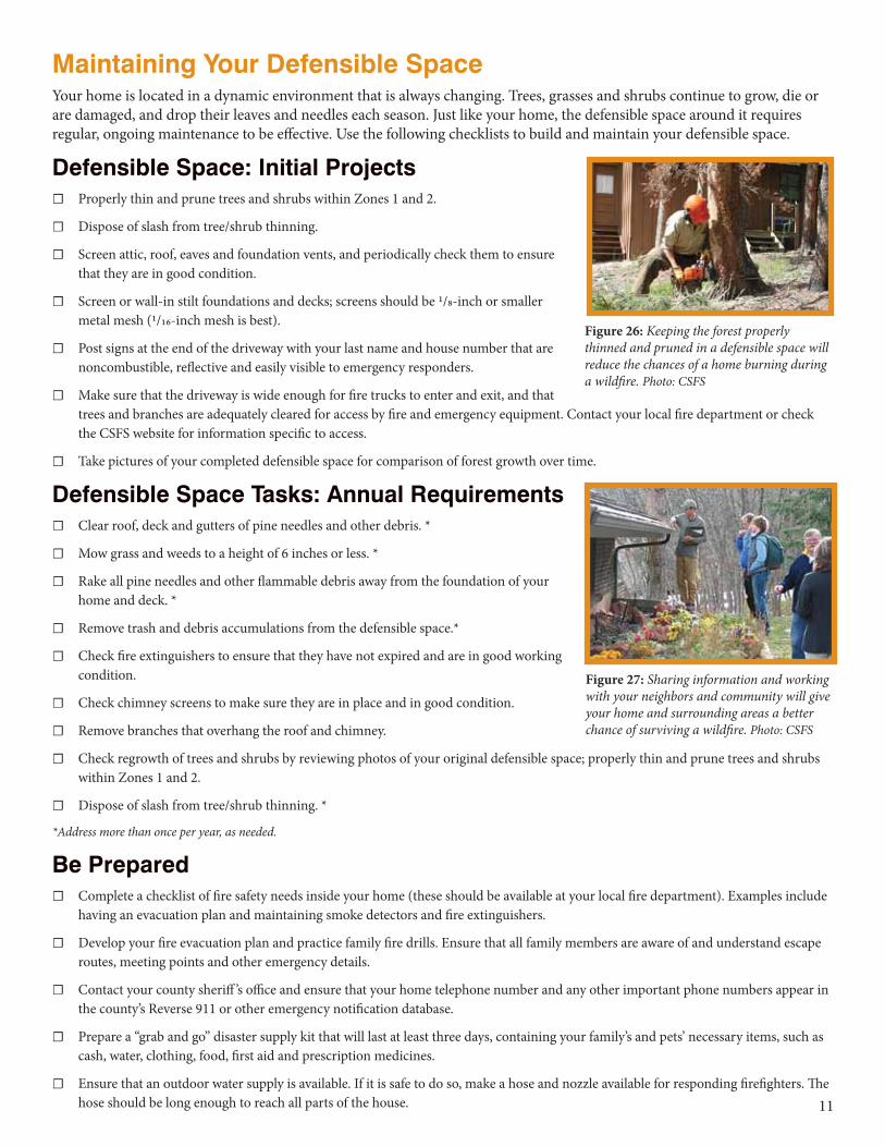
11
Maintaining Your Defensible SpaceYour home is located in a dynamic environment that is always changing. Trees, grasses and shrubs continue to grow, die or are damaged, and drop their leaves and needles each season. Just like your home, the defensible space around it requires regular, ongoing maintenance to be effective. Use the following checklists to build and maintain your defensible space.
Defensible Space: Initial Projects ☐ Properly thin and prune trees and shrubs within Zones 1 and 2.
☐ Dispose of slash from tree/shrub thinning.
☐ Screen attic, roof, eaves and foundation vents, and periodically check them to ensure that they are in good condition.
☐ Screen or wall-in stilt foundations and decks; screens should be 1/8-inch or smaller metal mesh (1/16-inch mesh is best).
☐ Post signs at the end of the driveway with your last name and house number that are noncombustible, reflective and easily visible to emergency responders.
☐ Make sure that the driveway is wide enough for fire trucks to enter and exit, and that trees and branches are adequately cleared for access by fire and emergency equipment. Contact your local fire department or check the CSFS website for information specific to access.
☐ Take pictures of your completed defensible space for comparison of forest growth over time.
Defensible Space Tasks: Annual Requirements ☐ Clear roof, deck and gutters of pine needles and other debris. *
☐ Mow grass and weeds to a height of 6 inches or less. *
☐ Rake all pine needles and other flammable debris away from the foundation of your home and deck. *
☐ Remove trash and debris accumulations from the defensible space.*
☐ Check fire extinguishers to ensure that they have not expired and are in good working condition.
☐ Check chimney screens to make sure they are in place and in good condition.
☐ Remove branches that overhang the roof and chimney.
☐ Check regrowth of trees and shrubs by reviewing photos of your original defensible space; properly thin and prune trees and shrubs within Zones 1 and 2.
☐ Dispose of slash from tree/shrub thinning. *
*Address more than once per year, as needed.
Be Prepared ☐ Complete a checklist of fire safety needs inside your home (these should be available at your local fire department). Examples include
having an evacuation plan and maintaining smoke detectors and fire extinguishers.
☐ Develop your fire evacuation plan and practice family fire drills. Ensure that all family members are aware of and understand escape routes, meeting points and other emergency details.
☐ Contact your county sheriff ’s office and ensure that your home telephone number and any other important phone numbers appear in the county’s Reverse 911 or other emergency notification database.
☐ Prepare a “grab and go” disaster supply kit that will last at least three days, containing your family’s and pets’ necessary items, such as cash, water, clothing, food, first aid and prescription medicines.
☐ Ensure that an outdoor water supply is available. If it is safe to do so, make a hose and nozzle available for responding firefighters. The hose should be long enough to reach all parts of the house.
Figure 26: Keeping the forest properly thinned and pruned in a defensible space will reduce the chances of a home burning during a wildfire. Photo: CSFS
Figure 27: Sharing information and working with your neighbors and community will give your home and surrounding areas a better chance of surviving a wildfire. Photo: CSFS
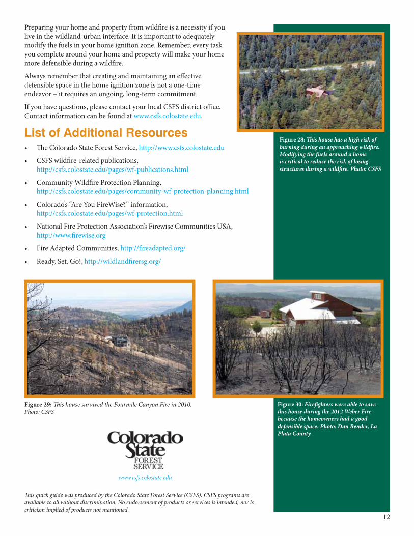
12
This quick guide was produced by the Colorado State Forest Service (CSFS). CSFS programs are available to all without discrimination. No endorsement of products or services is intended, nor is criticism implied of products not mentioned.
www.csfs.colostate.edu
Preparing your home and property from wildfire is a necessity if you live in the wildland-urban interface. It is important to adequately modify the fuels in your home ignition zone. Remember, every task you complete around your home and property will make your home more defensible during a wildfire.
Always remember that creating and maintaining an effective defensible space in the home ignition zone is not a one-time endeavor – it requires an ongoing, long-term commitment.
If you have questions, please contact your local CSFS district office. Contact information can be found at www.csfs.colostate.edu.
List of Additional Resources• The Colorado State Forest Service, http://www.csfs.colostate.edu
• CSFS wildfire-related publications, http://csfs.colostate.edu/pages/wf-publications.html
• Community Wildfire Protection Planning, http://csfs.colostate.edu/pages/community-wf-protection-planning.html
• Colorado’s “Are You FireWise?” information, http://csfs.colostate.edu/pages/wf-protection.html
• National Fire Protection Association’s Firewise Communities USA, http://www.firewise.org
• Fire Adapted Communities, http://fireadapted.org/
• Ready, Set, Go!, http://wildlandfirersg.org/
Figure 28: This house has a high risk of burning during an approaching wildfire. Modifying the fuels around a home is critical to reduce the risk of losing structures during a wildfire. Photo: CSFS
Figure 30: Firefighters were able to save this house during the 2012 Weber Fire because the homeowners had a good defensible space. Photo: Dan Bender, La Plata County
Figure 29: This house survived the Fourmile Canyon Fire in 2010. Photo: CSFS

Appendix C
Fuelbreak Guidelines for Forested Subdivisions and Communities
31
Fuelbreak Guidelines for Forested Subdivisions & Communities
By
Frank C. Dennis
Knowledge to Go Places
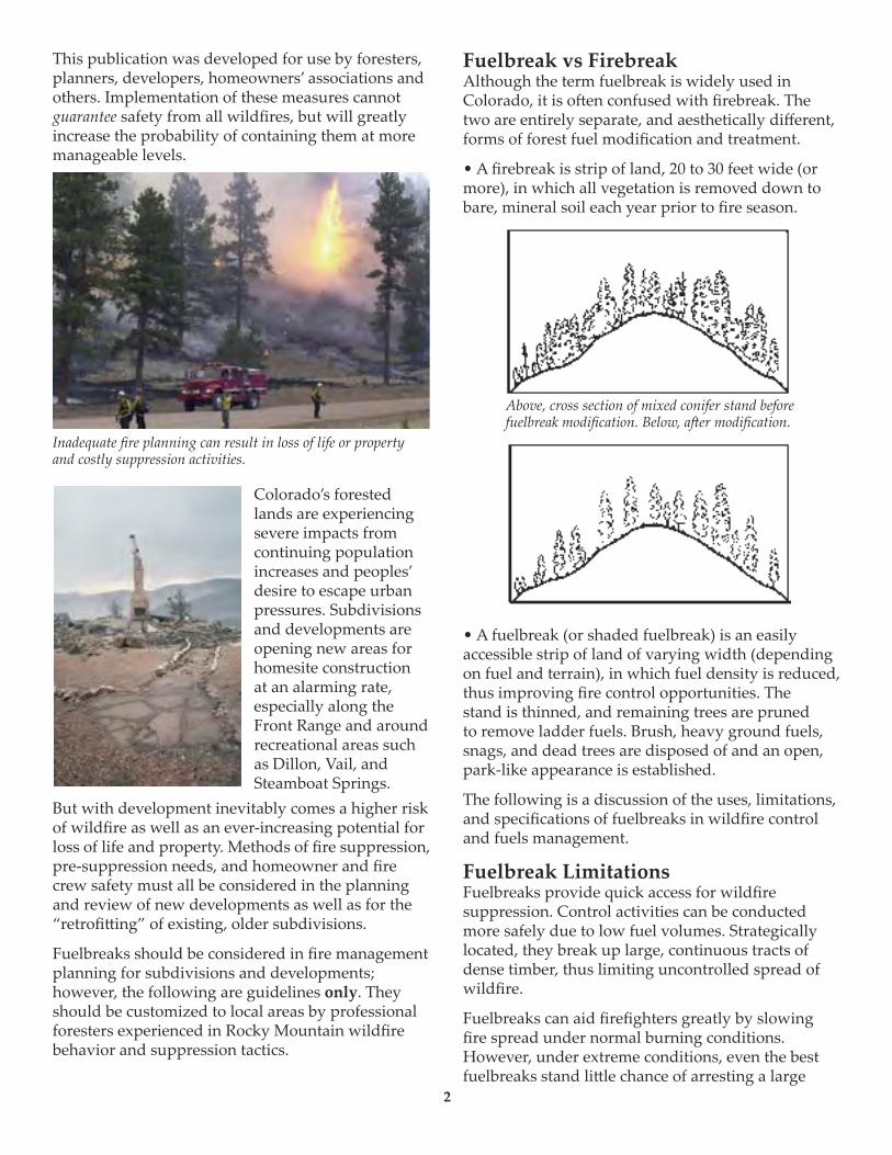
This publication was developed for use by foresters, planners, developers, homeowners’ associations and others. Implementation of these measures cannot guarantee safety from all wildfires, but will greatly increase the probability of containing them at more manageable levels.
Colorado’s forested lands are experiencing severe impacts from continuing population increases and peoples’ desire to escape urban pressures. Subdivisions and developments are opening new areas for homesite construction at an alarming rate, especially along the Front Range and around recreational areas such as Dillon, Vail, and Steamboat Springs.
But with development inevitably comes a higher risk of wildfire as well as an ever-increasing potential for loss of life and property. Methods of fire suppression, pre-suppression needs, and homeowner and fire crew safety must all be considered in the planning and review of new developments as well as for the “retrofi�ing” of existing, older subdivisions.
Fuelbreaks should be considered in fire management planning for subdivisions and developments; however, the following are guidelines only. They should be customized to local areas by professional foresters experienced in Rocky Mountain wildfire behavior and suppression tactics.
Fuelbreak vs FirebreakAlthough the term fuelbreak is widely used in Colorado, it is o�en confused with firebreak. The two are entirely separate, and aesthetically different, forms of forest fuel modification and treatment.
• A firebreak is strip of land, 20 to 30 feet wide (or more), in which all vegetation is removed down to bare, mineral soil each year prior to fire season.
• A fuelbreak (or shaded fuelbreak) is an easily accessible strip of land of varying width (depending on fuel and terrain), in which fuel density is reduced, thus improving fire control opportunities. The stand is thinned, and remaining trees are pruned to remove ladder fuels. Brush, heavy ground fuels, snags, and dead trees are disposed of and an open, park-like appearance is established.
The following is a discussion of the uses, limitations, and specifications of fuelbreaks in wildfire control and fuels management.
Fuelbreak LimitationsFuelbreaks provide quick access for wildfire suppression. Control activities can be conducted more safely due to low fuel volumes. Strategically located, they break up large, continuous tracts of dense timber, thus limiting uncontrolled spread of wildfire.
Fuelbreaks can aid firefighters greatly by slowing fire spread under normal burning conditions. However, under extreme conditions, even the best fuelbreaks stand li�le chance of arresting a large
Inadequate fire planning can result in loss of life or property and costly suppression activities.
Above, cross section of mixed conifer stand before fuelbreak modification. Below, a�er modification.
2
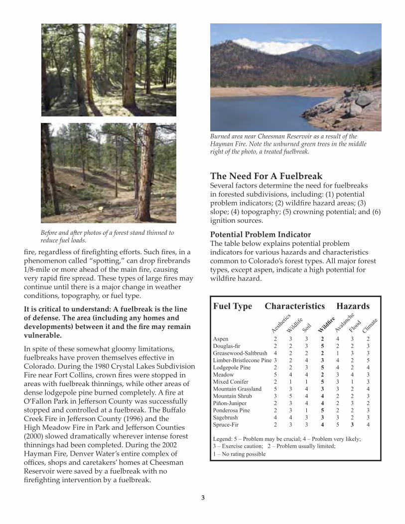
fire, regardless of firefighting efforts. Such fires, in a phenomenon called “spo�ing,” can drop firebrands 1/8-mile or more ahead of the main fire, causing very rapid fire spread. These types of large fires may continue until there is a major change in weather conditions, topography, or fuel type.
It is critical to understand: A fuelbreak is the line of defense. The area (including any homes and developments) between it and the fire may remain vulnerable.
In spite of these somewhat gloomy limitations, fuelbreaks have proven themselves effective in Colorado. During the 1980 Crystal Lakes Subdivision Fire near Fort Collins, crown fires were stopped in areas with fuelbreak thinnings, while other areas of dense lodgepole pine burned completely. A fire at O’Fallon Park in Jefferson County was successfully stopped and controlled at a fuelbreak. The Buffalo Creek Fire in Jefferson County (1996) and the High Meadow Fire in Park and Jefferson Counties (2000) slowed dramatically wherever intense forest thinnings had been completed. During the 2002 Hayman Fire, Denver Water’s entire complex of offices, shops and caretakers’ homes at Cheesman Reservoir were saved by a fuelbreak with no firefighting intervention by a fuelbreak.
The Need For A FuelbreakSeveral factors determine the need for fuelbreaks in forested subdivisions, including: (1) potential problem indicators; (2) wildfire hazard areas; (3) slope; (4) topography; (5) crowning potential; and (6) ignition sources.
Potential Problem IndicatorThe table below explains potential problem indicators for various hazards and characteristics common to Colorado’s forest types. All major forest types, except aspen, indicate a high potential for wildfire hazard.
Before and a�er photos of a forest stand thinned to reduce fuel loads.
Burned area near Cheesman Reservoir as a result of the Hayman Fire. Note the unburned green trees in the middle right of the photo, a treated fuelbreak.
3
Fuel Type Characteristics Hazards
Aspen 2 3 3 2 4 3 2Douglas-fir 2 2 3 5 2 2 3Greasewood-Saltbrush 4 2 2 2 1 3 3Limber-Bristlecone Pine 3 2 4 3 4 2 5Lodgepole Pine 2 2 3 5 4 2 4Meadow 5 4 4 2 3 4 3Mixed Conifer 2 1 1 5 3 1 3Mountain Grassland 5 3 4 3 3 2 4Mountain Shrub 3 5 4 4 2 2 3Piñon-Juniper 2 3 4 4 2 3 2Ponderosa Pine 2 3 1 5 2 2 3Sagebrush 4 4 3 3 3 2 3Spruce-Fir 2 3 3 4 5 3 4
Legend: 5 – Problem may be crucial; 4 – Problem very likely; 3 – Exercise caution; 2 – Problem usually limited; 1 – No rating possible
Aesthe
tics
Wildlife
Soil Wild
fire
Avalan
che
Flood
Climate
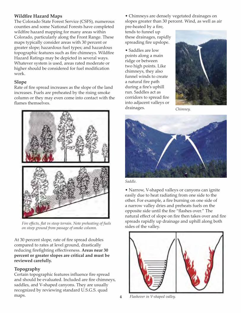
Fire effects, flat vs steep terrain. Note preheating of fuels on steep ground from passage of smoke column.
Chimney.
Saddle.
Flashover in V-shaped valley.4
Wildfire Hazard MapsThe Colorado State Forest Service (CSFS), numerous counties and some National Forests have completed wildfire hazard mapping for many areas within Colorado, particularly along the Front Range. These maps typically consider areas with 30 percent or greater slope; hazardous fuel types; and hazardous topographic features such as fire chimneys. Wildfire Hazard Ratings may be depicted in several ways. Whatever system is used, areas rated moderate or higher should be considered for fuel modification work.
SlopeRate of fire spread increases as the slope of the land increases. Fuels are preheated by the rising smoke column or they may even come into contact with the flames themselves.
At 30 percent slope, rate of fire spread doubles compared to rates at level ground, drastically reducing firefighting effectiveness. Areas near 30 percent or greater slopes are critical and must be reviewed carefully.
TopographyCertain topographic features influence fire spread and should be evaluated. Included are fire chimneys, saddles, and V-shaped canyons. They are usually recognized by reviewing standard U.S.G.S. quad maps.
• Chimneys are densely vegetated drainages on slopes greater than 30 percent. Wind, as well as air pre-heated by a fire, tends to funnel up these drainages, rapidly spreading fire upslope.
• Saddles are low points along a main ridge or between two high points. Like chimneys, they also funnel winds to create a natural fire path during a fire’s uphill run. Saddles act as corridors to spread fire into adjacent valleys or drainages.
• Narrow, V-shaped valleys or canyons can ignite easily due to heat radiating from one side to the other. For example, a fire burning on one side of a narrow valley dries and preheats fuels on the opposite side until the fire “flashes over.” The natural effect of slope on fire then takes over and fire spreads rapidly up drainage and uphill along both sides of the valley.
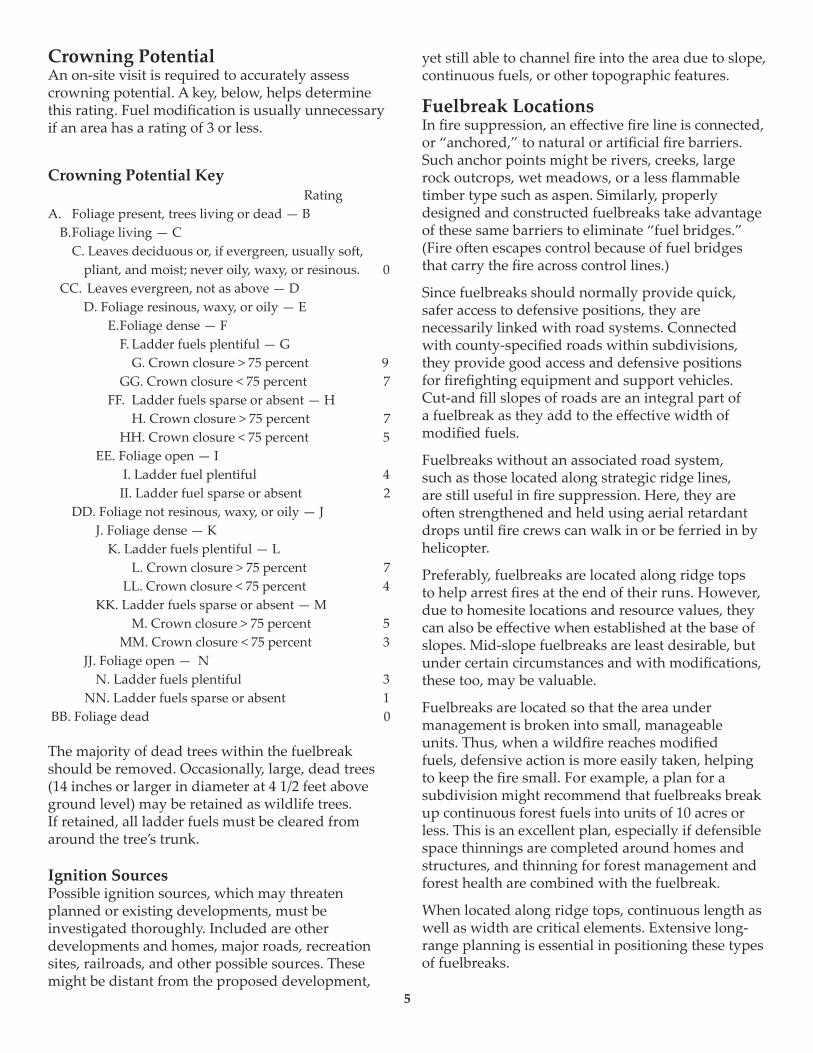
5
Crowning PotentialAn on-site visit is required to accurately assess crowning potential. A key, below, helps determine this rating. Fuel modification is usually unnecessary if an area has a rating of 3 or less.
Crowning Potential Key RatingA. Foliage present, trees living or dead — B B. Foliage living — C C. Leaves deciduous or, if evergreen, usually so�, pliant, and moist; never oily, waxy, or resinous. 0 CC. Leaves evergreen, not as above — D D. Foliage resinous, waxy, or oily — E E. Foliage dense — F F. Ladder fuels plentiful — G G. Crown closure > 75 percent 9 GG. Crown closure < 75 percent 7 FF. Ladder fuels sparse or absent — H H. Crown closure > 75 percent 7 HH. Crown closure < 75 percent 5 EE. Foliage open — I I. Ladder fuel plentiful 4 II. Ladder fuel sparse or absent 2 DD. Foliage not resinous, waxy, or oily — J J. Foliage dense — K K. Ladder fuels plentiful — L L. Crown closure > 75 percent 7 LL. Crown closure < 75 percent 4 KK. Ladder fuels sparse or absent — M M. Crown closure > 75 percent 5 MM. Crown closure < 75 percent 3 JJ. Foliage open — N N. Ladder fuels plentiful 3 NN. Ladder fuels sparse or absent 1 BB. Foliage dead 0
The majority of dead trees within the fuelbreak should be removed. Occasionally, large, dead trees (14 inches or larger in diameter at 4 1/2 feet above ground level) may be retained as wildlife trees. If retained, all ladder fuels must be cleared from around the tree’s trunk.
Ignition SourcesPossible ignition sources, which may threaten planned or existing developments, must be investigated thoroughly. Included are other developments and homes, major roads, recreation sites, railroads, and other possible sources. These might be distant from the proposed development,
yet still able to channel fire into the area due to slope, continuous fuels, or other topographic features.
Fuelbreak LocationsIn fire suppression, an effective fire line is connected, or “anchored,” to natural or artificial fire barriers. Such anchor points might be rivers, creeks, large rock outcrops, wet meadows, or a less flammable timber type such as aspen. Similarly, properly designed and constructed fuelbreaks take advantage of these same barriers to eliminate “fuel bridges.” (Fire o�en escapes control because of fuel bridges that carry the fire across control lines.)
Since fuelbreaks should normally provide quick, safer access to defensive positions, they are necessarily linked with road systems. Connected with county-specified roads within subdivisions, they provide good access and defensive positions for firefighting equipment and support vehicles. Cut-and fill slopes of roads are an integral part of a fuelbreak as they add to the effective width of modified fuels.
Fuelbreaks without an associated road system, such as those located along strategic ridge lines, are still useful in fire suppression. Here, they are o�en strengthened and held using aerial retardant drops until fire crews can walk in or be ferried in by helicopter.
Preferably, fuelbreaks are located along ridge tops to help arrest fires at the end of their runs. However, due to homesite locations and resource values, they can also be effective when established at the base of slopes. Mid-slope fuelbreaks are least desirable, but under certain circumstances and with modifications, these too, may be valuable.
Fuelbreaks are located so that the area under management is broken into small, manageable units. Thus, when a wildfire reaches modified fuels, defensive action is more easily taken, helping to keep the fire small. For example, a plan for a subdivision might recommend that fuelbreaks break up continuous forest fuels into units of 10 acres or less. This is an excellent plan, especially if defensible space thinnings are completed around homes and structures, and thinning for forest management and forest health are combined with the fuelbreak.
When located along ridge tops, continuous length as well as width are critical elements. Extensive long-range planning is essential in positioning these types of fuelbreaks.
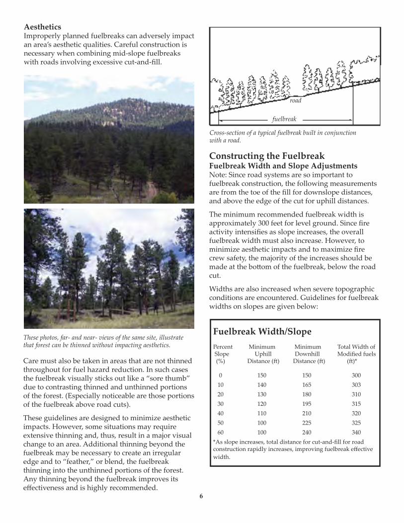
AestheticsImproperly planned fuelbreaks can adversely impact an area’s aesthetic qualities. Careful construction is necessary when combining mid-slope fuelbreaks with roads involving excessive cut-and-fill.
Care must also be taken in areas that are not thinned throughout for fuel hazard reduction. In such cases the fuelbreak visually sticks out like a “sore thumb” due to contrasting thinned and unthinned portions of the forest. (Especially noticeable are those portions of the fuelbreak above road cuts).
These guidelines are designed to minimize aesthetic impacts. However, some situations may require extensive thinning and, thus, result in a major visual change to an area. Additional thinning beyond the fuelbreak may be necessary to create an irregular edge and to “feather,” or blend, the fuelbreak thinning into the unthinned portions of the forest. Any thinning beyond the fuelbreak improves its effectiveness and is highly recommended.
Constructing the FuelbreakFuelbreak Width and Slope AdjustmentsNote: Since road systems are so important to fuelbreak construction, the following measurements are from the toe of the fill for downslope distances, and above the edge of the cut for uphill distances.
The minimum recommended fuelbreak width is approximately 300 feet for level ground. Since fire activity intensifies as slope increases, the overall fuelbreak width must also increase. However, to minimize aesthetic impacts and to maximize fire crew safety, the majority of the increases should be made at the bo�om of the fuelbreak, below the road cut.
Widths are also increased when severe topographic conditions are encountered. Guidelines for fuelbreak widths on slopes are given below:
Fuelbreak Width/SlopePercent Minimum Minimum Total Width of Slope Uphill Downhill Modified fuels (%) Distance (�) Distance (�) (�)*
0 150 150 300 10 140 165 303 20 130 180 310 30 120 195 315 40 110 210 320 50 100 225 325 60 100 240 340*As slope increases, total distance for cut-and-fill for road construction rapidly increases, improving fuelbreak effective width.
These photos, far- and near- views of the same site, illustrate that forest can be thinned without impacting aesthetics.
road
fuelbreak
6
Cross-section of a typical fuelbreak built in conjunction with a road.
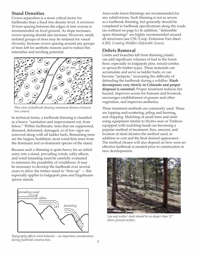
Stand Densities Crown separation is a more critical factor for fuelbreaks than a fixed tree density level. A minimum 10-foot spacing between the edges of tree crowns is recommended on level ground. As slope increases, crown spacing should also increase. However, small, isolated groups of trees may be retained for visual diversity. Increase crown spacing around any groups of trees le� for aesthetic reasons and to reduce fire intensities and torching potential.
In technical terms, a fuelbreak thinning is classified as a heavy “sanitation and improvement cut, from below.” Within fuelbreaks, trees that are suppressed, diseased, deformed, damaged, or of low vigor are removed along with all ladder fuels. Remaining trees are the largest, healthiest, most wind-firm trees from the dominant and co-dominant species of the stand.
Because such a thinning is quite heavy for an initial entry into a stand, prevailing winds, eddy effects, and wind funneling must be carefully evaluated to minimize the possibility of windthrow. It may be necessary to develop the fuelbreak over several years to allow the timber stand to “firm-up” — this especially applies to lodgepole pine and Engelmann spruce stands.
Area-wide forest thinnings are recommended for any subdivisions. Such thinning is not as severe as a fuelbreak thinning, but generally should be completed to fuelbreak specifications along the roads (as outlined on page 6.) In addition, “defensible space thinnings” are highly recommended around all structures (see CSU Coop. Extension Fact sheet 6.302, Creating Wildfire-Defensible Zones).
Debris RemovalLimbs and branches le� from thinning (slash) can add significant volumes of fuel to the forest floor, especially in lodgepole pine, mixed-conifer, or spruce/fir timber types. These materials can accumulate and serve as ladder fuels, or can become “jackpots,” increasing the difficulty of defending the fuelbreak during a wildfire. Slash decomposes very slowly in Colorado and proper disposal is essential. Proper treatment reduces fire hazard, improves access for humans and livestock, encourages establishment of grasses and other vegetation, and improves aesthetics.
Three treatment methods are commonly used. These are lopping-and-sca�ering, piling and burning, and chipping. Mulching of small trees and slash using equipment similar to Hydro-axes or Timbcos equipped with mulching heads are becoming a popular method of treatment. Size, amount, and location of slash dictates the method used, in addition to cost and the final desired appearance. The method chosen will also depend on how soon an effective fuelbreak is needed prior to construction in new developments.
Plan view of fuelbreak showing minimum distance between tree crowns.
road
10’ min.
prevailing wind
eddies
funneling
Lop and sca�er: slash should be no deeper than 12’’ above ground surface.
7
Topography affects wind behavior – an important consideration during fuelbreak construction.
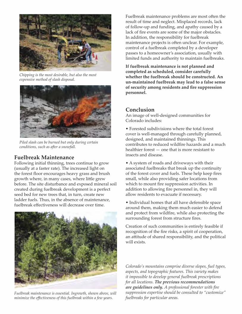
Fuelbreak MaintenanceFollowing initial thinning, trees continue to grow (usually at a faster rate). The increased light on the forest floor encourages heavy grass and brush growth where, in many cases, where li�le grew before. The site disturbance and exposed mineral soil created during fuelbreak development is a perfect seed bed for new trees that, in turn, create new ladder fuels. Thus, in the absence of maintenance, fuelbreak effectiveness will decrease over time.
Fuelbreak maintenance problems are most o�en the result of time and neglect. Misplaced records, lack of follow-up and funding, and apathy caused by a lack of fire events are some of the major obstacles. In addition, the responsibility for fuelbreak maintenance projects is o�en unclear. For example, control of a fuelbreak completed by a developer passes to a homeowner’s association, usually with limited funds and authority to maintain fuelbreaks.
If fuelbreak maintenance is not planned and completed as scheduled, consider carefully whether the fuelbreak should be constructed. An un-maintained fuelbreak may lead to a false sense of security among residents and fire suppression personnel.
Conclusion An image of well-designed communities for Colorado includes:
• Forested subdivisions where the total forest cover is well-managed through carefully planned, designed, and maintained thinnings. This contributes to reduced wildfire hazards and a much healthier forest — one that is more resistant to insects and disease.
• A system of roads and driveways with their associated fuelbreaks that break up the continuity of the forest cover and fuels. These help keep fires small, while also providing safer locations from which to mount fire suppression activities. In addition to allowing fire personnel in, they will allow residents to evacuate if necessary.
• Individual homes that all have defensible space around them, making them much easier to defend and protect from wildfire, while also protecting the surrounding forest from structure fires.
Creation of such communities is entirely feasible if recognition of the fire risks, a spirit of cooperation, an a�itude of shared responsibility, and the political will exists.
Colorado’s mountains comprise diverse slopes, fuel types, aspects, and topographic features. This variety makes it impossible to develop general fuelbreak prescriptions for all locations. The previous recommendations are guidelines only. A professional forester with fire suppression expertise should be consulted to “customize” fuelbreaks for particular areas.
Chipping is the most desirable, but also the most expensive method of slash disposal.
Fuelbreak maintenance is essential. Ingrowth, shown above, will minimize the effectiveness of this fuelbreak within a few years.
Piled slash can be burned but only during certain conditions, such as a�er a snowfall.

Appendix D
Fire-Resistant Landscaping
32
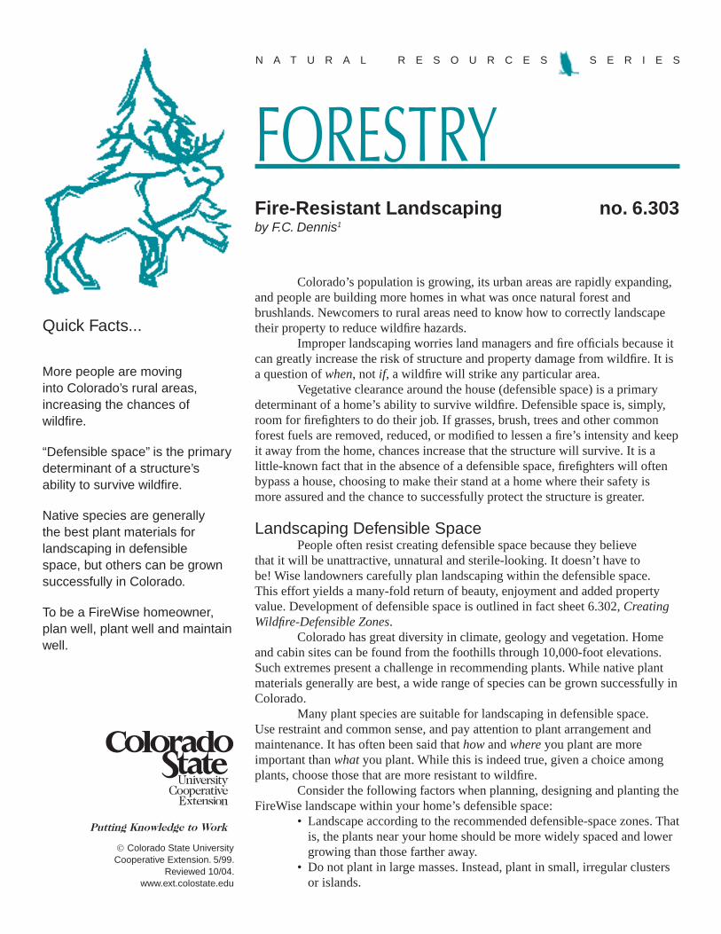
Colorado State University Cooperative Extension. 5/99.
Reviewed 10/04.www.ext.colostate.edu
FORESTRYN A T U R A L R E S O U R C E S S E R I E S
Colorado’s population is growing, its urban areas are rapidly expanding, and people are building more homes in what was once natural forest and brushlands. Newcomers to rural areas need to know how to correctly landscape their property to reduce wildfire hazards.
Improper landscaping worries land managers and fire officials because it can greatly increase the risk of structure and property damage from wildfire. It is a question of when, not if, a wildfire will strike any particular area.
Vegetative clearance around the house (defensible space) is a primary determinant of a home’s ability to survive wildfire. Defensible space is, simply, room for firefighters to do their job. If grasses, brush, trees and other common forest fuels are removed, reduced, or modified to lessen a fire’s intensity and keep it away from the home, chances increase that the structure will survive. It is a little-known fact that in the absence of a defensible space, firefighters will often bypass a house, choosing to make their stand at a home where their safety is more assured and the chance to successfully protect the structure is greater.
Landscaping Defensible SpacePeople often resist creating defensible space because they believe
that it will be unattractive, unnatural and sterile-looking. It doesn’t have to be! Wise landowners carefully plan landscaping within the defensible space. This effort yields a many-fold return of beauty, enjoyment and added property value. Development of defensible space is outlined in fact sheet 6.302, Creating Wildfire-Defensible Zones.
Colorado has great diversity in climate, geology and vegetation. Home and cabin sites can be found from the foothills through 10,000-foot elevations. Such extremes present a challenge in recommending plants. While native plant materials generally are best, a wide range of species can be grown successfully in Colorado.
Many plant species are suitable for landscaping in defensible space. Use restraint and common sense, and pay attention to plant arrangement and maintenance. It has often been said that how and where you plant are more important than what you plant. While this is indeed true, given a choice among plants, choose those that are more resistant to wildfire.
Consider the following factors when planning, designing and planting the FireWise landscape within your home’s defensible space:
• Landscape according to the recommended defensible-space zones. That is, the plants near your home should be more widely spaced and lower growing than those farther away.
• Do not plant in large masses. Instead, plant in small, irregular clusters or islands.
Fire-Resistant Landscaping no. 6.303by F.C. Dennis1
Quick Facts...
More people are moving into Colorado’s rural areas, increasing the chances of wildfire.
“Defensible space” is the primary determinant of a structure’s ability to survive wildfire.
Native species are generally the best plant materials for landscaping in defensible space, but others can be grown successfully in Colorado.
To be a FireWise homeowner, plan well, plant well and maintain well.
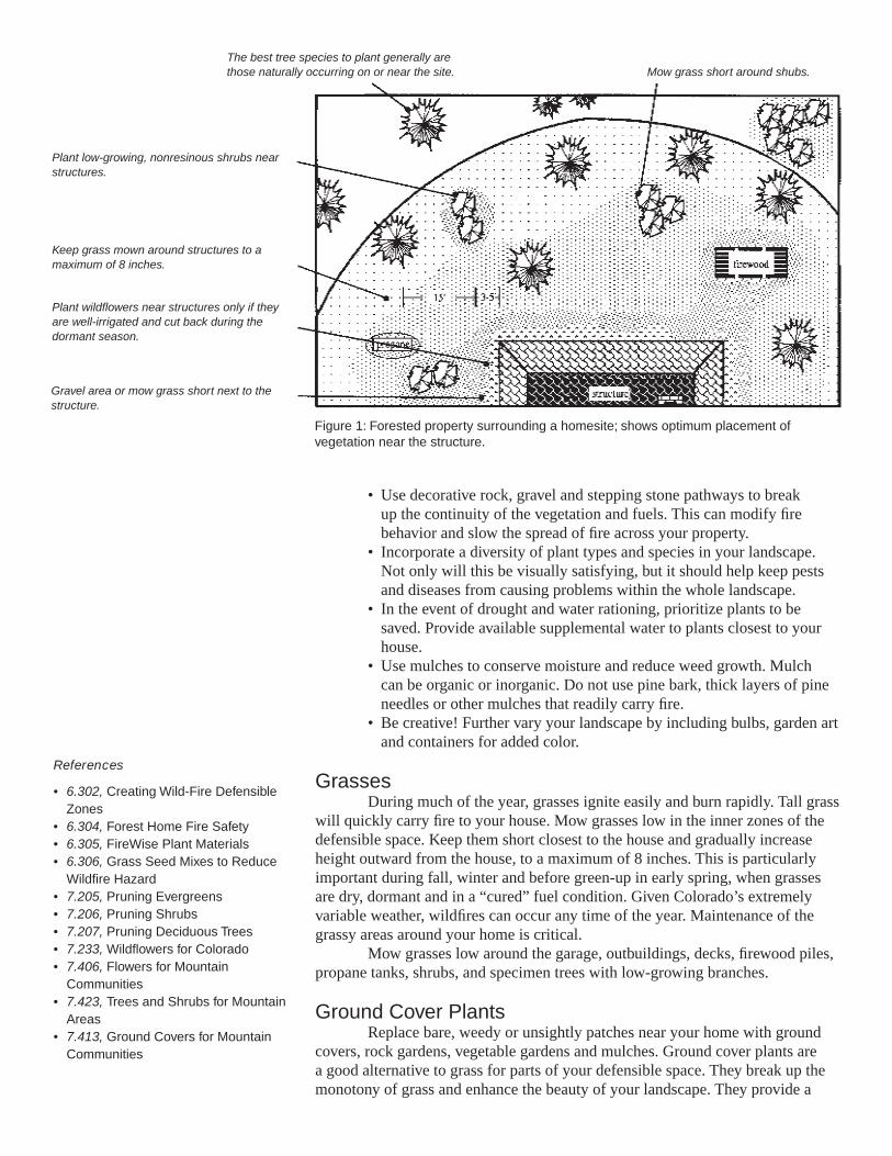
• Use decorative rock, gravel and stepping stone pathways to break up the continuity of the vegetation and fuels. This can modify fire behavior and slow the spread of fire across your property.
• Incorporate a diversity of plant types and species in your landscape. Not only will this be visually satisfying, but it should help keep pests and diseases from causing problems within the whole landscape.
• In the event of drought and water rationing, prioritize plants to be saved. Provide available supplemental water to plants closest to your house.
• Use mulches to conserve moisture and reduce weed growth. Mulch can be organic or inorganic. Do not use pine bark, thick layers of pine needles or other mulches that readily carry fire.
• Be creative! Further vary your landscape by including bulbs, garden art and containers for added color.
GrassesDuring much of the year, grasses ignite easily and burn rapidly. Tall grass
will quickly carry fire to your house. Mow grasses low in the inner zones of the defensible space. Keep them short closest to the house and gradually increase height outward from the house, to a maximum of 8 inches. This is particularly important during fall, winter and before green-up in early spring, when grasses are dry, dormant and in a “cured” fuel condition. Given Colorado’s extremely variable weather, wildfires can occur any time of the year. Maintenance of the grassy areas around your home is critical.
Mow grasses low around the garage, outbuildings, decks, firewood piles, propane tanks, shrubs, and specimen trees with low-growing branches.
Ground Cover PlantsReplace bare, weedy or unsightly patches near your home with ground
covers, rock gardens, vegetable gardens and mulches. Ground cover plants are a good alternative to grass for parts of your defensible space. They break up the monotony of grass and enhance the beauty of your landscape. They provide a
Figure 1: Forested property surrounding a homesite; shows optimum placement of vegetation near the structure.
Mow grass short around shubs.
Keep grass mown around structures to a maximum of 8 inches.
The best tree species to plant generally are those naturally occurring on or near the site.
Plant low-growing, nonresinous shrubs near structures.
Plant wildflowers near structures only if they are well-irrigated and cut back during the dormant season.
Gravel area or mow grass short next to the structure.
References
• 6.302, Creating Wild-Fire Defensible Zones• 6.304, Forest Home Fire Safety• 6.305, FireWise Plant Materials• 6.306, Grass Seed Mixes to Reduce Wildfire Hazard• 7.205, Pruning Evergreens• 7.206, Pruning Shrubs• 7.207, Pruning Deciduous Trees• 7.233, Wildflowers for Colorado• 7.406, Flowers for Mountain Communities• 7.423, Trees and Shrubs for Mountain Areas• 7.413, Ground Covers for Mountain Communities
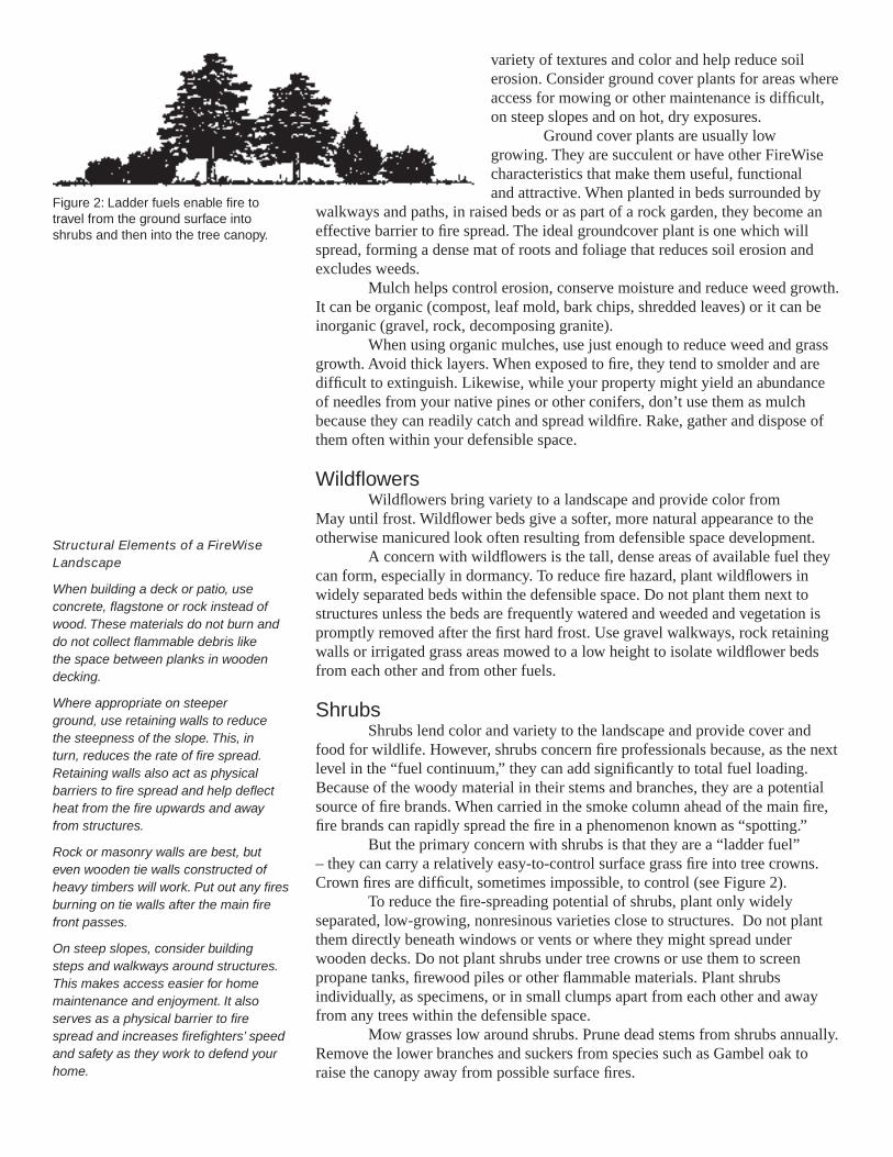
variety of textures and color and help reduce soil erosion. Consider ground cover plants for areas where access for mowing or other maintenance is difficult, on steep slopes and on hot, dry exposures.
Ground cover plants are usually low growing. They are succulent or have other FireWise characteristics that make them useful, functional and attractive. When planted in beds surrounded by
walkways and paths, in raised beds or as part of a rock garden, they become an effective barrier to fire spread. The ideal groundcover plant is one which will spread, forming a dense mat of roots and foliage that reduces soil erosion and excludes weeds.
Mulch helps control erosion, conserve moisture and reduce weed growth. It can be organic (compost, leaf mold, bark chips, shredded leaves) or it can be inorganic (gravel, rock, decomposing granite).
When using organic mulches, use just enough to reduce weed and grass growth. Avoid thick layers. When exposed to fire, they tend to smolder and are difficult to extinguish. Likewise, while your property might yield an abundance of needles from your native pines or other conifers, don’t use them as mulch because they can readily catch and spread wildfire. Rake, gather and dispose of them often within your defensible space.
WildflowersWildflowers bring variety to a landscape and provide color from
May until frost. Wildflower beds give a softer, more natural appearance to the otherwise manicured look often resulting from defensible space development.
A concern with wildflowers is the tall, dense areas of available fuel they can form, especially in dormancy. To reduce fire hazard, plant wildflowers in widely separated beds within the defensible space. Do not plant them next to structures unless the beds are frequently watered and weeded and vegetation is promptly removed after the first hard frost. Use gravel walkways, rock retaining walls or irrigated grass areas mowed to a low height to isolate wildflower beds from each other and from other fuels.
ShrubsShrubs lend color and variety to the landscape and provide cover and
food for wildlife. However, shrubs concern fire professionals because, as the next level in the “fuel continuum,” they can add significantly to total fuel loading. Because of the woody material in their stems and branches, they are a potential source of fire brands. When carried in the smoke column ahead of the main fire, fire brands can rapidly spread the fire in a phenomenon known as “spotting.”
But the primary concern with shrubs is that they are a “ladder fuel” – they can carry a relatively easy-to-control surface grass fire into tree crowns. Crown fires are difficult, sometimes impossible, to control (see Figure 2).
To reduce the fire-spreading potential of shrubs, plant only widely separated, low-growing, nonresinous varieties close to structures. Do not plant them directly beneath windows or vents or where they might spread under wooden decks. Do not plant shrubs under tree crowns or use them to screen propane tanks, firewood piles or other flammable materials. Plant shrubs individually, as specimens, or in small clumps apart from each other and away from any trees within the defensible space.
Mow grasses low around shrubs. Prune dead stems from shrubs annually. Remove the lower branches and suckers from species such as Gambel oak to raise the canopy away from possible surface fires.
Figure 2: Ladder fuels enable fire to travel from the ground surface into shrubs and then into the tree canopy.
Structural Elements of a FireWise Landscape
When building a deck or patio, use concrete, flagstone or rock instead of wood. These materials do not burn and do not collect flammable debris like the space between planks in wooden decking.
Where appropriate on steeper ground, use retaining walls to reduce the steepness of the slope. This, in turn, reduces the rate of fire spread. Retaining walls also act as physical barriers to fire spread and help deflect heat from the fire upwards and away from structures.
Rock or masonry walls are best, but even wooden tie walls constructed of heavy timbers will work. Put out any fires burning on tie walls after the main fire front passes.
On steep slopes, consider building steps and walkways around structures. This makes access easier for home maintenance and enjoyment. It also serves as a physical barrier to fire spread and increases firefighters’ speed and safety as they work to defend your home.
Colorado State University, U.S. Department of Agriculture, and Colorado counties cooperating. Cooperative Extension programs are available to all without discrimination. No endorsement of products mentioned is intended nor is criticism implied of products not mentioned.
TreesTrees provide a large amount of available fuel for a fire and can be a
significant source of fire brands if they do burn. Radiant heat from burning trees can ignite nearby shrubs, trees and structures.
Colorado’s elevation and temperature extremes limit tree selection. The best species to plant generally are those already growing on or near the site. Others may be planted with careful selection and common sense.
If your site receives enough moisture to grow them, plant deciduous trees such as aspen or narrow-leaf cottonwood. These species, even when planted in dense clumps, generally do not burn well, if at all. The greatest problem with these trees is the accumulation of dead leaves in the fall. Remove accumulations close to structures as soon as possible after leaf drop.
When site or available moisture limits recommended species to evergreens, carefully plan their placement. Do not plant trees near structures. Leave plenty of room between trees to allow for their growth. Spacing within the defensible space should be at least 10 feet between the edges of tree crowns. On steep ground, allow even more space between crowns. Plant smaller trees initially on a 20- to 25-foot spacing to allow for tree growth. At some point, you will have to thin your trees to retain proper spacing.
As the trees grow, prune branches to a height of 10 feet above the ground. Do not overprune the crowns. A good rule of thumb is to remove no more than one-third of the live crown of the tree when pruning. Prune existing trees as well as ones you planted.
Some trees (for example, Colorado blue spruce) tend to keep a full crown. Other trees grown in the open may also exhibit a full growth habit. Limit the number of trees of this type within the defensible space. Prune others as described above and mow grasses around such specimen trees.
MaintenanceA landscape is a dynamic system that constantly grows and changes.
Plants considered fire resistant and that have low fuel volumes can lose these characteristics over time. Your landscape, and the plants in it, must be maintained to retain their FireWise properties.o Always keep a watchful eye towards reducing the fuel volumes available to
fire. Be aware of the growth habits of the plants within your landscape and of the changes that occur throughout the seasons.
o Remove annuals and perennials after they have gone to seed or when the stems become overly dry.
o Rake up leaves and other litter as it builds up through the season.o Mow or trim grasses to a low height within your defensible space. This is
particularly important as grasses cure.o Remove plant parts damaged by snow, wind, frost or other agents.o Timely pruning is critical. Pruning not only reduces fuel volumes but also
maintains healthier plants by producing more vigorous, succulent growth.o Landscape maintenance is a critical part of your home’s defense system.
Even the best defensible space can be compromised through lack of maintenance. The old adage “An ounce of prevention is worth a pound of cure” applies here.
FIREWISE is a multi-agency program that encourages the development of defensible space and the prevention of catastrophic wildfire.
This fact sheet was produced in cooperation with the Colorado State Forest Service.
1 Wildfire Hazard Mitigation Coordinator, Colorado State Forest Service.

Appendix E
Firewise Plant Materials
33
FORESTRYN A T U R A L R E S O U R C E S S E R I E S
© Colorado State University Cooperative Extension. 4/02.
Reviewed 1/06.www.ext.colostate.edu
Creating a “defensible space” around your home is one of the most important and effective steps you can take to protect you, your family and your home from catastrophic wildfire. Defensible space is the area between a structure and an oncoming wildfire where nearby vegetation has been modified to reduce a wildfire’s intensity. (See fact sheet 6.302, Creating Wildfire-Defensible Zones.)
Many people resist creating defensible space around their homes because they believe these areas will be unattractive and unnatural. This is far from true. With careful planning, FireWise landscaping can be aesthetically pleasing while reducing potential wildfire fuel. It can actually enhance beauty and property values, as well as personal safety.
Many native plants are highly flammable during different seasons of the year. At such times, left unmanaged, they can accelerate the spread of a wildfire through your neighborhood, threatening homes, property and lives.
All vegetation, naturally occurring and otherwise, is potential fuel for fire. Its type, amount and arrangement has a dramatic effect on fire behavior. There are no truly “fireproof” plant species, so plant choice, spacing and maintenance are critical to defensible space landscaping. In fact, where and how you plant may be more important than what you plant. However, given alternatives, choose plant species that tend to be more resistant to wildfire.
General concepts to keep in mind when choosing and planting FireWise species are:
• A plant’s moisture content is the single most important factor governing its volatility. (However, resin content and other factors in some species render them flammable even when the plant is well-watered.) Conifers tend to be flammable due to their oil and pitch content, regardless of their water content.
• Deciduous plants tend to be more fire resistant because their leaves have higher moisture content and their basic chemistry is less flammable. Also, when deciduous trees are dormant, there is less fuel to carry fire through their canopies.
In some cases, there is a strong correlation between drought tolerance and fire resistance. For example, a plant may shed its leaves or needles during extreme drought. Other drought-tolerant species may have smaller leaves or thick, succulent leaves. These plants offer less fuel or have a higher moisture content, both of which help reduce fire hazard.
There also appears to be a correlation between a plant’s salt tolerance and natural fire resistance. Plants adapted to salty conditions, and actually growing in salty situations, may better resist burning.
Quick Facts...
FireWise landscaping can be aesthetically pleasing while reducing potential wildfire fuel.
Plant choice, spacing and maintenance are critical.
Your landscape, and the plants in it, must be maintained to retain their FireWise properties.
FireWise Plant Materials no. 6.305by F.C. Dennis 1
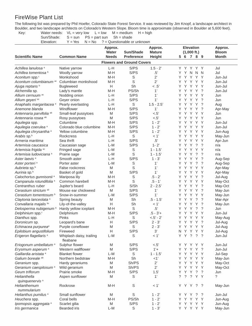
FireWise Plant ListThe following list was prepared by Phil Hoefer, Colorado State Forest Service. It was reviewed by Jim Knopf, a landscape architect in Boulder, and two landscape architects on Colorado’s Western Slope. Bloom time is approximate (observed in Boulder at 5,600 feet). Key: Water needs: VL = very low L = low M = medium H = high Sun/Shade: S = sun PS = part sun Sh = shade Elevation: Y = Yes N = No ? = Questionable or unknown
Approx. Approx. Elevation Approx. Water Sun/Shade Mature (1,000 ft.) BloomScientific Name Common Name Needs Preference Height 5 6 7 8 9 Month
Flowers and Ground Covers
Achillea lanulosa a Native yarrow L-H S/PS 1.5 - 2’ Y Y Y Y Y JulAchillea tomentosa b Woolly yarrow M-H S/PS .5’ Y Y N N N JulAconitum spp.c Monkshood M-H S 2’ Y Y Y Y Y Jun-JulAconitum columbianum ac Columbian monkshood M-H S 2’ Y Y Y Y Y Jun-JulAjuga reptans b Bugleweed H Sh < .5’ Y Y Y Y Y Jun-JulAlchemilla sp. Lady’s mantle M-H PS/Sh 1’ Y Y Y Y ? Jun-JulAllium cernuum ac Nodding onion L-H S/PS 1’ Y Y Y Y Y JunAllium geyeri ac Geyer onion L-H S/PS 1’ Y Y Y Y ? JunAnaphalis margaritacea a Pearly everlasting L-H S 1.5 - 2.5’ Y Y Y Y ? AugAnemone blanda Windflower M-H S/PS 1’ Y Y Y Y ? Apr-MayAntennaria parvifolia ab Small-leaf pussytoes M S/PS <.5’ Y Y Y Y Y JunAntennaria rosea ab Rosy pussytoes M S/PS <.5’ Y Y Y Y Y JunAquilegia spp. Columbine M-H S/PS 1 - 2’ Y Y Y Y Y Jun-Jul Aquilegia coerulea a Colorado blue columbine M-H S/PS 1 - 2’ Y Y Y Y Y Jun-JulAquilegia chrysantha a Yellow columbine M-H S/PS 1 - 2’ Y Y Y Y Y Jun-AugArabis sp.b Rockcress L-H S < 1’ Y Y Y Y Y May-JunArmeria maritima Sea thrift L-H S/PS .5’ Y Y Y Y Y Apr-JunArtemisia caucasica Caucasian sage L-M S/PS 1- 2’ Y Y Y ? ? n/aArtemisia frigida ac Fringed sage L-M S 1 - 1.5’ Y Y Y Y Y n/aArtemisia ludoviciana a Prairie sage L-M S 1 - 1.5’ Y Y Y ? ? n/aAster laevis a Smooth aster L-H S/PS 1 - 3’ Y Y Y Y ? Aug-SepAster porteri a Porter aster L-M S 1’ Y Y Y ? ? Aug-SepAubrieta sp.b False rockcress M S 1’ Y Y Y Y Y Apr-MayAurinia sp.b Basket of gold M S/PS 1’ Y Y Y Y Y Apr-MayCalochortus gunnisonii a Mariposa lily M-H S .5 - 2’ Y Y Y Y ? Jul-AugCampanula rotundifolia a Common harebell M-H S .5 - 1’ Y Y Y Y Y May-OctCentranthus ruber Jupiter’s beard L-H S/Sh 2 - 2.5’ Y Y Y Y ? May-OctCerastium strictum ab Mouse ear chickweed M S/PS 1’ Y Y Y Y ? May-JunCerastium tomentosum b Snow-in-summer L-M S/PS 1’ Y Y Y Y Y May-JunClaytonia lanceolata a Spring beauty M Sh .5 - 1.5’ Y Y Y ? ? Mar-AprConvallaria majalis bc Lily-of-the-valley H Sh < 1’ Y Y Y Y ? May-JunDelosperma nubigenum b Hardy yellow iceplant M-H S .5’ Y Y Y ? ? JunDelphinium spp.c Delphinium M-H S/PS .5 - 3’+ Y Y Y Y Y Jun-JulDianthus spp. Pinks L-H S <.5’ - 2’ Y Y Y Y Y May-AugDoronicum sp. Leopard’s bane H S/PS 2 - 3’ Y Y Y Y ? Jul-AugEchinacea purpureaa Purple coneflower M S 2 - 3’ Y Y Y Y Y Jul-AugEpilobium angustifolium Fireweed H S/PS 3’ N Y Y Y Y Jul-AugErigeron flagellaris a Whiplash daisy, trailing L-M S < 1’ Y Y ? ? ? Jun-Jul fleabaneEriogonum umbellatum a Sulphur flower M S/PS <.5’ Y Y Y Y Y Jun-JulErysimum asperum a Western wallflower M S/PS 1’+ Y Y Y Y ? Jun-JulGaillardia aristata a Blanket flower L-M S 1 - 1.5’ Y Y Y Y Y Jul-SepGalium boreale ab Northern bedstraw M-H Sh <1’ Y Y Y Y Y May-JunGeranium spp. Hardy geraniums M Sh/PS 2’ Y Y Y Y Y May-OctGeranium caespitosum a Wild geranium M Sh/PS 2’ Y Y Y Y Y May-OctGeum triflorum Prairie smoke M-H S/PS 1.5’ Y Y Y ? ? JunHelianthella Aspen sunflower M S 1’ ? ? ? Y Y ? quinquenervis a
Helianthemum Rockrose M-H S < 1’ Y Y Y ? ? May-Jun nummulariumHelianthus pumilus a Small sunflower M S 1 - 2’ Y Y Y ? ? Jun-JulHeuchera spp. Coral bells M-H PS/Sh 1 - 2’ Y Y Y Y Y Jun-AugIpomopsis aggregata a Scarlet gilia M S/PS 1 - 2’ Y Y Y Y Y Jun-AugIris germanica Bearded iris L-M S 1 - 3’ Y Y Y Y Y May-Jun
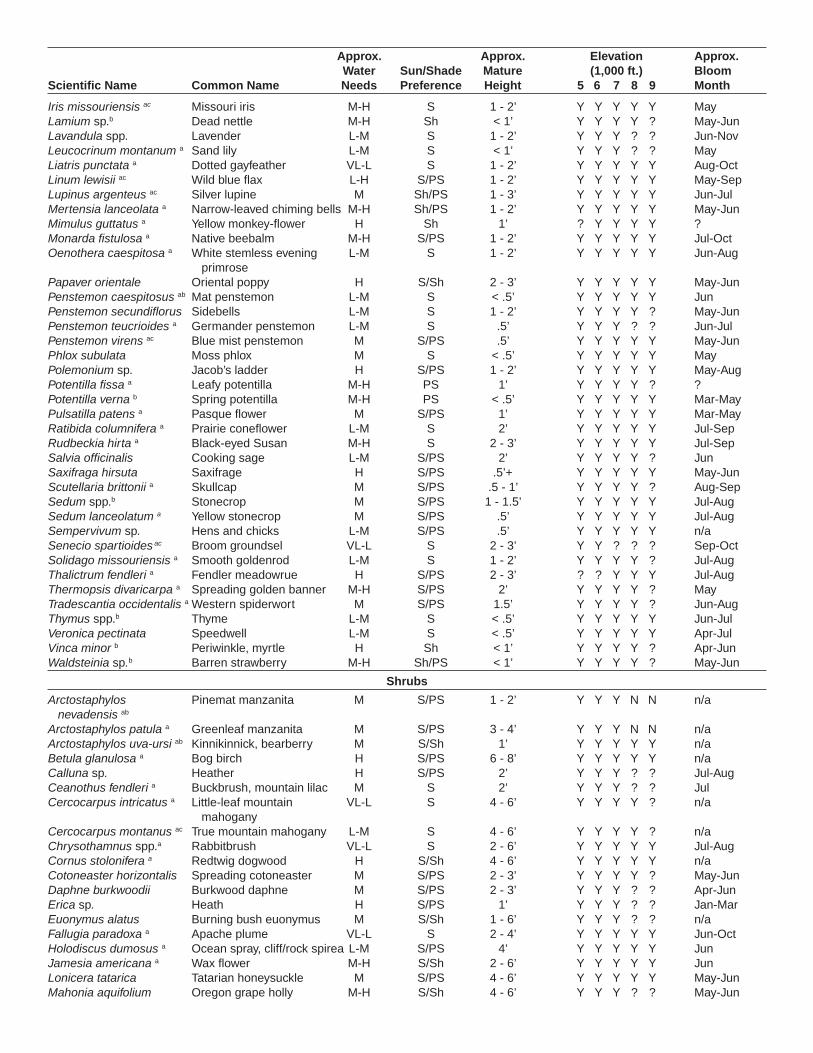
Iris missouriensis ac Missouri iris M-H S 1 - 2’ Y Y Y Y Y MayLamium sp.b Dead nettle M-H Sh < 1’ Y Y Y Y ? May-JunLavandula spp. Lavender L-M S 1 - 2’ Y Y Y ? ? Jun-NovLeucocrinum montanum a Sand lily L-M S < 1’ Y Y Y ? ? MayLiatris punctata a Dotted gayfeather VL-L S 1 - 2’ Y Y Y Y Y Aug-OctLinum lewisii ac Wild blue flax L-H S/PS 1 - 2’ Y Y Y Y Y May-SepLupinus argenteus ac Silver lupine M Sh/PS 1 - 3’ Y Y Y Y Y Jun-JulMertensia lanceolata a Narrow-leaved chiming bells M-H Sh/PS 1 - 2’ Y Y Y Y Y May-JunMimulus guttatus a Yellow monkey-flower H Sh 1’ ? Y Y Y Y ?Monarda fistulosa a Native beebalm M-H S/PS 1 - 2’ Y Y Y Y Y Jul-OctOenothera caespitosa a White stemless evening L-M S 1 - 2’ Y Y Y Y Y Jun-Aug primrosePapaver orientale Oriental poppy H S/Sh 2 - 3’ Y Y Y Y Y May-JunPenstemon caespitosus ab Mat penstemon L-M S < .5’ Y Y Y Y Y JunPenstemon secundiflorus Sidebells L-M S 1 - 2’ Y Y Y Y ? May-JunPenstemon teucrioides a Germander penstemon L-M S .5’ Y Y Y ? ? Jun-JulPenstemon virens ac Blue mist penstemon M S/PS .5’ Y Y Y Y Y May-JunPhlox subulata Moss phlox M S < .5’ Y Y Y Y Y MayPolemonium sp. Jacob’s ladder H S/PS 1 - 2’ Y Y Y Y Y May-AugPotentilla fissa a Leafy potentilla M-H PS 1’ Y Y Y Y ? ?Potentilla verna b Spring potentilla M-H PS < .5’ Y Y Y Y Y Mar-MayPulsatilla patens a Pasque flower M S/PS 1’ Y Y Y Y Y Mar-MayRatibida columnifera a Prairie coneflower L-M S 2’ Y Y Y Y Y Jul-SepRudbeckia hirta a Black-eyed Susan M-H S 2 - 3’ Y Y Y Y Y Jul-SepSalvia officinalis Cooking sage L-M S/PS 2’ Y Y Y Y ? JunSaxifraga hirsuta Saxifrage H S/PS .5’+ Y Y Y Y Y May-JunScutellaria brittonii a Skullcap M S/PS .5 - 1’ Y Y Y Y ? Aug-SepSedum spp.b Stonecrop M S/PS 1 - 1.5’ Y Y Y Y Y Jul-AugSedum lanceolatum a Yellow stonecrop M S/PS .5’ Y Y Y Y Y Jul-AugSempervivum sp. Hens and chicks L-M S/PS .5’ Y Y Y Y Y n/aSenecio spartioides ac Broom groundsel VL-L S 2 - 3’ Y Y ? ? ? Sep-OctSolidago missouriensis a Smooth goldenrod L-M S 1 - 2’ Y Y Y Y ? Jul-AugThalictrum fendleri a Fendler meadowrue H S/PS 2 - 3’ ? ? Y Y Y Jul-AugThermopsis divaricarpa a Spreading golden banner M-H S/PS 2’ Y Y Y Y ? MayTradescantia occidentalis a Western spiderwort M S/PS 1.5’ Y Y Y Y ? Jun-AugThymus spp.b Thyme L-M S < .5’ Y Y Y Y Y Jun-JulVeronica pectinata Speedwell L-M S < .5’ Y Y Y Y Y Apr-JulVinca minor b Periwinkle, myrtle H Sh < 1’ Y Y Y Y ? Apr-JunWaldsteinia sp.b Barren strawberry M-H Sh/PS < 1’ Y Y Y Y ? May-Jun
Shrubs
Arctostaphylos Pinemat manzanita M S/PS 1 - 2’ Y Y Y N N n/a nevadensis ab Arctostaphylos patula a Greenleaf manzanita M S/PS 3 - 4’ Y Y Y N N n/aArctostaphylos uva-ursi ab Kinnikinnick, bearberry M S/Sh 1’ Y Y Y Y Y n/aBetula glanulosa a Bog birch H S/PS 6 - 8’ Y Y Y Y Y n/aCalluna sp. Heather H S/PS 2’ Y Y Y ? ? Jul-AugCeanothus fendleri a Buckbrush, mountain lilac M S 2’ Y Y Y ? ? JulCercocarpus intricatus a Little-leaf mountain VL-L S 4 - 6’ Y Y Y Y ? n/a mahoganyCercocarpus montanus ac True mountain mahogany L-M S 4 - 6’ Y Y Y Y ? n/aChrysothamnus spp.a Rabbitbrush VL-L S 2 - 6’ Y Y Y Y Y Jul-AugCornus stolonifera a Redtwig dogwood H S/Sh 4 - 6’ Y Y Y Y Y n/aCotoneaster horizontalis Spreading cotoneaster M S/PS 2 - 3’ Y Y Y Y ? May-JunDaphne burkwoodii Burkwood daphne M S/PS 2 - 3’ Y Y Y ? ? Apr-JunErica sp. Heath H S/PS 1’ Y Y Y ? ? Jan-MarEuonymus alatus Burning bush euonymus M S/Sh 1 - 6’ Y Y Y ? ? n/aFallugia paradoxa a Apache plume VL-L S 2 - 4’ Y Y Y Y Y Jun-OctHolodiscus dumosus a Ocean spray, cliff/rock spirea L-M S/PS 4’ Y Y Y Y Y Jun Jamesia americana a Wax flower M-H S/Sh 2 - 6’ Y Y Y Y Y JunLonicera tatarica Tatarian honeysuckle M S/PS 4 - 6’ Y Y Y Y Y May-JunMahonia aquifolium Oregon grape holly M-H S/Sh 4 - 6’ Y Y Y ? ? May-Jun
Approx. Approx. Elevation Approx. Water Sun/Shade Mature (1,000 ft.) BloomScientific Name Common Name Needs Preference Height 5 6 7 8 9 Month
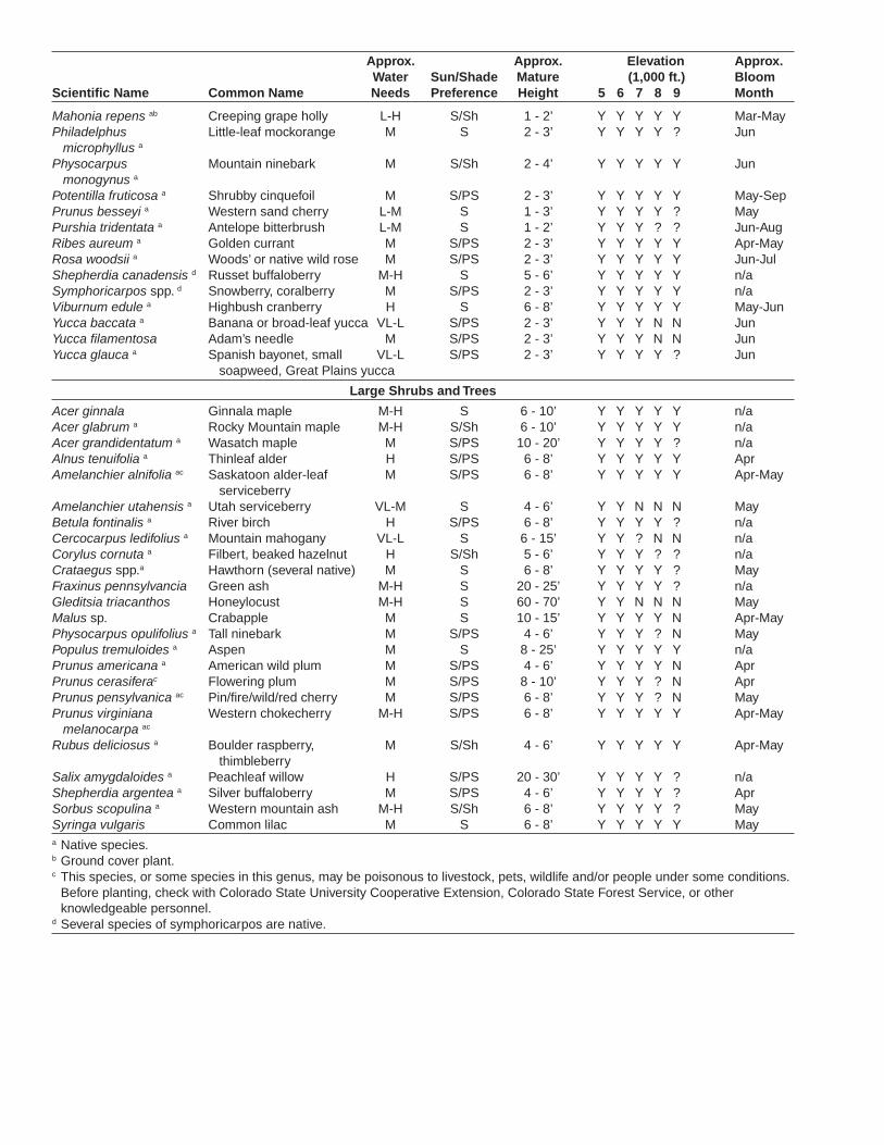
Mahonia repens ab Creeping grape holly L-H S/Sh 1 - 2’ Y Y Y Y Y Mar-MayPhiladelphus Little-leaf mockorange M S 2 - 3’ Y Y Y Y ? Jun microphyllus a
Physocarpus Mountain ninebark M S/Sh 2 - 4’ Y Y Y Y Y Jun monogynus a
Potentilla fruticosa a Shrubby cinquefoil M S/PS 2 - 3’ Y Y Y Y Y May-SepPrunus besseyi a Western sand cherry L-M S 1 - 3’ Y Y Y Y ? MayPurshia tridentata a Antelope bitterbrush L-M S 1 - 2’ Y Y Y ? ? Jun-AugRibes aureum a Golden currant M S/PS 2 - 3’ Y Y Y Y Y Apr-MayRosa woodsii a Woods’ or native wild rose M S/PS 2 - 3’ Y Y Y Y Y Jun-JulShepherdia canadensis d Russet buffaloberry M-H S 5 - 6’ Y Y Y Y Y n/aSymphoricarpos spp. d Snowberry, coralberry M S/PS 2 - 3’ Y Y Y Y Y n/aViburnum edule a Highbush cranberry H S 6 - 8’ Y Y Y Y Y May-JunYucca baccata a Banana or broad-leaf yucca VL-L S/PS 2 - 3’ Y Y Y N N Jun Yucca filamentosa Adam’s needle M S/PS 2 - 3’ Y Y Y N N JunYucca glauca a Spanish bayonet, small VL-L S/PS 2 - 3’ Y Y Y Y ? Jun soapweed, Great Plains yucca
Large Shrubs and Trees
Acer ginnala Ginnala maple M-H S 6 - 10’ Y Y Y Y Y n/aAcer glabrum a Rocky Mountain maple M-H S/Sh 6 - 10’ Y Y Y Y Y n/aAcer grandidentatum a Wasatch maple M S/PS 10 - 20’ Y Y Y Y ? n/aAlnus tenuifolia a Thinleaf alder H S/PS 6 - 8’ Y Y Y Y Y AprAmelanchier alnifolia ac Saskatoon alder-leaf M S/PS 6 - 8’ Y Y Y Y Y Apr-May serviceberryAmelanchier utahensis a Utah serviceberry VL-M S 4 - 6’ Y Y N N N MayBetula fontinalis a River birch H S/PS 6 - 8’ Y Y Y Y ? n/aCercocarpus ledifolius a Mountain mahogany VL-L S 6 - 15’ Y Y ? N N n/aCorylus cornuta a Filbert, beaked hazelnut H S/Sh 5 - 6’ Y Y Y ? ? n/aCrataegus spp.a Hawthorn (several native) M S 6 - 8’ Y Y Y Y ? MayFraxinus pennsylvancia Green ash M-H S 20 - 25’ Y Y Y Y ? n/aGleditsia triacanthos Honeylocust M-H S 60 - 70’ Y Y N N N MayMalus sp. Crabapple M S 10 - 15’ Y Y Y Y N Apr-MayPhysocarpus opulifolius a Tall ninebark M S/PS 4 - 6’ Y Y Y ? N MayPopulus tremuloides a Aspen M S 8 - 25’ Y Y Y Y Y n/aPrunus americana a American wild plum M S/PS 4 - 6’ Y Y Y Y N AprPrunus cerasiferac Flowering plum M S/PS 8 - 10’ Y Y Y ? N AprPrunus pensylvanica ac Pin/fire/wild/red cherry M S/PS 6 - 8’ Y Y Y ? N MayPrunus virginiana Western chokecherry M-H S/PS 6 - 8’ Y Y Y Y Y Apr-May melanocarpa ac
Rubus deliciosus a Boulder raspberry, M S/Sh 4 - 6’ Y Y Y Y Y Apr-May thimbleberrySalix amygdaloides a Peachleaf willow H S/PS 20 - 30’ Y Y Y Y ? n/aShepherdia argentea a Silver buffaloberry M S/PS 4 - 6’ Y Y Y Y ? AprSorbus scopulina a Western mountain ash M-H S/Sh 6 - 8’ Y Y Y Y ? MaySyringa vulgaris Common lilac M S 6 - 8’ Y Y Y Y Y Maya Native species.b Ground cover plant.c This species, or some species in this genus, may be poisonous to livestock, pets, wildlife and/or people under some conditions.
Before planting, check with Colorado State University Cooperative Extension, Colorado State Forest Service, or other knowledgeable personnel.
d Several species of symphoricarpos are native.
Approx. Approx. Elevation Approx. Water Sun/Shade Mature (1,000 ft.) BloomScientific Name Common Name Needs Preference Height 5 6 7 8 9 Month
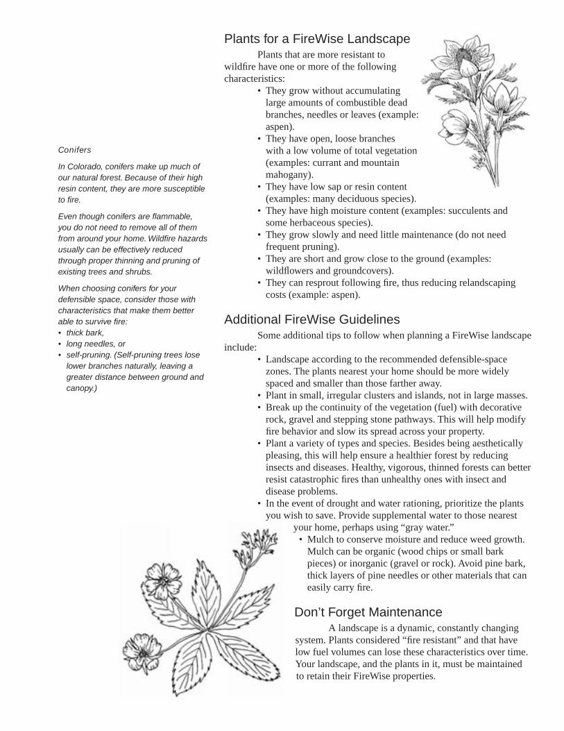
Plants for a FireWise LandscapePlants that are more resistant to
wildfire have one or more of the following characteristics:
• They grow without accumulating large amounts of combustible dead branches, needles or leaves (example: aspen).
• They have open, loose branches with a low volume of total vegetation (examples: currant and mountain mahogany).
• They have low sap or resin content (examples: many deciduous species).
• They have high moisture content (examples: succulents and some herbaceous species).
• They grow slowly and need little maintenance (do not need frequent pruning).
• They are short and grow close to the ground (examples: wildflowers and groundcovers).
• They can resprout following fire, thus reducing relandscaping costs (example: aspen).
Additional FireWise GuidelinesSome additional tips to follow when planning a FireWise landscape
include:• Landscape according to the recommended defensible-space
zones. The plants nearest your home should be more widely spaced and smaller than those farther away.
• Plant in small, irregular clusters and islands, not in large masses. • Break up the continuity of the vegetation (fuel) with decorative
rock, gravel and stepping stone pathways. This will help modify fire behavior and slow its spread across your property.
• Plant a variety of types and species. Besides being aesthetically pleasing, this will help ensure a healthier forest by reducing insects and diseases. Healthy, vigorous, thinned forests can better resist catastrophic fires than unhealthy ones with insect and disease problems.
• In the event of drought and water rationing, prioritize the plants you wish to save. Provide supplemental water to those nearest
your home, perhaps using “gray water.”• Mulch to conserve moisture and reduce weed growth.
Mulch can be organic (wood chips or small bark pieces) or inorganic (gravel or rock). Avoid pine bark, thick layers of pine needles or other materials that can easily carry fire.
Don’t Forget MaintenanceA landscape is a dynamic, constantly changing
system. Plants considered “fire resistant” and that have low fuel volumes can lose these characteristics over time. Your landscape, and the plants in it, must be maintained to retain their FireWise properties.
Conifers
In Colorado, conifers make up much of our natural forest. Because of their high resin content, they are more susceptible to fire.
Even though conifers are flammable, you do not need to remove all of them from around your home. Wildfire hazards usually can be effectively reduced through proper thinning and pruning of existing trees and shrubs.
When choosing conifers for your defensible space, consider those with characteristics that make them better able to survive fire: • thick bark, • long needles, or • self-pruning. (Self-pruning trees lose
lower branches naturally, leaving a greater distance between ground and canopy.)
Be aware of the growth habits of the plants on your land and of the changes that occur seasonally. Keep a watchful eye for the need to reduce fuel volumes and fuel continuity.
• Remove annual, herbaceous plants after they have gone to seed or when the stems become overly dry.
• Rake up and dispose of litter as it builds up over the season.• Mow or trim grasses to a low height within your defensible space. This
is especially important as they begin to cure and dry.• Remove plant parts damaged by snow, wind, frost or other agents. • Timely pruning is critical. It not only reduces fuel volume but also
maintains healthier plants with more succulent, vigorous growth.
Additional FireWise Publications
Cooperative ExtensionThe following publications are available from The Other Bookstore,
Colorado State University Cooperative Extension, 115 General Services Bldg., Fort Collins, CO 80523-4061; (970) 491-6198; [email protected]. Printed copies cost $1; they are available free on our Web site at www.cerc.colostate.edu:
• 6.302, Creating Wildfire-Defensible Zones• 6.303, Fire-Resistant Landscaping• 6.304, Fire Safety, Evacuation and Home Defense• 6.306, Grass Seed Mixes for the Reduction of Wildfire Hazard• 7.205, Pruning Evergreens• 7.206, Pruning Shrubs• 7.207, Pruning Deciduous Trees• 7.402, Protecting Trees During Construction
Colorado State Forest ServiceThe following publication is available from the Colorado State Forest
Service, Colorado State University, Fort Collins, CO 80523-5060; (970) 491-6303:• Home Fire Protection in the Wildland Urban Interface, CSFS #142-399
FIREWISE is a multi-agency program that encourages the development of defensible space and the prevention of catastrophic wildfire.
Colorado State University, U.S. Department of Agriculture and Colorado counties cooperating. Cooperative Extension programs are available to all without discrimination. No endorsement of products mentioned is intended nor is criticism implied of products not mentioned.
This fact sheet was produced in cooperationwith the Colorado State Forest Service.
1 Wildfire Hazard Mitigation Coordinator, Colorado State Forest Service.

Appendix F
Cheatgrass and Wildfire
34
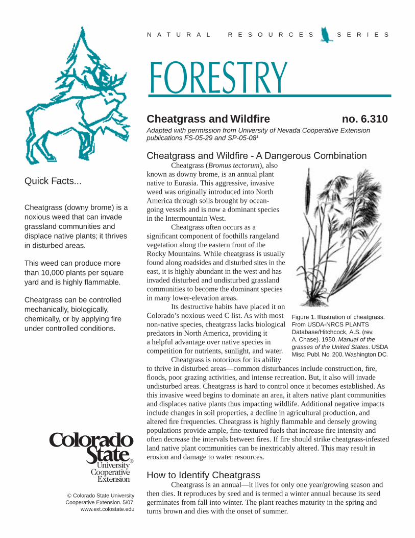
Colorado State University Cooperative Extension. 5/07.
www.ext.colostate.edu
N A T U R A L R E S O U R C E S S E R I E S
FORESTRYCheatgrass and Wildfire no. 6.310
Quick Facts...
Cheatgrass (downy brome) is a noxious weed that can invade grassland communities and displace native plants; it thrives in disturbed areas.
This weed can produce more than 10,000 plants per square yard and is highly flammable.
Cheatgrass can be controlled mechanically, biologically, chemically, or by applying fire under controlled conditions.
Cheatgrass and Wildfire - A Dangerous CombinationCheatgrass (Bromus tectorum), also
known as downy brome, is an annual plant native to Eurasia. This aggressive, invasive weed was originally introduced into North America through soils brought by ocean-going vessels and is now a dominant species in the Intermountain West.
Cheatgrass often occurs as a significant component of foothills rangeland vegetation along the eastern front of the Rocky Mountains. While cheatgrass is usually found along roadsides and disturbed sites in the east, it is highly abundant in the west and has invaded disturbed and undisturbed grassland communities to become the dominant species in many lower-elevation areas.
Its destructive habits have placed it on Colorado’s noxious weed C list. As with most non-native species, cheatgrass lacks biological predators in North America, providing it a helpful advantage over native species in competition for nutrients, sunlight, and water.
Cheatgrass is notorious for its ability to thrive in disturbed areas—common disturbances include construction, fire, floods, poor grazing activities, and intense recreation. But, it also will invade undisturbed areas. Cheatgrass is hard to control once it becomes established. As this invasive weed begins to dominate an area, it alters native plant communities and displaces native plants thus impacting wildlife. Additional negative impacts include changes in soil properties, a decline in agricultural production, and altered fire frequencies. Cheatgrass is highly flammable and densely growing populations provide ample, fine-textured fuels that increase fire intensity and often decrease the intervals between fires. If fire should strike cheatgrass-infested land native plant communities can be inextricably altered. This may result in erosion and damage to water resources.
How to Identify CheatgrassCheatgrass is an annual—it lives for only one year/growing season and
then dies. It reproduces by seed and is termed a winter annual because its seed germinates from fall into winter. The plant reaches maturity in the spring and turns brown and dies with the onset of summer.
Adapted with permission from University of Nevada Cooperative Extension publications FS-05-29 and SP-05-081
Figure 1. Illustration of cheatgrass. From USDA-NRCS PLANTS Database/Hitchcock, A.S. (rev. A. Chase). 1950. Manual of the grasses of the United States. USDA Misc. Publ. No. 200. Washington DC.
The height of cheatgrass ranges from three to 30 inches. It has a crooked seed head and small soft hairs covering the entire body of the plant. Leaves emerge dark green with a hint of purple. As it matures and begins to cure, cheatgrass turns yellow to reddish-brown in color with seed heads ranging from two to six inches long at maturity. These seeds have wedged awns that may be dispersed by wind and water, but most often they are spread by adhering to clothes or to the coat of a wild or domestic animal.
Fire HazardsThe early-season growth habits of cheatgrass provide a competitive
advantage by allowing it to grow tall and abundant before native species emerge. During years of high precipitation, this grass can produce more than 10,000 plants per square yard. Cheatgrass turns brown and dies by early summer leaving behind thick, continuous dry fuels and creating extreme wildfire hazards.
Though several components can affect flame length and fire spread, a typical cheatgrass fire on flat terrain with wind speeds of 20 miles per hour may generate flame lengths up to eight feet in height; the fire can travel more than four miles per hour. Grass fires are dangerous because they move quickly and grasses act as ladder fuels igniting larger and more volatile vegetation.
Due to these readily combustible characteristics, it is critical for those who live, play, or work in “cheatgrass country” to know not only how to identify and eradicate it, but also take precautions not to ignite it:
• Keep vehicles on well-maintained roads at all times. Fires can ignite as a result of hot car exhaust systems coming in contact with tall, dry fuels.
• Build campfires on bare ground in contained or designated areas. Make sure campfires are out completely before you leave.
• During hunting season or target practice, be aware of fires that may ignite due to stray bullets hitting solid objects and thus creating sparks.
• Supervise hay-baling and wheat harvesting operations closely to prevent ignition of dry fuels.
• Dispose of cigarette butts and matches properly.• Use and maintain approved spark arresters on all power equipment.• Keep an eye out for rocks and metal when brush hogging or mowing;
sparks generated could start wildfires.• Monitor sparks when using welding equipment. Have a fire
extinguisher available.• Instruct children to never play with fire or fireworks.
A Concern for HomeownersCheatgrass is highly flammable and therefore a concern for homeowners.
Clear this grass from within the area 30 feet immediately surrounding your home. Cheatgrass can act as a ladder fuel to ignite larger fuels; these can, in turn, throw burning embers and pose an even larger threat. Grass should be mowed to a minimum of six inches or less. Keep yards clean and green. Perform routine vegetation maintenance around your home and high-value property areas to mitigate potential problems.
Control MethodsCheatgrass can be controlled mechanically, biologically, chemically,
or by applying fire under controlled conditions. The best results usually come from a combination of some or all of these techniques. The key to eradicating cheatgrass is diligence—once you begin the process you must be persistent and continue follow up treatments for up to four or five years (or however long it might take) because cheatgrass seed may survive in soils this long.
How can homeowners eradicate cheatgrass?Cheatgrass can be removed by hand pulling or mechanical techniques
(i.e., a lawn mower, weed whacker, disking); remove the grass before it has time to mature, produce seed, and cure (turn brown and die). Once cheatgrass has been removed, rototill the soil to a three inch depth. Plant the area with desirable species, water properly, and maintain.
Mechanical TreatmentsHand pulling – during spring and fall; repeat when new plants appear;
effective in small areas only.Disking/tilling (live plants) – spring and fall before the seed heads turn
purple; repeat when new plants appear; use disk, rototiller, spike-tooth harrow, etc.Disking/tilling (seeds) – once in late spring before seeding with desirable
species in the fall; bury seeds at least three inches deep to prevent germination.Mowing – not recommended as a long-term control technique as seed
may be produced by mown plants.
Biological TreatmentsLivestock grazing – graze, very heavily, twice in early in spring
(approximately three weeks apart) when the grass is green but prior to seed formation; repeat for at least two years.
Chemical TreatmentsA few chemical formulations exist, such as Plateau or Roundup, that may
control or even eradicate cheatgrass. However, before using any chemical make sure that the herbicide label lists cheatgrass; if it is not listed, do not use. No one herbicide will control all weed species. Combinations of herbicides may be required for control. As always, follow all instructions on the label. For more assistance with chemical cheatgrass control, contact your county weed office or your local Colorado State University Extension office.
Controlled Burning Treatment – late spring and summer; controlled burning has associated risks which should be addressed in a prescribed burn plan. If not done correctly, prescribed burns may escape control and become wildfires, produce smoke that impairs visibility on highways or impacts individuals with respiratory problems, and may cause damage to desirable vegetation. Consultation with a prescribed fire/controlled burn specialist is recommended when developing a prescribed burn plan. Prescribed burn plans may require local and/or state burning permits. Contact your county sheriff or local fire official prior to burning.
Colorado State University, U.S. Department of Agriculture, and Colorado counties cooperating. CSU Extension programs are available to all without discrimination. No endorsement of products mentioned is intended nor is criticism implied of products not mentioned.
1J. Davison, central/northeast area plant and soils specialist, University of Nevada; E. Smith, western area natural resource specialist, University of Nevada Cooperative Extension. Colorado adaptation by G. Beck, Colorado State University Extension weed specialist and professor, department of bioagricultural sciences and pest management.
For More Information
To learn more about cheatgrass and proper control methods contact your county weed district or Colorado State University Extension office.
Colorado State Forest Service, Colorado State University, Fort Collins, CO 80523-5060; (970) 491-6303; http://csfs.colostate.edu
Colorado State University Extension, 115 General Services Building, Fort Collins, CO 80523-4061; (970) 491-6198; E-mail: [email protected]:
• 6.303, Fire-Resistant Landscaping • 6.304, Forest Home Fire Safety • 6.305, FireWise Plant Materials • 6.306, Grass Seed Mixes to Reduce Wildfire Hazard

35
Appendix G
Firewise Construction Design and Materials
FireWise Construction: Site Design & Building MaterialsBased on the 2009 International Wildland-Urban Interface Code
About the AuthorsDavid Bueche, Ph.D., of Lakewood, Colo., works for Hoover Treated Wood Products, a major producer of fire-retardant-treated wood. He has more than 30 years of construction experience in both academia and industry. In addition to his hands-on experience as a carpenter, superintendent and project manager, he has been a research scientist at Colorado State University, taught college courses in construction and forest products, was a field representative for APA – The Engineered Wood Association and an applications engineer for the American Galvanizers Association. He is active in building code development, serves on the National Fire Protection Association (NFPA) and American Society for Testing and Materials (ASTM) commit tees that develop standards on the performance of materials in fire and building construc tion, is a member of the Society of Fire Protection Engineers, the Society of Wood Science and Technology and the Forest Products Society. David developed sections 4 and 5 of this publication based on the 2009 International Wildland-Urban Interface Code.
Tim Foley most recently worked for the Colorado State Forest Service as the Northwest Colorado Fire Management Officer. Tim started his wildfire career with the Pike Hot Shots in 1977. He then worked for the Bureau of Land Management as a West Zone Fire Management Officer for the Upper Colorado River Interagency Fire Management Unit. Tim also serves on a wildfire Type 1 Team as a fire behavior analyst and fire investigator.Tim was the main author of the first three sections of this publication.
DedicationPeter Slack of Boulder, Colo., was a practicing architect for 26 years, until his untimely death in June 2000. Peter designed many homes and other buildings in the wildland-urban interface (WUI). His designs emphasized the integration of fire-resistive elements with other important design principles, such as proper site development for limited impact, low energy and water consumption, and the use of appropriate, resource-conserving materials.
Peter developed the first iteration of this publication in 1999.
AcknowledgementsOur thanks to the following for reviewing publication drafts:
Steve Quarles, Insurance Institute for Business and Home SafetyChris Jennings, APA - The Engineered Wood Association
Special thanks to:Judy Serby, Conservation Education Program Manager, and Katherine Timm, Outreach Division Supervisor, Colorado State Forest Service, for providing leadership in the production of this report.
December 2012
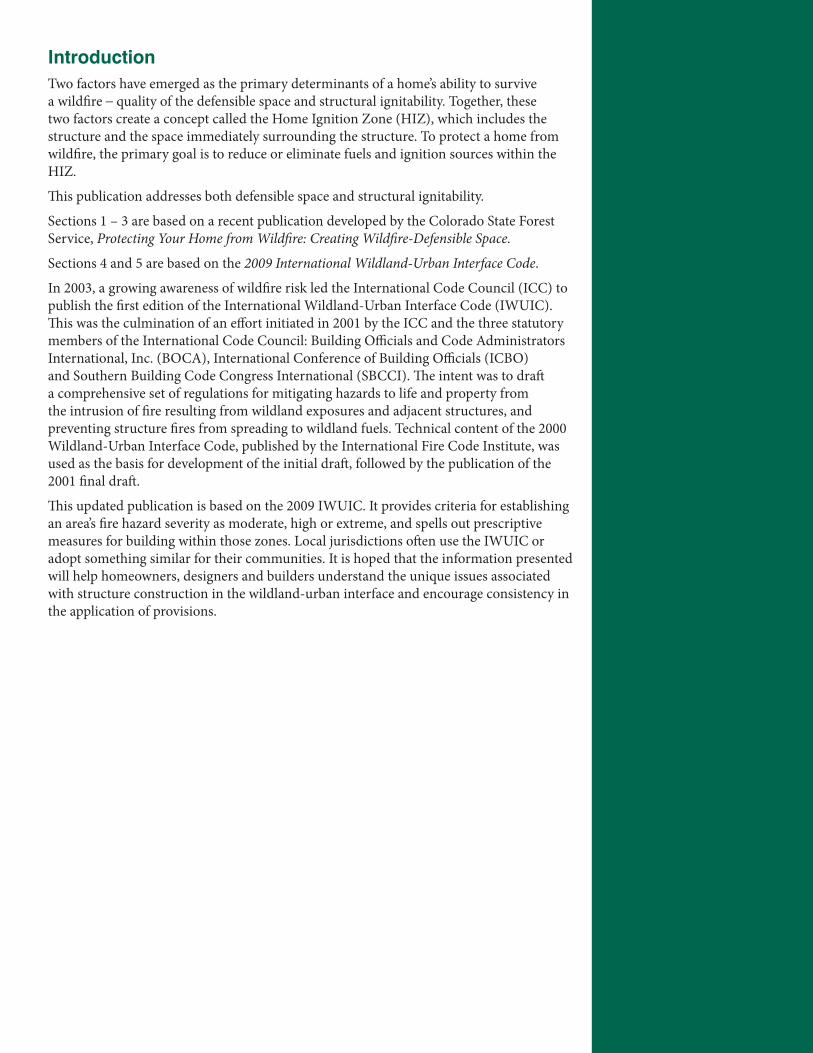
IntroductionTwo factors have emerged as the primary determinants of a home’s ability to survive a wildfire – quality of the defensible space and structural ignitability. Together, these two factors create a concept called the Home Ignition Zone (HIZ), which includes the structure and the space immediately surrounding the structure. To protect a home from wildfire, the primary goal is to reduce or eliminate fuels and ignition sources within the HIZ.
This publication addresses both defensible space and structural ignitability.
Sections 1 – 3 are based on a recent publication developed by the Colorado State Forest Service, Protecting Your Home from Wildfire: Creating Wildfire-Defensible Space.
Sections 4 and 5 are based on the 2009 International Wildland-Urban Interface Code.
In 2003, a growing awareness of wildfire risk led the International Code Council (ICC) to publish the first edition of the International Wildland-Urban Interface Code (IWUIC). This was the culmination of an effort initiated in 2001 by the ICC and the three statutory members of the International Code Council: Building Officials and Code Administrators International, Inc. (BOCA), International Conference of Building Officials (ICBO) and Southern Building Code Congress International (SBCCI). The intent was to draft a comprehensive set of regulations for mitigating hazards to life and property from the intrusion of fire resulting from wildland exposures and adjacent structures, and preventing structure fires from spreading to wildland fuels. Technical content of the 2000 Wildland-Urban Interface Code, published by the International Fire Code Institute, was used as the basis for development of the initial draft, followed by the publication of the 2001 final draft.
This updated publication is based on the 2009 IWUIC. It provides criteria for establishing an area’s fire hazard severity as moderate, high or extreme, and spells out prescriptive measures for building within those zones. Local jurisdictions often use the IWUIC or adopt something similar for their communities. It is hoped that the information presented will help homeowners, designers and builders understand the unique issues associated with structure construction in the wildland-urban interface and encourage consistency in the application of provisions.

Table of Contents1. Wildfire in Colorado. . . . . . . . . . . . . . . . . . . . . . . . . .1 What is the Wildland-Urban Interface? Fire suppression and increased fuelsHow can we protect our homes?Fire intensity and duration related to the fire resistance of a structureEvaluating fire hazard
2. Fire Behavior: Fuels, Topography and Weather. . . . . . . . 4Wildfires and burning structuresVegetation is the fuel for wildfiresFire duration and fuelFire behavior and slopeFire behavior, ignition of fuels: mechanisms of heat transferConvective liftingIndirect: convective heatingRadiant heatingDirect contact or impingementWeather
3. Building-site Location and Landscaping . . . . . . . . . . . . . 9Topography and vegetation: fire behavior and intensityAspectDangerous topographic features: areas of more intense fire behaviorNatural barriers and buffer zonesEffects on structure location and design decisionsSite design and modifications to the forest: developing a defensible space
4. Building Design . . . . . . . . . . . . . . . . . . . . . . . . . . . . . . . . 13Simple vs. complex formsAspect ratioVents, eaves, soffits, gutters, downspouts and decksIgnition-resistant construction class
5. Building Materials and Components . . . . . . . . . . . . . . . 21 RatingsRoofingSidingWindows and glassDoors
6. Summary . . . . . . . . . . . . . . . . . . . . . . . . . . . . . . . . . . . . . 31
References and Additional Resources . . . . . . . . . . . . . . . 32

1
1. Wildfire in ColoradoThis publication was developed to provide homeowners, building designers/builders and landscape architects with design, building and landscaping techniques for additional protection from wildfires in the wildland-urban interface (WUI).
It is not always possible to control a wildfire. Under extreme conditions, wildfires can threaten homes and other structures, infrastructure and evacuation routes. Planning and preparation can make the difference in personal safety and home protection.
What is the wildland-urban interface?The wildland-urban interface (WUI) is any area where structures and other human development meets or intermingles with wildland vegetative fuels.
Population growth in the WUI has increased, especially in the Western U.S. The expansion of subdivisions and other high-density developments has created conditions under which local fire departments cannot possibly protect all structures during a wildfire.
Fire suppression and increased fuelsPast fire suppression and limited forest management have produced dangerous accumulations of fuels, causing hotter and more intense fires when they burn. The arrangement of these fuels causes fire to travel to the top of the forest, rather than staying close to the ground. These crown fires are extremely threatening to soils, habitat, property and people.
In some of Colorado’s forests, naturally occurring low-intensity wildfires periodically burned through stands of trees, removing fuels and thinning out excess vegetation.
As population in the WUI has increased, so too has the difficulty of protecting that population. When fires occur in the WUI, they are suppressed to prevent the destruction of homes and other values at risk. This creates a problem because historically, some forests have depended on fire to maintain good health. Fire can thin trees and brush, and eliminate dead material. By fighting wildfires to protect homes and people, this natural process has been altered and vegetation density has increased, which provides more fuel for fires. When fires occur, the dense vegetation can burn more intensely, making it more destructive and dangerous.
How can we protect our homes?Construction in virtually every jurisdiction in the United States is regulated by building codes for the purpose of providing minimum public health and safety standards. Non-governmental model building code organizations, such as the International Code Council (ICC) and the National Fire Protection Association (NFPA), develop and maintain model building codes for use by state and local jurisdictions. A model building code is not enforceable until it is adopted by a state or local jurisdiction, with or without amendments, and becomes law. Several states, including Colorado, are “home-rule states.” Under home rule, local governments have the ability to establish their own sets of codes and standards specific to their community. Because Colorado is a home-rule state and no statewide building code has been enacted as law, local jurisdictions adopt and/or adapt their own codes.
2
Typically, model codes allow the use of given building materials, while creating the parameters under which the material can be used. The concepts presented in this publication are based on the 2009 International Wildland-Urban Interface Code (IWUIC), the most widely adopted code addressing the WUI in the United States.
This comprehensive WUI code establishes minimum regulations for land use and the built environment in designated WUI areas, using prescriptive and performance-related provisions. It is founded on data collected through tests and fire incidents, technical reports and mitigation strategies from around the world. The IWUIC references the International Building Code (IBC), rather than the International Residential Code (IRC), the code most often adhered to by builders for home construction. This is because the IRC does not address several of the fire-resistive construction concepts that are necessary to meet the Ignition-Resistance Construction Classification. (Ignition-resistant building materials are those that sufficiently resist ignition or sustained flaming combustion to reduce losses from WUI conflagrations under worst-case weather and fuel conditions with wildfire exposure to burning embers and small flames.)
This publication offers a two-part approach to the problem:1. Build more ignition-resistant structures, and
2. Reduce hazardous forest fuels.
A combination of site/landscape management techniques and appropriate construction materials are necessary to build more ignition-resistant structures in the WUI. The goal is to create structures that can either resist fire on their own, or at least make it easier for firefighters to safely protect structures. Building a noncombustible structure, as often is done in urban settings, can be prohibitively expensive; this publication discusses a combination of cost-effective strategies that increase the probability a structure will survive a wildfire.
Solutions to problems in the WUI involve a two-part approach: Make structures more ignition-resistant and reduce surrounding wildland fuels. Choosing the best combination of these two strategies for a particular site requires a basic understanding of wildfire behavior.
• If we leave the surrounding wildland in its current state, we need to build structures that are resistant to fire. Noncombustible structures are very expensive to build.
• Trying to provide a defensible space large enough for a typical wood-frame structure may not be practical or desirable.
Another goal of this publication is to give homeowners, designers and builders a better understanding of how buildings in the WUI ignite during a wildfire. With this information, it is possible to make better choices when selecting building techniques and materials. However, fire is only one of many factors to consider during construction. There is no single approach, and using alternative materials or landscape management techniques is always possible.
Awareness of the unique issues landowners face when building in the WUI will help direct them toward a more comprehensive solution during the design process. Some design elements and materials may help mitigate fire hazards; some may not. It is possible, however, to compensate for less desirable fire protection choices and still meet design goals.
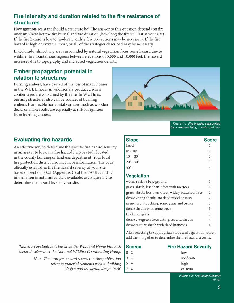
3
Fire intensity and duration related to the fire resistance of structuresHow ignition-resistant should a structure be? The answer to this question depends on fire intensity (how hot the fire burns) and fire duration (how long the fire will last at your site). If the fire hazard is low to moderate, only a few precautions may be necessary. If the fire hazard is high or extreme, most, or all, of the strategies described may be necessary.
In Colorado, almost any area surrounded by natural vegetation faces some hazard due to wildfire. In mountainous regions between elevations of 5,000 and 10,000 feet, fire hazard increases due to topography and increased vegetation density.
Ember propagation potential in relation to structuresBurning embers, have caused of the loss of many homes in the WUI. Embers in wildfires are produced when conifer trees are consumed by the fire. In WUI fires, burning structures also can be sources of burning embers. Flammable horizontal surfaces, such as wooden decks or shake roofs, are especially at risk for ignition from burning embers.
Evaluating fire hazardsAn effective way to determine the specific fire hazard severity in an area is to look at a fire hazard map or study located in the county building or land use department. Your local fire protection district also may have information. The code officially establishes the fire hazard severity of your site based on section 502.1 (Appendix C) of the IWUIC. If this information is not immediately available, use Figure 1-2 to determine the hazard level of your site.
This short evaluation is based on the Wildland Home Fire Risk Meter developed by the National Wildfire Coordinating Group.
Note: The term fire hazard severity in this publication refers to material elements used in building
design and the actual design itself.
Figure 1-1: Fire brands, transported by convective lifting, create spot fires
Slope ScoreLevel 00° - 10° 110° - 20° 220° - 30° 330°+ 4
Vegetation water, rock or bare ground 0grass, shrub, less than 2 feet with no trees 1grass, shrub, less than 4 feet, widely scattered trees 2dense young shrubs, no dead wood or trees 2many trees, touching, some grass and brush 3dense shrubs with some trees 3thick, tall grass 3dense evergreen trees with grass and shrubs 4dense mature shrub with dead branches 4
After selecting the appropriate slope and vegetation scores, add them together to determine the fire hazard severity.
Scores Fire Hazard Severity0 - 2 low3 - 4 moderate5 - 6 high7 - 8 extreme
Figure 1-2: Fire hazard severity ratings
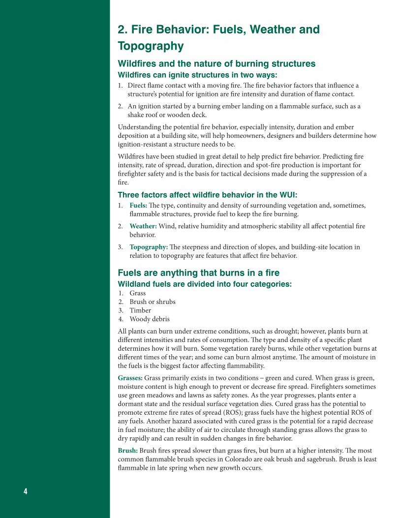
4
2. Fire Behavior: Fuels, Weather and TopographyWildfires and the nature of burning structuresWildfires can ignite structures in two ways:1. Direct flame contact with a moving fire. The fire behavior factors that influence a
structure’s potential for ignition are fire intensity and duration of flame contact.
2. An ignition started by a burning ember landing on a flammable surface, such as a shake roof or wooden deck.
Understanding the potential fire behavior, especially intensity, duration and ember deposition at a building site, will help homeowners, designers and builders determine how ignition-resistant a structure needs to be.
Wildfires have been studied in great detail to help predict fire behavior. Predicting fire intensity, rate of spread, duration, direction and spot-fire production is important for firefighter safety and is the basis for tactical decisions made during the suppression of a fire.
Three factors affect wildfire behavior in the WUI:1. Fuels: The type, continuity and density of surrounding vegetation and, sometimes,
flammable structures, provide fuel to keep the fire burning.
2. Weather: Wind, relative humidity and atmospheric stability all affect potential fire behavior.
3. Topography: The steepness and direction of slopes, and building-site location in relation to topography are features that affect fire behavior.
Fuels are anything that burns in a fireWildland fuels are divided into four categories: 1. Grass2. Brush or shrubs3. Timber4. Woody debris
All plants can burn under extreme conditions, such as drought; however, plants burn at different intensities and rates of consumption. The type and density of a specific plant determines how it will burn. Some vegetation rarely burns, while other vegetation burns at different times of the year; and some can burn almost anytime. The amount of moisture in the fuels is the biggest factor affecting flammability.
Grasses: Grass primarily exists in two conditions – green and cured. When grass is green, moisture content is high enough to prevent or decrease fire spread. Firefighters sometimes use green meadows and lawns as safety zones. As the year progresses, plants enter a dormant state and the residual surface vegetation dies. Cured grass has the potential to promote extreme fire rates of spread (ROS); grass fuels have the highest potential ROS of any fuels. Another hazard associated with cured grass is the potential for a rapid decrease in fuel moisture; the ability of air to circulate through standing grass allows the grass to dry rapidly and can result in sudden changes in fire behavior.
Brush: Brush fires spread slower than grass fires, but burn at a higher intensity. The most common flammable brush species in Colorado are oak brush and sagebrush. Brush is least flammable in late spring when new growth occurs.
5
Timber: Timber burns in two manners – as surface fires and crown fires. Surface fires consume fuels on the forest floor without burning trees, although trees may burn individually, which is called torching. Crown fires occur when entire stands of trees are totally consumed. These fires are the most intense, but tend to move less rapidly than other types of fire. Coniferous trees are more susceptible to crown fire than deciduous trees. Torching and crown fires are the major source of ember production, which can start new fires (spot-fires) in vegetation and structures downwind.
Woody debris: Dead logs, branches and sticks on the ground surface are referred to as woody debris. Debris can result from human activity, such as thinning, or from natural processes, such as wind-throw or beetle-killed trees that have fallen to the ground. Wildfires in these fuels vary greatly, but can produce high-intensity, slow-moving fires that are very difficult to control. Colorado’s mountain pine beetle epidemic will result in a major increase in woody debris over large areas.
Complexes: More than one fuel component is present in most wildland areas. Areas containing these fuel complexes are more common than those represented by a single fuel component.
Structures: The effect of a burning structure can significantly impact wildfire behavior. Structures burn with extreme intensity, often launching large burning embers over long distances.
Fuels and fire duration: Fire duration refers to the length of time a wildfire will burn under certain conditions. Fuel type, quantity, temperature and moisture content determine the duration of a fire. Building structures that will resist fires for any length of time is dependent on a good understanding of local conditions that contribute to the duration of fire in a particular area. Different building materials can resist fire for different time periods.
Climate and WeatherClimate: Fire seasons in Colorado’s high country and on the Western Slope tend to last from late spring until mid-autumn. Fire seasons on the Front Range and Eastern Plains tend to be split, with most large fires occurring in the spring or fall. It’s important to keep in mind that these are generalizations and that large fires can occur anytime conditions are right. The most likely fire season depends on the geographical location of the building site.
Weather is a major factor that affects fire behavior and is highly variable in terms of time, intensity and location. Weather can change dramatically in a short period of time, resulting in rapid changes in fire behavior.
Wind: Surface winds are the most important element in determining fire direction and rate of spread. Wind pushes flames into adjacent fuels, facilitating rapid ignition, and tends to be the common theme in large fire events. High-velocity, warm, dry, down-slope winds, such as a Chinook, can cause fuels to dry rapidly, resulting in extreme fire behavior.
Relative Humidity (RH): RH is a measure of how much moisture is in the air compared to the maximum amount of moisture the atmosphere can hold at that temperature. RH has a major influence on the moisture content of dead fuels. The smaller the dead fuel, the faster it will react to a change in the RH. Cured grass can dry out in less than 15 minutes when a dry air mass moves into an area. Firefighters generally monitor RH on an hourly basis when fighting a fire.
Temperature: Before combustion can occur, fuels must reach ignition temperature (approximately 450° F); fuels heat up and reach ignition temperature more quickly on hot days. In addition, when fuels are preheated, fire expends less energy and will burn at a higher intensity.
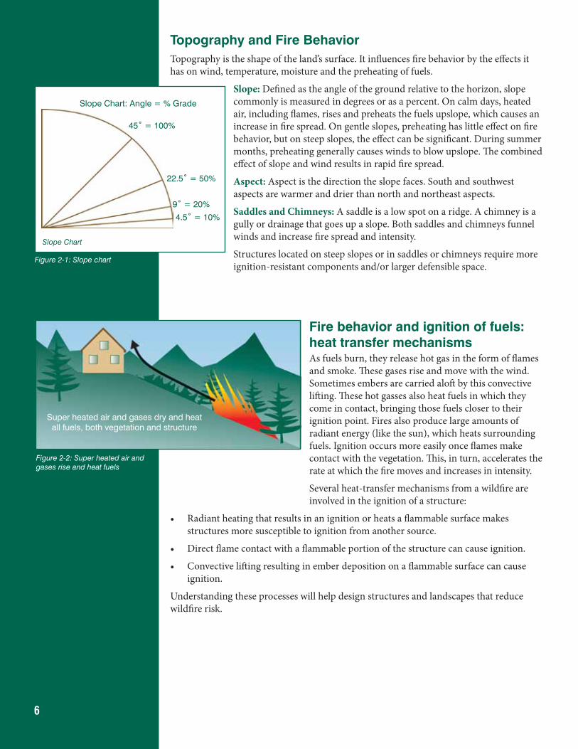
6
Topography and Fire BehaviorTopography is the shape of the land’s surface. It influences fire behavior by the effects it has on wind, temperature, moisture and the preheating of fuels.
Slope: Defined as the angle of the ground relative to the horizon, slope commonly is measured in degrees or as a percent. On calm days, heated air, including flames, rises and preheats the fuels upslope, which causes an increase in fire spread. On gentle slopes, preheating has little effect on fire behavior, but on steep slopes, the effect can be significant. During summer months, preheating generally causes winds to blow upslope. The combined effect of slope and wind results in rapid fire spread.
Aspect: Aspect is the direction the slope faces. South and southwest aspects are warmer and drier than north and northeast aspects.
Saddles and Chimneys: A saddle is a low spot on a ridge. A chimney is a gully or drainage that goes up a slope. Both saddles and chimneys funnel winds and increase fire spread and intensity.
Structures located on steep slopes or in saddles or chimneys require more ignition-resistant components and/or larger defensible space.
Fire behavior and ignition of fuels: heat transfer mechanismsAs fuels burn, they release hot gas in the form of flames and smoke. These gases rise and move with the wind. Sometimes embers are carried aloft by this convective lifting. These hot gasses also heat fuels in which they come in contact, bringing those fuels closer to their ignition point. Fires also produce large amounts of radiant energy (like the sun), which heats surrounding fuels. Ignition occurs more easily once flames make contact with the vegetation. This, in turn, accelerates the rate at which the fire moves and increases in intensity.
Several heat-transfer mechanisms from a wildfire are involved in the ignition of a structure:
• Radiant heating that results in an ignition or heats a flammable surface makes structures more susceptible to ignition from another source.
• Direct flame contact with a flammable portion of the structure can cause ignition.
• Convective lifting resulting in ember deposition on a flammable surface can cause ignition.
Understanding these processes will help design structures and landscapes that reduce wildfire risk.
Slope Chart
Slope Chart: Angle = % Grade
45˚ = 100%
22.5˚ = 50%
9˚ = 20%
4.5˚ = 10%
Figure 2-1: Slope chart
Super heated air and gases dry and heat all fuels, both vegetation and structure
Figure 2-2: Super heated air and gases rise and heat fuels
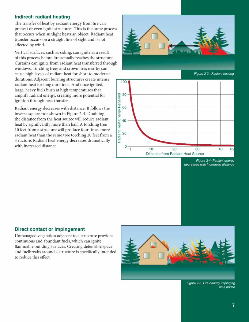
7
Indirect: radiant heatingThe transfer of heat by radiant energy from fire can preheat or even ignite structures. This is the same process that occurs when sunlight heats an object. Radiant heat transfer occurs on a straight line of sight and is not affected by wind.
Vertical surfaces, such as siding, can ignite as a result of this process before fire actually reaches the structure. Curtains can ignite from radiant heat transferred through windows. Torching trees and crown fires nearby can cause high levels of radiant heat for short to moderate durations. Adjacent burning structures create intense radiant heat for long durations. And once ignited, large, heavy fuels burn at high temperatures that amplify radiant energy, creating more potential for ignition through heat transfer.
Radiant energy decreases with distance. It follows the inverse square rule shown in Figure 2-4. Doubling the distance from the heat source will reduce radiant heat by significantly more than half. A torching tree 10 feet from a structure will produce four times more radiant heat than the same tree torching 20 feet from a structure. Radiant heat energy decreases dramatically with increased distance.
Direct contact or impingementUnmanaged vegetation adjacent to a structure provides continuous and abundant fuels, which can ignite flammable building surfaces. Creating defensible space and fuelbreaks around a structure is specifically intended to reduce this effect.
Figure 2-3: Radiant heating
Figure 2-5: Fire directly impinging on a house
100
80
60
40
20
01 10 3020 40 45
Distance from Radiant Heat Source
Rad
iant
Hea
t Ene
rgy
Rec
eive
d
Figure 2-4: Radiant energy decreases with increased distance
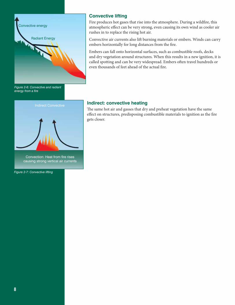
8
Convective liftingFire produces hot gases that rise into the atmosphere. During a wildfire, this atmospheric effect can be very strong, even causing its own wind as cooler air rushes in to replace the rising hot air.
Convective air currents also lift burning materials or embers. Winds can carry embers horizontally for long distances from the fire.
Embers can fall onto horizontal surfaces, such as combustible roofs, decks and dry vegetation around structures. When this results in a new ignition, it is called spotting and can be very widespread. Embers often travel hundreds or even thousands of feet ahead of the actual fire.
Indirect: convective heatingThe same hot air and gasses that dry and preheat vegetation have the same effect on structures, predisposing combustible materials to ignition as the fire gets closer.
Figure 2-7: Convective lifting
Convection: Heat from fire rises causing strong vertical air currents
Indirect Convective
Figure 2-6: Convective and radiant energy from a fire
Convective energy
Radiant Energy
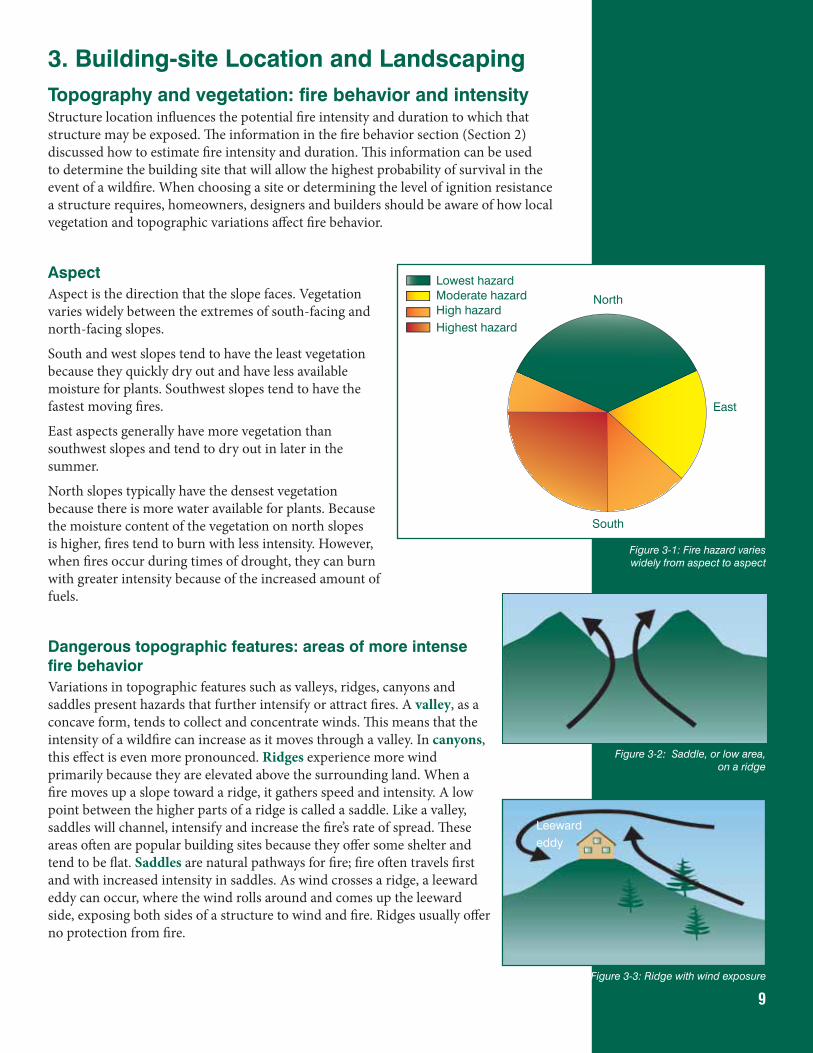
9
3. Building-site Location and LandscapingTopography and vegetation: fire behavior and intensityStructure location influences the potential fire intensity and duration to which that structure may be exposed. The information in the fire behavior section (Section 2) discussed how to estimate fire intensity and duration. This information can be used to determine the building site that will allow the highest probability of survival in the event of a wildfire. When choosing a site or determining the level of ignition resistance a structure requires, homeowners, designers and builders should be aware of how local vegetation and topographic variations affect fire behavior.
AspectAspect is the direction that the slope faces. Vegetation varies widely between the extremes of south-facing and north-facing slopes.
South and west slopes tend to have the least vegetation because they quickly dry out and have less available moisture for plants. Southwest slopes tend to have the fastest moving fires.
East aspects generally have more vegetation than southwest slopes and tend to dry out in later in the summer.
North slopes typically have the densest vegetation because there is more water available for plants. Because the moisture content of the vegetation on north slopes is higher, fires tend to burn with less intensity. However, when fires occur during times of drought, they can burn with greater intensity because of the increased amount of fuels.
Dangerous topographic features: areas of more intense fire behaviorVariations in topographic features such as valleys, ridges, canyons and saddles present hazards that further intensify or attract fires. A valley, as a concave form, tends to collect and concentrate winds. This means that the intensity of a wildfire can increase as it moves through a valley. In canyons, this effect is even more pronounced. Ridges experience more wind primarily because they are elevated above the surrounding land. When a fire moves up a slope toward a ridge, it gathers speed and intensity. A low point between the higher parts of a ridge is called a saddle. Like a valley, saddles will channel, intensify and increase the fire’s rate of spread. These areas often are popular building sites because they offer some shelter and tend to be flat. Saddles are natural pathways for fire; fire often travels first and with increased intensity in saddles. As wind crosses a ridge, a leeward eddy can occur, where the wind rolls around and comes up the leeward side, exposing both sides of a structure to wind and fire. Ridges usually offer no protection from fire.
Figure 3-2: Saddle, or low area, on a ridge
Figure 3-3: Ridge with wind exposure
Leewardeddy
South
North
East
Lowest hazardModerate hazardHigh hazardHighest hazard
Figure 3-1: Fire hazard varies widely from aspect to aspect
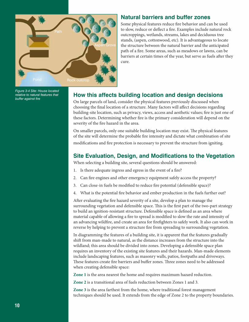
10
Natural barriers and buffer zonesSome physical features reduce fire behavior and can be used to slow, reduce or deflect a fire. Examples include natural rock outcroppings, wetlands, streams, lakes and deciduous tree stands, (aspen, cottonwood, etc). It is advantageous to locate the structure between the natural barrier and the anticipated path of a fire. Some areas, such as meadows or lawns, can be barriers at certain times of the year, but serve as fuels after they cure.
How this affects building location and design decisionsOn large parcels of land, consider the physical features previously discussed when choosing the final location of a structure. Many factors will affect decisions regarding building-site location, such as privacy, views, access and aesthetic values; fire is just one of these factors. Determining whether fire is the primary consideration will depend on the severity of the fire hazard in the area.
On smaller parcels, only one suitable building location may exist. The physical features of the site will determine the probable fire intensity and dictate what combination of site modifications and fire protection is necessary to prevent the structure from igniting.
Site Evaluation, Design, and Modifications to the VegetationWhen selecting a building site, several questions should be answered:
1. Is there adequate ingress and egress in the event of a fire?
2. Can fire engines and other emergency equipment safely access the property?
3. Can close-in fuels be modified to reduce fire potential (defensible space)?
4. What is the potential fire behavior and ember production in the fuels further out?
After evaluating the fire hazard severity of a site, develop a plan to manage the surrounding vegetation and defensible space. This is the first part of the two-part strategy to build an ignition-resistant structure. Defensible space is defined as an area where material capable of allowing a fire to spread is modified to slow the rate and intensity of an advancing wildfire, and create an area for firefighters to safely work. It also can work in reverse by helping to prevent a structure fire from spreading to surrounding vegetation.
In diagramming the features of a building site, it is apparent that the features gradually shift from man-made to natural, as the distance increases from the structure into the wildland; this area should be divided into zones. Developing a defensible space plan requires an inventory of the existing site features and their hazards. Man-made elements include landscaping features, such as masonry walls, patios, footpaths and driveways. These features create fire barriers and buffer zones. Three zones need to be addressed when creating defensible space:
Zone 1 is the area nearest the home and requires maximum hazard reduction.
Zone 2 is a transitional area of fuels reduction between Zones 1 and 3.
Zone 3 is the area farthest from the home, where traditional forest management techniques should be used. It extends from the edge of Zone 2 to the property boundaries.
Figure 3-4 Site: House located relative to natural features that buffer against fire
Aspen Grove
Pond Rock outcrop
Path
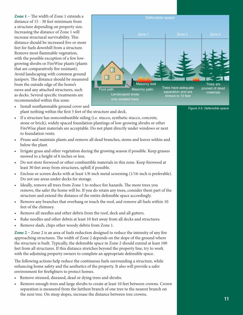
11
Zone 1 – The width of Zone 1 extends a distance of 15 - 30 feet minimum from a structure depending on property size. Increasing the distance of Zone 1 will increase structural survivability. This distance should be increased five or more feet for fuels downhill from a structure. Remove most flammable vegetation, with the possible exception of a few low-growing shrubs or FireWise plants (plants that are comparatively fire resistant).Avoid landscaping with common ground junipers. The distance should be measured from the outside edge of the home’s eaves and any attached structures, such as decks. Several specific treatments are recommended within this zone: • Install nonflammable ground cover and
plant nothing within the first 5 feet of the structure and deck. • If a structure has noncombustible siding (i.e. stucco, synthetic stucco, concrete,
stone or brick), widely spaced foundation plantings of low-growing shrubs or other FireWise plant materials are acceptable. Do not plant directly under windows or next to foundation vents.
• Prune and maintain plants and remove all dead branches, stems and leaves within and below the plant.
• Irrigate grass and other vegetation during the growing season if possible. Keep grasses mowed to a height of 6 inches or less.
• Do not store firewood or other combustible materials in this zone. Keep firewood at least 30 feet away from structures, uphill if possible.
• Enclose or screen decks with at least 1/8-inch metal screening (1/16-inch is preferable). Do not use areas under decks for storage.
• Ideally, remove all trees from Zone 1 to reduce fire hazards. The more trees you remove, the safer the home will be. If you do retain any trees, consider them part of the structure and extend the distance of the entire defensible space accordingly.
• Remove any branches that overhang or touch the roof, and remove all fuels within 10 feet of the chimney.
• Remove all needles and other debris from the roof, deck and all gutters. • Rake needles and other debris at least 10 feet away from all decks and structures. • Remove slash, chips other woody debris from Zone 1.
Zone 2 – Zone 2 is an area of fuels reduction designed to reduce the intensity of any fire approaching structures. The width of Zone 2 depends on the slope of the ground where the structure is built. Typically, the defensible space in Zone 2 should extend at least 100 feet from all structures. If this distance stretches beyond the property line, try to work with the adjoining property owners to complete an appropriate defensible space.
The following actions help reduce the continuous fuels surrounding a structure, while enhancing home safety and the aesthetics of the property. It also will provide a safer environment for firefighters to protect homes. • Removestressed,diseased,deadordyingtreesandshrubs.• Removeenoughtreesandlargeshrubstocreateatleast10feetbetweencrowns.Crown
separation is measured from the farthest branch of one tree to the nearest branch on the next tree. On steep slopes, increase the distance between tree crowns.
Figure 3-5: Defensible space
Defensible space
Zone 1 Zone 2 Zone 3
Foot pathLandscaped areasonly isolated trees
Masonry patio
Masonry wallTrees have adequate separation and are limbed to 10 feet
Trees are pruned of dead
materials
12
• Removeallladderfuelsfromunderremainingtrees.Prunetreebranchestoaheightof10 feet from the ground or 1/3 the height of the tree crown, whichever is less.
• Extendtreethinningout30-feetalongbothsidesofyourdrivewayallthewaytothemain access road, even if it is over 100 feet from your home. Thin all trees to create 10-foot spacing between tree crowns.
• SmallgroupsoftwotothreetreesmaybeleftinsomeareasofZone2,butleaveaminimum of 30 feet between the crowns of these clumps and surrounding trees.
• AsnotedinZone1,themoretreesandshrubsremoved,themorelikelythestructurewill be spared in a wildfire.
• Isolatedshrubsmayremain,providedtheyarenotundertrees.• Keepshrubsatleast10feetawayfromtheedgeoftreebranches.Thiswillpreventthe
shrubs from becoming ladder fuels. • Minimumspacingrecommendationsbetweenclumpsofshrubsis21/2timesthe
mature height of the vegetation. The maximum diameter of the clumps themselves should be twice the mature height of the vegetation. As with tree-crown spacing, all measurements are made from the edge of vegetation crowns.
• Periodicallypruneandmaintainshrubstopreventexcessivegrowth;removedeadstems from shrubs annually.
• Mowortrimgrassestoamaximumheightof6inches.Thisiscriticalinthefallwhengrasses dry out.
• Avoidaccumulationsgreaterthan4inchesdeepofsurfacefuelssuchaslogs,branches,slash and chips.
• Stackfirewoodandwoodpilesuphillfromoronthesameelevationasanystructures,and at least 30 feet away.
• Clear,mowandremoveallflammablevegetationwithin10feetofwoodpiles.• Donotstackwoodagainstyourhomeoron/underyourdeck,eveninwinter.• Locatepropanetanksandnaturalgasmetersatleast30feetfromanystructures,
preferably on the same elevation as the structure. The containers should not be located below your home because if it ignites, the fire would tend to burn uphill. Conversely, if the tank or meter is located above your structure and it develops a leak, gas will flow downhill into your home.
• Clearandremoveflammablevegetationwithin10feetofalltanksandmeters.• Donotvisiblyscreenpropanetanksornaturalgasmeterswithshrubs,vegetationor
flammable fencing. Instead, install 5 feet of nonflammable ground cover around the tank or meter.
Zone 3 – Zone 3 has no specified size. It should provide a gradual transition from Zone 2 to areas farther from the home that have other forest management objectives. Your local Colorado State Forest Service forester can help you with this zone.
Forest management in Zone 3 provides an opportunity to improve the health of the forest. With an assortment of tools and alternatives, it is possible to proactively manage forest land to reduce wildfire intensity and protect water quality, increase habitat diversity for wildlife, increase the health and growth rate of trees and increase the survivability of trees in a wildfire.
For additional information about defensible space, see Protecting Your Home from Wildfire: Creating Wildfire-Defensible Space or visit http://csfs.colostate.edu/pages/wf-publications.html.
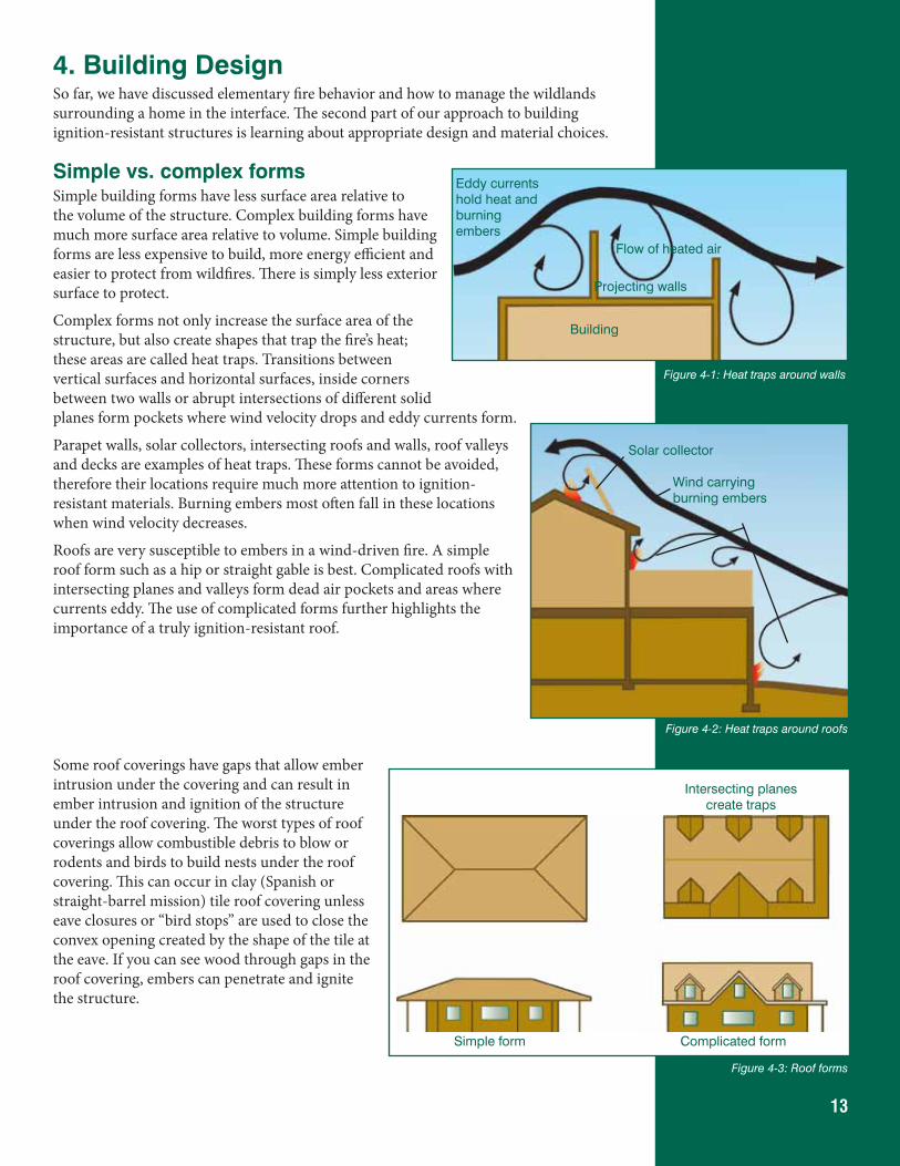
13
4. Building DesignSo far, we have discussed elementary fire behavior and how to manage the wildlands surrounding a home in the interface. The second part of our approach to building ignition-resistant structures is learning about appropriate design and material choices.
Simple vs. complex formsSimple building forms have less surface area relative to the volume of the structure. Complex building forms have much more surface area relative to volume. Simple building forms are less expensive to build, more energy efficient and easier to protect from wildfires. There is simply less exterior surface to protect.
Complex forms not only increase the surface area of the structure, but also create shapes that trap the fire’s heat; these areas are called heat traps. Transitions between vertical surfaces and horizontal surfaces, inside corners between two walls or abrupt intersections of different solid planes form pockets where wind velocity drops and eddy currents form.
Parapet walls, solar collectors, intersecting roofs and walls, roof valleys and decks are examples of heat traps. These forms cannot be avoided, therefore their locations require much more attention to ignition-resistant materials. Burning embers most often fall in these locations when wind velocity decreases.
Roofs are very susceptible to embers in a wind-driven fire. A simple roof form such as a hip or straight gable is best. Complicated roofs with intersecting planes and valleys form dead air pockets and areas where currents eddy. The use of complicated forms further highlights the importance of a truly ignition-resistant roof.
Some roof coverings have gaps that allow ember intrusion under the covering and can result in ember intrusion and ignition of the structure under the roof covering. The worst types of roof coverings allow combustible debris to blow or rodents and birds to build nests under the roof covering. This can occur in clay (Spanish or straight-barrel mission) tile roof covering unless eave closures or “bird stops” are used to close the convex opening created by the shape of the tile at the eave. If you can see wood through gaps in the roof covering, embers can penetrate and ignite the structure.
Building
Eddy currents hold heat and burning embers
Projecting walls
Flow of heated air
Figure 4-1: Heat traps around walls
Wind carrying burning embers
Solar collector
Figure 4-2: Heat traps around roofs
Figure 4-3: Roof forms
Simple form Complicated form
Intersecting planes create traps
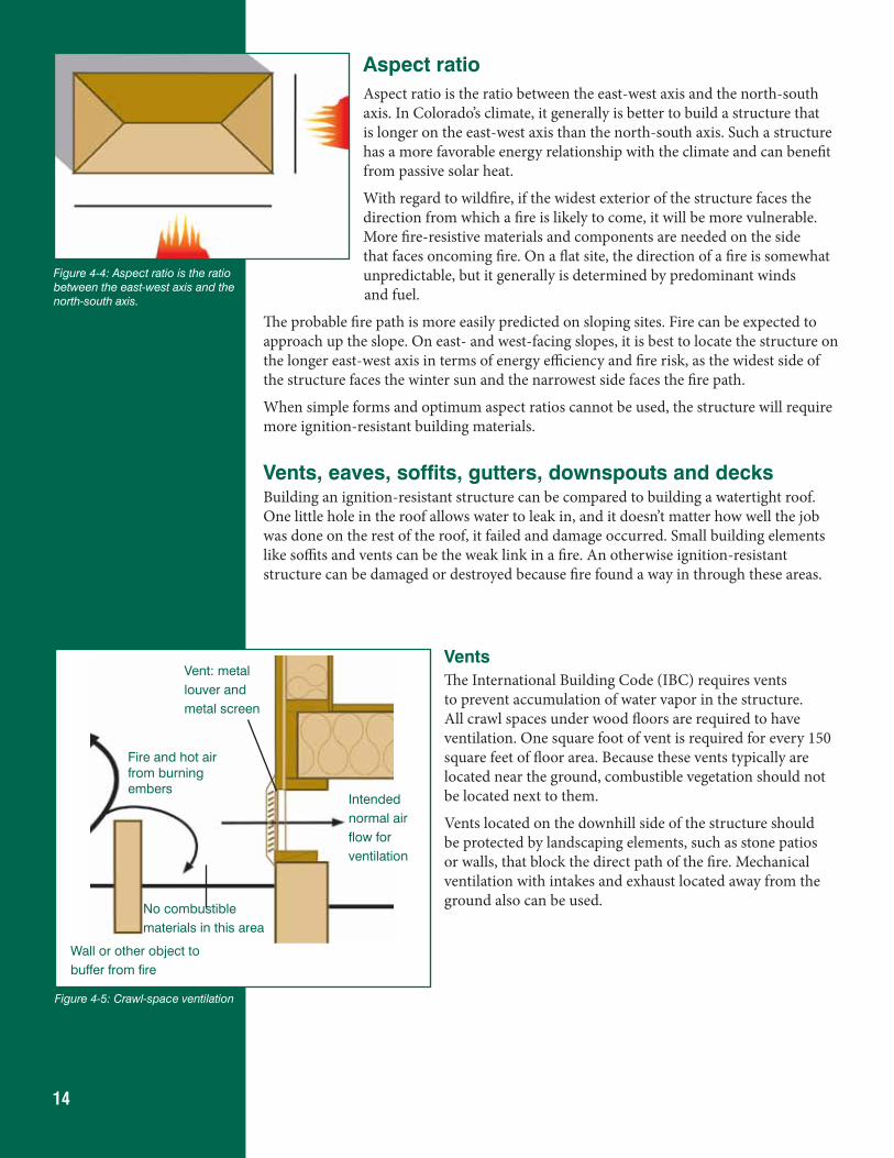
14
Aspect ratioAspect ratio is the ratio between the east-west axis and the north-south axis. In Colorado’s climate, it generally is better to build a structure that is longer on the east-west axis than the north-south axis. Such a structure has a more favorable energy relationship with the climate and can benefit from passive solar heat.
With regard to wildfire, if the widest exterior of the structure faces the direction from which a fire is likely to come, it will be more vulnerable. More fire-resistive materials and components are needed on the side that faces oncoming fire. On a flat site, the direction of a fire is somewhat unpredictable, but it generally is determined by predominant winds
and fuel.
The probable fire path is more easily predicted on sloping sites. Fire can be expected to approach up the slope. On east- and west-facing slopes, it is best to locate the structure on the longer east-west axis in terms of energy efficiency and fire risk, as the widest side of the structure faces the winter sun and the narrowest side faces the fire path.
When simple forms and optimum aspect ratios cannot be used, the structure will require more ignition-resistant building materials.
Vents, eaves, soffits, gutters, downspouts and decksBuilding an ignition-resistant structure can be compared to building a watertight roof. One little hole in the roof allows water to leak in, and it doesn’t matter how well the job was done on the rest of the roof, it failed and damage occurred. Small building elements like soffits and vents can be the weak link in a fire. An otherwise ignition-resistant structure can be damaged or destroyed because fire found a way in through these areas.
VentsThe International Building Code (IBC) requires vents to prevent accumulation of water vapor in the structure. All crawl spaces under wood floors are required to have ventilation. One square foot of vent is required for every 150 square feet of floor area. Because these vents typically are located near the ground, combustible vegetation should not be located next to them.
Vents located on the downhill side of the structure should be protected by landscaping elements, such as stone patios or walls, that block the direct path of the fire. Mechanical ventilation with intakes and exhaust located away from the ground also can be used.
Figure 4-5: Crawl-space ventilation
Intendednormal airflow forventilation
Fire and hot air from burning embers
Wall or other object tobuffer from fire
Vent: metallouver andmetal screen
No combustiblematerials in this area
Figure 4-4: Aspect ratio is the ratio between the east-west axis and the north-south axis.
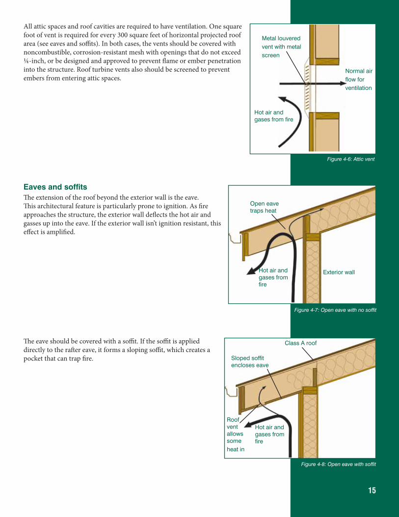
15
All attic spaces and roof cavities are required to have ventilation. One square foot of vent is required for every 300 square feet of horizontal projected roof area (see eaves and soffits). In both cases, the vents should be covered with noncombustible, corrosion-resistant mesh with openings that do not exceed ¼-inch, or be designed and approved to prevent flame or ember penetration into the structure. Roof turbine vents also should be screened to prevent embers from entering attic spaces.
Eaves and soffitsThe extension of the roof beyond the exterior wall is the eave. This architectural feature is particularly prone to ignition. As fire approaches the structure, the exterior wall deflects the hot air and gasses up into the eave. If the exterior wall isn’t ignition resistant, this effect is amplified.
The eave should be covered with a soffit. If the soffit is applied directly to the rafter eave, it forms a sloping soffit, which creates a pocket that can trap fire.
Metal louveredvent with metalscreen
Normal airflow forventilation
Hot air and gases from fire
Figure 4-6: Attic vent
Figure 4-7: Open eave with no soffit
Open eave traps heat
Exterior wallHot air and gases from fire
Figure 4-8: Open eave with soffit
Class A roof
Sloped soffit encloses eave
Roof vent allows someheat in
Hot air and gases from fire
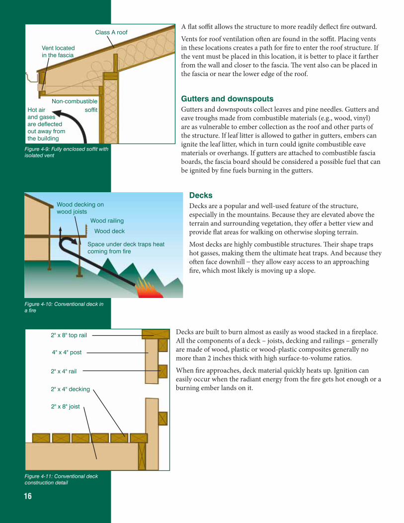
16
A flat soffit allows the structure to more readily deflect fire outward.
Vents for roof ventilation often are found in the soffit. Placing vents in these locations creates a path for fire to enter the roof structure. If the vent must be placed in this location, it is better to place it farther from the wall and closer to the fascia. The vent also can be placed in the fascia or near the lower edge of the roof.
Gutters and downspoutsGutters and downspouts collect leaves and pine needles. Gutters and eave troughs made from combustible materials (e.g., wood, vinyl) are as vulnerable to ember collection as the roof and other parts of the structure. If leaf litter is allowed to gather in gutters, embers can ignite the leaf litter, which in turn could ignite combustible eave materials or overhangs. If gutters are attached to combustible fascia boards, the fascia board should be considered a possible fuel that can be ignited by fine fuels burning in the gutters.
DecksDecks are a popular and well-used feature of the structure, especially in the mountains. Because they are elevated above the terrain and surrounding vegetation, they offer a better view and provide flat areas for walking on otherwise sloping terrain.
Most decks are highly combustible structures. Their shape traps hot gasses, making them the ultimate heat traps. And because they often face downhill – they allow easy access to an approaching fire, which most likely is moving up a slope.
Decks are built to burn almost as easily as wood stacked in a fireplace. All the components of a deck – joists, decking and railings – generally are made of wood, plastic or wood-plastic composites generally no more than 2 inches thick with high surface-to-volume ratios.
When fire approaches, deck material quickly heats up. Ignition can easily occur when the radiant energy from the fire gets hot enough or a burning ember lands on it.
Figure 4-9: Fully enclosed soffit with isolated vent
Vent located in the fascia
Hot air and gases are deflected out away from the building
Class A roof
Non-combustiblesoffit
Wood decking on wood joists
Wood railing
Space under deck traps heat coming from fire
Wood deck
Figure 4-10: Conventional deck in a fire
Figure 4-11: Conventional deck construction detail
2" x 8" top rail
4" x 4" post
2" x 4" rail
2" x 4" decking
2" x 8" joist
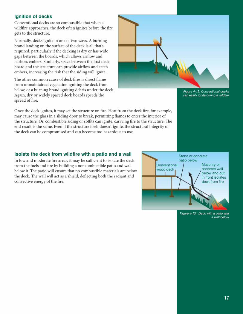
17
Ignition of decksConventional decks are so combustible that when a wildfire approaches, the deck often ignites before the fire gets to the structure.
Normally, decks ignite in one of two ways. A burning brand landing on the surface of the deck is all that’s required, particularly if the decking is dry or has wide gaps between the boards, which allows airflow and harbors embers. Similarly, space between the first deck board and the structure can provide airflow and catch embers, increasing the risk that the siding will ignite.
The other common cause of deck fires is direct flame from unmaintained vegetation igniting the deck from below, or a burning brand igniting debris under the deck. Again, dry or widely spaced deck boards speeds the spread of fire. Once the deck ignites, it may set the structure on fire. Heat from the deck fire, for example, may cause the glass in a sliding door to break, permitting flames to enter the interior of the structure. Or, combustible siding or soffits can ignite, carrying fire to the structure. The end result is the same. Even if the structure itself doesn’t ignite, the structural integrity of the deck can be compromised and can become too hazardous to use.
Isolate the deck from wildfire with a patio and a wallIn low and moderate fire areas, it may be sufficient to isolate the deck from the fuels and fire by building a noncombustible patio and wall below it. The patio will ensure that no combustible materials are below the deck. The wall will act as a shield, deflecting both the radiant and convective energy of the fire.
Figure 4-13: Deck with a patio and a wall below
Conventional wood deck
Stone or concrete patio below
Masonry or concrete wall below and out in front isolates deck from fire
Figure 4-12: Conventional decks can easily ignite during a wildfire
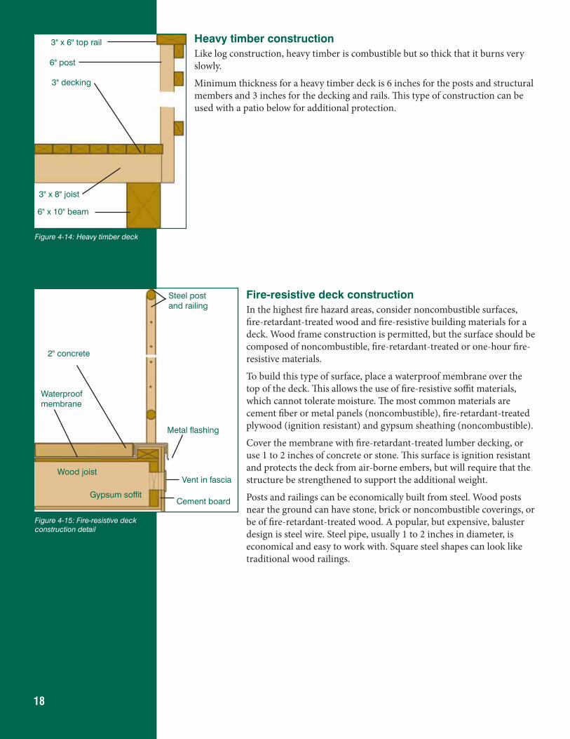
18
Heavy timber constructionLike log construction, heavy timber is combustible but so thick that it burns very slowly.
Minimum thickness for a heavy timber deck is 6 inches for the posts and structural members and 3 inches for the decking and rails. This type of construction can be used with a patio below for additional protection.
Fire-resistive deck constructionIn the highest fire hazard areas, consider noncombustible surfaces, fire-retardant-treated wood and fire-resistive building materials for a deck. Wood frame construction is permitted, but the surface should be composed of noncombustible, fire-retardant-treated or one-hour fire-resistive materials.
To build this type of surface, place a waterproof membrane over the top of the deck. This allows the use of fire-resistive soffit materials, which cannot tolerate moisture. The most common materials are cement fiber or metal panels (noncombustible), fire-retardant-treated plywood (ignition resistant) and gypsum sheathing (noncombustible).
Cover the membrane with fire-retardant-treated lumber decking, or use 1 to 2 inches of concrete or stone. This surface is ignition resistant and protects the deck from air-borne embers, but will require that the structure be strengthened to support the additional weight.
Posts and railings can be economically built from steel. Wood posts near the ground can have stone, brick or noncombustible coverings, or be of fire-retardant-treated wood. A popular, but expensive, baluster design is steel wire. Steel pipe, usually 1 to 2 inches in diameter, is economical and easy to work with. Square steel shapes can look like traditional wood railings.
Figure 4-14: Heavy timber deck
3" x 6" top rail
6" post
6" x 10" beam
3" decking
3" x 8" joist
Figure 4-15: Fire-resistive deck construction detail
2" concrete
Cement board
Vent in fasciaWood joist
Gypsum soffit
Steel post and railing
Waterproof membrane
Metal flashing
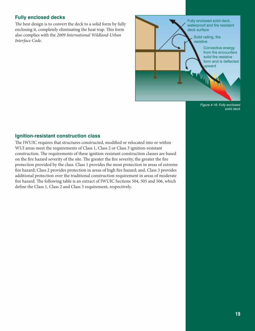
19
Fully enclosed decksThe best design is to convert the deck to a solid form by fully enclosing it, completely eliminating the heat trap. This form also complies with the 2009 International Wildland-Urban Interface Code.
Ignition-resistant construction classThe IWUIC requires that structures constructed, modified or relocated into or within WUI areas meet the requirements of Class 1, Class 2 or Class 3 ignition-resistant construction. The requirements of these ignition-resistant construction classes are based on the fire hazard severity of the site. The greater the fire severity, the greater the fire protection provided by the class. Class 1 provides the most protection in areas of extreme fire hazard; Class 2 provides protection in areas of high fire hazard; and, Class 3 provides additional protection over the traditional construction requirement in areas of moderate fire hazard. The following table is an extract of IWUIC Sections 504, 505 and 506, which define the Class 1, Class 2 and Class 3 requirement, respectively.
Figure 4-16: Fully enclosed solid deck
Fully enclosed solid deck, waterproof and fire resistant deck surface
Solid railing, fire resistive
Convective energy from fire encounters solid fire resistive form and is deflected upward
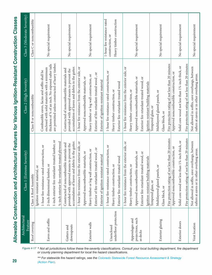
20
* Not all jurisdictions follow these fire-severity classifications. Consult your local building department, fire department or county planning department for local fire hazard classifications.
** For statewide fire hazard ratings, see the Colorado Statewide Forest Resource Assessment & Strategy (Action Plan).
Arc
hite
ctur
al
Fe
atur
eC
lass
1 (E
xtre
me
Seve
rity)
Cla
ss 2
(Hig
h Se
verit
y)C
lass
3 (M
oder
ate S
ever
ity)
Roof
cove
ring
Cla
ss A
Roo
f Ass
embl
yC
lass
B o
r non
com
bust
ible
Cla
ss C
or n
onco
mbu
stib
le
Eave
s and
soffi
ts
Igni
tion-
resis
tant
mat
eria
l, or
1-ho
ur fi
re-r
esist
ance
-rat
ed co
nstr
uctio
n, o
r
2-in
ch d
imen
siona
l lum
ber,
or
1-in
ch e
xter
ior fi
re-r
etar
dant
-tre
ated
lum
ber,
or
¾-in
ch e
xter
ior fi
re-r
etar
dant
-tre
ated
ply
woo
d
Com
bust
ible
eav
es, f
acia
s and
soffi
ts sh
all b
e en
clos
ed w
ith so
lid m
ater
ials
with
a m
inim
um
thic
knes
s of ¾
of a
n in
ch. N
o ex
pose
d ra
fter t
ails
are
perm
itted
unl
ess c
onst
ruct
ed o
f hea
vy ti
mbe
r.
No
spec
ial r
equi
rem
ent
Gut
ters
and
dow
nspo
uts
Con
stru
cted
of n
onco
mbu
stib
le m
ater
ials
and
prov
ided
with
appr
oved
mea
ns to
pre
vent
the
accu
mul
atio
n of
leav
es a
nd d
ebris
in th
e gu
tter.
Con
stru
cted
of n
onco
mbu
stib
le m
ater
ials
and
prov
ided
with
appr
oved
mea
ns to
pre
vent
the
ac
cum
ulat
ion
of le
aves
and
deb
ris in
the
gutte
r.N
o sp
ecia
l req
uire
men
t
Exte
rior w
alls
1-ho
ur fi
re re
sista
nce
from
the
exte
rior s
ide,
or
Appr
oved
non
com
bust
ible
mat
eria
ls, o
r
Hea
vy ti
mbe
r or l
og w
all c
onst
ruct
ion,
or
Exte
rior o
f fire
-ret
arda
nt tr
eate
d w
ood
, or
Exte
rior o
f ign
ition
-res
istan
t mat
eria
l
1-ho
ur fi
re re
sista
nce
from
the
exte
rior s
ide,
or
Appr
oved
non
com
bust
ible
mat
eria
ls, o
r
Hea
vy ti
mbe
r or l
og w
all c
onst
ruct
ion,
or
Exte
rior o
f fire
-ret
arda
nt-t
reat
ed w
ood
, or
Exte
rior o
f ign
ition
-res
istan
t mat
eria
l
No
spec
ial r
equi
rem
ent
Une
nclo
sed
un
derfl
oor p
rote
ctio
n
1-ho
ur fi
re-r
esist
ance
-rat
ed co
nstr
uctio
n, o
r
Hea
vy ti
mbe
r con
stru
ctio
n, o
r
Exte
rior fi
re-r
etar
dant
-tre
ated
woo
d
1-ho
ur fi
re re
sista
nce-
rate
d co
nstr
uctio
n, o
r
Hea
vy ti
mbe
r con
stru
ctio
n, o
r
Exte
rior fi
re-r
etar
dant
-tre
ated
woo
d
1-ho
ur fi
re re
sista
nce-
rate
d co
nstr
uctio
n, o
r
Hea
vy ti
mbe
r con
stru
ctio
n
Appe
ndag
es a
nd
pr
ojec
tions
, suc
h
as d
ecks
1-ho
ur fi
re re
sista
nce
from
the
exte
rior s
ide,
or
Hea
vy ti
mbe
r con
stru
ctio
n, o
r
Appr
oved
non
com
bust
ible
mat
eria
ls, o
r
Exte
rior fi
re-r
etar
dant
-tre
ated
woo
d, o
r
Igni
tion-
resis
tant
bui
ldin
g m
ater
ials
1-ho
ur fi
re re
sista
nce
from
the
exte
rior s
ide,
or
Hea
vy ti
mbe
r con
stru
ctio
n, o
r
Appr
oved
non
com
bust
ible
mat
eria
ls, o
r
Exte
rior fi
re-r
etar
dant
-tre
ated
woo
d, o
r
Igni
tion-
resis
tant
bui
ldin
g m
ater
ials
No
spec
ial r
equi
rem
ent
Exte
rior g
lazi
ng
Tem
pere
d gl
ass,
or
Mul
tilay
ered
gla
zed
pane
ls, o
r
Gla
ss b
lock
, or
Fire
pro
tect
ion
ratin
g of
not
less
than
20
min
utes
Tem
pere
d gl
ass,
or
Mul
tilay
ered
gla
zed
pane
ls, o
r
Gla
ss b
lock
, or
Fire
pro
tect
ion
ratin
g of
not
less
than
20
min
utes
No
spec
ial r
equi
rem
ent
Exte
rior d
oors
Appr
oved
non
com
bust
ible
cons
truc
tion,
or
Solid
core
woo
d no
t les
s tha
n 1¾
-inch
thic
k, o
r
Fire
pro
tect
ion
ratin
g of
not
less
than
20
min
utes
Appr
oved
non
com
bust
ible
cons
truc
tion,
or
Solid
core
woo
d no
t les
s tha
n 1¾
-inch
thic
k, o
r
Fire
pro
tect
ion
ratin
g of
not
less
than
20
min
utes
No
spec
ial r
equi
rem
ent
Vent
loca
tion
Not
allo
wed
in so
ffits
, eav
e ov
erha
ngs,
betw
een
rafte
rs at
eav
es o
r in
othe
r ove
rhan
g ar
eas.
Not
allo
wed
in so
ffits
, eav
e ov
erha
ngs,
betw
een
rafte
rs at
eav
es o
r in
othe
r ove
rhan
g ar
eas.
No
spec
ial r
equi
rem
ent
Allo
wab
le C
onst
ruct
ion
and
Arc
hite
ctur
al F
eatu
res
for
Vari
ous
Igni
tion-
Res
ista
nt C
onst
ruct
ion
Cla
sses
Figure 4-17
21
5. Building Materials and ComponentsWhen discussing building materials and components, we make frequent references to types of construction, noncombustible materials and various classes and ratings. Flame-spread classes, roofing classes and hourly ratings are confusing terms and sometimes are misused. The first is based on the Society for Testing and Materials’ ASTM E-84/UL 723 “Test for Surface Burning Characteristics of Building Materials,” the second is based on ASTM E-108/UL 790, “Test for Fire Performance of Roofing Materials,” and the third is based on ASTM E-119, “Fire Tests of Building Materials.”
NoncombustibleAs applied to building materials, noncombustible means a material that, in the form in which it is used, is one of the following:
1. Material of which no part will ignite and burn when subjected to fire. Any material conforming to ASTM E-136 “Standard Test Method for Behavior of Materials in a Vertical Tube Furnace at 750°C” is considered noncombustible. Materials such as concrete, steel and brick masonry generally are considered noncombustible.
2. Material that has a structural base of noncombustible material, as defined in Item 1 above, with a surfacing material not over 1/8-inch (3.2 mm) thick, and a flame spread index of 50 or less. The paper face on most gypsum wallboard has a flame-spread index of 15 and is considered noncombustible.
If a building material does not fall into either of the above categories, it is assumed to be combustible.
Flame-spread classification of building materialsThe Uniform Building Code UBC uses the I-II-III designation, and the International Building Code (IBC) uses A-B-C. The flame-spread categories are as follows, per ASTM E-84/UL 723:
Class A or I: Flame-spread index of 25 or less (Fire-Retardant-Treated Wood or FRTW)
Class B or II: Flame spread index of 26 to 75 (some untreated lumber)
Class C or III: Flame spread index of 76 to 200 (most untreated lumber and plywood)
Class A-B-C roof coveringsClass A, B or C roofing systems sometimes are confused with the Class A-B-C/I-II-III flame-spread categories as referenced above. The tendency is to assume that Class A roof systems have a Class A flame spread, and so on, but there is no correlation.
The ASTM E-108/UL 790 roof-coverings test does not produce a flame-spread rating. It is a pass-fail test under which a product either passes the criteria as a Class A, B or C roof covering system or it doesn’t. It is an entirely different test from ASTM E-84/UL 723, and it includes weathering per the ASTM D-2898 “Standard Rain Test.” The highest fire classification is Class A. Note that a Class C roof system is considered fire resistant, while a Class C (or III) building material (as above) is not. Non-classified roof systems have no fire rating.
22
Hourly fire-resistance ratingsHourly ratings are a function of the assembly being used (wall, floor, door, ceiling, roof, etc.) and generally require use of a noncombustible membrane (e.g. gypsum, masonry). ASTM E-119 “Fire Tests of Building Construction Materials,” is the test used to determine the hourly rating of an assembly. It exposes an assembly to heat and flame on one side and tests for heat transmission, burn-through, structural integrity and ability to withstand a hose stream from a fire hose.
Because of the potential for radiant heat exposure from one structure to another, either on adjoining sites or on the same site, the IBC regulates the construction of exterior walls for fire resistance. Where exterior walls have a fire-separation distance of more than 5 feet, IBC Section 705.5 allows the fire-resistance rating to be determined based only on interior fire exposure. This recognizes the reduced risk that is due to the setback from the lot line. For fire separation distances greater than 5 feet, the hazard is considered to be predominately from inside the structure. Thus, fire-resistance-rated construction whose tests are limited to interior fire exposure is considered sufficient evidence of fire resistance under these circumstances. However, at a distance of 5 feet or less, there is additional hazard of direct fire exposure from a structure on the adjacent lot and the possibility that it may lead to self-ignition at the exterior face of the exposed structure. Therefore, exterior walls located very close to any lot line must be rated for exposure to fire from both sides. The listings of various fire-resistance-rated exterior walls will indicate if they were only tested for exposure from the inside, usually by a designation of “FIRE SIDE” or similar terminology. Where so listed, their use is limited to those applications where the wall need only be rated from the interior side. For application in the WUI, the “FIRE SIDE” of the wall system must be the exterior wall surface.
The difference between a non-combustible material and a rated material or assembly is the surface resistance to ignition versus the protection afforded the structure behind it. A good example of a non-combustible material is metal roofing and siding. Metal is non-combustible, but an excellent conductor of heat. If the fire remains present long enough, the heat will be conducted through the metal and ignite the material behind it. An example of a fire-rated assembly is wood siding applied over 5/8 inch gypsum sheathing. This assembly is rated as one hour. The surface can ignite, but the structure is protected from the fire for one hour. The importance is the difference between intensity of fire and duration of fire, as described in the fire behavior section (Section 2).
Most ratings are for commercial structures in urban settings. That is why the IWUIC references the IBC, which is used to build both commercial and residential structures, rather than the IRC, which is used for single family and multi-family homes with up to four units.
The IBC allows both prescriptive and performance-based fire-resistant designs, although its current emphasis is clearly on the former. Section 720 of the code explicitly lists several detailed, prescriptive fire-resistant designs. However, Section 703.3 also allows the designer to choose from other alternative methods for design as long as they meet the fire exposure and criteria specified in the American Society for Testing and Materials (ASTM) fire test standard ASTM E-119.
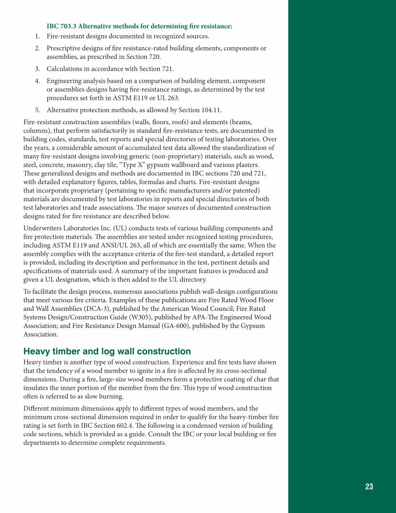
23
IBC 703.3 Alternative methods for determining fire resistance:1. Fire-resistant designs documented in recognized sources.
2. Prescriptive designs of fire resistance-rated building elements, components or assemblies, as prescribed in Section 720.
3. Calculations in accordance with Section 721.
4. Engineering analysis based on a comparison of building element, component or assemblies designs having fire-resistance ratings, as determined by the test procedures set forth in ASTM E119 or UL 263.
5. Alternative protection methods, as allowed by Section 104.11.
Fire-resistant construction assemblies (walls, floors, roofs) and elements (beams, columns), that perform satisfactorily in standard fire-resistance tests, are documented in building codes, standards, test reports and special directories of testing laboratories. Over the years, a considerable amount of accumulated test data allowed the standardization of many fire-resistant designs involving generic (non-proprietary) materials, such as wood, steel, concrete, masonry, clay tile, “Type X” gypsum wallboard and various plasters. These generalized designs and methods are documented in IBC sections 720 and 721, with detailed explanatory figures, tables, formulas and charts. Fire-resistant designs that incorporate proprietary (pertaining to specific manufacturers and/or patented) materials are documented by test laboratories in reports and special directories of both test laboratories and trade associations. The major sources of documented construction designs rated for fire resistance are described below.
Underwriters Laboratories Inc. (UL) conducts tests of various building components and fire protection materials. The assemblies are tested under recognized testing procedures, including ASTM E119 and ANSI/UL 263, all of which are essentially the same. When the assembly complies with the acceptance criteria of the fire-test standard, a detailed report is provided, including its description and performance in the test, pertinent details and specifications of materials used. A summary of the important features is produced and given a UL designation, which is then added to the UL directory.
To facilitate the design process, numerous associations publish wall-design configurations that meet various fire criteria. Examples of these publications are Fire Rated Wood Floor and Wall Assemblies (DCA-3), published by the American Wood Council; Fire Rated Systems Design/Construction Guide (W305), published by APA-The Engineered Wood Association; and Fire Resistance Design Manual (GA-600), published by the Gypsum Association.
Heavy timber and log wall constructionHeavy timber is another type of wood construction. Experience and fire tests have shown that the tendency of a wood member to ignite in a fire is affected by its cross-sectional dimensions. During a fire, large-size wood members form a protective coating of char that insulates the inner portion of the member from the fire. This type of wood construction often is referred to as slow burning.
Different minimum dimensions apply to different types of wood members, and the minimum cross-sectional dimension required in order to qualify for the heavy-timber fire rating is set forth in IBC Section 602.4. The following is a condensed version of building code sections, which is provided as a guide. Consult the IBC or your local building or fire departments to determine complete requirements.
24
602.4.1 Columns. Wood columns shall be not be less than 8 inches nominal in any dimension where supporting floor loads and not less than 6 inches nominal in width and not less than 8 inches nominal in depth where supporting roof and ceiling loads only.
602.4.2 Floor framing. Wood beams and girders shall be not less than 6 inches nominal in width and not less than 10 inches nominal in depth.
602.4.3 Roof framing. Framed or glued-laminated arches for roof construction, framed timber trusses and other roof framing, which do not support floor loads, shall have members not less than 4 inches nominal in width and not less than 6 inches nominal in depth.
602.4.4 Floors. Floors shall be without concealed spaces. Wood floors shall be of sawn or glued-laminated planks, splined or tongue-and-groove, of not less than 3 inches nominal in thickness. Floors shall not extend closer than 0.5 inch to walls. This space shall be covered by a molding fastened to the wall and so arranged that it will not obstruct the swelling or shrinkage movements of the floor.
602.4.5 Roofs. Roofs shall be without concealed spaces and wood roof decks shall be of sawn or glued-laminated, splined or tongue-and-groove plank, not less than 2 inches nominal in thickness, 1 1/8 inch thick plywood, or of planks not less than 3 inches nominal in width, set on edge close together and laid as required for floors. Other types of decking shall be permitted to be used if providing equivalent fire resistance and structural properties.
Fire-retardant-treated woodCertain ingredients, when added to the wood, can insulate its surfaces so that its temper-ature remains below the kindling temperature for an extended period of time, no matter how hot the heat source might become. Among the ingredients used for this purpose are the acid salts of sulfates and phosphates, borates and boric acid.
All fire-retardant treatments are water-soluble, so water is used as the vehicle for carrying the treatments into the wood. The only effective method of application is the pressure treatment process. After pressure impreg nation, most of the moisture is removed until the treated wood has a moisture content of no more than 19 percent for lumber and 15 percent for plywood.
Fire-retardant treatments do not necessarily prevent wood from being destroyed by fire, but they are the necessary in gredient that, when added to wood, slow decompo sition to such an extent that the wood structurally outperforms most other building materials during actual fire conditions.
When temperatures reach a point slightly below the kindling point, the chemicals react with each other. Nonflammable gases and water vapor are formed and released at a slow, persistent rate that envelops the wood fibers, insu lating them from temperatures that cause the wood to decom pose. The inflammable gases and tars are reduced and an insulating char forms on the surface of the wood, further slowing the process of decomposition. Structural integrity of the wood is preserved for a longer time with the reduced rate of decomposition, and smoke and toxic fumes are greatly reduced. When the heat source is removed, the treated wood ceases to decompose and fire spread is eliminated.
In Section 2303.2, the IBC defines fire-retardant-treated wood as “any wood product that, when impregnated with chemicals by a pressure process or other means during manufacture, shall have, when tested in accordance with ASTM E 84 or UL 723, a listed flame spread index of 25 or less and show no evidence of significant
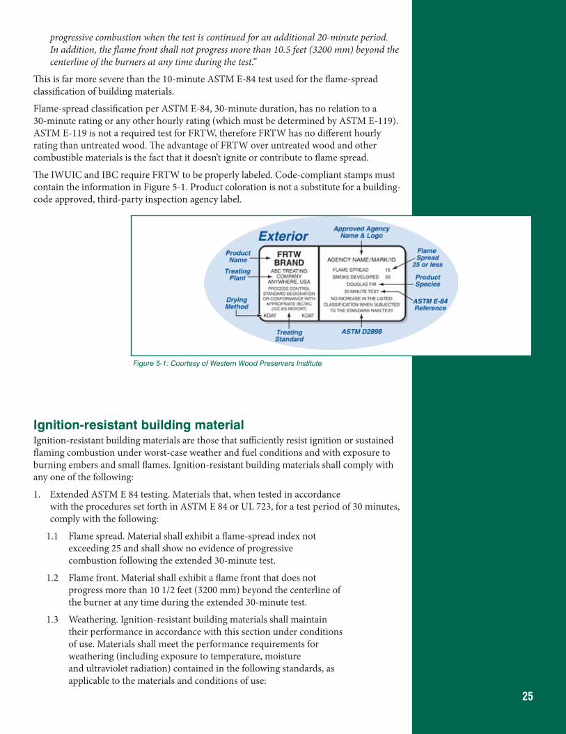
25
progressive combustion when the test is continued for an additional 20-minute period. In addition, the flame front shall not progress more than 10.5 feet (3200 mm) beyond the centerline of the burners at any time during the test.”
This is far more severe than the 10-minute ASTM E-84 test used for the flame-spread classification of building materials.
Flame-spread classification per ASTM E-84, 30-minute duration, has no relation to a 30-minute rating or any other hourly rating (which must be determined by ASTM E-119). ASTM E-119 is not a required test for FRTW, therefore FRTW has no different hourly rating than untreated wood. The advantage of FRTW over untreated wood and other combustible materials is the fact that it doesn’t ignite or contribute to flame spread.
The IWUIC and IBC require FRTW to be properly labeled. Code-compliant stamps must contain the information in Figure 5-1. Product coloration is not a substitute for a building-code approved, third-party inspection agency label.
Ignition-resistant building materialIgnition-resistant building materials are those that sufficiently resist ignition or sustained flaming combustion under worst-case weather and fuel conditions and with exposure to burning embers and small flames. Ignition-resistant building materials shall comply with any one of the following:
1. Extended ASTM E 84 testing. Materials that, when tested in accordance with the procedures set forth in ASTM E 84 or UL 723, for a test period of 30 minutes, comply with the following:
1.1 Flame spread. Material shall exhibit a flame-spread index not exceeding 25 and shall show no evidence of progressive combustion following the extended 30-minute test.
1.2 Flame front. Material shall exhibit a flame front that does not progress more than 10 1/2 feet (3200 mm) beyond the centerline of the burner at any time during the extended 30-minute test.
1.3 Weathering. Ignition-resistant building materials shall maintain their performance in accordance with this section under conditions of use. Materials shall meet the performance requirements for weathering (including exposure to temperature, moisture and ultraviolet radiation) contained in the following standards, as applicable to the materials and conditions of use:
Figure 5-1: Courtesy of Western Wood Preservers Institute
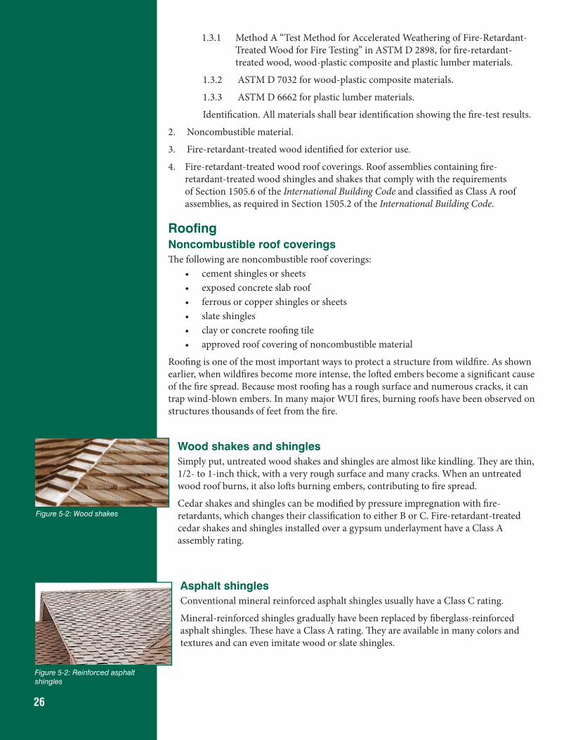
26
1.3.1 Method A “Test Method for Accelerated Weathering of Fire-Retardant-Treated Wood for Fire Testing” in ASTM D 2898, for fire-retardant-treated wood, wood-plastic composite and plastic lumber materials.
1.3.2 ASTM D 7032 for wood-plastic composite materials.
1.3.3 ASTM D 6662 for plastic lumber materials.
Identification. All materials shall bear identification showing the fire-test results.
2. Noncombustible material.
3. Fire-retardant-treated wood identified for exterior use.
4. Fire-retardant-treated wood roof coverings. Roof assemblies containing fire-retardant-treated wood shingles and shakes that comply with the requirements of Section 1505.6 of the International Building Code and classified as Class A roof assemblies, as required in Section 1505.2 of the International Building Code.
RoofingNoncombustible roof coveringsThe following are noncombustible roof coverings:
• cement shingles or sheets• exposed concrete slab roof• ferrous or copper shingles or sheets• slate shingles• clay or concrete roofing tile• approved roof covering of noncombustible material
Roofing is one of the most important ways to protect a structure from wildfire. As shown earlier, when wildfires become more intense, the lofted embers become a significant cause of the fire spread. Because most roofing has a rough surface and numerous cracks, it can trap wind-blown embers. In many major WUI fires, burning roofs have been observed on structures thousands of feet from the fire.
Wood shakes and shinglesSimply put, untreated wood shakes and shingles are almost like kindling. They are thin, 1/2- to 1-inch thick, with a very rough surface and many cracks. When an untreated wood roof burns, it also lofts burning embers, contributing to fire spread.
Cedar shakes and shingles can be modified by pressure impregnation with fire-retardants, which changes their classification to either B or C. Fire-retardant-treated cedar shakes and shingles installed over a gypsum underlayment have a Class A assembly rating.
Asphalt shinglesConventional mineral reinforced asphalt shingles usually have a Class C rating.
Mineral-reinforced shingles gradually have been replaced by fiberglass-reinforced asphalt shingles. These have a Class A rating. They are available in many colors and textures and can even imitate wood or slate shingles.
Figure 5-2: Wood shakes
Figure 5-2: Reinforced asphalt shingles
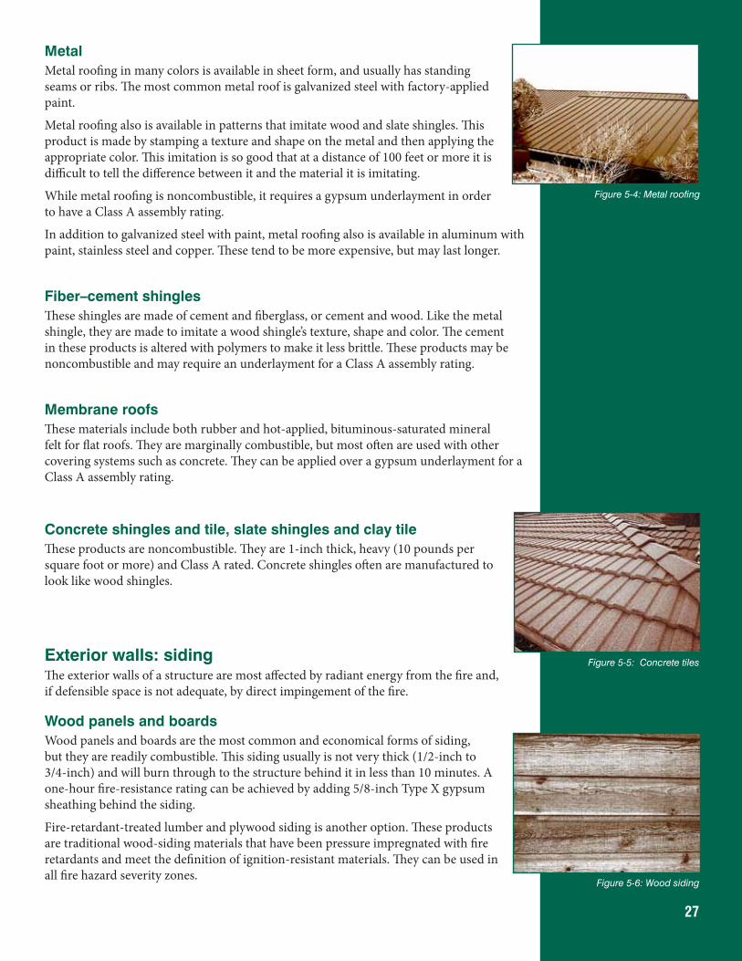
27
MetalMetal roofing in many colors is available in sheet form, and usually has standing seams or ribs. The most common metal roof is galvanized steel with factory-applied paint.
Metal roofing also is available in patterns that imitate wood and slate shingles. This product is made by stamping a texture and shape on the metal and then applying the appropriate color. This imitation is so good that at a distance of 100 feet or more it is difficult to tell the difference between it and the material it is imitating.
While metal roofing is noncombustible, it requires a gypsum underlayment in order to have a Class A assembly rating.
In addition to galvanized steel with paint, metal roofing also is available in aluminum with paint, stainless steel and copper. These tend to be more expensive, but may last longer.
Fiber–cement shinglesThese shingles are made of cement and fiberglass, or cement and wood. Like the metal shingle, they are made to imitate a wood shingle’s texture, shape and color. The cement in these products is altered with polymers to make it less brittle. These products may be noncombustible and may require an underlayment for a Class A assembly rating.
Membrane roofsThese materials include both rubber and hot-applied, bituminous-saturated mineral felt for flat roofs. They are marginally combustible, but most often are used with other covering systems such as concrete. They can be applied over a gypsum underlayment for a Class A assembly rating.
Concrete shingles and tile, slate shingles and clay tileThese products are noncombustible. They are 1-inch thick, heavy (10 pounds per square foot or more) and Class A rated. Concrete shingles often are manufactured to look like wood shingles.
Exterior walls: sidingThe exterior walls of a structure are most affected by radiant energy from the fire and, if defensible space is not adequate, by direct impingement of the fire.
Wood panels and boardsWood panels and boards are the most common and economical forms of siding, but they are readily combustible. This siding usually is not very thick (1/2-inch to 3/4-inch) and will burn through to the structure behind it in less than 10 minutes. A one-hour fire-resistance rating can be achieved by adding 5/8-inch Type X gypsum sheathing behind the siding.
Fire-retardant-treated lumber and plywood siding is another option. These products are traditional wood-siding materials that have been pressure impregnated with fire retardants and meet the definition of ignition-resistant materials. They can be used in all fire hazard severity zones.
Figure 5-4: Metal roofing
Figure 5-5: Concrete tiles
Figure 5-6: Wood siding
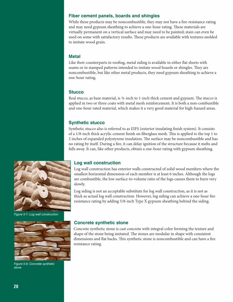
28
Fiber cement panels, boards and shinglesWhile these products may be noncombustible, they may not have a fire-resistance rating and may need gypsum sheathing to achieve a one-hour rating. These materials are virtually permanent on a vertical surface and may need to be painted; stain can even be used on some with satisfactory results. These products are available with textures molded to imitate wood grain.
MetalLike their counterparts in roofing, metal siding is available in either flat sheets with seams or in stamped patterns intended to imitate wood boards or shingles. They are noncombustible, but like other metal products, they need gypsum sheathing to achieve a one-hour rating.
StuccoReal stucco, as base material, is ¾-inch to 1-inch thick cement and gypsum. The stucco is applied in two or three coats with metal mesh reinforcement. It is both a non-combustible and one-hour rated material, which makes it a very good material for high-hazard areas.
Synthetic stuccoSynthetic stucco also is referred to as EIFS (exterior insulating finish system). It consists of a 1/8-inch thick acrylic cement finish on fiberglass mesh. This is applied to the top 1 to 2 inches of expanded polystyrene insulation. The surface may be noncombustible and has no rating by itself. During a fire, it can delay ignition of the structure because it melts and falls away. It can, like other products, obtain a one-hour rating with gypsum sheathing.
Log wall constructionLog wall construction has exterior walls constructed of solid wood members where the smallest horizontal dimension of each member is at least 6 inches. Although the logs are combustible, the low surface-to-volume ratio of the logs causes them to burn very slowly.
Log siding is not an acceptable substitute for log wall construction, as it is not as thick as actual log wall construction. However, log siding can achieve a one-hour fire resistance rating by adding 5/8-inch Type X gypsum sheathing behind the siding.
Concrete synthetic stoneConcrete synthetic stone is cast concrete with integral color forming the texture and shape of the stone being imitated. The stones are modular in shape with consistent dimensions and flat backs. This synthetic stone is noncombustible and can have a fire resistance rating.
Figure 5-7: Log wall construction
Figure 5-8: Concrete synthetic stone
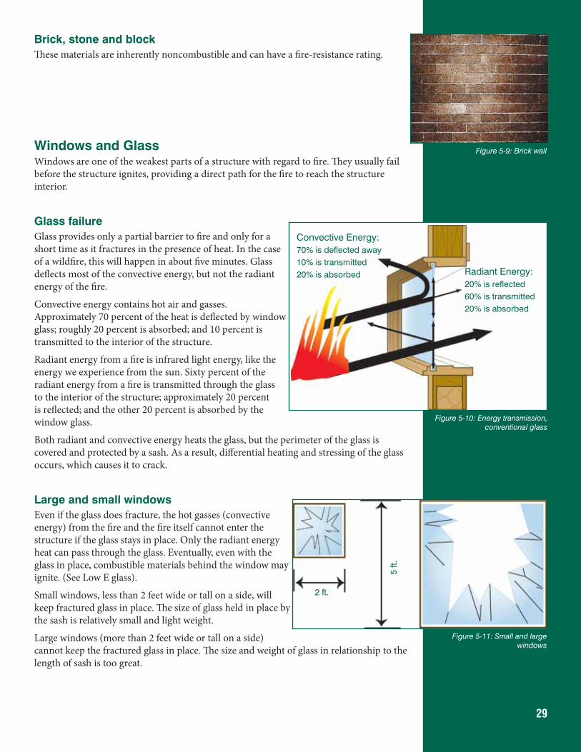
29
Brick, stone and blockThese materials are inherently noncombustible and can have a fire-resistance rating.
Windows and GlassWindows are one of the weakest parts of a structure with regard to fire. They usually fail before the structure ignites, providing a direct path for the fire to reach the structure interior.
Glass failureGlass provides only a partial barrier to fire and only for a short time as it fractures in the presence of heat. In the case of a wildfire, this will happen in about five minutes. Glass deflects most of the convective energy, but not the radiant energy of the fire.
Convective energy contains hot air and gasses. Approximately 70 percent of the heat is deflected by window glass; roughly 20 percent is absorbed; and 10 percent is transmitted to the interior of the structure.
Radiant energy from a fire is infrared light energy, like the energy we experience from the sun. Sixty percent of the radiant energy from a fire is transmitted through the glass to the interior of the structure; approximately 20 percent is reflected; and the other 20 percent is absorbed by the window glass.
Both radiant and convective energy heats the glass, but the perimeter of the glass is covered and protected by a sash. As a result, differential heating and stressing of the glass occurs, which causes it to crack.
Large and small windowsEven if the glass does fracture, the hot gasses (convective energy) from the fire and the fire itself cannot enter the structure if the glass stays in place. Only the radiant energy heat can pass through the glass. Eventually, even with the glass in place, combustible materials behind the window may ignite. (See Low E glass).
Small windows, less than 2 feet wide or tall on a side, will keep fractured glass in place. The size of glass held in place by the sash is relatively small and light weight.
Large windows (more than 2 feet wide or tall on a side) cannot keep the fractured glass in place. The size and weight of glass in relationship to the length of sash is too great.
Figure 5-10: Energy transmission, conventional glass
Radiant Energy:20% is reflected60% is transmitted20% is absorbed
Convective Energy:70% is deflected away10% is transmitted20% is absorbed
2 ft.
5 ft.
Figure 5-11: Small and large windows
Figure 5-9: Brick wall
30
Thermopane or double-glazed windowsMost of today’s energy codes require glass to be double-glazed or Thermopane. During a fire event, double-glazed windows last approximately twice as long as a single pane, or about 10 minutes.
The same processes of convective and radiant energy affect the front pane of glass. As long as the front pane is in place, the second pane is partially protected. When the front pane fails and falls away, the process continues until the second pane fails and falls away.
As shown earlier in the fire behavior section (Section 2), the duration of a fire in an area is dependent on slope and fuels; which, in the case of a grass fire, can be as short as 5 minutes.
If the duration of the fire is any longer than 10 minutes due to preheating or significant fuel around the structure, additional protection is necessary to prevent glass failure and fire from entering the structure.
Tempered glassTempered glass is resistant to high impact and high heat, which means it will remain in place and intact throughout a wildfire event. Building codes require tempered glass to be used in patio doors and all areas subject to human impact. Tempered glass also is used in
front of fireplaces.
Tempered glass typically costs 50-percent more than regular glass. However, patio door replacement units are mass-produced and stocked by virtually every glass business. As a result, they are economical and less expensive than conventional glass. They come in six sizes, as shown in Figure 5-12, and typically can be used as a picture window unit, or combined to make a window wall or solar structure.
Using patio door replacement units provides tempered glass at a very economical price.
A few brands of windows are marketed as replacement windows in existing mid-rise urban structures where the use of tempered glass is required. As a result, the additional cost for these brands of tempered glass is only 25 percent more than standard glass. Your local window supplier can suggest appropriate manufacturers.
Figure 5-12: Thermopane window
2'-4" 2'-10" 3'-10"
7'-8
"6'
-4”
Figure 5-12: Patio door replacement unit sizes
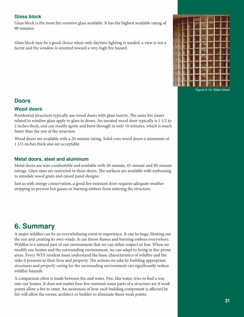
31
Glass blockGlass block is the most fire-resistive glass available. It has the highest available rating of 90 minutes.
Glass block may be a good choice when only daytime lighting is needed, a view is not a factor and the window is oriented toward a very high fire hazard.
DoorsWood doorsResidential structures typically use wood doors with glass inserts. The same fire issues related to window glass apply to glass in doors. An unrated wood door typically is 1 1/2 to 2 inches thick, and can readily ignite and burn through in only 10 minutes, which is much faster than the rest of the structure.
Wood doors are available with a 20-minute rating. Solid-core wood doors a minimum of 1 1/2-inches thick also are acceptable.
Metal doors, steel and aluminumMetal doors are non-combustible and available with 20-minute, 45-minute and 90-minute ratings. Glass sizes are restricted in these doors. The surfaces are available with embossing to simulate wood grain and raised panel designs.
Just as with energy conservation, a good fire-resistant door requires adequate weather stripping to prevent hot gasses or burning embers from entering the structure.
6. SummaryA major wildfire can be an overwhelming event to experience. It can be huge, blotting out the sun and creating its own winds. It can throw flames and burning embers everywhere. Wildfire is a natural part of our environment that we can either respect or fear. When we modify our homes and the surrounding environment, we can adapt to living in fire-prone areas. Every WUI resident must understand the basic characteristics of wildfire and the risks it presents to their lives and property. The actions we take by building appropriate structures and properly caring for the surrounding environment can significantly reduce wildfire hazards.
A comparison often is made between fire and water. Fire, like water, tries to find a way into our homes. It does not matter how fire-resistant some parts of a structure are if weak points allow a fire to enter. An awareness of how each building component is affected by fire will allow the owner, architect or builder to eliminate those weak points.
Figure 5-14: Glass block
32
References and Additional Resources2009 International Wildland-Urban Interface CodeInternational Code Council, Inc.www.iccsafe.org/Store/Pages/Product.aspx?id=3850X09
NFPA 1144 Standard for Reducing Structure Ignition Hazards from WildfireNational Fire Protection Association, (NFPA)www.nfpa.org/catalog/product.asp?pid=114413
2009 International Building CodeInternational Code Council, Inc.www.iccsafe.org/Pages/default.aspx
Fire-Retardant-Treated Lumber and PlywoodHoover Treated Wood Productswww.FRTW.com
The following is a partial list of organizations that can provide more information on the subjects covered in this document.
Colorado State Forest Servicehttp://csfs.colostate.edu/http://csfs.colostate.edu/pages/wildfire.htmlhttp://csfs.colostate.edu/pages/wf-publications.html
Fire Adapted Communitieshttp://fireadapted.org/
Firewise Communities USA (National Fire Protection Association)http://www.firewise.org/
eXtension Wildfire Information Network (eWIN)http://www.extension.org/surviving_wildfire
Southern Rockies Fire Science Networkhttp://www.frames.gov/partner-sites/srfsn/home/
Federal Emergency Management Agency-Wildfirehttp://www.ready.gov/wildfires
Insurance Institute for Business and Home Safetyhttp://www.disastersafety.org/Wildfire
USDA Forest Service, Southern Research Station, Centers for Urban and Interface Forestryhttp://www.humanandnaturalsystems.org/technology/cuif
University of Nevada Cooperative Extension, Living with Firehttp://www.livingwithfire.info/who-we-are
33
AcronymsAPA American Plywood Association (now APA-The Engineered Wood Association)ANSI American National Standards InstituteASTM American Society for Testing and MaterialsBOCA Building Officials and Code Administrators International, IncFEMA Federal Emergency Management AgencyFRTW Fire-retardant-treated woodICBO International Conference of Building OfficialsICC International Code CouncilIRC International Residential CodeIWUIC International Wildland-Urban Interface CodeNFPA National Fire Protection AssociationSBCCI Southern Building Code Congress InternationalUBC Uniform Building Code UL Underwriter’s LaboratoryWHIMS Wildfire Hazard Identification and Mitigation System
WUI Wildland-Urban Interface
Disclaimer: Colorado State Forest Service programs and products are available to all without discrimination. No endorsement of products mentioned is intended nor
is criticism implied of products not mentioned.
This quick guide was produced by the Colorado State Forest Service (CSFS). CSFS programs are available to all without discrimination. No endorsement of products or services is intended, nor is criticism implied of products not mentioned.