Embed Size (px)
Citation preview
LAND USE ORDINANCE
FOR THE
TOWN OF GREENVILLE
AS AMENDED 2016
APPROVED AT JUNE 6, 2016 ANNUAL TOWN MEETING
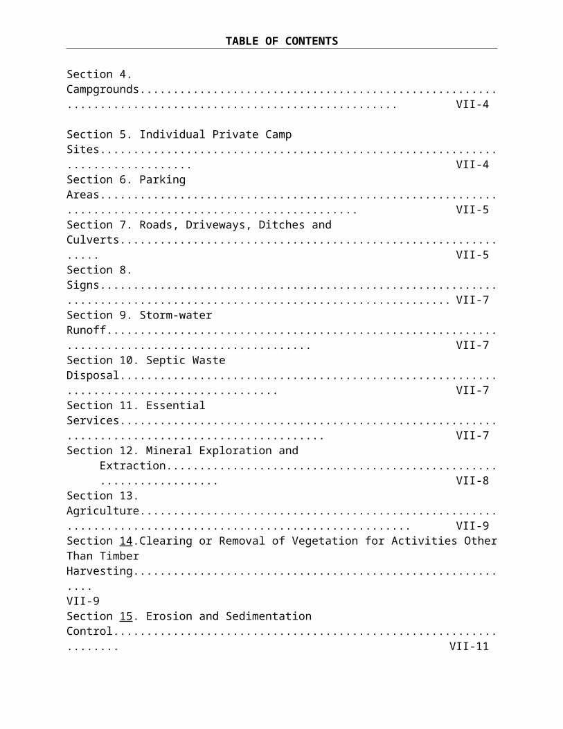
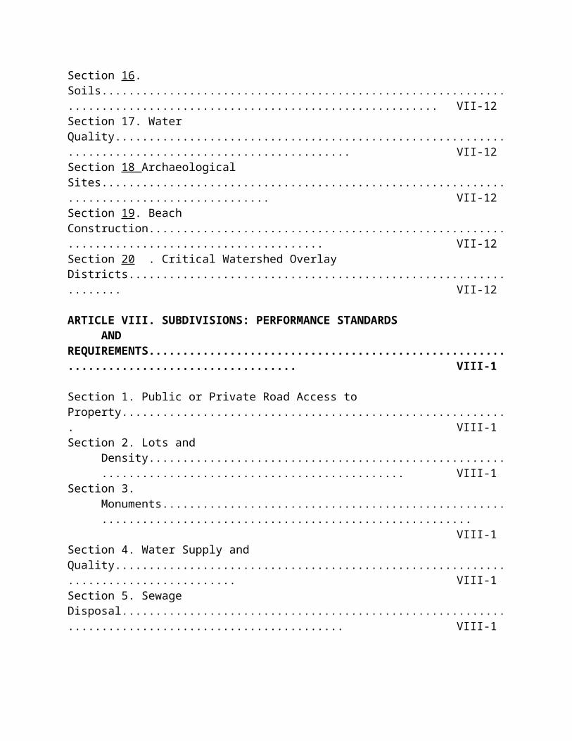
TABLE OF CONTENTS
LAND USE ORDINANCE FOR THE TOWN OF GREENVILLE
PageARTICLE I. GENERAL PROVISIONS.............................................................................. I-1
Section 1. Title........................................................................................................................... I-1Section 2. Authority................................................................................................................... I-1Section 3. Purpose...................................................................................................................... I-1Section 4. Applicability..............................................................................................................I-1Section 5. Validity and Severability...........................................................................................I-2Section 6. Conflicts with Other Ordinances, Laws and Regulations......................................... I-2Section 7. Availability................................................................................................................I-2Section 8. Effective Date and Repeal of Formerly Adopted Ordinances and Regulations........I-2Section 9. Amendments............................................................................................................. I-2
ARTICLE II. ADMINISTRATION AND ENFORCEMENT.......................................... II-1
Section 1. Administrative Bodies and Agents.......................................................................... II-1Section 2. Appeals.................................................................................................................... II-1Section 3. Appeal Procedure.....................................................................................................II-4Section 4. Enforcement............................................................................................................. II-5
ARTICLE III. PERMITTING REQUIREMENTS AND PROCEDURES....................III-1
Section 1. Activities Requiring a Land Use Permit.................................................................III-1Section 2. Activities Not Requiring a Land Use Permit..........................................................III-1Section 3. Types of Land Use Permits.....................................................................................III-2Section 4. Plumbing Permit Required..................................................................................... III-2Section 5. Permit and Review Fees......................................................................................... III-2Section 6. Expiration of a Permit.............................................................................................III-2Section 7. Transfer of Permits................................................................................................. III-3Section 8. General Permit Requirements.................................................................................III-3Section 9. Code Enforcement Officer Review of Permitted Uses...........................................III-3Section 10. Planning Board Review of Conditional Uses and Subdivisions...........................III-4Section 11. Planning Board Review of Conditional Uses....................................................... III-8Section 12. Planning Board Review of Subdivisions.............................................................. III-9Section 13. Performance Guarantees.....................................................................................III-19
ARTICLE IV. NON-CONFORMANCE............................................................................IV-1
Section 1. Purpose................................................................................................................... IV-1Section 2. General................................................................................................................... IV-1Section 3. Non-conforming Structures.................................................................................... IV-1Section 4. Non-conforming Uses............................................................................................ IV-4Section 5. Non-conforming Lots............................................................................................. IV-5Section 6. Vested Rights..........................................................................................................IV-6
ARTICLE V. LAND USE DISTRICTS AND REQUIREMENTS................................... V-1
Section 1. Establishment of Districts........................................................................................V-1Section 2. Location of Districts and Certification of Official Zoning Maps............................ V-1Section 3. Uncertainty of Boundary Location.......................................................................... V-1Section 4. District Purposes......................................................................................................V-2Section 5. District Land Uses................................................................................................... V-5
Table of Land Uses By District.................................................................................... V-6Section 6. District Space Standards and Dimensional Requirements.....................................V-11
Table of Space and Dimensional Requirements.........................................................V-12Section 7. Airport District.......................................................................................................V-15Section 8. Resource Protection District – Single Family Residential Structures................... V-15Section 9. Ground Water Protection Overlay District Standards........................................... V-15Section 10.Scenic Corridor Overlay District Standards......................................................... V-16Section 11. Rural District Standards.......................................................................................V-18
ARTICLE VI. ALL AREAS: PERFORMANCE AND DESIGNSTANDARDS.............................................................................................................VI-1
Section 1. Land Not To Be Included in the Calculation of Lot Area.....................................VI-1Section 2. Water Supply and Quality...................................................................................... VI-1Section 3. Sewage Disposal.....................................................................................................VI-1Section 4. Storm Water Runoff............................................................................................... VI-2Section 5. Erosion and Sedimentation Control........................................................................VI-3Section 6. Solid Waste Disposal..............................................................................................VI-3Section 7. Traffic Access, Circulation and Parking................................................................ VI-4Section 8. Buffer Areas........................................................................................................... VI-5Section 9. Recreational Facilities, Campgrounds, and Parks and Recreation.........................VI-5Section 10. Home Occupations............................................................................................... VI-6Section 11. Signs..................................................................................................................... VI-6Section 12. Historic and Archaeological Sites........................................................................ VI-7Section 13. Conformance with Other Laws, Regulations....................................................... VI-7Section 14. Cluster Development: Residential and/or Non-Residential................................. VI-7Section 15. Reservation, Dedication and Maintenance of
Common Open Space and Facilities............................................................................VI-9
ARTICLE VII. SHORELAND OVERLAY DISTRICT AND RESOURCE PROTECTION DISTRICT STANDARDS...........................................................VII-1
Section 1. Minimum Lot Standards....................................................................................... VII-1Section 2. Principal and Accessory Structures.......................................................................VII-2Section 3. Piers, Docks Wharves, Bridges and Other Structures Extending Over or
Below the Normal High-Water Line of a Water Body or Within a Wetland.... VII-3Section 4. Campgrounds........................................................................................................ VII-4
TABLE OF CONTENTS
Section 5. Individual Private Camp Sites...............................................................................VII-4Section 6. Parking Areas........................................................................................................VII-5Section 7. Roads, Driveways, Ditches and Culverts..............................................................VII-5Section 8. Signs......................................................................................................................VII-7Section 9. Storm-water Runoff................................................................................................VII-7Section 10. Septic Waste Disposal.........................................................................................VII-7Section 11. Essential Services................................................................................................VII-7Section 12. Mineral Exploration and Extraction....................................................................VII-8Section 13. Agriculture.......................................................................................................... VII-9Section 14.Clearing or Removal of Vegetation for Activities Other Than Timber Harvesting........................................................... VII-9Section 15. Erosion and Sedimentation Control.................................................................. VII-11Section 16. Soils...................................................................................................................VII-12Section 17. Water Quality....................................................................................................VII-12Section 18 Archaeological Sites.......................................................................................... VII-12Section 19. Beach Construction........................................................................................... VII-12Section 20 . Critical Watershed Overlay Districts................................................................VII-12
ARTICLE VIII. SUBDIVISIONS: PERFORMANCE STANDARDSAND REQUIREMENTS....................................................................................... VIII-1
Section 1. Public or Private Road Access to Property..........................................................VIII-1Section 2. Lots and Density..................................................................................................VIII-1Section 3. Monuments.......................................................................................................... VIII-1Section 4. Water Supply and Quality................................................................................... VIII-1Section 5. Sewage Disposal..................................................................................................VIII-1Section 6. Storm Water Runoff............................................................................................ VIII-1Section 7. Soil Erosion and Sedimentation Control............................................................. VIII-2Section 8. Solid Waste Disposal...........................................................................................VIII-2Section 9. Traffic.................................................................................................................. VIII-2Section 10. Buffer Areas.......................................................................................................VIII-2Section 11. Conformance with Other Laws, Regulations.....................................................VIII-2Section 12. Natural Beauty, Aesthetics, Historic Sites, Wildlife Habitat,
Rare Natural Areas or Public Access to Shorelines..................................................VIII-2Section 13. Floodplain Management.................................................................................... VIII-2Section 14. Street Design and Construction Standards........................................................ VIII-3Section 15. Maintenance Requirements for Roads and Common Areas..............................VIII-8Section 16. Financial and Technical Capacity......................................................................VIII-9Section 17. Construction Prohibited.....................................................................................VIII-9Section 18. Phosphorus Control......................................................................................... VIII-9
ARTICLE IX. DEFINITIONS.............................................................................................IX-1

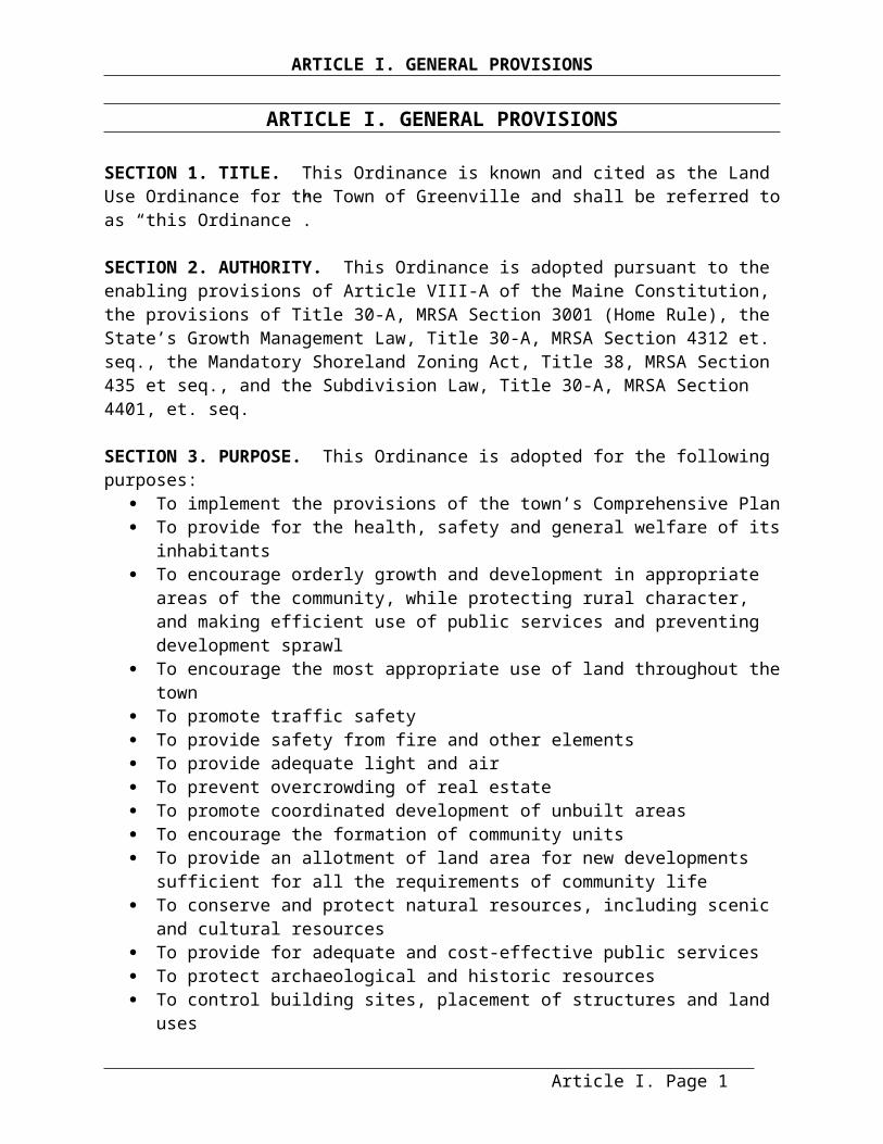
ARTICLE I. GENERAL PROVISIONS
ARTICLE I. GENERAL PROVISIONS
SECTION 1. TITLE. This Ordinance is known and cited as the Land Use Ordinance for the Town of Greenville and shall be referred to as “this Ordinance”.
SECTION 2. AUTHORITY. This Ordinance is adopted pursuant to the enabling provisions of Article VIII-A of the Maine Constitution, the provisions of Title 30-A, MRSA Section 3001 (Home Rule), the State’s Growth Management Law, Title 30-A, MRSA Section 4312 et. seq., the Mandatory Shoreland Zoning Act, Title 38, MRSA Section 435 et seq., and the Subdivision Law, Title 30-A, MRSA Section 4401, et. seq.
SECTION 3. PURPOSE. This Ordinance is adopted for the following purposes: To implement the provisions of the town’s Comprehensive Plan To provide for the health, safety and general welfare of its inhabitants To encourage orderly growth and development in appropriate areas of the community,
while protecting rural character, and making efficient use of public services and preventing development sprawl
To encourage the most appropriate use of land throughout the town To promote traffic safety To provide safety from fire and other elements To provide adequate light and air To prevent overcrowding of real estate To promote coordinated development of unbuilt areas To encourage the formation of community units To provide an allotment of land area for new developments sufficient for all the
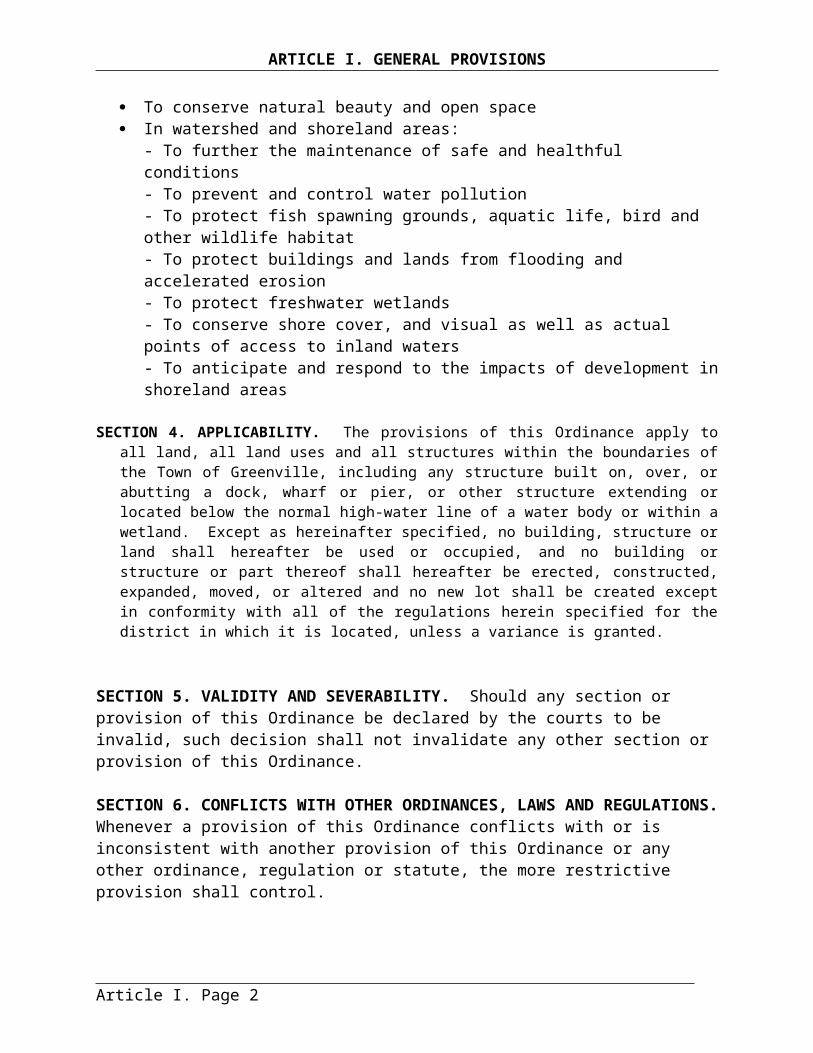
requirements of community life To conserve and protect natural resources, including scenic and cultural resources To provide for adequate and cost-effective public services To protect archaeological and historic resources To control building sites, placement of structures and land uses To conserve natural beauty and open space In watershed and shoreland areas:
- To further the maintenance of safe and healthful conditions - To prevent and control water pollution- To protect fish spawning grounds, aquatic life, bird and other wildlife habitat- To protect buildings and lands from flooding and accelerated erosion- To protect freshwater wetlands- To conserve shore cover, and visual as well as actual points of access to inland waters- To anticipate and respond to the impacts of development in shoreland areas
SECTION 4. APPLICABILITY. The provisions of this Ordinance apply to all land, all land uses and all structures within the boundaries of the Town of Greenville, including any structure built on, over, or abutting a dock, wharf or pier, or other structure extending or located below the normal high-water line of a water body or within a wetland. Except as hereinafter specified, no building, structure or land shall hereafter be used or occupied, and no building or structure or part thereof shall hereafter be erected, constructed, expanded, moved, or altered and no new lot shall be created except in
Article I. Page 1

ARTICLE I. GENERAL PROVISIONS
conformity with all of the regulations herein specified for the district in which it is located, unless a variance is granted.
SECTION 5. VALIDITY AND SEVERABILITY. Should any section or provision of this Ordinance be declared by the courts to be invalid, such decision shall not invalidate any other section or provision of this Ordinance.
SECTION 6. CONFLICTS WITH OTHER ORDINANCES, LAWS AND REGULATIONS. Whenever a provision of this Ordinance conflicts with or is inconsistent with another provision of this Ordinance or any other ordinance, regulation or statute, the more restrictive provision shall control.
SECTION 7. AVAILABILITY. A certified copy of this Ordinance shall be filed with the Municipal Clerk and shall be accessible to any member of the public. Copies shall be made available to the public at reasonable cost at the expense of the person making the request. Notice of availability of this Ordinance shall be posted.
SECTION 8. EFFECTIVE DATE AND REPEAL OF FORMERLY ADOPTED ORDINANCES AND REGULATIONS.
A. Date of Enactment. This Ordinance takes effect upon its enactment by the Town of Greenville.B. Date of Enactment of Shoreland Zoning Provisions. The shoreland zoning provisions of this Ordinance shall be effective upon the date of adoption provided that the Commissioner of the Department of Environmental Protection subsequently approves them. A certified copy of the Ordinance, attested and signed by the Municipal Clerk, shall be forwarded to the Commissioner of the Department of Environmental Protection for approval. If the Commissioner fails to act on the shoreland zoning provisions of this Ordinance within 45 days of his/her receipt of the Ordinance, it shall be deemed approved. Upon approval of the shoreland zoning provisions of this Ordinance, the shoreland zoning provisions previously adopted are hereby repealed.C. Repeals and Replacements. This Ordinance repeals and replaces the Basic Land Use Ordinance of 1995, adopted June 1995, as well as any subsequent amendments including amendments on June 13, 1997, and June 6, 1999, June 4, 2001, June 1, 2009, June 7, 2010, June 5, 2012, June 3, 2013, June 2, 2014 and June 1, 2015. This Ordinance also repeals and replaces the Subdivision Regulations for the Town of Greenville adopted by the Planning Board on July 10, 1996, along with any subsequent amendments to those regulations.D. The Zoning Map, Town of Greenville, ME, as enacted on November 28, 2001 shall remain in effect as part of this ordinance.
SECTION 9. AMENDMENTS.
A. Initiation of Amendment. An amendment to this Ordinance may be initiated by:1. Planning Board. The Planning Board provided a majority of the Board has so voted;2. Selectmen. Request of the Selectmen to the Planning Board; or3. Registered Voters. Written petition of 10% of the registered voters of the town.
Article I. Page 2
ARTICLE I. GENERAL PROVISIONS
B. Amendment Procedure. All proposed amendments shall be referred to the Planning Board for their recommendations. The Planning Board may hold a public hearing on any proposed amendment. Within 30 days of receiving a proposed amendment, the Planning Board shall make its recommendation known to the Selectmen and the town. This Ordinance may be amended by a majority vote of the voters at a Town Meeting. Copies of amendments relative to the shoreland zone, attested and signed by the Municipal Clerk, shall be submitted to the Commissioner of the Department of Environmental Protection following adoption by the Town of Greenville and shall not be effective unless approved by the Commissioner. If the Commissioner fails to act on any amendment within 45 days of his/her receipt of the amendment, the amendment is automatically approved. Any application for a permit in the shoreland zone, submitted to the municipality within the 45-day period shall be governed by the terms of the amendment, if the Commissioner approves such amendment.
C. Map Amendments. If amendments, in accordance with Section 9, are made in the district boundaries or other matter portrayed on the Zoning Map, within or relating to the shoreland zone, then such changes shall be made on the Zoning Map within thirty (30) days after the amendment has been approved by the Commissioner of the Department of Environmental Protection.
Article I. Page 3
ARTICLE I. GENERAL PROVISIONS
Article I. Page 1
ARTICLE II. ADMINISTRATION AND ENFORCEMENT
ARTICLE II. ADMINISTRATION AND ENFORCEMENT
SECTION 1. ADMINISTRATIVE BODIES AND AGENTS.
A. Code Enforcement Officer. The Code Enforcement Officer (CEO), appointed or re-appointed by the Selectmen annually by July 1, shall be responsible for enforcing the provisions of this Ordinance. The CEO shall have the following powers and duties in addition to those provided in Article II. Section 4. Enforcement:
1. Act upon permit applications, review applications requiring Planning Board review, and refer requests for variances and administrative appeals to the Board of Appeals;2. Enter any property at reasonable hours or enter any building with the consent of the property owner, occupant or agent, to inspect the property or building for compliance with this Ordinance;3. Investigate complaints and reported violations, and take action as appropriate;4. Revoke any permits issued in error or which are based on erroneous information;5. Exercise any additional powers or duties authorized by the state statutes, or as directed by the Board of Selectmen or Town Manager;6. Develop and revise permit application forms; and7. Maintain the development tracking system.
B. Planning Board. The Planning Board shall be responsible for such duties and exercise such powers as are provided by the town’s ordinances and the laws of the State of Maine. This shall include reviewing and acting upon conditional uses as provided within this Ordinance. The Planning Board shall operate according to the Ordinance for the Establishment of the Greenville Planning Board, which may be amended and repealed by the Selectmen.
C. Board Of Appeals. The powers and duties of the Board of Appeals include hearing and making binding decisions on appeals in regard to final decisions of the Code Enforcement Officer or the Planning Board, and granting or rejecting variance requests. The Board of Appeals must be maintained in accordance with the provisions of Title 30-A Section 2691, Board of Appeals.
SECTION 2. APPEALS.
Administrative Appeals The Board of Appeals shall have the power to hear and decide administrative appeals, on an appellate basis, where it is alleged by an aggrieved party that there is an error in any order, requirement, decision, or determination made by, or failure to act by, the Planning Board in the administration of this Ordinance; and to hear and decide administrative appeals on a de novo basis where it is alleged by an aggrieved party that there is an error in any order, requirement, decision or determination made by, or failure to act by, the Code Enforcement Officer in his or her review of and action on a permit application under this Ordinance. Any order, requirement, decision or determination made, or failure to act, in the enforcement of this ordinance is not appealable to the Board of Appeals.
1. When the Board of Appeals reviews a decision of the Code Enforcement Officer the Board of Appeals shall hold a “de novo” hearing. At this time the Board may receive and consider new evidence and testimony, be it oral or written. When acting in a “de novo” capacity the Board of Appeals shall hear and decide the matter afresh, undertaking its own independent analysis of evidence and the law, and reaching its own decision.
Article II. Page 1

ARTICLE II. ADMINISTRATION AND ENFORCEMENT
2. When the Board of Appeals hears a decision of the Planning Board, it shall hold an appellate hearing, and may reverse the decision of the Planning Board only upon finding that the decision was contrary to specific provisions of the Ordinance or contrary to the facts presented to the Planning Board. The Board of Appeals may only review the record of the proceedings before the Planning Board. The Board Appeals shall not receive or consider any evidence which was not presented to the Planning Board, but the Board of Appeals may receive and consider written or oral arguments. If the Board of Appeals determines that the record of the Planning Board proceedings are inadequate, the Board of Appeals may remand the matter to the Planning Board for additional fact finding.
B. Variances. The Board of Appeals shall have the power to authorize variances upon appeal, within the limitations set forth in this Ordinance. The Board of Appeals shall limit any variances granted as strictly as possible in order to ensure conformance with the purposes and provisions of this Ordinance to the greatest extent possible, and in doing so may impose such conditions to a variance as it deems necessary. The party receiving the variance shall comply with any conditions imposed. The Board of Appeals shall have the power to authorize the following types of variances:
1. Variances.a. Variances may be granted from dimensional requirements including frontage, lot area, lot width, structure height, percent of lot coverage, and setback requirements. b. Variances may also be granted for the establishment of any uses otherwise prohibited within a district by this Ordinance, except that variances may not be granted for the establishment of any uses otherwise prohibited within a district when the property is located in whole or in part within 250 feet of a great pond, river or wetland, or within 75 feet of a stream.c. The Board shall not grant a variance unless it finds that:
(i) The proposed structure or use would meet the performance standards of this Ordinance except for the specific provision which has created the non-conformity and from which relief is sought; and(ii) The strict application of the terms of this Ordinance would result in undue hardship. The term “undue hardship” as used in this subsection shall mean:
- That the land in question cannot yield a reasonable return unless a variance is granted;- That the need for a variance is due to the unique circumstances of the property and not to the general conditions in the neighborhood;- That the granting of a variance will not alter the essential character of the locality; and - That the hardship is not the result of action taken by the applicant or a prior owner.
2. Variances for Certain Dimensional Requirements. Not withstanding Article II. Section 2.B.1. above, the Board of Appeals may grant a variance under this subsection from the following dimensional requirements: frontage, lot area, lot coverage, and setback requirements. Variances shall not be granted under this subsection, for establishment of any uses otherwise prohibited within a district by this Ordinance, or
Article II. Page 2

ARTICLE II. ADMINISTRATION AND ENFORCEMENT
where the property is located in whole or in part within shoreland zone. Furthermore, the Board shall not grant a variance unless it finds that:
a. The proposed structure or use would meet the performance standards of this Ordinance except for the specific provision which has created the non-conformity and from which relief is sought;b. The strict application of the terms of this Ordinance would result in practical difficulty. The term “practical difficulty” as used in this subsection shall mean:
(i) That the need for a variance is due to the unique circumstances of the property and not to the general conditions in the neighborhood;(ii) That the granting of a variance will not produce an undesirable change in the character of the neighborhood and will not unreasonably detrimentally affect the use or market value of abutting properties.(iii) That the practical difficulty is not the result of action taken by the applicant or a prior owner; and (iv) That no other feasible alternative to a variance is available to the petitioner (“No other feasible alternative” means that there is no other place on the lot or no other location on the structure that the proposed construction could go without the need for a variance or without creating other compliance problems on the lot because of this Ordinance, deed restrictions, or conditions imposed by a lease or contract); and(v) That the granting of a variance will not unreasonably adversely affect the natural environment;
c. As used in this subsection “practical difficulty” means that the strict application of the Ordinance to the property precludes the ability of the petitioner to pursue a use permitted in the zoning district in which the property is located and results in significant economic injury to the petitioner.
3. Disability Variance. Notwithstanding Article II. Section 2.B.1. above, in accordance with 30-A M.R.S.A section 4353-A, the Code Enforcement Officer may approve a permit to the owner of a residential dwelling unit for the purpose of making that dwelling accessible to a person with a disability who resides in or regularly uses that dwelling. The permit is deemed to include the variance, which shall be solely for installation of equipment or the construction of structures necessary for access to or egress from the dwelling by the person with the disability. The Code Enforcement Officer may impose conditions on the permit, including limiting the permit to the duration of the disability or to the time that the person with the disability lives in the dwelling. The term "structures necessary for access to or egress from the dwelling" shall include ramps and associated railing, and wall or roof systems necessary for the safety or effectiveness of the structure. Such permitting is subject to Article II. Sections 3.A.4 and 3.E below.4. Set-back Variance for Year-round Single Family Dwellings. Not withstanding Article II. Section 2.B.1. above, the Board of Appeals may grant a variance from setback requirements for a single family dwelling which is the primary year-round residence of the applicant or its accessory structure(s) upon a finding that the strict application of this Ordinance to the applicant’s property would create undue hardship. Variances shall not be granted under this subsection where the property is located in whole or in part within shoreland zone. The term “undue hardship” as used in this subsection means:
Article II. Page 3
ARTICLE II. ADMINISTRATION AND ENFORCEMENT
a. The need for a variance is due to the unique circumstances of the property and not to the general conditions in the neighborhood;b. The granting of a variance will not alter the essential character of the locality;c. The hardship is not the result of action taken by the applicant or a prior owner;d. The granting of the variance will not substantially reduce or impair the use of the abutting property; ande. The granting of a variance is based upon demonstrated need, not convenience, and no other feasible alternative available.
The Board of Appeals many not grant a set back variance for a single family dwelling under this subsection if the result would be to exceed the lot coverage ratio allowed in the district. Minimum shoreline setback may not be reduced under this subsection. Minimum front, side, and rear setbacks may be reduced by more than 20% under this subsection only if the applicant has obtained the written consent of any affected abutting landowner.
SECTION 3. APPEAL PROCEDURE.
A. Making an Appeal.1. Time Limit. An administrative or variance appeal may be taken to the Board of Appeals from any decision of the Code Enforcement Officer or the Planning Board except for enforcement-related matters as described in Article II Section, A. Administrative Appeals above. Such appeal shall be taken within thirty 30 days of the date of the official written decision appealed from, and not otherwise, except that the Board, upon showing of good cause, may waive the 30-day requirement.2. Submissions. Such appeal shall be made by filing with the Board of Appeals at the office of the Town Clerk, a written notice, on forms provided by the town, of appeal that includes:
a. A concise written statement indicating what relief is requested and why it should be granted.b. A site plan to scale showing lot lines, location of existing buildings and structures and other physical features of the lot pertinent to the relief sought.
3. Records to be Forwarded to Board of Appeals. Upon receiving an application for an administrative appeal or a variance the Code Enforcement Officer or Planning Board, as appropriate, shall transmit to the Board of Appeals all of the papers constituting the record of the decision appealed from.4. Records to be Forwarded to DEP. A copy of each request for a variance from a shoreland zoning standard, including the application and all supporting information supplied by the applicant, shall be forwarded by the Code Enforcement Officer to the Commissioner of the Department of Environmental Protection at least twenty (20) days prior to action by the Board of Appeals. Any comments received from the Commissioner prior to the action by the Board of Appeals shall be made part of the record and shall be taken into consideration by the Board of Appeals.5. Public Hearing Required. The Board of Appeals shall hold a public hearing on an administrative appeal or a request for a variance within 35 days of its receipt of a complete written application, unless this time is extended by the parties. The notice for the public hearing shall be done in the same manner as the notice requirements for
Article II. Page 4
ARTICLE II. ADMINISTRATION AND ENFORCEMENT
conditional use permits in Article III. Section10.H. Procedures for Public Hearings. The public hearings shall be conducted in accordance with the procedure set forth in Title 30-A M.R.S.A., Section 2691. The Planning Board, Code Enforcement Officer, and Selectmen may be parties to the hearing.
B. Decision by the Board of Appeals.1. Quorum. A majority of the full voting membership of the Board shall constitute a quorum for the purposes of deciding an appeal. 2. Burden of Proof. The person filing the appeal shall have the burden of proof.
3. Written Decisions Within 35 Days.a. The Board shall decide all administrative appeals and variance appeals within 35 days after the close of the hearing and shall issue a written decision on all appeals and shall send a copy of the decision to the applicant, Code Enforcement Officer and the Planning Board within 7 days thereafter.b. All decisions shall become a part of the record and shall include a statement of findings and conclusions as well as the reasons or basis therefore, and the appropriate order, relief or denial thereof. In instances where the Board of Appeals remands a case to the Planning Board or Code Enforcement Officer, such decisions shall include an appropriate order.
C. Reconsideration by the Board of Appeals In accordance with 30-A M.R.S.A. section 2691(3)(F), the Board of Appeals may reconsider any decision within forty-five (45) days of its prior decision. A request to the Board to reconsider a decision must be filed within ten (10) days of the decision that is being reconsidered. A vote to reconsider and the action taken on that reconsideration must occur and be completed within forty-five (45) days of the date of the vote on the original decision. Reconsideration of a decision shall require a positive vote of the majority of the Board members originally voting on the decision, and proper notification to the landowner, petitioner, planning board, code enforcement officer, and other parties of interest, including abuttors and those who testified at the original hearing(s). The Board may conduct additional hearings and receive additional evidence and testimony.
D. Appeal to Superior Court. Appeal of a reconsidered decision to Superior Court must be made within fifteen (15) days after the decision on reconsideration. Except as provided by 30-A M.R.S.A. section 2691(3)(F), any aggrieved party who participated as a party during the proceedings before the Board of Appeals may take an appeal to Superior Court in accordance with State laws within forty-five (45) days from the date of any decision of the Board of Appeals.
E. Submission of Shoreland Variances to the Department of Environmental Protection. A copy of all shoreland zone variances granted by the Board of Appeals shall be submitted to the Department of Environmental Protection within 7 days of the decision.
F. Recording of Variances at Registry of Deeds or Variance is Void. If a variance is granted under this section, a certificate indicating the name of the current property owner, identifying the property by reference to the last recorded deed in its chain of title and indicating the fact that a variance including any conditions on the variance, has been granted and the date of the
Article II. Page 5
ARTICLE II. ADMINISTRATION AND ENFORCEMENT
granting, shall be prepared in recordable form. The certificate must be recorded in the local registry of deeds within 90 days of the final approval of the variance or the variance is void. The variance is not valid until recorded as provided in this provision. It is the applicant’s responsibility to obtain a Variance Certificate from the Code Enforcement Officer, and to record this Certificate at the Piscataquis County Registry of Deeds.
SECTION 4. ENFORCEMENT.
A. Nuisances. Any violation of this Ordinance shall be deemed to be a nuisance.
B. Code Enforcement Officer Procedures.1. Written Notification of Violations. It shall be the duty of the Code Enforcement Officer to enforce the provisions of this Ordinance. If the Code Enforcement Officer shall find that any provision of this Ordinance is being violated, he or she shall notify in writing the person responsible for such violation, indicating the nature of the violation and ordering the action necessary to correct it, including discontinuance of illegal use of land, buildings, or structures, or work being done, removal of illegal buildings or structures, and abatement of nuisance conditions or shall take any other action authorized by this Ordinance to ensure compliance with or to prevent violation of its provisions. A copy of such notices shall be submitted to the Selectmen and be maintained as a permanent record.2. On-site Inspections and Permit Revocation Due to Erroneous Information. The Code Enforcement Officer shall conduct on-site inspections to ensure compliance with all applicable laws and conditions attached to permit approvals. The Code Enforcement Officer shall also investigate all complaints of alleged violations of this Ordinance. The Code Enforcement Officer may enter any property at reasonable hours and enter any structure with the consent of the property owner, occupant or agent, to inspect the property or structure for compliance with the laws or ordinances set forth in this Ordinance. If consent is denied he/she should obtain an administrative warrant before entering the property. The Code Enforcement Officer may revoke a permit after proper notification and a public hearing, if it was in error or if based on erroneous information.3. Record Keeping Requirements. The Code Enforcement Officer shall keep a complete record of all essential transactions of the office, including applications submitted, permits granted or denied, variances granted or denied, revocation actions, revocation of permits, appeals, court actions, violations investigated, violations found, and fees collected. On an annual basis, a summary of this record shall be submitted to the Selectmen for their review and for the annual town report. The Code Enforcement Officer should also maintain a current file of all pertinent federal, state, and local statutes, ordinances, regulations, codes, and plans relating to land use regulation.
C. Legal Action and Violations. When the above action does not result in the correction or abatement of the violation or nuisance condition, the Selectmen, upon notice from the Code Enforcement Officer, are hereby directed to institute any and all actions and proceedings, either legal or equitable, including seeking injunctions of violations and the imposition of fines, that may be appropriate or necessary to enforce the provisions of this Ordinance in the name of the municipality.
Article II. Page 6
ARTICLE II. ADMINISTRATION AND ENFORCEMENT
D. Consent Agreements. The Selectmen, or their authorized agent, are hereby authorized to enter into administrative consent agreements for the purpose of eliminating violations of this Ordinance and recovering fines without Court action. Such agreements shall not allow an illegal structure or use to continue unless there is clear and convincing evidence that the illegal structure or use was constructed or conducted as a direct result of erroneous advice given by an authorized municipal official and there is no evidence that the owner acted in bad faith, or unless the removal of the structure or use will result in a threat or hazard to public health and safety or will result in substantial environmental damage.
E. Fines. Any person, including but not limited to a landowner, a landowner's agent or a contractor, who violates any provision or requirement of this Ordinance shall be penalized in accordance with Title 30-A, Maine Revised Statutes Annotated, Subsection 4452.
Article II. Page 7

ARTICLE III. PERMITTING REQUIREMENTS AND PROCEDURES
ARTICLE III. PERMITTING REQUIREMENTS AND PROCEDURES
SECTION 1. ACTIVITIES REQUIRING A LAND USE PERMIT. A permit shall be required for all those activities listed below prior to the start of any construction, site work or commencement of a land use activity. A person who is issued a permit pursuant to this Ordinance shall have a copy of the permit on site while the work authorized by the permit is performed.
Permits shall be required for the following activities:A. Construction, erection, demolition, or movement of any permanent or temporary building,
foundation or structure (See Article IX. Definitions, for definitions of “building”, “structure”, etc.)
B. Addition or enlargement of any permanent or temporary building or structureC. Installation, construction or relocation of a mobile home or modular homeD. Increase in the number of residential dwelling unitsE. Expansion, relocation, reconstruction, replacement, or change of use of a non-conforming use
or structureF. SubdivisionG. Cluster developmentH. Mobile home parkI. A new or expanded residential, commercial, industrial, institutional, or outdoor resource land
use activity as required in Table V-1. Land Uses by District, Article V.J. Installation, alteration or illumination of any sign as required in Article VI. Section 11 or, if
located within the Shoreland Overlay District or a Resource Protection District in Article VII. Section 8.
K. Agriculture within the Residential Districts and Resource Protection DistrictsL. Within the Shoreland Overlay Districts and Resource Protection Districts the following uses,
if allowed, also require permits under Article VII.1. Clearing or removal of vegetation for activities other than timber harvesting.2. Aquaculture3. Road and driveway construction 4 Parking facilities5. Filling and earth moving activities6. Home occupations7. Culvert installation or replacement8. Archeology activities, except as provided in Section 2.E below.
SECTION 2. ACTIVITIES NOT REQUIRING A LAND USE PERMIT. Permits are not required for the following:
A. The normal repair and maintenance of any building or structure, including interior improvements and also allows normal repair and maintenance of non-conforming uses and structures including repairs or renovations that do not involve expansion of the non-conforming use or structure, and such other changes in a non-conforming use or structure as federal, state, or local building and safety codes may require.B. Open Space Uses (see Article IX. Definitions)
Article III. Page 1
ARTICLE III. PERMITTING REQUIREMENTS AND PROCEDURES
C. Uses listed in Section 1.L. above, when not located within the Shoreland Overlay District or Resource Protection District.
D. Agriculture in the Rural, Rural Development and Village Districts.E. A permit is not required for an archaeological excavation as long as the excavation is
conducted by an archaeologist listed on the State Historic Preservation Officer’s level 1 or level 2 approved list, and unreasonable erosion and sedimentation is prevented by means of adequate and timely temporary and permanent stabilization measures.
SECTION 3. TYPES OF LAND USE PERMITS.
A. Permitted Use Permits. Permitted Use Permits shall be obtained from the Code Enforcement Officer for uses that are listed as “Permitted Uses” in Table V-1. Land Uses by District, Article V.
B. Conditional Use Permits and Subdivision Permits. Conditional Use Permits shall be obtained from the Planning Board for uses listed as “Conditional Uses” in Table V-1. Land Uses by District, Article V. Subdivision Permits must be obtained from the Planning Board.
SECTION 4. PLUMBING PERMIT REQUIRED (WHERE APPLICABLE). No land use permit shall be issued for any structure or use involving the construction, installation, or alteration of plumbing facilities unless a permit for such facilities has been secured from the local plumbing inspector by the applicant or authorized agent, according to the requirements of this Ordinance and the State Subsurface Waste Water Disposal Rules of the State Plumbing Code.
SECTION 5. PERMIT AND REVIEW FEES. Permit application and application review fees, including variances and administrative appeals fees shall be set by the Board of Selectmen. These fees shall be non-refundable and submitted by the applicant to the Code Enforcement Officer at the time of application. The application shall not be considered complete until the appropriate fee is paid.
SECTION 6. EXPIRATION OF PERMITS.
A. Areas Outside the Shoreland Zone. Following the issuance of a permit, if no substantial start is made in construction, or in use of the property for which such permit has been issued, within two years of the date of the permit, the permit lapses and becomes void.B. Areas Within Shoreland Zone. Following the issuance of a permit, if no substantial start is made in construction, or in use of the property for which such permit has been issued, within one year of the date of the permit, the permit lapses and becomes void. If a substantial start is made within one year of the issuance of the permit, the applicant shall have one additional year to complete the project, at which time the permit shall expire.C. Subdivisions. The Planning Board may set a completion date for all subdivision improvements as a condition of approval. If the subdivision improvements, including monumentation, road construction, storm water facilities or other required improvements, are not completed by the established completion date, the subdivision approval will expire and the Board shall have a notice placed in the County Registry of Deeds to that effect.
Article III. Page 2
ARTICLE III. PERMITTING REQUIREMENTS AND PROCEDURES
SECTION 7. TRANSFER OF PERMITS. Valid permits from the Planning Board or the Code Enforcement Officer or valid variances from the Appeals Board are transferable to a new owner or lessee of the property for which the permit or variance was given provided that the new owner or lessee signs a statement that they will adhere to the conditions and specifications of the issued permit. The new owners must conform to all construction, site development, uses, and permit conditions as specified in the permit application and the permits from the Planning Board or Code Enforcement Officer, and any conditions attached in a valid variance from the Appeals Board. This provision of the Ordinance does not supersede the expiration of permits as outlined in the previous Section 6.
SECTION 8. GENERAL PERMIT REQUIREMENTS.
A. Submissions to Code Enforcement Officer. All applications for permits shall be submitted in writing to the Code Enforcement Officer on forms provided by the Town. The Code Enforcement Officer shall note upon each application the date and time of its receipt. Town shall maintain applications for permits and their accompanying plans as a permanent record. The Code Enforcement Officer shall establish and maintain a file related to all applications for all submissions, materials and correspondence related to each proposal.
B. Owner Authorization. All applications shall be signed by an owner or individual who can show evidence of right, title or interest in the property or by an agent, representative, tenant, or contractor of the owner with authorization from the owner to apply for a permit hereunder, certifying that the information in the application is complete and correct.
C. Applicant has Burden of Proof. The applicant shall have the burden of proving that the proposed land use activity is in conformity with the purposes and provisions of this Ordinance.
D. Additional Permits. Any permit required by this Ordinance shall be in addition to any other permit required by other law or ordinance.
SECTION 9. CODE ENFORCEMENT OFFICER REVIEW OF PERMITTED USES.
A. Applicability. Land use activities listed as Permitted Uses in Table V-1. Land Uses by District, shall be reviewed by the Code Enforcement Officer (CEO), under this Section. The Code Enforcement Officer shall issue a permit after review if the proposal complies with all applicable provisions of this Ordinance. The Code Enforcement Officer may attach conditions to the permit to ensure compliance with the standards and criteria of this Ordinance.
B. Application Procedure.1. Within 30 days of receiving a permit application, the CEO shall determine if the application is complete, and notify the applicant in writing that the application is complete, or if the application is incomplete, the specific additional material needed to make the application complete.2. Within 30 days of determining that the application is complete, the CEO shall in writing approve or deny the application, or approve the application with conditions.
Article III. Page 3
ARTICLE III. PERMITTING REQUIREMENTS AND PROCEDURES
3. Any conditions, modifications and waivers to permits shall be in the form suitable for filing at the Registry of Deeds. Prior to commencing work under a permit, proof of such filing shall be provided to the CEO.
C. Submission Requirements. A permit application shall be made on forms provided by the Town and shall contain the following:
1. A copy of the deed to the property, option to purchase the property or other documentation to demonstrate right, title or interest in the property on the part of the applicant.2. Receipt of the application fee, payable to the Town to Greenville.3. A schedule of construction, including beginning and completion dates.4. A map drawn to scale, showing the location, boundaries, dimensions, elevations, uses and size of the following: site, type of structure, setbacks from the front, side, rear lot lines, signage, parking areas, driveways, and existing and proposed roads or ways. The map shall also show the location of wells, septic systems and of all water bodies and their distances from all structures proposed for the site.5. If the property is not served by a public sewer, a valid plumbing permit or a completed application for a plumbing permit, including the site evaluation approved by the Plumbing Inspector, shall be submitted whenever the nature of the proposed structure or use would require the installation of a subsurface sewage disposal system.6. Any other information necessary to show the proposal complies with the applicable provisions of this Ordinance.7. A list of all other state and federal permits required by the proposal.
D. Review Criteria. The Code Enforcement Officer shall approve a permit application according to the following review criteria:
1. The permit and application fee has been paid.2. The permit application is complete.3. The proposal conforms to all applicable provisions of this Ordinance.
SECTION 10. PLANNING BOARD REVIEW OF CONDITIONAL USES AND SUBDIVISIONS.
A. Applicability. Land use activities listed as Conditional Uses in Table V-1. Land Uses by District, and subdivisions shall be reviewed by the Planning Board, under this Section and Sections 11, 12 and 13. The Planning Board shall approve a conditional use or subdivision application if the proposal complies with the applicable provisions of this Ordinance. Subdivisions, including mobile home parks and most cluster developments, shall be reviewed as a minor subdivision or a major subdivision according to the following:
1. A minor subdivision contains not more than four lots or dwelling units, and in which no street is proposed to be constructed.2. A major subdivision contains more than four lots or dwelling units, and/or contains a proposed street, regardless of whether the street is to be dedicated to municipal or private ownership.
B. Administration.1. The Planning Board shall administer this section and shall review all applications according to the applicable procedures and review criteria.
Article III. Page 4
ARTICLE III. PERMITTING REQUIREMENTS AND PROCEDURES
2. The Code Enforcement Officer shall make a preliminary determination of whether the application is complete before the application is placed on the Planning Board’s agenda. The Planning Board is responsible for making the final decision concerning whether or not the application is complete.3. The Planning Board may request the applicant to pay into a special account the cost to the Town of hiring independent consulting services for assistance in reviewing the application and to provide project inspection as needed. The fee shall be determined after the Planning Board has secured an estimate of the cost of the services and the applicant has seen the estimate. If the balance in the special account established for the purpose is drawn down by 75%, the Board shall notify the applicant and may require an additional amount. Any balance in the account remaining after a final decision on the application shall be returned to the applicant.
C. Review Criteria. The applicant shall demonstrate that the proposed use meets the review criteria listed below, in addition to conforming to the provisions of Articles V, VI and VII. The Planning Board shall approve the application unless it makes written findings that one or more of these criteria have not been met:
1. Pollution. The proposed activity shall not result in undue water or air pollution. In making this determination the Board shall consider:
a. The elevation of the land above sea level and its relation to the floodplains;b. The nature of soils and sub-soils and their ability to adequately support waste disposal;c. The slope of the land and its effect on effluents;d. The availability of streams for disposal of effluents; ande. The applicable state and local health and water resources rules and regulations.
2. Sufficient Water. The proposed activity shall have sufficient water available for the reasonably foreseeable needs of the proposed development.3. Municipal Water Supply. The proposed activity shall not cause an unreasonable burden on an existing public water supply, if one is to be used.4. Erosion. The proposed activity shall not cause unreasonable soil erosion, erosion or sedimentation to surface waters, or a reduction in the land’s capacity to hold water so that dangerous or unhealthy situation results. The best management practices set forth in the “Maine Erosion and Sedimentation Control Handbook for Construction Practices” (Cumberland County Soil and Water Conservation District, Department of Environmental Protection. March 1991, or as revised) shall be used as a guide for compliance with this requirement.5. Traffic. The proposed activity shall not cause unreasonable highway or public road congestion or unsafe conditions with respect to the use of the highways or public roads existing or proposed.6. Sewage Disposal. The proposed activity shall provide for adequate sewage waste disposal and shall not cause an unreasonable burden on public services if they are to be utilized.7. Municipal Solid Waste Disposal. The proposed activity shall not cause an unreasonable burden on the town’s ability to dispose of solid waste, if town services are to be utilized.8. Aesthetic, Cultural and Natural Values. The proposed activity to the maximum extent possible shall not have an undue adverse effect on the scenic or natural beauty of
Article III. Page 5
ARTICLE III. PERMITTING REQUIREMENTS AND PROCEDURES
the area; aesthetics; archaeological and historic sites; spawning grounds, fish, aquatic life, bird or other wildlife habitat; significant wildlife habitat identified by the Maine Department of Inland Fisheries and Wildlife or the town; rare and irreplaceable natural areas; or any public rights for physical or visual access to the shoreline. The proposed activity, to the maximum extent possible, shall conserve shore cover.9. Conformity with Local Ordinances and Plans. The proposed activity shall conform with all applicable ordinances, and the Comprehensive Plan. In making this determination, the Planning Board may interpret these ordinances and plans.10. Financial and Technical Capacity. The applicant shall have adequate financial resources and technical capacity to meet the standards and criteria of this Ordinance.11. Groundwater. The proposed activity shall not alone, or in conjunction with existing activities affect the quality or quantity of ground water.12. Flood Areas. The proposed activity shall not adversely affect floodplain areas as depicted on the Federal Emergency Management Agency Flood Boundary and Floodway Maps and Flood Insurance Rate Maps, and the proposal shall conform to the applicable requirements of the Town of Greenville Floodplain Management Ordinance.13. Freshwater Wetlands. The proposed activity shall not have an undue adverse impact on freshwater wetlands.14. Water Bodies. The proposed activity shall not have an undue adverse impact on any water body such as a lake, pond, river or stream.15. Storm Water. The proposed activity shall provide for adequate storm water management. The best management practices set forth in the “Stormwater Management for Maine” (Department of Environmental Protection, State of Maine, January 2006, or as revised) shall be used as a guide for compliance with this requirement.16. Adjacent Land Uses. The proposed activity shall not have a significant detrimental effect on adjacent land uses or properties that might be affected by waste, noise, glare, fumes, smoke, dust, odors or other effects.17. Financial Burden on Town. The proposed activity shall not cause an unreasonable financial burden on the town for provisions of public services and facilities.
D. Decisions.1. After review of a complete application, the Planning Board shall determine whether or not the proposed use meets the review criteria contained in Section 10.C. The Planning Board shall make written findings of fact to support its decision and vote to approve the application, deny the application, or approve the application with conditions. The written decision shall be submitted to the applicant.2. If in its findings the Planning Board determines that the applicant has not met the review criteria and that additional actions by the applicant shall be sufficient to meet them, it may require such actions as conditions of approval. The conditions may set forth requirements in addition to those set forth in this Article only when the Board finds it necessary to further the purposes of this Article. All conditions approved by the Planning Board shall be listed along with the reasons for these conditions in the Planning Board’s decision.3. The Planning Board shall list any waivers approved by the Board in it decision and the reasons for such approval.
Article III. Page 6
ARTICLE III. PERMITTING REQUIREMENTS AND PROCEDURES
4. No approval shall be granted for an application involving a structure if the structure would be located in an illegal subdivision or would violate any other local ordinance or regulation or any state law that the Town is responsible for enforcing.
E. Waivers.1. The Planning Board, upon the petition of an applicant, may vote to waive any of the submission requirements, review criteria and/or performance standards of this Ordinance, other than those set forth in Article V. Land Use Districts and Requirements, when its finds one of the following:
a. One or more of the review criteria and/or Ordinance performance standards are not applicable to the proposal due to the size of the project, circumstances on the site, design of the project, or unique features of the proposed use.b. The applicant has proposed an alternative design that meets or exceeds the requirements set forth in the Ordinance performance standards.
2. The applicant shall submit information and materials that support the waiver request with the application. The waiver request shall not be granted in the shoreland zone unless it meets the criteria of subsection E.1.a. If the waiver request meets the criteria of this subsection (E.1), the Planning Board shall approve the request and submit its decision in writing to the applicant. If the waiver does not meet the criteria for a waiver, the Board shall deny the waiver and submit its decision in writing. The Board shall not make a final decision on the application until the applicant supplies the additional information to the satisfaction of the Planning Board.
F. Rights Not Vested. The pre-application meeting, the submittal or review of the sketch plan or the on-site inspection, or the submittal of the application to the Code Enforcement Officer or the Planning Board to review for a complete application shall not be considered the initiation of the review process for the purposes of bringing the application under protection of Title 1 M.R.S.A. Section 302. The formal process shall begin upon written notification to the applicant that a complete application has been received.
G. Site Inspection. The Planning Board may vote to schedule an on-site inspection of the proposed project. The date, time and place of the site inspection shall be posted at the Town Office.
H. Procedures for Public Hearings.1. For conditional use permits, notice of the date, time, place, and subject matter of any public hearing shall be sent to the applicant and published, at least once, with the date of the publication at least 7 days before the hearing, in a newspaper of general circulation in the area. 2. For subdivision permits, notice of the date, time, place, and subject matter of any public hearing shall be sent to the applicant and published, at least two times, with the date of the first publication at least 7 days before the hearing, in a newspaper of general circulation in the area.3. A copy of the notice shall also be mailed to the owners of all property within 300 feet of the property and each abutting land owner involved at least 7 days in advance of the hearing, of the time and place of the public hearing and the nature of the application. Property owners shall be considered to be those against whom taxes are assessed. Failure of any property owner to receive a notice of public hearing shall not necessitate another hearing or invalidate any action by the Planning Board.
Article III. Page 7
ARTICLE III. PERMITTING REQUIREMENTS AND PROCEDURES
I. Revisions to Approved Plans. An applicant for a revision to a previously approved plan shall, at least 7 days prior to a scheduled meeting of the Planning Board, request to be placed on the Board’s agenda. If the revision involves an expansion of a building or structure greater than 5% in area or volume from the original plan, modifications to any condition imposed by the Planning Board, the addition of new lots or residential dwelling units, a change or expansion of use, an expansion of the proposed development, significant alterations to road or drainage design, or other major design changes, the procedures for a new application shall be followed. If the revision involves minor modifications of the plan, the Planning Board may consider the request at the meeting. The Board’s scope of review shall be limited to those portions of the plan proposed to be revised or that are adversely impacted by the proposed revision. The Board shall vote to approve the revision, deny the revision, or approve the revision with conditions. The Board may further require additional information be submitted in order to ensure that the review criteria are met.
SECTION 11. PLANNING BOARD REVIEW OF CONDITIONAL USES.
A. Application Procedures. All applications for Conditional Use Permits shall follow the procedure outlined below:
1. Pre-application Meeting, Sketch Plan and Site Visit. Applicants may request a pre-application meeting with the Code Enforcement Officer and/or the Planning Board to discuss their plans and gain an understanding of the review procedures, requirements and standards. Applicants are encouraged to provide a sketch plan of the site and proposal at this time. The Planning Board may schedule a site visit at this time, or when it has received an application.2. Applications. Application forms for a Conditional Use Permit shall be obtained from the Code Enforcement Officer. Upon completion by the applicant the applications shall be submitted to the Code Enforcement Officer, who shall issue a dated receipt to the applicant.3. Preliminary Determination of Application Completeness. Within 14 days of receipt of the application the Code Enforcement Officer shall make a preliminary determination whether the application is complete, and notify the applicant in writing of his/her decision. If the application is not complete, the notification shall indicate the specific material needed. Upon receiving the requested information, the Code Enforcement Officer will schedule the application for consideration by the Planning Board. The Code Enforcement Officer shall notify all abutting landowners at this time.4. Planning Board Meeting to Consider Application Completeness. The applicant shall submit one copy of the application and other submissions to the Code Enforcement Officer for review by the Planning Board. The Planning Board shall make the final decision as to the completeness of the application. The application shall be considered complete when all the submission requirements are included or when the applicant files a written waiver request, for items not included. A complete copy of the application shall be available for public review at the Town Office.5. Public Hearing. If the Planning Board decides to hold a public hearing on an application, it shall hold the hearing within 30 days after determining it has received a complete application, and shall follow the procedures in Section 10.H.
Article III. Page 8
ARTICLE III. PERMITTING REQUIREMENTS AND PROCEDURES
6. Planning Board Decision on Application. Within 35 days of receiving a completed application, or within 35 days of the public hearing, if one is held, the Planning Board shall approve, approve with conditions, or deny the permit application, according to Section 10.D. Permits shall be approved if the proposed use or structure is found to be in conformance with the purposes and provisions of this Ordinance.7. Extension on Final Decision. The deadline for making a final decision may be extended by the Planning Board for a period not to exceed 60 days, if the Board voted to deny a waiver request or if the Board voted to require additional studies or information to be submitted to meet the review criteria.
B. Submission Requirements for Conditional Uses. Submission Requirements for Conditional Uses are listed in Table III-1.
SECTION 12. PLANNING BOARD REVIEW OF SUBDIVISIONS
A. Pre-application Meeting, Sketch Plan and Site Inspection. The purpose of the pre-application meeting and on-site inspection is for the applicant to present general information regarding the proposed project and to receive Planning Board comments prior to the expenditure of substantial sums of money on surveying and engineering.
1. Procedure. The applicant shall present the Pre-application Sketch Plan and make a verbal presentation regarding the site and proposed subdivision. The Board may ask questions and make suggestions to be incorporated by the applicant into the application. The date for the on-site inspection is selected.2. Submissions. The Pre-application Sketch Plan shall show in simple sketch form the proposed layout of streets, lots, buildings, and other features in relation to existing site conditions. The sketch plan, which may be a free hand, penciled sketch, should be supplemented with general information to describe the existing conditions of the site (such as, wet areas, steep slopes, vegetation) and proposed development. The sketch shall be superimposed on or accompanied by a copy of the assessor’s map(s) on which the land is located. The applicant shall also submit a copy of the portion of the U.S.G.S. topographic map of the area showing the outline of the proposed subdivision.3. Contour Interval and On-site Inspection. Within 30 days of the pre-application meeting, the Board may hold an on-site inspection of the property and inform the applicant in writing of the required contour interval on the Preliminary Plan, or Final Plan in the case of a Minor Subdivision. The applicant shall place flagging at the centerline of any proposed streets, at the intersection of the street centerlines and lot corners, prior to the on-site inspection. The Board shall not conduct site inspections unless the ground is bare of snow so that adequate inspection can be made.
B. Submission of a Preliminary Plan for a Subdivision.1. Timeline. Within 6 months of the pre-application meeting, the applicant shall submit a complete application for approval of a Preliminary Plan. Failure to submit an application within this timeframe shall require re-submission of the sketch plan to the Planning Board.
Article III. Page 9
ARTICLE III. PERMITTING REQUIREMENTS AND PROCEDURES
2. Application Submission and Issuance of a Dated Receipt. The applicant, or the applicant’s representative, shall attend the meeting of the Board to present the Preliminary Plan application. The Planning Board will issue a dated receipt to the applicant at this meeting.3. Determination of a Complete Application. Within 30 days of the receipt of a Preliminary Plan for a subdivision, the Planning Board shall determine whether the application is complete and notify the applicant in writing. If the application is not complete, the Board shall indicate the specific additional material needed to complete the application. Upon a determination that a complete application has been submitted for review, the Planning Board shall issue a dated receipt to the applicant. The Board shall also determine whether to hold a public hearing. In determining whether the application is complete the Board will consider whether the subdivision is a minor or major subdivision. The specific requirements will vary according to the size and complexity of the subdivision proposal and according to whether the Board has classified the subdivision as either a major or a minor subdivision. In the case of a minor subdivision the Planning Board may waive the requirements for Preliminary Plan, in which case the application form must be submitted with the Final Plan.
C. Notification of Abutters and Neighboring Municipalities. The Code Enforcement Officer shall notify all abutting property owners of the proposed subdivision, specifying the location, and including a general description of the project. If any portion of the subdivision abuts or crosses the town boundary, the Code Enforcement Officer shall also notify the clerk and the reviewing authorities of the neighboring town. If any subdivision crosses a town boundary, the Planning Board shall follow the applicable procedures for conducting a joint meeting as contained in Title 30-A M.R.S.A., Section 4401-4407.
D. Public Hearing. If the Planning Board decides to hold a public hearing, it shall hold the hearing within 30 days of determining it has received a complete application, and shall follow the procedures in Section 10.H., of this Article. The applicant shall submit 10 copies of the complete application and applicable submissions to the Code Enforcement Officer at least 14 days prior to the public hearing.
E. Planning Board Decision on Preliminary Plan.1. Within 30 days of the public hearing, or if no hearing is held, within 60 days of determining it has received a compete application, or within another time period as may be otherwise mutually agreed to by the Planning Board and the applicant, the Planning Board shall make findings of fact on the Preliminary Plan application. The Planning Board will approve, approve with conditions, or deny the Preliminary Plan application. The Board shall specify in writing its findings and reasons for any conditions or denial. When granting approval to a Preliminary Plan, the Board shall state the conditions of such approval, if any, with respect to:
a. The specific changes which it will require in the Final Plan;b. The character and extent of the required improvements for which waivers may have been requested and for which the Board finds may be waived without jeopardy to the public health, safety and general welfare; andc. The construction items for which cost estimates and performance guarantees will be required as prerequisite to the approved Final Plan.
2. Approval of a Preliminary Plan shall not constitute approval of the Final Plan or intent to approve the Final Plan, but rather it shall be deemed an expression of approval of the
Article III. Page 10
ARTICLE III. PERMITTING REQUIREMENTS AND PROCEDURES
design of the Preliminary Plan as a guide to the preparation of the Final Plan. The Final Plan shall be submitted for approval of the Board upon fulfillment of the requirements of these regulations and the conditions of preliminary approval, if any. Prior to the approval of the Final Plan, the Board may require additional changes as a result of the further study of the subdivision or as a result of new information received.
F. Submission of a Final Plan for a Subdivision.1. Submission Timeline. Within 6 months after the approval of the Preliminary Plan, the applicant shall submit an application for approval of the Final Plan. If the Final Plan is not submitted within 6 months after Preliminary Plan approval, the Board shall require re-submission of the Preliminary Plan, except when the applicant requests an extension prior to the deadline and has shown good faith efforts in pursuing preparation of the Final Plan.2. Application Submission and Issuance of a Dated Receipt. The applicant, or the applicant’s representative, shall attend the meeting of the Board to present the Final Plan for a subdivision application. The Planning Board will issue a dated receipt to the applicant at this meeting.3. Determination of a Complete Application. Within 30 days of the receipt of a Final Plan application, the Planning Board shall determine whether the application is complete and notify the applicant in writing of its determination. If the application is not complete, the Board shall notify the applicant of the specific additional material needed to complete the application. Upon a determination that a complete application has been submitted for review, the Board shall issue a dated receipt to the applicant. The Board shall also determine whether to hold a public hearing.
G. Public Hearing on Final Plan. If the Planning Board decides to hold a public hearing, it shall hold the hearing within 30 days of determining it has received a complete application, and shall follow the procedures in Section 10.H. of this Article.
H. Planning Board Decision on Final Plan for a Subdivision.1. Before the Board grants approval of the Final Plan, the applicant shall meet the performance guarantee requirements contained in Article III. Section 13.2. Within 30 days of a public hearing, or within 60 days of having received a completed application, if no hearing is held, or within such other time limit as may be mutually agreed to by the Board and the applicant, the Board shall make findings of fact, and conclusions relative to the criteria for approval contained in Title 30-A M.R.S A., Section 4404 and the standards of this Ordinance. If the Board finds that all the criteria of the statute and the standards of Article III. Section 10.C. have been met, it shall approve the Final Plan for the subdivision. If the Board finds that any of the criteria of the statute of the standards of Article III. Section 10.C. have not been met, the Board shall either deny the application or approve the application with conditions to ensure all the criteria and standards will be met by the subdivision. The Board shall issue a written notice of its decision to the applicant, including its findings, conclusions and any reasons for denial or conditions of approval.
I. Conditions of Final Subdivision Approval and Filing1. No plan shall be approved by the Planning Board as long as the applicant is in violation of the provisions of a previously approved plan within the Town.2. Upon approval of the Plan, a majority of the Board shall sign all 4 copies. The original transparency shall be filed with the Register of Deeds and a receipted copy (a copy of all
Article III. Page 11
ARTICLE III. PERMITTING REQUIREMENTS AND PROCEDURES
that was recorded at the Registry of Deeds including book and page number) shall be filed with the Town. The developer shall retain one copy, the Planning Board shall retain one copy, and one copy shall be filed with the Selectmen. Any subdivision not recorded in the Registry of Deeds within 90 days of the date upon which the plan is approved and signed by the Board shall become null and void.3. No changes, erasures, modifications, or revisions shall be made in any Final Plan after approval has been given by the Board and endorsed in writing on the plan, unless the revised Final Plan is first submitted and the Board approves any modifications, except in accordance with Article III. Section 10.I. The Board shall make findings that the revised plan meets the standards of Title 30-A, M.R.S.A. §4404, and this Ordinance.4. The approval by the Board of a subdivision plan shall not be deemed to constitute or be evidence of any acceptance by the Town of a street, easement, or other open space shown on such plan. When a park, playground, or other recreation area shall have been shown on the plan to be dedicated to the Town, approval of the plan shall not constitute an acceptance by the Town of such areas. The Board shall require the Plan to contain appropriate notes to this effect.5. The Planning Board may set a completion date for all subdivision improvements as a condition of approval. If the subdivision improvements, including monumentation, road construction, storm water facilities or other required improvements, are not completed by the established completion date, the subdivision approval will expire and the Board shall have a notice placed in the County Registry of Deeds to that effect.
J. Submission Requirements for Subdivisions. Submission requirements are listed in Table III-1. The Preliminary Plans and Final Plans shall meet the following specifications:
1. Preliminary Plan. The Preliminary Plan shall include one or more maps or drawings drawn to a scale of not greater than 1 inch equals 100 feet and not less than 1 inch equal 400 feet, with contour lines as specified by the Planning Board. Plans shall be designed so that the necessary details are easily read. Plans shall be no larger than 24 by 36 inches in size. One copy shall be reduced to an 8 1/2” by 11” copy for distribution to the Planning Board. At least 3 copies shall be provided: one for the developer, one for the Planning Board and one for the Board of Selectmen. The Preliminary Plan shall display the items identified by the Planning Board from the list of submission requirements in Table III-1.2. Final Plan. The Final Plan shall consist of one original transparency and 3 copies of one or more maps or drawings similar to the maps or drawings prepared for Preliminary Plan submission, except that space shall be reserved on the plat plan for the attachment of specific conditions of approval. Also, the developer shall submit at least one 8 1/2 inch by 11 inch or approximate sized reduced copy of these plans for distribution to the Planning Board. The Final Plan shall display the items identified by the Planning Board from the list of submission requirements in Table III-2 Subdivision Requirements.
Article III. Page 12
ARTICLE III. PERMITTING REQUIREMENTS AND PROCEDURES
TABLE III-1. APPLICATION REQUIREMENTS AND DOCUMENTATION FOR CONDITIONAL USE PERMITS
Waivers of submission requirements may be granted according to the provisions of Article III. Section 10.E. of the Town of Greenville Land Use Code Amended June 2013.
Check if Applicable
1. Complete Application Form and receipt of Application Fee, payable to the Town of Greenville2. Names and addresses of the owner(s) of record as well as of the applicant, if different; if the applicant is not the owner of the property, written certification signed by the owner(s) that the applicant is their duly authorized agent3. Proposed name of the use, or identifying title; the town(s) in which it is located; the assessor’s map and lot numbers; and Registry of Deeds book and page numbers4. Copy of deed to the property, option to purchase the property, or other documentation to demonstrate right, title, or interest in property on the part of the applicant; and copy of all covenants or deed restrictions, easements, rights-of-way, or other encumbrances currently affecting the property5. Names and addresses of all property owners within 300 feet of the edge of the property line of the proposed use. Names of adjacent property owners shall be shown on the site plan. Attach List6. Indication of the type of water system(s) to be used. When water is to be supplied by the public water district or a private water association, a written statement from the servicing district/association shall be submitted indicating that there is adequate supply and pressure, and approving any extensions, when necessary. Where the supply line is to be extended, a written statement from the Fire Chief, stating approval of the location of fire hydrants, if any, shall be submitted.7. Indication of the type of sewage disposal to be used. When sewage disposal is to be accomplished by connection to the public sewer, a written statement from the sewer district, stating that the district has the capacity to collect and treat the wastewater shall be submitted. For subsurface wastewater disposal systems, test pit analysis prepared by a licensed Site Evaluator and a map showing the location of all test pits dug on the site. Form HHE 200 or its equivalent shall be supplied for the primary disposal site for each lot.
Article III. Page 13
ARTICLE III. PERMITTING REQUIREMENTS AND PROCEDURES
8. Location and size of any existing sewer and water mains, culverts and drains that will serve the use whether on or off the property to be used, along with the direction of existing surface water drainage across the site. Place on site map9. Location, dimensions, square footage of all existing and proposed buildings on the site, and the distance of each to abutting lot lines, and the high water mark, if in shoreland overlay district. Distance of sewage disposal system to owner and abutter’s wells, and to high water line, if in shoreland overlay district. Distance of owner’s well to abutter’s sewage disposal system. Place on site map.10. The location and type of public water supply, when located within 1,000 feet of a proposed development that has the potential to contaminate the water supply, such as a junkyard, automotive repair shop, or gas station. Distance of the proposed project from the public water supply. Place on site map
TABLE III-1. Continues on Next Page
Article III. Page 14

ARTICLE III. PERMITTING REQUIREMENTS AND PROCEDURES
TABLE III-1. APPLICATION REQUIREMENTS AND DOCUMENTATION FORCONDITIONAL USE PERMITS
Waivers of submission requirements may be granted according to the provisions of Article III. Section 10.E. of the Town of Greenville Land Use Code Amended June 2013.
Check if Applicable
11.The location, names, widths, site distances and other dimensions of existing and proposed streets and access points, highways, easements, building lines, parks, recreation areas, open space areas, pedestrian walkways, and parking and loading areas on or adjacent to the development, including the location and dimensions of proposed outdoor lighting and signage. Place on site map12. Location and dimensions of any existing or proposed easements and copy of existing or proposed covenants or deed restrictions. Place easements on site map. Attach copy of covenants.13. Storm water and erosion control plan.14. An estimate of the amount and type of vehicular traffic to be generated on a daily basis and at peak hours, and a traffic impact analysis, if applicable.15. Assessment of the solid or hazardous waste to be generated by the proposed activity and a plan for its handling and disposal, along with evidence of disposal arrangements16. Any conditions or waivers approved by the Planning Board shall be shown on the Notice of Decision17. Any additional information the Planning Board considers necessary to properly review the application according to standards and criteria contained herein.
Article III. Page 15
ARTICLE III. PERMITTING REQUIREMENTS AND PROCEDURES
TABLE III-2. APPLICATION REQUIREMENTS FOR SUBDIVISION PERMITSWaivers of submission requirements may be granted according to the provisions of Article III. Section 10.E. of the Town of Greenville Land Use Ordinance Amended June 2013
Subdivision
1. Complete Application Form and receipt of Application Fee, payable to the Town of Greenville
x
2. Names and addresses of the owner(s) of record as well as of the applicant, if different; if the applicant is not the owner of the property, written certification signed by the owner(s) that the applicant is their duly authorized agent
x
3. Proposed name of the development, or identifying title; the town(s) in which it is located; the assessor’s map and lot numbers; and Registry of Deeds book and page numbers
x
4. Copy of deed to the property, option to purchase the property, or other documentation to demonstrate right, title, or interest in property on the part of the applicant; and copy of all covenants or deed restrictions, easements, rights-of-way, or other encumbrances currently affecting the property
x
5. Names and addresses of all property owners within 300 feet of the edge of the property line of the proposed development. Names of adjacent property owners shall be shown on the plat plan.
x
6. Indication of the type of water system(s) to be used. When water is to be supplied by the public water district or a private water association, a written statement from the servicing district/association shall be submitted indicating that there is adequate supply and pressure, and approving any extensions, when necessary. Where the supply line is to be extended, a written statement from the Fire Chief, stating approval of the location of fire hydrants, if any, shall be submitted.
x
7. Indication of the type of sewage disposal to be used. When sewage disposal is to be accomplished by connection to the public sewer, a written statement from the sewer district, stating that the district has the capacity to collect and treat the wastewater shall be submitted. For subsurface wastewater disposal systems, test pit analysis prepared by a licensed Site Evaluator and a map showing the location of all test pits dug on the site. Form HHE 200 or its equivalent shall be supplied for the primary disposal site for each lot.
x
8. Location Map showing the relation of the proposed development to adjacent properties and to surrounding areas within 2,000 feet of any property line of the proposed development. Map shall show any existing subdivisions, locations and names of existing and proposed streets and access points, boundaries and designations of zoning districts, an outline of the proposed development, and any remaining portions of the owner’s property.
x
9. USGS topographical map and a copy of the tax map showing subject property and adjoining properties. Either of these may be used as the base for the Location Map.
x
10. Date the plan was prepared, magnetic north point, graphic map scale, and the names and addresses of record owner(s) applicant(s), and individual(s) or company which prepared the plan. A signature block shall be required for Final Plat Plans.
x
11. Name, registration number and seal of land surveyor, architect, engineer and/or similar professional who prepared the plat plan, if applicable
x
Table III-2. Continues on Next Page
Article III. Page 16
ARTICLE III. PERMITTING REQUIREMENTS AND PROCEDURES
TABLE III-2. APPLICATION REQUIREMENTS FOR SUBDIVISION PERMITSWaivers of submission requirements may be granted according to the provisions of Article III. Section 10.E. of the Town of Greenville Land Use Ordinance Amended June 2013
Subdivision
12. A standard boundary survey of the perimeter of the tract with complete descriptive data by bearing and distances, made and certified by a registered land surveyor. The corners of the tract shall be located on the ground and marked by permanent markers. The plan shall indicate the type of permanent marker proposed to be set or found at each lot corner, and the number of acres contained in the parcel and any parcels to be created. Final Subdivision plans shall include the location, bearing, and length of every lot line, with all lots numbered.
x
13. Map showing bearings and distances of all property lines of the property to be developed and source of information. Proposed lot lines with approximate dimensions and lot areas. Number of acres contained in the parcel(s), and in any parcels to be created.
x
14. Zoning district classification(s) of the property and the location of district boundaries if the property is located in 2 or more districts, or abuts a different district
x
15. Contour lines at the intervals specified by the Board, showing elevations relative to mean sea level; include indication of how contours were derived, if applicable.
x
16. Location and size of any existing sewer and water mains, culverts and drains that will serve the development whether on or off the property to be developed, along with the direction of existing surface water drainage across the site
x
17. Location, dimensions, square footage, and ground floor elevations of all existing and proposed buildings on the site, and the distance of each to abutting lot lines, and the high water mark, if in shoreland overlay district. Distance of sewage disposal system to owner and abutter’s wells, and to high water line, if in shoreland overlay district. Distance of owner’s well to abutter’s sewage disposal system
x
18. The location and type of public water supply, when located within 1,000 feet of a proposed development that has the potential to contaminate the water supply, such as a junkyard, automotive repair shop, or gas station. Distance of the proposed project from the public water supply.
x
19. The location, names, widths, site distances and other dimensions of existing and proposed streets and access points, highways, easements, building lines, parks, recreation areas, open space areas, pedestrian walkways, and parking and loading areas on or adjacent to the development, including the location and dimensions of proposed outdoor lighting and signage.
x
20. Location of open drainage courses, wetlands, water bodies*, floodplains (see Town of Greenville Flood Insurance Rate Maps), stands of trees and other important natural features, with a description of features to be retained. If the development is located within a watershed of a great pond, the application shall indicate which great pond. (* Any “river, stream or brook”, as defined in Title 38, Section 480-B.9, within or abutting a subdivision must be identified on the subdivision plan.)
x
Table III-2. Continues on Next Page
Article III. Page 17
ARTICLE III. PERMITTING REQUIREMENTS AND PROCEDURES
TABLE III-2. APPLICATION REQUIREMENTS FORSUBDIVISION PERMITS
Waivers of submission requirements may be granted according to the provisions of Article III. Section 10.E. of The Town of Greenville Land Use Ordinance
Subdivision
21. Location and dimensions of any existing or proposed easements and copy of existing or proposed covenants or deed restrictions.22. Location of areas within or adjacent to the development that contain moderate or high value wildlife habitat or significant historic or archaeological resources, as identified in the Comprehensive Plan or by the State, and any proposed mitigation
x
23. Location of areas to be cleared, cut, filled, graded or of other earth-moving activities. Proposed landscaping and buffering, and indication of where clearing of existing vegetation will take place.
x
24. Final Plans - engineered drawings showing the location and construction specifications for all proposed streets, access points, frontage roads, storm drainage facilities, and other improvements, if applicable.
x
25. Storm water and erosion control plan. x26. Phosphorus control plan. x27. An estimate of the amount and type of vehicular traffic to be generated on a daily basis and at peak hours, and a traffic impact analysis, if applicable.
x
28. Assessment of the solid or hazardous waste to be generated by the proposed activity and a plan for its handling and disposal, along with evidence of disposal arrangements
x
29. Location and dimensions of all parcels of land, easements, areas reserved for, or dedicated to, public use or common use of lot owners, open space to be preserved, and areas reserved by the developer. Proposed management of public or common areas shall be described, if applicable
x
30. Copies of documents of land dedication, & written evidence that the Selectmen are satisfied with the legal sufficiency of any documents accomplishing such dedication
x
31. List of construction items, with cost estimates, that will be completed by the applicant prior to the sale of lots and evidence that the applicant has the financial commitments and resources to cover these costs. In addition, that applicant, or agent of applicant, has the experience requisite to complete the subdivision/development.
x
32. A performance guarantee to secure completion of public improvements, if required by Planning Board, and written evidence that Selectmen are satisfied with the legal sufficiency of such guarantee
x
33. Schedule of construction, including anticipated beginning and completion dates
x
34. Copies of applicable federal, state or town applications or permits which have been or may be issued - prior to submittal of Final Plans, the following approvals shall be obtained in writing, if applicable: Maine Department of Environmental Protection, under the Site Location of Development Act, the Natural Resources Protection Act, or if a Storm Water Management permit or a Wastewater Discharge License is needed; Maine Department of HumanServices, if a central water supply system and/or if an engineered waste disposal
Table III-2. Continues on Next Page
x
Article III. Page 18

ARTICLE III. PERMITTING REQUIREMENTS AND PROCEDURES
system is to be utilized; Maine Department of Transportation permit for access to state or state-aid highways; U.S. Army Corps of Engineers, if a permit under Section 404 of the Clean Water act is required35. Any conditions or waivers approved by the Planning Board shall be shown on the Final Plan.
x
36. Any additional information the Planning Board considers necessary to properly review the application according to standards and criteria contained herein.
x
Article III. Page 19
ARTICLE III. PERMITTING REQUIREMENTS AND PROCEDURES
SECTION 13. PERFORMANCE GUARANTEES.A. Improvements Guarantee. Performance Guarantees shall be tendered for all improvements
required by the Planning Board, including the construction of the streets, stormwater management facilities, public sewage collection or disposal facilities, public water systems, and erosion and sedimentation control measures. The form, time periods, conditions and amount of the Performance Guarantee shall be determined by the Planning Board and the Board of Selectmen.
B. Types of Guarantees. As required by the Planning Board, the developer shall provide one of the following Performance Guarantees for an amount adequate to cover the total costs of all required improvements, taking into account the time span of the construction schedule and the inflation rate for construction costs.
1. Either a certified check payable to the Town, or a savings account or certificate of deposit naming the Town as owner, for the establishment of an escrow account.2. An irrevocable letter of credit from a financial institution establishing funding for the construction of the project, from which letter the Town may draw if construction is inadequate.3. A performance bond payable to the Town, issued by a surety company, and acceptable to the Town.4. Phase Development Plan submitted by the developer whereby improvements shall be installed before the Town gives final approval to those lots served by the improvements.
C. Contents of the Guarantee. The Performance Guarantee shall contain a construction schedule, cost estimates for each major phase of construction taking into account inflation, provisions for inspection of each phase of the construction, provision for the release of part or all of the Performance Guarantee to the developer, and a date after which the developer shall be in default and the Town shall have access to the funds to finish construction.
D. Escrow Account. A cash contribution to the establishment of an escrow account shall be made by either a certified check made out to the Town, the direct deposit into a savings account or the purchase of a certificate of deposit. For any account opened by the developer, the Town shall be named as owner or co-owner, and the consent of the Town shall be required for withdrawal, but the consent of the developer shall not be required for withdrawal. Any interest earned on the escrow account shall be returned to the developer unless the Town has found it necessary to draw on the account, in which case the interest earned shall be proportionately divided between the amount returned to the developer and the amount withdrawn to complete the required improvements.
E. Letter of Credit. An irrevocable letter of credit from a bank or other lending institution shall indicate that funds have been set aside for the construction of the project and may not be used for any other project or loan.
F. Performance Bond. A Performance Bond shall detail the conditions of the bond, the method for release of the bond or portions of the bond to the developer, and the procedures for collection by the Town. The bond documents shall specially reference the development activity for which approval is sought.
G. Phasing of Development. The Planning Board may approve plans to develop a Major Subdivision, or other large development, in separate and distinct phases. This may be accomplished by limiting final approval to those lots abutting that section of the proposed development street, or other improvement, which is covered by a Performance Guarantee.
Article III. Page 20
ARTICLE III. PERMITTING REQUIREMENTS AND PROCEDURES
When development is phased, road construction shall commence from an existing public way. Final approval of lots in subsequent phases shall be given only upon satisfactory completion of all requirements pertaining to previous phases.
H. Release of Guarantee. Prior to the release of any part of the Performance Guarantee, the Planning Board shall determine to its satisfaction, in part upon report of a qualified engineer and whatever other agencies and departments may be involved, that the proposed improvements shall meet or exceed the design and construction requirements for that portion of the improvements for which the release is requested.
I. Default. If, upon inspection, the Code Enforcement Officer finds that any of the required improvements have not been constructed in accordance with the Plans and specifications filed as part of the application, the Code Enforcement Officer shall so report in writing to the Board of Selectmen, the Planning Board, and the developer. The Board of Selectmen shall retain the authority to take any steps necessary to preserve the Town’s rights.
Article III. Page 21
ARTICLE IV. NON-CONFORMANCE
ARTICLE IV. NONCONFORMANCE
SECTION 1. PURPOSE. It is the intent of this Ordinance to promote land use conformities, except that non-conforming conditions that existed before the effective date of this Ordinance, or any amendment thereto, shall be allowed to continue, subject to the requirements set forth in this section.
SECTION 2. GENERAL.
A.Transfer of ownership. Non-conforming structures, lots, and uses may be transferred, and the new owner may continue the non-conforming use or continue to use the non-conforming structure or lot, subject to the provisions of this Ordinance.
A. Repair and Maintenance. This Ordinance allows, without a permit pursuant to this Ordinance, the normal upkeep and maintenance of nonconforming uses and structures including repairs or renovations that do not involve expansion of the non-conforming use or structure, and such other changes in a non-conforming use or structure as federal, state, or local building and safety codes may require.
B. Increase or Expansion in Nonconformity. A nonconforming building, structure, or other site development may not be changed in any manner which increases or expands its nonconformity; this restriction shall not prohibit changes which do not directly affect the nonconforming site development aspect(s). Except as otherwise provided in this Ordinance, a nonconforming condition shall not be permitted to become more nonconforming.
SECTION 3. NONCONFORMING STRUCTURES.
A. Nonconforming Structures Located Outside the Shoreland Zone
1. An existing non-conforming structure on a conforming lot outside the shoreland zone may be reconstructed or replaced at any time provided it is reconstructed or replaced on a legal lot of record, and provided that such reconstruction or replacement does not increase or expand the nonconformity of such structure; this restriction shall not prohibit changes which do not directly affect the non-conforming site development aspect(s).
2. An existing non-conforming structure on a non-conforming lot located outside the shoreland zone may be reconstructed or replaced at any time provided the lot is a legal lot of record and not contiguous with any other vacant or partially built lot in the same ownership, and provided that such replacement or reconstruction does not increase or expand the nonconformity for such structure or such lot; this restriction shall not prohibit changes which do not directly affect the non-conforming site development aspect(s).
Article IV. Page 1
ARTICLE IV. NON-CONFORMANCE
Section B. Non-conforming Structures Located Within the Shoreland Zone
1. Expansions. All new structures must meet the shoreline setback requirements contained in Article V Section 6 and Article VII Section 2. A nonconforming structure may be added to or expanded after obtaining a permit from the same permitting authority as that for a new structure, if such addition or expansion does not increase the nonconformity of the structure and is in accordance with the subsections of Section 3.B.1.
(a) Expansion of any portion of a structure within 25 feet of the normal high-water line of a water body, tributary stream or upland edge of a wetland is prohibited, even if the expansion will not increase nonconformity with the shoreline setback requirement.
(b) Expansion of an accessory structure that is located closer to the normal high-water line of a water body, tributary stream or upland edge of a wetland than the principal structure is prohibited, even if the expansion will not increase nonconformity with the shoreline setback requirement.
(c) Notwithstanding Section 3.B.1(a), if a nonconforming principal structure is entirely located less than 25 feet from the normal high-water line of a water body, tributary stream or upland edge of a wetland, that structure may be expanded as follows, as long as all other applicable standards of this Ordinance are met and the expansion is not prohibited by Section 3.B.1 above:
(i) The maximum total footprint of the principal structure may not be expanded to an area greater than 800 square feet or 30% larger than the footprint that existed on January 1, 1989, whichever is greater.
(ii) The maximum height of the principal structure may not be made greater than 15 feet or the height of the existing structure, whichever is greater.
(d) All other nonconforming principal and accessory structures that do not meet the shoreline setback requirements may be expanded or altered as follows, as long as other applicable standards of this Ordinance are met and the expansion is not prohibited by Section 3.B.1 and subsections (a), (b) or (c) above:
(i) For structures located less than 75 feet from the normal high-water line of a water body, tributary stream or upland edge of a wetland, the maximum combined total footprint of all structures may not be expanded to an area greater than 1,000 square feet or 30% larger than the footprint that existed on January 1, 1989, whichever is greater.
(ii) For structures located less than 75 feet from the normal high-water line of a water body, tributary stream or upland edge of a wetland, the maximum height of any structure may not be made greater than 20 feet or the height of the existing structure, whichever is greater.
Article IV. Page 2
ARTICLE IV. NON-CONFORMANCE
(iii) For structures located less than 100 feet from the normal high-water line of a great pond or a river flowing to a great pond, the maximum combined total footprint of all structures may not be expanded to an area greater than 1,500 square feet or 30% larger than the footprint that existed on January 1, 1989, whichever is greater.
(iv) For structures located less than 100 feet from the normal high-water line of a great pond or a river flowing to a great pond, the maximum height of any structure may not be made greater than 25 feet or the height of the existing structure, whichever is greater.
(v) For structures located less than 100 feet from the normal high-water line of a great pond or a river flowing to a great pond, any portion of those structures located less than 75 feet from the normal high-water line of a water body, tributary stream or upland edge of a wetland must meet the footprint and height requirements of Section 3.B.1(d) (i) and (ii).
(e) In addition to the limitations in Section 3.B.1 and subsections (a), (b) and (c) above, structures that are nonconforming due to their location within the Resource Protection District and are located at less than 250 feet from the normal high-water line of a water body or the upland edge of a wetland may be expanded or altered as follows, as long as other applicable standards of this Ordinance are met:
(i) The maximum combined total footprint of all structures may not be expanded to an area greater than 1,500 square feet or 30% larger than the footprint that existed at the time the Resource Protection District was established on the lot, whichever is greater.
(ii) The maximum height of any structure may not be made greater than 25 feet or the height of the existing structure, whichever is greater.
(iii) Any portion of the structures located less than 100 feet from the normal high-water line of a great pond or a river flowing to a great pond, must meet the footprint and height requirements of Sections 3.B.1(d) (iii) and (iv).
(iv) Any portion of the structures located 75 feet from the normal high-water line of a water body, tributary stream or upland edge of a wetland must meet the footprint and height requirements of Section 3.B.1(d) (i) and (ii).
(f)Any approved plan for expansion of a nonconforming structure under Section 3.B.1 must be recorded by the applicant in the registry of deeds of the county in which the property is located within 90 days of approval. The recorded plan must include the existing and proposed footprint of structures on the property, the existing and proposed height of structures on the property, the shoreland zone boundary and evidence of approval by the municipal permitting authority.
2. Foundations. Whenever a new, expanded or replacement foundation is constructed under a nonconforming structure, the structure and new foundation must be placed such that the shoreline setback requirement is met to the greatest practical extent as determined by the
Article IV. Page 3
ARTICLE IV. NON-CONFORMANCE
Planning Board or its designee, basing its decision on the criteria specified in Section 3.B.3 below.
3. Relocation. A nonconforming structure may be relocated within the boundaries of the lot on which the structure is located provided that the site of relocation conforms to all shoreline setback requirements to the greatest practical extent as determined by the Planning Board or its designee, and provided that the applicant demonstrates that the present subsurface sewage disposal system meets the requirements of State law and the State of Maine Subsurface Wastewater Disposal Rules (Rules), or that a new system can be installed in compliance with the law and said Rules. In no case shall a structure be relocated in a manner that causes the structure to be more nonconforming.
In determining whether the building relocation meets the shoreline setback to the greatest practical extent, the Planning Board or its designee shall consider the size of the lot, the slope of the land, the potential for soil erosion, the location of other structures on the property and on adjacent properties, the location of the septic system and other on-site soils suitable for septic systems, and the type and amount of vegetation to be removed to accomplish the relocation.
When it is necessary to remove vegetation within the shoreline setback area in order to relocate a structure, the Planning Board shall require replanting of native vegetation to compensate for the destroyed vegetation. In addition, the area from which the relocated structure was removed must be replanted with vegetation. Replanting shall be required as follows:
Trees removed in order to relocate a structure must be replanted with at least one native tree, three (3) feet in height, for every tree removed. If more than five trees are planted, no one species of tree shall make up more than 50% of the number of trees planted. Replaced trees must be planted no further from the water or wetland than the trees that were removed.
Other woody and herbaceous vegetation, and ground cover, that are removed or destroyed in order to relocate a structure must be re-established. An area at least the same size as the area where vegetation and/or ground cover was disturbed, damaged, or removed must be reestablished within the shoreline setback area. The vegetation and/or ground cover must consist of similar native vegetation and/or ground cover that was disturbed, destroyed or removed.
Where feasible, when a structure is relocated on a lot the original location of the structure shall be replanted with vegetation which may consist of grasses, shrubs, trees, or a combination thereof.
The Planning Board may also require replanting in accordance with Article VII Section 17.
Article IV. Page 4
ARTICLE IV. NON-CONFORMANCE
4. Reconstruction or Replacement. Any nonconforming structure which is located less than the required shoreline setback from a water body, tributary stream, or wetland and which is removed, or damaged or destroyed, regardless of the cause, by more than 50% of the market value of the structure before such damage, destruction or removal, may be reconstructed or replaced provided that a permit is obtained within eighteen (18) months of the date of said damage, destruction, or removal, and provided that such reconstruction or replacement is in compliance with the shoreline setback requirement to the greatest practical extent as determined by the Planning Board or its designee in accordance Section 3.B.3 above. In no case shall a structure be reconstructed or replaced so as to increase its nonconformity.
If the reconstructed or replacement structure is less than the required shoreline setback it shall not be any larger than the original structure, except as allowed pursuant to Section 3.B.1 above, as determined by the nonconforming footprint of the reconstructed or replaced structure at its new location. If the total amount of footprint of the original structure can be relocated or reconstructed beyond the required shoreline setback area, no portion of the relocated or reconstructed structure shall be replaced or constructed at less than the shoreline setback requirement for a new structure.
When it is necessary to remove vegetation in order to replace or reconstruct a structure, vegetation shall be replanted in accordance with Section 3.B.3 above.
Any nonconforming structure which is located less than the required shoreline setback from a water body, tributary stream, or wetland and which is removed by 50% or less of the market value, or damaged or destroyed by 50% or less of the market value of the structure, excluding normal maintenance and repair, may be reconstructed in place if a permit is obtained from the Code Enforcement Officer within one year of such damage, destruction, or removal.
In determining whether the building reconstruction or replacement meets the shoreline setback to the greatest practical extent the Planning Board or its designee shall consider, in addition to the criteria in Section 3.B.3 above, the physical condition and type of foundation present, if any.
5. Change of Use of a Nonconforming Structure. The use of a nonconforming structure may not be changed to another use unless the Planning Board, after receiving a written application, determines that the new use will have no greater adverse impact on the water body, tributary stream, or wetland, or on the subject or adjacent properties and resources than the existing use.
In determining that no greater adverse impact will occur, the Planning Board shall require written documentation from the applicant, regarding the probable effects on public health and safety, erosion and sedimentation, water quality, fish and wildlife habitat, vegetative cover, visual and actual points of public access to waters, natural beauty, floodplain management, archaeological and historic resources, and commercial fishing and maritime activities, and other functionally water dependent uses.
Article IV. Page 5
ARTICLE IV. NON-CONFORMANCE
SECTION 4. NONCONFORMING USES
(A) Expansions. Expansions of nonconforming uses are prohibited, except that nonconforming residential uses may, after obtaining a permit from the Planning Board, be expanded within existing residential structures or within expansions of such structures as allowed in Section 3.B.1 above.
(B) Resumption Prohibited. A lot, building or structure in or on which a nonconforming use is discontinued for a period exceeding one year, or which is superseded by a conforming use, may not again be devoted to a nonconforming use except that the Planning Board may, for good cause shown by the applicant, grant up to a one year extension to that time period. This provision shall not apply to the resumption of a use of a residential structure provided that the structure has been used or maintained for residential purposes during the preceding five (5) year period.
(C) Change of Use. An existing nonconforming use may be changed to another nonconforming use provided that the proposed use has no greater adverse impact on the subject and adjacent properties and resources, including water dependent uses, than the former use, as determined by the Planning Board. The determination of no greater adverse impact shall be made according to criteria listed in Section 3.B.5 above.
SECTION 5. NON-CONFORMING LOTS
A. Non-conforming Lots Within or Outside the Shoreland Zone. A vacant, non-conforming lot of record legally existing as of the effective date of this Ordinance or amendment thereto may be built upon, without the need for a variance, provided that such lot is in separate ownership and not contiguous with any other lot in the same ownership, and that all provisions of this Ordinance except lot area, lot width and frontage can be met. Variances relating to setback requirements or other dimensional requirements not involving lot area, lot width or frontage shall be obtained by action of the Board of Appeals.
B. Non-conforming Lots Outside the Shoreland Zone. On any nonconforming lot of record having an area of at least 5,000 square feet at the time of adoption or amendment of this ordinance, single-family dwellings and customary accessory uses may be established in any district in which single-family dwellings are permitted.
C. Contiguous Built Lots. If two or more contiguous lots are in the same ownership of record at the time of adoption or amendment of this Ordinance, if all or part of the lots do not meet the dimensional requirements of the Ordinance, and if a principal use or structure exists on each lot, the non-conforming lots may be conveyed separately or together, provided that lots of at least 20,000 square feet are created and other provisions of the State Minimum Lot Size Law (12 M.R.S.A. sections 4807-A through 4807-D) are complied with, and provided further that all such lots meet the requirements of the State of Maine Subsurface Wastewater Disposal
Article IV. Page 6
ARTICLE IV. NON-CONFORMANCE
Rules.If two or more principal uses or structures existed on a single lot of record on the effective date of this Ordinance, each may be sold on separate lots provided that the above referenced law and rules are complied with. When such lots are divided, each lot thus created must be as conforming as possible to the dimensional requirements of this Ordinance.
D. Contiguous Lots - Vacant or Partially Built. If two or more contiguous lots are in single or joint ownership of record at the time of or since adoption or amendment of this Ordinance, if any of these lots do not individually meet the dimensional requirements of this Ordinance or subsequent amendments, and if one or more of the lots are vacant or contain no principal structure the lots shall be combined to the extent necessary to meet the dimensional requirements. This provision shall not apply to 2 or more contiguous lots, at least one of which is non-conforming, owned by the same person or persons on August 8, 1995, and recorded in the registry of deeds if the lot is served by a public sewer or can accommodate a subsurface sewage disposal system in conformance with the State of Maine Subsurface Wastewater Disposal Rules, and:
1. Each lot contains at least 100 feet of shore frontage and at least 20,000 square feet of lot area; or
1. Any lots that do not meet the frontage and lot size requirements of Section 5.D.1. above are reconfigured or combined so that each new lot contains at least 100 feet of shore frontage and at least 20,000 square feet of lot area.
SECTION 6. VESTED RIGHTS. Non-conforming use rights cannot arise by the mere filing of a notice of intent to build, an application for building permits, or an application for required state permits and approvals. Such rights usually arise when actual substantial construction has begun, or, in the case of pending applications, when the substantive review process to determinecompliance with substantive ordinance standards on a complete application commences. Such construction must be legal at the time it is commenced and the owner must be in possession of and in compliance with all validly issued permits, both state and local.
Article IV. Page 7
ARTICLE V. LAND USE DISTRICTS AND REQUIREMENTS
ARTICLE V. LAND USE DISTRICTS AND REQUIREMENTS
SECTION 1. ESTABLISHMENT OF DISTRICTS.
A. Land Use Districts. To implement the provisions of this Ordinance, the Town Greenville is hereby divided into the following districts:
Airport Districts Residential Districts Village Districts Commercial/Industrial Districts Rural Districts Rural Development Districts Resource Protection Districts
B. Overlay Districts. To further implement the provisions of this Ordinance, the Town of Greenville is hereby divided into the following overlay districts, whose provisions will be in addition to those of the underlying districts:
Shoreland Overlay Districts (including the Critical Watershed Shoreland Overlay District)
Scenic Corridor Overlay Districts Groundwater Protection Overlay Districts
SECTION 2. LOCATION OF DISTRICTS AND CERTIFICATION OF OFFICIAL ZONING MAPS. The zoning districts are defined as shown on the official copy of the official “Zoning Map, Town of Greenville, ME”, as it may be amended from time to time in accordance with Section I.9. The official Zoning Map shall be certified by the attested signature of the town clerk and shall be drawn to scale of not less than 1 inch equals 2000 feet and kept on file by the town clerk. District boundaries shall be clearly delineated and a legend indicating the symbols for each district shall be placed on the Zoning Map. The official Zoning Map is hereby made a part of this Ordinance.
SECTION 3. UNCERTAINTY OF BOUNDARY LOCATION. Where uncertainty exists with respect to the boundaries of the various districts as shown on the official Zoning Map, the following rules shall apply:
A. General. Boundaries indicated as approximately following the centerlines of streets, property lines, highways, alleys, railroads, or other rights-of-way shall be construed as following such lot lines.
B. Water Bodies. Boundaries indicated, as approximately following the shoreline shall be construed as following the normal high-water line or upland edge of a wetland as defined. Boundaries indicated as following the centerline of a body of water shall be construed as following such centerline.
C. Natural Features. Boundaries indicated as being based on natural features, shall be subject to an actual, on-site verification by the Code Enforcement Officer.
D. Distances. The scale of the map shall determine distance not specifically indicated on the official Zoning Map.
Article V. Page 1
ARTICLE V. LAND USE DISTRICTS AND REQUIREMENTS
E. Uncertainties. Where uncertainties exist as to the exact location of the district boundary lines, the Planning Board shall be the final authority as to the location.
F. Lots split by a Zoning District. If a lot is divided by two or more districts, the requirements of this Ordinance for a particular district may apply only to that part of the lot that is located in that district.
G. Shoreland Overlay Districts. The Code Enforcement Officer shall determine the boundaries of the shoreland overlay districts by conducting an on-site inspection and measurement of the distance from the actual normal high-water line of the water body or the upland edge of the wetland.
H. Scenic Corridor Overlay District. The Scenic Corridor District shall include areas within 500 feet of both sides of Route 15. Measurements shall be taken from centerline of Route 15, and shall extend horizontally from the centerline, for a distance of 500 feet. The CEO shall be responsible for determining boundary locations.
SECTION 4. DISTRICT PURPOSES
A. Airport District. The Airport District is designed to accommodate those uses, which because of location requirements or operational characteristics are appropriate to locate at or in close proximity to a general aviation airport. This district is for aviation uses as well as certain manufacturing and related, light industrial uses that generally would be considered compatible with an airport complex. The Airport District shall not include those uses that would be seriously affected by adverse noise and hazard factors inherent in an airport operation.
B. Residential District. The Residential District is designed to allow medium and high-density residential areas within Greenville to promote a wholesome living environment. To this end, development shall not exceed 2 dwelling units per 10,000 square feet in areas where town sewer and water are available and 1 dwelling unit per 20,000 square feet of land where town sewer and water are not available.
C. Village District. The Village District is intended to be a more intensive and varied medium to high density mixed use area that allows for a varied selection of housing modes, but at the same time, assures a quality environment for residential and selected retail and other light commercial uses. The secondary purpose is to preserve the traditional character, architecture and blend of uses that make up the town’s developed village areas. Development shall not be in excess of 2 dwelling units per 10,000 square feet of land where town sewer is available and 1 dwelling unit per 20,000 square feet of land where town sewer is not available.
D. Commercial/Industrial District. The Commercial/Industrial District is designed to provide land that is conveniently located with access to transportation facilities for business and industrial activities that require extensive land area, but do not require close proximity to residential areas of the community or high visibility locations. The district is intended to promote commercial and industrial uses in the community while at the same time locating such activities so as to prevent undesirable conflict with residential uses and minimize traffic congestion in these areas. Because of the potential impact on the community of the type and variability of uses for which this district has been established, the Planning Board shall review all use applications in this district as Conditional Uses.
E. Rural District. This District is intended to preserve specific quality of life features that make rural areas desirable in an area of the town that has traditionally been in forest and
Article V. Page 2
ARTICLE V. LAND USE DISTRICTS AND REQUIREMENTS
agricultural use, open fields, pastures, and stands of trees. The district is characterized by large properties. Therefore, this district is considered to be best suited to low-density single-family dwellings, farms, open space, or forestlands. Development shall not be in excess of 1 dwelling unit per 40,000 square feet of land. Natural resource based industries, home occupations and other low-intensity recreational, commercial and residential uses are also permitted with restrictions on size and impacts.
F. Rural Development District. This District is designed to accommodate low to medium density rural residential and commercial development that requires larger lots than available within the urban area, and a more rural setting. Natural resource based activities, such as timber harvesting and agriculture, will continue to be important uses within this district. This district takes into consideration the need for a regional growth area designed to accommodate the demand for second and seasonal residences, recreational accommodations and services for the transient population.
G. Resource Protection District The Resource Protection District includes areas in which development would adversely affect water quality, productive habitat, biological ecosystems, or scenic and natural values. This district shall include the following areas when they occur within the limits of the shoreland zone, except that areas which are currently developed and areas which meet the criteria for the Village District or Commercial/Industrial District need not be included within the Resource Protection District.
1. Areas within 250 feet, horizontal distance, of the upland edge of freshwater wetlands, and wetlands associated with great ponds and rivers, which are rated "moderate" or "high" value waterfowl and wading bird habitat, including nesting and feeding areas, by the Maine Department of Inland Fisheries and Wildlife (MDIF&W) that are depicted on a Geographic Information System (GIS) data layer maintained by either MDIF&W or the Department as of December 31, 2008. For the purposes of this paragraph “wetlands associated with great ponds and rivers” shall mean areas characterized by non-forested wetland vegetation and hydric soils that are contiguous with a great pond or river, and have a surface elevation at or below the water level of the great pond or river during the period of normal high water. “Wetlands associated with great ponds or rivers” are considered to be part of that great pond or river.
2. Areas of 2 or more contiguous acres with unstained slopes of 20% or greater.
3. Areas of 2 or more contiguous acres supporting wetland vegetation and hydric soils, which are not part of a freshwater wetland as defined, and which are not surficially connected to a water body during the period of normal high water.
4. Land areas along rivers subject to severe bank erosion, undercutting, or river bed movement. 5. Floodplains along rivers and floodplains along artificially formed great ponds along rivers, defined by the 100 year floodplain as designated on the Federal Emergency Management Agency's (FEMA) Flood Insurance Rate Maps or Flood Hazard Boundary Maps, or the flood of record, or in the absence of these, by soil types identified as recent floodplain soils.
Article V. Page 3

ARTICLE V. LAND USE DISTRICTS AND REQUIREMENTS
H. Shoreland Overlay District. The Shoreland Overlay District is established to further the maintenance of safe and healthful conditions; to prevent and control water pollution; to protect fish spawning grounds, aquatic life, bird and other wildlife habitat; to protect buildings and lands from flooding and accelerated erosion; to protect archaeological and historic resources; to protect freshwater wetlands; to control building sites, placement of structures and land uses; to conserve shore cover, and visual as well as actual points of access to inland waters; to conserve natural beauty and open space; and to anticipate and respond to the impacts of development in shoreland areas.Exclusive of the Resource Protection District, the Shoreland Overlay District includes all land areas within 250 feet, horizontal distance, of the normal high-water line of any great pond or river; within 250 feet, horizontal distance, of the upland edge of a freshwater wetland; and within 75 feet, horizontal distance, of the normal high-water line of a stream. Within the Village Shoreland Overlay District, the waterfront includes uses that are functionally water dependent, such as fishing activities, marinas and related uses, seaplane bases, and other traditional waterfront dependent activities. The Shoreland Overlay District also applies to any structure built on, over or abutting a dock, wharf or pier, or other structure built on, over or abutting a dock, wharf or pier, or other structure extending or located below the normal high-water line of a water body or within a wetland.The Shoreland Overlay District also includes “Critical Watershed Shoreland Overlay Districts” where additional protection, including increased buffers, is provided to all lands within 750 feet of the normal high-water line of water bodies considered particularly vulnerable to development and added phosphorus loading. These water bodies have the following characteristics:
1. Low flushing rate - less than 2 times per year2. Average mean depth of less than 15 feet3. An existing, moderate to high phosphorous loading4. More than 50% of the watershed or drainage area consisting of soils that have poor drainage characteristics with severe limitations to development5. Areas surrounding small, shallow ponds with small watersheds, which are considered particularly vulnerable6. Water bodies that have highly significant natural areas and resource values
The following water bodies are surrounded by Critical Watershed Shoreland Overlay Districts: Sawyer Pond, Little Mud Pond, Grenell Pond, Mud Pond, Salmon Pond, Rum Pond, Secret Pond and Prong Pond.
I. Scenic Corridor Overlay District. The Scenic Corridor Overlay District is primarily designed to accommodate commercial activities that require more space and need to be adjacent to principal traffic routes. Attractive development designs (e.g., signage, landscaping, maintenance of existing vegetative buffers and parking in the rear) and access management strategies (e.g., shared driveways, limits on curb cuts) designed to address traffic safety issues and highway capacity shall be required in this district. The Scenic Corridor Overlay District includes all land areas within 500 feet of both sides of the Route 15 south of the Greenville urban area Village District, to the Shirley-Greenville town line.
J. Groundwater Protection Overlay District. The Groundwater Protection Overlay District is designed to protect the groundwater resources of the town from adverse development land-use practices (such as, but not limited to, the disposal or storage of solid wastes, sludge, subsurface waste disposal, road salting materials, gas or other petroleum products) that might
Article V. Page 4
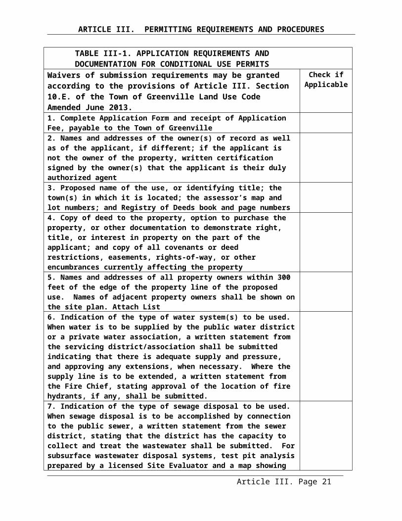
ARTICLE V. LAND USE DISTRICTS AND REQUIREMENTS
reduce the quality and quantity of water that is now, and in the future will be, available for use by municipalities, individuals and industries. The Groundwater Protection Overlay District shall be based on the “Significant Sand and Gravel Aquifer Maps” prepared by the Maine Geological Survey (Open-File No. 98-10 and 98-14, 1998). This overlay district is not depicted on the Zoning Map.
SECTION 5. DISTRICT LAND USES.
A. Town-wide District Land Uses. Land uses permitted in Greenville are displayed in Table V-1. Land Uses by District, by the type of permit required or not required within each land use district under this Ordinance. Required permit review shall be secured prior to obtaining the appropriate building or other applicable construction permits in accordance with the procedures and processes described in this Ordinance.
B. Overlay Districts. In addition, land use activities proposed to be located within the Shoreland Overlay District, Scenic Corridor Overlay District and Groundwater Overlay District must also meet the requirements of the applicable overlay district. Where there are differences between the provisions, the more restrictive provisions shall apply.
C. Land Uses Not Listed in Table V-1. Land uses not listed in Table V-1, and similar to those requiring Code Enforcement Officer review, Planning Board review, or allowed uses shall require similar review. The Code Enforcement Officer shall make the final determination on the appropriate review for any land use not listed.
Article V. Page 5

ARTICLE V. LAND USE DISTRICTS AND REQUIREMENTS
TABLE V-1. LAND USES BY DISTRICT (NOTES TO TABLE V. ON THE PAGE FOLLOWING THE TABLE)Y = Allowed Use (no permit necessary, but must comply with regulations); P = Permitted Use (Code Enforcement Officer Review Required);
CU = Condition Use (Planning Board Review Required); N = Prohibited Use
USES13 ResidentialDistrict
Village District
Commercial/ Industrial
Rural Development
Rural District
Airport District
Resource Protection
ResidentialAccessory Structure P P N P P N CU 8
Mobile Home Parks N N N CU 2 CU 4 N NMulti-Family Dwelling CU P N CU 2 N N NSingle Family Dwelling P P N P P N CU 8 & 9
Two Family Dwelling P P N P P N NCommercialAccessory Structure CU CU CU CU CU CU NAuto Sales/Services/Repairs N CU CU CU N N NBed & Breakfasts, Boarding Houses CU CU N CU CU 5 N NBusiness/Professional <2000 sq. ft. 1 N P CU CU N CU 6 NBusiness/Professional >2000 sq. ft. 1 N CU CU CU N CU 6 NHome Occupations Y/CU 7 Y/P 7 N Y/CU 7 Y/CU 7 N NIndoor Theater N CU N CU N N NJunkyard/Auto Graveyard/Auto Recycling N N CU CU CU N NConvention Center N CU N CU N N NMotel/Hotel/Inn N CU N CU CU 5 CU NRecreational Facility N CU N CU N CU NRestaurants <2000 sq. ft. 1 N P N CU CU CU NRestaurants >2000 sq. ft. 1 N CU N CU CU 5 N NRetail Sales/Services <2000 sq. ft. 1 N P CU CU CU CU 6 NRetail Sales/Services >2000 sq. ft. 1 N CU CU CU N CU 6 NWholesale Business N CU CU CU N CU 6 NRefer to “Notes to Table V-1. Land Uses by District”.
Article V. Page 6
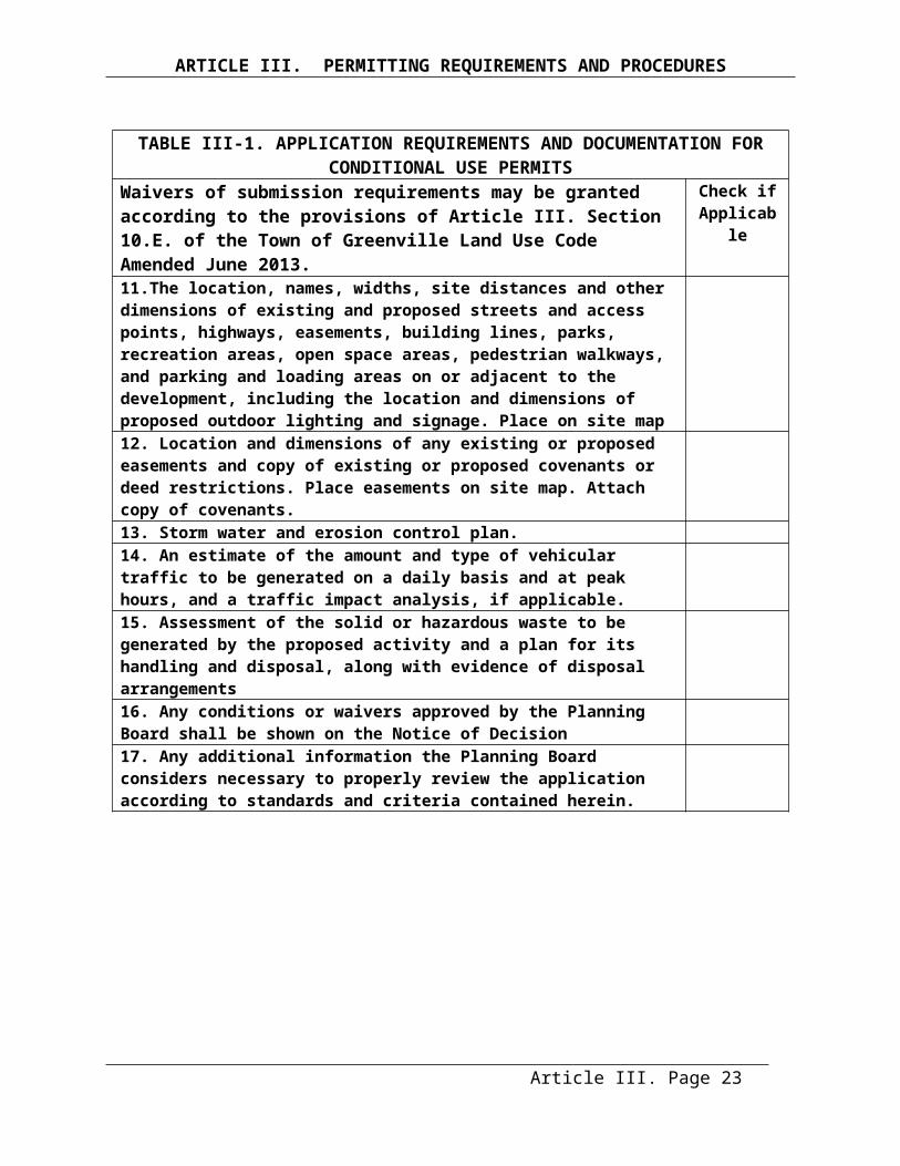
ARTICLE V. LAND USE DISTRICTS AND REQUIREMENTS
TABLE V-1. LAND USES BY DISTRICT (NOTES TO TABLE V. ON THE PAGE FOLLOWING THE TABLE)Y = Allowed Use (no permit necessary, but must comply with regulations); P = Permitted Use (Code Enforcement Officer Review Required);
CU = Condition Use (Planning Board Review required); N = Prohibited Use
USES13 Residential District
Village District
Commercial/ Industrial
Rural Development
Rural District
Airport District
Resource Protection
IndustrialAccessory Structure N N CU CU CU CU 6 NBulk Storage of Petroleum Products - <500,000 gal. above ground, & <10,000 gal. below ground per tank
N N CU N N CU 6 N
Manufacturing/Processing/Treatment- exclusive of rendering, storage &/or treatment of animal &/or fish waste
N N CU N N N N
Uses involving the use, manufacture, storage or wholesale distribution, of creosote, disinfectant, insecticide, poisons, cement, lime, gypsum or plaster of paris, blast furnace, gasoline, petroleum, kerosene, paint, varnish or shellac
N N CU N N CU 6 N
Recycling Operation N N CU N N N NResearch Labs/Facilities N CU CU CU CU 5 CU 6 NSludge Spreading N N CU CU 3 CU N NTrucking/Distribution Terminal N N CU CU 3 N CU 6 NWarehousing & Storage N N CU CU 3 N CU 6 NInstitutionalAccessory Structure CU CU N CU CU CU NAirport N N N N N CU NCemeteries CU CU N CU CU N NChurch/Parish House CU CU N CU N N NCommunity Center/Clubs CU CU N CU N N NDay Care/Nursery School CU CU N CU N N NEssential Services/Utilities CU CU CU CU CU CU 6 CU 8
Government Buildings/Uses CU CU CU CU CU CU 6 NRefer to “Notes to Table V-1. Land Uses by District”
Article V. Page 7
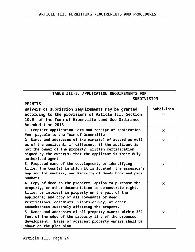
ARTICLE V. LAND USE DISTRICTS AND REQUIREMENTS
TABLE V-1. LAND USES BY DISTRICT (NOTES TO TABLE V. ON THE PAGE FOLLOWING THE TABLE)Y = Allowed Use (no permit necessary, but must comply with regulations); P = Permitted Use (Code Enforcement Officer Review Required);
CU = Condition Use (Planning Board Review Required); N = Prohibited Use
USES13 Residential District
Village District
Commercial/ Industrial
Rural Development
Rural District
Airport District
Resource Protection
Institutional (continued from last page)Group Homes CU CU N CU N N NHospitals/Nursing Homes/ Congregate Care/Medical Care N CU N N N N N
Libraries/Museums CU CU N CU N N NPublic Utility Facility N CU CU CU CU CU 6 CU 8
Public/Private Schools CU CU N CU N N NNatural Resource Based UsesAccessory Structure CU CU N CU CU N CU 8
Agriculture CU Y N Y Y N CU 8
Aquaculture_________________________Campgrounds
_____CU____CU
_____CU___CU
_____CU___N
_____CU___CU
_____CU___CU
___CU___N
____CU___N
Timber Harvesting #11 Y Y Y Y Y Y PIndividual Private Campsites #12 P P N P P N P
Kennels CU CU N CU CU N N
Mining & Mineral Extraction/Exploration N N N CU CU N CU 8
Natural Res.-Based Industries N CU N CU CU N NParks and Recreation CU CU N CU CU N CU 8
Piers/Docks/Wharfs/Bridges - Permanent CU CU N CU CU N CU 8
Piers/Docks/Wharfs/Bridges - Temporary Y/P 7 Y/P 7 Y/P 7 Y/P 7 P 7 N Y/P 7 & 8
Marinas/Sheds/Storehouses for Fishing/Sea Plane Bases/Boating N CU N N N N N
OtherClearing or Removal of Vegetation for Activities Other than Timber Harvesting
Y Y Y Y Y Y P8
Demolition P P P P P CU CU 8
Filling & Earth Moving Activities Y/P7 Y/ P7 Y/ P7 Y/ P7 Y/ P7 Y/ P7 P7&8
Roads, Driveways & Parking Y/CU7 Y/CU7 Y/CU7 Y/CU7 Y/CU7 Y/CU7 N 8 & 10
Article V. Page 8
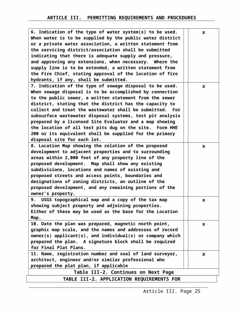
ARTICLE V. LAND USE DISTRICTS AND REQUIREMENTS
Signs P P P P P P PRefer to “Notes to Table V-1. Land Uses by District”
Article V. Page 9

ARTICLE V. LAND USE DISTRICTS AND REQUIREMENTS
NOTES TO TABLE V-1. LAND USES BY DISTRICT
1 Square Footage shall include all enclosed floor area used for the business, profession, restaurant and/or retail sales or service activity. The cumulative square footage from all commercial activities located on a lot shall be included.
2 Scenic Corridor Overlay District. Mobile Home Parks and Multifamily Structures shall be limited to less than four units within the Scenic Corridor Overlay District.
3 Scenic Corridor Overlay District. This use is not permitted in the Scenic Corridor Overlay District.
4 Mobile Home Parks in the Rural District shall not contain more than three manufactured housing units (See Article V. Sec.11. Rural District Standards).
5 Rural District. See Article V. Sec.11. Rural District Standards for additional requirements.6 Aviation Related Uses. Must be aviation-related uses. (See Article V. Sec.7. Airport District
Standards for additional requirements.
7 Shoreland Permits Required. Permits not required unless located within the Shoreland Overlay Districts or Resource Protection Districts. (See Article VI and VII as applicable.) Within the shoreland zone, filling or earth moving activities of more than ten cubic yards requires planning board review, unless such activity is part of a permit already reviewed by the planning board.
8 Resource Protection District Uses. See Article VII. Shoreland Overlay District and Resource Protection District Standards for additional restrictions.
9 Single-Family Residential Structures may be allowed as a conditional use and only according to the provisions of Article V. Sec. 8.
10 Roads, Driveways & Parking Within the shoreland zone, roads and driveways are not allowed except as provided in Article VII Section 7. Within the shoreland zone, parking areas are not allowed in the Resource Protection District where any of the criteria in Article V Section 4.G.1 through 4 are met; elsewhere, see Article VII Section 6 for additional requirements.
11. Timber Harvesting within the shoreland zone, as of January 1, 2013, is regulated by the Maine Forest Service and not by the Town of Greenville.
12. 120 Day Threshold. When a recreational vehicle, tent or similar shelter is placed on-site for more than 120 days per year, all requirements for residential structures shall be met, including the installation of a subsurface sewage disposal system in compliance with the State of Maine Subsurface Wastewater Disposal Rules unless served by public sewage facilities. See Article VII Section 5 for additional requirements within the shoreland zone.
13. Prohibited. See Section 5.D below for prohibited uses. Additionally, within seventy-five (75) feet, horizontal distance, from the normal high-water line of a stream, structures or the removal of vegetation is allowed for uses allowed in the underlying district only when a variance from the shoreline setback is obtained from the Board of Appeals in accordance with Article II.
Article V. Page 10

ARTICLE V. LAND USE DISTRICTS AND REQUIREMENTS
D. Prohibited Land Uses.
1. Shoreland Overlay Districts and Resource Protection Districts. The following new commercial and industrial uses are prohibited within the Shoreland Overlay and Resource Protection Districts:
a. Auto washing facilitiesb. Auto or other vehicle service and/or repair operations, including body shopsc. Chemical and bacteriological laboratoriesd. Storage of chemicals, including herbicides, pesticides or fertilizers other than amounts normally associated with individual households or farmse. Commercial painting, wood preserving, and furniture strippingf. Dry cleaning establishmentsg. Electronic circuit assemblyh. Laundromats, unless connected to a sanitary seweri. Metal plating, finishing, or polishingj. Petroleum or petroleum product storage and/or sale except storage on same property as use occurs and except for storage and sales associated with marinask. Photographic processingl. Printing2. Streams. The following new uses are prohibited within seventy-five (75) feet, horizontal distance, from the normal high-water line of a stream:
a. Multi-unit residential.b. Industrial.c. Campgrounds.d. Parking.e. Commercial, except: a recreational facility, a parks and recreation use, or a marina, where allowed in the underlying district.f. Governmental or institutional, except: a parks and recreation use, or an accessory public or private recreational use, where allowed in the underlying district.
SECTION 6. DISTRICT SPACE STANDARDS AND DIMENSIONAL REQUIREMENTS.
Article V. Page 11
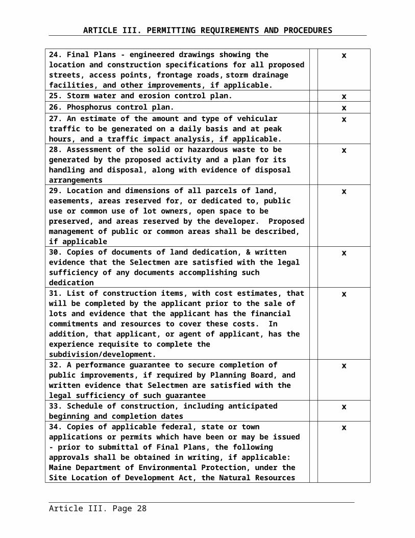
ARTICLE V. LAND USE DISTRICTS AND REQUIREMENTS
Unless otherwise permitted by this Ordinance, all lots, structures and uses must meet the minimum standards and requirements as set forth in Table V-2, Space and Dimensional Requirements.
Article V. Page 12
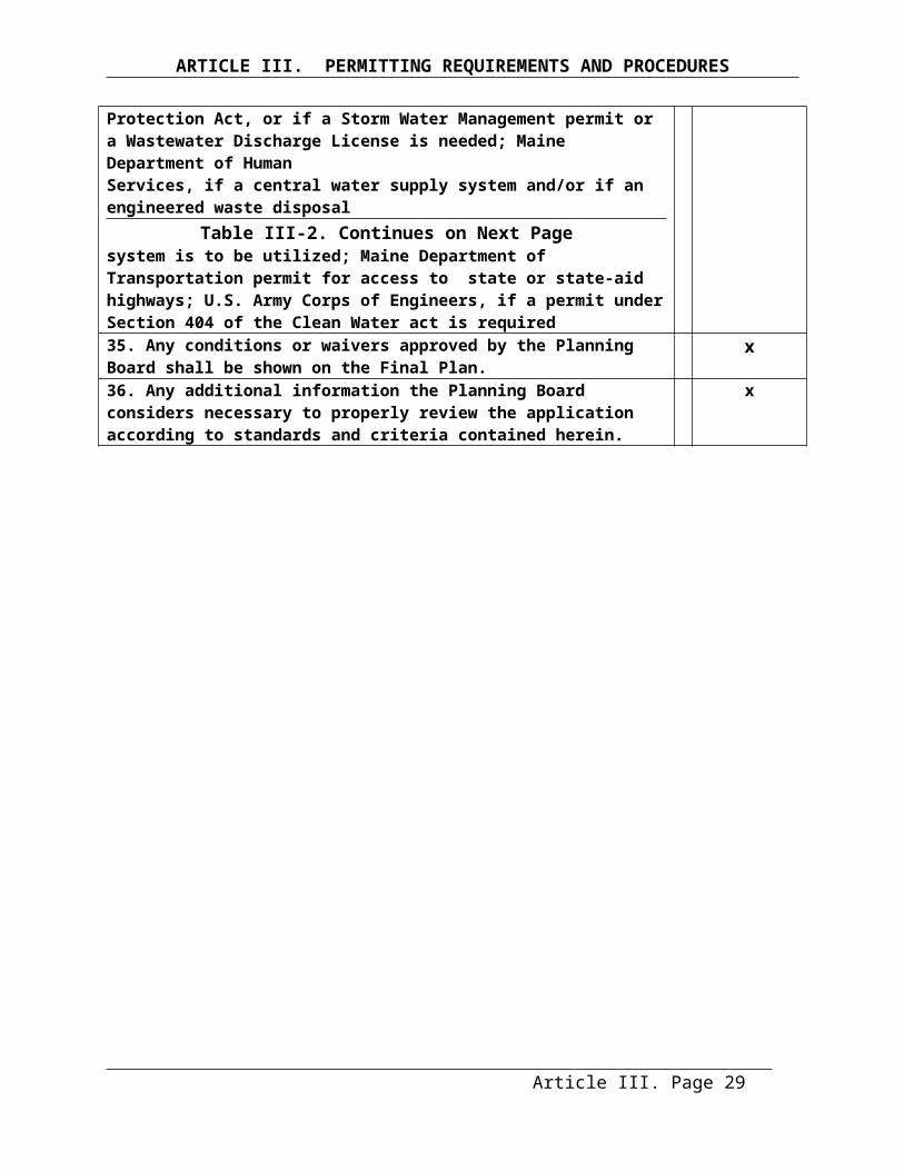
ARTICLE V. LAND USE DISTRICTS AND REQUIREMENTSTABLE V-2. SPACE AND DIMENSIONAL REQUIREMENTS (NOTES TO TABLE ON NEXT PAGE)
Shoreland Overlay District standards11 are displayed in shaded areas.
District
Minimum Lot Size1 & 10
(Square Feet)
Maximum Density2 & 10
(Square Feet)
Maximum% Lot
Coverage3 Mini-mumRoad
Frontage
Minimum Setback From Property
Lines MaximumStructure
Height
MaximumExpansion
Non-conform.Structure(square
feet /percent)
MinimumShore
Frontage
Minimum Shoreline Setback
WithSewer
Without Sewer
WithSewer
Without Sewer
Build.&
Struc.
Non-vege-tative Front Side Rear Great Pond
4A Water4 Wetland
Airport See Town of Greenville Airport Master Plan
Residential 10,000 20,000 2 units/ 10,000
1 unit/ 20,000 40% NA None 15’ 15’ 15’ NA NA NA NA NA NA
Residential Shoreland 20,000 40,000 1 unit/
20,0001 unit/ 40,000 NA 20% None 15’ 15’ 15’ 35’ 1500/30 13 200’ 100’5 75’ 75’
Village 10,000 20,000 2 units/ 10,000
1 unit/ 20,000 50% NA None 15’ 15’ 15’ NA NA NA NA NA NA
VillageShoreland 10,000
6
20,000 1 Unit10,000
1 Unit20.000 N.A. 50% None 15’ 15’ 15’ 35’ 1500/30 13 100 Com
200’ Res.
0’ Water Related7
25 Com
75’ Res.
25 Com75’ Res.
25’ Water Related7
25’Com 75’ Res.
Commercial/ Industrial 20,000 40,000 None None 50% NA 100’ 30’ 20’ 20’ NA NA NA NA NA NA
Commercial/Industrial Shoreland
20,000 40,000 None None NA 20% 100’ 30’ 20’ 20’ 35’ 1500/30 13 300’ 100’ 75’ 75’
Rural Dev. 40,000 40,000 None 1 unit/20,000 30%9 NA None9 15’9 15’ 15’ NA NA NA NA NA NA
Rural Dev. Shoreland 40,000 40,000 1 unit/
40,0001 unit/ 40,000 NA 20% None 15’ 15’ 15’ 35’ 1500/30 13 300’ Com
200’ Res. 100’ 75’ 75’
Rural 40,000 40,000 1 unit/ 40,000
1 unit/ 40,000 20% NA None 15’ 15’ 15’ NA NA NA NA NA NA
Rural Shoreland 40,000 40,000 1 unit/
40,0001 unit/ 40,000 NA 20% None 15’ 15’ 15’ 35’ 1500/30 13 300’ Com
200’ Res. 100’ 75’ 75’
Critical Watershed Shoreland
40,000 40,000 1 unit/ 40,000
1 unit/ 40,000 NA 20% None 15’ 15’ 15’ 35’ 1500/30 13 200’
125’ Min. 500’Comb. Setback & Frontage
75’ 75’
Article V. Page 13
ARTICLE V. LAND USE DISTRICTS AND REQUIREMENTS
Resource Protection 12 40,000 40,000 1 unit/
40,0001 unit/ 40,000 NA 20% None 15’ 15’ 15’ 35’ 1500/30 13 200’
125’ Min. 500’ Comb. Setback & Frontage
75’ 75’
Article V. Page 14

ARTICLE V. LAND USE DISTRICTS AND REQUIREMENTS
NOTES TO TABLE V-2. SPACE AND DIMENSIONAL REQUIREMENTS1 Lot Size Calculation. See Article VI. Section 1., Land Not To Be Included In The Calculation Of Lot Area.2 Maximum Density Requirements. If more than one residential dwelling unit or non-residential principal
building is constructed on a single parcel of land, the maximum density requirement shall apply. Therefore, if more than one non-residential principal building is constructed on a lot, the maximum density per unit shall be met for each additional building. In the Village District, the Planning Board may grant a 25% density bonus when provision is made for public access along the waterfront. Such public access-ways shall be in the form of landscaped walks, esplanades, or boardwalks of suitable design to encourage active use by the public. Provision shall also be made for access from public streets to the shoreline. Land dedicated to such use may remain in private ownership, with the provisions for maintenance, or deeded to the Town, at the mutual consent of the Town and the developer.
3 Maximum Lot Coverage. Lot coverage is that portion of the lot that is covered by buildings and structures, except within the shoreland zone where Article VII Section 1.E applies.
4 Water. Shoreline setbacks apply to any river that does not flow to a great pond, and any stream or tributary stream. See Article IX. Definitions.
4A. Shoreline setbacks apply to any great pond and any river that flows to a great pond.5 Residential Reduced Setback Shoreland Area. The minimum setback from the shoreline in the following
areas is 75 feet:Craft Road -- Tax Map 25, Lot 1 south to the north line of the Red Cross Beach, including lots 9, 8A, 10, 8, 2, 3 and 4A; Birch Street -- Tax Map 28, Lots 1, 2, 4, 5, 6, 7, 8, 9, 10, 11,12, 14, 15, 16, 17, 18, 19, 20, 21, 22, 23, 24, 25, 26, 27, 28A, 28, 36 and 30; and Lakeview Street -- Tax Map 26, Lots 2, 3, 1-7, 1-8, 1-9, and Tax Map 24, Lots 55 through 64A, 64 through 68 and 70 and 71.(Note: These are grandfathered non-conforming lots where setbacks from the shoreline have been reduced to 75 feet to allow for limited expansion and construction.)
6 Wharves and Sheds that are entirely non-residential in nature may be permitted on lots containing less than 20,000 square feet, and with less than 100 feet shore frontage, as a Conditional Use if authorized by the Planning Board.
7 Functionally Water Dependent Uses as defined in Article IX. Definitions.8 Minimum Lot Size. One unit per 20,000 square feet, or as otherwise permitted in the Maine Minimum Lot
Size Law, Title 12, M.R.S.A. Sections 4807.9 Scenic Corridor District Standards
Maximum Lot Coverage: 40% Minimum Road Frontage on Route 15: 200 feetMinimum Building Setbacks from Route 15 are as follows:
Residential: 75 feet from the road right-of-wayCommercial and other non-residential structures: 100 feet from the road right-of-way
10 Mobile Home Parks. Minimum area of a mobile home park lot shall be 6,500 square feet where served by public sewer, and 12,000 square feet where served by a central on-site subsurface wastewater disposal system, and 20,000 square feet with on-site subsurface wastewater disposal. Mobile home park lots within shoreland overlay districts shall meet the dimensional requirements for that overlay district. The overall density of the mobile home park shall be the combined area of its mobile home park lots plus: the area required for road rights-of-way, the area required for buffer strips; and the area within the shoreland overlay district, See 13 below.
11 Article VII. Shoreland Overlay Districts and Resource Protection District Standards, for additional space and dimensional requirements for these areas.
12 Resource Protection District. Shoreline setback standards listed apply to structures and uses specifically allowed; otherwise, the shoreline setback in this district is the same as the shoreland zone itself. Within the shoreland zone, no structure associated with a park or recreation use allowed in the Resource Protection District shall be allowed within the shoreland zone, except for minimal structural development as determined by the planning board.
13 Maximum Expansion. See Article IV Section 3.B.1 for requirements within the shoreland zone.
Article V. Page 15
ARTICLE V. LAND USE DISTRICTS AND REQUIREMENTS
SECTION 7. AIRPORT DISTRICT. Buildings or land used or occupied, and buildings erected, constructed, reconstructed, moved or structurally altered, whether permitted uses or conditional uses, shall comply with the following additional requirements: a) Federal aviation regulations, Part 77 existing and as may be amended; b) restrictive covenants between United States of America, the State of Maine, and the Town of Greenville controlling the development and use of the Greenville Airport; and c) the Town's Airport Management Plan. Bulk oil and fuel storage tanks and facilities shall meet State standards for construction, maintenance and operating procedures. Appropriate spill prevention and control plans shall accompany the application for a permit.
SECTION 8. RESOURCE PROTECTION DISTRICT – SINGLE FAMILY RESIDENTIAL STRUCTURES. The Planning Board may issue a Conditional Use Permit for a single family residential structure in a Resource Protection District provided the applicant demonstrates that all of the following conditions are met, in addition to the other requirements of this Ordinance:
A. Lot Criteria. 1. There is no location on the property, other than a location within the Resource Protection District, where the structure can be built.2. The lot on which the structure is proposed is undeveloped and was established and recorded in the Piscataquis County registry of deeds before the adoption of the Resource Protection District.
B. Location of Improvements. All proposed buildings, sewage disposal systems and other improvements are:
1. Located on natural ground slopes of less than 20%; and2. Located outside the floodway of the 100-year floodplain along rivers and artificially formed great ponds along rivers, based on detailed flood insurance studies and as delineated on the Federal Emergency Management Agency's Flood Boundary and Floodway Maps and Flood Insurance Rate Maps; all buildings including basements are elevated at least one foot above the 100-year floodplain elevation; and the development is otherwise in compliance with the Greenville floodplain ordinance. If the floodway is not shown on the Federal Emergency Management Agency maps, it is deemed to be ½ the width of the 100-year floodplain.
C. Footprint. The total footprint, as defined, is limited to a maximum of 1,500 square feet. This limitation shall not be altered by variance.
D. Shoreline Setbacks. All structures, except functionally water dependent structures, are set back from the shoreline to the greatest practical extent, but not less than 75 feet horizontal distance. In determining the greatest practical extent the Planning Board shall consider the depth of the lot, the slope of the land, the potential for soil erosion, the type and amount of vegetation to be removed, the proposed building site's elevation in regard to the floodplain and its proximity to moderate-value and high value wetlands.
SECTION 9. GROUND WATER PROTECTION OVERLAY DISTRICT. Within the boundaries of the Ground Water Protection Overlay Zone, no land shall be used, treated or
Article V. Page 16

ARTICLE V. LAND USE DISTRICTS AND REQUIREMENTS
sprayed except in conformity with the provisions of this Ordinance. No activity shall locate, store, discharge, or permit the discharge of any treated, untreated, or inadequately treated liquid, gaseous or solid materials of such nature, quantity, obnoxiousness, toxicity, or temperature that run off, seep, percolate, or wash into surface or ground waters so as to contaminate, pollute, or harm such waters or cause nuisances, such as objectionable shore deposits, floating or submerged debris, oil or scum, color, odor, taste or unsightliness or be harmful to human, animal plant or aquatic life.
A. Uses, In General. Uses shall be permitted as specified within the provisions of the underlying zoning district, unless restricted under this section, and if they meet the provisions in the preceding paragraph.
B. Conditional Use Permits Required. The following uses may be established or expanded only upon the granting of a Conditional Use Permit by the Planning Board in accordance with the provisions of the Ordinance:
1. Manure pile and manure storage pit.2. Cemetery.3. Spraying or spreading of chemical fertilizers or pesticides.4. Expansions of existing gravel pits.
C. Prohibited Uses. The following uses are prohibited:1. Disposal or storage of solid wastes, other than brush and stumps.2. Pipeline transmission or storage in bulk of petroleum or other refined petroleum products.3. The disposal or storage, both temporary and permanent, of liquid or leachable wastes except residential subsurface waste disposal systems.4. The rendering impervious of more than 10% of any lot.5. Uses prohibited in the underlying zone.6. Storage of road salt.7. Flooding of land.8. Animal feedlot.
SECTION 10. SCENIC CORRIDOR OVERLAY DISTRICT. Development site designs, including, but not limited to, landscaping, exterior lighting, and the placement of buildings, structures, parking lots and storage areas, shall be designed to maintain and/or enhance the rural and forested character of the corridor. Within the boundaries of the Scenic Corridor District, the following shall apply:
A. Minimum Road Frontage. The minimum road frontage along Route 15 shall be 200 feet.B. Minimum Building Setbacks from the road right of way of Route 15 shall be as follows:
1. Residential = 75 feet2. Commercial/non-residential = 100 feet
C. Maximum Lot Coverage shall be 40 percent.D. Vegetative Buffers.
1. The first 50 feet (lot depth) of front yards of individual lots abutting Route 15 shall be maintained as a vegetative buffer between development activity on the lot and Route 15. Existing natural vegetation (trees and shrubs) along Route 15 shall be maintained to the maximum extent practically feasible. Landscaping, using native species as much as possible, must provide year-round vegetative screening to conceal parking lots, storage
Article V. Page 17
ARTICLE V. LAND USE DISTRICTS AND REQUIREMENTS
areas, and loading/unloading docks and areas, from view from Route 15. Vegetative buffers shall be maintained throughout the life of the development. Placement of parking lots, storage areas and loading/unloading areas behind the principal building can be used towards meeting the goal of concealment from Route 15. 2. A “site triangle” shall be maintained 25 feet in length on each side of the intersection of the driveway and the public street or road right-of-way line, with the third side connecting the other two sides. Within each sight triangle, no landscape plants, other than low growing shrubs shall be planted. These shrubs must be no more than 30 inches in height above the driveway elevation.
E. Access Management Standards. Driveway and private-right-of-way access points with Route 15 (Moosehead Lake Road) shall be limited as follows:
1. Residential lots shall be limited to one access point per residential lot, or one access point for every 200 feet, whichever is less stringent2. Commercial and other non-residential lots shall be limited to two access points per lot, or one access point every 200 feet, whichever is less stringent3. Shared access points shall be encouraged for adjacent sites, in order to minimize the number of driveways/rights-of-way along Route 15. The minimum frontage requirement of 200 feet may be reduced by 10 percent when the applicant agrees to provide a common driveway/right-of-way for multiple lots and/or uses.4. Subdivisions: direct access between Route 15 and any individual lot shall be prohibited unless the Planning Board determines physical conditions particular to the parcel justify granting a waiver from this requirement. A waiver shall be granted only if there will be no further subdivision of the parcel and one of the following conditions is met:
a. There is too little road frontage to reasonably allow creation of a new way;b. The shape or physical condition of the parcel does not permit access to or creation of a street other than Route 15; orc. Common access will be utilized which will allow all proposed lots to be served by one new curb cut.
F. Exterior Lighting Standards for Light Levels, Glare Reduction and Energy Conservation.
1. All residential, commercial, and industrial building exterior lighting fixtures will be full cut-off, except for incandescent lights of less than 160 watts, or any other light less than 50 watts. Full cut-off fixtures are those that project no more than 2.5% of light above the horizontal plane of the luminare’s lowest part. The following diagram illustrates a cut-off fixture as defined by the Illuminating Engineering Society of North America.
Article V. Page 18

ARTICLE V. LAND USE DISTRICTS AND REQUIREMENTS
2. Light fixtures mounted on gasoline station or convenience store canopies shall be recessed so that fixtures are flush with the canopy. Alternatively, canopies maybe indirectly lit using light beamed upward and then reflected down from the underside of the canopy. In this case fixtures must be shielded so that direct illumination is focused exclusively on the underside of the canopy.3. All exterior lights shall be designed, located, installed and directed in such a manner as to illuminate only the target area, to the extent physically possible, and to prevent glare across the property lines.4. For non-residential development, all non-essential lighting shall be turned off after business hours, leaving only the minimal necessary lighting for site security. The term “non-essential” applies to display, aesthetic, and parking lighting.5. The following activities are exempt from these lighting standards: roadway and airport lighting; lighting for temporary fair, event or civic uses; emergency lighting, provided it is temporary and is discontinued upon termination of the work; lighting that is activated by motion sensors; and lighting that was in place prior to the adoption of these standards.
SECTION 11. RURAL DISTRICT. The following standards are designed to minimize the impacts of development on the rural character of this District:
A. Vegetative Buffers. Existing natural vegetation (trees and shrubs) along public roads shall be maintained to the maximum extent practically feasible.
B. Limits On Size Of Certain Developments.1. Bed and Breakfasts and Boarding Houses shall be limited to 15 units per lot of record as of the date of the adoption of this ordinance.2. Motels, Hotels and Inns shall be limited to 15 units per lot of record as of the date of the adoption of this ordinance.3. Restaurants shall be limited to 5,000 square feet of floor space per lot of record as of the date of the adoption of this ordinance.4. Research Labs and Facilities shall occupy no more than 5,000 square feet of floor space per lot of record as of the date of the adoption of this ordinance.
Article V. Page 19
ARTICLE VI. ALL AREAS: PERFORMANCE AND DESIGN STANDARDS
ARTICLE VI. ALL AREAS: PERFORMANCE AND DESIGN STANDARDS
SECTION 1. LAND NOT TO BE INCLUDED IN THE CALCULATION OF LOT AREA.The following lands shall not be included in the calculation of lot area for the purpose of meeting the lot area requirements of this Ordinance:
A. Land, which is located below the normal high-water line of any water body or upland edge of a wetland; and
B. Land which is located beneath roads serving more than two lots.
SECTION 2. WATER SUPPLY AND QUALITY.
A. Water Quality. No activity shall deposit on or into the ground or discharge to the waters of the State any pollutant that, by itself or in combination with other activities or substances, will impair designated uses, including existing and potential groundwater supplies, or the water classification of the water body, tributary stream or wetland.
B. Public Water Supply. When a proposed subdivision or development is to be served by a public water system, the complete supply system, including fire hydrants (if necessary), shall be installed at the expense of the developer.
1. The developer shall provide a written statement from the servicing water company or district that adequate supply and pressure for both domestic and fire fighting purposes can be provided without placing an undue burden on the source, treatment facilities, or distribution system involved. The developer shall be responsible for paying the costs of system improvements necessary to serve the subdivision or development.2. The size and location of mains, gate valves, hydrants, and service connections shall be reviewed and approved in writing by the servicing water company or district and the Fire Chief.
C. Individual Wells. Individual wells shall be sited and constructed to prevent infiltration of surface water, and contamination from subsurface wastewater disposal systems and other sources of potential contamination. Lot design shall permit placement of wells and subsurface wastewater disposal areas in compliance with the Maine Subsurface Wastewater Disposal Laws.
D. Wellhead Protection for Water Supplies. No activity shall be sited or constructed so as to contaminate public or private water supplies. Proposed uses, such as junkyards, automobile graveyards, gas stations, and bulk storage of petroleum products, must be located at least 300 feet from existing private and public water supplies.
SECTION 3. SEWAGE DISPOSAL. A. Subsurface Disposal Systems. All subsurface sewage disposal systems shall be installed in
conformance with the State of Maine Subsurface Wastewater Disposal Rules, and the following: a) clearing or removal of woody vegetation necessary to site a new system and any associated fill extensions, shall not extend closer than seventy-five (75) feet, horizontal distance, from the normal high-water line of a water body or the upland edge of a wetland and b) a holding tank is not allowed for a first-time residential use in the shoreland zone.
Article VI. Page 1
ARTICLE VI. ALL AREAS: PERFORMANCE AND DESIGN STANDARDS
NOTE: The Maine Subsurface Wastewater Disposal Rules require new systems, excluding fill extensions, to be constructed no less than one hundred (100) horizontal feet from the normal high-water line of a perennial water body. The minimum setback distance for a new subsurface disposal system may not be reduced by variance.
B. Public Sewer System Disposal. When sewage disposal for a proposed subdivision or development is to be accomplished by connection to the public sewer, the Planning Board may require a letter from the Sewer District indicating there is adequate capacity reserved within the district’s system to transport and treat the sewage.
SECTION 4. STORM WATER RUNOFF.
A. General. All new construction and development shall be designed to minimize storm water runoff from the site in excess of the natural predevelopment conditions. Where possible, existing natural runoff control features, such as berms, swales, terraces and wooded areas, shall be retained in order to reduce runoff and encourage infiltration of storm waters. The best management practices set forth in the “Storm water Management for Maine” (Department of Environmental Protection, State of Maine, November 1995, or as revised) shall be used as a guide for compliance with this requirement.
B. Maintenance of Facilities. Storm water runoff control systems shall be maintained as necessary to ensure proper functioning.
C. Requirements. The Planning Board may require the preparation of a storm water management plan by a Registered Professional Engineer and/or the installation of ditches, catch basins, piping systems, and other appurtenances for the conveyance, control, or disposal of surface waters. In addition, the Planning Board may require the following:
1. Where a development or subdivision is traversed by a stream, river or surface water drainage-way, or where the Board believes that surface water runoff to be created by the development or subdivision should be controlled, there shall be provided easements or drainage rights-of-way with swales, culverts, catch basins or other means of channeling surface water within the subdivision and over other properties. This storm water management system shall be designed by a Registered Professional Engineer.2. Drainage easements for existing water courses or proposed drainage ways at least 30 feet wide shall be provided and indicated on the plan conforming substantially with the lines of existing natural drainage.3. The developer shall provide a statement from the designing engineer that the proposed development or subdivision will not create erosion, drainage or runoff problems either in the development/subdivision or in other properties. The peak runoff from the development or subdivision onto other properties shall not be increased. NOTE: The Storm water Management Law (38 M.R.S.A. section 420-D) requires a full permit to
be obtained from the DEP prior to construction of a project consisting of 20,000 square feet or more of impervious area or 5 acres or more of a developed area in an urban impaired stream watershed or most-at-risk lake watershed, or a project with 1 acre or more of developed area in any other stream, coastal or wetland watershed. A permit-by-rule is necessary for a project with one acre or more of disturbed area but less than 1 acre impervious area (20,000 square feet for most-at-risk lakes and urban impaired streams) and less than 5 acres of developed area. Furthermore, a Maine Construction General Permit is required if the construction will result in one acre or more of disturbed area.
Article VI. Page 2
ARTICLE VI. ALL AREAS: PERFORMANCE AND DESIGN STANDARDS
SECTION 5. EROSION AND SEDIMENTATION CONTROL.
A. Erosion and Sedimentation Control Plan Required. All activities, which involve filling, grading, excavation, or other similar activities, which result in, unstabilized soil conditions and which require a permit shall also require a written soil erosion and sedimentation control plan. The plan shall be submitted to the permitting authority for approval and shall include, where applicable, provisions for:
1. Mulching and revegetation of disturbed soil.2. Temporary runoff control features such as hay bales, silt fencing or diversion ditches.3. Permanent stabilization structures such as retaining walls or riprap.
B. Applicability. Erosion and sedimentation control measures shall apply to all aspects of the proposed project involving land disturbance, and shall be in operation during all stages of the activity. The amount of exposed soil at every phase of construction shall be minimized to reduce the potential for erosion.
C. Design. In order to create the least potential for erosion, development shall be designed to fit with the topography and soils of the site. Areas of steep slopes where high cuts and fills may be required shall be avoided wherever possible, and natural contours shall be followed as closely as possible.
D. Temporary and Permanent Stabilization. Any exposed ground area shall be temporarily or permanently stabilized within one (1) week from the time it was last actively worked, by use of riprap, sod, seed, and mulch, or other effective measures. In all cases permanent stabilization shall occur within nine (9) months of the initial date of exposure. In addition:
1. Where mulch is used, it shall be applied at a rate of at least 1 bale per 500 square feet and shall be maintained until a catch of vegetation is established.2. Anchoring the mulch with netting, peg and twine or other suitable method may be required to maintain the mulch cover.3. Additional measures shall be taken where necessary in order to avoid siltation into the water. Such measures may include the use of staked hay bales and/or silt fences.
E. Drainage Ways. Natural and man-made drainage ways and drainage outlets shall be protected from erosion from water flowing through them. Drainage ways shall be designed and constructed in order to carry water from a 25 year storm or greater, and shall be stabilized with vegetation or lined with riprap.
F. Best Management Practices. The best management practices set forth in the “Maine Erosion and Sedimentation Control Handbook for Construction Practices” (Cumberland County Soil and Water Conservation District, Department of Environmental Protection. March 1991, or as revised) shall be used as a guide for compliance with this requirement.
SECTION 6. SOLID WASTE DISPOSAL. If additional solid waste from the proposed development or subdivision exceeds the capacity of the municipal solid waste facility, causes the Town to no longer be in compliance with its license from the Department of Environmental Protection, or causes the Town to exceed its contract with a non-municipal facility, the applicant shall make alternative arrangements for the disposal of solid waste. The alternative arrangements shall be at a disposal site, which is in compliance with its license. The Planning Board may not require the alternative arrangement to exceed a period of 5 years.
Article VI. Page 3

ARTICLE VI. ALL AREAS: PERFORMANCE AND DESIGN STANDARDS
SECTION 7. TRAFFIC ACCESS, CIRCULATION AND PARKING.
A. Access and Circulation. Provision shall be made for vehicular access to the development and circulation within the development in such as manner as to safeguard against hazards to traffic and pedestrians in existing streets and within the development, to provide safe and convenient circulation on public streets and within the development, and to avoid traffic congestion on any street. These provisions shall also apply to subdivisions.
B. Driveways.1. All Driveways. All entrance and exit driveways shall be designed and located in profile and grading to afford safety to traffic, provide for safe and convenient ingress and egress to and from the proposed land use activity and to minimize conflict with the flow of traffic. Driveways, roads, rights-of-way, or other means of access to public or private ways or roads shall not have an average slope in excess of 8% within 50 feet of the point of intersection, to the maximum extent possible. The angle of intersection shall be as near to 90 degrees as site conditions will permit, and should not be less than 60 degrees, or more than 120 degrees.2. Driveways Serving Uses Other Than Single and Two Family Dwellings. The following criteria shall be followed for driveways to any use other than single and two-family dwellings:
a. The dimensions of driveways shall be designed to adequately accommodate the volume and character of vehicles anticipated to be attracted daily onto the land development for which a site plan is prepared.b. Provisions shall be made for convenient and safe emergency vehicle access to all buildings and structures at all times.
3. Site Distances.a. Any driveway or proposed street must be designed so as to provide the required sight distance according to the Maine Department of Transportation (MDOT) standards, to the maximum extent possible.b. On roads where the MDOT standards do not apply, any exit driveway or driveway lane shall be so designed in profile and grading and so located as to provide the following minimum sight distance measured in each direction of egress and access, to the maximum extent possible. The measurements shall be from the driver’s seat of a vehicle being a minimum of 10 feet behind the curb line or edge of the existing shoulder, with the height of the eye 3.5 feet to the top of an object 4.25 feet above the pavement.
Allowable Speed Required Site Distance(Miles per hour) (Feet)
25 25030 30040 40045 45050 50055 550
Article VI. Page 4

ARTICLE VI. ALL AREAS: PERFORMANCE AND DESIGN STANDARDS
4. Access Location and Spacing. a. Any driveway or proposed street must be designed so as to meet the minimum access location and spacing requirements of the Maine Department of Transportation, to the maximum extent possible.b. On roads where the MDOT standards do not apply, driveways must be located at least 50 feet from the closest unsignalized intersection and 150 feet from the closest signalized intersection, as measured from the point of tangency for the access way. Driveways in or out of a development or subdivision requiring Planning Board review must be separated by a minimum of 75 feet. These requirements may be reduced if the shape and/or configuration of the site does not allow conformance with these standards.
C. Parking.1. Size/Storm water Runoff. Parking areas shall be adequately sized for the proposed use and shall be designed to prevent storm water runoff from flowing directly into a water body, tributary stream or wetland or onto a roadway, and where feasible, to retain all runoff on-site.2. Size. In determining the appropriate size of proposed parking facilities, the following shall apply:
a. Typical parking space: Approximately 10 feet wide and 20 feet long, except that parking spaces for a vehicle and boat trailer shall be 40 feet long.b. Internal travel aisles: Approximately 20 feet wide.
SECTION 8. BUFFER AREAS. Buffer areas may be required where subdivisions, multifamily developments, commercial, industrial or institutional buildings or uses abut existing residential properties. The following criteria may be used to determine the buffer area requirements:
A. Existing Natural Buffer Areas. Side and rear yards abutting residential properties should be maintained in their natural state to provide a visual screen between properties.
B. Creation of Buffer Areas. Where no natural buffering can be maintained, side and rear yards abutting residential properties should be landscaped to provide a visual screen between properties. Because of varying site conditions, landscaping for the purposes of this section may include tree plantings, hedges, fences, walls and combinations thereof.
SECTION 9. RECREATIONAL FACILITIES, CAMPGROUNDS, AND PARKS AND RECREATION.
A. Waste Disposal. Containers and facilities for both rubbish collection and removal shall be provided. The Planning Board may require that rest room facilities be provided.
B. Buffer Areas. Adequate screening, buffer area, or landscape provisions shall be built, planted, or maintained, to protect adjacent residences from adverse noise, light, dust, smoke, and visual impact. The Planning Board may, when necessary, require additional setbacks and buffer areas to preserve the character of a surrounding neighborhood.
C. Traffic. The proposed use shall not create a traffic hazard. The Police Department shall review the location and site plans, and provide its comments to the Planning Board prior to or at the public hearing.
Article VI. Page 5
ARTICLE VI. ALL AREAS: PERFORMANCE AND DESIGN STANDARDS
D. Common Areas. Lots proposed to be held in common by more than one individual shall meet the applicable requirements of Article VI Section 15, Reservation, Dedication and Maintenance of Common Open Space and Facilities.
SECTION 10. HOME OCCUPATIONS.
A. General Requirements. The home occupation shall be conducted on or in a residential structure or property. The home occupation shall be carried on wholly within the principal building or within a building or other accessory structure that already exists.
B. Compatible with Residential Uses. The home occupation shall be clearly incidental to and compatible with the residential use of the property and surrounding residential uses. No exterior storage of materials and no other exterior indication of the home occupation or variation from the residential character of the principal building is permitted.
C. Employee Requirements. Non-family member employment shall not exceed 80 employee/hours per week.
D. Signage. One exterior display sign is permitted, and it cannot exceed 32 square feet. Home occupations signs will be allowed in all districts, where home occupations are allowed. Signage within the shoreland zone shall also conform to Article VII Section 8.
SECTION 11. SIGNS. This provision is designed to preserve the beauty of the Town and assure safe placement of signage, while at the same time allowing reasonable advertising and informational signs by regulating the type, number, location and size of such signs. No person, firm or corporation shall hereafter erect, hang, place or alter a sign or sign structure of any kind without a permit having been issued by the Code Enforcement Officer, in accordance with the provisions provided herein.
A. General. Signs shall relate to the premises on which they are located and shall only identify the occupant of such premises or advertise the service available within said premises.
B. Sign Dimensions. The top edge of any freestanding sign shall not be higher than 20 feet vertical measure above the grade of the street nearest the sign support(s). For traffic safety, where vision may be obscured entering a public street, the whole of the sign board or display elements of any freestanding sign shall be either below 3 feet in height or above 10 feet in height of the street grade. A freestanding sign may be located within the front yard space, but as not to create a traffic hazard. Freestanding signs shall not be located within the street right-of-way.
C. Signs Overhanging Sidewalks. Any sign that is attached to a structure, which overhangs a pedestrian walkway or public sidewalk, shall not extend beyond 5 feet of the structure face to which it is attached. The Road Commissioner must approve any sign proposed to extend over any sidewalk or pedestrian walkway. Such approval, in writing shall be based on the Road Commissioner's perceived hindrance to snow removal operations on the sidewalks.
D. Sign Maintenance. All signs shall be properly maintained and kept. Any sign now or hereafter existing that no longer advertises a bona fide business conducted, an activity or campaign shall be taken down and removed by the owner, agent, or person having the beneficial use of the building structure, or lot. Within 10 days after written notification from the Code Enforcement Officer and, upon failure to comply with such notice within the time specified in such order, the Code Enforcement Officer is hereby authorized to cause removal
Article VI. Page 6
ARTICLE VI. ALL AREAS: PERFORMANCE AND DESIGN STANDARDS
of such sign, and any expense incident thereto shall be paid by the owner of the building, structure, or lot to which such sign is attached.
E. Sign Illumination. Signs may be illuminated by shielded, non-flashing, non-moving lights.F. Special Event Signs. Special event signs shall be permitted with written permission from the
property owner as long as these signs are erected no sooner than 3 weeks prior to the event being advertised. All special event signs must be removed within one week following the event being advertised. Such signs shall be located and erected so as not to create a traffic hazard.
G. Home Occupation Signs. See Article VI. Section 10. Home Occupations.H. Signs in Resource Protection Districts, Shoreland Overlay Districts, including the
Critical Watershed Shoreland Overlay Districts. Signs within these areas must meet the requirements in Article VII. Section 8. Signs.
SECTION 12. HISTORIC AND ARCHAEOLOGICAL SITES. If any portion of the site has been identified as containing historic or archaeological resources listed on the National Register of Historic Places, or preliminarily determined to be eligible for listing on the Register, the development must include appropriate measures for protecting these resources, including but not limited to, modification of the proposed design of the site, timing of construction, and limiting the extent of excavation. Further, any proposed land use activity involving structural development or soil disturbance on or adjacent to sites listed on, or eligible to be listed on the National Register of Historic Places, as determined by the Code Enforcement Officer or Planning Board shall be submitted by the applicant to the Maine Historic Preservation Commission for review and comment, at least 20 days prior to action being taken by the permitting authority. The permitting authority shall consider comments received from the Commission prior to rendering a decision on the application.
SECTION 13. CONFORMANCE WITH OTHER LAWS, REGULATIONS.
A. General. The proposed development or subdivision shall be in conformance with all pertinent local, State, and Federal ordinances, statutes, laws and regulations.
B. Maine Site Location Act Reviews. If the proposed development or subdivision requires a permit under the Maine Site Location Act, Title 38, M.R.S.A. § 482, the developer must secure the approval of both the Department of Environmental Protection (DEP) and the Planning Board. When a proposed development or subdivision requires approval of the Planning Board and the DEP, each review may be conducted simultaneously. However, each review will be conducted independently, and the Planning Board may deny approval of the development or subdivision even though the DEP has granted an approval under the Provisions of the Site Location Act.
SECTION 14. CLUSTER DEVELOPMENT: RESIDENTIAL AND NON-RESIDENTIAL.
A. Purposes. The purpose of these provisions is to allow for flexibility in the design of residential and other developments, and to allow for the creation of open space, which provides recreational opportunities or protects important natural features from the adverse impacts of development. Notwithstanding provisions of the zoning ordinance relating to dimensional requirements, the Board, in reviewing and approving proposed residential and other developments may modify the provisions related to dimensional requirements to permit
Article VI. Page 7
ARTICLE VI. ALL AREAS: PERFORMANCE AND DESIGN STANDARDS
flexibility in approaches to housing, building layout, and environmental design in accordance with the following guidelines. This shall not be construed as granting variances. The Planning Board may allow lots within subdivisions and lots associated with multiple principal buildings to be reduced in area below the minimum normally required by this Ordinance in return for open space where the Planning Board determines that the benefits of the cluster approach will decrease development costs, increase recreational opportunities or prevent the loss of natural features.
B. Applications.1. General. Applications for cluster subdivisions and developments shall follow the application and permitting procedures within this Ordinance, including Article III. and within this section.2. Two Sketch Plans. At the sketch plan stage the applicant shall submit 2 sketch plans: one showing the lot layout as a standard subdivision or development, and the second showing the proposed lot layout as a cluster development indicating the open space and significant natural features to be preserved. Each lot in the standard subdivision or development shall meet the minimum lot size and lot width requirements of this Ordinance, and have an area suitable for subsurface wastewater disposal.3. Cluster Development Site Plan. The proposal shall have an overall plan for site development that identifies the location of all buildings, footpaths, roads, services, parking and common open space. In so doing, the developer shall take into consideration all requirements of this section and of other relevant sections of this Ordinance. Each building shall be an element of an overall plan for site development.
C. Basic Requirements for Cluster Developments.1. General. Cluster developments shall meet the requirements of this Ordinance and all other applicable municipal ordinances, except as otherwise noted.2. Minimum Size. Cluster developments shall be a minimum of 3 or more dwelling units or principal buildings on one lot.3. Density Bonus. A density bonus of up to 20% is permitted. Density bonuses are not permitted within shoreland overlay districts, under this provision.4. Minimum Lot Size Requirements for Cluster Developments. Unless the development is on public sewer or a community sewage collection and treatment system is provided, no lot shall be smaller in area than 20,000 square feet.5. Minimum Distance Between Buildings. The distance between principal structures shall not be less than 20 feet.6. Total Open Space. The total area of open space within the development shall be a minimum of 25% of the total parcel, and shall equal or exceed the sum of the areas by which any building lots are reduced below the minimum lot size normally required.7. Distance to Common land. Each building lot that is reduced in area below the amount normally required shall be within 1,000 feet of the common land.8. Shore Frontage, Setbacks and Access. Neither shore frontage nor shoreline setback shall be reduced below the minimum normally required in the Shoreland Overlay Districts. Where a cluster development abuts a water body, a useable portion of the shoreline, as well as reasonable access to it shall be part of the common land. This open space land shall have a minimum depth of 100 feet. (See Article VII. Section 1.G).9. Reservation, Dedication and Maintenance of Common Open Space and Facilities. Cluster developments shall meet the requirements of the following Section 15.
Article VI. Page 8

ARTICLE VI. ALL AREAS: PERFORMANCE AND DESIGN STANDARDS
10. Shared Driveways/Entrances. Cluster developments shall be designed with shared driveways and entrances providing access to public roads.
SECTION 15. RESERVATION, DEDICATION AND MAINTENANCE OF COMMON OPEN SPACE AND FACILITIES.A. Reservation or Dedication of Common Space and Facilities. Common open space and
facilities shall be dedicated upon approval of the project, as a separate lot of record. There shall be no further subdivision of common open space, which shall be used only for forestry, agriculture, conservation or non-commercial recreation. Non-commercial recreation includes playgrounds, picnic grounds, community gardens, boat launching facilities, docks, natural trails, and other similar low impact recreational facilities. However, easements for public utilities, or structures accessory to non-commercial recreation, forestry or conservation may be permitted. The Planning Board shall consider the suitability of the common land for the proposed uses in making a determination of what will be permitted. When the open space is to be owned by an entity other than a homeowner’s association, there may be a conservation easement deeded to the Town prohibiting future development.
B. Notes To Be Included on Final Plan. The common open space(s) shall be shown on the final approved development plan and with appropriate notation on the face thereof to indicate the following:
1. That the common open space shall not be used for future building lots, and 2. A part or all of the common open space may be dedicated for acceptance by the Town or by another entity approved by the Selectmen which has indicated that it will accept such dedication.
C. Ownership of Open Space. If common open space areas are not dedicated and accepted by the Town or by another entity approved by the Selectmen, the developer shall indicate whether these areas shall be owned, in part or totally, by the residents or retained by the developer.
D. Retention of Open Space by Developer. If the developer retains any or all of the common open space, the developer shall make provisions for permanent maintenance of open space areas. The Planning Board shall approve such provisions when it is satisfied that the provisions, proposed by the developer, will result in the open space continuing as such and being properly maintained. No building permit shall be issued until approval of the Planning Board has been given to the maintenance plan for the common open space.
E. Rules Governing Homeowner’s Associations. If any or all open space is to be reserved for ownership by the residents, a homeowner’s association shall be formed and the by-laws of the proposed homeowner’s association shall specify maintenance responsibilities and shall be submitted to the Planning Board prior to development plan approval. No building permit shall be issued until the Planning Board has approved the homeowner’s association by-laws and the common open space and facilities maintenance plan. A homeowner’s association shall be governed according to the following regulations:
1. The association shall be established by the developer and shall commence operation, with financial subsidization by the developer, if necessary, before the sale 2. Membership in the association shall be mandatory for all purchasers of homes in the development and their successors. Covenants setting forth the owner’s rights and interests and privileges in the association and the common land, shall be reviewed by the Planning Board and included in the deed for each lot.
Article VI. Page 9
ARTICLE VI. ALL AREAS: PERFORMANCE AND DESIGN STANDARDS
3. The association shall be responsible for maintenance of common open space and property. It shall also be responsible for insurance and taxes on common open space and property.4. The association shall levy annual charges against all property owners to defray the expenses connected with the maintenance of open space, other common and recreational facilities and Town assessments.
Article VI. Page 10
ARTICLE VII. SHORELAND OVERLAY DISTRICT AND RESOURCE PROTECTION DISTRICT STANDARDS
ARTICLE VII. SHORELAND OVERLAY DISTRICT AND RESOURCE PROTECTION DISTRICT STANDARDS
All land use activities within the Resource Protection and Shoreland Overlay Districts, including the Critical Watershed Shoreland Overlay Districts, shall conform to the provisions of the underlying district and to the following provisions, if applicable. In addition, no movement of soil, sand, vegetation or other material, or construction activity, within 100 feet of the shoreline of a water body, river, stream, or brook or the upland edge of a freshwater wetland, shall be conducted without first obtaining all permits required under State and Federal laws, including but not limited to, the Natural Resources Protection Act, Title 38 M.R.S.A., Sec. 480-A through 480-Y.
SECTION 1. MINIMUM LOT STANDARDS. All land use activities within Resource Protection Districts and Shoreland Overlay Districts, including the Critical Watershed Shoreland Overlay Districts, shall conform to the minimum lot standards in Article V, Table V-2. Space and Dimensional Requirements. In addition, the following provisions shall apply.
A. Minimum Lot Area Calculation. Land below the normal high- water line of a water body or upland edge of a wetland and land beneath roads serving more than 2 lots shall not be included toward calculating minimum lot area. B. Lots Separated by Roads. Lots located on opposite sides of a public or private road shall be considered each a separate tract or parcel of land unless such road was established by the owner of land on both sides thereof after September 22, 1971.C. Minimum Lot Width. The minimum width of any portion of any lot within one hundred (100) feet, horizontal distance, of the normal high-water line of a water body or upland edge of a wetland shall be equal to or greater than the shore frontage requirement in Article V Section 6.D. Multiple Residential Dwelling Units and Principal Structures. If more than one residential dwelling unit, principal governmental, institutional, commercial or industrial structure or use, or combination thereof, is constructed or established on a single lot, all dimensional requirements shall be met for each additional residential dwelling unit, principal structure, or use. E. Calculation of Maximum Lot Coverage. Except in the Village Shoreland Overlay District, non-vegetated surfaces shall not exceed twenty (20) percent of the portion of the lot located within the shoreland zone. In the Village Shoreland Overlay District, non-vegetated surfaces shall not exceed fifty (50) percent of the portion of the lot within the shoreland zone. Non-vegetated surfaces include, but are not limited to the following: structures, driveways, parking areas, and other areas from which vegetation has been removed. Naturally occurring ledge and rock outcroppings are not counted as non-vegetated surfaces for lots that were recorded on March 24, 1990, and that have been in continuous existence since that date. Section 1.E shall not apply to public boat launching facilities, regardless of the district in which the facility is located. F. Shorefront Common Areas. Shorefront common areas shall meet the following criteria:
1. The shorefront common area shall contain a minimum of one acre and at least 2,000 square feet for each unit having access or use of it.
Article VII. Page 1
ARTICLE VII. SHORELAND OVERLAY DISTRICT AND RESOURCE PROTECTION DISTRICT STANDARDS
2. The shorefront common area shall have a minimum of 25 feet of shore frontage for each residential dwelling unit that has access to the common area and for each right of use granted to the common use.3. Accommodations for motorized watercraft shall be limited to one watercraft for each 25 feet of shore frontage. This limit shall not apply to motorized watercraft of transient visitors that remain at the common for less than 24 hours.4. Proposed shorefront common areas shall meet the applicable provisions of Article VI. Section 15. Reservation, Dedication and Maintenance of Common Open Space and Facilities.
G. Clustered Housing. Clustered housing is permitted within the shoreland overlay districts provided that the overall dimensional requirements, including frontage and lot area per dwelling unit, are met. When determining whether dimensional requirements are met, only land area within the shoreland overlay district must be considered. (Article VI. Section 14)
SECTION 2. PRINCIPAL AND ACCESSORY STRUCTURES
A. Setbacks. All new principal and accessory structures shall conform to the minimum setback standards, including water related, in Article V, Table V-2. Space and Dimensional Requirements.
B. Structure Height. Principal or accessory structures and expansions of existing structures shall not exceed 35 feet in height.
(a) This provision shall not apply to structures such as transmission towers, windmills, antennas, and similar structures having no floor area. (b) The height of a structure shall exclude a nonhabitable feature mounted on a structure roof for observation purposes, such as a cupola, a dome or a widow’s walk, provided the following conditions are met:
(i) the feature is being added to, or is part of, a conforming structure,(ii) the structure is not located in a Resource Protection District or within seventy-
five (75) feet, horizontal distance, of a stream,(iii) the feature does not extend beyond the exterior walls of the structure,(iv)the feature has a floor area of fifty-three (53) square feet or less, and(v) the feature does not increase the height the structure, as defined, more than
seven (7) feet.
C. Floor Elevations The lowest floor elevation or openings of all buildings and structures, including basements, shall be elevated at least one foot above the elevation of the 100 year flood, the flood of record, or in the absence of these, the flood as defined by soil types identified as recent floodplain soils. Accessory structures may be placed in accordance with the standards of the Greenville Floodplain Management Ordinance, November 2009 or later version.
D. Stairways and Similar Structures. Notwithstanding the requirements of Section 2.A above, stairways or similar structures may be allowed with a permit from the Code Enforcement Officer, to provide shoreline access in areas of steep slopes or unstable soils provided: that the structure is limited to a maximum of 4 feet in width; that the structure does not extend below or over the normal high-water line of a water body or upland edge of a wetland, (unless permitted
Article VII. Page 2
ARTICLE VII. SHORELAND OVERLAY DISTRICT AND RESOURCE PROTECTION DISTRICT STANDARDS
by the Department of Environmental Protection pursuant to the Natural Resources Protection Act, 38 M.R.S.A., Section 480-C); and that the applicant demonstrates that no reasonable access alternative exists on the property.
E. Bunkhouses. Bunkhouses are considered residential accessory structures and they must meet all dimensional and setback requirements in this Ordinance.
F. Pump Houses. Pump houses (for water) shall be considered water-dependent structures and will be allowed no closer than 25 feet from the normal high-water line.
G. Non-Conforming Lot Accessory Structures. On a non-conforming lot of record on which only a residential structure exists, and it is not possible to place an accessory structure meeting the required shoreline setbacks, the code enforcement officer may issue a permit to place a single accessory structure, with no utilities, for the storage of yard tools and similar equipment. Such accessory structure shall not exceed eighty (80) square feet in area nor eight (8) feet in height, and shall be located as far from the shoreline or tributary stream as practical and shall meet all other applicable standards, including non-vegetative lot coverage and vegetation clearing limitations. In no case shall the structure be located closer to the shoreline or tributary stream than the principal structure.
H. Retaining Walls. Retaining walls that are not necessary for erosion control shall meet the shoreline setback requirement, except for low retaining walls and associated fill provided all of the following conditions are met:(a) The site has been previously altered and an effective vegetated buffer does not exist;(b) The wall(s) is(are) at least 25 feet, horizontal distance, from the normal high-water line of a water
body, tributary stream, or upland edge of a wetland;(c) The site where the retaining wall will be constructed is legally existing lawn or is a site eroding
from lack of naturally occurring vegetation, and which cannot be stabilized with vegetative plantings;
(d) The total height of the wall(s), in the aggregate, is no more than 24 inches; (e) Retaining walls are located outside of the 100-year floodplain on rivers, streams, and tributary
streams, as designated on the Federal Emergency Management Agency’s(FEMA) Flood Insurance Rate Maps or Flood Hazard Boundary Maps, or the flood of record, or in the absence of these, by soil types identified as recent floodplain soils.
(f) The area behind the wall is revegetated with grass, shrubs, trees, or a combination thereof, and no further structural development will occur within the shoreline setback area, including patios and decks; and
(g) A vegetated buffer area is established within 25 feet, horizontal distance, of the normal high-water line of a water body, tributary stream, or upland edge of a wetland when a natural buffer area does not exist. The buffer area must meet the following characteristics:(i) The buffer must include shrubs and other woody and herbaceous vegetation. Where natural
ground cover is lacking the area must be supplemented with leaf or bark mulch;(ii) Vegetation plantings must be in quantities sufficient to retard erosion and provide for
effective infiltration of storm water runoff;(iii) Only native species may be used to establish the buffer area;(iv) A minimum buffer width of 15 feet, horizontal distance, is required, measured
perpendicularly to the normal high-water line or upland edge of a wetland; (v) A footpath not to exceed the standards in the Clearing or Removal of Vegetation for
Activities other than Timber Harvesting Section 14 may traverse the buffer.
Article VII. Page 3
ARTICLE VII. SHORELAND OVERLAY DISTRICT AND RESOURCE PROTECTION DISTRICT STANDARDS
NOTE: If the wall and associated soil disturbance occurs within 75 feet, horizontal distance, of a water body or tributary stream, a permit pursuant to the Natural Resource Protection Act is required from the Department of Environmental Protection.
SECTION 3. PIERS, DOCKS, WHARVES, BRIDGES AND OTHER STRUCTURES AND USES EXTENDING OR LOCATED OVER OR BELOW THE NORMAL HIGH-WATER LINE OF A WATER BODY OR WITHIN A WETLAND; AND SHORELINE STABILIZATION.
A. Number. No more than one structure extending or located below the normal high-water line of a water body or within a wetland is allowed on a single lot; except that when a single lot contains at least twice the minimum shore frontage as specified in Article V Section 6, a second structure may be allowed and may remain as long as the lot is not further divided.
B. Shore Access. Access from shore shall be developed on soils appropriate for such use and constructed so as to control erosion.
C. Location. The location shall not interfere with existing developed or natural beach areas.D.Fisheries. The facility shall be located so as to minimize adverse effects on fisheries.
E. Dimensions. The facility shall be no larger in dimension than necessary to carry on the activity and be consistent with the surrounding character and uses of the area. A temporary pier, dock or wharf shall not be wider than six feet for non-commercial uses.
F. Operational Necessity. No new structure shall be built on, over or abutting a pier, wharf, dock or other structure extending or located below the normal high-water line of a water body or within a wetland unless the structure requires direct access to the water body or wetland as an operational necessity.
NOTE: A structure constructed on a float or floats is prohibited unless it is designed to function as, and is registered with the Maine Department of Inland Fisheries and Wildlife as, a watercraft.
G. New Permanent Piers and Docks. New permanent piers and docks shall not be permitted unless it is clearly demonstrated to the Planning Board that a temporary pier or dock is not feasible, and a permit has been obtained from the Department of Environmental Protection, pursuant to the Natural Resources Protection Act.
H. Residential Dwelling Units Prohibited. No existing structures built on, over or abutting a pier, dock, wharf or other structure extending or located below the normal high-water line of a water body or within a wetland shall be converted to residential dwelling units in any district.
I. Height Restrictions. Structures built on, over or abutting a pier, wharf, dock or other structure extending or located below the normal high-water line of a water body or within a wetland shall not exceed 20 feet in height above the pier, wharf, dock or other structure.
Article VII. Page 4
ARTICLE VII. SHORELAND OVERLAY DISTRICT AND RESOURCE PROTECTION DISTRICT STANDARDS
NOTE:New permanent structures, and expansions thereof, projecting into or over water bodies shall require a permit from the Department of Environmental Protection pursuant to the Natural Resources Protection Act, 38 M.R.S.A. section 480-C. Permits may also be required from the Army Corps of Engineers if located in navigable waters.
J. Shoreline Stabilization. The Planning Board may approve shoreline stabilization of an eroding shoreline, provided that the following requirements are met:
(1) Construction equipment must access the shoreline by barge when feasible, as determined by the Planning Board.
(2) When necessary, the removal of vegetation to allow for construction equipment access to the stabilization site via land must be limited to no more than twelve (12) feet in width. When the shoreline stabilization is complete, the construction equipment access way must be restored.
(3) Any restoration or revegetation shall occur in accordance with Article VII Section 17.
NOTE:A permit pursuant to the Natural Resources Protection Act is required from the Department of Environmental Protection for shoreline stabilization activities.
SECTION 4. CAMPGROUNDS. Campgrounds shall conform to the minimum requirements imposed under State licensing procedures and the following:
A. Minimum Size. Campgrounds shall contain a minimum of 5,000 square feet of land, not including roads and driveways, for each site. Land supporting wetland vegetation, and land below the normal high-water line of a water body shall not be included in calculating land area per site.
B. Shoreline Setbacks. The areas intended for placement of a recreational vehicle, tent or shelter, and utility and service buildings shall be set back a minimum of 100 feet horizontal distance, from the normal high-water line of a great pond or a river flowing to a great pond, and 75 feet, horizontal distance, from the normal high-water line of other water bodies, tributary streams, or the upland edge of a wetland.
SECTION 5. INDIVIDUAL PRIVATE CAMPSITES. Individual, private campsites not associated with campgrounds are allowed provided the following conditions are met:
A. Minimum Size. On a vacant lot, one campsite per lot existing on the effective date of this Ordinance, or 30,000 square feet of lot area within the shoreland zone, whichever is less, may be permitted. On a lot that contains a principal use or structure, the lot shall contain the minimum lot dimensional requirements for that principal use or structure separately from the thirty thousand (30,000) square feet of lot area within the shoreland zone required per individual private campsite.
Article VII. Page 5
ARTICLE VII. SHORELAND OVERLAY DISTRICT AND RESOURCE PROTECTION DISTRICT STANDARDS
B. Shoreline Setbacks. Campsite placement on any lot, including the area intended for a recreational vehicle or tent platform, shall be set back 100 feet, horizontal distance, from the normal high-water line of a great pond or river flowing to a great pond, and 75 feet, horizontal distance, from the normal high-water line of other water bodies, tributary streams, or the upland edge of a wetland.
C. Recreational Vehicles. Only one Recreational Vehicle shall be allowed on a campsite. The Recreational Vehicle shall not be located on any type of permanent foundation except for a gravel pad, and no structure except a canopy shall be attached to the recreational vehicle.
D. Clearing of Vegetation. The clearing of vegetation for the placement of the recreational vehicle, tent or similar shelter in a Resource Protection District shall be limited to 1,000 square feet.
E. Sewage Disposal. A written sewage disposal plan describing the proposed method and location of sewage disposal shall be required for each campsite and shall be approved by the Local Plumbing Inspector. Where disposal is off-site, written authorization from the receiving facility or landowner is required.
F. 120 Day Threshold. When a recreational vehicle, tent or similar shelter is placed on-site for more than 120 days per year, all requirements for residential structures shall be met, including the installation of a subsurface sewage disposal system in compliance with the State of Maine Subsurface Wastewater Disposal Rules unless served by public sewage facilities.
SECTION 6. PARKING AREAS
A. Shoreline Setbacks. Parking areas shall meet the shoreline setback requirements for structures for the district in which such areas are located. Other than where the shoreline setback requirement is less than fifty (50) feet, the shoreline setback requirement for parking areas serving public boat launching facilities shall be no less than fifty (50) feet if the Planning Board finds that no other reasonable alternative exists further from the shoreline.
B. Size/Storm water Runoff. Parking areas shall be adequately sized for the proposed use and shall be designed to prevent storm water runoff from flowing directly into a water body, tributary stream or wetland and where feasible, to retain all runoff on-site.
C. Size. In determining the appropriate size of proposed parking facilities, the following shall apply:
1. Typical parking space: Approximately 10 feet wide and 20 feet long, except that parking spaces for a vehicle and boat trailer shall be 40 feet long.2. Internal travel aisles: Approximately 20 feet wide.
SECTION 7. ROADS, DRIVEWAYS, DITCHES CULVERTS. The following standards shall apply to the construction of roads and/or driveways and drainage systems, culverts and other related features.
A. Shoreline Setbacks. Roads and driveways shall be set back at least 100 feet, horizontal distance, from the normal high-water line of a great pond or a river that flows to a great pond, and 75, horizontal distance, feet from the normal high-water line of other water bodies, tributary streams, or the upland edge of a wetland unless no reasonable alternative exists as determined by the Planning Board. If no other reasonable alternative exists, road and/or driveway shoreline setback requirement shall be no less than 50 feet, upon clear showing by
Article VII. Page 6
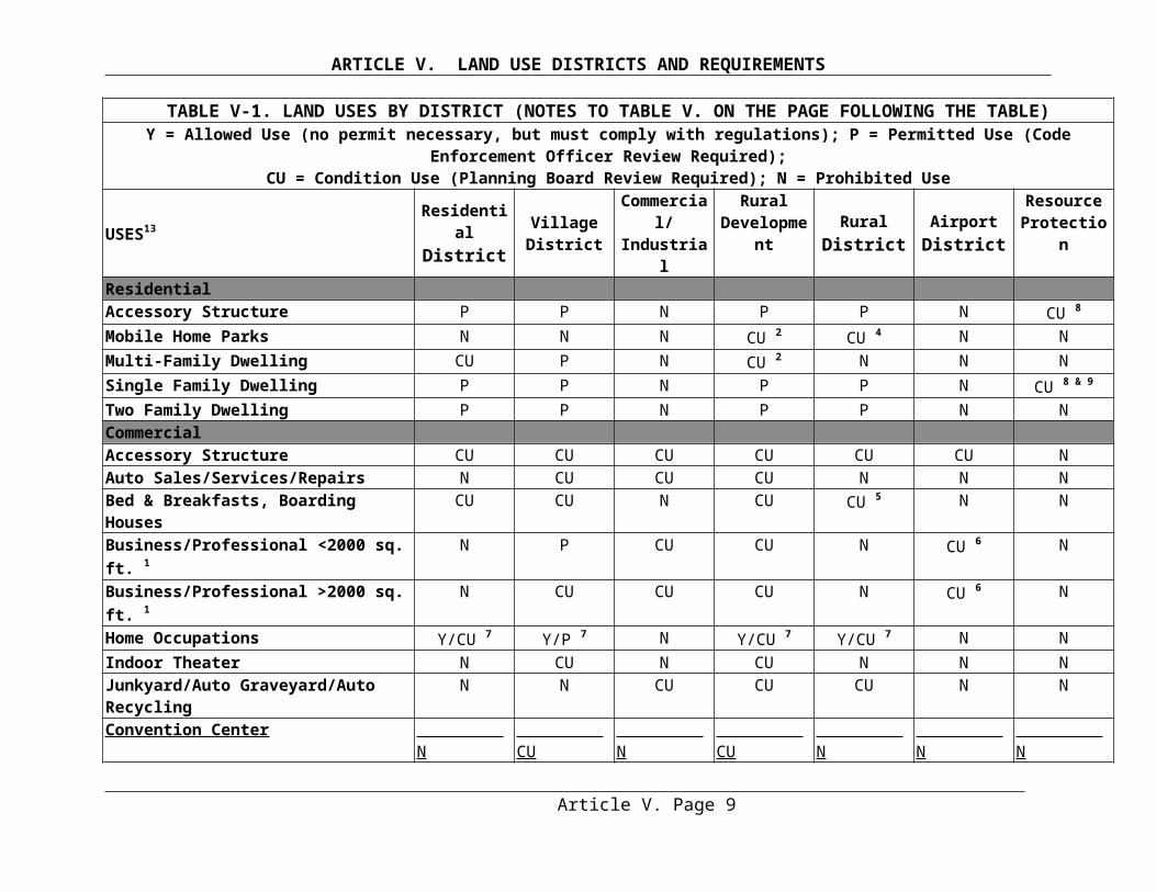
ARTICLE VII. SHORELAND OVERLAY DISTRICT AND RESOURCE PROTECTION DISTRICT STANDARDS
the applicant that appropriate techniques will be used to prevent sedimentation of the water body, tributary or wetland. Such techniques may include, but are not limited to, the installation of settling basins, and/or the effective use of additional ditch relief culverts and turnouts placed so as to avoid sedimentation of the water body, tributary stream, or wetland. On slopes of greater than 20% the shoreline setback shall be increased by 10 feet, horizontal distance, for each 5% increase in slope above 20%. Section 7 (A) does not apply to approaches to water crossings or to roads or driveways that provide access to permitted structures and facilities located nearer to the shoreline or tributary stream due to an operational necessity, excluding temporary docks for recreational uses. Roads and driveways providing access to permitted structures within the shoreline setback area shall comply fully with the requirements of Section 7(A) except for that portion of the road or driveway necessary for direct access to the structure.
B. Setback Exception. Existing public roads may be expanded within the legal road right-of-
way regardless of its distance from a shoreline.
C. Resource Protection District Prohibition. New roads and driveways are prohibited in a Resource Protection District except that the Planning Board may grant a permit to construct a road or driveway to provide access to permitted uses within the district. A road or driveway may also be approved by the Planning Board in a Resource Protection District, upon a finding that no reasonable alternative route or location is available outside the district. When a road or driveway is permitted in a Resource Protection District the road and/or driveway shall be set back as far as practicable from the normal high-water line of a water body, tributary stream, or upland edge of a wetland.
D. Erosion and Sedimentation Control. Road and driveway banks shall be no steeper than a slope of two horizontal to one vertical, and shall be graded and stabilized in accordance with the provisions for erosion and sedimentation control contained in Article VI. Section 5 and in Article VII Section 18.
E. Road and Driveway Grades. Road and driveway grades shall be no greater than 10% except for segments of less than 200 feet.
F. Buffer Strip. In order to prevent road and driveway drainage from directly entering water bodies, tributary and wetlands, roads and driveways shall be designed, constructed, and maintained to empty onto an unscarified buffer strip at least 50 feet plus two times the average slope, in width between the outflow point of the ditch or culvert and the normal high-water line of a water body, tributary stream, or upland edge of a wetland. Surface drainage that is directed to an unscarified buffer strip shall be diffused or spread out to promote infiltration of the runoff and to minimize channelized flow of the drainage through the buffer strip.
G. Surface Drainage Facilities. Ditch relief (cross drainage) culverts, drainage dips and water turnouts shall be installed in a manner effective in directing drainage onto unscarified buffer strips before the flow gains sufficient volume or head to erode the road, driveway or ditch. To accomplish this, the following shall apply:
1. Ditch relief culverts, drainage dips and associated water turnouts shall be spaced along the road or driveway at intervals no greater than indicated in the following table:
Article VII. Page 7
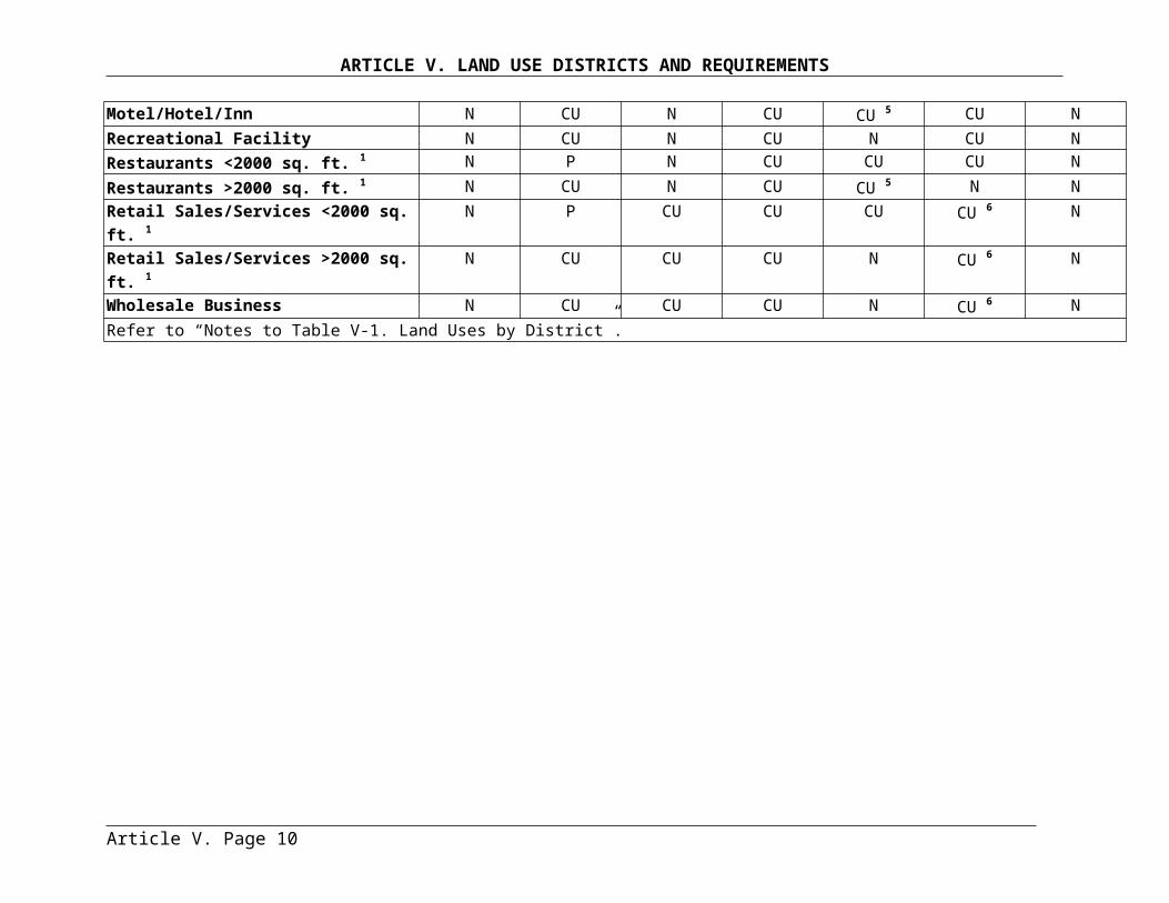
ARTICLE VII. SHORELAND OVERLAY DISTRICT AND RESOURCE PROTECTION DISTRICT STANDARDS
Grade Spacing0-2% 250 feet3-5% 200-135 feet6-10% 100-80 feet11-15% 80-60 feet16-20% 60-45 feet21% + 40 feet
2. Drainage dips may be used in place of ditch relief culverts only where the grade is 10% or less.3. On sections having slopes greater than 10%, ditch relief culverts shall be placed approximately a 30-degree angle down slope from a line perpendicular to the centerline of the road or driveway.4. Ditch relief culverts shall be sufficiently sized and properly installed in order to allow for effective functioning, and their inlet and outlet ends shall be stabilized with appropriate materials.
H. Maintenance of Drainage Facilities. Ditches, culverts, bridges, dips, water turnouts and other storm water runoff control installations associated with roads and driveways shall be maintained on a regular basis to assure effective functioning.
I. Culverts. A permit is required for the placement of any new culvert or replacement of an existing culvert.
SECTION 8. SIGNS. The following provisions shall govern the use of signs:
A. Commercial Signs. Signs relating to goods and services sold on the premises shall be allowed, provided that such signs shall not exceed 6 square feet in area and shall not exceed 2 signs per premises. Signs relating to goods or services not sold or rendered on the premises shall be prohibited.
B. Name Signs. Name signs are allowed, provided such signs shall not exceed 2 signs per premises and shall not exceed 12 square feet in the aggregate.
C. Residential Signs. Residential users may display a single sign not over 3 square feet in area relating to the sale, rental, or lease of the premises.
D. Trespassing and Hunting Signs. Signs relating to trespassing and hunting shall be allowed without restriction as to number provided that no such sign shall exceed 2 square feet in area.
E. Public Safety Signs. Signs relating to public safety shall be allowed without restriction.F. Sign Height. No sign shall extend higher than 20 feet above the ground.G. Illumination. Signs may be illuminated only by shielded, non-flashing lights.
Article VII. Page 8
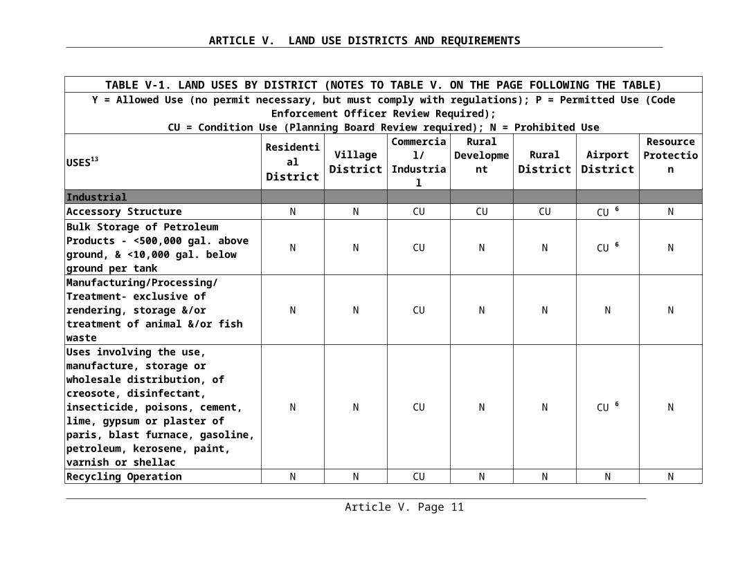
ARTICLE VII. SHORELAND OVERLAY DISTRICT AND RESOURCE PROTECTION DISTRICT STANDARDS
SECTION 9. STORMWATER RUNOFF. The proposed use shall be in conformance with the provisions of Article VI. Section 4. Storm water Runoff.
SECTION 10. SEPTIC WASTE DISPOSAL. The proposed use shall be in conformance with the provisions of Article VI. Section 3. Sewage Disposal.
SECTION 11. ESSENTIAL SERVICES
A. General. Where feasible, the installation of essential services shall be limited to existing public ways and existing service corridors.
B. Restrictions. The installation of essential services, other than roadside distribution lines, is not allowed in a Resource Protection Districts or in shoreland zone of streams, except to provide services to a permitted use within said areas, or except where the applicant demonstrates that no reasonable alternative exists. Where allowed, such structures and facilities shall be located so as to minimize any adverse impacts on surrounding uses and resources, including visual impacts.
C. Replacement and Repair of Utility and Transmissions Lines. Damaged or destroyed public utility transmission and distribution lines, towers and related equipment may be replaced or reconstructed without a permit.
D. Public Utility Installation. A public utility, water district, sanitary district or any utility company of any kind may not install services to any new structure located in the shoreland zone unless written authorization attesting to the validity and currency of all local permits required under this or any previous Ordinance has been issued by the appropriate municipal officials or other written arrangements have been made between the municipal officials and the utility.
SECTION 12. MINERAL EXPLORATION AND EXTRACTION . Mineral exploration to determine the nature or extent of mineral resources shall be accomplished by hand sampling, test boring, or other methods which create minimal disturbance of less than 100 square feet of ground surface. A permit from the Code Enforcement Officer shall be required for mineral exploration, which exceeds the above limitation. All excavations, including test pits and holes shall be immediately capped, filled or secured by other equally effective measures, to restore disturbed areas and to protect the public health and safety. Mineral extraction may be permitted under the following conditions:
A. Prohibited. Within seventy-five (75) feet, horizontal distance, of the normal high-water line of a stream, mineral exploration and mineral extraction are prohibited. Within the shoreland zone, mineral extraction is prohibited in the Resource Protection District where the criterion of Article V Section 4.G.1 is met.
B. Reclamation Plan. A reclamation plan shall be filed with, and approved by the Planning Board before a permit is granted. Such plan shall describe in detail procedures to be undertaken to fulfill the requirements of Section 12.D below.
C. Shoreline Setbacks. No part of any extraction operation, including drainage and runoff control features shall be permitted within 100 feet, horizontal distance, of the normal high-water line of a great pond or a river flowing to a great pond, and within 75 feet, horizontal
Article VII. Page 9
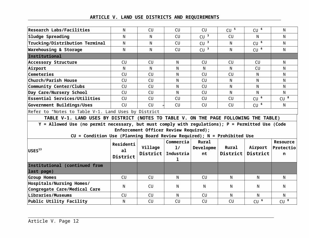
ARTICLE VII. SHORELAND OVERLAY DISTRICT AND RESOURCE PROTECTION DISTRICT STANDARDS
distance, of the normal high-water line of any other water body, tributary stream, or the upland edge of a wetland. Extraction operations shall not be permitted within 50 feet, horizontal distance of any property line, without written permission of the owner of such adjacent property.
D. Site Closure and Stabilization. Within 12 months following the completion of extraction operations at any extraction site, which operations shall be deemed complete when less than 100 cubic yards of materials are removed in any consecutive 12-month period, ground levels and grades shall be established in accordance with the following:
1. All debris, stumps, and similar material shall be removed for disposal in an approved location, or shall be buried on-site. Only materials generated on-site may be buried or covered on-site. Disposal of materials shall be in compliance with the Solid Waste Management Rules Chapters 400-419 of the Department of Environmental Protection's regulations.2. The final graded slope shall be two and one half to one (2 1/2:1) slope or flatter.3. Topsoil or loam shall be retained to cover all disturbed land areas, which shall be reseeded and stabilized with vegetation native to the area. Additional topsoil or loam shall be obtained from off-site sources if necessary to complete the stabilization project.
E. Other Conditions. In keeping with the purposes of this Ordinance, the Planning Board may impose such conditions as are necessary to minimize the adverse impacts associated with mineral extraction operations on surrounding uses and resources.
SECTION 13. AGRICULTURE
A. General. All spreading of manure shall be accomplished in conformance with the Manure Utilization Guidelines published by the Maine Department of Agriculture on November 1, 2001, and the Nutrient Management Law (7 M.R.S.A. sections 4201-4209).
B. Manure Storage. Manure shall not be stored or stockpiled within 100 feet, horizontal distance, of a great pond or a river flowing to a great pond, or within 75 feet horizontal distance, of other water bodies, tributary streams, or wetlands. All manure storage areas within the shoreland zone must be constructed or modified such that the facility produces no discharge of effluent or contaminated storm water.
C. Soil and Water Conservation Plan. Agricultural activities involving tillage of soil greater than 40,000 square feet in surface area, within the shoreland zone shall require a Conservation Plan shall be filed with the Planning Board. Non-conformance with the provisions of said plan shall be considered to be a violation of this Ordinance.
__________________________________________________________________________NOTE: Assistance in preparing a soil and water conservation plan may be available through the local Soil and Water Conservation District office.___________________________________________________________________________
D. Tilling of Soil. There shall be no new tilling of soil within 100 feet, horizontal distance, of the normal high-water line of a great pond; within 75 feet, horizontal distance, from other water bodies; nor within twenty-five feet, horizontal distance, of tributary streams, and freshwater wetlands. Operations in existence on the effective date of this Ordinance and not in conformance with this provision may be maintained.
Article VII. Page 10
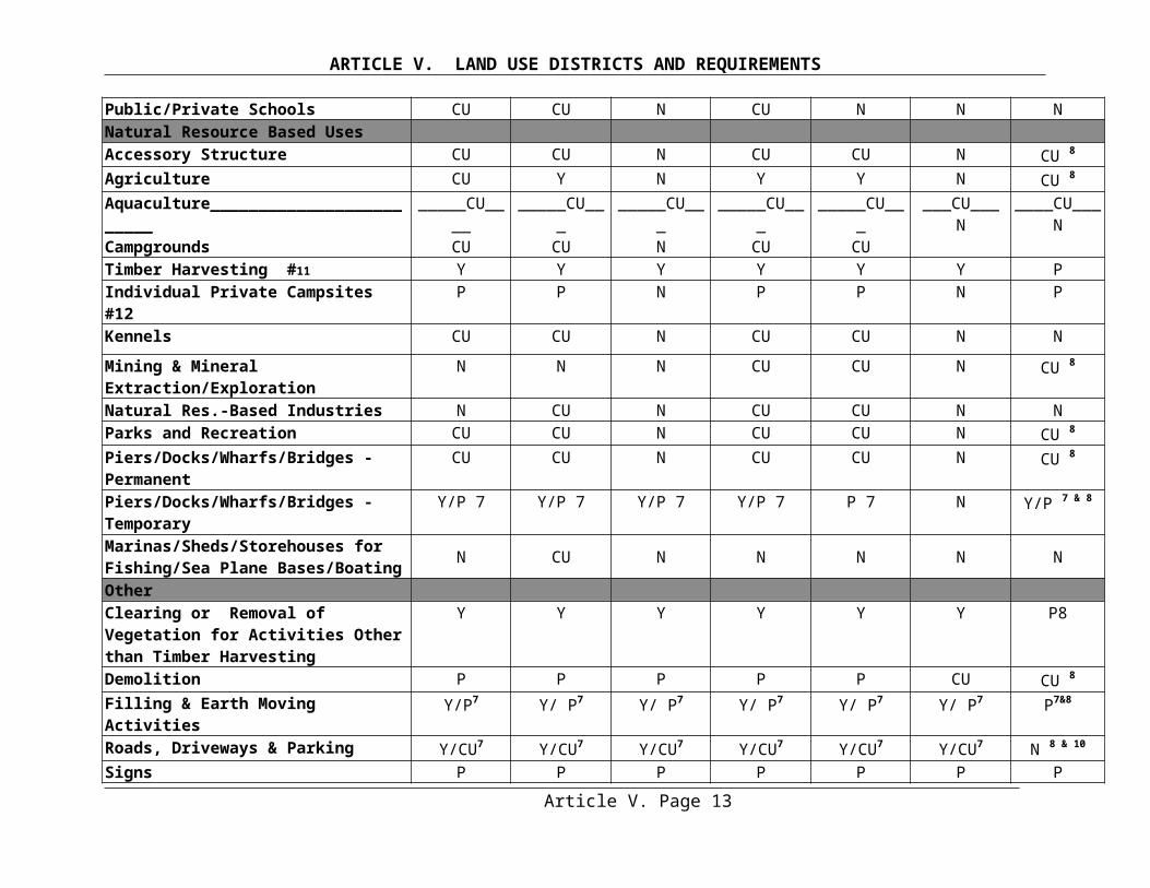
ARTICLE VII. SHORELAND OVERLAY DISTRICT AND RESOURCE PROTECTION DISTRICT STANDARDS
E. Livestock Grazing. Newly established livestock grazing areas shall not be permitted within 100 feet, horizontal distance, of the normal high-water line of a great pond; within 75 feet, horizontal distance of other water bodies; nor within 25 feet, horizontal distance, of tributary streams, and wetlands. Livestock grazing associated with ongoing farm activities, and which are not in conformance with the above shoreline setback provisions may continue, provided that such grazing is conducted in accordance with a Conservation Plan that has been filed with the Planning Board.
SECTION 14 CLEARING OR REMOVAL OF VEGETATION FOR ACTIVITIES OTHER THAN TIMBER HARVESTING.
A. Streams, and Resource Protection and Critical Watershed Shoreland Overlay Districts. 1. In a Resource Protection or Critical Watershed Shoreland Overlay District abutting a great pond, there shall be no cutting of vegetation within the shoreline buffer extending 75 feet, horizontal distance, inland from the normal high-water line, except to remove safety hazards in accordance with Article VII Section 15. However, a single footpath not to exceed six (6) feet in width as measured between tree trunks and/or shrub stems is allowed for accessing the shoreline provided that a cleared line of sight to the water through the shoreline buffer is not created. Elsewhere, in any Resource Protection District and Critical Watershed Shoreland Overlay District the cutting or removal of vegetation shall be limited to that which is necessary for uses expressly authorized in that district.2. Within the seventy-five (75) foot shoreline buffer of a stream, clearing or removal of vegetation requires a permit from the code enforcement officer.
B. Vegetative Buffer Strips. Except in areas as described in, Section 14.A above, within a shoreline buffer extending 100 feet, horizontal distance, inland from the normal high-water line of a great pond or a river flowing to a great pond, or within a shoreline buffer extending 75 feet, horizontal distance, from any other water body, tributary stream, or the upland edge of a wetland, vegetation shall be preserved as follows:
1. There shall be no cleared opening greater than 250 square feet in the forest canopy (or other existing woody vegetation if a forested canopy is not present) as measured from the outer limits of the tree or shrub crown. However, a single footpath not to exceed six (6) feet in width as measured between tree trunks and/or shrub stems is allowed for accessing the shoreline provided that a cleared line of sight to the water through the shoreline buffer is not created.
2. Selective cutting of trees within the shoreline buffer is allowed provided that a well-distributed stand of trees and other natural vegetation is maintained. For the purposes of this section a "well-distributed stand of trees” adjacent to a great pond, or a river or stream flowing to a great pond, shall be defined as maintaining a rating score of 24 or more in any 25-foot by 50-foot square (1250 square feet) area as determined by the following rating system.
Article VII. Page 11
ARTICLE VII. SHORELAND OVERLAY DISTRICT AND RESOURCE PROTECTION DISTRICT STANDARDS
Diameter of Tree at 4-1/2 feet Above PointsGround Level (inches)2 < 4 in. 14 < 8 in. 28< 12 in. 412 in. or greater 8
Adjacent to other water bodies, tributary streams, and wetlands, a "well-distributed stand of trees" is defined as maintaining a minimum rating score of 16 per 25-foot by 50-foot rectangular area.
NOTE: As an example, adjacent to a great pond, if a 25-foot x 50-foot plot contains four (4) trees between 2 and 4 inches in diameter, two trees between 4 and 8 inches in diameter, three trees between 8 and 12 inches in diameter, and two trees over 12 inches in diameter, the rating score is:
(4x1)+(2x2) + (3x4) + (2x8) = 36 points
Thus, the 25-foot by 50-foot plot contains trees worth 36 points. Trees totaling 12 points (36- 24 =12) may be removed from the plot provided that no cleared openings are created.
The following shall govern in applying this point system:
(i) The 25-foot by 50-foot rectangular plots must be established where the landowner or lessee proposes clearing within the required buffer;
(ii) Each successive plot must be adjacent to, but not overlap a previous plot;(iii) Any plot not containing the required points must have no vegetation removed
except as otherwise allowed by this Ordinance;(iv) Any plot containing the required points may have vegetation removed down to
the minimum points required or as otherwise allowed by is Ordinance;(v) Where conditions permit, no more than 50% of the points on any 25-foot by 50-
foot rectangular area may consist of trees greater than 12 inches in diameter.
For the purposes of Section 14(B)(2) “other natural vegetation” is defined as retaining existing vegetation under three (3) feet in height and other ground cover and retaining at least five (5) saplings less than two (2) inches in diameter at four and one half (4 ½) feet above ground level for each 25-foot by 50-foot rectangle area. If five saplings do not exist, no woody stems less than two (2) inches in diameter can be removed until 5 saplings have been recruited into the plot.
Notwithstanding the above provisions, no more than forty per-cent (40%) of the total volume of trees four (4) inches or more in diameter, measured at 4 1/2 feet above ground level may be removed in any ten (10) year period.
3. In order to protect water quality and wildlife habitat, existing vegetation under three (3) feet in height and other ground cover, including leaf litter and the forest duff layer, shall not be cut, covered or removed, except to provide for a footpath as described in Section 14.B.1. above.4. Pruning of tree branches, on the bottom 1/3 of the tree is allowed
Article VII. Page 12
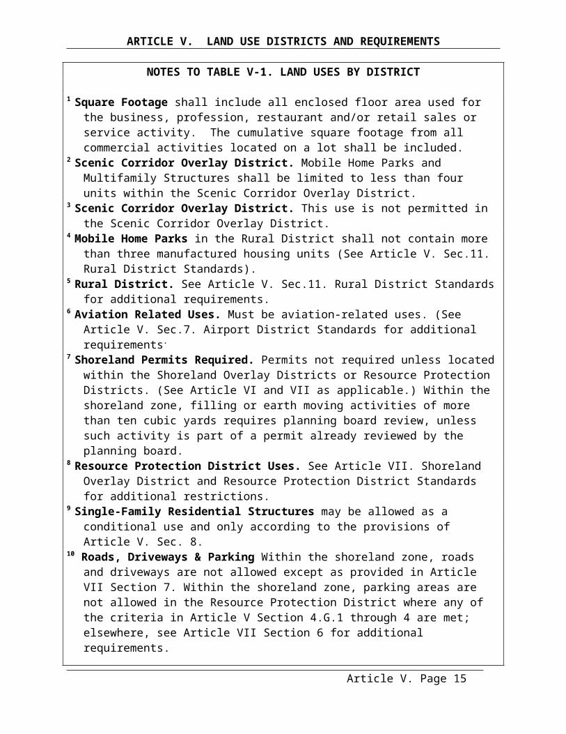
ARTICLE VII. SHORELAND OVERLAY DISTRICT AND RESOURCE PROTECTION DISTRICT STANDARDS
5. In order to maintain the vegetation in the shoreline buffer, the removal of storm-damaged, hazard or dead trees and any required replanting shall occur in accordance with Article VII Section 15.6. In order to maintain the vegetation in the shoreline buffer, clearing or removal of vegetation for allowed activities, including associated construction and related equipment operation, within or outside the shoreline buffer, must comply with the requirements of Section 14.B.
C.Outside the Shoreline Buffer. At distances greater than 100 feet, horizontal distance, from a great pond or a river flowing to a great pond, and 75 feet, horizontal distance, from the normal high-water line of any other water body, tributary stream, or the upland edge of a wetland, there shall be allowed on any lot, in any 10 year period, selective cutting of not more than 40% of the volume of trees 4 inches or more in diameter, measured 4½ feet above ground level. Tree removal in conjunction with the development of permitted uses shall be included in the 40% calculation. For the purposes of these standards volume may be considered to be equivalent to basal area
D. Cleared Openings. In no event shall cleared openings for any purpose, including but not limited to, principal and accessory structures, driveways, lawns and sewage disposal areas, exceed in the aggregate, 25% of the lot area within the shoreland zone or ten thousand (10,000) square feet, whichever is greater, including land previously cleared. This provision applies to the portion of the lot within the shoreland zone, including the shoreline buffer area. This provision shall not apply to the Village District.
E. Existing Cleared Openings. Legally existing nonconforming cleared openings may be maintained, in accordance with Article VII Section 16. If these areas, fields or other cleared openings have reverted back to primarily woody vegetation, as a result of not maintaining them in accordance with Section 16, then the provisions of Section 14 shall apply.
SECTION 15. Hazard Trees, Dead Trees and Storm-Damaged Trees. (A)Hazard trees may be removed without a permit after consultation with the Code Enforcement
Officer, provided the following requirements are met:
(1) Within the shoreline buffer, if the removal of a hazard tree results in a cleared opening in the tree canopy greater than two hundred and fifty (250) square feet, the opening shall be replaced with native tree species, unless there is new tree growth already present near to where the hazard tree was removed. New tree growth is considered to be at least two (2) inches in diameter, measured at four and one half (4.5) feet above ground level. If new growth is not present, then replacement trees shall consist of native species, be at least four (4) feet in height and be no less than two (2) inches DBH. Stumps shall not be removed.
(2) Outside the shoreline buffer, if the removal of hazard trees results in more than forty (40) percent of the volume of trees, four (4) inches or more in diameter as measured at four and one half (4.5) feet above ground level, being removed in any ten (10) year period; or
Article VII. Page 13
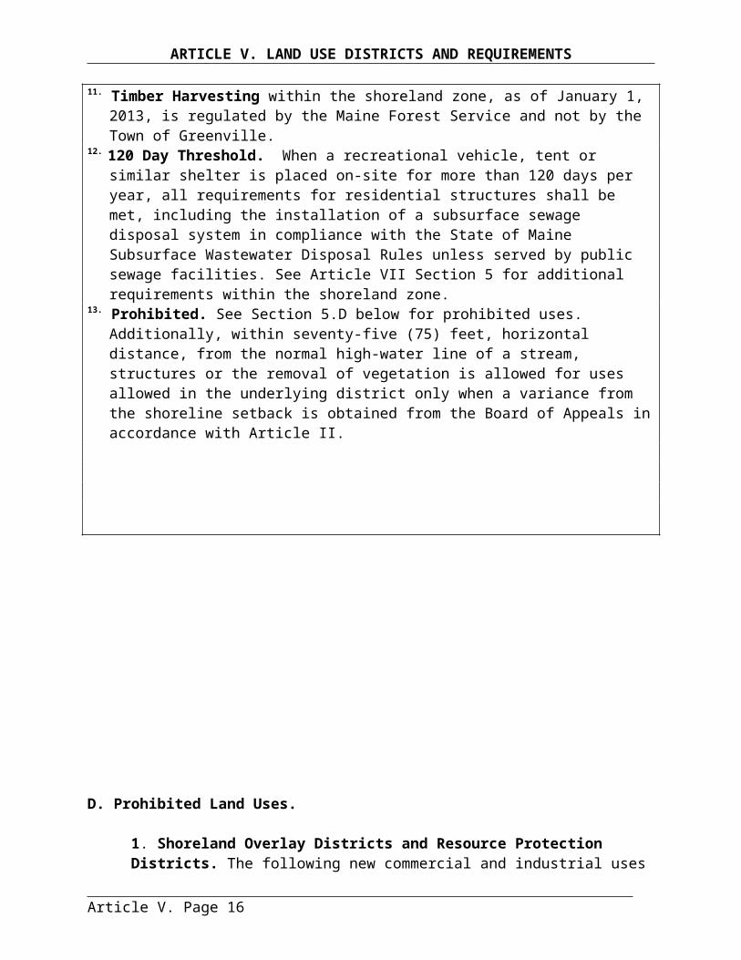
ARTICLE VII. SHORELAND OVERLAY DISTRICT AND RESOURCE PROTECTION DISTRICT STANDARDS
results in cleared openings of more than twenty-five (25) percent of the lot area within the shoreland zone or more than ten thousand (10,000) square feet, whichever is greater; then replacement with native tree species is required, unless there is new tree growth already present near to where the hazard tree was removed. New tree growth is considered to be at least two (2) inches DBH. If new growth is not present, then replacement trees shall consist of native species and be no less than two (2) inches DBH.
(3) The code enforcement officer may require the applicant to submit an evaluation from a licensed forester or arborist before any hazard tree can be removed within the shoreland zone.
(4) The code enforcement officer may require more than a one-for-one replacement for removed hazard trees that exceeded eight (8) inches in diameter at four and one half (4.5) feet above ground level.
(B) Dead trees may be removed without a permit, provided the following requirements are met:
(1) The trees are dead from natural causes. Dead trees are those that contain no foliage during the growing season.
(2) The removal of dead trees does not result in the creation of new lawn areas or other permanently cleared areas.
(3) Stumps shall not be removed.
(C) Storm-damaged trees may be removed without a permit after consultation with the Code Enforcement Officer, provided the following requirements are met:
(1) Within the shoreline buffer, if the removal of storm-damaged trees results in a cleared opening in the tree canopy greater than two hundred and fifty (250) square feet, the following shall be required:
(a) The area shall be required to naturally revegetate. If after one growing season, no natural regeneration or regrowth is present, replanting of native tree seedlings or saplings shall be required at a density of one seedling/sapling per every eighty (80) square feet of open canopy.
(b) The removal of storm-damaged trees does not result in the creation of new lawn areas or other permanently cleared areas.
(c) Stumps shall not be removed.
(d) Limbs damaged from a storm event may be pruned even if they extend beyond the bottom one-third (1/3) of the tree.
(2) Outside the shoreline buffer, if the removal of storm-damaged trees results in more than forty (40) percent of the volume of trees, four (4) inches or more in diameter as measured
Article VII. Page 14
ARTICLE VII. SHORELAND OVERLAY DISTRICT AND RESOURCE PROTECTION DISTRICT STANDARDS
at four and one half (4.5) feet above ground level, being removed in any ten (10) year period; or results in cleared openings of more than twenty-five (25) percent of the lot area within the shoreland zone or more than ten thousand (10,000) square feet, whichever is greater; then the area shall be required to naturally revegetate. If after one growing season, no natural regeneration or regrowth is present, replanting of native tree seedlings or saplings shall be required on a one-for-one basis.
SECTION 16. Exemptions to Section 14. The following activities are exempt from the standards for clearing or removal of vegetation set forth in Section 14, provided that all other applicable requirements of this Ordinance are complied with, and the removal of vegetation is limited to that which is necessary:
(A)The clearing or removal of vegetation that occurs at least once every two (2) years for the maintenance of legally existing areas that do not comply with the standards of Section 14, such as but not limited to cleared openings in the canopy or fields. If any of these areas revert back to primarily woody vegetation, due to a lack of removal of vegetation every two (2) years, the requirements of Section 14 shall apply.
(B) The clearing or removal of vegetation from the location of allowed structures or allowed uses, when the shoreline setback requirements of Article VII Section 2 are not applicable.
(C) The clearing or removal of vegetation from the location of public swimming areas associated with allowed public recreational facilities.
(D)The clearing or removal of vegetation associated with allowed agricultural uses, provided that all requirements of Article VII Section 13 are complied with, and that best management practices are utilized.
(E) The clearing or removal of non-native invasive vegetation, provided that the following requirements are met:
(1) If clearing or removal of vegetation occurs via wheeled or tracked motorized equipment, then the wheeled or tracked motorized equipment is operated and stored at least twenty-five (25) feet, horizontal distance, from the shoreline, except that the wheeled or tracked motorized equipment may be operated or stored on existing structural surfaces, such as pavement or gravel;
(2) The clearing or removal of vegetation within twenty-five (25) feet, horizontal distance, from the shoreline occurs via hand tools; and
(3) If the clearing or removal of non-native invasive vegetation results in a standard of Section 14 being exceeded, then the area shall be revegetated in accordance with Section 17 to achieve compliance with the applicable standard(s) of Section 14.
Article VII. Page 15
ARTICLE VII. SHORELAND OVERLAY DISTRICT AND RESOURCE PROTECTION DISTRICT STANDARDS
NOTE:An updated list of non-native invasive vegetation is maintained by the Department of Agriculture, Conservation and Forestry’s Natural Areas Program.http://www.maine.gov/dacf/mnap/features/invasive_plants/invasives.htm
(F) The clearing or removal of vegetation associated with emergency response activities conducted by the Department, the U.S. Environmental Protection Agency, the U.S. Coast Guard, and their agents.
SECTION 17. Revegetation Requirements. When revegetation is required to address the removal of non-native invasive species of vegetation, to address removal of vegetation in conjunction with shoreline stabilization, in response to violations of the standards set forth in Section 14, or as a mechanism to allow for development that may otherwise not be permissible due to the standards of Section 14, then revegetation shall comply with the following requirements:
(A)The applicant must submit a revegetation plan, prepared with and signed by a qualified professional, that describes revegetation activities and maintenance. The plan must include a scaled site plan, depicting where vegetation was, or is to be removed, where existing vegetation is to remain, and where vegetation is to be planted, including a list of all vegetation to be planted.
(B) Revegetation must occur along the same segment of shoreline and in the same area where vegetation was removed, and must occur at a density comparable to the pre-existing vegetation. If this is not feasible due to shoreline stabilization, then revegetation must occur along the same segment of shoreline and as close as possible to the area where vegetation was removed.
(C) If part of a permitted activity, revegetation shall occur before the expiration of the permit. If the activity or revegetation is not completed before the expiration of the permit, a new revegetation plan shall be submitted with any renewal or new permit application.
(D)Revegetation activities must meet the following requirements for trees and saplings:
(1) All trees and saplings removed must be replaced with native noninvasive species;
(2) Replacement vegetation must consist of saplings at a minimum;
(3) If more than three (3) trees or saplings are planted, then at least three (3) different species shall be used;
(4) No one species shall make up 50% or more of the number of trees and saplings planted;
(5) If revegetation is required for shoreline stabilization, and it is not possible to plant trees and saplings in the same area where trees or saplings were removed, then trees or saplings must be planted in a location that effectively reestablishes the screening between the shoreline and structures; and
Article VII. Page 16

ARTICLE VII. SHORELAND OVERLAY DISTRICT AND RESOURCE PROTECTION DISTRICT STANDARDS
(6) A survival rate of at least eighty (80) percent of planted trees/saplings is required for a minimum of five (5) years.
(E) Revegetation activities must meet the following requirements for all woody vegetation and for other vegetation under three (3) feet in height:
(1) All woody vegetation and vegetation under three (3) feet in height must be replaced with native noninvasive species of woody vegetation and vegetation under three (3) feet in height as applicable;
(2) Woody vegetation and vegetation under three (3) feet in height shall be planted in quantities and variety sufficient to prevent erosion and provide for effective infiltration of stormwater;
(3) If more than three (3) woody vegetation plants are to be planted, then at least three (3) different species shall be planted;
(4) No one species shall make up 50% or more of the number of planted woody vegetation plants; and
(5) Survival of planted woody vegetation and vegetation under three feet in height must be sufficient to remain in compliance with the standards contained in Section 14 for a minimum of five (5) years.
(F) Revegetation activities must meet the following requirements for ground vegetation and ground cover:
(1) All ground vegetation and ground cover removed must be replaced with native herbaceous vegetation, in quantities and variety sufficient to prevent erosion and provide for effective infiltration of stormwater;
(2) Where necessary due to a lack of sufficient ground cover, the area must be supplemented with leaf mulch and/or bark mulch at a minimum of four (4) inches deep to prevent erosion and provide for effective infiltration of stormwater; and
(3) Survival and functionality of ground vegetation and ground cover must be sufficient to remain in compliance with the standards contained within this Ordinance for a minimum of five (5) years.
SECTION 18. EROSION AND SEDIMENTATION CONTROL. The proposed use shall be in conformance with the provisions of Article VI. Section 5. Erosion and Sedimentation Control.
A. When an excavation contractor will perform the activities, compliance with the following shall be required:
Article VII. Page 17

ARTICLE VII. SHORELAND OVERLAY DISTRICT AND RESOURCE PROTECTION DISTRICT STANDARDS
1. A person certified in erosion control practices by the Maine Department of Environmental Protection shall be responsible for management of erosion and sedimentation control practices at the site. This person shall be present at the site each day earthmoving activity occurs for a duration that is sufficient to ensure that proper erosion and sedimentation control practices are followed. This is required until erosion and sedimentation control measures have been installed, which will either stay in place permanently or stay in place until the area is sufficiently covered with vegetation necessary to prevent soil erosion.2. Include on the required plan or building application, the name and certification number of the person who will oversee activities causing or resulting in soil disturbance.
SECTION 19. SOILS. All land uses shall be located on soils in or upon which the proposed uses or structures can be established or maintained without causing adverse environmental impacts, including severe erosion, mass soil movement, improper drainage, and water pollution, whether during or after construction. Proposed uses requiring subsurface waste disposal, and commercial or industrial development and other similar intensive land uses, shall require a soils report based on an on-site investigation and be prepared by state-certified professionals. Certified persons may include Maine Certified Soil Scientists, Maine Registered Professional Engineers, Maine State Certified Geologists and other persons who have training and experience in the recognition and evaluation of soil properties. The report shall be based upon the analysis of the characteristics of the soil and surrounding land and water areas, maximum ground water elevation, presence of ledge, drainage conditions, and other pertinent data that the evaluator deems appropriate. The soils report shall include recommendations for a proposed use to counteract soil limitations where they exist.
SECTION 20. WATER QUALITY. The proposed use shall be in conformance with the provisions of Article VI. Section 2. Water Supply And Quality
SECTION 21. ARCHAEOLOGICAL SITES. The proposed use shall be in conformance with the provisions of Article VI. Section 12. Archaeological Sites.
SECTION 22. BEACH CONSTRUCTION. Beach construction on any great pond, stream or brook shall require a permit from the Department of Environmental Protection.
SECTION 23. CRITICAL WATERSHED SHORELAND OVERLAY DISTRICTS. Additional resource protection measures are required in Critical Watershed Shoreland Overlay Districts to minimize phosphorous runoff and its adverse impact on water quality. The following will be required:
A. Principal Structures. Any new principal structures shall be set back a minimum of 125 feet from normal high-water line. Further, when lots have frontage on a water body, tributary streams and wetlands identified as in a Critical Watershed Shoreland Overlay District, principal structures shall have a combined lot shore frontage and setback from the shoreline of 500 feet. Principal structures shall be screened from the water by existing vegetation, and the vegetation standards in Sections 14, 15, 16 and 17 of this Article shall be closely followed.
B. Roads.
Article VII. Page 18
ARTICLE VII. SHORELAND OVERLAY DISTRICT AND RESOURCE PROTECTION DISTRICT STANDARDS
1. Developers of new permanent roads, except for those providing access to already permitted uses, shall demonstrate that no reasonable alternative route outside of the primary shoreland zone (for purposes of this section primary shoreland zone is defined as 250 feet from the shoreline of the respective water body, tributary, stream or wetland exists. When roads must be located within the primary shoreland zone, they shall be set back as far as practicable from the shoreline and screened from the water body, tributary, stream, or wetland by existing vegetation.2. All roads shall be constructed to avoid steep slopes (areas larger than 5 acres with an average slope greater than 10%), and to divert road-ditching flows periodically into flat wooded areas. When such ditch diversion is not possible, dry wells, or wet ponds shall be constructed to prevent channeled flow along such roadways.
C. Sewage Disposal. Underground sewage disposal facilities shall be constructed per the State of Maine subsurface wastewater regulations. This requirement shall not be reduced by variance except for replacement systems existing prior to enactment of this Ordinance. No provision of this section shall prohibit the placement of sewage disposal facilities upon a lot of record existing before 1988 providing the lot meets the full requirements of the Maine State Plumbing Code without variance.
D. Seasonal Conversions.1. Any person shall, prior to converting a seasonal dwelling to a year-round dwelling, obtain a conversion permit from the CEO/Local Plumbing Inspector. Conversion of a seasonal dwelling to a year-round dwelling means a change of occupancy from seasonal to year-round use or principal dwelling.2. No permit for conversion shall be issued unless one of the following is met:
a. Available records show the dwelling’s sewage disposal system meets the full requirements of the State Plumbing Code without variance.b. Site evaluation can demonstrate site conditions will permit installation of a sewage system meeting the full requirements of the State Plumbing Code without variance in the event of future system malfunction.c. No conversions shall be permitted unless required minimum lot size is met.
F. Erosion and Sedimentation Control Prior to Construction. Before any construction is begun adjacent to the primary shoreland zone, hay bales, erosion fencing, or a similar sedimentation barrier shall be installed of sufficient width and at appropriate points to protect water bodies from any erosion or sedimentation that might result from the construction.
Article VII. Page 19
ARTICLE VIII. SUBDIVISIONS: PERFORMANCE STANDARDS AND REQUIREMENTS
ARTICLE VIII. SUBDIVISIONS:PERFORMANCE STANDARDS AND REQUIREMENTS
The standards and requirements in this section, and the other applicable provisions of this Ordinance, are intended to clarify and expand upon the criteria for approval found within the Subdivision Statute (30-A M.R.S.A., 4404 4401-4408). In reviewing a proposed subdivision, the Planning Board shall review the application for conformance with the following standards and requirements, and the other applicable provisions of this Ordinance, and make findings that each has been met prior to the approval of a final plan. In all instances the burden of proof shall be upon the applicant to present adequate information to indicate all standards and statutory criteria for approval have been or will be met.
SECTION 1. PUBLIC OR PRIVATE ROAD ACCESS TO PROPERTY. Each property proposed for development shall be provided with vehicular access to the property by abutting public or private ways. Private rights-of-way shall be protected by permanent easements.
SECTION 2. LOTS AND DENSITY.
A. Dimensional Requirements. All lots shall meet the minimum dimensional requirements for the zoning district in which they are located, including the requirements for calculating lot area in Article VI. Section 1, or as an alternative meet the cluster development provisions contained in Article VI. Section 14. Cluster Development.
B. Future Subdivision. The subdivision of tracts into parcels that can be further subdivided shall be laid out in such a manner as either to provide for or preclude future re-subdivision. Where public utilities and roads could be extended to the subdivision in the foreseeable future, the subdivision shall be designed to accommodate the extensions of utilities.
C. Odd Shaped Lots. Flag lots and other odd shaped lots in which narrow strips are joined to other parcels in order to meet minimum lot size requirements are prohibited.
D. Shore Frontage Restrictions. If any lots in the proposed subdivision have shore frontage on a river, brook, stream, or great pond, none of the lots created within the subdivision shall have a lot depth to shore frontage ratio greater than 5:1.
SECTION 3. MONUMENTS. All subdivision boundary corners and angle points, as well as all lot boundary corners and angle points shall be marked by suitable monumentation, as required by the Maine Board of Registration of Land Surveyors. Suitable monumentation includes stone and concrete monuments, irons, pins and drill holes in ledge or boulders.
SECTION 4. WATER SUPPLY AND QUALITY. The proposed Subdivision shall be in conformance with the provisions of Article VI. Section 2. Water Supply and Quality.
SECTION 5. SEWAGE DISPOSAL. The proposed Subdivision shall be in conformance with the provisions of Article VI. Section 3. Sewage Disposal.
SECTION 6. STORMWATER RUNOFF. The proposed Subdivision shall be in conformance with the provisions of Article VI. Section 4. Storm water Runoff.
Article VIII. Page 1

ARTICLE VIII. SUBDIVISIONS: PERFORMANCE STANDARDS AND REQUIREMENTS
SECTION 7. SOIL EROSION AND SEDIMENTATION CONTROL. The subdivider shall submit a soil erosion and sedimentation control plan, and shall meet the requirements of Article VI. Section 5. Erosion and Sedimentation Control. The Planning Board may require that the plan be endorsed by the County Soil and Water Conservation District or that the plan be prepared by a Registered Professional Engineer. Topsoil shall be considered part of the subdivision and shall not be removed from the site except for surplus topsoil from roads, parking areas, and building excavations.
SECTION 8. SOLID WASTE DISPOSAL. The proposed subdivision shall be in conformance with the provisions of Article VI. Section 6. Solid Waste Disposal.
SECTION 9. TRAFFIC. The proposed subdivision shall be in conformance with the provisions of Article VI. Section 7. Traffic Access, Circulation and Parking.
SECTION 10. BUFFER AREAS. The Planning Board may require buffer areas to adjacent properties, according to the provisions of Article VI. Section 8. Buffer Areas. In addition, if any portion of the proposed subdivision is located within the Scenic Corridor Overlay District or Rural District, see Article V. Sections 10. and 11.
SECTION 11. CONFORMANCE WITH OTHER LAWS, REGULATIONS. The proposed subdivision shall be in conformance with the provisions of Article VI. Section 13. Conformance With Other Laws, Regulations.
SECTION 12. IMPACT ON NATURAL BEAUTY, AESTHETICS, HISTORIC SITES, WILDLIFE HABITAT, RARE NATURAL AREAS OR PUBLIC ACCESS TO THE SHORELINE.
A. Preservation of Important Areas. The Planning Board may require that a proposed subdivision design include a landscape plan that will show the preservation of existing trees (10” or more in diameter), the replacement of trees and vegetation, graded contours, streams, and the preservation of scenic, historic, or environmentally desirable areas. The street and lot layout shall be adapted to the topography. Extensive grading and filling shall be avoided as much as possible.
B. Shoreline Access. Where the proposed subdivision abuts a lake, pond, river or perennial stream, the Planning Board may require, where feasible and appropriate, that the subdivider reserve an area of land abutting the water body or water course as an open space and/or recreational area for use by property owners in the subdivision. The requirements of Article VI. Section 15. Reservation, Dedication and Maintenance of Common Open Space and Facilities, shall apply.
SECTION 13. FLOODPLAIN MANAGEMENT. This section is applicable when any portion of the subdivision includes flood prone areas as identified on the Federal Emergency Management Agency’s Flood Boundary and Floodway Insurance Maps and information presented by the applicant. The subdivider shall determine the 100-year flood elevation and identify the flood hazard boundaries on the plan. The subdivision plan shall include a statement that structures in the subdivision shall be constructed with their lowest floor, including basement, at least one foot above the 100-year flood elevation.
Article VIII. Page 2
ARTICLE VIII. SUBDIVISIONS: PERFORMANCE STANDARDS AND REQUIREMENTS
SECTION 14. STREET DESIGN AND CONSTRUCTION STANDARDS.
A. General Requirements.1. The Planning Board shall not approve any subdivision plan unless proposed streets are designed in accordance with any local ordinance or the specifications contained within this Ordinance. Approval of the final plan by the Board shall not be deemed to constitute or be evidence of acceptance by the Town of any street or easement.2. Applicants shall submit to the Board, as part of the final plan, detailed construction drawings showing a plan view, profile, and typical cross sections of the proposed streets and existing streets within 300 feet of any proposed intersections. The plan view shall be at a scale of 1 inch equals no more than 50 feet. The vertical scale of the profile shall be 1 inch equals no more than 5 feet. The plans shall include the following information:
a. Date, scale and north point indicating magnetic or true north.b. Intersections of the proposed street with existing streets.c. Roadway and right-of-way limits including edge of pavement, edge of shoulder, sidewalks, and curbs (if applicable).d. Kind, size location, material, profile and cross-section of all existing and proposed drainage structures and their location with respect to existing natural waterways and proposed drainage ways.e. Complete curve data shall be indicated for all horizontal and vertical curvesf. Turning radii at all intersectionsg. Centerline gradientsh. Size, type and locations of all existing and proposed overhead and underground utilities, to include (if applicable) but not be limited to water, sewer, electricity, telephone, lighting, and cable television.
3. Upon receipt of plans for a proposed street the Board shall forward copies to the Selectmen, Town Manager (Road Foreman & Fire Chief), and Engineer, as appropriate, for review and comment.4. Where the applicant proposes improvements within existing streets, the proposed design and construction details shall be approved in writing by the Town Manager or the Maine Department of Transportation, as appropriate.5. Where the subdivision streets are to remain private roads, the following words shall appear on the recorded plan: “All roads in this subdivision shall remain private roads to be maintained by the developer or the lot owners and shall not be accepted or maintained by the Town, until they meet the street design and construction standards for public roads within this Ordinance and are accepted by the Town’s legislative body”.
B. Applicability. These design standards shall be met by all streets within subdivisions, and shall control the roadway, shoulders, curbs, sidewalks, drainage systems, culverts, and other appurtenances.
C. Through Traffic. The Board may require that streets be designed to discourage through traffic within a residential subdivision.
D. Areas Reserved for Widening. Where access to a proposed subdivision borders an existing narrow street (not meeting the width requirement of the standards for streets in these regulations), or when the Comprehensive Plan indicates plans for realignment or widening of a road that would require use of some of the land in the subdivision, the plan shall indicate reserved areas for widening or realigning the road marked “Reserved for Road Realignment
Article VIII. Page 3

ARTICLE VIII. SUBDIVISIONS: PERFORMANCE STANDARDS AND REQUIREMENTS
(Widening) Purposes”. When such widening or realignment is indicated on the Official Map, the reserve is to be deeded to the municipality or other appropriate ownership (camp, association, etc.).
E. Access To Arterials Limited. Where a major subdivision abuts or contains an existing or proposed arterial street, no residential lot may have vehicular access directly on to the arterial street. This requirement shall be noted on the Plan and in the deeds of any lot with frontage on the arterial street.
F. Access Via Substandard Streets or Private Roads. Where a subdivision proposes to utilize an existing substandard street or streets as sole access and the Planning Board determines that the street is unsatisfactory or unsuited, for reasons of public health and safety, and not withstanding other provisions of this or other ordinances, a payment in lieu of upgrading of the street may be assessed by the Board and required to be deposited into a municipal or private association’s road improvement fund. In cases where a subdivision is to be accessed by a private road, the developer shall show proof that future lot owners have a legal right to use the road.
Article VIII. Page 4
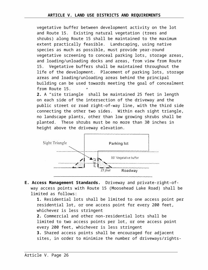
ARTICLE VIII. SUBDIVISIONS: PERFORMANCE STANDARDS AND REQUIREMENTS
G. Design Standards. The following design standards apply according to street classifications:
TABLE VIII-1ROAD AND STREET DESIGN STANDARDS
Description Arterial Collector Local Commercial/Industrial
Private R/0/W
Minimum Right-of-Way Width 80 feet 50 feet 50 feet6 60 feet 50 feet6
Minimum Travel Way 44 feet 24 feet 20 feet6 30 feet 18 feetMin. Shoulder Width (Each Side) 5 feet 3 feet 5 feet 8 feet N/AMinimum Grade .5% .5% .5% .5% N/AMaximum Grade1 5% 6% 8% 5% 8%Minimum Centerline Radius
Without Super elevationWith Super elevation
(Banking on Curves)
500 feet350 feet
280 feet175 feet
280 feet175 feet
400 feet300 feet
174 feet110 feet
Roadway Crown2 ¼ in./ft. ¼ in./ft. ¼ in./ft. ¼ in./ft. 3
Minimum Angle of Street Intersections4 90° 90° 75° 90° 75°
Maximum Grade within 75 Feet of Intersection 3% 3% 3% 3% N/A
Minimum Curb Radii at Intersections 30 feet 25 feet 20 feet 30 feet5 N/AMinimum R/O/W at Intersections 20 feet 10 feet 10 feet 20 feet 10 feetMinimum Radii at Turn-Around Property Line (Min.) Pavement (Min.) Travel Way
N/AN/A
N/AN/A
65 feet50 feet
70 feet44 feet
N/AN/A
Minimum Sidewalk Width -(if constructed) 8 feet 5 feet 5 feet Com. 6 feet
Ind. 5 feet N/A
Notes:1 Maximum grade may be exceeded for a length of 100 feet or less.2 Roadway crown is per foot of lane width.3 Gravel surfaces shall have a minimum crown of ¾ inch per foot of lane width.4 Street intersection angles shall be as close to 90° as feasible but no less than the listed angle.5 Should be based on turning radii of expected commercial vehicles, but no less than 30 feet.6 Mobile Home Parks. The right-of-way width within mobile home parks shall be a minimum of 23 feet in width. The minimum width of pavement or travel way shall be 20 feet.
H. Road Centerline. The centerline of the roadway shall be the centerline of the right-of-way.I. Dead End Streets. In addition to the design standards above, dead-end streets shall be
constructed to provide a cul-de-sac turn-around with the following requirements for radii:Property line 60 feetOuter edge of travel way 50 feet
A hammerhead turnaround can be used as a substitute but must be of adequate dimensions to accommodate a school bus, a fire truck and other safety vehicles and must be approved by the Planning Board. If the Planning Board allows a hammerhead turnaround, Maine Department of Transportation standards for such turnarounds will be used. The Board may require the reservation of a 20-foot easement in line with the street to provide continuation of pedestrian traffic or utilities to the next street. The Board may also require the reservation of a 50-foot easement in line with the street to provide continuation of the road where future
Article VIII. Page 5

ARTICLE VIII. SUBDIVISIONS: PERFORMANCE STANDARDS AND REQUIREMENTS
subdivision is possible. The Planning Board may also require additional safety turnouts on dead end streets and roads.
J. Grades, Intersections, Sight Distances and Turn-arounds.1. Grades of all streets shall conform in general to the terrain, so that cut and fill are minimized while maintaining the grade standards above.2. All changes in grade shall be connected by vertical curves to provide for the minimum stopping sight distances below.3. Where new street intersections or driveway curb-cuts are proposed, sight distances, as measured along the road onto which traffic will be turning, shall be based upon the posted speed limit and conform to the table below. Sight distances shall be measured from the driver’s seat of a vehicle a minimum of 10 feet behind the curb line or edge of shoulder, with the height of the eye 3½ feet, to the top of an object 4½ feet above the pavement.
Posted Speed Limit (mph) 25 mph 30 mph 35 mph 40 mph 45 mph 50 mph 55 mphSight Distance (feet) 250 ft. 300 ft. 350 ft. 400 ft. 450 ft. 500 ft. 550 ft.
Where necessary, corner lots shall be cleared of all growth and sight obstructions, including ground excavations, to achieve the required visibility.4. Cross (four-cornered) street intersections shall be avoided insofar as possible, except as shown on the Comprehensive Plan or at other important traffic intersections. 5. Additional turn-arounds and/or safety turnouts may be required by the Planning Board.
J. Preparation.1. Before any clearing has started on the right-of-way the centerline and sidelines of the new road shall be staked or flagged at 50-foot intervals.2. Before grading is started, the roadway shall be cleared of all stumps, roots, brush and other objectionable material. Enough grade sticks shall be placed after clearing so that the Town’s engineer can determine where the road is being placed on the ground. Wherever possible, all ledge, large boulders and tree stumps shall be removed from the right-of-way. All organic materials or other deleterious material shall be removed to a depth of 2 feet below the sub-grade of the roadway. Rocks and boulders shall also be removed to a depth of 2 feet below the sub-grade of the roadway. Where soils are unsuitable for roadways, either the soil should be removed from the road site to a depth of 2 feet below the sub-grade and replaced with aggregate sub-base material, or Maine Department of Transportation approved stabilization geotextile may be used.3. Except in a ledge cut, side slopes shall be no steeper than a slope of 3 feet horizontal to 1 foot vertical, and shall be graded, loamed, limed, fertilized, and seeded according to specifications of the erosion and sedimentation control plan. Where a cut results in exposed ledge, a side slope no steeper than 4 feet vertical to 1 foot horizontal is permitted.4. All underground utilities shall be installed prior to paving to avoid cuts in the pavement. Building sewers and water service connections shall be installed to the edge of the right-of-way prior to paving.5. All gravel bases shall be placed in 2 layers with the top layer not exceeding a compacted depth of 9 inches. If an excess of oversized stones are encountered they should either be removed by other methods on the project site during the process of from
Article VIII. Page 6
ARTICLE VIII. SUBDIVISIONS: PERFORMANCE STANDARDS AND REQUIREMENTS
each layer prior to the addition of the next course. Each layer of gravel shall be placed uniformly over the full width of the sub-grade. If existing traffic or other conditions restrict this operation, layers less than a full width will be allowed. Shoulder sections shall not be constructed in a separate operation from that of the gravel base. The shoulder slope should be constructed and compacted with the gravel base operation.
K. Minimum Thickness of Material after Compaction. The minimum thickness of material after compaction shall meet the specifications in Table VIII-2.
TABLE VIII-2. MINIMUM REQUIREMENTS FOR THICKNESS OF MATERIALS AFTER COMPACTION
Road Materials Arterial Collector Local Industrial/ Commercial
Private R/O/W
GRAVEL ROADSAggregate Sub-base Course(Max. Size Stone – 6 inches) Without Base Gravel With Base Gravel
24 inches20 inches
18 inches15 inches
18 inches15 inches
24 inches20 inches
15 inches12 inches
Crushed Aggregate Base Course (if necessary*)(Max. Size Stone – 3 inches)
4 inches 3 inches 3 inches 4 inches 4 inches
Surface Gravel Course(Max. Size Stone 3 inches) 3 inches 3 inches 3 inches 3 inches 3 inches
PAVED ROADSAggregate Sub-base Course(Max. Size Stone – 6 inches) Without Base Gravel With Base Gravel
24 inches20 inches
18 inches15 inches
18 inches15 inches
24 inches20 inches
15 inches12 inches
Crushed Aggregate Base Course (if necessary*)(Max. Size Stone – 3 inches)
4 inches 3 inches 3 inches 4 inches 4 inches
Hot Bituminous Pavement Total Thickness Surface Course Base Course
3 inches 1¼ inches13/4 inches
3 inches1¼ inches 13/4 inches
3 inches1¼ inches13/4 inches
4 inches1¼ inches23/4 inches
3 inches1¼ inches13/4 inches
* The need for a crushed aggregate base course depends on the quality of the aggregate sub-base course. The aggregate base course is needed only when the sub-base course does not contain a distribution of particle sizes which allows it to be fine graded yet support the loads of traffic.
L. Aggregate Base and Sub-Base Courses.1. The aggregate sub-base course shall be sand or gravel of hard durable particles free from vegetative matter, lumps or balls of clay and other deleterious substances. Aggregate for the sub-base shall contain no particles of rock exceeding 6 inches in any dimension.2. If the aggregate sub-base course is found to be not fine gradable because of larger stones, then a minimum of 3 inches of aggregate base course shall be placed on top of the sub-base course. The aggregate base course shall be screened or crushed gravel of hard durable particles free from vegetative matter, lumps or balls of clay and other deleterious substances. If selected bank run material meeting these requirements can be obtained,
Article VIII. Page 7
ARTICLE VIII. SUBDIVISIONS: PERFORMANCE STANDARDS AND REQUIREMENTS
screening or crushing will not be required. Aggregate for the base course shall contain no particles of rock exceeding 3 inches in any dimension.
M. Gravel Surface Course. The gravel surface course is for the fine grading operation to obtain the desired grade and good readability. The surface gravel course shall consist of a wearing course or leveling course of screened or crushed aggregate. This material shall be uniformly graded with 100% passing the 3” screen. If selected bank run material meeting these requirements can be obtained, screening or crushing will not be required. Surface gravel shall be placed on top of the aggregate sub-base course.
N. Paved Roads.1. Pavement Joints. Where pavement joins an existing pavement, the existing pavement shall be cut along a smooth line and form a neat, even, vertical joint.2. Pavements.
a. Minimum standards for the base layer of pavement shall be the Maine Department of Transportation specifications for plant mix grade B with an aggregate size no more than 1 inch maximum and a liquid asphalt content between 4.8% and 6.0% by weight depending on aggregate characteristics. The pavement may be placed between April 15 and November 15, provided the air temperature in the shade at the paving location is 35°F or higher and the surface to be paved is not frozen or unreasonably wet. b. Minimum standards for the surface layer of pavement shall be the Maine Department of Transportation specifications for plant mix grade C or D with an aggregate size no more than 3/4 inch maximum and a liquid asphalt content between 5.8% and 7.0% by weight depending on aggregate characteristics. The pavement may be placed between April 15 and October 15, provided the air temperature in the shade at the paving location is 50°F or higher.
O. Revegetation. All exposed cut and filled banks, ditches, bridge abutments, culvert crossings, exposed soil, etc. will be stabilized to avoid unreasonable slumping, washing or erosion and sedimentation problems. Generally, these areas shall be graded, limed, fertilized, and seeded, except where fertilizer run-off could impact streams and lakes. Sufficient revegetation must take place in a reasonable period of time to avoid the above problems otherwise other provisions (approved by the Planning Board) must be applied to avoid these problems. Adequate (enough to stabilize all exposed soils, ditches, and slopes, etc.) revegetation growth must occur by September 15, or otherwise another plan must be approved by the Planning Board. The Planning Board may require that the grading, seeding, lime and fertilizer applications and other provisions be provided in the erosion and sedimentation plan. There shall be no fertilizer run-off in streams or other bodies of water. Any additional requirements of Article VI., Sections 4 and 5 shall also be met.
P. Certification of Construction. Upon completion of street construction and prior to a vote by the Selectmen to submit a proposed public way to the legislative body, a written certification signed by a professional engineer, of the Town’s choice, registered in the State of Maine shall be submitted to the Selectmen at the expense of the applicant, certifying that the proposed way meets or exceeds the design and construction requirements of these regulations. “As built” plans shall be submitted to the Selectmen.
SECTION 15. MAINTENANCE REQUIREMENTS OF ROADS AND COMMON AREAS If roads and open space or common areas are to be maintained by the residents of the subdivision, the instruments of conveyance (deeds) shall provide a manner (such as an association with a set of by-laws) for providing for the cost of maintenance of the reserved
Article VIII. Page 8
ARTICLE VIII. SUBDIVISIONS: PERFORMANCE STANDARDS AND REQUIREMENTS
common areas and for the costs or road maintenance to each property owner of the subdivision. All such plans for providing this maintenance shall be submitted to the Planning Board prior to Final Plan approval. The applicable provisions of Article VI. Section 15, Reservation, Dedication And Maintenance Of Common Open Space And Facilities, shall apply.
SECTION 16. FINANCIAL AND TECHNICAL CAPACITY
A. Financial Capacity. The applicant shall have adequate financial resources to construct the proposed improvements and meet the criteria of the statute and the standards of this Ordinance. When the applicant proposes to construct the buildings as well as the subdivision improvements, the applicant shall have adequate financial resources to construct the total development. In making the above determinations the Planning Board shall consider the proposed time frame for construction and the effects of inflation.
B. Technical Ability. The applicant shall retain qualified contractors and consultants to supervise, construct, and inspect the required improvements in the proposed subdivision. In determining the applicant’s technical ability the Planning Board shall consider the applicant’s previous experience, the experience and training of the applicant’s consultants and contractors, and the existence of violations of previous approvals granted to the applicant.
SECTION 17. CONSTRUCTION PROHIBITED. No utility installations, no ditching, grading, or construction of roads, no grading of land or lots, no timber harvesting or clearing and no construction of buildings shall be done on any part of the subdivision until a Final Plan of the subdivision has been prepared, submitted, reviewed, approved and endorsed as provided by these regulations, nor until an attested copy of the Final Plan so approved and endorsed has been recorded by the subdivider in the Registry of Deeds and a copy of the recorded subdivision and attachments has been given to the Town. Plans for road construction, grading and ditching shall be reviewed by the Code Enforcement Officer and the Town Manager/Road Commissioner for their recommendations prior to Planning Board approval.
SECTION 18. PHOSPHORUS CONTROL
A. Applicability. The following standards shall apply to all subdivisions which are to be located in the direct watershed of any great pond.
B. Standards. A phosphorus control plan shall be developed in accordance with the design criteria contained in the Phosphorus Control in Lake Watersheds: A Technical Guide for Evaluating New Development, published by the Maine Department of Environmental Protection, revised September 1992.
Article VIII. Page 9

ARTICLE IX. DEFINITIONS
ARTICLE IX. DEFINITIONS
CONSTRUCTION OF LANGUAGE
In the interpretation and enforcement of this Ordinance, all words other than those specifically defined in the Ordinance shall have the meaning implied by their context in the Ordinance or their ordinarily accepted meaning. In the case of any difference of meaning or implication between the text of this Ordinance and any map, illustration, or table, the text shall control. The word “person” includes a firm, association, organization, partnership, trust, company, or corporation, as well as an individual or any other legal entity. The present tense includes the future tense, the singular number includes the plural, and the plural numbers includes the singular. The word “shall” and “will” are mandatory, the word “may” is permissive. The word “lot” includes the words “plot” and “parcel”. The word “building” includes the word “structure”. The word “used” or “occupied”, as applied to any land or building, shall be construed to include the words “intended, arranged, or designed to be used or occupied”. The words “Town” or “Municipality” mean the Town of Greenville, Maine.
DEFINITIONS
In this Ordinance, the following terms have the following meanings:
Accessory Use or Structure - a use or structure that is incidental and subordinate to the principal use or structure. The term “incidental” in reference to the principal structure shall mean both a) subordinate and minor in significance to the principal use or structure, and b) attendant to the principal use or structure. Accessory uses, when aggregated shall not subordinate the principal use of the lot. A deck or similar extension of the principal structure or a garage attached to the principal structure by a roof or a common wall is considered part of the principal structure.Access Point – the location of the intersection of a highway or street or driveway with the highway.Aggrieved Party - an owner of land whose property is directly or indirectly affected by the granting or denial of a permit or variance under this ordinance; a person whose land abuts land for which a permit or variance has been granted; or any other person or group of persons who have suffered particular injury as a result of the granting or denial of such permit or variance.Agriculture - the production, keeping or maintenance for sale or lease, of plants and/or animals, including but not limited to: forages and sod crops; dairy animals and dairy products; poultry products; livestock; fruits and vegetables; and ornamental green house products, including the seasonal sale on the premises at retail of crops or livestock grown thereon. Agriculture does not include forest management or timber harvesting activities.Airports - Airports, heliports, aircraft landing fields, and related operational and terminal facilities; aviation uses, including the sale, service, or storage of aircraft and aircraft parts; accessory uses on the same lot and customarily incidental to and coordinate to the above.Alteration - any change, addition, or modification in construction, or any change in the structural members of a building, such as bearing walls, columns, beams or girders.Aquaculture - the growing or propagation of harvestable freshwater, estuarine, or marine plant or animal
species.
Article IX. Page 1
ARTICLE IX. DEFINITIONS
Aquifer - geologic formation composed of rock or sand and gravel that contain significant amounts of potentially producible potable water.Areas of Special Flood Hazard - the land in the floodplain within a community subject to a one percent or greater chance of flooding in any given year.Arterial – a major thoroughfare, which serves as a major traffic way for travel through the municipality. Route 15, from the Shirley town line to the intersection of Main Street and Pritham Avenue is classified as an arterial.Automobile Graveyard Means a yard, field or other area used as a place of storage for two or more unregistered or uninspected motor vehicles or parts of vehicles.Basal Area – the area of cross-section of a tree stem at 4 ½ feet above the ground level and inclusive of bark.Basement – any portion of a structure with a floor-to-ceiling height of 6 feet or more and having more than 50% of its volume below the existing ground level.Base Flood - a flood having a 1% chance of being equaled or exceeded in any given year. Alternatively referred to as the 100-year flood.Bed and Breakfast/Boarding House - an owner-occupied residential structure where lodging or lodging and meals are provided for compensation. There is no provision for cooking in any individual boarding room.Boat Launching Facility - a facility primarily for the launching and landing of watercraft, and which may include an access ramp, docking area, parking spaces for vehicles and trailers.Building - a structure for the support, shelter, or enclosure of persons, animals, goods, or property of any kind.Bulk Storage of Petroleum Products - any storage and/or on-site distribution of petroleum products that are not accessory uses or are in excess of 2,500 gallons per facility.Bunkhouse - an accessory structure used only for sleeping accommodations that does not have cooking or bathroom facilities and is not hooked up to a subsurface wastewater disposal system.Business and Professional Offices – the place of business of doctors, lawyers, accountants, financial advisors, architects, surveyors, real estate and insurance businesses, psychiatrists, counselors, and the like, or in which a business conducts its administrative, financial or clerical operations including banks and other financial services, but not retail sales or activities utilizing trucks as part of the business operation.Campground - any area or tract of land to accommodate 2 or more parties in temporary living quarters, including, but not limited to tents, recreational vehicles or other shelters.Camping - temporary use of premises for overnight accommodation with or without shelter such as a tent and recreational vehicle. Does not include use of campgrounds.Canopy – the more or less continuous cover formed by tree crowns in a wooded area.Church – a building or structure, or group of buildings or structures, designed, primarily intended and used for the conduct of religious services, excluding schools.Civic, Convention Center – a building or complex of buildings that house municipal offices and services, and which may include cultural, recreational, athletic, convention and entertainment facilities owned and/or operated by a governmental agency.Cluster Development – a subdivision or development in which the lot sizes are reduced below those normally required in the zoning district in which the development is located in return for the provision of permanent open space owned in common by lot/unit owners. Clustering shall not be used to increase the overall density of the development, unless a density bonus is specifically allowed within the district.
Article IX. Page 2

ARTICLE IX. DEFINITIONS
Code Enforcement Officer - a person appointed by the Municipal Officers to administer and enforce this Ordinance. Reference to the Code Enforcement Officer may be construed to include Building Inspector, Plumbing Inspector, Electrical Inspector, and the like, where applicable.Collector – a street or road, which connects local streets and roads to arterials, and generally provides access to abutting land. Collector roads include: Pritham Avenue between the Little Moose Township town line and the intersection with Main Street; Main Street and Lily Bay Road, between the Pritham Avenue intersection and the Beaver Cove town line; and Pleasant Street, between the Main Street intersection and Airport Road.Commercial Use - the use of lands, buildings or structures, other than a "home occupation” defined herein, the intent and result of which activity is the production of income from the buying and selling of goods and/or services, exclusive of rental of residential buildings and/or residential dwelling units. Commercial Fishing Activities - includes activities directly related to commercial fishing and those commercial activities commonly associated with or supportive to commercial fishing, such as the manufacture or sale of ice, bait and nets, and the sale, manufacture, installation or repair of boats, engines and other electronic devices commonly used on boats. Community Center, Club – a building that houses any voluntary association of persons organized for social, religious, literary, scientific, or political purposes; whose facilities, especially a clubhouse, are open to members and guests only, and not the general public; and are not engaged in activities customarily carried on by a business or for pecuniary gain.Conditional Use - a use permitted only after review and approval by the Planning Board. A conditional use is a use that would not be appropriate without restriction but which, if controlled under the provisions of the Ordinance, would promote the purposes of this Ordinance. Such uses may be permitted if specific provisions for such conditional use are made in this Ordinance.Conditional Use Permit - a permit authorized by the Planning Board for a conditional use. A conditional use permit may be issued only after the applicant has followed the procedures of this Ordinance.Conforming Use - a use that is not a nonconforming use as defined. Congregate Care – residential housing consisting of private apartments and central dining facilities and within which a congregate housing supportive services program serves functionally impaired elderly or disabled occupants: the individuals are unable to live independently yet do not require the constant supervision or intensive health care available at intermediate care or skilled nursing facilities. Congregate housing must include only those facilities, which have been certified by the State of Maine as meeting all certification standards and guidelines for congregate housing facilities as promulgated by the Department of Human Services pursuant to the provisions of Maine State Statutes.Construction - includes building, erecting, moving upon or any physical operations on the premises, which are required for construction. Excavation, fill, paving, drainage and the like shall be considered part of construction.Contiguous Lots – lots, which adjoin at any line or point, or are separated at any point by a stream less than 15 feet wide.DBH – the diameter of a standing tree measured 4.5 feet from ground level.Day Care/Nursery School – a building or use of property operated for the care or instruction of more than three children, exclusive of children who may be living in the home, which is serving as the day care or nursery school facility.
Article IX. Page 3
ARTICLE IX. DEFINITIONS
Deck - a structure with a floor, elevated above ground level. Decks, porches, and similar structures are specifically included in computation of square footage of structure, lot coverage, and in determining setback requirements.Density – the number of dwelling units or principal structures per area of land.Development – a change in land use involving alteration of the land, water or vegetation, or the addition or alteration of structures or other construction not naturally occurring.Development Area –any area on which site improvement or change is made, including building, landscaping, parking areas and streets.Dimensional Requirements - numerical standards relating to spatial relationships, including but not limited to setback requirements, lot area, shore frontage and height.Disability – any disability, infirmity, malformation, disfigurement, congenital defect or mental condition caused by bodily injury, accident, disease, birth defect, environmental conditions or illness; and also includes the physical or mental condition of a person which constitutes a substantial handicap as determined by a physician or in the case of mental handicap, by a psychiatrist or psychologist, as well as any other health or sensory impairment which requires special education, vocational rehabilitation or related services.District - a district or zone is a specified portion of the municipality, delineated on the official Zoning Map, within which certain regulations and requirements or various combinations thereof apply under the provisions of this Ordinance.Driveway - a vehicular access-way less than 500 feet in length serving two single-family dwellings or one
two-family dwelling, or less.Dwelling - any building, structure, or portion thereof designed or used for residential purposes. The term shall include mobile homes and modular homes, but shall not include travel trailers or other recreational vehicles.
Single Family Dwelling - a building containing only 1 dwelling unit for occupation by not more than 1 family.Two-Family Dwelling – a building containing only 2 dwelling units, for occupation by not more than 2 families.Multi-Family Dwelling - a building containing 3 or more dwelling units, such buildings being designed for residential use and occupancy by 3 or more families living independently of one another, with the number of families not exceeding the number of dwelling units.
Dwelling Unit - a room or suite of rooms designed and equipped exclusively for use by one family as a habitation and which contains independent living, cooking, sleeping, bathing and sanitary facilities. The term includes single-family and multifamily housing, apartments, mobile homes, modular homes, residential condominiums, and time-share units, but not recreational vehicles or hotel/motel units.Emergency Operation - operations conducted for the public health, safety or general welfare such as protection of resources from immediate destruction or loss, law enforcement, and operations to rescue human beings, property and livestock from the threat of destruction or injury. Essential Services - gas, electrical or communications facilities; steam, fuel, electric power or water transmission or distribution lines, towers and related equipment; telephone cables or lines, poles and related equipment; gas, oil, water, slurry or similar pipelines; municipal sewage lines, collection or supply systems; and associated storage tanks. Such systems may include towers, poles, wires, mains, drains, pipes, conduits, cables, fire alarms and police call boxes, traffic signals, hydrants and similar accessories, but shall not include services drops or buildings which are necessary for the furnishings of such services.
Article IX. Page 4
ARTICLE IX. DEFINITIONS
Excavation Contractor – an individual or firm that either is engaged in a business that causes the disturbance of one or more cubic yards of soil, or is in a business in which the disturbance of one or more cubic yards of soil results from an activity that the individual or firm is retained to perform. Disturbance includes: grading, filling, and removal. A person or firm engaged in agriculture or timber harvesting activities is not considered an excavation contractor as long as best management practices for erosion and sedimentation control are used. Municipal, state and federal employees engaged in projects associated with that employment are not considered excavation contractors.Expansion of a Structure - an increase in the footprint of the structure including all extensions such as, but not limited to attached decks, garages, porches and greenhouses.Expansion of Use - the addition of one (1) or more months to uses operating season; or the use of more footprint or ground area devoted to a particular use; or the provision of additional seats or seating capacity.Family - one or more persons occupying a dwelling and living as a single house keeping unitFilling - depositing or dumping any matter on or into the ground or water.Flood Insurance Map - the official map on which the Department of Housing and Urban Development or the Federal Emergency Management Agency has delineated both the areas of special flood hazard and the risk premium zones applicable to the Town.Flood Proofing - a combination of structural provisions, changes or adjustments to properties subject to flooding, primarily for the reduction or elimination of flood damages to properties, water and sanitary facilities, structures and contents or buildings.Floodplain - any land area susceptible to being inundated by flood waters from any source.Floodway - the channel of a river or other watercourse and adjacent land areas that must be reserved in order to discharge the 100-year flood without cumulatively increasing the water surface elevation more than one foot in height.Floor area - the sum of the horizontal areas of the floor(s) of a structure enclosed by exterior
walls.Footprint – the entire area of ground covered by the structure(s) on a lot, including but not limited to: cantilevered or similar overhanging extensions, as well as unenclosed structures such as patios and decks.Forestry – the operation of timber tracks, tree farms, forest nurseries, the gathering of forest products, or the performance of forest services.Forested Wetland - a freshwater wetland dominated by woody vegetation that is 6 meters (approximately twenty (20) feet)or taller.Foundation - the supporting substructure of a building or other structure excluding wooden sills and post
supports, but including basements, slabs, frost walls, or other base consisting of concrete, block, brick or similar material.
Freshwater Wetland - freshwater swamps, bogs and similar areas, other than forested wetlands, which are:
1. Ten or more contiguous acres; or of less than 10 contiguous acres and adjacent to a surface water body, excluding any river, stream or brook, such that in a natural state, the combined surface area is in excess of 10 acres; and:2. Inundated or saturated by surface or ground water at a frequency and for a duration sufficient to support, and which under normal circumstances do support, a prevalence of wetland vegetation typically adapted for life in saturated soils.
Article IX. Page 5
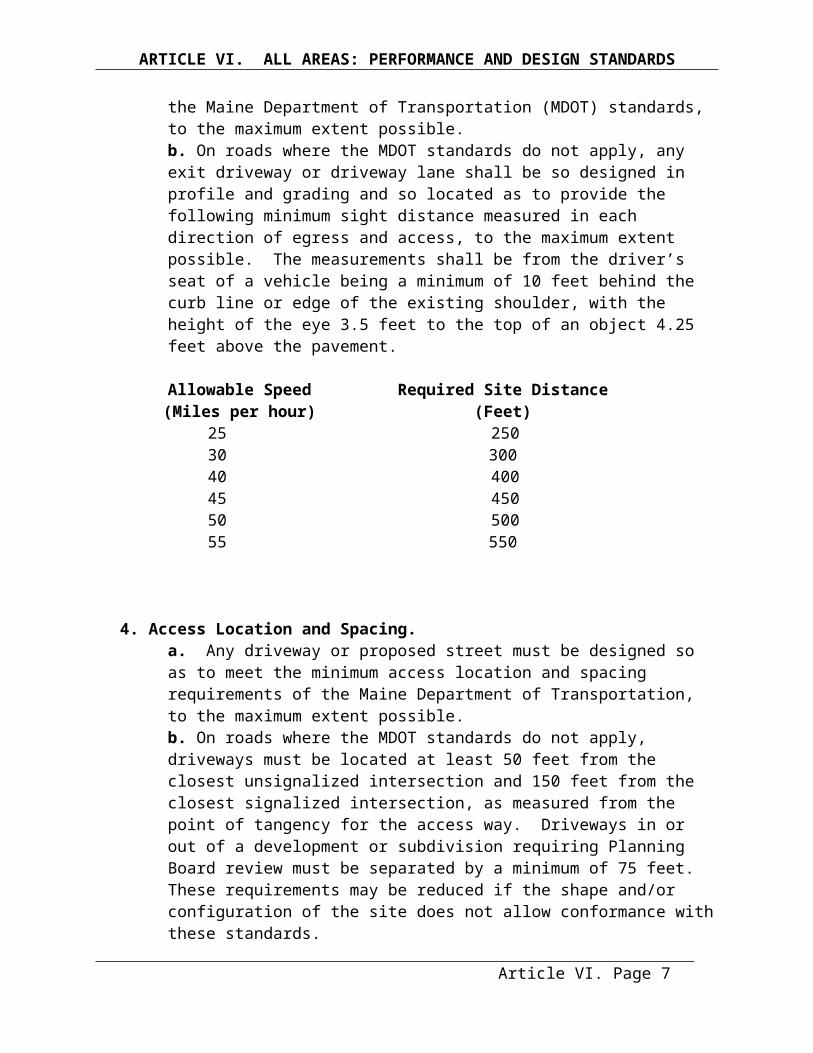
ARTICLE IX. DEFINITIONS
Freshwater wetlands may contain small stream channels or inclusions of land that do not conform to the criteria of this definition.Frontage - the horizontal distance between side lot lines as measured along the front line along a street, or along a private way that has a width of at least 25 feet. Frontage shall be continuous and under one ownership and for the full depth of the required setback. For corner lots, frontage may be the total distance along more than one street or private way as long as it is continuous.Frontage, Shoreline - the length of a lot bordering on a water body or wetland measured as a horizontal distance in a straight line, between the intersection of the lot lines with the shoreline.Functionally Water Dependent Uses - Those uses that require, for their primary purpose,
location on submerged lands or that require direct access to, or location in, coastal or inland waters and that can not be located away from these waters. The uses include, but are not limited to commercial and recreational fishing and boating facilities, finfish and shellfish processing, fish-related storage and retail and wholesale fish marketing facilities, waterfront dock and port facilities, shipyards and boat building facilities, marinas, navigation aids, basins and channels, shoreline structures necessary for erosion control purposes, industrial uses dependent upon water-borne transportation or requiring large volumes of cooling or processing water that can not reasonably be located or operated at an inland site, and uses that primarily provide general public access to waters. Recreational boat storage buildings are not considered to be a functional water-dependent use.
Great Pond - any inland body of water which in a natural state has a surface area in excess of ten acres, and any inland body of water artificially formed or increased which has a surface area in excess of 30 acres except for the purposes of this Ordinance, where the artificially formed or increased inland body of water is completely surrounded by land held by a single owner. Ground cover – small plants, fallen leaves, needles and twigs, and the partially decayed organic
matter of the forest floor.Group Home – a boarding home for the sheltered care of persons with special needs, which in addition to providing food and shelter, may also provide some combination of personal, social or counseling services.
Note the following state statute –Title 30A Sec. 4357-A Community Living Arrangements – housing for 8 or fewer persons with “disabilities” that is approved, authorized, certified or licensed by the State must be deemed a single family use. “Disabilities” have the same meaning as the term “handicap” in the federal Fair Housing Act U.S. Code, Sec. 3602. “Handicap” means, with respect to a person –(1) A physical or mental impairment which substantially limits one or more of such person’s
major life activities,(2) A record of having such impairment, or(3) Being regarded as having such impairment, but such term does not include current,
illegal use of or addiction to a controlled substance.Ground Water - all the water found beneath the surface of the ground. In this Ordinance, the term refers to the slowly moving subsurface water present in aquifers and recharge areas.Ground Water Protection Overlay District - the Ground Water Protection Overlay District is comprised of those areas of Greenville identified by the United States Geological Survey in Open File Reports as capable of supporting wells that will yield at least ten gallons per minute.
Article IX. Page 6
ARTICLE IX. DEFINITIONS
Hazardous Waste - hazardous waste means a waste substance or material in any physical state, designated as hazardous by the Board of Environmental Protection under 38 M.R.S.A. Section 1303.A.Hazard tree - a tree with a structural defect, combination of defects, or disease resulting in a structural defect that under the normal range of environmental conditions at the site exhibits a high probability of failure and loss of a major structural component of the tree in a manner that will strike a target. A normal range of environmental conditions does not include meteorological anomalies, such as, but not limited to: hurricanes, hurricane-force winds, tornados, microbursts, or significant ice storm events. Hazard trees also include those trees that pose a serious and imminent risk to bank stability. A target is the area where personal injury or property damage could occur if the tree or a portion of the tree fails. Targets include roads, driveways, parking areas, structures, campsites, and any other developed area where people frequently gather and linger.Height of a Structure - the vertical distance between the mean original (prior to construction) grade at the downhill side of the structure and the highest point of the structure, excluding chimneys, steeples, antennas, and similar appurtenances that have no floor area.Home Occupation - an occupation or profession which is customarily, conducted on or in a residential
structure or property and; 1) which is clearly incidental to and compatible with the residential use of the property and surrounding residential uses, 2) which employs no more than two 2) persons other than family members residing in the home, and 3) where all of the occupation or profession must be confined to existing structures on said property.
Hotel/Motel – a commercial building or group of buildings built to accommodate for a fee travelers and other transient guests who are staying for a limited duration with sleeping rooms, with or without cooking facilities, each rental unit having its own private bathroom and its own separate entrance leading either to the outdoors or to a common corridor or hallway. A hotel/motel may include restaurant facilities where food is prepared and meals served to its guests and other customers. Hotel/Motel includes such terms as sporting camps, tourist cabins and tourist court. Any transient accommodations that do not meet the definitions of Bed and Breakfast or Boarding House shall be deemed to be a Hotel/Motel for the purposes of this Ordinance.Increase in Nonconformity of a Structure – any change in a structure or property which causes further deviation from the dimensional standard(s) creating the nonconformity such as, but not limited to, reduction in shoreline setback distance, increase in lot coverage, or increase in height of a structure. Property changes or structure expansions which either meet the dimensional standard or which cause no further increase in the linear extent of nonconformance of the existing structure shall not be considered to increase nonconformity. For example, there is no increase in nonconformity with the shoreline setback requirement for water bodies, wetlands, or tributary streams if the expansion extends no further into the required shoreline setback area than does any portion of the existing nonconforming structure. Hence, a structure may be expanded laterally provided that the expansion extends no closer to the water body, tributary stream or wetland than the closest portion of the existing structure from that water body, tributary stream or wetland. Included in this allowance are expansions that in-fill irregularly shaped structures.Individual Private Campsite - an area of land which is not associated with a campground, but which is developed for personal use, for repeated camping by 1 group not to exceed 10 individuals and which involves site improvements which may include but not be limited to a gravel pad, parking area, fire place, or tent platform.
Article IX. Page 7
ARTICLE IX. DEFINITIONS
Industrial - the assembling, fabrication, finishing, manufacturing, packaging or processing of goods, or the extraction of minerals.Industrial or Commercial Road or Street – a road that principally serves industrial or commercial uses.Inn - a building, which contains a dwelling unit, occupied by an owner or resident manager and in which up to 10 lodging rooms or lodging rooms and meals are offered to the general public for compensation, and in which entrance to bedrooms is made though a lobby or other common room. Inn includes such terms as guesthouse, lodging house and tourist house.Institutional – a non-profit or quasi-public use, or institution such as a church, library, public or private
school, hospital, or municipally owned or operated building, structure or land used for public purposes.
Junkyard - a yard, field or other area used as a place of storage for:1. Discarded, worn-out or junked plumbing, heating supplies, household appliances, and furniture;2. Discarded, scrap and junked lumber;3. Old scrap copper, brass, rope, rags, batteries, paper trash, rubber or plastic debris, waste and all scrap iron, steel and other scrap ferrous or non ferrous material; or4. Garbage dumps, waste dumps and sanitary fills will not be considered junkyards for the purpose of this Ordinance.
Kennel – An establishment, in which more than 4 dogs or 4 cats are sold, housed, bred, boarded, or trained for a fee.Land Occupancy - the area within any lot occupied by buildings, driveways, parking areas, manufacturing areas, processing areas, storage areas and accessory buildings and structures.Landscaped or Landscaping - the addition of lawns, trees, plants and other natural and decorative features to land which creates an expanse of natural scenery. (Plant materials shall be selected, installed and maintained in accordance with current Maine Department of Transportation "Standard Specifications for Highways and Bridges" for Class A plantings.) In addition, wherever possible, indigenous species, native trees and shrubs shall be planted. In instances where healthy plant material exists on a site prior to its development, in part or in whole, the Planning Board may adjust the application of the above standards to allow credit for such plant materials, if in its opinion, such adjustment is in keeping with and will preserve the intent of these standardsLeachable Wastes - waste materials including solid wastes, sludge, and agricultural wastes that are capable of releasing water-borne contaminants to the surrounding environment.Local Road or Street – a road that principally provides access to abutting properties, usually owned and maintained by a municipality.Lot Area - the area of land enclosed within the boundary lines of a lot, minus land below the normal high-water line of a water body or upland edge of a wetland and areas beneath roads serving more than two lots. Lot Coverage - that portion of the lot that is covered by building and structures, except in the shoreland zone where Article VII Section 1.E applies.Lot of Record - a parcel of land, a legal description of which, or the dimensions of which are recorded on a document or map on file with the County Register of Deeds or in common use by City or County officials.Manufactured Housing - means a structural unit or units designed for occupancy and constructed in a manufacturing facility and transported, by the use of its own chassis or an independent chassis, to a building site. This shall include mobile homes and modular homes.
Article IX. Page 8
ARTICLE IX. DEFINITIONS
Marina - a business establishment having frontage on navigable water and, as its principal use, providing for hire offshore moorings or docking facilities for boats, and which may also provide accessory services such as boat and related sales, boat repair and construction, indoor and outdoor storage of boats and marine equipment, bait and tackle shops and marine fuel service facilities.Market Value - the estimated price a property will bring in the open market and under prevailing market conditions in a sale between a willing seller and a willing buyer, both conversant with the property and with prevailing general price levels.Mineral Exploration - hand sampling, test borings, or other methods of determining the nature or extent of mineral resources which create minimal disturbance to the land and which include reasonable measures to restore the land to its original condition.Mineral Extraction - any operation within any 12 month period which removes more than 100 cubic yards of soil, topsoil, loam, sand, gravel, clay, rock, peat, or other like material from its natural location to transport the product removed, away from the extraction site.Minimum Lot Width - the closest distance between the side lot lines of a lot. When only two lot lines
extend into the shoreland zone, both lot lines shall be considered to be side lot lines.Mobile Home Park – a parcel or adjoining parcel of land, under single ownership, that has been planned and improved for the placement of 3 or more manufactured homes (M.R.S.A. Title 10, Section 9081).Multi-unit residential - a residential structure containing three (3) or more residential dwelling units.Native – indigenous to the local forests.Natural Resource Based Industries – shall be construed to include the following: extraction and processing of water, wood, lumber, minerals and soils, and the associated retail and/or wholesale functions for those natural resource based industries. Examples of the same would include wells and bottling plants, sawmills and lumberyards and mining and soils processing industries. Within the shoreland zone, timber harvesting is not considered a natural resource based industry.Non-conforming condition – non-conforming lot, structure or use which is allowed solely because it was in lawful existence at the time this Ordinance or subsequent amendment took effect.Non-Conforming Lot - a single lot of record, which, at the effective date of adoption or amendment of this Ordinance, does not meet the area, frontage, or width requirements of the district in which it is located.Non-Conforming Structure - a structure which does not meet any one or more of the following dimensional requirements: setback requirements, height, non-vegetated surfaces, footprint, or lot coverage, but which is allowed solely because it was in lawful existence at the time this Ordinance or subsequent amendments took effect.Non-Conforming Use - use of buildings, structures, premises, land or parts thereof which is not permitted in the district in which it is situated, but which is allowed to remain solely because it was in lawful existence at the time this Ordinance or subsequent amendments took effect.Non-native invasive species of vegetation - species of vegetation listed by the Maine Department of Agriculture, Conservation and Forestry as being invasive in Maine ecosystems and not native to Maine ecosystem.Normal High-Water Line - that line which is apparent from visible markings, changes in the character of soils due to prolonged action of the water or changes in vegetation, and which distinguishes between predominantly aquatic and predominantly terrestrial land. Areas contiguous with rivers and great ponds that support non-forested wetland vegetation and hydric soils and that are at the same or lower elevation
Article IX. Page 9

ARTICLE IX. DEFINITIONS
as the water level of the river or great pond during the period of normal high-water are considered part of the river or great pond. Nursing Home – a privately operated establishment where maintenance and personal or nursing care are provided for persons who are unable to care for themselves.Open Space Uses – non-intensive uses of land not requiring structures, such as hunting, fishing, hiking, motorized vehicular traffic, forest management activities, fire prevention activities, wildlife management practices, soil and water conservation practices, mineral exploration where less than 100 square feet of surface area is disturbed, surveying and resource analysis and harvesting of wild crops.Parking Space - a minimum area of 180 square feet, exclusive of drives, aisles or entrances, fully accessible for the storage or parking of vehicles.Parks and Recreation – outdoor recreation facilities including, but not limited to, playgrounds, parks, monuments, mini-parks, athletic fields and tennis courts, boat launching ramps, piers and docks, picnic grounds, swimming pools, wildlife and nature preserves, along with any necessary accessory facilities, such as, rest rooms, bath houses, and retail functions. Retail functions must be incidental to the recreational use, and may include the sale of rental goods and services related to the recreation, as well as, refreshment stands. The term “parks and recreation” must not include campgrounds, golf courses, bowling alleys, amusement centers or amusement parks.Person - an individual, corporation, governmental agency, municipality, trust, estate, partnership, association, two or more individuals having a joint or common interest, or other legal entity.Private Way - any thoroughfare designated for private use and maintained by a property owner or set of property owners, which is not an accepted or dedicated public street.Piers, Docks, Wharves, Bridges- and other structures and uses extending or located over or below the normal high-water line or within a wetland -
Temporary: Structures that remain in or over the water for less than 7 months in any period of 12 consecutive months.Permanent: Structures that remain in or over the water for 7 months or more in any period of 12 consecutive months.
Principal Structure or Building - A structure or building other than one which is used for purposes wholly incidental or accessory to the use of another structure, building or use on the same lot.
Principal Use- A use other than one which is wholly incidental or accessory to another use on the same lot.
Private Right-of Way – any thoroughfare designed for private use and maintained by a property owner or set of property owners, which is not an accepted or dedicated public street.Public Facility - any facility, including, but not limited to, building, property, recreational area, and roads, which are owned, leased, or otherwise operated, or funded by a governmental body or public entity.Public and Private Schools – primary and secondary schools, or parochial schools, which satisfy either of the following requirements: the school is not operated for a profit or as a gainful business; or the school teaches courses of study which are sufficient to qualify for attendance in compliance with state compulsory education requirements.Public Utility – any person, firm, corporation, town department, board or commission authorized to furnish gas, steam, electricity, waste disposal, communication facilities, transportation or water to the public.Public Utility Facility – refer to Essential Services as defined above.
Article IX. Page 10
ARTICLE IX. DEFINITIONS
Public Water System - a water system that serves 25 or more people for 60 or more days per year. There are three types of public water systems and for each there is a different set of federal and state requirements. These system types are:
Community Water Systems that serve people in their place of residence;Non-Transient, Non-Community Water Systems such as schools or office buildings; andTransient Water Systems that serve a constantly changing, transient population.
Pump House - a 4 feet by 4 feet by 4-½ feet high structure with an A-roof for a cover that is used to house a water pump and/or storage tank.Recent Floodplain Soils - the following soils series as described and identified by the National Cooperative Soil Survey: Fryeburg, Alluvial, Hadley, Charles, Cornish, Sunday, Lovewell, Medomak, Podunk, Rumney, Limerick, Saco, Ondawa, Winooski and Suncook. Note: Soils listed in Group 11, table 6-1 of the Maine Subsurface Wastewater Regulations are included.Recharge Area - areas composed of porous sand and gravel, or other areas, that collect precipitation or surface water and carry it to aquifers.Recording Plan – a copy of the Final Plan which is recorded at the Registry of Deeds and which need not show information not relevant to the transfer of an interest in the property, such as sewer and water line locations and sizes, culverts and building lines.Recreational Facility - a place designed and equipped for the conduct of sports, leisure time activities, and other customary and usual recreational activities, including, but not limited to amusement centers (e.g., premises containing 4 or more table sports, pinball machines, video games, or similar mechanical or electronic games) bowling alleys, racquet and tennis clubs, health facilities, amusement parks, golf courses, and gymnasiums but excluding boat launching facilities.Recreational Vehicle - A vehicle or an attachment to a vehicle designed to be towed, and designed fortemporary sleeping or living quarters for one or more persons, and which may include a pick-up camper,
travel trailer, tent trailer, camp trailer, and motor home. In order to be considered as a vehicle and not as a structure, the unit must remain with its tires on the ground, and must be registered with the State Division of Motor Vehicles.
Recycling Operation – a privately owned facility for the recycling of heavy goods and bulk metal.
Replacement system - a system intended to replace: 1.) an existing system which is either malfunctioning or being upgraded with no significant change of design flow or use of the structure, or 2.) any existing overboard wastewater discharge.
Residential Dwelling Unit - A room or group of rooms designed and equipped exclusively for use as permanent, seasonal, or temporary living quarters for only one family at a time, and containing cooking, sleeping and toilet facilities. The term shall include mobile homes and rental units that contain cooking, sleeping, and toilet facilities regardless of the time-period rented. Recreational vehicles are not residential dwelling units.
Resubdivision – the division of an existing subdivision or any change in the plan for an approved subdivision, which affects the lot lines, including land transactions by the subdivider not indicated on the approved plan.Research Laboratory/Facilities – an establishment or other facility for carrying on investigation in the natural, physical, or social sciences, which may include engineering and product development.Retail Sales and Services – a business establishment engaged in the sale, rental, or lease of goods and services to the ultimate consumer for direct use or consumption and not for resale. This term includes redemption centers for bottles and cans.
Article IX. Page 11

ARTICLE IX. DEFINITIONS
Riprap - rocks, irregularly shaped, and at least 6 inches in diameter, used for erosion control and soil stabilization, typically used on ground slopes of 2 units horizontal to 1 unit vertical or less. River- a free-flowing body of water including its associated floodplain wetlands from that point at which
it provides drainage for a watershed of twenty five (25) square miles to its mouth.Retail Sales and Services – a business establishment engaged in the sale, rental, or lease of goods and services to the ultimate consumer for direct use or consumption and not for resale. This term includes redemption centers for bottles and cans.Road - a route or track consisting of a bed of exposed mineral soil, gravel, asphalt, or other surfacing
material constructed for or created by the repeated passage of motorized vehicles, excluding a driveway as defined.
Sapling – a tree species that is less than two (2) inches in diameter at four and one half (4.5) feet above ground level.Seedling – a young tree species that is less than four and one half (4.5) feet in height above ground level.Service Drop – any utility line extension which does not cross or run beneath any portion of a water body provided that:
1. In the case of electric services:a. The placement of wires and/or the installation of utility poles is located entirely upon the premises of the customer requesting service or upon a roadway right of way; andb. The total length of the extension is less than 1,000 feet.
2. In the case of telephone service:a. The extension, regardless of length, will be made by the installation of telephone wires to existing utility poles; orb. The extension requiring the installation of new utility poles or placement underground is less than 1,000 feet in length.
Setback - the nearest horizontal distance from a lot line or a road right-of-way line to the nearest part of a structure.Setback Requirements– the dimensional requirements relating to setback or shoreline setback. Shoreline Setback - the nearest horizontal distance from the shoreline to the nearest part of a structure, road, parking space or other regulated object or area.Shore Frontage – the length of a lot bordering on a water body or wetland measured in a straight line between the intersections of the lot lines with the shoreline. Shoreline – the normal high-water line, or upland edge of a freshwater wetland.Shoreland Zone - the land area located within 250 feet, horizontal distance, of the normal high-water line of any great pond or river; within 250 feet of the upland edge of a freshwater wetland; within 75 feet, horizontal distance, of the normal high-water line of a stream; or within 750 feet of the normal high-water line of a water body identified as "Critical Watershed Shoreland Overlay District".
Article IX. Page 12
ARTICLE IX. DEFINITIONS
Shorefront Common Area - any land area having shoreline frontage on any water body regulated by this Ordinance and intended for use by more than one residential dwelling unit or family excluding visitors and guests. This definition shall also include areas for which easements, rights-of-way, or other use rights are granted or sold.Sign - a name, identification, description, display or illustration for advertising or information purposes painted or represented upon any surface.Storage Facility - an accessory structure that is specifically designed and primarily used for general storage purposes.Storm-damaged tree – a tree that has been uprooted, blown down, is lying on the ground, or remains standing, and is damaged beyond the point of recovery as a result of a storm event. Stream - a free flowing body of water from the outlet of a great pond or the confluence of 2 perennial streams as depicted on the most recent, highest resolution version of the national hydrography dataset available from the United States Geological Survey, on the website of the United States Geological Survey or the national map, to the point where the stream becomes a river or where the stream meets the shoreland zone of another water body or wetland. When a stream meets the shoreland zone of a water body or wetland and a channel forms downstream of the water body or wetland as an outlet, that channel is also a stream.Street – public and private ways such as alleys, avenues, boulevards, highways, roads and other rights-of-way, as well as areas on subdivision plans designated as rights-of-way.Street Classification:Structure -Within the shoreland zone a structure, whether temporary or permanent, shall mean: anything located, built, constructed or erected for the support, shelter or enclosure of persons, animals, goods or property of any kind; anything built, constructed or erected on or in the ground. The term structure includes decks, patios, and satellite dishes. Structure does not include fences; poles; wiring, guy wires, guy anchors and other aerial equipment normally associated with service drops; subsurface waste water disposal systems as defined in Title 30-A, section 4201, subsection 5; geothermal heat exchange wells as defined in Title 32, section 4700-E, subsection 3-C; and wells or water wells as defined in Title 32, section 4700-E, subsection 8. Outside the shoreland zone, a structure shall mean anything built, constructed or erected, the use of which requires a fixed location on or in the ground or an attachment to something having a fixed location on the ground, including but not limited to buildings, swimming pools, ponds in excess of 10,000 square feet, billboards, commercial park rides and games, carports, porches, decks and other building features, including stacks, satellite dishes and antennas, but not including subsurface waste water disposal systems as defined in Title 3-A, section 4201, subsection 5, sidewalks, fences, signs, driveways, parking lots, utility poles, flagpoles and field or garden walls or embankment retaining walls. Subdivision - a subdivision is defined as per Title 30, M.R.S.A. Section 4956, and any future amendments thereof. In addition, in the Town of Greenville, any lot up to 500 acres in size shall be counted as a “lot”, whether or not the lot or parcel from which it was divided is located wholly or partly within any shoreland area as defined in Title 38, section 435, and any future amendments thereof.Subdivision, Major – any subdivision containing more than 4 lots or dwelling units or any subdivision containing a proposed street.Subdivision, Minor – any subdivision containing not more than 4 lots or dwelling units, and in which no street is proposed to be constructed.
Article IX. Page 13
ARTICLE IX. DEFINITIONS
Substantial Improvement - means any repair, reconstruction, or improvement of a structure, the cost of which equals or exceeds 50% of the market value of the structure, either before the improvement or repair is started or, if the structure has been damaged and is being restored, before the damage occurred. For purposes of this definition, "substantial improvement" is considered to occur when the first alteration of any wall, ceiling, floor or structural part of the building commences, whether or not that alteration affects the external dimensions of the structure. The term does not, however, include any project for improvement of a structure to comply with existing state and local health, sanitary, or safety code specifications, which are solely necessary to assure safe living conditions, or for any alteration of a structure listed on the National Registry of Historic Places or a State Inventory of Historical Places.Substantial Start - completion of 30 percent of a permitted structure or use measured as a percentage of estimated total cost.Subsurface Sewage Disposal System any system designed to dispose of waste or waste water on or beneath the surface of the earth; includes, but is not limited to: septic tanks; disposal fields; grandfathered cesspools; holding tanks; pretreatment filter, piping, or any other fixture, mechanism, or apparatus used for those purposes; does not include any discharge system licensed under 38 M.R.S.A. section 414, any surface waste water disposal system, or any municipal or quasi-municipal sewer or waste water treatment system.Sustained Slope - a change in elevation where the referenced percent grade is substantially maintained or exceeded throughout the measured area.Swimming Pool – an outdoor man-made receptacle or excavation designed to hold water to a depth of at least 36 inches, primarily for swimming or bathing, whether in the ground or above the ground.Timber Harvesting - The cutting and removal of timber for the primary purpose of selling or processing forest products. The cutting or removal of trees in the shoreland zone associated with any other land use activity, and the cutting or removal of trees in the shoreland zone on a lot that has less than two (2) acres within the shoreland zone, shall not be considered timber harvesting. Such cutting or removal of vegetation shall be regulated pursuant to Article VII, Section 14Clearing or Removal of Vegetation for Activities other than Timber Harvesting.Timeshare – an interest in a unit under which the exclusive right of use, possession or occupancy of the unit circulates among various time-share owners in the unit in accordance with a fixed time schedule on an annually reoccurring basis for periods of time of two weeks or less as specified in the schedule, coupled with ownership or lease of the time share property or a proportionate portion thereof and where the management authority for the units and the overall development lies with a single entity such as an association.Tract, or Parcel, of Land – all contiguous land in the same ownership, provided that lands located on opposite sides of a public or private road shall be considered each a separate tract or parcel of land unless such road was established by the owner of land on both sides thereof.Tree – a woody perennial plant that has a well-defined trunk(s) at least two (2) inches in diameter at four and one half (4.5) feet above the ground, that has a more or less definite crown and that reaches a height of at least ten (10) feet at maturity. Tributary Stream - a channel between defined banks created by the action of surface water, which is characterized by the lack of terrestrial vegetation or by the presence of a bed, devoid of topsoil containing waterborne deposits on exposed soil, parent material or bedrock, and which is connected hydrologically with other water bodies. “Tributary stream” does not include rills or gullies forming because of accelerated erosion in disturbed soils where the natural vegetation cover has been removed by human activity. This definition does not include the term "stream" as defined elsewhere in this Ordinance, and
Article IX. Page 14
ARTICLE IX. DEFINITIONS
only applies to that portion of the tributary stream located within the shoreland zone of the receiving water body or wetland.Upland Edge of a Wetland- the boundary between upland and wetland. For purposes of a freshwater wetland, the upland edge is formed where the soils are not saturated for a duration sufficient to support wetland vegetation; or where the soils support the growth of wetland vegetation, but such vegetation is dominated by woody stems that are six (6) meters (approximately twenty (20) foot) tall or taller.Use – the manner, in which land or a structure is arranged, designed or intended, or is occupied.Variances - a relaxation of the terms of this ordinance.Vegetation - all live trees, shrubs, and other plants including without limitation, trees both over and under 4 inches in diameter, measured at 4 1/2 feet above ground level.Volume of a Structure - the volume of all portions or a structure enclosed by roof and fixed exterior walls as measured from the exterior faces of these walls and roof.Water Body - a great pond, river or stream.Water Crossing - any project extending from one bank to the opposite bank of a river, stream, tributary stream or wetland whether under, through, or over the water or wetland. Such projects include but may not be limited to roads, fords, bridges, culverts, water lines, sewer lines, and cables as well asmaintenance work on these crossings. This definition includes crossings for timber harvesting equipment and related activities.Wetland - a wetland is a freshwater wetland.Wholesale Business – a business establishment engaged in the sale of goods or commodities in large quantities for individual consumption or resale.Woody Vegetation - live trees or woody, non-herbaceous shrubs.Zone - see definition of "District" or “Shoreland Zone” as applicable.
Article IX. Page 15