Embed Size (px)
Citation preview

Twickenham Plantation
A Historical Timeline
1663 King Charles II signed the Charter creating the colony of Carolina in 1663. The colony then
included what is now present day North Carolina and South Carolina. Initially, the colony was
administered by eight Lord Proprietors who were granted very liberal authority until 1729 when
the proprietors surrendered to the Crown their rights and interests in the colony. At that time,
the colony was divided into the colony of North Carolina and the colony of South Carolina, each
having its own governor under the Crown of England.
1685 It is believed rice was first brought to Charleston harbor about 1685 on a ship from the island of
Madagascar off the east coast of Africa. At this time, a limited rice culture existed on
Madagascar and on the coastal areas of West Africa. According to legend, the ship encountered
a raging storm in the Atlantic and sought the safety of Charleston harbor. During its dockage in
Charleston, the ship’s captain gave rice to Dr. Henry Woodward, one of the first European
settlers in the area. Following some experimentation with its growing, Dr. Woodward and others
found the tidal rivers near Charleston were well suited for the growing of rice. Not only did early
colonist survive, they soon profited greatly from this newly found cash crop. Many planters in
and around Charleston later sought additional lands including tidal river lands along the
Ashapoo, Combahee and Edisto rivers which now comprise the ACE Basin. The ACE Bain is the
second largest estuary on the east coast, as the Chesapeake area is the largest. These lands
were often secured by wealthy planters through land grants issued by King George II of England
and through purchase.
1715 In the low country, wars raged between European colonial settlers and Native American tribes
from North Carolina to Florida. The defeat of the Yemassee Indians and other confederated

Page2
tribes fighting the settlers in 1715 paved the way for wealthy colonists to settle the low country
and begin the farming of rice along the tidal rivers in the ACE basin, including lands south of the
Combahee River where Twickenham is located.
1732 King George II of Great Britain reigned from 1727‐1760. The lands now comprising Twickenham
Plantation consisted of three land grants from King George II in 1732 and 1733 on the south
bank of the Combahee River to Walter Izard, Sr. (1692‐1750). Although no known copy exists of
the original King’s Grant for the plantation lands owned by Walter Izard, there is no doubt these
lands were issued to Walter Izard, Sr. under a grant by King George II. It is possible a copy these
grants may exist in England.
Walter Izard, Sr. was the son of Ralph Izard and his wife Mary, who was the widow of Arthur
Middleton, a signer of the Declaration of Independence. The English town of Twickenham,
Middlesex, England, was the childhood home of Arthur Middleton. It is not clear how or when
the name Twickenham was applied to the plantation, but it was likely named in honor of Arthur
Middleton’s home in England. Walter Izard was a Captain in the Berkley County Militia and
fought in the Yemassee War of 1715. At the time of its founding, the plantation was then
located in Prince William’s Parish, now Beaufort County. Some of the original boundary lines are
proved through the existence of a copy of the original King’s Grant for neighboring Hobonny
Plantation and a survey map of Hobonny dated 1745. On the map of 1745, the lands of
Twickenham, west of Hobonny Creek, are shown to be owned by James & John Wright Esq.
Lands to the south are shown to be owned by Henry Middleton, Jr. Esq. A portion of Hobonny
Plantation shown on the original King’s Grant now exists as a part of the currently owned 2510
acres known as Twickenham. The present property is unusual in that it conforms on three sides
to the original grant lines that are nearly 300 years old.
Rice plantations were located upstream along tidal rivers where only fresh water existed, but far
enough downstream where the ocean’s tide could be used to move water on and off the
planted fields. Generally, high tide was used to flood the rice fields after spring planting and low
tide was used to remove water from the fields when it was time to harvest the rice in the fall or
during periods of heavy rains during the growing season. After rice reached a certain height
following its planting, fresh water was allowed into the fields thereby providing a natural
herbicidal effect to prevent grass and weeds from growing. Control of the water was primarily
achieved through the use of “trunks”. A trunk works similarly to a flap gate and may be set to
allow water to flow out of a field, or reversed, thus allowing water to flow into a field. It is
unclear who engineered, designed and built the first trunk, but it was likely slaves from West
Africa where a rice culture already existed or possibly the Dutch, who has a long history of
controlling water in Europe. Trunks of the same basic design are still used today in the low
country.
Page3
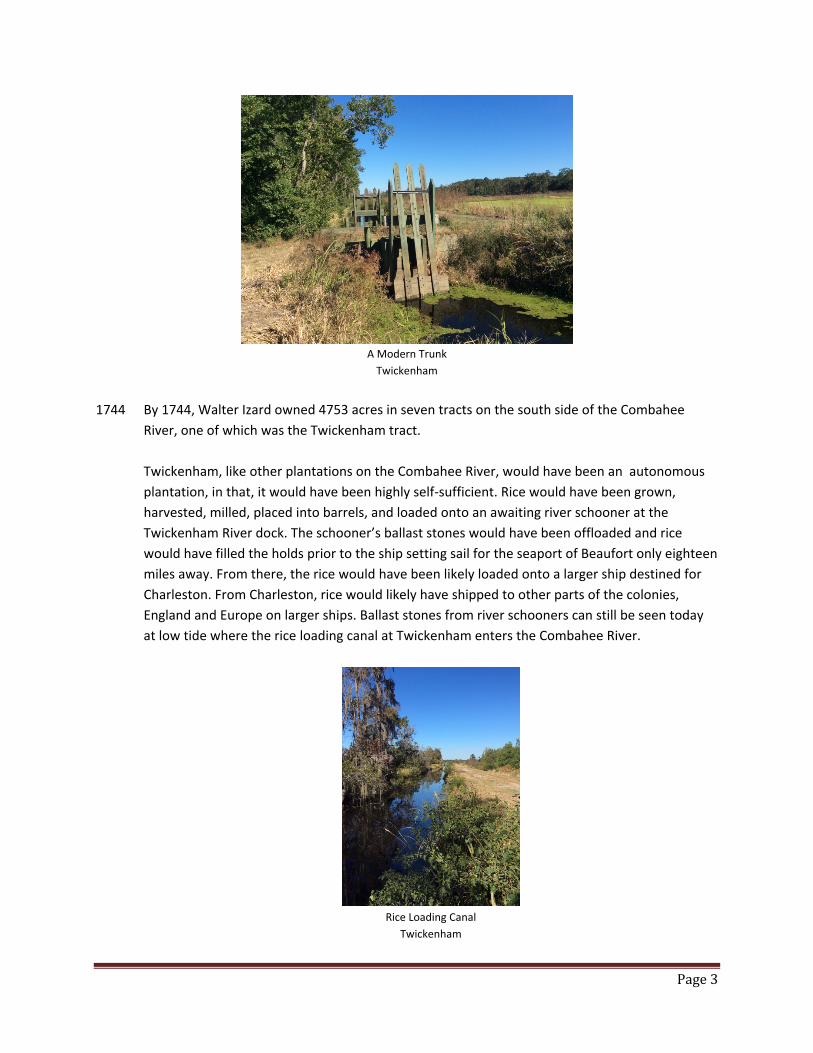
A Modern Trunk
Twickenham
1744 By 1744, Walter Izard owned 4753 acres in seven tracts on the south side of the Combahee
River, one of which was the Twickenham tract.
Twickenham, like other plantations on the Combahee River, would have been an autonomous
plantation, in that, it would have been highly self‐sufficient. Rice would have been grown,
harvested, milled, placed into barrels, and loaded onto an awaiting river schooner at the
Twickenham River dock. The schooner’s ballast stones would have been offloaded and rice
would have filled the holds prior to the ship setting sail for the seaport of Beaufort only eighteen
miles away. From there, the rice would have been likely loaded onto a larger ship destined for
Charleston. From Charleston, rice would likely have shipped to other parts of the colonies,
England and Europe on larger ships. Ballast stones from river schooners can still be seen today
at low tide where the rice loading canal at Twickenham enters the Combahee River.
Rice Loading Canal
Twickenham
Page4
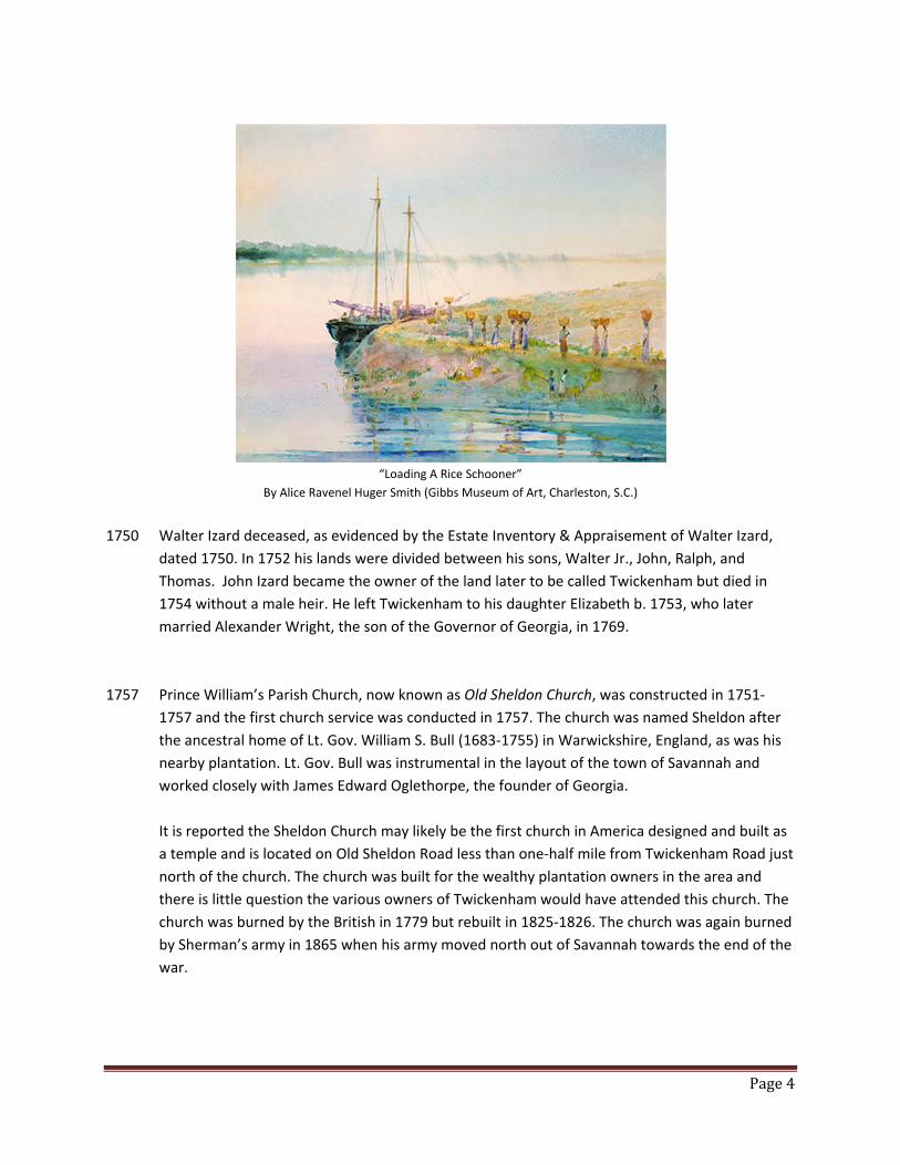
“Loading A Rice Schooner”
By Alice Ravenel Huger Smith (Gibbs Museum of Art, Charleston, S.C.)
1750 Walter Izard deceased, as evidenced by the Estate Inventory & Appraisement of Walter Izard,
dated 1750. In 1752 his lands were divided between his sons, Walter Jr., John, Ralph, and
Thomas. John Izard became the owner of the land later to be called Twickenham but died in
1754 without a male heir. He left Twickenham to his daughter Elizabeth b. 1753, who later
married Alexander Wright, the son of the Governor of Georgia, in 1769.
1757 Prince William’s Parish Church, now known as Old Sheldon Church, was constructed in 1751‐
1757 and the first church service was conducted in 1757. The church was named Sheldon after
the ancestral home of Lt. Gov. William S. Bull (1683‐1755) in Warwickshire, England, as was his
nearby plantation. Lt. Gov. Bull was instrumental in the layout of the town of Savannah and
worked closely with James Edward Oglethorpe, the founder of Georgia.
It is reported the Sheldon Church may likely be the first church in America designed and built as
a temple and is located on Old Sheldon Road less than one‐half mile from Twickenham Road just
north of the church. The church was built for the wealthy plantation owners in the area and
there is little question the various owners of Twickenham would have attended this church. The
church was burned by the British in 1779 but rebuilt in 1825‐1826. The church was again burned
by Sherman’s army in 1865 when his army moved north out of Savannah towards the end of the
war.

Page5
A Rendition of Prince William’s Parish Church Abt. 1760
1779 The Twickenham Plantation home, houses, crops and outbuildings, as well as other neighboring
plantations, were burned by the British Army about 1779 at the time Old Sheldon Church was
burned. It is believed the second known plantation home was rebuilt upon the same foundation
as the first home sometime before 1820. The map of 1820 clearly shows a settlement where the
current plantation home exists.
Numerous artifacts including dated British coins, a dated Portuguese silver coin, and blue &
white pottery chards of the colonial period attest to the activities on Twickenham during early
and late colonial history.
1795 A land survey in 1795 indicates the owners of Twickenham to be James Alexander Wright and
John Izard Wright, sons of Alexander Wright, Governor of Georgia, and Elizabeth Izard Wright (b.
January 23, 1753). Elizabeth Izard was the daughter of John Izard and the grand‐daughter of
Walter Izard and married Governor Alexander Wright in 1769. When John Izard died in 1754
without a male heir, Elizabeth inherited his entire estate.
1800 Two tracts of land, now a part of Twickenham, are referenced in the book titled, “Prince
William’s Parish and Plantations”, by John R. Todd and Francis M. Hutson. The book references
an undated map that is presumably from 1800, in which, shows the two tracts to be situated
between Hobonny on the east, the lands of James Reid Pringle, and the half of the present
property toward Brewton Plantation, shown at this time to have been the lands of William S.
Bull. On this early Pringle map, a road leading into what was presumably the Bull settlement.
Old bricks can be found on high ground several hundred yards from what is shown as the Bull
and Pringle line. It is unknown whether the bricks mark the place of the old Bull residence or
home of an overseer. However, the Bull “street”, or slave quarters, on this tract is known to hve
been located on the edge of the river rice fields. Some of the bricks of the foundation of what
was the sick house may be seen to this day, and the plantation burying ground, which has been

Page6
abandoned for many years. According to the book, the building has not stood in the recollection
of any living person and probably dates back to Revolutionary times.
1820 Sometime prior to 1820, Twickenham was owned by James Reid Pringle (1782‐1840) of
Hobonny Plantation. A map dated ca. 1820 shows boundary delineations for Twickenham and
surrounding properties owned by John Izard Middleton to the east, William Stephan Bull (1784‐
1818) to the west and Francis Saltus to the south. A plat in 1820 shows the same information
for 1077 acres known as Twickenham. The 1820 census shows that James Reid Pringle owned
120 slaves in Prince William’s Parish in 1820. These slaves likely lived on Twickenham
exclusively, as there are no known records showing other properties in Prince William’s Parish
that were owned by James R. Pringle at that time.
James Reid Pringle Elizabeth Mary Pringle
Gibbs Museum, Charleston Gibbs Museum, Charleston
1830 The 1830 slave census shows no slaves owned by James Reid Pringle in Prince William’s Parish,
therefore, it is likely he sold Twickenham prior to 1830.
1834 Twickenham was owned by the William Heyward family, as evidenced by the Hobonny survey
map of 1834.
1848 Thomas Middleton Hanckel (1822‐1888) of Charleston was the son of Christian Hanckel, rector
of St. Phillips Church in Charleston. Thomas married Sarah Thomas Heyward (1828‐1910) in
1848. Sarah was the daughter of Thomas Heyward (1805‐1828) and Charity Wilson (1802‐1829),
whose tombstones are in the Stoney Creek Cemetery just a few miles from Twickenham. The
first extant mention of Twickenham Plantation by name, rather than by description, is in the
Page7
marriage settlement of Thomas and Sarah. The marriage settlement and trust agreement
showed that Sarah owned in fee simple the 1610 acre tract of William S. Bull and owned a two‐
thirds interest in the 1077 acre tract known as Twickenham, as a tenant in common with Sarah
Jane Wilson. Thomas Middleton Hanckel graduated second in his class at the College of South
Carolina in 1840, then read law and was admitted to the bar in 1843.
1860 Although Thomas Middleton Hanckel lived and practiced law in Charleston, he operated
Twickenham as a rice plantation and owned 127 slaves according to the 1860 slave schedule.
Samuel Marvin managed Twickenham for Thomas and Sarah Hanckel and in 1860 the plantation
produced 553,500 pounds of rice. Thomas was a prolific writer and speaker having published
numerous articles on political subjects. On the fifth anniversary of the South Carolina Historical
Society meeting at Hibernian Hall in Charleston on May 23, 1860, Thomas delivered an eloquent
speech addressing states’ rights and was a delegate to the Secession Convention and a signer of
the Ordinance of Secession in 1860.
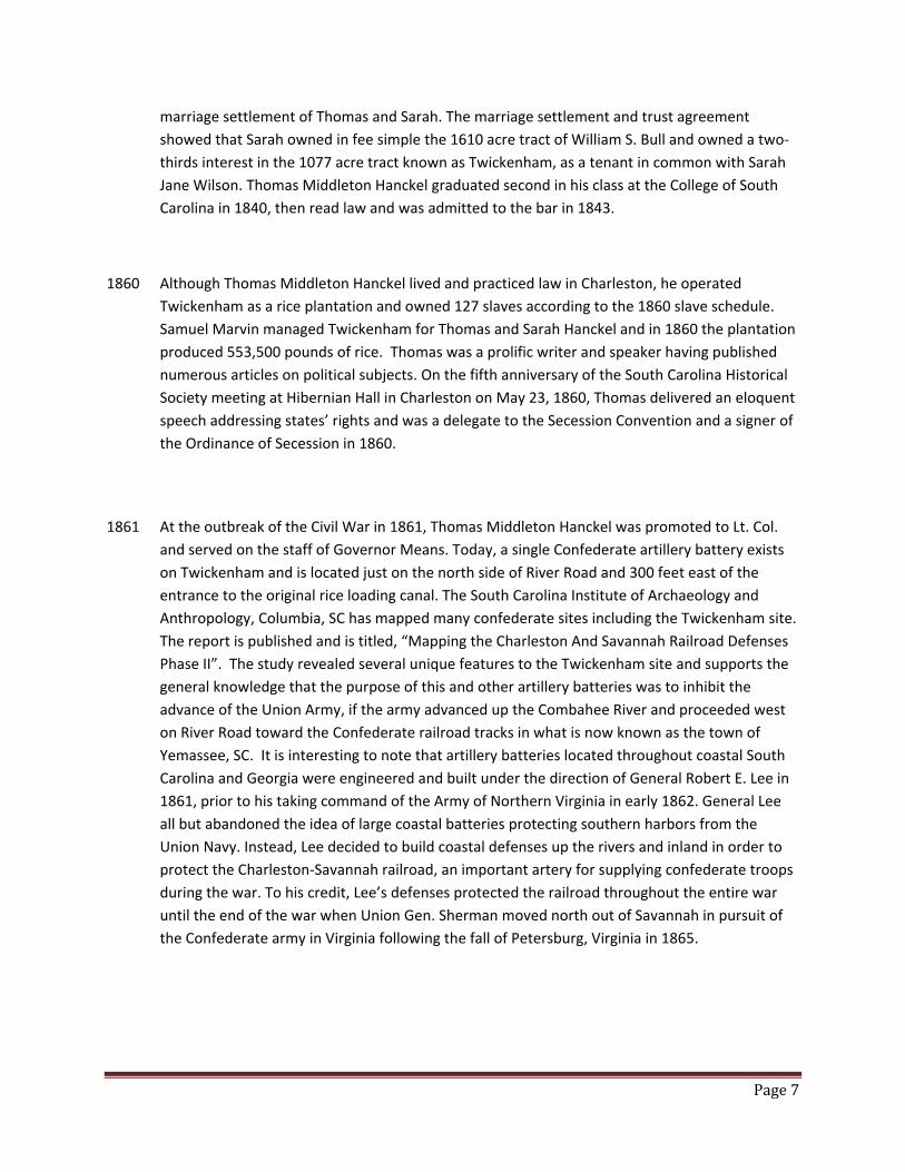
1861 At the outbreak of the Civil War in 1861, Thomas Middleton Hanckel was promoted to Lt. Col.
and served on the staff of Governor Means. Today, a single Confederate artillery battery exists
on Twickenham and is located just on the north side of River Road and 300 feet east of the
entrance to the original rice loading canal. The South Carolina Institute of Archaeology and
Anthropology, Columbia, SC has mapped many confederate sites including the Twickenham site.
The report is published and is titled, “Mapping the Charleston And Savannah Railroad Defenses
Phase II”. The study revealed several unique features to the Twickenham site and supports the
general knowledge that the purpose of this and other artillery batteries was to inhibit the
advance of the Union Army, if the army advanced up the Combahee River and proceeded west
on River Road toward the Confederate railroad tracks in what is now known as the town of
Yemassee, SC. It is interesting to note that artillery batteries located throughout coastal South
Carolina and Georgia were engineered and built under the direction of General Robert E. Lee in
1861, prior to his taking command of the Army of Northern Virginia in early 1862. General Lee
all but abandoned the idea of large coastal batteries protecting southern harbors from the
Union Navy. Instead, Lee decided to build coastal defenses up the rivers and inland in order to
protect the Charleston‐Savannah railroad, an important artery for supplying confederate troops
during the war. To his credit, Lee’s defenses protected the railroad throughout the entire war
until the end of the war when Union Gen. Sherman moved north out of Savannah in pursuit of
the Confederate army in Virginia following the fall of Petersburg, Virginia in 1865.
Page8
Confederate Gun Battery at River Road
Twickenham
1863 Harriett Tubman, who escaped slavery in Maryland in 1849, helped lead the Union Navy up the
Combahee River from Beaufort, SC on June 2, 1863. During this one day raid, over 750 awaiting
slaves boarded three ships, thus escaping slavery themselves. The 150 black union soldiers
onboard the ships help burn several plantations during what is now called the Combahee River
Raid. A historical sign on the west side of the bridge, where Highway 17 crosses the Combahee
River, provides details of the raid. It is likely, many of the slaves at Twickenham escaped on this
date.
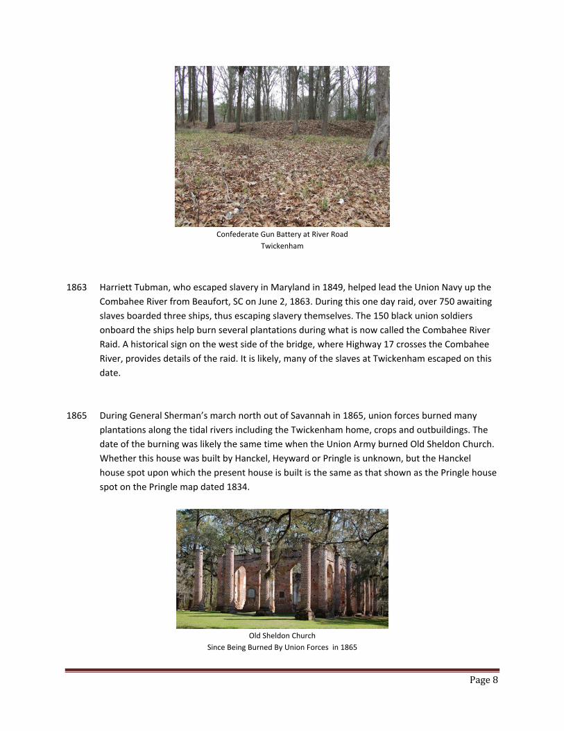
1865 During General Sherman’s march north out of Savannah in 1865, union forces burned many
plantations along the tidal rivers including the Twickenham home, crops and outbuildings. The
date of the burning was likely the same time when the Union Army burned Old Sheldon Church.
Whether this house was built by Hanckel, Heyward or Pringle is unknown, but the Hanckel
house spot upon which the present house is built is the same as that shown as the Pringle house
spot on the Pringle map dated 1834.
Old Sheldon Church
Since Being Burned By Union Forces in 1865
Page9
1871 Due to financial hardships following the war, Hanckel leased both the Twickenham and Bull
tracts, both totaling 2600 acres, to J. Bennett Bissell for three years. As with most rice planters
at that time, due to the lack of labor required for rice farming, and for other reasons, debts
continued to mount.
1878 A Judgement of Foreclosure and Sale action was filed against the Hanckels on September 1,
1878, thus forcing the sale of Twickenham by Sheriff’s sale.
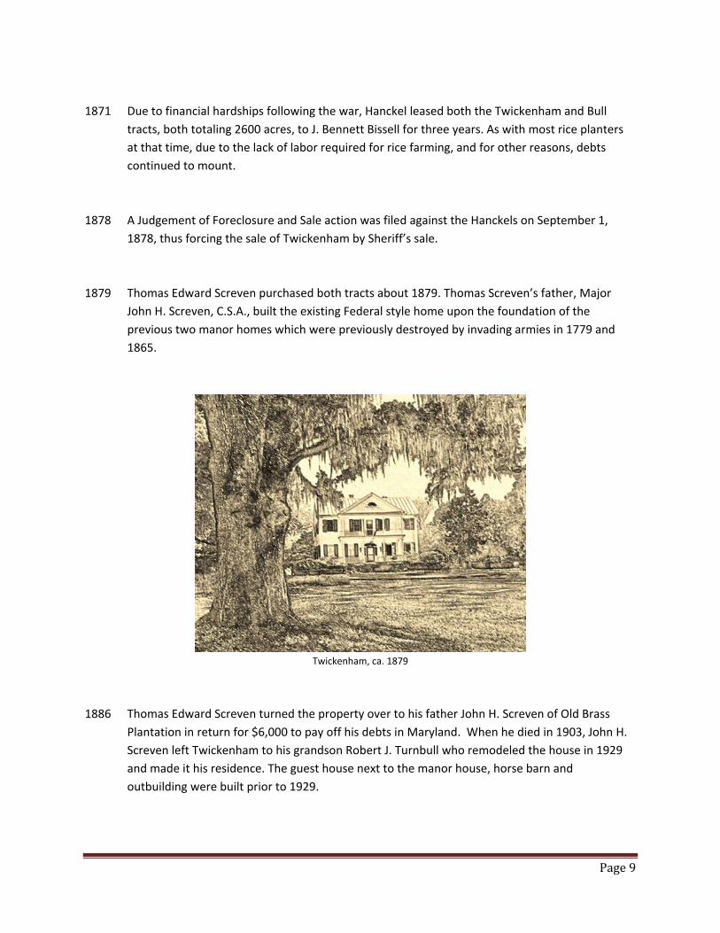
1879 Thomas Edward Screven purchased both tracts about 1879. Thomas Screven’s father, Major
John H. Screven, C.S.A., built the existing Federal style home upon the foundation of the
previous two manor homes which were previously destroyed by invading armies in 1779 and
1865.
Twickenham, ca. 1879
1886 Thomas Edward Screven turned the property over to his father John H. Screven of Old Brass
Plantation in return for $6,000 to pay off his debts in Maryland. When he died in 1903, John H.
Screven left Twickenham to his grandson Robert J. Turnbull who remodeled the house in 1929
and made it his residence. The guest house next to the manor house, horse barn and
outbuilding were built prior to 1929.
Page10
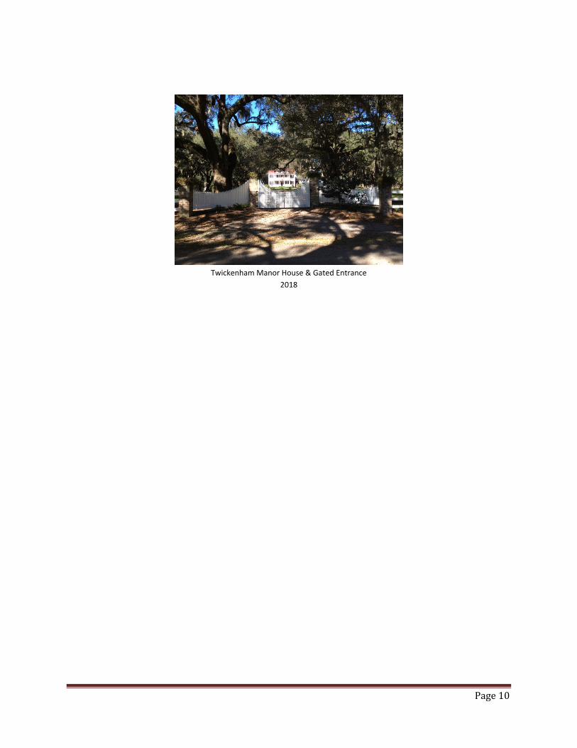
Twickenham Manor House & Gated Entrance
2018
![[Frontiers in Bioscience 16, 1663-1674, January 1, 2011 ... › a1a2 › 2bf5cf072987... · [Frontiers in Bioscience 16, 1663-1674, January 1, 2011] 1663 Inflammatory markers and](https://img.pdfslide.net/doc/110x75/5f03c4f17e708231d40aae1b/frontiers-in-bioscience-16-1663-1674-january-1-2011-a-a1a2-a-2bf5cf072987.jpg)