Embed Size (px)
Citation preview
Two walks in Scott Creek
Conservation Park
The Twisted Chimney Track
The almanda Mine track
The Twisted Chimney Walk
Walking trails- the Twisted Chimney walk
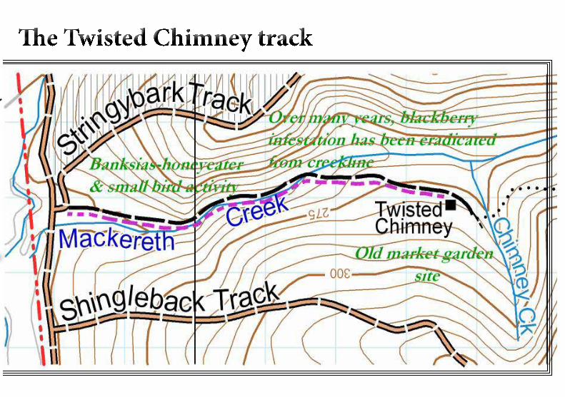
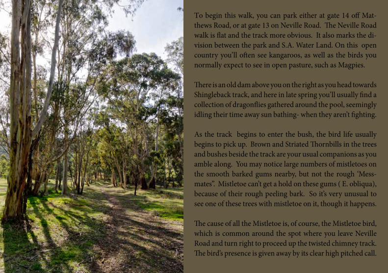
To begin this walk, you can park either at gate 14 off Mat-thews Road, or at gate 13 on Neville Road. The Neville Road walk is flat and the track more obvious. It also marks the di-vision between the park and S.A. Water Land. On this open country you’ll often see kangaroos, as well as the birds you normally expect to see in open pasture, such as Magpies.
There is an old dam above you on the right as you head towards Shingleback track, and here in late spring you’ll usually find a collection of dragonflies gathered around the pool, seemingly idling their time away sun bathing- when they aren’t fighting. As the track begins to enter the bush, the bird life usually begins to pick up. Brown and Striated Thornbills in the trees and bushes beside the track are your usual companions as you amble along. You may notice large numbers of mistletoes on the smooth barked gums nearby, but not the rough ‘Mess-mates”. Mistletoe can’t get a hold on these gums ( E. obliqua), because of their rough peeling bark. So it’s very unusual to see one of these trees with mistletoe on it, though it happens. The cause of all the Mistletoe is, of course, the Mistletoe bird, which is common around the spot where you leave Neville Road and turn right to proceed up the twisted chimney track. The bird’s presence is given away by its clear high pitched call.
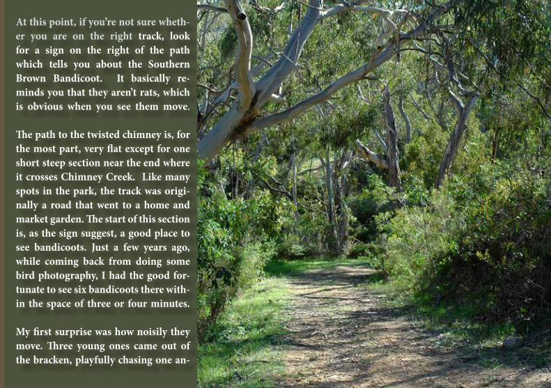
At this point, if you’re not sure wheth-er you are on the right track, look for a sign on the right of the path which tells you about the Southern Brown Bandicoot. It basically re-minds you that they aren’t rats, which is obvious when you see them move. The path to the twisted chimney is, for the most part, very flat except for one short steep section near the end where it crosses Chimney Creek. Like many spots in the park, the track was origi-nally a road that went to a home and market garden. The start of this section is, as the sign suggest, a good place to see bandicoots. Just a few years ago, while coming back from doing some bird photography, I had the good for-tunate to see six bandicoots there with-in the space of three or four minutes. My first surprise was how noisily they move. Three young ones came out of the bracken, playfully chasing one an-
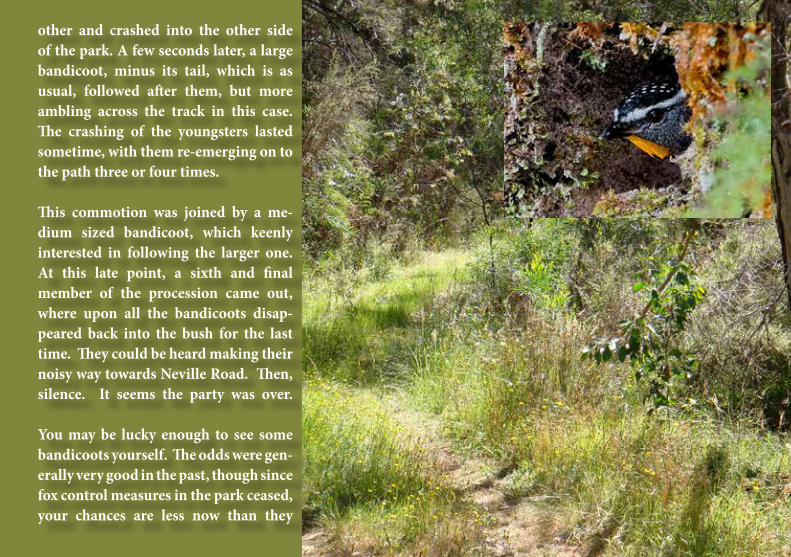
other and crashed into the other side of the park. A few seconds later, a large bandicoot, minus its tail, which is as usual, followed after them, but more ambling across the track in this case. The crashing of the youngsters lasted sometime, with them re-emerging on to the path three or four times.
This commotion was joined by a me-dium sized bandicoot, which keenly interested in following the larger one. At this late point, a sixth and final member of the procession came out, where upon all the bandicoots disap-peared back into the bush for the last time. They could be heard making their noisy way towards Neville Road. Then, silence. It seems the party was over. You may be lucky enough to see some bandicoots yourself. The odds were gen-erally very good in the past, though since fox control measures in the park ceased, your chances are less now than they
have been, even in the recent past.
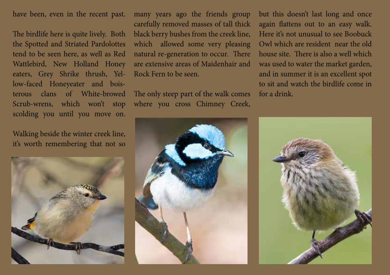
The birdlife here is quite lively. Both the Spotted and Striated Pardolottes tend to be seen here, as well as Red Wattlebird, New Holland Honey eaters, Grey Shrike thrush, Yel-low-faced Honeyeater and bois-terous clans of White-browed Scrub-wrens, which won’t stop scolding you until you move on. Walking beside the winter creek line, it’s worth remembering that not so
many years ago the friends group carefully removed masses of tall thick black berry bushes from the creek line, which allowed some very pleasing natural re-generation to occur. There are extensive areas of Maidenhair and Rock Fern to be seen.
The only steep part of the walk comes where you cross Chimney Creek,
but this doesn’t last long and once again flattens out to an easy walk. Here it’s not unusual to see Boobuck Owl which are resident near the old house site. There is also a well which was used to water the market garden, and in summer it is an excellent spot to sit and watch the birdlife come in for a drink.
The walking trails: Almanda Mine
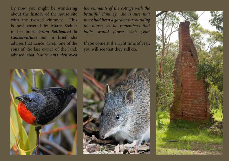
By now, you might be wondering about the history of the house site with the twisted chimney. This is best covered by Marie Steiner in her book- From Settlement to Conservation; but in brief, she advises that Lance Jarret, one of the sons of the last owner of the land, advised that ‘white ants destroyed
the remnants of the cottage with the beautiful chimney ...he is sure that there had been a garden surrounding the house, as he remembers that bulbs would flower each year.’ If you come at the right time of year, you will see that they still do.

The walking trails: Almanda Mine
THE ALMANDA MINE WALK
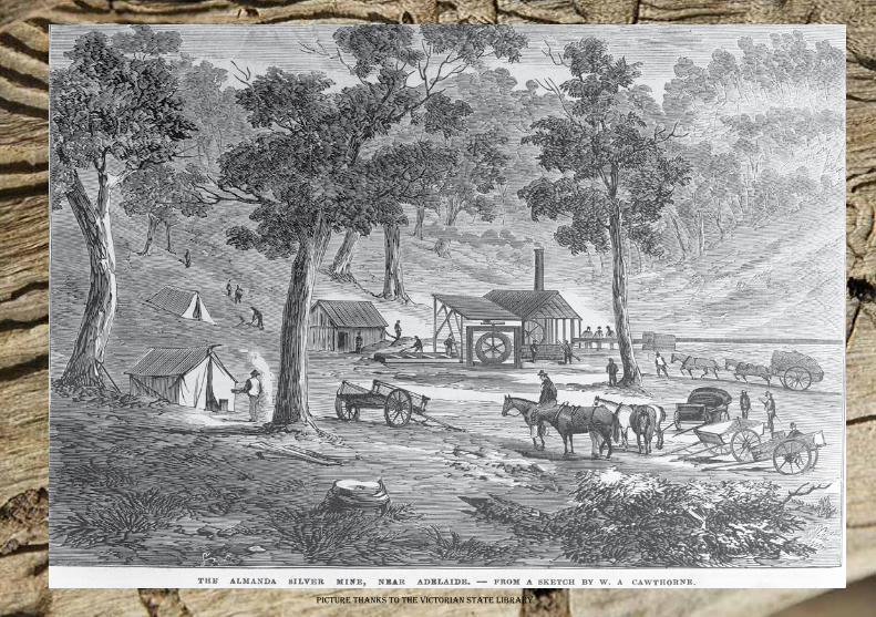
PIcTurE THANKs To THE VIcTorIAN sTATE LIbrAry
Start
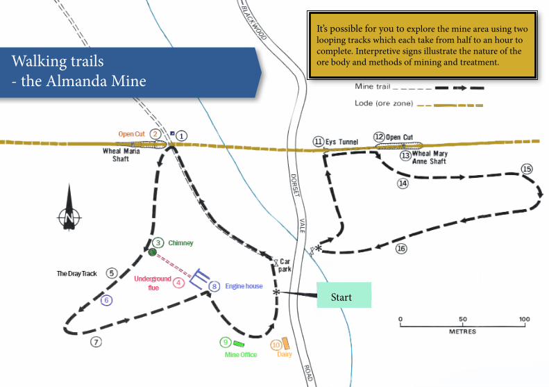
Walking trails - the Almanda Mine
It’s possible for you to explore the mine area using two looping tracks which each take from half to an hour to complete. Interpretive signs illustrate the nature of the ore body and methods of mining and treatment.
1. Bagots Shaft was named after Edward Bagot, who was a major shareholder in the Amanda Silver Mining Association. It was reported in the THE REGISTER of April 1863 that the workings were carried on for six months, and went to a depth of 15 fath-oms, or 27.4 metres, before they ceased.
4. The Flue has sections visible in collapsed areas, showing the arched roof construc-tion.
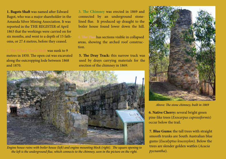
Engine house ruins with boiler house (left) and engine mounting block (right). The square opening to the left is the underground flue, which connects to the chimney, seen in the picture on the right.
2. The Wheal Maria Shaft was sunk to 9 metres in 1850. The open cut was excavated along the outcropping lode between 1868 and 1870.
3. The Chimney was erected in 1869 and connected by an underground stone-lined flue. It produced up draught to the boiler house found lower down the hill.
5. The Dray Track: this narrow track was used by drays carrying materials for the erection of the chimney in 1869.
6. Native Cherry: several bright green pine-like trees (Exocarpus cupressiformis) occur below the trail.
Above: The stone chimney, built in 1869
7. Blue Gums: the tall trees with straight smooth trunks are South Australian blue gums (Eucalyptus leucoxylon). Below the trees are slender golden wattles (Acacia pycnantha).
11
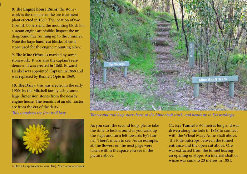
As you start the second loop, please take the time to look around as you walk up the steps and turn left towards Ey’s tun-nel. There’s much to see. As an example, all the flowers on the next page were taken within the space you see in the picture above.
This completes the first trail loop.
8. The Engine house Ruins: the stone-work is the remains of the ore treatment plant erected in 1869. The location of two Cornish boilers and the mounting block for a steam engine are visible. Inspect the un-derground flue running up to the chimney. Note the large hand-cut blocks of sand-stone used for the engine mounting block.
9. The Mine Office: is marked by some stonework. It was also the captain’s resi-dence and was erected in 1868. Edward Henkel was appointed Captain in 1868 and was replaced by Bennett Opie in 1869.
10. The Dairy: this was erected in the early 1900s by the Mitchell family using some large dimension stones from the nearby engine house. The remains of an old tractor are from the era of the dairy.
The second trail loop starts here, at the Mine shaft track, and heads up to Eys workings.
11. Eys Tunnel is 60 metres long and was driven along the lode in 1868 to connect with the Wheal Mary Anne Shaft above. The lode outcrops between the tunnel entrance and the open cut above. Ore was extracted from the tunnel leaving an opening or stope. An internal shaft or winze was sunk to 23 metres in 1881.
A Hover fly approaches a Yam Daisy, Microseris lanceolata

Australian Indigo: Indigofera australis
Nodding Greenhood, Pterostylis nutansButtercup Ranunculus lappaceus Leafless Bitter-pea Daviesia brevifola
Twiggy Bush-pea Pultenea largiflorens
11
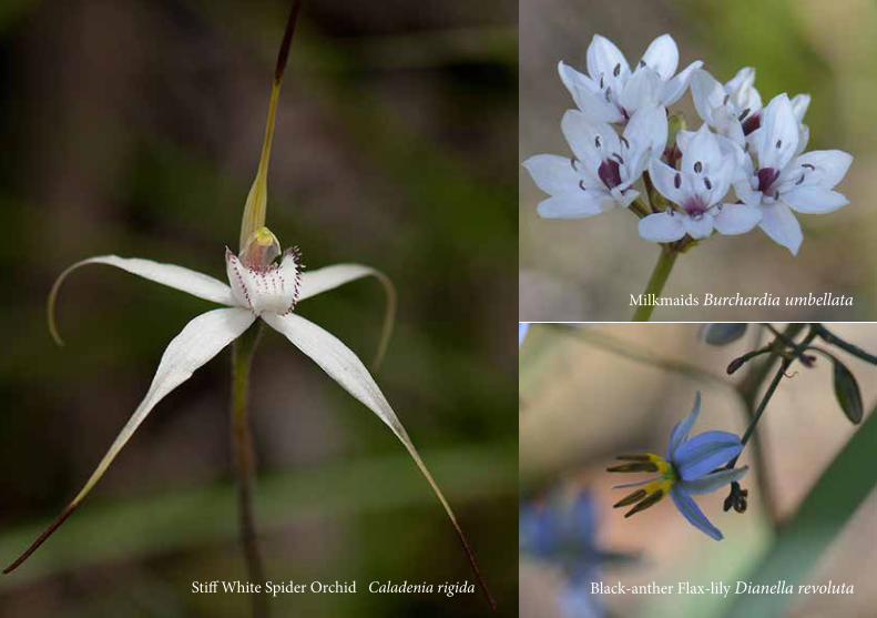
Stiff White Spider Orchid Caladenia rigida Black-anther Flax-lily Dianella revoluta
Milkmaids Burchardia umbellata
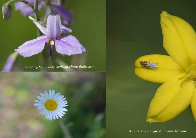
Nodding Vanilla-lily Arthropodium fimbriatum
Bulbine Lily and guest Bulbine bulbosaBlack-anther Flax-lily Dianella revoluta
Milkmaids Burchardia umbellata
12. Open Cut: this was formed by ex-cavation of an old tunnel to the surface in 1887.
13. Wheal Mary Anne Shaft: this shaft was sunk on the lode to 27 metres in 1862. The collapsed shaft can be seen in the middle of the open cut below the bridge.
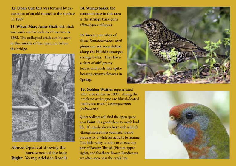
Above: Open cut showing the narrowness of the lode Right: Young Adelaide Rosella
14. Stringybarks: the common tree in this area is the stringy bark gum (Eucalypus obliqua).
16. Golden Wattles regenerated after a bush fire in 1992. Along the creek near the gate are bluish-leafed bushy tea trees ( Leptospurnum pubescens).
Quiet walkers will find the open space near Point 15 a good place to watch bird life. It’s nearly always busy with wildlife -though sometimes you need to stop moving for a while for activity to resume. This little valley is home to at least one pair of Bassian Thrush (Picture upper right), and Southern Brown Bandicoots are often seen near the creek line.
15 Yacca: a number of these Xanathorrhoea semi-plana can see seen dotted along the hillside amongst stringy barks. They have a skirt of stiff grassy leaves and rush-like spike bearing creamy flowers in Spring.

A small mystery about the mine. In the Adelaide Observer of July, 1869
there appeared a list of expenses associated with developing the mine up to that time. Some things were self explanatory:
But more curious was the following item: small. Perhaps where this was will remain a mystery, but the likeli-hood is that the dam covered most of the area seen below Bagot’s shaft.
Looking into Bagot’s Shaft A view of possible locality of the mine’s dam and lake site.
“The item engine account, £550 4s. 2d., re-ferred chiefly to expenses connected with the small engine, which had been in operation for some time, but had not acted satisfactorily. “
“The dam had cost from £150 to £180, and the erection of the new engine something short of £500.”
Where would the dam have been? It was been described as be-
ing immediately north of the workings. Given its cost, it could not have been
The weir for the Bridgewater Mill didn’t take many years to silt up, and no doubt the mine dam was filled with run off even quicker, given the extensive timber cutting undertaken to feed the stream engine.

An impression of
”The cartage of the machinery began 6 weeks ago, but was delayed through bad weather, and it required fully three weeks to place it all on the ground. The erection of the stamps and the engine occupied about another fortnight, and was finished only on Wednesday last.
...A creek, about half a mile north of the stamps, has been tapped by several races, which bring down abundance of water at a merely nominal expense. The supply is of course abundant at present, and as there are several other springs in the locality, it can easily be supple-mented in the summer season.
By the wallaby track aforesaid you have to descend to the very bottom of a nar-row gully. Entering it at the north end you see about a quarter of a mile ahead the shed in which the stamps have been erected, with a small store alongside it. These are situate on the skirt of the west
hill on a level with the tunnels on the opposite side, which by and by will be connected with the stamps by a tram-way. The new working on the west hill is a short distance to the north-west of the stamps. A mining captain could not make a bet-ter site for a mine had he the designing of it according to his own taste. Within a few hundred yards of the engine there
souTH AusTrALIAN rEGIsTEr, 17TH AuGusT, 1868
is several years’ supply of firewood. A few days’ labour in digging races has furnished a permanent supply of water.”
ADELAIDE obsErVEr, 30TH JANuAry, 1869
“Six months ago the only approach to the property was through a maze of bush-tracks diverging from the Claren-don road, which offered greater choice
A visit to Almanda mine By your correspondent of 1868
An impression of the interior of the boiler house and engine house erected in 1869. Taken from an original illustration in the Dept. of Mines and Energy Brochure of 1991.

than was agreeable to the most er-ratic explorer. They were all of nature’s own making, undisturbed by District Councils or shilling rates, and they had been made in a bewildering variety of fashions. But the staple materials were ruts and stumps, among which the alternation of ups and downs was more exciting than comfortable. ...As it approached the gully, which now
rejoices in the name of Almanda, but was then better known as the Wheal Maria, the track lost itself among twists and plunges...
the eighteen pans are fixed the Almanda will be both in appearance and reality an enterprising venture.
Ruins of the engine mounting blocks showing the iron mounting bolts.
Ruins of the engine house, as it’s seen from near the mine car park.
The workings on the lode have not made any perceptible progress, not-withstanding the enormous quantity of ore that must have been extracted. There are as yet only four distinct work-ings, and they are mere tunnels in the hill rather than shafts. ...The excavation of the site for the new engine is to be proceeded with immediately, and when
To the sight-seeing, as well as to the speculative public, it will always have attractions, and the visitor will be fastidious, indeed, who is not satisfied with the courtesy of the resident Man-agers. Our own chaperon, Mr.. Gawan, can be specially commended for doing the amiable.”
An impression of