Embed Size (px)
Citation preview
Tygart Lake
Shoreline Management Plan
March 2020
ii
U.S. ARMY CORPS OF ENGINEERS
PITTSBURGH DISTRICT
TYGART LAKE SHORELINE MANAGEMENT PLAN
TABLE OF CONTENTS
Page
I. INTRODUCTION ......................................................................................................................5
1. Purpose
2. Authority
3. References
4. Applicability
5. History Underlying the Plan
6. Description of Tygart Lake
7. Boundary Line Surveillance and Encroachment Policy
8. Regeneration of Open Areas
II. OBJECTIVES OF THE PLAN...............................................................................................8 1. General
2. Commercial Concessions
3. Private Exclusive Use
4. Liability
III. DESCRIPTION OF THE SHORELINE..............................................................................9
1. Flood Control and Navigation
2. Present Land Use
3. Existing Public Access
4. Proprietary/Joint Jurisdiction
IV. SHORELINE ALLOCATION.............................................................................................10
1. Shoreline Allocation
(a) Prohibited Access Areas
(b) Public Recreation Areas
(c) Protected Shoreline Areas
(d) Fee Limited Development Areas
(e) Flowage Easement Limited Development Areas
V. SHORELINE USE PERMITS...............................................................................................11
1. Shoreline Use Permits
2. Duration of Shoreline Use Permits
3. Application Procedures
4. Conditions
iii
VI. PRIVATE DOCK
FACILITIES................................................................................................................................12
1. Government Access Across Private Property
2. Shared Docks
3. Individual Docks
(a) Location
(b) Density of Development
(c) Size
(d) Construction Criteria
(e) Dock Structural-Support Systems
(f) Boat Hoists
(g) Dock Anchoring
(h) Dock Storage Boxes/Ladders
(i) Furniture, Decorative Items, Garden Plants, etc.
(j) Buoy Placement
4. Group Docks
(a) Community Dock Associations
(b) Shared Docks
(c) Boat Clubs
5. Guidelines for Establishing a Non-Profit Corporation
VII. LAND BASED ACTIVITIES.............................................................................................18
1. General
2. Mowing Permits
(a) Mowing in Limited Development Areas
(b) Mowing in Restricted Areas
(c) Unauthorized Mowing
3. Boundary Delineation
4. Other Activities Approved By the Resource Manager
(a) Improved Paths
(b) Hazardous Tree Removal
(c) Non-Native Plant Species
(d) Chemical Agents
(e) Fires
(f) Land Formations
(g) Specified Acts
(h) Accessibility for Individuals with Disabilities
VIII. ACTIVITIES REQUIRING A REAL ESTATE OUTGRANT……...........................20
1. Real Estate Outgrants
(a) Electrical Lighting and Equipment
(b) Steps and Walkways
(c) Water Lines and Water Withdrawals
iv
IX. ACTIVITIES REQUIRING REGULATORY PERMITS................................................22
1. Regulatory Permits
(a) Shoreline Erosion Control
X. FEES.........................................................................................................................................23
1. Shoreline Use and Mowing Permits
2. Real Estate Outgrants
XI. PROHIBITED FACILITIES AND ACTIVITIES.............................................................23
1. Prohibited Items
XII. ENVIRONMENTAL STEWARDSHIP............................................................................24
1. Water Quality
(a) Trash, Refuse and Debris
(b) Privately Owned Sanitary Facilities on Adjacent Property
(c) Fill Material
(d) Non-Point Sources of Water Pollution
(e) Municipal and Industrial Discharges
XIII. GRANDFATHERED PRIVILEGES...............................................................................24
1. Grandfathered Privileges
2. Special Privileges
XIV. APPEALS............................................................................................................................25
1. Appeals Process
XV. ITEMS NOT OTHERWISE COVERED IN THIS PLAN..............................................25
1. Procedures for Items Not Otherwise Covered in this Plan
XVI. EVALUATION OF THE PLAN.......................................................................................26
1. General Evaluation of the Plan
XVII. PUBLIC INVOLVEMENT..............................................................................................26
APPENDICES
Appendix A. How to Apply for Shoreline Use Permits/Real Estate Outgrants/Regulatory
Permits
Appendix B. Shoreline Management Allocation Map
Appendix C. Shoreline Use Permit Conditions
Appendix D. Approved Plantings List
Appendix E. Design Specification Drawings
Appendix F. Environmental Assessment
5
U.S. ARMY CORPS OF ENGINEERS
PITTSBURGH DISTRICT
TYGART LAKE SHORELINE MANAGEMENT PLAN
I. INTRODUCTION
1. Purpose. This Shoreline Management Plan provides policies and guidelines for the effective
long-term management of the shoreline resources of Tygart Lake (Project). Recreational
demands and development pressures increase each year, yet the total amount of public land and
water areas remain fixed. Please reference Appendix B for the Shoreline Management
Allocation Map. Sound management is necessary to provide optimum use of finite Project
resources for present and future generations. This Plan also considers means of restoration of the
shoreline where degradation has occurred. This Plan is an appendix to the Project’s Operational
Management Plan.
2. Authority. Authority for preparation of this document is granted under Title 36, Chapter III,
Part 327, Code of Federal Regulations (CFR), “Rules and Regulations Governing Public Use of
Water Resource Development Projects Administered by the Chief of Engineers.” Section 327.30
of these rules and regulations specifically addresses Shoreline Management and is published as
Engineer Regulation (ER) 1130-2-406, dated 31 October 1990, titled “Project Operation –
Shoreline Management at Civil Works Projects,” and amended by Change 1 dated 14 September
1992, and Change 2 dated 28 May 1999.
3. References.
(a) Section 4 of the Flood Control Act of 1944, as amended (16 U.S.C. § 460d)
(b) Section 4 of the Rivers and Harbors Act of 1894, as amended (33 U.S.C. § 1)
(c) Section 10 of the Rivers and Harbors Act of 1899 (33 U.S.C. § 403)
(d) Flood Control Act of 1938 (P.L. 75-761), as amended
(e) Water Resources Development Act of 1986 (P.L. 99-662)
(f) Section 6 of P.L. 97-140, 29 December 1981 (95 Stat. 1718)
(g) National Historic Preservation Act of 1966 (P.L. 89-665; 80 Stat. 915) as amended
(54 U.S.C. §§ 300101 et seq.)
(h) Clean Water Act (33 U.S.C. §§ 1344 et seq.)
(i) Endangered Species Act of 1973 (P.L. 93-205), as amended (16 U.S.C. §§ 1531 et
seq.)
(j) National Environmental Policy Act of 1969 (P.L. 91-190), as amended (42 U.S.C. §§
4321 et seq.)
6
(k) 36 CFR Part 327, Rules and Regulations Governing Public Use of Water Resource
Development Projects Administered by the Chief of Engineers
(l) Executive Order 12088, “Federal Compliance with Pollution Control Standards” (13
Oct 1978) as revoked in part
(m) Executive Order 13834, “Efficient Federal Operations” (17 May 2018)
(n) 33 CFR Parts 320-330, Regulatory Programs of the Corps of Engineers
(o) ER 1130-2-540, “Environmental Stewardship Operations and Maintenance Policies”
(15 Nov 96) and corresponding Engineer Pamphlet (EP) 1130-2-540, “Environmental
Stewardship Operations and Maintenance Guidance and Procedures” (15 Nov 96)
(p) ER 1130-2-550, “Recreation Operations and Maintenance Policies” (15 Nov 96) and
corresponding EP 1130-2-550, “Recreation Operations and Maintenance Guidance and
Procedures” (15 Nov 96)
(q) Engineer Manual (EM) 385-1-1, "Safety and Health Requirements" (30 Nov 14)
(r) ER 1130-2-406, “Shoreline Management at Civil Works Projects” (31 Oct 90)
(s) ER 405-1-12, Real Estate Handbook, Chapter 8, Real Property Management (30 Sept
94)
4. Applicability. This Plan is applicable to all Project lands and water owned in fee by the
United States and flowage easement areas. It does not apply to those fee lands and water that are
outgranted by the United States for various purposes. The terms and conditions of those
outgrants control the activities authorized thereunder. Shoreline real estate licenses for such
items as steps, light poles, walkways, and erosion control methods are an exception to this rule,
as their issuance is controlled by this Plan.
5. History Underlying this Plan. The Project was authorized by the Rivers and Harbors Act of
August 30, 1935. Construction of the dam was initiated in January 1935 and was completed
three years later in February 1938. Shortly thereafter, both the private and public recreational
development of the Project took place. With the exception of the federal administration area in
the vicinity of the dam, West Virginia Division of Natural Resources, Parks and Recreation and
Wildlife Resources Section has developed and managed public recreational facilities and for fish,
wildlife and forestry management purposes, and continues to do so.
Private recreational development such as boat docks, paths, steps, erosion control methods, and
mowing also took place on the Project’s shoreline. As the trend for expansion of private
exclusive use facilities became more pronounced, the U.S. Army Corps of Engineers (Corps)
implemented Shoreline Use Permit (SUP) procedures. If a proposed facility was structurally
sound, and the applicant had a residence adjacent to Government property, in most instances the
Corps granted a SUP or real estate outgrant (typically a license) for the facility. An adjacent
landowner are those persons who own land that share a common boundary with the Corps. The
original September 1978 Shoreline Management Plan was intended to establish policies and
7
guidelines for the protection and preservation of the desirable environmental characteristics of
the Project’s shoreline. That Plan was updated in 1982.
6. Description of Tygart Lake. The Project is located in north-central West Virginia. The
Project lands and waters extend into portions of Taylor and Barbour Counties. The dam is
situated completely in Taylor County. The reservoir is surrounded by high, rounded hills with
steep slopes. The rugged terrain and many tributary valleys result in an irregular shoreline that is
approximately 31 miles in length. Flowage easements outside of the fee boundary cover eleven
of those miles along the shoreline. The Project’s drainage basin is 1,184 square miles and
extends 65 miles in a north-south direction covering parts of Pocahontas, Randolph, Barbour and
Taylor Counties. The stream channels generally consist of narrow, steep-sided valleys
conducive to rapid runoff. The topography of the watershed will often cause rapid increases in
the Project’s pool elevation during moderate to severe precipitation events or seasonal melt-off
of snow. Starting near the end of the summer recreation season and throughout the fall, the pool
is gradually dropped to its winter pool elevation of 1039.5 feet NAVD88 to increase flood
storage capacity. During dry periods in late summer the reservoir elevation may start to fall on
its own as minimum outflow requirements from the dam for navigation and other downstream
purposes exceed the inflow of water into the reservoir. Summer pool elevation is 1093.5 feet
NAVD88.
7. Boundary Line Surveillance and Encroachment Policy. The Project property boundary
line has been established and marked by the Corps in accordance with standard survey
techniques. Local survey standards include boundary monuments, H-beams and/or carsonite
posts, and paint blazes on trees. In areas where the distance between corners is such that the
monuments or pins are not visible, posts with signs may be placed by the Corps to witness the
property line.
Each adjacent landowner is responsible to know the exact location of his or her property lines
and corners. Construction on, or alteration of, public property can be avoided by proper research
and planning; this will prevent costly removal of private structures and/or after-the-fact
restoration of public property. Other than pedestrian access or general public recreation
activities, any activity on public property not covered by a SUP or outgrant will be considered an
encroachment or trespass on public property and a violation of 36 CFR Part 327.
Examples of trespass include, but are not limited to: motorized vehicle operation, burning, tree
cutting or the placement of debris or fill dirt. An encroachment pertains to any personal item,
structure, or improvement built, installed or established on land owned and managed by the
United States. An encroachment has occurred where the item, structure or improvement extends
over, across, in or upon lands which the Government owns and the structure or improvement has
not been approved.
Examples of encroachment include, but are not limited to: unauthorized personal property that is
mobile, moveable, and not attached to a structure, such as swings, grills, picnic tables, benches,
gardens, hammocks, parked vehicles, firewood, and lumber. However, encroachments can also
include items which are fixed or attached to real property, such as any portion of a residence,
shed, barn or building. Other examples include septic tanks, drain fields, decks, porches,
fireplaces, constructed grills, and storage buildings.
8
A request for an initial SUP or license will not be considered until identified encroachments are
resolved. The reissuance of existing SUPs and licenses to the same and/or new owner will be
delayed and/or denied pending an encroachment resolution plan and timeline. In some cases,
SUPs or licenses may be issued for terms less than 5 years in an effort to provide time for
landowners to correct encroachments. If the applicant does not correct encroachments within the
designated time, the Corps will not re-issue the SUP and/or license and the applicant will be
required to remove all previously authorized facilities from public land. If the encroachment is
resolved within the designated term and the request for a SUP or license is otherwise justified,
the Corps will re-issue the SUP and/or license for a full 5 year term, but processing SUP or
license fees will apply.
8. Regeneration of Open Areas. Open areas are defined as those areas of public land where a
natural mixture of native plants does not exist. Most of these open areas are established grassed
areas, which were permitted in the past; however, some may also be areas that have been
stripped of vegetation through excessive underbrushing and mowing. Unauthorized
tree/vegetation cutting are a violation of 36 CFR Part 327, and the Corps will require a
regeneration plan at the owner’s expense along with suspending any SUP.
Mowed areas currently authorized by an existing permit have been considered a “prior
commitment” in the past and are allowed to remain until the permit becomes null and void
through sale of adjacent property, revocation of a SUP, or non-renewal. At such time, in
cooperation with the permittee, the Corps will conduct an evaluation to assess the possible need
for regeneration to enhance the environmental and recreational aspects of the area. The
evaluation may result in deauthorization of the mowed area. If the Corps determines that
plantings need to be done, the permittee must develop and submit a plan that includes a mixture
of native trees/shrubs to the Tygart Lake Resource Manager for approval. Corps staff will
periodically evaluate the planting areas to ensure successful regeneration.
II. OBJECTIVES OF THE PLAN
1. General. In implementing this Plan, the Corps intends to balance private shoreline uses with
the protection and restoration of the natural environmental conditions of the Project. The Project
is operated for flood protection in the Tygart, Monongahela, and Ohio River Valleys. In addition
to flood control, the reservoir provides navigational water supply, industrial and domestic water
supply, and low flow augmentation. Additional uses of the reservoir area include water quality
improvements, fish and wildlife management, and recreation. These additional uses shall not
conflict with the primary function of flood control.
In the absence of sound management, substantial portions of the shoreline could be cleared of
natural vegetation and become congested with private mooring facilities and other structures.
Federal lands which are available to the general public could exhibit the appearance of private
property of adjacent landowners. This Plan contains definitive guidance which balances
permitted private uses of public resources while providing natural environmental conditions for
the use and enjoyment of the general public. The development of this Plan has included full
consideration of existing permitted private use facilities or privileges and prior commitments
made regarding them.
9
2. Commercial Concessions. Boat owners are encouraged to moor their boats at commercial
marinas, utilize dry storage facilities off Project lands, or trailer their boats to public launching
ramps, which are provided by the State of West Virginia.
3. Private Exclusive Use. The issuance of a SUP or a real estate license does not convey any
real estate or personal property rights or exclusive use rights to the SUP or license holder. The
public's right of access and use of the permitted/licensed area must be maintained and preserved.
Owners of permitted or licensed facilities may take necessary precautions to protect their
property from theft, vandalism or trespass, but may not preclude the public right of pedestrian or
vessel access to the water surface or public land adjacent to the facility. In addition, ownership
of private land adjacent to Government property does not convey any special rights or privileges
on the adjacent public lands and waters.
4. Liability. The Corps assumes no liability or responsibility for the safety of individuals using
any facility authorized by a SUP and/or license. The permittee assumes full liability and
responsibility for the safe condition of the facility. Inspections by Corps personnel will be made
to assure compliance with SUP and/or license conditions. The Corps assumes no liability or
responsibility for any damage or accident associated with the facility.
III. DESCRIPTION OF THE SHORELINE
1. Flood Control and Navigation. The Project has a normal summer recreation pool elevation
of 1093.5 feet NAVD88; however, operation of the dam in support of its flood control and
navigational missions can affect pool elevation levels. Large storm events and the release of
stored flood waters can cause the reservoir levels to fluctuate significantly. Likewise, during
drought conditions, minimum required water releases from the dam for navigation purposes may
exceed upstream inflows resulting in premature lowering of the reservoir level during the
summer recreation season.
2. Present Land Use. The Project consists of a total of 3,973 acres including road and flowage
easement. Near the dam, the Corps maintains an information center, Project office, two
dwellings, a maintenance building, walking trail to the dam, outdoor restrooms, and a non-public
boat ramp for Corps use only. The Corps outgrants 1,379 acres of Project lands to the West
Virginia Division of Natural Resources.
3. Existing Public Access. There are four developed boat launching ramps on the Project.
Three of the launch ramps are located in Tygart Lake State Park adjacent to the public marina on
the east side of the reservoir. The fourth launch ramp is located at the Doe Run Area of Pleasant
Creek Wildlife Management Area on the west side of the reservoir. Additionally, there are
several roadways around the reservoir from which paddlecraft or smaller vessels can be
launched.
4. Proprietary/Joint Jurisdiction. No other Federal agency administers the Project Shoreline
Management Plan. However, Federal, state and local laws are applicable to all Project lands and
waters. While the Corps does not have the authority to enforce the laws and regulations of other
Federal, state and local agencies that apply to Project lands and waters, the Corps does cooperate
with these other agencies in their respective enforcement responsibilities specific to the Project.
10
The West Virginia Division of Natural Resources, Parks and Recreation, has a current lease with
the Corps for public park and recreation purposes. The West Virginia Division of Natural
Resources, Wildlife Resources Section, also has a license with the Corps for fish, wildlife, and
forestry management purposes.
IV. SHORELINE ALLOCATION
1. Shoreline Allocation. To meet the objectives of ER 1130-2-406 and the Project's Master
Plan, the Shoreline Management Plan classifies the Project’s shoreline into five categories to
balance and promote the shoreline’s orderly use and development. These categories are
described below and are in accordance with the Project's Master Plan and Operational
Management Plan. Requests for shoreline allocation changes will be considered only as part of a
formal update to the Shoreline Management Plan. In accordance with ER 1130-2-406, no
changes may be made to shoreline allocations except through the formal plan update process.
See Appendix B for the Shoreline Management Allocation Map.
(a) Prohibited Access Areas. Prohibited access areas are established for the physical
safety of the public or security reasons. Shoreline use privileges are not allowed in these
areas. The following areas are within this classification:
1. The immediate area of the dam, including the posted danger/restricted areas
upstream and downstream of the structure.
2. The service base, including the Government dwellings and the maintenance
shop facilities at the dam site.
(b) Public Recreation Areas. Public recreation areas include Tygart Dam Day Use Area
and the West Virginia Division of Natural Resources areas including both Tygart Lake
State Park and Pleasant Creek Wildlife Management Area. These areas have been
developed around the reservoir in accordance with the Project’s Master Plan to provide
for the recreational needs of the public. The Project’s Master Plan and Operational
Management Plan contain descriptions of these areas. No private shoreline use facilities
and/or activities will be permitted within or near designated or developed public
recreation areas.
(c) Protected Shoreline Areas. Protected shoreline areas have been established to retain
the natural, undeveloped character of the shoreline, maintain shoreline aesthetics, prevent
erosion, and protect other environmental resources of the reservoir. Fish and wildlife
areas; scenic areas; cultural, historical or archaeological areas; areas impractical for
moorage due to water depths, or areas too shallow for navigation, subject to excessive
siltation, erosion, rapid dewatering, or exposure to high wind, wave or currents are
included in this designation. Shoreline use privileges will not be granted in these areas.
(d) Fee Limited Development Areas. Fee Limited Development Areas (LDAs) are
those areas that the Project owns in fee by the United States and are areas established
through prior development, public use, and management designation. Floating facilities
and certain land based activities may be authorized in these areas if a SUP and/or license
is obtained. Applications are reviewed on a first-come, first-served basis, and are
evaluated based on individual merit. Several natural resource management
11
considerations must be satisfied prior to approving or denying a SUP and/or license,
including density of development, navigation, environment, safety, and site conditions.
(e) Flowage Easement Limited Development Areas. Flowage Easement LDAs are
those sections of the Project’s shoreline for which the Government purchased only the
perpetual right to flood or clear to the 1190 Mean Sea Level (MSL) elevation contour.
Activities on flowage easement lands are subject to the terms of the specific easement,
but generally such activities are prohibited if, in the opinion of an authorized Corps
representative, they may be detrimental to the continued operation and maintenance of
the reservoir and/or dam. The Corps requests that individual easement property owners
become familiar with their respective easement agreements and notify the Tygart Lake
Resource Manager before undertaking any major vegetative alteration or construction
projects below the 1190 MSL contour. No structure for human habitation shall be
constructed or maintained on flowage easement land. These structures include, but are
not limited to: houses, cabins, mobile homes, travel trailers, overnight campgrounds, etc.
SUPs will be issued in Flowage Easement LDAs only. These areas fall under the same
LDA density rules. All decisions regarding docks on flowage easement will be at the
discretion of the Tygart Lake Resource Manager and his/her representative.
In order to defray the administrative costs borne by the Government and taxpayers, a fee
is always charged when a real estate license is issued on fee land. On flowage easement
land, a consent to easement would be issued.
V. SHORELINE USE PERMITS
1. Shoreline Use Permits. SUPs are instruments used to authorize private structures or activities
affecting lands or waters of the Project, other than commercial development activities and
activities involving grading, cuts, fills, or other changes in land form or establishment of land-
based support facilities required for private floating facilities, which are addressed below. SUPs
are only issued to adjacent property owners. Private structures requiring a SUP include docks
and mooring buoys. Permits may also be issued for vegetative modification, mowing and other
activities that do not involve changes to land form. SUPs are issued and enforced in accordance
with provisions of 36 CFR § 327.30.
SUPs are not assignable or transferable and will automatically be revoked upon sale or transfer
of the SUP holder's adjacent private property, sale or transfer of the SUP holder's authorized
facility, or death of the SUP holder and spouse. If ownership of adjacent private property or
authorized facilities is sold or transferred, it is recommended that the SUP holder or prospective
new owner notify the Resource Manager’s Office prior to the completion of the sale or transfer.
The new owner must apply for a SUP within 14 days after completion of the sale or transfer or
the holder of the SUP must remove the facility and restore the area within 30 days from the date
of ownership transfer. Assuming the property is eligible for a SUP, and upon receipt of a
completed SUP application, a new SUP will be issued, effective as of the first day of the month
following the date of transfer on the deed. The new owner will be responsible for all associated
SUP fees from the date specified on their deed. All applications for SUPs must be approved by
the Resource Manager or his or her designated representative. Should an applicant desire to
appeal a SUP decision, he or she may do so in writing within 30 days through the Resource
12
Manager to the District Commander. Only those persons whose names appear on a recorded
deed to adjacent land and have at least 50 feet of frontage may qualify for a SUP and use thereof.
Permittees who currently have a SUP and do not meet the frontage requirement will be
grandfathered into this Plan. SUPs located within LDAs shall remain in effect for 5 years.
Violation of the conditions of the SUP, or any unauthorized modification of the permitted
structure or activity, will be grounds for revocation of the SUP. SUPs are subject to revocation
with 30 days’ notice if removal of the permitted structure or activity is required to conform to the
law or this Plan, or as necessary for the operation of the Project.
Non-compliance with any of the terms and conditions, general or special, may result in the
issuance of a Violation Notice, requiring the payment of a fine or appearance before the U.S.
Magistrate, termination of the SUP, and restitution. Severe cases of destruction of public
property may also result in a moratorium being placed on the affected adjacent public property,
preventing the issuance of any new SUP for a minimum period of 5 years. Non-renewal or
revocation will require the owner to remove the previously-permitted facilities or structures and
termination of any land-based activities.
2. Duration of Shoreline Use Permits. SUPs will be issued for a 5 year period. SUPs can be
suspended or revoked by the Resource Manager at any time for non-compliance with SUP
conditions as outlined in the previous paragraph, a violation of Title 36 Rules and Regulations, if
it becomes necessary to protect the public interest, or for Project operations.
3. Application Procedures. Applications for SUPs must be obtained in person from the Tygart
Lake Resource Manager. A copy of a recorded deed with the applicant’s names, current boat
registrations, dock specifications and anchoring point diagram must be presented at time of
applying along with payment. Applicants shall pay all SUP fees in advance; checks or money
orders are currently the only acceptable form of payment. The Resource Manager will sign and
file the completed application and a copy of the application will be given to the permittee.
Checks or money orders for the proper amount (made payable to: FAO, USAED, Pittsburgh),
and all required information may be hand delivered to the Resource Manager’s Office or mailed
to: Resource Manager, Tygart Lake, 530 Paul E. Malone Road, Grafton, WV 26354.
4. Conditions. Any individual or group wishing to use, change, landscape, build upon, or place
any facility upon Government property must obtain written permission through the Resource
Manager’s Office. Plans and specifications for construction of any structure on Government
lands or water are required. These documents will include structural design, anchorage methods,
construction material, size, location, owner’s address and telephone number, and expected
duration of use. In addition, permittees or licensees must submit required plans and
specifications for any alterations or improvements to existing permitted facilities to the Resource
Manager for review prior to modification.
VI. PRIVATE DOCK FACILITIES
1. Government Access Across Private Property. The Resource Manager or his/her authorized
representative shall be allowed to cross the permittee’s property, as necessary, to inspect
facilities and/or activities under permit.
13
2. Shared Docks. Shared Docks consist of individual docks and group docks. Applicants for a
SUP must own land adjacent to Corps property. SUPs for these facilities will be issued only in
LDAs (See Appendix B, Shoreline Management Allocation Map). Applicants must submit a
SUP application with a detailed plan of the proposed facility. Each application will be
considered according to location, amount of frontage, pool fluctuation, shoreline characteristics,
water depth, impact on public use, and potential for interference with boat traffic. The density of
private docks allowed will depend on the criteria under 3(b), below. Docks are for the moorage
of boats only and shall not contain diving boards, slides, grills, sinks, household appliances, roof
decks, sundecks, furniture (i.e., tables, chairs, fixtures, cabinets) or similar items or facilities.
The only utilities allowed on docks are electric lines.
3. Individual Docks. Applicants for a SUP must own land adjacent to Corps property in a LDA
and provide a recorded deed as proof of ownership of property adjacent to public land.
The Corps will not accept any new SUP applications where the applicant obtained access to
public land through an easement granted by a private property owner. Additionally, public and
private roads will no longer constitute a legal access for new applications. However, in
situations where a public road and public land have a common boundary, adjacent landowners
along this road/boundary may be considered as having access. All SUPs in effect as of the
approval date of this document, where access to the shoreline is by an easement through another
property, or by a private road, will be grandfathered. The grandfathered privileges will be
administered in accordance with Section XIII of this Plan.
Only one dock will be permitted per household in association with a single parcel of adjacent
land. Multiple persons listed on a deed will be considered as one adjacent landowner and
therefore ineligible for new or multiple SUPs. SUPs are for the purpose of mooring boats on the
shoreline. The Corps will not issue SUPs for speculative purposes or enhancement of private
property values, or to persons renting private property. The permittee must provide to the
Resource Manager photocopies of state boat registrations for each vessel utilizing the dock.
Only valid boat registrations in the dock owner’s or co-owner’s name will be accepted.
Shoreline erosion may preclude the placement or permitting of a new dock at a specific location.
Shoreline erosion control may be required prior to the granting of a SUP to reduce the negative
environmental impact the installation of a dock facility may have on the environment. The
guidelines for shoreline erosion control are outlined in Section IX, paragraph 1(a) of this Plan.
SUPs are for the use of the permittee and the moorage of the permittee’s boat(s) on the waters of
the Project. The Corps may revoke a SUP for any failure of the permittee to properly maintain a
dock structure on the waters of the Project.
(a) Location. Permittees shall construct new individual private docks within the limits of
the shoreline defined by the shortest possible lines from the adjacent private property
corners to the shoreline at normal pool elevation as determined by the Resource Manager,
in a qualifying LDA. The dock must also be located at least 50 feet from every other
dock using the outer edge of the dock structure as a reference point for measuring. In
addition, the applicant must have at least 50 feet of frontage to be eligible for a SUP. The
14
Resource Manager or his/her representative will designate guidelines for the placement of
the dock.
(b) Density of Development. The density of dock facilities will not be more than 50% of
the LDA in which they are located. Density will be measured by determining the linear
feet of shoreline identified as compared to the width of the facilities plus associated
moorage arrangements which restrict the full unobstructed use of that portion of the
shoreline. When a LDA or a portion of a LDA reaches maximum density, notice will be
given to the public and SUP holders that no additional facilities will be allowed. Docks
should not extend out from the shore more than one-third of the width of a cove at normal
recreation or multipurpose pool.
(c) Size. Docks shall be no larger than 500 square feet in size. Circumstances requiring
the dock size to be further restricted are as follows: navigational interest, space
restrictions, or public recreational use of the reservoir. The Resource Manager may
approve a boat hoist in conjunction with an approved dock, subject to the conditions set
forth below. The space occupied by the lift will be counted toward the size limitation of
the dock.
(d) Construction Criteria.
1. Fixed piers, walkways, or docks are prohibited. Floating docks must be properly
constructed and firmly secured in place with shoreline anchors and/or spud
poles.
2. Floats and the flotation material for all docks shall be fabricated of materials
manufactured for marine use. The float and its flotation material shall be 100%
warranted for a minimum of eight years against sinking, becoming waterlogged,
cracking, peeling, fragmenting, or losing beads. All floats shall resist puncture
and penetration and shall not be subject to damage by animals under normal
conditions for the area. All floats and the flotation material used in them shall
be fire resistant. Any float which is within 40 feet of a line carrying fuel shall be
100% impervious to water and fuel. The use of new or recycled plastic or metal
drums or non-compartmentalized air containers for encasement or floats is
prohibited. Existing floats are authorized until the flotation material or float is
no longer serviceable, at which time they shall be replaced with floats that meet
the conditions listed above. For any float installed after the effective date of this
Plan, repair or replacement shall be required when it or its flotation material no
longer performs its designated function or it fails to meet the specifications for
which it was originally warranted. Flotation material shall be placed with the
maximum surface area in contact with the water to increase the stability of the
docks.
3. Encapsulated foam flotation will be permitted for use. Variances from
encapsulated foam flotation dimensions may cause improper height alignment
with adjacent slips. Proper height alignment upon installation is required.
4. Composite decking may be used on the finger, main dock, and walkway.
However, additional bracing and flotation may be required in accordance with
manufacture’s recommendations, and the slip and walkway must be compatible
without creating a structural or tripping hazard.
15
5. All nails, bolts, screws, washers and other metal hardware shall be compatible
for use with structural and decking material used on the docks. All deck boards
will be secure by screws or spiral nails. Flotation support boards will be secure
with lag screws also called lag bolts.
6. All wooden materials shall be commercially pressure treated with a wood
preservative. Wood treated for ‘ground contact’ or for marine environment is
recommended to extend the life span of the dock.
7. Painting of docks shall only consist of the following neutral earth tone colors:
white, dark green, black, tan, brown or gray. The painting or sealing of docks
must be applied before the dock is on the water. The Resource Manager must
first approve any paint, sealer or preservative before use on docks.
8. SUP tags furnished by the Resource Manager must be visibly displayed on each
dock on both the water and land sides. The permittee must maintain the
structure in a safe and structurally sound condition.
9. The SUP holder is responsible for ensuring that the dock is designed,
constructed and maintained to ensure safety and structural integrity. The SUP
holder must submit, to the Resource Manager, plans certified by a state licensed
professional engineer for all new docks and modifications to existing docks.
Plans are to be 8 1/2" x 11" drawings showing the dimensions of the proposed
structure and anchor system, construction materials and flotation type and
amount.
(e) Dock Structural-Support Systems. The permittee must repair, remove or replace
any facility which is found to be in an unsafe condition in accordance with current
standards. Permitted facilities and activities are subject to periodic inspection by
authorized Corps representatives. The Resource Manager will notify the permittee of any
deficiencies and establish a reasonable schedule for their correction. No deviation or
changes from approved plans will be allowed without prior written approval from the
Resource Manager.
(f) Boat Hoists. Boat slips may contain floating or suspended hoists. Suspended boat
hoists are only permitted when the applicant submits certified engineering drawings that
guarantee the dock and lift capacity for the vessel are designed to support the additional
weight of the specific boat to be hoisted. Floating boat hoists must be attached to the
dock substructure. All hoists and lifts must be constructed within the slip area with the
exception of Personal Watercraft (PWC) floating hoists or lifts that allow the PWC to rest
on the dock. Hoists previously certified will not require re-certification upon expiration
of the SUP unless the hoist mechanism or the support structure has been modified,
replaced or is in need of major repair.
(g) Dock Anchoring.
1. Anchoring devices shall be 3/8’’ minimum diameter metal cable or wire rope
attached to the dock with 1/2’’ minimum eyebolts. Trees or other vegetation will
not be used for anchoring. With approval from the Resource Manager, winches
can be attached on the dock or land to release and retrieve cables. If placed on
land they must be at ground level.
16
2. Docks shall be securely attached to the shore in accordance with the approved
plans by means of moorings which do not obstruct general public use of the
shoreline or adversely affect the natural terrain or vegetation.
3. An anchorage system shall be provided which will ensure secure anchoring of the
dock while taking into consideration the water depth, exposure to wave action and
wind.
4. To prevent structural stress, docks will be anchored perpendicular to the
shoreline. Docks will not share the same anchor post or cross anchor points at
any time.
5. The permittee will remove any anchoring devices placed in the reservoir when no
longer in use.
(h) Dock Storage Boxes/Ladders. Enclosed storage on docks will be limited to a
maximum of 50 cubic feet. Storage boxes may not interfere with walk space. Dock
storage boxes are authorized for storage of water related recreation equipment only. Boat
docks are not to be used for general storage. Dock storage boxes must be securely
anchored to the dock surface. Additionally, ladders for entering and exiting the water
may be attached to the dock structure.
(i) Furniture, Decorative Items, Garden Plants, etc. Due to wind and wave action,
dock owners are prohibited from bringing furniture onto the dock. Structures of any type
such as diving boards, sliding boards, hammocks, canopies and playground equipment
are prohibited. Additionally, items such as indoor furniture or objects that denote
habitation such as, but not limited to: couches, sinks, cabinets, appliances, satellite dishes,
and permanent stereo systems are prohibited on docks. House and garden plants, holiday
decorations, decorative/festive lights, signs, banners, and other similar decorative items
are prohibited on public land and on private facilities located on public land. Carpet and
other materials covering decking and obscuring visual inspection of deck integrity are
prohibited.
(j) Buoy Placement. Buoys used by dock owners for identification and caution are
prohibited. All existing buoys placed on the reservoir by private parties will be removed.
4. Group Docks. Group docks are a sensible alternative to the proliferation of individual docks
and can benefit both the resources at the reservoir and the individual members of the group. A
group dock can reduce the visual and physical impacts of a private development along the
shoreline by replacing several individual docks with one centralized facility. Property owners
who qualify for individual docks can benefit from participating in a group dock arrangement in
several ways. Overall construction and maintenance costs per person are generally lower for a
group dock than for an individual dock. Electrical installation, maintenance and inspection costs
would also be lower per person for a group dock. There are three primary types of group docks;
Community Dock Associations, Shared Docks, and Boat Clubs. Each of these is discussed
below:
(a) Community Dock Associations. A community dock is owned by an association, the
members of which own land with a common boundary with the Corps. Each member
will have his or her own individual SUP. Individual slips may not be rented, leased
17
or licensed, nor may any other commercial activity be associated with the operation
of the facility. The dock shall not extend more than one-third the distance across a
cove. The Resource Manager may approve or deny community dock applications
dependent on density and spacing restrictions. The Resource Manager may reduce or
deny expansion of the dock, if it is determined that environmental, public safety, or
current policy and regulation requirements warrant the action. These include, but are
not limited to issues such as: dock density, shoreline erosion, or reservoir operations.
The construction requirements are similar to those of private individual docks. The
community dock must be located within the limits of an area defined by the Resource
Manager so that it is at least 50 feet from every other existing dock. Community
docks will be permitted only in LDAs. Public lands will not be made available for
parking. No offshore moorage will be approved. A new community dock cannot
accommodate individuals who do not own adjacent property to the Corps.
(b) Shared Docks. Shared docks are between landowners that have a common boundary
with the Corps and a common boundary with each other. Each landowner shares one
dock but will have individual SUPs for their slip. Individual slips may not be rented,
leased or licensed, nor may any other commercial activity be associated with the
operation of the facility. The dock shall not extend more than one-third the distance
across a cove. The construction requirements are similar to those of private
individual docks. The shared dock must be located within the limits of an area
defined by the Resource Manager so that it is at least 50 feet from every other
existing dock. Shared docks will be permitted only in LDAs. No offshore moorage
will be approved. A shared dock cannot accommodate individuals who do not own
adjacent property to the Corps.
(c) Boat Clubs. A boat club is operated by members of an association that are a legally
incorporated non-profit organization. While each member has access to their own
individual slip, only one SUP is required for a boat club. Individual slips may not be
rented, leased or licensed, nor may any other commercial activity be associated with
the operation of the facility. The Resource Manager may approve or deny boat club
applications dependent on density and spacing restrictions. The dock shall not extend
more than one-third the distance across a cove. The Resource Manager may reduce
or deny expansion of the dock, if it is determined that environmental, public safety, or
current policy and regulation requirements warrant the action. These include, but are
not limited to issues such as: dock density, shoreline erosion, or reservoir operations.
The construction requirements are similar to those of private individual docks. The
boat club must be located within the limits of an area defined by the Resource
Manager so that it is at least 50 feet from every other existing dock. Boat clubs will
be permitted only in LDAs. Public lands will not be made available for parking. No
offshore moorage will be approved. Existing boat clubs will continue to operate
under their approved Corporate Charter and by-laws. Liability insurance may be
required.
5. Guidelines for Establishing a Non-Profit Corporation. The applicant for a group dock
(with the exception of shared docks) must be a legal non-profit corporation. Copies of the state
certificate of incorporation, the corporate charter, corporate by-laws, and a list of officers and
18
members (names, addresses, phone numbers, and subdivision lot numbers) must be submitted
with the application. Registration numbers of vessels to be moored at the facility shall be made
available to the Resource Manager upon request. The charter must state that, "The purpose for
which the corporation is organized is to obtain a SUP from the Corps to construct and maintain a
private boat dock facility, and not to engage in any activities which are inconsistent with local,
state or Federal laws."
(a) The corporate by-laws must clearly state (in addition to all information required by
law):
1. The qualifications for participation.
2. Evidence of membership on a non-discriminatory basis.
3. Procedures for utilization by members, routine maintenance and removal of
inoperable or ineligible vessels and reassignment of slips.
4. The schedule for regular meetings and procedures to deal with issues that may
arise.
5. Individual slips cannot be rented, leased, or licensed.
(b) The corporation must submit a SUP application with detailed plans showing the
location of the facility on the shoreline, dimensions, type of construction material, etc.
No deviation from the approved plans is allowed without the prior written approval of the
Resource Manager.
(c) The authorized representative must sign a statement certifying that the rules and
conditions covering the issuance of the SUP have been read, understood, and agreed to by
all members.
VII. LAND BASED ACTIVITIES
1. General.
It is the intent of the Corps to maintain a vegetative buffer on public land adjacent to private
property in as natural a state as possible. In LDAs, an adjacent private property owner may
apply for a permit to mow and maintain a limited area of public property between his or her
property and the reservoir. The Corps and its contractors have the right to enter upon and inspect
the flowage easement area to determine contour lines and inspect facilities and structures.
2. Mowing Permits. All mowing permits will be issued or renewed for a 5 year term.
(a) Mowing in Limited Development Areas. A dock owner may apply for a mowing
permit through the Resource Manager’s Office to mow an area adjacent to his or her dock
that is no greater than 20 feet by 20 feet from the edge of the summer pool vegetation
line.
19
New mowing permit applications for areas in proximity to private residences will be
considered on a case-by-case basis. Upon the current mowing permit expiration, the
Resource Manager will determine whether the permit will be renewed.
(b) Mowing in Restricted Areas. The Resource Manager will not issue mowing permits
in Protected Shoreline Areas, Public Recreation Areas or Prohibited Access Areas.
(c) Unauthorized Mowing. Mowing in violation of the conditions specified in the
mowing permit will be considered a trespass and could result in the revocation of a SUP
and/or mowing permit or a Violation Notice.
3. Boundary Delineation. Each permittee shall be required to mark the boundary line between
his or her property and public property so the general public can determine the extent of public
shoreline property. The permittee shall submit his/her proposed method of delineation to the
Resource Manager for consideration.
4. Other Activities Subject to Approval by the Resource Manager.
(a) Improved Paths. The Resource Manager in conjunction with the Pittsburgh District
Real Estate Office may authorize a path not to exceed four feet in width to improve
pedestrian access to the reservoir. Tree cutting will not be allowed unless approved by
the Resource Manager or his/her representative. The path must blend in with the natural
terrain, and only a natural surface will be permitted. The use of natural material for flat
stepping stones will be allowed as long as the resulting appearance is not that of a
sidewalk. Access paths across public lands will be restricted to pedestrian use only and
will be available for the use of the general public. This section on improved paths does
not apply to the installation and/or construction of concrete, metal, or wooden walkways
or steps. All requests for approval shall be submitted through the Resource Manager’s
Office.
(b) Hazardous Tree Removal. Adjacent property owners shall contact the Resource
Manager with respect to any concerns regarding potentially hazardous trees on public
land.
(c) Non-Native Plant Species. Non-Native plant species or vegetation not native to the
area are not authorized. Flower and vegetable gardens are not authorized. See Appendix
D for Approved Plantings List.
(d) Chemical Agents. Use of chemical agents such as pesticides are prohibited.
Chemical products such as pre-emergent, weed-killers, fertilizers, growth retardant, etc.
may not be used on public lands. However, some topical applications to control noxious
or non-native flora species may be allowed. All requests must be approved by the
Resource Manager.
(e) Fires. Naturally occurring drift wood may be burned only on the exposed reservoir
bottom in conjunction with Federal, local and state requirements. Written approval must
be granted prior to burning by the Resource Manager.
20
(f) Land Formations. Land formations may not be modified without prior authorization.
To receive additional information on this contact the Resource Manager’s Office.
(g) Specified Acts. The Resource Manager may authorize the removal of damaged trees,
downed trees, or selected standing trees, and the filling of holes and eroded drainage
areas on public land if it is determined that such conditions constitute a bona-fide safety
hazard. These activities will be considered on a case-by-case basis.
(h) Accessibility for Individuals with Disabilities. Adjacent landowners and permittees
are encouraged to use facilities in public recreation areas when the need to address
accessibility concerns for individuals with disabilities arise. If direct access to the dock is
required from adjacent property for a resident with physical disabilities, authorization for
appropriate accommodations may be considered. Each case will be reviewed based upon
its own merits. To qualify, one must provide a letter from a physician that describes the
disability in detail and describes the type of access medically necessary for continued use
of the facilities. The letter should also include information as to whether the condition is
permanent or temporary. Benches, handrails, or use of a motorized cart or similar vehicle
may be authorized. Any vehicle authorized as an accommodation will be identified in a
method as determined by the Resource Manager. Authorization will be granted for the
minimum improvements necessary to provide safe access. Temporary solutions will be
considered for temporary disabilities. At renewal of the permit, this need must be re-
established with a subsequent letter from a physician. Because of the temporary nature of
these permits, hardened surfaces such as gravel, asphalt, or concrete may not be
authorized due to negative environmental impacts and the high cost of removal. Site
conditions may limit the Corps’ ability to accommodate every applicant.
VIII. ACTIVITIES REQUIRING A REAL ESTATE OUTGRANTS
1. Real Estate Outgrants. In accordance with ER 405-1-12, a license is required for the
installation and maintenance of certain land-based facilities such as walkways, steps,
electrical lines, water lines, and erosion control methods. In addition, all commercial
development activities require a real estate outgrant; such activities do not fall under the
scope of this Plan. A completed license application must be submitted to the Resource
Manager’s Office. Assuming the property is eligible for a license and upon receipt of a
completed license application, a new license will be issued, the effective date of which
will be the first day of the month following the date of transfer on the deed. The new
owner will be responsible for all associated license fees from the date specified on their
deed. A license must be issued prior to beginning any work on Project lands or waters.
Licenses are non-transferable and will automatically be revoked upon sale or transfer of
the license holder's adjacent private property, sale or transfer of the license holder's
authorized facility, or death of the license holder and spouse. Upon transfer of the
adjacent private property, the new owner may apply for a license to continue use and
maintenance of said structure. The new owner must apply for a license within 14 days
after completion of the sale or transfer or the holder of the license must remove the
facility and restore the use area within 30 days from the date of ownership transfer.
Written appeals of license decisions must be submitted through the Resource Manager.
Non-compliance with the terms and conditions of a license may result in issuance of a
21
Violation Notice requiring payment of a fine or an appearance before the U.S. Magistrate,
termination of the license, and/or payment of restitution. Non-compliance may also
result in a moratorium, preventing the issuance of a new license.
Licenses are issued for a term not to exceed 5 years. The issuance of a license does not
convey any real property rights or private exclusive use of Project lands or waters. The
license holder will in no way impede, limit or restrict the public’s right to use Project
lands and waters. Licenses will not be issued for commercial or speculative purposes in
order to enhance the selling potential of adjacent private property. Administrative fees
and any rental amounts due for activities to be authorized under a license will be
collected before the license is issued.
(a) Electrical Lighting and Equipment. Electrical equipment, including service for a
private dock or shoreline security light, may be permitted provided that the installation of
such equipment conforms to the National Electric Code, the National Electric Safety
Code and all other applicable Federal, state and local codes and regulations. The
electrical installation must be completed by a licensed electrician in accordance with
Federal, state and local laws and regulations and a copy of the electrical inspection
certificate must be furnished to the Resource Manager and in conjunction with the
Pittsburgh District Real Estate Office before final approval. A copy of every subsequent
re-certification (e.g., for rewiring or adding more outlets) shall also be furnished to the
Resource Manager. Electrical facilities on public property will only be approved to
provide security lighting or power for a permitted private dock. The Resource Manager
will approve the location of all security lights on public land. Due to the potential
hazards of electricity, the Resource Manager will require removal of any electrical
equipment if the installation cannot be certified. Overhead electrical lines will not be
permitted unless the Resource Manager determines that natural conditions preclude
underground installation. Electrical lines or fixtures cannot be affixed to trees on public
property.
(b) Steps and Walkways. Licenses for steps or walkways may be granted when the
Resource Manager in conjunction with the Pittsburgh District Real Estate Office
determines that such facilities are needed to provide safe access to permitted private
moorage facilities. These licenses will be approved on a case-by-case basis in locations
where terrain is steep or other conditions exist which make access difficult. Materials
used must be structural lumber. Metal staircases, placed concrete, or mortared block,
brick or stone will not be authorized. As an alternative, composite decking may be used
on the walkways and railings. All wooded materials shall be pressure treated or
otherwise treated with wood preservative that will not damage the environment. Wood
treated for ‘ground contact’ or for marine environment is recommended to extend the
lifespan of stairways, steps, and walkways. A licensee may only paint steps or walkways
the following neutral earth tone colors: white, dark green, black, tan, brown or gray. All
the materials (i.e. paint color, sealer, preservative, overall design, etc.) and a real estate
application must be submitted to the Resource Manager and approved by the Pittsburgh
District Real Estate Office before installation. For Design Specification Drawings refer
to Appendix E.
22
(c) Water Lines and Water Withdrawals. No new licenses for water lines and/or water
withdrawals will be issued. Existing licenses for water lines and/or water withdrawals for
domestic use are grandfathered and will be authorized for current and subsequent owners
until a public water supply becomes available. The withdrawal of water for irrigation is
not permitted under this Plan. The Corps may issue temporary water withdrawal
agreements during periods of drought; however, these agreements are not addressed in
this Plan and will require prior approval from the Tygart Lake Resource Manager and
Pittsburgh District Real Estate Office.
IX. ACTIVITIES REQUIRING REGULATORY PERMITS
1. Regulatory Permits. Activities involving excavation of the reservoir bottom, dredging, or
placing fill material into the reservoir require Regulatory approval. Some categories of work
have previously been authorized under Nationwide Permits so that an Individual Permit is not
required. The average processing time for non-controversial Individual Permit applications may
take up to six months from the date a complete application is received in the Corps' Pittsburgh
District Office. During the application review period, including the public notification process,
applications which involve potentially adverse environmental impacts could take much longer
and could ultimately be denied. Contact the Resource Manager’s Office for more information on
Regulatory Permits.
(a) Shoreline Erosion Control. Shoreline erosion control is encouraged because it
benefits public property as well as the adjacent private property owner. Biotechnical
methods may be used to control shoreline erosion and is preferred. Biotechnical erosion
control methods use live native vegetation, or a combination of vegetation and structural
materials, to stabilize a site by constructing living structures that control erosion and
sediment. Vegetation used may include native woody species which root easily, such as:
willow, ash, dogwood, maple, birch, sycamore, locust, and forsythia. These methods
promote a more natural shoreline appearance. As plants become established, they control
erosion in several ways: leaves intercept raindrops which may cause erosion, stem
material catches sediment, and roots stabilize soil conditions and can help protect against
slope failure.
Placement of quarry-run stone (referred to as rip-rap) is another method which is used for
shoreline erosion control. Normally, stone less than six inches in diameter does not
provide adequate erosion protection and will not be approved for use as rip-rap. R-4 rip-
rap or large stone must be used. However, if large stone is used and recreational access is
approved across the rip-rap, a pedestrian access way can be prepared by top-dressing with
a limited amount of fine stone material to fill voids and make access safe and easy. Small
stone can also be approved for use as a filter blanket, provided it is topped with large
stone. The Resource Manager will require a method of erosion control which will
minimize destruction of vegetation along the shoreline.
The adjacent owner or licensee must place rip-rap along the existing shoreline and in a
continuous manner without creating inlets, boat harbors or jetties. No land reclamation
will be authorized. Public land disturbed by equipment used for placing rip-rap must be
leveled, seeded, mulched and replanted with native trees (if required) to restore
23
vegetative cover to the shoreline. The adjacent owner must submit a request for approval
of rip-rap placement to the Resource Manager; rip-rap placement will require a real estate
outgrant and may also require a Regulatory Permit.
Retaining walls or seawalls are more expensive to install and maintain than rip-rap, and
they eliminate habitat for aquatic life. Experience has shown that many existing retaining
walls or seawalls were not adequately constructed and are subject to cracking and
undercutting. To be approved, a retaining wall or seawall must be built with proper
footing, drainage behind the wall, and use of tie-backs. The adjacent landowner must
submit a proposed design and materials list to the Resource Manager; retaining walls and
seawalls will require a real estate outgrant and may require a Regulatory Permit.
Retaining or seawalls constructed of railroad ties or telephone poles will not be approved.
Applicant is required to begin installation of the shoreline erosion control method within
expiration of the Regulatory Permit, which is generally within two years of issuance.
X. FEES
1. Shoreline Use and Mowing Permits. SUP fees for floating facilities and mowing permits are
set forth in 36 CFR 327.31 and are applicable nationwide. Those regulations are published
separately from this Plan. Currently, SUPs are $35 for a 5 year term and mowing permits are
$10 for 5 year term.
2. Real Estate Outgrant. The applicant must pay administrative and rental fees associated with
the issuance of an outgrant issued by the Pittsburgh District's Real Estate Office. Contact the
Resource Manager’s Office for more information.
XI. PROHIBITED FACILITIES AND ACTIVITIES
1. Prohibited Items. Shoreline uses not specifically authorized above are prohibited. Prohibited
items and activities include, but are not limited to:
(a) Structures, including patios, fences, sidewalks, buildings, sheds, barbecue grills,
satellite dish antennas, playground equipment, and planters.
(b) Gardens and orchards.
(c) The spreading of sand to construct a beach and gravel or any other material to
construct a private access ramp.
(d) The storage of any object including firewood, boats, trash cans, scrap material, pet
houses, and pens.
(e) The disposal of litter, leaves, trash, grass cuttings, tree limbs, waste oil, chemicals, or
any other material into the reservoir and/or along the shoreline.
(f) Signs on public lands.
24
All unauthorized structures and private items shall be removed from Government property within
30 calendar days of written notice. Trash, litter, and debris shall be removed immediately upon
verbal or written notice. Prohibited items are subject to impoundment and removal by the Corps
at the owner's expense if there is a failure to comply with a removal notice issued. Note that
certain of the items above may be approved in flowage easement areas.
XII. ENVIRONMENTAL STEWARDSHIP
1. Water Quality. The Project provides aquatic habitat, recreational opportunities, and a
dependable residential, municipal, and industrial water supply therefore, safeguarding the water
quality of the reservoir is of utmost importance. The cooperation of area residents and Federal,
state, and local agencies is necessary in this effort.
(a) Trash, Refuse and Debris. The disposal of household trash, grass cuttings, leaves,
tree limbs, waste oil, chemicals, or any other material in the reservoir or on the shoreline
is strictly prohibited. Burning household trash or garbage on public land is also
prohibited.
(b) Privately Owned Sanitary Facilities on Adjacent Property. Septic tanks, drain
fields, and other subsurface sanitary facilities on adjacent private property are regulated
by the County Health Department in West Virginia. Surface waste water treatment plants
or surface drainage facilities are regulated by the West Virginia Department of
Environmental Protection. The construction or installation of a septic tank, drain field, or
holding tank on public land is not permitted.
(c) Fill Material. The Corps regulates the discharge of dredged or fill material into any
waterway or adjacent wetland, regardless of ownership. Copies of applicable regulations
are available for review from the Resource Manager.
(d) Non-Point Sources of Water Pollution. The West Virginia Division of Natural
Resources, West Virginia Department of Environmental Protection, local county Soil and
Water Conservation Districts, and the county Department of Health, are responsible for
the prevention and control of stream bank dumping, unauthorized gravel dredging,
siltation from unprotected construction sites, and other activities which occur off Federal
property in the tributaries of the reservoir and do not involve a direct discharge of fill
material as described in paragraph c., above. Penalties for fish kills resulting from water
pollution are assessed by the appropriate Government organization.
(e) Municipal and Industrial Discharges. Industrial and municipal sewage treatment
plants designed to discharge treated effluent directly into the Tygart River are regulated
and monitored by the West Virginia Department of Environmental Protection, the West
Virginia Division of Natural Resources and the county Departments of Health. There are
no authorized municipal or industrial discharges directly into the Project at this time.
XIII. GRANDFATHERED PRIVILEGES
1. Grandfathered Privileges. The "grandfather clause" is a provision which allows an existing
land or water-based privilege of a type no longer permitted to continue to the individual who
25
originally obtained the SUP or real estate license, provided he or she adheres to all terms and
conditions of the SUP or license. Such SUPs or license shall remain in effect until:
(a) The transfer of ownership of the permittee's or licensee's adjacent private property.
(b) The death of the individual(s) who obtained the SUP or license.
(c) The permittee or licensee does not timely correct a violation of SUP or license
conditions.
(d) The permittee or licensee voluntarily discontinues the private use covered by the
grandfather clause.
Those who own a back lot, not adjacent to Government property, who have a right of
way, will be covered by their SUP until the permittee(s) sell the property or are deceased.
When any of these events occur, the SUP or license becomes null and void. Any future private
use on public property at that location must conform to current requirements of this Shoreline
Management Plan. Grandfathering does not apply to outgrant costs.
2. Special Privileges. Individuals currently holding a SUP for a dock that was in place under a
valid SUP as of November 17, 1986 constitute a special category. In this case, the District’s
interpretation of Public Law 99-662 and Paragraph 8 of Engineer Regulation 1130-2-406 is that
such docks can be allowed to remain through successive owners provided that (1) the original
dock structure is maintained in a safe and usable condition and has been under SUP without
interruption, (2) the dock does not occasion a threat to life or property, and (3) the holder of the
SUP is in substantial compliance with the existing SUP. Proof that the dock was in place as of
November 17, 1986 will be required to meet this exception.
XIV. APPEALS
1. Appeals Process. Most problems concerning shoreline management can be resolved at the
local level through the Resource Manager. If a problem cannot be resolved at this level,
documentation of the dispute may be forwarded to the District Commander or his/her
representative for review. The review will focus on any procedural deficiencies in the Resource
Managers decision, or conflicts with the decision and the Shoreline Management Plan. The
decision of the District Commander or his representative will be final.
XV. ITEMS NOT OTHERWISE COVERED IN THIS PLAN
1. Procedures for Items Not Otherwise Covered in this Plan. There may be occasions when
requests for privileges or work within the scope of shoreline management arise which are not
specifically addressed in this Plan. If this occurs, the Resource Manager, at his or her discretion,
will coordinate with the Pittsburgh District Office, and take action, if necessary. The Pittsburgh
District Office will follow the following procedures:
26
(a) Review the request for general conformance with the objectives and intent of the
Shoreline Management Plan. Determine if the request is a one-time event or if it will be
a recurring demand.
(b) If the request is a one-time event and a decision concerning the application could
clearly be shown to be either contrary to or not contrary to, the overall public interest in
light of the objectives of the Shoreline Management Plan, the Resource Manager may
approve or deny the request in a timely manner and document as to the nature of the
request and reason for actions taken.
(c) If the request would be of a recurring nature, in addition to making a determination
and taking action as in (b), above, the Resource Manager may forward a copy of the
documentation to the Pittsburgh District Office, with a proposal of how such request
should be addressed in updates to the Shoreline Management Plan.
(d) If a request is highly controversial, could impact the administration of the shoreline
management program by setting a precedent for similar proposals, or is not clearly in the
overall public interest, the Resource Manager may forward the request to the Pittsburgh
District Office for review and determination as to the proper course of action. The
applicant will be advised in a timely manner as to the status of his or her request and
informed of the anticipated date of a decision on the request. Once a decision is made,
the Resource Manager will draft proposed wording to be included in updates to the
Shoreline Management Plan to address similar requests, and submit the proposal to the
Pittsburgh District Office for review.
XVI. EVALUATION OF THE PLAN
1. General Evaluation of the Plan. This Shoreline Management Plan is intended to provide
optimum benefits to the general public and to conserve the natural resources of the Project.
Present and future recreational needs of the general public and environmental considerations
were evaluated in formulating this Plan. This Shoreline Management Plan will be reviewed
periodically, but no less often than every 5 years, to determine the need for an update. This Plan
is prepared as an appendix to the Operational Management Plan for the Project.
XVII. PUBLIC INVOLVEMENT
In August 2018, notification was provided to the appropriate congressional delegations, local
elected officials, current SUP holders and the general public concerning the public scoping
process to update the Tygart Lake 1982 Shoreline Management Plan and 1976 Master Plan. A
workshop style public meeting was held on August 20, 2018, followed by an open house public
meeting and dam tour event on August 25, 2018. The objectives of these scoping meetings were
to: 1) communicate the Corps’ intent and need to revise the Shoreline Management Plan and
Master Plan; 2) establish the scope of the Shoreline Management Plan and Master Plan updates;
and 3) learn about the needs, opportunities, and concerns of partners, stakeholders, and the
public. A follow up public meeting will be held in March 2020, with the purpose of unveiling
the proposed recommendations and eliciting feedback on the proposed updates to the Shoreline
Management Plan, Master Plan and accompanying the Environmental Assessment.
Appendix A
APPENDIX A
HOW TO APPLY FOR SHORELINE USE PERMITS/REAL ESTATE
OUTGRANTS/REGULATORY PERMITS
Introduction. The Corps has been delegated authority by Congress to manage and regulate
public use of the reservoir. As part of its management program, the Corps may issue real estate
outgrants and Regulatory Permits to install minor private facilities on certain public lands and
waters. SUPs and real estate licenses are issued to eligible individuals and are non-transferable.
They grant no real estate rights nor convey any private exclusive use privileges on Government
property. The Project’s shoreline is open to use by the general public.
Who May Apply. Individuals who own property adjacent to public lands managed by the Corps
may apply for a SUP/license.
How to Apply. Contact the Resource Manager’s Office at (304) 265-1760 and request an
appointment with the Park Ranger responsible for shoreline management at the Project. The
Park Ranger will meet with you to discuss shoreline management policies. You will be given an
application packet to complete and return to the Resource Manager’s Office, along with payment
of any administrative fees, for review and consideration. All information must be submitted at
the same time. Partial or incomplete applications will not be accepted.
Final approval will not be given until the Resource Manager or appropriate Pittsburgh District
Office representative reviews and issues the SUP/license. Once the SUP/license is approved, the
SUP/license is mailed to the applicant, subject to the payment of fees or fair market value. SUP
tags must be visibly displayed on the land and water sides of the dock.
What to File.
Shoreline Use Permits or Other Permits: Issued for items such as (but not strictly limited
to) docks, mowing, special events and activities, and specified acts.
One completed original application (available at Resource Manager’s Office).
One copy of your recorded property deed.
One copy of engineered dock drawings displaying dimensions and materials used.
Group dock agreement with each member’s name (if applicable).
Checks or money orders are made payable to “FAO, USAED, Pittsburgh” in the amount
specified by the Resource Manager.
Shoreline Use Licenses: Issued for items such as (but not strictly limited to): steps,
improved paths, electrical lighting and equipment, and shoreline erosion control.
One completed Regulatory application (if applicable) available online at the Pittsburgh
District Office internet site under Regulatory and Permits:
https://www.lrp.usace.army.mil/Missions/Regulatory/ or at the Resource Manager’s
Office.
Appendix A
One copy of your recorded property deed.
One completed real estate application.
One copy of drawings showing proposed improvements and materials to be used for:
steps, improved paths, electrical lighting and equipment, and shoreline erosion control.
Checks or money orders payable to “FAO, USAED, Pittsburgh” in the amount specified
by the Pittsburgh District Office.
Where to File.
U.S. Army Corps of Engineers
Tygart Lake
ATTN: Resource Manager
530 Paul E. Malone Road
Grafton, WV 26354-9738
How to Modify the Shoreline Use Permit. Modification to any part of the SUP requires prior
approval of the Resource Manager. A site review is generally required. Contact the Tygart Lake
Resource Manager or Park Ranger for any additional information.
Rules and Regulations. Regulations governing the use of the Project are established in 36 CFR
Part 327. Copies are available at the Tygart Lake Resource Manager’s Office.
Any type of work or installation of facilities on public property must be pre-approved by the
Pittsburgh District Office. A SUP or outgrant must be issued prior to any work being done on
public property.
A violation of the provisions of the regulations shall subject the violator to a fine, as defined in
36 CFR § 327.25, of not more than $5,000.00 or imprisonment for not more than six months, or
both. In addition, any or all parts of the SUP may be terminated.
Appendix B
APPENDIX B
ALLOCATION MAP
Adjacent landowners and prospective buyers are reminded that shoreline allocations affect the
type of facilities and/or activities that may be permitted at a particular site. SUPs are prohibited
in some areas of the Project shoreline. To determine the shoreline allocation adjacent to a
particular site, please contact the Tygart Lake Resource Manager’s Office at (304) 265-1760.
Prospective buyers are encouraged to determine the shoreline allocations prior to purchasing
property adjacent to the Corps.
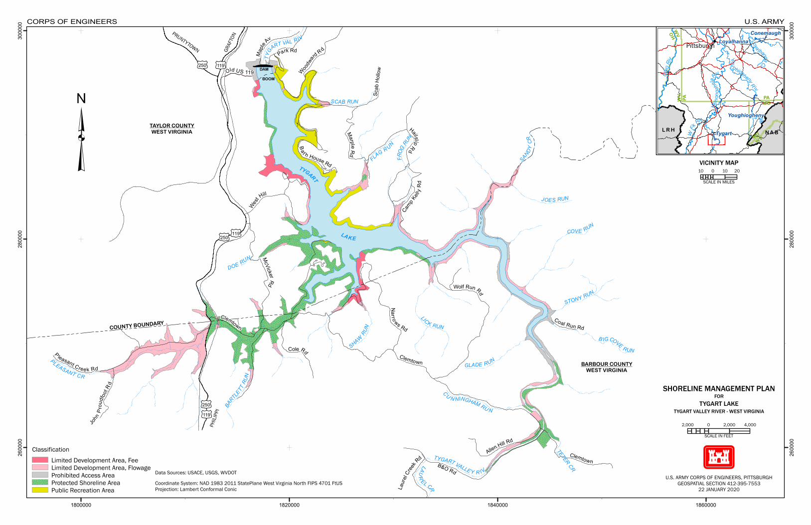
£¤250
£¤119
£¤119
£¤250
£¤250
£¤119
John Pr
oudfo
otR d
P leasant Creek Rd
Cole Rd
McVickerRd
Nar ro ws Rd
Clemtown
Clemtown
Wolf Run Rd
Allen Hill Rd
B&O Rd
Laure
l Cree
k Rd Clemtown
Coal Run Rd
Camp Kell
y Rd
West
Hill
HailslipRdBa t h House Rd
MarpleRd
Scab
Hollo
wWoodwa
rd Rd
Maple
Av
Park Rd
Old US 119BOOM
TYGART
LAKE
JOES RUN
LAUR EL CR
GLADE RUN
SCAB RUN
TYGART VALLEY R IV
COVE RUN
B IGCOVE RUN
FROG
RUN
SHAW
RUN
LICK RUN
STONY RUN
SANDYCR
BARTLE
TTRU
N
PLEASANT CR
TETER CR
CU N NINGHAM RU N
DOE RUNTY
GART VAL RIV
FLAG RUN
DAM
TAYLOR COUNTYWEST VIRGINIA
BARBOUR COUNTYWEST VIRGINIA
COUNTY BOUNDARY
1800000 1820000 1840000 1860000
2600
00
2600
00
2800
00
2800
00
3000
00
3000
00
ClassificationLim ited Development Area, FeeLim ited Development Area, FlowageProh ibited Access AreaProtected Sh oreline AreaPublic Recreation Area
ConemaughLoyalhanna
Youghiogheny
Tygart N A BL R HWVMD
WV PA
WVOH
MDPA
PittsburghLoya lhannaCr
WFk
Riv
Ohio
Riv
You g hioghenyR iv
Mono
ngah
ela
Ri v
³
Coordinate System: NAD 1983 2011 StatePlane West Virginia North FIPS 4701 FtUSProjection: Lambert Conformal Conic
CORPS OF ENGINEERS U.S. ARMY
GRAFTON→
←PRUNT YTOWN
←PHILIPPI
10 0 10 20
SCALE IN MILES
VICINITY MAP
Data Sources: USACE, USGS, WVDOT
SHORELINE MANAGEMENT PLANFOR
TYGART LAKETYGART VALLEY RIVER - WEST VIRGINIA
U.S. ARMY CORPS OF ENGINEERS, PIT T SBURGHGEOSPAT IAL SECTION 412-395-7553
22 JANUARY 2020
2,000 0 2,000 4,000
SCALE IN FEET
Appendix C
APPENDIX C
Shoreline Use Permit Conditions
1. This SUP is granted solely to the applicant for the purpose described on the attached SUP.
2. The permittee agrees to and does hereby release and agree to save and hold the Government
harmless from any and all causes of action, suits at law or equity, or claims or demands or from
any liability of any nature whatsoever for or on account of any damages to persons or property,
including a permitted facility, growing out of the ownership, construction, operation or
maintenance by the permittee of the permitted facilities and/or activities.
3. Ownership, construction, operation, use, and maintenance of a permitted facility are subject to
the Government’s navigational servitude.
4. No attempt shall be made by the permittee to forbid the full and free use by the public of all
public waters and/or lands at or adjacent to the permitted facility or to unreasonably interfere
with any authorized Project purposes, including navigation in connection with the ownership,
construction, operation or maintenance of a permitted facility and/or activity.
5. The permittee agrees that if operations by the Government require an alteration in the location
of a permitted facility and/or activity, or if in the opinion of the District Commander a permitted
facility and/or activity shall cause unreasonable obstruction to navigation or the public interest so
requires, the permittee shall be required, upon written notice from the District Commander to
remove, alter, or relocate the permitted facility, without expense to the Government.
6. The Government shall in no case be liable for any damage or injury to a permitted facility
which may be caused by or result from operations undertaken by the Government for the
improvement of navigation or for other lawful purposes, and no claims or right to compensation
shall accrue from any such damage. This includes any damage that may occur to private
property if a facility is removed for non-compliance with the conditions of the SUP.
7. Ownership, construction, operation, use, and maintenance of a permitted facility and/or
activity are subject to all applicable Federal, state, and local laws and regulations. Failure to
abide by these applicable laws and regulations may be cause for revocation of the SUP.
8. This SUP does not convey any property rights either in real estate or material; and does not
authorize any injury to private property or invasion of private rights or any infringement of
Federal, state or local laws or regulations, nor does it obviate the necessity of obtaining state or
local assent required by law for the construction, operation, use or maintenance of a permitted
facility and/or activity.
9. The permittee agrees to construct the facility within the time limit agreed to on the SUP
issuance date. The SUP shall become null and void if construction is not completed within that
period. Further, the permittee agrees to operate and maintain any permitted facility and/or
activity in a manner so as to provide safety, minimize any adverse impact on fish and wildlife
Appendix C
habitat, natural, environmental or cultural resource values, and in a manner so as to avoid the
degradation of water quality.
10. The permittee shall remove a permitted facility within 30 calendar days, at his/her expense,
and restore the waterway and lands to a condition acceptable by the Resource Manager upon
termination or revocation of this SUP or if the permittee ceases to use, operate, or maintain a
permitted facility and/or activity. If the permittee fails to comply with the satisfaction of the
Resource Manager, the District Commander may remove the facility by contract or otherwise
and the permittee agrees to pay all costs incurred.
11. The use of a permitted boat dock facility shall be limited to the mooring of the permittee’s
vessel or watercraft and the storage, in dock storage box of his/her gear essential to the operation
of such vessel or watercraft.
12. Neither a permitted facility nor any houseboat, cabin cruiser, or other vessel moored thereto
shall be used as a place of habitation or as a full or part-time residence or in any manner which
gives the appearance of converting the public property, on which the facility is located, to private
use.
13. Facilities granted under this SUP will not be leased, rented, sub-let or provided to others by
any means of engaging in commercial activities by the permittee or his/her agent for monetary
gain. The permittee is not precluded from transferring ownership of the facility (for instance, the
dock itself), but any such transfer will not also apply to the SUP, which is non-transferable.
14. Floats and the flotation material for all docks and boat mooring buoys shall be fabricated of
materials manufactured for marine use. The float and its flotation material shall be 100%
warranted for a minimum of eight years against sinking, becoming waterlogged, cracking,
peeling, fragmenting, or losing beads. All floats shall resist puncture and penetration and shall
not be subject to damage by animals under normal conditions for the area. All floats and the
flotation material used in them shall be fire resistant. Any float which is within 40 feet of a line
carrying fuel shall be 100% impervious to water and fuel. The use of new or recycled plastic or
metal drums or non-compartmentalized air containers for encasement or floats is prohibited.
Existing floats are authorized until it or its flotation material is no longer serviceable, at which
time it shall be replaced with a float that meets the conditions listed above. For any floats
installed after the effective date of this Plan, repair or replacement shall be required when it or its
flotation material no longer performs its designated function or it fails to meet the specifications
for which it was originally warranted.
15. Permitted facilities and activities are subject to periodic inspection by authorized Corps
representatives. The Resource Manager will notify the permittee of any deficiencies and
together establish a schedule for their correction. No deviation or changes from approved plans
will be allowed without prior written approval of the Resource Manager.
16. Floating facilities shall be securely attached to the shore in accordance with the approved
plans by means of moorings which do not obstruct general public use of the shoreline or
adversely affect the natural terrain or vegetation. Anchoring to vegetation is prohibited.
Appendix C
17. The SUP display tag shall be posted on the permitted facility and/or on the land areas
covered by the SUP so that it can be visually checked with ease in accordance with instructions
provided by the Resource Manager.
18. No vegetation other than that prescribed in the SUP will be damaged, destroyed, or removed.
No vegetation of any kind will be planted, other than that specifically prescribed in the SUP.
19. No change in land form such as grading, excavation, or filling is authorized by this SUP.
20. This SUP is non-transferable. Upon the sale or other transfer of the permitted facility or the
death of the permittee and his/her legal spouse, this SUP is null and void.
21. The District Commander may revoke this SUP whenever the public interest necessitates such
revocation or when the permittee fails to comply with any SUP condition or term. The
revocation notice shall specify the reasons for such action. If the permittee wants a hearing, one
must be requested in writing to the District Commander through the Resource Manager within a
30 day period. The District Commander shall grant such hearing at the earliest opportunity. In
no event shall the hearing date be more than 60 calendar days from the date of the hearing
request. Following the hearing, a written decision will be rendered and a copy mailed to the
permittee by certified letter.
22. Notwithstanding the condition cited in 21 above, if in the opinion of the District Commander,
emergency circumstances dictate, the District Commander may summarily revoke the SUP.
23. When vegetation modification on these lands is accomplished by chemical means, the
program will be in accordance with appropriate Federal, state, and local laws, rules, and
regulations. Any activity of this type must have prior approval from the Resource Manager and
must meet all Federal, state and local requirements.
24. The Resource Manager or his/her authorized representative shall be allowed to cross the
permittee’s property, as necessary, to inspect facilities and/or activities under the SUP.
25. When vegetation modification is allowed, the permittee will delineate the Government
property line in a clear, but unobtrusive manner approved by the Resource Manager and in
accordance with the Project Shoreline Management Plan.
26. If the ownership of a permitted facility is sold or transferred, the permittee or new owner will
notify the Resource Manager of the action prior to finalization. The new owner must apply for a
SUP within 14 days or remove the facility and restore the use area within 30 calendar days from
the date of ownership transfer.
27. If permitted facilities are removed for storage or extensive maintenance, the Resource
Manager may require all portions of the facility be removed from public property.
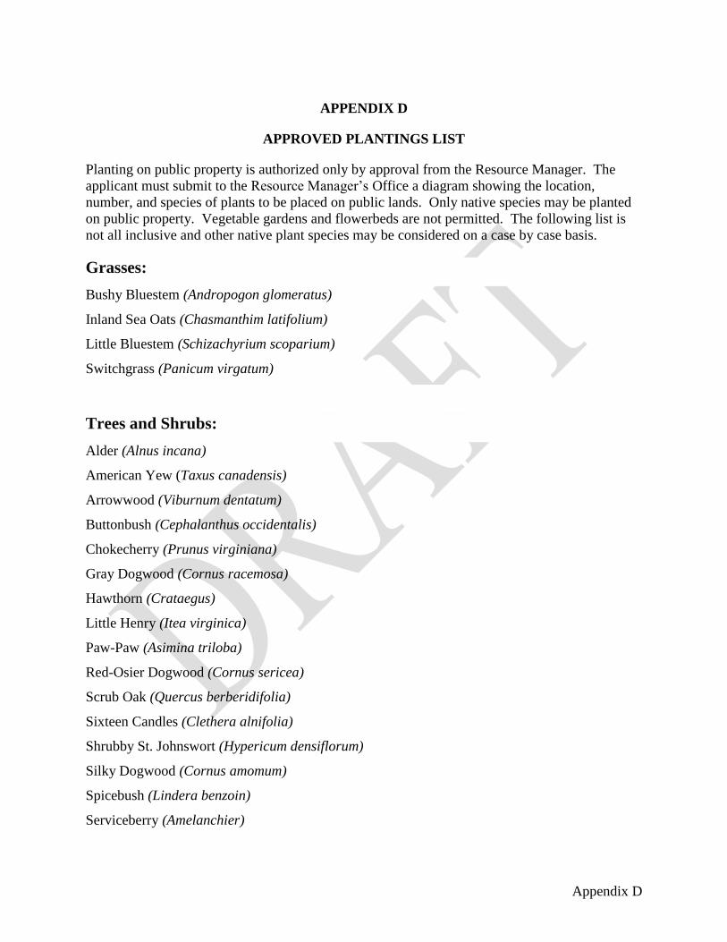
Appendix D
APPENDIX D
APPROVED PLANTINGS LIST
Planting on public property is authorized only by approval from the Resource Manager. The
applicant must submit to the Resource Manager’s Office a diagram showing the location,
number, and species of plants to be placed on public lands. Only native species may be planted
on public property. Vegetable gardens and flowerbeds are not permitted. The following list is
not all inclusive and other native plant species may be considered on a case by case basis.
Grasses:
Bushy Bluestem (Andropogon glomeratus)
Inland Sea Oats (Chasmanthim latifolium)
Little Bluestem (Schizachyrium scoparium)
Switchgrass (Panicum virgatum)
Trees and Shrubs:
Alder (Alnus incana)
American Yew (Taxus canadensis)
Arrowwood (Viburnum dentatum)
Buttonbush (Cephalanthus occidentalis)
Chokecherry (Prunus virginiana)
Gray Dogwood (Cornus racemosa)
Hawthorn (Crataegus)
Little Henry (Itea virginica)
Paw-Paw (Asimina triloba)
Red-Osier Dogwood (Cornus sericea)
Scrub Oak (Quercus berberidifolia)
Sixteen Candles (Clethera alnifolia)
Shrubby St. Johnswort (Hypericum densiflorum)
Silky Dogwood (Cornus amomum)
Spicebush (Lindera benzoin)
Serviceberry (Amelanchier)

Appendix D
Sumac (Rhus)
Winter Red (Ilex verticillata)
Witch Hazel (Hamamelis virginiana)

Appendix E
APPENDIX E
DESIGN SPECIFICATION DRAWINGS

18"rebar
l l 18"rebar
=-----�l l i{FF!:!:i:::Fi:!:l:::Fl:HJ}l:H�::i�:::i*:i:
:,f
i:I 1:,:···*····�···�····:,t· 1 :::,····
,:,:···
,#.· -�=�......., ........ �.......,�= ........ ......;;-� ........
ground
Treated wood or composite lumber
18"rebar
4'
!I!I!I!i!jI!jI!I!jjji!jI!I!I!I!Iljil]J
Tie anchor detail
18 " rebar crossed at both ends
IMPROVED FOOT PATH
lJS. Army Corps of Engineers,
Drawing
Scale: None
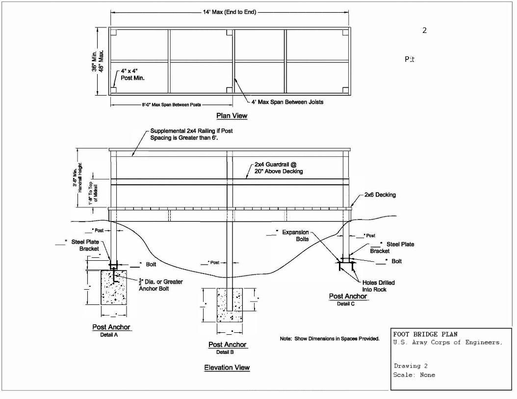
i------------14' Max (End to End)-------------i
_J L L
4"x4" J Pos!Min.
r \ r
I 8'--0" Max Span Between Poslll \_ 4' Max Span Between Joists
" Steel Plate Bracket
Post Anchor
DetaBA
Plan View
Supplemental 2x4 Railing if Post Spacing is Greater than 6'.
_"Post
Post Anchor
Detail B
Elevation View
2x4 Guardrail @ 20• Above Decking
2x6 Decking
_• Steel Plate Bracket
• Bolt
Holes Drilled Into Rock
Post Anchor
Detail C
FOOT BRIDGE PLAN Note: Show Dimensions in Spaces Provided.
U.S. Army Corps of Engineers,
Drawing
Scale: None
2
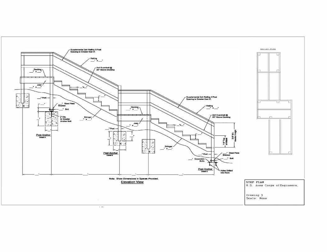
• ... ··
--, . •··
Post.l\ncllor
�B
-: Show DirTalalono In 5- ProYlded_
Elevation View
.l.erinJ YIBY
...J L
-, r
-' L L
-, n r
17 r
STEP PLAN
U.S. Army Corps of Engineers�
Dra.ving
Scale: Hone
3
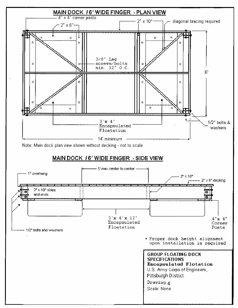
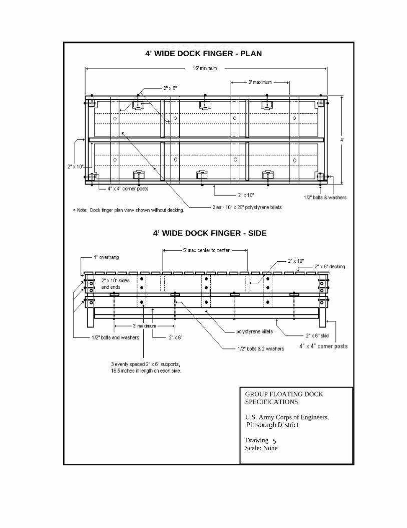
4’ WIDE DOCK FINGER - PLAN
4’ WIDE DOCK FINGER - SIDE
GROUP FLOATING DOCK SPECIFICATIONS
U.S. Army Corps of Engineers,
Drawing Scale: None

\
1-2'-0" oc
-+I . .
,.
---�
+--2"x8"--+ ,I..
---� ,. =· .... -
i posts, w/ 2"x 8"
hex hd bolts Minimum
nd lock
WALKWAY - PLAN VIEW
length varies
... ., -
3/8" Lag screws/bolts no greater than 12" O.C.
4" x 4" posts, w/ 112-13 hex hd bolts& flat and lock
1 washers ,.
I ,- :ii,.-. !oir-
+-2" 18"t
.. If.: -:
:• -
1- 2 'x 3'x
"o
-
�o
12 II
,)
Encapsulated-Polystyrene Float
1 ,:
'
ft.-. 0
0
o, �"';'!' :
-: -
4" X 4" post
1 4'
l
s,wl
4"x 4" 112-13 & flat a washe (post is
rs +- Shoreline -� i i 112-13 hex h d boltsckoptional) & flat and lo
washers
Note: Walkway plan view shown without decking.
metal guard strip ( optional)
Mid-walkway flotation is optional, depending on site conditions. If installed, its position may vary, depending on site conditions. Center stringer/support is optional, but recommended.
WALKWAY - SIDE VIEW
,r-- 2" X 6" decking
+--- ground line
. ' I I I I
l 2"x 8"
Mnimum
GROUP FLOATING DOCK
SPECIFICATIONS
U.S. Army Corps of Engineers,
Drawing
Scale: None
-l20"
l
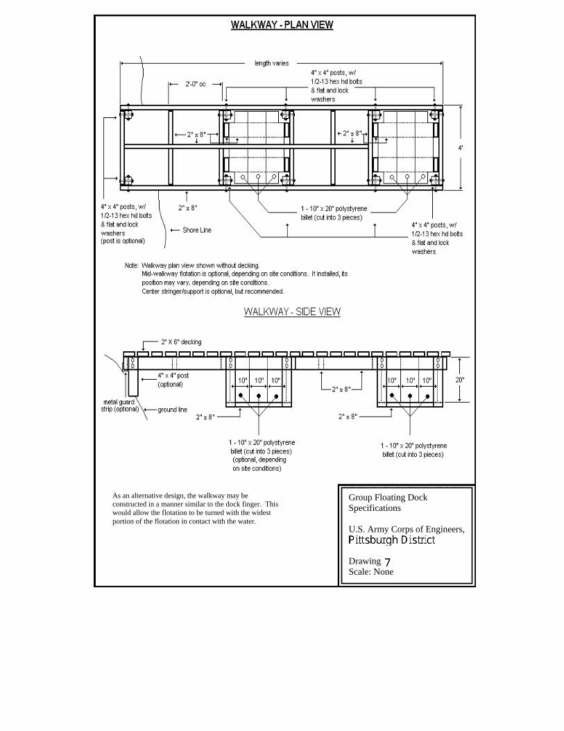
As an alternative design, the walkway may be constructed in a manner similar to the dock finger. This would allow the flotation to be turned with the widest portion of the flotation in contact with the water.
Group Floating Dock Specifications
U.S. Army Corps of Engineers,
Drawing Scale: None
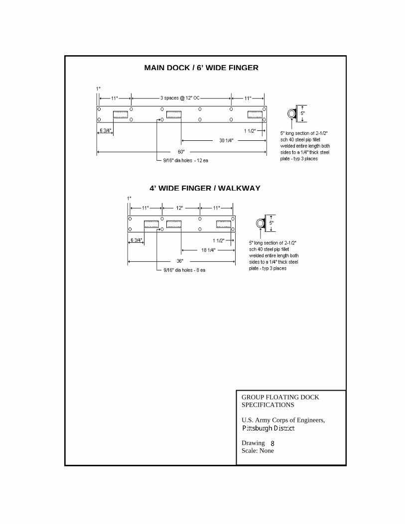
MAIN DOCK / 6’ WIDE FINGER
4’ WIDE FINGER / WALKWAY
GROUP FLOATING DOCK SPECIFICATIONS
U.S. Army Corps of Engineers,
Drawing Scale: None
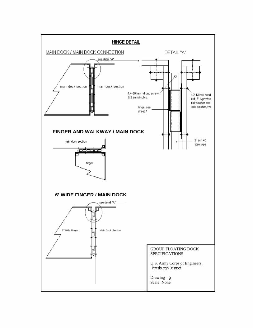
6’ WIDE FINGER / MAIN DOCK
6’ Wide Finger Main Dock Section
FINGER AND WALKWAY / MAIN DOCK
GROUP FLOATING DOCK SPECIFICATIONS
U.S. Army Corps of Engineers,
Drawing Scale: None
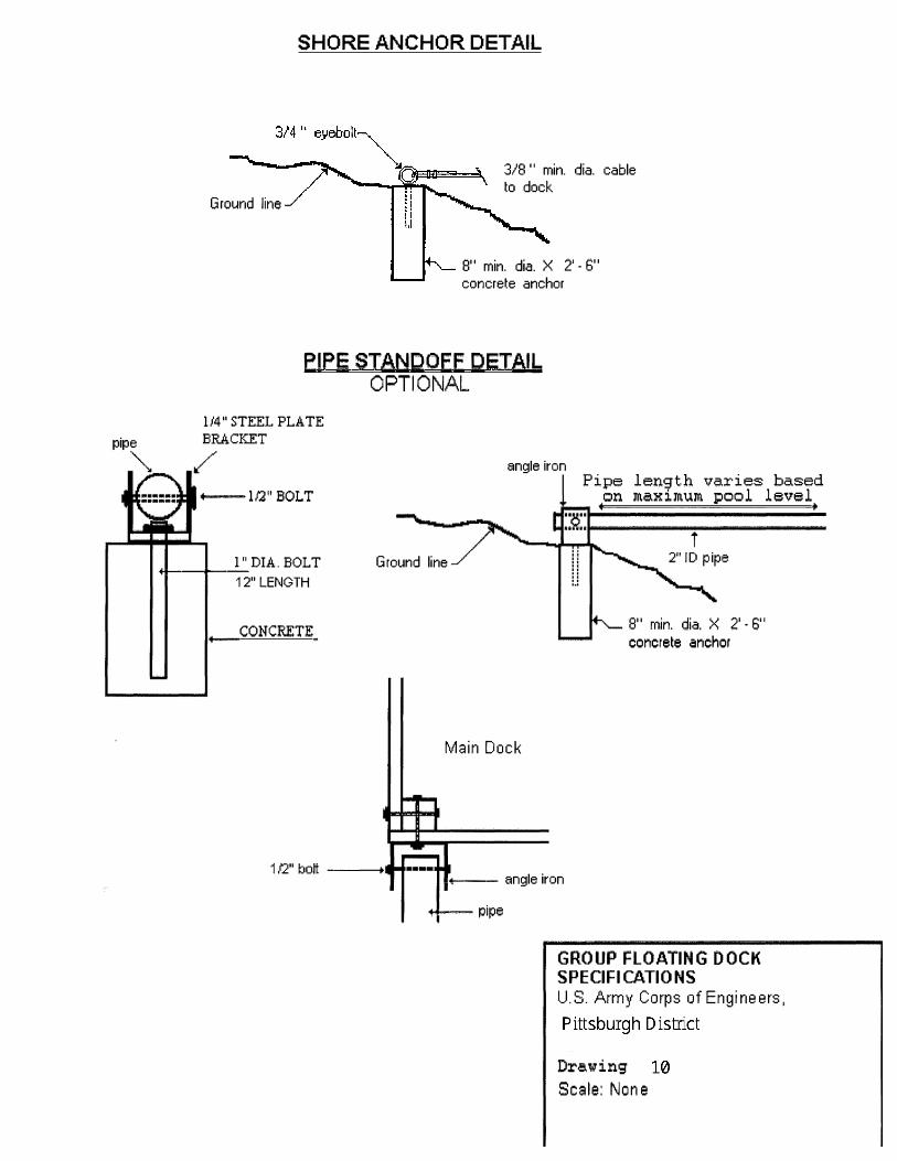
pipe '""
. .,.
SHORE ANCHOR DETAIL
Ground line✓
3/8 '' min. dia. cable to dock
8" min. dia. X 2' - 6" concrete anchor
PIPE STANDOFF DETAIL OPTIONAL
ll4" STEEL FLA TE
�l/2"BOLT
l" DIA. BOLT ----
12" LENGTH
CONCRETE
angle iron
Ground line
Main Dock
Pipe len'9th varies based on maximum pool level
i
8" min. dia. X 2' • 6" concrete anchor
■--- angle iron
--pipe
GROUP FLOATING DOCK
SPECIFICATIONS
U.S. Army Corps of Engineers,
Drawing
Scale: None
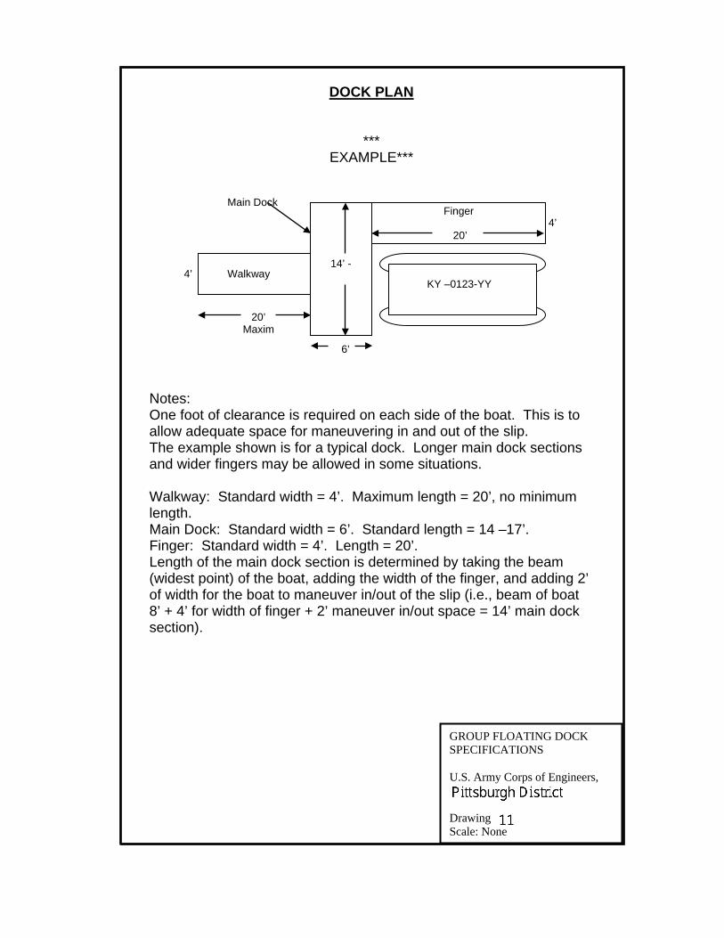
14’ - 4’
20’ Maxim
Walkway
Finger Main Dock
6’
20’ 4’
KY –0123-YY
DOCK PLAN
*** EXAMPLE***
Notes: One foot of clearance is required on each side of the boat. This is to allow adequate space for maneuvering in and out of the slip. The example shown is for a typical dock. Longer main dock sections and wider fingers may be allowed in some situations.
Walkway: Standard width = 4’. Maximum length = 20’, no minimum length. Main Dock: Standard width = 6’. Standard length = 14 –17’. Finger: Standard width = 4’. Length = 20’. Length of the main dock section is determined by taking the beam (widest point) of the boat, adding the width of the finger, and adding 2’ of width for the boat to maneuver in/out of the slip (i.e., beam of boat 8’ + 4’ for width of finger + 2’ maneuver in/out space = 14’ main dock section).
GROUP FLOATING DOCK SPECIFICATIONS
U.S. Army Corps of Engineers,
Drawing Scale: None
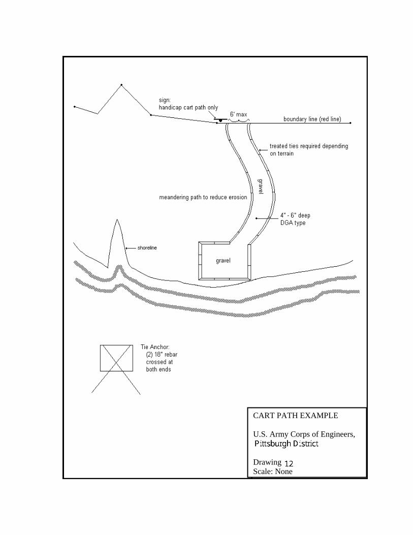
CART PATH EXAMPLE
U.S. Army Corps of Engineers,
Drawing Scale: None

Appendix F
APPENDIX F
ENVIRONMENTAL ASSESSMENT