Embed Size (px)
Citation preview

Uncorrected Non corrigé
CR 2012/9 International Court Cour internationale of Justice de Justice THE HAGUE LA HAYE
YEAR 2012
Public sitting
held on Tuesday 24 April 2012, at 10 a.m., at the Peace Palace,
President Tomka presiding,
in the case concerning the Territorial and Maritime Dispute (Nicaragua v. Colombia)
____________________
VERBATIM RECORD ____________________
ANNÉE 2012
Audience publique
tenue le mardi 24 avril 2012, à 10 heures, au Palais de la Paix,
sous la présidence de M. Tomka, président,
en l’affaire du Différend territorial et maritime (Nicaragua c. Colombie)
________________
COMPTE RENDU ________________
- 2 -
Present: President Tomka Vice-President Sepúlveda-Amor Judges Owada Abraham Keith Bennouna Skotnikov Cançado Trindade Yusuf Greenwood Xue Donoghue Sebutinde Judges ad hoc Mensah Cot Registrar Couvreur
⎯⎯⎯⎯⎯⎯
- 3 -
Présents : M. Tomka, président M. Sepúlveda-Amor, vice-président MM. Owada Abraham Keith Bennouna Skotnikov Cançado Trindade Yusuf Greenwood Mmes Xue Donoghue Sebutinde, juges MM. Mensah Cot, juges ad hoc M. Couvreur, greffier
⎯⎯⎯⎯⎯⎯
- 4 -
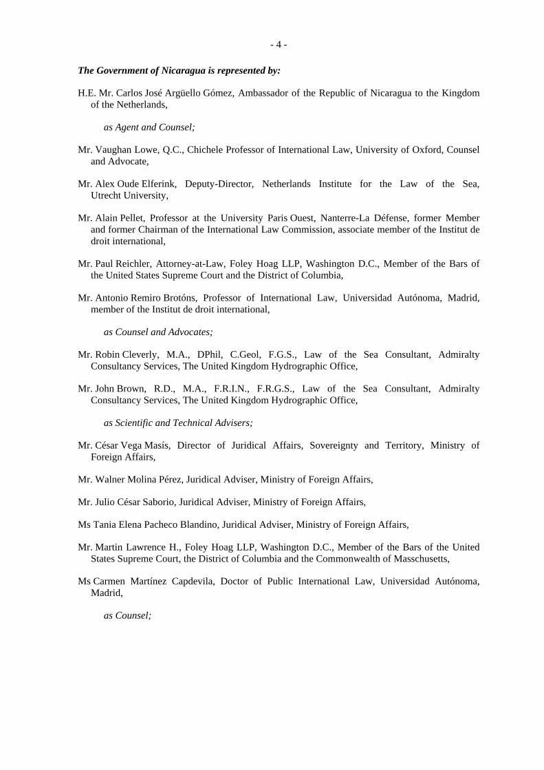
The Government of Nicaragua is represented by:
H.E. Mr. Carlos José Argüello Gómez, Ambassador of the Republic of Nicaragua to the Kingdom of the Netherlands,
as Agent and Counsel;
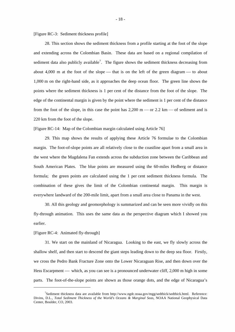
Mr. Vaughan Lowe, Q.C., Chichele Professor of International Law, University of Oxford, Counsel and Advocate,
Mr. Alex Oude Elferink, Deputy-Director, Netherlands Institute for the Law of the Sea, Utrecht University,
Mr. Alain Pellet, Professor at the University Paris Ouest, Nanterre-La Défense, former Member and former Chairman of the International Law Commission, associate member of the Institut de droit international,
Mr. Paul Reichler, Attorney-at-Law, Foley Hoag LLP, Washington D.C., Member of the Bars of the United States Supreme Court and the District of Columbia,
Mr. Antonio Remiro Brotóns, Professor of International Law, Universidad Autónoma, Madrid, member of the Institut de droit international,
as Counsel and Advocates;
Mr. Robin Cleverly, M.A., DPhil, C.Geol, F.G.S., Law of the Sea Consultant, Admiralty Consultancy Services, The United Kingdom Hydrographic Office,
Mr. John Brown, R.D., M.A., F.R.I.N., F.R.G.S., Law of the Sea Consultant, Admiralty Consultancy Services, The United Kingdom Hydrographic Office,
as Scientific and Technical Advisers;
Mr. César Vega Masís, Director of Juridical Affairs, Sovereignty and Territory, Ministry of Foreign Affairs,
Mr. Walner Molina Pérez, Juridical Adviser, Ministry of Foreign Affairs,
Mr. Julio César Saborio, Juridical Adviser, Ministry of Foreign Affairs,
Ms Tania Elena Pacheco Blandino, Juridical Adviser, Ministry of Foreign Affairs,
Mr. Martin Lawrence H., Foley Hoag LLP, Washington D.C., Member of the Bars of the United States Supreme Court, the District of Columbia and the Commonwealth of Masschusetts,
Ms Carmen Martínez Capdevila, Doctor of Public International Law, Universidad Autónoma, Madrid,
as Counsel;
- 5 -
Le Gouvernement du Nicaragua est représenté par :
S. Exc. M. Carlos José Argüello Gómez, ambassadeur de la République du Nicaragua auprès du Royaume des Pays-Bas,
comme agent et conseil ;
M. Vaughan Lowe, Q.C., professeur de droit international à l’Université d’Oxford, titulaire de la chaire Chichele, conseil et avocat,
M. Alex Oude Elferink, directeur adjoint de l’Institut néerlandais du droit de la mer de l’Université d’Utrecht,
M. Alain Pellet, professeur à l’Université de Paris Ouest, Nanterre-La Défense, ancien membre et ancien président de la Commission du droit international, membre associé de l’Institut de droit international,
M. Paul Reichler, avocat au cabinet Foley Hoag LLP, Washington D.C. , membre des barreaux de la Cour suprême des Etats-Unis d’Amérique et du district de Columbia,
M. Antonio Remiro Brotóns, professeur de droit international à l’Universidad Autónoma de Madrid, membre de l’Institut de droit international,
comme conseils et avocats ;
M. Robin Cleverly, M.A., D.Phil, C.Geol, F.G.S., consultant en droit de la mer, Admiralty Consultancy Services du bureau hydrographique du Royaume-Uni,
M. John Brown, R.D., M.A., F.R.I.N., F.R.G.S., consultant en droit de la mer, Admiralty Consultancy Services du bureau hydrographique du Royaume-Uni,
comme conseillers scientifiques et techniques ;
M. César Vega Masís, directeur des affaires juridiques, de la souveraineté et du territoire au ministère des affaires étrangères,
M. Walner Molina Pérez, conseiller juridique au ministère des affaires étrangères,
M. Julio César Saborio, conseiller juridique au ministère des affaires étrangères,
Mme Tania Elena Pacheco Blandino, conseiller juridique au ministère des affaires étrangères,
M. Martin Lawrence H., cabinet Foley Hoag LLP, Washington D.C., membre des barreaux de la Cour suprême des Etats-Unis d’Amérique, du district de Columbia et du Commonwealth du Massachusetts,
Mme Carmen Martínez Capdevila, docteur en droit international public de l’Universidad Autónoma de Madrid,
comme conseils ;
- 6 -
Mr. Edgardo Sobenes Obregon, First Secretary, Embassy of Nicaragua in the Kingdom of the Netherlands,
Ms Claudia Loza Obregon, Second Secretary, Embassy of Nicaragua in the Kingdom of the Netherlands,
Mr. Romain Piéri, Researcher, Centre for International Law (CEDIN), University Paris Ouest, Nanterre-La Défense,
Mr. Yuri Parkhomenko, Foley Hoag LLP, United States of America,
as Assistant Counsel;
Ms Helena Patton, The United Kingdom Hydrographic Office,
Ms Fiona Bloor, The United Kingdom Hydrographic Office,
as Technical Assistants.
The Government of Colombia is represented by: H.E. Mr. Julio Londoño Paredes, Professor of International Relations, Universidad del Rosario,
Bogotá,
as Agent and Counsel;
H.E. Mr. Guillermo Fernández de Soto, member of the Permanent Court of Arbitration, former Minister for Foreign Affairs,
as Co-Agent;
Mr. James Crawford, S.C., F.B.A., Whewell Professor of International Law, University of Cambridge, member of the Institut de droit international, Barrister,
Mr. Rodman R. Bundy, avocat à la Cour d’appel de Paris, member of the New York Bar, Eversheds LLP, Paris,
Mr. Marcelo Kohen, Professor of International Law at the Graduate Institute of International and Development Studies, Geneva, associate member of the Institut de droit international,
as Counsel and Advocates;
H.E. Mr. Eduardo Pizarro Leongómez, Ambassador of the Republic of Colombia to the Kingdom of the Netherlands, Permanent Representative of Colombia to the OPCW,
as Adviser;
H.E. Mr. Francisco José Lloreda Mera, Presidential High-Commissioner for Citizenry Security, former Ambassador of the Republic of Colombia to the Kingdom of the Netherlands, former Minister of State,
Mr. Eduardo Valencia-Ospina, member of the International Law Commission,

- 7 -
M. Edgardo Sobenes Obregon, premier secrétaire de l’ambassade du Nicaragua au Royaume des Pays-Bas,
Mme Claudia Loza Obregon, deuxième secrétaire de l’ambassade du Nicaragua au Royaume des Pays-Bas,
M. Romain Piéri, chercheur au centre de droit international (CEDIN) de l’Université de Paris Ouest, Nanterre-La Défense,
M. Yuri Parkhomenko, cabinet Foley Hoag LLP, Etats-Unis d’Amérique,
comme conseils adjoints ;
Mme Helena Patton, bureau hydrographique du Royaume-Uni,
Mme Fiona Bloor, bureau hydrographique du Royaume-Uni,
comme assistantes techniques.
Le Gouvernement de la Colombie est représenté par :
S. Exc. M. Julio Londoño Paredes, professeur de relations internationales à l’Universidad del Rosario, Bogotá,
comme agent et conseil ;
S. Exc. M. Guillermo Fernández de Soto, membre de la Cour permanente d’arbitrage, ancien ministre des affaires étrangères,
comme coagent ;
M. James Crawford, S.C., F.B.A., professeur de droit international à l’Université de Cambridge, titulaire de la chaire Whewell, membre de l’Institut de droit international, avocat,
M. Rodman R. Bundy, avocat à la Cour d’appel de Paris, membre du barreau de New York, Cabinet Eversheds LLP, Paris,
M. Marcelo Kohen, professeur de droit international à l’Institut de hautes études internationales et du développement de Genève, membre associé de l’Institut de droit international,
comme conseils et avocats ;
S. Exc. M. Eduardo Pizarro Leongómez, ambassadeur de la République de Colombie auprès du Royaume des Pays-Bas, représentant permanent de la Colombie auprès de l’OIAC,
comme conseiller ;
S. Exc. M. Francisco José Lloreda Mera, haut conseiller présidentiel pour la cohabitation et la sécurité des citoyens, ancien ambassadeur de la République de Colombie auprès du Royaume des Pays-Bas, ancien ministre d’Etat,
M. Eduardo Valencia-Ospina, membre de la Commission du droit international,
- 8 -
H.E. Ms Sonia Pereira Portilla, Ambassador, Ministry of Foreign Affairs,
Mr. Andelfo García González, Professor of International Law, former Deputy Minister for Foreign Affairs,
Ms Mirza Gnecco Plá, Minister-Counsellor, Ministry of Foreign Affairs,
Ms Andrea Jiménez Herrera, Counsellor, Embassy of Colombia in the Kingdom of the Netherlands,
as Legal Advisers;
CF William Pedroza, International Affairs Bureau, National Navy of Colombia,
Mr. Scott Edmonds, Cartographer, International Mapping,
Mr. Thomas Frogh, Cartographer, International Mapping,
as Technical Advisers;
Mr. Camilo Alberto Gómez Niño,
as Administrative Assistant.
- 9 -
S. Exc. Mme Sonia Pereira Portilla, ambassadeur, ministère des affaires étrangères,
M. Andelfo García González, professeur de droit international, ancien ministre adjoint des affaires étrangères,
Mme Mirza Gnecco Plá, ministre-conseiller au ministère des affaires étrangères,
Mme Andrea Jiménez Herrera, conseiller à l’ambassade de Colombie au Royaume des Pays-Bas,
comme conseillers juridiques ;
Le capitaine de frégate William Pedroza, bureau des affaires internationales, Marine colombienne,
M. Scott Edmonds, cartographe, International Mapping,
M. Thomas Frogh, cartographe, International Mapping,
comme conseillers techniques ;
M. Camilo Alberto Gómez Niño,
comme assistant administratif.
- 10 -
The PRESIDENT: Please be seated. The sitting is open. I give the floor to
Dr. Robin Cleverly to make his presentation. You have the floor, Sir.
Mr. CLEVERLY:
GEOMORPHOLOGY AND THE NATURE OF THE CONTINENTAL SHELF.
A. Introduction
1. Thank you, Mr. President. Mr. President, Members of the Court, it is a great pleasure to
have the honour and the privilege to appear before you on behalf of the Government of Nicaragua.
2. Yesterday Mr. Oude Elferink discussed the general geographical setting, including the
relevant coastlines, islands and cays. I would like to continue the presentation of the factual
elements of this case and describe in more detail the geological and geomorphological aspects,
particularly of the continental shelf. As a geologist and a scientist, rather than a lawyer, I will
address the technical aspects, Professor Lowe will address the legal aspects afterwards.
B. Geological setting
3. I would like to start by a brief look at the geological history. The present-day
geomorphology and bathymetry reflect the detail of the geological past and this is helpful for a
regional understanding of the continental shelf and to explain the differences between the different
parts of the continental margin.
[RC-1: Geological map of Caribbean (R3-1)]
4. The earth’s crust is composed of a number of rigid tectonic plates. These move around,
collide and slide under one another to create the complex surface of the earth. This geological map
now on your screens shows the major features of the Caribbean. This is a complex map, but I
would like to emphasize the principal features. Virtually all the Caribbean and Central America is
underlain by the Caribbean tectonic plate which is approximately rectangular in shape about
3,000 x 1,000 km, or 1,500 miles x 500 miles, extending from the Pacific in the west as far as
Barbados in the east, and includes the landmass of Nicaragua and Central America in the west. To
the north lies the North American Plate separated by the deep Cayman Trough, and to the south the
- 11 -
South American Plate on which Colombia sits. The Caribbean Plate is mainly of volcanic origin,
and contains large areas of oceanic crust. It was forced into its current position from the west,
driven like a wedge between North and South America.
[Figure RC-2: Cross-section of subduction zone]
5. The southern margin of the Caribbean Plate is formed by a major subduction zone; this is
where the Caribbean Plate slides under and past the continental mass of South America. This
separates the continental crust of Colombia and South America from the oceanic crust of the deep
sea. The cross section now on your screens shows the way such a plate boundary works. Here the
Caribbean and South American Plates are moving past one another ⎯ at about 20 mm, or 1 inch
per year. The movement is both downwards and sideways. This movement has produced a
crumpling of the edge of the South American Plate into a series of complex folds and faults,
especially across the north-west of the Colombian landmass.
6. Such a plate boundary is one of the most fundamental geological discontinuities. The
geological material that forms Colombia and northern South America has a common origin, distinct
from that of the Caribbean Plate. There is no geological continuity across this plate boundary.
This was also an issue in both the Libya/Malta and Tunisia/Libya cases where a plate boundary was
put forward as a potential limit of the continental shelf. There the parties disagreed on the
existence of the plate boundary ⎯ happily in this case there is no such disagreement between the
Parties nor in the scientific community, and there is a clear distinction between the Caribbean Plate
and the South American Plate1. This distinction is crucial for an understanding of the differences
between the two continental margins.
C. Geomorphology
[Figure RC-3: Animation showing receding water level]
7. These regional events and plate boundaries have all left their mark on the geomorphology
of the area like fingerprints and DNA at the scene of a crime and can be interpreted by a geologist
as a detective. So what does the geomorphology show? Firstly we need to look at the sea-bed and
subsoil beneath the sea. This map on your screens shows the effect of reducing the sea level.
1See for example James, K. H., Lorente, M. A. & Pindell, J. L. (eds.) 2009. The Origin and Evolution of the Caribbean Plate, Geological Society, London. Special Publication 328.
- 12 -
8. Firstly we have reduced the sea level by 50 m ⎯ this shows the extremely shallow nature
of the sea-bed east of Nicaragua. We now reduce the sea level still further by 100 m, 150 m and
finally by 200 m. This final map in a sequence shows the effects of reducing the sea level to show
the sea-bed at a depth of 200 m ⎯ this corresponds to the physical continental shelf ⎯ a shallow
area of sea that surrounds all the world’s continents which was produced as a result of lower sea
levels during the last Ice Age about 15,000 years ago. This would have been the shape of the
coastlines at that time. This extensive shallow area is known as the Nicaraguan Rise. In
Nicaragua’s case this physical continental shelf extends in a triangular shape about 180 miles
towards Jamaica. Around the South American coasts the physical shelf is narrow, mostly no more
than about 25 miles, and in some areas much less.
[Figure RC-4: Bathymetry of the SW Caribbean (R3-2)]
9. From this simple analysis of the areas of shallow seas surrounding Nicaragua I would now
like to turn to the more extensive bathymetry data. By removing all the sea we can see the
geological bones of the sea-bed. Shallow water to about 1,000 m is shown in green, deeper water
in blue and the deep ocean at about 4,000 m in the more purple colours. This map of the
bathymetry shows graphically the geological structure of the region.
10. In the north there is the extensive area of the Nicaraguan Rise we saw earlier; this is an
area of very shallow water, with large areas at about 50 m water depth. To the south lies the
oceanic abyssal plain known as the Colombian Basin, separated by a very long linear feature ⎯ the
Hess Escarpment. This is one of a series of parallel north-east trending geological fracture zones
formed within the Caribbean Plate as it slid to the north-east across the top of South America.
These fracture zones are large cracks in the Caribbean Plate where one crustal block slides past
another. We can see all this more clearly on a perspective view of the same data.
[Figure RC-5: Bathymetry of the SW Caribbean (R3-2)]
11. The Nicaraguan Rise can be divided into two: to the north the Nicaraguan Rise proper,
and to the south, separated by the Pedro Bank Fracture Zone, the Lower Nicaraguan Rise. The
northern part is mostly less than 1,000 m with large shallow plateau areas. The southern part, the
Lower Nicaraguan Rise, is generally between 2,000 and 2,500 m water depth. It is fairly irregular
in nature and includes a number of volcanic features producing small bathymetric highs. In the
- 13 -
western and shallower part of the Nicaraguan Rise these highs emerge to form islands and cays,
including San Andrés, Providencia and the various other small cays. To the south-west are two
submerged larger volcanic features, the Zipa seamount and the Mono Rise.
[Figure RC-6: Cross section of the Nicaraguan Rise (R 3-3)]
12. This graphic now on your screens is a cross section that shows these giant steps across
the Nicaraguan Rise more clearly. In the north on the left is the Upper Nicaraguan Rise bounded to
the north by the Cayman Trough. This area is between 1,000 and 1,500 m water depth. The Pedro
Bank Fracture Zone is the first major feature and forms the first step down to the Lower
Nicaraguan Rise; this area is mostly about 2,000 to 2,500 m in water depth, but is quite irregular in
detail, and a few small islands appear as steep bumps. The Hess Escarpment forms the southern
edge to the Nicaraguan Rise, separating it from the deep abyssal plan which is at about 4,000 m
water depth. This junction is sharp and well defined ⎯ there is very little sediment in this area.
On the right of this cross section is the Colombian margin, this slopes down to the deep ocean floor
and is relatively narrow compared to the extensive Nicaraguan margin. This is the location of the
plate boundary between the Caribbean and South American Plates I spoke about before, and is the
major geological discontinuity. There is an apron of sediment around the Colombian margin that
has the effect of softening this transition.
D. Definition of the continental shelf
13. I would now like to move on from this technical analysis to discuss the application of
Article 76 of the United Nations Convention and the definition of the legal limits of the continental
shelf.
[Figure RC-7a: Article 76 1 & 3]
14. The continental shelf is defined by the provisions of Article 76:
“1. The continental shelf of a coastal State comprises the seabed and subsoil of the submarine areas that extend beyond its territorial sea throughout the natural prolongation of its land territory to the outer edge of the continental margin, or to a distance of 200 nautical miles . . . where the outer edge of the continental margin does not extend up to that distance.”
15. The definition of the continental margin is clarified in paragraph 3 and defined more
precisely in paragraph 4. Paragraph 3 states that:
- 14 -
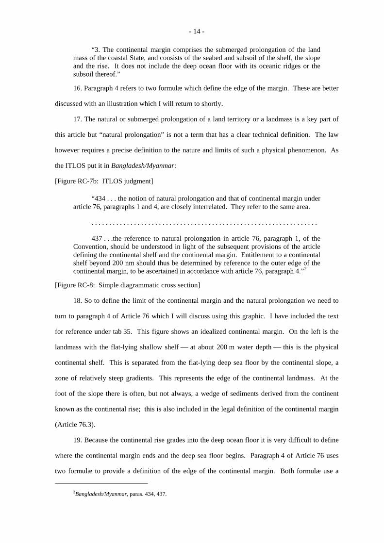
“3. The continental margin comprises the submerged prolongation of the land mass of the coastal State, and consists of the seabed and subsoil of the shelf, the slope and the rise. It does not include the deep ocean floor with its oceanic ridges or the subsoil thereof.”
16. Paragraph 4 refers to two formulæ which define the edge of the margin. These are better
discussed with an illustration which I will return to shortly.
17. The natural or submerged prolongation of a land territory or a landmass is a key part of
this article but “natural prolongation” is not a term that has a clear technical definition. The law
however requires a precise definition to the nature and limits of such a physical phenomenon. As
the ITLOS put it in Bangladesh/Myanmar:
[Figure RC-7b: ITLOS judgment]
“434 . . . the notion of natural prolongation and that of continental margin under article 76, paragraphs 1 and 4, are closely interrelated. They refer to the same area.
. . . . . . . . . . . . . . . . . . . . . . . . . . . . . . . . . . . . . . . . . . . . . . . . . . . . . . . . . . . . . . . .
437 . . .the reference to natural prolongation in article 76, paragraph 1, of the Convention, should be understood in light of the subsequent provisions of the article defining the continental shelf and the continental margin. Entitlement to a continental shelf beyond 200 nm should thus be determined by reference to the outer edge of the continental margin, to be ascertained in accordance with article 76, paragraph 4.”2
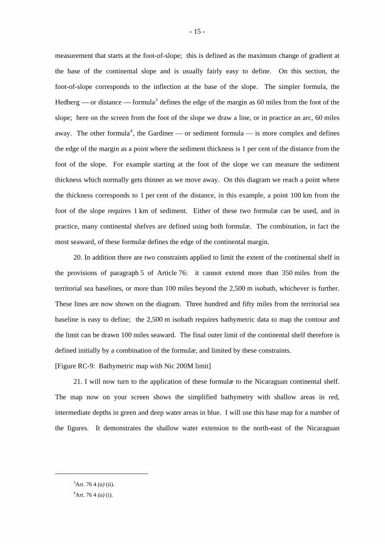
[Figure RC-8: Simple diagrammatic cross section]
18. So to define the limit of the continental margin and the natural prolongation we need to
turn to paragraph 4 of Article 76 which I will discuss using this graphic. I have included the text
for reference under tab 35. This figure shows an idealized continental margin. On the left is the
landmass with the flat-lying shallow shelf ⎯ at about 200 m water depth ⎯ this is the physical
continental shelf. This is separated from the flat-lying deep sea floor by the continental slope, a
zone of relatively steep gradients. This represents the edge of the continental landmass. At the
foot of the slope there is often, but not always, a wedge of sediments derived from the continent
known as the continental rise; this is also included in the legal definition of the continental margin
(Article 76.3).
19. Because the continental rise grades into the deep ocean floor it is very difficult to define
where the continental margin ends and the deep sea floor begins. Paragraph 4 of Article 76 uses
two formulæ to provide a definition of the edge of the continental margin. Both formulæ use a
2Bangladesh/Myanmar, paras. 434, 437.
- 15 -
measurement that starts at the foot-of-slope; this is defined as the maximum change of gradient at
the base of the continental slope and is usually fairly easy to define. On this section, the
foot-of-slope corresponds to the inflection at the base of the slope. The simpler formula, the
Hedberg ⎯ or distance ⎯ formula3 defines the edge of the margin as 60 miles from the foot of the
slope; here on the screen from the foot of the slope we draw a line, or in practice an arc, 60 miles
away. The other formula4, the Gardiner ⎯ or sediment formula ⎯ is more complex and defines
the edge of the margin as a point where the sediment thickness is 1 per cent of the distance from the
foot of the slope. For example starting at the foot of the slope we can measure the sediment
thickness which normally gets thinner as we move away. On this diagram we reach a point where
the thickness corresponds to 1 per cent of the distance, in this example, a point 100 km from the
foot of the slope requires 1 km of sediment. Either of these two formulæ can be used, and in
practice, many continental shelves are defined using both formulæ. The combination, in fact the
most seaward, of these formulæ defines the edge of the continental margin.
20. In addition there are two constraints applied to limit the extent of the continental shelf in
the provisions of paragraph 5 of Article 76: it cannot extend more than 350 miles from the
territorial sea baselines, or more than 100 miles beyond the 2,500 m isobath, whichever is further.
These lines are now shown on the diagram. Three hundred and fifty miles from the territorial sea
baseline is easy to define; the 2,500 m isobath requires bathymetric data to map the contour and
the limit can be drawn 100 miles seaward. The final outer limit of the continental shelf therefore is
defined initially by a combination of the formulæ, and limited by these constraints.
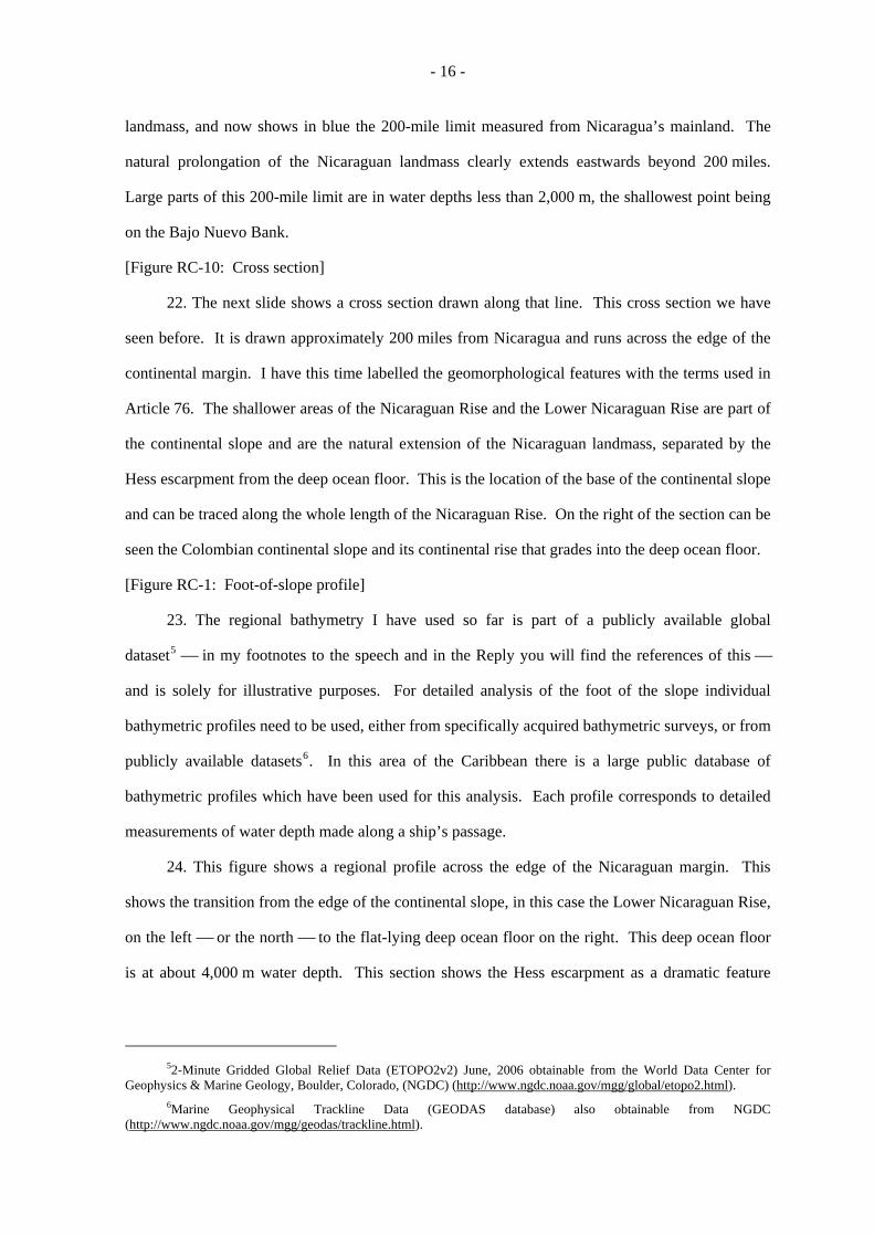
[Figure RC-9: Bathymetric map with Nic 200M limit]
21. I will now turn to the application of these formulæ to the Nicaraguan continental shelf.
The map now on your screen shows the simplified bathymetry with shallow areas in red,
intermediate depths in green and deep water areas in blue. I will use this base map for a number of
the figures. It demonstrates the shallow water extension to the north-east of the Nicaraguan
3Art. 76 4 (a) (ii). 4Art. 76 4 (a) (i).
- 16 -
landmass, and now shows in blue the 200-mile limit measured from Nicaragua’s mainland. The
natural prolongation of the Nicaraguan landmass clearly extends eastwards beyond 200 miles.
Large parts of this 200-mile limit are in water depths less than 2,000 m, the shallowest point being
on the Bajo Nuevo Bank.
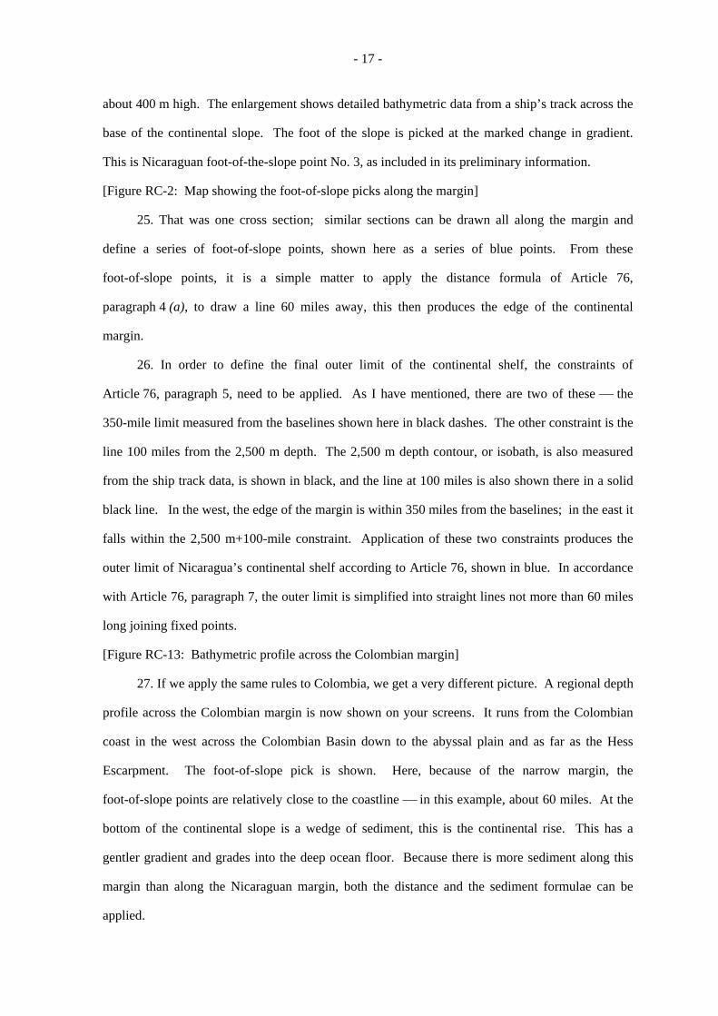
[Figure RC-10: Cross section]
22. The next slide shows a cross section drawn along that line. This cross section we have
seen before. It is drawn approximately 200 miles from Nicaragua and runs across the edge of the
continental margin. I have this time labelled the geomorphological features with the terms used in
Article 76. The shallower areas of the Nicaraguan Rise and the Lower Nicaraguan Rise are part of
the continental slope and are the natural extension of the Nicaraguan landmass, separated by the
Hess escarpment from the deep ocean floor. This is the location of the base of the continental slope
and can be traced along the whole length of the Nicaraguan Rise. On the right of the section can be
seen the Colombian continental slope and its continental rise that grades into the deep ocean floor.
[Figure RC-1: Foot-of-slope profile]
23. The regional bathymetry I have used so far is part of a publicly available global
dataset5 ⎯ in my footnotes to the speech and in the Reply you will find the references of this ⎯
and is solely for illustrative purposes. For detailed analysis of the foot of the slope individual
bathymetric profiles need to be used, either from specifically acquired bathymetric surveys, or from
publicly available datasets6. In this area of the Caribbean there is a large public database of
bathymetric profiles which have been used for this analysis. Each profile corresponds to detailed
measurements of water depth made along a ship’s passage.
24. This figure shows a regional profile across the edge of the Nicaraguan margin. This
shows the transition from the edge of the continental slope, in this case the Lower Nicaraguan Rise,
on the left ⎯ or the north ⎯ to the flat-lying deep ocean floor on the right. This deep ocean floor
is at about 4,000 m water depth. This section shows the Hess escarpment as a dramatic feature
52-Minute Gridded Global Relief Data (ETOPO2v2) June, 2006 obtainable from the World Data Center for
Geophysics & Marine Geology, Boulder, Colorado, (NGDC) (http://www.ngdc.noaa.gov/mgg/global/etopo2.html). 6Marine Geophysical Trackline Data (GEODAS database) also obtainable from NGDC
(http://www.ngdc.noaa.gov/mgg/geodas/trackline.html).
- 17 -
about 400 m high. The enlargement shows detailed bathymetric data from a ship’s track across the
base of the continental slope. The foot of the slope is picked at the marked change in gradient.
This is Nicaraguan foot-of-the-slope point No. 3, as included in its preliminary information.
[Figure RC-2: Map showing the foot-of-slope picks along the margin]
25. That was one cross section; similar sections can be drawn all along the margin and
define a series of foot-of-slope points, shown here as a series of blue points. From these
foot-of-slope points, it is a simple matter to apply the distance formula of Article 76,
paragraph 4 (a), to draw a line 60 miles away, this then produces the edge of the continental
margin.
26. In order to define the final outer limit of the continental shelf, the constraints of
Article 76, paragraph 5, need to be applied. As I have mentioned, there are two of these ⎯ the
350-mile limit measured from the baselines shown here in black dashes. The other constraint is the
line 100 miles from the 2,500 m depth. The 2,500 m depth contour, or isobath, is also measured
from the ship track data, is shown in black, and the line at 100 miles is also shown there in a solid
black line. In the west, the edge of the margin is within 350 miles from the baselines; in the east it
falls within the 2,500 m+100-mile constraint. Application of these two constraints produces the
outer limit of Nicaragua’s continental shelf according to Article 76, shown in blue. In accordance
with Article 76, paragraph 7, the outer limit is simplified into straight lines not more than 60 miles
long joining fixed points.
[Figure RC-13: Bathymetric profile across the Colombian margin]
27. If we apply the same rules to Colombia, we get a very different picture. A regional depth
profile across the Colombian margin is now shown on your screens. It runs from the Colombian
coast in the west across the Colombian Basin down to the abyssal plain and as far as the Hess
Escarpment. The foot-of-slope pick is shown. Here, because of the narrow margin, the
foot-of-slope points are relatively close to the coastline ⎯ in this example, about 60 miles. At the
bottom of the continental slope is a wedge of sediment, this is the continental rise. This has a
gentler gradient and grades into the deep ocean floor. Because there is more sediment along this
margin than along the Nicaraguan margin, both the distance and the sediment formulae can be
applied.
- 18 -
[Figure RC-3: Sediment thickness profile]
28. This section shows the sediment thickness from a profile starting at the foot of the slope
and extending across the Colombian Basin. These data are based on a regional compilation of
sediment data also publicly available7. The figure shows the sediment thickness decreasing from
about 4,000 m at the foot of the slope ⎯ that is on the left of the green diagram ⎯ to about
1,000 m on the right-hand side, as it approaches the deep ocean floor. The green line shows the
points where the sediment thickness is 1 per cent of the distance from the foot of the slope. The
edge of the continental margin is given by the point where the sediment is 1 per cent of the distance
from the foot of the slope, in this case the point has 2,200 m ⎯ or 2.2 km ⎯ of sediment and is
220 km from the foot of the slope.
[Figure RC-14: Map of the Colombian margin calculated using Article 76]
29. This map shows the results of applying these Article 76 formulae to the Colombian
margin. The foot-of-slope points are all relatively close to the coastline apart from a small area in
the west where the Magdalena Fan extends across the subduction zone between the Caribbean and
South American Plates. The blue points are measured using the 60-miles Hedberg or distance
formula; the green points are calculated using the 1 per cent sediment thickness formula. The
combination of these gives the limit of the Colombian continental margin. This margin is
everywhere landward of the 200-mile limit, apart from a small area close to Panama in the west.
30. All this geology and geomorphology is summarized and can be seen more vividly on this
fly-through animation. This uses the same data as the perspective diagram which I showed you
earlier.
[Figure RC-4: Animated fly-through]
31. We start on the mainland of Nicaragua. Looking to the east, we fly slowly across the
shallow shelf, and then start to descend the giant steps leading down to the deep sea floor. Firstly,
we cross the Pedro Bank Fracture Zone onto the Lower Nicaraguan Rise, and then down over the
Hess Escarpment ⎯ which, as you can see is a pronounced underwater cliff, 2,000 m high in some
parts. The foot-of-the-slope points are shown as those orange dots, and the edge of Nicaragua’s
7Sediment thickness data are available from http://www.ngdc.noaa.gov/mgg/sedthick/sedthick.html. Reference: Divins, D.L., Total Sediment Thickness of the World's Oceans & Marginal Seas, NOAA National Geophysical Data Center, Boulder, CO, 2003.
- 19 -
continental shelf in that orange line. We now turn south and fly across the abyssal plain towards
the Colombian margin. The abyssal plain is markedly flat and smooth compared with the
continental blocks that form the Nicaraguan Rise. As I have mentioned, this margin is formed by a
subduction zone where the Caribbean Plate slides under the South American Plate and is relatively
narrow and steep. In the west, a sediment fan has formed at the mouth of the Magdalena River,
extending across the trace of the subduction zone. The foot-of-slope points and the edge of the
margin measured using the two formulae are shown. We fly back north again across the abyssal
plain, across the Hess escarpment and towards San Andrés and Providencia and look back towards
the Nicaraguan land mass. Finally, we zoom out to the east where we can see the full extent of
Nicaragua’s natural prolongation along the Nicaraguan Rise.
E. Obligations with respect to CLCS and preliminary information
32. I would now like to discuss the process of making a submission to the Commission on
the Limits of the Continental Shelf (the Commission). Coastal States must submit information on
the breadth of the continental shelf where it extends beyond 200 miles to the Commission, who will
review the data and make recommendations on the basis of which the coastal State can then
establish the outer limits of its continental shelf8.
33. The provisions of Article 76 on the definition of the continental shelf are without
prejudice to questions of delimitation; in addition, the rules of procedure of the Commission mean
that it cannot consider any submission where it has been notified of a dispute9.
[SPLOS/183 ⎯ tab 44]
34. States have ten years from the date of becoming a party to the Convention to make such
submissions, but for States that ratified before 1999, the deadline was extended till May 2009.
However, it became apparent that many States, especially the less developed, would have difficulty
completing the onerous data collection and analysis process and meeting this deadline, and in June
2008 at their 18th meeting, the States parties to the Convention decided that this deadline may be
satisfied by submitting to the Secretary-General preliminary information indicative of the outer
8Art. 76, para. 8. 9Art. 76, para. 10.
- 20 -
limits of the continental shelf beyond 200 nautical miles, and a description of the status of
preparation and intended date of making a submission in accordance with the requirements of
Article 76 of the Convention and the Rules of Procedure and Scientific and Technical Guidelines of
the Commission10. The relevant part of the text of this decision, which is SPLOS/183, is shown on
the screen. Such preliminary information would not prejudice a full submission, and would not be
considered by the Commission.
35. Nicaragua ratified the Convention in May 2000, and submitted preliminary information
indicative of the limits of the continental shelf in April 2010, within the ten-year deadline. The
preliminary information is available on the Commission’s website11 and the technical annexes to
this were included as Annexes 16 to 18 in Nicaragua’s Reply.
The basic technical and other preparatory work that is required in order for Nicaragua to
make a full submission is well advanced. Nicaragua has established the outer limit of its
continental shelf beyond 200 miles on the basis of available public domain datasets, as I have
shown you, and intends to acquire additional survey data in order to complete the information to be
submitted to the Commission in accordance with Article 76 of the Convention and the Scientific
and Technical Guidelines of the Commission. In the preliminary information, we indicated that
such work will be carried out taking into account the judgment of the Court in this case.
F. Summary
36. Mr. President, this brings me towards the end of my presentation. Although the concept
of the continental shelf is simple in theory, in practice its legal and scientific definition is more
complex and Article 76 is one of the most challenging in the Convention.
[Figure RC 19/20: Bathymetric chart]
37. My final graphic has simplified the continental shelf to its essential elements that you can
now see on your screen. This map shows a very simplified bathymetry divided into the four
components identified in Article 76, paragraph 3: that is, the physical shelf, the slope, rise and
deep ocean floor. The physical shelf is shown in red, the slope and rise together in green, and the
10SPLOS 183 available from the UN website at: http://daccess-dds-ny.un.org/doc/UNDOC/GEN/N08/398/76/PDF/N0839876.pdf?OpenElement. 11http://www.un.org/Depts/los/clcs_new/submissions_files/preliminary/nic_preliminaryinformation2010.pdf.
- 21 -
deep ocean floor in blue. Colombia’s 200 mile limit is now shown as a dark pink line; it is nearly
everywhere on deep ocean floor about 4000 m deep; Colombia’s continental margin and its natural
prolongation do not extend as far as 200 miles. In contrast, Nicaragua’s 200-mile limit, shown now
in blue, is throughout its length in water depths generally less than 2500 m and is entirely on the
continental slope; Nicaragua’s continental margin and natural prolongation extend well past
200 miles to a distance of about 500 miles. The difference between these margins is plain to see.
38. Mr. President, Members of the Court, that concludes my presentation. I thank you for
your kind attention and I respectfully ask you to allow Professor Lowe to continue on behalf of
Nicaragua.
The PRESIDENT: Thank you very much. May I give the floor to Professor Vaughn Lowe.
You have the floor, Sir.
Mr. LOWE:
CONTINENTAL SHELF ENTITLEMENT AND DELIMITATION
Thank you, Mr. President, Members of the Court: it is an honour to appear before you, and
to have been entrusted with the presentation of this part of the submissions of the Republic of
Nicaragua.
Scope of question
1. The scope of the question now before you was defined by the Court, in its Judgment in
2007, at paragraph 42: “the questions which constitute the subject-matter of the dispute between
the Parties on the merits are, first, sovereignty over territory (namely the islands and other maritime
features claimed by the Parties) and, second, the course of the maritime boundary between the
Parties”.
2. The first question is addressed by my colleagues, Professor Remiro Brotóns and
Professor Oude Elferink, who explain that the maritime features that are permanently above water
(apart from San Andrés, Providencia, Santa Catalina and the other islands, islets and reefs that form
part of the San Andrés Archipelago) belong to Nicaragua; and that, for its part, Quitasueño is not
among those features, because it is permanently submerged.
- 22 -
3. I shall address the second question: the basic principles concerning Nicaragua’s
continental shelf entitlement and the delimitation of the maritime boundary. It is necessary to do so
because, although the geography of this case is a little unusual ⎯ Nicaragua has been endowed by
nature with a very much wider physical continental margin than has Colombia ⎯ the basic legal
principles are as binding in this case as they are in any other.
Basic principles of maritime boundary delimitation
[Tab 46 ⎯ Five basic principles of continental shelf delimitation]
4. Maritime delimitation must be consistent with basic legal principles. In our view, five
basic principles, not in themselves controversial, frame the question that is now before the Court.
They are on the slide, at tab 46:
(a) The continental shelf is the natural prolongation of land territory ⎯ and as the ITLOS has
recently pointed out, in international law there is a single continental shelf, “without any
distinction being made between the shelf within 200 nautical miles and the shelf beyond that
limit”12.
(b) Continental shelf rights over the natural prolongation of a coastal State under the sea (whether
more or less than 200 nautical miles from the baselines) are an ipso facto and ab initio
entitlement, appertaining automatically to each coastal State by operation of law.
(c) The continental shelf is overlain, but is not extinguished or superseded, by the Exclusive
Economic Zone (EEZ).
(d) Regardless of the geology or geomorphology of the sea-bed, an automatic entitlement to a
continental shelf within 200 nautical miles of coastal baselines now exists.
(e) The delimitation of maritime boundaries must achieve an equitable solution.
5. Let me emphasize two points. First, the single continental shelf up to and beyond
200 nautical miles from the baselines is an entitlement under customary international law. That is
the natural prolongation principle, articulated by this Court in the North Sea Continental Shelf
cases.
12Bangladesh/Myanmar, para. 361.
- 23 -
6. Second, Article 76 of the United Nations Convention on the Law of the Sea limits that
entitlement under customary international law: it does not create or extend it.
7. You have the full text of Articles 76 and 77 set out in your folders at tab 47.
8. You will see that Article 76, paragraph 1, says what the continental shelf is. Article 77,
paragraphs 1, 2 and 3, then declare that coastal State rights over the continental shelf exist
automatically and, in the words of Article 77, paragraph 3, do not depend upon occupation,
notional or effective, or on any express declaration. Article 76, paragraph 2, fixes an outer limit for
the continental shelf entitlement in so far as it extends beyond 200 nautical miles from the coast.
9. Nicaragua’s continental shelf entitlement is limited by Article 76. Colombia’s
entitlement, in this case, is not limited by Article 76. Colombia, whose natural prolongation falls,
for the most part, well short of 200 nautical miles from the coast, benefits from the more generous
distance criterion introduced into international law by UNCLOS III, which I shall explain in a
moment
10. In the present case, Nicaragua’s position is that the achievement of an equitable solution
is subordinate to the legal basis of entitlement. You will find that in our Reply at paragraphs 3.12
and 3.14. Delimitation can only take place after one has decided what is the area that needs to be
delimited. That is:
⎯ one must first consider what legal continental shelf entitlement is generated by each State
Party’s territory, disregarding actual or possible claims by the other State Party; and
⎯ then one must consider how far the entitlements of the Parties overlap, and make an equitable
delimitation of the area of overlap between the Parties.
11. The five principles in tab 47 are not in themselves controversial.
[Tab 48 ⎯ Five basic principles of continental shelf delimitation (a), (b) only]
12. Let me address first, principles (a) and (b), both of which are concerned with the
automatic entitlement of every coastal State to sovereign rights over the resources of the sea-bed
that is the natural prolongation of its land territory, throughout the entire continental margin. Those
principles are set out at tab 48.
- 24 -
13. Those two principles are reflected in the first part of the definition in UNCLOS
Article 76, paragraph 1. It is common ground that this provision reflects customary international
law: this is clear from page 306 of the Counter-Memorial, and paragraph 3.12 of our Reply. And
in any event, the fact that Colombia is not a party to the 1982 Convention can scarcely deprive
Nicaragua of its rights under the Convention and under general international law, which fully
coincides with the Convention in this respect.
14. Dr. Cleverly has already taken you to UNCLOS Article 76, paragraph 1, which stipulates
that “the continental shelf of a coastal State comprises the sea-bed and subsoil of the submarine
areas that extend beyond its territorial sea throughout the natural prolongation of its land territory
to the outer edge of the continental margin”. He took you to Article 76, paragraph 3, which asserts
that “the continental margin comprises the submerged prolongation of the land mass of the coastal
State, and consists of the sea-bed and subsoil of the shelf, slope and rise”.
15. Well it is trite law, established since the 1969 North Sea Continental Shelf cases, that the
entitlement to those areas ⎯ or more precisely, to the sovereign rights over those areas which
constitute the legal régime of the continental shelf ⎯ arises automatically by operation of law. The
rights exist ipso facto and ab initio.
16. The legal régime of the continental shelf emerged from the 1945 Truman Proclamation.
In the Abu Dhabi arbitration in 1952, its legal status was said still to be uncertain. But by 1956 the
International Law Commission was able to lay down the basic principles clearly and confidently,
and these were included in Article 2 of the 1958 Continental Shelf Convention, which was said by
this Court in the North Sea Continental Shelf cases, at paragraph 63, to have “reflected” or
“crystallized” received or at least emergent rules of customary international law.
17. And that principle is now reflected in UNCLOS Article 77, paragraph 3: “The rights of
the coastal State over the continental shelf do not depend on occupation, effective or notional, or on
any express proclamation.”
18. So these provisions express the well-established legal principles: (a) that the continental
shelf is generated by the land territory of the coastal State, and is its natural prolongation under the
sea, and (b) that the continental shelf is an ipso facto and ab initio entitlement of the coastal State,
appertaining automatically to each coastal State by operation of law.
- 25 -
[Tab 46 again ⎯ Five basic principles of continental shelf delimitation]
19. Principle (c), the principle that “the continental shelf is overlain, but not extinguished or
superseded, by the EEZ”, is in our submission an aspect or consequence of the other principles.
20. The United Nations Convention on the Law of the Sea was 15 years in the making. The
architecture of the Convention was apparent in the “negotiating texts” at least seven years before its
adoption in 1982. That architecture consistently maintained distinct provisions for the continental
shelf, now in Part VI of the Convention, and for the EEZ, now in Part V of the Convention. Those
parts of the Convention co-exist, and the EEZ and the continental shelf co-exist.
21. There is not the slightest hint in the Convention that one supersedes or trumps or cancels
out the other. And in particular, there is nothing in the Convention that even hints at the possibility
that the ipso facto and ab initio entitlement of the coastal State to its continental shelf, which is set
out explicitly in the Convention itself, is in any way compromised by the provisions on the EEZ.
But in fact our friends in Colombia make out no case to the contrary, so it is unnecessary to say
more about this.
22. Similarly, it is common ground that principle (d), the automatic entitlement to a
continental shelf out to 200 nautical miles ⎯ subject, of course, to delimitation ⎯ is now part of
customary international law, reflected in UNCLOS Article 76, paragraph 1. And you will see that
in the Counter-Memorial at page 306, and again in paragraph 3.12 of our Reply.
23. And there is no disagreement over principle (e): that the delimitation of maritime
boundaries must achieve an equitable solution.
Application of basic principles
Natural prolongation
24. I turn now, Mr. President, to the application of those principles in the context of the
present case.
[Tab 49 ⎯ Perspective view over the SW Caribbean]
- 26 -
25. First, what is the natural prolongation of Nicaragua’s territory? Colombia says that
Nicaragua “invented its outer continental shelf claim”13. But the existence of a continental shelf is
essentially a question of fact. The law stipulates how we ascertain the geographical limits of what
is an actual physical phenomenon. As the ITLOS put it in Bangladesh/Myanmar, at
paragraphs 434 and 437,
“the notion of natural prolongation and that of continental margin under article 76, paragraphs 1 and 4, are closely interrelated. They refer to the same area.
. . . . . . . . . . . . . . . . . . . . . . . . . . . . . . . . . . . . . . . . . . . . . . . . . . . . . . . . . . . . . . . .
the reference to natural prolongation in article 76, paragraph 1, of the Convention, should be understood in light of the subsequent provisions of the article defining the continental shelf and the continental margin. Entitlement to a continental shelf beyond 200 nautical miles should thus be determined by reference to the outer edge of the continental margin, to be ascertained in accordance with article 76, paragraph 4. To interpret otherwise is warranted neither by the text of article 76 nor by its object and purpose.”
26. Every coastal State has continental shelf rights over the legal continental shelf, which is
the continental margin that exists in fact. I shall turn shortly to the 200-nautical-mile “distance”
element in the definition of the continental shelf in Article 76.
27. And it is firmly established that the entitlement to continental shelf rights appertains
automatically to the coastal State: the rights exist ipso facto and ab initio.
28. So what is the “natural prolongation” of Nicaragua’s landmass under the sea? The
geology speaks for itself; and Dr. Cleverly has explained it to you. And the most striking fact is
that Nicaragua’s landmass continues under the sea in a north-easterly direction for about
500 nautical miles, overlapping Colombia’s 200-nautical-mile zone. Hence the need for
delimitation.
29. What is the natural prolongation of Colombia’s territory? Again, Dr. Cleverly has
explained this. And the plain fact is that Colombia has no natural prolongation beyond the line
marking the outer limits of its 200-nautical-mile zone.
13RC, para. 4.39.

- 27 -
The sea-bed within 200 nautical miles
30. Of course, Colombia is also entitled in principle to claim continental shelf rights in
relation to the sea-bed within 200 nautical miles of the coast of its mainland, under the distance
criterion in Article 76, paragraph 1. Nicaragua accepts the prima facie entitlement to a
200-nautical-mile continental shelf is automatic, in the same way that the entitlement to continental
shelf rights over the physical continental margin is automatic. But that does not, of course,
guarantee that in this, or any other case, every coastal State will in fact be given its full 200 nautical
miles. Indeed, the need for delimitation arises precisely because it is not possible to give every
State its full prima facie entitlement.
[Tab 50 ⎯ The islands]
The islands
31. The islands claimed by Colombia, as distinct from the Article 121, paragraph 3, “rocks”
and low-tide elevations that it claims, also have an entitlement to a continental shelf. Entitlement,
however, is a legal principle that is quite distinct from the question of delimitation. As
Professor Pellet will show, the practice established by this Court and other tribunals has not been to
presume that islands necessarily have a full 200-nautical-mile entitlement: the zones attaching to
these features may ⎯ and in our submission in this case do ⎯ need to be enclaved.
32. We have submitted that all the maritime features in the area that are permanently above
water (other than San Andrés, Providencia and Santa Catalina, and the other islands, islets and reefs
that form part of the San Andrés Archipelago) belong to Nicaragua. Professor Oude Elferink has
told you about these minor maritime features, and explained that Quitasueño is a maritime feature
that has no islands ⎯ it is permanently submerged. The other features, such as the small cays on
the top of the banks of Serrana and Roncador, and the East Southeast Cays, and the cays on the
banks of Serranilla and Bajo Nuevo, are technically islands: but they are all incapable of
sustaining human habitation or economic life of their own, and they have no entitlement to an EEZ
or a continental shelf. In UNCLOS terms, they fall within Article 121, paragraph 3. Only
San Andrés, Providencia and Santa Catalina generate an entitlement to a continental shelf.
- 28 -
33. Well, an examination of the map shows that all of these minor maritime features lie on
what is the natural prolongation of Nicaragua’s landmass. None of them, not one of them, lies on
the natural prolongation of Colombia’s landmass: and that is a matter of fact, not of argument.
34. Title to them is not a matter of fact, but a question of law. But there are only two
possibilities. They belong to Nicaragua, or to Colombia. No other State has any claim to them.
And Nicaragua’s case is that whether they belong to Nicaragua or to Colombia, these minor
maritime features should be enclaved, and not treated as if they were mainland coasts or significant
offshore features.
35. This point will be developed this afternoon by Professor Pellet; but I recall at this stage
the fact that as a matter of geometry, tiny features can have dramatic effects.
[Tab 51 ⎯ 12 miles from a rock]
36. A rock the size of this lectern ⎯ if it were above water at high tide and therefore an
“island” within the meaning of UNCLOS Article 121, paragraph 1, and Article 10, paragraph 1, of
the 1958 Territorial Sea Convention ⎯ would generate an entitlement to over 452 square miles of
sea, if it were given a 12-mile territorial sea. The geometry is shown in Figure IV at the end of
Volume 1 of Nicaragua’s Memorial. That is the same area of territorial sea as is generated by
37.7 nautical miles of coastline. A rock the size of this lectern would generate a larger territorial
sea than is generated by the entire coastline of Belgium.
37. Well, that would be one thing if the rock were in mid-ocean, and the area around it would
otherwise be high seas. But it is quite another matter if the rock sits on the continental shelf of
another State, and the circle of sea around it is carved out of what would otherwise be that State’s
entitlement. Hence Nicaragua’s argument that a 3-mile enclave is an equitable solution.
Colombia’s argument that Nicaragua’s continental shelf rights are extinguished
38. Colombia does not seriously dispute Nicaragua’s entitlement to its continental shelf. The
Rejoinder has a section ⎯ paragraph 4.37 ⎯ headed (in capital letters) “There are No Areas of
Extended Continental Shelf in the Western Caribbean”. It consists of 120 words and the point it
makes is that the western Caribbean all falls within 200 nautical miles of one State or another.
- 29 -
39. That may be so. But the suggestion that it would therefore follow that any continental
shelf entitlement of one State within 200 nautical miles of another State is extinguished ⎯ that a
continental shelf entitlement based on the 200-nautical-mile distance criterion in UNCLOS
Article 76 somehow trumps or extinguishes or prevails over a continental shelf entitlement based
on the geological, natural prolongation, criterion in Article 76 ⎯ is baseless and obviously wrong.
40. There is nothing in UNCLOS or in customary international law that suggests this
conclusion.
[Tab 52 ⎯ Article 76, paragraph 1]
41. Let me take you again to the text of UNCLOS Article 76:
“The continental shelf of a coastal State comprises the sea-bed and subsoil of the submarine areas that extend beyond its territorial sea throughout the natural prolongation of its land territory to the outer edge of the continental margin, or to a distance of 200 nautical miles from the baselines from which the breadth of the territorial sea is measured where the outer edge of the continental margin does not extend up to that distance.”
42. Article 76 refers to two, alternative, criteria for the extent of the continental shelf:
natural prolongation and distance. A coastal State has an entitlement to continental shelf rights
over its entire continental margin. A coastal State also has an entitlement to continental shelf rights
over all areas within 200 nautical miles of its baselines. But these alternatives simply create
alternative bases for title to the continental shelf. To quote the ITLOS again, there is a single
continental shelf: there is no difference in law between the continental margin proper, and the
sea-bed within 200 nautical miles of the coast which is deemed, regardless of its geology, to be part
of the coastal State’s continental shelf14.
43. Colombia refers, in its Rejoinder at paragraph 4.58, to a statement in the Libya/Malta
case that the geological or geophysical characteristics of a State’s coast are completely immaterial
to issues of entitlement and delimitation. But Colombia twists what the Court said in that case.
44. I invite you to read the passage, at paragraphs 39 and 40 of the Judgment of
3 June 1985 ⎯ it is too long to quote in full.
14Bangladesh/Myanmar, para. 361.
- 30 -
45. But it is plain beyond doubt that in that passage in Libya/Malta the Court was addressing
a situation where the continental shelf claims of both States lay within 200 nautical miles of their
coasts.
46. The distance between Libya and Malta is less than 200 nautical miles in total. Since each
State was entitled to the sea-bed within 200 nautical miles of its coast, and that was the case for the
entirety of the area in question, the existence of any geomorphological discontinuities was indeed
irrelevant in that case, both to questions of entitlement and to questions of delimitation.
47. But that says nothing about the situation where the States are more than 400 nautical
miles apart, and the entitlement of one State, based on the natural prolongation of its land
territory ⎯ its continental margin, in terms of UNCLOS Article 76, paragraph 1 ⎯ overlaps with
an entitlement of the other State based on distance from the coast ⎯ the alternative
200-nautical-mile criterion in UNCLOS Article 76, paragraph 1.
48. In such circumstances, the entitlement of the first State is not simply ignored or
extinguished. There are overlapping claims, and there must be a delimitation.
49. Well, Colombia tries to muddy these crystal-clear waters by throwing in a reference to
the expert geologists, geophysicists and hydrographers who make up the Commission on the Limits
of the Continental Shelf under UNCLOS Annex II. Colombia says ⎯ in the Rejoinder,
paragraph 4.42 ⎯ that Nicaragua cannot be deemed to have established any rights to an extended
continental shelf unless and until it has followed the steps set out in UNCLOS Article 76 and
Annex II to submit the co-ordinates of its continental shelf to the Commission.
50. Colombia notes that “the Commission will not even examine such claims unless the
relevant parties consent”. And the implication seems to be that by withholding consent, a “relevant
party” could prevent ⎯ apparently indefinitely ⎯ the “establishment” of rights over the “extended
continental shelf”, as Colombia calls it.
51. Quite how Colombia can rely on a procedure set out in a treaty to which it is not a party
is not explained. But Colombia’s point also collapses for other reasons.
52. First, as I have explained, the rights over the continental shelf, as defined in international
law, attach automatically to the coastal State. That is clear from the consistent and unquestioned
jurisprudence of the Court over the past 40 years; and it is reflected in UNCLOS Article 77.
- 31 -
Neither Nicaragua nor any other coastal State has to “establish” its rights. It has those rights, now,
as we stand here.
53. Second, Colombia’s argument is no more convincing because it uses the term “extended
continental shelf”. That term is not used anywhere in the Law of the Sea Convention. The sea-bed
within 200 nautical miles of the coast, which is deemed ⎯ regardless of its geomorphology ⎯ to
be part of the legal continental shelf, and, on the other hand, the sea-bed that is part of the
continental margin and is thus the natural prolongation of the land territory of the State, are both,
equally, part of the legal concept of the continental shelf [see UNCLOS Article 76 (1)]. This was
recognized by the Tribunal in Barbados/Trinidad at paragraph 213, and by the ITLOS in
Bangladesh/Myanmar at paragraph 361. Nicaragua is “extending” nothing: it is referring,
accurately, to the continental shelf that international law has already ascribed to it, no more and no
less.
54. And I note in passing the alarming suggestion that until the Commission on the Limits of
the Continental Shelf has examined and approved the outer limit lines for the continental margin,
notified by coastal States parties to UNCLOS under Article 76 (7) and (8), a coastal State has no
established rights to its “extended” continental shelf. If that were correct, one wonders what the
position of non-UNCLOS parties, such as the United States of America, would be. Presumably,
they could never establish such rights.
55. One wonders what the position of States parties would be if their limits are not among
the 59 that had been filed with the Commission by January of this year15 ⎯ although the actual
number of States parties filing their limits is rather smaller than that: the 59 submissions include
separate filings in respect of the Celtic Sea and the Bay of Biscay, Ascension Island, the Hatton
Rockall Area, and the Falkland Islands, all made by the United Kingdom. Many other States, such
as China, have not yet made submissions, although quite a few of them have, like China, and Chile,
Fiji, France, Mauritius, Mexico, New Zealand, Spain, and Nicaragua, sent preliminary information
regarding all or part of their limits to the Secretary-General of the United Nations.
15http://www.un.org/Depts/los/clcs_new/commission_submissions.htm.
- 32 -
56. One wonders what the position of a coastal State wishing to exploit part of its continental
shelf beyond 200 miles from its coast would be if another State objected to part of that State’s
notified outer limit lines ⎯ perhaps a part far removed from the projected exploitation site ⎯ so
that the Commission would defer consideration of the submission16.
57. And one wonders what the position of any State would be while it awaits the completion
of the Commission’s consideration of the submissions as it works to clear its backlog. In a
presentation in 201017 the Commission itself estimated that at its current rate of work it will take it
until 2035 to complete its work.
58. But of course Colombia’s suggestion is not correct. There is no support for the argument
that a coastal State’s continental shelf rights depend upon securing a “recommendation”, and that is
the term for the Commission’s decision: see UNCLOS Article 76, paragraph 8, and Annex II,
Articles 6 onwards which you will find at tab 47 in you folder. That is the recommendation given
by the Commission18.
59. Continental shelf rights exist ipso facto and ab initio, by operation of law. And the legal
right no more depends upon making the submission to the Commission and the settling of precise
agreed outer limits than my liability to pay income tax depends upon me submitting my tax form
and agreeing my precise liability with the tax authorities.
60. What submission and agreement with the Commission does do is, at least as between
UNCLOS States parties, to put the legality of the outer limit established in accordance with the
Commission recommendations beyond legal challenge. “The delimitation of sea areas has always
an international aspect: it cannot be dependent merely upon the will of the coastal State as
expressed in its municipal law” as the Court rightly said in the Anglo-Norwegian Fisheries case
(Fisheries, Judgment, I.C.J. Reports 1951, p. 132). And the Commission provides the review of
the “international aspect” of the outer limit lines. Its role is to help to confirm the location of the
outer limits of a State’s entitlement. But its role is not to create legal title.
16http://www.un.org/Depts/los/clcs_new/commission_submissions.htm, para. 43. 17http://www.un.org/depts/los/clcs_new/workload/2010_04_14_workload_presentation.pdf, p. 4. 18http://www.un.org/Depts/los/clcs_new/commission_recommendations.htm.
- 33 -
61. And you will notice that it only “helps to confirm” that location. Under UNCLOS
Article 76, paragraph 8, it is not the Commission that establishes the limits: “The limits of the shelf
established by a coastal State on the basis of these recommendations shall be final and binding.”
(Emphasis added.)
62. Approval by the Commission does not create continental shelf rights. And the absence
of approval by the Commission does not cancel continental shelf rights. And the fact that some
States have, as Colombia notes ⎯ paragraph 4.61 of its Rejoinder ⎯ limited the continental shelf
claims that they have notified to the Commission to areas that lie more than 200 miles from the
nearest third States does not prove that sea-bed rights within 200 nautical miles trump or extinguish
overlapping rights based upon the natural prolongation criterion under UNCLOS Article 76 (1).
63. There is a third reason for rejecting Colombia’s argument. UNCLOS Article 76,
paragraph 10, says: “The provisions of this article are without prejudice to the question of
delimitation of the continental shelf between States with opposite or adjacent coasts.” As the
Virginia Commentary on the Law of the Sea Convention puts it:
“This provision emphasizes that Article 76 prescribes the method of determining the outer limits of the continental shelf; it does not address in any way the question of delimitation of the continental shelf between opposite or adjacent States, which is addressed exclusively in article 83.”19
You will find that at tab 53 in your folder.
64. And fourth, the argument was thoroughly considered and decisively rejected by the
ITLOS in paragraphs 368-394 of its judgment in Bangladesh/Myanmar. There the ITLOS found
that the pendency of a recommendation from the Commission on the Limits of the Continental
Shelf did not preclude delimitation by the ITLOS and did not render it inappropriate for the ITLOS
to make such a delimitation.
65. As for the argument that Nicaragua’s continental shelf rights beyond 200 miles are
“treaty-based” and not opposable to Colombia20, the answer is that Nicaragua’s entitlement is the
automatic result of its natural prolongation. That basis of entitlement to continental shelf rights
was recognized by the Court in 1969 in the North Sea Continental Shelf cases as a rule of
19J. N. Moore et al., United Nations Convention on the Law of the Sea 1982: A Commentary, Vol. II, 1993,
p. 883, para. 76.18 (m). 20RC, para. 4.38.
- 34 -
customary international law. It is a sufficient basis for Nicaragua’s claim here. If anything in the
Article 76 definition of the continental shelf could be described as a treaty-law innovation that went
beyond customary international law, it is the idea that a State is entitled to a 200-nautical-mile
continental shelf regardless of geology or the geomorphology of its natural prolongation.
Colombia’s argument based on its EEZ
66. Mr. President, Members of the Court, I have made the point that two continental shelf
entitlements, one based on natural prolongation, the other based on distance, can overlap. Neither
entitlement extinguishes the other entitlement and the area of overlap must be delimited. That is
the case here.
67. The argument that a distance-based, 200-nautical-mile continental shelf trumps a
continental shelf entitlement based on natural prolongation is not correct. Of course, there may be
some circumstances where, in order to achieve an equitable result, all or part of the boundary may
be drawn around the 200-nautical-mile limit, leaving the whole of the 200-nautical-mile continental
shelf to the coastal State. But that is not because the 200-nautical-mile continental shelf claim
extinguishes the rights of the other State over the continental margin. It is because in the
circumstances of the particular case, it is necessary to draw the boundary in that way in order to
achieve an equitable result.
68. You will recall that the first part of the definition of the continental shelf in UNCLOS
Article 76, paragraph 1, confirms that the whole of the natural prolongation “to the outer edge of
the continental margin” remains part of the continental shelf of the coastal State. That safeguarded
the rights and interests of States with an extensive natural prolongation.
69. The interests of narrow shelf States, and the existence of the EEZ, on the other hand,
were accommodated in UNCLOS III in the second part of the Article 76 (1) definition, in the
200-nautical-mile criterion set out there.
- 35 -
[Tab 54 ⎯ Sovereign rights in the EEZ/CS]
70. The “natural prolongation” and “200 nautical mile” criteria are alternative definitions of
the geographical scope of the continental shelf entitlement of the coastal State ⎯ alternative bases
for claiming continental shelf rights. Articles 56, paragraph 1, and Article 77, paragraph 1, are
alternative bases for the assertion of rights over the sea-bed and subsoil.
71. But where does that get us? There is no indication ⎯ not the slightest suggestion or
hint ⎯ that to the extent that the “200 nautical mile” continental shelf claim of State A overlaps
with a “natural prolongation” continental shelf of State B, State B’s claim is extinguished or
trumped.
72. I have explained that there is nothing in UNCLOS, or in customary international law,
that establishes a distinction between a “first class” continental shelf within 200 nautical miles and
a “second class” continental shelf beyond 200 nautical miles; and the ITLOS has explicitly
rejected any such distinction21. There is simply nothing on which to base Colombia’s argument. It
is pure assertion and it is pure wishful thinking.
[Tab 55 ⎯ Overlapping Continental Shelf Entitlements]
73. The situation here is that there is an overlap of legal continental shelf entitlements that
calls for delimitation, so as to achieve an equitable result. You see that at tab 55.
[Tab 56 ⎯ Overlapping Continental Shelf Entitlements]
74. In our Reply we indicated one way of reaching what we consider an equitable result ⎯ a
line of equal division of the area of the overlapping physical continental margins of Nicaragua and
of Colombia. You will see that at tab 56.
[Tab 57 ⎯ Overlapping Continental Shelf Entitlements]
75. Another way might be to draw the median line between the outer limit of Nicaragua’s
continental margin and the outer limit of Colombia’s 200-nautical-mile continental shelf, and EEZ,
entitlement ⎯ between the juridical continental shelves. And, as this graphic ⎯ which is tab 57 ⎯
shows, it does not make much difference, as far as the delimitation line that results.
21Bangladesh/Myanmar, para. 361.
- 36 -
76. But what is important is to have the area of overlap delimited so as to achieve an
equitable result, and not to allow an entitlement based upon one limb of Article 76 to have an
automatic ⎯ and complete ⎯ priority over an entitlement based on the other limb. That is not
equitable; and that is not good law.
Colombia does not challenge the basis of Nicaragua’s case
77. Mr. President, my submissions are coming to a close and there are two conclusions to
emphasize. First, Colombia has not challenged, and cannot challenge, the fundamental principle of
the automatic appurtenance of the continental shelf to the coastal State. It has made arguments
referring to the structure and procedures of the 1982 Convention ⎯ the argument that its rights
over a 200-nautical-mile zone somehow extinguish Nicaragua’s continental shelf rights, and the
argument that receiving a recommendation from the Commission on the Limits of the Continental
Shelf is a legal precondition for an entitlement to continental shelf rights ⎯ but (quite apart from
the fact that the Convention is res inter alios acta as far as non-Parties such as Colombia are
concerned) those arguments are plainly without merit.
78. The fundamental legal principle of the automatic appurtenance of the continental shelf to
the coastal State stands unchallenged, as it has stood since this Court explained it forty years ago in
the North Sea Continental Shelf cases.
79. Second, it must be emphasized that for all its criticism of the technical adequacy of the
supporting information submitted by Nicaragua with its preliminary notification to the
Secretary-General of the United Nations, Colombia does not actually challenge Nicaragua’s
definition of its shelf, or even suggest that it is wrong. In paragraphs 4.48 to 4.59 ⎯ the section
headed “Nicaragua has not proved the limits of its own continental margin and the outer limit of
Colombia’s margin from its mainland coast is irrelevant” ⎯ Colombia criticizes Nicaragua’s
methodology, but it very carefully does not criticize Nicaragua’s conclusions. It does not deny that
Nicaragua’s continental margin is where Nicaragua says it is, and where all the published
oceanographic maps show it to be.
- 37 -
80. Mr. President, Members of the Court, that brings me to the end of my part of these
submissions. Unless I can be of further assistance to the Court, I would ask you to call upon my
colleague, Professor Oude Elferink, but you may think this is an opportune moment for a pause
café.
The PRESIDENT: Thank you, Professor. You are right. This is a good moment for the
pause café. The hearing is suspended for 15 minutes.
The Court adjourned from 11.20 a.m. to 11.35 a.m.
The PRESIDENT: Please be seated. The hearing is resumed. I invite Mr. Elferink to
address the Court. You have the floor, Sir.
Mr. ELFERINK:
THE ISLANDS, CAYS AND BANKS IN THE RELEVANT MARITIME AREA
1. Thank you, Mr. President. Mr. President, Members of the Court, today I will be mainly
dealing with two topics. First, I will provide you with a description of the islands and cays in the
relevant maritime area. And my other main topic concerns the bank of Quitasueño. Contrary to
what Colombia is claiming, I will set out that there are no islands on this bank and that it is totally
submerged. In between these two topics I will briefly comment on the, at times, misleading figures
in the written pleadings of Colombia.
The islands and cays in the relevant maritime area
2. Mr. President, I would now like to look in some more detail at Colombia’s arguments in
respect of the islands and cays it claims as its own and the islands and cays fringing the mainland
coast of Nicaragua.
3. Let me start with the latter. The Rejoinder submits that Nicaragua has taken an
inconsistent position on its own islands in connection with its continental shelf claim22. That is not
the case. As was already explained by Dr. Cleverly and Professor Lowe, earlier during this first
22RC, pp. 189-190, paras. 5.52-5.53.
- 38 -
round of pleadings, Nicaragua’s continental shelf entitlement is not based on distance from the
coast, but on the location of the outer edge of its continental margin. Nicaragua’s continental
margin extends from its mainland coast and fringing islands. In that sense, both the mainland coast
and fringing islands are taken into account.
4. As I set out on Monday, there are two groups of islands fringing the mainland coast of
Nicaragua ⎯ now on the screen23. To the north, this concerns the Cayos Miskitos, which centre on
the main island of the group, Miskito Cay. Further south, a similar chain of small islands fringing
Nicaragua’s mainland coast is found in the area between the Rio Grande and Punta de Perlas. This
concerns the Cayos Perlas and the Cayos Man of War. These cays are located between some 3 and
25 km from the mainland coast of Nicaragua. Further seaward ⎯ Big and Little Corn Island.
5. In the Reply, Nicaragua explained why the islands along its coast are fringing islands and
that they constitute an integral part of Nicaragua’s mainland coast. The Reply in that connection
pointed to the relevant case law24. The Rejoinder ignored this case law and only submitted that the
Corn Islands are 26 nautical miles from the mainland coast and that the territorial sea of the islands
and Nicaragua’s mainland coast does not overlap25. The Rejoinder fails to mention that there are
numerous small cays between the mainland and the Corn Islands and that as a consequence the
territorial seas of the two merge and overlap, as can be seen on the figure on the screen26, a fact that
was also mentioned in the Reply27.
6. For obvious reasons, the Rejoinder is silent on the distance between the Miskito Cays and
the Nicaraguan mainland. This tightly knit group is less than 10 nautical miles from the mainland
coast of Nicaragua. The Rejoinder does refer to the fact that no statistics are given for the
population of the Miskito Cays and that the population of the Corn Islands pales in comparison
with the population of Colombia’s islands28. As the Reply explained, the Miskito Cays are a
23Fig. AOE2-1, tab 58 of the judges’ folder. 24RN, pp. 110-114, paras. 4.15-4.24. 25RC, pp. 190-191, para. 5.55. 26Fig. AOE2-2, tab 59 of the judges’ folder. 27RN, p. 112, para. 4.17. 28RC, p. 191, para. 5.56.

- 39 -
natural reserve and the Corn Islands according to a 2009 estimate have some 7,400 inhabitants29.
What Colombia, of course, conveniently overlooks is that the population figure of an island is not
relevant to determining whether these islands are fringing islands, as is evident from the case law
discussed in the Reply.
7. Colombia has not even started to make a case that Nicaragua’s islands are not fringing
islands. As a consequence they have to be treated as a part of Nicaragua’s mainland coast. That
mainland coast is always relevant to the delimitation, either together with the fringing islands, or on
its own, if the Court were to consider that these islands are not fringing.
8. Mr. President, I would now like to briefly discuss the islands claimed by Colombia that
are located in the relevant delimitation area. In the Reply, Nicaragua took issue with the fact that
Colombia sought to artificially boost the significance of the Archipelago of San Andrés and
Providencia by various means30. The Rejoinder is less insistent in this respect, but at times still
seeks to give the impression that this is a tightly knit archipelago by, for instance, referring to them
as “a string of islands”31 and still devotes a whole section to the individual features that Colombia
considers to be part of the Archipelago of San Andrés32.
9. At first sight, the Rejoinder might give the impression that it provides a detailed and richly
illustrated overview of the Archipelago of San Andrés and the other islands claimed by Colombia.
However, on closer consideration it becomes clear that the Rejoinder is disturbingly superficial.
First of all, in the Reply, Nicaragua pointed out that Colombia’s Counter-Memorial did not provide
any figures concerning the size of individual cays. Nicaragua’s Reply provided information on the
size of the cays on the basis of information in the public domain. Unfortunately, due to Colombia’s
policy of excluding Nicaragua from the disputed area, which was discussed by the Agent of
Nicaragua this Monday, Nicaragua has not been in a position to confirm the size of cays by an
on-site inspection33. The Rejoinder also critiques Nicaragua for not addressing all of the features
29RN, p. 111, para. 4.17. 30RN, pp. 105-110, paras. 4.6-4.16. 31RC, p. 164, para. 5.12. 32RC, pp. 168-184, Chap. 5 (A) (2). 33RN, pp. 108-110, paras. 4.12-4.14.
- 40 -
concerned34. This actually is incorrect. Nicaragua, in the Reply, on the basis of the available
information, actually concluded that all of the cays are insignificant in size35. In particular,
Nicaragua concluded that Cayo Bajo Nuevo on the basis of the available information could not be
more than 100 m across, and the coast of Serranilla Cay, the largest cay on the bank of Serranilla,
facing Nicaragua measured some 400 m36. The Reply also concluded that the information on these
and the other cays available from nautical charts indicates that the coastal length of the cays facing
the Nicaraguan mainland coast in its totality does not add up to more than 0.9 km37. In the light of
Colombia’s criticism of the information provided by Nicaragua in the Reply, it is all the more
surprising that Colombia itself has not provided any accurate information on the size of the cays in
its Rejoinder.
10. The Rejoinder is equally superficial in its critique that Nicaragua has not substantiated
the position that the cays on the banks of Albuquerque, East-Southeast, Roncador, Serrana,
Serranilla and Bajo Nuevo are rocks in the sense of Article 121, paragraph 3, of the United Nations
Convention on the Law of the Sea. The Rejoinder limits itself to listing some of the activities that
have taken place at the cays but does not engage in any serious discussion as to whether these
activities imply that the cays do not fall under the definition of a rock under Article 121,
paragraph 3, of the 1982 Convention. For instance, in respect of Serrana Cay, the Rejoinder
submits that “a glance at the photograph [which is included in the Rejoinder] is sufficient to show
that Serrana cannot possibly be characterized as a ‘rock’”38. So, let us have a closer look at this
photograph39. It is actually rather hazy and it does not allow to determine any details or the size of
the cay. Obviously, this photograph also does not make it possible to establish whether the cay is
capable of sustaining human habitation or economic life of its own. Under Article 121 (3) of the
Convention, an island that does not meet at least one of these requirements does not have an
exclusive economic zone and continental shelf.
34RC, p. 171, para. 5.26. 35RN, pp. 108-110, paras. 4.12-4.14, especially at p. 110, para. 4.14. 36RN, pp. 108-109, paras. 4.12-4.13. 37RN, p. 110, para. 4.14. 38RC, p. 173, para. 5.29. 39Fig. AOE2-3, tab 60 of the judges’ folder.
- 41 -
11. Other photographs of the individual cays are equally nondescript. For instance, on
screen40 we now have the photograph of Bajo Nuevo Cay that is included in the Rejoinder41. The
part of the cay that is visible probably measures some tens of metres in its width, and its width may
even amount to less than 10 m. It certainly does not prove that Bajo Nuevo Cay is capable of
sustaining human habitation or economic life of its own.
12. So, what can we actually say about the capability of the cays to sustain human habitation
or economic life of their own? First of all, the information in the Rejoinder does not substantiate
that the cays are capable of sustaining human habitation. The Rejoinder indicates that some of the
cays are visited by tourists or used as shelter by fishermen or have detachments of the Colombian
Navy on them42. There is no indication that any of these activities amount to the cays being
capable of sustaining human habitation. It is safe to assume that tourists and fishermen will bring
their supplies with them when they pass by the cays and that the Colombian Navy detachments are
rotated and provisioned from Colombian bases beyond the cays.
13. The Rejoinder also fails to prove that the cays are capable of supporting economic life of
their own. Only in respect of Serrana, the Rejoinder submits that the cays on the bank have an
historical economic importance because guano was exported from them43. Still, that does not
prove that the cays on Serrana sustained an economic life of their own. We do not have any
information on the amounts of guano that were exported from the cays on Serrana and we also do
not know why this activity was discontinued in the distant past. It may well be that this activity
was never economically feasible, that is, the cays on Serrana were not able to support economic life
of their own. The other activities the Rejoinder refers to ⎯ visits by tourist, offering shelter to
fishermen and the presence of Navy detachments ⎯ also do not prove that the cays are capable of
sustaining economic life of their own. Military activities clearly do not qualify as economic
activities. Fishermen will be carrying out economic activities at sea and not on the cays and the
40Fig. AOE2-4, tab 61 of the judges’ folder. 41RC, p. 176, Fig. R-5.1c. 42RC, pp. 171-177, paras. 5.27-5.34. 43RC, p. 173, para. 5.29.
- 42 -
occasional visit of tourists to some of the cays also does not prove that the cays sustain an
economic life of their own.
14. On the basis of the evidence that is available, it is clear that the cays under consideration
are not capable of sustaining human habitation or economic life of their own. Consequently, they
have no continental shelf or exclusive economic zone. Even if the Court were to hold differently in
this respect, that will not be helpful to Colombia. As my distinguished colleague Alain Pellet will
show, the cays in that case also have to be enclaved in a limited territorial sea to arrive at an
equitable delimitation between Nicaragua and Colombia.
Colombia’s nautical charts and the figures in Colombia’s pleadings
15. Mr. President, I would now like to turn to the second topic of my speech of today. This
concerns the use of figures in Colombia’s pleadings. In the Reply, Nicaragua reviewed a number
of the figures that had been included in Colombia’s Counter-Memorial and compared them to
Colombia’s own nautical charts44. As a reading of the relevant paragraphs will show, Nicaragua
argued that the figures Colombia used in its Counter-Memorial in depicting the cays Colombia is
claiming were not in accordance with the information contained in Colombia’s own nautical charts.
In the Rejoinder, Colombia turns things on its head by stating that Nicaragua’s Reply “attempts to
criticize Colombia’s charts relating to some of these islands”45.
16. Mr. President, one will look in vain for criticism of Colombia’s nautical charts in the
Nicaraguan Reply. This notwithstanding, the Rejoinder dedicates a three-page appendix to this
non-existent issue46. That appendix is further illustration of Colombia’s manipulation of the fact
and figures. On page 1 of the appendix, the Colombian nautical charts in relation to the bank of
Quitasueño are discussed. As Nicaragua observed in the Reply, all relevant Colombian nautical
charts indicate that there are no islands on the bank of Quitasueño47. The Reply then concluded
that “[n]otwithstanding this conclusive evidence to the contrary, the Counter-Memorial maintains
44RN, pp. 105-109, paras. 4.6-4.13. 45RC, p. 177, para. 5.34. 46RC, Vol. II, App. 2. 47RN, p. 119, para. 4.32.
- 43 -
that there always has been a cay on the bank of Quitasueño”48. Appendix 2 of the Rejoinder
completely misrepresents this argument contained in the Reply, observing that Nicaragua is
implying that “insular features that have not yet been charted somehow do not exist”49. As will be
apparent, Nicaragua in the Reply was suggesting no such thing. We maintain that the nautical
charts indicate that the bank of Quitasueño has been regularly surveyed in the past and that the
nautical charts resulting from these surveys indicate that the entire bank of Quitasueño is
submerged.
17. Appendix 2 of the Rejoinder also takes issue with Nicaragua’s discussion of the
depiction of two supposedly drying reefs on the bank of Bajo Nuevo in figure 2.10 of the
Counter-Memorial. The Reply also pointed out that the relevant Colombian nautical chart of Bajo
Nuevo does not show a drying reef, that is, the nautical chart does not show any low-tide
elevations50. Appendix 2 of the Rejoinder seeks to reconcile the difference between figure 2.10
and Colombia’s nautical chart by suggesting that the symbol for so-called breakers that has been
used on the chart may be replaced by the green colouring which is used to identify drying reefs,
that is, low-tide elevations51. As I will set out shortly, standard charting practice indicates that
these symbols cannot be used interchangeably. Appendix 2 further muddies the waters by
observing that its depiction of the reefs as low-tide elevations is supported by an analysis of
Landsat imagery. On screen52 we now have the comparison Appendix 2 makes between the
relevant part of Colombia’s nautical chart ⎯ on the left ⎯ the Landsat imagery ⎯ in the middle ⎯
and figure 2.10 of the Counter-Memorial53. The chart indicates that all of the reef area is
permanently submerged. The Landsat imagery that is now enlarged on the screen54 might suggest
that the reef area is above water, as it is distinct from the surrounding waters. That is, however, not
the case. The way this imagery has been processed emphasizes underwater shoal areas in light
48RN, p. 119, para. 4.33. 49RC, Vol. II, App. 2, p. 67. 50RN, p. 107, para. 4.10. 51RC, Vol. II, App. 2, p. 68. 52Fig, AOE2-5, tab 62 of the judges’ folder. 53RC, Vol. II, App. 2, p. 69. 54Fig. AOE2-6, tab 63 of the judges’ folder.
- 44 -
blue. However, as the figure now on the screen shows55, if this imagery is processed using the red
and infrared bands that do not penetrate water, nothing is to be seen except for some cloud cover
and a hardly visible line indicating the presence of breakers. That is, contrary to what Colombia is
suggesting, the satellite image does not indicate that there are two extensive low-tide areas on Bajo
Nuevo. The satellite image thus confirms that Colombia’s nautical chart is correct and figure 2.10
of the Counter-Memorial is not.
18. To finish this point, let me emphasize once more that Nicaragua considers that
Colombia’s nautical charts that were produced prior to these proceedings provide important
information on the cays in question and the bank of Quitasueño. These nautical charts indicate that
the figures Colombia has prepared especially for these proceedings may be misleading or plainly
incorrect.
The bank of Quitasueño
19. Mr. President, as a final matter I would like to address Colombia’s contention that it has
sovereignty over a number of features on the bank of Quitasueño. Colombia asserts that there are
at least 54 features on the bank of Quitasueño which are capable of generating a full suite of
maritime zones56. As I will set out later in my presentation, the 2009 report by Dr. Robert Smith
on which basis Colombia reaches this conclusion57, as well as a preceding report from 200858, both
of which were prepared for purposes of this litigation, are fundamentally flawed for a number of
reasons, and as such do not provide a basis for Colombia’s claims. However, even if the Court
were to conclude that these reports should be taken into account, they do not establish a Colombian
title over any feature on Quitasueño. Colombia has not offered any evidence whatsoever that these
features were above water before the time that Colombia carried out its surveys in 2008 and 2009,
almost a decade after Nicaragua filed its Application instituting the present proceedings. To the
contrary, Colombia’s own nautical charts and a Colombian report from 1937 on a survey of the
55Fig. AOE2-7, tab 64 of the judges’ folder. 56See, e.g., RC, p. 168, para 5.24, p. 177, para. 5.35 and p. 219, para. 6.44. 57Expert Report by Dr. Robert Smith “Mapping The Islands Of Quitasueño (Colombia) ⎯ Their Baselines,
Territorial Sea, And Contiguous Zone”, February 2010 (hereinafter “Smith Report”), RC, Vol. II, App. 1. 58Study on Quitasueño and Albuquerque prepared by the Colombian Navy, September 2008 (CMC, Vol. II-A,
Ann. 171).

- 45 -
bank of Quitasueño establish that there never was any island on Quitasueño. Secondly, as I will
also set out, even if one of the features on Quitasueño may now be permanently above water that
does not mean that it is an island in legal terms. Before I turn to a discussion of the Colombian
reports of 2008 and 2009, there are a number of other arguments in respect of Quitasueño in the
Rejoinder that need to be considered. First, the Rejoinder submits that Nicaragua in the past has
recognized that there are islands on Quitasueño59. This is not the case. Secondly, the Rejoinder
argues that Nicaragua and other States have acquiesced in the regulation of activities in the area of
the bank of Quitasueño60. This argument of the Rejoinder comes down to an historic waters claim.
I will set out that Colombia has not proven that the waters of the bank of Quitasueño have the
status of historic waters.
Colombia’s argument that Nicaragua has recognized that there are islands on the bank of Quitasueño is without merit
20. I now first of all turn to the question whether Nicaragua in the past has recognized that
there are islands on the bank of Quitasueño. According to the Rejoinder, the 1928 Treaty between
Nicaragua and Colombia provides the first instance of such recognition61. However, the only thing
the 1928 Treaty does is to provide that the “Roncador, Quitasueño and Serrana cays are not
considered to be included in this Treaty, sovereignty over which is in dispute between Colombia
and the United States of America”. The Treaty does not say anything about Nicaragua’s view on
the status of these features. And Colombia also fails to mention that in an exchange of Notes
between the United States and Colombia in connection with the conclusion of the 1928 Treaty, the
United States referred to the “Serrana and Quita Sueño Banks and Roncador Cay”62. So, the
“sovereignty dispute” referred to in the 1928 Treaty thus also concerned the question whether or
not Quitasueño and Serrana actually had any cay on them. The 1928 Treaty does not constitute
recognition on the part of Nicaragua that there was an island on the bank of Quitasueño.
59RC, pp. 84-85, paras 3.3-3.4. 60RC, pp. 83-84, para. 3.1. 61RC, p. 18, para. 1.20. 62Note of the US Secretary of State of 10 April 1928 (CMC, Ann. 2).
- 46 -
21. Colombia’s Rejoinder further submits that a Formal Declaration of the Nicaraguan
Congress of 1972 indicates that it shared Colombia’s views that there were features on Quitasueño
over which sovereignty could be claimed. Did Colombia even bother to read the Formal
Declaration? The Declaration refers to the “banks of Quitasueño, Roncador and Serrana”63. No
reference is made to islands on these banks. And as the title and text of the Declaration make clear,
the reason for the declaration of sovereignty was that the banks are located on the continental shelf
of Nicaragua. The reference to sovereignty in connection with the continental shelf and
200-nautical-mile zones is in accordance with Nicaragua’s legislation64 and the practice of other
Latin American States65.
22. The Rejoinder is equally careless in referring to Nicaragua’s diplomatic practice. A
Nicaraguan Memorandum to the State Department to which the Rejoinder refers66 takes exactly the
same approach as the Formal Declaration of the Nicaraguan Congress I just discussed. It states that
“Nicaragua considers the banks located in that region part of its Continental Shelf, and therefore
they are subject to its sovereignty”67. These banks to which reference is made include the bank of
Quitasueño.
23. In conclusion, Nicaragua’s practice shows exactly the opposite of what is submitted by
the Rejoinder. Nicaragua has made it abundantly clear that it considers that Quitasueño is a
permanently submerged bank, which is part of Nicaragua’s maritime zones.
Colombia does not have an historic title to the waters of Quitasueño
24. The Rejoinder makes the claim that Quitasueño “has not been treated simply as part of
the high seas”68 and by implication that the bank is subject to a régime of historic waters. In fact,
63The Formal Declaration is reproduced at MN, Ann. 81. 64See, e.g., Law on the Continental Shelf and Adjacent Sea, Act N. 205 of 20 Nov. 1979, Art. 1 (MN, Ann. 66). 65See, e.g., Presidential Decree No. 781 Concerning Submerged Continental or Insular Shelf of 1 August 1947
(available at http://www.un.org/Depts/los/LEGISLATIONANDTREATIES/PDFFILES/PER_1947_Decree.pdf). 66RC, p. 85, para. 3.4. 67MN, Ann. 31; other diplomatic practice of Nicaragua is contained in MN, Anns. 34 and 35. 68RC, p. 83, para. 3.1.

- 47 -
Colombia in this context alleges that it has regulated fishing in Quitasueño with the express
recognition or at least acquiescence of other States69.
25. An historic title requires continuous government exercise on the part of the claimant
State and acquiescence on the part of other States. The Rejoinder in paragraph 3.1 submits that
Colombia has regulated fishing around Quitasueño since the mid-19th century and that other States
have acquiesced in this regulation. The available facts tell a different story. A diplomatic Note of
the British Foreign Secretary to the Colombian Minister in London of 7 July 192670, addressed
various fishing incidents in Quitasueño involving fishermen of the Cayman Islands. The Note
allows a number of conclusions. In 1926, some 75 years after Colombia allegedly started to
regulate the fisheries on Quitasueño, Cayman islanders were still fishing in that area without the
permission of Colombia. Secondly, the United Kingdom rejected that Colombia was entitled to
regulate the fishery. The British Note rejected that there were islands on Quitasueño that generated
a territorial sea. There is no suggestion whatsoever that Colombia asserted a right to regulate
fishing activities on the basis of an historic waters claim. A reference to an historic waters claim is
equally absent from the diplomatic correspondence between Nicaragua and Colombia in the 1960s,
after Nicaragua had issued a licence for oil and gas exploration on its continental shelf in the area
of Quitasueño in 196671.
26. The Rejoinder also submits that Colombia for a long time has been responsible for the
administration and operation of two lighthouses, without Nicaragua ever protesting72. First of all,
it should of course be noted that artificial installations and structures, like the lighthouses to which
the Rejoinder is referring, are not territory and are not entitled to a territorial sea or other coastal
State maritime zones. Moreover, the Rejoinder’s presentation of the facts is plainly wrong. At the
time the 1972 Treaty between the United States and Colombia concerning the status of Quitasueño,
Roncador and Serrana was concluded73, there was a lighthouse on the northern tip of the bank of
69RC, p. 83, para. 3.1. 70CMC, Ann. 47. 71See MN, Vol. II, Anns. 28 to 30. 72RC, p. 87, para. 3.5. 73Treaty between Colombia and the United States of America concerning the Status of Quitasueño, Roncador and
Serrana (with Exchanges of Notes), Bogotá, 8 Sept. 1972 (CMC, Vol. II-A, Ann. 3).
- 48 -
Quitasueño. That light had been built and was being operated by the United States74. The
United States never claimed that the lighthouse was entitled to maritime zones. The lighthouse was
transferred to Colombia under the 1972 Treaty, which only came into force on 17 September 1981.
A dispute between Nicaragua and Colombia concerning the continental shelf in the area of
Quitasueño existed since the second half of the 1960s75. Nicaragua’s Memorial discussed in detail
that it repeatedly protested the negotiation, conclusion and ratification of the 1972 Treaty76. There
is no need to repeat that discussion, but let me just refer to one episode described in the Memorial.
When the Nicaraguan Ministry of Foreign Affairs became aware of the negotiations on the Treaty,
it sent a Memorandum to the United States State Department dated 23 June 1971, in which it
reserved Nicaragua’s rights over the continental shelf77. In other words, even before the lighthouse
was transferred to Colombia, Nicaragua reaffirmed its rights. The other lighthouse on Quitasueño
was only built by Colombia in 200678, five years after Nicaragua filed its Application in the present
case.
Earlier surveys indicate that there were no islands on the bank of Quitasueño
27. Nicaragua’s Reply discussed two surveys of the bank of Quitasueño, which were
respectively carried out by the United Kingdom in the 1830s and Colombia in 1937. Both these
surveys indicate that there were no islands on the bank of Quitasueño79. The Rejoinder is silent on
these surveys. Instead, the Rejoinder only refers to a letter of the Foreign Secretary of the United
Kingdom to the Colombian Minister in London of 1926. According to the Rejoinder, this letter
proves that “it is not the case that earlier surveys ignored the presence of some high-tide
elevations”80. The Rejoinder then seeks to suggest that this letter actually refers to a high-tide
elevation. If one actually looks at the letter, there is no reference to a high-tide elevation. This is
74See Note No. 693 of the Embassy of the United States of America to the Minister for Foreign Affairs of
Colombia of 8 Sept. 1972 (reproduced at CMC, Vol. II-A, Ann. 3, pp. 20-21). 75See MN, Vol. I, pp. 153-155, paras. 2.203-2.205, and Vol. II, pp. 101-110, Anns. 28 and 29. 76MN, pp. 132-142, paras 2.157-2.178. 77See MN, p. 133, para. 2.158. 78CMC, p. 32, para. 2.29. 79See RN, Vol. I, paras. 4.27-4.33. 80RC, Vol. I, p. 95, para. 3.17.
- 49 -
an invention of Colombia. This letter, which is not backed up by any other information, does not
disprove the two detailed surveys that Nicaragua discussed in its Reply. The reports resulting from
these surveys indicate that no islands were encountered on the bank of Quitasueño. In view of the
silence of the Rejoinder on these reports, let me just recall what Colombia’s survey of 1937 had to
report. The report first of all noted that, and I quote ⎯ this is a translation in English: “The cay of
Quitasueño does not exist. It hardly is a shoal, which is very dangerous to navigation.” In respect
of the light erected by the United States the report observes: “In the northern extremity of the reef
of this extensive shoal, above the rock, is the artificial base of armoured concrete, which is the only
thing, the only thing, which emerges from the waters in the entire bank of Quitasueño.” Finally,
the report observes that: “There is no guano or eggs in Quitasueño because there is no firm
land.”81
28. That is what the evidence shows as of the time the dispute over Quitasueño arose.
Plainly and simply, there was nothing above water at all. The evidence is conclusive on this point.
Colombia’s 2008 and 2009 reports establish that there are no islands on Quitasueño
29. Colombia has recently carried out two surveys on the bank of Quitasueño. According to
the Rejoinder the more recent of these two reports, prepared by Colombia’s expert Dr. Smith,
proves the existence of 34 high-tide elevations on Quitasueño. According to Dr. Smith these
34 high-tide elevations are “islands in accordance with international law”82. Nicaragua considers
that the 2008 report of the Colombian Navy and the 2009 Smith Report are fundamentally flawed
and, as such, should not be taken into account in determining whether there may be islands on the
bank of Quitasueño. Furthermore, as I will set out, if these reports are taken at face value they
actually establish that there are no islands on Quitasueño.
30. Colombia presents the Smith Report as an independent opinion83. However, it is nothing
but a piece of advocacy for Colombia’s case prepared by a paid expert. To serve Colombia’s
interests, the report distorts and misrepresents the facts and the law on a number of critical points.
81These parts of the report were not included in the English translation of the original report provided by
Colombia (CMC, Ann. 120). An English translation of the report is contained in RN, Ann. 14. 82RC, para. 3.24; Smith Report, para. 3.2. 83RC, para. 3.21.
- 50 -
In this connection Nicaragua is mindful of what the Court has said about the value of expert
evidence in its Judgment in the Pulp Mills case:
“As for the independence of such experts, the Court does not find it necessary in order to adjudicate the present case to enter into a general discussion on the relative merits, reliability and authority of the documents and studies prepared by the experts and consultants of the Parties. It needs only to be mindful of the fact that, despite the volume and complexity of the factual information submitted to it, it is the responsibility of the Court, after having given careful consideration to all the evidence placed before it by the Parties, to determine which facts must be considered relevant, to assess their probative value, and to draw conclusions from them as appropriate.”84
By providing a careful review of the Smith Report we hope that we are able to assist the Court in
this task.
31. Mr. President, before going into the substance of the Smith Report allow me to recall the
Agent’s speech of this Monday. As Ambassador Argüello observed, Colombia continues its policy
of denying Nicaragua access to the maritime area in dispute between Nicaragua and Colombia. It
thus has been impossible for Nicaragua to carry out a survey on the bank of Quitasueño to assess
the veracity of the Smith Report and the 2008 Report prepared by the Colombian Navy. In view of
the content of these reports, which allege having discovered islands on Quitasueño that are not
mentioned in any previous document on Quitasueño, and the consequences this might have for
Nicaragua’s rights, Nicaragua considers that its exclusion from the disputed area is of grave
concern and should be taken properly into consideration in assessing the probative value of
the 2008 and Smith reports.
32. Let me start my review of Dr. Smith’s report by looking at an example. On the screen
you have a photograph from the Smith Report of the feature which is labelled “QS 4”85. According
to the Smith Report, this feature is an island in accordance with international law86. I will deal with
that assertion in a moment. For the moment let us concentrate on the photograph. To the right of
the photograph it is noted that this piece of coral is 0.277 m above MSL, that is, mean sea level.
The accuracy of this figure is astounding. Precise up to the millimetre. This same precision is
suggested by all measurements of the features included in the Smith Report. At the same time, the
84Case concerning Pulp Mills on the River Uruguay (Argentina v. Uruguay), Judgment of 20 April 2010,
para. 168. 85Fig. AOE2-8 at tab 65 of the judges’ folder. 86Smith Report, p. 10, para. 3.2.
- 51 -
measuring device used to determine the height of QS 4 is not exactly precise. How the
measurement with a precision of up to a millimetre is arrived at is incomprehensible. Another
point to observe is that Dr. Smith in his report states that he has used highest astronomical tide,
HAT, to determine whether features are permanently above water. According to the report, HAT is
0.273 m above MSL ⎯ Mean Sea Level. As I just mentioned the feature is 0.277 m above MSL.
This implies that the feature is just 4 mm above water at highest astronomical tide (HAT). That is
less than half the length of a finger nail above water. At HAT, QS 4 probably has a surface above
water of a couple of square centimetres. In view of the methods used by Dr. Smith to measure
heights and the possible margin of error, the report does not provide a credible basis to conclude
that QS 4 is above water at HAT.
33. Now, I could continue this discussion of the individual features included in the Smith
Report for some time. There is, however, an even more fundamental problem with the Smith
Report. To determine heights above and depths below water, hydrographers will use a tidal model.
A tidal model normally will be calculated using tidal gauges in or near the area of survey. To the
contrary, the Colombian surveys and the Smith Report have used the global Grenoble Tide Model
FES 95.287. This model is used for research purposes for modelling ocean tides. As has been
remarked by NASA in their published collection of global tidal models: “These tidal models are
accurate to within 2 to 3 cm in waters deeper than 200 m. In shallow waters they are quite
inaccurate, which makes them unsuitable for navigation or other practical applications.”88
34. Nicaragua has selected a tidal model that is more appropriate to determine height in the
area of Quitasueño. This concerns the “Admiralty Total Tide” model produced by the United
Kingdom Hydrographic Office. This model gives a different tidal range ⎯ for Old Providencia ⎯,
indicating that HAT is 0.8 m above mean sea level. That is, under this model, HAT is fully half a
metre above HAT as determined on the basis of the Grenoble Tidal Model that is inaccurate in
shallow waters.
87CMC, Vol. II, p 609; Smith Report, Ann. 4, p. 52. 88A collection of Global Ocean Tide Models on CD_ROM (U of Texas, JPL et al.) published by Goddard Space
Flight Center, NASA and available at http://gcmd.nasa.gov/records/04-Global-TideModels-00.html.
- 52 -
35. For the Court’s information, we have prepared a table on all the features listed in the
Smith Report, which is included at tab 66 of the judges’ folder. In this table, the height of the
features in relation to HAT in the Smith Report is compared to the height of the features under the
“Admiralty Total Tide” model. This comparison points out that all the features except one are
below water at HAT. That is, at best they are low-tide elevations. The table also lists the point of
measurement of the height of each feature identified in the Smith Report. In the large majority of
cases the height was measured at a considerable distance from the feature, a height was not
determined, or the point of measurement is not specified.
36. The only feature that possibly is above water if the “Admiralty Total Tide” model is
applied is QS 32. So let us take a closer look at this feature. The photograph and description of
QS 32 from the Smith Report are on the screen89. A couple of points are to be noted. It again is a
piece of coral. Secondly, at HAT, QS 32 is even less significant than on the photo. According to
the Smith Report the height above HAT is 1,232 mm, that is, about 1.2 m90. However, if the
“Admiralty Total Tide” model is applied its height at HAT is only 0.7 m, fully half a metre less
than the Smith Report indicates.
37. Thirdly, the text alongside the photo of QS 32 states: “Note the white guano on the rock
indicating that it is above waters at all times.” Whether there really is guano on top of the feature is
impossible to tell. It may be just the reflection of the sunlight on the bleached coral. Still, this
assertion of the Smith Report is not without interest. First, if there really is guano on the feature
this only concerns its top, which seems to measure some 10 to 20 cm. The rest of the feature
according to the “guano test” of the Smith Report covers and uncovers regularly. The presence of
guano on QS 32 and Dr. Smith’s “guano test” are also interesting for another reason. There is no
guano on top of any of the other features included in the Smith Report, indicating that they
regularly cover and uncover. That is, they are not permanently above water. This is in conformity
with the “Admiralty Total Tide” model employed by Nicaragua, which indicates that all these
features are below water at HAT.
89Fig. AOE2-9 at tab 67 of the judges’ folder. 90Smith Report, Ann. 5.
- 53 -
38. There is one other thing to be noted about QS 32. On screen we have a section of
Colombian nautical Chart COL 631, Banco Quitasueño ⎯ Sector norte91. Or in English, Bank of
Quitasueño ⎯ Northern sector. The red circle identifies the location of QS 32 on the chart. It can
be noted that QS 32 is located on a part of the chart that has been surveyed. It is well beyond the
“area no levantada”, “unsurveyed area” in English, on the eastern side of the bank. The numbers
on the chart indicate water depth and the positive signs indicate permanently submerged rocks.
One of these numbers, indicating a water depth of over 5 m is inside the red circle and thus in the
vicinity of QS 32. The information on Chart COL 631 indicates that numerous measurements were
made in the area QS 32, and the chart also indicates that no feature above water was present. This
information is not from some old survey. The source information of Chart COL 631 ⎯ which you
can see at the bottom of the slide ⎯ indicates that the hydrographic surveys in connection with its
preparation were carried out in 1999 by the Colombian Center for Oceanographic and
Hydrographic Research, which is also responsible for the preparation of the chart. Only in 2008
QS 32 for the first time inexplicably makes its appearance.
39. I now would like to turn to the Smith Report’s treatment of existing Colombian nautical
charts of the area of Quitasueño. Nicaragua’s Reply indicated that the four large-scale charts
published by the General Maritime Directorate of the Colombian Navy “do not indicate the
presence of any islands on the bank of Quitasueño”92. So, what has the report of Dr. Smith to say
about these charts? I first of all would like to draw your attention to Annex 8 to the Smith Report
that is prepared by the Office of Hydrographic Services of Colombia’s General Maritime
Directorate. This Annex was prepared at Dr. Smith’s request93. On page 61 of the Annex,
Colombian Chart COL 416 is discussed and it is submitted that it contains symbols that clearly
define among others “the Cays” on the bank of Quitasueño. The Annex then states that the place
name “Cay” on the northern part of the chart refers to the “cay or islet in the north area of the
bank”. The Annex observes that this Cay or Islet is named Quitasueño. On screen we have the
91Fig. AOE2-10 at tab 68 of the judges’ folder. 92RN, p. 119, para. 4.32. 93Smith Report, p. 34, para. 5.2.
- 54 -
relevant part of Chart COL 41694. There indeed is a label “Quitasueño Cay”. The chart however
does not show a high-tide feature identified by the relevant chart symbols.
40. As the symbology used on charts is rather complex, the legend for standard chart
symbols is provided in a separate publication, “Symbols and Abbreviations used on Nautical
Charts”. This English language version that is on the screen95 is from the UK Hydrographic
Office. It is chart 5011 or INT 1 and it is equivalent to that produced by Colombia in Spanish,
extracts of which were provided in the Rejoinder96. On the right-hand side of the screen we now
have an example of a page contained in Chart 5011/INT 1.
41. The inset on the screen, that is an enlarged section of this page, shows the symbol to
identify high-tide features, consisting of land territory coloured in beige surrounded by a black line
identifying the high-water line. This inset shows the symbols that are used internationally to depict
rocks. You may also note that the height above water in this inset is indicated by a number that is
in normal font. Numbers indicating depths below water are in italics. The section of Chart
COL 416 of Quitasueño, that we have once more on the screen, only includes numbers in italics97.
Other parts of Chart COL 416 and the other Colombian charts also do not show a high-water line
on any part of Quitasueño or heights above water, only depths below water.
42. Dr. Smith also discusses another aspect of the Colombian charts covering the area of
Quitasueño. This concerns the use of the symbol for “breakers”. The International Hydrographic
Dictionary produced by the International Hydrographic Organization (IHO) defines a breaker as
waves breaking on the shore or over a reef or other features98. This definition does not imply that
there necessarily are features above water. Breakers may also break on permanently submerged
reefs. So what does the Smith Report have to say about the breakers included on the Colombian
charts? Dr. Smith creates the impression that the symbol of breakers is used to chart drying reefs99.
In other words, he is suggesting that the charts have always shown the existence of drying features
94Fig. AOE2-11 at tab 69 of the judges’ folder. 95Fig. AOE2-12 at tab 70 of the judges’ folder. 96See Smith Report, Ann. 9, p. 64. 97Fig. AOE2-13 at tab 71 of the judges’ folder. 98Hydrographic Dictionary, Part I, Vol. I, English, Special Publication No. 32 Fifth Edition, International
Hydrographic Organization, Monaco, 1994, item 540. 99Smith Report, p. 36.
- 55 -
on Quitasueño. Well, that is absolutely not the case. Let me show you why. On the slide that is
now on screen of Section J of Chart 5011/INT 1 at No. 22 we have the symbol to identify coral
reefs that cover and uncover100. That is, the edge of the reef is the low-water line. On the next
slide of Section K of Chart 5011/INT 1 at No. 17 we have the international symbol to depict
breakers101. From an international law perspective it has to be noted that breakers are not relevant
to establishing baselines, as they are not part of the low-water line. On the other hand, drying coral
reefs may be relevant to determining the baseline, if they are associated with an island. The black
line on the perimeter of the reef area is the low-water line. That these two symbols for reefs and
breakers are not used interchangeably is easily illustrated by Colombia’s own charting practice. On
screen we have an extract from Chart COL 218 indicating the presence of drying reefs102. Before
we move to the next chart, I have to introduce one further symbol used on charts. The symbol
behind No. 16 of section K of Chart 5011/INT 1 in this slide is used to identify coral reefs which
are always covered103. The symbol “Co” stands for coral and the plus sign identifies permanently
submerged rocks that are dangerous to surface navigation. And here, we again have an extract
from a Colombian chart of Quitasueño104. Apart from showing the symbol for breakers it indicates
that the reef bounded by the breakers is a submerged reef. This is clear from the dotted line and the
label “Co” and the plus signs identifying submerged rocks. It does not identify any part of the reef
as a drying reef.
43. At this point, let me also draw your attention to the satellite imagery of Quitasueño in the
Colombian Rejoinder105. The way this imagery has been processed emphasizes underwater shoal
areas in light blue. The white strip along the east of Quitasueño is the line of breakers. However,
if this imagery is processed using the red and infrared bands that do not penetrate water, nothing is
to be seen except for the line of breakers and the cloud cover106. That is, contrary to what
100Fig. AOE2-14 at tab 72 of the judges’ folder. 101Fig. AOE2-15 at tab 73 of the judges’ folder. 102 Fig. AOE2-16 at tab 74 of the judges’ folder. 103Fig. AOE2-17, tab 75 of the judges’ folder. 104Fig. AOE2-18, tab 76 of the judges’ folder. 105Fig. AOE2-19, tab 77 of the judges’ folder. 106Fig. AOE2-20, tab 78 of the judges’ folder.
- 56 -
Colombia is suggesting, the satellite image does not indicate that there are any features above water
on Quitasueño.
44. A further issue to be considered is whether the features that according to Colombia are
above water at HAT for that sole reason are islands in accordance with international law. The
Smith Report and the Rejoinder do not have any doubt in this respect: any feature that is above
water at high tide is an island in accordance with international law107. So, according to Dr. Smith
and Colombia, a feature like QS 4, which we have again on screen108, and which allegedly is 4 mm
above water at HAT, at least according to the inappropriate tidal model Dr. Smith has used, is
entitled to at least a 12-nautical-mile territorial sea. In my view, that is a result which is, to use the
words of Article 32 of the Vienna Convention on the Law of Treaties, “manifestly absurd or
unreasonable”. And, as a matter of fact, the view of Dr. Smith and the Rejoinder is plainly wrong
on this count. Let me explain why. The features that the Smith Report has identified as being
above water at HAT all have a characteristic in common. According to that report, they are all
pieces of coral109.
45. Corals are living organisms that are attached to the sea-bed, at times forming extensive
reef areas that may grow near the surface of the water. However, coral will die if it is permanently
above water. If a piece of coral breaks off from a reef it may be washed ashore. The soft body
parts of the coral will decay and only the hard skeleton will remain. The features that Colombia
alleges are islands are all pieces of coral debris that have been washed upon the bank of Quitasueño
by action of the waves.
46. So what does the law have to say on the point of the definition of islands? Nicaragua and
Colombia agree that Article 121 of the United Nations Convention on the Law of the Sea provides
the applicable law. Article 121 provides that in order to qualify as an island, a feature not only has
to be above water at high tide, but also that it has to be “a naturally formed area of land”. This
requirement points to a fundamental flaw in the Colombian argument that there are islands on
Quitasueño. An individual piece of coral debris, that is, a part of the skeleton of a dead animal, is
107Smith Report, p. 10, para. 3.2; RC, pp. 88-92, paras. 3.10-3.13. 108Fig. AOE2-21, tab 79 of the judges’ folder. 109Smith Report, pp. 11-30.
- 57 -
not a naturally formed area of land. I do not think that anybody would venture to argue that the
carcass of a beached whale or a tree trunk that is permanently above water is a naturally formed
area of land and as such is an island that is entitled to maritime zones. However, Colombia is
doing just that by arguing that the pieces of coral debris on Quitasueño are islands. The same
conclusion, of course, applies to Colombia’s suggestion that some of these pieces of coral debris
constitute low-tide elevations. Article 13 of the 1982 Convention provides that a low-tide elevation
is a naturally formed area of land. Pieces of coral debris do not meet that requirement.
The treatment of Qit’at Jaradah in the Qatar/Bahrain case does not constitute a precedent for Quitasueño
47. The Rejoinder invokes the treatment of the island of Qit’at Jaradah in the Qatar/Bahrain
case as a precedent for the case of Quitasueño110. Colombia ignores the differences between the
two cases and sees similarities where there are none. The case of Qit’at Jaradah rather helps to
highlight that Colombia’s approach to Quitasueño is completely unprecedented.
48. This Court, in the Qatar/Bahrain case, noted that Qit’at Jaradah was a very small island
situated in the territorial sea of Qatar and Bahrain (Maritime Delimitation and Territorial
Questions between Qatar and Bahrain (Qatar v. Bahrain), Merits, Judgment, I.C.J. Reports 2001,
p. 99, para. 197). According to the report of experts submitted by Bahrain, the island measured
12 by 4 m at high tide (ibid.). This obviously is a very small feature, but much larger and quite
distinct from the pieces of coral debris that are found on Quitasueño. The Smith Report does not
give any figures on the sizes of the pieces of coral on Quitasueño, but it is safe to assume that they
all are much less than 1 sq m. That is, the area of Qit’at Jaradah that is above water at high tide is
at least 50 to 100 times larger than the pieces of coral on the bank of Quitasueño.
49. The Rejoinder draws a number of conclusions from the Court’s treatment of
Qit’at Jaradah. First, the Rejoinder submits that the Court’s handling of the case shows that
whether a feature qualifies as an island is a question of present-day fact and even if some other
governments have not recognized a feature as an island at some earlier point of time that is not
decisive111. Now, that may be an accurate reading of the Court’s Judgment, but Colombia’s
110RC, pp. 92-96, paras. 3.13-3.19. 111RC, p. 93, para. 3.14.
- 58 -
reliance on it is beside the point. In the present case, it is Colombia’s own detailed survey of
Quitasueño of 1937 and its own recent nautical charts, which indicate that there were no islands on
Quitasueño before Nicaragua started this case in 2001. That is highly relevant for determining if
there have been any effectivités in respect of specific islands. Colombia discovered the coral debris
on Quitasueño only in 2008 and 2009.
50. Secondly, according to the Rejoinder, the Court in the Qatar/Bahrain case accepted a
categorical distinction between an island (however small) and a low-tide elevation112. What the
Rejoinder ignores is that in the Qatar/Bahrain case the parties only differed over the question
whether Qit’at Jaradah was actually above water or not. The decision which faces the Court in the
present case, if it were to conclude that it has been proven that there are any features above water at
high tide, is whether these features have to be considered to constitute naturally formed areas of
land. As I set out, that is not the case.
51. Finally, the Rejoinder ignores the basis on which the Court reached its decision in respect
of the title to Qit’at Jaradah. The Court concluded “taking into account the size of Qit’at Jaradah,
the activities carried out by Bahrain on that island must be considered sufficient to support
Bahrain’s claim that it has sovereignty over it” (Maritime Delimitation and Territorial Questions
between Qatar and Bahrain (Qatar v. Bahrain), Merits, Judgment, I.C.J. Reports 2011, p. 100,
para. 197). Colombia has given no example of any act carried out à titre de souverain in respect of
the features listed in the Smith Report, which was carried out almost a decade after Nicaragua filed
its Application instituting these proceedings.
112RC, p. 93, para. 3.14.
- 59 -
Implications of the absence of effectivités
52. In the absence of effectivités in respect of the features identified by the Smith Report,
how should the Court deal with them if it were to conclude that they are islands?
53. These features are located in the overlapping maritime entitlements of Nicaragua and
Colombia. These overlapping entitlements pre-date the 2008 and Smith reports submitted by
Colombia by several decades. A dispute over the delimitation of the continental shelf arose in the
second half of the 1960s after Nicaragua had issued a licence for oil and gas exploration including
the bank of Quitasueño in 1966113. Nicaragua filed its Application instituting the present
proceedings on 6 December 2001, more than six years before Colombia first discovered that there
were “islands” on the bank of Quitasueño. In its Application, Nicaragua inter alia asked the Court
to adjudge and declare that “Nicaragua has sovereignty over the . . . Quitasueño keys (in so far as
they are capable of appropriation)”.
54. Nicaragua submits that, if the Court were to conclude that there are at present islands on
the bank of Quitasueño, it is not possible to determine the title to these islands in accordance with
the rules of international law applicable to the acquisition of territory. Colombia’s own detailed
survey of Quitasueño of 1937 and nautical charts indicated that there were no islands on
Quitasueño before Nicaragua started this case in 2001. As I mentioned before, Colombia has not
demonstrated any effectivités in respect of the islands it alleges to exist on the bank of Quitasueño,
apart from its surveys from 2008 and 2009. These surveys are well after the critical date for this
matter, which at the latest is at the time of Nicaragua’s filing of its Application in December 2001,
but, as I set out, in Nicaragua’s view the critical date can be traced back to the second half of the
1960s. Colombia has also failed to establish that its activities in the area of the bank of Quitasueño
entitle it to claim sovereignty over these features or, for that matter, the maritime area concerned.
Before the continental shelf régime developed, this area was part of the high seas. Ever since, the
area has been in dispute between Nicaragua and Colombia.
113 See MN, Vol. II, Anns. 28 to 30.
- 60 -
55. In the light of the impossibility of determining a territorial title, Nicaragua submits that
the attribution of the features on Quitasueño should result from the maritime delimitation to be
effected by the Court. As has been set out by Professor Lowe earlier and Mr. Reichler this
afternoon, under the applicable law, the submerged bank of Quitasueño is located on the
Nicaraguan side of its maritime boundary with Colombia.
Conclusions
56. Mr. President, allow me to briefly summarize the most important conclusions of my
presentation. First, Nicaragua’s undisputed islands are fringing islands and have to be treated as an
integral part of Nicaragua’s mainland coast. To the contrary, the islands of the Archipelago of
San Andrés and the other cays claimed by Colombia are not in proximity to each other. Secondly,
apart from the islands of San Andrés and Providencia and Santa Catalina, the cays that are claimed
by Colombia are rocks in the sense of Article 121, paragraph 3, of the 1982 Convention. The
evidence that Colombia has submitted indicates that these cays are not capable of sustaining human
habitation or economic life of their own. Consequently, they do not have a continental shelf and
exclusive economic zone. The size of the cays is negligible. The total coastal length of the cays
facing Nicaragua’s mainland coast does not add up to more than 0.9 km.
57. As far as the bank of Quitasueño is concerned, the following is to be noted. First,
contrary to what Colombia argues, Nicaragua in the past has not recognized that there are islands
on the bank of Quitasueño. Nicaragua’s practice indicates that it considers the bank of Quitasueño
to be part of its maritime zones. Secondly, there is no basis for the Colombian claim that it has an
historic waters title to the bank of Quitasueño. Thirdly, Colombia’s practice up to 2008 establishes
that there are no islands on the bank of Quitasueño. Fourth, Colombia’s 2008 report and the Smith
Report at best establish that there is one piece of coral debris permanently above water on
Quitasueño. Such coral debris in any case would not fall under the definition of a naturally formed
area of land that is included in Article 13 on low-tide elevations, and Article 121 on the definition
of islands, of the 1982 Convention. The reports thus confirm earlier information to the effect that
there are no islands on the bank of Quitasueño. Nicaragua moreover considers that these reports
lack both objectivity and reliability and display a number of fundamental flaws. Finally, as I just
- 61 -
mentioned, the facts and the law indicate that the attribution of the features on Quitasueño should
result from the maritime delimitation to be effected by the Court.
58. Mr. President, this concludes my statement. I thank you and the Members of the Court
for your kind attention. And I respectfully request you to allow my colleague Alain Pellet to
continue on behalf of Nicaragua, unless you would like to break for the lunch now. Thank you.
The PRESIDENT: Thank you very much, Mr. Elferink. Would 15 minutes be sufficient for
Professor Pellet or does he prefer to plead in the afternoon? Monsieur le professeur, vous avez la
parole.
M. PELLET : [Inaudible]
The PRESIDENT: I understand that documents to which Professor Pellet intends to refer in
his pleading are not available at this moment for Members of the Court, so perhaps we will give the
floor to Professor Pellet in the afternoon. So the Court will meet again this afternoon from 3 p.m.
to 6 p.m. to hear the conclusion of Nicaragua’s first round of oral argument. The Court is
adjourned.
The Court rose at 12.45 p.m.
___________