Embed Size (px)
Citation preview

Understanding and reducing global earthquake vulnerability
Robin SpenceEmeritus Professor of Architectural Engineering,
Cambridge University Director, Cambridge Architectural Research Ltd
Outline:
Causes of earthquake losses – how much do we understand them?Improving earthquake loss modellingStrategies for risk reduction

Earthquake losses depend on magnitude, location and frequency of large earthquakes
Locations and magnitudes of earthquakes of Mw>6.5 over 30 years

Earthquakes losses also depend on location of settlements – attracted to fault zones
Thrust faulting leads to the creation of water storage in arid regions, and accounts for the development of human settlements directly alongside fault systems (eg Bam - shown, Tabas, Tehran in Iran).
Also along the mountain margins in India, China?
3WCCE Conference, Istanbul, June 22-24, 2009

Earthquake losses depend on building vulnerability
Bhuj, India, 2001: 14,000 deathsrubble and adobe masonry
Bam, Iran, 2003: 32,000 deathsadobe with vaulted roofs
traditional forms of construction often have extreme vulnerability to ground shaking

Earthquake losses depend on building vulnerability
In modern forms of construction requirements for earthquake resistance are frequently ignored

Earthquake losses: secondary hazards
Landslides, tsunamis and fire following can be major sources of loss
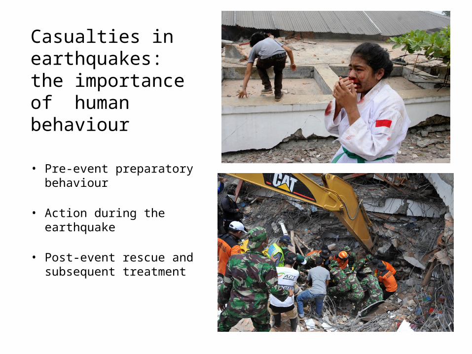
Casualties in earthquakes: the importance of human behaviour
• Pre-event preparatory behaviour
• Action during the earthquake
• Post-event rescue and subsequent treatment

Estimating earthquake risk
Risk modelling can:
Help urban or national authorities plan upgrading strategies for public buildings
Help private owners of buildings identify and modify or avoid high-risk premises
Help the insurance industry model its likely losses and set premium rates
Help improve codes of practice for new buildings
Help urban authorities identify zones for future expansion
Study for British Council by CAR Ltd

Loss estimation: hazards to consider
A taxonomy of earthquake hazards

Earthquake Risk Modelling: Typical Structure
Source Definition
1 10 100 1000Distance (km)
PG
A (
g)
5678
Intensity
Dam
age
Rat
io
Rate
Mag
nitu
de
Event Rates Attenuation
Vulnerability
Event Rate Loss 1 .0001 $ 2 .0002 $ 3 .0001 $
Event Loss Table EP Curve
Loss
Exc
eede
nce
Prob
abili
ty
Source: Risk Management Solutions Inc.

Vulnerability estimation: observed vulnerability
After Coburn and Spence, 1993
Limitations of observed vulnerability:•Can’t use for (eg) newer buildings for which no damage data exists•Single parameter of ground motion cannot capture relationship between ground motion, subsoil and structural behaviour•Assessment of earthquake ground shaking depends of building damage

Vulnerability estimation: calculated vulnerability
Limitations of calculated vulnerability:•Models of building assumed do not adequately represent real structural form•Models of structural behaviour assumed unlike real behaviour of the worst buildings•Extension of single building model to large populations of buildings
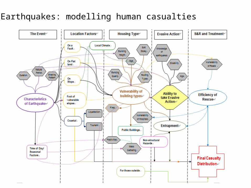
Earthquakes: modelling human casualties

Risk Modelling: How can we do better ?
Improve understanding of active faults and global seismicity
Collect and organise impact data post event
Improve understanding of “at risk” buildings and infrastructure
Improve global collaboration
Improve understanding of uncertainty
Munich Re’s Hazard Globe, 2009

Improving post-earthquake reconnaissance methods, using
remote sensing
Pre-Earthquake Satellite Image Post-Earthquake Satellite Image Field Work Photograph – 6 months after
EEFIT has been active in data collection since 1982 with increasing sophistication
Damage Case-Study: YingXiu Township, Wenchuan earthquake
15WCCE Conference, Istanbul, June 22-24, 2009

FREE web-accessible source of building typology/damage data on >1m buildings from55 earthquakes since the 1960s. Plus casualty dataUse to create vulnerability curves
www.ceqid.org
16WCCE Conference, Istanbul, June 22-24, 2009
Archiving earthquake consequence data

Understanding global exposures: application of remote sensing and “mass observation”
Unsupervised segmentation using Gabor filters and Self Organising Maps (SOM) to segment image (urban area) into clusters where building type distribution is similar. Selection of sampling area
A B A: Google Street View
B: “Mass observation”(example from NASA’s moon crater mapping project)

Earthquake risk reduction: six elements of a strategy
1. Improving codes of practice for design of new buildings 2. Improving building control3. Building for Safety programmes for non-engineered
buildings4. Strengthening programmes for high-risk buildings
5. Promoting earthquake insurance 6. Guiding future urban development

1. Improving building codes
After SEAOC, 2000
Performance- based codes are now widely specified in earthquake-risk countries

2. Improving building control
• Creation of “building supervision” firms • Registration of contractors• Large buildings to have a site engineer• Builder responsible for 20 years
Key elements of new system proposed in Turkey:
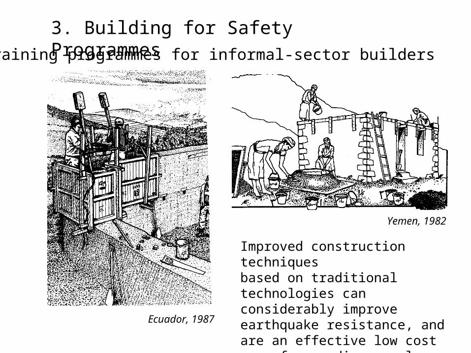
3. Building for Safety Programmes
Improved construction techniquesbased on traditional technologies can considerably improve earthquake resistance, and are an effective low cost way of upgrading rural construction
Yemen, 1982
Ecuador, 1987
Training programmes for informal-sector builders

4. Strengthening existing buildings: assessing and upgrading existing school buildings in Italy
• After the 2002 Molise earthquake, in which 26 schoolchildren died, funds were made available for evaluations of school buildings.
• The evaluation follows a 4-stage process; desk study, rapid visual screening, and simplified mechanical analysis are used to identify the highest risk schools before a full structural investigation is done.
• The evaluation programme is currently in progress, and has revealed serious deficiencies: for example, of 546 schools assessed in Latium Region 136 had a capacity/demand ration less than 0.2
• Retrofitting costs will be found by the regions and are estimated at around 40% of the cost of rebuilding

Typical urban apartment block and strengthening scheme
Shear wall strengthening, Bolu, 2000
4.Strengthening existing buildings
RC apartment buildings in Turkey

4.Strengthening existing buildings: old masonry buildings in Europe
Damage experience and structural modifications following the Umbria-Marche earthquake in Italy, 1997
Cost benefit studies in Portugal showed that adding ties is cheap and highly cost effective

5. Earthquake insurance Insurance cover of earthquake risks is desirable because:
•insurance can help control building standards•insurance rates can be used to encourage upgrading•insurance can make available the funds needed for repair and rebuilding, and manage the repair and recovery process
Earthquake insurance: common problems of implementation • Many insurers do not offer it• Banks and loan agencies do not require it• Too expensive in relation to perceived risk of insured damage• Government expected to help the uninsured
Examples• In many high risk regions eg Southern California, Japan, take-up of
insurance is quite low• National schemes for compensating owners for earthquake damage are in
place in several countries, eg Italy, France, Greece• Turkey has recently introduced a compulsory insurance scheme to replace
such as scheme. – other such schemes are planned
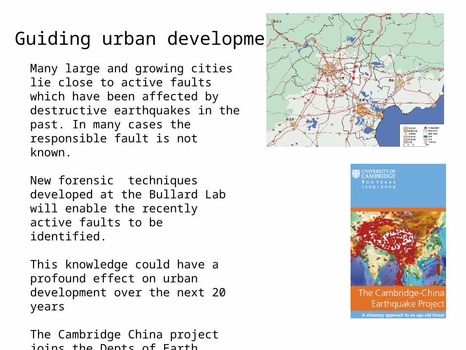
6. Guiding urban developmentMany large and growing cities lie close to active faults which have been affected by destructive earthquakes in the past. In many cases the responsible fault is not known.
New forensic techniques developed at the Bullard Lab will enable the recently active faults to be identified.
This knowledge could have a profound effect on urban development over the next 20 years
The Cambridge China project joins the Depts of Earth Sciences and Architecture at Cambridge with Chinese Partner institutions to develop this potential.

Thank you