Embed Size (px)
Citation preview

Lesson A2–1:
Understanding Land Measurement and
Legal Descriptions
Agricultural Mechanics and Technology Cluster Illinois Agricultural Education Core Curriculum
Unit A. Mechanical Systems and Technology
Problem Area 2. Soil and Environmental Technology Systems
Lesson 1. Understanding Land Measurement and Legal Descriptions
Illinois State Goal and Learning Standard. This lesson is correlated to the
following State Goal and Learning Standard:
State Goal 9: Use geometric methods to analyze, categorize and draw conclusions about points,
lines, planes and space.
Learning Standard A: Demonstrate and apply geometric concepts involving points, lines, planes
and space.
Learning Benchmark 5: Use geometric figures and their properties to solve problems in the arts,
the physical and life sciences and the building trades, with and without the use of technology.
Student Learning Objectives. Instruction in this lesson should result in students
achieving the following objectives:
1. Explain the purpose of land measurement and legal descriptions.
2. Identify the systems of land measurement and legal description used in the
United States.
3. Discuss the causes of irregular townships and sections.
Illinois Core Curriculum: Agricultural Mechanics and Technology Cluster
Unit A. Problem Area 2. Lesson 1. Page 1.

List of Resources. The following resources may be useful in teaching this lesson:
Recommended Resources. One of the following resources should be selected to accompany the
lesson:
VAS 2042. Land Surveys and Descriptions. Urbana, Illinois: Vocational Agriculture
Service, University of Illinois at Urbana-Champaign.
List of Equipment, Tools, Supplies, and Facilities
Writing surface
Overhead projector
Transparencies from attached masters
Terms. The following terms are presented in this lesson (shown in bold italics):
Artificial monuments
Base lines
Clear title
Meridian
Natural monuments
Regular township
Section
Interest Approach. Use an interest approach that will prepare the students for the les-
son. Teachers often develop approaches for their unique class and student situations. A possible
approach is included here.
Ask students to write out the directions to their house on a piece of paper. When finished ask them to give
their paper to someone in the class that does not know where they live. Ask the other student if they think
they would be able to find this house by following these directions. Discuss with the class why clear and
understandable instructions are needed to give the legal description of a property.
Summary of Content and Teaching Strategies
Objective 1: Explain the purpose of land measurement and legal descriptions.
Anticipated Problem: What is the purpose of land measurement and legal descriptions?
I. Land is owned as private property in the United States and is transferred in various ways
from one owner to another. To make this type of transfer possible, it is essential to have a
system through which a purchaser can obtain a clear title to any tract of land. A clear title
means that there are no legal claims against the ownership of the property. In order to trans-
Illinois Core Curriculum: Agricultural Mechanics and Technology Cluster
Unit A. Problem Area 2. Lesson 1. Page 2.
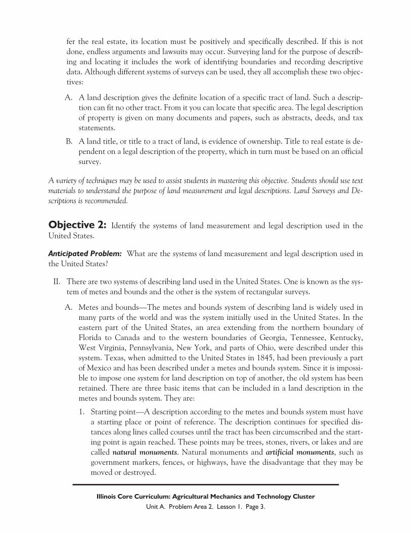
fer the real estate, its location must be positively and specifically described. If this is not
done, endless arguments and lawsuits may occur. Surveying land for the purpose of describ-
ing and locating it includes the work of identifying boundaries and recording descriptive
data. Although different systems of surveys can be used, they all accomplish these two objec-
tives:
A. A land description gives the definite location of a specific tract of land. Such a descrip-
tion can fit no other tract. From it you can locate that specific area. The legal description
of property is given on many documents and papers, such as abstracts, deeds, and tax
statements.
B. A land title, or title to a tract of land, is evidence of ownership. Title to real estate is de-
pendent on a legal description of the property, which in turn must be based on an official
survey.
A variety of techniques may be used to assist students in mastering this objective. Students should use text
materials to understand the purpose of land measurement and legal descriptions. Land Surveys and De-
scriptions is recommended.
Objective 2: Identify the systems of land measurement and legal description used in the
United States.
Anticipated Problem: What are the systems of land measurement and legal description used in
the United States?
II. There are two systems of describing land used in the United States. One is known as the sys-
tem of metes and bounds and the other is the system of rectangular surveys.
A. Metes and bounds—The metes and bounds system of describing land is widely used in
many parts of the world and was the system initially used in the United States. In the
eastern part of the United States, an area extending from the northern boundary of
Florida to Canada and to the western boundaries of Georgia, Tennessee, Kentucky,
West Virginia, Pennsylvania, New York, and parts of Ohio, were described under this
system. Texas, when admitted to the United States in 1845, had been previously a part
of Mexico and has been described under a metes and bounds system. Since it is impossi-
ble to impose one system for land description on top of another, the old system has been
retained. There are three basic items that can be included in a land description in the
metes and bounds system. They are:
1. Starting point—A description according to the metes and bounds system must have
a starting place or point of reference. The description continues for specified dis-
tances along lines called courses until the tract has been circumscribed and the start-
ing point is again reached. These points may be trees, stones, rivers, or lakes and are
called natural monuments. Natural monuments and artificial monuments, such as
government markers, fences, or highways, have the disadvantage that they may be
moved or destroyed.
Illinois Core Curriculum: Agricultural Mechanics and Technology Cluster
Unit A. Problem Area 2. Lesson 1. Page 3.

2. Courses and Distances—Courses are identified by direction, with distances being lin-
ear measurements along these lines. Sometimes a course has been partly described as
connecting two natural monuments, such as trees, but generally it is described in
terms of its angle to a point of reference. The usual point of reference is a meridian or
true north and south line.
3. Irregular boundaries—Some tracts of land, such as those bordering lakes or rivers,
have irregular boundaries. A tract described as lying along a river is typically inter-
preted as having one boundary at the middle line between the shores of the stream.
Lake boundaries are somewhat different. The owners of land adjoining a natural lake
own to the center, if the lake is not navigable; otherwise the title to the bed of the
lake is in trust for the people. The ownership of artificial lake beds depends upon the
words of conveyance used in transferring the shoreline property. Streets and high-
ways can sometimes also serve as boundaries.
4. Rectangular land surveys—In 1785 the Continental Congress of the United States
passed an ordinance directing that a rectangular system be used in surveying public
lands. Thomas Jefferson was directed to organize it. The United States was the first
country to use such a system, but Canada later adopted it. The rectangular survey
system was set up to accomplish two things: (1) provide for definite location of the
land by establishing corner markers on the ground, and (2) provide a short, com-
plete, direct, and easily understood legal description. The system involves the use of
principal meridians, base lines, townships, sections, and tracts.
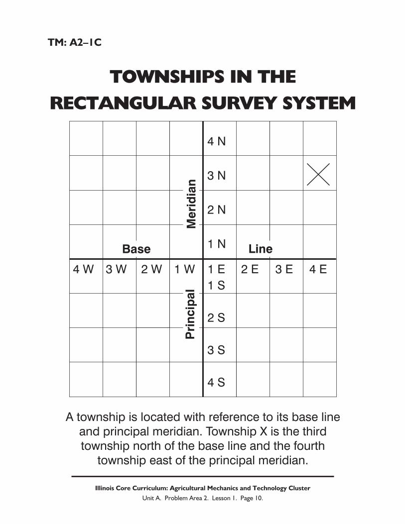
B. Principal meridians and base lines—These lines form the skeleton of the rectangular sur-
vey system. The intersection of the base line and the principal meridian is the starting
point of the survey for a given area. The meridians are north and south lines. The base
lines are east and west lines.
1. Townships and sections—The location of a township can be expressed in terms of
ranges east or west of the principal meridian and in terms of tiers of townships north
or south of the base line. A regular township is six miles square. A section is located
within a township. Each square mile of a township is considered a section. In all sur-
veys since 1796, the sections in each township have been numbered from 1 to 36, be-
ginning at the upper right, or northeast, corner of the township.
2. Tracts of land—A tract of land is located within a section. If the tract in question is
smaller than a section or is located in more than one section, the fraction or fractions
of the section or sections must be indicated. This is done by identifying and locating
the fractional portion of each section for each tract of land. In land descriptions the
last fraction given is the largest area or portion of the section. We read from left to
right. However, in writing a description from a map or in locating a tract of land on a
map, we proceed from right to left.
A variety of techniques may be used to assist students in mastering this objective. Students should use text
materials to understand the systems of land measurement and legal description used in the United States.
Land Surveys and Descriptions is recommended. Use TM: A2–1A thru TM: A2–1E to aid in the discus-
sion on this topic.
Illinois Core Curriculum: Agricultural Mechanics and Technology Cluster
Unit A. Problem Area 2. Lesson 1. Page 4.

Objective 3: Discuss the causes of irregular townships and sections.
Anticipated Problem: What causes irregular townships and sections?
III. It can be observed that not all townships and sections in a rectangular survey are square.
There are several possible reasons for this. They are:
A. Curvature of the Earth—Applying a rectangular system to a curved surface, such as the
Earth, results in some irregularities. Meridian lines get closer together as they approach
the north and south poles. Therefore, a township based off these lines cannot be a per-
fect square. It is impossible for all sections to be perfectly square and to contain exactly
640 acres. Sections containing more or less than 640 acres may be found in the north
and west rows of sections in a township. Most of the other sections will be approximately
640 acres in size. When designing this system, surveyors were requested to throw all defi-
ciencies or excesses in acreage into the north and west sides of the townships.
B. Human error—The surveyors who conducted these surveys are human and therefore
made mistakes. Occasionally errors in surveying have resulted in townships with sections
of odd shapes and sizes.
C. Surveys meeting—Where the survey from one principal meridian meets the survey from
another, both irregular townships and sections are sure to occur. The same is true where
surveys from two different base lines meet.
A variety of techniques may be used to assist students in mastering this objective. Students should use text
materials to understand the causes of irregular townships and sections. Land Surveys and Descriptions is
recommended. Use TM: A2–1F to aid in the discussion on this topic.
Review/Summary. Use the student learning objectives to summarize the lesson. Have
students explain the content associated with each objective. Student responses can be used in de-
termining which objectives need to be reviewed or taught from a different angle. Questions at the
end of each chapter in the recommended textbooks may also be used in the review/summary.
Evaluation. Evaluation should focus on student achievement of the objectives for the les-
son. Various techniques can be used, such as student performance on the application activity. A
sample written test is attached
Answers to Sample Test A2–1:
Part One: Matching
1 = b, 2 = e, 3 = a, 4 = f, 5 = c, 6 = d
Part Two: Completion
1. township
2. irregularities
Illinois Core Curriculum: Agricultural Mechanics and Technology Cluster
Unit A. Problem Area 2. Lesson 1. Page 5.

3. Thomas Jefferson
Part Three: Short Answer
Curvature of the earth; human error; different surveys meeting.
Illinois Core Curriculum: Agricultural Mechanics and Technology Cluster
Unit A. Problem Area 2. Lesson 1. Page 6.

Sample Test Name_____________________________________
Test
Lesson A2–1: Understanding Land Measurement
and Legal Descriptions
Part One: Matching
Instructions. Match the term with the correct response. Write the letter of the term by the defini-tion.
a. artificial monuments b. base lines c. meridian
d. natural monuments e. regular township f. section
_______ 1. East and west lines.
_______ 2. Six miles square.
_______ 3. Government markers, fences, or highways used are references in a metes and
bounds survey.
_______ 4. Each square mile of a township.
_______ 5. North and south lines.
_______ 6. Trees, stones, rivers, or lakes used are references in a metes and bounds survey.
Part Two: Completion
Instructions. Provide the word or words to complete the following statements.
1. The location of a ____________ can be expressed in terms of ranges east or west of the prin-
cipal meridian and in terms of tiers of townships north or south of the base line.
2. Applying a rectangular system to a curved surface, such as the Earth, results in some
_________________.
3. ______________ _____________ was directed to organize the rectangular survey system.
Part Three: Short Answer
Instructions. Provide information to answer the following question.
What are three causes of irregular townships and sections?
Illinois Core Curriculum: Agricultural Mechanics and Technology Cluster
Unit A. Problem Area 2. Lesson 1. Page 7.

TM: A2–1A
LAND DESCRIPTION IN THE
METES AND BOUNDS SYSTEM
Illinois Core Curriculum: Agricultural Mechanics and Technology Cluster
Unit A. Problem Area 2. Lesson 1. Page 8.
StartingPoint
45°Angle
ReferencePoint
135° Angle
Dista
nce
Cou
rse
N

TM: A2–1B
PRINCIPLE MERIDIANS AND
BASE LINES
Illinois Core Curriculum: Agricultural Mechanics and Technology Cluster
Unit A. Problem Area 2. Lesson 1. Page 9.
4th
P.M
.
5th
P.M
.
Meri
dia
n
4th
P.M
.
Pri
ncip
al
WISCONSIN
B.L. for ext. 4th P.M.
B.L.
IOWA
MISSOURI
5th
P.M
.
Base Line
MIS
SO
UR
I
KENTUCKY
IND
IAN
A
2n
dP
rin
cip
alM
eri
dia
n
MICHIGAN
Base Line
TM: A2–1C
TOWNSHIPS IN THE
RECTANGULAR SURVEY SYSTEM
Illinois Core Curriculum: Agricultural Mechanics and Technology Cluster
Unit A. Problem Area 2. Lesson 1. Page 10.
4 N
3 N
2 N
1 N
4 W 3 W 2 W 1 W 2 E1 E
1 S
2 S
3 S
4 S
3 E 4 E
Pri
ncip
al
Me
rid
ian
Base Line
A township is located with reference to its base line
and principal meridian. Township X is the third
township north of the base line and the fourth
township east of the principal meridian.

TM: A2–1D
SECTIONS WITHIN A TOWNSHIP
Illinois Core Curriculum: Agricultural Mechanics and Technology Cluster
Unit A. Problem Area 2. Lesson 1. Page 11.
6
7
18
19
30
31
5
8
17
20
29
32
4
9
16
21
28
33
3
10
15
22
27
34
2
11
14
23
26
35
1
12
13
24
25
36
A regular township contains 36 sections
numbered as shown.

TM: A2–1E
DESCRIPTIONS OF FOUR
SECTIONS OF LAND WITHIN
A SECTION
Illinois Core Curriculum: Agricultural Mechanics and Technology Cluster
Unit A. Problem Area 2. Lesson 1. Page 12.
A
A—N.E. ¼160 acres
C—E. ½ of N.W. ¼80 acres
B—N.W. ¼ of S.E. ¼40 acres
D—W. ½ of N.E. ¼ of S.W. ¼20 acres
B
C
D

TM: A2–1F
IRREGULAR SECTIONS
WITHIN A SURVEY
Illinois Core Curriculum: Agricultural Mechanics and Technology Cluster
Unit A. Problem Area 2. Lesson 1. Page 13.
Townships and sections are usuallyirregular where a survey east from one
principal meridian meets a surveywest from another. In this
example, R11 is less than a mile wide.