Embed Size (px)
Citation preview
Lesson A8–7
Understanding Remote Sensing
Technology
Unit A. Mechanical Systems and Technology
Problem Area 8. Technology Systems
Lesson 7. Understanding Remote Sensing Technology
New Mexico Content Standard:
Pathway Strand: Power, Structural and Technical Systems
Standard: IX: Use the variety of tools available in computer systems to accomplish fast,
accurate production in the workplace.
Benchmark: IX-A: Identify and explain various types of hardware systems to show their
applications potential.
Performance Standard: 1. Identify and describe individual components of each system.
2. Discuss various types of diagnostic equipment. 3. Be able to show aptitude in use of
various equipment. 4. Demonstrate competency on cable though put and set up.
Student Learning Objectives. Instruction in this lesson should result in students
achieving the following objectives:
1. Explain remote sensing.
2. Describe how remote sensing systems gather data on agronomic crops.
3. Explain how precision farming uses remote sensing.
New Mexico Agricultural Mechanics and Technology Lesson Plan Library
Unit A. Problem Area 8. Lesson 7. Page 1.
List of Resources. The following resources may be useful in teaching this lesson:
Recommended Resources. One of the following resources should be selected to accompany the
lesson:
Brandau, Patricia. Precision Agriculture. Unit U4074. Urbana, Illinois: ITCS
Instructional Materials.
Johnson, Donald M., et al. Mechanical Technology in Agriculture. Danville, Illinois:
Interstate Publishers, Inc., 1998.
Westervelt, James D., and Harold F. Reetz, Jr. GIS in Site-Specific Agriculture.
Danville, Illinois: Interstate Publishers, Inc., 2000.
Other Resources. The following resources will be useful to students and teachers:
www.aces.uiuc.edu/~vo-ag/precise.htm
List of Equipment, Tools, Supplies, and Facilities
Writing surface
Overhead projector
Transparencies from attached masters
Terms. The following terms are presented in this lesson (shown in bold italics):
Active system
Aerial photography
Frequency of coverage
Geographic Information System
Ground-truthing
Passive system
Pixels
Remote sensing
Satellite imaging
Spatial resolution
Spectral resolution
Spectral response
Vegetative indices
Interest Approach. Use an interest approach that will prepare the students for the les-
son. Teachers often develop approaches for their unique class and student situations. A possible
approach is included here.
It’s the middle of July, and it’s time to check the cornfields to see how this year’s crop looks.
New Mexico Agricultural Mechanics and Technology Lesson Plan Library
Unit A. Problem Area 8. Lesson 7. Page 2.
There are two ways to do this:
Option #1—Go into the 100 degree heat and start walking through the 7 foot tall corn stalks. Of course
the leaf edges will cut your face, arms, and neck, the bugs will buzz your eyes, the pollen will make you
sneeze. Last night’s rain will cause your feet to weigh 10 times their normal amount because they are cov-
ered in mud, and you can really only see about 5 rows on each side of where you are walking.
Option #2—Sit down at your computer in your air-conditioned office and download the remote sensing
imagery that indicates the exact locations that vary from the normal plant growth taking place in the rest
of the field. Use diagnostic tools to determine why those areas are performing below their peak perfor-
mance, and make a decision that may correct the problem.
How will you check your corn field?
Summary of Content and Teaching Strategies
Objective 1: Explain remote sensing.
Anticipated Problem: What is remote sensing?
I. Remote sensing is a group of techniques used to collect information about an object or area
without actually being in contact with that object or area. Remote sensing can be used in
precision farming to gather data about an area in order to make management decisions. This
can be accomplished through two processes:
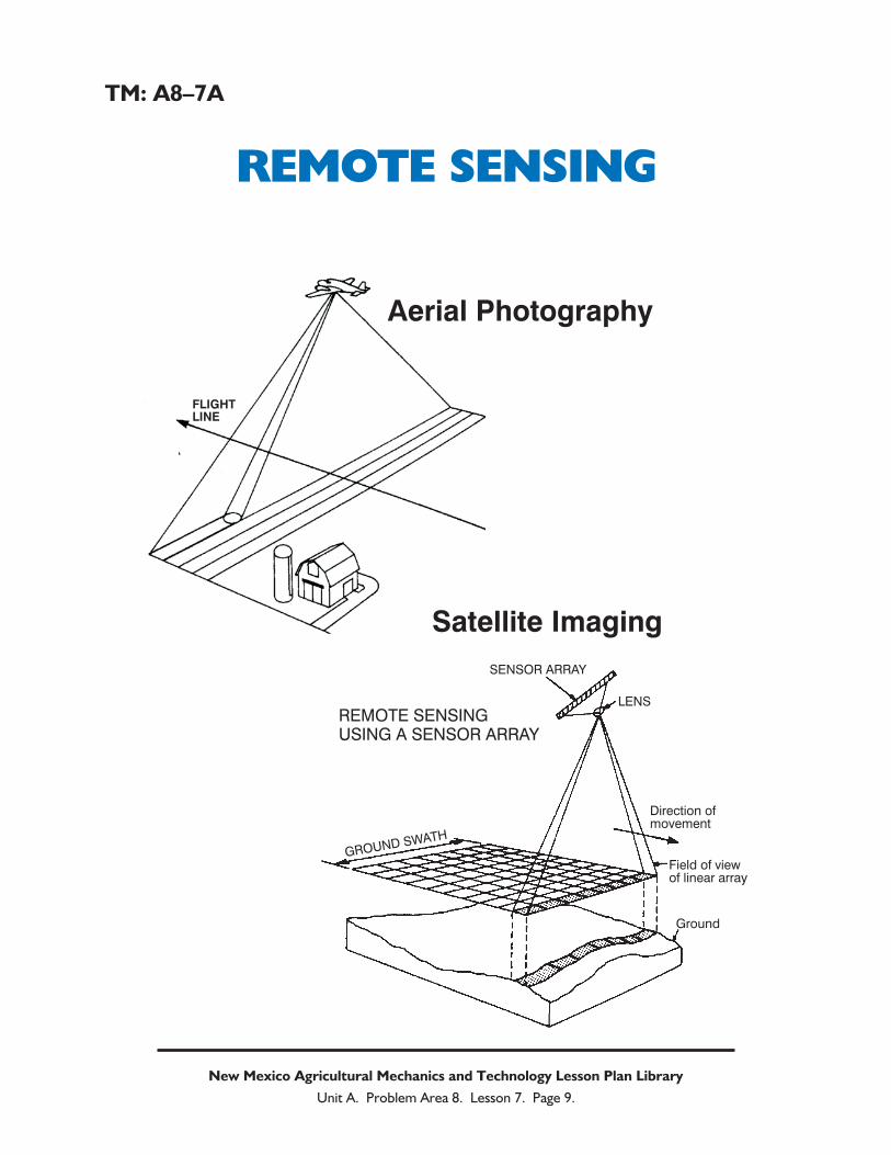
A. Aerial photography can be done with modern aircraft, using photography or electro-
optical sensors. These take a “snapshot” of an area and information can be gathered
based on the differences in color within the image. Aerial imagery can be done by private
companies or by individuals.
B. Satellite imaging uses satellites in space to gather information on an area. Though the
distance is much greater than that of an airplane, satellite based sensing can provide very
detailed information. Remote sensing through satellite imaging uses one of two sys-
tems— LANDSAT (Land Satellite), which is a group of governmental satellites used to
collect environmental information about the earth’s surface, or SPOT (Systeme Pour
l’Observation de la Terre), operated by the French government. Data is retrieved from
these satellites by special request.
A variety of teaching methods can be used to help students master this material. Assigned readings in the
recommended texts will help students in understanding the content. Have students consider using a video
camera or still camera. The photos and images gathered with those cameras can be used to show the gath-
ered information to people who were not at that place at that time. Remote sensing can provide precision
farmers with information that they could not see from their viewpoint. See TM: A8–7A to reinforce the
two methods used to gather remote sensing information.
New Mexico Agricultural Mechanics and Technology Lesson Plan Library
Unit A. Problem Area 8. Lesson 7. Page 3.
Objective 2: Describe how remote sensing systems gather data on agronomic crops.
Anticipated Problem: How does remote sensing gather data on agronomic crops?
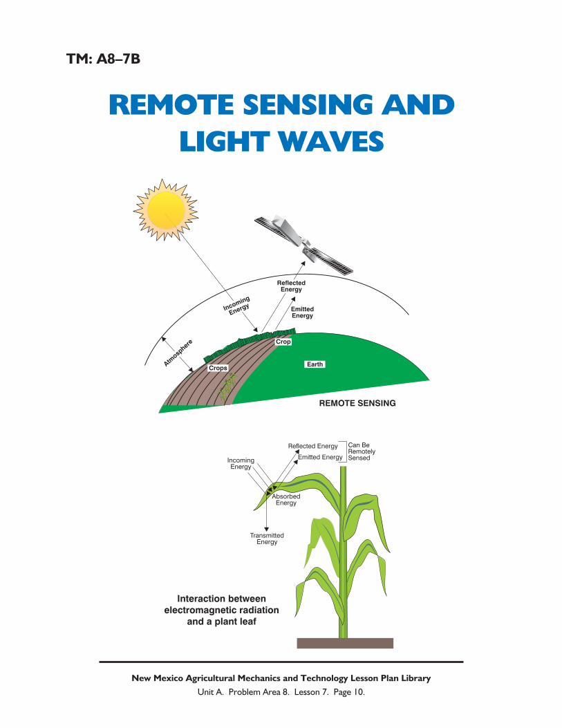
II. Remote sensing gathers information about an area by utilizing light waves within the elec-
tromagnetic spectrum. The weather maps that show cloud cover and precipitation use
remote sensing to provide that information. When light waves travel through space and hit
an object, the waves can reflect off the object, be absorbed by the object, or be transmitted
through the object. Often, more than one of these reactions occur. In addition, all objects
with a temperature above absolute zero emit radiation of their own, though this is not visible
to the human eye. Every object causes a unique reflection of wavelengths, known as a spec-
tral response. Remote sensing uses all of the reflected and emitted radiation to create a dif-
ferential map that shows differences in an area. All areas that have plants that had a consis-
tent growth and health would appear the same, while areas that had poor growth or a lack of
vegetative material would appear different from the healthy plants.
A. Remote sensing systems can be an active system, such as a radar, that generates and
detects its own signal, or a passive system, which detects signals that occur naturally.
B. Spatial resolution is the size of the object that can be distinguished through remote sens-
ing. Some systems can distinguish each plant from the next, while other systems can only
see each row distinguished from the others. Spectral resolution determines how well the
system can distinguish between different wavelengths of energy. Frequency of coverage
refers to how often the system is available to view the area to be remotely sensed. Some
methods, such as airplanes could be used as often as a customer desires. Satellite meth-
ods may not be able to access the area in question as often as desired.
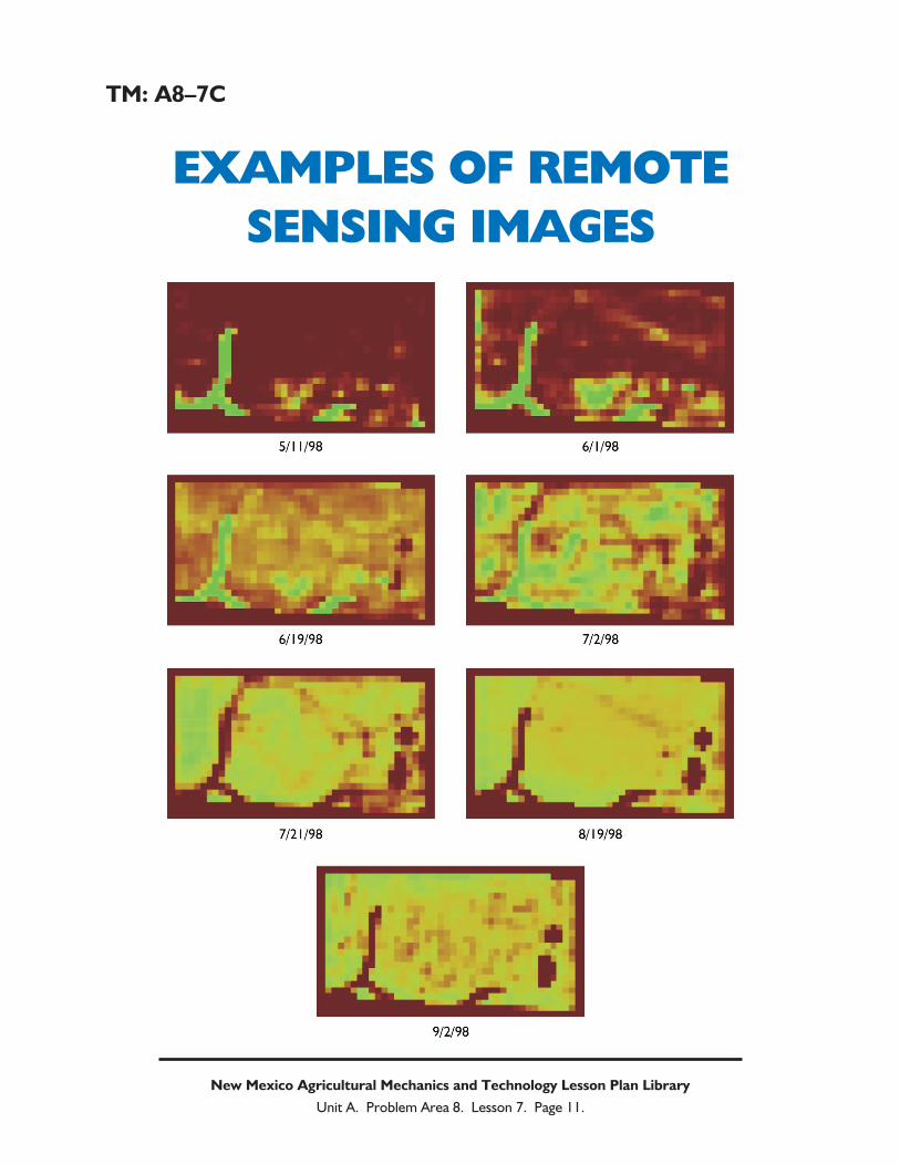
C. When a remote sensing system gathers data from the electromagnetic radiation emitted
from an object or area, it produces a digital image in two or three-dimensional form.
Information is then displayed as pixels, or picture elements. Smaller pixels provide better
resolution, and thus more detail to a map. The images can be in black and white, color,
or color infrared. In color infrared images, healthy green vegetation appears as bright
red.
Have students read te Precision Agriculture Unit (#4074) listed in the recommended resources list. The
information in this unit would be most helpful if it is assigned before the content of this objective is covered.
Use TM: A8–7B to reinforce how remote sensing uses light waves to gather information. Display
TM: A8–7C. It will be useful in reinforcing the types of images remote sensing can show.
Objective 3: Explain how precision farming uses remote sensing.
Anticipated Problem: How can precision farmers use remotely sensed data?
III. It is not possible to measure soil moisture content or phosphorus levels in plant leaves using
remote sensing. Specific numerical data of any type cannot be gathered using this technol-
ogy. However, the data can be inferred by using data analysis tools to find correlation
between the data gathered by remote sensing, and actual measurements on the ground in
New Mexico Agricultural Mechanics and Technology Lesson Plan Library
Unit A. Problem Area 8. Lesson 7. Page 4.
exact locations. Once this sensor data is matched with actual measurements, correlation can
then be drawn over large areas of ground where ground measurements were not conducted.
This is considered to be the greatest value of remote sensing, which is the ability to gather
large amounts of data quickly with minimal labor input.
A. Vegetative properties such as crop progress, water stress, leaf damage, or nitrogen levels
can be determined using remotely sensed maps known as vegetative indices. This can
also be used to detect weed or insect pressure in an area. The differences within the map,
or the differences from a specific time an area was remotely sensed to the next time sens-
ing is done, can be used in analysis tools to determine which scenario could be causing
the problem in the field.
B. Remote sensing is used primarily as one data layer in an entire Geographic Information
System (GIS). All of the other layers, such as yield data, topography, crop scouting
reports, crop varieties, and soil fertility assist the precision farmer in analyzing the re-
motely sensed data.
C. Ground-truthing must be done to verify variability within a remotely sensed area and to
identify what problems are causing the variability. Ground-truthing is scouting an area
that has been remotely sensed, and verifying that the information is accurate.
A variety of teaching methods can be used to reinforce student learning. Students will benefit from reading
the text materials in order to better understand the content. Having students read the Precision Agricul-
ture Unit (#4074) listed in the recommended resources would be helpful in reinforcing the content. A
guest speaker from a retail chemical and fertilizer store would be a valuable resource, as would a producer
involved in precision farming.
Review/Summary. Use the student learning objectives to summarize the lesson. Have
students explain the content associated with each objective. Student responses can be used to
determine which objectives need to be reviewed or taught from a different perspective.
Evaluation. Evaluation should focus on student achievement of the objectives for the les-
son. Various techniques can be used, such as student performance, on the application activity.
Answers to Sample Test:
Part One: Matching
1 = g, 2 = a, 3 = f, 4 = d, 5 = e, 6 = c, 7 = b, 8 = h
Part Two: Completion
1. Geographic Information System
2. Remote sensing
3. LANDSAT, SPOT
4. numerical
New Mexico Agricultural Mechanics and Technology Lesson Plan Library
Unit A. Problem Area 8. Lesson 7. Page 5.
Part Three: Short Answer
The greatest value of a remote sensing system is the ability to analyze large areas quickly
with limited labor input.
New Mexico Agricultural Mechanics and Technology Lesson Plan Library
Unit A. Problem Area 8. Lesson 7. Page 6.
Sample Test Name_____________________________________
Test
Lesson A8–7: Understanding Remote Sensing
Technology
Part One: Matching
Instructions. Match the term with the correct response. Write the letter of the term by the defini-tion.
a. aerial photography e. satellite imaging
b. spectral response f. active system
c. passive system g. frequency of coverage
d. pixels h. ground-truthing
_______ 1. How often remote sensing can by done with a given system.
_______ 2. Remote sensing that can be done with aircraft.
_______ 3. A remote sensing system that sends and then detects its own signal.
_______ 4. Picture elements.
_______ 5. Remote sensing that must be done with satellites.
_______ 6. A remote sensing system that detects natural radiation emissions.
_______ 7. The reactions of wavelengths that are measured in remote sensing systems.
_______ 8. Personally observing areas to determine accuracy of remotely sensed maps.
Part Two: Completion
Instructions. Provide the word or words to complete the following statements.
1. Remote sensing data is usually used as one layer of an entire _______________
______________ ____________ that allows the producer to make educated decisions.
2. ___________ ___________ is a group of techniques used to collect information about an
object or area without being there.
3. All satellite imaging must come from one of two systems, known as ________________ and
_______________.
4. Remote sensing cannot be used to determine ______________ data, but can show varia-
tions within a field or changes over time.
New Mexico Agricultural Mechanics and Technology Lesson Plan Library
Unit A. Problem Area 8. Lesson 7. Page 7.
Part Three: Short Answer
Instructions. Provide information to answer the following question.
What is the greatest value of using remote sensing in a precision farming operation?
New Mexico Agricultural Mechanics and Technology Lesson Plan Library
Unit A. Problem Area 8. Lesson 7. Page 8.
TM: A8–7A
REMOTE SENSING
New Mexico Agricultural Mechanics and Technology Lesson Plan Library
Unit A. Problem Area 8. Lesson 7. Page 9.
FLIGHTLINE
SENSOR ARRAY
Direction ofmovement
Field of viewof linear array
Ground
GROUND SWATH
LENSREMOTE SENSINGUSING A SENSOR ARRAY
Aerial Photography
Satellite Imaging
TM: A8–7B
REMOTE SENSING AND
LIGHT WAVES
New Mexico Agricultural Mechanics and Technology Lesson Plan Library
Unit A. Problem Area 8. Lesson 7. Page 10.
EmittedEnergy
REMOTE SENSING
CropsEarth
Crop
Atmosp
here
Incoming
Energy
ReflectedEnergy
IncomingEnergy
Reflected Energy Can BeRemotelySensedEmitted Energy
AbsorbedEnergy
TransmittedEnergy
Interaction betweenelectromagnetic radiation
and a plant leaf
TM: A8–7C
EXAMPLES OF REMOTE
SENSING IMAGES
New Mexico Agricultural Mechanics and Technology Lesson Plan Library
Unit A. Problem Area 8. Lesson 7. Page 11.


![[REMOTE SENSING] 3-PM Remote Sensing](https://img.pdfslide.net/doc/110x75/61f2bbb282fa78206228d9e2/remote-sensing-3-pm-remote-sensing.jpg)


