Embed Size (px)
Citation preview
GEOHORIZONS January 2006 /28
Introduction:
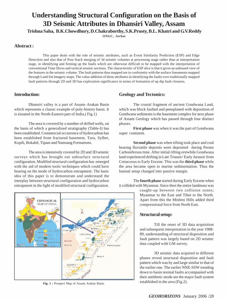
Dhansiri valley is a part of Assam–Arakan Basinwhich represents a classic example of poly-history basin. Itis situated in the North-Eastern part of India.( Fig.1)
The area is covered by a number of drilled wells, onthe basis of which a generalized stratigraphy (Table-I) hasbeen established. Commercial occurrence of hydrocarbon hasbeen established from fractured basement, Tura, Sylhet,Kopili, Bokabil, Tipam and Namsang Formations.
The area is intensively covered by 2D and 3D seismicsurveys which has brought out subsurface structuralconfiguration. Modified structural configuration has emergedwith the aid of modern tools/ techniques which could havebearing on the mode of hydrocarbon entrapment. The basicidea of this paper is to demonstrate and understand theinterplay between structural configuration and hydrocarbonentrapment in the light of modified structural configuration.
Understanding Structural Configuration on the Basis of3D Seismic Attributes in Dhansiri Valley, Assam
Trishna Saha, B.K.Chowdhury, D.Chakraborthy, S.K.Prusty, B.L. Khatri and G.V.ReddyONGC, Jorhat
Abstract :
This paper deals with the role of seismic attributes, such as Event Similarity Prediction (ESP) and EdgeDetection and also that of Post Stack merging of 3d seismic volumes at processing stage rather than at interpretationstage, in identifying and firming up the faults which are otherwise difficult to be mapped with the interpretation ofconventional Time Slices and vertical seismic sections. The characteristic of ESP slice is that it gives an unbiased view ofthe features in the seismic volume. The fault patterns thus mapped are in conformity with the surface lineaments mappedthrough Land Sat Imagery maps. The value addition of these attributes in identifying the faults over traditionally mappedfault patterns through 2D and 3D has exploration significance in terms of formation of up dip fault closures.
Geology and Tectonics:
The crustal fragment of ancient Gondwana Land,which was block faulted and peneplaned with deposition ofGondwana sediments is the basement complex for next phaseof Assam Geology which has passed through four distinctphases.
First phase was when it was the part of Gondwanasuper continent.
Second phase was when rifting took place and coalbearing fluviatile deposits were deposited during PermoCarboniferous time. After initial rifting erstwhile Gondwanaland experienced drifting in Late Triassic/ Early Jurassic fromCretaceous to Early Eocene. This was the third phase whilethe area became open to marine sedimentation. Thus thebasinal setup changed into passive margin.
The fourth phase started during Early Eocene whenit collided with Myanmar. Since then the entire landmass was
caught-up between two collision zones;Myanmar to the East and Tibet to the North.Apart from this the Mishmi Hills added thirdcompressional force from North East.
Structural setup:
Till the onset of 3D data acquisitionand subsequent interpretation in the year 1988-89, understanding of structural disposition andfault pattern was largely based on 2D seismicdata coupled with GM survey.
3D seismic data acquired in differentphases reveal structural disposition and faultpattern which was by and large similar to that ofthe earlier one. The earlier NNE-SSW trendingdown to basin normal faults accompanied withtheir antithetic mode are the major fault systemestablished in the area (Fig.2).Fig. 1 : Prospect Map of Assam Arakan Basin.

GEOHORIZONS January 2006 /29
Table 1: Standard stratigraphic succession in Dhansiri Valley
The occurrence of Hydrocarbon in the area suggeststhat they are all fault controlled. Some deep seated faultsextending further into the Schuppen belt (the kitchen) appearto play an important role as possible conduit. Therefore,correct understanding and mapping of fault pattern in thearea may lead to the exploratory success. The fault patternsmapped earlier in the area have been re- looked in terms oftheir genesis and subsequent reactivation.
Analysis of merged 3D seismic data:
3D data set amounting to 550 SKM was merged inpost stack mode to facilitate seamless interpretation of thearea in holistic manner. The interpretation of the merged data
has enabled us to bring out better structural disposition ofthe area.
It has been observed that ENE-WSW trending crossfaults offset NNE-SSW trending main faults at different places.Analysis of fault patterns indicate that the NNE – SSWtrending faults take a NE-SW swing at different places. Suchfault trends together with the contour pattern suggest thedevelopment of cross trends in the area north of Merapani,Uriamghat and in between Borholla – Mekrang. ConventionalTime slices and horizon based attributes such as EdgeDetection (Fig.3) faintly suggest the existence of cross faultstrending ENE-WSW. However, the volume based attributesfrom event similarity prediction (ESP) Volume (Fig. 4) suggestbeyond doubt the existence of such cross faults. ESP volumesare essentially a measure of trace-to-trace similarity, so thediscontinuities in the seismic data are brought into betterfocus. Regions of seismic traces cut by faults result in sharpdiscontinuities of trace-to-trace coherence, producingdelineation of low coherence along fault planes. Since thethree-dimensionality is an essential ingredient of coherencecomputation, faults or fractures in any orientation are revealedequally. Faults exhibit the greatest amount of trace-to-tracedissimilarity. The Land Mark Software measures the datacontinuity by trace-to-trace cross correlation. The algorithm
Fig 2. Map showing fault pattern based on 2D (on the left) & 3D (onthe right) Fig.3 Edge Detection Attribute

GEOHORIZONS January 2006 /30
Fig.4 Time Slices of ESP attribute at different time levels bringfaults into better focus.
Fig. 5 Comparison of Conventional Time Slice with ESP time Slice.ESP brings faults into sharp focus.
Fig.6 Land Sat Imagery map showing the lineaments in Dhansiri Valley.
performs cross correlation of seismic trace with itsneighbouring two, four or eight traces. The cross correlationvalues are averaged and normalized to compute a continuity
attribute. Fig. 5 depicts an example where faults apparentlydifficult to interpreton the conventionalTime Slice, show upclearly on the ESPslice. The additionalcharacteristic of ESPslice is that it givesan unbiased view ofthe features in theseismic volume.
L a n dSatellite imagerymap also showspresence of NE-SW,E-W trendinglineaments (Fig.6)which supports thepresence of suchcross trends. ESPa t t r i b u t e s ,considered togetherwith the otherattributes, enabledmapping of crossfaults which couldnot be mappedthrough earlierstudies. The 3D timemap incorporatingthese cross faults isplaced at Fig. 7.These cross faults
cutting across the main fault system results in the formationof fault blocks that could have exploration significance.

GEOHORIZONS January 2006 /31
Conclusions:
1. Seismic attributes such as ESP and Edge detectionhelped identifying fault patterns that are otherwisedifficult to be identified through section basedinterpretation.
2. Post Stack merged data offeredinterpretative advantage over the mergingof different data sets at interpretation levelas far as the fault mapping is concerned.3. In this modified structural set-upseveral favorable locales for HCaccumulation can be identified. Thesecross faults are expected to offerentrapment to the hydrocarbons movingup dip direction.
Acknowledgement
The authors are grateful to ShriD.P. Sahasrabudhe, GGM-Basin ManagerA& A A Basin, ONGC for hisencouragement for doing this analyticalwork. Authors are thankful to Shri J.S.Sekhon GM-Block Manager, SAS for hisguidance and Shri H.L. Kharoo DGM, GP,ONGC for his critical suggestion duringthe course of work.
References
Dasgupta.A.B, Biswas, A.K. 2000. Geologyof Assam. Geological Society of India.Bangalore.Dotiwala,F et.al. 1999. Integration and analysisof surface and subsurface structural data usingGIS- A study for the Dhansiri Valley adjoiningNaga Schuppen Belt and Mikir Massif. ONGCUnpublished report.Naik,G. C. et.al. 2001,Sequence Stratigraphy
and Petroleum System of Assam Shelf, ONGCunpublished report.
Pradhan, U.C. et.al. Integrated regional tectonic framework,depositional environment and petroleum systems inDhansiri valley.
S.V. Deshpande et.al. 1993 Lithostratigraphy of Indian petroliferousBasins. ONGC. KDMIPE. Dehradun.
Fig.7 Time map showing resultant fault pattern emerged after considering various attributes.