Embed Size (px)
Citation preview

Catch-Up Program 2008
1
Heritage HouseLuang Prabang
UNESCO's World Heritage Site
Integrated Conservation Integrated Conservation –– DevelopmentDevelopment
Jean‐Christophe Castella
Preserving Preserving LuangLuang Prabang’sPrabang’s natural and cultural heritages natural and cultural heritages in a time of rapid socioeconomic changesin a time of rapid socioeconomic changes
in the Nam Khan Watershed, Lao PDRin the Nam Khan Watershed, Lao PDR
Jean-Christophe CastellaKim Valakone
Linkham Douangsavanh
National Protected AreaNam Et ‐ Phu Loei
LandscapeMosaicsProject
Conservation
Development
Nam Khan River: 260 km long, running into the Mekong in Luang PrabangCatchment area: 7 200 km2 covers 3 provinces and 8 districtsAltitude: 280 m to 1535 m asl (with 2 mountains at 2250 masl)Nam Et – Phu Loei NPA: 3 000 km2 core zone

Catch-Up Program 2008
2
Nam Khan Eco-valley Program• 1993 Establishment Phu Loei – Nam Et National Biodiversity
Conservation Area (NBCA) later changed into NPA.
• 1995 Luang Prabang: nominated UNESCO Word Heritage for “outstanding universal value”, founded in the harmonious relationship between the natural and built environment
• 2005 Candidate to UNESCO's Man and the Biosphere (MAB) Programme – stresses protecting natural and cultural environment while creating development opportunities for local communities.g p pp
• Collaborative program since 2004-> to document natural and cultural diversity
• Towards a watershed management committee-> to preserve natural and cultural diversity
PART1: DIVERSITY OF CULTURES AND NATURES IN THE
NAM KHAN WATERSHED (NKW)
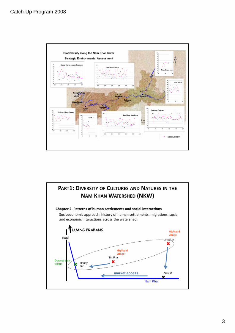
Chapter 1. What makes the NKW a natural heritage?
Biogeographic approach: characterizing the diversity of natural and human environments from landscape to watershed scales.environments from landscape to watershed scales.
Fallow
Fallow
Teak
Ray
Old Forest
Young Forest
Land Use Type
% of total land cover Biodiversitycoefficient
OldForest
OF = 0 0
0 < OF < 10 % 1
10 % < OF < 25 % 2
25 % < OF 4
Old forest Young forest Fallow Ray Paddy Teak15% 15 % 30 % 30 % 0 % 10 %
Water
YoungForest
YF = 0 0
0 < YF < 10 % 1
10 % < YF < 25 % 2
25 % < YF 4
Fallow …
Catch-Up Program 2008
3
012
34567
89
10
40 50 60
Nam Khan sup
3
45
67
89
10 Xiang Ngeun – Luang Prabang
3
45
67
89
10
Sopchoun - Pakxa
pk 0pk 0
Biodiversity along the Nam Khan River
Strategic Environmental Assessment
012
34567
89
10
40 50 60
Nam Khan sup012
34567
89
10
40 50 60
Nam Khan sup
3
45
67
89
10 Xiang Ngeun – Luang Prabang
345
67
89
10 Xiang Ngeun – Luang Prabang
3
45
67
89
10
Sopchoun - Pakxa
3
45
67
89
10
Sopchoun - Pakxa
78
910
Sopkhao - Pakvang
01
23
45
67
89
10
0 10 20
Nam Khao
10
D kh S h8
910
Pakxa – Xiang Ngeun
01
2
220 230 240 250 260 012
160 170 180 190 200 210
pk 120pk 260
pk 162
pk 99
Luang Prabang•
Xiang Ngeun•
Dunkhan•
•Pakxa
•Sopchoun
•Pakvang
pk 201
pk 224
pk 44
•Sopkhao
pk 120pk 260
pk 162
pk 99
Luang Prabang•
Xiang Ngeun•
Dunkhan•
•Pakxa
•Sopchoun
•Pakvang
pk 201
pk 224
pk 44
•Sopkhao
78
910
Sopkhao - Pakvang
78
910
Sopkhao - Pakvang
01
23
45
67
89
10
0 10 20
Nam Khao
01
23
45
67
89
10
0 10 20
Nam Khao
10
D kh S h10
D kh S h8
910
Pakxa – Xiang Ngeun8
910
Pakxa – Xiang Ngeun
01
2
220 230 240 250 260012
220 230 240 250 260 012
160 170 180 190 200 210012
160 170 180 190 200 210
01
2345
6
50 60 70 80 90 100
01
23
456
78
9
120 130 140 150 160 170
Dunkhan - Sopchoun
01
23
456
78
910
0 10 20
Nam Ti
01
23
456
7
200 210 220 230
01
2345
6
50 60 70 80 90 10001
2345
6
50 60 70 80 90 100
01
23
456
78
9
120 130 140 150 160 170
Dunkhan - Sopchoun
01
23
456
78
9
120 130 140 150 160 170
Dunkhan - Sopchoun
01
23
456
78
910
0 10 20
Nam Ti
01
23
456
78
910
0 10 20
Nam Ti
01
23
456
7
200 210 220 23001
23
456
7
200 210 220 230
Biodiversity
PART1: DIVERSITY OF CULTURES AND NATURES IN THE
NAM KHAN WATERSHED (NKW)
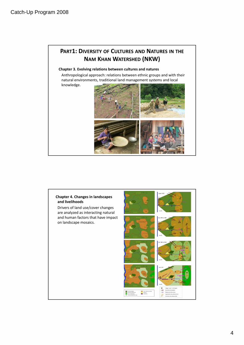
Chapter 2. Patterns of human settlements and social interactions
Socioeconomic approach: history of human settlements, migrations, social d h h dand economic interactions across the watershed.
LUANG PRABANG
Long Letroad
Highland village
Highland village
Nam Khan
HouayYen
Tin Pha
Nong Dimarket access
village
Downstream village
Catch-Up Program 2008
4
PART1: DIVERSITY OF CULTURES AND NATURES IN THE
NAM KHAN WATERSHED (NKW)
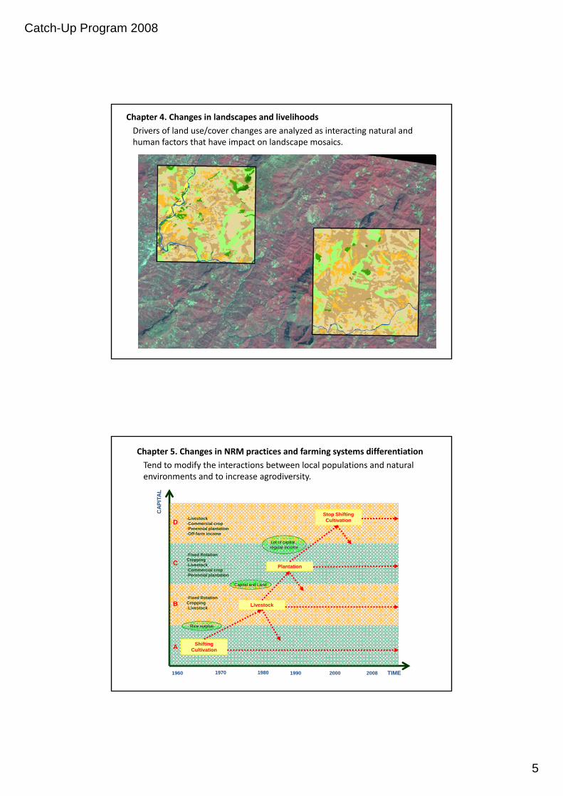
Chapter 3. Evolving relations between cultures and natures
Anthropological approach: relations between ethnic groups and with their natural environments, traditional land management systems and local knowledge.
Chapter 4. Changes in landscapes and livelihoods
Drivers of land use/cover changes are analyzed as interacting natural and human factors that have impact on landscape mosaics.
Catch-Up Program 2008
5
Chapter 4. Changes in landscapes and livelihoods
Drivers of land use/cover changes are analyzed as interacting natural and human factors that have impact on landscape mosaics.
Data Base
• Aerial pictures 1998
• Quick Bird Image 2005
• Spot Image 2006
DStop Shifting Cultivation-Livestock
CAP
ITA
L
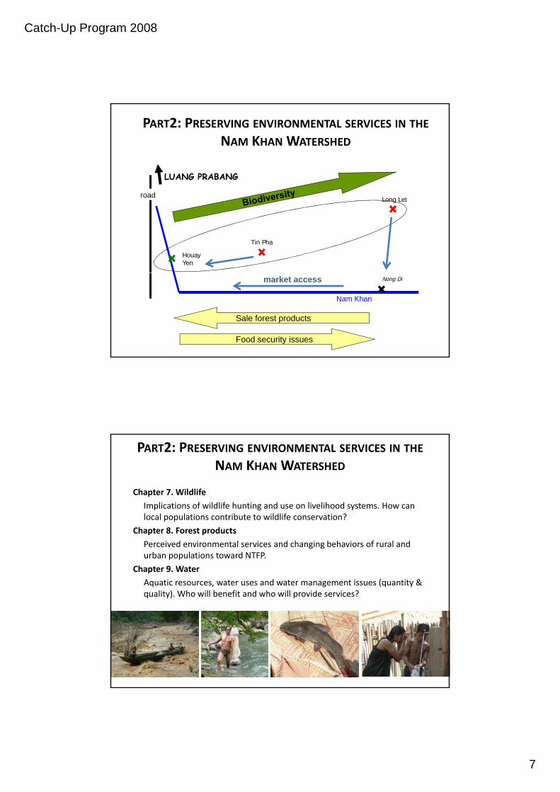
Chapter 5. Changes in NRM practices and farming systems differentiation
Tend to modify the interactions between local populations and natural environments and to increase agrodiversity.
B
C
D
Livestock
Plantation
Cultivation
Capital and Land
Lot of capital, regular income
-Commercial crop-Perennial plantation-Off-farm income
-Fixed Rotation Cropping-Livestock-Commercial crop-Perennial plantation
-Fixed Rotation Cropping
A Shifting Cultivation
Livestock
Rice surplus
TIME1960 1970 1980 1990 2000 2008
-Livestock

Catch-Up Program 2008
6
PART2: PRESERVING ENVIRONMENTAL SERVICES IN THE
NAM KHAN WATERSHED
Chapter 6. Biodiversity
Assessing the sustainability of shifting cultivation systems on shrinking areas. Impact of decreasing fallow periods on biodiversity and ecosystemic services.
Landscape
Land use
HabitatPlant
Landscapes analysis•Structure
•Fragmentation
•Heterogeneity
Floristic surveyFocus group – InterviewsAbout Local use of forest products
Fallow Garden Village Production Forest Protection Forest
Local uses of forest resources
• Focus Groups
Rice Crop Vegetable GardenOrchard Teak Agar wood
Catch-Up Program 2008
7
PART2: PRESERVING ENVIRONMENTAL SERVICES IN THE
NAM KHAN WATERSHED
LUANG PRABANG
HouayYen
Tin Pha
Long Letroad
Sale forest products
Nam Khan
Nong Dimarket access
Food security issues
PART2: PRESERVING ENVIRONMENTAL SERVICES IN THE
NAM KHAN WATERSHED
Chapter 7. Wildlife
Implications of wildlife hunting and use on livelihood systems. How can local populations contribute to wildlife conservation?local populations contribute to wildlife conservation?
Chapter 8. Forest products
Perceived environmental services and changing behaviors of rural and urban populations toward NTFP.
Chapter 9. Water
Aquatic resources, water uses and water management issues (quantity & quality). Who will benefit and who will provide services?

Catch-Up Program 2008
8
Chapter 10. Policy mechanisms towards integrated conservation –development: Exploring conservation ‐ development strategies
‐ Land use planning: multifunctional landscapes, protection of fragile natural environments, management of national parks and buffer zones, towards new territories and land rights.
Payment for environmental services avoided deforestation (REDD) reduced‐ Payment for environmental services: avoided deforestation (REDD), reduced erosion and land degradation (hydropower), biodiversity, ecotourism.
‐ Socio‐technological innovations: agricultural intensification of lowlands, terracing, conservation agriculture (no tillage, cover crops and mulching, etc.), ecological engineering for land slide protection of roads and river banks, flood control, etc.
F ilit ti th f i tit ti ti ti h i+ Facilitating the emergence of institutions, negotiation mechanisms between multiple groups of stakeholders with diverging interests across the landscape.
+ Role of action‐research in supporting watershed management committee.
+ Long term commitment…
Thank you for your attention…