Embed Size (px)
Citation preview
IRMCo, Malta e-Module Gozo Unit 2 Page 1/16
Unit 2 – Geological Setting Anna Spiteri, Josianne Vella, Dirk De Ketelaere
Preamble
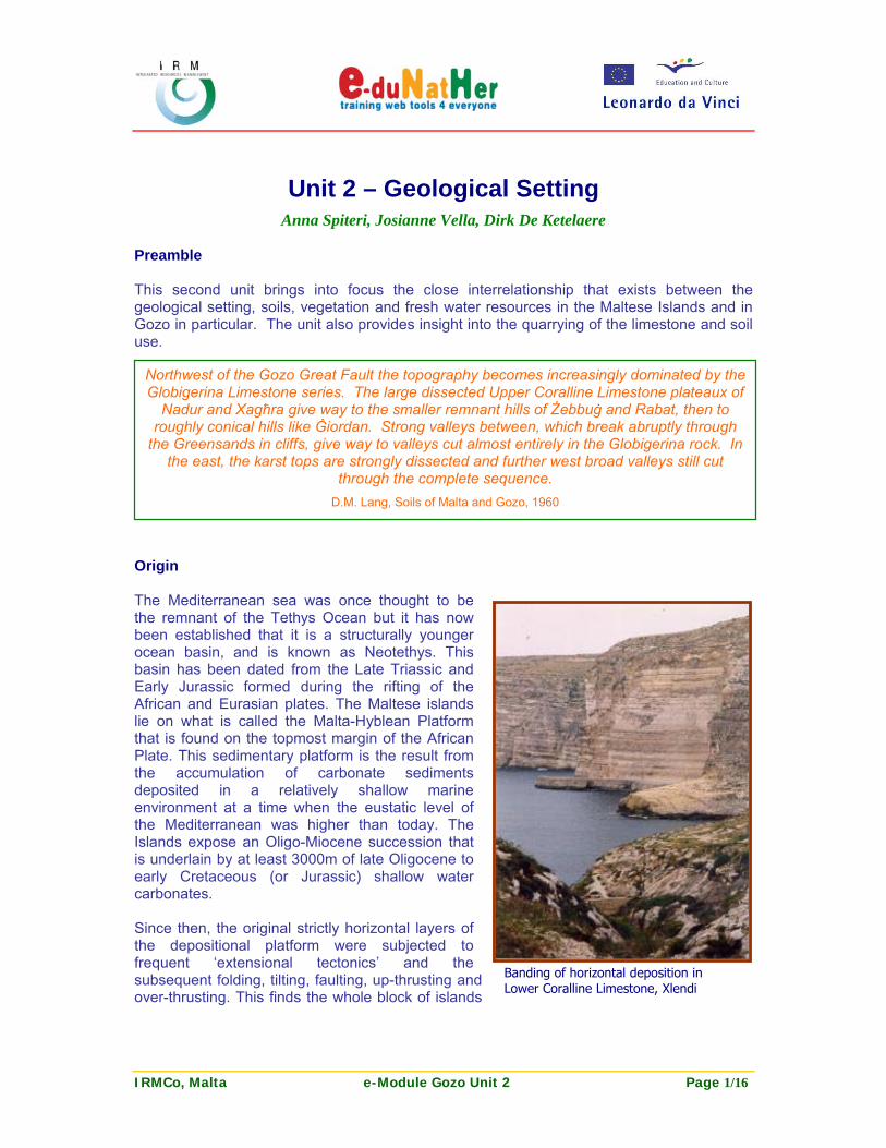
This second unit brings into focus the close interrelationship that exists between the geological setting, soils, vegetation and fresh water resources in the Maltese Islands and in Gozo in particular. The unit also provides insight into the quarrying of the limestone and soil use. Origin The Mediterranean sea was once thought to be the remnant of the Tethys Ocean but it has now been established that it is a structurally younger ocean basin, and is known as Neotethys. This basin has been dated from the Late Triassic and Early Jurassic formed during the rifting of the African and Eurasian plates. The Maltese islands lie on what is called the Malta-Hyblean Platform that is found on the topmost margin of the African Plate. This sedimentary platform is the result from the accumulation of carbonate sediments deposited in a relatively shallow marine environment at a time when the eustatic level of the Mediterranean was higher than today. The Islands expose an Oligo-Miocene succession that is underlain by at least 3000m of late Oligocene to early Cretaceous (or Jurassic) shallow water carbonates. Since then, the original strictly horizontal layers of the depositional platform were subjected to frequent ‘extensional tectonics’ and the subsequent folding, tilting, faulting, up-thrusting and over-thrusting. This finds the whole block of islands
Northwest of the Gozo Great Fault the topography becomes increasingly dominated by the Globigerina Limestone series. The large dissected Upper Coralline Limestone plateaux of
Nadur and Xagħra give way to the smaller remnant hills of Żebbuġ and Rabat, then to roughly conical hills like Ġiordan. Strong valleys between, which break abruptly through
the Greensands in cliffs, give way to valleys cut almost entirely in the Globigerina rock. In the east, the karst tops are strongly dissected and further west broad valleys still cut
through the complete sequence. D.M. Lang, Soils of Malta and Gozo, 1960
Banding of horizontal deposition in Lower Coralline Limestone, Xlendi

IRMCo, Malta e-Module Gozo Unit 2 Page 2/16
itself tilted eastwards, raising the cliffs to the west to about 240 meters above sea level and drowning the valleys on the eastern and south-eastern coast. This tilting is also visible on the island of Gozo. From the south-west to the north-east, the coast consists entirely of cliffs, whilst the southern part of the island facing Malta is low lying. The island has a hilly terrain with rounded, flat-topped hills. The highest point is Ta’ Dbiegi hill which rises to 190 metres above sea level. A dense sequence of faults, following a NE-SW direction, is observed in the southern part of Gozo. It should also be noted that the geology of the Maltese Islands displays well developed karst phenomena. Dolines and sinkholes in Malta are mostly found in the uppermost geological formation, i.e. the Upper Coralline Limestone. The Lower Coralline Limestone hosts archaeologically important caves, sinkholes as well as some spectacular natural arches. Far less karstified compared to the previous limestone formations, karstic channeling and cavities are found mostly where the Globigerina Limestone outcrops at the land surface. The karstic origin of these features will be discussed in more detail in the Unit on Karst Heritage, since this karst heritage significantly contributes to the islands scenic beauty.
Karst is a distinctive topography in which the landscape is largely shaped by the dissolving action of water on carbonate bedrock. This geological process, occurring over many thousands of years, results in unusual surface and subsurface features ranging from sinkholes, dolines, vertical shafts, disappearing streams and springs, to complex underground drainage systems and caves.
In general, the processes responsible for the erosion of the limestone include atmospheric weathering, the constant flow of rainfall water over the rock surface, chemical dissolution along fissures, and subterranean erosion due to circulation of meteoric waters. In the case of the Maltese Islands, these processes are further enhanced by wave action, while it should also be added that the mixing of seawater and fresh water may accelerate the dissolution process (Ford et al., 1989).
Inland Sea: an example of a solution subsidence structure

IRMCo, Malta e-Module Gozo Unit 2 Page 3/16
Pioneers of Maltese geology (historical background) During the 17th and 18th centuries, authors such as Paolo Boccone, Giacomo Buanamico, Gian Francesco Buanamico, Giuseppe Seychell, and Deodat de Dolomieu, already attempted to tackle aspects of Maltese geology. However, it took until the 19th century for the study of Maltese rocks and fossils to become a more scientific endeavour, mainly through the important contribution of T.A.B. Spratt. T.A.B. Spratt proved a pioneer and is acknowledged as being ‘The Father of Maltese Geology’ because he was the first to give a correct and clear exposition of local rock formations, their fossils and their surface features. During his long stretches in Malta, as a Vice Admiral with the British Navy, Spratt studied local Tertiary rock formations and stratigraphy. He excavated Maltese Quaternary deposits and contributed considerably to the identification and description of most of the characteristic Pleistocene fauna of the Island. Spratt is also accredited with discovering Malta’s most significant geological fault and correctly identifying the structure as a major tectonic feature. He called it “The Great Fault of Malta” and represents it on his 1843 topographical map along with another major fault crossing Gozo. Spratt was also the first to recognise the distinctive landscape produced by the subcircular depressions in Gozo, such as the area known as the Inland Sea at Dwejra. Sir William Reid, Governor in Malta during 1851-58, is considered as one of the earliest promoters of the study of Maltese geology and palaeontology. Reid reorganised the archaeological, zoological and geological material kept at the Public Library. He took great interest in these collections and managed to increase the literature and geological material for display by appealing insistently to the Crown Agents for the Colonies. Concurrently he supported and encouraged map making and commissioned a number of topographical and geological maps of the Maltese Islands. Through the support of Sir William Reid and the discoveries of T.A.B. Spratt, a new series of local studies was initiated: The Tectonics of the Maltese Islands – a research that was later taken up by Andrew Leith Adams. After leaving the island, Spratt maintained his interest in Maltese geology and palaeontology and even helped Adams procure grants from the British Association to carry out excavations at local Pleistocene sites. Andrew Leith Adams was stationed in Malta with the Royal Army Medical Corps from 1860 to 1866. His experience and observations on the Maltese Islands were recorded in a number of scientific papers and in his significant publication ‘Notes of a Naturalist in the Nile Valley and Malta’. The book is a veritable mine of information on the natural history of these two countries. Initially, Adams seems to have devoted most of his time and energy to the study of Maltese Tertiary rock formations and stratigraphy, producing 4 papers on the subject between 1863 and 1864. Throughout his stay on the island, Adams carried out extensive excavations of fossiliferous Pleistocene deposits infilling caverns and fissures. It was the Vertebrata, both Tertiary and Quaternary, that Adams concentrated mostly on. John Henry Cooke is also considered to be an important figure in the history of Maltese geology. He was an enthusiastic naturalist who arrived in Malta in 1887 to take up the post as Teacher of English at the Malta Lyceum. He soon became deeply interested in Maltese rock formations and their fossils. In his publication ‘Sketches written in and about Malta’, Cooke reveals his interest also in caverns by reporting on his investigation of the newly discovered “Stalactitic Cave’ (Għar ta Ninu) and another longer cavern (Calypso’s Cave) overlooking Ramla l-Hamra Bay in Gozo. His explorations of Għar Dalam (Malta) led to the recovery of an almost complete jaw of a small species of brown bear. This provided conclusive evidence for the existence of Pleistocene carnivores on the Maltese Islands which had long been suspected by Falconer (1865), Spratt (1867) and Adams (1870). The above are some of the pioneers who have contributed extensively to the development of the study of Maltese geology. A more extensive account can be found in ‘Pioneers of Maltese Geology’ by George Żammit Maempel (1989).

IRMCo, Malta e-Module Gozo Unit 2 Page 4/16
Geological Formations The Maltese Islands are made up almost entirely of marine tertiary limestone with subsidiary clays and marls. All exposed rocks were deposited in shallow waters during the Oligocene and Miocene periods. Quaternary deposits represent the other type of rock formation found on the islands and are sediments that were deposited in a terrestrial environment following the emergence of the Maltese Islands above sea level. Superficial deposits, mostly Pleistocene in age, take the form of cliff braccias, cave and valley loams, sands and gravels. The sequence of Tertiary rocks, starting from the uppermost and hence ‘most recent’ formation, is as follows:
Upper Coralline Limestone (Miocene) Greensand (Miocene) Blue Clay (Miocene) Globigerina Limestone (Miocene) Lower Coralline Limestone (Oligocene)
The Tertiary succession bears a strong resemblance to that of south-east Sicily where a limestone-clay-limestone sequence occurs, and to that of North Africa. The geological formations of the island are very distinctive lithologically and this is reflected in the characteristic topography and vegetation which it sustains.
Era Formation Thickness (m)
Lithology
Quaternary 2 - 10 Alluvial valley fillings, cave deposits Miocene Upper Coralline
Limestone 30 - 100 Cross-bedded limestone with reef
formation patches Greensand 0 - 12 Sand with phosphorite material Blue Clay 0 - 75 Kaolinite rich clay and marly clay Globigerina 30 - 230 Pale yellow massive limestone beds
Oligocene Lower Coralline Limestone
> 450 m Coarse grained with extensive cross-bedding and reef patches
Lower Coralline Limestone is the oldest exposed rock in the Maltese islands and is responsible for forming magnificent cliffs, some reaching 150 meter in height. These characteristic vertical cliffs are found around most of Malta, south of Fomm ir-Riħ, and also in western Gozo. The Lower Coralline is hard and intractable and when found inland usually gives rise to a barren, grey limestone-pavement topography.
Lower Coralline outcrop

IRMCo, Malta e-Module Gozo Unit 2 Page 5/16
At the top of this formation is a characteristic band, a few metres thick, with frequent fossil occurrence, referred to as the Scutella bed. The widespread Scutella graveyard, found among other locations at the Dwejra Inland Sea, suggests that during the formation of the upper Lower Coralline Limestone the sea floor was nearly flat.
The total thickness of the Lower Coralline Limestone is estimated at more than 450m according to data derived from oil exploration wells. The most recent exploratory well on land was drilled in Kerċem, Gozo, in 1999, while much earlier oil exploration wells were drilled in various localities in Malta during the 1950s. Another characteristic are the many coral reefs that are found within the Lower Coralline Limestone. These reefs developed under shallow water or shoal conditions. Although their extent, volume and possible interconnection are not known, these reefs play a very important role from a hydrogeological point of view. Indeed, these reefs can be considered as zones which have a higher permeability, and hence higher capacity to store fresh water within the porous matrix of the Lower Coralline limestone. As will be discussed in more detail in the Unit dealing with the Island’s water resources, the cracks and pores within the Lower Coralline are host to the Maltese Islands’ most important aquifers, the so-called Mean Sea Level Aquifers. Globigerina Limestone represents the second oldest rock and much of the central and south-eastern portion of Malta comprises outcrops of Globigerina Limestone, making it the most widespread outcropping formation on the Maltese Islands. Softer, compared to the underlying Lower Coralline Limestone, Globigerina produces rather meagre soils, and a gentle, rolling landscape. The latter characteristic has lent itself to terraced slopes which are intensively cultivated.
Scutella bed, found in the Lower Coralline Limestone
"Il-Madonna taż-Żejt" exploratory oil well at Kerċem, 1999

IRMCo, Malta e-Module Gozo Unit 2 Page 6/16
The formation shows marked thickness variations. The greatest thickness now exposed, about 230m, is found in southern Malta near Marsaxlokk and the thinnest, about 30m, is found below Fort Chambray in southern Gozo. The formation is sub-divided by two beds of phosphatic nodules, into Lower, Middle and Upper Globigerina Limestone.
The Lower Globigerina provides the golden brown building stone, ‘franka’, which is a very easily cut freestone which is worked in large, vertical sided quarries and is used for most of the buildings on the islands. When used for exterior work the ‘franka’ weathers well. The stone develops a tough outer layer but in time this often exfoliates and weathers in a curious honeycomb manner.
Blue Clay is a series of blue and yellow clays and marls which overly the Globigerina Limestone. Aided by the spring flows above it, Blue Clay forms the most fertile outcrop on the islands. The outcrop is usually narrow and the slopes steep, and these are seen as carefully terraced and tilled, except in places where they form a classical ‘talus’ jutting out just below the upper coralline. Variations in thickness are considerable ranging from 75m at Xaghra, Gozo to nil in eastern Malta, where Upper Coralline Limestone rests directly on Globigerina Limestone. Deposition of the Blue Clay is thought to have occurred in an open marine environment at depths up to 150m for the lower part of the formation. Blue Clay is of considerable importance to the fresh water resources on the Islands, as the formation acts as a seal to the water which infiltrates from the surface and is stored in the Upper Coralline Limestone and Greensand aquifer. Greensand is a coarse orange-brown, thick bedded fragmental limestone made up of a thick congregation of heterostegina fossils, which usually forms the base to the Upper Coralline Limestone cliffs. In the unweathered state an abundance of glauconite gives the rock a green colour. The thickness reaches a maximum of 12m in south-west Malta and in localised depressions at Il-Gelmus in Gozo, but it is usually about half this figure. In other places the formation is absent. The boundary with the Blue Clay below is very abrupt and, around the coast is the cause of localized landslides. The upper boundary is often more difficult to determine. The formation has yielded a very rich echinoid fauna together with shark teeth and the remains of dugongs, manatees, dolphins and whales, indicating that the Blue Clay was deposited under warm shallow marine conditions. Upper Coralline Limestone is the youngest Tertiary formation on the islands but resembles its oldest and lowest formation both in its chemical and palaeontological characteristics. Except for the sequence of valleys in the northern part of Malta where geological faulting has brought the uppermost layer down to present day sea level, the Upper Coralline Limestone caps the highest hills, some of which reach 250m in altitude. These hill tops are typically
Lower Globigerina Limestone quarrying site in San Lawrenz

IRMCo, Malta e-Module Gozo Unit 2 Page 7/16
barren and the bare limestone plateaux display features of karstic origin such as cracks, small solution holes and underground caves. Particularly the north-western region in Malta is characterised by highlands on which Upper Coralline Limestone is the dominant outcrop, while a rather more uniform distribution of highlands is found across the island of Gozo. The thickness of the formation varies considerably but usually only about 30 meters is preserved on the high land. Deposition took place in shallow waters and the formation shows various strata gradually making a transition from the underlying Greensands. As noted earlier, the Blue Clay acts as a seal to the deeper infiltration of water from the surface. The porous and fissured Upper Coralline Limestone allows for substantial amounts of water to be retained in the Upper Coralline and (where present) Greensand aquifers, a key characteristic which will be examined in more detail in the Unit on the Island’s fresh water resources. Pleistocene Quaternary Deposits are found in the form of palaeosols, fluvial gravels, coastal conglomerates and breccias, and bone deposits in caves and fissures. The Għar Dalam cave is the most celebrated and has yielded numerous interesting animal remains from Pleistocene age. The oldest faunas include Pleistocene dwarf hippopotami, pygmy elephants, dormice and swans and a later deposit has horse and deer. Geological Faults As is the case in Malta, the island of Gozo is cut by a system of normal faults most of which follow a north eastern - south western (NE-SW) trend. A particularly dense sequence of such faults is found in the south eastern part of the island, around the Mġarr harbour. A second system of faults follows a north western - south eastern trend and is particularly dense in the central, southern part of Gozo. These geological faults play an important role in the replenishing of the aquifers, and as will be examined in the next Unit, play an equally crucial role when assessing the vulnerability of these aquifers to the pollution caused by human activities on the land.
Upper Coralline Plateau behind Ta’ Pinu Church
Transverse faulting below Ta’ Ċenċ

IRMCo, Malta e-Module Gozo Unit 2 Page 8/16
Soils The original, natural pattern of soils distribution in the Maltese Islands is largely determined by the parent material (in most cases the underlying rock), climate (both present and past under which rock weathering and soil formation took place), time and topography. The different kind of soils in Malta and Gozo are almost entirely due to the differences in the chemical composition, as well as in the physical constitution of the parent rock. The soils have in common that they are very calcareous because the parent rock is limestone. Since the processes of soil formation on calcareous material is very slow in a semi-humid country, the soils on the islands are considered to be young or immature soils. On the ridges, plateaux and plains, the soils are usually very shallow ranging in depth from less than 20 to about 60cm. In valleys the soils are usually much deeper, often exceeding 150cm, while on the gentler slopes of the Globigerina Limestone, the soils are moderately deep ranging from 60 to 120cm. The soils of Malta and Gozo were first classified by Lang (1960) following Kubiena’s system into three groups: the Terra Rossa, Xerorendzina and Carbonate Raw soils. The red and reddish-brown, humus-enriched, highly decalcified soils of the Terra Rossa group were probably formed under a past humid climate. The shallow, brown, slightly humus-enriched, calcareous soils over limestone bedrock are called Xerorendzinas and are the soils formed by exposure to the present climate for the longest period. The third group of soils are the very young man-made, whitish, humus-deficient Carbonate Raw soils dating back to less than a century. The latter soils are essentially physically disintegrated parent rock and occur side by side with Xerorendzinas. In fact, the difference between the two groups of soils is very slight, both containing more than 70% total calcium carbonate. In recent years a national soil inventory of the soils of the Maltese Islands was undertaken within the framework of the project MALSIS, A MALtese Soil Information System. Information on soils is now found at the National Soil Unit (NSU), in a soils geo-database that includes soil classification information, and data on soil characteristics and soil contamination for more than 350 geo-referenced sites.
The fertile Lunzjata valley

IRMCo, Malta e-Module Gozo Unit 2 Page 9/16
The MALSIS Soil Information System is based on the identification system of soil types as drawn up by Lambert for the compilation of data for the European Soil Geographical Database. This database contains a list of Soil Typological Units (STU), which are grouped into Soil Mapping Units (SMU) to form soil associations, which in turn take into account the pedological relationships within the landscapes. (a more comprehensive system than Lang attempts in 1960). The following are the seven major soil reference groups that were identified in Malta: - Calcisols (CL) - these are the dominant soil group in the Maltese Islands. They are recognized by the presence of secondary CaCO3 concentrations as coatings on soil structure faces. The calcic horizons may be present in the lower topsoil and/or the subsoil/substrate horizons. Soil units identified within this group include Endoleptic Calcisols, Epileptic Calcisols, and Hypocalcic Calcisols. - Leptosols (LP) - Calcari-Lithic Leptosols occur mainly on the vertical cliff faces where a very thin weathered layer of soil overlies rock at less than 10 cm depth. These are the most common form of Leptosols, found on relatively undisturbed garigue (both on level and very steep slopes), where rock occurs at 10 to 25 cm depth. - Vertisols (VR) - the cracking clay soils, are restricted to the Blue Clay outcrop in Malta. These soils are recognised by their very clayey nature, the presence of deep, wide cracks during the dry months and the presence of slightly gleyed and rusty mottles. - Luvisols (LV) - in Malta, the reddish clay Luvisols are the result of soil development under different climatic conditions to those of the present age. They probably formed during the wetter climates associated with Glacial advances in Northern Europe (Pleistocene Stadials). They are now relict soils and all contain secondary CaCO3 concentrations reflecting the current predominant pedo-climatic regime in the Islands. The shallow eroded remnants of former Luvisols in relatively undisturbed garigue are classified as Chromi-Calci-Epileptic Luvisols. Other soil units identified include the Endolepti-Chromi-Calci Luvisols and Chromi- Calcic Luvisols. The latter are the deepest form of Luvisols where relatively thick Pleistocene colluvial material underlies more recent terrace or colluvial material within 1 m depth. - Cambisols (CM) – in Malta, the Cambisols are soils with limited development showing only a distinct subsoil with a significantly different (browner or redder) colour to the topsoil but no characteristic calcic or reddish clay argic horizons. - Regosols (RG) – a group that includes ‘other’ soils, with very limited development in virtually unaltered parent material, showing no dark coloured topsoil and no distinct subsoil horizons. In Malta, Spolic Regosols have been described; these soils are situated on made ground terraces overlying urban waste material. - Arenosols (AR) - the deep sandy soils developed in residual sands, in situ after weathering of old, usually quartz-rich material or rock, and soils developed in recently deposited sands as occur on beach lands. In the Maltese Islands, this type of soil is present in localised areas, in Ramla Valley in Gozo, and in Armier, Malta.

IRMCo, Malta e-Module Gozo Unit 2 Page 10/16
It should be noted that today, the distribution of soils in Malta and Gozo appears to follow a rather random pattern. According to the Malta State of Environment 2005 Report, three closely inter-related human factors have contributed to this: the movement of excavated soil material from construction sites in accordance to the Fertile Soil Act of 1973 (see insert below), the creation of ‘made ground’ or replenishment of eroded or shallow soils, and the impacts of urbanisation. It must also not be forgotten that the knights of Malta also ferried volumes of soils from Sicily to augment some areas on the islands. We do not know whether records exist of the areas of where these soils were put. The Fertile Soil Act, particularly during the rapid urbanization witnessed throughout the 1980’s, resulted in large quantities of soil being moved from one location to another as required for its preservation. Thus, the distribution of soils today no longer maintains the very close relationship to the underlying bedrock as at the time when Lang produced the Islands’ Soil Map in 1960. Lang’s soil map, which was based on 8 months of fieldwork in the Maltese Islands and subsequent analysis of soil samples at the Macaulay Institute for Soil Research in the UK, has been reproduced in the web-GIS as it represents the best available source of information to link the original soil distribution to the underlying bedrock. Soil degradation In recent years the changes in soil distribution, soil composition, soil depth, field size etc, seem to continue to be dominated by human activities, the patterns of which are not as easy to predict or rationalise as the natural factors. Furthermore, urbanisation and development, together with modern agricultural practices have intensified the pressures on land resulting in erosion, decline in soil quality, decline in soil biodiversity and soil contamination. Although soil erosion is the result of both climatic and human factors, human activities have a more immediate effect on soil than the natural erosion by wind and water. Activities such as land development, quarrying, waste disposal, overexploitation of fresh water, deforestation, overgrazing, down slope ploughing and land abandonment have been identified in the Malta State of Environment 2005 Report as being the main activities leading to soil degradation. Natural vegetation and agricultural soil use Although Gozo is less built-up than Malta, there is virtually no ‘natural’ vegetation. There are few trees and areas of wooded land are virtually non-existent. Most of the greenery is attributed to arable land and/or valleys. The latter are very frequent because of Gozo’s hilly topography. The main natural vegetation cover consists of garigue and maquis, which are
Extract from Fertile Soil (Preservation) Act, 1973
‘No person may erect any building, or any part of a foundation for any building, before having given a 48 hour notice in writing on the prescribed form by registered post to the Director, and before he has removed at his own expense all the fertile soil existing on the site over which the building is going to extend, to any land belonging to him or to any site indicated by the Director, and, in either case, the soil is deposited in such manner as approved by the said Director, which approval has to given within ten working days.’
IRMCo, Malta e-Module Gozo Unit 2 Page 11/16
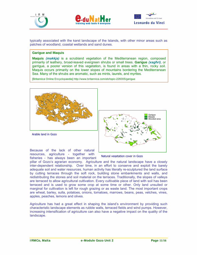
typically associated with the karst landscape of the Islands, with other minor areas such as patches of woodland, coastal wetlands and sand dunes.
Because of the lack of other natural resources, agriculture - together with fisheries - has always been an important pillar of Gozo’s agrarian economy. Agriculture and the natural landscape have a closely inter-dependent relationship. Over time, in an effort to conserve and exploit the barely adequate soil and water resources, human activity has literally re-sculptured the land surface by cutting terraces through the soft rock, building stone embankments and walls, and redistributing the stones and soil material on the terraces. Traditionally, the slopes of valleys are terraced to allow agricultural cultivation. Every cultivable piece of land with soil has been terraced and is used to grow some crop at some time or other. Only land unsuited or marginal for cultivation is left for rough grazing or as waste land. The most important crops are wheat, barley, sulla, potatoes, onions, tomatoes, marrows, beans, peas, vetches, vines, apples, peaches, lemons and olives. Agriculture has had a great effect in shaping the island’s environment by providing such characteristic landscape elements as rubble walls, terraced fields and wind pumps. However, increasing intensification of agriculture can also have a negative impact on the quality of the landscape.
Garigue and Maquis Maquis (makkja) is a scrubland vegetation of the Mediterranean region, composed primarily of leathery, broad-leaved evergreen shrubs or small trees. Garigue (xagħri), or garrigue, a poorer version of this vegetation, is found in areas with a thin, rocky soil. Maquis occurs primarily on the lower slopes of mountains bordering the Mediterranean Sea. Many of the shrubs are aromatic, such as mints, laurels, and myrtles. [Britannica Online Encyclopaedia] http://www.britannica.com/eb/topic-226005/garigue
Arable land in Gozo
Natural vegetation cover in Gozo

IRMCo, Malta e-Module Gozo Unit 2 Page 12/16
Today because of a high level of economic development, off-farm resources such as feed, fertilizers, pesticides, fuel and machinery are being used as substitutes for traditional farm inputs. From a resource-management point of view, despite this increase in mechanisation, management of arable land still has its shortfalls. Maintenance of the traditional rubble walls appears to be a dying practice and tillage of fields is not always done in parallel to the contours, thus facilitating erosion. Limestone quarrying Quarries are widespread in both Malta and Gozo and are predominantly found in the Lower Globigerina, where the ‘franka’ is a most highly sought after building stone. Quarries in Gozo are mostly concentrated in the north west of the island, mainly in San Lawrenz, but also in Kerċem and Għarb. Most of the sites in the area are so-called softstone quarries, extracted from Globigerina Limestone. As shown in the table below, there are only few quarries in Gozo producing so-called ‘hardstone’, which is extracted from either the Upper or Lower Coralline Limestone and used mostly for the construction of roads although it represents a rather poor quality substitute for gravel.
Quarry no. Area name Local Council Quarry Type Surface area (m2)
HG 01 Il-Mielħa Xagħra Hardstone (UCL) 6,424
HG 05 Il-Mixta Kerċem Hardstone (UCL) 21,665
HG 07 Qortin Isopo Nadur Hardstone (UCL) 13,386
HG 10 Għar id-Dar Qala Hardstone (LCL) 61,040
HG 12 Ta' Klement Qala Hardstone (LCL) 19,364
UCL = Upper Coralline Limestone; LCL = Lower Coralline Limestone Source: MEPA, October 2006
Mineral Extraction “Although it may last for many years, the process of mineral extraction should be considered as a temporary use of land. A fundamental approach of the Structure Plan is to ensure that land affected by mineral extraction is worked or reclaimed so that it can subsequently be used for some other beneficial purpose. This affects existing disused quarrying areas, active quarries, and new extraction areas to be defined. The approach in each of these cases is likely to be different.” Ministry for the Development of Infrastructure, Planning Division, 1990. ‘Structure Plan for the Maltese Islands’. Malta.

IRMCo, Malta e-Module Gozo Unit 2 Page 13/16
As shown in the above table, an extensive quarry for hardstone is found in Qala, but a recent application for the further extension of the quarry was dismissed by the Malta Environment and Planning Authority. A proposal for development of the quarry area into a tourist/residential complex including hotel and a marina has been creating controversy, and criticisms have arisen from environmental groups, members of the clergy and the Qala Local Council. In general, the environmental impact associated with the quarrying of limestone needs to be analysed carefully in relation to the protection and conservation of the ground water resources. Indeed, the quarrying of limestone represents the removal of the natural ‘protective cover’ overlying the aquifers. In Gozo, this impact must be linked in particular to the catchment of Wied Ilma (San Lawrenz), as well as the softstone quarries found in Kerċem and in Għarb. Abandoned quarries often become utilized as waste sites. Unless the necessary precautions are taken, this practice can dramatically increase the likelihood of pollution. It should be observed that the increased urbanization in Gozo over the past few decades has intensified quarrying practices on the island, wearing away stretches of the already limited natural and agricultural land. This carries with it a major visual impact on the island’s scenic beauty Interestingly, already in 1960, Lang provided a vivid description of the ‘impact of man’ on Gozo’s natural landscape. “Here there are only thin hill cappings of Upper Coralline Limestone modified by man beyond any real resemblance to karst as at Tad-Dabrani, Ta’ Kulyat, Għar Ilma and Għajn Abdul Ġiordan. One or two larger cappings, at Zebbug and Victoria, retain some karst features. Finally in the west there is a dissected Globigerina plateau with very strong terraced valleys becoming bare on descending to the Lower Coralline Limestone, and small remnant hills of Blue Clay at places such as San Dimitru and Ta’ Birbuba. In the same sequence, just as the karst disappears, the Terra soils give way to rendzinas and carbonate raw soils.”

IRMCo, Malta e-Module Gozo Unit 2 Page 14/16
Thematic Map and related Information Layers for Unit 2
The Thematic Map associated with Unit 2 in the WebGIS is made up of the following information layers:
Gozo Geology Formations: polygon map showing the outcrop of the five limestone formations in Gozo Gozo Faults: segment map of the island’s main faults Gozo Quarries: polygon map showing the aerial extent of the island’s quarries (IRMCo 1999 Surveys)
Other information layers available in the WebGIS include:
Gozo Soil Classes: polygon map showing the distribution of the three main soil classes: Carbonate Raw soils, Xerorendzinas and Terra Rossa soils Gozo Vegetation Cover: polygon map showing the distribution of garigue, maquis and wooded areas (IRMCo 1999 Surveys) Gozo Arable Land: polygon map showing the island’s arable land area Gozo Urban Areas: polygon map showing the island’s built-up area Gozo Local Council Boundaries: segment map delineating the boundaries of the Local Councils in Gozo
Layers Type Visible Selectable Attribute data (short name)
Attribute data (description in full)
Gozo Geology Formations
Polygon Yes Yes Outcrop_m2 Outcropping Surface Area in m2
Gozo Faults Segment Yes Yes
Gozo Quarries Polygon Yes Yes
Gozo Soil Classes
Polygon No Yes Area_m2 Surface Area in m2
Gozo Vegetation Cover
Polygon No Yes
Gozo Arable Land
Polygon No Yes
Gozo Urban Areas
Polygon No Yes
Gozo Local Council Boundaries
Segment No Yes

IRMCo, Malta e-Module Gozo Unit 2 Page 15/16
Useful Weblinks http://www.agric.gov.mt/ http://www.agric.gov.mt/laboratories/surveys.htm (MALSIS soil survey) http://www.emwis-mt.org/documentation/Context/Physical%20factors.htm http://www.gozo.gov.mt http://www.gozo.com http://www.islandofgozo.org http://www.mepa.org.mt http://geography.about.com/library/maps/blmalta.htm http://users.aber.ac.uk/jpg/malta/geology.html References Ford, D. and Williams, P., 1989. ‘Karst Geomorphology and Hydrology’, Unwin Hyman Ltd., London.
Government of Malta, 1973. ‘Fertile Soil (Preservation) Act (1973) Chapter 236’ at http://docs.justice.gov.mt/lom/legislation/english/leg/vol_5/chapt236.pdf
Lang, D. M., 1960. ‘Soils of Malta and Gozo’. Colonial Research Studies No. 29, Colonial Office, London.
MALSIS (Maltese Soil Information System). 2004. ‘Soil geographic database of the Maltese Islands’. National Soil Unit, Ministry for Rural Affairs and the Environment, Malta.
MEPA, 2006. ‘State of the Environment Report for Malta – Sub Report 4: Land’. MEPA, Malta.
Ministry for the Development of Infrastructure, Planning Division, 1990. ‘Structure Plan for the Maltese Islands’. Malta.
Pedley, M., 1993. ‘Geological Map of the Maltese Islands’. Oil Exploration Directorate, Office of the Prime Minister, Malta.
Sammut, S., 2005. ‘State of the Environment Report for Malta – Background Report on Soil’. MEPA, Malta.
Sillanpaa, M., 1982. ‘Micronutrients and the nutrient status of soils: a global study’. FAO Soils Bulletin 48, Rome, Food and Agriculture Organization of the United Nations.
Sivarajasingham, S.,1971. ‘The Soils of Malta. Wastes Disposal and Water Supply’. Report prepared for World Health Organization by the Food and Agriculture Organization of the United Nations, Rome.
Zammit Maempel, G., 1989. ‘Pioneers of Maltese Geology’. P.E.G. Ltd., Malta.

IRMCo, Malta e-Module Gozo Unit 2 Page 16/16
Further Reading Borg, J., Lanfranco, E. & Sultana, J., 2007. ‘Nature in Gozo’. BirdLife (Malta), Malta.
Hyde, H., 1954. ‘The Geology of the Maltese Islands’. Malta.
Paskoff, R., 1978. ‘Observations geomorphologiques sur les cotes de l’archipel maltais’. Zeitschrift fur Geomorphologie, Berlin Stuttgard.
Tanti, C., Role, A., Borg. C., Calleja, I. 2002. ‘Protection of Soil and Rural Landscapes in Northwest Malta.’ In UNEP/MAP (United Nations Environment Programme/Mediterranean Action Plan). 2003. MAP CAMP Project “MALTA” Final Integrated Project Document and Selected Thematic Documents, MAP Technical Reports Series No 138, Volume II, UNEP/MAP, Athens.
Vella, S. 2001. ‘Soil Information in the Maltese Islands’. In Zdruli, P., Steduto, P., Lacirignola C., and Montanarella, L. (eds) Soil Resources of Southern and Eastern Mediterranean Countries. Options mediterraneennes Serie B: Studies and Research Number 34 pp. 171-191, Bari, Italy, CIHEAM (Centre International de Hautes Etudes Agronomiques Mediterraneennes).
Vella, S.J. 2003. ‘Soil Survey and Soil Mapping in the Maltese Islands: the 2003 position’ in Soil Resources of Europe: incorporating EU Candidate Countries. P. Bullock, R.J.A. Jones and L. Montanarella (eds.) EUR 20559 EN 000pp. Office for Official Publications of the European Communities, Luxembourg.