Embed Size (px)
Citation preview
Unit 8: Moving Ground
Teacher Sheet 1
Unit 8: Moving Ground
Preparation
It is assumed that students will have done some preliminary work investigating the following:
i. surface processes, such as weathering.ii. water movements on the surface and within rocks.iii. sedimentary rock types.
Suggested Approach
1. Prior to the simulations, ask students to work through the sheets referring to the Folkestone Warren slide.
2. This should naturally lead on to a session investigating the processes involved in ground movement.
3. The simulation materials need to be prepared in advance. Teachers may decide to try all of them or a selection.Depending on class size, it may be easier to separate pupils into groups, with each group assigned to one of thefour simulations. They can then either report their results to the others or move around to the next one.
4. Examine preventive measures using the Barton case study and a personal study near pupils' own homes.
Notes on the student sheets
1. Background information on Folkestone Warren
Introduction
Folkestone Warren is located on the South Coast 2 km north-east of Folkestone itself. The Warren is an undercliffzone of rough ground occupying up to 50 metres above sea level. Above it tower cliffs of Chalk, known as High Cliffand reaching 125 metres altitude. The Warren itselfis an area of contorted hummocky ground distorted by a seriesof lands lips, shown on the maps and photographs of the Student Sheets.
The geology is simple and consists of nearly horizontal beds of sedimentary rock. The lowest formation is the
1~~I~f~rllll~llfll~l~m~1N07017
Teacher Sheet 2 .
Unit 8: Moving Ground
FolkestoneBeds, which are sandstone. These are overlain by about 50 m of a stiff blue clay, the Gaul t Clay, followedby the Chalk itself, which makes up the bulk of High Cliff, (see section, Figure 5).
Historical Background
Landslipshave been recorded since 1765, although the instability was largely ignored: the opening of the DoverRail way in 1844 indicates this. (An alternative - a tunnel of 1.5 kIn length was considered impracticable). A majorslip in 1877 caused partial collapse of the Martello Tunnel and closed the line for a time. The main collapse in 1915moved almost the whole of the Warren towards the sea. The railway moved 55 m seaward and dropped about 6 m.This extended the coastline between 240 and 350 m. The train c~ught at the time was derailed by a 5 m step whichdeveloped in the track and parts of the track were buried by the Great Fall. There were other less serious slips in1937 and 1940. This highlights the problem of containing natural phenomena.
Causes
The slides are considered to be the result of two main factors:
1. The Gault Clay may become unstable when saturated and pressure is applied by the weight of the overlyingChalk. This leads to failure at the junction with the Folkestone Beds. Shear movements develop and the clayslips.
2. The main direction of longshore drift ofbeach material is towards the east. This tends to starve East Wear Bay:of beach sediment and encourages slip within the Warren. Construction of harbour works at Folkestonesincethe 17th Century has progressively worsened the natural situation. The 19th Century construction ofa masonryharbour led to further erosion within East Wear Bay. Successive pier extensions in 1863,1883 and 1905 haveall been accompanied by landslip a few years later, the last severe one being in 1915, 10 years after the lastharbour extension. Since then, movements have been minor, thanks to preventive measures such as toeweighting and drainage tunnels within the clays.
The answers to questions 1.1 to 1.11 are largely self-explanatory from the text and diagrams in the Student Sheets.In 1.8, note that although most of the movement was downwards, the toe of the slip near the coast actually rose.
2. Why does ground move?
The major factors, considered under the headings given, are as follows:
Rock type composition (e.g. the presence of pyrite in a clay causes loss of strength when it weathers. SeeStudent Sheet 6)
strength (e.g. igneous rocks are usually strong, while fairly recently deposited sediments are not.)
porosity & permeability (e.g. clays can hold much water inthe pore spaces, but will not let it passthrough, thus lubricating slips.)
Rock Structure bedding planes (provide weaknesses along which water can move and weathering and weakeningcan take place.)
joints (have a similar effect, increased by the fact that joints, although further apart than beddingplanes, are often vertical.)
dip of beds (can be important because steeply dipping beds allow greater water penetration.)
Rainfall intensity (heavy rainfall during storms can cause water build-up on the surface or underground,which results in rock failure.)
seasonality (wet seasons may have a similar effect, even though the build-up is over a longerperiod)
drought (the 1976 drought caused many clays to dry out and shrink, resulting in subsidence and
Teacher Sheet 3
Unit 8: Moving Ground
other failure.)
salt spray (during storms increases weathering rates in coastal area.)
Temperature
Vegetation
great temperature variation can lead to rock failure, as can repeated freezing and thawing.
vegetation cover slows rates oferosion byreducing temperature variation and by the binding actionof the roots.
Human Activity e.g. road and rail cuttingsremoval of groundwateragriculturebuilding
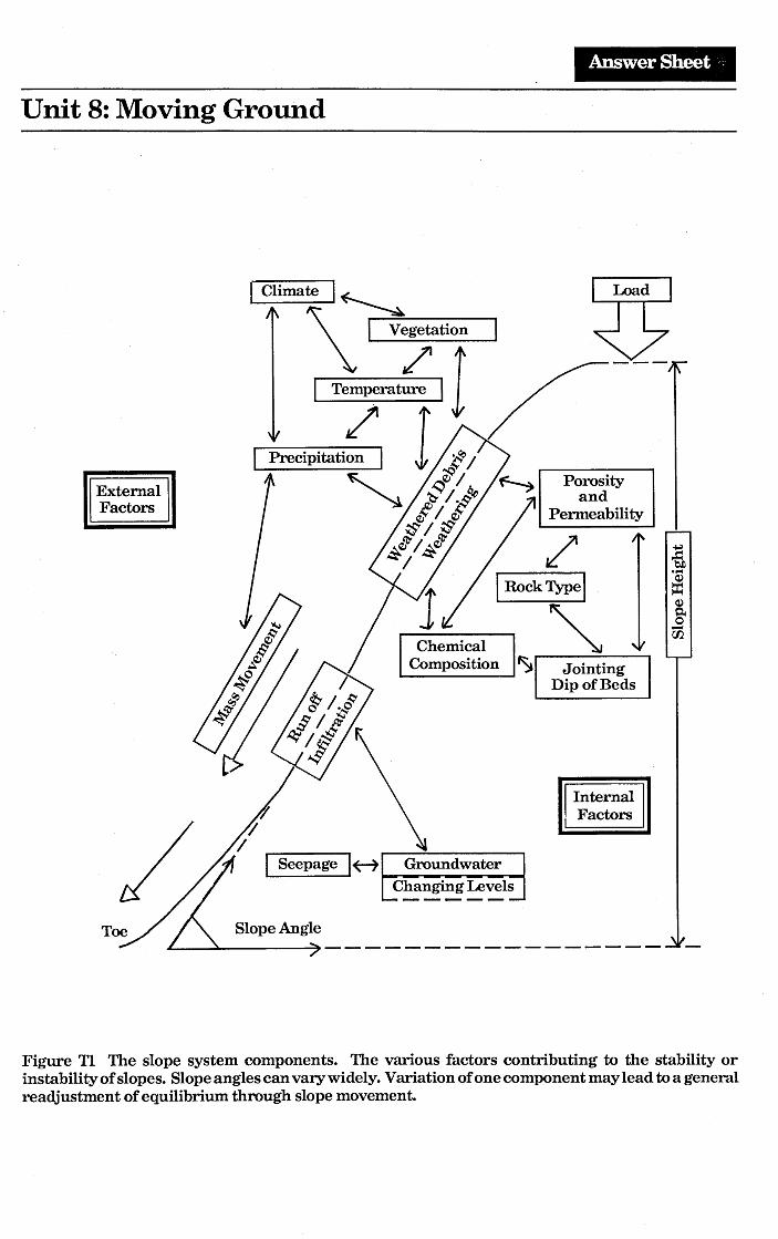
The "answer sheet" is Fig TI.
Discussion of these and related factors will lead on to the examination of other critical factors in more detail, suchas: slope angle, height, load, etc. which are examined during the investigations.
3. Experiments in the Laboratory
A) What is the angle of failure of different loose materials?
These experi.ments show how different materials can support different slope angles. The angle of slope that can besupported by loose materials is controlled by :
a) the wuys in which grains support one another. This in turn depends upon the packing of the grains, with closelypacked grains being more stable and 'supportive' than loosely packed grains. It also depends upon grain shapebecause elongated grains can interlock, increasing stability.
b) friction between the grains. Grains with smooth surfaces have low slope angles; once they become rougher (e.g.rusted ball bearings) they can support steeper slope angles.
c) amount of water present. A little water causes the grains to cohere or stick together, more water acts as alubricant and reduces friction, much water buoys up the grains, allowing them to flow more easily. Some effectsof water are examined in experiment B.
In rocks which are no longer loose materials, the situation is complicated by the amount, type and effectiveness ofcement, by the effects of the compression by overlying rocks, by any changes in particle shape or type caused byincreases of heat or pressure, by later fracturing, weathering, etc.
The differences are highlighted where scree slopes are found beneath steeper rock faces, either in natural cliffs orin man-made cuttings.
B) How does pressure of the pore water affect the strength of material?
Teacher Sheet 4
Unit 8: Moving Ground
The pressure exerted by water flowing through a material such as sand can be high enough to force the grains apart.This hydrostatic force can cause the sand to lose its strength and begin to flow, becoming a quicksand.
In this simulation, the pressure exerted by the water is proportional to the height of the water column (head) abovethe level of the sand surface. At lower heads, water will flow but the bolt will not sink.
This can happen naturally where permeable materials, like sands, are trapped between impermeable materials, likeclay layers. Both materials were present in the Folkestone Warren situation. Sudden increases in hydrostaticpressures, with their catastrophic effects, can be seen with earthquake triggered slides, as in Anchorage, Alaska.Both sand and clay can display this almost gel-like quality (sometimes called thixotropic).
Experimental follow-up could investigate the effects of different head pressures, different mixtures of materials,different thicknesses of materials, etc.
C) What effects do underlying rocks have on slope failure?
When porous materials (sand) lie above impermeable materials (clay) the sand can become saturated during storms,etc. The addition of more water causes the grain contacts to lose their friction and flow occurs under the influenceof gravity. This effect can be seen quite frequently on motorway embankments, especially after heavy rain.
D) What binds the grains together?
When the water has evaporated, the sand castle made with distilled water will collapse, while the salt saturated sandwill not, since the individual grains are glued together by the salt cement. This illustrates how weak sediments canbe cemented to form stronger and more resistant sedimentary rocks.
The importance of the composi tion ofthe cement can be illustrated by pouring boiling water over a piece ofsandstoneand then over the salt-cemented sand castle. As the less effective cement dissolves, the 'rock' collapses. Calciumcarbonate cements dissolve in acid rain and soil water; iron cements become weakened by oxidation and reactionwith water, but silica cements are resistant to most weathering processes so that the toughest sedimentary rocksin the U.K. are usually bound by silica cements. These, therefore, tend to form the steepest natural rock faces, whereother factors are not important.
4. Save the Barton Cliffs: Background Information.
The main processes in operation in the cliff area are shown in Fig. 13 and can be grouped as:
1. Surface processes, such as mass movement and seepages along the cliffs. Weathering of suIphides such as pyri teis a contributory factor, although not quite so marked as at Folkestone.
2. Marine processes operating along the cliff foot and beaches.
A combination of these mechanisms has resulted in average cliff recession rates of up to 1metre per year.Since 1960 remedial measures have been applied, with varying degrees of success. These have entailed twomainoperations:
1. Protection of the clifffoot against wave attack as shown in Figure 12 and by scattering gabions along the beachto break the force of longshore currents and waves. Gabions are boxes made of woven metal bands filled withearth or rocks.
Teacher Sheet 5
Unit 8: Moving Ground
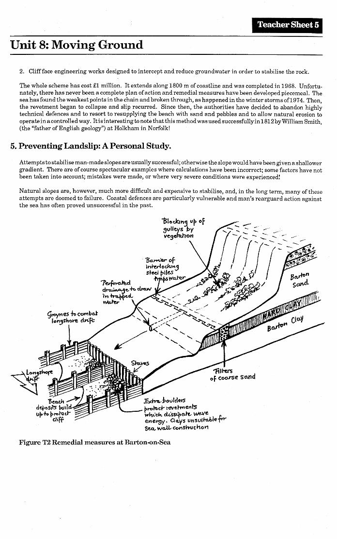
2. Cliff face engineering works designed to intercept and reduce groundwater in order to stabilise the rock.
The whole scheme has cost £1 million. It extends along 1800 m of coastline and was completed in 1968. Unfortu-nately, there has'never been a complete plan of action and remedial measures have been developed piecemeal. Thesea has found the weakest points in the chain and broken through, as happened in the winter storms of197 4. Then,the revetment began to collapse and slip recurred. Since then, the authorities have decided to abandon highlytechnical defences and to resort to resupplying the beach with sand and pebbles and to allow natural erosion tooperate in a controlled way. It is interesting to note that this method was used successfully in 1812 by William Smith,(the "father of English geology") at Holkham in Norfolk!
5. Preventing LandsIip: A Personal Study.
Attem pts to stabilise man -made slopes are usually successful; otherwise the slope wouldhave been given a shall owergradient. There are of course spectacular examples where calculations have been incorrect; some factors have notbeen taken into account; mistakes were made, or where very severe conditions were experienced!
Natural slopes are, however, much more difficult and expensive to stabilise, and, in the long term, many of theseattempts are doomed to failure. Coastal defences are particularly vulnerable and man's rearguard action againstthe sea has often proved unsuccessful in the past.
Figure T2 Remedial measures at Barton-on-Sea
Teacher Sheet 6
Unit 8: Moving Ground
Further reading
Other examples may be drawn from a wide variety of sources. Daily newspapers and magazines will often containreports concerning slope movements, as there may often be loss of life. This type of information source will involvestudents, as they can readily acquire such materials. The Geographical Magazine, Geography Review, NationalGeographic and Geology Today will occasionally contain relevant articles.
Study the Earth, Atherton. M. and Robinson, R. Hodder & Stoughton. The unit - Water at Work has usefulsimulations of geological processes.
Catastrophe: The Violent Earth. Waltham, T. Macmillan. Contains an exciting chapter on landslips, plus goodreference material for teachers.
Geology and Man. Watson, J. Allen & Unwin. Chapter 6 deals with earth movements, in context of reservoirs andcoasts.
Experiments in Physical Sedimentation. Allen, J.R.L. Allen & Unwin. Contains a wealth of experiments designedto illustrate sedimentary principles and processes.
High Roads and Low Roads. Carter, P. and Wallace, G. Article in Geology Today, March/April, 1987 pp. 54 to 59.
A colour slide (CT3) of the view in Fig. 2 is available from the Geological Museum, London, price 30p.
Acknowledgements
This Unit devised by Simon Elsy.
Grateful thanks are expressed to:The Curator of the Cambridge University Collection of Air Photographs, for permission to publish Fig. 2.British Rail, Southern Region, for allowing the use of the photograph in Fig. 3.Dr. J.E. Robinson for his helpful comments on the manuscript of the Unit.Mrs. H. Busteed and Mr. A. Birchall for diagrams and artwork.
Published by the Association of Teachers of Geology.Designed and printed by Geo-Supplies, Sheffield.The publication of this series of Units has been made possible by financial support from the Geologists' Association Fund, whichis gratefully acknowledged.
Copyright. There is no copyright on original material published in this Unit, if it is required for use within the laboratory orclassroom. Copyright material reproduced by permission of other publishers rests with the originating publishers.
"Science of the Earth" Units are obtainable from:ATG - Ms F Stratton, Sandbourne, Clophill Road, Maulden, Beds, MK45 2AA.GA - The Geologists' Association, Burlington House, Piccadilly, London, WI V 9AG.Geo-Supplies, 16 Station Road, Chapeltown, Sheffield, S30 4XH.
Student Sheet 1
Unit 8:Moving Ground
Major earthquakes are uncommon in the British Isles and so we tend to take it for granted that ourland is .safe and will not move. However, it is possible for land on steep cliffs and hillsides to give way.,When this happens it can prove disastrous for the people who live there or for roads and railways builtacross such areas.
We are going to study a famous example of moving ground, near Folkestone in Kent, to find out whatcauses land to give way. Later, you will be able to carry out some experiments to test your ideas aboutlandslip and then devise your own scheme for protecting another part of the south coast from this haz-ard.
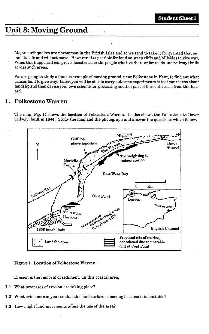
1. Folkestone Warren
The map (Fig. 1) shows the location of Folkestone Warren. It also shows the Folkestone to Doverrailway, built in 1844. Study the map and the photograph and answer the questions which follow.
English Channel
N
1Clifftopabove landslide
East Wear Bay
'Copt Point
'0 Km 1
o Landslip areaProposed site of marina,abandoned due to unstablecliff at Copt Point
Figure 1. Location of Folkestone Warren.
Erosion is the removal of sediment. In this coastal area,
1.1 What processes of erosion are taking place?
1.2 What evidence can you see that the land surface is moving because it is unstable?
1.3 How might land movements affect the use of the area?
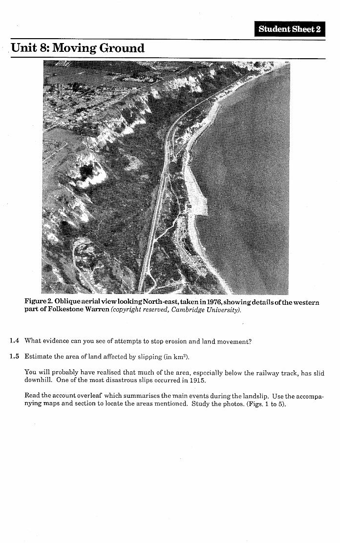
student Sheet 2
Unit 8: Moving Ground
Figure 2. Oblique aerial view looking North -east, taken in 1976, showing details of the westernpart of Folkestone WaITen (copyright reserved, Cambridge University).
1.4 What evidence can you see of attempts to stop erosion and land movement?
1.5 Estimate the area of land affected by slipping (in km2).
You will probably have realised that llluch of the area, especially belo\v the railway track, has sliddownhill. One of the most disastrous slips occurred in 1915.
Read the account overleaf \vhich summarises the main events during the landslip. Use the accompa-nying maps and section to locate the areas mentioned. Study the photos. (Figs. 1 to 5).
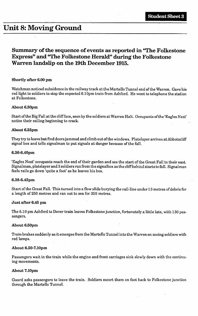
Student Sheet 3
Unit 8: Moving Ground
Summary of the sequence of events as reported in 'The FolkestoneExpress" and 'The Folkestone Herald" during the FolkestoneWarren landslip on the 19th December 1915..
Shortly after 6.00 pm
Watchman noticed subsidence in the railway track at the Martello Tunnel end of the Warren. Gave hisred light to soldiers to stop the expected 6.10pm train from Ashford. He went to telephone the stationat Folkestone.
About 6.3Opm
Start of the Big Fall at the cliffface, seen by the soldiers at Warren Halt. Occupants of the 'Eagles Nest'notice their ceiling beginning to crack.
About 6.35pm
They try to leave but find doorsjammed and climb out of the windows. Platelayer arrives at Abbotscliffsignal box and tells signalman to put signals at danger because of the fall.
6.36-6.4Opm
'Eagles Nest' occupants reach the end of their garden and see the start of the Great Fall to their east.Signalman, platelayer and 3 soldiers run from the signalbox as the cliffbehind starts to fall. Signalmanfeels rails go down 'quite a foot' as he leaves his box.
6.38-6.43pm
Start of the Great Fall. This turned into a flow slide burying the rail-line under 13 metres of debris fora length of 250 metres and ran out to sea for 350 metres.
Just after 6.45 pm
The 6.10 pm Ashford to Dover train leaves Folkestone junction, fortunately a little late, with 130 pas-sengers.
About 6.5Opm
Train brakes suddenly as it emerges from the Martello Tunnel into the Warren on seeing soldiers withred lamps.
About 6.50-7.10pm
Passengers wait in the train while the engine and front carriages sink slowly down with the continu-ing movements.
About 7.1Opm
Guard asks passengers to leave the train. Soldiers escort them on foot back to Folkestone junctionthrough the Martello Tunnel.
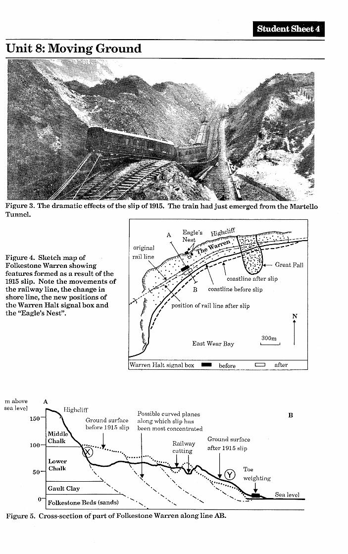
Student Sheet 4
Unit 8: Moving Ground
Figure 3. The dramatic effects of the slip of 1915. The train had just emerged from the MartelloTunnel.
I"Var:en Halt signal box - before
N
Ic:::J after
300mEast Wear Bay L.--.I
A
"} '.,, .>/ position of rail line after slip
{ ,I
originalrai11ineFigure 4. Sketch map of
Folkestone Warren showingfeatures formed as a result of the1915slip. Note the movements ofthe railway line, the change inshore line, the new positions ofthe Warren Halt signal box andthe "Eagle's Nest".
o Folkestone Beds (sands)
B
Sea level
Railwaycutting
" "
Possible curved planesGround surface along which slip hasbefore 1915 slip been most concentrated
........J..........., ..........LowerChalk
Gault Clay
50
100
150
nl above Asea level
Figure 5. Cross-section of part of Folkestone Warren along line AB.
Student Sheet 5
Unit 8:Moving Ground
When you have gained a good idea of what happened, try to answer the following questions:-
1.6 How has the position of the railway line, shown in the photo, map and cross section, changed?
1.7 What does the cross section show was the cause of these changes?
1.8 At points X and Y, measure the amount of vertical movements caused by the slip and say \vhetherit was upwards or downwards.
1.9 Was the slip a single event or a series of events?
1.10 How long did the whole landslip event take?
1.11 What are the first signs of lands lip?
2. Why does ground move?
Now we need to find out what factors cause grou~d to move.
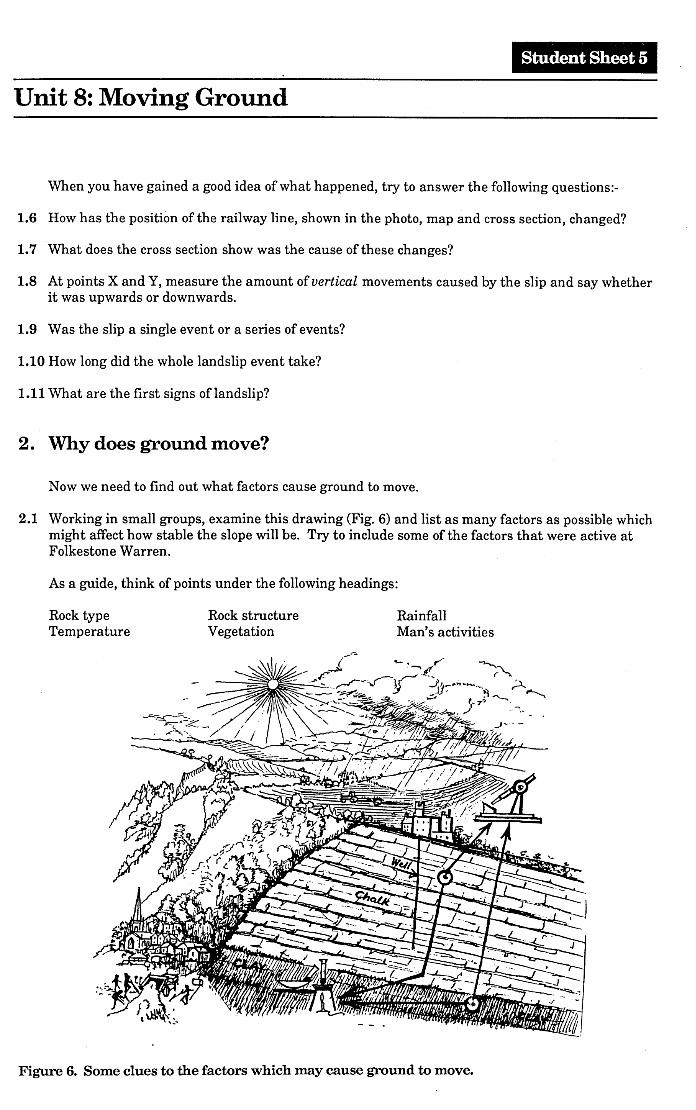
2.1 Working in small groups, examine this drawing (Fig. 6) and list as many factors as possible whichmight affect how stable the slope will be. Try to include some of the factors that were active atFolkestone Warren.
As a guide, think of points under the following headings:
Rock typeTemperature
Rock structureVegetation
RainfallMan's activities
Figure 6. Some clues to the factors which may cause ground to move.
Student Sheet 6
Unit 8: Moving Ground
When you have finished, ask your teacher for an "answer sheet" which shows you the factors whichgeologists and engineers have found to be important.
The factors which you have listed are all linked with one another so that change in one may causeothers to change too.Generally, slopes become less stable when:the slope angle becomes steeper.extra material is dumped at the top of the slope.material is removed from the base of the slope.the weight of rock is increased by water seeping in.the strength of rock is decreased by water seeping in.the groundwater level rises, causing water logging.vegetation, whose roots bind the material together is removed.chemical changes take place within the rock.
On coasts, much material is continually removed from the base of the slope by the erosive action of thesea.
At Folkestone, the effects of chemical changes within the rock are especially drastic. The Gault Claycontains a lot of the mineral called pyrite, sometimes known as "fool's gold". Chemically, it consists ofiron sulphide (FeS2). When exposed to air and moisture, this changes to sulphate minerals. As thechange occurs it causes the clay to swell, rather as yeast does in bread dough. Heatis given off by thereaction and this also causes the clay to crack. Taken together, these processes lead to the rapid dis-in tegration of the clay, which then slips very easily under the weight of overlying rock.
When Man -made slopes are being constructed, the engineers calculate "safe" angles for the slopes. Forexample, in the London Clay, which is a notoriously unreliable foundation rock, the slope of a cuttinghas to be as low as 80 to be safe!
It is possible to test some of the factors in the list above by simple experiments and this is the objectof the next section. .
3. Experiments in the laboratory
A) What is the angle of failure in different loose materials?
In these experiments you will find out how steep a slope has to be before it fails or slips. Howimportant is the type of material in the slope? To find out, use the method below.
1. Collect the apparatus from your teacher.
2. Cut the cardboard into a narrow ring with the outside diameter a little less than the bottle.Mark on this ring with a protractor a scale with 5 degree intervals and stick the ring to thebottom of the bottle.
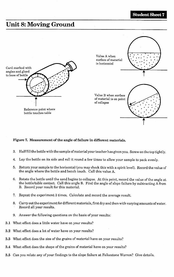
Student Sheet 7
Unit 8: Moving Ground
Value B when surfaceof material is on pointof collapsei
Value A whensurface of materialis horizontal
Reference point wherebottle touches table
Card marked withangles and gluedto base of bottle
-+
Figure 7. Measurement of the angle of failure in different materials.
3. Halffill the bottle with the sample ofmaterial your teacher has given you. Screw on the top tightly.
4. Lay the bottle on its side and roll it round a few times to allow your sample to pack evenly.
5. Return your sample to the horizontal (you may check this with a spirit level). Record the value ofthe angle where the bottle and bench touch. Call this value A.
6. Rotate the bottle until the sand begins to collapse. At this point, record the value of the angle atthe bottle/table contact. Call this angle B. Find the angle of slope failure by subtracting A fromB. Record your result for this material.
7. Repeat the experiment 3 times. Calculate and record the average result.
8. Carry out the experiment for different materials, first dry and then with varying amounts ofwater.Record all your results.
9. Answer the following questions on the basis of your results:
3.1 What effect does a little water have on your results?
3.2 What effect does a lot of water have on your results?
3.3 What effect does the size of the grains of material have on your results?
3.4 What effect does the shape of the grains of material have on your results?
3.5 Can you relate any of your findings to the slope failure at Folkestone Warren? Give details.
Student Sheet 8
Unit 8: Moving Ground
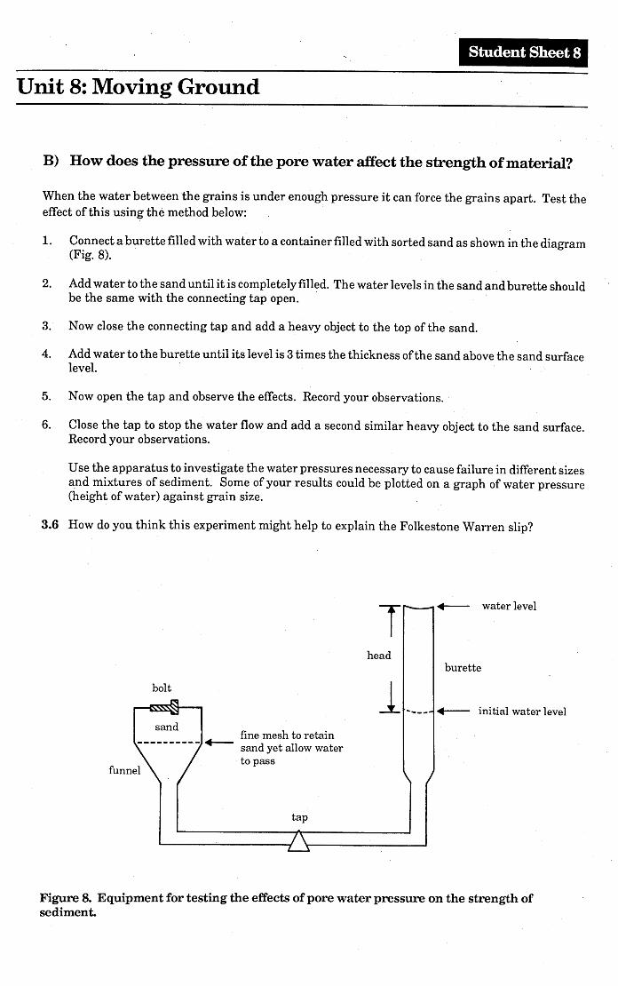
B) How does the pressure of the pore water affect the strength of material?
When the water between the grains is under enough pressure it can force the grains apart. Test theeffect of this using the method below:
1. Connect a burette filled with water to a container filled with sorted sand as shown in the diagram(Fig. 8). .
2. Add water to the sand un til it is completely filled. The water levels in the sand and burette shouldbe the same with the connecting tap open. .
3. Now close the connecting tap and add a heavy object to the top of the sand.
4. Add water to the burette until its level is 3 times the thickness of the sand above the sand surfacelevel.
5. Now open the tap and observe the effects. Record your observations.
6. Close the tap to stop the water flow and add a second similar heavy object to the sand surface.Record your observations.
Use the apparatus to investigate the water pressures necessary to cause failure in different sizes~nd mixtures of sediment. Some of your results could be plotted on a graph of water pressure(height of water) against grain size.
3.6 How do you think this experiment might help to explain the Folkestone Warren slip?
T .-- water level
bolt
head
1.~__burette
.-- initial water levelsand
'fine mesh to retain---------.-.-- sand yet allow water
to passfunnel
tap
Figure 8. Equipment for testing the effects of pore water pressure on the strength ofsediment.
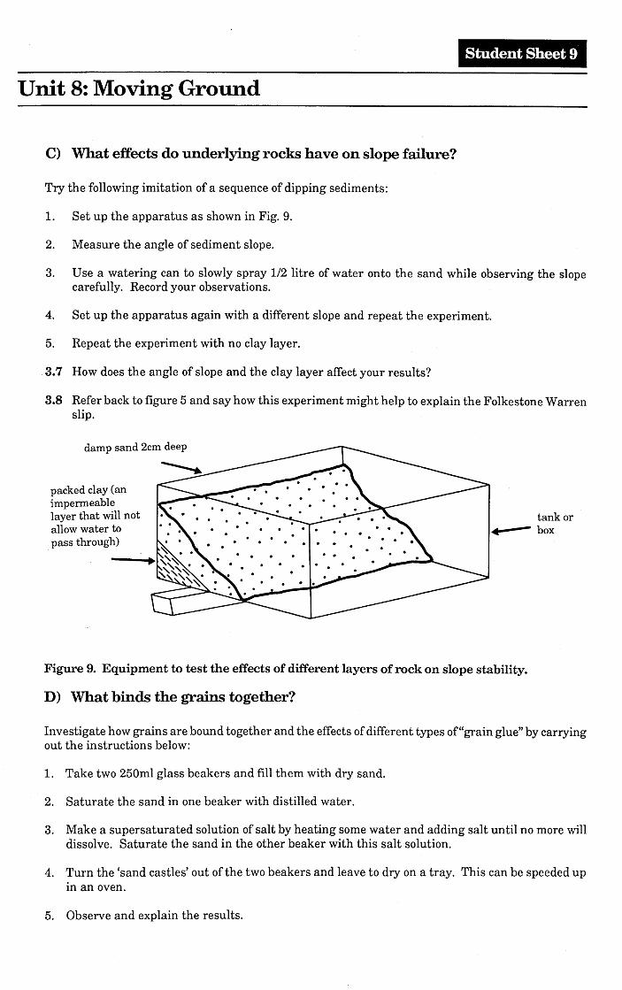
Student Sheet 9
Unit 8: Moving Ground
C) What effects do underlying rocks have on slope failure?
Try the following imitation of a sequence of dipping sediments:
1. Set up the apparatus as shown in Fig. 9.
2. Measure the angle of sediment slope.
3. Use a watering can to slowly spray 1/2 litre of water onto the sand while observing the slopecarefully. Record your observations.
4. Set up the apparatus again with a different slope and repeat the experiment.
5. Repeat the experiment with no clay layer.
,3.7 How does the angle of slope and the clay layer affect your results?
3.8 Refer back to figure 5 and say how this experiment might help to explain the Folkestone Warrenslip.
damp sand 2cm deep
packed clay (animpermeablelayer that will notallow water to
.pass through)
tank or•• --- box
Figure 9. Equipment to test the effects of different layers of rock on slope stability.
D) What binds the grains together?
Investigate how grains are bound together and the effects of different types of"grain glue" by carryingout the instructions below:
1. Take two 250ml glass beakers and fill them with dry sand.
2. Saturate the sand in one beaker with distilled water.
3. Make a supersaturated solution of salt by heating some water and adding salt until no more willdissolve. Saturate the sand in the other beaker with this salt solution.
4. Turn the 'sand castles' out of the two beakers and leave to dry on a tray. This can be speeded upin an oven.
5. Observe and explain the results.
Student Sheet 10
Unit 8:Moving Ground
3.9 How do the effects you observed in your experiment affect natural slopes in loose sediments?
3.10 What will happen in natural rock outcrops where the material ~ementing the grains together isan easily dissolved material?
Naturally occurring cements in rocks include silica (Si02), calcium carbonate (CaC03) and variousiron oxides.
3.11 Which one of these would you expect to be most soluble in acid rain water?
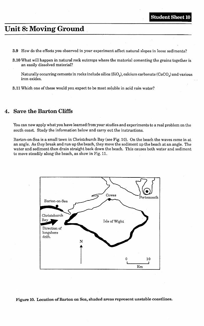
4. Save the Barton Cliffs
You can now apply what you have learned from your studies and experiments to a real problem on thesouth coast. Study the information below and carry out the instructions.
Barton-on-Sea is a small town in Christchurch Bay (see Fig. 10). On the beach the waves come in atan angle. As they break and run up the beach, they move the sediment up the beach at an angle. Thewater and sediment then drain straight back down the beach. This causes both water and sedimentto move steadily along the beach, as show in Fig. 11.
Portsmouth
Christchurch
~Direction oflongshoredrift.
N
oI
Km
10I
Figure 10. Location of Barton on Sea, shaded areas represent unstable coastlines.
Student Sheet 11
Unit 8: Moving Ground
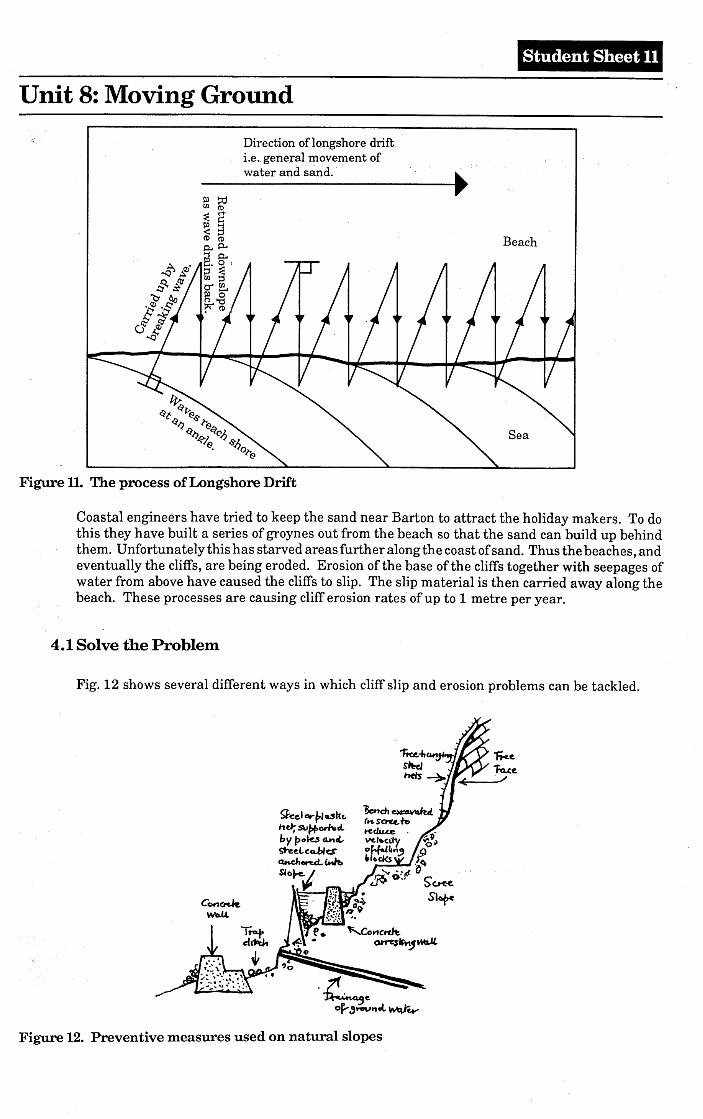
Direction of longshore driftLe..general movement ofwater and sand. . •••..-----~
Figure!l. The process of Longshore Drift
Beach
Sea
Coastal engineers have tried to keep the ·sand near Barton to attract the holiday makers. To dothis they have built a series of groynes out from the beach so that the sand can build up behindthem. Unfortunately this has starved areas further along the coast of sand. Thus the beaches, andeventually the cliffs, are being eroded. Erosion of the base of the cliffs together with seepages ofwater from above have caused the cliffs to slip. The slip material is then carried away along thebeach. These processes are causing cliff erosion rates of up to 1metre per year.
4.1 Solve the Problem
Fig. 12 shows several different ways in which cliff slip and erosion problems can be tackled.
g.c:el ~P'dltt.hd; Su/;+omcLbypo~4t1L~eLcCl.bles~on.cL~Slof.e."
Figure 12. Preventive measures used on natural slopes
Student Sheet 12
Unit 8: Moving Ground
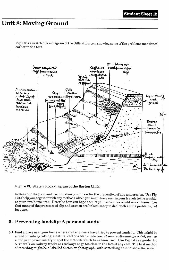
Fig. 13 is a sketch block-diagram of the cliffs at Barton, showing some of the problems mentionedearlier in the text.
M~c..etosicnoK.f>.use. -jnshlbiU1y ofcJa,ys CLt)cLternoVQlrcf'la.nclslipma, .
",'
'\ ....•..•.. •.
llU
,.....•-._- -- ---- -- •... -
""~. ~l')\beHrt~(. r d~
SafJ- ~~ 'oJie"Ba.ritw. day ~
Figure 13. Sketch block diagram of the Barton Cliffs.
Redraw the diagram and use it to show your ideas for the prevention of slip and erosion. Use Fig.12 to help you, together with any methods which you might have seen in your travels to the seaside,or your own home area. Describe how you hope each of your measures would work. Rememberthat many of the processes of slip and erosion are linked, so try to deal with all the problems, notjust one.
5. Preventing landslip: A personal study
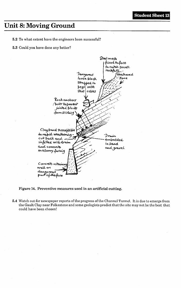
5.1 Find a place near your home where civil engineers have tried to prevent landslip. This might bea road or railway cutting, a natural cliff or a Man-made one. From a safe vantage point, such asa bridge or pavement, try to spot t~e methods which have been used. Use Fig. 14 as a guide. DoNOT walk on railway tracks or road\vays or go too close to the foot of any cliff. The best methodof recording might be a labelled sketch or photograph, with something on it to show the scale.
Student Sheet 13
Unit 8: Moving Ground
5.2 To what extent have the engineers been successful?
5.3 Could you have done any better?
-Pa"" ,t¥c:10SlooSt,pleck.
s~ecL+O~e9s wiHlS#'eel cables
1?c;c.k an c.h Clt:S"
li>o(t:s'"fbf;>~)*~)o."h.d..t>/o~~m $ICtlJNt,.J
1>~. t....., beelCo'led..-ttt So.nd..~Gl jt11rVe.t
Figure 14. Preventive measures used in an artificial cutting.
5.4. Watch out for newspaper reports of the progress of the Channel Tunnel. It is due to emerge fromthe Gault Clay near Folkestone and some geologists predict that the site may not be the best thatcould have been chosen!
Unit 8: Moving Ground
Answer Sheet :
ExternalFactors
Porosityand
Penneability
/'IRock Type I
~Jointing
Dip of Beds
InternalFactors
I Seepage I~ GroundwaterChanging Levels
Slope Angle
Figure TI The slope system components. The various factors contributing to the stability orinstability of slopes. Slope angles can vary widely. Variation of one component may lead to a generalreadjustment of equilibrium through slope movement.

![Moving Ducts Inside: Big Builders, Scientists Find Common Ground … Ducts inside[1].pdf · 2010-04-30 · Moving Ducts Inside: Big Builders, Scientists Find Common Ground Michael](https://img.pdfslide.net/doc/110x75/5ea198572e594e22504833eb/moving-ducts-inside-big-builders-scientists-find-common-ground-ducts-inside1pdf.jpg)