Embed Size (px)
Citation preview

UNITED STATES GOVERNMENT June 27, 2017
To: P u b l i c I n f o r m a t i o n (MS 5030)
From: P l a n C o o r d i n a t o r , FO, Plans S e c t i o n (MS
5231)
S u b j e c t : P u b l i c I n f o r m a t i o n copy o f p l a n
C o n t r o l # - S-07S55
Type - Supplemental Development O p e r a t i o n s C o o r d i n a t i o n s Document
Lease(s) - OCS-G16770 E l o c k - 641 Green Canyon Area
OCS-G200S2 B l o c k - 640 Green Canyon Area
O p e r a t o r - Chevron U.S.A. I n c .
D e s c r i p t i o n - I n s t a l l i n g one Lease Term P i p e l i n e and Commence
R i g Type - Not Found
A t t a c h e d i s a copy o f t h e s u b j e c t p l a n .
I t has been deemed s u b m i t t e d as o f t h i s d a t e and i s under r e v i e w f o r a p p r o v a l .
C h i q u i t a H i l l
P l a n C o o r d i n a t o r
s i t e
????/A TAHITI 6832 FSL, 6451 FWL G1677O/GC/641
WELL/SS002 G20082/GC/640 5741 FNL, 261 FEL G20082/GC/640

PUBLIC INBRMATION CO PY May, 2017
SUPPLEMENTAL DEVELOPMENT OPERATIONS COORDINATION DOCUMENT
Green Canyon Block 640 OCS-G 20082
Unit Agreement No. 754306008
A-Tahiti SPAR Production Facility Located In
Green Canyon Block 641
Tahiti 2 Affected State: Louisiana
Estimated Startup Date: January, 2018
SUBMITTED BY: Chevron U.S.A. Inc. 114 Northpark Blvd
Room137D Covington, LA 70433
Carly Moss (985) 773-1734
AUTHORIZED REPRESENTATIVE: Cathy Thornton
J. Connor Consulting, Inc. 19219 Katy Fwy Ste 200
Houston, TX 77094 (713) 705-8020
cathv.thornton(5)iccteam.com

TABLE OF CONTENTS
SECTION 1 PLAN CONTENTS 1
1.1 PLAN INFORMATION 1
1.2 LOCATION 2
1.3 SAFETY AND POLLUTION PREVENTION FEATURES 2
1.4 STORAGE TANKS AND PRODUCTION VESSELS 2
1.5 POLLUTION PREVENTION MEASURES 2
1.6 ADDITIONAL MEASURES 2
1.7 COST RECOVERY FEE 2
SECTION 2 GENERAL INFORMATION 3
2.1 APPLICATIONS AND PERMITS 3
2.2 DRILLING FLUIDS 3
2.3 PRODUCTION 3
2.4 OIL CHARACTERISTICS 3
2.5 NEW OR UNUSUAL TECHNOLOGY 3
2.6 BONDING STATEMENT 3
2.7 OIL SPILL FINANCIAL RESPONSIBILITY (OSFR) 4
2.8 DEEPWATER WELL CONTROL STATEMENT 4
2.9 SUSPENSION OF PRODUCTION 4
2.10 BLOWOUT SCENARIO 4
SECTION 3 GEOLOGICAL AND GEOPHYSICAL INFORMATION 5
3.1 GEOLOGICAL DESCRIPTION 5
3.2 STRUCTURE CONTOUR MAP(S) 5
3.3 INTERPRETED 2-D AND/OR 3-D SEISMIC LINE(S) 5
3.4 GEOLOGICAL STRUCTURE CROSS-SECTION(S) 5
3.5 SHALLOW HAZARDS REPORT 5
3.6 SHALLOW HAZARDS ASSESSMENT 6
3.7 HIGH-RESOLUTION SEISMIC LINES 6
3.8 STRATIGRAPHIC COLUMN 6
TOC Pg 1 of 4

3.9 TIME VS DEPTH TABLES 6
SECTION 4 HYDROGEN SULFIDE INFORMATION 7
4.1 CONCENTRATION 7
4.2 CLASSIFICATION 7
SECTION 5 MINERAL RESOURCE CONSERVATION INFORMATION 8
5.1 TECHNOLOGY & RESERVOIR ENGINEERING PRACTICES AND PROCEDURES [PROPRIETARY] 8
5.2 TECHNOLOGY AND RECOVERY PRACTICES AND PROCEDURES [PROPRIETARY] 8
5.3 RESERVOIR DEVELOPMENT [PROPRIETARY] 8
SECTION 6 BIOLOGICAL, PHYSICAL AND SOCIOECONOMIC INFORMATION 9
6.1 DEEPWATER BENTHIC COMMUNITIES 9
6.2 TOPOGRAPHIC FEATURES (BANKS) 9
6.3 TOPOGRAPHIC FEATURES STATEMENT (SHUNTING) 9
6.4 LIVE-BOTTOMS (PINNACLE TREND FEATURES) 9
6.5 LIVE BOTTOMS (LOW RELIEF) 9
6.6 POTENTIALLY SENSITIVE BIOLOGICAL FEATURES 9
6.7 REMOTELY OPERATED VEHICLE (ROV) SURVEYS 9
6.8 THREATENED AND ENDANGERED SPECIES, CRITICAL HABITAT, AND MARINE MAMMAL INFORMATION 10
6.9 ARCHAEOLOGICAL REPORT 11
6.10 AIR AND WATER QUALITY INFORMATION 12
6.11 SOCIOECONOMIC INFORMATION 12
SECTION 7 WASTES AND DISCHARGES INFORMATION 13
7.1 PROJECTED GENERATED WASTES 13
7.2 MODELING REPORT 13
SECTION 8 AIR EMISSIONS INFORMATION 14
8.1 EMISSIONS WORKSHEETS AND SCREENING QUESTIONS 14
8.2 SUMMARY INFORMATION 14
SECTION 9 OIL SPILL INFORMATION 16
9.1 OIL SPILL RESPONSE PLANNING 16
9.2 SPILL RESPONSE SITES 16
TOC Pg 2 of 4

9.3 OSRO INFORMATION 16
9.4 WORST-CASE DISCHARGE SCENARIO DETERMINATION 17
9.5 OIL SPILL RESPONSE DISCUSSION 18
SECTION 10 ENVIRONMENTAL MONITORING INFORMATION 27
10.1 MONITORING SYSTEMS 27
10.2 INCIDENTAL TAKES 27
10.3 FLOWER GARDEN BANKS NATIONAL MARINE SANCTUARY 27
SECTION 11 LEASE STIPULATIONS INFORMATION 28
11.1 MILITARY WARNING AREA (MWA) 28
11.2 MARINE PROTECTED SPECIES 28
SECTION 12 ENVIRONMENTAL MITIGATION MEASURES INFORMATION 30
12.1 MEASURES TAKEN TO AVOID, MINIMIZE, AND MITIGATE IMPACTS 30
12.2 INCIDENTAL TAKES 30
SECTION 13 RELATED FACILITIES AND OPERATIONS INFORMATION 31
13.1 RELATED OCS FACILITIES AND OPERATIONS 31
13.2 TRANSPORTATION SYSTEM 31
13.3 PRODUCED LIQUID HYDROCARBONS TRANSPORTATION VESSELS 31
SECTION 14 SUPPORT VESSELS AND AIRCRAFT INFORMATION 32
14.1 GENERAL 32
14.3 DRILLING FLUID TRANSPORTATION 32
14.4 SOLID AND LIQUID WASTE TRANSPORTATION 32
14.5 VICINITY MAP 32
SECTION 15 ONSHORE SUPPORT FACILITIES INFORMATION 33
15.1 GENERAL 33
15.2 SUPPORT BASE CONSTRUCTION OR EXPANSION 33
15.3 SUPPORT BASE CONSTRUCTION OR EXPANSION TIMETABLE 33
15.4 WASTE DISPOSAL 33
SECTION 16 COASTAL ZONE MANAGEMENT (CZM) INFORMATION 34
SECTION 17 ENVIRONMENTAL IMPACT ANALYSIS (EIA) 35
SECTION 18 ADMINISTRATIVE INFORMATION 36
18.1 EXEMPTED INFORMATION DESCRIPTION 36
TOC Pg 3 of 4

18.2 BIBLIOGRAPHY 36
TOC Pg 4 of 4

Section 1 Plan Contents 1-A OCS Plan Information Form 1-B Well Location Plat 1-C Pay.gov Receipt
Section 3 Geological, Geophysical Information 3-A Structure Contour Maps 3-B Geological Structure Cross Section
Section 8 Air Emissions Information
8-A Emissions Worksheets Section 14 Support Vessels and Aircraft Information
14-A Waste You Will Transport and/or Dispose Onshore Table 14-B Vicinity Map
Section 17 Environmental Impact Analysis (EIA)
17-A Environmental Impact Analysis (EIA)
Attachment-Pg. 1 of 1

SECTION 1 PLAN CONTENTS
1.1 PLAN INFORMATION
Chevron U.S.A. Inc. (Chevron) as designated operator of Lease OCS-G 20082, Green Canyon Block 640, which is part of the Green Canyon Block 640 Unit (Unit Agreement No. 754306008). Under this Supplemental Development Operations Coordination Document (DOCD), Chevron proposes to install one lease term pipeline and commence production from Lease OCS-G 20082, Green Canyon Block 640, Well No. SS002. Well No. SS002 will be drilled and completed underthe Supplemental Exploration Plan (EP) (Control No. S-7839) submitted March 20, 2017.
Area/Block Lease No.
Well Plan Control No. Operation
GC 640 OCS-G 20082
001ST02BP01 001ST02BP01 (PS001)
Initial EP Initial DOCD Revised DOCD
N-7157 N-8406 R-5101
Drilled and TA Completed, tied back and produced
002ST00BP04
002ST00BP04 (PS002)
Initial EP Revised EP Initial DOCD Revised DOCD
N-7157 R-3837 N-8406 R-5101
Drilled and TA Completed tied back and produced
GC 640 OCS-G 20082
PC001 through PC004 PS010
Supplemental EP S-7778 Drilled and completed
GC 640 OCS-G 20082
PC001 through PC004 PS010
Supplemental DOCD S-7820 Produced
GC 640 OCS-G 20082
SS002 Supplemental EP S-7839 Drilled and Completed
GC 641 OCS-G 16770
001ST01 BPOO Initial EP N-7408 Drilled and TA
GC 596 OCS-G 16759
001 (PN001) Supplemental EP Initial DOCD Revised DOCD
S-6016 N-8406 R-5101
Drilled and TA Completed and produced
Remaining PN and PS wells in the Tahiti Field
Initial EP
Supplemental EP
Initial DOCD Revised DOCD
N-7408 N-7479 N-7157 S-6016 S-5973 N-8406 R-5101
Drilled and TA
Completed and produced
GC 640 OCS-G 20082 GC 641 OCS-G 16770
Injector wells IS001 through IS004
Supplemental EP Revised EP
Supplemental DOCD
S-7399 R-5087 R-5825 S-7447
Drilled
Completed and produced
Chevron U.S.A. Inc. Supplemental DOCD Green Canyon Block 640 (OCS-G 20082)
Section 1 - Pg. 1 of 36 May, 2017

The OCS Plan Information Form BOEM-137 is included as Attachment 1-A.
1.2 LOCATION Well Location Plats depicting the proposed surface and bottom hole locations of the proposed well(s) measured depth/true vertical depth and water depth for each location is included as Attachment 1-B.
1.3 SAFETY AND POLLUTION PREVENTION FEATURES The pipeline jumper will be installed using a dynamically positioned offshore construction lay vessel and support vessels equipped with safety and fire-fighting equipment required to comply with United States Coast Guard (USCG) regulations. Appropriate lifesaving equipment such as life rafts, life jackets, ring buoys, etc. as prescribed the USCG, will be maintained on the vessel at all times.
Any waste or fuel resulting in pollution in the Gulf waters will be reported to the representatives in charge for immediate action. Any spill will be reported to the appropriate government agencies.
1.4 STORAGE TANKS AND PRODUCTION VESSELS Only includes storage tanks with capacity of 25 barrels or more that will store fuels, oil and lubricants.
Type of Storage Tank
Type of Vessel
Tank Capacity
(bbls)
Number of Tanks
Total Capacity
(bbls)
Fluid Gravity
(API) Fuel Oil (Marine Diesel)
Light Construction Vessel 942.86 7 6600 30°
Lube Oil Light Construction
Vessel 36.25 8 290 22°
1.5 POLLUTION PREVENTION MEASURES These operations do not propose activities for which the State of Florida is an affected state.
1.6 ADDITIONAL MEASURES Chevron does not propose any additional safety, pollution prevention, or early spill detection measures beyond those required by 30 CFR Part 250.
1.7 COST RECOVERY FEE Documentation ofthe $4238 cost recovery fee payment is included as Attachment 1-C.
Chevron U.S.A. Inc. Supplemental DOCD Green Canyon Block 640 (OCS-G 20082)
Section 1 - Pg. 2 of 36 May, 2017

U.S. Department ofthe Interior Bureau of Ocean Energy Management
OMB Control Number: 1010-0151
OMB Approval Expires: 12/31/1 e
OCS PLAN INFORMATION F O R M General Information
Type of OCS Plan: Exploration Plan (EP) X Development Operations Coordination Document
Company Name: Chevron U.S.A. Inc. BOEM Operator Number: 00078
Address: 114 Northpark Bivd, Room 137D Contact Person: Cathy Thomton
Covington, LA 70433 PhoneNumber: 713-705-8020
Email Address: cathy.thomton^Jccteam.com
If a service fee is requned under 30 CFR 550.125(a), provide the Amount paid $4238 Receipt No. 2628LJEQ
Project and Worst Case Discharge (WCD)Information
Lease(s): OCS-G 20082 Area: GC BIock(s): 640 Project Name (if applicable): Tahiti
Objective(s): X Oil X Gas Sulphur Salt Onshore Support Base(s): Leeville and Port Fourchon, Louisiana
Platform/Well Name: A-Tahiti-SPAR Total Volume of WCD: 195,410 API Gravity: 29.5°
Distance to Closest Land (Miles): 118 Volume from uncontrolled blowout: 186,452
Have you previously provided information to verify the calculations and assumptions for your WCD? X Yes No
If so, provide the Control Number of the EP or DOCD with which this information was provided. S-7839
Do you propose to use new or unusual technology to conduct your" activities? Yes X No
Do you propose to use a vessel with anchors to install or modify a structure? Yes X No
Do you propose any facility that will serve as a host facility for deepwater subsea development? Yes x No
Description of Proposed Activities and Tentative Schedule (Mark all that apply) Proposed Activity Start Date End Date No. of Days
Exploration drilling
Development dr illing, completion and production
Well completion
Well test flaring (for more than 48-hours)
Installation or modification of structure
Installation of production facilities
Installation of subsea wellheads and/or manifolds
Installation of lease term pipelines January 1, 2018 January 2, 2018 Commence production January 18,2018 Other (Specify and attach description)
Description of Drilling Rig Description of Structure Jackup Drillship Caisson Tension leg platform
Gorilla Jackup Platfonn Rig Fixed platform Compliant tower
Semisubmersible Submersible Spar Guyed tower
DP Semisubmersible Other (attach description) Floating production system X
Other (Attach Description) Subsea Well No. 002
Drilling Rig Name (if known):
Floating production system X
Other (Attach Description) Subsea Well No. 002
Description of Lease Term Pipelines From (Facility/Area/Block) To (Facility/Area/Block) Diameter (Inches) Length (Feet)
GC640 Well No. SS002 GC640 Subsea Manifold 7.75 100
FORM BOEM-0137 (March 2015 - Supersedes all previous editions ofthis form which may not be used.)
ATTACHMENT 1-A
Page 1 of 3

O C S P L A N I N F O R M A T I O N F O R M ( C O N T I N U E D ) Include one copy of this page for each proposed well/structure
Proposed Well/Structure Location Well or Structure Name / Number (if renaming well or structure, reference previous name) A-Tahiti-SPAR
Previously reviewed under an approved EP or DOCD?
X Yes No
Is this an existing well or structure?
X Yes No Ifthis is an existing well or structure, list the Complex ID or API No.
Complex ID No. 1819
Do you plan to use a subsea BOP or a surface BOP on a floating facility to conduct your proposed activities? Yes X No
WCD info For wells, volume of uncontrolled blowout (Bbls/day) 186,452
For structures, volume of all storage and pipelines (Bbls) 8958
API Gravity of fluid 29.5°
Surface Location Bottom-Hole Location (For Wells) Completion (For multiple completions, enter separate lines)
Lease No. OCS-G 16770
Area Name GC
Block No. 641
Block Line Departures (in feet)
N/S Departure: 6832'FSL N/S Departure: N/S Departure: N/S Departure: N/S Departure:
E/W Departure: 6451'FWL E/W Departure: E/W Departure: E/W Departure: E/W Departure:
Lambert X-Y coordinates
X: 2.382,451 X:
Y: 9,922,672 Y:
Latitude / Longitude
Latitude: 27019,33.2682" Latitude: Latitude: Latitude: Latitude:
Longitude: -90o42,50.946" Longitude: Longitude: Longitude: Longitude:
Water Depth (Feet): 4000'
MD (Feet): TVD (Feet):
Anchor Radius (if applicable) in feet:
MD (Feet): MD (Feet): MD (Feet):
TVD (Feet) TVD (Feet) TVD (Feet)
Anchor ocations for Drilling Rig or Construction Barge (If anchor radius supplied above, not necessary) Anchor Name
or No. Area Block X Coordinate Y Coordinate Length of Anchor Chain on Seafloor
X = Y= X = Y= X = Y= X = Y= X = Y= X = Y= X = Y= X = Y=
F O R M B O E M - 0 1 3 7 (March 2015 - Supersedes all previous editions of thisform which may not be used.) Page 2 of 3
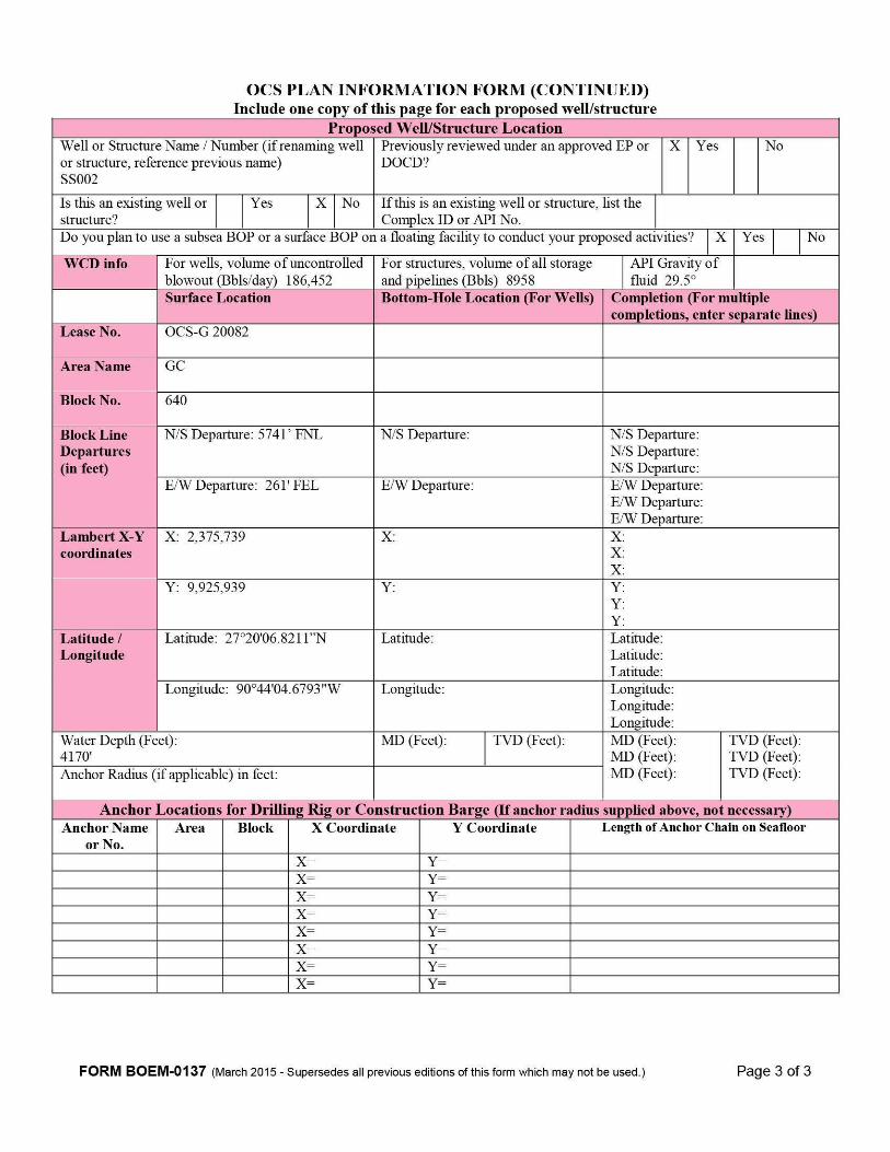
O C S P L A N I N F O R M A T I O N F O R M ( C O N T I N U E D ) Include one copy of this page for each proposed well/structure
Proposed Well/Structure Location Well or Structure Name / Number (if renaming well or structure, reference previous name) SS002
Previously reviewed under an approved EP or DOCD?
X Yes No
Is this an existing well or structure?
Yes X No Ifthis is an existing well or structure, list the Complex ID or API No.
Do you plan to use a subsea BOP or a surface BOP on a floating facility to conduct your proposed activities? X Yes No
WCD info For wells, volume of uncontrolled blowout (Bbls/day) 186,452
For structures, volume of all storage and pipelines (Bbls) 8958
API Gravity of fluid 29.5°
Surface Location Bottom-Hole Location (For Wells) Completion (For multiple completions, enter separate lines)
Lease No. OCS-G 20082
Area Name GC
Block No. 640
Block Line Departures (in feet)
N/S Departure: 5741' FNL N/S Departure: N/S Departure: N/S Departure: N/S Departure:
E/W Departure: 261'FEL E/W Departure: E/W Departure: E/W Departure: E/W Departure:
Lambert X-Y coordinates
X: 2,375,739 X:
Y: 9.925,939 Y:
Latitude / Longitude
Latitude: 27o20,06.8211"N Latitude: Latitude Latitude Latitude
Longitude: 90o44,04.6793"W Longitude: Longitude Longitude Longitude
Water Depth (Feet): 4170'
MD (Feet): TVD (Feet):
Anchor Radius (if applicable) in feet:
MD (Feet) MD (Feet) MD (Feet)
TVD (Feet) TVD (Feet) TVD (Feet)
Anchor iQcations for Drilling Rig or Construction Barge (If anchor radius supplied above, not necessary) Anchor Name
or No. Area Block X Coordinate Y Coordinate Length of Anchor Chain on Seafloor
X = Y= X = Y= X = Y= X = Y= X = Y= X = Y= X = Y= X = Y=
F O R M B O E M - 0 1 3 7 (March 2015 - Supersedes all previous editions ofthis form which may not be used.) Page 3 of 3

WATER DEPTH COMTOUR IM FEET. COIsrTOUR I MTERVAL = 20 FEET.
EXISTING PIPELINE/UMBILICAL/CABLE LOCATION, AS REPORTED BY BOEM.
DATE : 16 MARCH 2017 PROJECTIOM; UTM
GEODETIC DATUM: MAD 1927 ZOME: 15 MORTH
ELLIPSOID: CLARKE 1866 GRID UMITS: US FEET
Well Designation and
Block
Cartesian Coordinates UTM Zone 15 (ft)
Geographic Coordinates
Biock Calls (ft) Well
Designation and Block
Cartesian Coordinates UTM Zone 15 (ft) fT866, NAD 1927 Biock Calls (ft)
Well Designation and
Block
Cartesian Coordinates UTM Zone 15 (ft)
(deg., min, scc.) Biock Calls (ft)
Well Designation and
Block X Y Latitude Longitude
Biock Calls (ft)
SS002 2,375,739' 27" 20' 06.8211" N 90° 44' 04.6793" W 5741FNL 261 FFL
SS002A 2,375,740' 9,925,940' 27- 20' 06.8308" N 90- 44' 04.6680" W 5740FNL 260 FEL
SS002B 2,375,738' 9,925,938' 27- 20 06.8113" N 90- 44' 04.6906" W 5742 FNL 262 FEL
FILE MAME: 2560_PLAT_R.DWG
CHEVRON U.S.A. INC.
TAHITI FIELD SURFACE LOCATION PLAT
PQRUM
BLOCK 640 GREEN CANYON AREA
GULF OF MEXICO LOCATION MAP
ATTACHMENT 1-B

Pay.gov - Receipt Page 1 of 1
Receipt
Your payment is complete Pay.gov Tracking ID: 2628LJEQ Agency Tracking ID: 75238297127 Form Name: BOEM Development Operations Coordination Document or DPP Application Name: BOEM Development/DOCD Plan - BD
Payment Information Payment Type: Debit or credit card Payment Amount; $4,238.00 Transaction Date: 05/04/2017 09:37:41 AM EDT Payment Date: 05/04/2017 Region: GulfofMexico Contact: Kirk Richard 985-773-6327 Company Name/No: Chevron U S A, Inc.. 00078 Lease Number(s): 20082, , , , Area-Block: Green Canyon GC, 640: , : , : , : , Type-Wells: Supplemental Plan, 1
Account Information Cardholder Name: Kirk Richard Card Type: American Express Card Number: ************1009
Email Confirmation Receipt Confirmation Receipts have been emailed to: [email protected]
ATTACHMENT 1-C https://v^vw.pay.gov/public/coIlection/confirm/print/2628LJEQ/AmericanExpress 5/4/2017

SECTION 2 GENERAL INFORMATION
2.1 APPLICATIONS AND PERMITS Listed in the table below are the additional applications to be filed covering operations proposed in this DOCD.
Application/Permit Issuing Agency Status Surface Commingling Application BSEE Pending Deepwater Operations Plan BSEE Pending
Conservation Information Document BOEM Pending
Lease Term Pipeline Applications BSEE Pending
Downhole Commingling Application BSEE Pending
2.2 DRILLING FLUIDS No drilling operations are proposed in this DOCD.
2.3 PRODUCTION Anticipated Production:
Type Average Production Rate
Peak Production Rate Life of Reservoir
Oil 1500 bbls/day 20,000 bbls/day 30 Years
Gas 800 mmcf/day 10,500 mmcf/day 30 Years
2.4 OIL CHARACTERISTICS Oil characteristics are not required to be submitted with this plan.
2.5 NEW OR UNUSUAL TECHNOLOGY No new or unusual technology is proposed in this DOCD as defined by 30 CFR 550.200.
2.6 BONDING STATEMENT The bond requirements forthe activities and facilities proposed in this DOCD are satisfied by an area-wide bond, furnished and maintained according to 30 CFR 556 Subpart I; NTL No. BOEM 2015-N04, "General Financial Assurance;" and a current BOEM-approved deferment from providing additional security under 30 CFR 556.53 and National NTL No.
Chevron U.S.A. Inc. Section 2 - Pg. 3 of 36 Supplemental DOCD May, 2017 Green Canyon Block 640 (OCS-G 20082)

2016-N01-BOEM, "Requiring Additional Security". If, at any point, Chevron no longer qualifies for a supplemental bonding deferment, Chevron will either provide the required additional security or a third party guarantee within 60 days after such disqualification.
2.7 OIL SPILL FINANCIAL RESPONSIBILITY (OSFR) Chevron (Operator Number 00078) has demonstrated or will demonstrate oil spill financial responsibility for the facilities proposed in this DOCD according to 30 CFR Part 553; and NTL No. 2008-N05, "Guidelines for Oil Spill Financial Responsibility for Covered Facilities" prior to conducting operations covered in this DOCD.
2.8 DEEPWATER WELL CONTROL STATEMENT Not applicable for the operations proposed in this PlanChevron (Operator Number 00078) has the financial capability to drill a relief well and conduct other emergency well control operations.
2.9 SUSPENSION OF PRODUCTION The Green Canyon Block 640 Unit is currently held by ongoing production.
2.10 BLOWOUT SCENARIO There are no drilling and/or completion operations proposed in this Plan.
Chevron U.S.A. Inc. Section 2 - Pg. 4 of 36 Supplemental DOCD May, 2017 Green Canyon Block 640 (OCS-G 20082)

SECTION 3
GEOLOGICAL AND GEOPHYSICAL INFORMATION
3.1 GEOLOGICAL DESCRIPTION [PROPRIETARY]
3.2 STRUCTURE CONTOUR MAP(S) Current structure contour maps drawn on the top of each productive hydrocarbon sand, show the entire lease block, the locations of the wells, and the locations of geological cross-sections are included as Attachment 3-A (Attached in the Proprietary Copy).
3.3 INTERPRETED 2-D AND/OR 3-D SEISMIC LINE(S) The proposed operations will be conducted from previously approved surface locations as provided for in the Supplemental Exploration Plan (Control No. S-7839), therefore, seismic lines are not provided.
3.4 GEOLOGICAL STRUCTURE CROSS-SECTION(S) Interpreted geological structure cross-sections showing the location and depth of the proposed well with the key horizon and the objective sands labeled using standard biostratigraphic terms are included as Attachment 3-B (Attached in Proprietary Copy).
3.5 SHALLOW HAZARDS REPORT A shallow hazards survey was conducted over Green Canyon Block 640.
The proposed operations will be conducted from previously approved surface locations as provided for in the Supplemental Exploration Plan (Control No. S-7839); therefore, in accordance with NTL No. 2008-G05, "Shallow Hazards Program", a shallow hazards report is not provided.
Chevron U.S.A. Inc. Section 3 - Pg. 5 of 36 Supplemental DOCD May, 2017 Green Canyon Block 640 (OCS-G 20082)

3.6 SHALLOW HAZARDS ASSESSMENT The proposed operations will be conducted from previously approved surface locations as provided for in the Supplemental Exploration Plan (Control No. S-7839), approved on January 14, 2016; therefore, in accordance with NTL No. 2008-G05, Shallow Hazards Program", a shallow hazards assessment is not provided.
3.7 HIGH-RESOLUTION SEISMIC LINES The proposed operations will be conducted from previously approved surface locations as provided for in the Supplemental Exploration Plan (Control No. S-7839), approved on January 14, 2016; therefore, annotated high-resolution survey lines are not being submitted.
3.8 STRATIGRAPHIC COLUMN A generalized biostratigraphic/lithostratigraphic column depicting each well from the seafloor to the total depth is not required for the operations proposed in this DOCD.
3.9 TIME VS DEPTH TABLES Sufficient well control data for the target areas proposed in this DOCD exists; therefore, seismic time versus depth tables for the proposed well locations are not required.
Chevron U.S.A. Inc. Section 3 - Pg. 6 of 36 Supplemental DOCD May, 2017 Green Canyon Block 640 (OCS-G 20082)

SECTION 4 HYDROGEN SULFIDE INFORMATION
4.1 CONCENTRATION Chevron does not anticipate encountering or handling H2S during the proposed operations.
4.2 CLASSIFICATION Not applicable for the operations proposed in this Plan.
Chevron U.S.A. Inc. Section 4 - Pg. 7 of 36 Supplemental DOCD May, 2017 Green Canyon Block 640 (OCS-G 20082)

SECTION 5 MINERAL RESOURCE CONSERVATION INFORMATION
5.1 TECHNOLOGY & RESERVOIR ENGINEERING PRACTICES AND PROCEDURES [PROPRIETARY]
5.2 TECHNOLOGY AND RECOVERY PRACTICES AND PROCEDURES [PROPRIETARY]
5.3 RESERVOIR DEVELOPMENT [PROPRIETARY]
Chevron U.S.A. Inc. Section 5 - Pg. 8 of 36 Supplemental DOCD May, 2017 Green Canyon Block 640 (OCS-G 20082)

SECTION 6 BIOLOGICAL, PHYSICAL AND SOCIOECONOMIC INFORMATION
6.1 DEEPWATER BENTHIC COMMUNITIES The proposed operations will be conducted within 500 feet of a previously approved surface locations as provided for in the Supplemental Exploration Plan (Control No. S-7839)
6.2 TOPOGRAPHIC FEATURES (BANKS) Activities proposed in this DOCD do not fall within 305 meters (1000 feet) of a topographic "No Activity Zone;" therefore, no map is required per NTL No. 2009-G39, "Biologically Sensitive Underwater Features and Areas."
6.3 TOPOGRAPHIC FEATURES STATEMENT (SHUNTING) All activities proposed under this DOCD will be conducted outside all Topographic Feature Protective Zones; therefore, shunting of drill cuttings and drilling fluids is not required per NTL No. 2009-G39, "Biologically Sensitive Underwater Features and Areas."
6.4 LIVE-BOTTOMS (PINNACLE TREND FEATURES) Green Canyon Block 640 is not located within 61 meters (200 feet) of any pinnacle trend feature; therefore, a separate bathymetric map is not required per NTL No. 2009-G39, "Biologically Sensitive Underwater Features and Areas."
6.5 LIVE BOTTOMS (LOW RELIEF) Green Canyon Block 640 is not located within 30 meters (100 feet) of any live bottom (low relief) feature with vertical relief equal to or greater than 8 feet; therefore, live bottom (low relief) maps are not required per NTL No. 2009-G39, "Biologically Sensitive Underwater Features and Areas."
6.6 POTENTIALLY SENSITIVE BIOLOGICAL FEATURES Green Canyon Block 640 is not located within 30 meters (100 feet) of potentially sensitive biological features; therefore, biologically sensitive area maps are not required.
6.7 REMOTELY OPERATED VEHICLE (ROV) SURVEYS Not applicable.
Chevron U.S.A. Inc. Section 6 - Pg. 9 of 36 Supplemental DOCD May, 2017 Green Canyon Block 640 (OCS-G 20082)

6.8 THREATENED AND ENDANGERED SPECIES, CRITICAL HABITAT, AND MARINE MAMMAL INFORMATION There are five species of sea turtles that may be found in the Gulf of Mexico (see table below). NOAA fisheries currently list all five of these turtles as endangered (E) or threatened (T).
Species Scientific Name Status Potential Presence Critical Habitat Designated in
the Gulf of Mexico
Species Scientific Name Status Lease Area
Coastal Critical Habitat Designated in
the Gulf of Mexico
Sea Turtles Loggerhead Carettsa caretta T X X None
Green Chelonia mydas T X X None
Leatherback Dermochelys coriacea
E X X None
Hawksbill Eretmochelys imbricata
E X X None
Kemp's Ridley
Lepidochelys kempii
E X X None
In addition, there are 28 species of marine mammals that may be found in the Gulf of Mexico. The table provided below identifies the seven (7) species of marine mammals that are listed as endangered or threatened. Currently, there are no designated critical habitats for the listed species in the Gulf of Mexico Outer Continental Shelf; however, it is possible that one or more of these species could be seen in the area during operations.
Species Scientific Name Status Potential Presence
Critical Habitat
Designated in the Gulf of
Mexico
Species Scientific Name Status
Lease Area Coastal
Critical Habitat
Designated in the Gulf of
Mexico
Marine Mammals Sperm Whale Physeter
macrocephalus E X — None
West Indian Manatee
Trichechus manatus latirostris
E — X Florida
Blue Whale Balaenoptera masculus
E X — None
Chevron U.S.A. Inc. Supplemental DOCD Green Canyon Block 640 (OCS-G 20082)
Section 6 - P g . 10 of 36 May, 2017

Species Scientific Name Status Potential Presence
Critical Habitat
Designated in the Gulf of
Mexico
Lease Area Coastal
Critical Habitat
Designated in the Gulf of
Mexico
Fin Whale Balaenoptera physalus
E X — None
Humpback Whale
Megaptera novaeangliae
E X — None
North Atlantic Right Whale
Eubalaena glacialis E X — None
Sei Whale Balaenopiera borealis
E X — None
There is one (1) species of fish that NOAA fisheries currently list as threatened (T) that may be found in the Gulfof Mexico. The Gulfsturgeon, also known as the GulfofMexico sturgeon, is an anadromous (breeding in freshwater after migrating up rivers from marine and estuarine environments) fish overwintering in estuaries, bays, and the Gulf of Mexico (see table below).
Species Scientific Name Status Potential Presence
Critical Habitat
Designated in the Gulf of
Mexico
Species Scientific Name Status
Lease Area Coastal
Critical Habitat
Designated in the Gulf of
Mexico
Fish Gulf Sturgeon Acipenser
oxyrinchus (=oxyrhynchus)
desotoi
T X X None
6.9 ARCHAEOLOGICAL REPORT The proposed operations will be conducted from previously approved surface locations as provided for in the Supplemental Exploration Plan (Control No. S-7839); therefore, in accordance with NTL No. 2005-G07, "Archaeological Surveys and Reports," and NTL No. 2011-JOINT-G01, "Revisions to the List of OCS Lease Blocks Requiring Archaeological Resource Surveys and Reports," an archaeological survey report is not provided.
Chevron U.S.A. Inc. Supplemental DOCD Green Canyon Block 640 (OCS-G 20082)
Section 6 - P g . 11 of 36 May, 2017

6.10 AIR AND WATER QUALITY INFORMATION Air and water quality information is not required to be included in this plan per NTL No. 2008-G04, "Information requirements for Exploration Plans and Development Operations Coordination Documents".
6.11 SOCIOECONOMIC INFORMATION Socioeconomic Information is not required to be included in this plan per NTL No. 2008-G04, "Information Requirements for Exploration Plans and Development Operations Coordination Documents".
Chevron U.S.A. Inc. Section 6 - P g . 12 of 36 Supplemental DOCD May, 2017 Green Canyon Block 640 (OCS-G 20082)

SECTION 7 WASTES AND DISCHARGES INFORMATION
7.1 PROJECTED GENERATED WASTES Projected generated wastes are not required forthe operations proposed in this Plan.
7.2 MODELING REPORT Modeling reports are not required forthe activities proposed in this plan.
Chevron U.S.A. Inc. Section 7 - P g . 13 of 36 Supplemental DOCD May, 2017 Green Canyon Block 640 (OCS-G 20082)

SECTION 8 AIR EMISSIONS INFORMATION
8.1 EMISSIONS WORKSHEETS AND SCREENING QUESTIONS Screen Questions for DOCD's Yes No
Is any calculated Complex Total (CT) Emission amount (tons) associated with your proposed development activities more than 90% ofthe amounts calculated using the following formulas: CT = 3400D2 / 3 for CO, and CT = 33.3D for the other air pollutants (where D = distance to shore in miles)?
X
Do your emission calculations include any emission reduction measures or modified emission factors?
X
Does or will the facility complex associated with your proposed development and procluction activities process production from eight or more wells?
X
Do you expect to encounter H2S at concentrations greater than 20 parts per million (ppm)? X
Do you propose to flare or vent natural gas in excess ofthe criteria set forth under 250.1105(a)(2) and (3)?
**
Do you propose to burn produced hydrocarbon liquids? X Are your proposed development and production activities located within 25 miles (40 kilometers) from shore? X
Are your proposed development and production activities located within 124 miles (200 kilometers) ofthe Breton Wilderness Area? X
Note: The flare volumes included in the AQR are based on the worst case instantaneous rate for flares. Chevron has included the worst case rate for conservatism with regards to air permitting via the AQR, however, Chevron will comply with the requirements of 30 CFR 250.1160 and 1161.
8.2 SUMMARY INFORMATION Included as Attachment 8-A are Air Emission Worksheets which show the emissions calculations for the Plan Emissions and if different, a set of worksheets showing the emissions calculations for the Complex Total emissions.
Chevron U.S.A. Inc. Supplemental DOCD Green Canyon Block 640 (OCS-G 20082)
Sections- Pg. 14 of 36 May, 2017
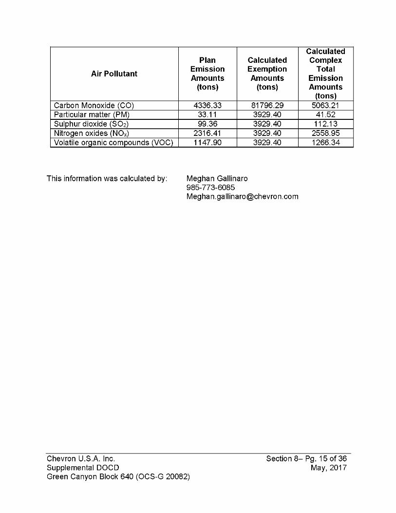
Air Pollutant
Plan Emission Amounts
(tons)
Calculated Exemption Amounts
(tons)
Calculated Complex
Total Emission Amounts
(tons) Carbon Monoxide (CO) 4336.33 81796.29 5063.21 Particular matter (PM) 33.11 3929.40 41.52 Sulphur dioxide (SO2) 99.36 3929.40 112.13 Nitrogen oxides (NOx) 2316.41 3929.40 2558.95 Volatile organic compounds (VOC) 1147.90 3929.40 1266.34
This information was calculated by: Meghan Gallinaro 985-773-6085 [email protected]
Chevron U.S.A. Inc. Supplemental DOCD Green Canyon Block 640 (OCS-G 20082)
Section 8- Pg. 15 of 36 May, 2017

DOCD AIR QUALITY SCREENING CHECKLIST O M B C o n t r o l N o . 1 0 1 0 - 0 1 5 1
O M B A p p r o v a l E x p i r e s ! 0 3 / 3 1 / 2 0 1 8
COMPANY Chevron U.S.A. Inc. AREA GC BLOCK 641 LEASE OCS-G 16770 PLATFORM Tahiti WELL COMPANY CONTACT Meghan Gallinaro TELEPHONE NO. 985-773-6085 REMARKS
"Yes" "No" Screening Questions for DOCD's
Yes
Is any calculated Complex Total (CT) Emission amount (in tons) associated with your proposed exploration activities more than 90% of the amounts calculated using the following formulas: CT = 3400D2/3 for CO, and CT = 33.3D for the other air pollutants (where D = distance to shore in miles)?
No uo your emission calculations mciuae any emission reduction measures or modified emission factors?
Yes Does or will the facility complex associated with your proposed development and production activities process production from eight or more wells?
No uo you expect to encounter H/a at concentrations greater tnan zu parts per million (ppm)?
Yes Note, the flare Chevron has however, Che
i volumes indu ncluded the wc vron will compl
Do you propose to flare or vent natural gas in excess of the criteria set forth under 250.1105(a)(2) and (3)?
ded in the AQR are based on the worst case instantaneous rate for the flares, rst case rate for conservatism with regards to air permitting via the AQR, y with the requirements of 30 CFR 250.1160 and 1161.
No Do you propose to bum produced hydrocarbon liquids?
No Are your proposea aeveiopment ana proauction activities locatea witmn zs miles from shore?
No Are your proposea aeveiopment ana proauction activities locatea witmn zuu kilometers of the Breton Wildemess Area?
B O E M FORM 0139 (March 2015- Supersedes all previous versions ofthis form which may not be used).
ATTACHMENT 8-A
Page 1 of 8

AIR EMISSIONS CUMPUTATION F A C T O R S
Fuel Usage Conversion Factors Natural Gas Turbines Natural Gas Engines Diesel Recip. Engine REF. DATE Fuel Usage Conversion Factors SCF/hp-hr | 9.524 SCF/hp-hr | 7.143 GAL/hp-hrl 0.0483 AP42 3.2-1 4/76 8- 8/84
Equipment/Emission Factors units PM SOx NOx VOC CO REF. DATE
NG Turbines gms/hp-hr 0.00247 1.3 0.01 0.83 AP42 3.2-18-3.1-1 10/96
NG 2-cycle lean gms/hp-hr 0.00185 10.9 0.43 1.5 AP42 3.2-1 10/96
NG 4-cycle lean gms/hp-hr 0.00185 11.8 0.72 1.6 AP42 3.2-1 10/96
NG 4-cycle rich gms/hp-hr 0.00185 10 0.14 8.6 AP42 3.2-1 10/96
Diesel Recip. < 600 hp. gms/hp-hr 1 1.468 14 1.12 3.03 AP42 3.3-1 10/96
Diesel Recip. > 600 hp. gms/hp-hr 0.32 1.468 11 0.33 2.4 AP42 3.4-1 10/96
Diesel Boiler Ibs/bbl 0.084 2.42 0.84 0.008 0.21 AP42 1.3-12,14 9/98
NG Heaters/Boilers/Bumers Ibs/mmscf 7.6 0.593 100 5.5 84 ^42 1.4-1, 14-2, 8- 14 7/98
NG Flares Ibs/mmscf 0.593 71.4 60.3 388.5 AP42 11.5-1 9/91
Liquid Flaring Ibs/bbl 0.42 6.83 2 0.01 0.21 AP42 1.3-1 8-1.3-3 9/98
Tank Vapors Ibs/bbl 0.03 E8-P Forum 1/93
Fugitives Ibs/hr/comp. 0.0005 API Study 12/93
Glycol Dehydrator Vent Ibs/mmscf 6.6 La. DEQ 1991
Gas Venting Ibs/scf 0.0034
Sulphur Content Source Value Units Fuel Gas 3.33 ppm
Diesel Fuel 0.4 % weight Produced Gas( Flares) 3.33 ppm
Produced Oil (Liquid Flaring) 1 % weight
B O E M FORM 0139 (March 2015 - Supersedes all previous versions ofthis form which may not be used). Page 2 of 8

AIR EMISSIONS CALCULATIONS - SECOND YEAR
COMPANY AREA BLOCK LEASE PLATFORM WELL CONTACT PHONE REMARKS
Chevron U.SA Inc. GC 641 OCS-G 16770 Tahiti Meghan Gallinaro 985-773-6085 OPERATIONS EQUIPMENT RATING MAX. FUEL ACT. FUEL RUN TIME MAXIMUM POUNDS PER HOUR ESTIMATED TONS
Diesel Engines HP GAL/HR GAL/D Nat. Gas Engines SCF/HR SCF/D
::::::B»rners MMBTU/HR SCF/HR SCF/D HR/D DAYS PM SOx NOx VOC CO PM SOx NOx VOC CO i DRILLING PRIME MOVER>600hp diesel 0 0 0.00 0 0 0.00 0.00 0.00 0.00 0.00 0.00 0.00 0.00 0.00 0.00
PRIME MOVER>600hp diesel 0 0 0.00 0 0 0.00 0.00 0.00 0.00 0.00 0.00 0.00 0.00 0.00 0.00 PRIME MOVER>600hp diesel 0 0 0.00 0 0 0.00 0.00 0.00 0.00 0.00 0.00 0.00 0.00 0.00 0.00 PRIME MOVER>600hp diesel 0 0 0.00 0 0 0.00 0.00 0.00 0.00 0.00 0.00 0.00 0.00 0.00 0.00 BURNER diesel 0 0 0 0.00 0.00 0.00 0.00 0.00 0.00 0.00 0.00 0.00 0.00 AUXILIARY EQUIP<600hp diesel 0 0 0.00 0 0 0.00 0.00 0.00 0.00 0.00 0.00 0.00 0.00 0.00 0.00 VESSELS>600hp diesel(crew) 0 0 0.00 0 0 0.00 0.00 0.00 0.00 0.00 0.00 0.00 0.00 0.00 0.00 VESSELS>600hp diesel(supply) 0 0 0.00 0 0 0.00 0.00 0.00 0.00 0.00 0.00 0.00 0.00 0.00 0.00 VESSELS>600hp diesel(tugs) 0 0 0.00 0 0 0.00 0.00 0.00 0.00 0.00 0.00 0.00 0.00 0.00 0.00
PIPELINE PIPELINE LAY Construction Vessel diesel 0 0 0.00 0 0 0.00 0.00 0.00 0.00 0.00 0.00 0.00 0.00 0.00 0.00 INSTALLATION PIPELINE LAY BARGE diesel 0 0 0.00 0 0 0.00 0.00 0.00 0.00 0.00 0.00 0.00 0.00 0.00 0.00
Jumper Installation Vessel 12069 582.9327 13990.38 24 2 8.51 39.02 292.42 8.77 63.80 0.20 0.94 7.02 0.21 1.53
FACILITY DERRICK BARGE diesel 0 0 0.00 0 0 0.00 0.00 0.00 0.00 0.00 0.00 0.00 0.00 0.00 0.00 INSTALLATION MATERIAL TUG diesel 0 0 0.00 0 0 0.00 0.00 0.00 0.00 0.00 0.00 0.00 0.00 0.00 0.00
VESSELS>600hp diesel(crew) 0 0 0.00 0 0 0.00 0.00 0.00 0.00 0.00 0.00 0.00 0.00 0.00 0.00 VESSELS>600hp diesel(supply) 0 0 0.00 0 0 0.00 0.00 0.00 0.00 0.00 0.00 0.00 0.00 0.00 0.00
PRODUCTION RECIP.>600hp diesel- Emergency Generator - GC641A-ENG5305 2876 138.9 3333.9 24 52 2.03 9.30 69.68 2.09 15.20 1.26 5.80 43.48 1.30 9.49 RECIP >600hp diesel- Firewater Pump Engine - GC641A-ZZZ6205 1065 51.4 1234.5 24 52 0.75 3.44 25.80 0.77 5.63 0.47 2.15 16.10 0.48 3.51 RECIP.>600hp diesel- Firewater Pump Engine - GC641A-ZZZ6255 1065 51.4 1234.5 24 52 0.75 3.44 25.80 0.77 5.63 0.47 2.15 16.10 0.48 3.51 RECIP.<600hp diesel- Hurricane Generator - GC641A-ENG5405 66 3.2 76.5 24 52 0.15 0.21 2.04 0.16 0.44 0.09 0.13 1.27 0.10 0.27 RECIP.<600hp diesel- Platform Crane No. 1 Driver (East) - GC641A-LCR1-DR ZZZ9000 490 23.7 568.0 24 365 1.08 1.58 15.11 1.21 3.27 4.73 6.94 66.18 5.29 14.32 RECIP.<600hp diesel- Platform Crane No. 2 Driver (West) - GC641A-LCR1-DR ZZZ9020 490 23.7 568.0 24 365 1.08 1.58 15.11 1.21 3.27 4.73 6.94 66.18 5.29 14.32 RECIP.>600hp diesel- Gas Turbine Driver - GC641A-EZZ5110 (Dual Fuel) 14264 689.0 16534.8 24 52 10.05 46.12 345.60 10.37 75.40 6.27 28.78 215.66 6.47 47.05 RECIP.>600hp diesel- Pigging Pump - GC641A-EZZ6510 2250 108.7 2608.2 24 52 1.59 7.28 54.52 1.64 11.89 0.99 4.54 34.02 1.02 7.42 RECIP. <600hp diesel- Temporary/Mobile Equipmenl" 1760 85.0 2040.2 24 180 3.88 5.69 54.27 4.34 11.75 8.37 12.29 117.23 9.38 25.37 SUPPORT VESSEL diesel 9750 470.9 11302.2 24 52 6.87 31.53 236.23 7.09 51.54 4.29 19.67 147.41 4.42 32.16 Life Boats 180 8.7 208.7 24 52 0.40 0.58 5.55 0.44 1.20 0.25 0.36 3.46 0.28 0.75 Life Boats 180 8.7 208.7 24 52 0.40 0.58 5.55 0.44 1.20 0.25 0.36 3.46 0.28 0.75 Life Boats 180 8.7 208.7 24 52 0.40 0.58 5.55 0.44 1.20 0.25 0.36 3.46 0.28 0.75 Life Boats 180 8.7 208.7 24 52 0.40 0.58 5.55 0.44 1.20 0.25 0.36 3.46 0.28 0.75 Rescue Boat 180 8.7 208.7 24 52 0.40 0.58 5.55 0.44 1.20 0.25 0.36 3.46 0.28 0.75 TURBINE nat gas- Gas Turbine Driver - GC641A-EZZ5010 14264 135850.3 3260408.1 24 365 0.08 40.84 0.31 26.08 0.34 178.90 1.38 114.22 TURBINE nat gas- Gas Turbine Driver - GC641A-EZZ5110 14264 135850.3 3260408.1 24 365 0.08 40.84 0.31 26.08 0.34 178.90 138 114.22 TURBINE nat gas- Gas Turbine Driver - GC641A-EZZ5210 14264 135850.3 3260408.1 24 365 0.08 40.84 0.31 26.08 0.34 178.90 1.38 114.22 TURBINE nat gas- Water Inj. - GC641A-EZZ6705 14800 140955.2 3382924.8 24 365 0.08 42.38 0.33 27.06 0.35 185.62 1.43 118.51 TURBINE nat qas- Water Inj. - GC641A-EZZ6745 14800 140955.2 3382924.8 24 365 0.08 42.38 0.33 27.06 0.35 185.62 1.43 118.51 MISC. BPD SCF/HR COUNT
TANK- 0 0 0 0.00 0.00 FLARE - Upset Conditions 6,277,083 24 48 3.72 448.18 378.51 2438.65 2.14 258.15 218.02 1404.66 FLARE 1,286,573 24 365 0.76 91.86 77.58 499.83 3.34 402.35 339.80 2189.27 PROCESS VENT (Contingency) 6,277083 24 2 21342.08 512.21 FUGITIVES- _ J 6 0 0 0 _ 365 8.00 35.04 GLYCOL STILL VENT- 0 0 0 0.00 0.00
DRILLING OIL BURN 0 0 0 0.00 0.00 0.00 0.00 0.00 0.00 0.00 0.00 0.00 0.00 WELL TEST GAS FLARE 0 0 0 0.00 0.00 0.00 0.00 0.00 0.00 0.00 0.00
2018 YEAR TOTAL 38.71 157.00 1911.68 21848.41 3324.67 33.11 99.36 2316.41 1147.90 4336.33
EXEMPTION
CALCULATION DISTANCE FROM LAND IN MILES 3929.40 3929.40 3929.40 3929.40 81796.29
118.0
'NOTE - The listing for temporary and mobile equipment includes various maintenance, operations, and construction equipment which may be brought on site, including but not limited to air compressors, welding machines, work camp generators, pressure washers, tank cleaners, light towers, pumps, pipe cutters, winches, temporary cranes, etc. The horsepower rating indicated is the total of individual engines, which are anticipated to be less than 600 hp.
B O E M FORM 0139 (March 2015-Supersedes al previous of this form which rray not be used). Page 4 of f

AIR EMISSIONS CALCULATIONS - THIRD YEAR
COMPANY AREA BLOCK LEASE PLATFORM WELL CONTACT PHONE REMARKS
Charon U.S.A. Inc. oc 641 OCS-S 16770 Taht | Meghan Gall naro 985-773.6085 OPERATIONS EQUIPMENT RATING MAX FUEL ACT. FUEL RUN TIME MAXIMUM POUNDS PER HOUR ESTIMATED TONS
Diesel Engines HP GAUHR GAL.'D
Nal. Gas Enqines HP SCF'HR SCF/D : : : : : :Sumera: : : : : MMBTU/HR SCF/HR SCF/D HR'D DAYS PM SOx NOx VOC CO PM SOx NOx VOC CO
DRILLING PRIME MOVER>600hp desel 0 0 0.00 0 0 0.00 0.00 0.00 0.00 0 0 0 0.00 0.00 0.00 0.00 0.00 PRIME MOVER>600hp desel 0 0 0.00 0 0 0.00 0.00 0.00 0.00 0.00 0.00 0.00 0.00 0.00 0.00 PRIME MOVER>600hp desel 0 0 0.00 0 0 0.00 0.00 0.00 0.00 0.00 0.00 0.00 0.00 0.00 0.00 PRIME MOVER>600hp desel 0 0 0.00 0 0 0.00 0.00 0.00 0.00 0.00 0.00 0.00 0.00 0.00 0.00 BURNER desel 0 0 0 0.00 0.00 0.00 0.00 0.00 0.00 0.00 0.00 0.00 0.00 AUXILIARY EQUIP<600hp diesel 0 0 0.00 0 0 0.00 0.00 0.00 0.00 0.00 0.00 0.00 0.00 0.00 0.00 VESSELS>600hp desel(crew) 0 0 0.00 0 0 0.00 0.00 0.00 0.00 0.00 0.00 0.00 0.00 0.00 0.00 VESSELS>600hp diesel(supply) 0 0 0.00 0 0 0.00 0.00 0.00 0.00 0.00 0.00 0.00 0.00 0.00 0.00 VESSELS>600hp desel(tugs) 0 0 0.00 0 0 0.00 0.00 0.00 0.00 0.00 0.00 0.00 0.00 0.00 0.00
PIPELINE PIPELINE LAY BARGE desel 0 0 0.00 0 0 0.00 0.00 0.00 0.00 0.00 0.00 0.00 0.00 0.00 0.00 INSTALLATION SUPPORT VESSEL desel 0 0 0.00 0 0 0.00 0.00 0.00 0.00 0.00 0.00 0.00 0.00 0.00 0.00
PIPELINE BURY BARGE desel 0 0 0.00 0 0 0.00 0.00 0.00 0.00 0.00 0.00 0.00 0.00 0.00 0.00 SUPPORT VESSEL desel 0 0 0.00 0 0 0.00 0.00 0.00 0.00 0.00 0.00 0.00 0.00 0.00 0.00 VESSELS>600hp diesel(crew) 0 0 0.00 0 0 0.00 0.00 0.00 0.00 0.00 0.00 0.00 0.00 0.00 0.00 VESSELS>600hp diesel(supply) 0 0 0.00 0 0 0.00 0.00 0.00 0.00 0.00 0.00 0.00 0.00 0.00 0.00
FACILITY DERRICK BARGE desel 0 0 0.00 0 0 0.00 0.00 0.00 0.00 0.00 0.00 0.00 0.00 0.00 0.00 INSTALLATION MATERIAL TUG desel 0 0 0.00 0 0 0.00 0.00 0.00 0.00 0.00 0.00 0.00 0.00 0.00 0.00
VESSELS>600hp desel(crew) 0 0 0.00 0 0 0.00 0.00 0.00 0.00 0.00 0.00 0.00 0.00 0.00 0.00 VESSELS>600hp desel(supply) 0 0 0.00 0 0 0.00 0.00 0.00 0.00 0.00 0.00 0.00 0.00 0.00 0.00
PRODUCTION RECIP.>600hp dieseF Emergency Generalor - GC641A-ENG5305 2876 138.9 3333.9 24 52 2.03 9.30 69.68 209 15.20 126 5.80 43.48 1 30 9 49
RECIP.>600hp dieseF Rrewaler Pump Engine - GC641A-ZZZ6205 1065 51.4 1234.5 24 52 0.75 3.44 25.80 0.77 5.63 0.47 2.15 16.10 0.48 3.51 RECIP.>600hp diesel- Firewaler Pump Engine - GC641A-ZZZ6255 1065 51.4 1234.5 24 52 0.75 3.44 25.80 0.77 5.63 0.47 2.15 16.10 0.48 3.51 RECIP.<600hp desel- Hurricane Generator - GC641A-ENG5405 66 3.2 76.5 24 52 0.15 0.21 2.04 0.16 0.44 0.09 0.13 1.27 0.10 0.27 RECIP.<600hp dieseF Platform Crane No. 1 Driver (East) - GC641A-LCR1-DR ZZZ9000 490 23.7 568.0 24 365 1.08 1.58 15.11 1.21 3.27 4.73 6.94 66.18 5.29 14.32 RECIP.<600hp deseF Platform Crane No. 2 Driver (Wesl) - GC641A-LCR1-DR ZZZ9020 490 23.7 568.0 24 365 1.08 1.58 15.11 1.21 3.27 4.73 6.94 66.18 5.29 14.32 RECIP.>600hp deseF Gas Turbine Driver - GC641A-EZZ5110 (Dual Fuel) 14264 689.0 16534.8 24 52 10.05 46.12 345.60 10.37 75.40 6.27 28.78 215.66 6.47 47.05 RECIP.>600hp deseF Pigging Pimp - GC641A-EZZ6510 2250 108.7 2608.2 24 52 1.59 7.28 54.52 1.64 11.89 0.99 4.54 34.02 1.02 7.42 RECIP. <600hp dieseF Temporary/Mobile Equifmenr 1760 85.0 2040.2 24 365 3.88 5.69 54.27 4.34 11.75 16.98 24.93 237.72 19.02 51.45 SUPPORT VESSEL desel 9750 470.9 11302.2 24 52 6.87 31.53 236.23 7.09 51.54 4.29 19.67 147.41 4.42 32.16 Life Boats 180 8.7 208.7 24 52 0.40 0.58 5.55 0.44 1.20 0.25 0.36 3.46 0.28 0.75 Life Boats 180 8.7 208.7 24 52 0.40 0.58 5.55 0.44 1.20 0.25 0.36 3.46 0.28 0.75 Life Boats 180 8.7 208.7 24 52 0.40 0.58 5.55 0.44 1.20 0.25 0.36 3.46 0.28 0.75 Life Boats 180 8.7 208.7 24 52 0.40 0.58 5.55 0.44 1.20 0.25 0.36 3.46 0.28 0.75 Rescue Boat 180 8.7 208.7 24 52 0.40 0.58 5.55 0.44 1.20 0.25 0.36 3.46 0.28 0.75 TURBINE nat gas- Gas Tut ine Driver - GC641A-EZZ5010 14264 135850.3 3260408.1 24 365 0.08 40.84 0.31 26.08 0.34 178.90 1.38 11422 TURBINE nat gas- Gas Tut ine Driver - GC641A-EZZ5110 14264 135850.3 3260408.1 24 365 0.08 40.84 0.31 26.08 0.34 178.90 1.38 11422 TURBINE nat gas- Gas Tut ine Driver - GC641A-EZZ5210 14264 135850.3 3260408.1 24 365 0.08 40.84 0.31 26.08 0.34 178.90 1.38 11422 TURBIhC nat gas- Waler Irj. - GC641A-EZZ6706 14800 140955.2 3382924.8 24 365 0.08 42.38 0.33 27.06 0.35 185.62 1.43 118.51 TURBINE nat oas- Water Ini. - GC641A-EZZ6745 14800 140955 2 3382924.8 24 365 0 0 8 42 38 033 27.06 0.35 185 62 1 43 118,51 MISC. SCF/HR COUNT
TAW- •ii: iii: iiii:-: 0 0 0.00 0.00 FLARE - Upset Condlions 6,277,083 :i::i;S'S;i::i 24 72 3.72 448.18 378.51 2438.65 3.22 387.23 327.03 2106.99 FLARE 1,286,573 ii^iiiiiii^i 24 365 0.76 91.86 77.58 499.83 3.34 402.35 339.80 2189.27 PROCESS VENT (Contingency) 6,277,033 :i::S:i:i:i::? 24 2 21342.08 512.21 FUGITIVES- i i i i i i i 16000 365 8.00 35.04 GLYCOL S T i a VENT- 3 0 0.00 0.00
DRILLING OIL BURN wmum 0 0 0.00 0.00 0.00 0.00 0.00 0.00 0.00 0.00 0.00 0.00 WELL TEST GAS FLARE 0 0 0 0.00 0.00 0.00 0.00 0.00 0.00 0.00 0.00
2019-2026 YEAR TOTAL 30.20 117.97 1619.26 21839.64 3260.86 41.52 112.13 2558,95 1266.34 5063.21
EXEMPTION CALCULATION
DISTANCE FROM LAND IN MILES 3929.40 3929.40 3929.40 3929.40 81796.29
118.0
'NOTE - The listing for terrporary and mobile equipment includes various maintenance, operations, and construction equipment wfich may be brought on site, includng but not firrtted to air compressors, welding machines, worii camp generators, pressure washers, tank cleaners, light towers, purrps, pipe cutters, winches, temporary cranes, etc. The horsepower rating indcated is the total of individual engines, which are anlicipated to be less than 600 hp.
B O E M F O R M 0 1 3 9 (March2015-Supersede;

AIR EMISSIONS CALCULATIONS
COMPANY AREA BLOCK LEASE PLATFORM WELL
Chevron U.S.A. GC 641 OCS-G 16770 Tahiti
Year Emitted Substance
PM SOx NOx VOC CO 2018 33.11 99.36 2316.41 1147.90 4336.33
2019-2026 41.52 112.13 2558.95 1266.34 5063.21 Allowable 3929.40 3929.40 3929.40 3929.40 81796.29
BOEM FORM 0139 (March 2015 - Supersedes all previous versions of this form which may not be used). Page 8 of 8

SECTION 9 OILSPILL INFORMATION
9.1 OIL SPILL RESPONSE PLANNING All the proposed activities and facilities in this DOCD will be covered by the Chevron's Oil Spill Response Plan (OSRP) filed by Chevron Corporation (Operator Number 02335) and last approved on March 22, 2016 (OSRP Control Number 0-421). The following operators are covered underthis OSRP:
Chevron U.S.A. Inc. (00078)
Chevron Pipe Line Company (00400)
Sabine Pipe Line LLC (00835)
Union Oil Company of California (00003)
PRS Offshore, L.P. (01767)
9.2 SPILL RESPONSE SITES
Primary Response Equipment Location
Preplanned Staging Location
Leeville, LA Leeville, LA
9.3 OSRO INFORMATION Clean Gulf Associates (CGA) and Marine Spill Response Corp. (MSRC) are the primary surface response equipment providers for Chevron in the Gulf of Mexico Region, and maintain a dedicated fleet of vessels and other equipment permanently located as designated ports. CGA and MSRC have the capability to plan the mobilization and rapid deployment of spill response resources on a 24-hour, 7 day a week basis, the CGA and MSRC equipment is strategically positioned across the GulfofMexico from Ingleside, TX to Tampa, FL and is available on a 24-hour, 7 day a week basis. Trained Oil Spill Removal Organizations (OSROs) operate all CGA and MSRC equipment.
Marine Well Containment Company (MWCC) is the primary subsea containment service provider for Chevron. MWCC equipment is available on a 24-hour basis year round.
Chevron's primary staging areas, marine transportation facilities and helicopter bases are located in Port Fourchon, Galliano and Venice, Louisiana. Chevron also can contract for additional staging areas throughout Gulf of Mexico ports.
Chevron U.S.A. Inc. Supplemental DOCD Green Canyon Block 640 (OCS-G 20082)
Section 9 - P g . 16 of 36 May, 2017

Chevron's primary command post for oil spill is located in Covington, LA; however, Chevron has the ability to set up and effectively manage spills at Chevron facilities located in Houma and Lafayette, LA and Houston, TX.
Offshore recovery equipment is primarily staged at the following locations:
Ingleside, Houston, Galveston and Port Arthur, TX; Lake Charles, Morgan City, Houma, Port Fourchon, Leeville, Fort Jackson, Harvey, Belle Chase and Baton Rouge, LA; Pascagoula, MS; Tampa, Miami and Jacksonville, FL.
9.4 WORST-CASE DISCHARGE SCENARIO DETERMINATION
Category
Production
Category Regional OSRP
WCD DOCD WCD
Type of Activity >10 Miles Production >10 Miles Production
Facility Location (Area/Block)
GC641 GC 641
Facility Designation A-Tahiti-SPAR A-Tahiti-SPAR
Distance to Nearest Shoreline (miles) 118 118
Volume • Storage tanks &
flowlines • Lease term pipelines • Uncontrolled
blowout Total Volume (bbls)
4,914 4,044
186,452 195,410
4,914 4,044
186,452 195,410
Type of Oil(s) (crude, condensate, diesel) Crude Crude
API Gravity 29.5° 29.5°
Chevron has determined that the worst-case scenario from the activities proposed in this DOCD does not supersede the worst-case scenario from our approved Regional OSRP.
Since Chevron has the capability to respond to the worst-case spill scenario included in our Regional OSRP approved on March 22, 2016, and since the worst-case scenario determined for our DOCD does not replace the worst-case scenario in our Regional
Chevron U.S.A. Inc. Supplemental DOCD Green Canyon Block 640 (OCS-G 20082)
Section 9 - P g . 17 of 36 May, 2017

OSRP, Chevron hereby certifies that Chevron has the capability to respond, to the maximum extent practicable, to a worst-case discharge, or a substantial threat of such a discharge, resulting from the activities proposed in this DOCD.
9.5 OIL SPILL RESPONSE DISCUSSION A discussion of the response to an oil spill resulting from the activities proposed in this plan. Included is all the applicable information described in 30 CFR 254.26(b), (c), (d), and (e).
Oil spill response related activities for facilities included in this document are governed by the Chevron regional Gulfof Mexico Oil Spill Response Plan (OSRP). This OSRP meets all requirements contained in 30 CFR 254. The Chevron regional Gulfof Mexico OSRP was approved by BSEE on March 22, 2016. The Chevron regional Gulf of Mexico OSRP encompasses all facilities operated by Chevron U.S.A. Inc. and, herein the jurisdiction of the BOEM and BSEE.
Upon notification ofa major oil release from a Chevron facility or operation in the Gulfof Mexico, Chevron response personnel will make the initial notifications to all involved government agencies, Oil Spill Response Organizations (OSROs), and associated support services.
Chevron has a contract in effect with MWCC, MSRC and CGA, as well as other OSROs, to ensure availability of personnel, services, and equipment on a 24-hour-per-day basis. The OSROs can provide personnel, equipment, and materials in sufficient quantities and recovery capacity to respond effectively to oil spills from the facilities and leases covered by this plan, including the Worst Case Discharge scenarios. OSROs under contract with Chevron have oil spill response equipment located throughout the Gulf Coast area. Much of the equipment is in road ready condition and available to be transported on short notice to the nearest predetermined staging areas(s). The "road-ready condition" provides the shortest reasonable response times for transporting equipment to the staging areas.
These assets are listed in the Chevron Oil Spill Response Plan.
The following paragraphs provide information required by 30 CFR 254.26.
Trajectory Analysis Land areas that could be potentially impacted by an oil spill were determined using the BOEM Oil Spill Risk Analysis Model (OSRAM) trajectory results. The OSRAM estimates the probability that oil spills from designated locations would contact shoreline and offshore natural resources. These probabilities indicate, in terms of percentage, the chance that an oil spill occurring in a particular launch area will contact a certain county
Chevron U.S.A. Inc. Section 9 - P g . 18 of 36 Supplemental DOCD May, 2017 Green Canyon Block 640 (OCS-G 20082)

or parish within 3, 10, and 30 days. OCS Launch Area 46 was used as the point of origin for the blocks in this plan. Land segments identified by the model are listed below:
Land Segment chance of contacting within chance of contacting within chance of contacting within 3 days 10 days 30 days
COS, Matagorda County, TX 0 0 1 % C09, Brazoria County, TX 0 0 1 % C10, Galveston County, TX 0 0 2% C12, Jefferson County, TX 0 0 1 % C13, Cameron Parish, LA 0 0 3% C14, Vermilion Parish, LA 0 0 1 % C17,Terrebonne Parish, LA 0 0 1 % C18, Lafourche Parish, LA 0 0 1 % C20, Plaquemines Parish, LA 0 0 3%
Resource Identification Resources of special economic or environmental importance found in land segments identified in the above paragraph can be found in the NOAA ESI Coastal Sensitivity Atlas (Maps). These maps can be accessed through NOAA and will be used during any spill occurring from the locations listed in this document.
Additionally, information on environmental sensitivities is contained in the below Coast Guard Area Contingency Plans which will be accessed and followed during an oil spill that threatens the Gulf of Mexico shoreline.
• Corpus Christi, TX Area Contingency Plan • Port Arthur, TX Area Contingency Plan • Houston-Galveston, TX Area Contingency Plan • Southeast Louisiana Area Contingency Plan • Sector New Orleans, LA Area Contingency Plan • Mobile, AL Area Contingency Plan • St. Petersburg, FL Area Contingency Plan
Response Discussion Chevron maintains numerous resources, equipment and expertise to respond to an oil spill in the Gulf of Mexico. Chevron has oil spill response service contracts with both local and international companies and cooperatives, and has a large corps of dedicated Chevron emergency responders that can work in the Gulf of Mexico. Chevron has contracts with the following oil spill response service organizations (OSRO).
Oil Spill Removal Organizations (OSRO). These companies have on-hand shoreline protection and cleanup equipment to respond to a spill in the Gulf of Mexico.
• Clean Gulf Associates Services (CGAS)
Chevron U.S.A. Inc. Supplemental DOCD Green Canyon Block 640 (OCS-G 20082)
Section 9 - P g . 19 of 36 May, 2017

Clean Gulf Associates (CGA) Marine Spill Response Corporation (MSRC) U.S. Environmental Services LLC (USES) American Pollution Control Corporation (AmPol) OMI Environmental Solutions (OMIES) ES&H Environmental Consulting (ES&H) Clean Harbors Inc. Horizon Environmental Oil Spill Response Limited (OSR) Marine Well Containment Company (MWCC) T&T Marine
Oil Spill Cooperatives (OSC). OSCs have equipment pre-staged in the Gulf of Mexico including Lake Charles, Intracoastal City, Houma, Fort Jackson and Venice, Louisiana; Galveston, Texas; and Pascagoula, Mississippi.
OSCs provide resources to respond to offshore incidents including areas identified in this plan.
• Clean Gulf Associates (CGA) - This major cooperative strictly dedicated to Gulf of Mexico oil and gas developers and producers.
• Marine Spill Response Corporation (MSRC) - This national not-for-profit organization has extensive dedicated offshore resources located in the Gulf of Mexico
Well Control Emergency Response Companies • WildWell Control Inc. • Boots & Coots • IWC Services, Inc.
Oil Spill Management and Response Consultants • The Response Group (TRG)
Chemical Dispersant Companies (capable of delivering air and/or vessel dispersants) • Airborne Support, Inc • Marine Spill Response Corporation (MSRC) • Clean Gulf Associates (CGA) • Oil Spill Response Limited (OSR)
Chevron U.S.A. Inc. Section 9 - Pg. 20 of 36 Supplemental DOCD May, 2017 Green Canyon Block 640 (OCS-G 20082)

Chevron will use a layered approach to respond to a worst case discharge from the area by conducting simultaneous response operations at the well site, in the offshore environment and in nearshore and shoreline areas. Plans will be implemented, resources deployed and response operations established within these environmental areas to accomplish the following objectives:
• Provide for the safety of responders and the general public • Intervene at the well site to stop the flow of oil • Minimize the spread of oil at the surface • Minimize encroachment to the coastline environment • Protect coastal and natural resources
Upon notification of a worst case discharge oil spill at the locations listed in this plan, Chevron will mobilize resources similar to those listed in the attached enclosures. This information comes directly from the Chevron regional Gulf of Mexico Oil Spill Response Plan and applies to a worst case discharge volume of 1 9 5 , 4 1 0 barrels per day that could occur at the Chevron facility located in Green Canyon Block 641. Resources will be mobilized to sites as relevant to the situation and/or directed by unified command.
Aerial Surveillance Equipment Offshore Recovery Equipment Nearshore Recovery Equipment In-Situ Burn Equipment Aerial Dispersant Equipment Shoreline Protection Equipment Offshore Storage Equipment
Chevron will also take the following general actions to mobilize and coordinate response operations as appropriate:
• Set up and staff its incident command post in Covington, LA • Set up a source control group in Houston, TX, or Covington, LA • Mobilize well site resources to cap, contain and disperse oil at the well head • Mobilize assets to drill relief wells • Mobilize assets to contain and collect surface oil at the well site and in the
offshore environment • Mobilize assets to disperse and burn surface oil at the well site and in the
offshore environment • Establish a deepwater staging area from a LA port or location • Deploy assets to track the movement of oil on the surface
Chevron U.S.A. Inc. Section 9 - Pg. 21 of 36 Supplemental DOCD May, 2017 Green Canyon Block 640 (OCS-G 20082)

Follow up actions will include the following as appropriate: Locate, monitor, track and project the movement ofthe oil spill Mobilize nearshore skimming and booming vessels, barges and systems to shorebase locations for rapid deployment in the nearshore environment Mobilize oil spill removal organization (OSRO) resources and assets to staging areas for rapid deployment of shoreline protection resources Mobilize wildlife protection and rehabilitation resources to staging areas for rapid deployment of resources to protect and rehabilitate wildlife Determine Incident Command Post (ICP) locations based on intervention operations and results and surface oil spill trajectories Determine ICP Operations Branch locations based on intervention operations and results and surface oil spill trajectories Determine additional staging areas based on the spill trajectory
Spill Response Resources and Deployment Time Offshore Response: Offshore response operations will integrate simultaneous containment booming, mechanical recovery, surface dispersants and in-situ burning. Response objectives within the offshore layer are to:
• Provide for the safety of responders and the general public • Minimize wide-scale spread ofoil • Minimize encroachment to coastline environment • Maximize containment and recovery of free oil
The strategy for offshore response will be to: • Station mechanical recovery vessels and barges that are outfitted with
ocean boom systems closest to the source to contain and collect as much oil as possible.
• Station mechanical recovery vessels and barges that deploy skimming systems on vessels of opportunity close to the source to rapidly contain and collect oil that strays from the main oil slick.
• Station in-situ burn assets closest to the source to burn as much oil as possible.
• Apply Dispersants to oil that cannot be mechanically recovered.
Simultaneous implementation of these strategies is designed to effectively contain and recover an oil spill offshore to minimize the potential impacts to public health, wildlife and the environment. Separate and distinct resources will be assigned for each operation. Based on the anticipated worst case discharge scenario, Chevron can be
Chevron U.S.A. Inc. Section 9 - Pg. 22 of 36 Supplemental DOCD May, 2017 Green Canyon Block 640 (OCS-G 20082)

onsite with contracted oil spill recovery equipment with adequate response capacity to contain and recover surface hydrocarbons, and minimize land impact, to the maximum extent practicable, within an estimated 24 hours.
The following sections of Chevron's OSRP provide more information on each operation to respond to and contain a worst case discharge to the maximum extent possible.
(1) Mechanical Recovery and Slick Containment. Offshore skimming and booming vessels, barges and systems will be deployed to the source ofthe spill and stationed in the thickest parts of the spill to enhance the encounter rate, collect and contain the oil. Radio communications will be established between skimming vessels and barges and spotter aircraft and surveillance systems to direct vessels to coordinates of thickest oil to maximize the effectiveness and efficiency of on water recovery resources. Vessels operating in oil will relay spill characteristics (thickness, trajectory) to the Forward Operating Branch and Incident Command Post to station additional vessels and barges that are equipped with night sensing systems in areas of recoverable oil prior to nightfall. This will again maximize the oil recovery encounter rate. MSRC Responder Class vessels, the CGA HOSS barge, Production Support Vessels, Dual Purpose Vessels and vessels of opportunity outfitted with KOSEQ skimming systems will deploy various boom configurations that will maximize containment of oil to collect using skimmers. These vessels will work in coordinated ways to cover as large of a geographic area as possible at the location of the surface spill where oil is the thickest.
Vessels deployed with MSRC and CGA Fast Response Units and CGA Fast Response Vessels will be stationed to collect oil that moves past the front line mechanical assets. These units will deploy a J-boom configuration because it only requires one support vessel. Oil that escapes the above assets and moves shoreward will be collected by vessels of opportunity that deploy sorbent boom, collection nets or other types of equipment that absorbs surface oil. These assets will be deployed as task forces that can rapidly respond to light oil.
(2) In-Situ Burning*. Offshore in-situ burn assets will be deployed as primary response resources for all locations within federal waters. Vessels of opportunity that can operate near the spill site will be used to deploy fire boom and trained in-situ burn responders. Fire boom will be configured in a "U" shape or similar to the NOFI Ocean Buster design.
* In-situ burn and surface dispersant use require FOSC and/or EPA approval
Chevron U.S.A. Inc. Section 9 - Pg. 23 of 36 Supplemental DOCD May, 2017 Green Canyon Block 640 (OCS-G 20082)

(3) Aerial Dispersants*. Aerial dispersants will be deployed as primary response resources for all locations that fall within the FOSC pre-approval process. Dispersant aircraft that arrive on-scene before mechanical recovery or in-situ burn resources will apply dispersants to areas until relieved by a different asset.
* In-situ burn and surface dispersant use require FOSC and/or EPA approval
Vessel radar systems and infrared cameras will be used to detect and mechanically collect oil. This will allow surveillance operations to continue both day and night and through inclement weather. These systems also will be used to track the movement ofoil which will assist with shoreline response planning.
Louisiana and Texas resources potentially at risk may include but are not limited to the following:
Marine sensitivities, Beaches, Waterfowl, Shoreline resources, Marshes, Marinas/Piers, Populated areas, and Environmental sensitivities
The BOEM oil spill trajectory model indicates that LA parishes and Texas counties could be impacted by an oil spill from areas listed in this plan. These areas are dominated by fine sand beaches, coarse sand beaches, swamps and salt water marshes. The below summarizes potential concerns with each environment. This information is taken from various Coast Guard Area Contingency Plans. Fine Sand Beach Environment
• Sensitivity: Fine sand beaches have a low sensitivity to oil spill impacts and cleanup methods.
• Oil Behavior: Oil typically stains and covers the beach sands with low permeability.
• Cleanup: The penetration is low to moderate depending on the water table and the position ofthe oiling on the shoreline. A potential environmental issue during beach cleanup is the protection ofthe dune habitat from the cleanup operations. Fine sand beaches typically have poor access, but good transportation ability. Fine sand beaches are relatively easier to clean in contrast to marshes. Large volumes of stained sand and debris can be generated by beach cleanup.
Coarse Sand Beach Environment • Sensitivity: The environmental sensitivity of coarse sand beaches is low
Chevron U.S.A. Inc. Section 9 - Pg. 24 of 36 Supplemental DOCD May, 2017 Green Canyon Block 640 (OCS-G 20082)
due to the limited animal and vegetation population. • Oil Behavior: Spilled oil typically stains and coats coarse grain beach sands
with moderate to high permeability. • Cleanup: Sediment penetration on coarse grain beaches is moderate/high
depending on the water table and the location ofoil deposition. A potential environmental issue is the protection of the dune habitat from cleanup operations. The transit ability ofthis shoreline type is less than fine sand beaches because the bearing strength is lower and this type of sand builds steep beach faces. Access is typically poor.
Swamp Environment • Sensitivity: The environmental sensitivity is high for swamps because of
the presence of wetland habitat. • Oil Behavior: Oil usually coats and covers the sediment and vegetation with
low sediment penetration. • Cleanup: The sediment penetration potential is low due to the high water
table and water content ofthe sediments. A potential environmental issue is that the cleanup may be more damaging than the oil itself. Access to swamps is poor due to the soft sediment and presence of dense tree growth.
Salt Marsh Environment • Sensitivity: The environmental sensitivity is high for salt marsh because of
the presence of wetland habitat. • Oil Behavior: Oil usually coats and covers the sediment and vegetation with
low sediment penetration. • Cleanup: The sediment penetration potential is low/moderate due to the
high water table and water content of the sediment. A potential environmental issue is that the cleanup may be more damaging than the oil itself. Access is typically poor in Louisiana.
The protection of waterfowl and wildlife during the course of an oil release is an essential element in every spill response operation. Federal and state natural resource trustees will be notified in the event that a wildlife habitat may be affected by a spill event. Information concerning methods to protect waterfowl and wildlife are contained in the Chevron OSRP. For fish and wildlife resources, the emphasis is on habitats where:
• Large numbers of animals are concentrated in small areas, such as bays where waterfowl concentrate during migration or overwintering
• Early life stages are present in somewhat restricted areas or in shallow water, such as anadromous fish streams and turtle nesting beaches
Chevron U.S.A. Inc. Section 9 - Pg. 25 of 36 Supplemental DOCD May, 2017 Green Canyon Block 640 (OCS-G 20082)

• Habitats are very important to specific life stages or migration patterns such as foraging or overwintering
• Specific areas are known to be vital sources for seed or propagation • The species are on Federal or state threatened or endangered lists • A significant percentage of the population is likely to be exposed to oil.
Human-use resources of concern are listed in the Chevron OSRP. Areas of economic importance, like waterfront hotels, should also be considered when establishing resource protection priorities. Human-use resources are most sensitive when:
• Archaeological and cultural sites are located in the intertidal zones • Oiling can result in potential significant commercial losses through fouling,
tainting, or avoidance because of public perception ofa problem • The resource is unique, such as a historical site • Oiling can result in potential human health concerns, such as tainting of
water intakes and/or subsistence fisheries
Suitability of Resources All response equipment, materials, support vessels and strategies listed in this document and the Chevron regional Gulf of Mexico Oil Spill Response Plan have proven suitable for the many environmental conditions existing at the locations listed in this plan. Chevron additionally conducts annual oil spill response training, drills and exercises and validates the content ofthe Oil Spill Response Plan. The Chevron regional GulfofMexico Oil Spill Response Plan is maintained by the Chevron Greater Gulf of Mexico Emergency Management Coordinator located in Covington, LA.
Chevron U.S.A. Inc. Section 9 - Pg. 26 of 36 Supplemental DOCD May, 2017 Green Canyon Block 640 (OCS-G 20082)

SECTION 10 ENVIRONMENTAL MONITORING INFORMATION
10.1 MONITORING SYSTEMS There are no environmental monitoring systems currently in place or planned for the proposed activities.
10.2 INCIDENTAL TAKES There is no reason to believe that any ofthe endangered species or marine mammals as listed in the ESA will be "taken" as a result ofthe operations proposed underthis Plan.
It has been documented that the use of explosives and/or seismic devices can affect marine life. Operations proposed in this plan will not be utilizing either of these devices.
Chevron will adhere to the requirements as set forth in the following documents, as applicable, to avoid or minimize impacts to any ofthe species listed in the Endangered Species Act (ESA) as a result ofthe operations conducted herein:
• NTL No. 2016-G01-BOEM, "Vessel Strike Avoidance and Injured/Dead Protected Species Reporting"
• NTL No. 2016-G02-BOEM, "Implementation of Seismic Survey Mitigation Measures and Protected Species Observer Program"
• NTL No. 2015-G03-BSEE, "Marine Trash and Debris Awarement and Elimination"
10.3 FLOWER GARDEN BANKS NATIONAL MARINE SANCTUARY Green Canyon Block 640 are not located in the Flower Garden Banks National Marine Sanctuary; therefore, relevant information is not required in this DOCD.
Chevron U.S.A. Inc. Section 10 - Pg. 27 of 36 Supplemental DOCD May, 2017 Green Canyon Block 640 (OCS-G 20082)

SECTION 11 LEASE STIPULATIONS INFORMATION
Development activities are subject to the following stipulations attached to Lease OCS-G 20082, Green Canyon Block 640.
11.1 MILITARY WARNING AREA (MWA)
Green Canyon Block 640 are located within designated Military Warning Area (W-92)
Chevron has entered into agreements with:
Fleet Area Control and Surveillance Facility
Attention: Schedules Officer 118 Albemare Ave. P.O. Box 40 Jacksonville, FL 32212 Telephone: (904) 542-2113 Email: [email protected]
11.2 MARINE PROTECTED S P E C I E S Although Marine Protected Species was not assigned, Chevron will follow all guidelines to implement these mitigation measures to reduce the potential taking of Federally protected species. In accordance with the Federal Endangered Species Act and the Marine Mammal Protection Act, Chevron will:
(a) collect and remove flotsam resulting from activities related to exploration, development, and production ofthis lease;
(b) post signs in prominent places on all vessels and platforms used as a result of activities related to exploration, development, and production ofthis lease detailing the reasons (legal and ecological) why release of debris must be eliminated;
(c) observe for marine mammals and sea turtles while on vessels, reduce vessel speed to 10 knots or less when assemblages of cetaceans are observed, and maintain a distance of 90 meters or greater from whales, and a distance of 45 meters or greater from small cetaceans and sea turtles;
Chevron U.S.A. Inc. Section 11 - Pg. 28 of 36 Supplemental DOCD May, 2017 Green Canyon Block 640 (OCS-G 20082)

(d) employ mitigation measures prescribed by BOEM/BSEE or the National Marine Fisheries Service (NMFS) for all seismic surveys, including the use of an "exclusion zone" based upon the appropriate water depth, ramp-up and shutdown procedures, visual monitoring, and reporting;
(e) identify important habitats, including designated critical habitat, used by listed species (e.g., sea turtle nesting beaches, piping plover critical habitat), in oil spill contingency planning and require the strategic placement of spill cleanup equipment to be used only by personnel trained in less-intrusive cleanup techniques on beaches and bay shores; and
(f) immediately report all sightings and locations of injured or dead protected species (e.g., marine mammals and sea turtles) to the appropriate stranding network. If oil and gas industry activity is responsible forthe injured or dead animal (e.g., because ofa vessel strike), the responsible parties should remain available to assist the stranding network. If the injury or death was caused by a collision with the lessee's vessel, the lessee must notify BSEE within 24 hours ofthe strike.
BOEM and BSEE issue Notices to Lessees (NTLs), which more fully describe measures implemented in support ofthe above-mentioned implementing statutes and regulations, as well as measures identified by the U.S. Fish and Wildlife Service and NMFS arising from, among others, conservation recommendations, rulemakings pursuant to the MMPA, or consultation. The lessee and its operators, personnel, and subcontractors, while undertaking activities authorized under this lease, must implement and comply with the specific mitigation measures outlined in NTL No. 2016-G01-BOEM, "Vessel Strike Avoidance and Injured/Dead Protected Species Reporting;" NTL No. 2012-JOINT-G02, "Implementation of Seismic Survey Mitigation Measures and Protected Species Observer Program;" and NTL No. 2015-G03-BSEE, "Marine Trash and Debris Awareness and Elimination." At the lessee's option, the lessee, its operators, personnel, and contractors may comply with the most current measures to protect species in place at the time an activity is undertaken under this lease, including but not limited to new or updated versions ofthe NTLs identified in this paragraph. The lessee and its operators, personnel, and subcontractors will be required to comply with the mitigation measures, identified in the above referenced NTLs, and additional measures in the conditions of approvals for their plans or permits.
Chevron U.S.A. Inc. Section 11 - Pg. 29 of 36 Supplemental DOCD May, 2017 Green Canyon Block 640 (OCS-G 20082)

SECTION 12 ENVIRONMENTAL MITIGATION MEASURES INFORMATION
12.1 MEASURES TAKEN TO AVOID, MINIMIZE, AND MITIGATE IMPACTS Green Canyon Block 640 is not located within Florida; therefore, mitigation information is not required forthe activities proposed in this plan.
12.2 INCIDENTAL TAKES Chevron will adhere to the requirements as set forth in the following documents, as applicable, to avoid or minimize impacts to any ofthe species listed in the Endangered Species Act (ESA) as a result ofthe operations conducted herein:
• NTL No. 2015-G03-BSEE, "Marine Trash and Debris Awareness and Elimination" • NTL No. BOEM 2016-G01, "Vessel Strike Avoidance and Injured/Dead Protected
Species Reporting" • NTL No. BOEM 2016-G02, "Implementation of Seismic Survey Mitigation
Measures and Protected Species Observer Program"
Chevron U.S.A. Inc. Section 12 - Pg. 30 of 36 Supplemental DOCD May, 2017 Green Canyon Block 640 (OCS-G 20082)

SECTION 13 RELATED FACILITIES AND OPERATIONS INFORMATION
13.1 RELATED OCS FACILITIES AND OPERATIONS The subject wells will be produced from the existing A-Tahiti-SPAR. One 7.75-inch well jumper approximately 100 feet in length will be installed to connect Well No. SS002 to the existing subsea manifold located in Green Canyon Block 640. The pipeline is designed for 75,000 BOPD and has a shut-in time of 45 seconds from sensor activation.
13.2 TRANSPORTATION SYSTEM A 20-24-inch oil right-of-way pipeline (Segment Number 15497) was installed to transport produced hydrocarbons from the A-Tahiti-SPAR to the existing A-Boxer platform in Green Canyon Block 19 for ultimate delivery to shore via Operations System No. 29.5. A 12-16-inch gas right-of-way pipeline (Segment Number 15603) was installed to transport produced hydrocarbons from the A-Tahiti-SPAR to an existing PLES located in Green Canyon Block 294 for ultimate delivery to shore via Operations System No. DSO. No new nearshore or onshore pipelines or facilities will be constructed.
13.3 PRODUCED LIQUID HYDROCARBONS TRANSPORTATION VESSELS There will not be any transfers of liquid hydrocarbons other than via pipeline.
Chevron U.S.A. Inc. Section 1 3 - Pg. 31 of 36 Supplemental DOCD May, 2017 Green Canyon Block 640 (OCS-G 20082)

SECTION 14
SUPPORT VESSELS AND AIRCRAFT INFORMATION
14.1 GENERAL
The most practical, direct route from the shore base as permitted by weather and traffic conditions will be utilized.
Type Maximum Fuel Tank Capacity
Maximum Number in Area at Any Time
Trip Frequency or Duration
Light Construction Vessel (LCV)
6600 bbls 1 1 Round Trip/ 2 Days
Supply Boat 2625 bbls 1 1 Round Trip/ Weekly
Helicopter 560 gals 1 1 Round Trip/Daily
No diesel oil supply vessels will be required for the operations proposed in this plan.
14.3 DRILLING FLUID TRANSPORTATION Drilling fluid transportation information is not required to be submitted with this plan.
14.4 SOLID AND LIQUID WASTE TRANSPORTATION A table, "Wastes You Will Transport and/or Dispose of Onshore," is included as Attachment 14-A.
14.5 VICINITY MAP A vicinity map showing the location of the activities proposed herein relative to the shoreline with the distance ofthe proposed activities from the shoreline and the primary route(s) ofthe support vessels and aircraft that will be used when traveling between the onshore support facilities and the platform is included as Attachment 14-B.
Chevron U.S.A. Inc. Supplemental DOCD Green Canyon Block 640 (OCS-G 20082)
Section 1 4 - Pg. 32 of 36 May, 2017

TABLE 2. WASTES YOU WILL TRANSPORT AND /OR DISPOSE OF ONSHORE please specify whether the amount reported is a total or per well
Projected generated waste
Sol id and Liquid Wastes t ransportat ion Waste Disposal
Type of Waste Compos i t ion Transport Method Name/Locat ion of Facil i ty Amount Disposal Method
Wi l l dr i l l ing occur ? If yes , f i l l in the muds and cut t ings. EXAMPLE: Synthetic-based drilling fluid or
mud internal olefin, ester
Below deck storage tanks on
offshore support vessels
Newport Environmental
Services Inc., Ingleside, TX X bbl/well Recycled
Oil-based drilling fluid or mud NA : :
Synthetic-based drilling fluid or mud NA
Cuttings wetted with Water-based fluid NA
Cuttings wetted with Synthetic-based fluid NA
Cuttings wetted with oil-based fluids NA
Wil you produce hydrocarbons? If yes f i l l in fo r produced sand.
Produced sand NA Produced sand NA
WII int
you have addit ional wastes that are not permi
ie appropr iate rows.
ted fo r d ischarge? If yes, f i l l
EXAMPLE: trash and debris (recylables) Plastic, paper, aluminum barged in a storage bin ARC, New Iberia, LA X lb/well Recycled
Trash and debris
Paper, plast ic, a luminum
glass and other refuse Shipped in containers
Progressive Waste Solut ions,
Larose, LA 1800 bbls/day Landfi l led
Used oil NA y y Wash water NA
Chemical product wastes NA
_ _
NOTE: If you will not have a type of waste, enter NA in the row.
ATTACHMENT 14-A

gs-o'o-w 4"0,0"W gs o'o-w 92-0,0-W gro'O'w 9 0 W W ro'o-w
M I S S I S S I P P I A L A B A M A
Legend
Bathymetry | Block of Interest
Lease Block Boundary
b - b
95°0'0"W 94°0,0"W 92°0'0"W 89,0'0"W 88°0'0"W
Coordinate System: GCS North American 1927
0 25 50 100 Kilometers l l l l l l l l l 0 25 50 100 Statute Miles I—I—I—I—I—I—I—I—I
87°0'0"W
o Figure 1. Vicinity map for the lease area.
ATTACHMENT 14-B 156

SECTION 15 ONSHORE SUPPORT FACILITIES INFORMATION
15.1 GENERAL The table below provides a listing of the onshore facilities that will be used to provide supply and service support for the proposed activities.
Name Location Existing/New/Modified
Chevron USA Leeville Shorebase/Heliport
Leeville, Louisiana Existing
15.2 SUPPORT BASE CONSTRUCTION OR EXPANSION There will be no new construction of an onshore support base, nor will we expand the existing shore base as a result ofthe operations proposed in this DOCD.
15.3 SUPPORT BASE CONSTRUCTION OR EXPANSION TIMETABLE A support base construction or expansion timetable is not required for the activities proposed in this plan.
15.4 WASTE DISPOSAL A table, "Wastes You Will Transport and/or Dispose of Onshore," is included as Attachment 14-A.
Chevron U.S.A. Inc. Section 15 - Pg. 33 of 36 Supplemental DOCD May, 2017 Green Canyon Block 640 (OCS-G 20082)

SECTION 16 COASTAL ZONE MANAGEMENT (CZM) INFORMATION
A certificate for Coastal Zone Management Consistency for the state of Louisiana (Control Number N-8406) was submitted with the Initial DOCD for Green Canyon Block 640.
Chevron U.S.A. Inc. Section 1 6 - Pg. 34 of 36 Supplemental DOCD May, 2017 Green Canyon Block 640 (OCS-G 20082)

SECTION 17 ENVIRONMENTAL IMPACT ANALYSIS (EIA)
The Environmental Impact Analysis is included as Attachment 17-A.
Chevron U.S.A. Inc. Section 17 - Pg. 35 of 36 Supplemental DOCD May, 2017 Green Canyon Block 640 (OCS-G 20082)

Chevron U.S.A. Inc. (Chevron)
Supplemental Development Operations Coordination Document Green Canyon Blocks 640 and 641
OCS-G 20082/16770
(A) IMPACT PRODUCING FACTORS ENVIRONMENTAL IMPACT ANALYSIS WORKSHEET
Environment Resources
R
Emissions (air, noise, light, etc.)
efer to recent GO
Effluents (muds,
cutting, other discharges to
the water column or seafloor)
Impact Producing Ff Categories and E
M OCS Lease Sale EI
Physical disturbances to the
seafloor (rig or anchor
emplacements, etc.)
ctors (IPFs) xamples 5 for a more coi
Wastes sent to shore for treatment or disposal
nplete list of IPF
Accidents (e.g., oil spills,
chemical spills, ITS releases)
s
Discarded Trash & Debris
Site-specific at Offshore Location
Designated topographic features
Pinnacle Trend area live bottoms
Eastem Gulflive bottoms
Benthic communities
Site-specific at Offshore Location
Designated topographic features
Pinnacle Trend area live bottoms
Eastem Gulflive bottoms
Benthic communities
Site-specific at Offshore Location
Designated topographic features
Pinnacle Trend area live bottoms
Eastem Gulflive bottoms
Benthic communities
Site-specific at Offshore Location
Designated topographic features
Pinnacle Trend area live bottoms
Eastem Gulflive bottoms
Benthic communities
Site-specific at Offshore Location
Designated topographic features
Pinnacle Trend area live bottoms
Eastem Gulflive bottoms
Benthic communities (4) (4) (4), (8) (4)
Water quahty X (8)
Fisheries X (8)
Marine Mammals (8) (8) X
Sea Turtles
Air quality
Shipwreck sites (known or potential)
(8) (8) X Sea Turtles
Air quality
Shipwreck sites (known or potential)
Sea Turtles
Air quality
Shipwreck sites (known or potential)
Prehistoric archaeological sites Prehistoric archaeological sites
Vicinity of Offshore Location
Essential fish habitat
Vicinity of Offshore Location
Essential fish habitat X (6)
Marine and pelagic birds (8) (6) X
Public health and safety (6)
Coastal and Onshore
Beaches
Coastal and Onshore
Beaches
Wetlands
Shore birds and coastal nesting birds
Coastal wildlife refuges
Wetlands
Shore birds and coastal nesting birds
Coastal wildlife refuges
Wetlands
Shore birds and coastal nesting birds
Coastal wildlife refuges
Wildemess areas
ATTACHMENT 17-A

Footnotes for Environmental Impact Analysis Matrix
1) Activities that may affect a marine sanctuary or topographic feature. Specifically, ifthe well or platform site or any anchors will be on the seafloor within the:
o 4-mile zone of the Flower Garden Banks, or the 3-mile zone of Stetson Bank;
o 1000-m, 1-mile or 3-mile zone of any topographic feature (submarine bank) protected by the Topographic Features Stipulation attached to an OCS lease;
o Essential Fish Habitat (EFH) criteria of 500 ft. from any no-activity zone; or
o Proximity of any submarine bank (500 ft. buffer zone) with relief greater than 2 meters that is not protected by the Topographic Features Stipulation attached to an OCS lease.
2) Activities with any bottom disturbance within an OCS lease block protected through the Live Bottom (Pinnacle Trend) Stipulation attached to an OCS lease.
3) Activities within any Eastern Gulf OCS block where seafloor habitats are protected by the Live Bottom (Low-Relief) Stipulation attached to an OCS lease.
4) Activities on blocks designated by the BOEM as being in water depths 300 meters or greater. 5) Exploration or production activities where H2S concentrations greater than 500 ppm might be encountered. 6) All activities that could result in an accidental spill of produced liquid hydrocarbons or diesel fuel that you
determine would impact these environmental resources. I f the proposed action is located a sufficient distance from a resource that no impact would occur, the EIA can note that in a sentence or two.
7) All activities that involve seafloor disturbances, including anchor emplacements, in any OCS block designated by the BOEM as having high-probability for the occurrence of shipwrecks or prehistoric sites, including such blocks that will be affected that are adjacent to the lease block in which your planned activity will occur. Ifthe proposed activities are located a sufficient distance from a shipwreck or a prehistoric site that no impact would occur, the EIA can note that in a sentence or two.
8) All activities that you determine might have an adverse effect on endangered or threatened marine mammals or sea turtles or their critical habitats.
9) Production activities that involve transportation of produced fluids to shore using shuttle tankers or barges.

(B) ANALYSIS
Site-Specific at Green Canyon Blocks 640 and 641
Proposed operations consist of the installation of two lease term pipelines to the existing A-Tahiti-SPAR md the commencement of production from Lease OCS-G 20082, Green Canyon Block 640, Well No. SS002.
1. Designated Topographic Features
Potential IPFs on topographic features include physical disturbances to the seafloor and accidents.
Physical disturbances to the seafloor: Green Canyon Blocks 640 and 641 are 52 miles from the closest designated Topographic Features Stipulation Block (Diaphus Bank); therefore, no adverse impacts are expected.
Accidents: It is unlikely that an accidental surface or subsurface spill would occur from the proposed activities (refer to statistics in Item 5, Water Quality). Oil spills cause damage to benthic organisms only if the oil contacts the organisms. Oil from a surface spill can be driven into the water column; measurable amounts have been documented down to a 10 m depth. At this depth, the oil is found only at concentrations several orders of magnitude lower than the amount shown to have an effect on corals. Because the crests of topographic features in the Northem Gulf of Mexico are found below 10 m, no oil from a surface spill could reach their sessile biota. Oil from a subsurface spill is not applicable due to the distance of these blocks from a topographic area. The activities proposed in this plan will be covered by Chevron's Regional OSRP (refer to information submitted in Section 9).
There are no other IPFs (including emissions, effluents and wastes sent to shore for disposal) from the proposed activities, which could impact topographic features.
2. Pinnacle Trend Area Live Bottoms
Potential IPFs on pinnacle trend area live bottoms include physical disturbances to the seafloor and accidents.
Physical disturbances to the seafloor: Green Canyon Blocks 640 and 641 are 189 miles from the closest live bottom (pinnacle trend) area; therefore, no adverse impacts are expected.

Accidents: It is unlikely that an accidental surface or subsurface spill would occur from the proposed activities (refer to statistics in Item 5, Water Quality). Oil spills have the potential to foul benthic communities and cause lethal and sublethal effects on live bottom organisms. Oil from a surface spill can be driven into the water column; measurable amounts have been documented down to a 10 m depth. At this depth, the oil is found only at concentrations several orders of magnitude lower than the amount shown to have an effect on marine organisms. Oil from a subsurface spill is not applicable due to the distance of these blocks from a live bottom (pinnacle trend) area. The activities proposed in this plan will be covered by Chevron's Regional OSRP (refer to information submitted in Section 9).
There are no other IPFs (including emissions, effluents and wastes sent to shore for disposal) from the proposed activities which could impact a live bottom (pinnacle trend) area.
3. Eastem Gulf Live Bottoms
Potential IPFs on Eastem Gulf live bottoms include physical disturbances to the seafloor and accidents.
Physical disturbances to the seafloor: Green Canyon Blocks 640 and 641 are not located in an area characterized by the existence of live bottoms, and this lease does not contain a Live-Bottom Stipulation requiring a photo documentation survey and survey report.
Accidents: It is unlikely that an accidental surface or subsurface spill would occur from the proposed activities (refer to statistics in Item 5, Water Quality). Oil spills cause damage to live bottom organisms only if the oil contacts the organisms. Oil from a surface spill can be driven into the water column; measurable amounts have been documented down to a 10 m depth. At this depth, the oil is found only at concentrations several orders of magnitude lower than the amount shown to have an effect on marine invertebrates. Oil from a subsurface spill is not applicable due to the distance of these blocks from a live bottom area. The activities proposed in this plan will be covered by Chevron's Regional OSRP (refer to information submitted in Section 9).
There are no other IPFs (including emissions, effluents and wastes sent to shore for disposal) from the proposed activities which could impact an Eastem Gulflive bottom area.
4. Benthic Communities
Green Canyon Blocks 640 and 641 are located in water depths 984 feet (300 meters) or greater. IPFs that could result in impacts to benthic communities from the proposed activities include physical disturbances to the seafloor.
Physical disturbances to the seafloor: Green Canyon Blocks 640 and 641 are approximately 22 miles from a known benthic community site (Green Canyon Block 287), listed in NTL 2009-G40. This plan submittal includes the required maps, analyses and statement(s). The proposed activities will be conducted in accordance with NTL 2009-G40, which will ensure that features or areas that could support high-density benthic communities will not be impacted.
There are no other IPFs (including emissions, effluents, wastes sent to shore for disposal, or accidents) from the proposed activities which could impact benthic communities.
5. Water Quality
IPFs that could result in water quality degradation from the proposed operations in Green Canyon Blocks 640 and 641 include disturbances to the seafloor, and accidents.
Physical disturbances to the seafloor: Bottom area disturbances resulting from the emplacement of drill rigs, the drilling of wells and the installation of platforms and pipelines would increase water-column turbidity and re-suspension of any accumulated pollutants, such as trace metals and excess nutrients. This would cause short-lived impacts on water quality conditions in the immediate vicinity of the emplacement operations.
Accidents: Oil spills have the potential to alter offshore water quality; however, it is unlikely that an accidental surface or subsurface spill would occur from the proposed activities. Between 1980 and 2000, OCS operations produced 4.7 billion barrels of oil and spilled only 0.001 percent of this oil, or 1 bbl for every 81,000 bbl produced. The spill risk related to a diesel spill from drilling operations is even less. Between 1976 and 1985, (years for which data were collected), there were 80 reported diesel spills greater than one barrel associated with drilling activities. Considering that there were 11,944 wells drilled, this is a 0.7 percent probability of an occurrence. If a spill were to occur, the water quality of marine waters would be temporarily affected by the dissolved components and small oil droplets. Dispersion by currents and microbial degradation would remove the oil from the water column and dilute the constituents to background levels. Historically, changes in offshore water quality from oil spills have only been detected during the life of the spill and up to several months afterwards. Most of the components of oil are insoluble in water and therefore float. The activities proposed in this plan will be covered by Chevron's Regional Oil Spill Response Plan (refer to information submitted in Section 9).
There are no other IPFs (including emissions, physical disturbances to the seafloor, effluents and wastes sent to shore for disposal) from the proposed activities which could cause impacts to water quality.
6. Fisheries

IPFs that could cause impacts to fisheries as a result of the proposed operations in Green Canyon Blocks 640 and 641 include physical disturbances to the seafloor, and accidents.
Physical disturbances to the seafloor: The emplacement of a structure or drilling rig results in minimal loss of bottom trawling area to commercial fishermen. Pipelines cause gear conflicts which result in losses of trawls and shrimp catch, business downtime, and vessel damage. Most financial losses from gear conflicts are covered by the Fishermen's Contingency Fund (FCF). The emplacement and removal of facilities are not expected to cause significant adverse impacts to fisheries.
Accidents: An accidental oil spill has the potential to cause some detrimental effects on fisheries; however, it is unlikely that such an event would occur from the proposed activities (refer to Item 5, Water Quality). The effects of oil on mobile adult finfish or shellfish would likely be sublethal and the extent of damage would be reduced to the capacity of adult fish and shellfish to avoid the spill, to metabolize hydrocarbons, and to excrete both metabolites and parent compounds. The activities proposed in this plan will be covered by Chevron's Regional OSRP (refer to information submitted in Section 9).
There are no IPFs from emissions, effluents or wastes sent to shore for disposal from the proposed activities which could cause impacts to fisheries.
7. Marine Mammals
GulfCet II studies revealed that cetaceans of the continental shelf and shelf-edge were almost exclusively bottlenose dolphin and Atlantic spotted dolphin. Squid eaters, including dwarf and pygmy killer whale, Risso's dolphin, rough-toothed dolphin, and Cuvier's beaked whale, occurred most frequently along the upper slope in areas outside of anticyclones. IPFs that could cause impacts to marine mammals as a result of the proposed operations in Green Canyon Blocks 640 and 641 include emissions, discarded trash and debris, and accidents.
Emissions: Noises from drilling activities, support vessels and helicopters may elicit a startle reaction from marine mammals. This reaction may lead to disruption of marine mammals' normal activities. Stress may make them more vulnerable to parasites, disease, environmental contaminants, and/or predation (Majors and Myrick, 1990). There is little conclusive evidence for long-term displacements and population trends for marine mammals relative to noise.
Discarded trash and debris: Both entanglement in, and ingestion of debris have caused the death or serious injury of marine mammals (Laist, 1997; MMC, 1999). The limited amount of marine debris, if any, resulting from the proposed activities is not expected to substantially harm marine mammals. Operators are prohibited from deliberately discharging debris as mandated by MARPOL-Annex V and the Marine Plastic Pollution Research and Control Act, and regulations

imposed by various agencies including the United States Coast Guard (USCG) and the Environmental Protection Agency (EPA).
Chevron will operate in accordance with the regulations and also avoid accidental loss of solid waste items by maintaining waste management plans, manifesting trash sent to shore, and using special precautions such as covering outside trash bins to prevent accidental loss of solid waste. Special caution will be exercised when handling and disposing of small items and packaging materials, particularly those made of non-biodegradable, environmentally persistent materials such as plastic or glass.
Informational placards will be posted on all vessels and facilities having sleeping or food preparation capabilities. All offshore personnel, including contractors and other support services-related personnel (e.g. helicopter pilots, vessel captains and boat crews) will be indoctrinated on waste procedures, and will view the video (or Microsoft PowerPoint presentation), "Think About It" (previously "All Washed Up: The Beach Litter Problem"). Thereafter, all personnel will view the marine trash and debris training video annually. Offshore personnel will also receive an explanation from Chevron management or the designated lease operator management that emphasizes their commitment to waste management in accordance with NTL No. 2015-G03-BSEE.
Accidents: Collisions between support vessels and cetaceans would be unusual events, however should one occur, death or injury to marine mammals is possible. Contract vessel operators can avoid marine mammals and reduce potential deaths by maintaining a vigilant watch for marine mammals and maintaining a safe distance when they are sighted. Vessel crews should use a reference guide to help identify the twenty-one species of whales and dolphins; and one species of manatee that may be encountered in the Gulf of Mexico OCS. Vessel crews must report sightings of any injured or dead protected marine mammal species immediately, regardless of whether the injury or death is caused by their vessel, to the NMFS Southeast Marine Mammal Stranding Hotline at (877) 433-8299 (www.nmfs.noaa.gov/ pr/healt]i/report.htm#southeast), In addition, i f the injury or death was caused by a collision with a contract vessel, the BSEE must be notified within 24 hours of the strike by email to protectedspecies(a)bsee. gov. I f the vessel is the responsible party, it is required to remain available to assist the respective salvage and stranding network as needed.
Oil spills have the potential to cause sublethal oil-related injuries and spill-related deaths to marine mammals. However, it is unlikely that an accidental oil spill would occur from the proposed activities (refer to Item 5, Water Quality). Oil spill response activities may increase vessel traffic in the area, which could add to changes in cetacean behavior and/or distribution, thereby causing additional stress to the animals. The effect of oil dispersants on cetaceans is not known. The acute toxicity of oil dispersant chemicals included in Chevron's OSRP is considered to be low when compared with the constituents and fractions of crude oils and diesel products. The activities proposed in this plan will be covered by Chevron's OSRP (refer to information submitted in accordance with Section 9).

There are no other IPFs (including physical disturbances to the seafloor and effluents) from the proposed activities which could impact marine mammals.
8. Sea Turtles
IPFs that could cause impacts to sea turtles as a result of the proposed operations include emissions, discarded trash and debris, and accidents. GulfCet II studies sighted most loggerhead, Kemp's ridley and leatherback sea turtles over shelf waters. Historically these species have been sighted up to the shelfs edge. They appear to be more abundant east of the Mississippi River than they are west of the river (Fritts et al., 1983b; Lohoefener et al., 1990). Deep waters may be used by all species as a transitory habitat.
Emissions: Noise from drilling activities, support vessels, and helicopters may elicit a startle reaction from sea turtles, but this is a temporary disturbance.
Discarded trash and debris: Both entanglement in, and ingestion of, debris have caused the death or serious injury of sea turtles (Balazs, 1985). The limited amount of marine debris, i f any, resulting from the proposed activities is not expected to substantially harm sea turtles. Operators are prohibited from deliberately discharging debris as mandated by MARPOL-Annex V and the Marine Plastic Pollution Research and Control Act, and regulations imposed by various agencies including the United States Coast Guard (USCG) and the Environmental Protection Agency (EPA). Chevron will operate in accordance with the regulations and also avoid accidental loss of solid waste items by maintaining waste management plans, manifesting trash sent to shore, and using special precautions such as covering outside trash bins to prevent accidental loss of solid waste. Special caution will be exercised when handling and disposing of small items and packaging materials, particularly those made of non-biodegradable, environmentally persistent materials such as plastic or glass.
Informational placards will be posted on all vessels and facilities having sleeping or food preparation capabilities. All offshore personnel, including contractors and other support services-related personnel (e.g. helicopter pilots, vessel captains and boat crews) will be indoctrinated on waste procedures, and will view the video (or Microsoft PowerPoint presentation), "Think About It" (previously "All Washed Up: The Beach Litter Problem"). Thereafter, all personnel will view the marine trash and debris training video annually. Offshore personnel will also receive an explanation from Chevron management or the designated lease operator management that emphasizes their commitment to waste management in accordance with NTL No. 2015-G03-BSEE.
Accidents: Collisions between support vessels and sea turtles would be unusual events, however should one occur, death or injury to sea turtles is possible. Contract vessel operators can avoid sea turtles and reduce potential deaths by maintaining a vigilant watch for sea turtles and

maintaining a safe distance when they are sighted. Vessel crews should use a reference guide to help identify the five species of sea turtles that may be encountered in the Gulf of Mexico OCS. Vessel crews must report sightings of any injured or dead protected sea turtle species immediately, regardless of whether the injury or death is caused by their vessel, to the State Coordinators for the Sea Turtle Stranding and Salvage Network (STSSN) at www.sefsc.noaa..gov/species/turtles/stranding_coordinators.htm) (phone numbers vary by state). In addition, i f the injury or death was caused by a collision with a contract vessel, the BSEE must be notified within 24 hours of the strike by email to [email protected]. I f the vessel is the responsible party, it is required to remain available to assist the respective salvage and stranding network as needed.
All sea turtle species and their life stages are vulnerable to the harmful effects of oil through direct contact or by fouling of their food. Exposure to oil can be fatal, particularly to juveniles and hatchlings. However, it is unlikely that an accidental oil spill would occur from the proposed activities (refer to Item 5, Water Quality). Oil spill response activities may increase vessel traffic in the area, which could add to the possibility of collisions with sea turtles. The activities proposed in this plan will be covered by Chevron's Regional Oil Spill Response Plan (refer to information submitted in accordance with Section 9).
There are no other IPFs (including physical disturbances to the seafloor and effluents) from the proposed activities which could impact sea turtles.
9. Air Quality
The projected air emissions identified in Section 8 are not expected to affect the OCS air quality primarily due to distance to the shore or to any Prevention of Significant Deterioration Class I air quality area such as the Breton Wildemess Area. Green Canyon Blocks 640 and 641 are beyond the 200 kilometer (124 mile) buffer for the Breton Wildemess Area and are 118 miles from the coastline. Therefore, no special mitigation, monitoring, or reporting requirements apply with respect to air emissions.
Accidents and blowouts can release hydrocarbons or chemicals, which could cause the emission of air pollutants. However, these releases would not impact onshore air quality because of the prevailing atmospheric conditions, emission height, emission rates, and the distance of Green Canyon Blocks 640 and 641 from the coastline. There are no other IPFs (including effluents, physical disturbances to the seafloor, wastes sent to shore for treatment or disposal) from the proposed activities which could impact air quality.
10. Shipwreck Sites (known or potential)
IPFs that could impact known or unknown shipwreck sites as a result of the proposed operations in Green Canyon Blocks 640 and 641 include accidents and disturbances to the seafloor. Green Canyon Blocks 640 and 641 are not located in or adjacent to an OCS block designated by BOEM as having a high probability for occurrence of shipwrecks. Chevron will report to BOEM the discovery of any evidence of a shipwreck and make every reasonable effort to preserve and protect that cultural resource. There are no other IPFs (including emissions, effluents, wastes sent to shore for treatment or disposal, or accidents) from the proposed activities which could impact shipwreck sites.
Accidents: An accidental oil spill has the potential to cause some detrimental effects to shipwreck sites i f the release were to occur subsea. However, it is unlikely that an accidental oil spill would occur from the proposed activities (refer to Item 5, Water Quality). The activities proposed in this plan will be covered by Chevron's Regional Oil Spill Response Plan (refer to information submitted in accordance with Section 9).
There are no other IPFs (including emissions, effluents, or wastes sent to shore for treatment or disposal) from the proposed activities that could cause impacts to shipwreck sites.
11. Prehistoric Archaeological Sites
IPFs which could impact prehistoric archaeological sites as a result of the proposed operations in Green Canyon Blocks 640 and 641 include disturbances to the seafloor (structure emplacement) and accidents (oil spill). Green Canyon Blocks 640 and 641 are located outside the Archaeological Prehistoric high probability line. Chevron will report to BOEM the discovery of any object of prehistoric archaeological significance and make every reasonable effort to preserve and protect that cultural resource.
Accidents: An accidental oil spill has the potential to cause some detrimental effects to prehistoric archaeological sites if the release were to occur subsea. However, it is unlikely that an accidental oil spill would occur from the proposed activities (refer to Item 5, Water Quality). The activities proposed in this plan will be covered by Chevron's Regional Oil Spill Response Plan (refer to information submitted in accordance with Section 9).
There are no other IPFs (including emissions, effluents, wastes sent to shore for treatment or disposal) from the proposed activities which could impact prehistoric archaeological sites.
Vicinity of Offshore Location
1. Essential Fish Habitat (EFH)
IPFs that could cause impacts to EFH as a result of the proposed operations in Green Canyon Blocks 640 and 641 include physical disturbances to the seafloor and accidents. EFH includes all estuarine and marine waters and substrates in the Gulf ofMexico.
Physical disturbances to the seafloor: The Live Bottom Low Relief Stipulation, the Live Bottom (Pinnacle Trend) Stipulation, and the Eastem Gulf Pinnacle Trend Stipulation would prevent most of the potential impacts on live-bottom communities and EFH from bottom disturbing activities (e.g., anchoring, stmcture emplacement and removal).
Accidents: An accidental oil spill has the potential to cause some detrimental effects on EFH. Oil spills that contact coastal bays and estuaries, as well as OCS waters when pelagic eggs and larvae are present, have the greatest potential to affect fisheries. However, it is unlikely that an oil spill would occur from the proposed activities (refer to Item 5, Water Quality). The activities proposed in this plan will be covered by Chevron's Regional OSRP (refer to information submitted in Section 9).
There are no other IPFs (including emissions, effluents or wastes sent to shore for treatment or disposal) from the proposed activities which could impact essential fish habitat.
2. Marine and Pelagic Birds
IPFs that could impact marine birds as a result of the proposed activities include air emissions, accidental oil spills, and discarded trash md debris from vessels and the facilities.
Emissions: Emissions of pollutants into the atmosphere from the proposed activities are far below concentrations which could harm coastal and marine birds.
Accidents: An oil spill would cause localized, low-level petroleum hydrocarbon contamination. However, it is unlikely that an oil spill would occur from the proposed activities (refer to Item 5, Water Quality). Marine and pelagic birds feeding at the spill location may experience chronic, nonfatal, physiological stress. It is expected that few, if any, coastal and marine birds would actually be affected to that extent. The activities proposed in this plan will be covered by Chevron's Regional OSRP (refer to information submitted in Section 9).
Discarded trash and debris: Marine and pelagic birds could become entangled and snared in discarded trash and debris, or ingest small plastic debris, which can cause permanent injuries and death. Operators are prohibited from deliberately discharging debris as mandated by MARPOL-Annex V and the Marine Plastic Pollution Research and Control Act, and regulations imposed by various agencies including the United States Coast Guard (USCG) and the Environmental Protection Agency (EPA). Chevron will operate in accordance with the regulations and also

avoid accidental loss of solid waste items by maintaining waste management plans, manifesting trash sent to shore, and using special precautions such as covering outside trash bins to prevent accidental loss of solid waste. Special caution will be exercised when handling and disposing of small items and packaging materials, particularly those made of non-biodegradable, environmentally persistent materials such as plastic or glass. Informational placards will be posted on all vessels and facilities having sleeping or food preparation capabilities. All offshore personnel, including contractors and other support services-related personnel (e.g. helicopter pilots, vessel captains and boat crews) will be indoctrinated on waste procedures, and will view the video (or Microsoft PowerPoint presentation), "Think About It" (previously "All Washed Up: The Beach Litter Problem "). Thereafter, all personnel will view the marine trash and debris training video annually. Offshore personnel will also receive an explanation from Chevron management or the designated lease operator management that emphasizes their commitment to waste management in accordance with NTL No. 2015-G03-BSEE. Debris, if any, from these proposed activities will seldom interact with marine and pelagic birds; therefore, the effects will be negligible.
There are no other IPFs (including effluents, physical disturbances to the seafloor, or wastes sent to shore for treatment or disposal) from the proposed activities which could impact marine and pelagic birds.
3. Public Health and Safety Due to Accidents.
There are no IPFs (emissions, effluents, physical disturbances to the seafloor, wastes sent to shore for treatment or disposal or accidents, including an accidental H2S release) from the proposed activities which could cause impacts to public health and safety. In accordance with NTL No.'s 2008-G04, 2009-G27, and 2009-G31, sufficient information is included in Section 4 to justify our request that our proposed activities be classified by BSEE as H2S absent.
Coastal and Onshore
1. Beaches
IPFs from the proposed activities that could cause impacts to beaches include accidents (oil spills) and discarded trash and debris.
Accidents: Oil spills contacting beaches would have impacts on the use of recreational beaches and associated resources. Due to the distance from shore (118 miles) and the response capabilities that would be implemented, no significant adverse impacts are expected. The activities proposed in this plan will be covered by Chevron's Regional OSRP (refer to information submitted in Section 9).
Discarded trash and debris: Trash on the beach is recognized as a major threat to the enjoyment and use of beaches. There will only be a limited amount of marine debris, i f any,

resulting from the proposed activities. Operators are prohibited from deliberately discharging debris as mandated by MARPOL-Annex V and the Marine Plastic Pollution Research and Control Act, and regulations imposed by various agencies including the United States Coast Guard (USCG) and the Environmental Protection Agency (EPA). Chevron will operate in accordance with the regulations and also avoid accidental loss of solid waste items by maintaining waste management plans, manifesting trash sent to shore, and using special precautions such as covering outside trash bins to prevent accidental loss of solid waste. Special caution will be exercised when handling and disposing of small items and packaging materials, particularly those made of non-biodegradable, environmentally persistent materials such as plastic or glass.
Informational placards will be posted on all vessels and facilities having sleeping or food preparation capabilities. All offshore personnel, including contractors and other support services-related personnel (e.g. helicopter pilots, vessel captains and boat crews) will be indoctrinated on waste procedures, and will view the video (or Microsoft PowerPoint presentation), "Think About It" (previously "All Washed Up: The Beach Litter Problem"). Thereafter, all personnel will view the marine trash and debris training video annually. Offshore personnel will also receive an explanation from Chevron management or the designated lease operator management that emphasizes their commitment to waste management in accordance with NTL No. 2015-G03-BSEE.
There are no other IPFs (emissions, effluents, physical disturbances to the seafloor, or wastes sent to shore for treatment or disposal) from the proposed activities which could impact beaches.
2. Wetlands
IPFs from the proposed activities that could cause impacts to wetlands include accidents (oil spills) and discarded trash and debris.
Accidents: Oil spills could cause impacts to wetlands, however, it is unlikely that an oil spill would occur from the proposed activities (refer to Item 5, Water Quality). Due to the distance from shore (118 miles) and the response capabilities that would be implemented, no impacts are expected. The activities proposed in this plan will be covered by Chevron's Regional OSRP (refer to information submitted in Section 9).
Discarded trash and debris: There will only be a limited amount of marine debris, if any, resulting from the proposed activities. Operators are prohibited from deliberately discharging debris as mandated by MARPOL-Annex V and the Marine Plastic Pollution Research and Control Act, and regulations imposed by various agencies including the United States Coast Guard (USCG) and the Environmental Protection Agency (EPA). Chevron will operate in accordance with the regulations and also avoid accidental loss of solid waste items by maintaining waste management plans, manifesting trash sent to shore, and using special precautions such as covering outside trash bins to prevent accidental loss of solid waste. Special
caution will be exercised when handling and disposing of small items and packaging materials, particularly those made of non-biodegradable, environmentally persistent materials such as plastic or glass.
Informational placards will be posted on all vessels and facilities having sleeping or food preparation capabilities. All offshore personnel, including contractors and other support services-related personnel (e.g. helicopter pilots, vessel captains and boat crews) will be indoctrinated on waste procedures, and will view the video (or Microsoft PowerPoint presentation), "Think About It" (previously "All Washed Up: The Beach Litter Problem"). Thereafter, all personnel will view the marine trash and debris training video annually. Offshore personnel will also receive an explanation from Chevron management or the designated lease operator management that emphasizes their commitment to waste management in accordance with NTL No. 2015-G03-BSEE.
There are no other IPFs (emissions, effluents, physical disturbances to the seafloor, or wastes sent to shore for treatment or disposal) from the proposed activities which could impact wetlands.
3. Shore Birds and Coastal Nesting Birds
Accidents: Oil spills could cause impacts to shore birds and coastal nesting birds. However, it is unlikely that an oil spill would occur from the proposed activities (refer to Item 5, Water Quality). Given the distance from shore (118 miles) and the response capabilities tiiat would be implemented, no impacts are expected. The activities proposed in this plan will be covered by Chevron's Regional OSRP (refer to information submitted in Section 9).
Discarded trash and debris: Coastal md marine birds are highly susceptible to entanglement in floating, submerged, and beached marine debris: specifically plastics. Operators are prohibited from deliberately discharging debris as mandated by MARPOL-Annex V and the Marine Plastic Pollution Research and Control Act, and regulations imposed by various agencies including the United States Coast Guard (USCG) and the Environmental Protection Agency (EPA). Chevron will operate in accordance with the regulations and also avoid accidental loss of solid waste items by maintaining waste management plans, manifesting trash sent to shore, and using special precautions such as covering outside trash bins to prevent accidental loss of solid waste. Special caution will be exercised when handling and disposing of small items and packaging materials, particularly those made of non-biodegradable, environmentally persistent materials such as plastic or glass.
Informational placards will be posted on vessels and every facility that has sleeping or food preparation capabilities. All offshore personnel, including contractors and other support services-related personnel (e.g. helicopter pilots, vessel captains and boat crews) will be indoctrinated on waste procedures, and will view the video (or Microsoft PowerPoint presentation), "Think About It" (previously "All Washed Up: The Beach Litter Problem").

Thereafter, all personnel will view the marine trash and debris training video annually. Offshore personnel will also receive an explanation from Chevron management or the designated lease operator management that emphasizes their commitment to waste management in accordance with NTL No. 2015-G03-BSEE.
There are no other IPFs (emissions, effluents, physical disturbances to the seafloor, or wastes sent to shore for treatment or disposal) from the proposed activities that could cause impacts to shore birds and coastal nesting birds.
4. Coastal Wildlife Refuges
Accidents: An accidental oil spill from the proposed activities could cause impacts to coastal wildlife refuges. However, it is unlikely that an oil spill would occur from the proposed activities (refer to Item 5, Water Quality). Due to the distance from shore (118 miles) and the response capabilities that would be implemented, no impacts are expected. The activities proposed in this plan will be covered by Chevron's Regional OSRP (refer to information submitted in Section 9).
Discarded trash and debris: Operators are prohibited from deliberately discharging debris as mandated by MARPOL-Annex V, the Marine Plastic Pollution Research and Control Act and regulations imposed by various agencies including the United States Coast Guard (USCG) and the Environmental Protection Agency (EPA). Chevron will operate in accordance with the regulations and also avoid accidental loss of solid waste items by maintaining waste management plans, manifesting trash sent to shore, and using special precautions such as covering outside trash bins to prevent accidental loss of solid waste. Special caution will be exercised when handling and disposing of small items and packaging materials, particularly those made of nonbiodegradable, environmentally persistent materials such as plastic or glass.
Informational placards will be posted on vessels and every facility that has sleeping or food preparation capabilities. All offshore personnel, including contractors and other support services-related personnel (e.g. helicopter pilots, vessel captains and boat crews) will be indoctrinated on waste procedures, and will view the video (or Microsoft PowerPoint presentation), "Think About It" (previously "All Washed Up: The Beach Litter Problem"). Thereafter, all personnel will view the marine trash and debris training video annually. Offshore personnel will also receive an explanation from Chevron management or the designated lease operator management that emphasizes their commitment to waste management in accordance with NTL No. 2015-G03-BSEE.
There are no other IPFs (emissions, effluents, physical disturbances to the seafloor, or wastes sent to shore for treatment or disposal) from the proposed activities that could cause impacts to coastal wildlife refuges.
5. Wildemess Areas
Accidents: An accidental oil spill from the proposed activities could cause impacts to wildemess areas. However, it is unlikely that an oil spill would occur from the proposed activities (refer to Item 5, Water Quality). Due to the distance from the nearest designated Wildemess Area (174 miles) and the response capabilities that would be implemented, no significant adverse impacts are expected. The activities proposed in this plan will be covered by Chevron's Regional OSRP (refer to information submitted in Section 9).
Discarded trash and debris: Operators are prohibited from deliberately discharging debris as mandated by MARPOL-Annex V, the Marine Plastic Pollution Research and Control Act and regulations imposed by various agencies including the United States Coast Guard (USCG) and the Environmental Protection Agency (EPA). Chevron will operate in accordance with the regulations and also avoid accidental loss of solid waste items by maintaining waste management plans, manifesting trash sent to shore, md using special precautions such as covering outside trash bins to prevent accidental loss of solid waste. Special caution will be exercised when handling and disposing of small items and packaging materials, particularly those made of nonbiodegradable, environmentally persistent materials such as plastic or glass.
Informational placards will be posted on vessels and every facility that has sleeping or food preparation capabilities. All offshore personnel, including contractors and other support services-related personnel (e.g. helicopter pilots, vessel captains and boat crews) will be indoctrinated on waste procedures, and will view the video (or Microsoft PowerPoint presentation), "Think About It" (previously "All Washed Up: The Beach Litter Problem"). Thereafter, all personnel will view the marine trash and debris training video annually. Offshore personnel will also receive an explanation from Chevron management or the designated lease operator management that emphasizes their commitment to waste management in accordance with NTL No. 2015-G03-BSEE.
There are no other IPFs (emissions, effluents, physical disturbances to the seafloor, or wastes sent to shore for treatment or disposal) from the proposed activities that could cause impacts to wildemess areas.
6. Other Environmental Resources Identified There are no other environmental resources identified for this impact assessment.
(C) IMPACTS ON PROPOSED ACTIVITIES
The site-specific environmental conditions have been taken into account for the proposed activities. No impacts are expected on the proposed activities from site-specific environmental conditions.
(D) ENVIRONMENTAL HAZARDS During the hurricane season, June through November, the Gulf of Mexico is impacted by an average of ten tropical storms (39-73 mph winds), of which six become hurricanes ( > 74 mph winds). Due to their location in the gulf, Green Canyon Blocks 640 and 641 may experience
hurricane and tropical storm force winds, and related sea currents. These factors can adversely impact the integrity of the operations covered by this plan. A significant storm may present physical hazards to operators and vessels, damage exploration or production equipment, or result in the release of hazardous materials (including hydrocarbons). Additionally, the displacement of equipment may disrupt the local benthic habitat and pose a threat to local species.
The following preventative measures included in this plan may be implemented to mitigate these impacts:
1. Platform / structure Installation Operator will not conduct platform / structure installation operations during Tropical Storm or Hurricane threat.
2. Pipeline Installation Operator will not conduct pipeline installation operations during Tropical Storm or Hurricane threat.
(E) ALTERNATIVES
No altematives to the proposed activities were considered to reduce environmental impacts.
(F) MITIGATION MEASURES
No mitigation measures other than those required by regulation will be employed to avoid, diminish, or eliminate potential impacts on environmental resources.
(G) CONSULTATION
No agencies or persons were consulted regarding potential impacts associated with the proposed activities. Therefore, a list of such entities has not been provided.
(H) PREPARER(S)
Stephen Depew J. Connor Consulting, Inc. 19219 Katy Freeway, Suite 200 Houston, Texas 77094 (281) 578-3388 [email protected]
(I) References
Authors:

American Petroleum Institute (API). 1989. Effects of offshore petroleum operations on cold water marine mammals: a literature review. Washington, DC: American Petroleum Institute. 385 pp.
Balazs, G.H. 1985. Impact of ocean debris on marine turtles: entanglement and ingestion. In: Shomura, R.S. and H.O. Yoshida, eds. Proceedings, Workshop on the Fate and Impact of Marine Debris, 26-29 November 1984, Honolulu, HI. U.S. Dept. of Commerce. NOAA Tech. Memo. NOAA-TM-NMFS-SWFC-54. Pp 387-429.
Burke, C.J. and J.A. Veil. 1995. Potential benefits from regulatory consideration of synthetic drilling muds. Environmental Assessment Division, Argonne National Laboratory, ANL/EAD/TM-43.
Daly, J.M. 1997. Controlling the discharge of synthetic-based drilling fluid contaminated cuttings in waters of the United States. U.S. Environmental Protection Agency, Office of Water. Work Plan, June 24, 1997.
Hansen, D.J. 1981. The relative sensitivity of seabird populations in Alaska to oil pollution. U.S. Dept. of the Interior, Bureau of Land Management, Alaska OCS Region, Anchorage. BLM-YK-ES-81-006-1792.
Laist, D.W. 1997. Impacts of marine debris: entanglement of marine life in marine debris including a comprehensive list of species with entanglement and ingestion records. In: Coe, J.M. and D.B. Rogers, eds. Marine debris: sources, impacts, and solutions. New York, NY: Springer-Verlag. Pp. 99-139.
Majors, A.P. and AC. Myrick, Jr. 1990. Effects of noise on animals: implications for dolphins exposed to seal bombs in the eastem tropical Pacific purse-seine fishery-an annotated bibliography. NOAA Administrative Report LJ-90-06.
Marine Mammal Commission. 1999. Annual report to Congress - 1998.
Piatt, J.F., C.J. Lensink, W. Butler, M. Kendziorek, and D.R. Nysewander. 1990. Immediate impact of the Exxon Valdez oil spill on marine birds. The Auk. 107 (2): 387-397.
Vauk , G, E. Hartwig, B. Reineking, and E. Vauk-Hentzelt. 1989. Losses of seabirds by oil pollution at the German North Sea coast. Topics in Marine Biology. Ros, J.D, ed. Scient. Mar. 53 (2-3): 749-754.
Vermeer, K. and R. Vermeer, 1975 Oil threat to birds on the Canadian west coast. The Canadian Field-Naturalist. 89:278-298.
Although not cited, the following were utilized in preparing this EIA:
• Hazard Surveys
• BOEM EIS's:
o GOM Deepwater Operations and Activities. Environmental Assessment. BOEM 2000-001
o GOM Central and Westem Planning Areas Sales 166 and 168 Final Environmental Impact Statement. BOEM 96-0058.

SECTION 18 ADMINISTRATIVE INFORMATION
18.1 EXEMPTED INFORMATION DESCRIPTION The proposed bottom-hole locations of the planned wells have been removed from the Public Information copy of the DOCD as well as any discussions of the target objectives, geologic or geophysical data, and any interpreted geology.
18.2 BIBLIOGRAPHY 1. Initial Exploration Plan (Control No. N-7157) 2. Supplemental Exploration Plan (Control No. S-7778) 3. Initial Development Operations Coordination Document (Control No. 8406) 4. Revised Development Operations Coordination Document (Control No. R-5101)
5. Initial Exploration Plan (Control No. N-7408) 6. Initial Exploration Plan (Control No. N-7479) 7. Revised Exploration Plan (Control No. R-3837) 8. Supplemental Exploration Plan (Control No. S-6016) 9. Supplemental Exploration Plan (Control No. S-5973) 10. Supplemental Exploration Plan (Control No. S-7399) 11. Revised Exploration Plan (Control No. R-5087) 12. Revised Exploration Plan (Control No. R-5825) 13. Supplemental Exploration Plan (Control No. 7839)
Chevron U.S.A. Inc. Section 18 - Pg. 36 of 36 Supplemental DOCD May, 2017 Green Canyon Block 640 (OCS-G 20082)


![GOVERNMENT SCIENCE COLLEGE [AUTONOMOUS] SUBJECT: …](https://img.pdfslide.net/doc/110x75/62306f168d8cc25ca57b7cf7/government-science-college-autonomous-subject-.jpg)