Embed Size (px)
Citation preview
1
2
3
4
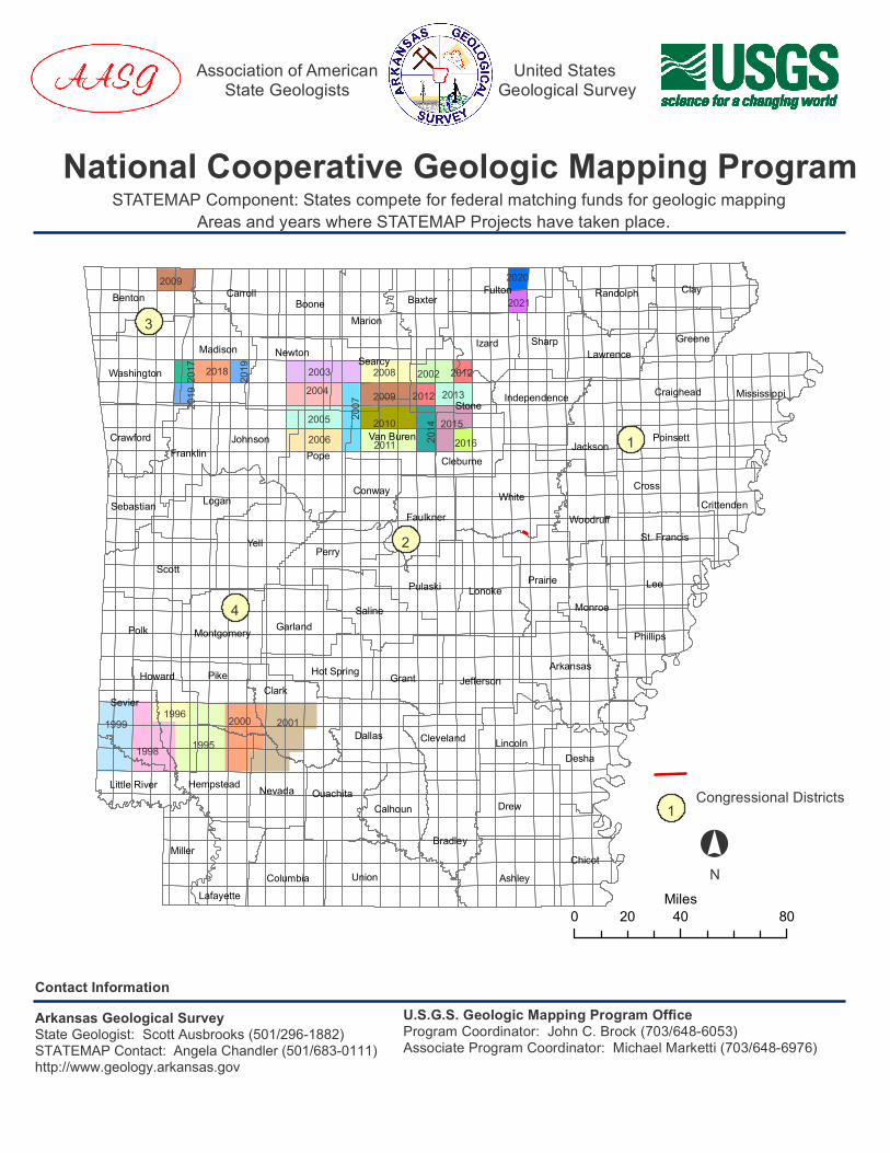
1 Congressional Districts
°N
Sebastian
Benton
WashingtonMadison
CarrollBoone
Newton
Marion
Searcy
Baxter
Stone
Fulton
Izard
Randolph
SharpLawrence
Clay
Greene
CraigheadIndependence
JacksonCleburne
Van Buren Poinsett
Mississippi
CrittendenCross
WhiteWoodruffFaulkner
Conway
Pope
St. Francis
JohnsonFranklin
Crawford
Logan
Yell
ScottPerry
Pulaski LonokePrairie
Polk Montgomery GarlandSaline
Howard
Sevier
PikeClark
Hot Spring
Little River NevadaHempstead
Miller
LafayetteColumbia
Ouachita
Union
Dallas
Grant Jefferson
Calhoun
Cleveland
Bradley
Drew
Lincoln
Ashley
Desha
Chicot
Arkansas
Lee
Phillips
Monroe
200220032004
2005
1999
1998
1996
19952000 2001
2006
2007
20082009
2009
20102011
20122012
2013
2014 2015
2016
2017 2018 2019
2019
2020
2021
Association of AmericanState Geologists
United States Geological Survey
National Cooperative Geologic Mapping ProgramSTATEMAP Component: States compete for federal matching funds for geologic mapping
Contact InformationArkansas Geological SurveyState Geologist: Scott Ausbrooks (501/296-1882) STATEMAP Contact: Angela Chandler (501/683-0111) http://www.geology.arkansas.gov
U.S.G.S. Geologic Mapping Program OfficeProgram Coordinator: John C. Brock (703/648-6053)Associate Program Coordinator: Michael Marketti (703/648-6976)
Areas and years where STATEMAP Projects have taken place.
0 40 8020Miles
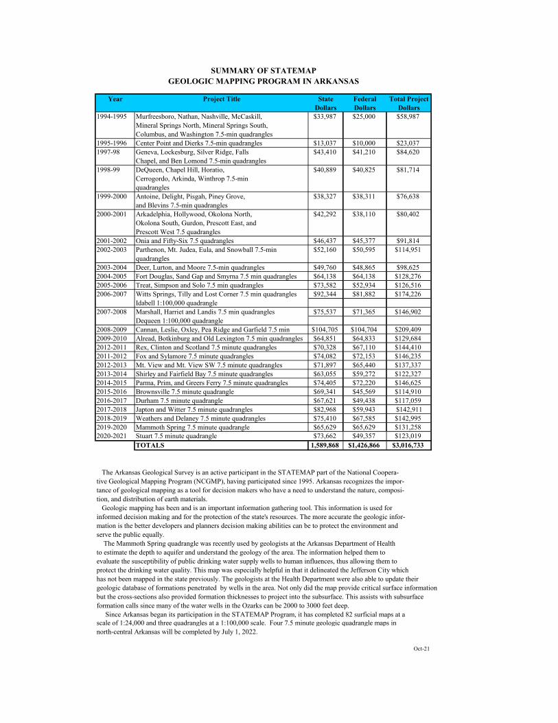
Year Project Title State Dollars
Federal Dollars
Total Project Dollars
1994-1995 Murfreesboro, Nathan, Nashville, McCaskill, $33,987 $25,000 $58,987Mineral Springs North, Mineral Springs South,Columbus, and Washington 7.5-min quadrangles
1995-1996 Center Point and Dierks 7.5-min quadrangles $13,037 $10,000 $23,0371997-98 Geneva, Lockesburg, Silver Ridge, Falls $43,410 $41,210 $84,620
Chapel, and Ben Lomond 7.5-min quadrangles1998-99 DeQueen, Chapel Hill, Horatio, $40,889 $40,825 $81,714
Cerrogordo, Arkinda, Winthrop 7.5-minquadrangles
1999-2000 Antoine, Delight, Pisgah, Piney Grove, $38,327 $38,311 $76,638and Blevins 7.5-min quadrangles
2000-2001 Arkadelphia, Hollywood, Okolona North, $42,292 $38,110 $80,402Okolona South, Gurdon, Prescott East, andPrescott West 7.5 quadrangles
2001-2002 Onia and Fifty-Six 7.5 quadrangles $46,437 $45,377 $91,8142002-2003 Parthenon, Mt. Judea, Eula, and Snowball 7.5-min $52,160 $50,595 $114,951
quadrangles2003-2004 Deer, Lurton, and Moore 7.5-min quadrangles $49,760 $48,865 $98,6252004-2005 Fort Douglas, Sand Gap and Smyrna 7.5 min quadrangles $64,138 $64,138 $128,2762005-2006 Treat, Simpson and Solo 7.5 min quadrangles $73,582 $52,934 $126,5162006-2007 Witts Springs, Tilly and Lost Corner 7.5 min quadrangles $92,344 $81,882 $174,226
Idabell 1:100,000 quadrangle2007-2008 Marshall, Harriet and Landis 7.5 min quadrangles $75,537 $71,365 $146,902
Dequeen 1:100,000 quadrangle2008-2009 Cannan, Leslie, Oxley, Pea Ridge and Garfield 7.5 min $104,705 $104,704 $209,4092009-2010 Alread, Botkinburg and Old Lexington 7.5 min quadrangles $64,851 $64,833 $129,6842012-2011 Rex, Clinton and Scotland 7.5 minute quadrangles $70,328 $67,110 $144,4102011-2012 Fox and Sylamore 7.5 minute quadrangles $74,082 $72,153 $146,2352012-2013 Mt. View and Mt. View SW 7.5 minute quadrangles $71,897 $65,440 $137,3372013-2014 Shirley and Fairfield Bay 7.5 minute quadrangles $63,055 $59,272 $122,3272014-2015 Parma, Prim, and Greers Ferry 7.5 minute quadrangles $74,405 $72,220 $146,6252015-2016 Brownsville 7.5 minute quadrangle $69,341 $45,569 $114,9102016-2017 Durham 7.5 minute quadrangle $67,621 $49,438 $117,0592017-2018 Japton and Witter 7.5 minute quadrangles $82,968 $59,943 $142,9112018-2019 Weathers and Delaney 7.5 minute quadrangles $75,410 $67,585 $142,9952019-2020 Mammoth Spring 7.5 minute quadrangle $65,629 $65,629 $131,2582020-2021 Stuart 7.5 minute quadrangle $73,662 $49,357 $123,019
TOTALS 1,589,868 $1,426,866 $3,016,733
The Arkansas Geological Survey is an active participant in the STATEMAP part of the National Coopera-tive Geological Mapping Program (NCGMP), having participated since 1995. Arkansas recognizes the impor-tance of geological mapping as a tool for decision makers who have a need to understand the nature, composi-tion, and distribution of earth materials. Geologic mapping has been and is an important information gathering tool. This information is used forinformed decision making and for the protection of the state's resources. The more accurate the geologic infor-mation is the better developers and planners decision making abilities can be to protect the environment andserve the public equally. The Mammoth Spring quadrangle was recently used by geologists at the Arkansas Department of Healthto estimate the depth to aquifer and understand the geology of the area. The information helped them toevaluate the susceptibility of public drinking water supply wells to human influences, thus allowing them toprotect the drinking water quality. This map was especially helpful in that it delineated the Jefferson City whichhas not been mapped in the state previously. The geologists at the Health Department were also able to update theirgeologic database of formations penetrated by wells in the area. Not only did the map provide critical surface informationbut the cross-sections also provided formation thicknesses to project into the subsurface. This assists with subsurfaceformation calls since many of the water wells in the Ozarks can be 2000 to 3000 feet deep. Since Arkansas began its participation in the STATEMAP Program, it has completed 82 surficial maps at a scale of 1:24,000 and three quadrangles at a 1:100,000 scale. Four 7.5 minute geologic quadrangle maps in north-central Arkansas will be completed by July 1, 2022.
Oct-21
SUMMARY OF STATEMAPGEOLOGIC MAPPING PROGRAM IN ARKANSAS