Embed Size (px)
Citation preview
Unmanned Aerial Vehicle-based Automobile License Plate Recognition System forInstitutional Parking Lots
Julian DasilvaRicardo JimenezRoland Schiller
andSanja Zivanovic Gonzalez
Department of Mathematics and Computer Science, Barry University,Miami Shores, FL 33161, USA
ABSTRACT
Unmanned aerial vehicles (UAVs), also known as drones havemany applications and they are a current trend across many in-dustries. They can be used for delivery, sports, surveillance, pro-fessional photography, cinematography, military combat, naturaldisaster assistance, security, and the list grows every day. Pro-gramming opens an avenue to automate many processes of dailylife and with the drone as aerial programmable eyes, security andsurveillance can become more efficient and cost effective. AtBarry University, parking is becoming an issue as the numberof people visiting the school greatly outnumbers the convenientparking locations. This has caused a multitude of hazards in park-ing lots due to people illegally parking, as well as unregisteredvehicles parking in reserved areas. In this paper, we explain howautomated drone surveillance is utilized to detect unauthorizedparking at Barry University. The automated process is incorpo-rated into Java application and completed in three steps: collect-ing visual data, processing data automatically, and sending auto-mated responses and queues to the operator of the system.
Keywords: UAV, surveillance, image processing, ALPR, javaapplication.
1. INTRODUCTION
Technology continues to grow at an exponential pace. Vehi-cle automation (both land and aerial) is now a reality, as auto-mated aircraft technology has shrunk down to a civilian level,and artificial intelligence is making leaps and bounds in mul-tiple disciplines. Research involving unmanned aerial vehicles(UAVs), also known as drones has vastly spread across sciencesboth within academics and industries. From automatic fire for-est monitoring [11], power line detection [13], to road segmentsurveillance [5], the usage is expanding.
At Barry University parking is a big issue as the amount of peo-ple visiting the school greatly outnumbers the available parkinglocations that one would consider convenient. This has caused amultitude of hazards in parking lots due to people illegally park-ing, as well as unregistered vehicles parking in reserved parkingareas. The public safety department struggles to cover all of thecampuses numerous parking lots effectively and thus many peo-ple get away with illegally parking, and worse unregistered ve-hicles are going unnoticed due to the inefficiency of an officerhaving to manually check all decals. Beyond this, malicious indi-viduals can falsify a decal to make it appear as if they are indeedregistered and to gain access to parking areas without proper au-thorization. In this paper, we discuss how drone surveillance can
be utilized for automatic parking enforcement. Providing such atool will not just speed up the process of enforcement but alsoallow for better use of public safety personnel.
Development of Automatic License Plate Recognition (ALPR)algorithms in the last decade or so, (see [1, 3, 9, 10, 12]) hasaided law enforcement on the road, at campus security, at airports,casinos, etc. University of Kansas is one of the places that usesALPR for parking enforcement. Parking lots are monitored by apublic safety person driving around the campus in a vehicle thathas ALPR camera mounted on the roof. The camera takes pic-tures of the cars, images are processed by ALPR, and tickets areissued if necessary. PlateSmart (see [6], [8]), is developing soft-ware using ALPR for parking management among other things.The software works with almost any camera and provides alertsof parking violations by email and text messages. However, nei-ther one of these examples and none that we found is employingdrones for parking enforcement.
The paper is organized as follows. Section 2 gives an overview ofdifferent technology and services that have been utilized. Section3 talks about automation of drone’s flight path. Data obtainedand results are presented in Section 4 while Section 5 presentsdifficulties encountered and future work.
2. TECHNOLOGY
We used DJI Phantom 3 Professional drone and utilized severalexisting technology/services in order to create a system that au-tomatically returns license plates of illegally parked cars. Tech-nology/services used are Litchi application, openALPR, FFmpegand a driving record search.
Litchi, [4], is an Android/IOS application for DJI drones that in-cludes numerous improvements over the official DJI Drone ap-plication such as in-depth waypoint mission planning and objecttracking. The Litchi flight app allows us to easily program moreaspects of the flights because it can be run from a computer. TheDJI app is only available on mobile devices. From a computer wecan then collect all of the data we have gathered about a partic-ular parking lot and build the routes on a large screen as well asprogram all the commands we need to perfectly capture data ina parking lot. Litchi works like an extension of the DJI app as itstill requires the DJI app to pull its user interface, and commands.Litchi also facilitates the saving and naming of the various way-point missions we create that we are then able to load into thephone and fly through the app. Litchi stores these waypoint mis-sions via our Litchi account.
OpenALPR, [7], is an open source Automatic License Plate
ISSN: 1690-4524 SYSTEMICS, CYBERNETICS AND INFORMATICS VOLUME 15 - NUMBER 5 - YEAR 2017 39

Recognition library written in C++ with bindings in C#, Java,Node.js, Go, and Python. In OpenAlpr, an input is an imagethat is processed in stages and the output is a list of possible li-cense plate strings. OpenALPR operates as a pipeline since thestages are occurring in the following order: Detection, Binariza-tion, Character analysis, Finding Plate Edges, Deskew, CharacterSegmentation, OCR and Post Processing.
The Detection phase only happens once for each input image andthis is the most processing-intensive phase. It uses the LBP (Lo-cal Binary Patterns) algorithm to find possible license plate re-gions in the picture. These regions consist of x and y coordinatesalong with width and height information that is sent to the laterpipeline phases for further processing. The next phases are occur-ring multiple times based on how many license plate regions wereidentified on the image. The Binarization phase creates multiplebinarized images to give us the best possible chance of findingall characters on the region because a single binarized image maymiss characters on the image that are too light or too dark. One ofthe methods that are used in this phase is called the Wolf-Jolienmethod fed with multiple parameters for better results and theseimages are processed in the next phase called Character Analy-sis. This phase attempts to find character sized areas in a singlelicense plate region. This analysis is done multiple times, start-ing by finding smaller characters and gradually looking for biggerones. It is being done by finding all connected blobs in the licenseplate region that are roughly the width and height of a licenseplate character and have tops/bottoms that are in a straight linewith other blobs of similar width/height. If nothing is found in thelicense plate region, the region will get discarded and no furtherprocessing will take place. The next phase is Finding the PlateEdges. The Detection phase is only responsible for identifying aregion where a possible license plate could reside and this phasewill try to find the exact edges (Top/Bottom/Left/Right) of the li-cense plate. The algorithm will start by finding the hough linesof the plate and computes the horizontal and vertical lines. In-formation from the previous stages will be used to determine thelikeliest plate line edges and a number of configurable weights areused to determine which edge makes the most sense. The Deskewstage requires plate edges information in order to remap the plateregion to a standard size and orientation. This phase helps to givea correctly oriented plate image without rotation or skew. Thenext step is to isolate all the characters that make up the plate im-age with a use of a vertical histogram to find gaps between theplate characters, called Character Segmentation. This also cleansup disqualifying character regions that are not good enough tobe recognized as characters, then the OCR phase analyzes allnewly calculated character regions separately. For each characterregion, it computes all possible characters and their confidenceratings. The final phase is the Post Processing phase where apossible list of OCR characters and confidences are given andorganized in a topN fashion. This phase also disqualifies charac-ters below a particular threshold given. Our work only modifiedcertain parameters to an extent to fine tune the algorithm to ourneeds and full credit to the algorithm is given to the developers ofOpenALPR.
There are numerous fine tunings for the algorithm which we canmanipulate in a config file such as:
1. Calibrating your camera improves detection accuracy incases where vehicle plates are captured at a steep angle
2. Detection will ignore plates that are too large. This is agood efficiency technique to use if the plates are going to bea fixed distance away from the camera
3. The detection doesn’t necessarily need an extremely highresolution image in order to detect plates. Using a smaller
1
2
3
4
5
6
7 2600 ft
2580 ft
2070 ft
980 ft
1420 ft
3180 ft
1480 ft
2580 ft
660 ft
2880 ft1160 ft
640 ft
1580 ft
1670 ft
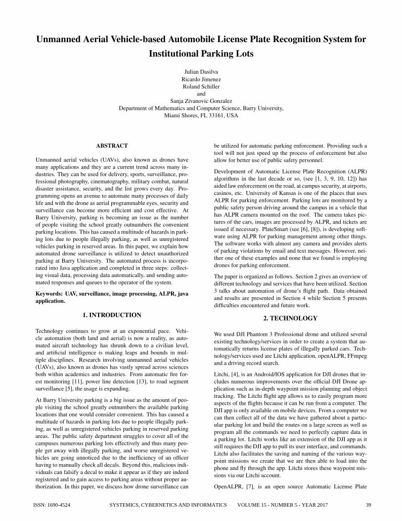
Figure 1: Undirected weighted graph. Nodes are the pointsof release of a drone. The red route represents the shortestpath.
input image should still find the plates and will do it faster.The algorithm resizes the images to a fixed resolution. Weused 1280 by 720, and got good results.
4. Whether we want to use masks. This can be expanded inthe future.
5. OpenALPR can scan the same image multiple times withdifferent randomization. Setting this to a value larger thanmay increase accuracy, but will increase processing timelinearly (e.g., analysis count = 3 is 3x slower)
6. Detection strength/strictness of license plate before signal-ing if license plate region exits.
FFmpeg, [2], is a cross-platform solution to record, convert andstream audio and video. It is capable of splitting video output intostandalone pictures.
3. DRONE AUTOMATION
The first step in successfully automating drones routes was to ex-tensively map out all the parking regions of the school. Since it islegally required by Federal Aviation Administration (FAA) thatif the drone is deployed, we have to stay within the line of sightof it, we designate a place (position), called a node, within eachparking lot as a release point of the drone. It is a place that is eas-ily accessible and covers one or possibly even two parking lots.Seven nodes were sufficient to cover all the parking lots at BarryUniversity. Walking distance between them represent weights ofthe undirected graph. Edges are then formed based of nodes’ po-sitions on the real map and their connectivity. Starting from node1, which is closest to public safety office, and returning to thesame one, we brute-force to find the shortest path. The shortestpath calculated is 1-2-3-4-7-6-5-1 for a total distance of 10910 ft,see Figure 3.
Routes are created by using our previously mapped out parkinglots and then programming waypoints set at GPS coordinates.The methodology for creating a route is that the drone must effec-tively capture all the parking spaces as well as potentially illegalparking areas while avoiding obstructions. We take into consider-ation that cars may be parked either facing forward or in reverse.When the drone reaches the end of a particular line of cars withina route, it is then given a command to either rotate and retrace
40 SYSTEMICS, CYBERNETICS AND INFORMATICS VOLUME 15 - NUMBER 5 - YEAR 2017 ISSN: 1690-4524

the same route to cover the opposite row of cars or move onto thenext section of the parking lot. Routes between rows of cars mustbe extremely precise as there are many hazards the drone can runinto, such as wind, trees, cars, people, and random hazards thatcould change on a day to day basis. To handle these variables, ex-tensive field testing was required. A projected path is created andthen tested in varying conditions. Whenever a potential danger isnoticed the path is modified accordingly.
To ensure that the visual data quality being captured was optimala lot of tweaking of the flight height and gimbal angle occurred.The height setting and gimbal angle change on a per parking lotbasis. For example, one of the lots had a height of 6 meters with agimbal angle of 42.5 degrees. However, the height is not the onlyfactor in determining gimbal angle. Changes in parking lot eleva-tion from one end to the other can also affect the desired gimbalangle settings. Modification is needed to center the license platein the image so that the image processing algorithm works ef-ficiently. Further, we automate the drones flight by mapping outeach parking lot on foot holding the drone in our hands. Using theDJI flight app, we take snapshots of GPS coordinates. RecordedGPS coordinates are used as waypoints which the drone followswhen collecting data. Once a route has been mapped out, we domanual piloting tests using the specifications determined. Usu-ally in manual pilot tests slight modifications to the GPS coordi-nates are made and the actions generated at particular waypointsare decided (actions such as turn x amount of degrees, tilt thecamera down or up, raise or lower flight altitude). During manualtesting we gradually raise the speed of the drone’s flight as tweaksare made to the final path. Once all testing has finished we givethe drone the fastest possible speed that we deem safe for thatparticular lot. Some lots being more open with less obstructionsallow the drone to fly faster, while others require a slower veloc-ity for safety purposes. If tweaks are necessary, then the processwould begin again and another manual test would be conducted.Once testing is finalized, we automate drone’s flight through theLitchi app. Namely, we plug the acquired GPS coordinates tobuild the necessary paths. Along the path Litchi app automati-cally facilitates the application of various commands to the dronesuch as, changing the gimbal angle, flight height, velocity, anddrone orientation. These parameters depend on the parking lotand generally vary from parking lot to parking lot. The route isprogrammed on the computer through the Litchi app. This pro-cess is repeated for all the parking lots that will be captured bythe drone. See Figure 2 for visualization of a programmed pathon a parking lot.
Figure 2: Flight automation of a parking lot.
4. DATA AND RESULTS
A custom java application was created to connect several ofabove mentioned solutions into a combined one. The applica-
tion first connects to the drone via USB connection and captures4K footage. The 4K footage from the drone camera (max imagesize 4000x3000, ISO range, 100-3200 video, 100-1600 photo,lens: FOV 94 degrees 20mm (35mm format equivalent) f/2,8 fo-cus at infinity, electronic shutter speed: 8-1/8000s, Sensor: 1/2.3“CMOS effective pixels: 12.4M, total pixels: 12.76M) with a thirdparty application, called FFmpeg, is loaded in our java softwarewhich directly splits the video footage from the drone into severalpictures. There are certain parameters that user can modify suchas number of pictures to be extracted every second and type ofimage files that would be created. We ran multiple tests changingthe type of image files between PNG, BMP, and JPEG, as wellas the number of pictures to be extracted which varied between1 and 3. We found out that three images per second and JPEGencoding of images were giving us adequate results. In Table 1we present a statistical representation of some of the different pa-rameters given by the extracting utility on a 2:57 minutes long,3840*2160 video resolution sample footage.
Table 1: Comparison between image types and image ex-traction statistics
Whenever the image extraction is done, all the newly created im-ages are analyzed one-by-one by the OpenALPR algorithm. Forevery image processed, the algorithm creates a list of possible re-sults, up to 10, with different confidence ratings, usually rangingfrom 70% to 95%. For one image, we get a list of license plateobjects in the program. Each object contains a list of possibleOCR reading for the license plate. We can get up to 10 possibleresults with a confidence rating in percentages, see Figure 3 andTable 2.
Figure 3: Sample Image from parking lot trial
Even though the results are around 85% to 90%, these are ofteninvalid, having some of the very similar characters misread suchas 8 and B, 0 and O. To overcome this issue, a map data structureis utilized and the license plate strings are used as keys to the mapand the values are the frequency of the same keys. The value isincremented by one every time the same license plate string wasread. At the end, the most frequent results will be shown to theuser. The more image the program analyzes, the more accuratethe results will be.
Even tough we are getting 95% confidence results, the algorithmis far from perfect and often gives unusable data, so we do the
ISSN: 1690-4524 SYSTEMICS, CYBERNETICS AND INFORMATICS VOLUME 15 - NUMBER 5 - YEAR 2017 41

plate0 confidenceDNYM26 91.1562DNYH26 90.7403DNY26 85.8861
DNYN26 85.4879DNYB26 85.0558ONYM26 84.81330NYM26 84.5391QNYM26 84.4453ONYH26 84.3974ONYH26 84.1232
Table 2: Top 10 results for plate0 with respect to confi-dence interval. Processing Time is 48.2849ms.
following. The pattern matching feature runs the topN (parame-ter a priori set - the max number of results) results against a Reg-ular expression (regex) matcher (another parameter inside ope-nALPR) to find results that match common license plate patterns.The regex patterns are customizable and can be found in runtime-data/postprocess/∗.patterns For example, using a pattern againstthis Czech plate results in only one possible match (which is thecorrect one), see Figure 4 and Table 3.
Figure 4: Sample image of a czech license plate
To visualize the output that the App produces see Figure 5. Af-ter the evaluation is finished, a third party service is utilized tocheck validity of the results and eliminate the invalid ones whichresulted in 100% accuracy.
Figure 5: Screenshot of the App
5. DISCUSSION AND FUTURE WORK
Using a drone to visually scout parking lots is much faster andmore effective across large areas, whilst obtaining accurate data.The drone can be connected to most devices (phones, tablets,
plate0 confidence pattern match4S5O233 90.947 04S5O23 87.8683 0
4S5O2S3 85.8861 04S5O23G 85.4879 04S5O23 85.1644 0
4S5O23S 84.5445 04S5O23B 83.7395 04S50233 83.0457 14S5O2B3 82.5635 0
4S5O2 82.0857 04S5O2G3 81.5684 04S5O2J3 81.0409 04S5O2S 80.2911 0
Table 3: Some of the 40 results for this plate, notice the pat-tern matches 4S50233. The cz patterns are: cz #@#####and cz #@@####.
computers) and have the visual data extracted quickly. Data isloaded into a program which efficiently analyzes license plates todetect unregistered vehicles, as well as illegally parked vehicleswhile automatically reporting violations, giving real time imagecaptures of the 4K quality footage showing individual cars, andrunning simultaneously with the drone’s surveillance routes.
Initially, we wanted the drone to take several pictures per secondusing either the official DJI App or Litchi which extends capabil-ities for drone automation. The most we could have achieved wastwo images per second, which is not the best solution if we go atfaster speed. It turned out that Litchi was unable to take some ofthe images and write it to the SD card. Error message was saying”failed to take photos for unknown reasons”. Intuitively, the moredetailed the images were, the bigger the file sizes were and thatcould have been the reason for failure of writing two images persecond to the card. Even purchasing higher performance SD card,U3 UHS-II, did not help. After all, the solution was to record 4Kvideos and extract images from it using a batch file on a computer.Since Litchi is using GPS coordinates, based on how accurate thehost devices’ (android phone or tablet) GPS is, we have to ”warmup” the GPS of the phone or tablet by enabling it via differentmethods. One such method is going into Google maps, or we candownload an App that gives constant communication with GPSsatellites for accurate GPS calculations.
The more accurate the results we want when we read the images,the more processing power is needed for the computer where re-sults are evaluated. First, we wanted to create this project on anandroid device and get the images from the drone during flightand quickly evaluate the results and send the citation. It turnedout that the algorithm to be run at acceptable speeds requires apowerful CPU, so low end devices are obsolete for this project.Also, we were not able to avoid connecting to the drone directlywith a cable, since there was no method to get the images on thedevices. We could have taken screenshots with the android de-vices, but the resolution would have not been adequate, and tak-ing multiple screenshots per second on the device is difficult andinefficient. Maybe in the future as more powerful mobile devices,and better and more affordable drone technology is available, wecould implement this software to android itself, skipping anotherdevice to carry.
Going further we can make improvements both in efficiency ofthe application and services it can provide. More precisely, we
42 SYSTEMICS, CYBERNETICS AND INFORMATICS VOLUME 15 - NUMBER 5 - YEAR 2017 ISSN: 1690-4524

can use image masks to make the areas of the images black thatwe don’t want to get searched for. Since 90% of the time spenton one image is to find license plates, and 10% to guess the char-acters, we need to minimize the field to be searched. A goodapproach and easy approach is to make several footage of thesame parking spot and get the average of coordinates of the li-cense plates. Based on that we can create the black masks to skipparts of the image.
Furthermore, the application will employ the university’sdatabase to cross reference the license plates and receive infor-mation about the vehicles eligibility to park in the parking lot.In addition, we can create a form that automatically populates acitation for illegal parking based on school records or third partyservices. We can attach a proof image that the car is parked il-legally or without permit. A system can be set up to send textmessages to the owner of the car before finalizing the citation, ifthe mobile number is available along with sending an email to theowner. After some designated amount of time, a citation wouldbe finalized and put into a database, or simply could be printedout from the software itself. Moreover, a weather forecasting sys-tem could also be implemented to check for any rain, humidity,and wind.
6. REFERENCES
[1] Chang, J., Ryoo, S., and Lim, H. (2011). ”Real-time vehi-cle tracking mechanism with license plate recognition fromroad images.” The Journal of Supercomputing, 65(1),353-364. doi:10.1007/s11227-011-0580-x
[2] FFMPEG. ”A complete cross-platform solution to record,stream, and convert audio and video.” https://ffmpeg.org/
[3] Liang, Z; Zhang, S; Ye, X. ”License plate state recogni-tion based on logo matching and state name string classifi-cation.” Applied Mathematics and Information Sciences.2, 907, 2015.
[4] Litchi App. ”Unlock the full potential of your DJI aircraftwith Litchi.” https://flyLitchi.com
[5] Liu, X., Guan, Z., Song, Y., and Chen, D. ”An optimiza-tion model of UAV route planning for road segment surveil-lance.” Journal of Central South University: Science &Technology of Mining and Metallurgy, no. 6 (2014).
[6] PlateSmart Parking Management. ”Delivers the mostaccurate, flexible, and cost-effective turn-key Auto-matic License Plate Recognition (ALPR) solutions.”https://www.platesmart.com/parking-management/
[7] OpenALPR - ”Open Automatic License Plate Recognitionsystem.” https://github.com/openalpr
[8] ”PlateSmart to Showcase Business Intelligence Tool Focus-ing on ALPR at ISCWest 2017.” ICT Monitor Worldwide.2017.
[9] Slapsinskas, P; Zilys, M. Efficiency of the electronic licenseplate recognition systems. Elektronika ir Elektrotechnika. 8,59, 2013.
[10] Wanniarachchi, W. K., Sonnadara, D. U., and Jayananda,M. K. (2007). ”License plate identification based onimage processing techniques.” International Confer-ence on Industrial and Information Systems. 2007doi:10.1109/iciinfs.2007.4579205
[11] Yuan, C., Zhang, Y., and Liu, Z. ”A survey on technologiesfor automatic forest fire monitoring, detection, and fighting
using unmanned aerial vehicles and remote sensing tech-niques.” Canadian Journal of Forest Research , vol. 45,no 7 (2015) p. 783 - 792.
[12] Zhenghao, D; Fengxin. ”Research on license plate recogni-tion algorithm based on support vector machine.” Journalof Multimedia. 2, 253, 2014
[13] Zhengrong, L., Yuee, L., Rodney, W., Hayward, R. andJinglan, Z. ”Towards automatic power line detection for aUAV surveillance system using pulse coupled neural fil-ter and an improved Hough transform.” Machine Vision &Applications, vol. 21, no. 5 (2010) p. 677 - 686.
ISSN: 1690-4524 SYSTEMICS, CYBERNETICS AND INFORMATICS VOLUME 15 - NUMBER 5 - YEAR 2017 43