Embed Size (px)
Citation preview

www.elsevier.com/locate/earscirev
Earth-Science Reviews 68 (2005) 245–279
U–Pb ages and source composition by Hf-isotope and
trace-element analysis of detrital zircons in Permian sandstone
and modern sand from southwestern Australia and a review of
the paleogeographical and denudational history of the
Yilgarn Craton$
J.J. Veevers*, A. Saeed, E.A. Belousova, W.L. Griffin
GEMOC ARC National Key Centre, Department of Earth and Planetary Sciences, Macquarie University, Sydney NSW 2109, Australia
Received 2 December 2003; accepted 19 May 2004
Abstract
Detrital zircons from the Permian Collie Coal Measures and modern sands on the northern part of the Albany Province have
been analysed for U–Pb ages by a laser ablation microprobe-inductively coupled plasma mass spectrometer (LAM-ICPMS)
and for Hf-isotope compositions by a laser ablation microprobe multi-collector inductively coupled plasma mass spectrometer
(LAM-MC-ICPMS). Trace elements were determined by analysis on the electron microprobe (EMP) and the ICPMS’s. This
combination of techniques makes it possible to determine for each grain not only the age but the nature and source of the host
magma, whether crustal or juvenile mantle, and a model age (TDM) based on a depleted-mantle source, which gives a minimum
age for the source material of the magma from which the zircon crystallised. The integrated analysis, applied to suites of detrital
zircon, gives a more distinctive, and more easily interpreted, picture of crustal evolution in the provenance area than age data
alone. Zircons from Permian and Triassic sediments already analysed for U–Pb ages by a sensitive high-resolution ion
microprobe (SHRIMP) were also analysed for Hf isotopes and trace elements.
Zircons from Collie and Permian and Early Triassic rocks of the northern Perth Basin have an age spectrum with a peak at
about 1200 Ma that can be traced to the Albany Province. Differences, however, in Hf-isotope composition indicate that the
Collie Coal Measures and the northern Perth Basin sandstones were not derived from the northern part of the Albany Province
or from the coastal strip of felsic granitoids. The Perth Basin samples have a second peak age of 600–500 Ma that can be traced
to the Leeuwin Block. One of the modern sands has a major peak at 2616 Ma that can be traced to the Yilgarn Craton.
Compiled with previously published U–Pb zircon age spectra, the analyses provide insights into the paleogeographical
history. The Yilgarn Craton sloped from the north at 1700 Ma, from the southeast at 1350–1140 and 490 Ma, its eastern part to
the east at 300 Ma, and the southern part to the northwest from the Albany Province at 300–255 Ma. Denudational data from
apatite fission-track analysis and vitrinite-reflectance studies suggest that the Yilgarn Craton was covered by a f 5-km-thick
blanket of Permian and Mesozoic sedimentary rock that was almost entirely removed by the Cenozoic, possibly because the
craton was situated between the shoulders of rift systems that grew into the eastern and southeastern Indian Ocean.
0012-8252/$ - see front matter D 2004 Elsevier B.V. All rights reserved.
doi:10.1016/j.earscirev.2004.05.005
$ Supplementary data associated with this article can be found, in the online version, at doi: 10.1016/j.earscirev.2004.05.005.
* Corresponding author. Tel.: +61-2-9850-8355; fax: +61-2-9850-8943.
E-mail addresses: [email protected] (J.J. Veevers), [email protected] (A. Saeed), [email protected]
(E.A. Belousova), [email protected] (W.L. Griffin).

J.J. Veevers et al. / Earth-Science Reviews 68 (2005) 245–279246
Ordovician, Permian, Early Triassic, and Quaternary sediment of the Perth Basin came from Proterozoic orogens. Only the
Late Permian sample contains significant populations of Archean (Yilgarn) zircons but whether they came direct from the craton
or were recycled from the postulated sedimentary cover is not known. The increased influx of sediment during the Jurassic
matched by a peak in the denudation rate would seem to require a primary supply from the craton. This question could be
resolved by dating zircon from the rapidly accumulated Jurassic formations.
D 2004 Elsevier B.V. All rights reserved.
Keywords: Australia; Yilgarn Craton; Perth Basin; U–Pb ages; Hf-isotopes; Permian sandstone; Modern sand; Source composition; Detrital
zircons; Paleogeographical and denudational history
1. Introduction After comparing these and other detrital spectra
1 See the online version of this article.
Detailed geochronology, especially the U–Pb dat-
ing of single zircon grains using SHRIMP ion microp-
robes, has been essential to paleogeographical
reconstructions and an understanding of the tectonic
history of Australia and its neighbours in Gondwana-
land (Veevers, 2000). Recently published data on
zircon age populations from modern strandline depos-
its (Sircombe and Freeman, 1999) and Permian and
Triassic sandstones of the the Perth Basin (Cawood
and Nemchin, 2000) indicate that only a few zircons
were derived from the neighbouring Archean Yilgarn
Craton. This matches the present state whereby the
craton supplies zircons to the southern coastal drainage
(Cawood et al., 2003) but only a few Archean grains
reach the west coast (Sircombe and Freeman, 1999).
However, age data alone give a one-dimensional
picture of provenance, and cannot distinguish between
two provenances of similar age but different geolog-
ical history. Recent developments in microanalytical
technology now make it possible to obtain U–Pb
ages, trace-element data, and Hf-isotope measure-
ments from single grains of zircon (Knudsen et al.,
2001; Belousova et al., 2001, 2002; Griffin et al.,
2000, 2002). This combination of techniques makes it
possible to determine for each grain not only the age
but the nature and source of the host magma, whether
crustal or juvenile mantle, and model age (TDM). The
integrated analysis, applied to suites of detrital zircon,
gives a more distinctive, and more easily interpreted,
picture of crustal evolution in the provenance area
than age data alone. We apply these techniques to
zircons from Permian and Triassic sandstones, includ-
ing three dated samples from the Perth Basin (Cawood
and Nemchin, 2000), and modern sands from south-
western Australia (Figs. 1–3).
with those of potential provenances (Figs. 4–6), we
integrate the chronological and sedimentological data
in maps of southwestern Australia from 1700 Ma to
the present (Figs. 7 and 8), and finally focus on the
denudational history of the Yilgarn Craton (Fig. 9).
TDM model ages are expressed in Ga (e.g., 2.0–
1.8 Ga), and signify the level of precision. U–Pb
zircon ages are given in Ma (e.g., 1068 Ma) except
where space considerations, as in some figures, require
abbreviation (e.g., 1.07 Ga).
The analytical data are available in archived data
tables (Tables A–K; Background Online Dataset1).
2. New analyses of zircons from the Permian Collie
Coal Measures and modern sands on the Albany
province
2.1. Methods
Zircon separates were prepared from crushed
samples and alluvial sediments using standard tech-
niques. Zircon grains were picked under the binoc-
ular microscope (with UV light attachment),
mounted in epoxy blocks, and polished for further
analysis. The selection of grains was designed to
include all visually recognised populations in ap-
proximate proportion to their abundance in the
sample, without attempting a statistically representa-
tive selection. It is our view that such ‘‘statistical
representation’’ is unlikely to be geologically mean-
ingful in any case, given the wide abundance of
zircon in different rocks, coupled with the vagaries
of transport survival.

Fig. 1. Southwestern Australia, showing location of dated sediment samples (keyed to source publications), including those dated here (*) from
the Permian Collie Basin and modern sands (two: P154402-20, pooled from samples 9 km apart, and P154415), and of the surrounding
Proterozoic Albany-Fraser Orogen, comprising the Biranup, Fraser, and Nornalup Complexes and the adjoining Stirling Range Formation and
Mount Barren Group, and the Pinjarra Orogen, including the Leeuwin and Northampton Blocks. Fr3 is sand from the lower reaches of the
Frankland River. Geology after Dawson et al. (2003). The broken line is the divide between the modern southern external drainage and the
internal, largely uncoordinated drainage, much of it inherited from past ages (Hocking and Cockbain, 1990; Morgan, 1993; Freeman, 2001).
MBG=Mount Barren Group; MRG=Mount Ragged Group; NB=Northampton Block; SRF=Stirling Range Formation. Inset: regional
context before extension and breakup in the Mesozoic, from Veevers (2000, Fig. 304), with additions from Fitzsimons (2003), in particular the
common (1.35–1.14 Ga) age of the Wilkes Province and the Albany-Fraser Orogen, and location (dots) of southwestern Australian samples for
apatite fission-track analysis (AFTA) (Kohn et al., 2002). A-F =Albany-Fraser Orogen; B =Bunger Hills; D =Denman Glacier; L= Leeuwin
Block; N=Northampton Block; P= Prydz Bay; W=Windmill Islands.
J.J. Veevers et al. / Earth-Science Reviews 68 (2005) 245–279 247
Following Sircombe (1999) and Cawood and
Nemchin (2000), we aimed to analyse at least 50–
60 grains of zircon from each sample; analysis of 60
grains provides a 95% probability of finding a popu-
lation comprising 5% of the total (Dodson et al.,
1988). In our case, the attempt to include all recog-
nisable populations would improve the probability
that such minor populations have been included.
Internal structure (inherited cores, resorption events,
metamorphic rims) was revealed by cathodolumines-
cence (CL) microscopy and back-scattered electron
(BSE) imaging on the electron microprobe (EMP).
The electron microprobe was also used for precise
analysis of Hf and Y in individual grains. The Hf data
allow Yb/Hf and Lu/Hf ratios collected during Hf
isotope analysis (see below) to be converted to con-
centrations. These elements, together with U and Th
data collected during the U–Pb analysis, provide
discriminants that can be used to recognise broad
categories of magmatic rocks from which the zircons
crystallised. The viability of such discriminants has
been debated (Hoskin and Ireland, 2000) but has been
demonstrated by statistical analysis of larger data-
bases; see discussion by Belousova et al. (2002).
U–Pb analysis was carried out using a New Wave
Research 213 nm laser-ablation microprobe (LAM)
attached to a Hewlett Packard 4500 inductively cou-
pled plasma mass spectrometer (LAM-ICPMS). A
well-characterised zircon standard (GEMOC GJ-1;
608 Ma with near-concordant Pb) is ablated under

Fig. 2. Concordia diagrams for the analysed samples.
J.J. Veevers et al. / Earth-Science Reviews 68 (2005) 245–279248
the same conditions. Spatial resolution is 30–40 Am.
This method gives U–Pb ages with precision (1% or
less) comparable to those of ion-probe data; accuracy
has been demonstrated by repeated analyses of stan-
dard zircons from several sources (Belousova et al.,
2001; Andersen et al., in press; Jackson et al., in
press). Comparison of count rates between sample and
standard also yields concentration values for U and
Th. We have used the more precise 206Pb/238U ages
for grains with 207Pb/206Pb ages < 1000 Ma, and207Pb/206Pb ages for older grains. Because most grains
were concordant as analysed, no common-lead cor-
rections have been applied (e.g., Andersen, 2002). We
have discarded grains that are discordant by more than
20% (i.e., where the 206Pb/238U age is less than 80%
of the 207Pb/206 Pb age). This cutoff is more generous
than is typically applied in dating individual rock
samples. However, in the study of detrital samples,
where one aim is to pick up small populations, the
exclusion of mildly discordant grains risks the loss of
information on the age structure of the sample. Some
reversely discordant grains with unusually low208Pb/232Th ages imply multistage disturbance of the
U–Pb systematics and also have been discarded. The
age spectra described in the text have been deconvo-
luted using an in-house program that models the data
as a series of Gaussian distributions; the associated
uncertainties are given as the full width half maximum
of each peak.
In-situ Hf-isotope analyses were carried out by a
New Wave Research 213 nm LAM attached to a Nu
Plasma multicollector (MC) inductively coupled plas-
ma mass spectrometer (ICPMS); techniques are de-
scribed by Griffin et al. (2000, 2002). Interferences of176Yb and 176Lu on 176Hf are corrected using176Yb/172Yb and 176Lu/175Lu ratios determined by
analysis of mixed Yb–Hf and Lu–Hf solutions. The
technique provides individual analyses of spots 50–
80 Am across with precision and accuracy equivalent
to conventional mass-spectrometric analysis of zircon
composites.
For the calculation of eHf values, which give the
difference between the sample and a chondritic reser-
voir in parts/104, we have adopted the chondritic values
of Blichert-Toft et al. (1997). To calculate model ages
(TDM) based on a depleted-mantle source, we have
adopted a model with (176Hf/177Hf)i= 0.279718 and176Lu/177Hf = 0.0384 to produce a value of 176Hf/177Hf
(0.28325) similar to that of average MORB over
4.56 Ga. There are currently three proposed values of
the decay constant for 176Lu. eHf values and model ages

J.J. Veevers et al. / Earth-Science Reviews 68 (2005) 245–279 249
used in the figures were calculated using the value
1.93� 10� 11 year� 1 proposed by Blichert-Toft et al.
(1997); values for eHf and model ages calculated using
this value lie between other proposed values of the
decay constant (1.865� 10� 11 year� 1, Scherer et al.,
2001; 1.983� 10� 11 year� 1, Bizzarro et al., 2003).
TDM model ages, which are calculated using the
measured 176Lu/177Hf of the zircon, can only give a
minimum age for the source material of the magma
from which the zircon crystallised. Therefore we also
have calculated, for each zircon, a ‘‘crustal’’ model
age (TDMC) which assumes that its parental magma
was produced from an average continental crust
(176Lu/177Hf = 0.015) that originally was derived from
the depleted mantle. Nd model ages recalculated
relative to a depleted mantle (TDM), and interpreted
as the age of extraction of crustal material from the
mantle, are given for Proterozoic rocks by Fitzsimons
(2003), and for the Archean Yilgarn Craton by Fletch-
er et al. (1994) augmented by Nd data from the
Eastern Goldfields (Champion and Sheraton, 1997)
and Hf-isotope data from the northern Yilgarn Craton
(Griffin et al., 2004).
The analytical data for our samples are given in
Tables A–H and new data for Cawood and Nemchin’s
zircons from the Perth Basin in Tables I–K of the
Background Online Dataset.
2.2. Sample description and data
Fig. 1 shows the location of samples from the
potential proximal provenances and the sedimentary
samples from southwestern Australia, including those
from Collie and the Albany Province analysed here.
Altogether, 227 grains were analysed from four sam-
ples: two from the Permian Collie Basin and two
sands (P154402-20, pooled from samples 9 km apart,
and P154415) from modern surface sands on the
Albany Province.
2.3. Collie Coal Measures
The remnant Collie Basin of Permian sediment
nonconformably overlies and is downfaulted into the
Yilgarn Craton. The total sedimentary thickness of
1350 m comprises 330 m of a basal tillite and
overlying bluish-grey shale (Stockton Formation),
and a 1120-m-thick succession of 5- to 15-m-thick
cycles of sandstone, siltstone, claystone, and coal
(Collie Coal Measures)(Wilson, 1990).
Samples come from the Collie Coal Measures
(Table 1). SWY-5 is a subarkosic grit between the
Galatea and Hebe Coals, at the base of the Proto-
haploxypinus rugatus zone in the ?Kungurian-Ufi-
mian (Le Blanc Smith, 1993), calibrated as 260 Ma
(Veevers, 2000). SWY-6 is another subarkosic grit
within the P-30 coal, also known as the Unicorn Seam
or Premier No. 3, in the lower part of the Premier Coal
Measures, in the lower part of the Microbaculispora
villosa zone (Le Blanc Smith, 1993), equivalent to
Upper Stage 4b of eastern Australia, in turn equivalent
to the Baigendzinian Sub-Stage of the Artinskian
Stage, or 275 Ma (Veevers, 2000).
Dr Barry Kohn, University of Melbourne, collected
the samples for apatite fission-track analysis. The
samples were crushed, minerals separated on a Wifley
table, paramagnetic phases removed using a Frantz
separator, and the residue separated in heavy liquids.
According to Glover (1952), zircon, with rutile and
garnet, is ubiquitous and, in some samples, is the most
abundant of the non-opaque heavy minerals. Many
zircons are extensively fractured. Subhedral zoned
colourless grains are common; perfectly euhedral
grains constitute 5%. Purple zircons found at Collie
occur also in the coeval Irwin River Coal Measures
and other sediments in the region.
According to Wilson (1989), ‘‘The palaeocurrent
mean for the Collie Coal Measures trends to the
northwest [341j] and this represents the palaeoslope
dip direction. There is no evidence that the Collie
Basin acted as a depocentre surrounded by inwardly
dipping palaeoslopes.’’ From this work, Veevers
(2000, p. 122) inferred that the source of the zircons
lay along the reciprocal bearing of 161j or SSE, and
ranged from the proximal Albany Province to the
distal Gamburtsev region of East Antarctica.
2.3.1. U–Pb age spectrum, Hf-isotope data and rock
type classification
The U–Pb data are shown on a concordia plot for
each sample in Fig. 2 and the age distribution, the Hf-
isotope data and the rock-type classification are shown
in Fig. 3. The analytical data are given in Tables A–D.
SWY5 has 11 mildly discordant grains, and SWY6 has
4. The age spectrum of SWY5 has a major peak at
1194 Ma and small populations at 1535, 1641, and

J.J. Veevers et al. / Earth-Science Reviews 68 (2005) 245–279250

Fig. 4. Probability densities for U–Pb SHRIMP age measurements of individual zircons in potential provenances, with Nd model ages (bars)
from Fitzsimons (2003). Albany Province (A) compiled from Pidgeon (1990) and Black et al. (1992), with peaks at 1178 Ma, 1286 Ma, 2618
Ma, and 2954 Ma and corresponding spectrum of Fr3 Frankland River sand (broken line)(Cawood et al., 2003), with peaks (underlined) at 1191,
1660, 2681, and 3221 Ma. Fraser Province (F) compiled from Nelson (1995), Nelson et al. (1995), and Clark et al. (1999, 2000), with Wilkes
Province localities at Windmill Islands (WI) (full-line boxes) and Bunger Hills (BH) (broken line). Leeuwin Block compiled from Nelson (1996,
1999, 2002) and Collins (2003), with Denman Glacier (D) (elevated line), Prydz Bay (black outline), and southern Prince Charles Mountains (S
PCM) (broken line), all from Fitzsimons (2003).
J.J. Veevers et al. / Earth-Science Reviews 68 (2005) 245–279 251
1771 Ma; a few grains scatter between 2500 and 2900
Ma. SWY6 shows essentially the same pattern, with
the major peak at 1201 Ma. The youngest grain
(boxed) is 275 Ma, the same as the age of deposition,
shown by the vertical line with open rectangle.
Fig. 3. Hf– isotopic ratio versus U–Pb ages, host-rock composition, mode
(left-hand column) Permian Collie Coal Measures samples SWY5 and SW
shown by the vertical line with open rectangle); and (right-hand column
Nemchin (2000), and host-rock composition, and EpsilonHf of the same det
Late Permian Beekeeper Formation, and PB9 Early Permian Irwin River Co
and 176Hf/177Hf plots with discriminant lines marked CHUR (chondritic
(Griffin et al., 2000, 2002) and trace-element classification of source ign
concentrations about 1200 Ma (2600 Ma in P154402-20) are given in t
individual Gaussian curves of each age measurement normalized to a valu
Basin ages were re-calculated so that ages by 207Pb/206Pb were used for >1
with our data.
In both samples the zircons with ages in the
range 1300–1000 Ma (grey band) are derived pre-
dominantly from relatively mafic granitoids, with
few from felsic granitoids and mafic rocks. The Hf
isotope patterns are similar, and all of the data
l ages of peak zircons (bars), and EpsilonHf of detrital zircons from
Y6, and modern sands P154415 and P154402-20 (age of deposition
) Perth Basin, U–Pb in zircon SHRIMP ages from Cawood and
rital zircons done here from PB8 Early Triassic Kockatea Shale, PB5
al Measures. Probability density plots of U–Pb ages (Ludwig, 2001)
unfractionated reservoir) and DM (depleted mantle), and EpsilonHfeous rock (Belousova et al., 2002). The components of the dense
he box immediately above. The age plots are the accumulation of
e of one. n is the number of individual ages in each plot. The Perth
000 Ma, and 206Pb/238U for < 1000 Ma, to allow direct comparison

J.J. Veevers et al. / Earth-Science Reviews 68 (2005) 245–279252

Fig. 6. Neoproterozoic-Cambrian reconstruction showing concentration of (a) 0.6–0.5 Ga deformation, granite, and detrital zircon in
Gondwanaland, from Florida and northwest Spain to Antarctica and Australia, and (b) 1.5–1.3 Ga igneous terrane and detrital zircon in
Laurentia, Marie Byrd Land (MBL), New Zealand (NZ), and Tasmania. A=Anakie; KL=King Leopold; MOZ =Mozambique belt;
PA= Paterson; P–L= Prydz–Leeuwin belt; HO =Himalaya Orogen; PR =Petermann. From Veevers (2004, Fig. 5), with addition of data from
the Himalayan orogen (Gehrels et al., 2003).
J.J. Veevers et al. / Earth-Science Reviews 68 (2005) 245–279 253
suggest that both samples have drained the same
area. The zircons in the main age peak have a mean
eHf = 0.37. With the assumption that the source rocks
for these magmas had a typical crustal value of176Lu/177Hf (0.015; Griffin et al., 2000), the model
age (TDMC ) of the source is 2.18 to 1.71 Ga, with
means of 2.00 and 1.96 Ga. These values correspond
Fig. 5. Probability density plots of ages of zircons and ranges (and means) o
vertically so that similar ages are grouped. Correlation of peaks indicated
spectra from Figs. 3 and 4 and model ages from above and (of bedrock) fro
(n= number of grains) arranged in approximate order of increasing age of t
with a V. (a) and (b) are from Sircombe and Freeman (1999), (c) to (j) from
Fig. 3, and (m) from Cawood and Nemchin (2000), (w) and (x), from the
densities for U–Pb SHRIMP age measurements of individual zircons inclu
al. (1997). Nd model ages (bars) are from Fitzsimons (2003). (n) Capricorn
Nemchin (2000), detrital zircon (grey) in Northampton paragneiss from Bru
1999, 2002) and Collins (2003), with Denman Glacier (D) (bar), Prydz B
broken lines. (q) and (r): plots of detrital zircons (grey) in the Albany Prov
(s) Albany Province (black) compiled from Pidgeon (1990) and Black et a
(2003) and Stirling Range Formation (outline) from Rasmussen et al. (2002
et al. (1999, 2000), with Wilkes Province localities at Windmill Islands (ful
from Cawood and Nemchin (2000), Paleoproterozoic Mount Barren Gro
Gawler Craton from Camacho et al. (2002). (w) Himalayan Orogen, Ordov
thrust sheets (Gehrels et al., 2003), and (x) Himalayan Orogen, pre-Ordo
together with Cambro-Ordovician granites supplied detritus to the Ordovi
with the youngest range (TDM= 2.1–1.8 Ga) of the
Albany Province (Fitzsimons, 2003).
2.4. Surface sand in the Albany Province
Fluvial sand was collected by Anglo American
Exploration (Aust) Ltd., Perth in an area of little
f model ages of zircons based on a depleted mantle source, arranged
by coloured patterns. Added to Veevers (2000, Fig. 130) are new
m Fitzsimons (2003). (a) to (m), (w) and (x): ages of detrital zircon
he enclosing sedimentary rock, shown on the left by the vertical line
Cawood and Nemchin (2000), (k) and (l), SWY5 and SWY6, from
Himalaya (Gehrels et al., 2003). The remaining plots of probability
de those in black from bedrock (potential provenances) from Pell et
Orogen and (o) Northampton Block (both black) from Cawood and
guier et al. (1999). (p) Leeuwin Block compiled from Nelson (1996,
ay in outline, and southern Prince Charles Mountains (S PCM) by
ince from surface sands (samples P154415 and P154402-20, Fig. 3).
l. (1992), with Fr3 Frankland River sand (grey) from Cawood et al.
). (t) Fraser Province (black) compiled from Nelson (1995) and Clark
l-line box) and Bunger Hills (broken line). (u) Yilgarn Craton (black)
up (grey) from Dawson et al. (2002) and Vallini et al. (2002). (v)
ician–Devonian sandstones of the Tethyan sequence and crystalline
vician metasedimentary strata and crystalline thrust sheets, which
cian–Devonian sediments (Gehrels et al., 2003).

J.J. Veevers et al. / Earth-Science Reviews 68 (2005) 245–279254

Fig. 7. Paleogeographical maps of southwestern Australia. Shoreline denoted by grey broken line, inferred provenance by solid black, ages of
zircons by boxed letters, with peak ages (Ga) and model ages in bold, with means in italics. Present coastline, Darling Fault line, and latitude and
longitude lines for reference only. (a) 1700 Ma, ‘‘showing indentation of a formerly continuous Pilbara-Gawler continental margin by the
Yilgarn Craton, such that the Pilbara-Yilgarn boundary is a transcurrent megashear’’ (Dawson et al., 2002). The Pilbara and Gawler Cratons lie
outside the frame. Ground to the west and south unknown. MBG=Mount Barren Group; SRF= Stirling Range Formation. (b) Collision 1350–
1140 Ma on the southeastern margin of the Yilgarn Craton (Fitzsimons, 2003). Western part of Albany Province restored to its pre-550 Ma
position. Ground to the west unknown. (c) 490 Ma, Cambrian/Ordovician. The wavy lines signify anastomosing drainage.The transition zone
(grey) between the Western (W) biotite domain and Eastern (E) biotite domain extended to between the Bunger Hills (B) and Windmill Islands
(WI) (Libby and De Laeter, 1998). The grey line between Australia and Antarctica marks the line of mid-Cretaceous breakup. Prydz Bay is
situated 800 km outside the frame. (d) 300 Ma, latest Carboniferous. Glacial and post-glacial paleogeography. Numerals indicate the thickness
(m) of glacigenic sediment, solid black concomitant uplift, and the diamond pattern the postulated area of glacigenic cover on the Yilgarn
Craton. L= Laverton; PC =Ponton Creek; SK=Sand King. (e) 275 Ma, Early Permian. The Nd model ages (in Ga) of the Pinjarra Orogen,
Leeuwin Complex, Albany Province, Fraser Province, Denman Glacier area, Bunger Hills, and Windmill Islands, are from Fitzsimons (2003),
and TDMC of SWY6 and PB9 from above. The diamond pattern denotes the postulated area of glacigenic cover on the Yilgarn Craton including
the stippled area about Collie. (f) 255 Ma, Late Permian. The dotted arrowed line denotes the long dip-slope away from the rim above the
Darling Fault scarp. (g) 245 Ma, Early Triassic. Shoreline and uplift of the Yilgarn Craton along the Darling Fault are from Cockbain (1990). (h)
225 Ma, Late Triassic, from Cockbain (1990) and Mory and Iasky (1996). (i) 140–116 Ma, Early Cretaceous. On the west, the shoreline in the
Jurassic–Cretaceous (broken line 147–137) lapped the Darling Fault in the south and by the Barremian (wide broken line 125) had advanced
up valleys past Donnybrook (DO) almost to Collie (C). In the east, the 125 Ma shoreline lapped the Precambrian basement in the Eucla and
Officer Basins. V, Vlaming Basin. (j) 35 Ma, Eocene. Fluvial (line) and lacustrine (grey) deposits and shoreline (wide grey broken line) from
Hocking and Cockbain (1990). (k) 2–0 Ma, Quaternary. The broken line is the divide between the modern external drainage and the internal,
largely uncoordinated drainage, much of it inherited from past ages (Hocking and Cockbain, 1990; Morgan, 1993; Freeman, 2001). Other
information, from Williams (2000), relates to events at the Last Glacial Maximum (18 ka): eolian dune orientation (arrows), active lunettes
(filled circles), and playas (grey). (l) Albany area enlarged from (k) to show distribution of Archean zircons (grey broken-line pattern).
J.J. Veevers et al. / Earth-Science Reviews 68 (2005) 245–279 255

Fig. 8. Neoproterozoic paleogeography, modified from Walter and
Veevers (2000, Figs. 157 and 159). (A) At 840 Ma during initial
deposition of a sheet of quartz sand at the base of the Centralian
Superbasin. The fluvial Gunanya Sandstone was deposited from
paleocurrents that flowed down a paleoslope across the zircon
provenances of the northern Gascoyne Complex, Bangemall
Supergroup, and Pinjarra Orogen, without picking up zircons from
the Yilgarn craton. (B) At 830 Ma, the western provenance
continued to provide detrital sand to the edge of an epeiric sea that
filled with carbonate and evaporites interleaved with basalt fed from
dyke swarms, including dolerite in the western Musgrave Inlier
(WMI).
J.J. Veevers et al. / Earth-Science Reviews 68 (2005) 245–279256
outcrop with deep partially dissected laterite profiles.
Samples of 15–20 kg of � 2 mm material were taken
from natural heavy-mineral traps in the current drain-
age. Zircons were separated by Wifley table, heavy
liquid, and magnetic methods.
P154415, at 34.70jS, 117.25jE in the Mount
Barker (SI 50–11) 1:250000 Sheet area (Fig. 1),
was collected from the Denmark River 1 km upstream
from its confluence with Cleerillup Creek. The area is
underlain by the Burnside Batholith near its eastern
edge (Myers, 1990), but P154415 samples a drainage
system that has its headwaters 10 and 15 km distant in
quartzo-feldspathic gneiss and granite of the Nornalup
Complex.
P154402, at 34.46jS, 116.78jE in the Pemberton
SI 50–10 1:250000 Sheet area, was collected from a
dry watercourse near its crossing of the Muir High-
way, and 6 km from its head in a 24 km2 drainage
system in the Biranup Complex. P154420, at 34.45jS,116.89jE, was collected in a similar situation 11 km
to the east, and 3 km from the junction with the
Frankland River. The area is underlain by the Burn-
side Batholith near its northern boundary with the
Biranup Complex of quartzo-feldspathic gneiss and
granite (Myers, 1990). Of the 53 zircons analysed
(Tables E, F), 34 from P154402 and 19 from P154420
were pooled as sample P154402-20. This is justified
because the age spectra of P154402 and P154420 are
identical except that P154420 lacks grains < 1100 Ma
and the absence of this small population is not
statistically significant when only 19 grains could be
analysed.
2.4.1. U–Pb age spectrum, Hf-isotope data and rock
type classification
All grains except one in P154402-20 and 16 grains
in P154415 are concordant (Fig. 2). The analytical
data are given in Tables G and H. The age spectrum of
P154415 (Fig. 3) has a major peak at 1172 Ma and a
shoulder at 1264 Ma, a minor peak at 1382 Ma, and
one or two grains at 2494, 2222, 1934, 1767, 573, and
411 Ma. The peak at 1172 Ma matches the SHRIMP
U–Pb ages of 1174F 12 Ma for the Albany Adamel-
lite and 1177F 4 Ma for the Burnside Batholith
(Pidgeon, 1990). These bedrock samples and those
from Black et al. (1992) contribute to the 1178 Ma
peak in the Albany Province (Fig. 4). The shoulder at
1264 Ma approximates the second peak at 1286 Ma in
J.J. Veevers et al. / Earth-Science Reviews 68 (2005) 245–279 257
the Albany Province, from the 1289F 10 Ma ender-
bitic gneiss near Albany (Pidgeon, 1990). Zircon rims
with ages of 1356 Ma (#56) and 1126 Ma (#67)
suggest that this span also represents a major high-
grade metamorphic episode.
More than a third of the analysed grains show
oscillatory or laminar zoning together with euhedral
crystal forms that indicate magmatic crystallization.
Nearly all of these have ages >1190 Ma, including
several of those in the 1264 Ma shoulder and most of
the grains in the 1450–1350 Ma range. The four
zircons with ages < 1000 Ma and those at 1934F26 and 2494F 17 Ma are very rounded, suggesting
abrasion during transport, most effectively by the
eolian processes that pertained during the Last Gla-
cial Maximum, between 25 and 13 ka (Williams,
2000). Anand and Paine (2002) describe the mantle
of locally derived eolian silt and fine sand across the
Yilgarn landscape in dunes partly stabilised by
spinifex and scattered mulga.
The zircons with ages in the range 1300–1000 Ma
are derived largely from relatively mafic granitoids,
with fewer from felsic granitoids and mafic rocks.
They have a mean eHf =� 11.27 and the model age
(TDMC ) of the source is 3.20–2.16 Ga, with a mean of
2.67. This older model age distinguishes P154415
from the Collie samples with a mean age of 1.96 Ga.
Unique among our samples, P154402-20 has a
major peak at 2616 Ma, a minor peak at 1200 Ma
with a shoulder at 1264 Ma, and a few grains at 3464,
3264, 3080, 2840, 1052, 872, and 549 Ma. Half the
grains are structureless under BSE/CL. About one-
third of the grains show oscillatory zoning, indicating
magmatic crystallization, but few have sharp euhedral
forms. Many of the >3000 Ma grains are rounded,
possibly because they were inherited and partly
resorbed in the younger magmas or abraded during
eolian transport, or both. The minor peak at 1200 Ma
with a shoulder at 1264 Ma mimics the 1178 and 1286
Ma peaks of the Albany Province (Fig. 4) and the
main peak at 1172 Ma of sample P154415. The main
peak at 2616 Ma matches the 2612 minor peak in
the Fraser Province (Fig. 4), and the youngest age
(2620 Ma) of the Yilgarn Craton (Nelson et al., 1995)
(Fig. 5). Cawood et al.’s (2003) sample Fr21 from the
headwaters of the Frankland River wholly within the
southern Yilgarn Craton yielded a unimodal age
distribution of 2653F 15 Ma. Downstream 250 km
at Fr3, the contribution from the Yilgarn Craton
(2681F 39 Ma) comprises only 22% of the sample.
We interpret the 2616 Ma peak of the P154402-20
spectrum as derived likewise from the southern Yil-
garn Craton, not transported by water—P154402-20
lies in a dry watercourse above the river—but blown
in by northwesterly winds directly from the Yilgarn
Craton during and after the intensely arid Last Glacial
Maximum 18000 years ago (Williams, 2000). The
correspondence of the TDM model ages of 3.39–2.88
Ga (mean 3.04 Ga) with the U–Pb in zircon ages
of 3.2–3.0 Ga in the southwestern Yilgarn Craton
(Fig. 7k) confirms the correlation. The prevailing
westerly wind also eliminates the possibility of
Yilgarn Craton zircons being blown westward from
the Frankland River to P154402-20. P154415, 50 km
downwind from the Frankland River, lacks 2.8–2.6 Ga
zircons, indicating the weakness of the present wind
to transport sand from the river in today’s environ-
ment, totally covered with vegetation.
Several 3500–3200 Ma zircons have Hf-isotope
compositions indicating derivation from a Depleted
Mantle (DM) source, whereas nearly all younger
zircons plot below the Chondritic Unfractionated
Reservoir (CHUR) reference line, indicating that their
host magmas were derived in part from older crustal
material. The 1300–1100 Ma zircons have eHf valuesranging down to � 41, with a cluster (boxed) with a
mean of � 2.4 and TDM= 1.76 Ga, and another with a
mean of � 25.36 and TDM= 2.61 Ga. This is identical
to the peak U–Pb age (2616 Ma), and reflects
derivation from the Yilgarn Craton. The grains with
the lowest eHf values give unreasonably high TDMC,
indicating that the source rocks for their host magmas
were more felsic (lower Lu/Hf) than the mean conti-
nental crust. These zircons give minimum TDM model
ages equivalent to the U–Pb ages of the oldest zircons
in the sample (ca. 3.5 Ga), confirming an ancient
Archean crustal input to 1.0–1.2 Ga magmatism in
the Albany province. The 2700–2500 Ma zircons
have a mean eHf =� 3.95 with TDM model ages of
3.4–2.9 Ga, and a mean of 3.04 Ga. In three grains
(2598, 1169, 549 Ma), rims containing more radio-
genic Hf than that of the core were intersected as the
laser drilled through the grain, indicating mixing
between magmas derived from different sources.
The grains in the 2616 Ma peak are classified as
derived equally from granitoids with 70–75% SiO2

J.J. Veevers et al. / Earth-Science Reviews 68 (2005) 245–279258
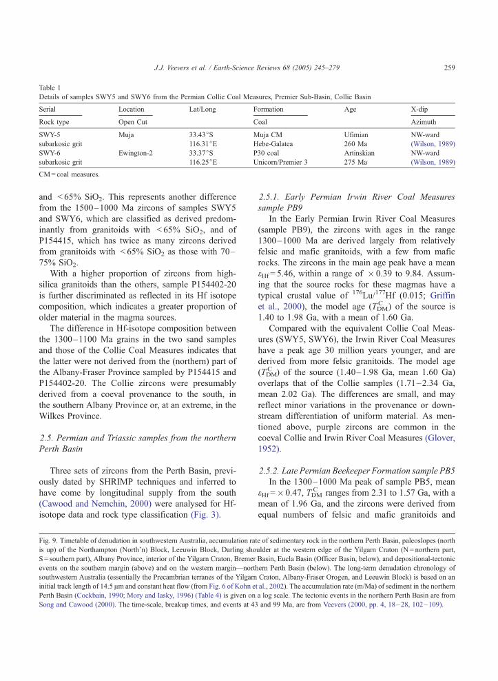
Table 1
Details of samples SWY5 and SWY6 from the Permian Collie Coal Measures, Premier Sub-Basin, Collie Basin
Serial Location Lat/Long Formation Age X-dip
Rock type Open Cut Coal Azimuth
SWY-5 Muja 33.43jS Muja CM Ufimian NW-ward
subarkosic grit 116.31jE Hebe-Galatea 260 Ma (Wilson, 1989)
SWY-6 Ewington-2 33.37jS P30 coal Artinskian NW-ward
subarkosic grit 116.25jE Unicorn/Premier 3 275 Ma (Wilson, 1989)
CM= coal measures.
J.J. Veevers et al. / Earth-Science Reviews 68 (2005) 245–279 259
and < 65% SiO2. This represents another difference
from the 1500–1000 Ma zircons of samples SWY5
and SWY6, which are classified as derived predom-
inantly from granitoids with < 65% SiO2, and of
P154415, which has twice as many zircons derived
from granitoids with < 65% SiO2 as those with 70–
75% SiO2.
With a higher proportion of zircons from high-
silica granitoids than the others, sample P154402-20
is further discriminated as reflected in its Hf isotope
composition, which indicates a greater proportion of
older material in the magma sources.
The difference in Hf-isotope composition between
the 1300–1100 Ma grains in the two sand samples
and those of the Collie Coal Measures indicates that
the latter were not derived from the (northern) part of
the Albany-Fraser Province sampled by P154415 and
P154402-20. The Collie zircons were presumably
derived from a coeval provenance to the south, in
the southern Albany Province or, at an extreme, in the
Wilkes Province.
2.5. Permian and Triassic samples from the northern
Perth Basin
Three sets of zircons from the Perth Basin, previ-
ously dated by SHRIMP techniques and inferred to
have come by longitudinal supply from the south
(Cawood and Nemchin, 2000) were analysed for Hf-
isotope data and rock type classification (Fig. 3).
Fig. 9. Timetable of denudation in southwestern Australia, accumulation rat
is up) of the Northampton (North’n) Block, Leeuwin Block, Darling sho
S = southern part), Albany Province, interior of the Yilgarn Craton, Bremer
events on the southern margin (above) and on the western margin—north
southwestern Australia (essentially the Precambrian terranes of the Yilgarn
initial track length of 14.5 Am and constant heat flow (from Fig. 6 of Kohn et
Perth Basin (Cockbain, 1990; Mory and Iasky, 1996) (Table 4) is given on
Song and Cawood (2000). The time-scale, breakup times, and events at 43
2.5.1. Early Permian Irwin River Coal Measures
sample PB9
In the Early Permian Irwin River Coal Measures
(sample PB9), the zircons with ages in the range
1300–1000 Ma are derived largely from relatively
felsic and mafic granitoids, with a few from mafic
rocks. The zircons in the main age peak have a mean
eHf = 5.46, within a range of � 0.39 to 9.84. Assum-
ing that the source rocks for these magmas have a
typical crustal value of 176Lu/177Hf (0.015; Griffin
et al., 2000), the model age (TDMC ) of the source is
1.40 to 1.98 Ga, with a mean of 1.60 Ga.
Compared with the equivalent Collie Coal Meas-
ures (SWY5, SWY6), the Irwin River Coal Measures
have a peak age 30 million years younger, and are
derived from more felsic granitoids. The model age
(TDMC ) of the source (1.40–1.98 Ga, mean 1.60 Ga)
overlaps that of the Collie samples (1.71–2.34 Ga,
mean 2.02 Ga). The differences are small, and may
reflect minor variations in the provenance or down-
stream differentiation of uniform material. As men-
tioned above, purple zircons are common in the
coeval Collie and Irwin River Coal Measures (Glover,
1952).
2.5.2. Late Permian Beekeeper Formation sample PB5
In the 1300–1000 Ma peak of sample PB5, mean
eHf =� 0.47, TDMC ranges from 2.31 to 1.57 Ga, with a
mean of 1.96 Ga, and the zircons were derived from
equal numbers of felsic and mafic granitoids and
e of sedimentary rock in the northern Perth Basin, paleoslopes (north
ulder at the western edge of the Yilgarn Craton (N = northern part,
Basin, Eucla Basin (Officer Basin, below), and depositional-tectonic
ern Perth Basin (below). The long-term denudation chronology of
Craton, Albany-Fraser Orogen, and Leeuwin Block) is based on an
al., 2002). The accumulation rate (m/Ma) of sediment in the northern
a log scale. The tectonic events in the northern Perth Basin are from
and 99 Ma, are from Veevers (2000, pp. 4, 18–28, 102–109).

J.J. Veevers et al. / Earth-Science Reviews 68 (2005) 245–279260
mafic rocks. These indicators are similar to those in
the nearby sample PB8 from the Early Triassic Kock-
atea Shale, and to the coeval sample SWY5 Muja
Coal Measures of the Collie Basin, which has mean
eHf = 0.46 (Table B), and TDMC ranges from 2.18 to
1.79 Ga, with a mean of 2.00 Ga. The only difference
is that the SWY5 zircons came predominantly from
mafic granitoids.
2.5.3. Early Triassic Kockatea Formation sample PB8
The zircons in the 1300–1000 Ma peak of PB8
have mean eHf = 0.55, TDMC from 2.39 to 1.37 Ga, with
a mean of 1.95 Ga, and the zircons were derived from
twice as many felsic granitoids as mafic granitoids.
The mix of granitoid sources is similar to that in the
nearby sample PB9 from the Early Permian Irwin
River Coal Measures but TDMC is some 0.4 billion
years older, which we interpret as reflecting input
from the Pinjarra Orogen (TDM = 2.2–2.0 Ga) and
Northampton Block (TDM = 1.9–1.6 Ga). The Collie
samples have similar TDMC means (1.96, 2.00) but a
source of predominantly mafic granitoids.
3. Ages of potential provenances
The age spectra and Hf-isotopic geochemistry of
the Collie zircons and modern sands from the Albany
region (Fig. 3) are now compared with the age spectra
of potential provenances in the immediate vicinity
(Fig. 4); and with the age spectra of other Permian
(and Triassic) sedimentary rocks and modern sands
from southwestern Australia, and of potential prove-
nances (Fig. 5). The analyses of modern sands in the
Albany Province contribute to the range of age and
composition of zircons in the modern provenances.
Individual zircons from the region have been dated
by the U–Pb method using the SHRIMP ion micro-
probe. The data sets of Nelson (1995, 1996, 1999,
2002) were the principal source for compiling the age
spectra of the potential provenances.
3.1. Albany Province
The Albany-Fraser orogen (Fig. 1) comprises the
northern Biranup Complex of granulite-facies felsic
orthogneiss and the southern Nornalup Complex of
less deformed orthogneiss and paragneiss, both
intruded by the granite of the Burnside Batholith
(Myers, 1990). Sufficient data are available to compile
an age spectrum for each province.
The U–Pb SHRIMP ages of zircons from bedrock
of the Albany Province (Fig. 4, full line) peak at 1178
Ma, representing the ages of the Burnside Batholith
and metamorphics (Black et al., 1992; Pidgeon,
1990); a satellite at 1286 Ma is derived from a
1289F 10 Ma enderbite (Pidgeon, 1990). Inherited
grains give ages of 2618 and 2954 Ma. The bedrock
spectrum is complemented by the spectrum of Fr3
sand from the lower reaches of the Frankland River
(Fig. 4, broken line) which sampled the western part
of the province as well as the Yilgarn Craton. The
main peak at 1191 Ma, encloses the 1178 Ma peak
from the bedrock, and is flanked by a low peak at
1660 Ma. Ages scattered between 2000 and 3250 Ma
peak at 2681 Ma, derived from the Yilgarn Craton,
that towers over the bedrock ages about 2618 Ma.
Cawood and Nemchin (2000) reported a tectonother-
mal peak of 1215–1140 Ma in the Albany-Fraser
Orogen, represented in Fig. 4 by the 1178 Ma peak in
the Albany area and a shoulder in the Fraser area. The
main peak age of f 1200 Ma (wide grey line),
represented by a shoulder in the Fraser Province, is
faithfully reflected in the modern sands and Permian
sandstones analysed here. The second peak at 1286 Ma
matches the main peak of 1298 Ma in the Fraser
Province. The minor peak of 1658 Ma (wide grey
broken line) in the Fraser Province is found as a peak
at 1660 Ma in the Fr3 river sand from the Albany
Province and less distinctly in the P154415 modern
sand and Permian sandstones. Nd model ages of
orthogneisses and granitoids are 3.0–2.75, 2.5–2.2,
and 2.1–1.8 Ga (Fitzsimons, 2003).
3.2. Fraser Province
The U–Pb SHRIMP ages have a major peak at
1298 Ma with a shoulder at 1200 Ma, and minor peaks
at 1658, 2612, and 2960 Ma. Clark et al. (1999, 2000)
proposed a tectonic model involving oblique Stage I
collision (1350–1260 Ma, mean 1305 Ma), indicated
by the Fraser (ultramafic) Complex, and reflected (Fig.
4) by the 1298 Ma peak in the Fraser Province. This
was followed by regional extension and renewed Stage
II compression (1210–1140 Ma, mean 1175 Ma),
reflected in the 1178 Ma peak of the Albany Province.

J.J. Veevers et al. / Earth-Science Reviews 68 (2005) 245–279 261
Nd model ages of granitoid gneisses and granitoids are
2.8–2.7, 2.2–2.1, and 1.9–1.8 Ga (Fitzsimons, 2003).
3.3. Wilkes Province (Fitzsimons, 2003)
Outcrops of orthogneiss and paragneiss in the
Windmill Islands (Fig. 1, inset, W; Fig. 4, heavy line)
contain 1350–1315 Ma amphibolite-facies assemb-
lages with a 1230–1160 Ma granulite-facies over-
print, within the main peak of the Fraser Province. In
the Bunger Hills (B) (dotted line), 1699 and 1521 Ma
orthogneiss underwent granulite-facies metamorphism
at 1190 Ma and was intruded by 1170 Ma gabbro and
1151 Ma monzodiorite. Nd model ages of felsic
intrusions in the Windmill Islands are 2.6–2.2 Ga,
and of granodioritic orthogneiss in the Bunger Hills
2.2–1.9 Ga (Fitzsimons, 2003).
3.4. Leeuwin Block
The Leeuwin Block is the southern exposure of the
Pinjarra Orogen. The U–Pb SHRIMP ages of zircons,
confined between 1200 and 500 Ma, are dominated by
twin peaks at 537 and 692 Ma, with an outlier at 1090
Ma. Collins (2003) added f 750 Ma for gneiss
protoliths and 522F 5 Ma for granulite/upper am-
phibolite facies metamorphism, some 100 million
years later than previously estimated. Nd model ages
are 1.6–1.1 Ga (Fitzsimons, 2003).
3.5. Prydz Bay, Prince Charles Mountains, Denman
Glacier (Fitzsimons, 2003)
Zircon ages from eastern Prydz Bay (P, Fig. 1,
inset) are from the Rauer Group, with protoliths of
3300–2800 and 1060–1000 Ma, and the 2800–2500
Ma Vestfold Hills Craton, both partially reset at 550–
490 Ma. In the south, gneiss was metamorphosed to
granulite-facies conditions at 530 Ma and then
intruded by A-type granites at 500 Ma. Zircons with
ages of 1200–700 Ma within the paragneiss are
probably detrital and 1000–900 Ma zircons in mafic
units indicate tectonism.
The southern Prince Charles Mountains, 400 km to
the southwest, contain 1300 Ma metavolcanics,
1020–980 Ma syenite and granite, 550 Ma orthog-
neiss, and 510–490 Ma granitic dykes. Nd model
ages are 3.2–3.0 Ga.
To the east, the Denman Glacier area, with
metamorphics poorly dated 600–550 Ma and a
precisely dated syenite at 516 Ma, shows affinity
with the Leeuwin Block. Nd model ages are 3.3 and
2.3–1.6 Ga.
This information, copied to Fig. 5, is added to data
from other potential provenances.
3.6. Capricorn Orogen
The spectrum of zircon ages from the Gascoyne
Complex of the Capricorn Orogen is from Cawood
and Nemchin (2000). Further information can be
found in Cawood and Tyler (2004).
3.7. Northampton Block
The Northampton Block is the northern exposure of
the Pinjarra Orogen. The spectrum of zircon ages from
the Northampton Block (black) is from Cawood and
Nemchin (2000), and that of ages of detrital zircons in
paragneiss (grey) is from Bruguier et al. (1999). The
youngest concordant grain (1151F18 Ma) indicates
the maximum age of deposition. Fitzsimons (2003)
notes a similar age distribution of zircons from psam-
mites in the Mullingarra Complex, 50 km to the
southeast. High-grade metamorphics cooled at
1080 Ma, granite at 1068 Ma and pegmatite at
989 Ma.
3.8. Pinjarra Orogen
The age spectrum of the Pinjarra Orogen is given
by those of the Northampton and Leeuwin Complexes
(Fig. 5o and p). Granitic basement has Nd model ages
of 2.2–2.0 Ga (Fitzsimons, 2003).
3.9. Yilgarn Craton
The Yilgarn Craton, from Cawood and Nemchin
(2000), has a broad peak between 2.8 and 2.6 Ga that
defines aaa (Fig. 5), and a tail that stretches past 3.5–
3.8 Ga.
3.10. Gawler Craton
The Gawler Craton spectrum is from Camacho
et al. (2002).

J.J. Veevers et al. / Earth-Science Reviews 68 (2005) 245–279262
4. Age spectra of detrital zircons
4.1. Distribution in southwestern Australia and East
Antarctica
The ages of zircons in protoliths of southwestern
Australian and East Antarctica, including Prydz Bay,
can be grouped into ten spans (Fig. 5; Table 2). The
spans are modified from the Gondwanaland-wide
groups of Veevers (2000, p. 110 ff ) by comparison
with the ages given in Sircombe and Freeman (1999),
Cawood and Nemchin (2000), and Cawood et al.
(2003). Fig. 5 shows the age spectra of detrital zircons
(grey) and primary zircons in adjacent basement
(black, with related detrital zircons in grey). Each
Table 2
U–Pb ages (Ga) of primary zircons in igneous-metamorphic
protoliths (e.g., 0.54–0.52) and of detrital zircons in sedimentary
protoliths (e.g., 2.00–1.32)
Region Sircombe
and
Freeman
(1999)
Cawood
and
Nemchin
(2000)
Cawood
et al.
(2003)
This paper
Prydz Bay ddd 1.00–0.80
Leeuwin 0.85–0.50 0.54–0.52 d 0.60–0.50
0.78, 0.68 dd 0.725–0.65
1.20–1.10 c 1.30–1.00
Albany 1.35–1.00 1.22–1.14 1.30–1.10 c 1.30–1.00
1.35–1.28
1.70–1.60
2.40–1.32 2.70–2.00
Fraser c 1.30–1.00
bb 1.40–1.30
a 1.80–1.50
aaV 2.60–2.50
aaa 2.80–2.60
Capricorn 1.80, 1.62 a 1.80–1.50
2.05, 1.96 aa 2.10–1.90
3.50–1.70 aaa 2.80–2.60
Northampton 1.10–0.99 c 1.30–1.00
bb 1.40–1.30
2.00–1.15 a 1.80–1.50
aa 2.10–1.90
Yilgarn 2.90–2.50 >2.60 >2.60 aaa 2.80–2.60
4.30–3.00
E Antarctica 0.55
1.00
2.80, 2.50
3.30
2.10–1.80
2.80–2.50
peak or group of peaks in the detrital zircons can be
found in the primary zircons except one, ddd (1.0–
0.8 Ga), dealt with below.
In order of increasing age, the age clusters are as
follows.
d (0.6–0.5 Ga), defined locally in the Leeuwin
Block, is widespread in Gondwanaland (Veevers,
2003); it is found in all the sedimentary samples except
those from Collie and the Triassic of the Perth Basin;
dd (0.725–0.650 Ga) is defined in the Leeuwin
Block; it is found in the sedimentary samples except
those from Collie and the Triassic of the Perth Basin
(again), and the modern Eneabba sand.
ddd (1.0–0.8 Ga) is found in Ordovician and
Permian sandstones east and south of the Northamp-
ton Block. Primary zircons or zircon-generating
events of this age are unknown in the rest of Australia
(Myers et al., 1996). The closest sources are the 0.99–
0.90 Ga zircons in the conjugate Rayner province of
East Antarctica, including Prydz Bay nearly 2000 km
distant (Fig. 1, inset), and the Eastern Ghats of India
(Fitzsimons, 2000, Fig. 3B; Mikhalsky et al., 2001).
c (1.3 –1.0 Ga). Rocks of this age were generated
during the collision between proto-Australia and
proto-Antarctica (Dawson et al., 2003). A symmetri-
cal peak at f 1.2 Ga is defined from the Albany
Province and the related Fr3 Frankland River sand.
This is also the age of mafic dykes in the southwestern
Yilgarn Craton (Pidgeon and Cook, 2003). The peak
is faithfully copied in the Collie sandstones and
P154415 modern sand; all other sedimentary samples
(except the Tumblagooda Sandstone and Eneabba
sand) and the Northampton paragneiss contain abun-
dant zircon ages within the 1.3–1.0 Ga range but with
a peak or peaks other than 1.2 Ga. The main peak in
the Fraser Province is offset 0.1 billion years to 1.3 Ga
within a range of 1.345–1.260 Ga (Dawson et al.,
2003), and passes into a saddle between 1.260 and
1.200 Ga that overlaps the Albany peak. Other base-
ment peaks are the main Northampton one at 1.05 Ga
and a minor one in the Leeuwin Block at 1.08 Ga.
Neither peak at 1.3 Ga nor 1.05 Ga is unequivocally
represented in the sedimentary samples. Another
event in this range is the emplacement of the
1075 Ma Warkurna large igneous province across
west-central Australia (Wingate et al., 2004).
bb (1.4–1.3 Ga) is defined as the older flank of c in
the Fraser Province; it is found in all the sedimentary

J.J. Veevers et al. / Earth-Science Reviews 68 (2005) 245–279 263
samples except the Tumblagooda Sandstone and the
Waroona and Eneabba sands.
b (1.5–1.3 Ga) is defined from Trans-Laurentia; it
is found in Tasmania but is absent in mainland
Australia (Veevers, 2000, pp. 110, 128) except as its
younger part (bb) in southwest Australia.
a (1.8–1.5 Ga) is defined in the Fraser Province,
and reinforced by a 1.6 Ga mound and a 1.8 Ga peak
in the Capricorn Orogen. Detrital zircon in this range
is found in Frankland River sand, Northampton para-
gneiss, Permian Dongara Sandstone and Beekeeper
Formation, Triassic Kockatea Shale, and modern
Waroona sand.
aa (2.1–1.9 Ga) is defined in the Capricorn Oro-
gen, Stirling Range Formation, and Mount Barren
Group; it also appears in the Permian Irwin River
Coal Measures, and the Wagina and Dongara Sand-
stones. 2.1–1.8 Ga is the span of global orogens
(Zhao et al., 2002).
aaV (2.6 – 2.5 Ga), not found in any terrane, is
defined by detrital zircons in five of the sedimen-
tary rocks in the northern Perth Basin and in the
2.6–2.5 Ga flank of the modern sands P154402-20
and Fr3.
aaa (2.8–2.6 Ga), defined in the Yilgarn Craton
and Capricorn Orogen, and a common age in Ar-
chean cratons worldwide, is found in the Paleopro-
terozoic Mount Barren Group, Mesoproterozoic
Stirling Range Formation, Permian Wagina and
Dongara Sandstones and Beekeeper Formation, and
the modern Eneabba, Waroona, P154402-20, and Fr3
sands. Zircons of this age are extremely rare to
absent in the Ordovician Tumblagooda Sandstone,
Permian Collie and Irwin River Coal Measures, and
Triassic Cockatea Shale.
aaaa (3.05–2.90 Ga), defined in the Yilgarn Cra-
ton and Albany and Fraser Provinces, is found in the
Mount Barren Group (2.977 Ga peak), and in the
Wagina and Dongara Sandstones and Beekeeper For-
mation. Older zircons to a limit of 4.4 Ga (Wilde et al.,
2001) are extremely rare.
4.2. Distribution elsewhere
Span d (0.60–0.50 Ga), restricted to Gondwana-
land (Fig. 6), indicates Pan-Gondwanaland events
(Veevers, 2003), and is represented in detrital zircons
(Fig. 5w) and granitic bedrock (Fig. 6) of the nearby
Himalayan Orogen (HO); span c (1.3–1.0 Ga—
‘‘Grenvillian’’) is common in most continents, includ-
ing nearby Himalayan India (Figs. 5w, x and 6). The
age spectra of the sediments in the Himalaya Orogen
(Fig. 5w and x) match those of the Permian sediments
of the Perth Basin (Fig. 5e–j) because events of these
ages are widespread in Gondwanaland. The matching
spectra do not signify a common provenance because,
as we show below, the Perth Basin sediments came
from the south.
5. Proterozoic setting of southwestern Australia
5.1. Paleoproterozoic–Mesoproterozoic (1700 Ma)
successions between the Albany-Fraser Orogen and
the Yilgarn Craton (Fig. 7a)
Dawson et al. (2002) sketched a reconstruction of
proto-Australia at 1700 Ma, with a formerly contigu-
ous Pilbara-Gawler continental margin indented by
the Yilgarn Craton such that the Pilbara-Yilgarn
boundary is a sinistral megashear (Fig. 7a).
Fitzsimons (2003) outlined the later Proterozoic
geodynamic history of southwestern Australia and
conjugate Antarctica, as follows. During two stages
of indentation of proto-Australia by a promontory of
proto-Antarctica at 1350–1260 and 1210–1140 Ma,
the Nornalup Complex collided with the Biranup
Complex, Fraser Complex, and Yilgarn Craton to
form the Albany-Fraser Orogen, including the coeval
Wilkes Province of Antarctica (Fig. 7b). Dawson et al.
(2003) point to the possibility that the f 1200 Ma
stage reflects regional heating rather than collision or
orogenic collapse.
The Pinjarra Orogen contains allochthonous
1100–1000 Ma gneissic blocks (Northampton, Mul-
lingarra, Leeuwin) transported along the craton mar-
gin during dextral strike-slip at 750 Ma and sinistral
strike-slip at 550–500 Ma during oblique collision
of Australo-Antarctic and Indo-Antarctic domains, in
a final assembly of Gondwanaland (Fitzsimons,
2003; Fig. 7c).
5.1.1. Paleoproterozoic Mount Barren Group
According to Dawson et al. (2002), the Mount
Barren Group (MBG), >1250 m of conglomerate,
sandstone, mudrock, and dolostone, is a fan delta

J.J. Veevers et al. / Earth-Science264
supplied from locally exposed sedimentary rocks. It
rests nonconformably on Yilgarn orthogneiss and was
overthrusted by the Albany-Fraser Orogen at f 1300
Ma. Its depositional age of f 1700 Ma is indicated
by SHRIMP U–Pb dating of early diagenetic xen-
otime (Vallini et al., 2002). Detrital zircons indicate a
first-cycle provenance of felsic rocks with mean ages
of 2977, 2645 (aaa), 2448, 2291, 2019 (aa), 1860,
and 1792 Ma (old part of a) (Dawson et al., 2002;
Nelson, 2001) (Fig. 5u). The nearest first-cycle prov-
enance of the 2977 Ma (aaaa) and 2645 Ma zircons is
the Yilgarn Craton itself. Potential first-cycle prove-
nances of the younger zircons are the 1000-km distant
Capricorn Orogen, which contains the three main
peaks at 2645 Ma (aaa), 2019 Ma (aa), and 1860–
1792 Ma (old part of a), and the 800-km distant
Gawler Craton, which contains aaa and a (though
with a significantly different full range of 1900–1500
Ga) but lacks aa.
The Gawler spectrum given here, from Camacho
et al.’s (2002) probability curve of 50 ages, and the
Capricorn spectrum, from a curve in Cawood and
Nemchin (2000), differ from some of the peak ages
given (in tabulated form only) by Dawson et al.
(2002). On zircon-age spectra alone, a (now lost)
foreland basin succession in the Capricorn Orogen is
the preferred provenance of the younger zircons. In
terms of contemporaneous tectonics (Dawson et al.,
2002), the Yilgarn Craton, on a trajectory to the
east-southeast, collided f 1800 Ma (Evans et al.,
2003; Cawood and Tyler, 2004) along a sinistral
transcurrent megashear with the Pilbara Craton to
form the collision zone of the Capricorn Orogen,
and at f 1725 Ma indented the rest of proto-
Australia in the orthogonal Gawler Craton with the
generation of a foreland basin. As advocated by
Dawson et al. (2002), sediment recycled from the
foreland basin would have supplied the zircons of
younger ages, but the Gawler Craton lacks the peak
at 2019 Ma.
The range of peak a (1.8–1.5 Ga) encompasses
also the deformation of the Paterson Orogen (peak 1.8
Ga, Camacho et al., 2002), central Australian terranes,
and south and north Australian cratons (Myers et al.,
1996), as well as in the neighbouring Antarctic 1.9–
1.5 Ga Rayner Province and 1.8–1.7 Ga Ross Prov-
ince (Condie, 2002), so that zircons of this age are
widespread.
5.1.2. Paleoproterozoic–Mesoproterozoic Stirling
Range Formation
The Stirling Range Formation (SRF), >1600 m of
shallow-water quartz sandstone and shale, probably
in tectonic contact with the Yilgarn orthogneiss, has
undergone greenschist facies metamorphism and sev-
eral generations of deformation (Rasmussen et al.,
2002). Low-grade metamorphic monazite dated (U–
Pb SHRIMP) at 1215F 20 Ma (Fig. 5s) was gener-
ated during a major tectonothermal event that peaked
at 1178 Ma in the Albany Province. The youngest
detrital zircons (n = 82) are 2016F 6 Ma (major
peak, aa) so that the age of deposition lies between
2016 and 1215 Ma. Other ages of detrital zircons are
2.16, 2.25, 2.30, 2.43, 2.65, 2.70, 2.75 (last three
aaa), 3.15, 3.18, and 3.46 Ga. The spectrum of the
Stirling Range Formation matches those parts of the
Capricorn Orogen and the Mount Barren Group
spectra older than 1.9 Ga; suggesting (Fig. 7a,
arrow) a common provenance in the Capricorn
Orogen or a provenance of similar age elsewhere.
The main peak between 1.9 and 1.7 Ga in the Mount
Barren Group spectrum is lacking in the Stirling
Range Formation, possibly indicating that the Stir-
ling Range Formation was deposited at its maximum
age of 2.0 Ga.
The deposition on the southern Yilgarn Craton of
the shallow-water Mount Barren Group at 1.7 Ga and
of the Stirling Range Formation some time between
2.0 and 1.2 Ga means that the Yilgarn Craton at these
times was covered by the shallow water of a lake or
sea at the foot of a paleoslope that stretched northward
through the provenances of the Yilgarn craton and
uplifted Capricorn Orogen (grey) along the northern
suture zone.
5.2. Albany-Fraser Orogen and the Yilgarn Craton
1350–1140 Ma (Fig. 7b)
The 1700 Ma transpressional collision on the
northern margin of the Yilgarn Craton is followed
350 million years later by collisions on the southeast.
This is the first appearance of high ground on the
southern and southeastern sides of the Yilgarn Craton.
No detrital zircon data from contemporaneous sedi-
ment are available for this event, and the figure is
simply a tectonic reconstruction, with the arrow
indicating downslope to the northwest.
Reviews 68 (2005) 245–279

ence Reviews 68 (2005) 245–279 265
5.3. 840 Ma Gunanya Sandstone of the northwestern
Officer Basin
High ground appeared again in the northwest
during deposition of the 840 Ma Gunanya Sandstone
at the base of the Centralian Superbasin (Walter and
Veevers, 2000) in the northwestern Officer Basin
(Fig. 8A), in the area immediately north of the map
area of Fig. 7. As shown by Bagas (2003), the
Gunanya Sandstone, deposited from east- to north-
east-paleocurrents (arrow), contains detrital zircons
whose ages indicate derivation from the northern part
of the Paleoproterozoic Gascoyne Complex, Meso-
proterozoic Bangemall Supergroup, and Meso- to
Neo-Proterozoic Pinjarra Orogen, which lie along
reciprocal bearings of the paleoslope to the southwest
and west. In the succeeding 830 Ma succession, the
westward facies change from detrital sand to carbon-
ate indicates a continuing source of detritus in the
west.
The dearth of Archean (aaa) zircons suggests that
the Yilgarn Craton was subdued.
J.J. Veevers et al. / Earth-Sci
6. Paleozoic and Mesozoic southwestern Australia
From their study of detrital zircons from the
Ordovician and Permian–Triassic sedimentary rocks
of the northern Perth Basin, Cawood and Nemchin
(2000) found that, as in the modern sands, most
zircons from the Ordovician and Permian–Triassic
sedimentary rocks were derived from 1.80–0.50 Ga
provenances in the south (Leeuwin Block and
Albany-Fraser Orogen) and few from the Archean
Yilgarn Craton. Zircons from Triassic sandstones
have a narrow range of 1.85–0.97 Ga, reflecting a
radical change in basin paleogeography that led to
cessation of input from the Yilgarn Craton and
Leeuwin Block.
6.1. Cambrian–Ordovician (490 Ma) Tumblagooda
Sandstone (Fig. 7c)
According to Hocking (1991), the 1200-m-thick
Tumblagooda Sandstone of Late Cambrian–Early
Ordovician age (Gorter et al., 1994) was deposited
on either side of the (then low-lying or covered)
Northampton Block in braided rivers and alluvial fans
at the foot of a northwestward paleoslope underlain by
the Yilgarn Craton. From the dearth of zircons of
Yilgarn age in their Tumblagooda sample (PB7),
Cawood and Nemchin (2000) inferred a subdued
Yilgarn Craton with rivers entrenched in their own
alluvium flowing down a northwest-dipping paleo-
slope (arrow) across an inferred step at the Darling
Fault. Direct evidence in this area and time of an
upthrown Yilgarn Craton along the Darling Fault is
lacking. The braided-river sandstone is succeeded by
coastal sandstone with trace fossils and conodonts, so
that the depositional structures could be delta (not
alluvial) fans prograding down a continuous north-
west slope into a shallow sea.
Deposition of the Tumblagooda Sandstone fol-
lowed the final assembly of this part of Gondwana-
land by the oblique collision of Indo-Antarctic and
Australo-Antarctic domains. The allochthonous
1100–1000 Ma gneissic blocks (Northampton, Mul-
lingarra, Leeuwin) of the Pinjarra Orogen were trans-
ported along the craton margin during sinistral strike-
slip at 550–500 Ma, dragging the western part of the
Albany Province through 90j (Fitzsimons, 2003). As
argued below, the most intense uplift and erosion
(solid black) was in the southern part of the system,
in the Prydz-Leeuwin Belt.
Evidence of the history of the western Yilgarn
Craton south of 32jS comes from Libby and de Laeter
(1998). Rb–Sr ages of biotite in the Yilgarn Craton
range from 2500 Ma in the east to 430 Ma in the
western margin at the Darling Fault. A similar range
of ages is found in the Albany Province and conjugate
Antarctica. Libby and de Laeter (1998), supported by
Nemchin and Pidgeon’s (1999) recognition of a 500–
400 Ma disturbance of the U–Pb isotopic systems in
apatite from the Darling Range Batholith, interpreted
the biotite data as indicating a reheating event at
500 Ma that followed tectonic loading by thrusting
from the west. Fitzsimons (2003) links the resetting
‘‘to the sinistral transcurrent movement that caused
pervasive deformation and metamorphism in the
Leeuwin Complex and Albany-Fraser margins at
550–500 Ma’’; this was part of the terminal heating
in the Prydz-Leeuwin Belt during the oblique collision
of the Australo-Antarctic and Indian-Antarctic
domains. Uplift by erosional rebound caused the
biotite dates to be reset at about 430 Ma as the western
zone passed upward through the 320jC isotherm

J.J. Veevers et al. / Earth-Science Reviews 68 (2005) 245–279266
representing the blocking temperature of the Rb/Sr
isotopic system. The uplifted western domain
deflected the interior drainage along a north–north-
west axis (arrowed dotted line) which bypassed the
locality of sample PB7. Zircons from the erosion of
the western domain are also absent in PB7, probably
because they were grossly diluted by those from the
south.
The main age groups of PB7, d and dd (both
potentially from the Leeuwin Block), and ddd (from
Prydz Bay), indicate a regional slope from the uplifted
Prydz-Leeuwin Belt in the south (black) to the shore-
line in the north; northward drainage was deflected (?
by the forebears of the NNW-trending Wicherina and
Urella Faults) to the northwest to debouch into the sea
in a complex of braided rivers and fan deltas.
6.2. Carboniferous–Permian (300 Ma) glacigenic
deposits (Fig. 7d)
Widespread glacigenic deposits provide much in-
formation on the paleogeography, as outlined below.
The ancestral Great Western Plateau (Veevers,
2000, p. 300), underlain by the Yilgarn and Pilbara
Cratons, was covered by ice during the Late Carbon-
iferous Gondwanan glaciation. When the ice melted at
the end of the Carboniferous (300 Ma), the glaciated
upland (diamond pattern) became strewn with glacial
deposits, and the rapidly subsiding peripheral basins
on all sides but the south filled with glacial outflow
deposits, all as part of the basal Pangean Superse-
quence (Veevers, 1990). A typical succession is tillite
and melt-out conglomerate and sandstone surmounted
by bluish-grey or greenish claystone or shale, depos-
ited from suspension in the quiet water of lakes or of
the shallow sea on the west.
In the Collie Basin, the Stockton Formation of 330
m of basal tillite and bluish-grey claystone rests on the
striated polished surface of the Yilgarn Craton with
f 200 m topographic relief (Wilson, 1990). The ice
vector runs down the paleoslope, indicated by the
341j vector of fluvial transport in the coal-measure
sandstone that overlies the glacials (Veevers, 2000,
p. 122). In the same area, Backhouse and Wilson
(1989) found palynomorphs in a claystone in a drill-
hole 3 km south of Donnybrook and 1 km east of the
Darling Fault with age equivalent to that of the
Stockton Formation.
On the eastern margin of the Yilgarn Craton
(Eyles and de Broekert, 2001), ‘‘open-cut mines
[squares] near Kalgoorlie in the Eastern Goldfields
region expose a Carboniferous–Permian network of
glacially eroded valleys filled with [up to 80 m of]
tillite and shale.’’ Drillholes at Ponton Creek (PC)
and nearby Cundeelee, within 10 km of the outcrop-
ping Yilgarn Craton, penetrated 500 m of Early
Permian tillite and sandstone with dropstones over-
lain by silty shale (Alan Whitaker, Geoscience Aus-
tralia, pers. comm., 2002), which Eyles and de
Broekert (2001) interpret as the fill of valleys over-
deepened by glacial flow toward the southeast. The
preservation of sediment on a relict Permian glacial
topography in the Eastern Goldfields indicates that
post-Permian erosion of the region was minimal,
though hypothetically much thicker younger Permian
sediment could have been removed. The maximum
preserved thickness of 500 m suggests that the local
bedrock relief was of this magnitude. The valleys fed
sediment to outwash fans in the 450-m-thick glaci-
genic Paterson Formation of the Officer Basin (Iasky,
1990).
The northern Perth Basin contains the 1500-m-
thick glacio-marine Nangetty Formation of tillite,
sandstone and shale overlain by the 450-m-thick
shallow-marine (Sakmarian) Holmwood Shale, with
non-marine equivalents in the south (Cockbain,
1990). Erratics in the Nangetty Formation suggest
ice movement towards the north-northwest, the same
as in the Collie Basin.
In the Carnarvon Basin (Hocking, 1990a), 2750 m
of glacially influenced deposits comprise the Lyons
Group of diamictites, erratic clasts, and varves,
deposited on a rapidly subsiding marine shelf be-
neath a floating ice sheet, and the Callytharra For-
mation of claystone and carbonate deposited on a
quiet shelf during the post-glacial (Sakmarian) sea-
level rise. Bedrock was smoothed and striated by the
ice (Playford, 2001).
That part of the region west of 120jE sloped north-
northwestward from high ground in the south (ruled
black pattern of the Wilkes Province, solid black of
the Leeuwin Block and Albany Province) along a
depositional axis that accumulated 330 m of glaci-
genic sediment at Collie, through 1950 m in the
northern Perth Basin, to 2750 m in the Carnarvon
Basin. The Darling Fault line was probably a hinge

J.J. Veevers et al. / Earth-Science Reviews 68 (2005) 245–279 267
between the subsiding Perth-Carnarvon Basin and the
gently sloping craton and not a scarp, which did not
develop until the Late Permian. The craton east of
120jE stood more than 500 m above sea-level and
was incised by glacial valleys that drained eastward
into the Officer Basin.
6.3. Early Permian (Artinskian, 275 Ma) coal
measures (Fig. 7e)
The only known deposits of younger Permian age
to have been preserved on the Yilgarn Craton are the
Collie Coal Measures, a 1120-m-thick succession of
5- to 15-m-thick cycles of sandstone, siltstone, clay-
stone, and coal deposited in an extensive braided-river
floodplain with swamps. The original relief during
glaciation was eliminated by glacigenic sediment
before the onset of coal-measure deposition (Wilson,
1990). From Wilson’s (1989) paleocurrent mean trend
to the northwest, Veevers (2000, p. 122) inferred that
the provenance lay along the reciprocal bearing to the
southeast, in a range that extended from the proximal
Albany Province to the distal Gamburtsev region of
East Antarctica.
‘‘There is no evidence that the Collie Basin acted
as a depocentre surrounded by inwardly dipping
palaeoslopes’’ (Wilson, 1989), and ‘‘This conclusion
implies that the northwestern and southeastern edges
of the basin, which lie along known lineaments, are
faults rather than valley sides’’ (Wilson, 1990). It
follows that the southwestern part of the Yilgarn
Craton was probably covered by a sheet of Permian
glacial and coal-measure sediment (diamond pattern)
subsequently stripped off except at Collie where the
1450-m-thick succession is preserved in downfaulted
outliers.
Critical evidence pertaining to provenance comes
from the Early Permian sample SWY6 (Figs. 3 and 5),
which though deposited on the Yilgarn Craton lacks
Yilgarn-age (aaa) zircons. As noted above, the surface
of theYilgarn Craton was probably covered by a sheet
of earlier Permian glacigenic sediment that prevented
any detritus from the southernmost Yilgarn Craton
entering the (presumably alluviated) rivers that flowed
along strike north-northwestward (341j) from the
Albany Province through Collie to the Perth Basin.
The spectra of the Collie samples are effectively
confined between 1.8 and 1.0 Ga, with a single peak
age c with a pediment bb (Fig. 5k and l). The closest
comparison is with the (immediately upslope) Albany
Province and (more distant) Fraser and Wilkes Prov-
inces. According to Wilson (1990), the clast and
heavy-mineral suite (Glover, 1952) could have been
derived from the nearby Archean Balingup Gneiss
Complex and the granitoid terrane to the east but the
lack of Yilgarn-age (aaa) zircons seems to rule out
this possibility.
The geochemistry of the 1300–1100 Ma zircons
from both Collie samples (Fig. 3) indicates host
rocks with these compositions. Of the 70 zircons
analysed, 55 (79%) indicate a granitoid with < 65%
SiO2 (mafic), 10 (14%) a granitoid with 70–75%
SiO2 (felsic), 4 (6%) mafic rocks, and 1 (1%)
carbonatite. The Albany Province, the northwestern-
most part of the Albany-Fraser-Wilkes Orogen, con-
tains the f 1200 Ma Burnside Batholith and
associated plutons, comprising granodiorite, adamel-
lite, and granite (Wilde and Walker, 1984). The
Burnside Batholith was sampled by the modern
sands P154415 and P154402-20. Of the 251300–
1100 Ma zircons analysed, 16 (64%) indicate a
granitoid with < 65% SiO2, 7 (28%) a granitoid with
70–75% SiO2, and 2 (8%) mafic rocks, in the same
order of abundance as those in the Collie zircons. In
contrast, the 93 samples of granitoids from the south
coast Albany area between 117.25jE and 118.50jE(Table 3; Stephenson, 1973, 1974) are dominantly
felsic (two-thirds contain >70% SiO2). But the Hf
data appear to discriminate between the Collie and
modern samples. The modern sand samples, which
indubitably reflect the Burnside Batholith, differ in
their Hf data: P154415 zircons in the f 1200 Ma
cluster have a mean eHf =� 11.27 and the model age
(TDMC ) of the source is 3.20 to 2.16 Ga, with a mean
of 2.67. In the Collie zircons in the same age cluster,
mean eHf = 0.37 and the model age (TDMC ) of the
source is 2.18–1.71 Ga, with means of 2.00 and
1.96 Ga. These values correspond with the youngest
range (TDM= 2.1–1.8 Ga) of the Albany Province.
Accordingly, we suggest that the provenance of the
Collie zircons lay between the Burnside Batholith
and the felsic granitoids in the coastal exposures or
farther south still, possibly in the Wilkes Province.
Incidentally, the structure of the Wilkes Land litho-
sphere is comparable to that of the Albany-Fraser
Orogen (Reading, 2004).

Table 3
Percentage silica in granitoids from the Albany Province
J.J. Veevers et al. / Earth-Science Reviews 68 (2005) 245–279268
Downslope from Collie, as part of a northward
regression of the shoreline in the northern Perth
Basin, the Artinskian Irwin River Coal Measures
prograded across a coastal plain to debouch in the
Carnarvon Basin as the northwestward-thickening
delta complex of the Moogooloo/Cordalia Sandstone
(Hocking, 1990a). Mory and Iasky (1996) described
paleocurrent data from the outcropping Irwin River
Coal Measures on the Irwin Terrace, no more than
5 km from the Darling Fault, as supporting depo-
sition in a deltaic environment by showing ‘‘a
radiating pattern from the east’’. The six actual
directions shown in their Fig. 10 are (in order from
south to north) N, NNW, NE, E, NE, SW, all but
the last measurement consistent with paleoflow
towards (and not from) a subdued Yilgarn Craton,
and contradicting ‘‘from the east’’. This explains the
lack of aaa (2.8–2.6 Ga, Yilgarn) zircons (Cawood
and Nemchin, 2000). As in the other sedimentary
rocks in the northern Perth Basin, the Irwin River
Coal Measures contain zircons d, dd, and ddd,
derivable from the south (Leeuwin Block and Prydz
Bay—long arrow) and, blended with c, bb, and aa,
all derivable from the southeast, but lacking aaa
(Yilgarn). Purple zircons in the coeval Collie and
Irwin River Coal Measures (Glover, 1952) provide
another similarity.
The peak age (c) and Nd and TDMC model ages of
zircons in SWY6 and PB9 reflect those of bedrock
zircons in the Albany and Wilkes provinces; the
lower range of Nd ages in PB9 (1.98–1.40 Ga)
and its other peak of d indicate a second provenance
in the Leeuwin Block, with Nd ages of 1.6–1.1 Ga.
We conclude that fluvio-deltaic flow was probably
continuous from Collie through the Irwin River (IR)
area to its mouth in the Carnarvon Basin from
provenances in the south and south-southeast, the
most proximal of which are the Albany and Wilkes
Provinces.
6.4. Late Permian (255 Ma) (Fig. 7f)
The Late Permian (260 Ma) sample SWY5 of the
Collie Coal Measures, with the same spectrum and
geochemistry as in the Early Permian sample SWY6,
indicates continuing drainage from the upland of the
Albany-Fraser-Wilkes Orogen.
Sample SWY5 comes from the youngest pre-
served part of the Collie succession. The post-Perm-
ian removal of the entire 300–260 Ma 1.5-km-thick
sheet of Permian sediment except at downfaulted
Collie would have recycled detrital zircons of ages a
(1.8–1.5 Ga), bb (1.4–1.3 Ga), and principally c
(1.3–1.0 Ga) into peripheral basins, in particular to
the Perth Basin, with its thick succession of Meso-
zoic and Cainozoic sediments. The only samples
exclusively within this range of zircon ages are from
the Early Triassic Kockatea Shale (a, bb, c) (Fig. 5c

J.J. Veevers et al. / Earth-Science Reviews 68 (2005) 245–279 269
and d), but a readier source is the proximal North-
ampton Block, with a similar zircon spectrum. De-
trital zircons of a and c in the modern Waroona sand
(Fig. 5b) could have been recycled in turn from any
of the Permian and Triassic sedimentary rocks of the
northern Perth Basin.
Following uplift and erosion in the northern Perth
Basin, the braided-stream deposit of the Late Permian
Wagina Sandstone rested with an abrupt low-angle
unconformity on the Irwin River Coal Measures and
Carynginia Formation, and signifies the onset of a
regime of rift faulting that continued intermittently to
continental breakup in the Cretaceous (Cockbain,
1990). The Wagina Sandstone (PB6) is interpreted
as an alluvial fan delta centred at the Darling Fault and
as a coal-swamp sandstone around the Northampton
Block, and the overlying Dongara Sandstone (PB1-3)
as a deltaic deposit that prograded into a shallow sea.
With the continued Late Permian marine transgression
over the northward paleoslope, the Beekeeper Forma-
tion (PB5) was deposited at the edge of an open sea.
The age spectra of zircons from the Late Permian
rocks of the northern Perth Basin contain all the
recognised clusters in the range 2.8–0.5 Ga, with c
(1.3–1.0 Ga) predominant. Potential provenances of
the zircons aged aaaa and aaa are the Yilgarn Craton;
aaV, an unknown provenances; aa, the Capricorn
Orogen, Stirling Range Formation, Mount Barren
Group; a, the Capricorn Orogen, Northampton Block,
Albany and Fraser Provinces, Mount Barren Group,
and Gawler Craton; bb and c, the Northampton Block
and Albany and Fraser Provinces; ddd, Prydz Bay; dd
and d, the Leeuwin Block. We interpret the main
provenances to have been the newly uplifted North-
ampton Block (a, bb, c), with its surface of Tumbla-
gooda Sandstone (ddd, dd, d), and the rift shoulder
of the Yilgarn Craton (aaa) newly risen along the
Darling Fault.
Zircons in the c (1300–1000 Ma) peak of the
Beekeeper Formation have mean eHf, TDMC, and
source composition comparable to those of the over-
lying Kockatea Formation sample PB8 and coeval
Muja Coal Measures SWY5, except the latter come
mainly from mafic granitoids. This suggests that the
provenance of the Beekeeper Formation resembled
that of the Kockatea Formation (Northampton Block)
more than that of the Muja Coal Measures (Albany
Province).
Sediment from the distal south would have been
diluted by sediment from the proximal Northampton
Block. Moreover, sediment from the southeast prov-
enances would have been blocked by the rising rift
shoulder at the crest of a long eastward to southeast-
ward slope (cf. the slope of Arabia away from the rim
that overlooks the Red Sea) that ends in the sump of
the Great Australian Bight. In effect, this reversed the
NW slope that had prevailed since 490 Ma (Fig. 7c).
6.5. Early Triassic (245 Ma) (Fig. 7g)
No sediment of Triassic age is known on the
Yilgarn Craton, but reworked material from the craton
associated with Devonian, Permian, and Triassic paly-
nomorphs in Early Cretaceous sediment of the Perth
Basin points to missing sections of these ages.
In the northern Perth Basin, the Early Triassic
Kockatea Shale contains a basal strandline sandstone
(Cockbain, 1990). At outcrop (PB8) the sandstone
rests unconformably on the Northampton Block, and
at the location of PB4, in a drilled section, it rests
unconformably on Late Permian sediments. Both
sands were analysed by Cawood and Nemchin
(2000) for zircon ages. Confined to 1.85–0.97 Ga
(a, bb, c), as represented in the nearby upstanding
Northampton Block, the ages indicate cessation of
input from the >1.8 Ga (aaa, aa) and < 1.0 Ga (ddd,
dd, d) provenances additionally represented in the
Late Permian deposits. We interpret the Early Triassic
spectrum as reflecting the continuing uplift of the
Northampton Block (a, bb, c) from which the Tum-
blagooda Sandstone (ddd, dd, d) had been stripped in
the Late Permian, and the impounding of d and dd
sand from the Leeuwin Block and aaa from the
western, scarped, edge of the Yilgarn Craton along
the shoreline that advanced up the paleoslope during
the Early Triassic transgression. Coarse fluvial sand-
stone continued to accumulate in the southern Perth
Basin, marking the southward extension of faulting
and uplift along the Darling Fault (Cockbain, 1990).
The rift shoulder of the Yilgarn Block would have
blocked sediment with a, bb, c zircons recycled
from the lost section of Permian sediments, now
represented in the remnant outlier at Collie, leaving
aaa (Yilgarn) zircons untapped.
The zircons in the 1300–1000 Ma peak of PB8
were also analysed for Hf isotopes. Mean eHf = 0.55,

J.J. Veevers et al. / Earth-Science Reviews 68 (2005) 245–279270
TDMC ranges from 2.39 to 1.37 Ga, with a mean of 1.95
Ga, and the zircons were derived from twice as many
felsic as mafic granitoids. All these indicators are
similar to those in the nearby sample PB9 from the
Early Permian Irwin River Coal Measures except TDMC
is 0.4 billion years older, and reflects input from the
Pinjarra Orogen (TDM = 2.2–2.0 Ga) and Northamp-
ton Block (TDM= 1.9–1.6 Ga).
6.6. Late Triassic (225 Ma) (Fig. 7h)
Because no ages of detrital zircons from Late
Triassic or younger rocks are known, the maps for
this and later times are constructed from sedimentary
evidence only.
In the Late Triassic, at a time of global rifting
(Veevers, 1990) and after the sea had retreated from
the Perth Basin, the alluvial-fan to fluvial Lesueur
Sandstone was deposited in response to continued
major upfaulting of the Yilgarn Craton. In the
northern Perth Basin, 3000 m of sandstone at the
foot of the Darling Fault wedge out downslope some
150 km to the northwest (arrow). ‘‘Palaeocurrents
directions from planar crossbeds are largely to the
northwest and, together with the high proportion of
feldspar [and 2-cm-long crystals], suggest a prove-
nance from a [proximal] granitic source’’ (Mory and
Iasky, 1996). Sediment flow to the northwest prob-
ably merged with the northward flow from the
Prydz-Leeuwin Belt.
6.7. Early Cretaceous–Berriasian (140 Ma) and
Aptian (116 Ma) (Fig. 7i)
In the outcrop area in the northern Perth Basin
(Mory and Iasky, 1996), the Jurassic-Cretaceous
(147–137 Ma) Parmelia Formation of fluvial feld-
spathic sandstone with minor lacustrine siltstone and
claystone conformably overlies the similar Yarraga-
dee Formation. Paleocurrents to northwest and south-
west (arrows) could reflect radial flow in an alluvial
fan. Pebbles of red, white, and black jasper near the
base match the Proterozoic outlier of the Noondine
Chert to the northeast. The basal (Otorowiri) member
contains reworked Devonian, Permian, and Triassic
palynomorphs, possibly indicating sediment of this
age stripped from the adjacent Irwin Terrace or, with
the jasper pebbles mentioned above, eroded from the
postulated cover of the Yilgarn Craton (box). Re-
worked Early Permian and Early Triassic palyno-
morphs are found through the rest of the column,
most likely from upthrown blocks within the Perth
Basin or less likely from east of the Darling Fault,
including the Collie (C) area (box). These sugges-
tions of Devonian, Permian, and Triassic sedimentary
sources on the Yilgarn Craton may reflect the missing
section.
The Parmelia Formation thickens to 8 km in the
Vlaming (V) Basin and signifies the extreme exten-
sion that preceded the 132 Ma continental breakup on
the west (broken line) between Australia-Antarctica
and Greater India (Cockbain, 1990). On the south,
Australia and Antarctica had undergone extension
(double-headed arrow) from 160 Ma preceding break-
up at 99 Ma (Veevers, 2000).
The Nakina Formation, 30 m of sandstone and
claystone with an Early Cretaceous (Aptian, 116 Ma)
microflora, was deposited unconformably on the
Collie Coal Measures (Wilson, 1990). Further occur-
rences nearby are known at Donnybrook (DO) and
in the Boyup Basin (Backhouse and Wilson, 1989),
40 km south of Collie. The deposition and preser-
vation of the Nakina Formation indicate that the
Collie area resumed subsidence by relaxation of the
rift shoulder following continental breakup at 132
Ma. The setting of the Perth Basin changed from a
rift valley to a wide marine gulf and finally to a
continental margin. Deposits were laid down in
valleys cut into the Darling Scarp and as the sea
advanced across the basin it filled them with shore-
line sandstone (Cockbain, 1990), and possibly
caused the impoundment of the nonmarine sediment
at Collie by raising base-level.
In the Eucla Basin, marine pyritic sandstone and
shale that lapped onto the Albany-Fraser Orogen
(Hocking, 1990b) are continuous to the north, in the
Officer Basin, with marine siltstone and sandstone
fringed by nonmarine sandstone (Iasky, 1990), all part
of an epeiric sea.
Before Cretaceous breakup, the southern margin
adjoined East Antarctica, such that the 1.2 Ga Albany
and Fraser provinces and the coeval Wilkes province
were a single terrane, and the Darling Mobile belt
continued along strike into the Prydz Bay-Denman
Glacier province (Fitzsimons, 2000) as part of the
Prydz-Leeuwin belt (Veevers, 2000).

J.J. Veevers et al. / Earth-Science Reviews 68 (2005) 245–279 271
From the distribution of Aptian-Albian marine
sediment across much of interior Australia, Veevers
(2000, p. 98) inferred a topography similar to that of
today but with general elevation a few hundred
metres lower, entailing this amount of subsequent
uplift. The Yilgarn and Pilbara Cratons apparently
formed a wide projection lapped by the sea on all
sides but the south.
With the retreat of the epeiric sea at the
beginning of the Late Cretaceous, at the time of
breakup and very slow spreading along the south-
ern margin, the Yilgarn Craton became deeply
weathered and lightly etched with a dendritic
drainage system.
6.8. Eocene (35 Ma) (Fig. 7j)
The drainage system incised into the Albany-
Fraser Orogen and the Yilgarn Craton (Hocking,
1990c; Morgan, 1993; Langford et al., 1995) accu-
mulated middle Eocene fluvial (line) and lacustrine
(grey) deposits, including brown coal, which were
drowned by late Eocene marine siltstone and spongo-
lite deposited behind the transgressive shoreline
(broad broken line) (Hocking and Cockbain, 1990),
at a time when spreading in the Southeast Indian
Ocean accelerated and Australia finally separated
along western Tasmania from Antarctica. In the pro-
cess, Australia began to move northwards into warmer
sub-tropical latitudes to expand the arid zone through-
out the inland that caused the degradation of the
drainage system (Williams, 2000).
From a hypsometric analysis, Veevers (2000, p. 94)
deduced that late Eocene shallow marine sediment at a
present elevation of 250 m inland and 0 m at the coast
indicates subsequent uplift of 190 m (above a + 60 m
Eocene sea level) by tilting about a coastal hinge,
which, according to Hocking and Cockbain (1990),
took place in the Oligocene.
In the Perth Basin (Cockbain, 1990), middle and
late Eocene siltstone and carbonate extend offshore
from the present coast, and in the Carnarvon Basin
extend to the Darling Fault line.
Subsequently, an early Miocene transgression that
skirted the Albany-Fraser coast and penetrated (as in
the Eocene) into the Eucla Basin left middle Miocene
limestone on the Nullarbor Plain at a present elevation
of 200 m inland and 0 m at the coast, indicating
subsequent uplift of 160 m (above the + 40 m
Miocene sea level) by tilting about a coastal hinge
(Veevers, 2000, p. 93).
6.9. Quaternary (2–0 Ma) (Fig. 7k and l)
The Quaternary climate of Australia is character-
ised by global glacial– interglacial cycles, exemplified
by the current cycle of glacial aridity during the 18 ka
Last Glacial Maximum (LGM) and 9 ka warm, wetter
interglacial maximum. In southwestern Australia, the
eolian dunes, last shaped in the LGM, are oriented
such that they were driven by winds from west
to west–northwest (Hocking and Cockbain, 1990;
Williams, 2000).
Sircombe and Freeman (1999) found that only
< 11% of zircons in the modern placer sands in the
Perth Basin, which lie no more than 60 km from the
Archean Yilgarn Craton, are of 2.8–2.5 Ga age. They
inferred from this that the Yilgarn Craton contributed
little sediment in the Mesozoic and Cainozoic to the
Perth Basin, against the long-held assumption that the
Yilgarn Craton dominated as a provenance. Instead
they found that the modern placer sands were prob-
ably derived ultimately from Proterozoic orogens
marginal to the Yilgarn Craton, among them the
Pinjarra Orogen including the Leeuwin Block to the
west, and the Albany-Fraser Orogen to the south.
Cawood et al. (2003) traced zircons from the
headwaters of the Frankland River in the Yilgarn
Craton to its lower reaches in the Albany Province.
They found that Yilgarn detritus fell from 100% in the
headwaters to 25% in the lower (incised) reaches by
dilution from the Albany Province.
The Nd model ages (in Ga) of granites and gneisses
of the subdivisions of the Yilgarn Craton, from
Fletcher et al. (1994), are effectively TDM, with the
same or similar constants as in Fitzsimons (2003), and
are augmented by TDM of the Eastern Goldfields
(Champion and Sheraton, 1997) and TDM by Hf
isotopes from the northern Yilgarn Craton (Griffin
et al., 2004). The full range of the Yilgarn Craton,
3.8–2.6 Ga, with peaks at 3.2 and 3.0 Ga, is over-
lapped by the model ages of P154415 and duplicated
by the 3.04 Ga model age of P154402-20. Sand
samples shown are Fr21, from the headwaters of the
Frankland River, with peak age of 2.65 Ga (Cawood
et al., 2003), and the samples described above,

J.J. Veevers et al. / Earth-Science Reviews 68 (2005) 245–279272
P154415 with TDMC model ages and P154402-20 with
TDM, both with the peak ages shown by the letter
symbols.
Yilgarn (Archean) detrital zircons (grey broken-
line pattern in Fig. 7l) are found in samples P154402-
20 and not in P154415, explained by zircons being
blown in from the Yilgarn Craton to P154402-20
during the intensely windy LGM 18000 years ago
but not blown from the Frankland River to P154415
today.
Zircons from Australian continental dunefields
were analysed by Pell et al. (1997). They found (1)
that each desert consists of material from several
protosource areas, some local, others up to 850 km
away; (2) that most of the protosource areas no longer
contribute sediment to the dunefields, reflecting
changes in climate and sediment transport; (3) that
most sand material has been reworked from older
fluvial and marine deposits. From a study of the Great
Victoria Desert of South Australia-Western Australia,
Pell et al. (1999) concluded that the sand was derived
mainly from local bedrock with very little subsequent
eolian transport. The arguments were countered by
Wopfner and Twidale (2001).
7. Denudational history of the Yilgarn Craton
since 300 Ma (Fig. 9)
The denudational history of the Yilgarn Craton
since 300 Ma is indicated by direct evidence from
apatite fission-track analysis and vitrinite-reflectance
data.
7.1. Apatite fission-track analysis
Kohn et al.’s (2002) analysis of southwestern
Australia from 300 Ma to the present is based on
samples from the Archean Yilgarn Craton and
adjacent Proterozoic terranes south of 30jS and
west of 124j (Fig. 1, inset). The chronology is
marked by these denudation rates: (1) Rising from
300 Ma (Carboniferous–Permian), a broad maxi-
mum (shaded) of >14 m/Ma between 270 (Early
Permian) and 165 Ma (Middle Jurassic) with peaks
at 245 Ma (Early Triassic) and 200 Ma (Early
Jurassic), entails denudation of >14 m/Ma� 105
million yearsz 1470 m, equivalent to the initial
thickness of the Permian strata at Collie (>1350 m).
(2) A second maximum (shaded) of >5 m/Ma be-
tween 50 Ma (early Eocene) and 22 Ma (early
Miocene) with a peak of 10 m/Ma at 35 Ma (late
Eocene), entailing denudation of >5 m/Ma� 28 mil-
lion yearsz 140 m.
Denudation starting at 300 Ma (Carboniferous–
Permian) corresponds with the widespread extension
in Gondwanaland (Syn-Rift I of Song and Cawood,
2000), and concomitant accumulation of glacigenic
sediment at the base of the Pangean Supersequence
(Veevers, 1990). According to Etheridge and O’Brien
(1994), initial extension involved 100% to 400%
northwest–southeast extension beneath most of the
present continental shelf of the western margin. In
the southwest, extension led to the accumulation of
the Stockton Formation in the Collie Basin and other
glacigenic deposits on the Yilgarn Craton and the
Nangetty Formation of the Perth Basin (Fig. 7d).
7.2. Vitrinite-reflectance data from Collie
The only younger (post-glacial) Permian rocks
preserved on the Yilgarn Craton are the Collie Coal
Measures (Fig. 7e). The original relief during glacia-
tion was eliminated by glacigenic sediment before the
onset of coal-measure deposition, all subsequently
stripped off except in the Collie area where it is
preserved in downfaulted outliers.
From vitrinite-reflectance data of Collie coals, Le
Blanc Smith (1993) inferred that maximum coal
burial temperature was possibly up to 100jC and
that f 6.5 km of missing section were removed
since the youngest age of deposition of 260 Ma.
Using a lower assumed surface temperature from a
constant heat-flow model appropriate for a sedimen-
tary blanket overlying the crystalline basement,
Kohn et al. (2002) revised this estimate to f 4
km. They found that ‘‘the vitrinite reflectance data
and the apatite fission track data suggest that a
substantial thickness of Upper Palaeozoic [and Me-
sozoic] sedimentary rocks extended across the crys-
talline rocks of the study area, and that the Collie
and adjacent basins are preserved outliers of this
accumulation.’’ This entails a total thickness of
sediment at Collie of 1.35 km of preserved Permian
rock together with f 4 km of subsequently removed
Mesozoic rock for a total f 5.35 km. The maxi-

Table 4
Accumulation rate of Permian, Mesozoic, and Cenozoic formations
of the northern Perth Basin
Formation Top Bottom Span Thickness Accumulation Rate
Ma Ma Ma m m/Ma log
Tamala 0 1.8 1.8 150 83 1.9
Wadjemup 1.8 11.2 9.4 289 31 1.5
Stark Bay 14.8 23.8 9 230 26 1.4
Porpoise Bay 37 49 12 382 32 1.5
Kings Park 49 61 12 532 44 1.65
Coolyena 65 112 47 276 6 0.8
Leederville/
South Perth
112 137 25 1340 54 1.7
Paramelia 137 147 10 8000 800 2.9
Yarragadee 147 165 18 3000 167 2.2
Cadda 165 180 15 392 26 1.4
Cockleshell
Gully 180 206 26 2075 80 1.9
Lesueur 206 242 36 2200 61 1.8
Woodada/
Kockatea
242 250 8 1053 132 2.1
Wagina/
Dongara
253 258 5 336 67 1.8
Irwin River/
Highcliff
272 280 8 642 80 1.9
Holmwood 280 288 8 450 56 1.75
Nangetty 288 300 12 1500 125 2.1
Data from Cockbain (1990).
J.J. Veevers et al. / Earth-Science Reviews 68 (2005) 245–279 273
mum extent of the missing section is indicated in
Fig. 7d–h by the diamond pattern. If, as depositional
trends suggest, the basin structure at Collie is typical
of the wider area, then the thickness of the missing
section elsewhere on the southwestern Yilgarn Cra-
ton would be the same (Freeman, 2001; Le Blanc
Smith, 1993). A volumetric study (cited by Kohn et
al., 2002) of Paleozoic and Mesozoic sediment
deposited in the Ordovician and younger basins that
flank the Yilgarn and Pilbara Cratons led to an
estimated thickness of f 4 km of rock removed
from the cratons at an overall average denudation
rate of f 9 m/Ma. As noted above, the denudation
rate from apatite fission-track analysis (Fig. 9)
exceeded 14 m/Ma during the Permian–Jurassic,
well above the overall rate.
A postulated 5-km-thick Permian and Mesozoic
sedimentary blanket over the 0.5� 106 km2 Yilgarn
Craton would resemble the Colorado Plateau of sim-
ilar area with a 3-km-thick Permian and Mesozoic
sedimentary blanket on Mesoproterozoic basement
(Cook and Bally, 1975). A notable difference is the
fate of the cover: all but a few fragments of the
Yilgarn cover were removed soon after it was depos-
ited, possibly because it was elevated during the
Mesozoic as shoulders of the rift-valley systems that
preceded breakup along the western and southern
margins. The postulated thick cover explains the
minor contribution of aaa (Archean) zircons and
the major contribution of possibly recycled c (1.3–
1.0 Ga) zircons in the Permian and Triassic samples
from the Perth Basin.
7.3. Sediment-accumulation rate in the Perth Basin
Accelerated denudation from 270 Ma corre-
sponds with the lacuna between the Irwin River
Coal Measures and the Wagina Sandstone, seen in
the detrital zircons of the northern Perth Basin
formations that overlie the low-angle unconformity
(Fig. 7f). Accelerated denudation at 245 Ma (Early
Triassic) and 205 Ma (earliest Jurassic) (Fig. 7g and
h) shows in the faster accumulation rate (Veevers,
2000; Veevers and Tewari, 1995), the latter during
Syn-Rift II-1 (Song and Cawood, 2000). Further
accelerated denudation from 165 Ma (Middle Juras-
sic) corresponds with the 154.3 Ma inception of
seafloor spreading in the Argo Abyssal Plain
(Veevers, 2000) and reaches a maximum of 800
m/Ma with deposition of the Parmelia Formation
associated with the strike-slip deformation that pre-
ceded 131.9 Ma inception of seafloor spreading in
the Perth Abyssal Plain. Relaxation that followed
the inception of seafloor spreading in the Late
Cretaceous is reflected in the minimal rates of
denudation and accumulation. Following the 60
Ma onset of the deposition of the Kings Park and
Porpoise Bay Formations and during the 43 Ma
transpressional events and Oligocene uplift of the
southern margin (Veevers, 2000), denudation rates
rise above 5 m/Ma until their final fall in the
Neogene (Table 4).
In conjugate Antarctica, in the region of the
Lambert Graben in the northern Prince Charles
Mountains, apatite fission-track data ‘‘indicate that
the basement experienced substantial cooling during
the late Paleozoic, followed by slow reheating (due
to sedimentary burial?) during almost the entire
Mesozoic, followed, finally, by a phase of accelerated

J.J. Veevers et al. / Earth-Science Reviews 68 (2005) 245–279274
cooling during the Cretaceous’’ (Lisker et al., 2003).
The late Paleozoic cooling took place at the same
time as the initiation of the Lambert Graben, possibly
as an ‘‘impactogen’’ (Sengor et al., 1978) during
shortening in the ancestral Gamburtsev Mountains
(Veevers, 1994).
8. Summary of events since 300 Ma on and about
the Yilgarn Craton
8.1. Carboniferous–Permian (300 Ma) onset of Syn-
Rift I, base of Pangean Supersequence
The original glacial relief ranged from 330 m in the
southwest (Collie) across a bevelled surface (semi-
circular outline in Fig. 9) to 500 m in the east. The
craton was flanked at a hinge on the west by a rapidly
subsiding sedimentary basin and on the south by high
ground. Tillite and black shale filled in depressions on
the craton and thickened northward in the sedimentary
basin.
8.2. Early Permian (275 Ma) continued subsidence
Rivers from the south flowed NNW and deposited
widespread fluvial coal measures on the craton and
basin. Local uplift and erosion accompanied growing
tectonic relief.
8.3. Late Permian (255 Ma) rise of the cratonic
shoulder
With increasingly intense rift faulting, the western
edge of the craton started to become uplifted in a
(Darling) shoulder that overlooked the basin and
sloped to the east and southeast. In places, the western
craton started to become denuded of its recently
deposited cover; in other places, as at Collie, deposi-
tion continued.
8.4. Early Triassic (245 Ma) incision of the cratonic
shoulder
The shoulder extended to the south and any sedi-
mentary cover was deeply incised by drainage. Pied-
mont fans accumulated at the foot of the shoulder
scarp, and sediment was carried eastward and south-
eastward across the craton. Depressions in the craton
accumulated sediment.
8.5. Late Triassic (225 Ma) continued incision of the
cratonic shoulder
The shoulder continued to rise. An accelerated rate
of uplift before the 206 Ma onset Syn-Rift II-1
resulted in another outpouring of sediment in pied-
mont fans.
8.6. Late Jurassic (154.3 Ma) climactic uplift
Another cycle of uplift (Syn-Rift II-1) produced an
even thicker wedge of piedmont deposit at the same
time as the 154.3 Ma breakup and onset of spreading
along the northwestern margin. Proterozoic jasper and
possibly Devonian, Permian, and Triassic sedimentary
cover were stripped from the craton during this
climactic uplift.
8.7. Early Cretaceous (132 Ma) relaxation of the
cratonic shoulder
Following breakup and the onset of spreading
along the western margin, the cratonic shoulder at
Collie subsided so that valleys across the scarp
became filled with marine sediment. On the east
the craton was onlapped by sediment deposited
from an epeiric sea. The craton formed a wide
peninsula a few hundred metres lower than today
between the ocean on the west and the epeiric sea
on the east.
8.8. Late Cretaceous (99–65 Ma) epeiric uplift
Following the complex of events at 99 Ma, in-
cluding the breakup of Australia and Antarctica along
the southern margin, the subdued topography of much
of the craton rose through a few hundred metres and
became deeply weathered and lightly etched by
drainage.
8.9. Eocene (50–33 Ma) subsidence of the southern
and western parts of the craton
Following the complex of events at 43 Ma, includ-
ing accelerated spreading in the Southeast Indian

J.J. Veevers et al. / Earth-Science Reviews 68 (2005) 245–279 275
Ocean, the southern and western parts of the craton
subsided beneath the sea.
8.10. Oligocene (30 Ma) uplift of southern and
western parts of the craton
The craton was uplifted by 190 m by tilting about a
coastal hinge.
8.11. Early Miocene (23 Ma) renewed subsidence of
the southern and western parts of the craton
In a second episode, the southern and western parts
of the craton subsided beneath the sea.
8.12. Late Miocene (11 Ma) uplift of the southern and
western parts of the craton
The craton was uplifted by 160 m by tilting about a
coastal hinge.
8.13. Quaternary (2–0 Ma) state of the craton
Today, the craton surface is a plateau that rises
from elevations of 200 m at a scarp in the west to a
broad crest at 500 m and down again to 200 m in the
east (Milligan et al., 1997). The western and south-
ern periphery is drained by coastal streams, the
interior by an etched surface of dry lakes and
valleys, the preservation of which indicates very
low rates of denudation outside the areas in the
south affected by uplift.
The Frankland River in the south conveys sediment
from the craton to the sea, but the streams in the west
convey little, if any, sediment to the coast, as was so
during at least the Ordovician, Early Permian, and
Early Triassic.
9. Conclusion
Of the Ordovician, Permian, Early Triassic, and
Quaternary sediment of the Perth Basin sampled
for zircons, only the Late Permian ones contain
significant populations of Archean (Yilgarn) zir-
cons. In other words, the Yilgarn Craton has not
contributed to sediments on the west during these
periods except the Late Permian. The chief con-
tributors during these periods were Proterozoic
orogens.
Other evidence suggests that the craton was
covered by a (now missing) cover of sedimentary
rock including one or more of Proterozoic, Devoni-
an, Permian, and Triassic ages. Whether the Archean
zircons in the Late Permian rocks came direct from
the craton or were recycled from the sedimentary
cover is not known. The increased influx of sedi-
ment during the Jurassic matched by a second peak
of the denudation rate would seem to require a
primary supply from the craton, unless parts of the
Pinjarra Orogen were uplifted within the basin
(Sircombe and Freeman, 1999). This question could
be resolved by dating zircon from the rapidly
accumulated Jurassic Cockleshell Gully, Yarragadee,
and Parmelia Formations.
Acknowledgements
We thank Barry Kohn, University of Melbourne,
for the heavy-mineral concentrate of samples SWY5
and SWY6, collected for Kohn et al. (2002); Peter
Cawood and Alexander Nemchin for the use of their
SHRIMPED zircons from the Perth Basin; Lance
Black, Geoscience Australia, explained data in Black
et al. (1992); Ian Fitzsimons, Curtin University of
Technology, and Peter Cawood and Keith Sircombe,
University of Western Australia, supplied preprints;
Bas Hensen, University of NSW, supplied literature,
and Mike Freeman, Geological Survey of Western
Australia, drew our attention to Bagas (2003). We
thank Grahame Kennedy for information on the
setting of samples P154415 and P154402-20 and
Ian Willis, both of Anglo American Exploration
(Aust) Ltd., Perth, for permission to publish data of
samples P154415 and P154402-20. We thank Alan
Whitaker, Geoscience Australia, for information on
the drill-hole at Ponton Creek. We thank Norm
Pearson, Carol Lawson, and Suzie Elhlou for
analytical assistance. We thank Mike Freeman and
Keith Sircombe for their comprehensive and helpful
reviews. JJV acknowledges the support of an
Australian Research Council grant. This is publication
number 358 from the ARC National Key Centre for
Geochemical Evolution and Metallogeny of Con-
tinents (www.es.mq.edu.au/GEMOC/).

J.J. Veevers et al. / Earth-Science Reviews 68 (2005) 245–279276
References
Anand, R.R., Paine, M., 2002. Regolith geology of the Yilgarn
Craton, Western Australia: implications for exploration. Austra-
lian Journal of Earth Sciences 49, 3–162.
Andersen, T., 2002. Correction of common Pb in U–Pb analyses
that do not report 204Pb. Chemical Geology 192, 59–79.
Andersen, T., Griffin, W.L., Jackson, S.E., Knudsen, T.-L., 2004.
Mid-Proterozoic magmatic arc evolution at the southwest mar-
gin of the Baltic Shield. Lithos, 73, 289–318.
Backhouse, J., Wilson, A.C., 1989. New records of Permian and
Cretaceous sediments from the southwestern part of the Yilgarn
Block. Geological Survey of Western Australia Professional
Papers Report 25, 1–5.
Bagas, L., 2003. Zircon provenance in the basal part of the
northwestern Officer Basin, Western Australia. Geological
Survey of Western Australia Annual Review 2002–2003,
43–52.
Belousova, E.A., Griffin, W.L., Shee, S.R., Jackson, S.E., O’Reilly,
S.Y., 2001. Two age populations of zircons from the Timber
Creek kimberlites, Northern Territory, Australia, as determined
by laser ablation-ICPMS analysis. Australian Journal of Earth
Sciences 48, 757–766.
Belousova, E.A., Griffin, W.L., O’Reilly, S.Y., Fisher, N.I., 2002.
Igneous zircon: trace element composition as an indicator of
source rock type. Contributions to Mineralogy and Petrology
143, 602–622.
Bizzarro, M., Baker, J.A., Haack, H., Ulfbeck, D., Rosing,
M., 2003. Early history of earth’s crust–mantle system in-
ferred from hafnium isotopes in chondrites. Nature 421,
931–933.
Black, L.P., Harris, L.B., Delor, C.P., 1992. Reworking of Ar-
chean and Early Proterozoic components during a progres-
sive, Middle Proterozoic tectonothermal event in the Albany
Mobile Belt, Western Australia. Precambrian Research 59,
95–123.
Blichert-Toft, J., Chauvel, C., Albarede, F., 1997. The Lu–Hf
geochemistry of chondrites and the evolution of the mantle–
crust system. Earth and Planetary Science Letters 148, 243–
258 (Erratum: Earth and Planetary Science Letters 154 (1998),
349).
Bruguier, O., Bosch, D., Pidgeon, R.T., Byrne, D.I., Harris, L.B.,
1999. U–Pb chronology of the Northampton Complex, Western
Australia—evidence for Grenvillian sedimentation, metamproh-
ism and deformation and geodynamic implications. Contribu-
tions to Mineralogy and Petrology 136, 258–272.
Camacho, A., Hensen, B.J., Armstrong, R., 2002. Isotopic test of a
thermally driven intraplate orogenic model, Australia. Geology
30, 887–890.
Cawood, P.A., Nemchin, A.A., 2000. Provenance record of a rift
basin: U/Pb ages of detrital zircons from the Perth Basin, West-
ern Australia. Sedimentary Geology 134, 209–234.
Cawood, P.A., Tyler, I.M., 2004. Assembling and reactivating
the Proterozoic Capricorn Orogen: lithotectonic elements,
orogenies, and significance. Precambrian Research 128,
201–218.
Cawood, P.A., Nemchin, A.A., Freeman, M., Sircombe, K., 2003.
Linking source and sedimentary basin: detrital zircon record of
sediment flux along a modern river system and implications for
provenance studies. Earth and Planetary Sciences Letters 210,
259–268.
Champion, D.C., Sheraton, J.W., 1997. Geochemistry and Nd iso-
tope systematics of Archean granites of the Eastern Goldfields,
Yilgarn Craton, Australia: implications for crustal growth pro-
cesses. Precambrian Research 83, 109–132.
Clark, D.J., Kinny, P.D., Post, N.J., Hensen, B.J., 1999. Relation-
ships between magmatism, metamorphism and deformation in
the Fraser Complex, Western Australia: constraints from new
SHRIMP U–Pb zircon geochronology. Australian Journal of
Earth Sciences 46, 923–932.
Clark, D.J., Hensen, B.J., Kinny, P.D., 2000. Geochronological
constraints for a two-stage history of the Albany-Fraser
Orogen, Western Australia. Precambrian Research 102,
155–183.
Cockbain, A.E., 1990. Perth basin. Western Australia Geological
Survey Memoir 3, 495–524.
Collins, A.S., 2003. Structure and age of the northern Leeuwin
Complex, Western Australia: constraints from field mapping
and U–Pb isotopic analysis. Australian Journal of Earth Sci-
ences 50, 585–599.
Condie, K.C., 2002. Breakup of a Paleoproterozoic supercontinent.
Gondwana Research 5, 41–43.
Cook, T.D., Bally, A.W., 1975. Stratigraphic atlas of North and
Central America. Princeton Univ. Press, Princeton. 272 pp.
Dawson, G.C., Krapez, B., Fletcher, I.R., McNaughton, N.J., Ras-
mussen, B., 2002. Did late Palaeoproterozoic assembly of proto-
Australia involve collision between the Pilbara, Yilgarn and
Gawler Cratons? Geochronological evidence from the Mount
Barren Group in the Albany-Fraser Orogen of Western Australia.
Precambrian Research 118, 195–220.
Dawson, G.C., Krapez, B., Fletcher, I.R., McNaughton, N.J.,
Rasmussen, B., 2003. 1.2 Ga thermal metamorphism in the
Albany-Fraser Orogen of Western Australia: consequence of
collision or regional heating by dyke swarms? Journal of the
Geological Society of London 160, 29–37.
Dodson, M.H., Compston, W., Williams, I.S., Wilson, J.F., 1988. A
search for ancient detrital zircons in Zimbabwean sediments.
Journal of the Geological Society of London 145, 977–983.
Etheridge, M.A., O’Brien, G.W., 1994. Structural and tectonic
evolution of the Western Australian margin rift system.
Australian Petroleum Exploration Association Journal 34,
906–908.
Evans, D.A.D., Sircombe, K.N., Wingate, M.T.D., Doyle, M.,
McCarthy, M., Pidgeon, R.T., Van Niekerk, H.S., 2003. Revised
geochronology of magmatism in the western Capricorn Orogen
at 1805–1785 Ma: diachroneity of the Pilbara–Yilgarn colli-
sion. Australian Journal of Earth Sciences 50, 853–864.
Eyles, N., de Broekert, P., 2001. Glacial tunnel valleys in the Eastern
Goldfields of Western Australia cut below the Late Paleozoic ice
sheet. Palaeogeography, Palaeoclimatology, Palaeoecology 171,
29–40.
Fitzsimons, I.C.W., 2000. Grenville-age basement provinces in
East Antarctica: evidence for three separate collisional orogens.
Geology 28, 879–882.

J.J. Veevers et al. / Earth-Science Reviews 68 (2005) 245–279 277
Fitzsimons, I.C.W., 2003. Proterozoic basement provinces of south-
ern and southwestern Australia, and their correlation with Ant-
arctica. In: Yoshida, M., Windley, B.F., Dasgupta, S. (Eds.),
Proterozoic East Gondwana: Supercontinent Assembly and
Breakup. Geological Society of London Special Publication
206, pp. 93–130.
Fletcher, I.R., Libby, W.G., Rosman, K.J.R., 1994. Sm–Nd model
ages of granitoid rocks in the Yilgarn Craton. Geological Survey
of Western Australia Report 37, 61–73.
Freeman, M.J., 2001. Avon River palaeodrainage system, Western
Australia: geomorphological evolution and environmental issues
related to geology. In: Gostin, V.A. (Ed.), Gondwana to Green-
house, Australian Environmental Geoscience. Geological Soci-
ety of Australia Special Publication 21, pp. 37–47.
Gehrels, G.E., DeCelles, P.G., Martin, A., Ojha, T.P., Pihhassi, G.,
2003. Initiation of the Himalayan Orogen as an Early Paleozoic
thin-skinned thrust belt. GSA Today 13 (9), 4–9.
Glover, J.E., 1952. The petrology of the Permian and Tertiary
deposits of Collie, Western Australia. In: Lord, J.H. (Ed.), Collie
Mineral Field. Geological Survey of Western Australia Bulletin
105, pp. 202–239. Part 1.
Gorter, J.D., Nicoll, R.S., Foster, C.B., 1994. Lower Palaeozoic
facies in the Carnarvon Basin, Western Autralia: Stratigraphy
and hydrocarbon prospectivity. In: Purcell, P.G., Purcell,
R.R. (Eds.), The sedimentary basins of Western Australia.
Western Australian Branch of the Petroleum Exploration So-
ciety of Australia, Perth, pp. 373–396.
Griffin, W.L., Pearson, N.J., Belousova, E., Jackson, S.E., van
Achterbergh, E., O’Reilly, S.Y., Shee, S.R., 2000. The Hf iso-
tope composition of cratonic mantle: LAM-MC-ICPMS analysis
of zircon megacrysts in kimberlites. Geochimica et Cosmochi-
mica Acta 64, 133–147.
Griffin, W.L., Wang, X., Jackson, S.E., Pearson, N.J., O’Reilly, S.Y.,
Xu, X., Zhou, X., 2002. Zircon chemistry and magma genesis,
SE China: in-situ analysis of Hf isotopes, Pingtan and Tonglu
igneous complexes. Lithos 61, 237–269.
Griffin, W.L., Belousova, E.A., Shee, S.R., Pearson, N.J., O’Reilly,
S.Y., 2004. Archean crustal evolution in the northern Yilgarn
Craton: U–Pb and Hf-isotope evidence from detrital zircons.
Precambrian Geology, 131, 231–282.
Hocking, R.M., 1990a. Carnarvon Basin. Western Australia Geo-
logical Survey Memoir 3, 457–495.
Hocking, R.M., 1990b. Eucla Basin. Western Australia Geological
Survey Memoir 3, 548–561.
Hocking, R.M., 1990c. Bremer Basin. Western Australia Geological
Survey Memoir 3, 561–563.
Hocking, R.M., 1991. The Silurian Tumblagooda Sandstone,
Western Australia. Western Australia Geological Survey Re-
port 27.
Hocking, R.M., Cockbain, A.E., 1990. Regolith. Geology and Min-
eral Resources of Western Australia. Western Australia Geolog-
ical Survey Memoir 3, 591–602.
Hoskin, P.W.O., Ireland, T.R., 2000. Rare earth element chemistry
of zircon and its use as a provenance indicator. Geology 28,
627–630.
Iasky, R.P., 1990. Officer Basin. Western Australia Geological Sur-
vey Memoir 3, 362–380.
Jackson, S.E., Pearson, N.J., Griffin, W.L., Belousova, E.A., 2004.
The application of laser ablation-inductively coupled plasma
mass spectrometry (LA-ICP-MS) to in situ U–Pb zircon geo-
chronology. Chemical Geology (in press).
Knudsen, T.-L., Griffin, W.L., Hartz, E.H., Andresen, A., Jackson,
S.E., 2001. In situ hafnium and lead isotope analyses of detrital
zircons from the Devonian sedimentary basin of NE Greenland:
a record of repeated crustal reworking. Contributions to Miner-
alogy and Petrology 141, 83–94.
Kohn, B.P., Gleadow, A.J.W., Brown, R.W., Gallagher, K., O’Sul-
livan, P.B., Foster, D.A., 2002. Shaping the Australian crust
over the past 300 million years: insights from fission track ther-
motectonic imaging and denudation studies of key terranes.
Australian Journal of Earth Sciences 49, 697–717.
Langford, R.P., Wilford, G.E., Truswell, E.M., Isern, A.R., 1995.
Palaeogeographic Atlas of Australia, 10—Cainozoic. Australian
Geological Survey Organisation, Canberra.
Le Blanc Smith, G., 1993. Geology and Permian Coal Resources of
the Collie Basin, Western Australia. Geological Survey of West-
ern Australia Report 38.
Libby, W.G., De Laeter, J.R., 1998. Biotite Rb–Sr age evidence for
Early Palaeozoic tectonism along the cratonic margin in south-
western Australia. Australian Journal of Earth Sciences 45,
623–632.
Lisker, F., Brown, R., Fabel, D., 2003. Denudational and thermal
history along a transect across the Lambert Graben, northern
Prince Charles Mountains, Antarctica, derived from apatite fis-
sion track thermochronology. Tectonics 22 (5), 1055 (doi:
10.1029/2002TC001477).
Ludwig, K.R., 2001. Isoplot/Ex rev. 2.49. Berkeley Geochronology
Center Special Publication 1a.
Mikhalsky, E.V., Sheraton, J.W., Laiba, A.A., et al., 2001. Geology
of the Prince Charles Mountains, Antarctica. AGSO-Geoscience
Australia, Canberra. Bulletin 247, 209 pp.
Milligan, P.R., Mackey, T.E., Morse, M.P., Bernadel, G., 1997.
Elevation Image of Australia, Scale 1:5 Million. Australian Geo-
logical Survey Organisation, Canberra.
Morgan, K.H., 1993. Development, sedimentation and economic
potential of palaeoriver systems of the Yilgarn Craton of West-
ern Australia. Sedimentary Geology 85, 637–656.
Mory, A.J., Iasky, R.P., 1996. Stratigraphy and structure of the
onshore northern Perth Basin, Western Australia. Western Aus-
tralia Geological Survey Report 46.
Myers, J.S., 1990. Albany-Fraser. Western Australia Geological
Survey Memoir 3, 255–263.
Myers, J.S., Shaw, R.D., Tyler, I.M., 1996. Tectonic evolution of
Proterozoic Australia. Tectonics 15, 1431–1446.
Nelson, D.R., 1995. Compilation of SHRIMP U–Pb zircon geo-
chronology data, 1994. Western Australia Geological Survey,
Record 1995/3.
Nelson, D.R., 1996. Compilation of SHRIMP U–Pb zircon geo-
chronology data, 1995. Western Australia Geological Survey,
Record 1996/5.
Nelson, D.R., 1999. Compilation of geochronology data, 1998.
Western Australia Geological Survey, Record 1999/2.
Nelson, D.R., 2001. An assessment of the determination of depo-
sitional ages for Precambrian clastic sedimentary rocks by U–

J.J. Veevers et al. / Earth-Science Reviews 68 (2005) 245–279278
Pb dating of detrital grains. Sedimentary Geology 141–142,
37–60.
Nelson, D.R., 2002. Compilation of geochronology data, 2001.
Western Australia Geological Survey, Record 2002/2 (CD-
ROM).
Nelson, D.R., Myers, J.S., Nutman, A.P., 1995. Chronology and
evolution of the Middle Proterozoic Albany-Fraser Orogen,
Western Australia. Australian Journal of Earth Sciences 42,
481–495.
Nemchin, A.A., Pidgeon, R.T., 1999. U–Pb ages on titanite and
apatite from the Darling Range granite: implications for Late
Archaean history of the southwestern Yilgarn Craton. Precam-
brian Research 96, 125–139.
Pell, S.D., Williams, I.S., Chivas, A.R., 1997. The use of proto-
lith zircon-age fingerprints in determining the protosource
areas for some Australian dune sands. Sedimentary Geology
109, 233–260.
Pell, S.D., Chivas, A.R., Williams, I.S., 1999. Great Victoria Des-
ert: development and sand provenance. Australian Journal of
Earth Sciences 46, 289–299.
Pidgeon, R.T., 1990. Timing of plutonism in the Proterozoic Albany
Mobile Belt, southwestern Australia. Precambrian Research 47,
157–167.
Pidgeon, R.T., Cook, T.J.F., 2003. 1214F5 Ma dyke from the Dar-
ling Range, southwestern Yilgarn Craton, Western Australia.
Australian Journal of Earth Sciences 50, 769–773.
Playford, P.E., 2001. The Permo-Carboniferous glaciation of
Gondwana: its legacy in Western Australia. PESA News 52,
45–46.
Rasmussen, B., Bengston, S., Fletcher, I.R., McNaughton, N.J.,
2002. Discoidal impressions and trace-like fossils more than
1200 million years old. Science 296, 1112–1116.
Reading, A.M., 2004. The seismic structure of Wilkes Land/Terre
Adelie, East Antarctica and comparison with Australia: first
steps in reconstructing the deep lithosphere of Gondwana.
Gondwana Research 7, 21–30.
Scherer, E., Munker, C., Mezger, K., 2001. Calibration of the
Lutetium-Hafnium clock. Science 293, 683–687.
Sengor, A.M.C., Burke, K., Dewey, J.F., 1978. Rifts at high
angles to orogenic belts; tests for their origin and the Upper
Rhine Graben as an example. American Journal of Science
278, 24–40.
Sircombe, K.N., 1999. Tracing provenance through the isotope ages
of littoral and sedimentary detrital zircon, eastern Australia.
Sedimentary Geology 124, 47–67.
Sircombe, K.N., Freeman, M.J., 1999. Provenance of detrital zircon
on the Western Australian coastline—implications for the geo-
logical history of the Perth Basin and denudation of the Yilgarn
Craton. Geology 27, 879–882.
Song, T., Cawood, P., 2000. Structural styles in the Perth Basin
associated with the Mesozoic break-up of Greater India and
Australia. Tectonophysics 317, 55–72.
Stephenson, N.C.N., 1973. The petrology of the Mt Manypeaks
Adamellite and associated high-grade metamorphic rocks near
Albany, Western Australia. Journal of the Geological Society of
Australia 19, 413–439.
Stephenson, N.C.N., 1974. Petrology of the Albany and Torbay
Adamellite plutons near Albany, Western Australia. Journal of
the Geological Society of Australia 21, 219–246.
Vallini, D., Rasmussen, B., Krapez, B., Fletcher, I.R., McNaugh-
ton, N.J., 2002. Obtaining diagenetic ages from metamor-
phosed sedimentary rocks: U–Pb dating of unusually coarse
xenotime cement in phosphatic sandstone. Geology 30,
1083–1086.
Veevers, J.J., 1990. Tectonic-climatic supercycle in the billion-year
plate-tectonic eon: Permian Pangean icehouse alternates with
Cretaceous dispersed-continents greenhouse. Sedimentary Geol-
ogy 68, 1–16.
Veevers, J.J., 1994. Case for the Gamburtsev subglacial mountains
of East Antarctica originating by mid-Carboniferous shortening
of an intracratonic basin. Geology 22, 593–596.
Veevers, J.J. (Ed.), 2000. Billion-year earth history of Australia and
neighbours in Gondwanaland GEMOC Press, Sydney. 400 pp.
Veevers, J.J., 2003. Pan-African is Pan-Gondwanaland: oblique
convergence drives rotation during 650–500 Ma assembly. Ge-
ology 31, 501–504.
Veevers, J.J., 2004. Gondwanaland from 650–500 Ma assembly
through 320 Ma merger in Pangea to185–100 Ma breakup:
supercontinental tectonics via stratigraphy and radiometric dat-
ing. Earth-Science Reviews, 68, 1–132.
Veevers, J.J., Tewari, R.C., 1995. Gondwana master basin of pen-
insular India between Tethys and the interior of the Gondwana-
land province of Pangea. Geological Society of America
Memoir 187, 72 pp.
Walter, M.R., Veevers, J.J., 2000. Neoproterozoic Australia. In:
Veevers, J.J. (Ed.), Billion-Year Earth History of Australia
and Neighbours in Gondwanaland. GEMOC Press, Sydney,
pp. 131–153.
Wilde, S.A., Walker, I.W., 1984. Pemberton-Irwin Inlet, West-
ern Australia. Geological Survey of Western Australia
1:250000 Geological Series—Explanatory Notes Sheet SI/
50-10, 14 pp.
Wilde, S.A., Valley, J.W., Peck, W.H., Graham, C.M., 2001. Evi-
dence from detrital zircons for the existence of continental crust
and oceans on earth 4.4 Gyr ago. Nature 409, 175–178.
Williams, M.A.J., 2000. Quaternary Australia: extremes in the last
glacial – interglacial cycle. In: Veevers, J.J. (Ed.), Billion-Year
Earth History of Australia and Neighbours in Gondwanaland.
GEMOC Press, Sydney, pp. 55–59.
Wilson, A.C., 1989. Palaeocurrent patterns in the Collie Coal Meas-
ures—the implications for sedimentation and basin models.
Geological Survey of Western Australia Professional Papers
Report 25, 85–91.
Wilson, A.C., 1990. Collie Basin. Western Australia Geological
Survey Memoir 3, 525–531.
Wingate, M.T.D., Piranjo, F., Morris, P.A., 2004. Warakurna large
igneous province: a new Mesoproterozoic large igneous prov-
ince in west-central Australia. Geology 32, 105–108.
Wopfner, H., Twidale, C.R., 2001. Australian desert dunes: wind
rift or depositional origin? Australian Journal of Earth Sciences
48, 239–244.
Zhao, G.C., Cawood, P.A., Wilde, S.A., Sun, M., 2002. Review of
2.1–1.8 Ga orogens: implications for a pre-Rodinia superconti-
nent. Earth-Science Reviews 59, 125–162.

J.J. Veevers et al. / Earth-Science Reviews 68 (2005) 245–279 279
John Veevers, Adjunct Professor in the
Department of Earth and Planetary Scien-
ces at Macquarie University, graduated
BSc (1951) and MSc (1954) from Sydney
University and PhD (1956) from London
University. He worked in the Bureau of
Mineral Resources on sedimentary basins
of northern Australia before moving to
Macquarie University in 1968, where he
worked in Australia and its Gondwana-
land neighbours of Antarctica, New Zea-
land, India, South America, and southern Africa. Currently he
works in the Australian Centre for Astrobiology (ACA) and the
ARC National Key Centre for Geochemical Evolution and Metal-
logeny of Continents (GEMOC). He was elected Fellow of the
Australian Academy of Science in 1995, and published Billion-year
earth history of Australia and neighbours in Gondwanaland in
2000 and a supplementary coloured ATLAS in 2001.
Ayesha Saeed did her MSc from Universi-
ty of New South Wales in 1993. Her PhD in
2001 from Auckland University is on the
Geochemistry of North Island rocks, New
Zealand. She joined GEMOC, Macquarie
University in Oct 2001 as Geochemist and
since then working with the Terrane
Chronk team.
Elena Belousova graduated with BSc
(Hons) degree in geology from Kiev State
University, Ukraine in 1988. She obtained
her PhD degree from Macquarie University,
Sydney in 2000 studying the trace element
signatures of zircon and apatite in a wide
range of rock types and mineral deposits.
She is currently an ARC Research Fellow in
the ARCNational Key Centre for Geochem-
ical Evolution and Metallogeny of Conti-
nents (GEMOC) at Macquarie University.
Bill Griffin took his BSc and MSc from
Stanford University (1962, 1963) and a
PhD from the University of Minnesota
(1967). From 1968–1980 he was employed
as a post-doctoral fellow, lecturer and cu-
rator at the University of Oslo, and was
Professor of Geochemistry from 1980 to
1988. He is Adjunct Professor at the
GEMOC ARC National Key Centre, Mac-
quarie University, and Chief Research Sci-
entist with CSIRO Exploration and Mining,
and is responsible for Technology Development and Industry
Liaison at GEMOC.