Embed Size (px)
Citation preview
GNGTS 2016 sessione 1.2
221
upper pLate quaternary evoLution of the tyrrhenian-apenninehinge zone in response to Lower pLate dynamics A. Milia1, M.M. Torrente2, P. Iannace2, M. Tesauro3
1 CNR-IAMC Napoli, Italy2 Università del Sannio, Benevento, Italy3 Utrecht University, Utrecht, Netherlands
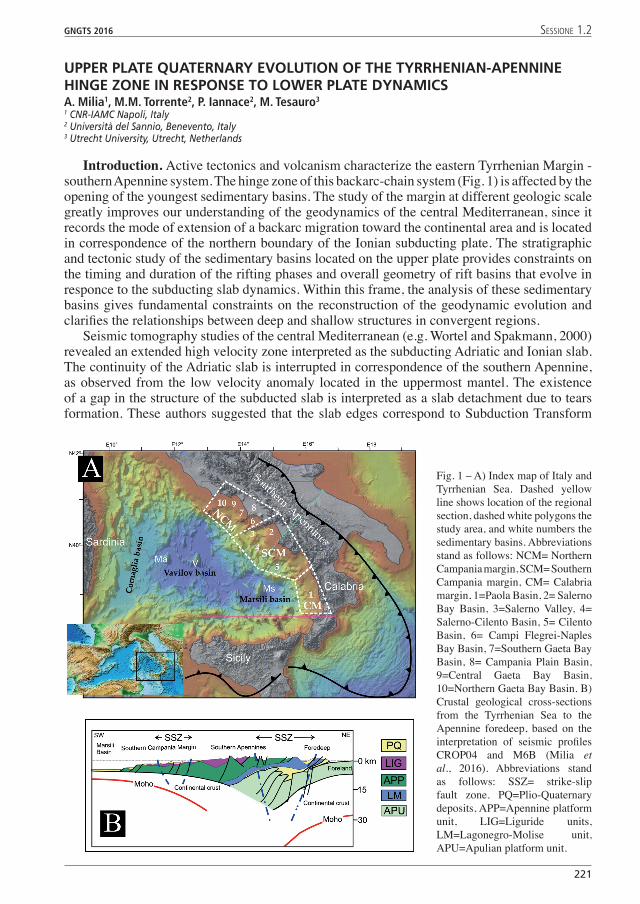
Introduction. Active tectonics and volcanism characterize the eastern Tyrrhenian Margin - southern Apennine system. The hinge zone of this backarc-chain system (Fig. 1) is affected by the opening of the youngest sedimentary basins. The study of the margin at different geologic scale greatly improves our understanding of the geodynamics of the central Mediterranean, since it records the mode of extension of a backarc migration toward the continental area and is located in correspondence of the northern boundary of the Ionian subducting plate. The stratigraphic and tectonic study of the sedimentary basins located on the upper plate provides constraints on the timing and duration of the rifting phases and overall geometry of rift basins that evolve in responce to the subducting slab dynamics. Within this frame, the analysis of these sedimentary basins gives fundamental constraints on the reconstruction of the geodynamic evolution and clarifies the relationships between deep and shallow structures in convergent regions.
Seismic tomography studies of the central Mediterranean (e.g. Wortel and Spakmann, 2000) revealed an extended high velocity zone interpreted as the subducting Adriatic and Ionian slab. The continuity of the Adriatic slab is interrupted in correspondence of the southern Apennine, as observed from the low velocity anomaly located in the uppermost mantel. The existence of a gap in the structure of the subducted slab is interpreted as a slab detachment due to tears formation. These authors suggested that the slab edges correspond to Subduction Transform
Fig. 1 – A) Index map of Italy and Tyrrhenian Sea. Dashed yellow line shows location of the regional section, dashed white polygons the study area, and white numbers the sedimentary basins. Abbreviations stand as follows: NCM= Northern Campania margin, SCM= Southern Campania margin, CM= Calabria margin, 1=Paola Basin, 2= Salerno Bay Basin, 3=Salerno Valley, 4= Salerno-Cilento Basin, 5= Cilento Basin, 6= Campi Flegrei-Naples Bay Basin, 7=Southern Gaeta Bay Basin, 8= Campania Plain Basin, 9=Central Gaeta Bay Basin, 10=Northern Gaeta Bay Basin. B) Crustal geological cross-sections from the Tyrrhenian Sea to the Apennine foredeep, based on the interpretation of seismic profiles CROP04 and M6B (Milia et al., 2016). Abbreviations stand as follows: SSZ= strike-slip fault zone. PQ=Plio-Quaternary deposits, APP=Apennine platform unit, LIG=Liguride units, LM=Lagonegro-Molise unit, APU=Apulian platform unit.
222
GNGTS 2016 sessione 1.2
Edge Propagator (STEP) faults, characterized by a very specific time-space evolution in the upper plate deformation (Milia et al., 2016).
Data and methods. We constructe a 3-D model of the Plio-Quaternary basin’s key-surfaces of the ETM through the interpolation of close and regularly spaced 2D seismic reflection profiles, integrated and calibrated with borehole data. This study has been carried out using a seismic and borehole dataset and a Geographical Information System (GIS) software (Kingdom, IHS Inc.), which constructs a 3D representation of a geologic volume at depth. The study includes the following steps: a) collection of all the available seismic profiles and boreholes data; b) implementation of a GIS geological data base; c) interpretation of the seismic profiles and calibration of the seismic unit using well-log data; d) construction of 2D and 3D models of the subsurface. A total of 6000 km of seismic lines and data from 25 wells has been collected in the study area. We use seismic reflection profiles with different resolution and penetration: multichannel seismic profiles, CROP seismic profiles and Sparker data (MEAS). We interprete the seismic data-set using the seismic stratigraphy method: seismic units are groups of seismic reflections, whose parameters (configuration, amplitude, continuity, and frequency) differ from those of adjacent groups. Sedimentary units are delineated on the basis of contact relations and internal and external configurations.
Results. The interpretation of seismic profiles calibrated by well data collected along the margin permit to identify the faults bounding the sedimentary basins and the stratigraphic infill. The stratigraphic analysis permit us to recognize three stratigraphic units in the studied sedimentary basins corresponding to Lower Pleistocene, early Middle Pleistocene and late Middle Pleistocene-Present sedimentary successions. We map the pre-Quaternary substrate and these three stratigraphic units (A, B, C) of the basin infills for 350 km along the ETM, to establish a coherent chronostratigraphic framework across the sedimentary basins and build a 3D model of the study area. The recognition of the syn-kinematic strata in the basin infill and analysis of the interplay between stratigraphic horizon and faulting enabled us to assign an age to fault activity in the eastern Tyrrhenian Sea Margin. We divide the fault structures into three groups according their age: Lower Pleistocene structures, Early Middle Pleistocene structures, Late Middle Pleistocene- Present structures.
The interpretation of the seismic data reveals a complex fault pattern along the ETM due to a poliphased tectonic evolution. The 2-D and 3-D models of stratigraphic surfaces, faults and isochron maps of the stratigraphic units reveal that the major faults bounding the basins correspond to normal faults and strike-slip transfer faults. The process of lithospheric extension within the eastern Tyrrhenian Sea produced tilted blocks/halfgrabens (sensu Wernicke and Burchfiel, 1982). We also recognize in the ETM positive inversion structures, documented by the changes of structural relief from previous lows (indicated by thick deposits) to highs (indicated by flexural arching or uplift) .
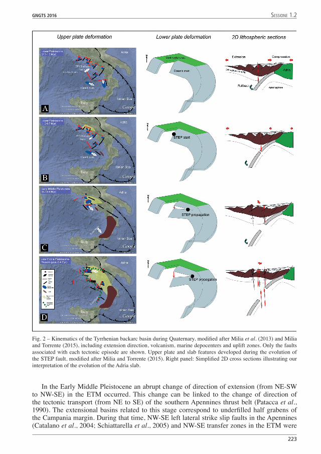
Quaternary evolution. The Quaternary evolution is illustrated in Fig. 2. During the Lower Pleistocene extensional tectonics affected the entire ETM and the western flank of the Apennines, creating several basins: NW-SE normal fault formed along the ETM (offshore and onshore). NE-trending and E-W normal faults developed, in the Marsili and Paola basins, respectively. These three contemporaneous extension directions follow Martin’s double-saloon-door model (2006): the Campania margin and Marsili basin approximately match with the two arc- parallel rifts and the Paola basin with the rift orthogonal to the subduction zone. During this stage rapid counterclockwise rotations affected the hanging wall of the active thrust sheets along the outer front of the Apennines (Mattei et al., 2004). In the late Lower Pleistocene (1.0-07 Ma) there was a change in the structural pattern: extensional faults continued their activity in the Campania Margin, Marsili basin, and western flank of the Apennines, while en echelon folds, linked to a NW-SE left-lateral transfer zone, formed in the Paola basin (the inset shows the 3D model of the 1.0 Myr surface). The activity of this transfer zone could be related to a higher speed of the Marsili basin opening compared to that of the ETM.
GNGTS 2016 sessione 1.2
223
In the Early Middle Pleistocene an abrupt change of direction of extension (from NE-SW to NW-SE) in the ETM occurred. This change can be linked to the change of direction of the tectonic transport (from NE to SE) of the southern Apennines thrust belt (Patacca et al., 1990). The extensional basins related to this stage correspond to underfilled half grabens of the Campania margin. During that time, NW-SE left lateral strike slip faults in the Apennines (Catalano et al., 2004; Schiattarella et al., 2005) and NW-SE transfer zones in the ETM were
Fig. 2 – Kinematics of the Tyrrhenian backarc basin during Quaternary, modified after Milia et al. (2013) and Milia and Torrente (2015), including extension direction, volcanism, marine depocenters and uplift zones. Only the faults associated with each tectonic episode are shown. Upper plate and slab features developed during the evolution of the STEP fault, modified after Milia and Torrente (2015). Right panel: Simplified 2D cross sections illustrating our interpretation of the evolution of the Adria slab.
224
GNGTS 2016 sessione 1.2
active. These transfer zones were affected by uplifts and inversion structures.In the Late Middle Pleistocene to Present extensional basins and transfer zone formed.
Intense volcanism and eastwards migration of the extension was recorded in the northern Campania Margin. NNE-trending normal faults developed in the ETM and Apennines and this extensional pattern is coherent with the migration of the Calabrian accretionary prism toward E-SE. During this tectonic stage, a NW-SE transfer zone, featuring restraining and releasingbends, formed at the SW border of the ETM.
The deformation features of the upper plate in correspondance of the ETM are not consistent with the current rifting models. We hypothesize a link between the evolution of upper plate and subducting slab. The proposed geodynamic scenario is characterized by the formation of extensional basins in the upper plate and onset and development of a STEP (Subduction-Transform-Edge-Propagator) fault along the northern margin of the Ionian slab.ReferencesCatalano, S., Monaco, C., Tortorici, L., 2004. Neogene-Quaternary tectonic evolution of the southern Apennines.
Tectonics 23, TC2003, doi:10.1029/2003TC001512. Koulakov, I., Kaban, M.K., Tesauro M., Cloetingh, S.A.P.L., 2009. P and S velocity anomalies in the upper mantle
beneath Europe from tomographic inversion of ISC data. Geophysical Journal International 179, 345-366. Govers, R., Wortel, M.J.R., 2005. Lithosphere tearing at STEP faults: response to edges of subduction zones. Earth
Planet. Scie. Lett. 236, 505–523. Marani, M., Gamberi, G., Bortoluzzi, G., Carrarra, G., Ligi, M., Penitenti, D., 2004. Seafloor morphology of the
Tyrrhenian Sea. Scale 1:1,000,000. Included to: Mem. Descr. Carta Geol. Ital., LXIV. Rome. Martin, A.K., 2006. Oppositely directed pairs of propagating rifts in back arc basins: double saloon door seafloor spreading during subduction rollback. Tectonics 25, TC3008. http://dx.doi.org/10.1029/2005TC001885.
Mattei, M., Petrocelli, V., Lacava, D., Schiattarella, M., 2004. Geodynamic implication of Pleistocene ultrarapid vertical – axis rotation in the Southern Apennines, Italy. Geology,789-792, doi:10.1130/G20552.1.
Milia, A., Torrente, M.M., Massa, B., Iannace, P., 2013. Progressive changes in rifting directions in the Campania margin (Italy): new constrains for the Tyrrhenian Sea opening. Glob. Planet. Change 109, 3-17, http://dx.doi.org/10.1016/j.gloplacha.2013.07.003.
Milia, A., Torrente, M.M., 2015. Tectono-stratigraphic signature of a rapid multistage subsiding rift basin in the Tyrrhenian-Apennine hinge zone (Italy): A possible interaction of upper plate with subducting slab. J. Geodyn. 86, 42–60, http://dx.doi.org/10.1016/j.jog.2015.02.005.
Milia, A., Iannace, P., Tesauro, M., Torrente, M.M., 2016. Upper plate deformation as marker for the Northern STEP fault of the Ionian slab (Tyrrhenian Sea, central Mediterranean). Tectonophysics, in press, http://dx.doi.org/10.1016/j.tecto.2016.08.017
Patacca, E., Sartori, R., Scandone, P., 1990. Tyrrhenian basin and Apenninic arcs: kinematic relations since late Tortonian times. Memorie Società Geologica Italiana 45, 425–451.
Schiatterella, M., Beneduce, P., Di Leo, P., Giano, S.I., Giannandrea, P., Principe, P., 2005. Assetto strutturale ed evoluzione morfotettonica quaternaria del vulcano del Monte Vulture (Appennino lucano). Boll. Soc. Geol. Ital. 124, 543-562.
Wortel, M.J.R., Spakman, W., 2000. Subduction and slab detachment in the Mediterranean-Carpathian Region. Science 290, 1910–1917, http://dx.doi.org/10.1126/science.290.5498.1910.