Embed Size (px)
Citation preview
Urban governance and spatial planning for sustainable urban
development in Tamale, Ghana
By
Issahaka Fuseini
March 2016
Dissertation presented for the degree of Doctor of Philosophy in the
Faculty of Arts and Social Sciences at
Stellenbosch University
Supervisor: Dr Jaco Kemp
ii
DECLARATION
By submitting this thesis electronically, I declare that the entirety of the work contained therein is my own,
original work, that I am the sole author thereof (save to the extent explicitly otherwise stated), that reproduction
and publication thereof by Stellenbosch University will not infringe any third party rights and that I have not
previously in its entirety or in part submitted it for obtaining any qualification.
March 2016
Copyright © 2016 Stellenbosch UniversityAll rights reserved
Stellenbosch University https://scholar.sun.ac.za
iii
ABSTRACT
This study investigated urban governance and spatial planning practices for sustainable urban development in
Tamale, Ghana, regarding provision and access to urban infrastructure and basic services. This broad aim of
the study was divided into three objectives, namely to 1) review of the statutory provisions for the conduct of
urban governance and spatial planning in Ghana and Tamale, 2) assess the spatio-temporal growth dynamics
and provision of urban infrastructure and basic services in Tamale, and 3) to explore stakeholder engagement
in spatial planning in the city. Research questions that guided the study were: a) what is the extent of the
physical expansion of Tamale and how does urban governance respond to the growth dynamics regarding
infrastructure and service provision?, b) to what extent does the spatial growth patterns of the city reflect local
and national development aspirations, c) what national and local statutory frameworks guide the practice of
urban governance and spatial planning, d) what are the modes of stakeholder engagement in urban governance
and spatial planning and who are the stakeholders, and e) is the city’s urban governance inclusive and amenable
to decentralisation, entrepreneurialism and democratisation (DED) principles? The DED analytical framework
and collaborative planning theoretical perspective were adopted to analyse urban governance practices and
outcomes in Tamale. Four evaluative questions were addressed using the DED and collaborative planning
frameworks, namely how urban governance is lived in Tamale, whether urban governance leads to job creation,
and for whom, whether urban governance results in improved urban services and whether urban governance
empowers people at the grass roots and promotes accountable governance.
A mixed methods research design was employed in the study. This comprised of quantitative analysis of the
city’s spatial growth using remote sensing and geographic information systems techniques, and qualitative
investigation of urban governance processes and outcomes. The results show that the legislative provisions
guiding urban governance in Ghana have not been effective in promoting sustainable urban development
leading to the country transitioning towards spatial development frameworks (SDFs) as alternative approaches.
Also, both the city’s spatial and demographic growth has been phenomenal, but access to urban infrastructure
and services has lagged behind. Moreover, there was limited stakeholder engagement in urban governance and
that resulted in low accountability. In terms of the DED and collaborative planning frameworks, there were
generally no straightforward answers to the evaluative questions, except with respect to the question of
accountability, which was almost non-existent in the urban governance practices of Tamale. The study
concludes by lauding efforts to reform urban governance laws and initiatives to engender participatory and
partnership-based urban governance and service delivery in the city. It is recommended that these reforms
should be encouraged and operationalised within real decentralisation, entrepreneurialism and
democratisation. Comprehensive needs assessment, institutional and stakeholder capacity-building efforts, and
empathic stakeholder engagements will be crucial in this regard, especially if social justice, economic viability,
and environmental health and sustainability are considered in the management of the city’s urban growth.
Further research is recommended to provide detailed understanding of urban governance outcomes in Tamale,
such as the magnitude of job creation, distribution and sustainability.
Stellenbosch University https://scholar.sun.ac.za
iv
OPSOMMING
Hierdie studie ondersoek stedelike bestuur en ruimtelike beplannings praktyke vir volhoubare stedelike
ontwikkeling in Tamale, Ghana, in verband met voorsiening en toegang tot stedelike infrastruktuur en basiese
dienste. Hierdie breë doelwit van die studie is opgedeel in drie subdoelwitte, naamlik 1) om hersiening van die
statutêre voorsienings vir die gedrag van stedelike bestuur en ruimtelike beplanning in Ghana en Tamale te
doen, 2) die ruimtelike-tydelike groei dinamika en voorsienings van stedelike infrastruktuur en basiese dienste
in Tamale te assesseer, en 3) om die betrokkenheid van belanghebbendes in ruimtelike beplanning van die stad
te verken. Navorsingsvrae wat die studie gelei het is as volg: a) wat is die aard van fisiese uitbreiding van
Tamale, b) tot watter mate reflekteer die ruimtelike groeipatrone van die stad die plaaslike en nasionale
ontwikkelings-aspirasies, c) watter nasionale en plaaslike statutêre raamwerke begelei die stedelike bestuur en
ruimtelike beplanningspraktyke, d) wat is die modus van belanghebbende betrokkenheid in stedelike bestuur
en ruimtelike beplanning en wie is die belanghebbendes, en e) is die stad se stedelike bestuur insluitend en
ontvanklik tot desentralisasie, entrepreneurskap en demokratiserings (DED) beginsels? Die DED analitiese
raamwerk en gesamentlike beplanning teoretiese perspektief was aangeneem om stedelike bestuurspraktyke
en uitkomste in Tamale te analiseer. Vier evaluerende vrae is geadresseer deur middel van die DED en
gesamentlike beplanningsraamwerke, naamlik hoe stedelike bestuur uitgeleef word in Tamale, of stedelike
bestuur lei tot werkskepping en vir wie, of stedelike bestuur lei tot verbeterde stedelike dienste, en of stedelike
bestuur mense bemagtig op die voetsoolvlak en verantwoorbare bestuur bevorder.
‘n Gemengde-metode navorsingsontwerp is gebruik in die studie. Dit bestaan uit kwantitatiewe analiese van
die stad se ruimtelike groei met gebruik van afstandwaarneming en geografiese inligtingstelsels tegnieke, en
kwalitatiewe ondersoek van stedelike bestuursprosesse en uitkomste. Die resultate wys dat die wetgewende
bepalings wat stedelike bestuur in Ghana lei nie effektief was in die bevordering van volhoubare
stadsontwikkeling nie, en lei tot die land se oorgang na ruimtelike ontwikkelingsraamwerke (SDFs) as
alternatiewe benaderings. Beide die stad se ruimtelike en demografiese groei was ook fenomenaal, maar
toegang tot stedelike infrastruktuur en dienste is agterblewend. Verder was daar beperkte belanghebbende
betrokkenheid in stedelike bestuur wat gelei het tot lae aanspreeklikheid. In terme van die DED en
gesamentlike beplanningsraamwerke, was daar oor die algemeen geen eenvoudige antwoorde vir die
evaluerende vrae nie, behalwe die vrae in verband met van aanspreeklikheid wat amper nie bestaan in die
stedelike bestuurspraktyke van Tamale nie. Die studie sluit af deur erkenning te gee aan pogings wat
aangewend is vir die hervorming van stedelike bestuurswette en inisiatiewe om deelnemende en vennootskap-
gebasseerde stedelike bestuur en dienslewering in die stad te kweek. Dit word voorgestel dat hierdie
hervormings aangemoedig en operasioneel word binne werklike desentralisasie, entrepreneurskap en
demokratisering. Omvattende-behoeftes assessering, institusionele en belanghebbende kapasiteitsbou-
pogings, asook empatiese belanghebbende betrokkenheid sal deurslaggewend wees in hierdie opsig, veral
indien sosiale geregtigheid, ekonomiese vatbaarheid, en omgewingsgesondheid en volhoubaarheid in ag
geneem word in die bestuur van die stad se stedelike groei. Verdere navosing word voorgestel om ‘n
Stellenbosch University https://scholar.sun.ac.za

v
gedetailleerde verstandhouding van stedelike bestuursuitkomste in Tamale van byvoorbeeld die grootte van
werkskepping, verspreiding en volhoubaarheid, te voorsien.
Stellenbosch University https://scholar.sun.ac.za
vi
ACKNOWLEDGEMENT
A journey through doctoral studies is often described as lonely and boring because of the personal commitment
and dedication required of the candidate! In reality, however, doctoral studies like any research endeavour
constitutes teamwork involving institutions and individuals from the conception through the execution of the
research. In this regard, Isaac Newton once remarked, “if I have seen further than others, it is by standing on
the shoulders of giants.” Therefore, I take this opportunity to acknowledge the support and affection I received
from numerous ‘giants’ while pursuing this study.
My first and foremost gratitude goes to my financial ‘engineers’ – the South African National Research
Foundation (NRF) and the African Doctoral Academy (ADA) at Stellenbosch University – for their financial
support towards this study. Further appreciation goes to the Stellenbosch University for its financial support
through the Postgraduate Merit Bursary programme.
I’m hugely indebted to my supervisor, Dr Jaco Kemp, for his unceasing support and direction that made the
timely completion of this study possible. Dr Kemp’s love for detail and academic propriety profoundly shaped
my approach to scholarship. I cannot forget his financial support to procure satellite image data for the study,
the regular over three-hour ‘learning’ and meeting sessions as well as his ever-present friendly and frank
demeanour during our meetings and interactions. I could not have hoped for a better supervisor! Thank you
Dr Kemp.
I also extend my gratitude to the staff of the Department of Geography and Environmental Studies
(Stellenbosch University) for the logistical support such as working space, computer laboratory and software
and technical (IT) support. The various consultations – formal and informal – I had with individual staff
members of the Department were valuable to the execution of my study. Particular mention is made of
consultations with the following: Prof JH van der Merwe, Prof R Donaldson, Prof G Visser, Mr D Du Plessis
and Mrs Anele Horn. Prof Visser’s constructive critique has made a great impact in shaping the theoretical
discussion of the study. I equally appreciate a rather informal, ad hoc and often corridor-based consultations
and interactions with other Departmental staff members such as Mr Garth Stephenson, Mr Theo Pauw, Mr
Jascha Muller, Mr Johans van Wyk and Mr Attie Boshoff. Thank you all for you attention.
Members of staff of the Department of Geography and Resource Development (University of Ghana, Accra)
have also supported me immensely during the conception and execution of the study, for which I am grateful.
I thank Prof EA Gyasi and Prof JA Yaro for their mentorship and support of all kinds. Dr J Teye, Dr O Barima
and Dr E Attua are also acknowledged for their advice and support.
Regarding data support for the study, I acknowledge receipt of satellite image data from the European Space
Agency (ESA) under its Third Party Mission (TPM) free data access programme. Similarly, I extend my
heartfelt gratitude to my research participants and their institutions in Tamale and Accra, Ghana for their
cooperation. The research participants were drawn from the Town and Country Planning Department (TCPD),
Stellenbosch University https://scholar.sun.ac.za
vii
Tamale Metropolitan Assembly (TaMA), Sagnarigu District Assembly (SDA), Survey Department (SD),
Lands Commission (LC), Environmental Protection Agency (EPA), Department of Urban Roads (DUR),
Metropolitan Agriculture Development Unit (MADU) of the TaMA, Urban Agriculture Network (UrbANet),
Ghana Water Company Ltd (GWCL), Customary Land Secretariat (CLS) and assembly members. Special
appreciation is in order of Mr Zikiru Sule (former Director, TCPD at TaMA), Mr Ben Mensah (Deputy
Director, TCPD at TaMA), Mr Saaka Takura (Director, TCPD at SDA) and Mr Mohammed Alhassan
(Management Information System [MIS] Officer at TCPD Headquarters, Accra). My persistent visits to the
aforementioned persons made Mr Takura once ask “and what again?”, when I was merely passing by his office
on this occasion.
A ‘galaxy’ of friends, too numerous to mention, supported me throughout the study and therefore deserve a
special mention. I express my awesome indebtedness to Dr Alphonse Nindow and Mr Abdallah Ali-Nakyea
for sponsoring my first trip to Stellenbosch to commence this study. Words are not enough to express my
gratitude for their generous gesture. I heard the name ‘Stellenbosch University’ for the first time and the
scholarship opportunity to study in this great institution from Abu Razak, for which I say a big thank you.
Bismark Azabre, Haruna Abubakari, Seidu Abdul-Rahman, Hardi Shahadu, Iddrisu Mohammed Shariff,
Iddrisu Khalid, Abubakar Amadu, Alhassan Seidu, Abukari Abdul-Razak, Dr Latif Alhassan, Paul Wunniche
Mahama, James Busagre Zakaria and Lukman Yakubu all supported me in diverse ways. Ibrahim Yakubu
proofread my first draft at incredibly short notice! Thank you guys, and forgive me if I inadvertently omitted
any persons.
I also extend my appreciation to my colleagues in the Postgraduate Office for their company and insight
through our conversations and interactions. John Bosco Isunju and Sunday Adeyini are particularly thanked in
this respect.
My family has been rock solid behind me throughout this journey. I thank my wife, Azara, for her support,
patience and endurance as well as accepting a challenging role of a ‘single’ parent as she took care of our son,
Mbo, while I undertook this study in a ‘faraway land’. My mother, Fuseina, my aunty Salamatu, uncles Saaka,
Fuseini, Tahidu, Yakubu and Alhassan Sheini, my cousin Zakaria as well as my siblings Suhnun and Shahdaw
all deserve special thanks for their unending support and care. Thank you all for the love and affection you
have shown me through this journey.
Finally, I could achieve nothing, I could be nobody, and I can go nowhere from here without the guidance,
protection and benefaction of the Most Compassionate and Most Merciful Almighty God. Another milestone
has been reached in my life, and I seek Your guidance as I transition into a more challenging stage of my life
journey.
Stellenbosch University https://scholar.sun.ac.za

viii
DEDICATION
To my late dad, Adam Ibrahim, my son, Mbo, who joined the family in the course of this study, and to my
entire family for their love care
Stellenbosch University https://scholar.sun.ac.za
ix
CONTENTS
Declaration . ...................................................................................................................................................... ii
Abstract …........................................................................................................................................................ iii
Opsomming . .................................................................................................................................................... iv
Acknowledgement ............................................................................................................................................ vi
Dedication ….................................................................................................................................................. viii
Contents ….. ..................................................................................................................................................... ix
Tables …….. .................................................................................................................................................. xiii
Figures …… ................................................................................................................................................... xiv
Abbreviations and acronyms ........................................................................................................................... xv
Chapter 1 Background to the study .................................................................................................................. 1
1.1 Introduction ..................................................................................................................................... 1
1.2 Statement of the problem ................................................................................................................. 3
1.3 Research questions .......................................................................................................................... 5
1.4 Research objectives ......................................................................................................................... 6
1.5 Operational definition of concepts .................................................................................................. 6
1.5.1 Urban governance ................................................................................................................................................. 6
1.5.2 The DED framework ............................................................................................................................................ 8
1.5.3 Spatial planning or urban land-use planning ........................................................................................................ 9
1.5.4 Urban infrastructure and service delivery .......................................................................................................... 10
1.5.5 Collaborative planning ........................................................................................................................................ 10
1.5.6 Sustainable urban development or urbanisation .............................................................................................. 10
1.6 Organisation of the work ............................................................................................................... 11
Chapter 2 Theoretical and analytical frames .................................................................................................. 13
2.1 Introduction ................................................................................................................................... 13
2.2 Theorising spatial planning and urban governance in the Global South ....................................... 13
2.3 Contemporary issues of urbanisation ............................................................................................ 18
2.3.1 Urban growth in the developing world .............................................................................................................. 18
2.3.2 Increasing poverty and informality .................................................................................................................... 19
Stellenbosch University https://scholar.sun.ac.za
x
2.3.3 Emergent land markets ....................................................................................................................................... 21
2.3.4 Cities and climate change .................................................................................................................................. 22
2.4 Analytical framework .................................................................................................................... 24
2.4.1 The DED framework ......................................................................................................................................... 25
2.4.2 Evaluating urban governance using the DED framework .............................................................................. 30
2.5 Summary........................................................................................................................................ 31
Chapter 3 Study area and methodological overview ...................................................................................... 32
3.1 Introduction ................................................................................................................................... 32
3.2 Tamale in context and scope of the study ...................................................................................... 32
3.2.1 Tamale – location and origin .............................................................................................................................. 33
3.2.2 Physical conditions .............................................................................................................................................. 34
3.2.3 Socio-economic characteristics ......................................................................................................................... 35
3.3 Roadmap of the study .................................................................................................................... 42
3.3.1 Methodology ....................................................................................................................................................... 42
3.3.2 Methods and data sources ................................................................................................................................... 49
3.3.3 Analysis................................................................................................................................................................ 51
3.4 Summary........................................................................................................................................ 55
Chapter 4 A review of spatial planning in Ghana’s socio-economic development trajectory: a sustainable
development perspective ............................................................................................................... 56
4.1 Introduction ................................................................................................................................... 56
4.2 Conceptualising sustainable development in urban governance ................................................... 59
4.3 Methodology.................................................................................................................................. 60
4.4 Spatial planning and development in Ghana ................................................................................. 62
4.4.1 Planning in pre-independence Ghana (the Gold Coast) .................................................................................. 62
4.4.2 Spatial planning in post-independence Ghana up to 1990 ............................................................................... 64
4.4.3 Planning in contemporary times, from 1991 ..................................................................................................... 66
4.5 New development to restructure planning and urban governance in Ghana ................................. 71
4.5.1 National Urban Policy Framework (NUPF) .................................................................................................... 71
4.5.2 Land Use and Spatial Planning Bill (LUSPB) .................................................................................................. 74
4.6 Discussion and lessons learnt ........................................................................................................ 76
Stellenbosch University https://scholar.sun.ac.za
xi
4.7 Conclusion ..................................................................................................................................... 77
Chapter 5 Characterising urban growth in Tamale: Analysis of urban governance response in infrastructure
and service provision ..................................................................................................................... 79
5.1 Introduction ................................................................................................................................... 79
5.2 Methodology.................................................................................................................................. 81
5.2.1 Study area ............................................................................................................................................................ 81
5.2.2 Data and methods ................................................................................................................................................ 82
5.2.2.1 Data ...................................................................................................................................................................... 82
5.2.2.2 Image analysis ..................................................................................................................................................... 83
5.3 Results and discussion ................................................................................................................... 84
5.3.1 Analysis of spatial growth dynamics ................................................................................................................. 85
5.3.2 Demographic trends and growth in vehicular and motorcycle numbers ........................................................ 89
5.3.3 Urban governance response to increasing urban pressures – infrastructure and service provision ............... 91
5.4 Concluding perspective ............................................................................................................... 101
Chapter 6 Public interest in spatial planning: An assessment of local plan preparation and implementation in
Tamale, Ghana ............................................................................................................................. 103
6.1 Introduction ................................................................................................................................. 103
6.2 Study methods ............................................................................................................................. 107
6.3 Results ......................................................................................................................................... 110
6.3.1 Content analysis of plans .................................................................................................................................. 110
6.3.2 Stakeholder engagement in plan preparation .................................................................................................. 117
6.4 Discussion.................................................................................................................................... 120
6.5 Conclusion ................................................................................................................................... 125
Chapter 7 Synthesis ...................................................................................................................................... 127
7.1 Introduction ................................................................................................................................. 127
7.2 Revisiting the study objectives and research question ................................................................ 127
7.2.1 Revisiting Objective 1: Institutional domain of spatial planning and urban governance ............................. 128
7.2.2 Revisiting Objective 2: Spatial growth dynamics and urban governance response in the provision of urban
infrastructure and services ................................................................................................................................ 130
7.2.3 Revisiting Objective 3: Spatial planning processes and implementation ...................................................... 131
7.3 Synthetical analysis ..................................................................................................................... 132
Stellenbosch University https://scholar.sun.ac.za
xii
7.3.1 Synthesis with the DED .................................................................................................................................... 134
7.3.2 Evaluation of urban governance in Tamale using the DED framework ....................................................... 143
7.3.3 Theoretical analysis ........................................................................................................................................... 148
7.4 Summary...................................................................................................................................... 150
Chapter 8 Conclusions ................................................................................................................................. 152
8.1 Introduction ................................................................................................................................. 152
8.2 Summary...................................................................................................................................... 152
8.2.1 Statutory provisions for urban governance and planning ............................................................................... 152
8.2.2 Spatial and demographic growth dynamics and urban governance response in infrastructure and service
provision ............................................................................................................................................................ 153
8.2.3 Secure public interest in planning – planning processes and stakeholder engagement ................................ 154
8.3 The DED analysis and evaluation ............................................................................................... 155
8.4 Theory ......................................................................................................................................... 158
8.5 Distilling the study’s contribution to scholarship ........................................................................ 158
8.5.1 Contribution to research on urbanisation dynamics in Tamale ...................................................................... 158
8.5.2 Contribution to theory ....................................................................................................................................... 159
8.6 Recommendations ....................................................................................................................... 160
8.6.1 Recommendations for further research ............................................................................................................ 160
8.6.2 Policy focus recommendations ........................................................................................................................ 161
References… ................................................................................................................................................. 162
Appendices.. .................................................................................................................................................. 174
Stellenbosch University https://scholar.sun.ac.za

xiii
TABLES
Table 3.1: Distribution of samples for training and accuracy assessment for image classification ................ 52
Table 3.2: Object features used in the GEOBIA classification procedure ...................................................... 53
Table 4.1: Selected policy objectives and initiatives of Ghana’s National Urban Policy Framework, 2012 ................. 73
Table 6.1: Distribution of stakeholders in urban governance in Tamale who participated in the study (2013/2014) .... 109
Table 6.3: Status of selected public land uses in nine local plans within Tamale metropolis, Ghana ........... 111
Table 6.2: Distribution of selected public land uses in nine local plans within Tamale metropolis, Ghana ............ 111
Table 6.4: Stakeholder engagement in plan preparation and implementation in Tamale, Ghana ................. 118
Table 7.1: Revenue performance of the Tamale Metropolitan Assembly, 2006-2009 .................................. 140
Stellenbosch University https://scholar.sun.ac.za
xiv
FIGURES
Figure 3.1: Location of the study area in Northern Region of Ghana ............................................................. 32
Figure 3.2: Informal business activities take over walkways, pedestrian and cyclist lanes in Tamale, Ghana ................. 39
Figure 3.3: Development of market infrastructure for informal businesses in Tamale, Ghana ....................... 39
Figure 3.4: The study design and structure of dissertation .............................................................................. 43
Figure 5.1: Built-up area of Tamale, Ghana, for 2001 and 2014 ................................................................... 86
Figure 5.2 Built up change in Tamale, Ghana, from 2001 to 2014 ................................................................ 87
Figure 5.3: Areal coverage of built-up area of Tamale, Ghana, in the various segments 2001 and 2014 ....... 88
Figure 5.4: Road condition in Tamale metropolis (2001 and 2014) ................................................................ 88
Figure 5.5: Total population of Tamale metropolis at different census periods (1960-2010) ......................... 89
Figure 5.6: Annual population growth rates of Tamale relative to Ghana, Northern Region, Accra and Kumasi................. 90
Figure 5.7: Unique vehicle and motorcycle registration in Tamale, Ghana (1995-2013) ............................... 91
Figure 5.8: Contemporary faces of the Builpela Dam, Tamale, Ghana ........................................................... 97
Figure 5.9: Relative importance of popular modes of liquid waste disposal in selected cities in Ghana (2010) ........ 99
Figure 5.10: Relative importance of popular modes of solid waste disposal in selected cities in Ghana (2010) ......... 100
Figure 5.11: Access to toilet facilities in selected cities in Ghana (2010) ..................................................... 100
Figure 6.1: Sampled local plans showing zonings for public land use in Tamale, Ghana ........................... 108
Figure 7.1 Framework for decision making in Ghana's decentralised local governance system .................. 133
Figure 7.2: Sources of revenue for Tamale Metropolitan Assembly, 2010 ................................................... 139
Stellenbosch University https://scholar.sun.ac.za
xv
ABBREVIATIONS AND ACRONYMS
ADA African Doctoral Academy
AFD Agence Francaise de Developpement
AM Assembly Member
AMA Accra Metropolitan Assembly
BCDS Bamako City Development Strategy
BIU Building Inspectorate Unit
BUSAC Fund Business Sector Advocacy Challenge Fund
CAP 84 Town and Country Planning Ordinance of 1945
CBD Central Business District
CBO Community-based Organisation
CE Completely Encroached
CEO Chief Executive Officer
CLS Customary Land Secretariat
DA District Assembly
DACF District Assemblies Common Fund
DANIDA Danish International Development Agency
DCE District Chief Executive
DED Decentralisation, Entrepreneurialism and Democratisation
DMDPSS Dhaka Metropolitan Development Planning Support System
DPCU District Planning Coordinating Unit
DUR Department of Urban Roads
DVLA Driver and Vehicle Licensing Authority
EC Electoral Commission
ECG Electricity Company of Ghana
EPA Environmental Protection Agency
ESA European Space Agency
ESRI Environmental Systems Research Institute
EU European Union
GDP Gross Domestic Product
GEOBIA Geographic Object-based Image Analysis
GHC Ghana Cedi
Stellenbosch University https://scholar.sun.ac.za
xvi
GIS Geographic Information Systems
GIZ German International Cooperation
GSS Ghana Statistical Service
GUMPP Ghana Urban Management Pilot Programme
GWCL Ghana Water Company Ltd
IDP Integrated Development Plan
IGF Internally Generated Funds
IHS Institute for Housing and Urban Development Studies
IMF International Monetary Fund
IT Information Technology
KCCA Kampala Capital City Authority
KML Keyhole Markup Language
LC Lands Commission
LED Local Economic Development
LP Local Plan
LUFP Land Use Futures Project
LUSP Land Use and Spatial Planning
LUSPA Land Use and Spatial Planning Authority
LUSPB Land Use and Spatial Planning Bill
MADU Metropolitan Agriculture Development Unit
MDGs Millennium Development Goals
MEST Ministry of Environment, Science and Technology
MIS Management Information System
ML Maximum Likelihood
MLGRD Ministry of Local Government and Rural Development
MMDAs Metropolitan, Municipal and District Assemblies
MMDCEs Metropolitan, Municipal and District Chief Executives
MMDPCU Metropolitan, Municipal and District Planning Coordinating Unit
MP Member of Parliament
MRS Multiresolution Segmentation
NCCE National Commission for Civic Education
NDC National Democratic Congress
NDPC National Development Planning Commission
Stellenbosch University https://scholar.sun.ac.za
xvii
NDVI Normalised Difference Vegetation Index
NE Not Encroached
NGO Non-governmental Organisation
NN Nearest Neighbour
NPDP National Physical Development Plan
NPP New Patriotic Party
NRF National Research Foundation
NUPF National Urban Policy Framework
OASL Office of the Administrator of Stool Land
PB Participatory Budgeting
PE Partially Encroached
PHC Population and Housing Census
PTA Progressive Traders Association
QDAS Qualitative Data Analysis Software
RCC Regional Coordinating Council
RS Remote Sensing
SANSA South African National Space Agency
SAPs Structural Adjustment Programmes
SBA Small Businesses Association
SD Survey Department
SDA Sagnarigu District Assembly
SDF Spatial Development Framework
SP Structure Plan
SPC Statutory Planning Committee
SPGEs Sub-committees on Production and Gainful Employment
SVM Support Vector Machine
TaMA Tamale Metropolitan Assembly
TAMA Tamale Metropolitan Area
TCPD Town and Country Planning Department
TPM Third Party Mission
UC Unit committee
UDS University for Development Studies
UMPs Urban Management Programmes
Stellenbosch University https://scholar.sun.ac.za

xviii
UN United Nations
UNDP United Nations Development Programme
UN-Habitat United Nations Human Settlements Programme
UPA Urban and Peri-urban Agriculture
UrbANet Urban Agriculture Network
USAID United States Agency for International Development
WB World Bank
Stellenbosch University https://scholar.sun.ac.za
1
CHAPTER 1 BACKGROUND TO THE STUDY
1.1 INTRODUCTION
In the 21st Century urban governance and spatial planning will have to play crucial roles to promote sustainable
urban development in the developing world, especially in sub-Saharan Africa where urbanisation is continuing
rapidly. The world became more urban than rural in 2008 and by 2010 about 51% of its population lived in
urban areas. This figure is projected to reach 70% by 2050 (Montgomery, 2008; UN-Habitat, 2009a; United
Nations, 2011). See Chapter 2 for detailed discussion of global urban population dynamics.
The rapid growth of urban population has been associated with spatial expansion of urbanised areas (Angel et
al., 2011). For instance, between 1980 and 2000, the total urbanised area of the developing world increased
by 118% (Singh & Asgher, 2005). According to Angel et al. (2011), while the world’s urban population is
expected to double in 43 years, the corresponding urban land cover is expected to double in only 19 years. It
is further expected that between 2000 and 2030 the developing world is likely to witness a doubling of its
urban population but a tripling of its urban land cover. Again, by illustration, between 1985 and 2000, the
population of Accra, Ghana, grew by 50% (from 1.8 million to 2.7 million) whereas its urban land cover grew
by 153% (from 13 000 to 33 000 ha) (Angel et al., 2011). The accelerated demographic and spatial growth of
cities have implications for the sustainable use of urban space regarding inclusive social and economic
development as well as the delivery of environmental and ecosystem services.
It follows that particularly in developing countries the unfolding urbanisation processes engender land-use
competition that presents challenges to the harmonious and equitable use of urban space. These challenges are
largely born of lack of effective urban governance and spatial planning systems to manage the growth for
sustainable development (UN-Habitat, 2009a; Angel et al., 2011). The absence of effective urban governance
and spatial planning systems to mediate land-use competition in urban space leads to haphazard spatial
development that has consequences as wide as sprawl, loss of arable land (about 2 million ha/yr of cropland
in developing countries) and increased incidence of food insecurity, destruction of ecosystems, decline in the
natural resource base, rising urban poverty and inequalities, infrastructure and service deficits, poor
environmental management, and increasing exposure to natural disasters such as flooding (Van Veenhuizen,
2006; Turner, Lambin & Reenberg, 2008; Tibaijuka, 2009; UN-Habitat, 2009a; Watson, 2009; McGregor et
al., 2011; Dewan, Yamaguchi & Rahman, 2012). Unless effective urban governance and spatial planning
approaches are devised, increasing urbanisation will only intensify the severity of these challenges in the cities
of developing countries, including those of sub-Saharan Africa.
Integrated spatial planning is one of the practical ways to promote sustainability in urban development.
Arguably, the most valuable resource in an urban setting is land. The importance of land can be understood
from four of its key characteristics, namely its finite nature (Duke & Wu, 2014); it sustains the livelihoods of
large numbers of people (De Wit & Verheye, 2003; Foresight, 2011; Lambin & Meyfroidt, 2011); it supports
Stellenbosch University https://scholar.sun.ac.za
2
ecosystem services vital to the environment and humanity (Ahern, Cilliers, & Niemelä, 2014; Andersson et
al., 2014a,b; Bierbaum et al., 2014); and it has socio-politico-religious functions that accord identity and sense
of belonging to people (Kasanga, 2001; Foresight LUFP, 2010; Fuseini, 2014). In real-world settings these
characteristics of land translate into complex webs of interests and power relations that intensify competition
for space in urban areas. Yet, existing planning regimes – mostly neoliberal and top-down technocratic
approaches – often fail to mediate land-use competition in urban space to achieve inclusivity and sustainable
development (Lovering, 2009; Watson, 2009; Yeboah & Shaw, 2013; Baffour Awuah & Hammond, 2014).
Indeed, in some instances planning practices have been accused of contributing to and/or intensifying
inequalities, poverty, vulnerability and exclusivity, with the urban poor and those in informal settlements and
businesses most affected (Lovering, 2009; Watson, 2009; Obeng-Odoom, 2013; Berrisford, 2014). Thus,
dialogue about planning reform to promote inclusive and sustainable development is gaining ground (Roy,
2009, 2014; Watson, 2009, 2014; Berrisford, 2014). Some authors even contemplate reversal of planning intent
to “protecting the needs of ordinary people rather than privileged minorities, the public rather than the private
interest [and] the future rather than the present. Planners will have to take into account new (or rather, old)
social forces [in developing inclusive plans]” (Lovering, 2009 p. 4). However, the danger exists that this
proposition may be interpreted as antagonistic to a section of society for the benefit of another sector in a
retributory manner which would equally be counterproductive. Rather, a notion of urban governance has been
proposed as an alternate approach that seeks decision making and planning reform through multistakeholder
participation by local government, governmental and non-governmental organisations (NGOs), community-
based organisations (CBOs), private businesses and the local people to regulate the processes of spatial
development and service delivery in urban contexts (Obeng-Odoom, 2013). This notion of urban governance
is in line with a collaborative planning approach that proposes empathic multistakeholder engagements to
promote inclusive planning or development (Healey, 2003). Although both the concept of urban governance
and collaborative planning theory do not suggest equal power among the multitude of stakeholders, it is hoped
that active participation by relevant stakeholders through empathic understanding, negotiation and consultation
in decision making and policy implementation would produce better urban development outcomes, spatially,
socially, economically and environmentally (Obeng-Odoom, 2013).
Integrated urban development, as envisioned by urban governance and collaborative planning, seeks to
promote holistic urban development to enhance both local and national development because urban areas play
critical roles in both local and national development. For instance, urban areas act as engines of economic
production in most economies by their contributions to gross domestic product (GDP) and employment. On
the African continent, for example, urbanisation has made a positive impact on national development (UN-
Habitat 2010, 2014), contrary to earlier views regarding the relationship between the two (see Njoh, 2003;
Obeng-Odoom, 2010a; Potts, 2012a). Emerging from its worst economic crisis of the 1980s and 1990s, Africa
has recorded impressive GDP growth rates in the first decade of the 21st Century and a growing middle class
population of 355 million in 2010, projected to reach 1.1 billion in 2060 (UN-Habitat, 2014). Urbanisation has
been instrumental in this economic transition with the continent’s urban population producing about 80% of
Stellenbosch University https://scholar.sun.ac.za
3
its GDP (UN-Habitat, 2010). Similarly, urban areas provide up to 80% of all non-farm jobs (Barwa 1995;
UN-Habitat, 2009a; Dewan et al., 2012). Residents in urban areas also enjoy far superior social services like
education, health, electricity and sanitation, compared to their rural counterparts (Ghana Statistical Service
2013a, 2014; Obeng-Odoom 2013). Also, deliberate and informed integration of urban and peri-urban
agriculture (UPA) in spatial planning could contribute positively towards sustainable urban development
through promotion of urban food security, supporting delivery of cultural ecosystem services as well as
facilitating climate-change adaptation and mitigation in urban settings (De Zeeuw, Van Veenhuizen &
Dubbeling, 2011; Andersson et al., 2014a,b; Gyasi et al, 2014a,b; Padgham, Jabbour & Dietrich, 2015).
Effective environmental management and social-service provision, especially healthcare, through good urban
governance, also promote healthy populations with multiple associated effects on increased productivity and
economic development.
Consequently, the process of urbanisation must be managed in a balanced manner to achieve sustainability
because “a well-run urban sector can ensure national prosperity; [while] a badly run sector can become a drag
on the whole country” (AAAS, 2000 p. 94). Accordingly, it is essential to investigate spatio-temporal growth
dynamics and processes in rapidly urbanising urban centres in sub-Saharan Africa, and to assess responses of
urban governance to the growth dynamics through spatial planning, urban infrastructure and service delivery.
Attention to a specific city is a worthwhile endeavour given that analysis of urbanisation, urban governance
and planning challenges and inefficiencies are often done by taking a generalised view of countries in a
category (e.g. developing countries, Africa) for the sake of simplicity and perhaps due to inadequate time,
human and financial resources. Such generalised characterisations do not necessarily provide concrete
evidence for micro-level solutions. In the foreword to the UN-Habitat’s 2014 State of African Cities report,
Joan Clos (Executive Director, UN-Habitat) concedes the limitation of the generalised analysis and the
impracticability of a one-size-fits-all solution where he notes that “cities are simply too individual and specific
in their needs and vulnerabilities for standardised solutions”. Research that targets country- and city-specific
peculiarities regarding growth dynamics, challenges and opportunities enhances our appreciation of the issues
and the efforts needed to address them. For this reason, this study spotlights Tamale, a rapidly urbanising urban
centre in Ghana.
1.2 STATEMENT OF THE PROBLEM
Effective urban governance is crucial for the sustainable management of urbanisation in the Tamale
Metropolitan Area (TAMA) of Ghana. The Metropolis has emerged as Ghana’s third largest urban centre since
1984, and its demographic and spatial growth dynamics have been characteristic of the growing urbanisation
challenges in Ghanaian cities and towns. For example, there has been poor urban infrastructure and service
provision in response to a rapidly growing demand by human and vehicular population. The human population
of TAMA is also less literate than that of other metropolitan areas of Ghana so that people have low skills for
employment in the formal sector (Ghana Statistical Service, 2013b,c,d). This in turn gives rise to a vibrant
Stellenbosch University https://scholar.sun.ac.za
4
informal sector where people who lose their rural or land-based livelihoods to the urbanisation processes seek
alternative and adaptive livelihoods. These dynamics require responsive urban governance to promote socially
and economically inclusive spatial planning as well as effective service provision to accommodate the
population growth, the growing complex land-use demands and the local livelihood activities in a harmonious
and integrated manner. Yet, the emergent land markets in the Metropolis, following the processes of
globalisation, have undermined the ability of the local governance structures to undertake comprehensive
spatial planning for the goal of achieving a socially, economically and environmentally liveable city.
Therefore, amorphous spatial growth and chaotic land-use competition are common in Tamale, a situation
previous studies have recommended addressing through effective and purposeful spatial planning (Braimoh &
Vlek, 2004; Fuseini, 2014). A recent Ghana Urbanisation Review Report revealed growing challenges in the
nation’s cities and towns with Tamale being among the worst performers concerning urban infrastructure and
provision of and access to services (The World Bank, 2015). These challenges are likely to increase given that
small towns and cities – of which Tamale is one (the city currently has less than one million inhabitants and
has the second highest population growth rates after Kumasi) – are expected to grow the fastest in the
predominately urban world of the 21st century (Pieterse & Parnell, 2014). Besides the general challenges
associated with rapid urban growth in the developing world, specific issues such as increasing urban poverty
and inequalities (Lovering, 2009; Watson, 2009; UN-Habitat, 2010), growing land markets (Ubink & Quan,
2008; Wehrmann, 2008; Yaro, 2010, 2012; Yeboah & Shaw, 2013) and environmental concern regarding
resource depletion, exposure to natural disasters like flooding, climate and environmental changes (Roy, 2009;
Watson, 2009; UN-Habitat, 2011; Gyasi et al., 2014a) pose real threats to sustainable and inclusive urban
development. Thus, concerted and integrated efforts are needed to tackle these challenges to reduce their
intensity and scope in the increasingly urban world, especially in the cities of developing countries.
City growth in the era of rapid urbanisation is unavoidable and, in the context of a developing country city like
Tamale, such growth often comes with challenges due to weak urban governance systems (UN-Habitat, 2009a,
2010). As a result, city authorities and other stakeholders in urban governance are advised to make adequate
preparations and adjustments to manage the phenomenon sustainably (Angel et al., 2011). Urban governance
with foresight could manage evolving urbanisation processes to achieve inclusive socio-economic
development and environmental sustainability for its citizens (City of Cape Town, 2012; Fuseini & Kemp,
2015). This position is the driving force behind the increasingly popular spatial development frameworks
(SDFs). However, before promulgating its own SDF to guide integrated national and urban development,
Ghana formulated its first ever National Urban Policy Framework (NUPF) in 2012 to guide the initiation and
implementation of appropriate policies for comprehensive urban development in a sound environment
(Government of Ghana, 2012). In a related development, the recent Ghana Urbanisation Review Report (The
World Bank, 2015) recommended four strategic areas of action for the successful implementation of the NUPF,
among which are integrated land-use planning and infrastructure provision for effective urban development.
Given that cities are hardly homogenous in their character, needs and challenges and the desired strategies for
solutions (UN-Habitat, 2014), it is important to investigate the peculiar urban governance responses to the
Stellenbosch University https://scholar.sun.ac.za
5
unfolding urbanisation processes in TAMA. This is especially relevant in the context of the supposedly
prevailing system of participatory decentralised governance regarding promotion of the ideals of socially and
economically inclusive development in a sound environment. This would enhance an understanding of the
city’s peculiar successes and challenges which could be factored into the implementation of the NUPF and,
subsequently, the National Land Use and Spatial Planning (LUSP) framework which envisions planning in the
context of the SDFs (Fuseini & Kemp, 2015).
This study assesses urban growth dynamics in Tamale and urban governance responses for sustainable
management of the growth regarding spatial planning, urban infrastructure and service provision. A
collaborative planning theoretical framework and an analytical framework of urban governance as
decentralisation, entrepreneurialism and democratisation (DED) (Obeng-Odoom, 2013) are employed to
evaluate urban governance processes and outcomes in the metropolis. The contribution of the study lay in its
broad and comprehensive approach to investigate urban growth dynamics and urban governance responses in
infrastructure and service provision compared to previous studies that have had narrow focus on thematic
issues such as food security, urban agriculture, land-use competition, climate change and housing (see, for
example, Braimoh & Vlek, 2004; Naab, Dinye & Kasanga, 2013; Fuseini, 2014; Gyasi et al., 2014a,b; Yakubu,
Akaateba & Akanbang, 2014). By its broad nature, the study provided a nuanced analysis of the contradictions
and tensions emanating from urban growth experiences of Tamale as opposed to the narrow and limited
analysis associated with the aforementioned previous thematic studies in the city.
1.3 RESEARCH QUESTIONS
The research problem led to the following questions:
1. What is the extent of the physical expansion of Tamale and how does urban governance respond to
the growth dynamics regarding infrastructure and service provision?
2. What national and local statutory regulatory framework exists for the practice of urban governance
and spatial planning?
3. To what extent does the observed spatial development pattern reflect local and national development
goals?
4. Who are the main stakeholders in urban governance and spatial planning?
5. How do stakeholders engage in spatial planning and other urban governance activities and processes
(e.g. infrastructure and service delivery)?
6. Does the city’s spatial growth-urban governance responses mirror the elements in DED?
The research questions outlined above guided the study regarding eliciting answers to the research objectives
that are provided in the next section. Question one relates to objective one whereas questions two and three
relate to objective two. Similarly, questions four and five seek to find answers to objective three. These
questions are treated in Chapter 7 along with four related DED evaluative questions. The discussion in Chapter
Stellenbosch University https://scholar.sun.ac.za
6
7 is a synthesis of the research results relative to collaborative planning theoretical and DED analytical
frameworks.
1.4 RESEARCH OBJECTIVES
The study aimed to assess urban growth in Tamale and to evaluate urban governance responses to the growth
for sustainable urban development regarding spatial planning, urban infrastructure provision and service
delivery. Three specific objectives guided the study, namely to:
1. Review the statutory provisions for the conduct of spatial planning and urban governance in Ghana
and Tamale.
2. Assess and characterise the spatio-temporal growth dynamics of Tamale from 2001 to 2014.
3. Identify major stakeholders in urban governance especially those related to spatial planning and
examine critically their respective roles and modes of engagement in decision making.
These objectives are treated in Chapters 4, 5 and 6. Each of them was structured as a journal article and
constitutes a complete chapter in the dissertation. Definition of key concepts used in the study is given in
Section 1.5.
1.5 OPERATIONAL DEFINITION OF CONCEPTS
Key concepts which structure this study require definition. They include urban governance, spatial planning,
urban infrastructure, service delivery, sustainable development and urbanisation, collaborative planning and
the conception of urban governance as decentralisation, entrepreneurialism and democratisation (DED).
Although these concepts and terminologies appear familiar, their meanings must be contextualised because
many social science concepts are fluid constructs which are adaptable to serve particular interests (Schwartz,
1992; Brenner, Peck & Theodore, 2010; Hunt & Colander, 2011). For instance, the concept of sustainable
development has been adopted and applied to several fields of study, including urban studies, since its
emergence in the late 20th Century (Conroy & Berke, 2004; Fuseini & Kemp, 2015). The section is divided
into six sub-sections based on the key concepts and terminologies used in the dissertation, namely urban
governance (1.5.1); the DED framework (1.5.2); spatial planning or land use planning (1.5.3); urban
infrastructure and services (1.5.4); collaborative planning (1.5.5); and sustainable urban development or
urbanisation (1.5.6).
1.5.1 Urban governance
Governance relates to processes of decision making and implementation (Obeng-Odoom, 2013). It involves
the interaction of multiple actors, including governmental, private and civic society groups (UNDP, 2005;
Obeng-Odoom, 2012a). Stone (2004, 2005) in his writings referred to these partnerships and engagements in
decision making as ‘urban regimes’ which connotes similar reasoning as urban governance regarding a move
from government to governance. In other words, urban regimes connote urban actors constructed responses to
Stellenbosch University https://scholar.sun.ac.za
7
their problems and challenges which arise from social, cultural, economic and environmental changes and
transformation (Stone, 2004). Thus, unlike government, governance connotes horizontal and vertical
partnerships that transcend formal government structures to recognise and encompass the participatory roles
by non-governmental actors. By this arrangement, actors build networks of partnerships as opposed to
hierarchical relationships that exist in governmental approaches to decision making (Kennedy, 2009; Obeng-
Odoom, 2013). The nature of urban governance is such that there are not fixed defined stakeholders, rather
issues at hand are the determinants of who is involved in decision making (Stone, 2005). Therefore, urban
governance presents an alternative for broad based participatory decision making process that underpins
socially, economically and culturally differentiated and complex urban environment. So, the UN-Habitat
defined urban governance as:
the sum of the many ways individuals and institutions, public and private, plan and manage
the common affairs of the city. It is a continuing process through which conflicting or
diverse interests may be accommodated and cooperative action can be taken. It includes
formal institutions as well as informal arrangements and the social capital of citizens (cited
in Kennedy 2009 p. 254).
There are three inherent concepts in this definition namely: decentralisation, participation and partnerships. To
achieve a functional urban-governance system, it is imperative to decentralise responsibility and resources to
the local actors, encourage multistakeholder participation in decision making and employ partnerships to
achieve commonly set development goals (UN-Habitat, 2009a). Multistakeholder engagements in decision
making serves democratic politics far better than the so-called ‘unitary interest’ exemplified by few individuals
making decisions, in a top-down fashion, for societies with socially, economically and culturally differentiated
stakeholders (Stone, 2004). Here, partnerships are not conceived as equal power relations among stakeholders,
rather as a participatory decision-making process involving governmental, private individuals and civic society
groups in a decentralised governance system (Obeng-Odoom, 2013). It has been argued that in a practical sense
urban governance is a nuanced form of decision making that transcends several strands of ideologies (Obeng-
Odoom, 2013). In this case, it may be difficult to trace the direction of decision making – whether top-down
or bottom-up – given the multitude of actors and interests, and the inherent principle of negotiated partnerships.
It is in the spirit of this Stone (2005) holds that urban regime (urban governance, as relevant here) differs from
classical pluralism in that the former involves coalition and partnership building and operates at different levels
while the latter is often equated with electoral processes of choice making that happen at the same plane.
Normatively, urban governance can be considered a spontaneous but structured need-based approach that
draws governmental and non-governmental actors together to manage urban-related issues. Obeng-Odoom
(2013) has argued that irrespective of the numbers of actors involved, urban governance should be
operationalised within the framework of DED in decision making. This view emphasises problem
identification and solutions at the local level and it expects urban governance systems to generate and use their
resources in the most beneficial ways through the democratic tenets of accountability, transparency and
consultation.
Stellenbosch University https://scholar.sun.ac.za
8
In this study, urban governance is conceived as all the processes and actors involved, practically or
normatively, in making decisions and investments for the socio-economic development of Tamale.
According to Ghana’s local-government law (Act 462) (Republic of Ghana, 1993), the primary actors
are local-government authorities, non-governmental organisations, civil society groups, chiefs and the
ordinary people at grass-roots level through their elected representatives called Assembly Members (see
discussion on this in Chapters 2 and 7). The normative governance structure provided in Act 462
mandates local government authorities to initiate and execute development processes in a consultative
and participatory manner. These two processes make it possible for development initiatives to emerge
from elected grass-roots representatives who serve as a bridge linking the local-government authorities
and the people. The system therefore functions in line with the interactive and partnership principle of
urban governance. Notwithstanding this principle, the local-government authorities are expected to lead
the consultative and participatory processes to regulate formal and informal livelihood activities in the
metropolis, generate resources and enter into partnerships for the provision and maintenance of urban
infrastructure and services as well as the general wellbeing of the metropolis. The following subsection
operationalises the DED analytical framework in light of the study.
1.5.2 The DED framework
The DED analytical framework is based on the premise that urban governance as a multistakeholder
participatory and partnership building activity to solve urban-related problems should be operationalised as
decentralisation, entrepreneurialism and democratisation (Obeng-Odoom, 2013). This proposition finds
expression in decentralising decision-making responsibility to local-level structures to engender appropriate
needs-based planning and implementation. On the other hand, decentralising decision-making responsibilities
to the local structures imposes a related obligation on the local authorities or stakeholders to imbibe
entrepreneurial principles in their urban governance pursuits to generate adequate resources to implement their
programmes and plans. A third principle – democratisation of urban governance – is required to give effect to
the first two principles by promoting certain tenets as transparency and accountability in the multistakeholder
decision-making processes. Espousing the tenets of democracy in urban governance is crucial to engendering
empathic understanding among stakeholders which is equally important to promote inclusive development in
urban space.
From the above, the DED framework is used in this study to connote (1) local-level decision making
(decentralisation), (2) local-level initiatives, programmes and projects that target generation and mobilisation
of resources for local socio-economic development (entrepreneurialism) and, (3) transparent and accountable
multistakeholder decision-making processes (democratisation) through empathic understanding for inclusive
urban development. See Chapters 2 and 7, respectively, for detailed discussion of the DED analytical
framework and how it is applied in this study. Attention now turns to defining spatial planning or urban land-
use planning in the next subsection.
Stellenbosch University https://scholar.sun.ac.za
9
1.5.3 Spatial planning or urban land-use planning
Spatial planning and urban land use planning are used interchangeably in this study even though the two
concepts may connote slightly different contextualised meanings. Allmendinger & Haughton (2010) contend
that spatial planning differs from urban land-use planning in the sense that the former entails long-term
strategic visions, effective sectoral integration and improved engagement with varied stakeholders and the
public so as to achieve sustainable development. By this conceptualisation, spatial planning can be thought of
as an activity that seeks to integrate the social (including political and cultural), economic and environmental
dimensions of urban space through institutional collaboration and multistakeholder participation in decision
making – both formally and informally. On the other hand, (urban) land-use planning is concerned with
deliberate efforts to coordinate and guide the location, intensity, form, amount and harmony among the various
space-using functions, including residential, industrial, commercial, administrative and recreational uses
(Albrechts, 2004; Moroni, 2010). The processes of zoning different land uses not only ensure harmony but
more importantly assign some legal rights to the landowners in respect of the zoning regimes (UN-Habitat,
2009a). In a sense, urban land-use planning also has long-term vision because secured titles could engender
sustainable use of space. Moreover, Albrechts (2004) has pointed out that urban land-use planning as described
here is done in an integrated and qualitative manner.
Thus, concerning the vision and aim, there appears to be little difference between spatial- and urban land-use
planning. Perhaps, the difference between the two hinges on modes of engagement whereby spatial planning
has a clear participatory intent whereas traditional (urban) land-use planning is a top-down, technocratic
activity that subordinates ”the individual[’s will] to the common good” (Moroni, 2010 p. 139). By situating
these concepts in the evolutionary trajectories of urban governance, it can be argued that urban land-use
planning resonates with urban management programmes (UMPs) in the late 20th Century which, by their
managerial nature and limited grassroots participation, imply technocratic decision making – even though
some scholars have a contrary view of the UMPs being non-participatory (see Watson 2009). In contrast,
spatial planning finds expression in present-day urban governance which is based on multistakeholder
participation including civil society and the grassroots systems (Obeng-Odoom, 2012a, 2013). Moreover,
planning education (and planning graduates) that fails to incorporate the tenets of sustainable development
such as “social equity and participatory” approaches is falling out of favour in present urban-governance
systems (UN-Habitat, 2009 p. xxvi). Thus, present urban-governance practices are fostering a convergence
between spatial planning and urban land-use planning regarding approach and modes of engagement.
Consequently, to the extent that planning for the use of space in urban settings is part of urban governance
processes of mediating complex and conflicting interests for harmonious coexistence of different land-use
forms, as well as promoting sustainable development, this study uses the terms ‘spatial planning’ and ‘urban
land-use planning’ interchangeably. This intent holds the proviso that both concepts are understood in the
context of the current dispensation of participatory and collaborative governance. The working definition of
urban infrastructure and services is provided in the next subsection.
Stellenbosch University https://scholar.sun.ac.za
10
1.5.4 Urban infrastructure and service delivery
There is no ‘right’ definition for ‘infrastructure’ except to characterise it as structures and facilities of human
creation that seek to serve a purpose (Wenban-Smith, 2006). Thus, infrastructure and services have an inherent
utility of leading to an end, rather than being an end in themselves. Therefore, urban infrastructure and services,
as used in this study, refer to all the facilities and structures that are developed and have productive (and
service) quality for the economic, political and social development of a society. These facilities and services
include roads, electricity, water, health and educational institutions, local markets and commercial centres,
housing and sanitary facilities. They support local economic and livelihood activities as well as promote safe,
healthy and productive populations, but the production and maintenance of which often require active
involvement of governmental actors – local, regional and national. For example, efficient urban infrastructure
and services were identified as being crucial to making cities economically competitive during the
implementation of urban management projects in the 1980s and early 1990s (UN-Habitat, 2009a; Obeng-
Odoom, 2013). The provision and maintenance of functional urban infrastructure and services remain vital to
urbanisation experiences of the developing world and Africa in the 21st Century so as to tackle issues of
inequality, poverty, informality (economic activities and slums), environmental challenges and the need to
advance economic growth and development (UN-Habitat, 2009a, 2010, 2014). Detailed discussion of these
issues are rendered in Chapter 2 as focus now shifts to operational definition of collaborative planning
theoretical framework in the next subsection.
1.5.5 Collaborative planning
Collaborative planning, per Healey's (1997, 2003) conception, is similar to a component of urban governance
where planning is done on an interactive and participatory basis among many stakeholders. Key propositions
in collaborative planning include empathic understanding, partnership building and consultative interactions
among multiple stakeholders with varying interests in, say, urban space. In other words, the daily routine of
“interactions …, discourses and practices of governance between structuring forces and what people do in
specific episodes” are ingredients of collaborative planning (Healey, 2003 p. 109). By this conception,
collaborative planning in Tamale must involve all stakeholders, including those in informal economic activities
whose access to urban space is often constrained and also considered a nuisance by top-down and modernist
planning practices (Watson, 2009; Obeng-Odoom, 2013; Berrisford, 2014). Collaborative planning is hence
used in this study in line with the provision of Ghana’s local-government law that stipulates broad participation,
partnerships and collaboration in governance. A detailed discussion of these concepts is provided in Chapter
2 while their empirical assessment in Tamale is presented in Chapter 7. At this juncture, the working definition
of sustainable urban development or urbanisation is given in the following subsection.
1.5.6 Sustainable urban development or urbanisation
Since its emergence during the latter part of the 20th century, the concept of sustainable development has
enjoyed wide acceptance in different dimensions of development, including the practice of (urban) land-use
Stellenbosch University https://scholar.sun.ac.za
11
planning and management. It has become quite common to encounter expressions such as ‘planning sustainable
cities’, ‘sustainable urbanisation’, ‘sustainable land use planning’, ‘sustainable urban development’” among
others (Rapoport, in press; Drakakis-Smith, 1995, 1996, 1997; Berke & Conroy, 2000; UN-Habitat, 2009a,
2012, 2014; Kruger, 2014). The concept’s popularity emanates from the high-level political platform it
enjoyed, its core proposition for integrating economic and social development with environmental issues as
well as its future-centredness regarding development discourse (De Wit & Verheye, 2003).
It follows that sustainable development in the context of urban development and urbanisation connotes a
holistic planning approach that targets improvement in the economic and social lives of urban citizens on an
equitable basis as well as judicious management and preservation of the environmental resources for their
long-term productivity. It also involves multistakeholder participation in decision making to defining actions
that are required to promote inclusivity, reduce exposure to disaster risk and vulnerability in urban context as
well as securing environmental harmony. Sustainable urban development should aim at minimising spatial
sprawl, judiciously using and conserving of non-renewable resources, preserving key renewable resources,
livelihood support and ecosystem services, developing conditions for efficient operation of enterprises,
strengthening regulatory frameworks for ethical production processes, supporting informal sector and local
economic activities, as well as ensuring social equity and justice in urban settings (Berke & Conroy, 2000;
UN-Habitat, 2009a). See Chapter 4 for a more detailed description of sustainable urban development as it
pertains to Ghana’s development history. The next subsection presents the structure of the dissertation.
1.6 ORGANISATION OF THE WORK
The thesis is structured as a collection of journal articles and/or manuscripts. Chapter 1 sets the scene for the
dissertation. It has introduced the research by giving a background to the pressures of urbanisation generally
and the need for effective urban governance and spatial planning to address such pressures sustainably. The
research problem, research questions and the study aim and objectives were stated. Lastly, the operational
definition of key concepts used in the study were presented. Theoretical and analytical frameworks are
presented in Chapter 2, which is broadly divided into two parts. The first part contextualises the study in
relevant theoretical and analytical frames and the second part of the chapter presents contemporary questions
or issues that challenge effective urban governance and spatial planning. Content of Chapter 2 overlaps
somewhat with that of Chapter 4 to serve as complementary literature reviews of the study’s topic. Chapter 3
presents the background of the focal city, Tamale, and describes the study’s methodology and methods. Tamale
is contextualised concerning the evolving dynamics of urbanisation in the metropolis and the relevance of
urban governance and spatial planning. The discussion of methods in Chapter 3 is complemented by the
treatment of specific methods in Chapters 4, 5 and 6.
Chapters 4, 5, and 6 comprise journal articles prepared to address the three specific objectives of the study as
presented in Section 1.4. Chapter 4 details the historical pursuit of, and provision for, the conduct of spatial
Stellenbosch University https://scholar.sun.ac.za
12
planning and deals with contemporary urban governance (Objective 1). The spatio-temporal growth dynamics
of Tamale (Objective 2) along with urban-governance responses are presented in Chapter 5. The presentation
is centred around the spatial and demographic dynamics of the city, and reporting urban governance responses
to those dynamics regarding urban infrastructure and service provision, namely road networks, water,
electricity and sanitary facilities. Objective 3 is addressed in Chapter 6 which concentrates on spatial planning
processes and implementation, and how these impact on the public good as the basic assumption in planning
theory. The analysis of the stakeholder engagements in plan development and implementation is partly used
as proxy to assess urban governance processes in the city.
Chapter 7 presents a synthesis of the work by discussing and relating the key findings in Chapters 4, 5, and 6
(and to some extent those in Chapter 3) to the collaborative theoretical frameworks as well as the DED
analytical framework presented in Chapter 2. Through the synthesis, the study’s contribution to scholarship is
established in terms of the understanding of the practice of spatial planning and urban governance in Tamale
as well as theoretical and analytical frameworks of the DED and collaborative planning. Conclusions are drawn
whether the evaluative analysis has shed light on the nature of urban governance in Tamale and if the observed
system conforms to the principles of the DED and/or the conception of collaborative planning. The next chapter
reviews the theoretical and analytical frameworks for the study.
Stellenbosch University https://scholar.sun.ac.za
13
CHAPTER 2 LITERATURE REVIEW: THEORETICAL AND
ANALYTICAL FRAMES
2.1 INTRODUCTION
This chapter presents a discussion of theory relevant to the practice of spatial planning and urban governance.
The purpose is to highlight issues pertaining to the contextualisation of urban land-use or spatial planning
within existing theory. The chapter is divided into five sections. The first concerns the evolution of planning
theory to contemporary debates about which theory is applicable to which practice in the context of a
developing country. The discussion outlines some emergent (even persistent) issues facing cities in developing
and/or African countries that call for renewed and innovative approaches to plan for and resolve them.
Increasing poverty and informality in urban areas, and the concerns for sustainable development are singled
out in this regard. The second section examines an analytical framework for assessing urban governance
processes, including spatial planning. The decentralisation, entrepreneurialism and democratisation (DED)
framework is employed in the study to analyse urban-governance processes to establish if, as the DED
proponents argue, the practical decision-making and governance approaches in the Metropolis are amenable
to inclusive and pro-poor urban development. The chapter is concluded with a summary in Section 2.5.
2.2 THEORISING SPATIAL PLANNING AND URBAN GOVERNANCE IN THE
GLOBAL SOUTH
Analyses of the practice of spatial planning and urban governance in the Global South are often based on
existing and wider theories, most of which originated from the Global North. It is true that most of the planning
theories prevalent across the world had their origins in Europe and North America (Watson, 2002, 2014;
Healey, 2003; Roy, 2014). Certainly, these theories are based on the specific contextual exigencies of those
regions (Healey, 2003) and, as Watson (2014) points out, to solve urban problems in those jurisdictions. These
theories found their way to the developing countries through several modes of transfer, first via colonialism
and then by exchanges through international professional consultancy and academic activities (Watson, 2014).
The colonial mode of spatial diffusion of the planning theories resulted in the theories of Euro-American origin
being adopted and implemented indiscriminately in the dominated countries with no or little regards for the
social, economic and institutionally differentiated contexts of the sending and adopting areas. Thus, some of
the planning-related challenges of the developing world, including Africa, are the result of the wholesale
adoption of the North-centric planning theories (Watson, 2009).
Besides the spatial incongruence of planning theory, the approach and basic assumptions underpinning
particular theories have been continuously debated leading to an evolutionary process of theorising which is
still unfolding. Criticisms of traditional planning theory have instigated vigorous debates and efforts to reform
planning theory over the years (Klosterman, 1978; Naess, 2001; Watson, 2002; Christiansen, 2015) so that
scholars writing on cities of the South and urban development are assessing the possibilities of developing
Stellenbosch University https://scholar.sun.ac.za
14
planning theories specifically for these cities (Roy, 2014; Watson, 2014). The grounds for developing so-called
southern planning theory are promising in that some experimental approaches have proved useful, and have
even been adopted in the North, which has traditionally been the crucible of experimentation and theory
building, and the origin of transmission in space and time (Watson, 2009).
Traditional planning has been premised on rational scientific reasoning and is seen as an activity by
professionals. This planning assumes a technocratic, positivist and top-down position in the belief that by
virtue of their training the professional planners are able to determine the spatial configuration of human
activities in ways that serve the social, economic and environmental needs of society (Klosterman, 1978). Such
traditional, rational-scientific planning postulates that professional planners can remotely decipher the complex
mix of individual needs and preferences regarding their land-use behaviour and then plan accordingly.
Opponents of these assumptions insist that it is practically impossible to plan independently of the people or
agents affected by such plans (Moroni, 2010). In his plea for normative planning as opposed to the supposedly
positivist, apolitical and value-free claims of planning, Klosterman (1978) questions the practicability of value-
free planning and advises professional planners to draw on the principles of John Rawl's (1971) ‘A theory of
justice’ which include ‘the greatest equal liberty principle’, ‘the difference principle’ and ‘the fair equality of
opportunity principle’ to subjectively plan for distributive justice without ruining their claim to professionalism
(Klosterman, 1978 p. 43). The normative planning approach (one that recognises societal diversity and the
need for subjective appraisal thereof) Klosterman (1978) proposed has been developed into several strands
over time (see Healey, 1992; Watson, 2002). The central arguments in almost all the strands of normative
planning are democratic decision making and social justice as contained in Rawls’ theory of justice. Some of
the normative planning approaches are communicative planning, collaborative planning, community action
planning, multicultural theory, theory of monocracy and the just city approach (Healey, 1992; Naess, 2001;
Watson, 2002; Moroni, 2010; Christiansen, 2015).
Communicative planning is a prominent normative planning approach. It’s proponents draw much of its
underpinnings from Habermas’ ‘theory of communicative action’ and Giddens’ ‘structuration theory’ (Naess,
2001; Watson, 2002; Healey, 2003). Inter-subjective communication among citizens and civil society is key
to the propositions of communicative planning while the power of the state or government is significantly
downgraded. According to one of the ardent proponents, Patsy Healey, “inter-subjective communication … is
required where living together but differently in shared space and time drives us to search for ways of finding
agreement on how to act in the world to address our collective concerns” (Healey, 1992 p. 150). Decision
making is largely taken in the realm of civil society through democratic, fair and empathic communication
while efforts are made to neutralise existing power relations that might constrain consensus building.
Eventually, ‘better argument’ will emerge from better speech which suggests an understanding and consensus
among the participants (Watson, 2002). Healey (1997) has developed a strand of communicative theory into
what is known as ‘collaborative planning’ which advocates taking inclusive decision making beyond inter-
subjective group communication to interactive and broader governance processes (Healey, 2003). Unlike
Stellenbosch University https://scholar.sun.ac.za
15
mainstay communicative planning, the collaborative approach accepts government or state as partners in
governance. Healey (2003 p. 117) maintains that “collaborative planning is a plea for the importance of
understanding complexity and diversity” through empathic interaction and analysis of situated instances,
decision-making processes and process outcomes.
Sandercock's (2000) multicultural theory is another strand of normative planning that is similar to Healey’s
collaborative planning. Like collaborative planning, multicultural theory calls for the recognition of differences
in societal groups regarding needs and aspirations, and planning's role to protect or care for such heterogeneity
(Watson, 2002). Such proposals for caring for heterogeneous needs of society appear more democratic and
inclusive than the consensus building of communicative planning because, as critics of the latter hold, there is
the possibility that consensus building may ultimately favour the powerful and the most eloquent in society
(Huxley, 2000). Moroni's (2010) theory of monocracy is similar to Sandercock's multiculturalism except that
the former calls for the production of a 'spontaneous order' through the behaviour of free-acting private persons
which implies minimal state or governmental involvement in planning. In making a case for unbridled
individual liberty, Moroni (2010) draws on the works of Hayek (1944, 1948), Polanyi (1951) and Von Mises
(1927) to question the possibility of planning for complex systems as the teleocratic (i.e. rational scientific and
instrumental planning) planning theory seeks to achieve, and also, the undesirability of doing so. He reasons
that cities are complex systems that grow out of individual decisions rather than in conformity with any grand
plan. Therefore, enough freedom must be granted to cities as complex systems to organise themselves through
unintentional and mutual acts of individuals’ pursuit of their interests and aspirations in accordance with
abstract and general framework of relational rules as opposed to order achieved through authoritative
coordination (Moroni, 2010). Fainstein's (2000) just city normative theory recognises individual and civil-
society agency in producing planning outcomes as opposed to control by government and its parastatals which
“may be neither neutral nor benevolent” to ensuring distributive equity (Watson 2002 p. 33). Generally,
normative theories are concerned with participatory planning that is rooted in local or situated knowledge with
the view to promoting inclusive development and reducing inequalities.
Nonetheless, criticism has been levelled against the various strands of normative planning theory. Regarding
communicative planning, critics question the propriety of the assumption of ‘good speech’ or ‘better argument’
which suggests that all participants are able to unambiguously debate their arguments in sufficient clarity and
to the understanding of other stakeholders (Huxley, 2000). It is doubtful that any mechanism exists or is able
to neutralise power imbalances in such intersubjective communication processes. Huxley (2000) is sceptical
that dominant interests inherently embedded in complex social systems would readily be assuaged by better
argument to abandon their positions in communicative planning. Certain sociocultural and institutional factors
may also influence – positively or negatively – the performance of civil society in the manner postulated by
communicative theorists. These factors (e.g. weak civil society) have been appraised to pose a serious
challenge to the conduct of normative planning theories in the context of sub-Saharan Africa (Watson, 2002).
Even when consensus is reached through intersubjective communication, there is no guarantee of successful
Stellenbosch University https://scholar.sun.ac.za
16
implementation. Consensus might be reached as a result of bracketing out certain realities of inequality and
power relations, but these may resurface to negate the implementation of the agreed plan of action (Huxley,
2000). Generally, except for collaborative planning, the call for minimal government involvement in planning
by some strands of normative theory may not necessarily bring about inclusive development outcomes. It is
true that government control over planning has had detrimental consequences for inclusive and pro-poor urban
development (Tibaijuka, 2007; Watson, 2009; Obeng-Odoom, 2013; Berrisford, 2014), but it is also true that
minimal government involvement has not led to efficient allocation of resources (Watson, 2002; Lovering,
2009). When interpreting normative planning theory in the context of sustainable development principles,
Naess (2001) has questioned if private decisions with minimal government or state involvement would
engender collective societal good. Naess (2001) cites private consumer decisions in Western Europe and the
USA under the guise of neoliberalism and the consequences of these for sustainable development, specifically
regarding climate change. Invariably, individuals and civil society groups depend on governmental resources
and regulations to effect planning making it unrealistic to plan independent of the state apparatus (Huxley,
2000).
Healey’s collaborative planning which provides a middle ground for conducting planning is a convenient
theoretical point of entry for this study. Whereas it is unlikely and undesirable to plan for complex systems
like cities in the sense of top-down control (Moroni, 2010), it can also be socially, culturally, economically
and environmentally detrimental to not purposefully regulate complex systems (Huxley, 2000; Naess, 2001;
Lovering, 2009; Roy, 2009; Watson, 2009). In a sense, collaborative planning resonates in the concept of
governance that is presently perceived as a more practical arena for decision making in complex systems.
Governance connotes collaboration and partnerships in developmental pursuits such that government is just
one of the numerous stakeholders. In this regard, governance entails interaction of situated (local) and tacit
(technical) knowledge and harnessing of all available resources in pursuit of particular development objectives.
Thus, Healey (2003) argues that collaborative planning is not a recipe to be implemented wholesale in all
contexts but that it provides a frame within which to situate particular needs, objectives and processes. On this,
Healey (2003 p. 116) advises:
[Collaborative planning] involves attention to both the qualities of place and of process, the ‘good
city’ and its ‘good governance’, understood in a social constructivist and relational way. … The
task of the planning enterprise is to critically interrogate the governance practices that currently
exist and to help governance communities concerned with place qualities to develop different
approaches where these are seen to be failing. This involves attention to both discourses and
practices; to what already exists, what is emerging and what might possibly emerge in a specific
context.
The treatment of collaborative planning as a governance approach to contextualised decision making has
stimulated scholarly works on theorising planning in the developing world (more appropriately, the Global
South) in a manner described earlier (see Watson, 2009, 2014; Roy, 2014). Somehow, such bottom-up
theorising as a consequence of understanding planning as a situated, partnership and innovative governance
activity contributes to finding practical solutions to some of the intractable planning challenges in sub-Saharan
Stellenbosch University https://scholar.sun.ac.za
17
Africa (Watson, 2002, 2009). This is important since any question of theory-practice gap is essentially ”which
theory for what kind of practice” (Moroni, 2010 p. 137). In most cases, theories borrowed from the Global
North fail in other jurisdictions because the context and assumptions that underlie their development differ
significantly from those of the destination areas (Healey, 1992; Watson, 2002, 2014; Roy, 2014). Therefore,
and as noted earlier, it is encouraging that increased scholarship on southern planning theory has gained
currency to the point that some of the innovative ideas emerging from it are being adopted in the traditional
fertile grounds for theory building (Watson, 2009). Watson (2009) cites some of these experimental
approaches, namely integrated development planning (IDP), spatial development frameworks (SDFs),
participatory budgeting (PB), strategic planning, urban management programmes (UMPs) and other
regulation-based state intervention innovative programmes. Participatory budgeting has been appraised to have
made positive impacts on participatory governance processes in Latin America and it has even been
experimented on European contexts (Watson, 2009). Similarly, the IDPs and SDFs have been integral to South
African urban governance to promote postapartheid urban restructuring and inclusive development (Watson,
2009; City of Cape Town, 2012; Republic of South Africa, 2013; Chobokoane & Horn, 2014), and the
implementation of the IDPs and SDFs has won the admiration of other countries, such as Ghana, where the
process is being adopted (Fuseini & Kemp, 2015).
Overall, planning reform in Africa has not been successful due to a number of factors. Primary among these
are ineffective stakeholder engagement, retention of unrealistic colonial planning codes and unfair targeting
of the poor while the rich and elites, such as developers and traditional leaders, get opportunities to exploit the
system to their advantage (Berrisford, 2014). A pertinent example (explored in Chapter 6) is playing out in
Tamale and other parts of Ghana where traditional authorities (chiefs) take centre stage in allocating land for
personal gain (Yeboah & Shaw, 2013). This leads to ‘the elephant in the room’ situation where the “powerful
– often including planning officials and related professionals – [manage] to escape the application of planning
laws that would in any way diminish or restrict their capacity to obtain capital growth as well as rental income
from their property” (Berrisford, 2014 p. 169). Although the aforementioned innovations (IDPs, SDFs, PB)
have not provided comprehensive guidance to tackling urban and planning problems in the global South
(Watson, 2009), they nonetheless provide useful experiences for stakeholders to act on Healey's (2003) advice
to pay attention to the unfolding processes that may follow from them and would most likely emerge from
particular contexts.
The preceding discussion has elucidated the transition of planning from a technical, top-down, state-led activity
to one in which citizens are given a voice. Following the transition, there has been a convergence and
integration of planning into governance processes with the view to streamlining and synchronising
development processes. Such convergence is manifested in the decentralisation and promotion of participatory
democracy. In Ghana, for example, the decentralised local-governance system is composed of representation
of the grass roots of society (represented by locally elected persons), traditional authority (nominated),
technocrats and public officials, and government representatives (Republic of Ghana, 1993). The
Stellenbosch University https://scholar.sun.ac.za
18
amalgamation of interests, local and tacit expertise is expected to engender popular participation in decision
making, promote mutual and empathic understanding, and subsequently lead to finding solutions to local
problems. To promote pro-poor urban development, these processes need to be strengthened.
The next section examines reasons why the developing world and sub-Saharan Africa need to redouble their
efforts at finding workable innovative urban governance approaches sooner than later.
2.3 CONTEMPORARY ISSUES OF URBANISATION
This section reviews some of the persistent or emergent issues that require innovative governance approaches
for dealing with the urbanisation challenges of the Global South, particularly Africa and Asia. The section
begins with an overview of urbanisation trends (sub-section 2.3.1); then turns to rising urban poverty and
informality (sub-section 2.3.2); reviews the issue of related emerging land markets (sub-section 2.3.3); and
concludes with a short examination of environmental imperative of climate change in sub-section 2.3.4.
2.3.1 Urban growth in the developing world
Contemporary urban studies must contend with the indubitable shift in demographic dynamics whereby more
people are now living in urban areas than rural areas. Globally, urban population has increased from 220
million people in 1900 to over 2.8 billion in 2000 and it is projected that the 2-billion increase in global urban
population over the last century will be matched in four decades in the 21st Century (Pieterse & Parnell, 2014).
Forecasts of regional distributions are that the developing world will account for about 93% of global urban
population with Africa and Asia set to contribute 80% of the growth within the first four decades of the 21st
century. Short-term forecasts up to 2030 put the developing world’s contribution to global urban population at
80%; with Africa and Asia expected to contribute about 70% of that figure (Pieterse & Parnell, 2014). Although
Africa is the least urbanised continent, its urban growth has been impressive if not phenomenal. With 24% of
its population living in urban areas in the early 1990s this increased to 27% at the turn of the century but
accelerated to 40% by 2014 (Njoh, 2003; Pieterse & Parnell, 2014). The continent presently (2014) has the
highest rates of urbanisation in the world with its urban population projected to treble between 2011 and 2050,
from 414 million to 1.3 billion (United Nations, 2012), although it is advisable to be cautious in discussing the
magnitude of urban growth on the continent due to limited and unreliable data (Cohen, 2004; Potts, 2012a,b;
UN-Habitat, 2014). Notwithstanding questions about the unreliability of data and projections, Africa’s urban
growth remains phenomenal as shown by specific countries. For example, Ghana has transitioned from
predominantly rural (70%) at independence in 1957 to over 50% urban presently, given an annual urban
population growth rate between 1984 and 2010 of 4.4% (Ghana Statistical Service, 2013a). The country’s
urban population more than tripled between 1984 and 2013, from 4 million to about 14 million (The World
Bank, 2015). Ghana is now one of the most urbanised countries in Africa where it is ranked one of four
countries in West Africa (and one of 21 in Africa) with larger urban than rural populations (Obeng-Odoom,
2013; Fuseini & Kemp, 2015). A striking feature of the rapid urbanisation of the developing world is the sheer
Stellenbosch University https://scholar.sun.ac.za
19
increase in the numbers of urban areas – new cities and towns – and that much of the population growth is
occurring, and will persist, in small urban settlements (less than 0.5 million inhabitants) well into the future
(Pieterse & Parnell, 2014).
While the urbanisation trends in developing countries, especially in sub-Saharan Africa, might appear to have
positive implications for socio-economic development, the strength of such linkages has been questioned. The
debate is not about whether or not urbanisation leads to economic development but, especially in the case of
Africa, how the urbanisation processes contribute to addressing some of the intractable (and emerging) urban
problems on the continent or how these are directly or indirectly reinforced by rapid urban growth. It is often
said that the developing world lacks the requisite capabilities to effectively manage and turn the rapid urban
growth into gain for its citizens in terms of job creation, livelihoods provision, infrastructure, service provision
and poverty reduction (UN-Habitat, 2009a), (See discussion in the following sections about some of these
issues). For example, while Ghana’s rapid urban transition has made positive impacts on socio-economic
development, including helping to reduce poverty, the process has also exposed millions to livelihood
vulnerability and presents grave challenges for sustainable management of urban settlements (The World
Bank, 2015). Indeed, increased collective scholarship to find workable theories and practices for the South is
not a romantic exercise but a serious attempt to address real, persistent and emerging urban issues in these
parts of the world ( see, for example, Watson, 2002, 2009, 2014; Lovering, 2009; Roy, 2009, 2014; Obeng-
Odoom, 2013; Berrisford, 2014; Home, 2014; Pieterse & Parnell, 2014).
2.3.2 Increasing poverty and informality
This concentration of the developing world’s population in urban areas is intensifying two defining
characteristics of urbanisation in the region – poverty and informality. The presence of these two features
contributes to growing inequalities in cities regarding access to shelter, basic services, and basic needs. There
has been mention of the ‘urbanisation of poverty’ which depicts growing incidence of poverty in urban
settlements amid rapid urbanisation processes (Tibaijuka, 2007; Watson, 2009; UN-Habitat, 2010). Indeed,
African cities suffer the widest intra-urban inequalities in the world (UN-Habitat, 2010). The growing urban
poverty is strongly associated with widespread informality which characterises urban economies in the
developing world, especially in sub-Saharan Africa. Regrettably, in most cases governmental efforts and
support through planning processes to ameliorate the living standards of the urban poor are lacking (Simone,
2000; Watson, 2009; Obeng-Odoom, 2013). At the onset of the explosive informal growth in the 1990s, it was
estimated that the sector accounted for about 72% of non-agriculture jobs in Africa, 65% in Asia and 51% in
Latin America (Watson, 2009). In Ghana over 86% of employment is currently in the informal sector, and
regarding gendered analysis over 90% of women are employed in the sector compared to about 81% of men
(Haug, 2014). The momentum of growth in the informal sector in Tamale has reached a point where over 80%
of the city’s active labour force is engaged in informal economic activities. Unless some drastic structural
changes occur in the economies of developing countries, such statistics point irrevocably to the informal sector
Stellenbosch University https://scholar.sun.ac.za
20
remaining the dominant employment-generating sector in these countries. However, if Joan Clos’s (Executive
Director, UN-Habitat) optimistic statement that ‘urbanisation is jump-starting industrialisation’ in Africa has
any veracity, it can be expected that formal sector-jobs (principally manufacturing) may improve urban
employment prospects in Africa (UN-Habitat, 2010). But it must be noted that industrialisation by itself will
not necessarily change the fortunes of urban dwellers in Africa, it has to be matched with purposeful planning
and governance to make any positive impacts. Otherwise, industrialisation will inevitably cause the same
problems experienced elsewhere in the immediate post-independence Ghana (Fuseini & Kemp, 2015).
Aside from employment issues, urban informality and inequality in cities of the Global South, especially in
sub-Saharan Africa, is manifested in slums (UN-Habitat, 2010; Pieterse & Parnell, 2014). Although the
proportion of slum dwellers in African urban centres have reduced during the period 2000-2010, much still
needs to be done to significantly tackle poor living conditions in informal settlements. Sub-Saharan Africa
countries in particular still have a bigger tasks in this regard as few countries (Ghana, Senegal and Uganda are
exceptions that have managed to reduce their slum populations by about 20%) have achieved significant
reductions in their shares of urban slum dwellers during the first decade of the 21st Century (UN-Habitat, 2010).
Generally, informal activities in urban areas – be they economic, entrepreneurial, service provision or
institutional – are survivalist strategies. The tilt of more urban than rural population is squeezing out formal-
sector employment as well as overstretching governments’ ability to provide basic urban infrastructure and
services, so exposing many to precarious and uncertain livelihood circumstances that push them into informal
activities as survival strategies (Simone, 2000). The forces of globalisation have also interacted with dwindling
state provision of basic social services. The case of Ghana’s informal sector illustrates this point. The adoption
and implementation of the World Bank and International Monetary Fund’s sponsored structural adjustment
programmes (SAPs) led to drastic growth in the informal sector as people tried to cope with the adverse effects
of those processes, particularly in urban settings (Barwa, 1995; Songsore, 2009).
Informality must not necessarily be associated with poverty; indeed, it can help alleviate poverty if adequately
supported and nurtured. However, often these activities are sidelined by modernist planning ideology still
prevalent in planning practices, that views such activities as unfitting in urban spatial organisation (Watson,
2009; Berrisford, 2014). Thus, the growing poverty and inequalities in cities of the global South are a
consequence of planning practices that seem to suggest that in “the planned city … the poor should at best be
hidden or, at worst, swept away” (Tibaijuka 2007, p. 4). Moreover, planning regulations, even where they are
intended as reform, often overburden the vulnerable in society, the bulk of whom operate in the informal sector
(Berrisford 2014). For instance, planning regulation requirements such as building materials and the
technologies to be used in building and design impose unnecessary burdens on the poor whose preoccupation
is not with living in ‘modern’ homes but to have simple structures for shelter and in which to pursue their
survivalist livelihoods. On this, Berrisford (2014 p. 168) asks an empathetic question: “Why should poor
people want to invest more in their homes and businesses than they are currently doing purely to satisfy a
Stellenbosch University https://scholar.sun.ac.za
21
planning vision?”. The reality is that informal activities will escalate with increasing urbanisation in the context
of few employment opportunities being generated by manufacturing. Already, many economies in Africa are
predominantly informal which means that realistic planning efforts must recognise informality as structural
and functional part of the urban systems which requires support in an integrated manner (Watson, 2009).
Chapter 7 later repeats the case of where the contribution of the informal sector to local economic development
has begun to be appreciated and supported. Mainstreaming the IDPs and SDFs in effective urban governance
practices could promote the identification and appreciation of the various interests and aspirations embedded
in complex urban space. These have to be genuinely integrated in planning with the view to reducing economic
inequalities and social exclusion in local urban space. This will involve a narrowing of the governance gap
between the elite and the poor by promoting participation at multistakeholder level (UN-Habitat, 2010). It is
implicit that such genuine efforts to achieve equity and inclusion in spatial development are rooted in situated
realities rather than application of modernist planning principles. The next sub-section discusses evolving land
markets as one of the contemporary issues of urbanisation.
2.3.3 Emergent land markets
Land as a commodity was ushered into the African context by European colonisation. Prior to colonialism,
customary tenure was the main arrangement through which ownership and access to land was operationalised.
Colonisation, and later the introduction of market economies across the dominated territories, established land
as a commodity (Wehrmann, 2008). Consequently, there emerged a Western-styled property ownership and
access attributes such as titling, leasing and mortgaging to either exist side-by-side with traditional customary
tenurial arrangements or overlap with them (Kasanga & Kotey, 2001; Ubink & Quan, 2008; Wehrmann, 2008).
Land markets – whether formal or informal – are more active in urban areas so that increasing urbanisation
adds impetus to their development and complexity. Peri-urban areas are particular centres of emergent land
markets that have implications for city-wide development. In cities of the South, rapid urban growth and the
corresponding increase in demand for land have overstretched the ability of urban governance systems to
manage land sustainably and this underscores the burgeoning informality in these cities (Harris, 2014). This
often results in opportunistic land transactions which invariably contribute to the growing inequalities in the
cities and towns of sub-Saharan Africa. For instance, in peri-urban Ghana the customary land-tenure systems
have lately been administered for the benefit of the elites (mostly traditional leaders) against the egalitarian
principles upon which such tenurial arrangements are predicated (Ubink, 2007, 2008; Yaro, 2010, 2012;
Yeboah & Shaw, 2013). Chapter 6 describes how these processes play out in Tamale.
There are many reasons why efforts should be made to administer land efficiently for the social, psychological
and economic development of society as well as to maintain environmental sustainability. Apart from the
obvious need for inclusive spatial development regarding housing and livelihood activities, there are
psychological attachments to land and a human rights dimension to which urban governance must pay attention
to avoid alienating people psychologically and spiritually. Yet, the reality in African cities is that the operation
Stellenbosch University https://scholar.sun.ac.za
22
of formal urban-land markets often makes it almost impossible for the majority of citizens to get access to
land so stimulating informal land markets with their attendant problems (UN-Habitat, 2010). Clarification is
required about how informal land markets are understood in this study. There are informal land markets, rooted
in the socio-historico-religious institutions of different land-owning groups, and that are legal and recognised
vis-à-vis the western-styled formal land markets. The other side of informal land markets relates to activities
and intervening forces that, due to increasing demand and prospects of windfall gains, seek to nefariously
distort the formal and customary tenurial arrangements (Wehrmann, 2008). Most of the land-related conflicts
– due to multiple sales, boundary disputes, misrepresentations – in urban and peri-urban areas relate to the
second conception of informal land markets (Chapter 6 discusses land-related conflicts in Tamale). The
consequences of these conflicts range from a stifling of socio-economic development to loss of human lives
as exemplified by the activities of so-called landguards in Ghana (Ghana Statistical Service, 2005; Amanor,
2009; Thurman, 2010; Adiaba, 2014). The peculiarity of these challenges have led Harris (2014 p. 111) to
conclude that “urban land markets in the global [S]outh clearly depart from any sort of ideal.”
It becomes clear that efforts to improve governance practices for effective management of urbanisation must
pay serious attention to questions of socially and economically responsive land markets. This may require
synergising the workings of the formal and the informal land markets in ways that promote flexible land
transactions. Doing so may call for a smoothing of bureaucratic bottlenecks and reduction of prohibitive costs
that so often discourage people from dealing with established land management institutions (Watson, 2009;
UN-Habitat, 2010). The following sub-section turns to cities and climate change in contemporary urbanisation
processes.
2.3.4 Cities and climate change
In the decades to come, climate change may make hundreds of millions of urban residents –
and in particular the poorest and most marginalized – increasingly vulnerable to floods,
landslides, extreme weather events and other natural disasters. … Yet none of these scenarios
needs to occur, provided we act now with determination. … How cities and towns are planned
affects not just the health and well-being of their inhabitants, but the global environment and
our prospects for sustainable development (UN-Habitat, 2011 p. vi).
These sentiments by UN Secretary-General, Ban Ki-moon, in his foreword to the UN-Habitat’s global report
on cities and climate change underscores the severity of the potential dangers that await cities and towns due
to environmental degradation and climate change. Specific ways climate change may impact on urban areas
and residents include destruction of physical infrastructure, transport systems, ecosystem goods and services
as well as disruption of local economies, livelihoods and populations (UN-Habitat, 2011). Indeed, some of
these prophesied environmental and climate-change-related disasters are already being experienced across the
developing world with increasing intensity (Roy, 2009). For example, several African country cities
experienced flooding during the first decade of the 21st Century (UN-Habitat, 2010). Tamale suffered severe
flooding in 2007 with extensive loss of property and destruction of urban infrastructure (Gyasi et al., 2014a)
Stellenbosch University https://scholar.sun.ac.za
23
and floods and flood-induced fire disaster in 2015 in Accra claimed over 150 human lives and property losses
totalling millions (Graphic Online, 2015; Smith, 2015). These are two recent instances of many such disasters
in Ghana’s urban settlements. An apparent characteristic of governments in poor countries is their inability to
respond to disaster situations in a timely and satisfactory manner due to lack of resources and related
challenges. Given that cities in these countries are most at risk from climate-change-related disasters and the
poor being most likely to be affected in the process (Watson, 2009), socio-economic inequalities and
vulnerabilities in urban areas will be exacerbated by such disasters. Thus, urban planning in the 21st Century
has added responsibilities of steering decisions on socio-spatial matters in ways that reduce exposure to these
disasters and developing and implementing measures to mitigate climate-change-induced hazards (Watson,
2009).
UN-Habitat’s report on cities and climate change sought to improve interlinked knowledge about the
contribution of cities to climate change, how the former are impacted by the latter and how cities mitigate and
adapt to the manifestations of climate change (UN-Habitat, 2011). The report aimed to scale down the policy
focus concerning climate and environmental changes from the levels of international agreements and national
governments to local-governance systems at the city level for a somewhat bottom-up approach to dealing with
these national and global policy agendas. The UN Secretary-General’s statement insists that purposive
integration of climate and environmental issues in urban planning could contribute to national and global action
for reducing the anthropogenic drivers of these changes. Yet, the environmental imperative, particularly
climate change, has not been given much attention in the practice of urban planning. Indeed, present urban-
planning practices are even perceived as contributors to social and spatial exclusion as well as environmental
unsustainability through resource and energy depletion, climate change and food insecurity (Watson, 2009).
Focusing on cities and urban planning to improve environmental management stems from two factors, namely
(1) cities consume about 75% of all the world’s resources and also produce 75% of global waste despite
occupying only 2% of the earth’s surface; and (2) cities possess greater concentration of resources, including
technology capable of mitigating the environmental and climate changes (Roy, 2009).
Given our increasing understanding of the relationship between cities and climate change, it is imperative that
city managers, including urban planners, adopt integrated approaches to planning that promote sustainable
urban development. To this end, the UN-Habitat (2011 p. vii) report identified principles for promoting
integrated and multistakeholder planning. These include:
1. No single mitigation or adaptation policy is equally well-suited to all cities;
2. It would be beneficial to take an opportunity/risk management approach in a sustainable
development perspective, considering not only emissions, but also risks that are present in a range of
possible climate and socio-economic futures;
3. Policies should emphasize, encourage, and reward ‘synergies’ and ‘co-benefits’ (i.e. what policies
can do to achieve both developmental and climate change response goals);
4. Climate change policies should address both near-term and longer-term issues and needs; and
Stellenbosch University https://scholar.sun.ac.za
24
5. Policies should include new approaches that support multiscale and multisector action, rooted in the
different expectations of a wide range of partners.
To operationalise these principles in local urban governance, the report calls for a tripartite partnership and
collaboration among the international, national and local governments. First, it proposes that the international
community grant direct financial support towards local climate-change mitigation and adaptation initiatives;
the easement of bureaucratic bottlenecks to local access to international support; and making information
readily available on climate change and options for mitigation and adaptation. Second, national governments
should design and implement national climate change mitigation strategies and adaptation planning which
provide frameworks for local action. National governments should also encourage and support appropriate
local-level mitigation and adaptation initiatives as well as enhance sectorial coordination and collaboration
with non-governmental actors. On their part, local governments should tailor their local development
aspirations to climate change and environmental sustainability, promote inclusive participatory planning with
special attention paid to participation by the poor and vulnerable, and these processes are rooted in
differentiated needs assessment (UN-Habitat, 2011). This notion of multilevel and multistakeholder
partnerships and collaboration in planning is essentially what advocates of planning reform preach (see, for
example, Healey, 1997, 2002, 2006; Roy, 2009; Watson, 2009, 2014; Berrisford, 2014). Modern technology
– such as scenario modelling and application of geographic information systems (GIS) decision support tools
– could be adopted and integrated into the multistakeholder participatory planning processes. This has been
demonstrated in the case of Dhaka Metropolitan Development Planning Support System (DMDPSS) which
sought to promote sustainable urbanisation in one of the fastest growing cities in the world (Roy, 2009).
The presentation in this section (Section 2.3) highlights the emerging and persistent issues of urbanisation that
stake claim for effective urban governance to achieve sustainable urban development. The following section
presents the analytical framework of the study.
2.4 ANALYTICAL FRAMEWORK
This section presents an outline of the analytical frame employed to analyse urban governance practices in
Tamale. As defined in Section 1.5.1, urban governance connotes processes of decision making in the context
of horizontal and vertical partnerships and active multistakeholder participation. To operationalise urban
governance in a somewhat measurable frame, Obeng-Odoom (2012a, 2013) has proposed that the process be
assessed and evaluated according to the DED framework. Consequently, this section elaborates on the
components of the DED, namely decentralisation, entrepreneurialism and democratisation, and concludes with
comments on the use of the DED as an analytical framework.
Stellenbosch University https://scholar.sun.ac.za
25
2.4.1 The DED framework
The DED framework seeks to situate urban governance in a decentralised (D), entrepreneurial (E) and
democratic (D) lens of conducting decision making in a highly complex and negotiated urban space.
Operationalising urban governance in this way holds the potential for spatial planning to contribute positively
towards addressing some of the persistent and emerging issues in the urbanisation experiences of the
developing world, including sub-Saharan Africa. How to conduct the affairs of urban governance in the frame
of decentralisation, entrepreneurialism and democratisation is outlined in the ensuing sections.
Decentralisation
Decentralisation is conceived here as a transfer or delegation of power and responsibility of decision making
and implementation usually from a higher authority to a lower-level entity. Decentralisation is relevant to
urban governance when exercised in the domain of cities and towns (Obeng-Odoom, 2012a). It is noteworthy
that not all forms of decentralisation (it is a many-stranded concept) are amenable to governance in the sense
of broad-based vertical and horizontal participation. Variants such as deconcentration (transfer of
administrative or managerial responsibilities to subnational governmental entities); delegation (power granted
to public enterprises to manage certain sectors of the economy, often utilities); areal decentralisation (transfer
of responsibilities for public functions to spatially-defined entities and organisations, e. g. regions, provinces
and districts); and functional decentralisation (transfer of certain tasks to specialised organisations that operate
within specified jurisdictions, e. g. national or provincial) are not relevant to the conception of urban
governance as a collaborative and participatory process (Obeng-Odoom, 2013). Political decentralisation –
one that grants extensive decision-making capabilities in policy formulation and implementation to local areas
– seems the most appropriate form of decentralisation for urban governance (UN-Habitat, 2010). Political
decentralisation is aptly expressed in devolution. Devolution refers to transfer of authority from the central
government to local authorities to provide services and finances to pursue local-level development. It goes
beyond delegation and deconcentration to allow citizens at the grass roots to elect their leaders and hold them
accountable for their performance (UN-Habitat, 2010). Thus, political decentralisation lends itself better to
partnerships and multistakeholder participation at grass roots than the other forms of decentralisation.
Ghana’s decentralisation is a hybrid system that combines elements of devolution and deconcentration (UN-
Habitat, 2010). The country’s local-government law (Act 462 of 1993) stipulates a three-tier structure
comprising the Metropolitan, Municipal and District Assemblies (MMDAs) at the top followed by the sub-
metro, zonal and urban councils at the second level while the unit committees occupy the lowest level. In
practice, however, it is a four-tier structure because the Regional Coordination Councils (RCCs) have oversight
responsibilities over the MMDAs (Bandie, 2007; Frieddrich Ebert Stiftung-Ghana & Institute of Local
Government Studies (Ghana), 2010). The MMDAs, as engines of the local-government system, are composed
of 70% elected members while 30% is appointed. The elected membership is composed of community
representatives (unit committees) and elected representatives at ward or electoral area (assembly members).
Stellenbosch University https://scholar.sun.ac.za
26
The appointed membership includes the Metropolitan, Municipal and District Chief Executives (MMDCEs),
technocrats and members of civil society. These are appointed by the President of the Republic in consultation
with traditional authorities and opinion leaders. The MMDCE is the leader and also the highest ranking
representative of national government at the district but his/her appointment has to be approved by at least
two-thirds majority of all assembly members present and voting (Republic of Ghana, 1993). The member(s)
of parliament (MP) from the district is also a member of the local government of that district but has no voting
rights (Republic of Ghana, 1993). However, Ghanaians now want the MMDCEs’ and all positions made
elective to deepen participatory democracy and accountable governance (Tetteh, 2015). A recent
Constitutional Review exercise, aimed at governance reforms, recommended the reforms and political parties
have woven its implementation into their recent electoral manifestoes (Obeng-Odoom, 2013).
In principle, the hybrid decentralisation does provide for ample grassroots participation. The law mandates the
assembly to perform broad deliberative, legislative and executive functions (Republic of Ghana, 1993).
Accordingly, grass roots of the community are expected to participate in all three functions of the assembly
through their elected representatives. The assembly members are the main link between the grass roots and the
assembly. Working in close consultation with communities or the unit committee members, the assembly
members collate the views, opinions, proposals and aspirations of the populace and then forward it to the
assembly. In turn, they communicate decisions reached at the assembly’s deliberations to the local people as
well as work in close partnership with the unit committee members to mobilise community efforts for policy
implementation. Various subcommittees (largely comprising the elected assembly members) are also put in
place and mandated to facilitate harmonisation of local-level needs and demands into the assembly’s
deliberative functions, to communicate the assembly’s legislative decisions to the public and then to
collaborate with the elected representatives (both community and electoral levels) to mobilise resources for
implementation of executive functions of the assembly. The subcommittees of the assemblies include
development planning, social services, works, justice and security, finance and administration as well as any
other as may be constituted by the assembly (Republic of Ghana, 1993). The following section discusses the
conception of urban governance as entrepreneurialism.
Entrepreneurialism
A feature of increasing decentralisation in the developing world, including sub-Saharan Africa, is heightened
attention given to local economic development (LED) initiatives (Rogerson & Rogerson, 2010).
Decentralisation often occurs following cutbacks in central government’s funding of local-level programmes
and projects leading to calls for local entrepreneurialism to generate adequate resources to pursue local-level
development agenda (Obeng-Odoom, 2012a). In some cases decentralisation policies grant explicit mandates
for local governance systems to generate their own income for their development pursuits. This is true of
Ghana’s local-government law where local authorities are tasked to employ innovative measures to generate
their own income to supplement what is subvented from the state through the District Assemblies Common
Stellenbosch University https://scholar.sun.ac.za
27
Fund (DACF) (Republic of Ghana, 1993). Some of this locally-generated income is raised from the assemblies’
investments such as tolls and levies from local traders who use public market spaces and infrastructure, fees
from administrative services such as registration of births and deaths, marriage certification and licensing of
various kinds. Maintenance of vibrant local economy potentially strengthens local-revenue generation
capacities of urban governance systems thereby improving their ability to provide essential urban services.
The conception of urban governance as entrepreneurialism transcends local economic development to nuanced
and interlocking issues of pro-growth considerations and partnership building among governmental entities,
private businesses, community-based organisations, transnational corporations and non-governmental
organisations to promote urban governance processes and outcomes (Obeng-Odoom, 2012a). This reasoning
has affinity with neoliberalism whereby the market is emphasised, not in its unbridled form but in ways that
permit the local state to partner with the private sector to promote economic development and service delivery
atypical of a traditional welfarist modus operandi. While the survival of the actors in urban governance,
including the poor, will depend on what they are able to do for themselves similar to what pertains in traditional
neoliberalism (Obeng-Odoom, 2012a), the entrepreneurial approach to urban governance normatively holds
that the multistakeholders’ public-private partnerships and collaboration will empower the poor to function
positively in urban governance. Therefore, issues of stakeholder capacity and resources are critical for
successful urban governance as stakeholders have to measure their decisions and agendas against the resources
required to implement these (Stone, 2004, 2005). Stoker (1995 p. 60) is of the view that:
for actors to be effective regime partners [stakeholders in urban governance] two characteristics
seem especially appropriate: first possession of strategic knowledge of social transactions and a
capacity to act on that knowledge; and second, control of resources that make one an attractive
coalition partner.
The nuanced nature of pursuing urban governance as entrepreneurialism tasks local government leaders to be
chief executive officers (CEOs) in their areas of jurisdiction so as to identify, initiate and implement market-
oriented policies and programmes to improve local economic performance as well as generate adequate
resources for financing of their development agenda (Obeng-Odoom, 2012a).
It must be noted that entrepreneurialism in urban governance is not only for augmenting revenue-generation
capabilities of the local authorities, but also to strengthen local economies through the identification of
particular local-level economic potential and building partnerships to generate decent jobs and to provide and
sustain livelihoods (Rogerson & Rogerson 2010). In this regard, LED activities are geared towards promoting
civil-society engagement and community dialogue with the goal being improved governance. This
entrepreneurialism approach to pursuing urban governance is appropriate for cities of the Global South,
especially those in Africa where the urban economies are dominated by informal economic activities. By
recognising the potential of informal economic activities in cities and towns, integrating them into urban
planning and then providing the enabling environment and infrastructure will most likely have multiple effects
on job creation, livelihoods sustenance and contribution to municipal income generation. City rebranding is a
Stellenbosch University https://scholar.sun.ac.za
28
novel way of pursuing entrepreneurialism in urban governance in the contemporary globalised world (see, for
example, Healey, 2006). Specific projects and programmes for projecting a positive image of a city can
stimulate economic activities and tourism potential (e. g. whale watching at Hermanus and Sardine run in
KwaZulu-Natal both in South Africa and crocodile watching at Navrongo, Ghana) of the said city as global
capital and investment flows, as well as visitor arrivals, respond to new and attractive opportunities.
Furthermore, fostering partnerships in urban governance – within and without a city – including entering into
and maintaining vibrant sister-city initiatives are very likely to be rewarding (see discussion on this in Chapter
7). Collectively, the aforementioned policies, programmes and projects could also attract foreign businesses
thereby boosting the vibrancy of the local economy.
Some municipalities in Ghana are beginning to appreciate and integrate informal economic activities into their
governance processes in a bid to stimulate local economic development. Van Empel (2007) has reported
public-private partnership strategies implemented to strengthen the local economies of the Awutu-Efutu-Senya
and Ajumako-Enya-Essiam districts of the Central Region of Ghana. By using the leverage to constitute any
subcommittee as deemed fit, the assemblies, through a consultative process, constituted a special sub-
committee known as Sub-committees on Production and Gainful Employment (SPGEs) to promote advocacy
for public-private cooperation in LED and also vertical and horizontal networking within and outside the
districts (among governmental, local-government structures, non-governmental and international
organisations, civil society, local business groups). To be able to function effectively in the SPGEs, local
businesses organised themselves into Small Businesses Associations (SBAs) and elected their representations
on the SPGEs. Each SPGE had 15 members, namely six from the SBAs, four assembly members and five
technical representatives from the assembly. The SPGEs collaborated with other assembly subcommittees (e.g.
social services and works) to ensure holistic and harmonious planning and implementation. Through the
vertical and horizontal networking and partnerships, the SPGEs attracted financial and technical assistance
from international organisations like the Danish International Development Agency (DANIDA) and the
German International Cooperation (GIZ) to organise capacity building training programmes for the local
businesses. The participatory decision-making processes of the SPGEs engendered mutual understanding
among the stakeholders such that the small businesses that hitherto were not consulted in decision making got
the opportunity to even contribute to fixing fees and tolls they paid to the assembly. Consequently, the SPGEs
made a positive impact on the local economy and also contributed to a substantial increase in the assemblies’
internally generated funds (IGFs) that enabled the assemblies to finance productive and social investments in
their jurisdictions. Local-government authorities in Tamale are also pursuing projects to strengthen the local
economy in order to promote the overall development of the metropolis even though no formalised
arrangements exist as yet in the shape of the SPGEs described above. The last component of the DED,
democratisation, is elaborated upon in the ensuing section.
Stellenbosch University https://scholar.sun.ac.za
29
Democratisation
There are different views about urban governance seen through the lens of democratisation (Obeng-Odoom,
2012a). In substance, however, these dissenting views about democratisation of urban governance converge at
the essential ingredients of dialoguing, participation, transparency, accountability and legitimacy. This study
considers democratising of urban governance to entail “economic governance and the design and
implementation of public policies with active citizens’ participation for a more equal urban society” (Obeng-
Odoom, 2012a p. 208). Democratic urban governance therefore connotes a system of governance that accords
a sense of belonging as opposed to exclusion, recognition of differences in social structure and economic
aspirations, as well as guaranteeing them in a transparent and accountable manner. This in line with Stone's
(2004 p. 5) view that a “community cannot know in concrete terms what the public interest is, independent of
political activity. [Therefore,] “it matters greatly who is represented in decision making.”
Ghana’s decentralisation normatively provides the structure within which to democratise urban governance.
Van Empel's (2007) account on the SPGEs in Section 2.4.1.2 demonstrates how democratisation of urban
governance could be expressed in Ghana’s local-government structures. According to Van Empel, dialogue
contributes significantly to the success of the SPGEs as dialogue enables inter-stakeholder understanding,
which unlocks innovative approaches to governance. On the other hand, successful dialogue is made possible
by inter- and intra-stakeholder democratic practices of transparency, legitimacy, partnerships, collaboration
and deliberate institutionalisation of novel practices. For instance, the SBAs adopted transparent processes to
select their representatives to the SPGEs, thereby legitimising their role in the multistakeholder,
institutionalised dialoguing and partnership formation for better development outcomes. Another example of
democratisation of urban governance is Bamako City Development Strategy (BCDS). The local authorities
involved all relevant stakeholders in the preparation of the plan with particular attention accorded participation
by those in the informal economy who formed the core of the city’s economy. Through this pro-poor approach,
a shared development vision was defined and the implementation strategy was mutually agreed upon (UN-
Habitat, 2010).
It is safe to conclude that effective urban governance is most likely possible and beneficial if decision making
is decentralised and governance processes are conducted in accordance with democratic principles (effective
participation be civil society, transparency and accountability) with entrepreneurial intent to generate adequate
resources for the execution of society’s development programmes. In short, democratic inclusion in decision
making is vital to the success of decentralisation, so it is imperative that the two happen together (UN-Habitat,
2010; Obeng-Odoom, 2012a). Evaluation of urban governance through the DED framework is discussed in
the next section.
Stellenbosch University https://scholar.sun.ac.za
30
2.4.2 Evaluating urban governance through the DED framework
According to Obeng-Odoom (2012a), the DED should be considered an interlinked concept rather than
separate concepts. This is especially so regarding decentralisation and democratisation. Consequently, the first
step in evaluating urban governance using the DED framework is to consider the ingredients of the
framework’s three components, namely participation by civil society (directly or by representation) in decision
making, equity, accountability, transparency and effectiveness (Obeng-Odoom, 2013). This allows one to
adapt the DED in analyses of particular contexts. More concretely, it is advisable to seriously consider the ends
of urban governance in any evaluation of the DED (Obeng-Odoom, 2012a). But this is not an easy task given
the complexity of interests, aspirations and expectations embedded in systems of urban governance. Without
doubt, there are inherent difficulties in developing matrices with which to evaluate the ends of urban
governance. A promising option is contextualised, logical-subjective assessment. On this topic Obeng-Odoom
(2012a p. 209) asserts that:
the important question is whether urban citizens benefit from a good society and economy,
typified by sustainable jobs, effective transport, affordable housing, egalitarian land
administration, and the provision of high-quality municipal services. … whether growth is
pro-poor and green enough, and whether society is becoming either segregated or socially
cohesive.
Accordingly, an analysis of the DED must involve contextualised gauging of the nature of urban governance,
assessment of the ends and how the ends are appraised by the citizenry (Obeng-Odoom, 2012a). In his
prescriptive work on the evaluation of urban governance using the DED, Obeng-Odoom (2012a) posed five
questions that empirical research must answer to ascertain the effective conduct of urban governance. These
are:
1. How is urban governance lived?
2. Does urban governance lead to job creation? If so, for whom?
3. Does urban governance lead to improved urban services, such as effective water provision and
sanitation services, effective urban transport services, affordable housing for all, and effective
land use management?
4. Do the elements of urban governance that are said to create ‘empowerment’ serve as a vehicle
to hold urban governments to account?
5. Is there a trade-off between urban economic growth, redistribution, and environmental
sustainability? (Obeng-Odoom, 2012a p. 210)
The assessment of urban governance’s response to rapid urbanisation in Tamale focuses on questions 1 to 4.
Answering these questions requires that the processes of urban governance be interrogated; urban
infrastructure and service delivery assessed; and spatial-planning processes and outcomes investigated. As
with the DED, these are not treated disparately but as interlinked and/or overlapping themes to guide the
interrogation of urbanisation and urban governance in Tamale.
Stellenbosch University https://scholar.sun.ac.za
31
2.5 SUMMARY
This chapter has reviewed the development of planning theory and presented the analytical framework to assess
the responses of urban governance in Tamale to rapid urbanisation. Planning theory has undergone reforms
from traditional scientific, rational and technocratic, top-down approaches to the present collaborative and
participatory approaches grounded in democratic practices. The main drivers of planning reform are
inclusivity, legitimacy, the need to reduce inequalities and the quest for sustainable development.
Communicative theory was among the first sets of normative planning theories that sought to reform theorising
on planning as a technocratic and state-controlled activity to one in which citizens and civil society have a
voice. The underpinning assumption of communicative theory is interpersonal communication such that
consensus is reached on the basis of ‘better argument’. Communicative planning theory was critiqued on
several grounds, including power imbalances, unrealistic telepathic understanding among stakeholders and the
possible mismatch between possession of brilliant ideas on the one hand, and the ability to argue them out
eloquently on the other. The other variants of normative theory – collaborative planning, multicultural and just
city approaches – aim to conceptualise improved citizenry participation beyond ‘better argument’ to the
recognition of diversity, fostering of partnerships and empathic understanding among stakeholders.
Subsequently, a convergence occurred between these participatory planning theories and urban governance
which calls for effective multistakeholder participation, collaboration and partnerships in governing complex
urban systems. Franklin Obeng-Odoom (2012a, 2013) argues that urban governance be characterised by
decentralisation (giving decision-making powers to the local persons and institutions), democratisation
(allowing transparent, accountable, legitimate and participatory governance) and entrepreneurialism (adoption
of innovative and benign business-like approaches to generate adequate resources to execute urban governance
programmes), that is, so-called DED. Burgeoning urbanisation in developing countries, especially in sub-
Saharan Africa, and the associated issues of growing urban poverty, widening inequalities, pervasive
informality, emerging land markets, and environmental and climate changes require effective planning and
urban governance regimes to sustainably manage cities.
The DED analytical framework is adopted to analyse the processes and outcomes of urban governance in
Tamale. This DED analytical frame requires empirical evidence to answer questions about the nature of urban-
governance processes; livelihoods support and job creation and their distributive effect; urban infrastructure
and service provision and access; spatial planning processes and outcomes; and the democratic tenets of
accountability, transparency and environmental sustainability. This study focuses on examining urban
governance processes, urban infrastructure and service delivery, and spatial planning processes and
implementation. They are not to be treated as mutually exclusive themes, rather they are considered to have
interlinkages and/or to overlap. The next chapter documents the nature of the study area, Tamale, and sets out
the methodology, methods and materials used.
Stellenbosch University https://scholar.sun.ac.za
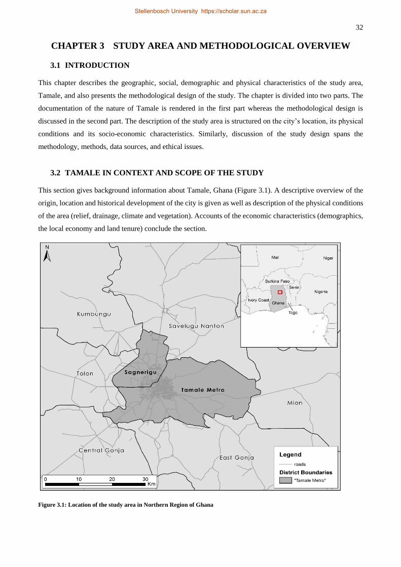
32
CHAPTER 3 STUDY AREA AND METHODOLOGICAL OVERVIEW
3.1 INTRODUCTION
This chapter describes the geographic, social, demographic and physical characteristics of the study area,
Tamale, and also presents the methodological design of the study. The chapter is divided into two parts. The
documentation of the nature of Tamale is rendered in the first part whereas the methodological design is
discussed in the second part. The description of the study area is structured on the city’s location, its physical
conditions and its socio-economic characteristics. Similarly, discussion of the study design spans the
methodology, methods, data sources, and ethical issues.
3.2 TAMALE IN CONTEXT AND SCOPE OF THE STUDY
This section gives background information about Tamale, Ghana (Figure 3.1). A descriptive overview of the
origin, location and historical development of the city is given as well as description of the physical conditions
of the area (relief, drainage, climate and vegetation). Accounts of the economic characteristics (demographics,
the local economy and land tenure) conclude the section.
Figure 3.1: Location of the study area in Northern Region of Ghana
Stellenbosch University https://scholar.sun.ac.za
33
3.2.1 Tamale – location and origin
The study was situated within the Tamale Metropolitan Area (TAMA) which, for the purpose of this research,
includes two local-government administrative units – Tamale Metropolitan Assembly (TaMA) and Sagnarigu
District Assembly (SDA). The TaMA and the SDA are two of 26 local-government administrative units within
the Northern Region of Ghana. The SDA was carved out of the TaMA in 2012 in accordance with Ghana’s
local-government law (Act 462 of 1993) (Republic of Ghana 1993). Despite the administrative separation, the
SDA is still connected to the TaMA in many ways and their demographic, cultural, economic and
administrative structures are virtually identical. For this reason they are considered a unit in this study.
Regarding settlement structure, the TAMA is composed of the city of Tamale, 17 peri-urban communities and
115 villages (Fuseini 2014). The study area is located within latitudes 9o16’N and 9o34’N and longitudes
0o34’W and 0o57’W. It covers a total area of 922 km2 (Tamale Metropolitan Assembly, 2010). Regarding its
relative location, the TAMA is bordered to the north by Savelugu-Nanton Municipality; to the northwest by
Kumbungu District; to the east by Mion District; to the south by East and Central Gonja Districts; and to the
west by Tolon District.
Tamale was a colonial creation around 1907 (Staniland, 1975). This followed the relocation of the
administrative capital of the then British Northern Territories from Gambaga to Tamale to take advantage of
the latter’s central location and its better environmental conditions and water supply (MacGaffey, 2006;
Fuseini, 2014). Indeed, the remote incident that facilitated the designation of Tamale as the administrative
capital of the Northern Territories was the emergence of the British as victors over the Germans for control of
this part of present day Ghana (Dickson, 1968), and the eventual quelling of the resistance by a Dagbamba
King who had vowed that the white man would not settle in his land1. It is reported that at the time of its
designation as the capital for the Northern Territories in 1907, Tamale was a collection of a few villages that
had about 1 435 inhabitants (Staniland, 1975; MacGaffey, 2006). The settlement started to experience rapid
growth from about 1909 when efforts were made to establish a cotton industry (the only viable resource of
interest to the colonialist’s regime in that part of the colony) in northern Ghana and Tamale was made the
centre for the distribution of inputs and purchase of the output from small out-grower farmers. By 1911, more
permanent buildings had emerged in the town including the installation of a cotton gin and a press, and these
collectively stimulated economic activities and further growth of the settlement (Dickson, 1968). Nonetheless,
colonial investment policies, directly and/or indirectly, thwarted the growth of the settlement as the colonial
power preferred to keep northern Ghana as a labour reserve for the more lucrative mines in the south (Plange,
1979). Part of this manifested in a manoeuvre that led to the collapse around 1916 of the very cotton industry
(the spark of Tamale’s original growth) due to low investment in transportation and the government’s enticing
1 An account given by an elder statesman in an interview as part of this study. This narrative has it that it was the said
resistance by the King that made the British originally locate the administrative capital at Gambaga (about 200 north of
Tamale).
Stellenbosch University https://scholar.sun.ac.za
34
of the youth to migrate south and work in the mines (Dickson, 1968). Thus, Tamale was largely rural at
independence in 1957.
Tamale’s real growth followed the immediate post-independence general urban growth across Ghanaian towns
and cities (Adarkwa, 2012; Fuseini & Kemp, 2015). The town’s total population was 40 443 according to the
first post-independence census in 1960, and between 1960 and 1970 recorded the highest annual growth rate
compared to Accra and Kumasi (7.2% against about 5% and 4.4% for Accra and Kumasi, respectively) (Ghana
Statistical Service, 2005). This was significant growth from the 1 435 inhabitants in 1907 and less than 10 000
people in the 1930s (MacGaffey, 2006). Tamale experienced rapid population growth during the 1970s and
1980s when urban growth in Ghana was generally slow and when the country endured severe economic
downturns. Interestingly, Tamale’s atypical growth was spurred by a vibrant rice industry that was promoted
as part of efforts to make Ghana self-sufficient in food production (Songsore, 2009; Gyasi et al., 2014a),
something the colonial cotton industry could not sustain. The TAMA’s current population exceeds 444 000
people (Gyasi et al., 2014a). (See Section 3.2.3.1 and Chapter 5 for a detailed discussion of the city’s
demographic and spatial growth dynamics).
3.2.2 Physical conditions
The description of the physical conditions of Tamale covers relief, drainage, climate and vegetation. These
physical features have relevance to urban governance regarding the provision and access to services and
infrastructure, local economic issues, public health and climate change.
3.2.2.1 Relief and drainage
The TAMA is located about 180 m above sea level. It has a generally rolling topography with a few isolated
hills. The area is poorly endowed with natural water bodies except for some ephemeral streams that drain the
area (Fuseini, 2014). There are also few ‘dug-outs’ and dams that provide alternate sources of water for
household use as there is no universal access to treated, piped water (see Section 5.3.3.2 for a discussion of
access to water in the TAMA). The ‘dug-outs’ and dams have traditionally provided water for free-range
livestock and they are integral to the local economy of the area. For instance, one of the popular dams in
Tamale, the Bielpela Dam, was constructed in the 1960s to provide water for domestic use as well as for
watering livestock (Gyasi et al., 2014a). However, the increasing complexities of urban growth have led to
significant reductions in livestock-rearing activities (especially cattle) in TAMA so potentially increasing the
volume of ‘dug-out’ and dam water available for household and other uses. The ‘dug-outs’ and dams have
recently assumed the important function of supporting urban and peri-urban agricultural practices, mostly
vegetable production (Gyasi et al., 2014b). In spite of their relevance, the sustainability of these alternate
sources of water in the TAMA is being challenged by human activities, chief among which is encroachment
(see Section 5.3.3.2, Chapter 5).
Stellenbosch University https://scholar.sun.ac.za
35
Generally, the rolling topography and the drainage system do not inhibit physical development in and around
the TAMA. In other words, there is neither rugged terrain nor large inland water/wetland areas that pose
significant challenges to physical development. However, the few seasonal streams that drain the area can pose
threats of flooding to some parts of the Metropolis, especially in the eastern part which is relatively low-lying.
The flat topography plays an important role in the spatial growth of the city.
3.2.2.2 Climate and vegetation
The TAMA lies within the Dry Equatorial Climatic and the Guinea Savannah Ecological zones of West Africa.
Therefore, it is characterised by two seasons; a rainy season from about April to October and a dry season from
about November to March. The rainy season is influenced by the moist South Westerly winds which result in
a unimodal rainfall regime compared to a bimodal pattern in the south of the country. The Metropolis
experiences a mean annual rainfall of 1 100 mm within 95 days of intense rainfall. The average length of
growing season is 220 days a year (Fuseini, 2014). However, the well-established pattern of rainy-dry seasons
is beginning to change as the onset of the rains is gradually shifting towards July (Gyasi et al., 2014a). The dry
season is influenced by the very dry north-easterly (Harmattan) winds that blow across the West African sub-
region from the Sahara Desert between about October and February each year. This period of Harmattan is
characterised by dry, hazy and dusty conditions as well as cool temperatures.
The vegetation of the area is characterised by tall grasses interspersed with drought-resistant tree species such
as the neem (Azadirachta indica), shea (Vitellaria paradoxa)) and dawadawa (African Locust Bean tree
[Parkia biglobosa]). Recognisable tree colonies occur as pockets of forest reserves, fetish grooves and
community woodlots (Fuseini, 2014). The shea and dawadawa are the most important tree species in the area.
The shea tree forms the anchor of women’s livelihoods either through gathering and sale of the nuts or agro-
processing by which shea-butter is extracted for cooking and for use in the cosmetic industry. Urbanisation
pressures and associated environmental degradation have caused women in the TAMA a partial loss of their
livelihoods as much bush from which they gather the nuts has disappeared. The option for them is to engage
in nut processing and other agro-processing activities (e.g. rice, groundnuts). The dawadawa tree has two basic
important uses, namely as a local condiment and as symbol of authority in the chieftaincy institution of the
Dagbong Kingdom. The following section describes the socio-economic characteristics of Tamale, namely
demographic, basic economic features and land tenure system.
3.2.3 Socio-economic characteristics
The demography of Tamale, its economy and land tenure are treated in this section. The nature of the latter
feature is indispensable in understanding spatial planning and urban governance in the TAMA.
Stellenbosch University https://scholar.sun.ac.za
36
3.2.3.1 Demographic characteristics
The total population of the TAMA in the most recent (2010) national census was 371 351 which represents a
26.4% increase over the total population of 293 881 in 2000 (Ghana Statistical Service 2005, 2013c). This
proportional increase in the Metropolitan population is the lowest recorded in all post-independence intercensal
periods. By comparison, the Metropolis witnessed an increase in its total population of 106.8% and 116% for
the periods 1960-1970 and 1984-2000 respectively (Ghana Statistical Service, 2005). TAMA’s share of the
regional (Northern Region) population also dropped from 16% in 2000 to 15%. However, the TAMA’s urban
population increased from about 67% in 2000 to about 74% in 2010 (Ghana Statistical Service, 2013b; Fuseini,
2014). By comparison, the urban population for Ghana and Northern Region in 2010 were 51% and 30%
respective, up from 44% and 26% in 2000. This means that, while the TAMA grew slowly in total population,
it witnessed an increase in its urban population by about 17 percentage points. The TAMA’s status as the
administrative and commercial hub of the entire northern Ghana, the greater job opportunities and better social
services make it attractive to would-be migrants from other parts of the region (Ghana Statistical Service,
2013b).
The TAMA has quite a youthful age structure although slightly less youthful than the average for Northern
Region. In the 2010 census, the Metropolis’ young population consisted of 44.2% of persons below 15 years,
and 37.1% aged 15 to 39 years whereas Northern Region’s figures were 44.9% and 37.9%, respectively. This
implies that natural population increase is likely to play an important role in the city’s future population growth.
The age structure will also make higher demands on urban governance for urban infrastructure, education and
healthcare services. Appropriate responses to strengthening the local economy through job creation and
livelihood support will be required. Yet, in the developing countries, small towns like Tamale have little
capacity to manage such unprecedented growth in terms of planning, infrastructure and service provision, job
creation and environmental management (Watson, 2009).
With 60% of its population aged 11 and older being literate, the TAMA was the most literate district in the
Northern Region with an average literacy rate of 37% in 2010. However, the metropolis’ literacy rate was
lower than the national rate of 74% as well as those of Accra and Kumasi at 90% and 83% respectively (Ghana
Statistical Service, 2013a,b,c,d). The 2010 literacy level in the TAMA reflects the Northern Region’s position
as the least literate among the ten regions of Ghana. The low literacy rate in the TAMA has implications for
the metropolis’ socio-economic development given the relationship between education, human-resource
development and socio-economic development (Ghana Statistical Service, 2013a). Education is imperative for
the moulding of the human mind, acquisition of skills – both technical and cognitive – and the application of
these to solve societal problems (Ghana Statistical Service, 2013b). Thus, low literacy in the TAMA may
impact negatively on the availability of critical minds and skills to contribute to local development. It may also
affect the populace’s chances of getting employment in the formal sector where appreciable levels of skills are
required, and this will affect people’s ability to diversify their livelihoods to adapt to the urbanisation
Stellenbosch University https://scholar.sun.ac.za
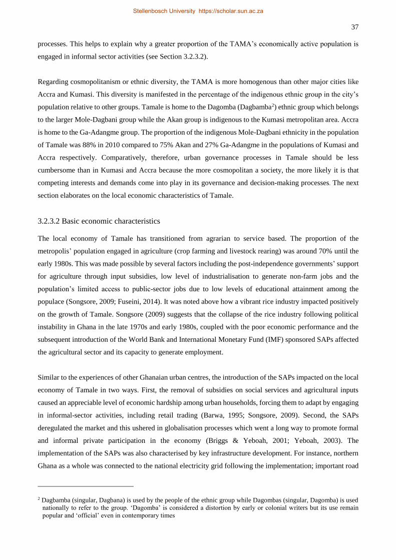
37
processes. This helps to explain why a greater proportion of the TAMA’s economically active population is
engaged in informal sector activities (see Section 3.2.3.2).
Regarding cosmopolitanism or ethnic diversity, the TAMA is more homogenous than other major cities like
Accra and Kumasi. This diversity is manifested in the percentage of the indigenous ethnic group in the city’s
population relative to other groups. Tamale is home to the Dagomba (Dagbamba2) ethnic group which belongs
to the larger Mole-Dagbani group while the Akan group is indigenous to the Kumasi metropolitan area. Accra
is home to the Ga-Adangme group. The proportion of the indigenous Mole-Dagbani ethnicity in the population
of Tamale was 88% in 2010 compared to 75% Akan and 27% Ga-Adangme in the populations of Kumasi and
Accra respectively. Comparatively, therefore, urban governance processes in Tamale should be less
cumbersome than in Kumasi and Accra because the more cosmopolitan a society, the more likely it is that
competing interests and demands come into play in its governance and decision-making processes. The next
section elaborates on the local economic characteristics of Tamale.
3.2.3.2 Basic economic characteristics
The local economy of Tamale has transitioned from agrarian to service based. The proportion of the
metropolis’ population engaged in agriculture (crop farming and livestock rearing) was around 70% until the
early 1980s. This was made possible by several factors including the post-independence governments’ support
for agriculture through input subsidies, low level of industrialisation to generate non-farm jobs and the
population’s limited access to public-sector jobs due to low levels of educational attainment among the
populace (Songsore, 2009; Fuseini, 2014). It was noted above how a vibrant rice industry impacted positively
on the growth of Tamale. Songsore (2009) suggests that the collapse of the rice industry following political
instability in Ghana in the late 1970s and early 1980s, coupled with the poor economic performance and the
subsequent introduction of the World Bank and International Monetary Fund (IMF) sponsored SAPs affected
the agricultural sector and its capacity to generate employment.
Similar to the experiences of other Ghanaian urban centres, the introduction of the SAPs impacted on the local
economy of Tamale in two ways. First, the removal of subsidies on social services and agricultural inputs
caused an appreciable level of economic hardship among urban households, forcing them to adapt by engaging
in informal-sector activities, including retail trading (Barwa, 1995; Songsore, 2009). Second, the SAPs
deregulated the market and this ushered in globalisation processes which went a long way to promote formal
and informal private participation in the economy (Briggs & Yeboah, 2001; Yeboah, 2003). The
implementation of the SAPs was also characterised by key infrastructure development. For instance, northern
Ghana as a whole was connected to the national electricity grid following the implementation; important road
2 Dagbamba (singular, Dagbana) is used by the people of the ethnic group while Dagombas (singular, Dagomba) is used
nationally to refer to the group. ‘Dagomba’ is considered a distortion by early or colonial writers but its use remain
popular and ‘official’ even in contemporary times
Stellenbosch University https://scholar.sun.ac.za
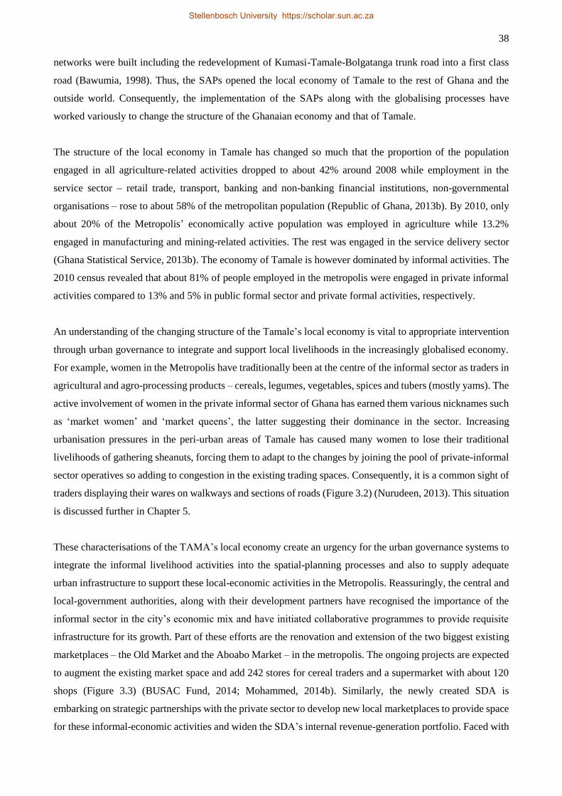
38
networks were built including the redevelopment of Kumasi-Tamale-Bolgatanga trunk road into a first class
road (Bawumia, 1998). Thus, the SAPs opened the local economy of Tamale to the rest of Ghana and the
outside world. Consequently, the implementation of the SAPs along with the globalising processes have
worked variously to change the structure of the Ghanaian economy and that of Tamale.
The structure of the local economy in Tamale has changed so much that the proportion of the population
engaged in all agriculture-related activities dropped to about 42% around 2008 while employment in the
service sector – retail trade, transport, banking and non-banking financial institutions, non-governmental
organisations – rose to about 58% of the metropolitan population (Republic of Ghana, 2013b). By 2010, only
about 20% of the Metropolis’ economically active population was employed in agriculture while 13.2%
engaged in manufacturing and mining-related activities. The rest was engaged in the service delivery sector
(Ghana Statistical Service, 2013b). The economy of Tamale is however dominated by informal activities. The
2010 census revealed that about 81% of people employed in the metropolis were engaged in private informal
activities compared to 13% and 5% in public formal sector and private formal activities, respectively.
An understanding of the changing structure of the Tamale’s local economy is vital to appropriate intervention
through urban governance to integrate and support local livelihoods in the increasingly globalised economy.
For example, women in the Metropolis have traditionally been at the centre of the informal sector as traders in
agricultural and agro-processing products – cereals, legumes, vegetables, spices and tubers (mostly yams). The
active involvement of women in the private informal sector of Ghana has earned them various nicknames such
as ‘market women’ and ‘market queens’, the latter suggesting their dominance in the sector. Increasing
urbanisation pressures in the peri-urban areas of Tamale has caused many women to lose their traditional
livelihoods of gathering sheanuts, forcing them to adapt to the changes by joining the pool of private-informal
sector operatives so adding to congestion in the existing trading spaces. Consequently, it is a common sight of
traders displaying their wares on walkways and sections of roads (Figure 3.2) (Nurudeen, 2013). This situation
is discussed further in Chapter 5.
These characterisations of the TAMA’s local economy create an urgency for the urban governance systems to
integrate the informal livelihood activities into the spatial-planning processes and also to supply adequate
urban infrastructure to support these local-economic activities in the Metropolis. Reassuringly, the central and
local-government authorities, along with their development partners have recognised the importance of the
informal sector in the city’s economic mix and have initiated collaborative programmes to provide requisite
infrastructure for its growth. Part of these efforts are the renovation and extension of the two biggest existing
marketplaces – the Old Market and the Aboabo Market – in the metropolis. The ongoing projects are expected
to augment the existing market space and add 242 stores for cereal traders and a supermarket with about 120
shops (Figure 3.3) (BUSAC Fund, 2014; Mohammed, 2014b). Similarly, the newly created SDA is
embarking on strategic partnerships with the private sector to develop new local marketplaces to provide space
for these informal-economic activities and widen the SDA’s internal revenue-generation portfolio. Faced with
Stellenbosch University https://scholar.sun.ac.za
39
Figure 3.2: Informal business activities take over walkways, pedestrian and cyclist lanes in
Tamale, Ghana
Figure 3.3: Development of market infrastructure for informal businesses in Tamale,
Ghana
Stellenbosch University https://scholar.sun.ac.za
40
resource constraints due to its young age, the SDA provides demarcated spaces and invites interested
individuals and groups to come in and erect low-cost structures to do their businesses while the Assembly
mobilises funds to build permanent market structures for them. See discussion in Chapter 7 on how these
initiatives could enhance urban governance in the TAMA. Discussion on land tenure in the next section
concludes the description of the socio-economic characteristics of Tamale.
3.2.3.3 Land tenure
Land tenure can be defined simply as the rules and arrangements that provide socio-legal frameworks within
which the rights of ownership, control and use of land are exercised (Fuseini, 2014). In many jurisdictions in
Africa, including Ghana, two forms of land tenure systems are discernible – formal or statutory and customary
tenurial arrangements (Kasanga & Kotey, 2001; Ubink & Amanor, 2008a; Ubink & Quan, 2008). Formal or
statutory tenurial arrangements relate to land under the control of the state. In the case of Ghana, statutory land
tenure relates to public lands that have either been compulsorily acquired to serve larger societal interests or
land vested in the state to be administered on behalf of and for the benefit of a particular group, clan or family
(Kasanga, 2001; Kasanga & Kotey, 2001). Customary land tenure relates to land not under state control but
which is controlled by a group, clan or family and administered for the benefits of its members as well as those
who acquire right of use through laid-down procedures and rules (Kasanga, 2001; Fuseini, 2014). Mostly
customary land exists without or with very little documentation (Fuseini, 2014). Control over customary land
is often exercised by chiefs or clan and family heads and, depending on particular geo-sociological instances,
such communally-owned land could be termed a stool, skin and family land (stool land largely refers to
communal land in the south of Ghana while skin land is used mostly in northern Ghana as chieftaincy
authorities are vested in stools and skins respectively). About 80% of the land in Ghana is customarily owned
(Ubink & Quan, 2008) and, as noted earlier, public land is acquired from the customary sector.
In its purest form, chiefly control over customary land does not imply an express authority or right to alienate
land on his own accord. In other words, customary land tenure bars the managers from unilaterally allocating
land for their personal benefits because the land perpetually belongs to the whole group including its dead
members and those yet to be born. This perpetual ownership of communal land is illustrated in the Holy Bible,
in 1 Kings 21, where Naboth thought it a prohibition to sell his vineyard to Ahab because it was the former’s
father’s inheritance (Fuseini, 2014). The Ghanaian Constitution also recognises that control of land carries a
social obligation and that managers are mere fiduciaries who ought to ensure that they manage the affairs of
land for the benefit of the appropriate groups and citizens (Kasanga, 2001).
Tamale lies in the Kingdom of Dagbon where land is communally owned and vested under the care of chiefs
or skins. The concept of family land does not exist in the Dagbon Kingdom. Land tenure in the area has a
normative underpinning of the classical customary tenure as described above. Control of land is tied to the
chieftaincy office whereby chiefs with varying authorities exercise control over sections of the Kingdom’s
Stellenbosch University https://scholar.sun.ac.za
41
land relative to their authorities. Interest in land is hierarchically structured with the Yaa-Naa (the King) sitting
at the apex of the structure and exercising control through his divisional and village chiefs down to the ordinary
citizens at the bottom of the hierarchy. In this regard, two basic interests in land are recognised; allodial interest
which is the highest and is held by the Yaa-Naa, and usufructuary right held by subjects of the Kingdom. The
King controls the land by designating his divisional chiefs to take care of large sections of the Kingdom’s land.
These divisional chiefs in turn designate their sub-chiefs to perform the day-to-day supervision and control on
sub-divided sections of the land. Landmarks, including important trees, are used to mark these sub-divisions
as no clearly delineated physical boundaries exist for the purpose. The dawadawa trees (see section 3.2.2.2)
are particularly used for this purpose. Customarily, the system rewards the chiefs for their supervisory roles
by granting them sole legitimate right to, and ownership of, fruits harvested from the dawadawa trees.
In a traditional setting or an agrarian economy, this arrangement allows natives of the Kingdom to settle
anywhere and use the land to pursue their livelihoods without having to seek prior approval of the Yaa-Naa or
any of his chain of sub-chiefs (Fuseini, 2014). However, no subject is allowed to sell the land and if a subject
leaves a piece of land unused for a period beyond the normal fallow period, another person can occupy it
without the former having any legal claim to the said land at any time in the future. For farming purposes,
strangers could also access land with ease by approaching a village chief and making a request by presenting
a token, traditionally termed cola3. However, any large-scale agricultural activity would have to be approved
by at least the divisional chief (approval ends here if the individual is a native), and eventually by the Yaa-
Naa, if it is undertaken by a stranger. Similarly, non-agricultural land uses, like land for rural housing purposes
by natives require only informing (with cola) the village chief about one’s intentions and where he/she wants
to site. Strangers could also present cola and gain access to land for housing development. These measures
have been put in place to guarantee access to land by all in an agrarian economy.
This egalitarian arrangement for ensuring access and social justice with respect to land was recognised and
appraised as progressive by the colonialists, who thus thought against tampering with its basic roots. A colonial
official is reported to have recommended that:
It is of the utmost importance not to destroy the existing system of land tenure, more
especially as we do not know its incidence. Bearing in mind that the traditional authorities
(i.e. chiefs) have no power to dispose of, or hold land, it is essential to devise some system
whereby existing land tenure is allowed to persist and develop side by side with
administrative progress and some means whereby essential disposition of land can be
readily made and recorded (Kasanga, 1995 p. 23).
The colonialists’ view is echoed by the modern Ghanaian Constitutional provision noted earlier about the need
for responsible management of communal land for the equitable benefit of larger society. However, societal
3 A caffeine-containing nut from the cola tree found in the tropical rainforest of Africa. Cola has had important customary
uses in Dagbon tradition especially in marriage, enskinment, funerals, invitation to functions/ceremonies, token for
making certain requests and thanksgiving. However, it is gradually being replaced by money and other valuables even
though these are still contextualised as cola.
Stellenbosch University https://scholar.sun.ac.za
42
dynamics, especially in the present era of monetised globalisation, have altered customary land tenure a great
deal. Indeed, the colonial official who made the above recommendation for the preservation of customary land
tenure ‘prophesied’ about the indigenous system’s inevitable collapse, a prophecy Kasanga thought had come
true as far back in 1995 (Kasanga, 1995). There is ample evidence to suggest that customary land tenure in
Ghana has undergone rapid changes from one grounded in egalitarianism to one expropriated by the custodians
at the expense of the ordinary people (Ubink, 2007, 2008; Ubink & Amanor, 2008a; Ubink & Quan, 2008).
The chiefly expropriation of communally-owned land is even more pronounced in northern Ghana, including
Tamale, where the restitution of land back to the people, with the chiefs acting as custodians, precipitated the
evolution of morbid land market by which chiefs commoditise and allocate land for personal gain (Kasanga,
1995; Yaro, 2010). Here, land-related conflicts are emerging. This makes a fallacy of customary tenure or
communal ownership as a system that guarantees equity and social justice. It thus justifies the colonialists’
decision to vest northern Ghana lands (in an apparent attempt to forestall the tendency of individualisation and
expropriation) in the state for administration for the benefit of the people (Amanor, 2009; Awedoba, 2010).
The practice also reveals the challenges in land governance in Ghana despite a combination of constitutional
provisions and the establishment of many parastatal agencies to manage land for sustainable socio-economic
development ((Kasanga, 2001; Kasanga & Kotey, 2001; Amanor, 2009). The evolved customary land-tenure
dynamics have had negative implications for urban governance, especially regarding spatial planning in
Ghanaian urban centres (Boamah, Gyimah & Nelson, 2012; Yeboah & Shaw, 2013; Fuseini & Kemp, 2015).
The effect of changing land tenure on spatial planning and urban governance in Tamale is discussed in Chapter
6.
The discussion in this section has elaborated on the physical and socio-economic features of Tamale relevant
to urban governance. Demographic dynamics, local economic features and evolving land tenure present
particular urgency for appropriate urban governance responses. The roadmap of the study is reported in the
following section.
3.3 ROADMAP OF THE STUDY
This section reports the roadmap of the study. The section is divided into two parts, namely methodology and
methods the latter concerning data capture and analysis.
3.3.1 Methodology
This section describes the procedure and logic of the organisation and execution of the study. The discussion
is centred on research design, approach, philosophical considerations, research validity, researcher
positionality and reflexivity, and ethical issues of research. The description of methodology in this section is
complemented by specific methodologies in Chapters 4, 5 and 6.
Stellenbosch University https://scholar.sun.ac.za
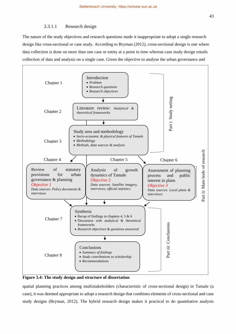
43
3.3.1.1 Research design
The nature of the study objectives and research questions made it inappropriate to adopt a single research
design like cross-sectional or case study. According to Bryman (2012), cross-sectional design is one where
data collection is done on more than one case or entity at a point in time whereas case study design entails
collection of data and analysis on a single case. Given the objective to analyse the urban governance and
Figure 3.4: The study design and structure of dissertation
spatial planning practices among multistakeholders (characteristic of cross-sectional design) in Tamale (a
case), it was deemed appropriate to adopt a research design that combines elements of cross-sectional and case
study designs (Bryman, 2012). The hybrid research design makes it practical to do quantitative analysis
Introduction Problem
Research questions
Research objectives
Literature review: Analytical &
theoretical frameworks
Review of statutory
provisions for urban
governance & planning
Objective 1 Data sources: Policy documents &
interviews
Assessment of planning
process and public
interest in plans
Objective 3 Data sources: Local plans &
interviews
Conclusions Summary of findings
Study contributions to scholarship
Recommendations
Synthesis Recap of findings in chapters 4, 5 & 6
Discussion with analytical & theoretical
frameworks
Research objectives & questions answered
Study area and methodology Socio-economic & physical features of Tamale
Methodology
Methods, data sources & analysis
Analysis of growth
dynamics of Tamale
Objective 2 Data sources: Satellite imagery,
interviews, official statistics
Chapter 1
Chapter 2
Chapter 3
Chapter 4 Chapter 6 Chapter 5
Chapter 8
Chapter 7
Par
t i:
Stu
dy
set
tin
g
Par
t ii
i: C
on
clu
sions
Par
t ii
: M
ain b
ody o
f re
sear
ch
Stellenbosch University https://scholar.sun.ac.za
44
through Remote Sensing (RS) and Geographic Information Systems (GIS) techniques, gather interview data
from multistakeholders involved in urban governance and spatial planning in Tamale, do content analysis of
local plans of Tamale and make use of official statistics and published literature regarding Tamale. The
research design is a description of all the research processes from conception of a topic of investigation through
observation to presentation of study results (Babbie, 2005).
In this regard, Figure 3.4 illustrates the organisation of the study from conception to conclusion. The study was
structured in three parts. Part i concerns the settings of the study including the main introduction, review and
discussion of the analytical and theoretical frameworks, profiling of the study area, description of the
methodology, methods, data sources and analysis. The study was executed in Part ii where it was structured
around three stand-alone journal articles and/or manuscripts, each answering a study objective. The execution
of the study was concluded in Part iii where a synthesis was done through amalgamation of the three journal
articles and/or manuscripts and the information set out in the preliminary chapters particularly the analytical
and theoretical frameworks in Chapter 3. The subsequent sub-sections describe the various components of the
research methodology starting with the philosophical perspective and choice of research approach in Section 3.3.1.2.
3.3.1.2 Philosophical perspective and choice of research approach
Interpretivist and constructionist stances of epistemology and ontology respectively formed the philosophical
basis of the study. These philosophical positions reject positivist view of an objective reality and consider
knowledge as constructed and situated (Golafshani, 2003; Bryman, 2012). In other words, the interpretivist
and constructionist stances are amenable to contextual understanding and appreciation of social actors as
differentiated and active agents (Bryman, 2012). Thus, the interpretivist and constructionist philosophical
positions allow for better appreciation and understanding of the behaviour of stakeholders involved in spatial
planning and urban governance is particularly relevant given the increasing shift from “planning for the public”
to “planning with the public” (Klosterman, 1999 p. 2). This appreciation of social agency by the interpretivist
and constructionist philosophies finds expression in contemporary collaborative planning and urban
governance which are employed as theoretical and analytical frameworks in this study (see Chapter 2).
Based on the research objectives (analysing the spatial growth of Tamale, assessing the legal basis for the
conduct of urban governance and spatial planning, and investigating urban governance and spatial planning
processes in the city), the interpretivist and constructionist philosophical positions taken and the collaborative
planning theoretical and the DED analytical frameworks considered, a mixed research approach was employed.
This allowed for quantitative analysis of spatial growth and qualitative investigation of the social actors
involved in urban governance and spatial planning processes (Babbie, 2005). In other words, combining both
methods of investigation was a strategic move intended to answer different research questions and objectives
(Bryman, 2012). The quantitative analysis involved the application of RS and GIS techniques which have
become useful and proven tools for spatial analysis (Campbell & Wynne, 2011; Myburgh & van Niekerk,
Stellenbosch University https://scholar.sun.ac.za
45
2014). The mixed methods research strategy also allowed for qualitative investigation of urban governance
and spatial planning processes and outcomes through unstructured personal interviews, review of policy
documents and content analysis of sample local plans. A description of research validity and reliability is given
in the next section.
3.3.1.3 Research validity and reliability
The concepts of research validity and reliability have traditionally been associated with quantitative research
under positivist epistemology that seeks to test the generalisability and trustworthiness of research findings
(Golafshani, 2003). In this context, reliability connotes replicability of research processes and results, whereas
validity concerns with the truthfulness of research findings (Whittemore, Chase & Mandle, 2001). Or as
Roberts, Priest & Traynor (2006 p. 41) put it, “reliability and validity are ways of demonstrating and
communicating the rigour of research processes and the trustworthiness of research findings.” Given the
aforementioned orientation, the application of the concepts of validity and reliability in qualitative research is
challenging in that unlike quantitative research, qualitative research technique seeks understanding rather than
measurement and explanation (Whittemore et al., 2001; Golafshani, 2003; Roberts et al., 2006; Thanasegaran,
2009). However, it is argued that consideration of rigour in research, exemplified by issues of validity and
reliability, is needed to differentiate scientific knowledge from fiction (Morse et al. 2002). It is, therefore,
suggested that each research paradigm – quantitative versus qualitative – should devise its own criteria for
ascertaining the rigour and trustworthiness of research such that while quantitative researchers use the terms
validity and reliability, their counterparts in qualitative research would dwell on the terms credibility,
neutrality, confirmability, consistency and transferability to check the rigour and trustworthiness of their
research (Morse et al., 2002; Golafshani, 2003).
Following from the above, two basic strategies were employed to ensure rigour and trustworthiness of this
research. The first concerns detailed description of the processes of capture, processing and analysis of the
spatial data (satellite imagery and sample of local plans). The descriptive exercise was complemented by
display of confusion matrices to illustrate various degrees of classification accuracy including overall accuracy,
producer accuracy, user accuracy as well as class specific accuracies (see Appendices 1 & 2). This was to
demonstrate how the data were processed and analysed (for possible replication) and to afford the reader the
opportunity to assess the validity or trustworthiness of the results in a quantitative sense.
Efforts to ensure credibility and trustworthiness of the qualitative aspect of the research involved researcher
neutrality and application of certain techniques (like reversal questioning in interviews) to ensure consistency
and confirmability in the capture and analysis of the data. Reversal questioning technique was employed to
check the consistency of answers given by respondents. Also, the open-ended nature of the interviews meant
that the researcher could confirm certain answers or statements given in previous interviews with other
respondents. The aforementioned process formed the basis for the emergence of shared opinions and
Stellenbosch University https://scholar.sun.ac.za

46
experiences, and these subsequently formed the themes for the analysis of the data. Through these processes,
it was possible to employ raw data examination and data reduction (elimination of apparent contradictions)
techniques to check the consistency and confirmability of answers and statements given by respondents
(Golafshani, 2003). Also relevant in this regard was personal observation of the mood, tone and physical
gestures and expressions of respondents when they answered questions.
The strategies discussed above were employed to ensure the validity and reliability of the quantitative part of
the research and the credibility, consistency, confirmability, neutrality and trustworthiness of the qualitative
component. The discussion now turns to researcher positionality and reflexivity in the next section.
3.3.1.4 Researcher positionality and reflexivity
In qualitative or social research generally, the researcher’s position relative to the research participants or
community can have significant influence on the data collection processes and the final report of the research.
As Bourke (2014 p. 2) notes, “the nature of qualitative research sets the researcher as the data collection
instrument … [and that] reflects the likelihood that the researcher’s own subjectivity will come to bear on the
research project and any subsequent reporting of findings.” In other words, the product of qualitative research
largely depends on the ability of the researcher (Golafshani, 2003). It is also contended that a researcher’s
positionality (whether insider or outsider) can have implications for access to research participants and/or
information (Visser, 2001). Therefore, in qualitative research, the researcher’s sociocultural background
relative to the research participants or community as well as the political and temporal institutional
environments ought to be considered in the preparation and execution of a fieldwork research project (Visser,
2001; Bourke, 2014).
In respect of the binary insider-outsider consideration (Visser, 2001), the researcher involved in this research
was an insider in Tamale because he is a native of the area, and in recent times has involved in research
conducted in the metropolis. In this research, the target research participants were of the elite category in that
these were people who occupied certain positions within the local-government structures and hierarchy.
Therefore, in terms of social standing they were in a position to interact on equal terms with the researcher
thereby reducing the risk of researcher’s subjectivity influencing the process. Furthermore, the governance
structures of the TAMA were very stable compared to what Visser (2001) encountered when he conducted
fieldwork in Tygerburg in the first decade of South Africa’s democratic transition. This meant that there might
not be any other consideration of the researcher by the respondents other than that of an indigene of the area.
The study environment was also politically very stable compared to that encountered by Thuo (2013) when he
conducted fieldwork in Nairobi around the time of Kenya’s post-election violence in 2007. More so, the study
area was culturally homogeneous and did not present any difficulties as was apparent in Visser's (2001) study
in Tygerberg (a white person conducting research in the immediate post-apartheid era on the topic of social
Stellenbosch University https://scholar.sun.ac.za
47
justice), or in Bourke's (2014) study where a white researcher tried to explore the experiences of non-white
students in a predominantly white University in the USA.
The networks the researcher built in previous research in the city proved useful in renewing trust between the
researcher and the researched. This was particularly so as many of the respondents were drawn from
institutions that previously participated in research in which the researcher was involved. Consequently, the
previous networks benefited the researcher similar to how Thuo's (2013) previous institutional networks
benefited his research in Nairobi. The introductory letter of the researcher was used to establish rapport with
respondents who were unfamiliar with the researcher. In one incident, however, a respondent (a director of an
institution) went as far as confirming the researcher’s claim to have come from a certain community within
the TAMA by instantly placing a call through to the DCE for the SDA (who comes from the same community)
that ‘Honourable, Issahaka is here to interview me regarding his PhD studies’. Upon confirming the
researcher’s status with the DCE, there was a lovely interaction between the researcher and the respondent.
However, as Visser (2001) observed in Tygerberg, there is a limit to how much pre-existing networks can help
in actual fieldwork situation, and that was where the researcher’s positionality as coming from the city
privileged the research process. In certain respects, much more detailed information was given in the local
Dagbanli (Dagbani) language as opposed to the English language with which most of the interviews were
conducted (based on their individual preferences). The use of local jargons and references to certain events
gave the researcher the sense of better understanding the issues than an outsider researcher would possibly grasp.
Notwithstanding the above narratives, the researcher’s experience agrees with Visser (2001) that the timing of
fieldwork can blur the insider-outsider distinction. This emerged when the researcher visited a government
agency for data. During the first visit a deputy director the researcher met indicated availability of the data but
stated that it would be granted upon his boss’s return from a trip. Upon his return, however, the boss said the
data being requested could only be obtained in Accra. Clearly disappointed, the deputy director referred the
researcher to someone in the head office in Accra and suspected that his boss denied access to the data because
of the recent activities by Anas4. It means that the activities of Anas have created a certain epoch in Ghanaian
society within which access to research participants and/or information is constrained to a certain degree
irrespective of the positionality of the researcher. This leads to another experience that reinforces the need for
qualitative research methodology to be flexible and amenable to some of these contingencies, especially in
terms of time and budget. Aside from the inevitable trip the researcher had to make to Accra for unknown
number of days, there were several instances that interviews had to be rescheduled and these had implications
for the duration of the fieldwork and the budget of the research.
4 Anas Aremeyaw Anas is an international award winning Ghanaian investigative journalist who has done several
undercover investigations and has exposed corrupt practices in Ghanaian public sector and internationally.
Stellenbosch University https://scholar.sun.ac.za
48
From the above, it would be concluded that the researcher’s positionality as a citizen of Tamale did impact
positively on the research even though the process was punctuated by few intervening hitches that slowed the
speed of the fieldwork. Thus, two lessons were learned from the fieldwork. First, given a more stable local
institutional base, more homogeneous research population and good pre-existing networks, a researcher’s
insider positionality could be engendering to fieldwork research. Second, the experiences presented in the
study affirm Visser's (2001) argument that there may be more to the binary distinction of insider-outsider
classification regarding researcher positionality depending on certain intervening contingencies, demonstrated
in this case by the fear of being surreptitiously studied by an undercover journalist.
3.3.1.5 Ethical considerations
Ethical issues are essential components for ensuring integrity of research. They are particularly important in
social research where the researcher(s) often interact (s) directly with human subjects either as research
participants or administrative personnel. There are ethical principles social researchers generally agree should
be adhered to in order to enhance the integrity of research, and which research and academic institutions
consider before granting permission for the execution of research projects. These principles include informed
consent, voluntary participation, no harm to research participants, anonymity, confidentiality, respect for
respondent’s privacy and no deception5 regarding the real intent of the research (Babbie, 2005; Bryman, 2012).
According to Babbie (2005), it is imperative to clearly inform prospective research participants about the
voluntary nature of the research and also assure them of no physical or psychological harm as a result of their
participation in the research. Anonymity and confidentiality are guarantees that the researcher will, as far as is
practicable treat the information given by the respondents in ways that will not expose the research participants
to harm, risk or victimisation of any sort. The concept of informed consent is operationalised to clarify ethical
issues with prospective research participants at the beginning of the research process (Miller & Boulton, 2007).
Once prospective participants agree to participate in the research, the researcher is ethically bound by these
terms throughout the research process (Miller & Bell, 2002). Clearing up ethical issues with research
participants builds trust and openness between the researcher and the researched thereby promoting quality
interaction for quality information (Boeije, 2010). Avoiding deceptive tendencies in social research aims to
ensure research integrity and maintain the mutual trust that is desirable between researchers and research
participants (Bryman, 2012).
The researcher complied with the above ethical considerations by obtaining ethical clearance from
Stellenbosch University’s Research Ethics Committee (REC) (Appendix 2) for the conduct of the research.
The research was deemed ‘low risk’ (i.e. research does not involve sensitive issues and children) and thus
Departmental ethics screening (DESC) approval was granted and certified by the Humanities Research Ethics
5 This principle is difficult to abide by as deception is employed in certain respects (e.g. in social psychology research) to
allow the researched act in their natural manner or in other social research where deception is used to elucidate certain
social behaviour and practices (Bryman, 2012).
Stellenbosch University https://scholar.sun.ac.za
49
Committee (REC). The researcher also obtained an introductory letter (Appendix 3) from the chair of the
Department of Geography and Environmental Studies, copies of which were given to the respondents in
addition to the informed consent form (Appendix 4). The informed consent form explained all the ethical issues
to the prospective research participants including their rights to participate voluntarily and withdraw from the
research, no harm to their person, no material benefits, confidentiality and anonymised treatment of their
responses. The introductory letter (and in a few instances the researcher’s ID card) helped to establish trust
and cordiality between the researcher and the research participants. Interactions were always done at the
convenience of the participants. Generally, these arrangements facilitated the interview processes and also
allowed the participants to ask questions to clear their mind of any doubt regarding the research and the
information they gave.
It conclusion, it is restated that the methodological organisation of the study comprised the research design,
philosophical perspective and choice of research approach, research validity and reliability, researcher
positionality and reflexivity and ethical issues. Research methods and sources of data for the study are
described in the next section.
3.3.2 Methods and data sources
Based on the research strategy described above, three sets of data were collected from satellite imagery,
interviews and secondary sources (including policy documents and local planning schemes). The use of these
sources and the nature of the datasets are given in the following subsections. Analysis of the data is given in
Section 3.3.3. Greater detail about the sources, data and analysis is given in the methodology discussions in
Chapters 4, 5 and 6.
3.3.2.1 Satellite imagery
The satellite imagery data comprised two datasets from two different satellite missions. The one was IKONOS
image of 28 September 2001 procured from DigitalGlobe through the South African National Space Agency
(SANSA) and the other set was RapidEye image of 11 January 2014 acquired from the European Space Agency
(ESA) under its Third Party Mission (TPM) data-access programme. The two datasets were acquired to
facilitate time series analysis of the city’s spatial-growth dynamics. Consequently, the analysis of the satellite
imagery was employed to answer research objective two and research question one. The 13-year period of
analysis was constrained by a paucity of data as very-high-resolution satellite imagery (envisioned for the
study) did not exist prior to 2000. Previous studies (e.g. Braimoh & Vlek, 2004; Fuseini, 2014) laid the
foundation on which the present study was built. Besides data limitations, there is no standardised period for
time-series analysis except that an observation period should be long enough to illustrate changes over time
(Watts & Halliwell, 1996). Consequently, the 13-year period was deemed sufficient to depict the urban-growth
dynamics of Tamale in light of the purpose to relate the growth dynamics to urban governance processes.
Stellenbosch University https://scholar.sun.ac.za
50
3.3.2.2 Interviews
Interviews were conducted with identified stakeholders in spatial planning and urban governance in Tamale.
This dataset was used to answer the research objectives one and three as well as research questions 2 to 6.
Because the sample frame of stakeholders in spatial planning was very limited (not ubiquitously distributed)
as defined by Ghana’s local-government law, a purposive sampling technique was employed to select
respondents. The advantage of this nonprobability sampling technique is that it allows research participants to
be selected who are most appropriate for the study based on their peculiar characteristics and the purpose of
the research (Babbie, 2005). Sixteen interviews were conducted among respondents from the Tamale
Metropolitan Assembly (TaMA), the Sagnarigu District Assembly (SDA), the Town and Country Planning
Department (TCPD), the Lands Commission (LC), the Ghana Water Company Limited (GWCL) and
Gulkpegu Customary Land Secretariat (CLS). The distribution of respondents and the rationales for their
selection are given in Table 6.1, Chapter 6.
Semi-structured (open-ended) in-depth interviews were conducted. Among the three main qualitative data-
gathering approaches – structured, semi-structured and unstructured – semi-structured interviews are popular
in social enquiries as they define key questions but allow respondents to give more detailed information (Gill,
Stewart, Treasure & Chadwick, 2008). The approach has the advantage of generating a wealth of information
beyond that which a researcher initially conceives, leading to important discoveries in the research process
(Babbie, 2005). Essentially, the approach involves the researcher developing a “general plan of inquiry but not
a specific set of questions that must be asked with particular words in a particular order” (Babbie, 2005 p. 314).
Nevertheless, it is important for the researcher to be familiar with the types of questions to be asked to enhance
the flow of the interaction and to keep respondents engaged by asking relevant probing questions. By asking
relevant follow-up questions “control” is gained over the interview process (Babbie, 2005) and it enables
optimal answers to be elicited (Turner, 2010). An interview guide (see Appendix 5) was developed on themes
relative to the research questions and objectives so providing a frame for interviewer-respondent interactions.
The questions thus focused on urban governance and spatial-planning frameworks, stakeholder engagements,
successes and challenges. The interviews also aimed to assess, albeit indirectly, the practical effects of the
various legislative frameworks guiding urban governance and spatial planning. The interviews were conducted
between October 2013 and March 2014 with duration of each interaction with a respondent ranged from 35
minutes to 1h 20 minutes.
3.3.2.3 Secondary data
Secondary data were obtained from policy documents, government statistics and a sample of local plans. The
policy documents were the Local Government Act (Act 462 of 1993), the National Development Planning
Commission Acts (Acts 479 & 480), the Town and Country Ordinance of 1945 (CAP 84), the Lands
Commission Act (Acts 483 & 767), the Environmental Protection Agency Act (Act 490), the National Urban
Policy Framework of 2012 and the Draft Land Use and Spatial Planning Bill of 2011. These were scrutinised
Stellenbosch University https://scholar.sun.ac.za
51
to understand the legislative frameworks guiding spatial planning and urban governance in Ghana and Tamale.
Statistical and/or census data from the Ghana Statistical Service (GSS), the Department of Urban Roads
(DUR), the Driver and Vehicle Licencing Authority (DVLA) and from published literature (e.g. Ghana
Urbanisation Review Report by The World Bank) were also used. These datasets provided information on
population figures, the population’s access to basic services, vehicle and motorcycle registration figures and
inventory of road networks in the TAMA. A sample of nine local plans were obtained from the TCPD to assess
spatial-planning processes, namely plan development, implementation and stakeholder engagement in these
processes. The use of the plans is described in Chapter 6. The next section describes how these datasets were analysed.
3.3.3 Analysis
The methods used to prepare and analyse the data are described in this section. The description of the analytical
techniques rendered in this section overlaps with the analysis sections in Chapters 4, 5 and 6. The preparation
and analysis of the satellite imagery is treated first in five subsections, followed by the processing and analysis
of the information collected during the interviews and the section ends with an account of the processing and
analysis of the sampled local plans.
3.3.3.1 Image analysis
The extraction, preparation and analysis of the image data involved four steps, namely pre-processing of the
images, the selection and collection of training data, segmentation and classification of the imagery and
assessment of the accuracy of the map classification. A related classification activity, the extraction of road
networks in the images to assess the provision of road infrastructure in the city, completes the section.
3.3.3.2 Image pre-processing
The IKONOS imagery was delivered as a standard geometrically corrected product. Atmospheric correction
was done using the ATCOR2 algorithm. The dataset consisted of a four-band (red, blue, green and near
infrared) multispectral image with a resolution of 3.2 m and a panchromatic band at a resolution of 0.8 m. The
multispectral image was pansharpened with the panchromatic band to obtain an overall resolution of 0.8 m.
PCI Geomatica software was used for both the atmospheric and pansharpening exercises. The project had an
extent of 14 788 by 12 952 pixels (11.8 km x 10.4 km).
Similarly, the RapidEye dataset was delivered as Level 3A orthorectified product that represents the highest
processing standard among the mission’s products (RapidEye, 2012). The Level 3A product is both
geometrically and radiometrically corrected. The RapidEye imagery was clipped to the extent of the IKONOS
imagery using ESRI’s ArcMap software. Atmospheric correction to ground reflectance values was performed
on the clipped image. The image had five bands (blue, green, red, red edge and near infrared) at 5-m resolution.
The resolution of 5 m was judged to be adequate to perform a geographic object-based image (GEOBIA)
Stellenbosch University https://scholar.sun.ac.za
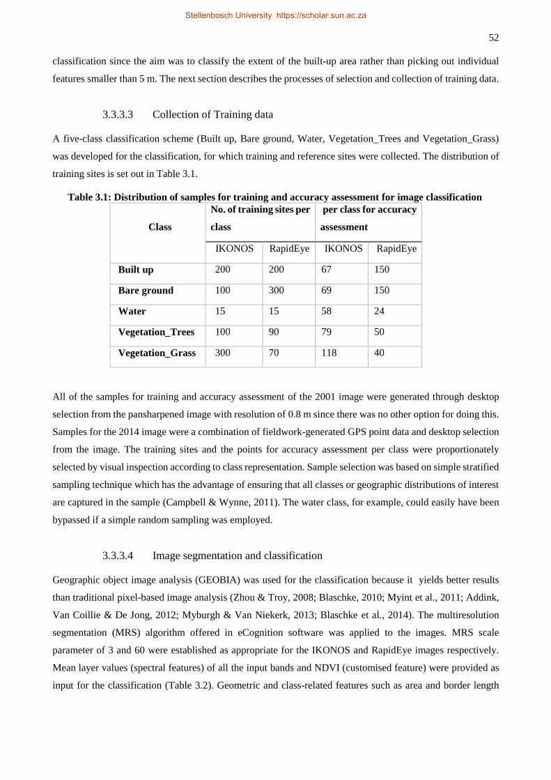
52
classification since the aim was to classify the extent of the built-up area rather than picking out individual
features smaller than 5 m. The next section describes the processes of selection and collection of training data.
3.3.3.3 Collection of Training data
A five-class classification scheme (Built up, Bare ground, Water, Vegetation_Trees and Vegetation_Grass)
was developed for the classification, for which training and reference sites were collected. The distribution of
training sites is set out in Table 3.1.
Table 3.1: Distribution of samples for training and accuracy assessment for image classification
Class
No. of training sites per
class
per class for accuracy
assessment
IKONOS RapidEye IKONOS RapidEye
Built up 200 200 67 150
Bare ground 100 300 69 150
Water 15 15 58 24
Vegetation_Trees 100 90 79 50
Vegetation_Grass 300 70 118 40
All of the samples for training and accuracy assessment of the 2001 image were generated through desktop
selection from the pansharpened image with resolution of 0.8 m since there was no other option for doing this.
Samples for the 2014 image were a combination of fieldwork-generated GPS point data and desktop selection
from the image. The training sites and the points for accuracy assessment per class were proportionately
selected by visual inspection according to class representation. Sample selection was based on simple stratified
sampling technique which has the advantage of ensuring that all classes or geographic distributions of interest
are captured in the sample (Campbell & Wynne, 2011). The water class, for example, could easily have been
bypassed if a simple random sampling was employed.
3.3.3.4 Image segmentation and classification
Geographic object image analysis (GEOBIA) was used for the classification because it yields better results
than traditional pixel-based image analysis (Zhou & Troy, 2008; Blaschke, 2010; Myint et al., 2011; Addink,
Van Coillie & De Jong, 2012; Myburgh & Van Niekerk, 2013; Blaschke et al., 2014). The multiresolution
segmentation (MRS) algorithm offered in eCognition software was applied to the images. MRS scale
parameter of 3 and 60 were established as appropriate for the IKONOS and RapidEye images respectively.
Mean layer values (spectral features) of all the input bands and NDVI (customised feature) were provided as
input for the classification (Table 3.2). Geometric and class-related features such as area and border length
Stellenbosch University https://scholar.sun.ac.za
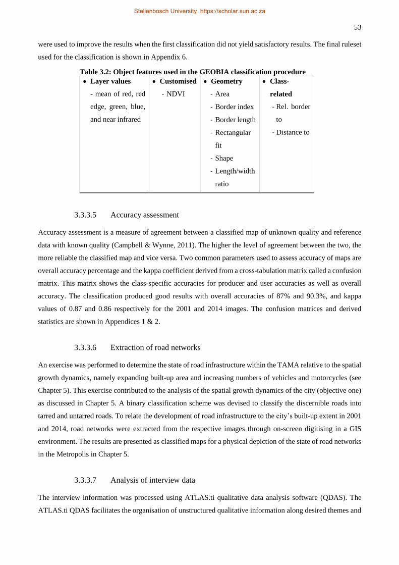
53
were used to improve the results when the first classification did not yield satisfactory results. The final ruleset
used for the classification is shown in Appendix 6.
Table 3.2: Object features used in the GEOBIA classification procedure
Layer values
- mean of red, red
edge, green, blue,
and near infrared
Customised
- NDVI
Geometry
- Area
- Border index
- Border length
- Rectangular
fit
- Shape
- Length/width
ratio
Class-
related
- Rel. border
to
- Distance to
3.3.3.5 Accuracy assessment
Accuracy assessment is a measure of agreement between a classified map of unknown quality and reference
data with known quality (Campbell & Wynne, 2011). The higher the level of agreement between the two, the
more reliable the classified map and vice versa. Two common parameters used to assess accuracy of maps are
overall accuracy percentage and the kappa coefficient derived from a cross-tabulation matrix called a confusion
matrix. This matrix shows the class-specific accuracies for producer and user accuracies as well as overall
accuracy. The classification produced good results with overall accuracies of 87% and 90.3%, and kappa
values of 0.87 and 0.86 respectively for the 2001 and 2014 images. The confusion matrices and derived
statistics are shown in Appendices 1 & 2.
3.3.3.6 Extraction of road networks
An exercise was performed to determine the state of road infrastructure within the TAMA relative to the spatial
growth dynamics, namely expanding built-up area and increasing numbers of vehicles and motorcycles (see
Chapter 5). This exercise contributed to the analysis of the spatial growth dynamics of the city (objective one)
as discussed in Chapter 5. A binary classification scheme was devised to classify the discernible roads into
tarred and untarred roads. To relate the development of road infrastructure to the city’s built-up extent in 2001
and 2014, road networks were extracted from the respective images through on-screen digitising in a GIS
environment. The results are presented as classified maps for a physical depiction of the state of road networks
in the Metropolis in Chapter 5.
3.3.3.7 Analysis of interview data
The interview information was processed using ATLAS.ti qualitative data analysis software (QDAS). The
ATLAS.ti QDAS facilitates the organisation of unstructured qualitative information along desired themes and
Stellenbosch University https://scholar.sun.ac.za
54
categories (e.g. research objectives and questions) through coding. The software also allows for manipulation
of qualitative data by creating networks of nodes, links and relations as well as performing some basic query
activities through the use of Boolean, semantic and proximity operators (Friese, 2013). The main activity in
the use of the ATLAS.ti QDAS is the coding procedure which can be done either deductively (strongly
structured along predetermined themes) or inductively (requires rigorous intellectual activity to build meaning
from the unstructured data as in the Grounded Theory approach that Glaser & Strauss (1967) proposed. The
interview data were analysed using a quasi6 inductive coding approach whereby coding was done such that
meaning emerged from the data rather than strict ordering consistent with the research objectives and
questions. This was done to take advantage of the element of serendipity as a principle in extracting meaning
out of unstructured data (Friese, 2013), especially as qualitative data can be richer than the initially
predetermined research objectives and questions.
3.3.3.8 Analysis of sampled local plans
The local plans were primarily secured to aid the assessment of public land-use zonings in local plans of
Tamale. This exercise was meant to gauge how public interest is treated in planning and plan implementation.
The plans were processed through georeferencing and digitising using ESRI’s ArcMap Software (Version 10).
Public land-use zonings, the focus of this exercise, were digitised individually while the other land use types
were digitised at parcel level. Maps were prepared for the digitised plans and the identified public land-use
zonings were classified into seven classes, namely open space, reserve/buffer, sanitary area, school/clinic,
market, social centre and worship. See Chapter 6 for the distribution of these classes.
The next step in the plan analysis involved determining the status of these public land-use zonings on the
ground. Status was assigned as not encroached (either developed for the intended public use or the zoning
remained for future development), encroached completely (i.e. developed for other uses) and partially
encroached (i.e. partly developed/encroached or partly encroached/preserved for future development).
Determination of the status of the public land-use zonings was done in two complementary ways. First, ground
truthing was carried out in January 2015 to physically verify the status of some (due to time constraint) of the
classes on the ground. Second, the digitised plans were converted to Keyhole Markup Language (KML) files
(.kml, .kmz) to render them viewable in Google Earth. This allowed the on-screen visual interpretation of the
plans against the backdrop of high-resolution satellite imagery acquired on 4 December 2014. Thus, the status
of the identified public land-use zonings was determined complementarily through ground truthing and
desktop review in Google Earth. The interpretation in Google Earth was aided by expert knowledge of the
area, size, orientation and context of objects of interest.
6 Not as rigorous as the Grounded Theory approach by Glaser and Strauss (Glaser & Strauss, 1967) as coding was still
influenced to a large extent by the research objectives and questions in the mind of the researcher. Not as rigorous as
Grounded Theory approach by Glaser and Strauss (Friese, 2013) as the process was still influenced to a large extent by
the research objectives and questions in the minds of the researchers.
Stellenbosch University https://scholar.sun.ac.za
55
3.4 SUMMARY
The chapter presented the demographic, social, economic and physical background information of the study
area. To a large extent, the presentation was contextualised in urban governance and spatial planning practices
in the areas regarding their implications. Demographic dynamics, structure of the local economy, land tenure
dynamics and physical conditions were appraised for their implications for the conduct of urban governance
and spatial planning.
The second part of the presentation centred on the roadmap of the study. The roadmap was structured and
discussed along the methodology, methods and sources of data, and analysis of data. The description of the
methodology spanned the study design, philosophical perspective, research validity and reliability,
researcher’s positionality and reflexivity, and ethical issues in scientific research. Three sources of data were
presented under the methods and data sources, namely satellite imagery, interview information and secondary
data. Similarly, the analysis of data followed the three datasets with specific techniques employed in the
processing and analysis of each dataset. The discussion of the methodology, methods and sources of data, and
analysis in this chapter was done taking cognisance of specific methodological and analytical presentations in
Chapters 4, 5 and 6. This was purposively done to provide a generalised description of the methodology,
methods and analysis to overlap with the specific methodological presentations in Chapters 4, 5 and 6. The
aim was to ensure a comprehensive discussion of the methodological and data analysis techniques employed
in the study.
The next three chapters contain the bulk of the analytical work organised on the research objectives and
structured as journal articles. Chapter 4 presents a review of spatial planning trajectories in Ghana vis-à-vis
the temporal legislative environment. A characterisation of urban growth dynamics of Tamale is presented in
Chapter 5 with discussion on urban governance responses to urban growth regarding the provision of urban
infrastructure and services, namely road networks, electricity, water and sanitary facilities. The processes of
urban governance and spatial planning in Tamale are discussed in Chapter 6.
Stellenbosch University https://scholar.sun.ac.za
56
CHAPTER 4 A REVIEW OF SPATIAL PLANNING IN GHANA’S SOCIO-
ECONOMIC DEVELOPMENT TRAJECTORY: A SUSTAINABLE
DEVELOPMENT PERSPECTIVE7
ABSTRACT
This study provides a review of spatial planning in the context of Ghana’s socio-economic development
trajectory. Spatial planning has been integral to the economic policies of the country since colonial rule. Yet,
its role has been overshadowed by the domain of socio-economic planning. Drawing from published literature,
policy documents, legislative frameworks and interviews, this study reveals the different context and scope
within which spatial planning has been implemented in Ghana, and the successes and failures thereof. While
the colonial governments employed spatial planning on limited scale and for exploitative purposes, post-
colonial governments have implemented broad-based planning grounded in the ‘genuine’ aspiration to promote
a spatially balanced development. This study argues that post-independence planning has not been successfully
implemented compared to pre-independence planning due to a myriad of factors including rapid urban growth,
inadequate staffing, low capacity, lack of institutional coordination, political interference in planning, complex
land tenure and evolving land markets among others. Consequently, urban centres in Ghana are beset with
problems such as poor environmental conditions, poor infrastructure and service delivery, and uncontrolled
growth; and these are inimical to sustainable urban development. The study lauds renewed efforts to transform
planning in the spirit of sustainable development through the national urban policy framework of 2012 and a
proposed land use and spatial planning bill; the latter proposes planning based on the spatial development
framework, and a repeal of an obsolete 1945 planning ordinance that has underlain planning since. It is argued
that if supported and harmonised the two initiatives present the best planning framework in the 21st century Ghana.
4.1 INTRODUCTION
Spatial planning is often employed to manage one of the most valuable naturally endowed resources, land.
Land is of central importance to the socio-economic development of people and nations as almost all human
activities occur in space. The importance of land can be grasped from its key characteristics, among which
include its finite nature (Duke & Wu, 2014), it provides direct livelihood sustenance to a large number of
people but with declining per capita (De Wit & Verheye, 2003; Foresight, 2011; Lambin & Meyfroidt, 2011),
it supports ecosystem services that are vital to the environment and humanity (Ahern, Cilliers, & Niemelä,
2014; Andersson et al., 2014a,b; Bierbaum et al., 2014), and also its socio-politico-religious functions that
accord identity and sense of belonging to the people (Kasanga, 2001; Foresight LUFP, 2010; Fuseini, 2014).
7 This chapter has been published in Land Use Policy Journal as “Fuseini, I. & Kemp, J., 2015. A review of spatial
planning in Ghana’s socio-economic development trajectory: A sustainable development perspective. Land Use Policy,
47, pp.309–320. DOI: 10.1016/j.landusepol.2015.04.020”. The conceptualisation and writing were the responsibility of
the author of this dissertation. The co-author contributed through editing and provision of general guidelines
Stellenbosch University https://scholar.sun.ac.za
57
The emergence of the concept of sustainable development has added another dimension to the need for
judicious planning as the former seeks to integrate economic development with environmental and social equity.
Increasing competition for space among human activities has been the motivating factor for the practice of
land use planning (Pacione, 2009). Rapid urbanisation is set to increase this competition and stake more claim
for prudent management of land resources in the 21st Century. This will especially be the case in the developing
world which is forecast to be the epicentre of future urban growth (Cohen, 2004, 2006; Montgomery, 2008;
Angel et al., 2011; Kundu, 2012; Roy, 2014). It is projected that as much as 70% of the world’s population
will live in urban areas by 2050, and most of the growth is expected in the developing world (Montgomery,
2008; UN-Habitat, 2009a). The rapid urban population growth has been associated with demographic
dimension of declining densities and spatial expansion of urbanised areas (Angel et al., 2011). For instance,
between 1980 and 2000 urbanised areas of the developing world increased by about 118% (Singh & Asgher,
2005). According to Angel et al. (2011), whilst the world’s urban population is expected to double in 43 years,
the corresponding urban land cover is expected to double in only 19 years. The authors further intimate that
between 2000 and 2030 the developing world is likely to witness a doubling of its urban population but a
tripling of its urban land cover.
These projected trends of urbanisation and related processes in the developing countries present yet another
urgent need for land management, in terms of urban land-use planning in a broader sense of urban governance,
so as to achieve sustainable development and the Millennium Development Goals (MDGs) in particular. Proper
land-use planning can contribute to effective management of urbanisation as the 1947 United Kingdom
planning system is reported to have achieved its twin goals of curbing spatial sprawl and protecting good
quality agricultural land (Pacione, 2009). Yet, many a developing country city managers are often faced with
limited capability to cope with and manage such huge urbanisation engendered land-use competition in a
sustainable manner (Montgomery, 2008; Pacione, 2009; UN-Habitat, 2009a).
It is in this context that this study sets out to review spatial planning in the socio-economic trajectories of
Ghana, a rapidly urbanising West African nation. Assessing the role of spatial planning in urban governance
in the Ghanaian context is relevant in that Ghana is only one of four countries in West Africa (and one of 21
in Africa) with more urban than rural population, similar to global trends of a more urban world (Obeng-
Odoom, 2013). Ghana’s demographic dynamics have shifted from predominantly rural at independence (70%)
in 1957 to over 50% urban presently (Ghana Statistical Service, 2012; Government of Ghana, 2012; Obeng-
Odoom, 2013; Andoh & Dodoo, 2014).
Geographically, colonial investment and planning created imbalanced spatial development where resource rich
areas received most of the infrastructural development with very little or none in the resource poor areas,
notably northern Ghana (Dickson, 1968; Songsore, 2003, 2009; Adarkwa, 2012). Therefore, retrospective
analysis of pre-independence planning suggests that an important ingredient of sustainable development,
Stellenbosch University https://scholar.sun.ac.za
58
equity, was missing because there was no social and spatial equity in planning. Post-independence
governments have attempted to promote spatially balanced development through planning. Yet, questions
remain as to how successful these have been in terms of approach and results. Particularly, how does spatial
planning in Ghana respond to the rapid urbanisation, increased land-use competition and international and
national demand for sustainable development? Adarkwa (2012) notes urban land-use planning and governance
weaknesses in contemporary Ghanaian cities. Similarly, Boamah (2013) and Boamah et al. (2012) have also
noted development control challenges in the Offinso South and Wa Municipalities, which may apply to many
Ghanaian Metrpolitan, Municipal and District authorities. Obeng-Odoom (2013 p. ix) goes further to assert
that “urban governance in Ghana has … produced predominantly ineffective and inegalitarian” outcomes, the
result being growing inequality in Ghanaian cities. The Ghanaian experience adds an interesting twist to the
argument as to whether or not urbanisation in Africa impacts positively on the continent’s development (see
for example The World Bank, 1999; Njoh, 2003; Obeng-Odoom, 2010a), especially the scope of such benefits
or otherwise across the economic and social strata of society.
What are the implications then: Is there the need for different planning approaches to promote the country’s
socio-economic development in a sustainable way? And what form should such approaches take? These are
some of the concerns this chapter seeks to analyse. Consequently, this chapter contributes to our understanding
of managing the rapid urbanisation processes, through planning, in Ghana in ways that promote effective
integration of the social, economic and environmental facets of development. Even though a great deal of
research has been done on urbanisation and related management issues in Ghana (e.g. Yeboah, 2000; Otiso &
Owusu, 2008; Songsore, 2009; Obeng-Odoom, 2010b, 2012b, 2013; Owusu, 2010; Yeboah & Obeng-Odoom,
2010; Adarkwa, 2012; Boamah et al., 2012; Boamah, 2013; Yeboah et al. 2013), the present chapter seeks an
historical review of spatial planning in the socio-economic development trajectories of Ghana; with special
highlight of new developments that are geared towards improving spatial planning for the attainment of better
urban governance and sustainable development.
Structurally, an overview of the concept of sustainable development in urban governance follows this
introductory section (detailed presentation compared with the definition in Chapter 1). In section 4.3 the
methodology for the organisation of the chapter is presented, which leads to the substantive matter of spatial
planning and development in Ghana. The first part of the main presentation (section 4.4) concerns an historical
discussion at three distinct planning periods – pre-independence, post-independence, and contemporary eras –
in terms of the scope, successes and failures relative to the concept of sustainable development (which
essentially seeks an integration of the social, economic and environmental components of development). The
second part of the presentation (section 4.5) will then focus on new developments in Ghanaian spatial planning,
highlighting the key features as well as whether or not such development presents better planning approaches
to those witnessed in the planning history of Ghana. This is done by drawing on the historical presentation and
relating it to the recent developments with a view to highlighting lessons learnt in the concluding section of
the chapter.
Stellenbosch University https://scholar.sun.ac.za
59
4.2 CONCEPTUALISING SUSTAINABLE DEVELOPMENT IN URBAN GOVERNANCE
Since its emergence during the later part of the 20th Century, the concept of sustainable development has
enjoyed a wide acceptance in different dimensions of development including in the practice of [urban] land-
use planning and management. Thus, it has become quite common to encounter expressions such as “planning
sustainable cities”, “sustainable urbanisation”, “sustainable land use planning”, “sustainable urban
development” among others (Rapoport, in press; Drakakis-Smith, 1995, 1996, 1997; Berke & Conroy, 2000;
UN-Habitat, 2009a, 2012, 2014; Kruger, 2014). It may be argued that the popularity of the concept emanates
from the high level political platform it enjoyed, its core proposition for integrating economic and social
development with environmental issues as well as its future-centredness regarding development discourse (De
Wit & Verheye, 2003).
Urban land-use planning is increasingly being perceived as a major role-player in achieving sustainable
development as more of the world’s population now live in urban areas amid challenges such as environmental
degradation, food insecurity and spatial sprawl (Berke & Conroy, 2000; Satterthwaite, 2007; UN-Habitat,
2009a). This recognition has been associated with efforts at designing planning schemes that promote
sustainable development agenda (Rapoport, in press; Berke & Conroy, 2000; UN-Habitat, 2009a; Angel et al.,
2011; Chobokoane & Horn, 2014). However, integrating the three core elements of sustainable development
– economic development, environmental/ecological preservation and social development and/or equity – into
land-use planning is not without conflicts (Rapoport, in press; Godschalk, 2004; UN-Habitat, 2009a; Angel et
al., 2011). These conflicts relate to the procedures and means of attaining sustainable development, which in
turn concerns how to balance the trade-offs that emerge from the integration process. Some scholars are also
of the view that there are inherent contradictions in the concept of sustainable development that foster these
conflicts in attempts to apply sustainable development principles in land-use planning (Godschalk, 2004).
Owens & Cowell (2002) state that:
In practice, land-use planning proved to be one of the most important arenas in which
conceptions of sustainable development are contested. Here, more than anywhere else, it has
become clear that trying to turn the broad consensual principles into policies, procedures, and
decisions tends not to resolve conflicts, but to expose tensions inherent in the idea of
sustainable development itself, (p 28).
Notwithstanding the challenge of translating sustainable development principles into land-use planning, it is
widely agreed, that land-use planning, under the general rubric of urban governance, is necessary to achieve
sustainable urbanisation in the current predominantly urban world (Angel et al., 2005; Angel et al., 2011;
Satterthwaite, 2007; UN-Habitat, 2009a). Among other things, sustainable urban development should target
minimising spatial sprawl, judicious use and conservation of non-renewable resources, preservation of key
renewable resources, livelihoods support and ecosystem services, developing conditions for efficient operation
of enterprises and strengthening regulatory framework for ethical production process, support to informal sector
and local economic activities as well as ensuring social equity and justice in urban setting (Berke & Conroy,
2000; UN-Habitat, 2009a). This broad conceptualisation of sustainable urban development finds expression in
Stellenbosch University https://scholar.sun.ac.za
60
what Obeng-Odoom (2013) calls the DED (decentralisation, entrepreneurship and democratisation) which are
important for successful practice of urban governance.
Consequently, achieving sustainable development through poverty reduction, inclusive urban development,
economic growth and ecological preservation has seen the emergence of what are termed “Local Agenda 21”
projects in Integrated Development Plans (IDPs) and Spatial Development Frameworks (SDFs) with requisite
legislative backing for implementation (Chobokoane & Horn, 2014; Kruger, 2014). These initiatives are
undertaken by the local-government entities but which reflect the broader regional and national development
aspirations. For example, some municipalities and city authorities in South Africa have been implementing
these IDPs and SDFs for some time now and the promulgation of the National Spatial Planning and Land Use
Management Act (16 of 2013) is expected to provide the framework for and streamline spatial planning
processes (City of Cape Town, 2012; Republic of South Africa, 2013; Chobokoane & Horn, 2014; Kruger,
2014). A paragraph in the introductory notes to Cape Town SDF highlights its sustainability intent as follows:
City change and growth are inevitable … Nevertheless, a city with foresight and insight can
guide and manage public and private development to ensure the best possible outcome for its
inhabitants… include[ing] the protection and enhancement of the city’s key economic, social
and environmental resources and assets, and the extension of these economic, social and
environmental opportunities to everyone in the city (City of Cape Town, 2012 p 8).
As will be seen in section 4.5, Ghana is similarly in the process of passing legislation to provide a legal basis
for streamlining spatial planning and adoption of the IDPs and SDFs in the Country. The emergence of these
IDPs and/or SDFs in developing countries is promising given that most future urban growth will occur there,
yet it is said to lack the capacity to manage such growth effectively (Montgomery, 2008; UN-Habitat, 2009a).
Sustainable development in the context of spatial planning and urban management connotes a holistic planning
approach that targets improvement in the economic and social lives of the people on an equitable basis as well
as judicious management and preservation of the environmental resources for their long-term productivity. In
light of the above conceptualisation of sustainable urban development as an embodiment of a broad,
participatory and concerted planning process, urban governance and urban management would be used
interchangeably throughout this essay. Such usage is without prejudice to the historical evolution of the two
related but different concepts (Obeng-Odoom, 2013).
4.3 METHODOLOGY
Data for this study was obtained from three main sources: existing literature, policy documents and interviews
with relevant stakeholders in spatial planning. Existing literature (e.g. Wood, 1970; Owusu, 2004; Otiso &
Owusu, 2008; Songsore, 2009; Yeboah & Obeng-Odoom, 2010; Adarkwa, 2012) provide a useful historical
context of spatial planning in Ghana and the results thereof. Legislative and policy documents yielded
information on the legal framework of planning in the Country. Documents consulted in this regard included
Ghana’s Local Government Act (Act 462), National Development Planning Commission’s Acts (Acts 479 &
Stellenbosch University https://scholar.sun.ac.za
61
480), Town and Country Planning Ordinance of 1945 (CAP 84), Draft Land Use and Spatial Planning Bill of
2011, Lands Commission Acts (Acts 483 & 767), Environmental Protection Agency Act (Act 490) and
National Urban Policy Framework of 2012.
The above sources were complemented with data from qualitative interviews between November 2013 and
April 2014. This method was employed to obtain a nuanced understanding of stakeholder participation in
planning. The choice of this method of primary data gathering was informed by the fact that the published
literature and the policy documents had provided the background on the “state” of planning in Ghana in terms
of issues, stakeholders and normative procedure for stakeholder participation. Given that these stakeholders
are not ubiquitously distributed, purposive and strategic sampling and interviews presented the most suitable
way to obtain the necessary data. As a result, 18 key stakeholders were identified and interviewed as follows:
Assembly members (4): These represent local communities at the Metropolitan, Municipal and District
Assemblies (MMDAs). As per the provisions of the Act 462, planning starts with the local people and
the assembly members play an important role in goal setting and needs assessment. Thus, their
participation was invaluable to this study.
Customary Land Secretariat (1): This body coordinates traditional land management issues and was
therefore appraised relevant to the study.
Town and Country Planning Department (2): Principal statutory body responsible for coordination of
land use planning.
Survey Department (1): Provides primary data (base maps) for preparation of plans.
Lands Commission (1): Responsible for registering land titles and transactions.
Environmental Protection Agency (1): Contributes to sustainable management of environmental and
natural resources.
Metropolitan and District Development Planning Units (2): Statutory bodies for planning at the local-
government level
Metropolitan works engineer (1): In charge of physical development inspection
Department of Urban Roads (1): Represented service providers in spatial planning
Metropolitan Agriculture Development Unit (2): Appraised to provide relevant information on
agricultural land use.
Urban Agricultural Network (UrbANet) (1): Represented NGOs, research and policy advocacy
institutions.
An elderly statesman (1): Gave an account of his lived experiences regarding planning and the growth
of Tamale.
The respondents were drawn from the Tamale Metropolitan Assembly and the Sagnarigu District (a newly
created district from the Tamale Metro). The distribution of the participants between the districts was not
considered important for this study, however, as the districts only recently became separate entities in 2012.
Stellenbosch University https://scholar.sun.ac.za
62
Thus, their socio-economic characteristics remained virtually the same, and they still shared certain human
resources and institutions including planners, surveyors and administrators at the Lands Commission.
4.4 SPATIAL PLANNING AND DEVELOPMENT IN GHANA
Spatial planning in Ghana has been predicated upon investment in the extractive sectors of the economy since
colonialism. Investment in mining and cocoa producing areas necessitated the need for colonial spatial
planning. Post-independence governments, especially Nkrumah’s (the first president of independent Ghana),
have since followed a similar trend. These investment-driven spatial planning efforts reveal the close
relationship that exists between economic development, or at least economic plans, and the need to plan human
activities in space. The following sections provide an historical account of planning in Ghana in terms of the
context, scope, legal framework, outcomes, challenges and the way forward.
4.4.1 Planning in pre-independence Ghana (the Gold Coast)
The genesis of planning in Ghana is traceable to the British Colonial Governor, Gordon Guggisberg, who
launched a 10-year Development Plan for the development of the then Gold Coast spanning the period 1920-
1930 (Leith, 1974). His plan was geared towards infrastructural development including roads, schools,
hospitals, housing and even institutional development. Guggisberg appraised spatial planning as integral to
economic development. It is said that the plan was the “first of its kind in the world” (Adarkwa, 2012 p 3). The
plan is generally considered successful on account of its achievements even though Guggisberg did not see it
through as a Governor. He was replaced as Governor in 1927, and speculation8 remains in sections of the
Ghanaian society regarding the reason of his replacement. It is alleged that his efforts were probably seen to be
empowering the locals to political consciousness that could make them rise against colonial rule. This would
eventually come to pass as Ghana became the first colony in Africa, south of the Sahara, to gain political
independence in 1957. The Guggisberg plan led to important infrastructural development in the then Gold
Coast including railways, roads, the prominent Achimota School, the country’s premier teaching hospital
(Korle-Bu), the Takoradi Harbour and the Cocoa Research Centre at Tafo (Adarkwa, 2012; Osei-Bonsu, 2012).
Interestingly, these colonial installations still remain some of the key infrastructure in the Ghanaian economy.
From a spatial planning perspective, Guggisberg’s 10-year development plan is important on two accounts.
First, the plan represented the first attempt in the Gold Coast to plan and regulate human activities in space to
ensure orderliness, safety and health of settlements. The earliest enactment in this respect was the Mining Areas
Ordinance of 1925. This was meant to provide guidelines for the management of mining areas as the interest
and increased investment in the sector by the colonialists attracted job seekers to these areas. Thus, the
population growth and increased human activities in the mining areas soon caught the attention of the colonial
authorities, hence the need for regulating land uses. Nonetheless, the Ordinance was hardly enforced (Wood,
1970). Second, the Town and Country Planning Ordinance of 1945 (known as CAP 84), which was to emerge
8 Based on an account given by a planning officer at the Tamale Metropolitan Assembly
Stellenbosch University https://scholar.sun.ac.za
63
as the colony’s first comprehensive spatial planning framework, featured some of the essential propositions
contained in the Guggisberg plan.
The replacement of Guggisberg as the colonial governor created a planning vacuum in terms of full
implementation of his 10-year development plan and progress in spatial planning across the colony. Another
plausible factor for this planning inertia was the intervening Second World War to which Britain diverted both
human and financial resources including those of its colonies. Therefore, the CAP 84 emerged out of the post-
war restructuring planning efforts in metropolitan Britain that was extended to the colonies to, among other
things, provide decent accommodation for the war veterans, the local literate labour force and to plan for the
increasing population growth in urban centres (Wood, 1970; Korboe & Tipple, 1995; Otiso & Owusu, 2008).
As a consequence, there appears to be no difference between planning frameworks in some of the developed
countries and those of developing countries (Yeboah & Obeng-Odoom, 2010). The CAP 84 sought to ensure
orderly and progressive development of human settlements as well as maintain their amenity value in the
colony. The Town and Country Planning Department was established to facilitate the implementation of the
provisions of the ordinance. Powers to develop and execute planning schemes were vested in a Town and
Country Planning Board. Even though the CAP 84 was intended to guide planning across the colony, its actual
implementation did not engender spatial equity in development due to factors enumerated in the following
paragraphs.
Pre-independence spatial planning was limited in geographic spread. As the Mining Areas Ordinance may
suggest, colonial planning was concentrated on areas with exploitable resources such as gold, bauxite, and
cocoa (Dickson, 1968, 1969; Songsore, 2009; Adarkwa, 2012). Most investment and planning were done within
the famous “Golden Triangle” that had its vertices at Accra, Kumasi and Takoradi to serve colonial interest
(Korboe & Tipple, 1995; Adarkwa, 2012). For instance, any infrastructural development that did not directly
serve colonial interest would not be given attention or would simply be brushed aside as undesirable (Dickson,
1969). With little or none of such exploitable resources of interest to the colonialists, northern Ghana essentially
became a labour reserve for the colony, and that ushered in the North-South development divide (Plange, 1979).
However, some commentators argue that the limited scope of pre-independence spatial planning in the Gold
Coast was due to very low levels of urbanisation and limited resources for large scale planning (Wood, 1970).
The colonial planning regime was also top-down and Eurocentric in nature with strict implementation and
enforcement regulations (Grant & Yankson, 2003; Adarkwa, 2012). However, community participation
through mass education and mobilisation, via the local chiefs, was integral to the implementation of plans. This
was in keeping with the Indirect Rule ideology employed by the British in managing the affairs of the colony.
Owing to its strictness and enforcement regime, low population at the time and the general ‘must-comply’
nature of colonial law, colonial planning was executed ‘successfully’. There were hardly issues of
environmental sanitation or waste (of all kind) disposal, and good landscaping was done with trees planted
along the roads (Adarkwa, 2012). The success was also partly due to the fact that pre-independence planning
Stellenbosch University https://scholar.sun.ac.za
64
was incremental in nature owing to the requirement that an area had to be declared a planning area before a
scheme was developed in that respect. As per the 1945 Town and Country Planning Ordinance, the power to
declare areas for planning resided with the aforementioned Town and Country Planning Board. The Board had
to decide whether or not there were issues such as population growth and increased human activities that
warranted planning of a settlement. It must also be noted that colonial planning was characterised by
segregationist policies which meant that different standards were applied at different locations depending on
who were inhabitants of an area; whether expatriates or indigenous people (Grant & Yankson, 2003; Adarkwa,
2012). Thus, pre-independence planning lacked social and spatial equity, an important ingredient of sustainable
development.
Essentially post-independence, and to a large extent, contemporary land use planning and spatial development
in Ghana principally still rests on the CAP 84. This is notwithstanding the fact that the CAP 84 has variously
been amended in post-independence Ghana.
4.4.2 Spatial planning in post-independence Ghana up to 1990
By the time Ghana gained independence in 1957, development remained spatially skewed in favour of the
resource-rich south that had enjoyed nearly all colonial investment. The new government led by president
Kwame Nkrumah sought to bridge the gap through national development centred on industrialisation. To this
end the government launched a 7-Year Development Plan (1964-1970), based on socialist ideology, to embark
upon rapid transformation of the Ghanaian economy through industrialisation and modernisation of agriculture
(Nkrumah, 1964; The Ghanaian Times, 2009). Import substitution was the mantra of the plan. The plan aimed
at changing the structure of the Ghanaian economy from that which evolved from the colonial administration
to one founded on the needs and aspirations of the citizenry. The plan formed part of the general enthusiasm
with which the new government pursued development to give effect to Nkrumah’s popular saying that ‘the
black man was capable of managing his own affairs’.
Like the Guggisberg plan, infrastructural development formed the core of Nkrumah’s plan with about 27% of
the total GBP88 million budget earmarked for infrastructural development. However, Nkrumah’s plan differed
in some sense in that (1) it was driven by a “genuine” national development agenda rather than one grounded
in exploitative behaviour, and (2) it was national in character and sought to implement strategic investment
across the nation based on spatial resource potential and comparative advantages. Pursuant to this, the
government tried to spatially restructure the productive sectors of the economy by establishing industries across
the country including agro-processing factories in the interior as well as meat and shoe factories in the northern
part of the country (Sawyerr, 2007; Joseph, 2009). The plan envisaged a more integrated development through
enhancing rural-urban linkages whereby the agro-processing industries would not only process agricultural
products but would enhance the living standards of farmers through increased incomes. This counterpoised the
Stellenbosch University https://scholar.sun.ac.za
65
essence of colonial development when cities and planning functioned to exploit the rural areas and people
(Songsore, 2009).
Again, spatial planning was to play an important role in the implementation of the plan. Meanwhile, prior to
the official launching of the plan, sections of the CAP 84 had already been amended in 1958 (Act 30 of 1958)
and 1960 (Act 33 of 1960) to make it more responsive to the development needs of the day. A notable
amendment in this regard relates to the transfer of functions of planning from the Town and Country Planning
Board as captured in the CAP 84 to a Minister responsible for Town and Country Planning, even though the
basic guiding principles of the CAP 84 remained (Town and Country Planning Department, 1945). Perhaps,
the transfer was based on pragmatism and could prove useful to the prevailing socialist ideals at the time. This
power was to be exercised by the Minister through the Town and Country Planning Department. Planning in
Ghana around the inception of Nkrumah’s plan had also been given an impetus by the promotion of planning
education in the newly created Kwame Nkrumah University of Science and Technology in 1963 (Inkoom,
2009). The planning and construction of 52 new towns including the Tema Township demonstrated the
nation’s strides in planning (Adarkwa, 2012).
To strengthen institutional capacity for successful implementation of the plan, planning departments were
established across the country. For the first time planning had been extended out of the pre-independence
traditional planning areas of Accra, Kumasi and Sekondi-Takoradi (Wood, 1970). For instance, Tamale was
declared a planning area in 1959 and the first few plans for the city were available in 1964. The increased
activity of planning in the decade also saw the Director of Town and Country Planning in 1969 direct all
regional and district planning departments to prepare a 15-year physical plans for their respective jurisdictions.
Efforts were also made for the preparation of a National Physical Development Plan (NPDP) from 1963 to
1970 which was to guide the spatial organisation of economic and social infrastructure with the objective of
achieving spatial equity in development. In this regard, a United Nations Regional Planning Commission was
invited to help the country develop a planning approach that could effectively integrate economic development
with physical planning. However, the Commission’s efforts ended in futility due to the 1966 coup that toppled
Nkrumah’s regime. Thus, for the first time in planning history of Ghana, broad-based planning approached
with characteristics akin to the principles of sustainable development was contemplated.
Planning to transform the new nation through rapid industrialisation had implications and consequences.
Planners were soon overwhelmed by the sheer growth in urban population and demand for basic services and
infrastructure. This arose from the general urban population growth that started in the late 1950s and into the
1960s. The population of Accra, for example, grew by about 240% between 1950 and 1960 (Wood, 1970), and
net-migration contributed about 97.7% and 66.1% respectively to the metropolitan area’s urban population for
1948-1960 and 1960-1970 (Songsore, 2009). In the words of Songsore (2009), the result of this growth was
that during the 1984 census, established urban centres like Accra, Kumasi and Sekondi-Takoradi were “under-
bounded” which means that their official boundaries had been outstripped by actual spatial development. This
Stellenbosch University https://scholar.sun.ac.za
66
development was due to low capacity of urban managers to plan and execute plans with all essential
complementary services and infrastructure in tandem with the unfolding urban growth (Wood, 1970; Laryea-
Adjei, 2000). It must be pointed out that investment was still skewed in favour of the better served growth
centres during colonialism. In this sense, Nkrumah’s plan failed in its own terms since a disproportionate
number of the industrial establishments were sited within the Accra-Kumasi-Sekondi-Takoradi region, making
them magnets of attraction for would-be job seekers. It is estimated that these areas combined had up to 80%
of all industrial establishments in the country (Songsore, 2009). This thus explains the rapid in-migration into
the golden triangle enclave which fed into the urban growth dynamics at the time. The situation was aggravated
by the fact that some of the industries established in the interior and northern part of the country could not
function properly due to lack of adequate raw materials (Joseph, 2009). Thus, the imbalanced spatial
development that characterised pre-independence planning was never rectified.
The present day urban challenges in Ghanaian towns and cities – poor sanitation, inadequate housing, slum
development, uncontrolled urban growth (loosely defined as sprawl) and inadequate services like water – thus
had their roots in the poor performance of the immediate post-independence economic and spatial planning
(Wood, 1970; Songsore, 2009; Yeboah & Obeng-Odoom, 2010; Owusu, 2011; Adarkwa, 2012; Boamah et al.,
2012; Cobbinah & Amoako, 2012; Boamah, 2013). Wood (1970) in particular argues that the inability of
planning to keep pace with rapid urban growth resulted from a combination of lack of foresight or capacity by
planners. This view is shared by Yeboah and Obeng-Odoom (2010) who maintain that planning in Ghana has
been done piecemeal and “reactive rather than proactive” (p 81). Perhaps, this situation could have been averted
if long term spatial planning efforts as attempted during the first Republic were given effect.
The chequered political history Ghana experienced together with the deteriorated economic performance
following the overthrow of Kwame Nkrumah in 1966 affected planning in the country. This is not surprising
given that planning in Ghana has fared better in stable and vibrant politico-economic environment. Thus, no
substantive planning initiatives are discernible during the intervening military regimes up until the onset of the
decentralisation programmes in the late 1980s.
4.4.3 Planning in contemporary times, from 1991
Planning from about 1991 deserves more detailed treatment than those discussed above. This consideration
stems from two main developments. First, there was liberalisation of the economy that unleashed the neoliberal
and globalisation forces that impacted urban growth greatly. The second development was the emergence of
the concept of “urban management” that sought to manage issues arising from the rapid urban growth (Obeng-
Odoom, 2013). In this section, discussion on planning in contemporary times will proceed in two sections:
Section 4.4.3.1 presents the general processes of urban growth and planning during the period, whilst Section
4.4.3.2 discusses the challenges of contemporary planning in Ghana.
Stellenbosch University https://scholar.sun.ac.za
67
4.4.3.1 Processes of urban growth and planning in contemporary times
In the mid-1980s, Ghana adopted the International Monetary Fund (IMF) and World Bank sponsored
programmes called Structural Adjustment Programmes (SAPs) to repair its deteriorated economy. Popularly
known as neoliberalism, the SAPs together with the decentralisation governance system that followed
immediately were to change Ghanaian towns and cities significantly. Even though the initial stages of the
SAPs saw de-urbanisation in some urban areas due to their adverse effects on the urban formal sector workers
(Songsore, 2009; Obeng-Odoom, 2013), the programmes generally impacted positively on urban growth
especially in small towns due to increased investment in those towns (Owusu, 2004, 2005; Adarkwa, 2012).
This happened in various ways including increased participation of private individuals in the provision of
housing following the de-regulation of the economy, an improved transport sector and provision of
infrastructure including roads and electricity as well as the general exposure to the new forces of globalisation
(Bawumia, 1998; Yeboah, 2000; Briggs & Yeboah, 2001; Otiso & Owusu, 2008; Grant, 2009). For instance,
northern Ghana was connected to the national electricity grid in 1991 (Bawumia, 1998) for the first time despite
the fact that the Akosombo Dam has been producing power for the country since the mid-1960s. The increased
infrastructure provision at the time had a special focus on the Metropolitan, Municipal and District capitals so
as to prepare these adequately to discharge their administrative and development functions in the decentralised
governance system (Owusu, 2004). Obeng-Odoom (2013) argues that one of the reasons for the increased
investment in the district capitals and small towns was to correct the perceived urban ‘bias’ development at
the time. Thus, a successful decentralisation would ‘decongest’ existing towns and cities, whilst at the same
time ensuring a better spatial distribution of urban settlements. The liberalised economy also created a good
climate for private retail businesses and this in turn was seized by a large section of the citizenry including
some workers retrenched from formal employment. This led to the growth of a large informal sector in the
Ghanaian economy which fed into the urban growth dynamics of the country (Barwa, 1995; Yeboah, 2000;
Songsore, 2009).
Somehow, the above-mentioned factors restored the hope of the citizenry in the urban sector as holding great
potential for prosperity similar to what was witnessed immediately after independence. A new wave of urban
growth thus ensued, especially in small and medium towns that benefited from the investment in agriculture
leading to increased farmer income (Owusu, 2005; Otiso & Owusu, 2008). Also, established towns and cities
like Accra were simultaneous affected by the neoliberal and globalisation forces such that Accra has recorded
urban growth of more than 300% over the past two decades (Grant, 2009). This was also evident in the growth
of Tamale which lies in the previously depressed and least urbanised part of Ghana. The city grew in population
by about 116% between 1984 and 2000, and in spatial extent by about 137% between 1989 and 2005 (Fuseini,
2014). In the case of Tamale, as observed in other Ghanaian and African cities (Otiso & Owusu, 2008), not
only did the informal sector grow but more importantly there emerged a strong appetite for private investment
in housing and this greatly influenced the spatial expansion of the city (Fuseini, 2014).
Stellenbosch University https://scholar.sun.ac.za
68
In the context of planning, Ghana had to design a new model of planning to respond to the emergent
opportunities and challenges from the liberalisation and decentralisation processes. While the promulgation of
the 1992 Constitution laid the foundation for this model, it was concretised by specific legislations including
the Local Government Act (Act 462 of 1993), the National Development Planning Commission (NDPC) Act
(Act 479 of 1994), the National Development Planning System (NDPS) Act (Act 480 of 1994), and
Environmental Protection Agency (EPA) Act (Act 490 of 1994). This plethora of legislations set out a
decentralised and collaborative legal framework within which planning should be pursued. The establishment
of the EPA to collaborate in planning reflects the prevailing global and national orientation, at the time, for
pursuing sustainable development. The local-government units (Metropolitan, Municipal and District
Assemblies [MMDAs]) were empowered to take charge of planning of all kinds within their areas of
jurisdiction but the NDPC was mandated to exercise a supervisory role to ensure that local-level development
plans reflect broader national development goals (Owusu, 2004). Pursuant to this, section 10, subsection 3 of
the Local Government Act states the functions of the MMDAs which include among others that the M/M/D/A:
a. is responsible for the overall development of the district and shall ensure the preparation and
submission, through the regional co-ordinating council, of development plans of the district to the
National Development Planning Commission for approval
b. shall formulate and execute plans, programmes and strategies for the effective mobilisation of the
resources necessary for the overall development of the district
c. shall promote and support productive activity and social development in the district and remove any
obstacles to initiative and development
d. shall initiate programmes for the development of basic infrastructure and provide municipal works and
services in the district
e. is responsible for the development, improvement and management of human settlements and the
environment in the district (Republic of Ghana, 1993)
Section 12, subsection 1 of the same Act further intimates that the MMDAs as planning authorities in their
areas of jurisdiction are mandated to perform any other planning function as may be assigned by a legislation.
Planning under the decentralised system was intended to be participatory. Local communities working in
concert with their representatives at the Assemblies (the Assembly Members) identify their needs and priorities
which are harmonised at the assembly for onward submission to the NDPC for approval (Owusu, 2004). Act
462 established the Development Planning Co-ordinating Unit (DPCU) with the primary purpose of co-
ordinating development in the MMDAs.
Per the provisions of Act 462, the spatial planning function of the assemblies is devolved to a Statutory
Planning Committee (SPC) the secretariat of which is based at the Town and Country Planning Department
(TCPD). As has been the case previously, TCPD is responsible for co-ordinating matters relating to spatial
planning. The membership of the SPC spans several institutions and agencies whose involvement is considered
Stellenbosch University https://scholar.sun.ac.za
69
relevant for ensuring successful spatial planning. Some of the members on the SPC include representatives
from the DPCU, EPA, Lands Commission, Survey Department, Customary Land Secretariat (representing
traditional land owners), Department of Urban Roads, utility service providers including Ghana Water
Company Limited (GWCL) and Electricity Company of Ghana (ECG). The members contribute
complementarily to achieve sustainable and successful physical planning from community and district needs
assessment to design, approval and implementation of plans.
This framework, at least structurally, provides for a better and sustainable spatial planning in Ghana. In
particular, the DED framework that Obeng-Odoom (2013) appraises as important for successful urban
governance seems present in the planning framework prescribed by Act 462. In other words, the structure of
the framework suggests it is amenable to sustainable development principles. However, the implementation of
the legal framework has been hampered by a plethora of issues as discussed in section 4.4.3.2 below.
4.4.3.2 Challenges facing contemporary planning in Ghana
As comprehensive as the structure of the decentralised planning system appears, planning has not fared any
better under the current practice (Laryea-Adjei, 2000; Yeboah & Obeng-Odoom, 2010; Adarkwa, 2012;
Boamah et al., 2012; Cobbinah & Amoako, 2012; Boamah, 2013; Obeng-Odoom, 2013; Mohammed, 2014a).
Issues of uncoordinated and haphazard development, slums, poor service delivery, and livelihood stress in
peri-urban areas resulting from rapid urban growth are all too common in Ghanaian towns and cities. These
challenges stem from a myriad of factors including inadequate financial and human resources (inadequate
staffing and/or low qualification among staff), outdated legislative frameworks, undue political interference,
complex land tenure systems, and lack of effective collaboration among the line agencies mandated to design
and execute plans (Laryea-Adjei, 2000; Kasanga, 2001; Kasanga & Kotey, 2001; Yeboah & Obeng-Odoom,
2010). For instance, in terms of staffing, northern region has only nine qualified physical planners to serve 26
MMDAs – a ratio of about 1 to 3. Coupled with the paucity of qualified human resource is inadequate logistical
provision. Many an MMDA lacks logistics to carry out its functions including transportation and modern
equipment such as computer hardware and software.
The decentralised system is also beset with other socio-political dynamics that affect planning. The multiparty
democracy that has been firmly established in Ghana since the promulgation of the 1992 constitution has,
unfortunately, bred political patronage in the country. At the MMDAs level, this patronage and influence works
variously to create negligence, impunity and general counterproductive behaviours (Yeboah & Obeng-Odoom,
2010). There are also issues of red tape and high cost of compliance to development regulations (Boamah,
2013). Accordingly, the situation creates “a total mess and a crisis that gets worse by the day” (MyJoy Online,
2014, para. 2). A planner succinctly captured this situation as follows:
The politician is only motivated by the desire to win or retain power which is a matter of
vote. A nicely planned neighbourhood does not vote but people who live in unapproved
developments do. There is no chance for any [planning] proposal succeeding if our political
Stellenbosch University https://scholar.sun.ac.za
70
leaders think it has the potential to affect their electoral fortunes (Yeboah & Obeng-Odoom,
2010 p. 87).
Related to the above challenge is complex land tenure system that impacts negatively on successful planning
(Yeboah & Obeng-Odoom, 2010). It is reported that over 80% of land in Ghana is customarily owned (Kasanga
& Kotey, 2001). As a result, traditional land owners or managers constitute an important stakeholder in spatial
planning, however, they do not often participate responsibly in planning as the law would require of them.
Instead, they often try to bend the rules in order to profit more from land allocation and sales. This attitude
stems from the general commodification of land following the liberalisation of the economy (Yaro, 2010). To
this end, it is very common for traditional authorities to employ quack surveyors to plan their areas instead of
channelling it through the legally mandated planning bodies. The situation even appears worse in northern
Ghana. Here, the restitution of land to the people following the promulgation of the 1992 Constitution has seen
unparalleled individualisation and disposal of skin9 land, contrary to the stipulation of customary land tenure
system, in response to the evolving land markets (Yaro, 2010). By this, the traditional authorities have literally
seized land-use planning to the extent that they even encroach and rezone areas that formal planning had zoned
for open space and public uses. Some assembly members within Tamale Metro and Sagnarigu District
bemoaned the situation as follows:
With regard to land-use planning we face a lot of challenges. For instance, land that is zoned
for public use – for schools, hospitals, markets, cemeteries, etc. – is often rezoned for
residential purposes. And when it happens you the assembly member always have to endure a
difficult relationship with the traditional authorities because you always want to stop them
from doing that but they will insist the land belongs to them (interview with an Assembly
member in the SDA, 12 February 2014).
They [chiefs] may be selling [allocating10] land in many of the communities but I do not think
it is legal because none of the statutory bodies responsible for planning has a hand in what is
happening around here. It is unbelievable the way people are eager to sell or allocate land these
days. We earmarked an area for a cemetery but people are clamouring for its allocation to
other uses just to make money. I am talking about a cemetery where everybody knows they
will go one day! Have you ever heard a person died and was thrown into the skies? (interview
with an Assembly member in the SDA, 22 February 2014).
There is also an issue of inadequate institutional collaboration among the frontline members of the SPCs – the
TCPD, the Survey Department and the Lands Commission. This situation had previously been noticed and the
revised Lands Commission Act (Act 767 of 2008) sought to bring these agencies under one umbrella to foster
effective collaboration amongst them. However, there still exists a ‘mutual distrust’ and a sense of self-
importance among these line agencies. There is particularly a big divide along professional lines. Economic
and social planners seem removed from spatial planners, and the former are invariably favoured by the MMDAs
in terms of resource allocation. This hinders successful planning in the sense of sustainable development which
9 Connotes communal land as traditional authority is embedded in a title, ‘Skin’. 10 The traditional authorities in this part of the country maintain that they do not sell land as it belongs to everybody but
they allocate based on 99-year lease.
Stellenbosch University https://scholar.sun.ac.za
71
envisions an integrated planning involving the economic, social and spatial planners as well as civil society
organisations. In an interview, a planning officer observed:
We have allowed socio-economic planning to lead spatial planning, which should not be
the case. Economic planners are clearly favoured and sometimes when you hold yourself
as a planner people look at you scornfully. Thus, it is difficult for some people to understand
that we are supposed to be working together (interview with an official of TCPD, Tamale,
25 March 2014).
Finally, there is an incongruent institutional affiliation that affects the main body charged with the responsibility
of leading spatial planning, the TCPD. At the national level, the TCPD draws its mandate and authority from
Ministry of Environment, Science and Technology (MEST). Yet, it works under the Ministry of Local
Government and Rural Development (MLGRD). This divided affiliation does not help the course of TCPD
when it comes to resource allocation. Whilst the MEST expects the MLGRD to resource the TCPD, the
MLGRD thinks it is the responsibility of the ‘mother’ ministry to do so. This situation contributes to the
resource deficiency the TCPD suffers. The next discusses new development to restructure planning and urban
governance in Ghana.
4.5 NEW DEVELOPMENT TO RESTRUCTURE PLANNING AND URBAN
GOVERNANCE IN GHANA
Since about 2010, some efforts have been made to improve the efficiency of planning to manage the rapid
urban growth in Ghana. These include the Ghana National Urban Policy Framework (NUPF) which came into
being in 2012 and the Land Use and Spatial Planning Bill (LUSPB) that has been pending at the national
parliament since 2011.
4.5.1 National Urban Policy Framework (NUPF)
After years of uncoordinated and piece-meal urban governance strategies, the ‘chicken seems to have come
home to roost’ with the formulation of the National Urban Policy Framework (NUPF). A plethora of issues
motivated the preparation of the NUPF. These include uncontrolled and haphazard development, deteriorating
environmental quality, insufficient infrastructure and services, weak urban economic performance and
increasing urban insecurity especially exposure to disasters like flooding, increasing urban poverty and slums
development. Weak urban governance and institutional co-ordination were integral to the aforementioned
challenges (Government of Ghana, 2012). Like the concept of sustainable development, international demand
for improved urban governance might also have influenced the formulation of the NUPF (Obeng-Odoom, 2013).
The goal of the framework is to:
promote a sustainable, spatially integrated and orderly development of urban settlements
with adequate housing, infrastructure and services, efficient institutions, and a sound living
and working environment for all people to support the rapid socio-economic development
of Ghana (Obeng-Odoom, 2013 p. 21).
Stellenbosch University https://scholar.sun.ac.za
72
Some of the specific policy objectives and the initiatives to attaining them are shown in Table 4.1. The policy
objectives and initiatives for attaining them seem plausible for addressing some of the challenges facing urban
development and planning in Ghanaian towns and cities. Nonetheless, it remains doubtful whether the
initiatives outlined above could be backed by practical efforts for successful implementation of the NUPF.
There seem to be many ‘how’ questions running through the initiatives which do not look convincing enough
given the state of urban challenges as highlighted, even in the NUPF itself. For instance, there is no evidence
that creating new growth points and promoting growth of small and medium towns to ensure balanced
redistribution of urban population would solve some of the intractable urban problems such as poor sanitation,
poor service and weak planning. Evidence suggests there could be simultaneous growth at the new growth
points and the established urban centres (Obeng-Odoom, 2013). Similarly, promoting spatially integrated
urban hierarchy through improvements in transportation and communication may make matters worse as
evidence shows that improvement in these sectors has facilitated urban growth in the developing world
including Ghana (Briggs & Yeboah, 2001; Cohen, 2004; Angel et al., 2011; Cobbinah & Amoako, 2012). This
may have direct influence on sprawl.
Issues of capacity building, investment and resourcing cut across the initiatives but there are no clear
indications as to how financial and capital resources would be raised to implement these. Of course, there is
an initiative to diversify local governments’ income sources (not captured in Table 1). But again, this begs the
question, how? Act 462, for example, clearly states that 5% of total national revenue be allocated to the District
Assemblies Common Fund (DACF) for use by the MMDAs, and that would be supplemented by their
internally generated funds (IGFs) from fees, royalties, licenses, rates and trading activities (Owusu, 2004).
Perhaps, as part of the diversification process, the MMDAs could be encouraged to seriously consider the
emerging sister11 cities initiatives that promote exchange of ideas and capacity building (Agyei-Mensah, 2006).
Despite the uncertainties outlined above, there are some elements in the NUPF which, if given more attention,
could promote better urban governance and planning. One relates to the Land Use and Spatial Planning Bill
(LUSPB). The NUPF outlines the Spatial Development Framework (SDF), which is the flagship policy issue
in the LUSPB, as an umbrella strategy for execution of many of its initiatives. However, given that the LUSPB
has been pending for consideration by the national parliament since 2011, the NUPF’s implementation would
be hindered or at best executed piece-meal, similar to previous policies and programmes. Perhaps, a
collaborative institutional advocacy by the MLGRD and the TCPD (the latter being a decentralised department
of the former) could be employed to press for the passage of the LUSPB into law. The initiative to promote
remote sensing and geographic information systems in planning is also a positive drive in that these
technologies have become very important tools for the management of spatial phenomena. Thus, these tools
11 A mutually beneficial relationship in which two or more cities come together to share and exchange ideas and best
practices to enhance their performance. Tamale, Ghana, is in a number of these relationships.
Stellenbosch University https://scholar.sun.ac.za
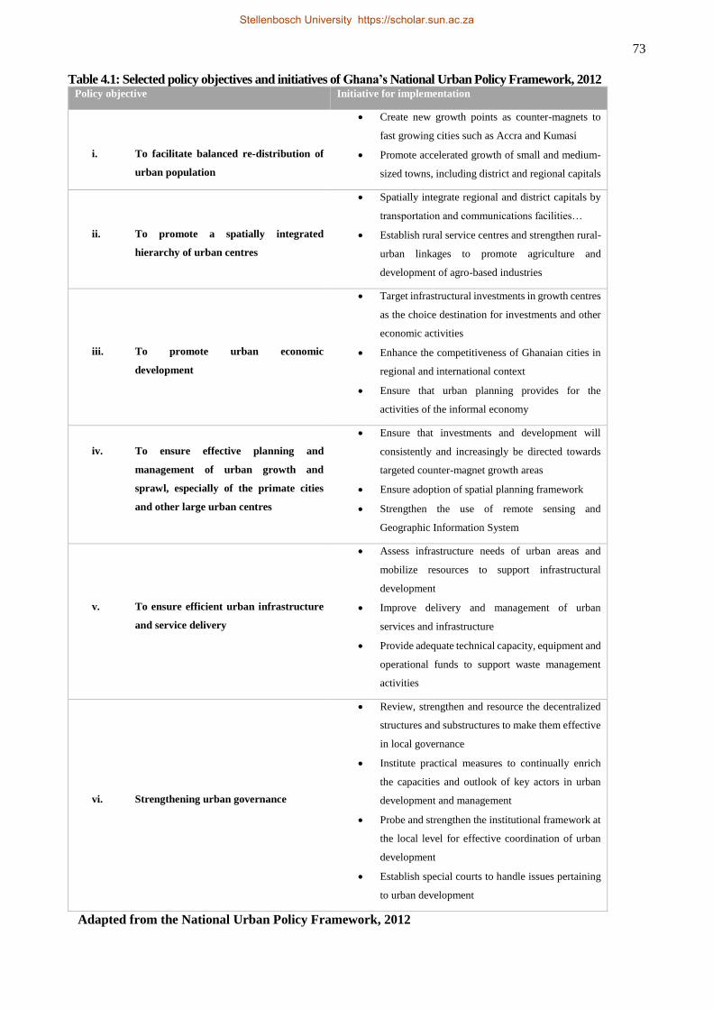
73
Table 4.1: Selected policy objectives and initiatives of Ghana’s National Urban Policy Framework, 2012 Policy objective Initiative for implementation
i. To facilitate balanced re-distribution of
urban population
Create new growth points as counter-magnets to
fast growing cities such as Accra and Kumasi
Promote accelerated growth of small and medium-
sized towns, including district and regional capitals
ii. To promote a spatially integrated
hierarchy of urban centres
Spatially integrate regional and district capitals by
transportation and communications facilities…
Establish rural service centres and strengthen rural-
urban linkages to promote agriculture and
development of agro-based industries
iii. To promote urban economic
development
Target infrastructural investments in growth centres
as the choice destination for investments and other
economic activities
Enhance the competitiveness of Ghanaian cities in
regional and international context
Ensure that urban planning provides for the
activities of the informal economy
iv. To ensure effective planning and
management of urban growth and
sprawl, especially of the primate cities
and other large urban centres
Ensure that investments and development will
consistently and increasingly be directed towards
targeted counter-magnet growth areas
Ensure adoption of spatial planning framework
Strengthen the use of remote sensing and
Geographic Information System
v. To ensure efficient urban infrastructure
and service delivery
Assess infrastructure needs of urban areas and
mobilize resources to support infrastructural
development
Improve delivery and management of urban
services and infrastructure
Provide adequate technical capacity, equipment and
operational funds to support waste management
activities
vi. Strengthening urban governance
Review, strengthen and resource the decentralized
structures and substructures to make them effective
in local governance
Institute practical measures to continually enrich
the capacities and outlook of key actors in urban
development and management
Probe and strengthen the institutional framework at
the local level for effective coordination of urban
development
Establish special courts to handle issues pertaining
to urban development
Adapted from the National Urban Policy Framework, 2012
Stellenbosch University https://scholar.sun.ac.za
74
would enhance the implementation and monitoring of plans, and thereby ease the logistical and technological
constraints that face contemporary planning.
It appears a way out for the NUPF to avoid the pitfalls suffered by Act 462 is to take Obeng-Odoom's (2013)
DED framework seriously. To this end, the proposal to “deepen the decentralisation programme” by promoting
active and participatory decision making involving diverse stakeholders across the local community, religious
groups, development partners and non-state actors (Government of Ghana, 2012 p. 4) should be taken
seriously. The intent to promote local urban economic development and the informal sector, to widen sources
of funding for urban development, and to improve efficiency in urban financial management (Government of
Ghana, 2012) may go a long way to promote entrepreneurial urban governance as postulated by the DED.
While laudable, the above propositions need to be complemented by democratic tenets such as accountability
and transparency if the NUPF is to make a real impact.
4.5.2 Land Use and Spatial Planning Bill (LUSPB)
This Bill emerged from recommendations of the Land Use Planning and Management Project (LUPMP)
implemented in Ghana as part of the broader Land Administration Project (LAP). It is a shared-vision proposal
by the MLGRD and the TCPD (the latter being a decentralised department in the former but seeking autonomy
in the form of an ‘Authority’ in the LUSPB). The Bill seeks to restructure and reorient land-use planning to a
more integrated system built upon sustainable development principles. This reflects the growing efforts to
entrench sustainability principles into land-use planning. On the African continent, South Africa has taken the
lead in this regard by promoting urban governance and planning based on its Spatial Development Framework
(SDF) (City of Cape Town, 2012; Republic of South Africa, 2013; Chobokoane & Horn, 2014; Kruger, 2014).
The goal of the LUSPB is:
to harmonize and regulate the laws on land use and planning, provide for sustainable
development of land and human settlements through a decentralized planning system,
ensure judicious use of land in order to improve quality of life, promote health, safety and
regulate national, regional, district and local spatial planning, and generally deal with spatial
aspects of socio-economic development as well as provide for related matters (Town and
Country Planning Department, 2011, p 10).
To achieve this goal, the Bill first and foremost seeks an establishment of a corporate body to be known as
Land Use and Spatial Planning Authority (LUSPA) to implement the provisions therein. The institutional
incongruence observed earlier is to be addressed by ensuring that the Minister of Environment, Science and
Technology exercises an oversight responsibility over the activities of the authority. It also proposes that the
CAP 84 be repealed in its entirety while sections of Act 462 dealing with planning functions of the MMDAs
be amended to give more planning power to the LUSPA. Likewise, Acts 479 and 480 of the NDPC are proposed
to be amended to include spatial planning in development planning. To overcome the problems of inadequate
finances, the bill proposes a fund for the LUSPA. Proposed sources of funding include subsidy from the state
Stellenbosch University https://scholar.sun.ac.za
75
as approved by parliament, fees and levies from its own activities, gifts and grants. Secured sources of funding
for its activities is one of the surest ways for the LUSPA to make an impact as financial challenges have been
the bane of effective planning in Ghana.
The thrust of the Bill is to pursue planning based on an SDF at the national, regional and district levels. The
SDF is prepared based on strategic identification and zoning of land uses considered relevant for the spatial,
economic, social and environmental wellbeing of the nation, region, or district. The new planning system, when
passed, would be implemented along a three-tier planning system starting from the SDF, Structure Plan (SP)
to Local Plan (LP). By this structure, the NUPF in its integrated form is expected to be subsumed into the
SDFs/IDPs for harmonisation in line with the latter’s vision, goals and aims. This, however, is not to suggest
an inferior-superior relationship between the NUPF and the SDFs/IDPs but to emphasise the scale at which
each operates.
The SDFs at the national, regional and district levels will be long-term plans spanning 20 years and could be
revised afterwards or at an earlier date if the Minister in charge makes recommendation to that effect. The SP
and LP are also long-term propositions but with a validity period of 15 years and can be revised similarly.
Among its functions, the LUSPA envisages collaboration with other relevant agencies and institutions such as
the MMDAs, EPA and other line agencies in land sector management. In particular, co-opting the provisions
of the NUPF would enhance this collaboration for improved spatial planning and urban governance. The goal
of this collaboration is to execute spatial planning and sustainable management of settlements in line with the
provisions of Acts 479 and 480 that established the NDPC.
The goal and roadmap of the LUSPB presents the best possible framework yet for land use and spatial planning
in Ghana. Its comprehensive yet broad scope – encompassing the economic and social as well as environmental
issues – together with the proposal to establish an authority and make it financially viable will in no small way
enhance the practice of planning in the country. Inadequate resourcing, specifically, has been identified by
planners as contributing to traditional land owners manipulating the planning process to their personal
advantage. This is because the TCPD barely has enough finances to do independent planning as required of it
by law. Thus, it invariably relies on financing by the land owners to plan, and unless they uphold high
professional ethics, planners would find it difficult to ward off any advances by land owners to manipulate the
process to their advantage. A further improvement is in the area of holistic planning for sustainable
development. To date, planning in Ghana has been done at the local level with a focus on urban land-use forms
and infrastructural development. Little attention has been given to broader issues of livelihoods, and this creates
livelihood stress and uncertainty particularly in peri-urban areas where competition for space is greatest
(Satterthwaite, 2007; Gyasi et al., 2014b).
Before talk of implementation can begin, a rather immeasurable divide lies between proponents of the bill and
those who will make it become law, the legislators. Information gathered in this study reveals that the bill was
Stellenbosch University https://scholar.sun.ac.za
76
submitted to cabinet and/or parliament, in revised form in 2011. Yet, there is no sign of it receiving
parliamentary consideration and approval any time soon12. However, planners who participated in this study in
the last quarter of 2013 were hopeful that the bill would be passed into law in that quarter or in the first half of
2014. As it stands, 2015 would be the most likely year for the bill to get parliamentary attention. In the
meantime, proponents would have to continue lobbying and advocating for the bill to get parliamentary
consideration, and finally presidential assent.
4.6 DISCUSSION AND LESSONS LEARNT
The above presentation on the temporal dynamics of spatial planning in the socio-economic trajectories of
Ghana reveals very low planning successes. On the one hand, the execution of planning in pre-independence
Ghana was deemed ‘successful’ due to its limited scope and strict enforcement regime. On the other hand,
planning after independence has been characterised by poor results on account of its broad scope, high
population and urbanisation rates, weak governance and control regime, inadequate resource allocation (both
human and financial), and the intervening globalisation forces that distort local socio-economic systems (e.g.
traditional land tenure is impacted by the developing land markets). The above contrasting outcomes make it
somewhat difficult to analyse the Ghanaian spatial planning practices within the sustainable development
framework. For example, while colonial planning was not predisposed to sustainable development due to its
limited scope, and lack of economic, social and spatial equity, post-independence planning has failed in its
own terms to try and achieve the said equity principle in sustainable development by adopting a broad-based
planning regime that sought for economic, social and spatial equity. Post-independence planning even went
further to adopt a decentralised, market-oriented, collaborative and participatory planning regime to confront
the ever evolving planning challenges. Conceptually, the ‘new’ planning regime resonated with the DED
framework proposed by Obeng-Odoom for successful planning and urban governance.
Yet, the ‘new’ planning regime could not magically improve planning outcomes in keeping with sustainable
development principles: the development of slums, mounting waste management challenges, land-use disorder
and uncontrolled urban sprawl, inadequate infrastructure, poor service delivery, and livelihoods insecurity
among others attest to this conclusion. Perhaps, the ‘right ingredients’ needed for the successful working of
the DED were not present in their right proportions. Unfortunately, the answer to the question of ‘how spatial
planning responds to the rapid urbanisation, increased land-use competition, and national and international
demand for sustainable development’ is, ‘not very good’. And yet again, an improvement in the contemporary
planning framework is being done in the form of the first ever NUPF and the draft LUSPB. The proposed
vision, goals and initiatives look plausible for improving contemporary planning successes in Ghana. This
‘new’ development, therefore, answers the question of ‘whether or not different planning approaches are
12 At the time of writing, the website of Ghanaian parliament showed no trace of the LUSPB among the pending bills for
parliamentary consideration.
Stellenbosch University https://scholar.sun.ac.za
77
needed to promote Ghana’s socio-economic development in a sustainable way’. In particular, the proposal to
make SDFs/IDPs integral to planning may do the trick.
A few lessons can be learnt from the above review. First, limited spatial planning (as seen during pre-
independence times) compromises on economic, social and spatial equity in development; whereas broad-
based planning intent (as seen in the post-independence era) without the necessary human and financial
resources as well as effective regulatory framework is as bad. Thus, a good and successfully executed plan
would be one that is broad enough to integrate the economic, social and environmental issues of a society, and
is supported by adequate regulatory, and human and financial resources. Such a plan should also be
underpinned by a long-term vision grounded in proper needs assessment and forecasting. Second, stable
political environment and continuity in national policy are good ingredients for successful planning and
execution. For instance, there was a planning vacuum during the World War 2 and the intervening military
regimes in Ghana’s political history. In other words, an unstable political and policy environment could be
blamed for the piece-meal nature of planning in Ghana. Three, it seems power imbalances (not to be interpreted
as equal) could partly explain the limited success of the decentralised planning system in contemporary times.
For the DED framework to work, not only should there be diverse representation of stakeholders in decision
making but more importantly power relations among stakeholders should not limit broad participation. In other
words, stakeholder participation should be proportional to representation. Four, weak institutional
collaboration also hampers successful planning. Mutual trust rather than ‘mutual distrust’ among decentralised
planning agencies and institutions could impact positively on planning than we witness presently.
4.7 CONCLUSION
Spatial planning has been integral to the socio-economic and political history of Ghana. However, its impact
on achieving sustainable development is very limited. Colonial planning had a limited scope but was executed
‘successfully’ due to comparatively lower urban growth and strict enforcement regimes. Its outcome, however,
was imbalanced spatial development which still persists in the Country. In contrast, post-independence
governments have attempted pursuing broad-based planning to not only bridge the unbalanced spatial
development but also to propel broad-based development in Ghana. However, unlike colonial planning, high
urban growth, weak development enforcement regime, complex land tenure systems, and a host of other factors
have interacted to impede the successful implementation of post-independence planning. Thus, Ghanaian
towns and cities are plagued with a plethora of planning challenges including the development of slums,
mounting waste management challenges, land-use disorder and uncontrolled urban sprawl, inadequate
infrastructure, poor service delivery, and livelihoods insecurity among others. This implies that planning in
Ghana has not been responsive enough to managing urbanisation and related matters in the spirit of sustainable
development.
Stellenbosch University https://scholar.sun.ac.za
78
There is some positive outlook, though, as renewed efforts are made to reposition planning for comprehensive
socio-economic development as well as environmental sustainability. These – the NUPF and the LUSPB –
envision integrated planning based on sound sustainable development principles. The ‘catchy’ strategy in these
renewed efforts is planning based on the SDFs and the IDPs. While the SDFs seek holistic planning within
certain geography scales – national, regional and district levels - the IDPs seek to effectively integrate
economic, social, cultural and environmental issues for accelerated development at some of the geographic
scales (most commonly at the district level). The LUSPB promises to be the most relevant planning framework
yet for the Country, especially in this era of global and national concerns for sustainable development,
improving urban governance, fighting increasing urban poverty, vulnerability, deprivation and environmental
degradation. It should therefore be supported. To this end, harmonising the NUPF with the provisions of the
LUSPB is highly encouraged to promote efficiency and capacity building of institutions and staff. Present and
future needs assessment should form the backbone of planning in order to promote judicious use of the
environmental and natural resources such as land. There is also the need to rethink the essence of decentralised
local government by building stakeholder capacity for effective participation in decision making as well as
delinking overly parochial political interests of individuals and groups from those of societal interests to allow
development programmes to progress uninhibited. The next chapter presents a characterisation of urban growth
dynamics in Tamale with focus on urban governance response in infrastructure and service provision.
Stellenbosch University https://scholar.sun.ac.za
79
CHAPTER 5 CHARACTERISING URBAN GROWTH IN TAMALE:
ANALYSIS OF URBAN GOVERNANCE RESPONSE IN
INFRASTRUCTURE AND SERVICE PROVISION13
ABSTRACT
Urban governance challenges are pervasive in African urbanisation processes, and these challenges require an
understanding of peculiar cases for action. This study sought to characterise urban growth dynamics of Tamale,
Ghana, and to analyse urban governance response to the growth dynamics in terms of urban infrastructure and
service delivery. Remote sensing approach was employed alongside qualitative interviews and secondary data
sources to achieve the objectives. The spatial analysis showed that the city’s built-up area grew by 76.5%
between 2001 and 2014 with an annual growth rate of 4.4% which translated to an aerial increases of 99
hectares per year. Increasing human and vehicular populations added complexities to the growth experiences
of the city, and collectively exact a high demand for basic infrastructure and services. We found that the
metropolis’ population had better access to water and electricity but access to waste disposal – both liquid and
solid – and toilet facilities leaves much to be desired. It is argued that urban governance has been
underwhelming in responding adequately to basic urban services, and that the state of affairs is a recipe for
poor development outcomes such as low economic performance, negative public health and environmental
outcomes, urban insecurity and a drawback on the successful implementation of Ghana’s Urban Policy
Framework. It is recommended that local-government authorities in the metropolis devise and implement
innovative measures through inclusive and participatory approaches in order to promote sustainable
management of the city’s growth.
5.1 INTRODUCTION
In the 21st Century, urban growth and associated demographic dynamics are forecast to present serious
challenges to sustainable urban development among cities in developing country, especially those in Africa
(UN-Habitat, 2014). The perceived challenges stem from multiple factors including generally weak
institutional capacity in those countries to manage the unfolding growth, and ineffective urban planning
systems that have failed to deliver sustainable urban development over the years (UN-Habitat, 2009a, 2010).
These forecasts and analyses are often done by taking a generalised view of countries in a category (e.g.
developing countries, Africa) for the sake of simplicity and perhaps due to inadequate resources, including
time, human and finances. Thus, the generalised characterisations do not necessarily provide concrete evidence
13 Submitted to Habitat International (ID: HABITATINT_2015_283) as Fuseini, I and Kemp, J. Characterising
urban growth in Tamale, Ghana: An analysis of urban governance response in infrastructure and service
provision. Decision regarding the peer review process has been taken (positive) and the author is at an
advanced stage doing revision in line with the reviewers’ comments. The conceptualisation and writing
were the responsibility of the author of this dissertation. The co-author, my supervisor, contributed through
editing and the provision of general guidelines towards improving the manuscript.
Stellenbosch University https://scholar.sun.ac.za
80
for micro-level solutions. In a foreword to the UN-Habitat’s ‘State of African Cities Report (2014)’ Joan Clos
(Executive Director, UN-Habitat) concedes the limitation of the generalised analysis and the impracticability
of a one-size-fits-all solution when he notes that “cities are simply too individual and specific in their needs
and vulnerabilities for standardised solutions” (UN-Habitat, 2014 p 3). Thus, research that targets country- and
city-specific peculiarities in terms of growth dynamics, challenges and opportunities enhances our appreciation
of the issues and the efforts needed for addressing them.
Two facts are clear about discussion of urbanisation in African cities: one, that the continent’s population is
growing, and urbanisation is accelerating (Cohen, 2004, 2006; Angel et al., 2005, 2011; UN-Habitat, 2009a)
even though we are advised to be cautious in discussing the magnitude of growth (Cohen, 2004; Potts, 2012a,b;
UN-Habitat, 2014); second, urban governance in the continent’s towns and cities leaves much to be desired
(UN-Habitat, 2009a, 2010; Angel et al., 2011). Regarding the second, Achim Steiner, in a foreword to the UN-
Habitat’s ‘State of African cities report (2010)’ was categorical that “poor planning has remained the Achilles
heel of many towns, impeding both sustainable growth and healthy living environments for an increasing
population of urban dwellers across Africa” (UH-Habitat, 2010 p. iii). Steiner’s statement finds expression in
the prevalence of urban poverty and inequalities, infrastructure and service deficits, poor environmental
management, urban food insecurity, sprawl and the generally weak institutional frameworks for achieving
sustainable urban development (Cohen, 2006; Cohen & Garrett, 2009; UN-Habitat, 2009a, 2012, 2014; Angel
et al., 2011; Ghanaweb, 2015).
Despite the aforementioned challenges, urbanisation has made a positive impact on the continent’s
development contrary to earlier views regarding the relationship between the two (see Njoh 2003; Obeng-
Odoom 2010; Potts 2012a). Emerging from its worst economic crisis in the 1980s and 1990s, Africa has
recorded impressive Gross Domestic Product (GDP) growth rates in the first decade of the 21st Century with
a growing middle class population that stood at 355 million in 2010 and is projected to reach 1.1 billion people
in 2060 (UN-Habitat, 2014). Urbanisation has been instrumental in this economic transition with the
continent’s urban population producing about 80% of its GDP (UN-Habitat, 2010). Even the World Bank
(2015) (with previously sceptical view about the development impact of urbanisation in Africa), in a recent
report of urbanisation in Ghana, remarked that:
Rapid urbanization in Ghana over the past three decades has coincided with rapid GDP growth,
helping create jobs, increase human capital, decrease poverty, and expand opportunities and
improve living conditions for millions of Ghanaians. … From 1984 to 2013 [the country’s
GDP] averaged 5.7 percent annually, and from 2005 to 2013 GDP growth averaged 7.8 percent.
… The recovery of the national economy from 1984 onwards and perceived improvements in
urban economic opportunities have made cities attractive to migrants. Mass urban migration
took place without generating excessive unemployment, implying that migrants moved for jobs
rather than “benefits shopping.” Even with rapid influx of urban migrants, the urban
unemployment rate fell 1.5 percentage points over 2000–10 (The World Bank, 2015 pp. 1-3).
The issues with urbanisation processes in Africa are also true for Ghana, and the above quote from The World
Bank report summarises the associated economic transformations. Ghana has transitioned from a
Stellenbosch University https://scholar.sun.ac.za
81
predominantly rural population at independence in 1957 to predominantly urban presently (Ghana Statistical
Service, 2013a). The country’s urban population more than tripled between 1984 and 2013 from about 4
million to 14 million people with annual growth rate of 4.4% (The World Bank, 2015). The country is ranked
as one of 4 and one of 21 countries with more urban than rural population in West Africa and in Africa,
respectively (Obeng-Odoom, 2013). Between 1985 and 2000, its capital, Accra, grew in population by 50
percent while its built-up area grew by 153 percent (Angel et al., 2011). Similar growth patterns have been
recorded in other towns and cities such as Kumasi and Tamale. Since its emergence as the third largest urban
centre in Ghana after Accra and Kumasi in the 1984 census (Songsore, 2009), Tamale has witnessed rapid and
sustained growth. The city’s metropolitan area recorded a 116 percent population growth between 1984 and
2000 (Ghana Statistical Service, 2005) and presently has 73.8% urban population against the regional average
of 30.3% (Ghana Statistical Service, 2005, 2013b). Yet, Ghana’s urbanisation has been associated with
challenges including poor service delivery, a gaping housing deficit, inadequate infrastructure, unsanitary
conditions, unregulated/sprawl spatial development that stems from ineffective planning regime, threats of
food insecurity and poverty (Yeboah & Obeng-Odoom, 2010; Adarkwa, 2012; Boamah et al., 2012;
Government of Ghana, 2012; Obeng-Odoom, 2013; Yeboah et al., 2013; Baffour Awuah & Hammond, 2014;
Gyasi et al., 2014a,b; Ghanaweb, 2015). These challenges, if not well managed, could cause “grave danger”
for national development (The World Bank, 2015 p. 1).
It is from the above that this paper seeks a nuanced analysis of urban growth dynamics in Tamale with the
view to assessing urban governance response to tackling some of these challenges. As the challenges span a
wide spectrum, our analysis will focus on road infrastructure provision and service delivery including water,
electricity as well as sanitary and waste disposal facilities and infrastructure. These are critical for the
sustainable transformation of the economic, social and environmental aspects of the city’s growth in line with
Ghana’s urban policy framework.
5.2 METHODOLOGY
Under section 5.2.1, an overview of the study area is given followed by the description of data sources and
analysis.
5.2.1 Study area
The study was done within Tamale Metropolitan Area (TAMA) (Figure 3.1) which, for the purpose of this
research, includes two local-government administrative units – the Tamale Metropolitan Assembly (TaMA)
and the Sagnarigu District Assembly (SDA). The TaMA and the SDA are two of 26 local-government
administrative units within Northern Region of Ghana. The SDA was carved out of the TaMA in 2012 in
accordance with Ghana’s local-government law (Republic of Ghana, 1993). Due to its young “age”, the SDA
is still connected to the TaMA in many ways and their demographic, cultural, economic and administrative
structures are virtually identical. They were therefore considered as a unit for this study.
Stellenbosch University https://scholar.sun.ac.za
82
The study area is located within latitudes 9o16’N and 9o34’N and longitudes 0o34’W and 0o57’W. It covers a
total area of approximately 922 km2 with an average elevation of 180m above sea level (Tamale Metropolitan
Assembly, 2010). It has a generally rolling topography with few isolated hills but these do not inhibit physical
development. In other words, there is neither rugged terrain nor large inland water/wetland areas that pose
significant challenges to physical development. However, the few seasonal streams that drain the area can pose
threats of flooding to some parts of the metropolis especially in the eastern part which is relatively low-lying.
The flat topography plays an important role in the spatial growth of the city.
5.2.2 Data and methods
This section presents data sources and analysis. It is divided into two sub-sections; description of the data and
the analysis of the data.
5.2.2.1 Data
Data for the study was obtained from satellite imagery, interviews and secondary sources. The satellite imagery
data comprised two datasets from two different satellite missions. The first was a 28 September 2001 IKONOS
image procured from DigitalGlobe whilst the other set was an 11 January 2014 RapidEye imagery that the
European Space Agency (ESA) supplied under its Third Party Mission (TPM) data access programme. The
13-year analysis period was informed by a paucity of data as very high resolution satellite imagery (a
requirement for the study) did not exist prior to the Year 2000. Our analysis of spatial trends is also built on
previous studies (Braimoh & Vlek, 2004; Fuseini, 2014). The satellite image data were used to map and analyse
the spatial growth of the city as well as the provision of road infrastructure.
Interviews were conducted among identified stakeholders in spatial planning. Given that the sample frame of
the stakeholders in spatial planning was very limited (not ubiquitously distributed), a purposive sampling
technique was employed to select respondents. Subsequently, a total of 15 respondents were selected and
interviewed. Respondents were selected from the Town and Country Planning Department (TCPD) (2), Lands
Commission (1), Survey Department (1), Customary Land Secretariat (CLA) (1), TaMA/SDA (3),
Environmental Protection Agency (EPA) (1), Department of Urban Roads (DUR) (1), Ghana Water Company
Limited (GWCL) (1) and Assembly Members (4). Information sought in the interviews included respondents’
roles in spatial planning, their views about the effectiveness of planning in the metropolis and emerging issues.
Secondary data from national statistics and published literature were also used. These included population
figures and access to basic services from Ghana Statistical Service’s (GSS) various census reports and other
published literature, car and motorcycle registration data from the Driver and Vehicle Licensing Authority
(DVLA) and road condition information from the DUR.
Stellenbosch University https://scholar.sun.ac.za
83
5.2.2.2 Image analysis
This section presents the procedure for image data treatment through pre-processing, training data selection,
image classification, accuracy assessment and road networks extraction techniques.
5.2.2.2.1 Data pre-processing
The IKONOS imagery was delivered as standard geometrically corrected product, which was atmospherically
corrected to surface reflectance values using the ATCOR2 algorithm. The dataset consists of a 4-band (red,
blue, green and near infrared) multispectral image with 3.2 m resolution, and a panchromatic band at 0.8 m
resolution. The multispectral image was pansharpened with the panchromatic band to obtain an overall
resolution of 0.8 m. The PCI Geomatica (Version 2014.0.) software was used for both the atmospheric
correction and pansharpening exercises. The image had an extent of 14788 x 12952 pixels (11.8 km x 10.4 km
[a 122.7 km2 subset of the total Metropolis’ total area of 922 km2]), which constituted the full extent of the
study. This was sufficient to cover the greater extent of the Metropolis’ built up area within which the analysis
of the trends of spatial growth dynamics was done.
Similarly, the RapidEye dataset was delivered as a Level 3A orthorectified product that represents the highest
processing standard among the mission’s products (RapidEye, 2012). The Level 3A product is both
geometrically and radiometrically corrected. The RapidEye imagery was clipped to the same extent of the
IKONOS imagery using ESRI’s ArcMap software (Version 10.0). Atmospheric correction to ground
reflectance values was performed on the clipped image. The image had 5 bands (blue, green, red, red edge and
near infrared) at 5 m spatial resolution.
The qualitative data from the interviews wereas processed using the ATLAS.ti qualitative data analysis
software. A quasi inductive coding approach was employed whereby coding was done such that meaning
emerged from the data rather than ordering along predetermined themes.
5.2.2.2.2 Image Classification
Satellite image classification is the process of assigning each pixel or zone in an image to a predetermined land
cover or land use class (Campbell & Wynne, 2011). While this was traditionally done on a per-pixel basis, the
availability of very high resolution imagery prompted a shift towards a technique called Geographic Object
Based Image Analysis (GEOBIA). This technique first performs image segmentation, which groups pixels into
homogenous zones or features (known as objects), before performing classification of the objects (Blaschke,
2010). GEOBIA has been found to yield better classification results for high-resolution imagery than the
traditional pixel-based image analysis, hence its increasing popularity (Zhou & Troy, 2008; Blaschke, 2010;
Myint et al., 2011; Addink et al., 2012; Myburgh & Van Niekerk, 2013; Blaschke et al., 2014).
Stellenbosch University https://scholar.sun.ac.za

84
A multiresolution segmentation (MRS) algorithm implemented in the eCognition Developer (Version 9)
software was applied to both the images. An MRS scale parameter of 3 and 60 were considered appropriate
for the IKONOS and RapidEye images, respectively. This parameter determines the size of the image objects
by setting the maximum intra-object variability of brightness values. The chosen scale parameters yielded
objects that were slightly over-segmented, ensuring no inclusion of different real-world features into the same object.
Support Vector Machine (SVM) supervised classifier was applied to both the 2001 and 2014 images. The
choice of the SVM was based on its superior performance compared with other supervised classifiers (Tzotsos
& Argialas, 2008; Myburgh & van Niekerk, 2014). A 5-class classification scheme (Built up, Bare ground,
Water, Vegetation_Trees and Vegetation_Grass) was developed based on which training sites were selected
for the classification. A total of 400 and 398 training samples were used for the supervised classification for
2001 and 2014. The collection of sample data was stratified to allow more samples in classes with larger areal
coverage and vice versa. Therefore, the number of training samples per class ranged from 200 (Built up) to 15
(Water) depending on intra-class feature spectral variations and areal coverage on the image. Based on the
stratification strategy, 391 and 414 samples of reference points for accuracy assessment were selected for 2001
and 2014. All of the samples for training and accuracy assessment for the 2001 image were based on desktop
selection from the 0.8m resolution pansharpened multi-spectral image since no other source existed for the
purpose. Samples for the 2014 image, however, were collected through a combination of fieldwork generated
GPS point data and desktop selection from the image.
To determine the state of road infrastructure in the metropolis, a binary classification scheme was employed
to classify roads into tarred and untarred. Consequently, all roads in the images were digitised to determine the
extent of paved and untarred road networks in 2001 and 2014. The output of the exercise was two road network
maps showing the distribution of the state of roads within the study area.
The classification produced overall accuracies of 87% and 90.3%, and kappa values of 0.87 and 0.86
respectively for the 2001 and 2014 images.
5.3 RESULTS AND DISCUSSION
The results of the chapter are presented in this section. First, an analysis of the city’s spatial growth dynamics
is presented in subsection 5.3.1, and that is followed, in subsection 5.3.2, by presentation of demographic
trends, vehicular and motorcycle numbers as further growth indicators that add pressure to sustainable
management of the city’s growth. Urban governance response to the growth dynamics and associated pressures
is presented in sub-section 5.3.3, and that is further sub-divided into three sections with specific treatments on
road infrastructure provision, access to water and electricity, and waste disposal.
Stellenbosch University https://scholar.sun.ac.za
85
5.3.1 Analysis of spatial growth dynamics
The results of the spatial growth dynamics of the city are presented in Error! Reference source not found..
Of interest to this study was the analysis of the built-up area. Therefore, we showed the built-up area by
juxtaposing its areal coverage for 2001 and 2014 (Error! Reference source not found.) to the exclusion of
the other land cover classes that guided the classification. The results clearly show significant growth of the
city’s urban land cover in terms of expansion in the peri-urban areas and in-fill development within the
urbanised areas of 2001. This shows that competition for space in the study area is essentially between urban
uses and non-urban uses. General patterns of growth show that the city experienced a radial expansion over
the 13-year period. This is a departure from the historical growth pattern that had aligned the major roads
traversing the city (Fuseini, 2014). The radial growth pattern reflects the absence of physical features like
rugged terrain and wetlands that affect spatial development. It also shows strong growth dynamics that
somehow defy historical evidence whereby developers considered accessibility to major road a major factor
in physical development in the Metropolis.
To do a comprehensive analysis of patterns of growth, the classified map was divided into eight sections –
North, North-East, North-West, East, South, South-East, South-West, and Central ( Figure 5.2). These sub-
divisions were conveniently done along the major arterial roads that have served as catalysts of growth in the
city’s growth experiences (Fuseini, 2014) while the central business district (CBD) – where more of the arterial
roads converge – constituted the Central segment. Statistics on the built-up area were then computed for each
segment with the aim to comparing growth over the 13-year period under consideration. The results in the
figure show that the north-west segment recorded highest growth of over 450 ha in 2014 compared to less than
200 ha in 2001. This growth translates to 158% increase over the 13-year period ( Figure 5.2). The north-east
segment recorded the second highest areal coverage in built-up in 2014, however, the southern segment
recorded the second highest rate of increase after the north-western segment. Interestingly, the areal coverage
of the built-up in the city central segment declined by 5% in 2014 in spite of discernible in-fill development in
that segment. Even though low growth was expected within the central segment, least was expected of a
decline. The reason for the decline is not readily available. Nonetheless, it is speculated that the levelling of a
veteran village located within the southern end of the city centre in the latter part of 2013 contributed to the
decline. The patterns of growth in the northern, north-eastern and north-western segments are largely explained
by political economy decisions of government that precipitated growth there from the early 1990s (Fuseini,
2014). By this growth the northern, northwestern and western parts of the metropolis have encroached on the
Savelugu-Nanton, Kumbungu and Tolon districts respectively (Farvacque-Vitkovic et al., 2008) whilst the
southern and southwestern parts are fast approaching the East and Central Gonja districts. Growth in the south-
western segment owes much to the relocation of the Tamale campus of the University for Development Studies
(UDS) about 15 km south of the city. The relocation attracted interest in real estate developers who want to
take advantage of the high demand on student accommodation.
Stellenbosch University https://scholar.sun.ac.za
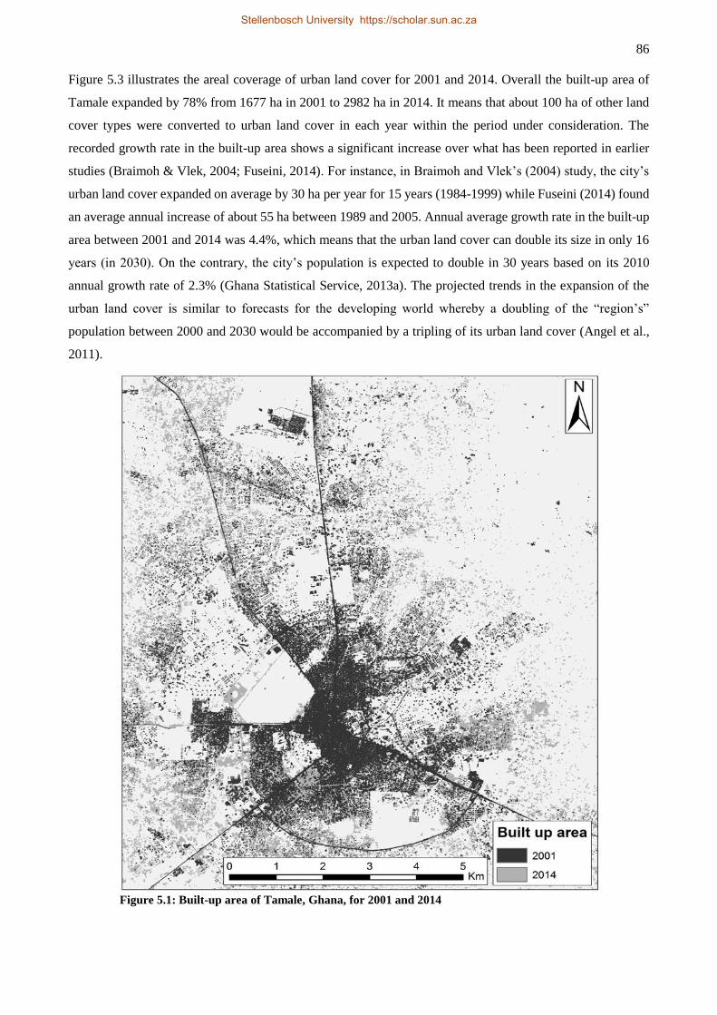
86
Figure 5.3 illustrates the areal coverage of urban land cover for 2001 and 2014. Overall the built-up area of
Tamale expanded by 78% from 1677 ha in 2001 to 2982 ha in 2014. It means that about 100 ha of other land
cover types were converted to urban land cover in each year within the period under consideration. The
recorded growth rate in the built-up area shows a significant increase over what has been reported in earlier
studies (Braimoh & Vlek, 2004; Fuseini, 2014). For instance, in Braimoh and Vlek’s (2004) study, the city’s
urban land cover expanded on average by 30 ha per year for 15 years (1984-1999) while Fuseini (2014) found
an average annual increase of about 55 ha between 1989 and 2005. Annual average growth rate in the built-up
area between 2001 and 2014 was 4.4%, which means that the urban land cover can double its size in only 16
years (in 2030). On the contrary, the city’s population is expected to double in 30 years based on its 2010
annual growth rate of 2.3% (Ghana Statistical Service, 2013a). The projected trends in the expansion of the
urban land cover is similar to forecasts for the developing world whereby a doubling of the “region’s”
population between 2000 and 2030 would be accompanied by a tripling of its urban land cover (Angel et al.,
2011).
Figure 5.1: Built-up area of Tamale, Ghana, for 2001 and 2014
Stellenbosch University https://scholar.sun.ac.za
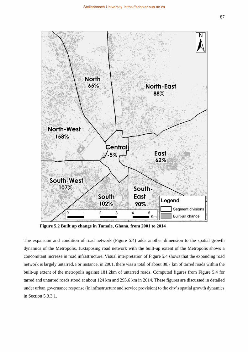
87
Figure 5.2 Built up change in Tamale, Ghana, from 2001 to 2014
The expansion and condition of road network (Figure 5.4) adds another dimension to the spatial growth
dynamics of the Metropolis. Juxtaposing road network with the built-up extent of the Metropolis shows a
concomitant increase in road infrastructure. Visual interpretation of Figure 5.4 shows that the expanding road
network is largely untarred. For instance, in 2001, there was a total of about 88.7 km of tarred roads within the
built-up extent of the metropolis against 181.2km of untarred roads. Computed figures from Figure 5.4 for
tarred and untarred roads stood at about 124 km and 293.6 km in 2014. These figures are discussed in detailed
under urban governance response (in infrastructure and service provision) to the city’s spatial growth dynamics
in Section 5.3.3.1.
Stellenbosch University https://scholar.sun.ac.za
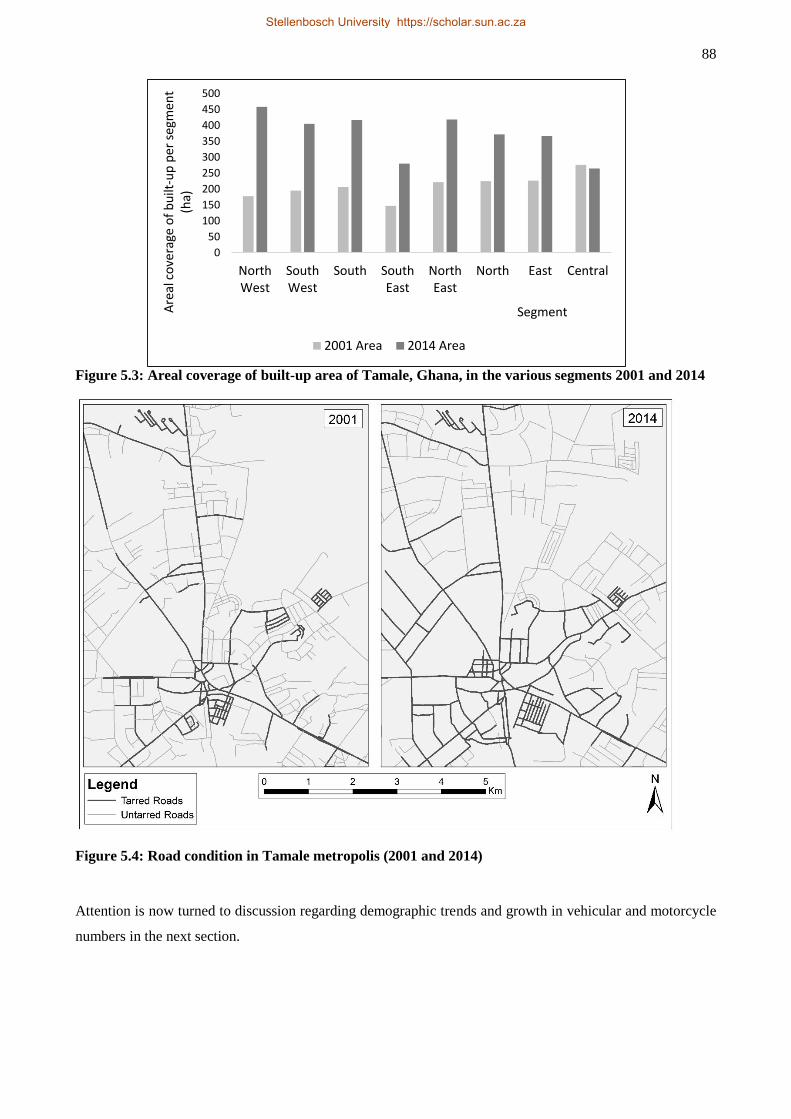
88
Figure 5.3: Areal coverage of built-up area of Tamale, Ghana, in the various segments 2001 and 2014
Figure 5.4: Road condition in Tamale metropolis (2001 and 2014)
Attention is now turned to discussion regarding demographic trends and growth in vehicular and motorcycle
numbers in the next section.
0
50
100
150
200
250
300
350
400
450
500
NorthWest
SouthWest
South SouthEast
NorthEast
North East Central
Are
al c
ove
rage
of
bu
ilt-u
p p
er s
egm
ent
(ha)
Segment
2001 Area 2014 Area
Stellenbosch University https://scholar.sun.ac.za
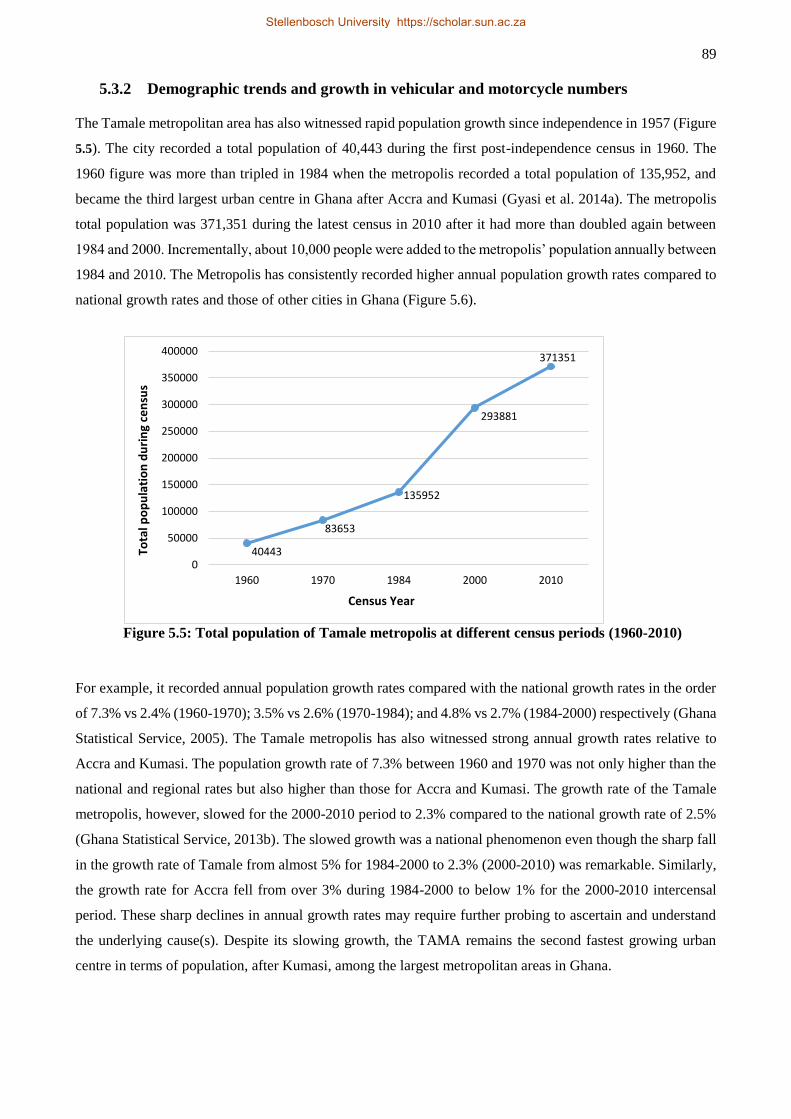
89
5.3.2 Demographic trends and growth in vehicular and motorcycle numbers
The Tamale metropolitan area has also witnessed rapid population growth since independence in 1957 (Figure
5.5). The city recorded a total population of 40,443 during the first post-independence census in 1960. The
1960 figure was more than tripled in 1984 when the metropolis recorded a total population of 135,952, and
became the third largest urban centre in Ghana after Accra and Kumasi (Gyasi et al. 2014a). The metropolis
total population was 371,351 during the latest census in 2010 after it had more than doubled again between
1984 and 2000. Incrementally, about 10,000 people were added to the metropolis’ population annually between
1984 and 2010. The Metropolis has consistently recorded higher annual population growth rates compared to
national growth rates and those of other cities in Ghana (Figure 5.6).
Figure 5.5: Total population of Tamale metropolis at different census periods (1960-2010)
For example, it recorded annual population growth rates compared with the national growth rates in the order
of 7.3% vs 2.4% (1960-1970); 3.5% vs 2.6% (1970-1984); and 4.8% vs 2.7% (1984-2000) respectively (Ghana
Statistical Service, 2005). The Tamale metropolis has also witnessed strong annual growth rates relative to
Accra and Kumasi. The population growth rate of 7.3% between 1960 and 1970 was not only higher than the
national and regional rates but also higher than those for Accra and Kumasi. The growth rate of the Tamale
metropolis, however, slowed for the 2000-2010 period to 2.3% compared to the national growth rate of 2.5%
(Ghana Statistical Service, 2013b). The slowed growth was a national phenomenon even though the sharp fall
in the growth rate of Tamale from almost 5% for 1984-2000 to 2.3% (2000-2010) was remarkable. Similarly,
the growth rate for Accra fell from over 3% during 1984-2000 to below 1% for the 2000-2010 intercensal
period. These sharp declines in annual growth rates may require further probing to ascertain and understand
the underlying cause(s). Despite its slowing growth, the TAMA remains the second fastest growing urban
centre in terms of population, after Kumasi, among the largest metropolitan areas in Ghana.
40443
83653
135952
293881
371351
0
50000
100000
150000
200000
250000
300000
350000
400000
1960 1970 1984 2000 2010
Tota
l po
pu
lati
on
du
rin
g ce
nsu
s
Census Year
Stellenbosch University https://scholar.sun.ac.za
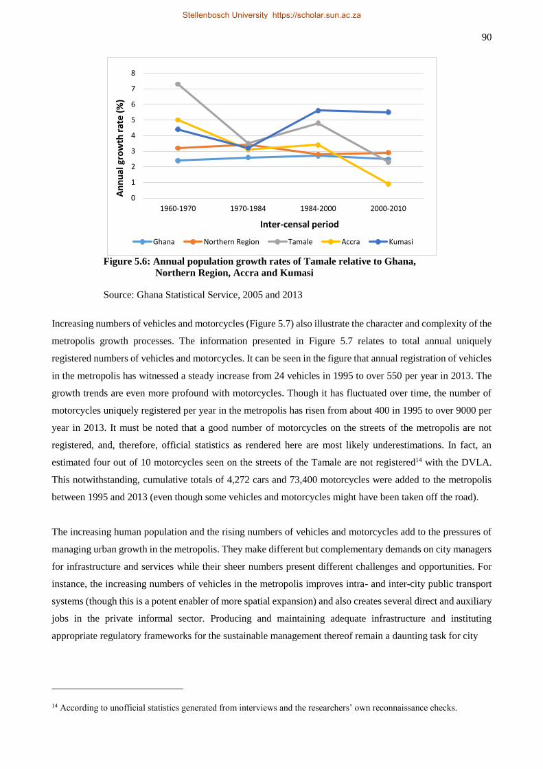
90
Figure 5.6: Annual population growth rates of Tamale relative to Ghana,
Northern Region, Accra and Kumasi
Source: Ghana Statistical Service, 2005 and 2013
Increasing numbers of vehicles and motorcycles (Figure 5.7) also illustrate the character and complexity of the
metropolis growth processes. The information presented in Figure 5.7 relates to total annual uniquely
registered numbers of vehicles and motorcycles. It can be seen in the figure that annual registration of vehicles
in the metropolis has witnessed a steady increase from 24 vehicles in 1995 to over 550 per year in 2013. The
growth trends are even more profound with motorcycles. Though it has fluctuated over time, the number of
motorcycles uniquely registered per year in the metropolis has risen from about 400 in 1995 to over 9000 per
year in 2013. It must be noted that a good number of motorcycles on the streets of the metropolis are not
registered, and, therefore, official statistics as rendered here are most likely underestimations. In fact, an
estimated four out of 10 motorcycles seen on the streets of the Tamale are not registered14 with the DVLA.
This notwithstanding, cumulative totals of 4,272 cars and 73,400 motorcycles were added to the metropolis
between 1995 and 2013 (even though some vehicles and motorcycles might have been taken off the road).
The increasing human population and the rising numbers of vehicles and motorcycles add to the pressures of
managing urban growth in the metropolis. They make different but complementary demands on city managers
for infrastructure and services while their sheer numbers present different challenges and opportunities. For
instance, the increasing numbers of vehicles in the metropolis improves intra- and inter-city public transport
systems (though this is a potent enabler of more spatial expansion) and also creates several direct and auxiliary
jobs in the private informal sector. Producing and maintaining adequate infrastructure and instituting
appropriate regulatory frameworks for the sustainable management thereof remain a daunting task for city
14 According to unofficial statistics generated from interviews and the researchers’ own reconnaissance checks.
0
1
2
3
4
5
6
7
8
1960-1970 1970-1984 1984-2000 2000-2010
An
nu
al g
row
th r
ate
(%
)
Inter-censal period
Ghana Northern Region Tamale Accra Kumasi
Stellenbosch University https://scholar.sun.ac.za
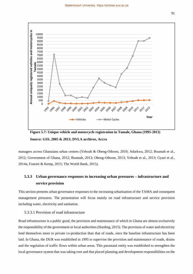
91
Figure 5.7: Unique vehicle and motorcycle registration in Tamale, Ghana (1995-2013)
Source: GSS, 2005 & 2013; DVLA archives, Accra
managers across Ghanaians urban centres (Yeboah & Obeng-Odoom, 2010; Adarkwa, 2012; Boamah et al.,
2012; Government of Ghana, 2012; Boamah, 2013; Obeng-Odoom, 2013; Yeboah et al., 2013; Gyasi et al.,
2014a; Fuseini & Kemp, 2015; The World Bank, 2015).
5.3.3 Urban governance responses to increasing urban pressures – infrastructure and
service provision
This section presents urban governance responses to the increasing urbanisation of the TAMA and consequent
management pressures. The presentation will focus mainly on road infrastructure and service provision
including water, electricity and sanitation.
5.3.3.1 Provision of road infrastructure
Road infrastructure is a public good, the provision and maintenance of which in Ghana are almost exclusively
the responsibility of the government or local authorities (Harding, 2015). The provision of water and electricity
lend themselves more to private co-production than that of roads, once the baseline infrastructure has been
laid. In Ghana, the DUR was established in 1995 to supervise the provision and maintenance of roads, drains
and the regulation of traffic flows within urban areas. This parastatal entity was established to strengthen the
local governance system that was taking root and that placed planning and development responsibilities on the
0500
100015002000250030003500400045005000550060006500700075008000850090009500
10000A
nn
ual
un
iqu
ely
re
gist
ere
d v
eh
icle
s an
d m
oto
rcyc
les
in
Tam
ale
YearVehicles Motor Cycles
Stellenbosch University https://scholar.sun.ac.za
92
local-government authorities (Republic of Ghana, 1993). Like the rest of Ghana, road networks play a crucial
role for the socio-economic development of Tamale as it accounts for about 97% of passenger traffic and 94%
of freight traffic (Adi, 2008). In this respect, good urban road networks will facilitate distribution of people,
goods and services, tourism development and emergency response services such as healthcare, security and
fire tendering. Thus, good urban road infrastructure has the potential to contribute to poverty reduction
(Harding, 2015). The preceding underlining needs for urban road infrastructure reflect the neoliberal
perspective of road development as a means to facilitating production and capital accumulation as well as
enhancing individual freedom through availability of alternatives for choice making (Obeng-Odoom, 2015a).
On the other hand, lack of good road infrastructure limits the benefits of economic expansion, capital
accumulation and individual economic choices as exemplified by Harding's (2015) description of yam rotting
in the farms of Northern Region of Ghana due to bad road network and the concomitant lack of transportation
to cart the produce to southern markets of Ghana. Road construction and maintenance also provide direct and
indirect employment opportunities leading to improvement in the income status of the citizenry who are
engaged one way or the other in the construction processes (Obeng-Odoom, 2015a,b). A strong case can be
made for road development in Tamale in that in 2010, wholesale/retail and hospitality-related activities that
are transportation dependent generated about 38% of all jobs in the TAMA, followed by other services at
about 25% (The World Bank, 2015). This means that efficient road infrastructure may have a chain of positive
impact on local economic development.
Yet, a poor road network is a characteristic feature of weak urban governance in Tamale. Figure 5.4 in Section
5.3.1 illustrates road conditions (tarred versus untarred) within the Tamale metropolis for 2001 and 2014. The
total of 88.7 km and 181.2 km of tarred and untarred roads in 2001, and 124 km and 293.6 km tarred and
untarred roads in 2014 (derived from section 5.3.1) were improvement over the stock of respective categories
in 1995. Records of the DUR indicate that there were 54.7 km and 185.7 km of tarred and untarred roads
respectively in 1995. However, the estimated stock of tarred and untarred roads derived from Figure 5.4 for
2014, seem to contrast sharply with data available at the DUR. For instance, the DUR’s records suggest
significant improvement in road conditions in the metropolis in 2011 with a total of 239.6 km of tarred and
224.4 km of untarred roads (an increases of 338% in tarred and 21% in untarred roads over the 1995 figures).
This points to an active provision of road infrastructure in the metropolis with more tarred roads added than
the untarred category. Nonetheless, comparing the results of this study and the figures obtainable from the
DUR show a less impressive state of road networks especially given the vast difference between the two
datasets. Perhaps, one possible explanation for these irreconcilable results could be poor maintenance culture
whereby some tarred roads degenerate over time to reacquire untarred status while in the records of the DUR
remain tarred. There are few such cases in Tamale. There is also the possibility of narrow definition of the
metropolis’s extent by the DUR compare to that used in this study which encompasses the discernible extent
of the built up area. This argument could partly suggest that the city expanded rapidly between 2011 and 2014
so much that the road networks within the peri-urban enclaves might not have been captured in the DUR’s
data for 2011. However, one thing is certain: that the spatial extent of this study comprehensively covered
Stellenbosch University https://scholar.sun.ac.za
93
almost all of the built-up area within which the metropolis’s tarred roads feature which means that differences
in definitional considerations should not result in high discrepancy in the quantum of tarred roads between the
DUR’s records and the estimates derived from Figure 5.4. In other words, definitional discrepancies would
only affect the estimation of road network in the city outliers but not within the city centre which has the
disproportionate representation of tarred roads.
The road network within the city’s peri-urban areas is largely untarred. According to the respondent at the
DUR, most areas in the peri-urban fringes still require ‘opening’. Opening refers to the first step in road
building in the metropolis whereby the DUR leads a process to clearly delineate road networks on the ground
as captured in local plans. The opening does not include major development such as construction of drains; at
best the “opened” road is gravelled. In most cases this process happens at least 10 years into an area’s
development. A minimum of another 10 years may be needed for the said ‘opened’ roads to be built to
acceptable standards including construction of drains and paving. This slow process of road development
explains the underwhelming provision of tarred road infrastructure within the metropolis as illustrated in
Figure 5.4, even though the DUR’s data suggest otherwise. Despite the slow road development in the peri-
urban areas, as argued by Yeboah (2000), the dream of owning a house by a typical Ghanaian drives people to
continue building in the peri-urban areas in anticipation of later provision of services and infrastructure. For
residents of the newly urbanising areas of Tamale, the roughly 20-year waiting period for road development
comes at the cost of having to endure severely dusty conditions especially during the Hamattan15 season when
the North-East trade winds blow vigorously across West Africa from the Sahara Desert between October and
February each year.
Road development and maintenance in the TaMA are challenged in several ways. The obvious is inadequate
financial resources, which explains why it can take the DUR a minimum of 20 years to develop road networks
in newly urbanised communities. Inadequate financial resources is a characteristic feature of most
decentralised departments of the local-government units within the TAMA. Another challenge is
encroachment on both unopened roads as well as fully constructed and paved roads. The first type of
encroachment emanates from the slow process of road development that allows unscrupulous chiefs take
advantage of the situation to rezone and reallocate these lands to developers who in turn develop on road
networks.
We have very good road networks in the plans … Unfortunately, some people are sitting on these
roads due to the subtle rezoning and reallocation by the chiefs. Get any local plan of Tamale and
you will see how beautiful it looks but when you go to the ground you will see a completely
different thing (interview with a respondent at the CLS, 12 February 2014).
The second type of encroachment results from weak plan enforcement and regulatory frameworks that lead to
almost all sidewalks, pedestrian and cycling lanes to be taken over by informal businesses for display of their
15 A season in West Africa characterised by cold and dry dusty winds that originate from the Sahara Desert
Stellenbosch University https://scholar.sun.ac.za
94
wares. The respondent at the DUR expressed his frustration on the spate of encroachment on road infrastructure
in the following:
… When you drive through town you will be surprised to see that structures are sitting anywhere
even on our drains! They will slab the drain and put the structure on it. Just right in front of my
office, there are stores springing along the road and there are some stores sitting on the drains
such that they have to display their wares on the roads. You can imagine how safety is being
compromised on that stretch of the road! We have had several meetings and discussions with
the assembly members regarding the matter but nothing seems to change. People are just being
recalcitrant, it is not the best. It behoves the Assembly to make sure that these things are stopped.
The standards are there. We need to have utility reservation where we can later do walkways
and all those things to manage all classes of road users – pedestrians who are the vulnerable
group, cyclists and motorbikes (interview with a respondent at the DUR, 11 March 2014).
Tishigu, Block B, was one of the most carefully planned localities in Tamale. But go there and
see containers on the streets. These are scattered everywhere on the streets to the extent that all
access roads are blocked and this does not only impede daily movement but more importantly
causes problems when emergency situations arise. Yet, if you come out to talk you will be
tagged a bad person. But must we continue like this? [We need] very courageous leaders to curb
this menace; those who perform their responsibilities even if it hurts their political fortunes.
They should be able to say yes, ‘even though you voted me into power you are not doing the
right thing’! You can take your Metropolitan Chief Executive title, I do not care! If leaders can
take such bold steps, then I think impunity will be reduced and we certainly will begin getting
things right (interview with a respondent at the Gulkpegu CLS, 12 February 2014).
The above summaries by the respondents point to weak development control as contributing to the spate of
encroachment on both yet-to-be-developed and developed road networks in the metropolis. It also points to
even more important issues of local economy and livelihoods of the people. The structure of the local economy
has changed from largely agrarian at independence (over 70%) to one dominated by informal economic
activities which employ about 81% of the economically active inhabitants of the metropolis (Ghana Statistical
Service, 2013b). The local authorities have come to accept, and even are taking serious steps to support these
informal businesses for mutual benefits (providing stable livelihoods for the traders and generating income for
the local authorities through payment of taxes, basic rates and rents). The ongoing efforts to cater for the
burgeoning informal businesses include collaborative projects to renovate the existing market space and also
add some 362 stores, stalls and a supermarket to cater for more traders (BUSAC Fund, 2014; Mohammed,
2014b). Planning theorists who now advocate planning approaches that are rooted in local livelihoods (Watson
2009, 2014) would welcome the collaborative governance in Tamale. However, the sheer numbers of the
informal businesses make it extremely difficult for all to be catered for in the designated spaces which
inevitably leads to traders’ encroachment on any available spaces including roads. Thus, the inability to secure
the roads hinges on economic rationality and political patronage and convenience (elected officials do not want
to gamble with their electoral fortunes). Nevertheless, there have been few instances that force was applied to
decongest some roads of informal activities though not on the scale normally witnessed in Accra and Kumasi
(for incidents in the two cities, see Obeng-Odoom 2013).
Stellenbosch University https://scholar.sun.ac.za
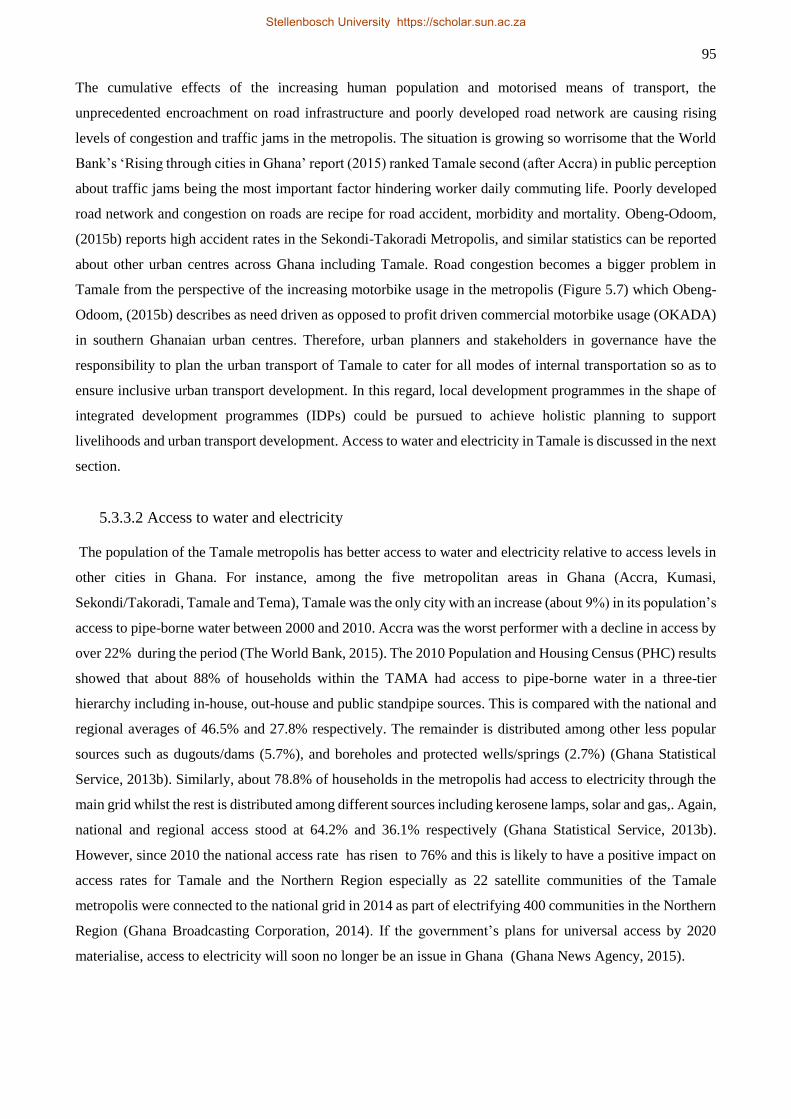
95
The cumulative effects of the increasing human population and motorised means of transport, the
unprecedented encroachment on road infrastructure and poorly developed road network are causing rising
levels of congestion and traffic jams in the metropolis. The situation is growing so worrisome that the World
Bank’s ‘Rising through cities in Ghana’ report (2015) ranked Tamale second (after Accra) in public perception
about traffic jams being the most important factor hindering worker daily commuting life. Poorly developed
road network and congestion on roads are recipe for road accident, morbidity and mortality. Obeng-Odoom,
(2015b) reports high accident rates in the Sekondi-Takoradi Metropolis, and similar statistics can be reported
about other urban centres across Ghana including Tamale. Road congestion becomes a bigger problem in
Tamale from the perspective of the increasing motorbike usage in the metropolis (Figure 5.7) which Obeng-
Odoom, (2015b) describes as need driven as opposed to profit driven commercial motorbike usage (OKADA)
in southern Ghanaian urban centres. Therefore, urban planners and stakeholders in governance have the
responsibility to plan the urban transport of Tamale to cater for all modes of internal transportation so as to
ensure inclusive urban transport development. In this regard, local development programmes in the shape of
integrated development programmes (IDPs) could be pursued to achieve holistic planning to support
livelihoods and urban transport development. Access to water and electricity in Tamale is discussed in the next
section.
5.3.3.2 Access to water and electricity
The population of the Tamale metropolis has better access to water and electricity relative to access levels in
other cities in Ghana. For instance, among the five metropolitan areas in Ghana (Accra, Kumasi,
Sekondi/Takoradi, Tamale and Tema), Tamale was the only city with an increase (about 9%) in its population’s
access to pipe-borne water between 2000 and 2010. Accra was the worst performer with a decline in access by
over 22% during the period (The World Bank, 2015). The 2010 Population and Housing Census (PHC) results
showed that about 88% of households within the TAMA had access to pipe-borne water in a three-tier
hierarchy including in-house, out-house and public standpipe sources. This is compared with the national and
regional averages of 46.5% and 27.8% respectively. The remainder is distributed among other less popular
sources such as dugouts/dams (5.7%), and boreholes and protected wells/springs (2.7%) (Ghana Statistical
Service, 2013b). Similarly, about 78.8% of households in the metropolis had access to electricity through the
main grid whilst the rest is distributed among different sources including kerosene lamps, solar and gas,. Again,
national and regional access stood at 64.2% and 36.1% respectively (Ghana Statistical Service, 2013b).
However, since 2010 the national access rate has risen to 76% and this is likely to have a positive impact on
access rates for Tamale and the Northern Region especially as 22 satellite communities of the Tamale
metropolis were connected to the national grid in 2014 as part of electrifying 400 communities in the Northern
Region (Ghana Broadcasting Corporation, 2014). If the government’s plans for universal access by 2020
materialise, access to electricity will soon no longer be an issue in Ghana (Ghana News Agency, 2015).
Stellenbosch University https://scholar.sun.ac.za
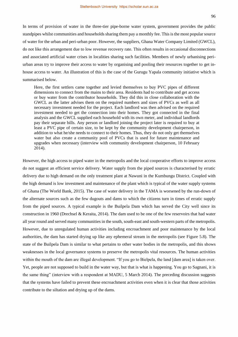
96
In terms of provision of water in the three-tier pipe-borne water system, government provides the public
standpipes whilst communities and households sharing them pay a monthly fee. This is the most popular source
of water for the urban and peri-urban poor. However, the suppliers, Ghana Water Company Limited (GWCL),
do not like this arrangement due to low revenue recovery rate. This often results in occasional disconnections
and associated artificial water crises in localities sharing such facilities. Members of newly urbanising peri-
urban areas try to improve their access to water by organising and pooling their resources together to get in-
house access to water. An illustration of this is the case of the Gurugu Yapala community initiative which is
summarised below.
Here, the first settlers came together and levied themselves to buy PVC pipes of different
dimensions to connect from the mains to their area. Residents had to contribute and get access
or buy water from the contributor households. They did this in close collaboration with the
GWCL as the latter advises them on the required numbers and sizes of PVCs as well as all
necessary investment needed for the project. Each landlord was then advised on the required
investment needed to get the connection into their homes. They got connected in the final
analysis and the GWCL supplied each household with its own meter, and individual landlords
pay their separate bills. Any person or landlord joining the project later is required to buy at
least a PVC pipe of certain size, to be kept by the community development chairperson, in
addition to what he/she needs to connect to their homes. Thus, they do not only get themselves
water but also create a community pool of PVCs that is used for future maintenance and
upgrades when necessary (interview with community development chairperson, 10 February
2014).
However, the high access to piped water in the metropolis and the local cooperative efforts to improve access
do not suggest an efficient service delivery. Water supply from the piped sources is characterised by erratic
delivery due to high demand on the only treatment plant at Nawuni in the Kumbungu District. Coupled with
the high demand is low investment and maintenance of the plant which is typical of the water supply systems
of Ghana (The World Bank, 2015). The case of water delivery in the TAMA is worsened by the run-down of
the alternate sources such as the few dugouts and dams to which the citizens turn in times of erratic supply
from the piped sources. A typical example is the Builpela Dam which has served the City well since its
construction in 1960 (Drechsel & Keraita, 2014). The dam used to be one of the few reservoirs that had water
all year round and served many communities in the south, south-east and south-western parts of the metropolis.
However, due to unregulated human activities including encroachment and poor maintenance by the local
authorities, the dam has started drying up like any ephemeral stream in the metropolis (see Figure 5.8). The
state of the Builpela Dam is similar to what pertains to other water bodies in the metropolis, and this shows
weaknesses in the local governance systems to preserve the metropolis vital resources. The human activities
within the mouth of the dam are illegal development. “If you go to Bielpela, the land [dam area] is taken over.
Yet, people are not supposed to build in the water way, but that is what is happening. You go to Sagnani, it is
the same thing” (interview with a respondent at MADU, 5 March 2014). The preceding discussion suggests
that the systems have failed to prevent these encroachment activities even when it is clear that those activities
contribute to the siltation and drying up of the dams.
Stellenbosch University https://scholar.sun.ac.za
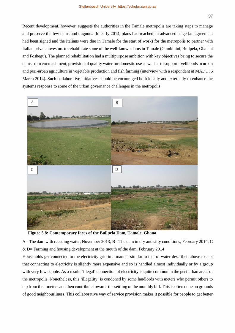
97
Recent development, however, suggests the authorities in the Tamale metropolis are taking steps to manage
and preserve the few dams and dugouts. In early 2014, plans had reached an advanced stage (an agreement
had been signed and the Italians were due in Tamale for the start of work) for the metropolis to partner with
Italian private investors to rehabilitate some of the well-known dams in Tamale (Gumbihini, Builpela, Gbalahi
and Foshegu). The planned rehabilitation had a multipurpose ambition with key objectives being to secure the
dams from encroachment, provision of quality water for domestic use as well as to support livelihoods in urban
and peri-urban agriculture in vegetable production and fish farming (interview with a respondent at MADU, 5
March 2014). Such collaborative initiatives should be encouraged both locally and externally to enhance the
systems response to some of the urban governance challenges in the metropolis.
Figure 5.8: Contemporary faces of the Builpela Dam, Tamale, Ghana
A= The dam with receding water, November 2013; B= The dam in dry and silty conditions, February 2014; C
& D= Farming and housing development at the mouth of the dam, February 2014
Households get connected to the electricity grid in a manner similar to that of water described above except
that connecting to electricity is slightly more expensive and so is handled almost individually or by a group
with very few people. As a result, ‘illegal’ connection of electricity is quite common in the peri-urban areas of
the metropolis. Nonetheless, this ‘illegality’ is condoned by some landlords with meters who permit others to
tap from their meters and then contribute towards the settling of the monthly bill. This is often done on grounds
of good neighbourliness. This collaborative way of service provision makes it possible for people to get better
D
A
C
B
Stellenbosch University https://scholar.sun.ac.za
98
access to crucial services in the area. Unfortunately, such collaboration is not possible with regard to the
provision of road infrastructure.
5.3.3.3 Waste disposal
Waste disposal and management constitute another aspect to which the growth of Tamale poses a serious
challenge. The sewage system for liquid waste disposal remains undeveloped across many urban centres in
Ghana but the situation appears serious for the TAMA. The TAMA scores the lowest proportion of liquid
waste disposal through the sewage system among the five metropolitan areas of the country (Figure 5.9). The
2010 PHC reports the disposal of liquid waste in the Tamale metropolis as follows: 3.3% is disposed through
the sewage system; 28.4% through the gutters (drainage system); 47.2% is thrown anywhere outside; 4.7%
thrown into a pit; 16% are thrown onto compound16; and 0.4% disposed of by “other” methods. Figure 5.9 also
shows that whilst the TAMA fares better than the national and regional averages in access to water and
electricity, it falls slightly to the national average (3.4 vs 3.3) in liquid waste disposal through the sewage
system but still outperforms the region by 1.2 percentage points (3.3 vs 2.1). The most popular mode of liquid
waste disposal in Ghana is by throwing it ‘onto the compound’. On the other hand, disposal through the gutters
is the most common way to dispose of liquid waste among the five metropolitan areas. Throwing of liquid
waste ‘anywhere outside’ the home is the most popular mode of disposal in Northern Region and Tamale.
These statistics show a huge infrastructure deficit for liquid waste disposal in Tamale and Ghana as a whole,
and this begs the question of the effectiveness of the country’s urban governance systems in providing urban
infrastructure and services. Per the status quo, Tamale and other urban centres in Ghana are treading on a
slippery slope of public health crisis not least emanating from the persistent incidence of malaria but also
potential outbreak of cholera.
The Tamale metropolis performs better in solid waste disposal, even slightly more so than both nationally and
regionally (Error! Reference source not found.). It scored about 66.7% in disposal methods that may be
considered “safe” (collected, burnt by household, dumped in a public container for collection and buried by
household) compared to national and regional averages of 52.2% and 34.1% respectively in that category.
However, the 66.7% score by the TAMA was the worst among the country’s five metropolitan areas
(Accra=93.6%; Kumasi=81.3%; Sekondi/Takoradi=79.7%; and Tema=84.2%). Taking the “collected”
category (the safest among the “safe” disposal methods) for example, the TAMA performs abysmally among
its peers. While Accra recorded close to 60% in that category, Tamale garnered less than 7%. The metropolis
only led its peers in the “unsafe” disposal method categories; public open and indiscriminate dumping. Twelve
percent of solid waste was disposed of indiscriminately within the metropolis whilst no other metropolitan area
16 Thrown onto unpaved compound (formed by the compound-house styled buildings) to percolate the ground and/or
dried up by the natural elements of weather
Stellenbosch University https://scholar.sun.ac.za
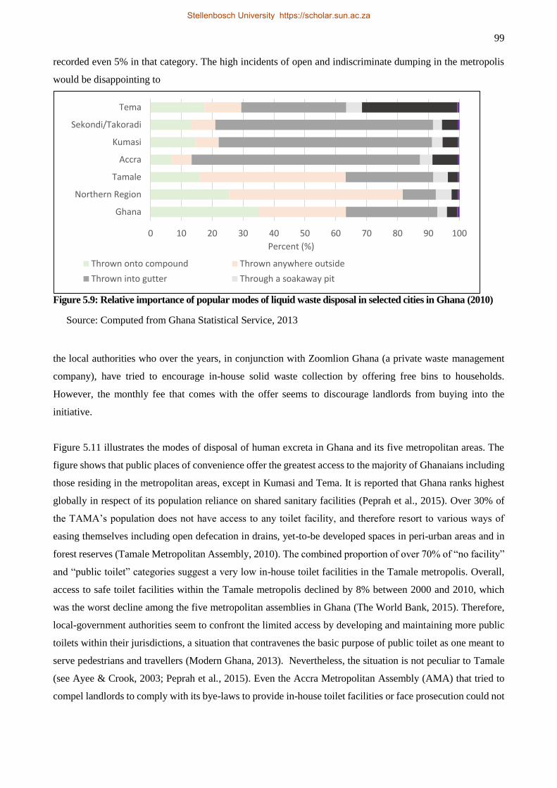
99
recorded even 5% in that category. The high incidents of open and indiscriminate dumping in the metropolis
would be disappointing to
Figure 5.9: Relative importance of popular modes of liquid waste disposal in selected cities in Ghana (2010)
Source: Computed from Ghana Statistical Service, 2013
the local authorities who over the years, in conjunction with Zoomlion Ghana (a private waste management
company), have tried to encourage in-house solid waste collection by offering free bins to households.
However, the monthly fee that comes with the offer seems to discourage landlords from buying into the
initiative.
Figure 5.11 illustrates the modes of disposal of human excreta in Ghana and its five metropolitan areas. The
figure shows that public places of convenience offer the greatest access to the majority of Ghanaians including
those residing in the metropolitan areas, except in Kumasi and Tema. It is reported that Ghana ranks highest
globally in respect of its population reliance on shared sanitary facilities (Peprah et al., 2015). Over 30% of
the TAMA’s population does not have access to any toilet facility, and therefore resort to various ways of
easing themselves including open defecation in drains, yet-to-be developed spaces in peri-urban areas and in
forest reserves (Tamale Metropolitan Assembly, 2010). The combined proportion of over 70% of “no facility”
and “public toilet” categories suggest a very low in-house toilet facilities in the Tamale metropolis. Overall,
access to safe toilet facilities within the Tamale metropolis declined by 8% between 2000 and 2010, which
was the worst decline among the five metropolitan assemblies in Ghana (The World Bank, 2015). Therefore,
local-government authorities seem to confront the limited access by developing and maintaining more public
toilets within their jurisdictions, a situation that contravenes the basic purpose of public toilet as one meant to
serve pedestrians and travellers (Modern Ghana, 2013). Nevertheless, the situation is not peculiar to Tamale
(see Ayee & Crook, 2003; Peprah et al., 2015). Even the Accra Metropolitan Assembly (AMA) that tried to
compel landlords to comply with its bye-laws to provide in-house toilet facilities or face prosecution could not
0 10 20 30 40 50 60 70 80 90 100
Ghana
Northern Region
Tamale
Accra
Kumasi
Sekondi/Takoradi
Tema
Percent (%)
Thrown onto compound Thrown anywhere outside
Thrown into gutter Through a soakaway pit
Stellenbosch University https://scholar.sun.ac.za
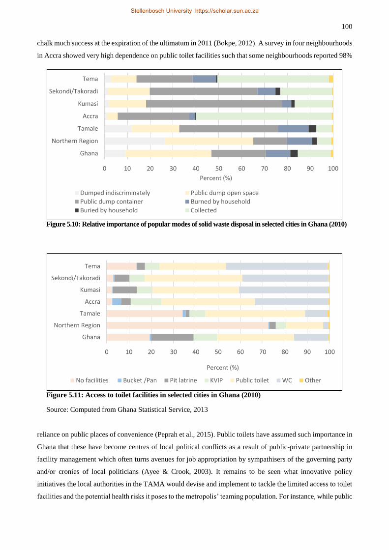
100
chalk much success at the expiration of the ultimatum in 2011 (Bokpe, 2012). A survey in four neighbourhoods
in Accra showed very high dependence on public toilet facilities such that some neighbourhoods reported 98%
Figure 5.10: Relative importance of popular modes of solid waste disposal in selected cities in Ghana (2010)
Figure 5.11: Access to toilet facilities in selected cities in Ghana (2010)
Source: Computed from Ghana Statistical Service, 2013
reliance on public places of convenience (Peprah et al., 2015). Public toilets have assumed such importance in
Ghana that these have become centres of local political conflicts as a result of public-private partnership in
facility management which often turns avenues for job appropriation by sympathisers of the governing party
and/or cronies of local politicians (Ayee & Crook, 2003). It remains to be seen what innovative policy
initiatives the local authorities in the TAMA would devise and implement to tackle the limited access to toilet
facilities and the potential health risks it poses to the metropolis’ teaming population. For instance, while public
0 10 20 30 40 50 60 70 80 90 100
Ghana
Northern Region
Tamale
Accra
Kumasi
Sekondi/Takoradi
Tema
Percent (%)
Dumped indiscriminately Public dump open space
Public dump container Burned by household
Buried by household Collected
0 10 20 30 40 50 60 70 80 90 100
Ghana
Northern Region
Tamale
Accra
Kumasi
Sekondi/Takoradi
Tema
Percent (%)
No facilities Bucket /Pan Pit latrine KVIP Public toilet WC Other
Stellenbosch University https://scholar.sun.ac.za
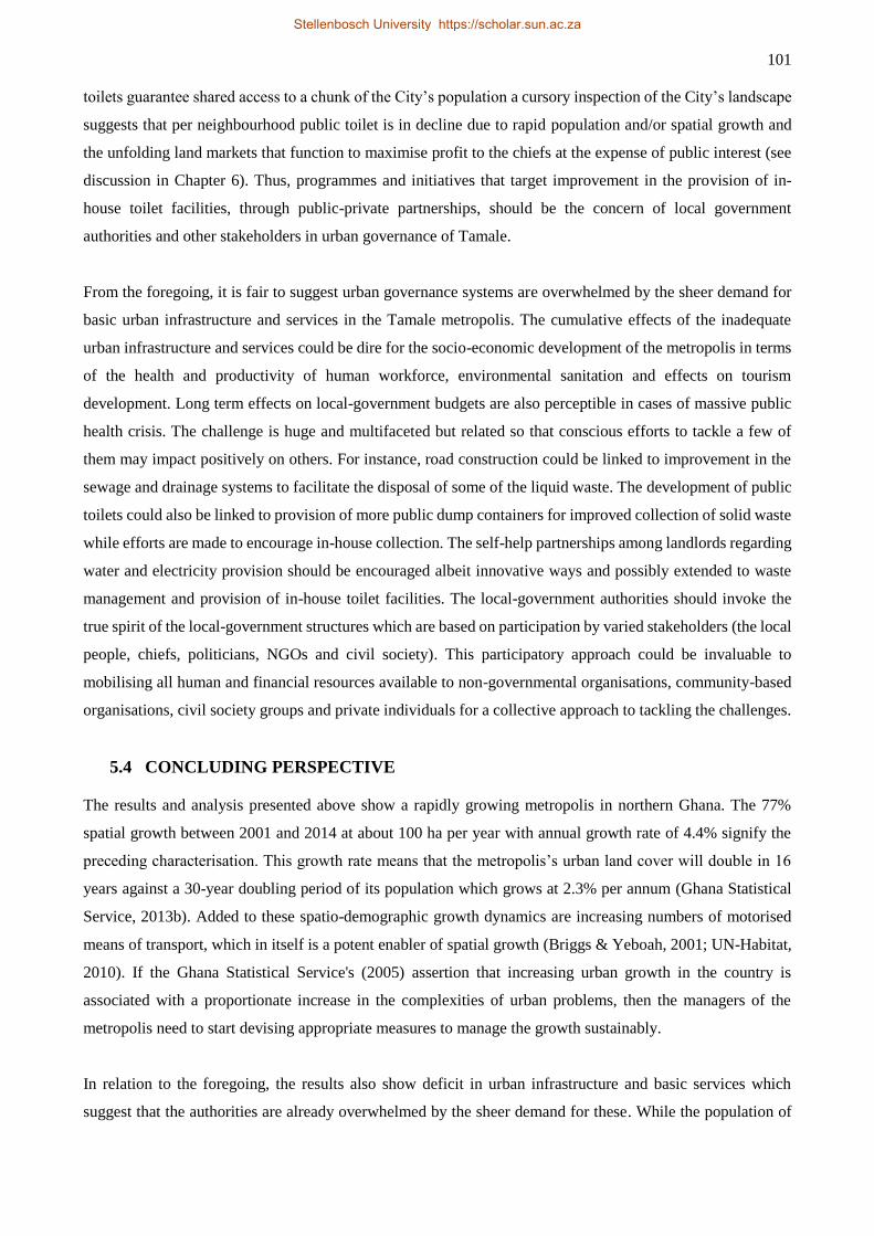
101
toilets guarantee shared access to a chunk of the City’s population a cursory inspection of the City’s landscape
suggests that per neighbourhood public toilet is in decline due to rapid population and/or spatial growth and
the unfolding land markets that function to maximise profit to the chiefs at the expense of public interest (see
discussion in Chapter 6). Thus, programmes and initiatives that target improvement in the provision of in-
house toilet facilities, through public-private partnerships, should be the concern of local government
authorities and other stakeholders in urban governance of Tamale.
From the foregoing, it is fair to suggest urban governance systems are overwhelmed by the sheer demand for
basic urban infrastructure and services in the Tamale metropolis. The cumulative effects of the inadequate
urban infrastructure and services could be dire for the socio-economic development of the metropolis in terms
of the health and productivity of human workforce, environmental sanitation and effects on tourism
development. Long term effects on local-government budgets are also perceptible in cases of massive public
health crisis. The challenge is huge and multifaceted but related so that conscious efforts to tackle a few of
them may impact positively on others. For instance, road construction could be linked to improvement in the
sewage and drainage systems to facilitate the disposal of some of the liquid waste. The development of public
toilets could also be linked to provision of more public dump containers for improved collection of solid waste
while efforts are made to encourage in-house collection. The self-help partnerships among landlords regarding
water and electricity provision should be encouraged albeit innovative ways and possibly extended to waste
management and provision of in-house toilet facilities. The local-government authorities should invoke the
true spirit of the local-government structures which are based on participation by varied stakeholders (the local
people, chiefs, politicians, NGOs and civil society). This participatory approach could be invaluable to
mobilising all human and financial resources available to non-governmental organisations, community-based
organisations, civil society groups and private individuals for a collective approach to tackling the challenges.
5.4 CONCLUDING PERSPECTIVE
The results and analysis presented above show a rapidly growing metropolis in northern Ghana. The 77%
spatial growth between 2001 and 2014 at about 100 ha per year with annual growth rate of 4.4% signify the
preceding characterisation. This growth rate means that the metropolis’s urban land cover will double in 16
years against a 30-year doubling period of its population which grows at 2.3% per annum (Ghana Statistical
Service, 2013b). Added to these spatio-demographic growth dynamics are increasing numbers of motorised
means of transport, which in itself is a potent enabler of spatial growth (Briggs & Yeboah, 2001; UN-Habitat,
2010). If the Ghana Statistical Service's (2005) assertion that increasing urban growth in the country is
associated with a proportionate increase in the complexities of urban problems, then the managers of the
metropolis need to start devising appropriate measures to manage the growth sustainably.
In relation to the foregoing, the results also show deficit in urban infrastructure and basic services which
suggest that the authorities are already overwhelmed by the sheer demand for these. While the population of
Stellenbosch University https://scholar.sun.ac.za
102
the metropolis has better access to water (albeit erratic supply) and electricity, access to road infrastructure,
waste disposal and other sanitary facilities leaves much to be desired. The dearth of these critical urban
infrastructure and services raises questions about the effectiveness of urban governance in the metropolis. For
instance, the weak governance has resulted in slow road development with high rates of encroachment by small
businesses on the few developed roads in the city. This situation creates congestion and traffic jams on the
roads to the extent that Tamale comes second to Accra in traffic assessment among the country’s metropolitan
areas (The World Bank, 2015). Waste disposal – solid and liquid – is a huge challenge with the metropolis
scoring poorly among its peers. Thus, weak urban governance is greatly responsible for the deterioration in
environmental sanitation, infrastructure and service deficit and increasing urban insecurity in Ghanaian
metropolitan areas including Tamale (Government of Ghana, 2012; The World Bank, 2015).
The results present a number of implications for the metropolis’s development. First, the infrastructural deficit
has the tendency to stifle the metropolis economic performance. Also, the poor waste management including
open defecation arising from limited access to toilet facilities poses a public health threat in case of an epidemic
such as cholera. Third, the state of affairs has the tendency to create economic and social marginalisation which
is antithetical to Ghana’s development agenda (Government of Ghana, 2012; The World Bank, 2015). Fourth,
the metropolis’ growth path poses a challenge to the attainment of the overarching goal of Ghana’s urban
policy framework which seeks “to promote a sustainable, spatially integrated and orderly development of urban
settlements with adequate housing, infrastructure and services, efficient institutions, and a sound living and
working environment for all people to support the rapid socio-economic development of Ghana” (Fuseini &
Kemp, 2015 p. 316).
It is concluded that the authorities of the Tamale metropolis need to devise innovative measures to achieve
sustainable management of the city. In particular, if social justice, economic viability and environmental health
are to be considered in the management of the city’s growth then it behoves on the local-government authorities
to participate actively in planning and implementation. Leadership could take advantage of the self-help
behaviour of some inhabitants with regard to water and electricity supply to package these innovations. The
country’s decentralised governance system which stands tall among other systems on the continent (UN-
Habitat, 2010) could be used effectively and/or re-engineered to engender partnerships among city managers,
the local people, civil society, NGOs and international development agencies so as to tackle these local-level
challenges. This could partly take the form of educating private developers to understand that proper
development with basic facilities like in-house toilet and water could add value to their properties as tarred
roads and concrete drains have been found to increase property values significantly in Accra and Kwabenya
(Baffour Awuah et al. 2014).
Stellenbosch University https://scholar.sun.ac.za
103
CHAPTER 6 PUBLIC INTEREST IN SPATIAL PLANNING: AN
ASSESSMENT OF LOCAL PLAN PREPARATION AND
IMPLEMENTATION IN TAMALE, GHANA17
ABSTRACT
The study investigates the extent to which zonings for public land uses in local plans in Tamale, Ghana, are
appreciated on the ground to serve the various recreational, social, economic and environmental purposes for
which they were envisioned. Using Geographic Information Systems (GIS) and interview approaches,
quantitative and qualitative content analysis of nine samples of local plans was performed to determine the
prevalence of these land-use zonings in local plans and their statuses on the ground as plans are implemented.
The results showed, first, a fairly high representation of zonings for public uses and, second, a high level of
general encroachment on these zonings. Among the seven identified public land-use classes, zonings for
sanitary purposes recorded the highest presentation, while zonings for schools/clinics recorded the least
encroachment. In contrast, areas zoned as open spaces and reserves/buffers witnessed the highest
encroachment of 86% and 96% respectively. The level of encroachment was explained by land tenure
dynamics and weak local governance including low public participation in planning and plan implementation.
Given their potential utility in providing cultural and environmental ecosystem services, mitigating urban
disaster and climate change as well as livelihood support in urban and peri-urban agriculture, it is argued that
the systematic encroachment on the open space and reserve/buffer classes presents an unsustainable scenario.
The study recommends structural reforms, real decentralisation and strengthening of key democratic tenets
such as participation, accountability and transparency in planning so as to ensure distributive justice as
stipulated in the Constitution of Ghana.
6.1 INTRODUCTION
Larger societal good is essentially what spatial planning seeks to guarantee, and this makes planning an active
part of the processes of creating a sense of place (Duke & Wu, 2014). In other words, planning connotes an
activity that has a ‘desired state of affairs’ with a set of coordinated strategies to achieve them (Moroni, 2010).
Society is comprised of a complex web of structures, interests and power relations which are rooted in the
social and economic needs of its members. These multitude of interests and aspirations continually compete
for space, especially in urban settings where there is a complex and increasing demand for economic, social
and environmental infrastructure and services. Therefore, decisions regarding how to use land and/or change
the use thereof affect society socially, economically and environmentally, whether positively or negatively
(Klosterman, 1978; Duke & Wu, 2014). Considerations for achieving sustainable development have added
17 Submitted to Land Use Policy (ID: LUP_2015_177) as Fuseini, I and Kemp, J. Public interest in spatial planning: An
assessment of local plan preparation and implementation in Tamale, Ghana. The conceptualisation and writing of the
manuscript were the responsibility of the author of this dissertation. The co-author, my supervisor, contributed through
the provision of general guidelines and editing.
Stellenbosch University https://scholar.sun.ac.za
104
another dimension to the need for efficient conduct of spatial planning (Naess, 2001; UN-Habitat, 2009a;
Watson, 2014) in order to promote larger societal interest (Klosterman, 1978). Accordingly, spatial planning
attempts to mediate land-use forms and decisions to attain harmonious societal development. In the 21st
Century, the argument for effective spatial planning stems from a multitude of factors including increasing
urban poverty and vulnerability, service delivery, resource depletion, the need for sound environmental and
sanitation management, climate change mitigation and improved economic performance among others (UN-
Habitat, 2009a, 2011; Watson, 2009; Pieterse & Parnell, 2014).
While planning for spatial structuring of human activities is largely accepted (though there is debate regarding
the legality of planning or the public interest justification thereof – see Klosterman, 1985; Campbell &
Marshall, 2002; Lai, 2005; Moroni, 2010), the approach for doing so successfully is subject to contestation.
Traditional planning has followed the rational scientific approach that is technocratic, positivist and top-down
in terms of determining the contents of plans (Klosterman, 1978). The assumption of this rational scientific
planning approach is that professional planners by their training and expertise are able to determine what land-
use mixes are appropriate to serve the social, economic and environmental needs of society, independent of
the social agents (Klosterman, 1978). Such a top-down planning approach often faces implementation
challenges and has also been criticised as being undemocratic, counterproductive and lacking legitimacy;
criticism that has precipitated planning reform based on active community engagement through consultation
and dialogue (Klosterman 1978; Watson 2002, 2009). This gave rise to the normative planning approach with
its varied strands – Communicative Planning, Collaborative Planning, Just City and Multicultural Theory. –
all of which have a point of convergence at civil society engagement in a multistakeholder democratic process
(Healey, 1992; Naess, 2001; Watson, 2002). It is assumed that the multistakeholder process would promote
needs-based planning which would in turn engender effective plan implementation (Watson, 2009). While the
normative planning approaches present a better alternative to the positivist, top-down rational scientific
approach by having inherent relevance in planning for reduction of poverty and spatial inequalities, it is
uncertain whether they present practical appeal in certain contexts, including much of Africa, due to factors
such as weak civil society and grassroots networks (Watson, 2002). This is especially true given the advocacy
of the normative theories for minimal state or government involvement in planning.
Beside the African context stated above, other general arguments exist to suggest that downplaying the role of
the state in planning would be equally counterproductive as weak segments of society would likely be
marginalised (Klosterman, 1985; Huxley, 2000; Watson, 2002). In a similar vein, market forces do not seem
efficient mechanisms for allocation of land resources for larger societal benefits (Klosterman, 1985; Mather,
1986; Yeboah & Shaw, 2013; Baffour Awuah et al., 2014). The argument thus far suggests a planning approach
that blends traditional welfare economic theory with democratic practices of popular participation and
consultation. This is especially relevant in Africa where planning is largely founded in welfarist ideals (Baffour
Awuah et al., 2014) despite the arguments against it (Campbell & Marshall, 2002; Lai, 2005). The financial
crisis in the first decade of the 21st Century has revived advocacy for the protection of public interest in
Stellenbosch University https://scholar.sun.ac.za
105
planning (especially for the poor and vulnerable groups) by revealing the inefficiencies of market forces in
allocating resources and left planners wondering if it was time to shift the focus of planning to more people-
centred approaches (Lovering, 2009; Watson, 2009). Lovering (2009), for example, suggested that the failure
of the neoliberal model of planning indirectly made the case for a reversal of planning intent to “protecting the
needs of ordinary people rather than privileged minorities, the public rather than the private interest [and] the
future rather than the present. Planners will have to take into account new (or rather, old) social forces” (p. 4).
It should be clarified here, however, that the renewed call for public interest-based planning is not the same as
the old-fashioned rational scientific planning but one that is rooted in the recognition of the economic and
social diversity of society and making efforts to preserve it by paying particular attention to minority or
vulnerable interests.
Consideration of public benefit has been central to zoning processes of Ghana’s land-use planning history.
Such zonings are clearly marked in local plans such as sites for public utilities, road networks, parks, play
grounds and open spaces, buffers around wetlands, dams and rivers, sanitary purposes, schools, clinics, police
stations, places of worship and local markets. These are intended to serve the social, economic, religious and
environmental needs of the larger society. The reasoning is that spatial development that respects these
zonations would most likely promote equitable, inclusive, healthy and, therefore, sustainable socio-economic
development. As planning authorities in their respective jurisdictions (Republic of Ghana, 1993), the local-
government authorities in Ghana are expected to work collaboratively with the grass roots and civil society to
properly acquire, protect and eventually develop these zonings to serve their intended purposes. This is one of
the ways of ensuring that planning reflects the everyday lives of the ordinary members of society (Watson,
2009) as these land uses serve the interest of the urban poor in particular. However, if urban growth
management is defined broadly as “to guide the location, quality, and timing of development” (Bengston,
Fletcher & Nelson, 2004 p. 273), then the efforts of urban governance systems in managing urban growth and
protecting public interests in Ghana leave much to be desired as there exists widespread unregulated growth
across Ghanaian urban centres (Yeboah & Obeng-Odoom, 2010; Boamah et al., 2012; Yeboah & Shaw, 2013;
Yeboah et al., 2013; Baffour Awuah & Hammond, 2014; Fuseini & Kemp, 2015; The World Bank, 2015). In
particular, the more personalised land uses including residential and commercial often take precedence over
and encroach upon the other uses envisioned for larger societal benefits. The situation may likely be explained
by the approach used in developing plans (whether participatory or top-down) and an apparent lack of direct
and/or indirect legislative and policy frameworks for effective plan implementation beyond the basic laws that
guide planning. For instance, concerns for social cost and environmental repercussions of urban sprawl had
motivated local, state and national governments in the United States of America to formulate direct and indirect
policies to manage and protect open space for public good (Bengston, Fletcher & Nelson, 2004. Thus,
participatory planning with clearly formulated and supported legislations and bylaws with set targets could
improve plan implementation over what is presently witnessed in Ghana.
Stellenbosch University https://scholar.sun.ac.za
106
For a number of reasons, the argument for securing public interest in urban growth management is as valid for
the Tamale Metropolitan Area (TAMA) as it may be for any urban centre in Ghana. First, the metropolis has
consistently ranked among the top three fastest growing metropolis in Ghana (Ghana Statistical Service, 2005,
2013a). Second, among five metropolitan areas in Ghana, Tamale recorded the highest proportion of its
population using shared sanitary facilities like public toilets and public solid waste disposal sites (Ghana
Statistical Service, 2013b,c,d,e). Third, the TAMA recently ranked second only to Accra in traffic related
difficulties to intra-city movement (The World Bank, 2015). Fourth, the metropolis’ population is facing an
increasing threat and vulnerability to climate related disasters (e.g. serious floods in 2007) due to weak
regulation of settlement growth that leads to encroachment on wetland areas and river valleys (Gyasi et al.,
2014a). A cursory tour of the city also showed scenes of social gatherings being organised on the streets which
suggests inadequate open spaces for social interaction; not to mention the environmental and ecosystem
services open spaces may render. These are some of the pressures that emanate from the urban growth
experiences of Tamale as far as public interest and safety are concerned, and it is these pressures that motivate
this study. How urban governance systems respond to the above pressures in order not to allow urbanisation
processes to ‘sweep the poor away’ (Watson, 2009) should be a topmost priority for managers of cities in the
developing countries in the 21st Century (UN-Habitat, 2009a; Angel et al., 2011; Obeng-Odoom, 2013).
The study seeks to investigate planning response to protecting public interest-based land-use zonings through
plan implementation. Land use for public interest/benefits as used here refers to all land-use zonings in local
plans other than for residential, commercial and industrial uses. They include open spaces, green
belts/reserves/buffers zones along and around wetlands, rivers, dams and roads; parks and play grounds;
sanitary areas; local markets for small businesses and informal retail activities; places of worship, schools and
clinics. Excluding residential, commercial and industrial zonings is premised on (1) they being individually
owned and (2) they face no or very little threat from encroachment compared to zonings for public uses. Except
for few studies that have highlighted general weaknesses in plan implementation (see Baffour Awuah &
Hammond 2014b; Boamah et al. 2012; Yeboah & Shaw 2013), no study has ever been done in the Ghanaian
context on the specific issue of ascertaining the real ‘state’ of these supposedly public interest based zonings.
Therefore, pursuing such endeavour in Tamale will further our understanding of the planning processes and
the extent of plan implementation successes and challenges, and thus inform policy and decision-making
choices by city managers.
The objective of the study is to investigate the extent to which these land-use zonings are represented in local
plans, the processes of defining them (co-production or unilaterally determined) and how they are respected
on the ground to serve the various recreational, social, economic and environmental purposes envisioned for
them. The results are relevant for urban geographers, professional planners and development practitioners
interested in sustainability discourse. The main activity in the study involved quantitative and qualitative
analysis of a representative sample of local plans in order to ascertain their state on the ground. Organisation
wise, a presentation of methods of investigation follows this introduction. The results of the study are presented
Stellenbosch University https://scholar.sun.ac.za
107
in section 6.3 while the discussion of the results is rendered in section 6.4. Concluding remarks are offered in
section 6.5.
6.2 STUDY METHODS
Two datasets were used for the study: a sample of nine local plans and qualitative data generated through
interviews. The local plans were supplied by the Tamale Metropolitan office of the Town and Country Planning
Department (TCPD) which is the main body in charge of development of local plans, and also is the repository
of all local plans within the TAMA. The local plans were selected based on availability and (1) to reflect
geographic distribution across the city (2) with attention to urban core-peri-urban continuum. The attention to
urban core-peri-urban continuum was useful in an assessment of plan implementation in that the intensity of
physical development (land-use competition that influences encroachment or otherwise of public interest land-
use zonings) along that gradient may vary. Therefore, the distribution was as follows: two plans for the northern
and northwestern parts of the metropolis; one plan in the eastern part; two plans in the western part; two plans
in the southern part; and two plans in the centre of the metropolis. The interviews, on the other hand, were
conducted with identified stakeholders in spatial planning the distribution of whom is illustrated in Table 6.1.
The plans were processed through georeferencing and digitising using ESRI’s ArcMap software (Version 10).
The subject of interest in the plans was with the public spaces and so these were individually digitised as
opposed to parcel level digitising of other land uses, which were dominated by residential land use forms.
Maps were prepared for respective plans, and Keyhole Markup Language (KML) files (.kml, .kmz) were
created for each to render them viewable in Google Earth Figure 6.1). Desktop observation of the KML files
in Google Earth (imagery acquired on 4 December 2014) was used complementarily with ground truthing to
ascertain the statuses of the identified public land use types. The ground truthing exercise involved physical
checks on the statuses of all public land use zonings in two selected plans while the desktop review in Google
Earth was employed to assess the rest. Seven broad classes18 of public space were defined to facilitate the
analysis, that is ‘open space’, ‘reserve/buffer’, ‘sanitary area’, ‘school/clinic’, ‘market’, ‘social centre’ and
‘worship’. Following Mascarenhas et al. (2015) and Conroy & Berke (2004), a combination of quantitative
and qualitative content analysis was performed on the plans to determine the extent of zonings for public use
and their statuses on the ground. The quantitative analysis involved determining the extent of representation
of these zonings in the plans while the qualitative analysis related to assessing their ‘state’ on the ground. The
assessment of the status of the open space and reserve/buffer classes was largely a binary exercise concerning
their presence or absence. The assessment and interpretation of the remaining classes in Google Earth were
18 ‘Open space‘= open greenery, playgrounds and parks; ‘reserved/buffer’= demarcated wetlands, river and dam
catchments, and road buffers; ‘sanitary area’= sites for public toilets and waste disposal; ‘school/clinic’= for
development of schools, clinics, hospitals and related infrastructure; ‘market’= sites for local retail trading activities;
‘social centre’= places for public gathering e.g. community centre; ‘worship’= for places of worship (churches or
mosques)
Stellenbosch University https://scholar.sun.ac.za
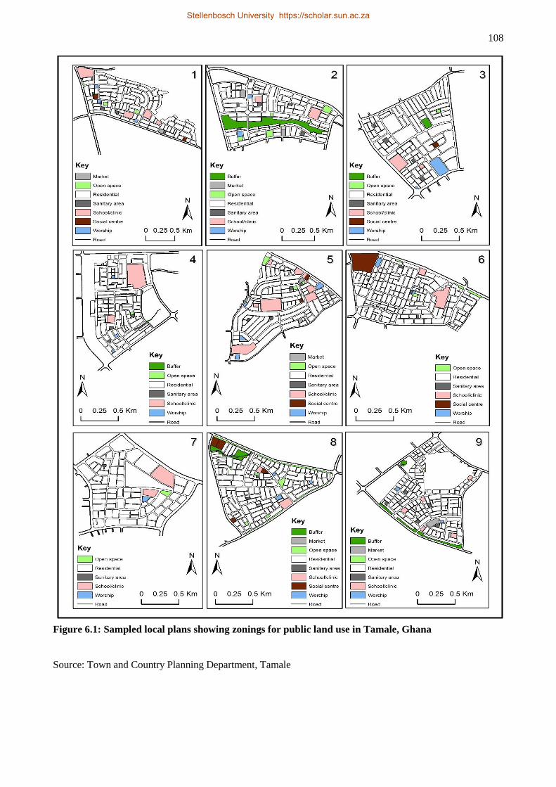
108
Figure 6.1: Sampled local plans showing zonings for public land use in Tamale, Ghana
Source: Town and Country Planning Department, Tamale
Stellenbosch University https://scholar.sun.ac.za
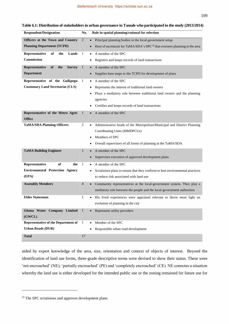
109
Table 6.1: Distribution of stakeholders in urban governance in Tamale who participated in the study (2013/2014)
aided by expert knowledge of the area, size, orientation and context of objects of interest. Beyond the
identification of land use forms, three-grade descriptive terms were devised to show their status. These were
‘not encroached’ (NE), ‘partially encroached’ (PE) and ‘completely encroached’ (CE). NE connotes a situation
whereby the land use is either developed for the intended public use or the zoning remained for future use for
19 The SPC scrutinises and approves development plans
Respondent/Designation No. Role in spatial planning/rational for selection
Officers at the Town and Country
Planning Department (TCPD)
2 Principal planning bodies in the local-government setup
Host of secretariat for TaMA/SDA’s SPC19 that oversees planning in the area
Representative of the Lands
Commission
1 A member of the SPC
Registers and keeps records of land transactions
Representative of the Survey
Department
1 A member of the SPC
Supplies base maps to the TCPD for development of plans
Representative of the Gulkpegu
Customary Land Secretariat (CLS)
1 A member of the SPC
Represents the interest of traditional land owners
Plays a mediatory role between traditional land owners and the planning
agencies
Certifies and keeps records of land transactions
Representative of the Metro Agric
Office
1 A member of the SPC
TaMA/SDA Planning Officers 2 Administrative heads of the Metropolitan/Municipal and District Planning
Coordinating Units (MMDPCUs)
Members of SPC
Overall supervisors of all forms of planning at the TaMA/SDA
TaMA Building Engineer 1 A member of the SPC
Supervises execution of approved development plans
Representative of the
Environmental Protection Agency
(EPA)
1 A member of the SPC
Scrutinises plans to ensure that they conform to best environmental practices
to reduce risk associated with land use
Assembly Members 4 Community representatives at the local-government system. They play a
mediatory role between the people and the local-government authorities
Elder Statesman 1 His lived experiences were appraised relevant to throw more light on
evolution of planning in the city
Ghana Water Company Limited
(GWCL)
1 Represents utility providers
Representative of the Department of
Urban Roads (DUR)
1 Member of the SPC
Responsible urban road development
Total 17
Stellenbosch University https://scholar.sun.ac.za
110
the intended zoning. PE is defined as partly developed and partly encroached or partly developed for a different
use and partly preserved for future use for the intended zoning.
The interviews were conducted with representatives from the key stakeholders in land use planning as shown
in Table 6.1 above. The respondents were selected from the Tamale Metropolitan Assembly (TaMA) and the
Sagnarigu District Assembly (SDA) that constitute the TAMA on which the study was based. Theoretically,
the Town and Country Planning Department (TCPD) and the Metropolitan and District Planning Coordinating
Units (MDPCUs) play central roles in land use planning in that the former is the lead body in spatial planning
in the local-government system and also hosts the Statutory Planning Committee (SPC). The MDPCUs for
their part are engines and supervisors of all types of planning within the local-government setup. The
Customary Land Secretariat (CLS) was selected for the study because it represents the interests of traditional
authorities (chiefs) in the planning processes by supporting their applications to the TCPD for preparation of
local schemes, certifies and keeps records of land allocation transactions and also participates on the SPC on
behalf of the chiefs. The role and relevance in the study of the other stakeholders are described in
. A total of 17 interviews was conducted on a wide range of issues such as stakeholder roles and levels of
participation in the planning processes, institutional collaboration, challenges in planning and implementation.
Analysis of the data involved the use of ATLAS.ti software to organise the raw information into useful themes
whilst simple pros was used to ensure logical flows and relationships.
6.3 RESULTS
The results of the study are presented here in two subsections. The results of the plan content analysis are
presented in subsection 6.3.1 while stakeholder engagement in planning is presented in subsection 6.3.2.
6.3.1 Content analysis of plans
A total of 154 zonings were identified for public uses in the nine local plans. Zonings for sanitary purposes
recorded the highest representation with a total of 37 across all plans. Open space and school/clinic classes
together ranked second with 28 zonings apiece. The social centre class was least represented with over half of
the plans not recording a single zoning for that category. The place of worship class not only came third in
representation but appears to be one of the indispensable public land uses across all plans. Perhaps, the low
representation of social centres is compensated for by the high presence of religious uses which themselves
serve as important meeting places for people. In general, Error! Reference source not found. shows that
zonings for sanitary areas, construction of schools/clinics, worship centres and open space are integral in the
content of local plans. In terms of plan specific consideration, plan #8 would be considered the most inclusive
in having all seven classes represented. It would also be considered the greenest with the highest units (17) of
reserve/buffer class, and if combined with the open space category would raise the units for greenery zonings
to 22. It must be noted, however, that the presence of the reserve/buffer class in only three plans illustrates
Stellenbosch University https://scholar.sun.ac.za
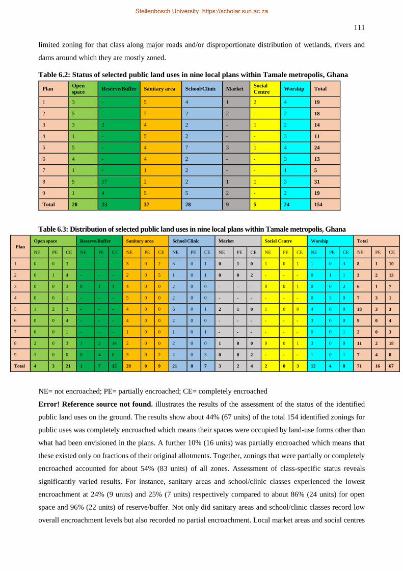
111
limited zoning for that class along major roads and/or disproportionate distribution of wetlands, rivers and
dams around which they are mostly zoned.
Table 6.2: Status of selected public land uses in nine local plans within Tamale metropolis, Ghana
Table 6.3: Distribution of selected public land uses in nine local plans within Tamale metropolis, Ghana
NE= not encroached; PE= partially encroached; CE= completely encroached
Error! Reference source not found. illustrates the results of the assessment of the status of the identified
public land uses on the ground. The results show about 44% (67 units) of the total 154 identified zonings for
public uses was completely encroached which means their spaces were occupied by land-use forms other than
what had been envisioned in the plans. A further 10% (16 units) was partially encroached which means that
these existed only on fractions of their original allotments. Together, zonings that were partially or completely
encroached accounted for about 54% (83 units) of all zones. Assessment of class-specific status reveals
significantly varied results. For instance, sanitary areas and school/clinic classes experienced the lowest
encroachment at 24% (9 units) and 25% (7 units) respectively compared to about 86% (24 units) for open
space and 96% (22 units) of reserve/buffer. Not only did sanitary areas and school/clinic classes record low
overall encroachment levels but also recorded no partial encroachment. Local market areas and social centres
Plan Open
space Reserve/Buffer Sanitary area School/Clinic Market
Social
Centre Worship Total
1 3 - 5 4 1 2 4 19
2 5 - 7 2 2 - 2 18
3 3 2 4 2 - 1 2 14
4 1 - 5 2 - - 3 11
5 5 - 4 7 3 1 4 24
6 4 - 4 2 - - 3 13
7 1 - 1 2 - - 1 5
8 5 17 2 2 1 1 3 31
9 1 4 5 5 2 - 2 19
Total 28 23 37 28 9 5 24 154
Plan
Open space Reserve/Buffer Sanitary area School/Clinic Market Social Centre Worship Total
NE PE CE NE PE CE NE PE CE NE PE CE NE PE CE NE PE CE NE PE CE NE PE CE
1 0 0 3 - - - 3 0 2 3 0 1 0 1 0 1 0 1 1 0 3 8 1 10
2 0 1 4 - - - 2 0 5 1 0 1 0 0 2 - - - 0 1 1 3 2 13
3 0 0 3 0 1 1 4 0 0 2 0 0 - - - 0 0 1 0 0 2 6 1 7
4 0 0 1 - - - 5 0 0 2 0 0 - - - - - - 0 3 0 7 3 1
5 1 2 2 - - - 4 0 0 6 0 1 2 1 0 1 0 0 4 0 0 18 3 3
6 0 0 4 - - - 4 0 0 2 0 0 - - - - - - 3 0 0 9 0 4
7 0 0 1 - - - 1 0 0 1 0 1 - - - - - - 0 0 1 2 0 3
8 2 0 3 1 2 14 2 0 0 2 0 0 1 0 0 0 0 1 3 0 0 11 2 18
9 1 0 0 0 4 0 3 0 2 2 0 3 0 0 2 - - - 1 0 1 7 4 8
Total 4 3 21 1 7 15 28 0 9 21 0 7 3 2 4 2 0 3 12 4 8 71 16 67
Stellenbosch University https://scholar.sun.ac.za
112
were encroached by the order of 78% (6 units) and 60% (3 units) respectively. The statuses of the land-use
classes make for a puzzling and interesting interpretation. For instance, the preponderance of open space in the
nine plans suggests its utility was generally appreciated in the area. Yet, the high level of encroachment on
them suggests otherwise.
Information gathered in the interviews points to land tenure and the local authorities’ failure to acquire and
protect such public lands as among the main factors explaining the level of encroachment. The argument is
that the local-government authorities often fail to properly acquire such lands and protect them in the interest
of larger society (as mandated by the law), which gives traditional authorities (chiefs) the opportunity to
reallocate such lands to other uses. The behaviour and attitude of the chiefs hinge on land tenure changes in
the area. The customary land tenure system which is practised in the area has undergone metamorphism since
the restitution of northern Ghana lands by the State to the indigenous people in the late 1970s and which was
affirmed in the 1992 Constitution of Ghana (Kasanga, 1995; Yaro, 2010). Under the customary tenure system
land belongs to no single person but to everyone who belongs to the ‘group’ by birth. Accordingly, chiefs are
supposed to be custodians of land and act like the Hobbesian Leviathan to protect and guarantee access by all
in an egalitarian manner. Two distinct interests (titles) in land are recognised; allodial and usufruct interests.
The allodial title is the highest interest which is held in the name of the ‘skin’ and exercised by the paramount
chief (as opposed to the Tindamba in other parts of northern Ghana – Kasanga & Kotey, 2001) on behalf of
the people while the usufruct title gives the subjects the right to use the land for whatever purpose other than
selling. There is no sale of land under customary tenure; not even the chief is allowed to sell land (Kasanga &
Kotey, 2001).
In the context of customary land tenurial arrangements, land administration in Tamale and Dagbon lies in the
authority of Tindamba (Tindana, singular) and chiefs. The Tindamba, literally land owners, have historically
been the administrators of customary land in Dagbon similar to what pertains in other parts of northern Ghana
(Kasanga & Kotey, 2001; Ubink, 2008; MacGaffey, 2013). Their traditional roles in land management ranged
from religious (making of sacrifices and pacification of the land) to administrative regarding land allocation
and settlement of disputes emanating from land ownership and use. The Tindamba are recognised for these
roles because they (or their descendants) were the first settlers in particular communities (Kasanga & Kotey,
2001). Unlike in other parts of northern Ghana, however, the role and authority of the Tindamba in land
administration in Dagbon have significantly been reduced by the chieftaincy institution which accords vast
executive, judiciary and legislative powers to chiefs. As Amanor (2008 p. 57) notes, the chiefs, “as founders
of the polity and the political order”, acquired the right to administer land as trustees, and this effectively took
shape in the 1930s following the establishment of the Native Authorities as part of the British Indirect Rule
policy. In this regard, the concept of allodial title as vested in chiefs in Dagbon is the direct result of chiefly
takeover of land administration from the Tindamba following colonial and post-independence state political
processes (Crook, 2008). Therefore, customary land administration in Dagbon and Tamale has been a shared
responsibility between the Tindamba (as first settlers with religious role in land management) and the chiefs
Stellenbosch University https://scholar.sun.ac.za
113
who retain executive and administrative roles in land management (this is opposed to customary tenurial
practices in southern Ghana which are administered exclusively by chiefs in cases of stool land or by family
heads in situations of family land (Amanor, 2008; Ubink, 2008)). In other words, in matters of land transaction
both the Tindana and the chief had to sanction any land allocation before it became legal. With the unfolding
land tenure changes, however, the chiefs have effectively arrogated to themselves the responsibilities of land
administration at the expense of the Tindamba. Only a few Tindamba retain control over some land within
their jurisdiction and administer such lands by themselves without any interference from chiefs. These isolated
cases relate to categories of Tindamba who are regarded as “senior” priests who, mythologically, (1) are not
supposed to be seen by the Ya-Naa20 and/or other paramount chiefs, and (2) the said chiefs do not benefit from
land allocation in the jurisdictions of those senior Tindamba.
Contrary to the above well laid structure to ensure egalitarian access to land, modern neoliberal capitalism has
led to chiefly commodification and sale of land without recourse to customary tenure arrangements (Yaro,
2012), and this has been the root cause of the wanton reallocation of lands zoned for public uses. Some scholars
also blame modern governmental structures – from the colonial Native Authorities to present democratic
governance structures – for empowering chiefs to manage customary land opportunistically for personal gain,
especially in respect of the definition and application of concepts of usufructuary and allodial interests in land
( see, for example, Amanor, 2008; Ubink, 2008; MacGaffey, 2013). Acting with the support of ‘quack’
surveyors (as self-styled surveyors are termed locally) – even though some respondents felt unscrupulous staff
of the TCPD are equally culpable – the chiefs subtly go back and distort the original plans to get more
residential plots for sale. Almost all respondents in the interviews bemoaned the practice. A planner lamented
on the issue as follows:
You reserve them [open space and buffers around roads, rivers and dams] but unfortunately,
when you go back to the ground you see that these have been sold out by the chiefs and are
developed accordingly. And the issue is that people do not come for permit before they build.
They build before you get to know. One key thing is that the assembly's development control
unit or building control division is very weak (interview with an official of TCPD, 7 February
2014).
As much as this situation is attributable to contemporary neoliberal economic forces, some scholars argue that
customary land tenure has had historically inherent ambiguity that exposes it to fluid interpretation and
perspectives (Ubink & Amanor, 2008b). This brings to question conceptions of negotiability and equity which
underpin customary land tenure because the balance of power to negotiate often tilts in favour of the local
elites including chiefs – the supposedly de jure trustees of land under customary tenure (Lund, 2000; Ubink,
2008; Ubink & Amanor, 2008b). For example, the contemporary land tenure changes in Tamale can be
interpreted as the result of the interplay of unequal powers embedded in the usufruct and allodial interest in
land.
20 The King of the Dagbon kingdom
Stellenbosch University https://scholar.sun.ac.za
114
An assembly member added: “In the near future we would not have enough roads, no recreational
grounds or open spaces; there would only be [mass] residential development.”
Another assembly member recounted an issue his community was engaged with the planning authorities at the
time of our fieldwork. He said:
Let me say I have never been consulted in matters of planning. But as an assembly member my
attention was drawn to an issue involving some chiefs in my electoral area and TCPD. I
understand … [an] old scheme was revised [illegally] by the chiefs on the grounds that there
were many areas designated as open spaces. However, the revised scheme is not recognised by
the TCPD and the DUR. … But we [the community] cannot use the new plan without their
support because it creates a lot of problems. [Yet] if you look at the other side of the community,
people now develop based on the revised plan. So we are saying that they [TCPD and DUR]
should understand us and abandon the old plan and let us work with the revised plan because it
was the same chiefs who planned the old one (interview with an assembly member in the Tamale
Metro Assembly, 5 March 2014).
The above narrative relates to one of the challenges of unilateral rezoning or revision of plans by the chiefs.
On this occasion the TCPD and the DUR wanted to standby the old (statutory) plan while the chiefs remained
firm on the revised plan. Considering the potential negative implications of the standoff on the community’s
development, the assembly member (perhaps judging from the power of the chiefs) was pleading that the
statutory planning bodies regularise the revised (illegal) plan because the chiefs have legal right over control
of the land.. In large measure, these issues never arose when land administration was controlled by the
Tindamba.
The respondents also expressed a bigger concern regarding the quacks’ involvement in illegal scheme
development. Deploying the quacks was calculated to tailor the contents of plans to suit and yield maximum
benefits to the chiefs at the expense of the larger society. Such plans create chaos and, therefore, are not
recognised by the local-government authorities or the CLS. Respondents were concerned that such plans do
not meet basic standards especially zonings for public uses. Also, land transactions regarding such plans are
not covered with formal documentation due to their illegal status. Yet, formal documentation guarantees secure
access to land and is also required for application for, and granting of, development permits by which physical
development is regulated. This situation, therefore, contributes to people’s lackadaisical attitudes towards
seeking development permits.
The attitude of the chiefs was facilitated by the local government authorities’ renege on their statutory
obligation to safeguard public interest in planning by formally acquiring, developing and/or protecting public-
interest land-use zonings. The local government authorities’ complicity in the ineffective plan implementation
has been acknowledged elsewhere by the local government authorities themselves (Yeboah and Obeng-Odoom
2010). Elaborating on the ineffectiveness of the local government authorities regarding plan implementation,
respondents in the interviews singled out three issues as contributing to the problem, namely low commitment,
Stellenbosch University https://scholar.sun.ac.za
115
misplaced priorities and malfunctioning decentralised structures. The MDPCUs were established to serve as
engines for governance, planning and general development in the metropolitan, municipal and district
assemblies (MMDAs). Accordingly, they are supposed to meet quarterly to review past performance and plan
for the next quarter. The review process encompasses all activities by the decentralised bodies/units including
that of the SPC which is mandated to oversee spatial development issues in the MMDAs and headed by the
TCPD. However, due to low commitment and misplaced priorities the engines (MDPCUs) and other
decentralised governance structures do not seem to be working properly and this hinders development of all
kinds including spatial planning and implementation. A planning officer summarised the point in the following
quote:
… most MDPCUs exist only on paper. Others have the composition alright but they hardly meet.
Meetings may be organised only once in a year instead of the mandatory four times [quarterly].
So how do we live up to our responsibility of reviewing past performance and planning ahead?
I am secretary to the DPCU and every quarter I write a memo for funds to be made available for
meetings but nothing happens. You will even have to remind administration several times and
they will still not act. So it is like there is no commitment because the DPCU is the engine of
the Assembly which should be taken seriously. … if we are committed and get our priorities
right, even if there is no money, there is always a way of persuading people to perform their
tasks in times of financial difficulties. It is about how the leader approaches issues or builds
relationship with the staff and sets priorities for the organisation (interview with planning officer
at the SDA, 22 February 2014).
A respondent at the DUR corroborated the need for more commitment to ensure better plan implementation
when he stated:
… I know that we are all constrained or challenged in terms of the resources to do our work but
once we decide to go the extra mile we can do something relatively better with the limited
resources at our disposal (interview with a respondent at the DUR, 11 March 2014).
According to Ubink (2008 p. 50) the ineffectiveness of local government authorities and systems in spatial
planning and land administration was due to the state government’s ‘policy of non-interference in chieftaincy
affairs’. This position is expressed variously and has contributed to poor planning and plan implementation in
Ghana. Janine Ubink has analysed the situation as follows:
… while the UC [Unit Committee and DA [District Assembly] members are a local force to be
reckoned with, they are not always backed by the district authorities [local-level politicians].
The District Chief Executive (DCE) of Ejisu, for instance, while acknowledging the negative
effects of chiefly land conversions in his district, went no further than the occasional public
statement that chiefs should spend part of the land revenues on community development. …
More generally, during UC and DA inauguration ceremonies members are often instructed to
refrain from interfering in chieftaincy and land matters. This is directly in line with the national
government’s informal ‘policy of non-interference’ in chieftaincy affairs (Ubink, 2008 p. 50).
The seemingly ‘non-interference’ posture of political leadership and government on matters of
customary land management was also manifested in the design and establishment of the customary
land secretariats (CLSs) as no explicit efforts were made to put in checks and balances to guarantee
the constitutional imperative of egalitarian access to land by subjects of skins, stools and family
members (Ubink, 2008). This is a true reflection of what Berrisford (2014) argued that the lack of
subsidiary legislations to enforce and implement targeted reformist legislations were among the
Stellenbosch University https://scholar.sun.ac.za
116
reasons why planning reform often fail in Africa. Thus, the lack of political support in matters of
land administration “provides chiefs with ample room to manoeuvre, and gives them little reason to
fear state intervention in land matters” (Ubink, 2008 pp. 52-53).
The low encroachment on the zonings for sanitary and school/clinic classes may be explained by their obvious
utility to everyone in the community, including the chiefs. As stated in Section 6.1, during the 2010 census
Tamale recorded the highest proportions of its population using public toilets and disposing solid waste at
public damp sites more than any other metropolitan area in Ghana. It was also revealed in the interviews that
many of the sites for the land uses in these classes predated the development of the local schemes and were
thus integrated into these schemes. Therefore, there were lower chances of encroaching on them compared to
zonings for open spaces and buffer areas which are the creation of the local schemes and are only known on
paper (to the planners and the chiefs). Not even the elected community representatives (assembly members)
have ready access to plans and their contents:
I can only know the zonings for public use if I have access to the local plans. But if I go to the
TCPD as an individual or even as an assembly member, I will have to pay between GHC70
($18) and GHC80 ($2021) per plan. Yet, I am not paid as an assembly member. So it becomes
difficult to take an inventory of lands zoned for public use. But the assembly has the authority
to request those from the TCPD and protect them accordingly. Sadly, this is not done, and on
one occasion they asked us [assembly members] to take inventory of these public lands and
acquire them on behalf of the assembly. Where will I get money to do that?” (interview with an
assembly member in the SDA, 12 February 2014).
This shows that there is little consultation in the development of local schemes which contradicts the concept
of communal land ownership. It also shows that the planning professionals unilaterally decide what should
feature in a local plan. While this is not necessarily bad (as it somehow guarantees minimal benefits for all),
the limited public knowledge about the extent of allotments zoned for public uses contributes to their re-
possession and re-allocation by the chiefs.
The 50-50 status of the worship class in Table 6.2 requires elaboration as evidence on the ground suggests the
results may be misleading. The results as presented seem to be in agreement with a study done in some
communities in Accra by Baffour Awuah et al. (2014) which found that places of worship did not add value
to real estate properties which implies that proximity to a place of worship may not be of top priority to home
owners and tenants. Therefore, excluding places of worship in local plans may be justifiable in this context.
The ground truthing exercise performed in this study, however, revealed a contrary reality. For instance, while
four allotments were zoned for worship purposes in plan #1 and three of them were encroached completely,
there were in fact 10 places of worship on the ground. Eight of those were residential plots bought and
developed into worship centres by individuals while the other two had been built on lands zoned for other
public uses (one was developed on a section of the only local market zoning in the plan and the other was built
21 According to exchange rates on 18 February 2014
Stellenbosch University https://scholar.sun.ac.za
117
on the site for one of the two zonings for community centres). Similar trends were observed across the city.
This suggests that residents in the city may wish to have places of worship in close proximity to their areas
contrary to the findings of Baffour Awuah et al. (2014). The findings reflect the growing influence of religion
and religiosity in Africa and Ghana such that the development and geographic distribution of places of worship
do not follow urban planning guidelines (Cobbinah & Korah, 2015). In their research to identify factors that
influence the location of places of worship in Kumasi, Ghana, Cobbinah and Korah (2015) found proximity
and access to the place of worship by members as well as affordability of land as the main considerations for
locating a place of worship in the Kumasi Metropolis. Little consideration was made of planning regulations
for the siting of places of worship. Similarly, proximity and access by members of faith groups are very
important in the spatial distribution of places of worship in Tamale where a disproportionate number of places
of worship is mosques, catering for members who are required to observe five mandatory daily congregational
prayers at fixed times. Thus, proximity and access will be key if members are to discharge this daily obligation.
6.3.2 Stakeholder engagement in plan preparation
Table 6.4 summarises the involvement of key stakeholders in planning within the Tamale metropolis. The table
is derived from reported stakeholder involvement in planning and plan implementation processes as gathered
from the interviews. It can be observed from the table that participation in the initial process of plan preparation
is limited to TCPD, Survey Department (SD) and the chiefs. The CLS involvement in the initial planning
process is limited to writing a covering letter to the TCPD bound application from the chiefs requesting that
planning schemes be prepared for their areas. “They [chiefs] will come to the secretariat and inform us that
they want to develop schemes for their areas. Then we will write a covering letter, attach it to their application
and forward both to TCPD” (interview with respondent at Gulkpegu CLS, 12 February 2014). An officer at
the TCPD added “normally they approach our office with an application that ‘I want you to plan my community
for me.’ We examine the application, ask the surveyors to go in and pick the area's base map and then we start
the process from there.” Asked whether chiefs are the right authority to initiate planning under the law, the
planning officer replied:
Ideally, the assemblies [e.g. TaMA] are the planning authorities and so should have spearheaded
the process and bear the expenses thereof. Unfortunately, that does not happen. So the chiefs
approach us, make the request and go further to finance the process. That is why sometimes it
is difficult for them to understand why we should tell them not to tamper with some of the areas
like public open space, sanitary grounds, markets, etc. because they feel it is their land and they
invest so much in the plan preparation and so should recoup their investment. Planning in a
technical sense does not deal with traditional boundaries, and so individual chiefs requesting to
have their areas planned is not the right thing (interview with a respondent at the TCPD, 7
February 2014).
This indicates that the law regarding where, how and who should initiate planning processes is subverted from
the very first step of scheme development. Also, the planning officer’s explanation points to a unilateral
determination (by the TCPD) of the content of plans. This brings to fore, at least two critical issues. First, the
Stellenbosch University https://scholar.sun.ac.za
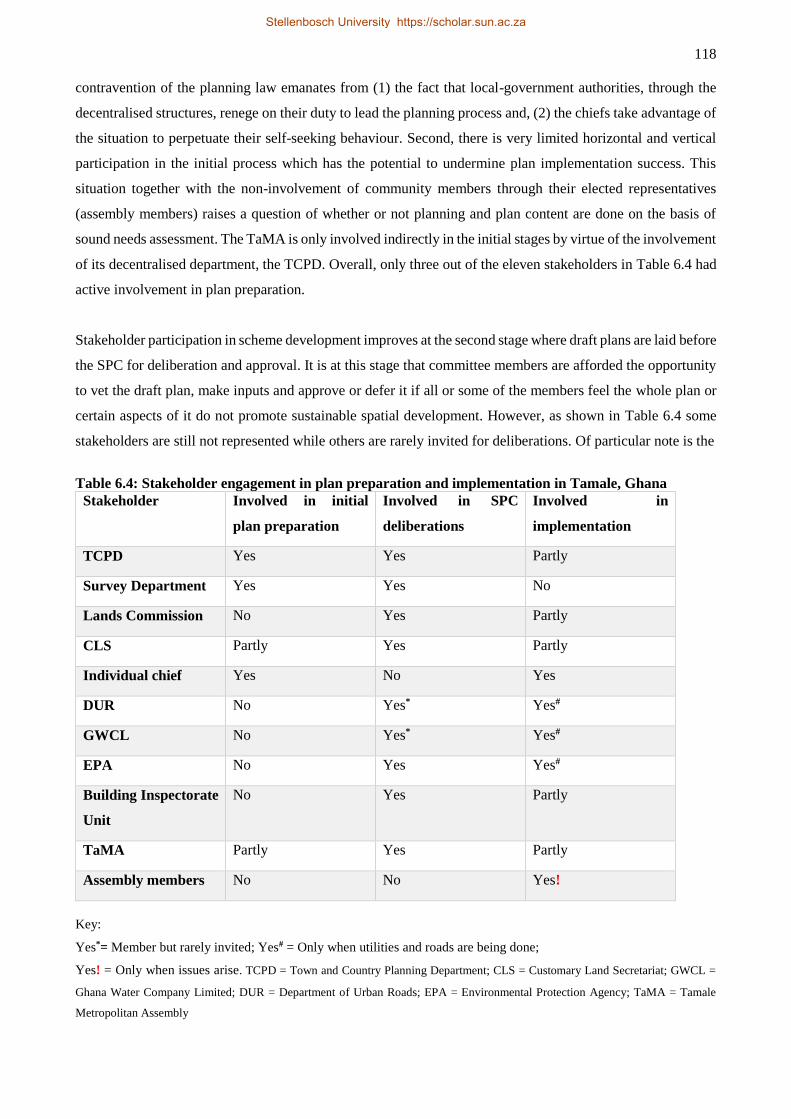
118
contravention of the planning law emanates from (1) the fact that local-government authorities, through the
decentralised structures, renege on their duty to lead the planning process and, (2) the chiefs take advantage of
the situation to perpetuate their self-seeking behaviour. Second, there is very limited horizontal and vertical
participation in the initial process which has the potential to undermine plan implementation success. This
situation together with the non-involvement of community members through their elected representatives
(assembly members) raises a question of whether or not planning and plan content are done on the basis of
sound needs assessment. The TaMA is only involved indirectly in the initial stages by virtue of the involvement
of its decentralised department, the TCPD. Overall, only three out of the eleven stakeholders in Table 6.4 had
active involvement in plan preparation.
Stakeholder participation in scheme development improves at the second stage where draft plans are laid before
the SPC for deliberation and approval. It is at this stage that committee members are afforded the opportunity
to vet the draft plan, make inputs and approve or defer it if all or some of the members feel the whole plan or
certain aspects of it do not promote sustainable spatial development. However, as shown in Table 6.4 some
stakeholders are still not represented while others are rarely invited for deliberations. Of particular note is the
Table 6.4: Stakeholder engagement in plan preparation and implementation in Tamale, Ghana
Stakeholder Involved in initial
plan preparation
Involved in SPC
deliberations
Involved in
implementation
TCPD Yes Yes Partly
Survey Department Yes Yes No
Lands Commission No Yes Partly
CLS Partly Yes Partly
Individual chief Yes No Yes
DUR No Yes* Yes#
GWCL No Yes* Yes#
EPA No Yes Yes#
Building Inspectorate
Unit
No Yes Partly
TaMA Partly Yes Partly
Assembly members No No Yes!
Key:
Yes*= Member but rarely invited; Yes# = Only when utilities and roads are being done;
Yes! = Only when issues arise. TCPD = Town and Country Planning Department; CLS = Customary Land Secretariat; GWCL =
Ghana Water Company Limited; DUR = Department of Urban Roads; EPA = Environmental Protection Agency; TaMA = Tamale
Metropolitan Assembly
Stellenbosch University https://scholar.sun.ac.za
119
absence of the chiefs on the SPC. Given the active role they play in plan implementation, the chiefs should be
represented on the SPC. The CLS is expected to serve as the mouthpiece of the chiefs, however, given the
former’s role as merely coordinating rather than controlling the activities and behaviour of the chiefs, it would
make more sense for the chiefs and at least the elected assembly members to participate in the plan approval
process and implementation. Inclusion of assembly members would ensure that the contents of the plans are
made known to the public. This could help minimise the wanton sale of public lands since the chiefs easily
perpetuate the illegality by virtue of the content of plans being shrouded in secrecy. Active participation of all
would also further the intent of the SPC by making plans amenable to the needs and interests of a larger society.
Plan implementation is supposed to be the sole responsibility of the local-government authorities (the TaMA
and SDA) through the decentralised agencies. However, just as in the initiation of planning, the chiefs have
emerged as active implementers of plans.
It is the responsibility of the assembly to implement plans. We participate [TCPD] in some
aspect of development control, though, with regard to the issuance of development permit. But
we do not have the power to enforce implementation of the plans. Practically, the control of land
is mostly done by chiefs except in few instances that you have state lands. So even though you
plan for them, they decide what to do regarding the implementation: you are in your office doing
the nice scheme but on the ground people are distorting it (interview with TCPD officer, 7
February 2014).
Development permits are the main instruments the local-government authorities employ to regulate spatial
development within the Tamale metropolis. But, as hinted by a TCPD official (see Section 6.3.1) this
instrument proves quite ineffective. Records at the Tamale office of the TCPD show that the TaMA’s SPC
approved a total of 49, 39 and 10 plans for 2011, 2012 and 2013 (first quarter) respectively. However, a
respondent at the TaMA’s Building Inspectorate Unit (BIU) felt that these figures were far from the reality on
the ground. “The number of applications we receive in a month is far less than the actual buildings that are
springing up in the metropolis. In other words, the rate of development far exceeds the permit we grant.”
(interview with respondent at TaMA BIU, 25 March 2014). According to the respondent, the poor state of
affairs is due to levels of general indiscipline and impunity which have social and political antecedents.
[Do] you remember we had a chieftaincy crisis in 2002? It has sharply divided our people, and
the worst is that people have dragged politics into it. People misbehave and quickly align
themselves with one chieftaincy gate or political party. And once that association is made,
people come out to defend their “allies” at all cost with no regard for the merits or demerits of
their [latter’s] behaviour. The result is a great deal of lawlessness and impunity [in the
metropolis] (interview with respondent at TaMA BIU, 25 March 2014).
The infective use of developing permit to control physical development is not limited to Tamale. Generally,
people in Ghana do not comply with the demand for development permit before they put up physical structures
due to the cumbersome nature of the process and the cost involved (Ubink, 2008; Boamah, Gyimah & Nelson.,
2012). Boamah, Gyimah & Nelson (2012) also not unrealistic regulatory requirements, economic status and
cultural factors as militating against the use of development permit to control physical development in Ghana.
The argument goes that physical development in Ghana is often done incrementally because low income
Stellenbosch University https://scholar.sun.ac.za
120
persons can use up to 10 years to build a house, and this renders unrealistic the statutory requirement that a
building permit is valid for five years. In the case of Wa municipality in Ghana, the authors also observed
cultural factors against obtaining a development permit prior to embarking on physical development. For
instance, it was a common perception among the natives of the Wa municipality that only settlers or strangers
were obliged to seek building permit (Boamah, Gyimah & Nelson., 2012). Therefore, the effectiveness of
building permitting in development control in Ghana will depend on how these factors are addressed.
Utility companies like GWCL and Electricity Company of Ghana (ECG) as well as state agencies like DUR
and the EPA only participate in plan implementation when laying infrastructure for extension of services,
construction of roads or when a certain development concerns environmental and public safety like siting of
gas stations. For the GWCL and DUR the belated nature of their participation in plan implementation imposes
another challenge whereby projects are sited on road networks and road buffers through which utility
infrastructure (e.g. sewage and water lines) is normally laid.
In all stages of the planning process the people and their elected representatives in the local-government system
are sidelined. All the assembly members interviewed said they are never consulted in any way in the planning
process. They are, however, at the centre of events whenever crisis arises out of plan implementation. An
assembly member stated:
We have had issues in my electoral area. The chiefs had allocated land to people and the military
later said their land had been encroached upon as a result. So they demolished people's homes.
Even though I was not involved in the allocation process we all had to fight it because I am their
representative at the local-government level (interview with an assembly member in the SDA,
22 February 2014).
6.4 DISCUSSION
The over 150 zonings for public land uses in the nine plans analysed in this study point to planners’ intent to
safeguarding societal interest in local planning schemes. Even though the zonings are based on an a priori
reasoning of the professional planners as opposed to practical and participatory needs assessment, they have a
positive value for societal development. For instance, the broad classes identified in this study – open space,
reserve/buffers, sanitary areas, schools/clinics, places of worship, local markets, and social centres – have
potential and expressed utilities for the socio-economic and environmental needs of society. For example, the
presence of the sanitary and school/clinic classes across all the plans and the little encroachment on them
clearly show the value attached to them. Also, the high prevalence of places of worship on the ground
(including those developed on zonings not for religious uses) against the 50% encroachment on the class shows
public preference for these places to satisfy their socio-religious needs. This is not surprising given the high
religiosity of residents in the metropolis – about 99% of residents in the metropolis reported to belong to one
religion or another in the 2010 census (Ghana Statistical Service, 2013b). It, however, contradicts Baffour
Awuah et al.'s (2014b) study which found that places of worship did not add value to properties. Nonetheless,
it is fair to state that their study and this one are not contextually and directly comparable. Issues like
Stellenbosch University https://scholar.sun.ac.za
121
composition of religious affiliations and denominations as well as homogeneity or heterogeneity of societal
population could influence the findings of either study. The low representation of zonings for social centres
seems compensated for by places of worship which not only serve religious functions but also social interaction.
The generally high encroachment on the zonings for public use contradicts the apparent utility planners and
members of society ascribe to them. In other words, the high incidence of encroachment seems to indicate a
rejection by society of imposed order in a sense similar to the view held by some that urban public spaces are
undesirable and unsafe (Kirby, 2008; Pacione, 2009). However, the preceding view is not the case in Tamale
where public life is not only cherished but is the order of the day. The emergence of ‘ataya22 bases’ in the
metropolis in the last decade has added impetus to public life in Tamale. The ataya bases bring people together
to socialise and exercise their civic rights by engaging in public discourse and political activism. In reality,
therefore, the encroachment is perpetuated by a few against societal interest. The observed encroachment on
public space is a reflection of an interplay of global and local capitalist forces in altering social structures and
creating new power relations. The products of this alteration process are emergent land markets, denigration
of age-old land tenure systems leading to the loss of usufructuary rights of the ordinary people and the de facto
appropriation of ownership of land by chiefs. These changes have seen chiefs transition from custodians to
absolute owners and disposers of land, even though the principle of land-not-for-sale remains in the form of a
99-year lease on residential development instead of an outright sale. Thus, land allocation “is solely guided by
the need to maximise financial benefits for the trustees [chiefs] and not in the context of sustainable
development, equity and social justice” (Yeboah & Shaw, 2013 p. 37). The development in the TAMA
somehow confirms the reservation expressed by some scholars about the normative theory’s faith in civil
society leading the planning process (see, for example, Naess, 2001; Watson, 2002). It is argued that the Global
South often lacks stable, effective and accountable local government and civil society for successful conduct
of planning and this allows for persons and agents with political and economic power to employ planning in
opportunistic way (Watson, 2009). The claim, by some variants of the normative theory, of some ‘invisible
forces’ neutralising inherently unequal power relations, which would then allow for societally beneficial
decisions, is not supported in this study. Indeed, for Tamale, the decentralised local governance system has
rather created a new form of oligopolists in the chiefs with respect to land ownership, allocation and spatial
planning. This reflects Simone's (2000) view that increased economic competition (especially in institutionally
weak jurisdictions) often turn public institutions into a “domain of specific interest groups, and … [avenue]
for private accumulation and advantage” (p 6).
The new status of chiefs in land tenure has implications for urban governance and public good. First, the
arrogation of land ownership deprives ordinary citizens in the area of their inalienable birthright as conceived
in customary land tenure and thus breeds social vulnerability, especially as there is no accountability regarding
the proceeds of such allocations. The lack of accountability in chiefly land allocation is partly the result of
22 Signifies organic tea that is commonly served at such gatherings
Stellenbosch University https://scholar.sun.ac.za
122
political leadership’s informal ‘non-interference policy’ in chieftaincy and customary land administration. This
position has emboldened chiefs to pursue opportunistic land allocation with impunity relative to the statutory
planning and land administration agencies (Ubink, 2008). Thus, the careers and/or jobs of bureaucrats
responsible for land administration have now been ‘mortgaged to the whims and caprices’ of powerful chiefs.
Ubink (2008) has observed the situation in the following:
… if a case were brought to court [against a chief] by an officer of the OASL [Office of the
Administrator of Stool Lands, an agency responsible for the management of customary lands in
Ghana], this would not be considered an action on behalf of the government, the ruling political
party, or even of the OASL in general, but as a personal action of that particular officer. Such
an action would surely provoke the wrath of all chiefs. … ‘The one who does it will become an
enemy of the chiefs,’ and this can pose serious dangers to the career of the official concerned.
In a number of cases officials have been ‘transferred’ after standing up to a powerful paramount
chief … (Ubink, 2008 pp. 45-46).
The ordinary people in Tamale keep to their part of the age-old reverence for traditional authority, even when
apparently dismayed by the attitude of the latter. A respondent observed as follows:
They [chiefs] abuse the plans forgetting that the planners foresaw the future needs of society,
and that is creating a whole lot of problems these days. … It is not good for you to take a chief
to court. So when it happens that way we just grumble and let go the matter (interview with a
respondent at Gulkpegu CLS, 12 February 2014).
The chief-subjects relationship in Tamale contrasts with what exists elsewhere in the Country where citizens
can take bold decisions to protest against their chiefs’ conduct as reported by Yeboah & Shaw (2013) in the
following:
Scores of people at Nobewam in the Ejisu-Juaben Municipality … protested against the alleged
indiscriminate sale of their lands by their chief and his failure to account for the proceeds. They
accused Nana Adu Gyamfi of having sold a number of building plots to developers, including
an area earmarked for a market and the community teak plantation (Ghana News Agency, 2010,
quoted in Yeboah & Shaw, 2013 p. 30).
However, the “grumbling” within the TAMA by subjects regarding some of the infamous attitudes of the chiefs
may evolve to more bold actions. Land related conflicts are emerging within the Tamale metropolis and these
may likely lay the foundation for popular revolt against chiefly land appropriation. Students’ demonstrations
(as was witnessed in Tamale during our fieldwork) may be all it takes to awaken the people to stand up for
their rights. On Saturday, 15 February 2014, students of Tamale Polytechnic (T-Poly) protested against the
take-over of the institution’s land for construction of a chief’s palace. The students marched to present a
petition to the Paramount Chief of the area, the Gulkpe-Naa, as well as the District Chief Executive (DCE) for
the area to publicly express their displeasure about the matter. They held placards some of which read “our
land, our future”, “chief, why T-poly land?”, “… dis one be 2 much [this particular case is too extreme]”.
Another implication of the state of affairs is a potential impaired sustainable urban development. The open
spaces, reserve/buffer areas and local market spaces have very important socio-economic and environmental
functions to play for sustainable societal futures. Open spaces, for instance, could have social and
environmental functions of providing scenic utilities as well as cultural and environmental ecosystem services.
Stellenbosch University https://scholar.sun.ac.za
123
Andersson et al. (2014b) argue that promoting cultural ecosystem services has a potential impact on
multifunctional ecosystem services and these would collectively contribute to addressing urban sustainability
issues. A respondent felt that the present urban growth pathways in Tamale would have far-reaching negative
implications on social lives in the metropolis. He said:
Looking at the implications of urban growth on our social lives in the next 20-30 years, I should
think that we are going to be crying instead of laughing because there will be more people but
not enough space for recreation to release stress. I have never been to Europe but we see on TV
soccer being played across that continent every weekend and sometimes midweek. There are
about five London-based teams playing in the Barclays Premier League alone and I believe there
are others also in the second and third divisions. All of these teams have their own stadiums
which means that people have places to go and relieve themselves of stress. That is the result of
good planning. But if you look around here [Tamale], you will not see any land that is reserved
and can be used for a stadium besides the only Tamale Stadium (interview with assembly
member in the SDA, 12 February 2014).
Open spaces and reserve/buffer areas have further ecological functions such as ameliorating climate change
impact of cities through carbon sequestration (Maes et al., 2014) and on cities by moderating storm water to
reduce the effects of floods. Floods in Ghanaian cities have become recurrent in recent times, and Tamale
experienced its own serious flooding in 2007 (Gyasi et al., 2014a). The 3 June 2015 floods and flood-triggered
fire disaster that claimed over 150 human lives in Accra (Graphic Online, 2015; Smith, 2015) is an example
of how floods in urban context post threats to lives, property and development. These recurrent and increased
incidences of flooding in Ghanaian cities are largely blamed on poor urban governance including planning and
encroachment on waterways. Contrary to the experiences in Tamale, evidence in Berlin and New York (far
more populated and urbanised than Tamale) shows that proper urban governance can deliver green
infrastructure in tandem with urbanisation (Schewenius, McPhearson & Elmqvist, 2014). For example, public
acquisition of land and effective regulatory and incentive-based approaches have been effectively used to
protect open spaces in US cities (Bengston, Fletcher & Nelson, 2004), while informal management of open
spaces in Berlin has equally proven successful (Schewenius, McPhearson & Elmqvist, 2014). Open spaces and
reserve/buffer areas can also support livelihoods in urban and peri-urban agriculture at the same time delivering
the cultural and environmental ecosystem services, and supporting climate change adaptation and mitigation
(Gyasi et al. 2014a; Padgham et al. 2015). Unfortunately, the present rates of systematic encroachment on open
spaces and buffer areas in the Tamale metropolis puts the city’s growth on the path of unsustainability.
The activities of the chiefs also result from ineffective stakeholder participation in planning and
implementation. This asymmetric stakeholder engagement in spatial planning is what gives the traditional
authorities the opportunity to hijack the process. It can be gleaned from this situation that Ghana’s
decentralisation governance system has not been successful in engendering local development as the intent of
the system was to promote local-level development through grassroots participation. It is in the light of this
that Watson (2002) doubts the capacity of civil society and the grass roots to lead planning as proposed by the
various strands of the normative participatory theories. Obeng-Odoom (2013) notes the low interest in the
Ghanaian local-level representation such that, in 2002, elections could not be organised in as much as 64% of
Stellenbosch University https://scholar.sun.ac.za
124
all the unit committees (the lowest level of the local-government structure that mobilises grassroots
representation in the local-government system) because people did not put themselves up for election. The
situation is no different in Tamale where an assembly member lamented on the apathy towards local-level
activism in the following paragraph:
Information dissemination is one of the biggest challenges I face. Normally we are supposed to
work with unit committee members, about five members from each community, but these unit
committees do not function because many of the members do not seem to be development
oriented. They feel reluctant to attend meetings and even when I relay information from the
assembly to them, they often fail to pass it on to the people as required of them. As a result, it is
difficult to get the people to understand what the real issues are or how they can contribute to
their own development (interview with assembly member in the SDA, 22 February 2014).
In this context, it would be easy for a few individuals or groups, like the chiefs, to hijack the process and cause
maladministration against the interest of the larger society.
The discussion thus far suggests the need to improve democratic decision making in Tamale to promote larger
societal interest in spatial planning. This will require effective collaboration among the decentralised bodies
of the local-government system with particular engagement between the chiefs and the local-government
authorities. In particular, addressing issues of ownership of land, the right and how to plan its use, and who
and how to implement the plans should be mutually understood. This should be done with public interest in
mind to give effect to Article 36, Paragraph 8 of Ghana’s Constitution which states that:
the State shall recognise that ownership and possession of land carry a social obligation to serve
the larger community and, in particular, the State shall recognise that the managers of public,
stool, skin and family lands23 are fiduciaries charged with the obligation to discharge their
functions for the benefit respectively of the people of Ghana, of the stool, skin, or family
concerned and are accountable as fiduciaries in this regard (Republic of Ghana, 1992).
Many respondents in the interviews recommended active state involvement in land management and planning
as a way of achieving the above Constitutional imperative of ensuring distributive justice. However, some of
the chiefs feel the involvement of state bureaucracy could deprive the people of their inalienable rights that
customary tenure affords them. Kumbun-Naa Yiri II (2006) made a statement to the effect that:
… traditional authorities do not need stifling laws and regulations that make them and their
subjects tenants on their own lands or at best gaping spectators while stifling laws whittle away
their lands and source of income, birthrights, and authorities (p. 7).
Also, a former Minister of Lands and Forestry, in apparent justification of the political leadership’s ‘non-
interference policy’ in land administration, supported the above position of the chief when he once remarked
that ‘‘the state should not attempt to enforce local checks and balances. This should be done by the citizens
themselves’’ (Ubink, 2008 p. 52). While the preceding assertion has an unconditional merit, it behoves the
chiefs to grant and preserve those “birthrights” customary tenure accords the people. Similarly, state and local-
23 Customary land ownership is vested in stools (chieftaincy authority held in a stool), skin (chieftaincy title held in a
skin) and family (ownership based on family than chieftaincy).
Stellenbosch University https://scholar.sun.ac.za
125
level political leaderships have a moral obligation to safeguard the Constitutional imperatives of ensuring
egalitarian access to land, and for the chiefs to administer communal land as fiduciaries rather than outright
owners. The expropriation of customary lands should not deprive the people of their wellbeing and social
belonging. Therefore, it is imperative to protect public interest in planning by making the local-government
structures work such that all identifiable stakeholders actively participate in planning from the very start
through implementation. Making use of the elected assembly members as the bridge that links the people and
the local-government system would be worthwhile. Active participation in planning processes may engender
transparency regarding the content of plans thereby doing away with the obscurity that has aided the unilateral
distortions of plans by the chiefs. It may also make it possible for professional bodies such as surveyors and
planners to crackdown on the quacks.
6.5 CONCLUSION
The study established that overall there was fair representation (in terms of numbers) of all the public land-use
zonings in the sample of nine local plans. Sanitary areas, school/clinics, open space and reserve/buffer classes
were particularly high on representation which means that their relative utility was deemed higher by the
planning professionals. Furthermore, the low encroachment on the sanitary areas and school/clinics classes
seems to show convergence between the planning professionals’ vision and societal expectation. However,
there was very high encroachment on the open space and reserve/buffer classes which on the surface would
suggest less appreciation of their utility by society. But this situation resulted mainly from the activities of
chiefs who unilaterally distort and reallocate these areas for personal gain, and their behaviour partly stemmed
from the content of plans being shrouded in secrecy. This, in turn, is the result of contemporary land tenure
changes and weak local-government functioning, including low participation in planning by the relevant
stakeholders.
It is argued that the public land-use zonings most encroached upon – open space and reserve/buffer – have
potential benefits and functions including providing cultural (scenic) and environmental ecosystem services,
ameliorating flood disasters, serving as sink for urban climate moderation and supporting livelihood activities
in urban and peri-urban agriculture. Collectively, therefore, the public land-use zonings identified in this study
possess the three elements of sustainable development including integration of the social, economic and
environmental facets of development. Unfortunately, the rates of systematic encroachment on these, especially
the open spaces and reserve/buffer areas in the Tamale metropolis puts the city’s growth on the path of
unsustainability.
It is concluded that structural reforms are needed in the decentralised governance system to improve
participation by all stakeholders in planning with particular attention to engagement between the chiefs and
local-government authorities in order to reverse the situation. These structural reforms would ensure real
decentralisation and strengthening of key democratic tenets such as participation, accountability and
Stellenbosch University https://scholar.sun.ac.za

126
transparency in planning with the view to upholding Ghana’s Constitutional provision that tasks managers of
public, stool, skin and family lands to ensure distributive justice for all. These reforms would then be
mainstreamed into the broader urban governance system to promote needs-based spatial planning and bottom-
up local development.
Stellenbosch University https://scholar.sun.ac.za
127
CHAPTER 7 SYNTHESIS
7.1 INTRODUCTION
This chapter presents a synthesis of the findings of the study in relation to the study objectives, the research
questions and the analytical and theoretical approaches. This introductory section outlines the content of the
chapter including a re-statement of the study objectives and research questions to guide the synthesis. Sections
7.2.1, 7.2.2 and 7.2.3 , respectively, summarise the main findings regarding institutional conditioning of spatial
planning and urban governance in Ghana and Tamale (objective 1), analysis of spatial growth dynamics of
Tamale including urban governance response in terms of urban infrastructure and service provision (objective
2) and processes of planning and plan implementation (objective 3). The synthesis is done in Section 7.3 where
the findings are related to the analytical framework and theoretical approaches. A summary of the chapter
concludes the discussion in Section 7.4.
7.2 REVISITING THE STUDY OBJECTIVES AND RESEARCH QUESTION
A recap of the findings of the study is rendered in this section around the three research objectives (restated
from Section 1.4), namely (1) to review statutory provisions for the conduct of spatial planning and urban
governance in Ghana and Tamale, (2) to assess and characterise spatio-temporal growth dynamics of Tamale
from 2001 to 2014, and (3) examine urban governance processes through identification and assessment of
stakeholder engagements in spatial planning. In pursuit of the research objectives, the study posed the
following research questions, as originally defined in Section 1.3:
1. What is the extent of the physical expansion of Tamale and how does urban governance respond to
the growth dynamics regarding infrastructure and service provision?
2. What national and local statutory regulatory frameworks exists for the practice of urban governance
and spatial planning?
3. To what extent does the observed spatial development pattern reflect local and national
development goals?
4. Who are the main stakeholders in land-use planning and what are their roles?
5. How do stakeholders engagement in spatial planning and other urban governance activities and
processes (e.g. infrastructure and service delivery)?
6. Does the city’s spatial growth-urban governance responses mirror the elements in DED??
Research Question 1 is answered in Section 7.2.2 while Questions 2 and 3 are answered in Section 7.2.1.
Question 3 overlaps with Objective 2 and is thus answered in Section 7.2.2 as well. Research Questions 4 and
5 are answered in Section 7.2.3. Lastly, research Question 6 is treated in Section 7.3.2. The synthetical analysis
presented in Section 7.3 is expected to answer Research Question 6. The research questions were structured to
elicit information to answer the respective research objectives to which they are tied.
Stellenbosch University https://scholar.sun.ac.za
128
7.2.1 Revisiting Objective 1: Institutional domain of spatial planning and urban
governance
This section seeks a summary of the findings of Chapter 4 which was structured on Research Objective 1 and
Research Questions 2 and 3. The chapter sought an analysis of institutional arrangement and legislative
provisions for the conduct of spatial planning and urban governance in Ghana and Tamale from colonial period
to contemporary times. To elicit information for the stated research objective, two related research questions
were posed, namely what national and local regulatory frameworks guide the conduct of spatial planning and
urban governance, and whether or not observed spatial development outcomes in Tamale reflect local and
national development aspirations.
The findings in Chapter 4 revealed that the efforts to institute spatial planning in Ghana (Gold Coast) by the
colonialists started in the 1920s following the enactment of the Mining Areas Ordinance of 1925 which was
superseded by the Town and Country Planning Ordinance of 1945 (CAP 84). Stated objectives of colonial
planning were to guide spatial development for orderliness, health considerations and to maintain the amenity
value of settlements, although these were part of the colonialists’ machinery to exploit the colony. The stated
planning objectives and the prevailing planning theory at the time meant that colonial planning was modernist,
rational scientific and top-down in nature. It had high implementation requirements which were strictly
enforced. Consequently, colonial planning was implemented ‘successfully’ regarding rates of compliance,
environmental sanitation and landscaping. Nonetheless, planning in the colonial period was employed to create
and reinforce spatial and social inequalities regarding access to basic urban services and infrastructure.
Post-independence governments, especially that of Nkrumah, tried to restructure the economy of the new
nation away from the spatially skewed development in favour of the resource rich areas in order to reduce
inequalities. The intent of the post-independence governments was to pursue genuine national development
and to do so nationwide based on spatial resource endowment and comparative advantages. In this respect,
revisions were made to the existing CAP 84 in 1958 (Act 30 of 1958) and 1960 (Act 33 of 1960) to render the
planning framework responsive to the development drive of the day. Efforts were made to enhance planning
in Ghana through the establishment of Town and Country Planning Departments (TCPDs) nationwide.
Planning education was instituted to produce more planning professionals while attempts were made to
develop a National Physical Development Plan (NPDP) to integrate economic development with spatial
planning similar to contemporary Spatial Development Frameworks (SDFs). Thus, for the first time planning
was done outside of the ‘Golden Triangle’ located within the Accra-Kumasi-Takoradi enclave such that
Tamale was declared a planning area in 1959 and the first plans were developed in 1964.
The amendments made to the colonial-planning law led to improved spatial spread of planning in Ghana and
this manifested in the construction of tens of new settlements in the country (see Chapter 4, Section 4.4.2).
However, planning challenges emerged following the post-independence planning restructuring such that the
Stellenbosch University https://scholar.sun.ac.za

129
objective to achieve spatial equity in investment and development was not realised because investment was
still skewed in favour of the well-off Golden Triangle (over 80% of industrial establishments located in this
region). The result was a precipitous rural-urban migration into established cities like Accra and Kumasi such
that the population of Accra grew by 240% between 1950 and 1960 with net-migration contributing 98% of
that growth (see Chapter 4, Section 4.4.2). The rush to cities generated high demand for, and pressure on,
existing urban infrastructure and services such that planners and municipal managers could not cope, and that
was the beginning of the persistent urban problems in contemporary Ghana.
After about two decades of planning inertia, renewed efforts were made in the early 1990s to reposition
planning and local governance to promote national development. These were encapsulated in the Local
Government Act (Act 462 of 1993) which laid the foundations for a decentralised governance and planning
framework for the Country. The new governance and planning framework provided for multistakeholder
engagements involving people at the grass roots, civil society, NGOs, governmental to supranational actors
through partnerships building and collaboration. Thus, Act 462 laid the basis for the operationalisation of
governance within the DED framework. However, the analysis of governance and planning outcomes in
Chapter 4 revealed that implementation of Act 642 has not been successful in tackling urban problems in
Ghana; in some respects, these challenges have exacerbated. The persistent and growing urban challenges in
Ghana have prompted renewed efforts for policy reforms to improve urban governance and planning in Ghana
for sustainable urban development. These are the development of National Urban Policy Framework (NUPF)
and Land Use and Spatial Planning Bill (LUSPB). The NUPF is geared towards achieving socially and
economically integrated urban settlements, and has several policy objectives to attain these (as discussed in
Section 4.5.1). Similarly, the LUSPB seeks to harmonise planning laws and to promote sustainable
development through integrated planning along the lines of SDFs from national, regional to district levels.
While these initiatives are laudable, efforts should be made to engender their successful implementation so
that they do not suffer a similar fate as the decentralised governance and planning laws under Act 462. This
requires paying serious attention to the DED framework to deepen decentralisation and democratic processes
and at the same time foster partnerships and collaborations as well as strengthen local economies to augment
local-level revenue generation capacities. This is because successful programme implementation partly hinges
on adequate resources. It is concluded that the description of the trajectory of planning and local governance
law reforms answers research Objective 1 and research Question 2. Research Question 3 is answered
inferentially from the persistent and growing urban challenges in Tamale (see Chapter 5), and the renewed
efforts to tackle them through the development of the NUPF and the LUSPB. In short, the observed spatial
development and urban governance outcomes do not reflect local and national development aspirations. This
conclusion is further elaborated in Chapters 5 and 6.
Stellenbosch University https://scholar.sun.ac.za
130
7.2.2 Revisiting Objective 2: Spatial growth dynamics and urban governance response in
the provision of urban infrastructure and services
Like in Section 7.2.1, this section provides a highlight of the results of spatial growth dynamics in Tamale and
urban governance responses regarding provision of, and access to, urban infrastructure and services (Objective
2). Research Questions 1 and 3 (the nature of the physical expansion of Tamale and whether or not the observed
spatial development pattern reflect local and national development goals) are tied to answering of research Objective 2.
The spatio-temporal growth analysis of Tamale shows that the built-up area expanded by about 78% between
2001 and 2014. Sectorial growth rates, however, varied from about 158% in the North-West section of the city
to -5% in the city centre region. Overall, the city’s built-up area increased by 100 ha (much higher than what
has been reported in previous studies) per year from 2001 to 2014 with an annual growth rate of 4.4%. Section
5.3.2 (Chapter 5) has also shown that the metropolis recorded consistent population growth over the years. It
has always had higher annual growth rates than the national averages except for the latest census in 2010 which
showed trends of slowed population growth across Ghana which resulted in Accra recording under 1%
population growth compared the TAMA’s 2.3%. Comparison between Tamale’s spatial expansion and its
population growth shows that the built-up area will double its size in only 16 years (2030) while the population
is expected to double in 30 years (around 2040). Increasing vehicular and motorcycle numbers added
complexities to the city’s growth dynamics. While the number of vehicles registered per year for use in the
metropolis rose from about 24 in 1995 to over 500 in 2013, that of motorcycles increased from about 400 to
over 9,000 per year in the same period. As has been observed elsewhere, the increasing numbers of motorised
means of transport is a potent catalyst for spatial expansion as improved intra-city transport eases urban core-
periphery travel difficulties thereby contributing to the distance-time collapse phenomenon (Briggs & Yeboah,
2001; Cohen, 2004).
The increasing human population and motorised means of transport make complementary demands on urban
infrastructure and services. Thus, urban governance processes have to provide water, sanitary facilities and
electricity in sufficient quantity and quality to meet the growing demand. The presentation in Section 5.3.3.2
shows that the metropolis’ population has relatively better access to water and electricity compared to other
metropolitan areas of the country. Among the five metropolitan areas in Ghana (Accra, Kumasi, Tamale,
Sekondi/Takoradi and Tema), the TAMA was the only one where its population’s access to piped-water
improved between 2000 and 2010. However, urban water supply in the metropolis is erratic which makes the
other less popular sources – dams, dug-outs and boreholes – very important alternatives. Yet, these localised
sources are not given much attention regarding maintenance such as desilting and protection against
encroachment. The metropolis performed rather poorly in waste disposal and sanitary facility provision
(Section 5.3.3.3). Only 3% of the TAMA’s population disposing off liquid waste through the sewer system
compared to 31% in the Tema Metropolitan Area. Over 45% of households in the metropolis reported
disposing their liquid waste ‘anywhere outside the home’ or haphazardly. No other metropolitan area in the
Stellenbosch University https://scholar.sun.ac.za
131
country recorded more than 12% in that category. Similarly, the proportion of solid waste collected at home
was the lowest in Tamale compared to the other four metropolitan areas of the Country. Access to toilet
facilities was even more appalling in the TAMA as over 34% of its population reported no access to any toilet
facility while about 45% depended on public places of convenience.
The results from Chapter 5 have also shown that the development of road infrastructure has not kept pace with
the spatial expansion and the increasing vehicular numbers in the metropolis. However, discrepancies emerged
between the total road networks (tarred vs untarred) in the TAMA available in this study and the figures
obtainable from the metropolis’ office of Department of Urban Roads (DUR). These discrepancies resulted
from possible definitional inconsistencies regarding the city’s built-up extent employed in this study and that
used by the DUR, poor maintenance culture with the likelihood of tarred roads relapsing to untarred status and
possible misclassification of the road networks.
Regarding the research Questions 1 and 3, it is concluded that the city is expanding rapidly spatially and
demographically with concomitant increases in vehicle and motorcycle numbers, and that growth dynamics
do not necessarily reflect local and national development aspirations. This leads to conclusion of research
Objective 2 that there is an urgent need for stakeholders in urban governance to work assiduously and
collaboratively to initiate and implement innovative programmes to improve access to basic urban facilities
and services in tandem with the city’s spatial and demographic growth.
7.2.3 Revisiting Objective 3: Spatial planning processes and implementation
Like Sections 7.2.1 and 7.2.2, this section seeks to restate the salient findings and issues of Chapter 6 which
was structured around Research Objective 3 (examine urban governance processes through identification and
assessment of stakeholder engagements in spatial planning). The chapter primarily sought to investigate spatial
planning processes and plan implementation as proxy for assessing urban governance practices in the TAMA.
This entails an assessment of three related issues: (1) the processes of plan preparation (stakeholder
engagement), (2) capturing public interest in plans (plan content analysis), and (3) processes of plan
implementation (combining 1 & 2). Research Questions 4 (identification of stakeholders in spatial planning)
and 5 (assessment of spatial planning and implementation) were posed to elicit answers for Objective 3.
The results of the content analysis of nine sampled local plans of Tamale showed that about 154 zonings were
identified as being allocated for public use. Zonings for sanitary purposes (public toilets and waste disposal
sites) recorded the highest numerical representation while zonings for social centres were the least represented.
Open space and school/hospital categories also recorded relatively higher representation across the sample
plans. The high number of zonings for public use would suggest their general acceptability among the
metropolis’ population. However, their status on the ground contrasted with the view of general acceptability
by the population. The identified public land-use zonings were generally encroached upon by about 54%.
Stellenbosch University https://scholar.sun.ac.za
132
Zonings for open space and buffer/reserve areas recorded the highest encroachment of 86% and 96%
respectively. On the other hand, sanitary areas and schools/hospitals recorded lower encroachment. The
observed statuses of public land-use zonings were explained by several factors, namely local power relations
with respect to land tenure, processes of plan development and implementation as well as the relative
immediate utility of those zonings. For instance, sanitary areas were least encroached because they serve
practical needs regarding public toilets and public-waste dump sites in the metropolis.
The identified stakeholders in spatial planning included the TCPD, DUR, Environmental Protection Agency
(EPA), Tamale Metropolitan Assembly (TaMA), Sagnarigu District Assembly (SDA), Customary Land
Secretariat (CLS), chiefs, Lands Commission (LC), Survey Department (SD), quack (self-styled) surveyors.
Statutorily, chiefs, quack surveyors and assembly members are not part of active stakeholders in planning,
although most land in Ghana and Tamale is in the hands of chiefs. Chiefs are supposed to be represented on
the statutory planning committee (SPC) by the CLS. However, the reality in Tamale is that the chiefs have
taken control over spatial planning with the support of the self-styled surveyors. The exclusion of the assembly
members from the SPC is not a good idea given the strategic role they play in the local governance system
(they serve as links between the MMDAs and the people at the grass roots). Regarding multistakeholder
participation in planning, the results showed very limited participation against the well-intended participatory
governance provided for in Ghana’s local-government law as discussed in Chapters 2 and 4). The limited
participation in plan preparation meant that there was limited knowledge about plan content and that made it
easy for traditional authorities (chiefs) to clandestinely rezone these areas, mostly open space and
buffer/reserve areas, and reallocate them for personal gain. This behaviour of the chiefs was supported by the
activities of quack surveyors. There is also the failure by the local-government authorities to secure and protect
these public land-use zonings as the law requires of them. Therefore, the asymmetry regarding active and
balanced stakeholder engagement in planning is the root cause of public interest not being adequately catered
for in plan development and implementation in Tamale.
Regarding research Objective 3 and Questions 4 and 5, it can be concluded that spatial planning processes in
Tamale are less participatory, although the local-government law prescribes a multistakeholder participatory
approach. There is appreciable representation of public interest in local plans of Tamale regarding zonings for
public land uses. However, the limited participation in plan preparation and implementation leads to a few
stakeholders manipulating the process for personal gain.
7.3 SYNTHETICAL ANALYSIS
This section renders a synthesis of the results of the study presented in relation to the DED analytical
framework and collaborative planning theory. Evidence in Chapters 2 and 4 revealed that during the last decade
of the 20th Century Ghana established a planning system that was pro-DED compared to the traditional top-
down planning system that persisted since colonialism. Yet, the results regarding urban governance response
Stellenbosch University https://scholar.sun.ac.za
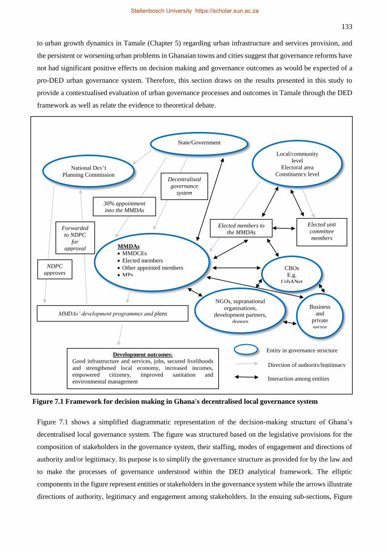
133
to urban growth dynamics in Tamale (Chapter 5) regarding urban infrastructure and services provision, and
the persistent or worsening urban problems in Ghanaian towns and cities suggest that governance reforms have
not had significant positive effects on decision making and governance outcomes as would be expected of a
pro-DED urban governance system. Therefore, this section draws on the results presented in this study to
provide a contextualised evaluation of urban governance processes and outcomes in Tamale through the DED
framework as well as relate the evidence to theoretical debate.
Figure 7.1 shows a simplified diagrammatic representation of the decision-making structure of Ghana’s
decentralised local governance system. The figure was structured based on the legislative provisions for the
composition of stakeholders in the governance system, their staffing, modes of engagement and directions of
authority and/or legitimacy. Its purpose is to simplify the governance structure as provided for by the law and
to make the processes of governance understood within the DED analytical framework. The elliptic
components in the figure represent entities or stakeholders in the governance system while the arrows illustrate
directions of authority, legitimacy and engagement among stakeholders. In the ensuing sub-sections, Figure
Figure 7.1 Framework for decision making in Ghana's decentralised local governance system
Elected unit
committee
members
MMDAs
MMDCEs
Elected members
Other appointed members
MPs
Local/community
level
Electoral area
Constituency level
State/Government
CBOs
E.g.
UrbANet
NGOs, supranational
organisations,
development partners,
donors
National Dev’t
Planning Commission
Development outcomes:
Good infrastructure and services, jobs, secured livelihoods
and strengthened local economy, increased incomes,
empowered citizenry, improved sanitation and
environmental management
Direction of authority/legitimacy
Interaction among entities
Forwarded
to NDPC
for
approval
30% appointment
into the MMDAs
Decentralised
governance
system
NDPC
approves
MMDAs’ development programmes and plans
Elected members to
the MMDAs
Entity in governance structure
Business
and
private
sector
Stellenbosch University https://scholar.sun.ac.za
134
7.1 will be interpreted in the DED framework in light of the findings of this study. In doing so, new analytical
information is occasionally used to elaborate on the key concepts, namely decentralisation, entrepreneurialism
and democratisation.
7.3.1 Synthesis with the DED
This section presents the synthesis of the study relative to the DED analytical framework. As discussed in
Chapters 3 and 4, the state decentralises legislative, administrative and executive functions to the Metropolitan,
Municipal and District Assemblies (MMDAs) within their areas of jurisdiction. Such functions and powers are
to be exercised through partnership building and participatory engagements by multistakeholders including
elected community representatives (assembly members [AMs]), government appointees, technocrats, non-
governmental organisations (NGOs) as well as civil society and community-based organisations (CBOs).
Decentralisation
Figure 7.1 shows how the state decentralises power and responsibilities to the local-government entities (the
MMDAs) to legislate, administer and then execute their development programmes and projects. However, it
can be seen from the figure that the decentralisation process is incomplete on two grounds. First, two (the
MMDCEs and about 30% of other staff members of the MMDAs) of the three categories of staff at the
MMDAs with voting rights (the MPs at the MMDAs do not have voting rights) are appointed by the President
of the Republic. Even though the appointments are made in consultation with local traditional authorities and
opinion leaders (the 30% of staff members appointed) and/or are subject to at least a two-thirds majority
approval (in the case of the MMDCEs) by the elected members of the MMDAs, the state still wields enormous
influence on local-level decision making. For instance, the appointed MMDCEs are not only central
government representatives but also the most powerful figures in the local-government setup. The act of
appointing the MMDCEs in a hybrid local-governance system (see Section 2.4) hinders the success of
decentralisation as well as stifles urban governance practices at city level. This issue will be elaborated in
Section 7.3.1.3. The second issue that affects complete decentralisation in Ghana is the requirement that
MMDAs must submit their development programmes to the state’s National Development Planning
Commission (NDPC) for vetting and approval or rejection (
Figure 7.1). This requirement implies that local governance may remotely be controlled in a top-down fashion
by the state under the guise of the NDPC’s harmonisation exercise. Consequently, some locally relevant issues
in terms of stakeholder interests may be sidelined in an attempt to prepare acceptable development programmes
by the NDPC’s standards and guidelines. This is against the backdrop that the decentralisation system was
adopted to check top-down decision making that was considered insensitive to community development
aspirations and initiatives, and lacked local-level participation in planning processes (Bandie, 2007).
The hybrid/incomplete decentralised local-government system currently in place is inferior to complete
political devolution which allows the citizens to elect all of the important office holders. The Ghanaian citizens’
Stellenbosch University https://scholar.sun.ac.za
135
expressed preference for making the position of the MMDCEs elective (see Chapter 2, Section 2.4.1.1) points
to how less desirable the local-government system fashioned out of Act 462 of 1993 has become. However,
making the MMDCEs’ position elective may appear rather symbolic than improving local and urban
governance in the Ghanaian context as issues such as sectionalism, patronage and ethnicity play a far more
important role in people’s voting behaviour than considerations of socio-economic circumstances (Obeng-
Odoom, 2013). The preceding possibility notwithstanding, allowing complete decentralisation whereby the
locals are able to elect their own leaders and hold them accountable seems to represent the true spirit of the
people’s power.
Respondents in this study felt that the current incomplete decentralised local-governance system makes it
difficult to pursue locally responsive development initiatives. A member of the TAMA’s SPC considered
incomplete decentralisation as one of the biggest challenges facing planning in the city. The respondent’s view
is summarised below:
… decentralisation in Ghana has not got to the level that the framers had envisioned. I think we
still have about 70% centralisation at the headquarters where[by] basic permitting and licensing
for planning projects are done in Accra. [I think] we [should] only have about 5% power at the
centre in Accra so that only serious matters are dealt with there. Complete decentralisation is
good for a number of reasons: 1. The regional and district authorities have proximity advantage
for better scrutiny and monitoring of issues, 2. Decision making is also quicker, 3. Centralisation
alienates the local people in the decision-making process. The people do not think they have the
power and this has been one of the reasons why policies fail [because they] feel everything is
owned by central government, every decision is made by government and that is why they stifle
some of the implementation processes.
If we really want planning to succeed in the country then it should be holistic … We must put
[power] back in the hands of the people [and] all must be engendering and not merely seen to
be participating, and there should be feasible benefits associated with planning for the people
and they should be able to visualise it in the medium to long term. It is also important that the
people be given a credible base for them to air their grievances in the planning process. … For
example, … planning scheme[s] … have to [be] take[n] … to the chief and his elders, the
assemblyman, the magazia24, etc. to explain the content of the plan to them and then give them
time to scrutinise and critique the plan. Once that is done then you have a system that allows
people to own the process. After all planning is about making decisions, agreeing and
disagreeing. It should involve agreeing with the decisions, owning the process, enjoying the
benefits and also fac[ing] the consequences therefrom (interview with a respondent at EPA, 11
February 2014).
Another respondent added:
I think [governance would be better] if the decentralisation concept is what we will go by strictly
where everybody is involved in what is happening … But it seems not to be working … Things
[decision making] are still centralised at the national level. Sometimes there are obvious things
the [MM]DAs should be doing but because of the power that they [national-level officials] want
to enjoy they would not allow the [MM]DAs to do those things. They will sit at the top and do
everything. Sometimes they even come as far as to the district to do things that the staff of the
[MM]DAs could do (interview with a planning official at the SDA, 22 February 2014).
24 Title for local women’s leader in the study area
Stellenbosch University https://scholar.sun.ac.za
136
The challenge of incomplete decentralisation can affect the functioning of the decentralised departments
of the MMDAs. For example, accounts like the above have the tendency to dampen the self-esteem of
staff of the MMDAs and the local people thereby affecting their performance in the local-governance
system. Moreover, the incomplete decentralisation has the tendency to breed unfunded mandate
situations whereby the central government imposes certain obligations on local-level governmental
bodies without providing the necessary resources for implementation of those obligations (Roin, 1999;
Anderson & Constantine, 2005; Dilger & Beth, 2016). Perhaps, the low interest shown (as established
in Chapter 6) by people at the grass roots regarding participation in the unit committee elections is partly
born out of the frustration and feeling of powerlessness as described above. This assertion seems to be
supported by a recent survey by the National Commission for Civic Education (NCCE) that suggested
that over 80% of Ghanaians knew the functions and roles of the various sub-structures of the MMDAs
(Tetteh, 2015). Yet, the unit committees are the building blocks for community and civil society
engagement in the governance processes in that they serve as pivots for community mobilisation by
working in close association with the assembly members to identify and forward the communities’ needs
to the MMDAs for harmonisation into their operations. They also serve as conduits for information
dissemination and policy implementation. Therefore, malfunctioning or non-existent unit committees
will inevitably affect the efficacy of the whole local governance system. As discussed in Chapter 6, a
respondent assembly member lamented about lack of this vital support from his electoral area’s unit
committee members and that is affecting his performance as an assembly member.
The challenge of decentralisation is not limited to vertical decentralisation (state-periphery relationship)
but also horizontally. The decentralised departments of the assembly do not collaborate effectively as
the law would require of them (see Chapter 4). Yet, internal collaboration among these decentralised
departments could be the starting point for external partnership building with CBOs, NGOs and
supranational organisations and development agencies to promote local development.
Entrepreneurialism
Unlike decentralisation and democratisation, entrepreneurialism is not explicitly shown in Figure 7.1. Rather,
it emerges from the decentralisation and democratisation processes through actual governance practices.
Normatively, therefore, entrepreneurialism is expected to emerge from the development programmes and
projects through the collaborative interactions among the central decision-making body of the MMDAs, central
government, NGOs, supranational development agencies, CBOs, civil society as well as private individuals in
various capacities.
There have not been clearly structured local economic development initiatives such as the Sub-committees on
Production and Gainful Employment (SPGEs) mentioned in Chapter 3 in some districts in Ghana. However,
as discussed in Chapter 3 some initiatives with entrepreneurial intent are being implemented in urban
governance in Tamale to support local economic development regarding informal economic activities and
Stellenbosch University https://scholar.sun.ac.za
137
livelihoods, although these are ad hoc in nature compared to the SPGEs. The renovation and expansion of the
local market infrastructure are two related projects being executed through collaborative efforts among the
local and national government, CBOs and international development partners and organisations. The first
component of the project stems from a Ghana Urban Management Pilot Programme (GUMPP) involving the
Government of Ghana (represented by the Ministries of Finance and Local Government and Rural
Development (MLGRD)) on the one hand, and the Agence Francaise de Developpement (AFD) on the other.
Under the programme, the AFD provides a concessionary loan (with a grant component) of €40.5 million to
support urban management improvement efforts of four cities in Ghana, namely Ho, Kumasi, Sekondi-
Takoradi and Tamale. The programme has a cluster of objectives including to “enhance widespread access to
essential services, build the financial, management and ownership capacity of cities, support economic
activities and local employment and limit the negative impact of city extension on peripheral ecosystems” (The
Ghanaian Times, 2012 para. 5). The beneficiary cities had to apply the funds to their priority development
programmes but which would lead to the attainment of the GUMPP objectives outlined above. For Tamale,
these included upgrading of markets and transport terminals, construction of storm drains to address seasonal
flooding and also to provide other ancillary urban infrastructure and services (The Ghanaian Times, 2012).
The implementation of the programme was to benefit from technical assistance from the Institute for Housing
and Urban Development Studies (IHS) of The Netherlands as part of the multilevel collaboration to advance
urban governance. The technical support related to the establishment, management, monitoring and
implementation of the programme with the last receiving special focus to ensure prudent budget spending,
project design and timely execution (IHS, 2012). It is hoped that the technical support sought would not be
‘transplanted’ wholesale as often done regarding knowledge coming from Europe or elsewhere but would be
integrated with local knowledge and context for better development outcome.
The other component of the local market development in Tamale is a collaboration between the TaMA and
The World Bank. This project is a good example of public-private dialogue yielding results to advance local
economic development. Traders in the Old Tamale Market organised themselves into a group known as
Progressive Traders Association (PTA) with technical and advisory support from a local business related NGO,
the BUSAC Fund (funded largely by DANIDA, USAID and the EU). The BUSAC Fund helped build the
capacity of the traders in advocacy and negotiation, and also facilitated dialogue between the traders and the
local authorities, the product of which came as a World Bank support of about US$1.1 million for the
renovation of the market (see Figure 3.3) (BUSAC Fund, 2014). The two projects under discussion show how
vertical and horizontal interaction and collaboration could improve urban governance. If these projects are
executed successfully, they could impact positively on local development through job creation, livelihood
security and increased income for both the traders and the assemblies. The latter would then be able to provide
more urban infrastructure and service.
The SDA’s initiative to develop local markets (also mentioned in Chapter 1) is yet another collaborative effort
to operationalise entrepreneurialism in urban governance. Here, the SDA tried to invoke the true spirit of
Stellenbosch University https://scholar.sun.ac.za
138
decentralisation that is mobilising and harnessing local resources to promote local development. Attempts to
prepare land or space and invite people to develop it with low cost material accessible to them, settle on it and
ply their trade is an innovative way of mobilising local resources for development. Partners in the projects
were to be incentivised in terms of tax subsidy. According to the planning officer at the SDA, the assembly
will initially charge a monthly rent of GHc5 (about US$1.5) because the traders were investing in the project
and might not realise high sale from the beginning. The officer added that they had already constructed a 10-
unit market facility and rented it out but did not have the resources to develop the other one, hence the decision
to partner with the local traders. By so doing, they will be able to generate more income to build more markets
and execute other development projects. The innovative programmes and engagements enumerated above
reflect the CEO traits Obeng-Odoom (2012a) admonished local government leaders to develop to be able to
operationalise urban governance as entrepreneurialism.
As mentioned in the case of the Progressive Traders Association (PTA) of Tamale, CBOs are actively engaging
the people at the grass roots to build their capacity to participate meaningfully in urban governance. The
BUSAC Fund and Urban Agriculture Network (UrbANet), a Tamale-based research and advocacy
organisation, are good examples in this regard. Like the BUSAC Fund did in the case of the PTA, UrbANet
has been able to mobilise and train farmers in group engagement, advocacy work and best farming practices.
The BUSAC Fund has complemented the efforts of UrbANet in training the farmers in financial management,
accounting, marketing skills and occasionally provide funding for some of their activities (BUSAC Fund,
2014). Through the support of the two organisations, vegetable farmers in Tamale were empowered to dialogue
with and lobby the local-government authorities and traditional rulers to help secure and protect their farming
sites to save their livelihoods. Like the traders, the dialogue with the local authorities will yield more benefits
than just securing and protecting their growing sites. The dam redevelopment project discussed in Chapter 5
is the product of these engagements to enable the farmers produce fresh vegetables all year round for the city.
Yet again, the project involves a collaborative effort. The TaMA is capitalising on its Sister City relationship
with the city of Torino in Italy to have an Italian company redevelop the dams for both dry season farming and
for domestic use. In this regard, Torino is joining Louisville, Kentucky, USA to promote local development in
Tamale. The city of Louisville, through the leadership of Dr Susan Herlin, has made a significant contribution
to the development of Tamale, especially in education, by establishing a scholarship scheme for brilliant but
needy students over the last two decades (about 1995-2012).
The activities discussed above suggest that urban governance in the TAMA is being pursued with
entrepreneurial ambitions despite the challenges of incomplete decentralisation and undemocratic tendencies
among some stakeholders. These initiatives could prove valuable in propelling local development through
increased incomes, job and livelihood security and improved quality of life. Increased local economic activities
will also have a positive impact on the assemblies’ internal revenue generation which, for the TaMA, has been
steady at around 10% over the past few years (Tamale Metropolitan Assembly, 2010). See Figure 7.2 for the
composition of the sources of revenue for the TaMA in 2010. It is clear from Figure 7.2 that the local
Stellenbosch University https://scholar.sun.ac.za
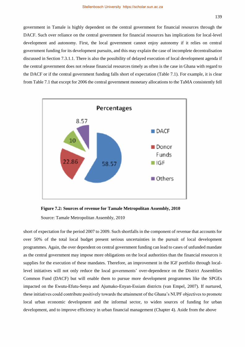
139
government in Tamale is highly dependent on the central government for financial resources through the
DACF. Such over reliance on the central government for financial resources has implications for local-level
development and autonomy. First, the local government cannot enjoy autonomy if it relies on central
government funding for its development pursuits, and this may explain the case of incomplete decentralisation
discussed in Section 7.3.1.1. There is also the possibility of delayed execution of local development agenda if
the central government does not release financial resources timely as often is the case in Ghana with regard to
the DACF or if the central government funding falls short of expectation (Table 7.1). For example, it is clear
from Table 7.1 that except for 2006 the central government monetary allocations to the TaMA consistently fell
Figure 7.2: Sources of revenue for Tamale Metropolitan Assembly, 2010
Source: Tamale Metropolitan Assembly, 2010
short of expectation for the period 2007 to 2009. Such shortfalls in the component of revenue that accounts for
over 50% of the total local budget present serious uncertainties in the pursuit of local development
programmes. Again, the over dependent on central government funding can lead to cases of unfunded mandate
as the central government may impose more obligations on the local authorities than the financial resources it
supplies for the execution of these mandates. Therefore, an improvement in the IGF portfolio through local-
level initiatives will not only reduce the local governments’ over-dependence on the District Assemblies
Common Fund (DACF) but will enable them to pursue more development programmes like the SPGEs
impacted on the Ewutu-Efutu-Senya and Ajumako-Enyan-Essiam districts (van Empel, 2007). If nurtured,
these initiatives could contribute positively towards the attainment of the Ghana’s NUPF objectives to promote
local urban economic development and the informal sector, to widen sources of funding for urban
development, and to improve efficiency in urban financial management (Chapter 4). Aside from the above
Stellenbosch University https://scholar.sun.ac.za
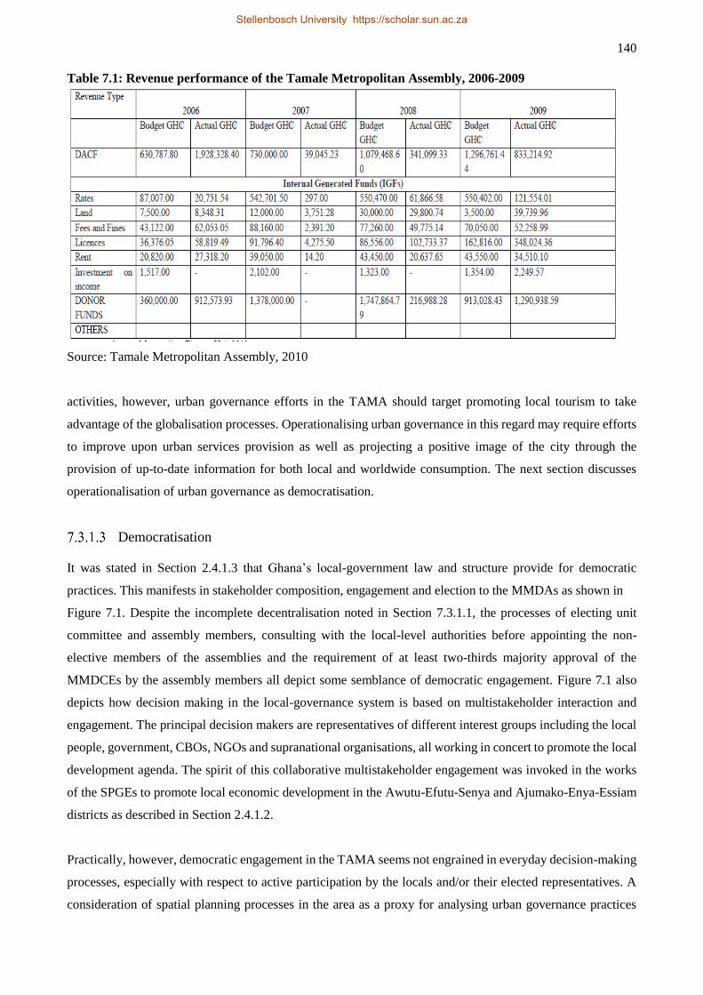
140
Table 7.1: Revenue performance of the Tamale Metropolitan Assembly, 2006-2009
Source: Tamale Metropolitan Assembly, 2010
activities, however, urban governance efforts in the TAMA should target promoting local tourism to take
advantage of the globalisation processes. Operationalising urban governance in this regard may require efforts
to improve upon urban services provision as well as projecting a positive image of the city through the
provision of up-to-date information for both local and worldwide consumption. The next section discusses
operationalisation of urban governance as democratisation.
Democratisation
It was stated in Section 2.4.1.3 that Ghana’s local-government law and structure provide for democratic
practices. This manifests in stakeholder composition, engagement and election to the MMDAs as shown in
Figure 7.1. Despite the incomplete decentralisation noted in Section 7.3.1.1, the processes of electing unit
committee and assembly members, consulting with the local-level authorities before appointing the non-
elective members of the assemblies and the requirement of at least two-thirds majority approval of the
MMDCEs by the assembly members all depict some semblance of democratic engagement. Figure 7.1 also
depicts how decision making in the local-governance system is based on multistakeholder interaction and
engagement. The principal decision makers are representatives of different interest groups including the local
people, government, CBOs, NGOs and supranational organisations, all working in concert to promote the local
development agenda. The spirit of this collaborative multistakeholder engagement was invoked in the works
of the SPGEs to promote local economic development in the Awutu-Efutu-Senya and Ajumako-Enya-Essiam
districts as described in Section 2.4.1.2.
Practically, however, democratic engagement in the TAMA seems not engrained in everyday decision-making
processes, especially with respect to active participation by the locals and/or their elected representatives. A
consideration of spatial planning processes in the area as a proxy for analysing urban governance practices
Stellenbosch University https://scholar.sun.ac.za
141
reveals the extent of asymmetry regarding stakeholder involvement in decision making (see Chapter 6). Spatial
planning practices are highly skewed in favour of a few stakeholders (traditional authorities and TCPD) against
the legislative provision that the process be participatory and conducted at the level of the assembly’s SPC
(see
Table 6.4, Chapter 6). This reality of a lack of democratic practices regarding the use of communally owned
resource (land) has a number of implications for local development. First, there is a danger of increased social
and economic vulnerability and inequality as there are no efforts to distribute the proceeds from land allocation
nor are such proceeds kept in a fund to finance larger societal development pursuits. Consequently, a key
concept of democratic engagement – accountability – is violated. Second, the skewed stakeholder participation
means that the chiefs only seek their interest over that of the larger society (i.e. maximising the proceeds from
land allocation) (see Yeboah & Shaw, 2013). Yet, as evidence in Chapters 5 and 6 shows, integrating public
land use needs in spatial planning is highly desirable in Tamale as a large proportion of the metropolis’
population still depends on public places of convenience and public dump sites for the disposal of domestic
waste. Third, spatial planning based on maximising personal gain pays very little attention to the ecological
and environmental needs of society. This is notwithstanding the discussion in Chapter 2 which suggests that
environmental and climate changes pose grave dangers to cities and their economies going forward. Indeed,
cities in poor countries are already feeling the devastating effects of these changing phenomena. The
undemocratic engagement in spatial planning in Tamale poses a threat to ecological and environmental
sustainability. The unilateral planning by the chiefs with the aid of quack surveyors, (as discussed in Chapter
6) has no regard for environmentally sensitive areas such as wetlands, streams and river courses. Even where
formal planning recognises these, the chiefs would find ways to rezone and reallocate them for residential uses.
Consequently, the ecological and ecosystem services functions of these environmentally sensitive areas were
compromised, and the populations residing in those areas were exposed to natural disasters such as flooding.
Unfortunately, when flooding occurs the local-government authorities and central government would have to
expend their limited resources to cater for ‘victims’ of an otherwise potentially avoidable disaster.
Decision making at the level of the assembly is not spared of undemocratic practices. As Obeng-Odoom (2013)
observes generally about Ghana, political patronage, vote buying, nepotism and sectionalism are rife in
Tamale. Together with local chieftaincy dynamics, these factors have coalesced into political polarisation
along the two dominant political parties in Ghana – the National Democratic Congress (NDC) and the New
Patriotic Party (NPP) (see a respondent’s take on this in Chapter 6,). The situation engenders mutual mistrust,
thereby hindering effective collaboration and partnerships in the decision-making processes at the assembly.
It also affects resource allocation in the society. For instance, some respondents were less enthused about the
development of local markets in Tamale on grounds that such projects are often distributed to party cronies.
This development is completely at odds with the local-government law (Act 462) that proscribes partisanship
in the local governance system (Republic of Ghana, 1993). Unfortunately, the same law, rather paradoxically,
allows the most powerful officers (the MMDCEs) in the local-government system to be appointed by the
President of the Republic from the pool of his/her party’s activists. As a result, the non-partisanship of the
Stellenbosch University https://scholar.sun.ac.za
142
MMDAs is best read in the law books than being practical. It is little wonder, therefore, that the National
Commission for Civic Education (NCCE) in its recent survey found that over 60% of the respondents thought
the current local-government system is partisan with about 70% indicating they would prefer the MMDCEs
be elected (Tetteh, 2015).
From the above, it can be inferred that the MMDCEs may not be effective in ensuring social and economic
inclusion in the manner a Hobbesian Leviathan would superintend the affairs of his subjects. Information
gathered from the interviews suggests that just as the chiefs do in spatial planning, other powerful persons in
society (including politicians) are conniving with the local leaders to bend the rules in their favour. An incident
in this regard relates to a land transaction that generated serious controversy at the time of our fieldwork in
Tamale. Respondents recounted that a ‘big man’ in town schemed and bought a piece of land that belonged to
the state and was occupied by the metropolitan agriculture development unit (MADU). It meant that taking
ownership of the said land by the private person would make the MADU ‘homeless’ in terms of its offices and
few staff quarters and that would impact negatively on societal development. The matter was brought before
the assembly for deliberation. All but two (these were rumoured to be allies of the said developer) of the
assembly members voted against it. However, the will of the people, expressed through their elected
representatives, was subverted as the MCE vetoed the outcome of the vote, in an unprecedented manner, to
sanction the transaction. “… the MCE … did not show good leadership. Because if you are a leader and you
are aware the Assembly represents the people; and the people's representatives say, ‘no, this one is wrong’,
[you should listen to them]25”. The MADU then took the matter to court, and one of the principal witnesses
(TCPD) gave its testimony in favour of the state and MADU. This incident raises serious questions about the
democracy in Tamale, and whether governance is pursued to better the lot of the people or that of a select few.
Another important element of democracy – transparency in governance – seems lacking in urban governance
in Tamale. Democratic governance requires that information regarding administrative, service delivery,
finances and budgets, fees and rates and all forms of documentation be made readily available for public
consumption. Modern societies improve transparency in this regard by employing technology such as
maintaining up-to-date web portals to provide their citizens and visitors enormous resources about living and
doing business in these societies. A cursory search on the internet shows that local-government units such as
the Accra Metropolitan Assembly (AMA), City of Cape Town and Kampala Capital City Authority (KCCA)
render varying degrees of e-services to facilitate service delivery and administrative processes. These efforts
are also relevant in reducing bureaucracy and speeding up document processing time, thereby help reduce
corruption as, in Ghanaian parlance, the ‘anything for the boys’ request is common when dealing face-to-face
with administrative officials. More so, promoting transparency and easy access to information could help boost
the city’s tourism and investment climate in ways that enhance entrepreneurial drive of urban governance (see
discussion in Section 7.3.1.2).
25 No attribution is made to this quote in order to anonymise information pertaining to the issue
Stellenbosch University https://scholar.sun.ac.za
143
Unfortunately, promoting transparency and access to information as described above is not taken seriously in
urban governance processes within the TAMA; at least not in providing public information through the
application of modern technology as some of the cities mentioned above (the city’s website has been down
since the first quarter of 2014) or through the orthodox paper work. It had been discussed in Chapter 6 how
limited public knowledge about the content of local plans contributes to the spate of encroachment and
rezoning of public lands in the metropolis. FM radio broadcast is commonly used as a medium for information
dissemination in the city but its effectiveness is unclear. For example, in explaining the ineffectiveness of
development permitting in Tamale (see Chapter 6), a respondent had doubts if many residents of the metropolis
were aware that they have to obtain a permit to develop their properties.
I do not know what exactly the problem is but it appears people are not even aware that they
have to take building permit before they build. There are people who may genuinely be surprised
to hear that they are required to take building permit before they build (interview with a planning
official at the TaMA, 25 January 2014).
Besides, as local governments strive to build partnerships, collaborate with development partners and market
themselves in this globalised world, it is important to project the democratic credentials as well as investment
and tourism potential of the TAMA by using modern technology as other cities do. Maintaining a functional
web portal would appear the minimum requirement at this stage. For instance, it was intimated in Chapter 6
that development permit applications are delayed because many applicants do not supply all the relevant
supporting documents. This may likely result from applicants not having adequate information such that if the
TAMA could maintain a functional website like the City of Cape Town or Stellenbosch Municipality (smaller
than the TAMA), it would be much easier for applicants to keep abreast of all the requirements before tendering
in their applications. Of course, knowledge of, and accessibility to, the internet is assumed. The next section
presents an evaluative discussion of urban governance in Tamale using the DED analytical framework.
7.3.2 Evaluation of urban governance in Tamale using the DED framework
It was stated in Chapter 2 that the DED framework would be employed to evaluate urban governance processes
and outcomes in Tamale. Obeng-Odoom (2012) proposed a set of questions for the evaluation of urban
governance outcomes using the DED framework and four of these questions are employed in this study, namely
(1) how is urban governance lived; (2) does urban governance lead to job creation, and for whom; (3) does
urban governance lead to improved urban services and infrastructure; and (4) do the elements of urban
governance engender empowerment and accountability in governance? The following discussion answers
these questions based on the results and analysis of the study.
7.3.2.1 How is urban governance lived in Tamale?
To a large extent, the answer to how urban governance is lived in Tamale is a function of how governance is
operationalised within the local-government structures. That is, the structures lay the functions for
multistakeholder collaboration in development pursuit such that the central government, local government,
Stellenbosch University https://scholar.sun.ac.za
144
international organisations, NGOs, CBOs, civil society and citizens at the grass roots build relationships at
different levels (see Section 7.3.1.2). However, a lot more happens outside of the formal local-government
structures. An example of this is the interaction between some CBOs (BUSAC Fund and UrbANet) and people
at the grass roots leading to the latter being empowered and participating actively in governance. This is
different from what transpired in Ewutu-Efutu-Senya and Ajumako-Enyan-Essiam districts regarding the
SPGEs. Similarly, the landlords’ initiatives to organise themselves and partner with utility providers such as
the GWCL (see Chapter 5) to improve their access to services are cases of stakeholder collaboration outside
of the formal structures.
Urban governance in Tamale also tries to promote local economic development by adopting and implementing
entrepreneurial projects (see Section 7.3.1.2). Although these projects are laudable, they appear ad hoc and
may not generate great impact like the SPGE programmes did in the districts mentioned above. However,
efforts to build local government’s capacity in financial management and administrative skills such as the
GUMPP seeks to do, could engender long-term local development. Urban governance in Tamale also fails to
secure public good in spatial planning by acquiring and protecting areas zoned for public use.
Urban governance in Tamale is riddled with undemocratic practices such as patronage and nepotism as
observed in Ghana as a whole (Obeng-Odoom, 2013). This creates an environment of distrust with attendant
issues like lack of social cohesion, favouritism in resource allocation (e.g. market stores) and exclusive
development.
7.3.2.2 Does urban governance lead to job creation in Tamale, and for whom?
Drawing from Section 7.3.1.2, the answer to whether or not urban governance leads to job creation in Tamale
is yes. For example, it is quite simple to argue that the construction of the markets in the City would generate
direct and ancillary jobs for inhabitants of the metropolis. Others may also get or have their jobs secured by
accessing space to ply their businesses upon the completion of the projects. Also, there are potential job
creation opportunities in UPA (vegetable production and fish farming) if the proposed dam redevelopment
projects are executed.
However, the magnitude of such jobs and for whom and how secure they are or would be are not very clear.
Political patronage and nepotism (Section 7.3.1.3) are alleged to cause skewed resource allocation in favour
of some sections of society, and their influence in Tamale would not engender economic and social equity.
Also, it is not clear if there would be job sustainability if no structured programmes are designed and
implemented like the SPGEs in Ewutu-Efutu-Senya and Ajumako-Enyan-Essiam districts. It was stated in
Chapter 3 that about 81% of employment in the local economy of Tamale was to be found in the informal
sector compared to a combined proportion of 18% in the public and private formal sectors. It was further
reported in Chapter 5 how these private informal economic activities accessed space to conduct their activities;
occupying every available space including on roads. In essence, these are ‘system generated’ jobs other than
Stellenbosch University https://scholar.sun.ac.za
145
those evolved from conscious urban governance processes. By system generated, I mean one-person
table/basin top, roadside or mobile vendors who were seen everywhere in the City but who did not exist in the
database of the local authorities. These are the most vulnerable categories of land users that the ‘planned city
easily sweeps’ away (Watson, 2009; Obeng-Odoom, 2013). How urban governance in Tamale accommodates
the livelihoods of this group in the land-use mix of the metropolis in a sustainable manner remains a daunting task.
From the above, it is clear that urban governance led to job creation in Tamale but the equitable distribution,
security and sustainability of such jobs remained unclear. Therefore, conscious efforts may need to be made
to promote equity in job distribution as well as designing programmes to ensure job security and sustainability.
7.3.2.3 Does urban governance lead to improved urban services in Tamale?
Unlike job creation, it is a difficult proposition regarding whether or not urban governance in Tamale enhanced
access to improved urban services. Some examples could be shown to support a ‘yes’ answer but there were
many others that could be cited to support a ‘no’ answer. It was reported in Chapter 5 that households in the
TAMA have enjoyed improved access to water and electricity over the past decade. In the case of water, for
example, the TAMA was the only metropolitan area (among the five metropolitan assemblies in Ghana
including Accra) that witnessed an increase in its population’s access to pipe-borne water between 2000 and
2010. However, water supply through the piped system remained erratic and urban governance was not
effective in providing or sustaining the less popular alternative sources of water such as dams, dug-outs and
boreholes. Access to sanitation and waste disposal services was very poor in the metropolis (Chapter 5). Very
low proportions of households or residents in the metropolis had access to in-house toilet facilities and/or in-
house waste collection or access to developed sewage systems for liquid waste disposal. Consequently, large
numbers of the metropolis’ inhabitants resorted to public toilets and refuse dump sites as practical alternatives.
In between these, there were substantial numbers of people without access to any toilet facility and thus
resorted to open defecation as well as those who disposed of waste indiscriminately (UN-Habitat, 2009b). This
presents direct public health risks in the metropolis. According to UN-Habitat (2009), the problem of poor
urban services provision in Tamale was partly due to uncoordinated spatial growth in the City, a claim to which
this study lends support (see Chapters 5 and 6). Chapter 6 in particular suggests potential future social and
environmental problems arising out of such uncoordinated spatial growth. This seems to validate the claim of
planning theory that “public interest is best served when community development does not proceed
haphazardly but is instead guided and coordinated by an officially adopted plan that expresses community
goals and includes strategic mechanisms for achieving those goals” (Stevens et al., 2014 p. 77).
In terms of urban infrastructure, the discussion suggests that urban governance in Tamale led to improvement
in local market infrastructure. There was also improvement in the metropolis’ road networks. Nevertheless, as
illustrated in Figure 5.4 in Chapter 5, a large part of the peri-urban areas lack road infrastructure and this was
Stellenbosch University https://scholar.sun.ac.za
146
confirmed by a respondent at the DUR who maintained that many roads in the metropolis required opening
(the first step in road development in the metropolis).
From the foregoing, it can be concluded that urban governance in Tamale had mixed results regarding the
production of urban services and infrastructure. There was relatively better access to water and electricity in
the metropolis than there was to sanitation and waste disposal facilities. Even the water situation was not
efficient in that erratic supply from the urban water system often led to periodic shortages as there were few
alternatives (dams, boreholes and dug-outs) on which to rely. There was improvement in the road infrastructure
too, but again, large parts of the City, especially in peri-urban areas, remained poorly connected. Efforts to
improve the local markets infrastructure are also positive signs of urban governance promoting local
development in Tamale. In the final analysis, urban governance in Tamale led to improved urban services and
infrastructure but at a slow pace. Therefore, much needs to be done, especially in the areas of sanitation and
waste disposal.
7.3.2.4 Does urban governance in Tamale empower people to hold their leaders accountable?
Modern democratic practices present people with opportunities to hold their leaders accountable. Some of
these opportunities include voting to elect, replace or impeach ineffective leaders, lobbying the power brokers
(appointing authorities) to remove unresponsive leaders and in some cases taking to the streets in public
demonstration to impress upon leadership to act in a certain way. For example, Ghana’s Local Government
Act (Act 462 of 1993) stipulates that an elected member of the assembly can be removed from office if at least
25% of registered voters in the electoral area concerned petitions the Electoral Commission (EC) in that regard.
The EC will then organise a referendum in which a minimum voter turnout of 40% is required with at least
60% of votes cast supporting the move to remove the embattled member from office (Republic of Ghana,
1993). Similarly, an appointed member can be removed from office at the discretion of the appointing authority
or based on a three-quarters recommendation by members of the assembly on grounds of impropriety and/or
negligence of duty. Thus, by these arrangements disgruntled members of an urban governance system no
longer have to ‘vote with their feet’ as the only practical method to escape from bad leadership (Obeng-Odoom,
2013).
Despite the aforementioned checks and balances, there was little to no direct evidence to suggest that the urban
governance processes in Tamale afforded the people an opportunity to hold their leaders accountable. The
conduct of the chiefs in regard to land appropriation and the related grumbling by people at the grass roots
were cases in point (see Chapter 6 and Section 7.3.1.3 of Chapter 7). The chiefs explicitly appropriated
communal property without any form of accountability. The case of an MCE overturning the collective
decision of the assembly members was another example of blatant disregard for the rule of law but for which
no punitive action was taken to hold him accountable. Many factors made it difficult to hold leaders
accountable in Tamale. Among these were what have been mentioned as political polarisation and patronage,
Stellenbosch University https://scholar.sun.ac.za
147
nepotism and sectionalism, vote buying as well as too much reverence for traditional authority. According to
Obeng-Odoom (2013 p. 174), “in such a politically imperfect context, accountability is sacrificed for voter
short cuts”. In the context of the preceding, it will be difficult to remove MMDCEs from office because they
will often build alliances with certain interest groups that would support them at all cost. Therefore, securing
a 25% of registered voters to move for their removal, then getting 40% turnout in a referendum and finally
securing a 60% approval is almost unthinkable. For example, securing 40% turnout in local-government
election is not easy in Ghana. Three out of five local elections in Ghana between 1994 and 2011 recorded
turnout rates below 40% while the rates for the other two were 42% and 43% (Obeng-Odoom, 2013). On the
part of traditional authority, the reverence with which it is held makes it particularly difficult for people to
speak out and those who may be brave enough to speak out are afraid of being victimised. The problem is
compounded by the fact that chieftaincy office is held for life and there is no opportunity available to the
people for their removal from office except only by the enskinning authority. However, this is very uncommon;
it might happen just once in a generation.
Regarding the Ghanaian local-government structure, it appears the question of accountability is more difficult
to deal with in applying the DED framework to analyse urban governance processes and outcomes. The hybrid
nature of the Ghanaian local-government structure (a combination of devolution and deconcentration),
especially the requirement for removing bad leaders, makes it much more difficult for people to hold their
leaders accountable. The question of accountability may be more evaluative in a complete decentralised
governance system than a hybrid one like Ghana’s. Consequently, the evaluation of accountability within the
DED framework should be contextualised to make it qualitatively measurable in specific cases. For better
assessment of accountability in urban governance, it is suggested that the question of accountability as
proposed by (Obeng-Odoom, 2013) should be modified to, first, understand the structural arrangements for
holding local-government leaders accountable and, second empirically evaluate the concept. The modified
question will then be similar to the two-pronged question of job creation and distribution in urban governance
(Obeng-Odoom, 2013).
From the above, it is reasonable to conclude that urban governance processes in Tamale do not provide
adequate avenues for the people to hold their leaders accountable. Nonetheless, it is a national problem and
efforts are needed to improve democratic practices in urban governance across the country. Perhaps, complete
decentralisation whereby all important local leaders are elected could promote accountability in local and urban
governance. However, it is possible that the problems discussed here would permeate an elective mayoral
system and thus render it unaccountable as well (Obeng-Odoom, 2013).
The evaluative discussion presented in Section 7.3.2 (Sections 7.3.2.1 to 7.3.2.4) answers research Question 6
regarding whether or not urban governance processes in Tamale are pro-DED. The statutory provisions for the
conduct of urban governance (as discussed in Section 2.4.1) and local initiatives to promote local economic
development (see Section 7.3.1.2) indicate a pro-DED urban governance in Tamale. On the contrary, the
Stellenbosch University https://scholar.sun.ac.za
148
incomplete decentralisation discussed in Section 7.3.1.1 and undemocratic practices such as lack of
accountability, self-centredness and political patronage shown in Section 7.3.1.3 did not engender pro-DED
urban governance in Tamale. The lack of clear-cut answer in this situation and in Sections 7.3.2.1 to 7.3.2.3
suggests that it will be difficult to apply the DED analytical framework in complex systems like urban
governance. For example, it will be practically challenging to identify all stakeholders in urban governance in
situations of high urban informality associated with overlapping and conflicting legitimacy issues as often is
the case in sub-Saharan Africa. Given this difficulty, there is a danger of analysts narrowly focusing attention
on governance processes and outcomes in formalised structures to the neglect of more potent forces embedded
in informal structures as illustrated in spatial planning processes in Tamale (where the chiefs are not recognised
and represented directly on the Statutory Planning Committees (SPCs) of the MMDAs but have greater control
over practical planning and implementation processes). The challenge hinges on developing appropriate
matrices for comprehensive evaluation of urban governance processes and outcomes using the DED. In spite
of the challenge noted in the preceding discussion, the application of the DED framework in urban governance
provides analysts the opportunity to identify loopholes and inefficiencies in governance for improvement by
the relevant stakeholders.
7.3.3 Theoretical analysis
It was stated in Chapter 3 that Healey’s collaborative planning theory would be adopted in this study. Its
relevance in this context stems from the convergence between governance as conceived in Ghana’s local-
government law and the core propositions of collaborative planning as a participatory and partnership-building
endeavour. The evidence provided in this study supports how collaborative planning and/or participatory urban
governance would be beneficial for local development. For instance, unlike other strands of normative
planning that prescribe minimal government involvement in planning (e.g. communicative theory or the theory
of monocracy by Moroni), conception of planning as a collaborative and partnership-building activity enables
the government of Ghana to facilitate local development by fostering collaboration and partnerships among
itself, the local governments, the AFD and the IHS in the initiation and implementation of city-specific priority
projects under the GUMPP. These multilevel, horizontal and vertical collaboration and partnerships also saw
people at the grass roots being empowered through their interactions with some CBOs (e.g. UrbANet and
BUSAC Fund) to enable them to participate effectively in urban governance. Thus, empathic understanding,
and empowered and purposeful stakeholder participation do not only promote pro-poor or inclusive urban
governance but more importantly have the potential to engender sustainable urban development.
However, the undemocratic practices observed in the study point to the inherent challenges of collaborative
planning or participatory governance. In reality, decision making unfolds quite differently from theory and the
structural framework extracted from the local-government law. For instance, the self-interested behaviour (e.g.
that of the chiefs) and undemocratic practices (exemplified by the political patronage, nepotism and lack of
accountability in governance) show how difficult it is to pursue broad societal interest in complex systems like
Stellenbosch University https://scholar.sun.ac.za
149
urban space. This means that Huxley's (2000) scepticism about dominant interests being assuaged by better
argument in favour of the common good in communicative planning is a valid challenge in collaborative
planning as well. Societal power imbalances and stakeholder self-centredness could easily unsettle the key
proposition of collaborative planning – empathic understanding among stakeholders – and cause ineffective
participatory engagements. Regarding the structures provided in Ghana’s local-government law to guide
collaborative and participatory governance, Berrisford (2014) argues that it is not enough to just provide
avenues for participation, especially when valuable resource like urban land is involved. Rather, it is imperative
that strategic means to enforcing such guidelines be devised and activated.
The challenges to collaborative planning and participatory urban governance observed in Tamale seem
characteristic of planning reform in sub-Saharan Africa. While Watson (2002) acknowledges the value of
normative planning theory in sub-Saharan Africa regarding giving voice to the vulnerable in planning and its
potential for poverty reduction and ensuring distributive justice, she is concerned that certain factors may
inhibit its applicability on the continent. For instance, she is concerned that civil society in Africa is less robust
and often times groupings at the grass roots are based on ethnicity rather than on the will to promote a larger
societal development agenda (Watson, 2002). The weak civil society, Watson (2002) continues, breeds
‘clientelist’ relationships between these local groups (their leadership especially) and politicians. While ethnic-
based group interests were not discernible in Tamale, sectionalism, political patronage and self-centredness
were apparent as discussed in the previous sections. According to Berrisford (2014), the difficulty in planning
reform in Africa is partly blamed on little attention to regulating the self-centred interests of the powerful and
privileged classes in society. To deal with ‘elite capture’ of the process requires an effective “framework of
rules to mediate and regulate competing pressures and interests” by putting in place in-built mechanisms to
alert the system when elite groups, including the traditional authorities, try to twist the process to their
advantage (Berrisford, 2014 p. 167).
In the African context (where traditional leadership enjoys an awesome reverence, e.g. in Tamale), therefore,
planning theory reform has to pay particular attention to issues of cultural dynamics with special focus on
power relations. Somehow, this may require government playing an active role, but not in the sense of absolute
control of planning or governance. Most of the respondents who participated in this study suggested that active
government involvement was the surest way to achieve inclusivity and protection of public interest in spatial
planning in Tamale because the state has the resources and legal obligation to guarantee distributive justice in
resource allocation. This obligation is vested in the state by the Ghanaian Constitution as quoted in Chapter 6,
Section 6.4. The argument put forward for active government involvement in planning in Tamale is in line
with Berrisford's (2014) call for moving beyond providing prescriptive entitlements in laws and policy
documents to devising strategic and practical measures to effecting them. For example, while restituting
Northern Ghana lands to the respective owners after it had been vested in the state in trust for the people since
colonial rule (Republic of Ghana, 1992), the state could have developed effective ancillary regulatory
frameworks to guarantee the Constitutional imperative mentioned above. Admittedly, this would not be an
Stellenbosch University https://scholar.sun.ac.za
150
easy endeavour given traditional authorities’ professed ambivalence to active government involvement in
customary/communal land administration (see Chapter 6, Section 6.4). This is typical of elite groups trying to
keep the status quo to maximise personal benefits in planning.
It appears, therefore, that only empathic understanding backed by empowered collaboration in multilevel and
multistakeholder partnerships are the most desirable approaches to doing inclusive planning and urban
governance in Tamale, and that may well apply to other parts of the Global South. Instilling such a sense of
empathic reasoning among self-interested stakeholders in complex systems like urban governance and
planning is undoubtedly a daunting task. This then raises doubts about the feasibility of Lovering's (2009)
persuasive dilemma regarding whether to reorient planning to cater for the vulnerable or to continue planning
for the interest of the elites. Certainly, elite capture of planning or governance reinforces social and economic
inequalities, and this contradicts the premise of collaborative planning and/or participatory governance. Thus,
theorising planning reform and improvement in urban governance in the context of sub-Saharan Africa would
require conscious efforts to deal with local-level power relations, stakeholder self-centredness, instilling the
value of empathic reasoning among stakeholders and empowering people at the grass roots to participate
effectively in decision making.
7.4 SUMMARY
This chapter set out to synthesise the findings of the study regarding legislative and institutional framework
for doing planning and urban governance in Ghana, spatial analysis of the city’s growth and how urban
governance processes respond by way of urban infrastructure and service provision. The objective in the
synthesis was to analyse urban governance in Tamale within the DED framework, and thereafter evaluate the
results against four questions proposed as benchmarks for evaluating the effectiveness of the DED in urban
governance.
The analysis showed that the decentralised governance system implemented in Ghana since the last decade of
the 20th Century provides enough room for multistakeholder participation in governance. However, people
would prefer complete decentralisation that gives them the opportunity to elect all of the most important leaders
of the local governance system and hold them accountable. There was also evidence that urban governance in
Tamale was being operationalised in entrepreneurial lenses in order to promote local socio-economic
development, and that this was made possible by multilevel and multistakeholder partnerships and
collaboration among central government, international development agencies and organisations, CBOs and
people at the grass roots. The CBOs played a particularly important role to empower the local people to be
able to participate effectively in the urban governance processes. The results were less than favourable
regarding the conception of urban governance in terms of democratisation. Issues raised in this respect included
incomplete decentralisation, leadership self-centredness and lack of accountability among both local
government and traditional leaders.
Stellenbosch University https://scholar.sun.ac.za
151
The evaluative analysis showed that (1) urban governance in Tamale was operationalised in the DED
framework but undemocratic practices by the leadership such as patronage, clientelism and nepotism were
apparent and have the potential to create or reinforce social and economic exclusion, (2) urban governance
creates jobs in Tamale but the magnitude, and whom those jobs benefit were not very clear (due to some of
the undemocratic practices outlined above), (3) urban governance in Tamale has had a limited impact on access
to improved services and infrastructure with better access to water and electricity while much needs to be done
regarding others like sanitary facilities and road infrastructure, (4) the question of whether or not urban
governance empowers people to hold their leaders accountable received largely a negative rating due to some
of the undemocratic tendencies mentioned earlier.
On a theoretical level, it was observed that the urban governance outcomes, especially those related to
entrepreneurial activities geared towards local development, unfolded in the context of collaborative planning.
Nonetheless, many factors including political patronage, nepotism, elite capture among others precluded
effective urban governance as conceived of in collaborative theory and the DED framework. The main reason
for this was self-centredness on the part of leaders which hampered empathic understanding among
stakeholders.
Stellenbosch University https://scholar.sun.ac.za
152
CHAPTER 8 CONCLUSIONS
8.1 INTRODUCTION
This chapter concludes the presentation of the results of the study by providing summary of key findings and
arguments (Section 8.2), the DED analysis and evaluation (Section 8.3), theoretical commentary in Section
8.4, the study’s contribution to scholarship in Section 8.5 and recommendations for further research and policy
in Section 8.6.
8.2 SUMMARY
The findings of the study are summarised under the study objectives, namely a review of statutory provisions
for spatial planning and urban governance, describe spatio-temporal growth dynamics of Tamale and assess
the provision of and access to urban services, and to examine urban governance processes through
identification and assessment of stakeholder engagements in spatial planning. Summary of the synthesis of the
findings and evaluation of urban governance in Tamale using the DED framework and collaborative theory is
also given while discussion of the study’s contribution to scholarship concludes the section.
8.2.1 Statutory provisions for urban governance and planning
The foundations of planning in Ghana were laid in the 1920s as the colonialists attempted to manage human
settlements primarily on health grounds and to some extent for aesthetic appeal. However, it was not until 1945
that the Town and Country Planning Ordinance (Cap 84) was passed, which served colonial planning and
remains integral to contemporary planning law of Ghana. In line with the exploitative character of colonial
rule, the practice of planning created social, economic and spatial inequalities in the colony which post-
independence governments, especially that of President Nkrumah, tried to redress through reorientation and
practice of planning. The immediate post-independence government embarked on planning reforms including
efforts to prepare a National Physical Development Plan (NPDP) and promotion of planning education to
produce professional planners to guide development to achieve social, economic and spatial equity. However,
little was achieved from these processes due to a multitude of factors, namely high urbanisation rates,
inadequate resources and the 1966 coup that toppled the first republican government of Nkrumah.
Consequently, urban problems got worse than before due to the rapid urban growth that followed the nation’s
independence.
Planning inertia occurred in Ghana for about two decades following political instability after the overthrow of
Nkrumah’s government. A new planning system was introduced in the early 1990s based on decentralised and
participatory local governance but key features of the colonial planning framework (CAP 84) remained the
guiding framework for spatial planning albeit with revisions with subsidiary legislations. Like the immediate
post-independence planning reforms, however, the decentralised governance system could not engender the
expected local and urban development due to factors such as poor resourcing, political interference, land tenure
Stellenbosch University https://scholar.sun.ac.za
153
dynamics, lack of institutional coordination and institutional incongruence. As a result, urban problems in
Ghanaian towns and cities have intensified such that poor urban services and infrastructure, slum development,
haphazard spatial development, increasing poverty and vulnerability to natural disasters like flooding, and
livelihood stress among urban and peri-urban dwellers are prevalent. The aforementioned challenges have led
to renewed efforts to promote sustainable urban development in Ghana through the formulation of a national
urban policy framework (NUPF) as well as the yet-to-be promulgated spatial development framework (SDF)
to guide planning at the national, regional and districts levels. The new developments seek to improve planning
in Ghana by integrating the social, economic and environmental aspects of development in the frame of
integrated development plans (IDPs) and spatial development frameworks (SDFs) to strengthen urban
governance, promote local economic development and enhanced delivery of urban infrastructure and services.
It is argued that the NUPF and the LUSPB need to be harmonised to promote efficiency and capacity building
of institutions and staff. Also, needs assessment should form the backbone of planning in order to promote
judicious use of the environmental and natural resources such as land. There is also the need to rethink the
essence of decentralised local government by building stakeholder capacity for effective participation in
decision making as well as delinking overly parochial political interests of individuals and groups from those
of societal interests to allow development programmes to progress uninhibited.
8.2.2 Spatial and demographic growth dynamics and urban governance response in
infrastructure and service provision
Demographically, the TAMA has witnessed rapid growth since Ghana’s independence in 1957 to become the
country’s third largest metropolis. The TAMA presently has an estimated population of 400 000 compared to
a total population of 40 000 during the first post-independence census in 1960. The TAMA recorded the second
highest intercensal annual population growth rate in 2010 after historically registering the highest intercensal
annual growth rate of 7.3% between 1960 and 1970. Rapid increases in the number of vehicles and motorcycles
registered for use within the metropolis have added complexity to the TAMA’s demographic and spatial
growth dynamics as improvement in intra-city transportation, especially between the peri-urban areas and the
urban core, enables people to settle farther away from the city centre. Consequently, the City has consistently
experienced rapid spatial growth which was about 100 ha per annum at 4.4% growth rate between 2001 and
2014.
The analysis in Chapter 5 showed that the city’s spatio-demographic growth dynamics exact complementary
demands on urban infrastructure and services so much that urban governance systems have been overwhelmed
by the sheer demand for adequate road infrastructure. Most parts of the peri-urban areas were connected with
poorly developed and dusty roads. The results further revealed that urban governance systems in Tamale have
not been able to provide adequate infrastructure for the disposal and treatment of both liquid and solid waste.
Access to toilet facilities was also very low in Tamale compared to other metropolitan areas like Accra, Kumasi
and Tema. However, the TAMA’s population had better access to piped-water and electricity, and this was
Stellenbosch University https://scholar.sun.ac.za
154
partly the result of co-production with individual households once the basic trunk infrastructure was laid.
Access to piped-water in the City between 2000 and 2010 was better than it was in any other metropolitan area
in Ghana, even though delivery was erratic due to system inefficiencies. Unfortunately, the urban governance
systems in the city did not effectively secure and protect less common sources of water such as dams, boreholes
and dug-outs to tackle the perennial water crisis occasioned by erratic supply from the urban water system.
The results of Chapter 5 have implications for socio-economic development of the TAMA, namely the
infrastructure deficit has the potential to stifle local economic development and the low access to sanitary
facilities poses a risk of public health crisis in the city. It is concluded that the results presented in this study
point to challenges regarding sustainable management of urban growth within the TAMA. It thus behoves the
authorities to devise innovative initiatives to improve urban infrastructure and service delivery to promote
local economic development and to avert any possible public health crisis from the dearth of sanitary and waste
disposal facilities. The innovative initiatives could be modelled along the lines of the self-help co-production
efforts exhibited by households regarding water and electricity delivery and channelled through participatory
approaches in the frame of local-government system. In this regard, practical innovations to improve urban
governance and service delivery should entail operationalisation of urban governance with entrepreneurial
intent to generate adequate resources to execute urban governance programmes. This will be a giant step
towards the attainment of the objectives of Ghana’s national urban policy framework.
8.2.3 Secure public interest in planning – planning processes and stakeholder engagement
The analysis of the content of nine sampled local plans of Tamale revealed appreciable representation of public
interest in plan content through zonings for public uses. The broad categories of these public land-use zonings
are open space, reserve/buffer, sanitary area, school/clinic, market, social centre and worship. The relatively
high representation of these public land-use zonings suggested a needs-based planning that would be
implemented to serve the purposes for which they were zoned. However, analysis of their status on the ground
revealed serious encroachment on them, suggesting that those zonings might not, after all, be appreciated by
the larger society. There were variations regarding rates of encroachment on the identified public land-use
zonings with sanitary areas and zonings for schools and clinics encroached the least. In contrast, zonings for
open space, reserve and buffer were encroached the most. The explanation for sanitary areas being encroached
the least was given as their apparent utility as sites for public toilets (which provided greatest access to the
population of the metropolis) and the fact that some of those land uses predated many local plans, making it
difficult for them to be encroached upon.
General explanation for the observed encroachment was related to the limited participatory nature of planning
that kept content of plans in obscurity, enabling traditional authorities (chiefs) to clandestinely rezone and
reallocate these public land-use zonings for personal gain. The behaviour of the chiefs in this regard was part
of a broader scheme to arrogate land ownership to themselves in direct contravention of traditional customary
Stellenbosch University https://scholar.sun.ac.za
155
land tenure arrangements which forbade chiefs from alienating land for personal gain. The encroachment was
also blamed on local-government authorities’ failure to properly acquire and protect these public land-use
zonings in the interest of larger society as the law mandated. Part of the failure of the local-government
authorities manifested in weak monitoring of spatial development.
It is argued that the spate of encroachment on public land-use zonings will have negative ramifications for
sustainable urban development in the TAMA. First, it will affect social development by restricting access to
places for public interaction and socialisation. Second, the land tenure changes occurring in the area will breed
inequalities by rendering people landless at the expense of a few. Third, the encroachment on open space and
reserve/buffer areas (often associated with wetlands, banks of rivers and dams) will likely result in impaired
ecological and ecosystem services functions of the urban environment in Tamale, at the time of growing
concerns for the impact of cities on climate change. Physical development in these areas also exposes people
to natural disasters such as flooding, which not only poses threat to lives and property but also can put pressure
on local-government budgets in times of disaster.
It is concluded that structural reforms are needed in the decentralised governance system to improve
stakeholder participation in spatial planning and urban governance to orient planning to benefit the larger
society. In this regard, attention should be given to engagements between the chiefs and local-government
authorities to promote democratic tenets such as participation, accountability and transparency in planning
with the view to upholding Ghana’s Constitutional provision that tasks managers of public, stool, skin and
family lands to ensure distributive justice for all. These reforms would then be mainstreamed into the broader
urban governance system to promote needs-based spatial planning and bottom-up local development.
8.3 THE DED ANALYSIS AND EVALUATION
The analysis of the DED framework involved an assessment and ascertainment as to whether or not the results
presented in this study (urban governance practices in Tamale) conform to decentralisation, entrepreneurialism
and democratisation principles. The evaluative aspect, on the other hand, relates to certain development
outcomes that point to effective urban governance, and in this study these were centred on processes of urban
governance, job creation, access to improved urban services and accountability.
On decentralisation, it was found that Ghana’s local-government law (Act 462 of 1993) offered the model that
does not allow for complete decentralisation. This conclusion was reached based on the fact that 30% of the
staff of the MMDAs (including the most powerful figures in the MMDCEs) is appointed by the President of
Ghana , and also the requirement that local-level development programmes and plans be audited and approved
by a state agency (National Development Planning Commission [NDPC]). The incomplete decentralisation
makes people feel powerless and alienated from the governance processes and this affects their enthusiasm
and participation in the process. A related issue is the possible continuous top-down control of local-level
Stellenbosch University https://scholar.sun.ac.za
156
development by the activities of the NDPC which will likely inhibit local initiatives and the pursuit of
programmes relevant to local development.
Operationalisation of urban governance as entrepreneurialism was observed to emerge from the interactions
among the various stakeholders the local-government law of Ghana prescribed. It was observed that urban
governance in Tamale was entrepreneurial in character even though no clearly structured programmes existed
in this regard like those implemented in the Ewutu-Efutu-Senya and Ajumako-Enyan-Essiam districts of
Central Region of Ghana. Several efforts to improve local economic development such as the renovation and
expansion of existing market infrastructure and building of new ones were considered entrepreneurial as those
have the potential to create and support jobs in the informal sector, and improve the incomes of the locals and
the MMDAs. Improved internally generated income (IGF) will not only make the MMDAs less dependent on
the District Assemblies Common Fund (DACF) but will more importantly enable them to execute their
development programmes successfully and on time. It was particularly refreshing to learn that these efforts
were products of collaboration, partnership-building and participatory engagements among the local-
government authorities, the central government, supranational agencies, NGOs, CBOs and people at the grass
roots. The interactions between some CBOs and certain livelihood groups or people at the grass roots leading
to the latter being empowered to participate meaningfully in urban governance was especially admirable. This
therefore supports collaborative planning theory’s argument that empathic understanding and engagement
among stakeholders has the potential to promote inclusive and sustainable development.
In respect of urban governance as democratisation, Ghana’s local-government law provides for democratic
practices through staffing of membership of the MMDAs and multistakeholder engagement as observed above.
In terms of staffing, about 70% of the membership of the MMDAs is elected by universal adult suffrage while
the remaining 30% is appointed in consultation with traditional and other local leaders, and approved by the
elected assembly members. Notwithstanding the above arrangements to ensure democratic practices, certain
undemocratic tendencies were discernible in urban governance processes of Tamale. These relate to self-
centred decision making and lack of accountability and transparency in governance, and were sustained by
political patronage, nepotism, sectionalism and local chieftaincy dynamics. These weaknesses have far-
reaching negative implications for inclusive development including resource distribution and participation in
decision making by relevant stakeholders. As governance involves building of partnerships, collaboration with
development partners and projecting the image and credibility of entities in this globalised world, it is
important to promote and project the democratic credentials of the TAMA alongside its investment and tourism
potentials to attract both local and international support like those from its sister city relationships and some
supranational agencies.
The above summary leads us to the evaluation of urban governance processes and outcomes in Tamale through
the DED framework regarding four questions highlighted earlier. For the first question (how urban governance
in Tamale is lived), it was concluded that urban governance in the city was collaborative, participatory,
Stellenbosch University https://scholar.sun.ac.za
157
entrepreneurial albeit project-based as opposed to structured programme-based. However, certain
undemocratic practices have the tendency to stifle inclusive development and promote social and economic
inequalities. Regarding the second evaluative question (whether or not urban governance in Tamale creates
jobs, and for whom), it was also concluded that urban governance in Tamale creates jobs but the magnitude,
distribution and sustainability of those jobs were not very clear. For example, some respondents in the
interviews alleged that the undemocratic practices discussed earlier had the tendency to influence the
distribution of these jobs or opportunities based on partisan considerations. The third question (whether or not
urban governance in Tamale enhanced access to urban services and infrastructure) also received a mixed
answer. There was evidence to the effect that urban governance in Tamale has brought about improved access
to water and electricity. There had also been improvement in road infrastructure even though the extent of
tarred road network was limited within the city’s built-up areas and a greater part of the peri-urban areas still
needed opening. On the other hand, there was not much to celebrate regarding access to sanitary and waste
disposal facilities. In the nutshell, urban governance in Tamale led to improved access to urban infrastructure
and services albeit at a slow pace. Perhaps, evaluative question number four (whether or not urban governance
empowered the people to hold their leaders accountable) attracted the clearest cut answer. There was very little
evidence that urban governance in the City promoted accountability despite the local-government law showing
some in-built mechanisms to achieve that. The undemocratic practices noted earlier were the main reasons for
the lack of accountability in urban governance processes of Tamale. However, it was argued that the hybrid
nature of Ghana’s decentralisation system (a combination of devolution and deconcentration) made it difficult
to achieve accountability in urban governance. It was suggested that complete decentralisation will be more
amenable to evaluation than the hybrid system like Ghana’s. It was suggested further that the question of
accountability be modified in a two-pronged format to first evaluate the disposition of the decentralisation
system towards accountability (structural evaluation) before evaluating its accountability credentials (outcome
evaluation). This would be similar to the question of job creation and distribution.
Besides the specific problem with evaluation of accountability in the application of the DED framework, there
was a general challenge of the applicability of the framework in complex systems like urban governance. This
difficulty follows from the lack of clear-cut answer in the first three evaluative questions. In this regard,
analysts applying the DED framework in the urban context may be overwhelmed by the sheer numbers of
stakeholders – both formal and informal – with conflicting and overlapping interests, legitimacy and power
relations. This makes it difficult to collate information and develop matrices for empirical evaluation of urban
governance using the DED framework. Notwithstanding this challenge, the DED analytical framework
remains useful in evaluating urban governance, especially as it enables analysts to identify the ineffectiveness
of urban governance systems through its application.
Stellenbosch University https://scholar.sun.ac.za
158
8.4 THEORETICAL COMMENTARY
The theoretical point of entry for this study was Healey’s collaborative planning that proposes active
multistakeholder participation in planning to promote pro-poor development. The processes and outcome of
urban governance in Tamale (fashioned on Ghana’s local-government law) show the potential of collaborative
decision making in promoting inclusive development. Thus, the vertical and horizontal collaboration and
partnerships among the governmental, non-governmental, local-government authorities, CBOs and people at
the grass roots impacted positively on local development through infrastructure and service provision, job
creation and livelihoods support. Nonetheless, several challenges were identified to inhibit collaborative
planning and participatory urban governance in the metropolis. These were self-centredness, elite capture and
undemocratic practices such as political patronage, nepotism, sectionalism and lack of accountability and
transparency in decision making. These challenges are by no means peculiar to Tamale. Indeed, they have
been acknowledged as genuine hindrances to collaborative planning and participatory urban governance,
especially in the context of sub-Saharan Africa (Huxley, 2000; Watson, 2002; Obeng-Odoom, 2013;
Berrisford, 2014). Therefore, this study provides empirical support in that regard. It is thus concluded that,
theorising planning reform and improvement in urban governance in the context of sub-Saharan Africa would
require conscious efforts to deal with local-level power relations, stakeholder self-centredness, instilling the
value of empathic reasoning among stakeholders and empowering people at the grass roots to participate
effectively in decision making.
8.5 DISTILLING THE STUDY’S CONTRIBUTION TO SCHOLARSHIP
This section summarises the study’s contribution to knowledge regarding research and theory. Contribution to
research in this context concerns the processes of ‘knowing’ about urbanisation dynamics and outcomes of
Tamale as other studies have done in the past. On the contrary, contribution to theory is conceived of as
enhancing knowledge and understanding of urbanisation processes in broader terms and this is situated within
the collaborative planning theoretical and the DED analytical frameworks.
8.5.1 Contribution to research on urbanisation dynamics in Tamale
The study contributed to research on urbanisation dynamics in Tamale in a related number of ways. First, the
study provided a nuanced analysis of urban growth of Tamale and urban governance response in terms of
spatial planning and urban infrastructure and services provision. Therefore, the work has advanced our
knowledge of urban growth dynamics of Tamale beyond (and by building on) previous studies such as Braimoh
& Vlek (2004), UN-Habitat (2009), Naab et al. (2013), Fuseini (2014), Yakubu et al. (2014) and Gyasi et al.
(2014a,b). Second, the evaluative application of the DED analytical framework offered a comprehensive
empirical assessment of the operation of Ghana’s local-government framework more than other studies have
done (see Yeboah & Obeng-Odoom 2010; Boamah et al. 2012; Boamah 2013; Yeboah & Shaw 2013; Baffour
Awuah & Hammond 2014; Baffour Awuah et al. 2014; Kuusaana & Eledi 2015). The study’s analysis of
legislative and institutional development for the conduct of spatial planning and urban governance also
Stellenbosch University https://scholar.sun.ac.za
159
provides a first-hand assessment of the new efforts – the development of the NUPF and the proposed LUSPB
– to promote sustainable urban development in Ghana. Interestingly, The World Bank's (2015) assessment of
the NUPF in its Ghana Urbanisation Review Report concurs with the view held in this study (which suggests
the relevance of this study’s assessment efforts) regarding the successful implementation of the NUPF.
Therefore, the study not only furthers knowledge about urbanisation and urban governance experiences of
Tamale, but also contributes to the broader understanding of urban growth issues in Ghana. The next section
discusses the study’s contribution to theory.
8.5.2 Contribution to theory
The study contributes to theory and practice of planning and urban governance in the context of sub-Saharan
Africa in two ways. First, the evidence presented in this study confirms that collaborative planning and
participatory urban governance represent better models to promote inclusive and pro-poor urban development
compared to top-down approaches that downplay multistakeholder agency in decision making. Collaboration,
partnership-building and participatory governance seem well suited in developing countries, especially in the
African context where there exist limited resources, weak civil society, growing inequality and high
informality (Watson 2002, 2009; UN-Habitat 2009b; Simone 2014; Berrisford 2014). Governance based on
collaboration and participation will promote inclusivity and efficiency in resource allocation as stakeholders
will be enabled to pool together and channel their limited resources to tackle societal needs in a prioritised
manner. Evidence in the study showed that building the capacity and empowering people at the grass roots
could enable them participate actively in decision making.
Similarly, the study shows that collaborative planning and/or participatory governance is difficult to achieve
due to a host of challenges as discussed in Section 7.3.1.3 above. The challenge here might not be about ‘which
theory for what kind of practice’ (Moroni, 2010), as the theoretical and analytical frames used in this study
appeared appropriate in the context, but rather, how to engender successful practice of these theory and
analytical frameworks. For instance, promoting empathic understanding among stakeholders, dealing with
self-centredness and power imbalances appear difficult in practice than in theoretical prescription. In the case
of Tamale, the difficulty is compounded by cultural dynamics (chieftaincy) and a political system shrouded in
clientelism and patronage. Therefore, many of the challenges thought to militate against theorising for
participatory planning or governance (see Huxley 2000; Watson 2002; Berrisford 2014) were present in
Tamale. The challenge of the application of the DED analytical framework in urban context was also noted.
This relates to developing methodologies or mechanisms to construct appropriate matrices from complex urban
systems with overlapping and conflicting interests, aspirations and power relations to answer evaluative
questions. Experience gained from the application of the DED framework in this study suggests that it will be
worthwhile to modify the evaluative question that concerns accountability to a two-pronged question to analyse
particular decentralised governance structures’ in-built mechanisms to achieve accountability before
investigating governance outcomes emanating from them.
Stellenbosch University https://scholar.sun.ac.za
160
From the preceding discussion, it can be stated that this study contributes to theory as the findings render
empirical support to the theoretically held views about the utility, potential and challenges of collaborative
planning and participatory urban governance. Similarly, the study provides practical evidence regarding the
potential, applicability and limitations of the DED framework in the urban context.
8.6 RECOMMENDATIONS
“Any serious research can only be to make two questions grow where only one grew before”.
Thorstein Veblen
The above quote points to the fact that research almost always stimulates new questions requiring further
research. It is in the light of this that recommendations are made in this section for further research in Tamale
and for policy reform.
8.6.1 Recommendations for further research
The following recommendations are presented for further research in Tamale to provide a better understanding
of urbanisation-urban governance-development relationships.
First, more research is recommended to determine the extent of livelihood support of urban governance
processes in Tamale as the City gets increasingly urbanised with concomitant growth in informal livelihood
activities. In this regard, empirical studies to ascertain the magnitude, distribution and sustainability of
livelihood and job creation activities being implemented in the city are worthwhile. It is equally important to
determine the best forms of livelihoods diversification and support opportunities for those who lose their land-
based livelihoods to the processes of urbanisation.
Second, more localised research could be done within the TAMA to ascertain whether or not complete
decentralisation would promote inclusive and pro-poor development in the light of prevailing urban
governance challenges such as political polarisation and patronage, nepotism, sectionalism and polarised
chieftaincy dynamics. Specific case studies that provide detailed description of the usefulness of complete
decentralisation in certain contexts while at the same time overcoming the identified challenges could then
augment the advocacy for complete decentralisation.
It is also recommended that further research be done to understand the barriers to households’ low participation
in in-house provision of sanitary and safe waste disposal facilities such as in-house waste collection and toilet
provision.
Stellenbosch University https://scholar.sun.ac.za
161
8.6.2 Policy focus recommendations
The following recommendations are with regards to policy making to improve urban governance in Tamale in
order to promote pro-poor and inclusive development.
First, it is recommended that complete decentralisation be implemented in Ghana to improve local level – and
urban governance. Complete decentralisation not only allows people to elect their leaders and hold them
accountable, but it also bestows a sense of ownership and belonging on them such that they gladly and wilfully
support the process. However, this call should be supported by the recommendation to research and understand
the feasibility of complete decentralisation, as it is not completely apparent that allowing the people to elect
the most powerful officers in the governance system would bring about better governance and governance
outcomes (Obeng-Odoom, 2013).
Related to the above is the need for concerted efforts to do a lot more civic education to reduce the level of
political polarisation in Ghana. To this end, the NCCE could collaborate with political parties, civil society
groups, the legislative, judiciary and executive arms of government to promote non-partisan approaches to
local, regional and national issues. Even when partisanship is introduced in local-level elections (in case
complete decentralisation is granted), it should be practised responsibly rather than in a polarised manner.
Third (also in line with complete decentralisation), it is recommended that locally feasible approaches to land
management (especially communal land) be devised to curb the wanton personalised commoditisation and
allocation of land for personal gain. This leads to another recommendation that calls for ancillary legislative
frameworks and bylaws to enforce national constitutional provision of protecting public interest in customary
land tenure systems.
Five, there is the need to promote deliberate policies and programmes to facilitate local economic development
in Tamale as in the SPGEs which were implemented in the Ewutu-Efutu-Senya and Ajumako-Enyan-Essiam
districts of the Central Region of Ghana. This could be tied to collaborative efforts to promote provision of in-
house sanitary facilities (toilet and waste management practices). Specific areas of note in this regard should
centre on local job creation and livelihood support including capacity building, local tourism development,
strengthening of the sister city relationship and facilitating partnerships and collaboration with both local and
international NGOs and supranational agencies as witnessed on a limited scale in Tamale.
Finally, more advocacy work should be done to facilitate the passage into law the LUSPB which has been
pending before the national Parliament or Cabinet since 2011. The passage of the bill into law would represent
a major practical step towards the integration of the social, economic and environmental facets of development
to promote sustainable development. This integration would increase the efficiency and speed of decision
making than is currently witnessed in urban governance and spatial planning spheres.
Stellenbosch University https://scholar.sun.ac.za
162
REFERENCES
AAAS [American Association for the Advancement of Science]. 2000. AAAS Atlas of population and
environment. Berkeley: University of California Press.
Adarkwa, K.K. 2012. The changing face of Ghanaian towns. African Review of Economics and Finance. 4(1):1–29.
Addink, E.A., Van Coillie, F.M.B. & De Jong, S.M. 2012. Introduction to the GEOBIA 2010 special issue: From
pixels to geographic objects in remote sensing image analysis. International Journal of Applied Earth
Observation and Geoinformation. 15:1–6.
Adi, S.B. 2008. Development of an urban road maintenance management system for Tamale. Kwame Nkrumah
University of Science and Technology.
Adiaba, S.Y. 2014. A framework for land information management in Ghana.
Agyei-Mensah, S. 2006. Marketing its colonial heritage: A new lease of life for Cape Coast, Ghana? International
Journal of Urban and Regional Research. 30(September):705–716.
Ahern, J., Cilliers, S. & Niemelä, J. 2014. The concept of ecosystem services in adaptive urban planning and
design: A framework for supporting innovation. Landscape and Urban Planning. 125:254–259.
Albrechts, L. 2004. Strategic (spatial) planning reexamined. Environment and Planning B: Planning and Design.
31(5):743–758.
Allmendinger, P. & Haughton, G. 2010. Spatial planning, devolution, and new planning spaces. Environment and
Planning C: Government and Policy. 28(5):803–818.
Amanor, K. 2008. The Changing face of customary land tenure. In Contesting land and custom in Ghana: State,
Chief and the Citizen. J.M. Ubink & K.S. Amanor, Eds. Leiden: Leiden University Press. 55–79.
Amanor, K.S. 2009. Securing land rights in Ghana. In Legalising Land Rights: Local practices, state responses
and tenure security in Africa, Asia and Latin America. J.M. Ubink, A.J. Hoekema, & W.J. Assies, Eds. Leiden:
Leiden University Press. 97–131.
Anderson, S. & Constantine, R. 2005. Unfunded mandates. Harvard Law School: Federal Budget Policy Seminar.
Briefing Paper No. 7.
Andersson, E., Barthel, S., Borgström, S., Colding, J., Elmqvist, T., Folke, C. & Gren, A. 2014a. Reconnecting
cities to the biosphere: stewardship of green infrastructure and urban ecosystem services. Ambio. 43(4):445–
53.
Andersson, E., Tengö, M., McPhearson, T. & Kremer, P. 2014b. Cultural ecosystem services as a gateway for
improving urban sustainability. Ecosystem Services. (September):1–4.
Andoh, D. & Dodoo, A. 2014. Government not well prepared to manage urbanisation - report. Available at:
http://www.graphic.com.gh/news/general-news/24595-govt-not-well-prepared-to-manage-urbanisation-
report.html.
Angel, S., Sheppard, S.C., Civco, D.L., Buckley, R., Chabaeva, A., Gitlin, L., Kraley, A., Parent, J. & Perlin, M.
2005. The Dynamics of Global Urban Expansion. Washington DC.
Angel, S., Parent, J., Civco, D.L. & Blei, A.M. 2011. Making Room for a Planet of Cities. Cambridge.
Awedoba, A.K. 2010. An ethnographic study of Northern Ghanaian conflicts: Towards a sustainable peace. 2nd
ed. Accra: Sub-Saharan Publishers.
Ayee, J. & Crook, R. 2003. “Toilet wars”: Urban sanitation services and the politics of public-private
partnerships in Ghana. (213). Brighton.
Babbie, E. 2005. The basics of social research. 3rd ed. Belmont: Wadsworth.
Baffour Awuah, K.G. & Hammond, F.N. 2014. Determinants of low land use planning regulation compliance rate
in Ghana. Habitat International. 41:17–23.
Stellenbosch University https://scholar.sun.ac.za
163
Baffour Awuah, K.G., Hammond, F.N., Lamond, J.E. & Booth, C. 2014. Benefits of urban land use planning in
Ghana. Geoforum. 51:36–46.
Bandie, B. 2007. NDPC at the best practices. In Conference on Decentralisation in Ghana. Vol. May 8. Accra:
Institute of Local Government Studies.
Barwa, S.D. 1995. Structural adjustment programmes and the urban informal sector in Ghana. (3). Geneva.
Bawumia, M. 1998. Understanding the rural-urban voting patterns in the 1992 Ghanaian presidential election . A
closer look at the distributional impact of Ghana ’ s Structural Adjustment Programme. The Journal of Modern
African Studies. 36(1):47–70. Available at: http://www.jstor.org/stable/161637.
Bengston, D.N., Fletcher, J.O. & Nelson, K.C. 2004. Public policies for managing urban growth and protecting
open space: policy instruments and lessons learned in the United States. Landscape and Urban Planning. 69(2-
3):271–286.
Berke, P.R. & Conroy, M.M. 2000. Are We Planning for Sustainable Development? Journal of the American
Planning Association. 66(1):21–33.
Berrisford, S. 2014. The challenge of urban planning law reform in African cities. In Africa’s urban revolution.
S. Parnell & E. Pieterse, Eds. Cape Town: University of Cape Town Press. 167–183.
Bierbaum, R., Stocking, M., Bouwman, H., Cowie, A., Diaz, S., Granit, J., Patwardhan, A., Sims, R. 2014.
Delivering Global Environmental Benefits for Sustainable Development Report to the 5 th GEF Assembly ,
México , May 2014. Mexico City.
Blaschke, T. 2010. Object based image analysis for remote sensing. ISPRS Journal of Photogrammetry and
Remote Sensing. 65(1):2–16.
Blaschke, T., Hay, G.J., Kelly, M., Lang, S., Hofmann, P., Addink, E., Feitosa, Q.R., van der Meer, F., van der
Werff, H., van Coillie, F. & Tiede, D. 2014. Geographic Object-Based Image Analysis - Towards a new
paradigm. ISPRS journal of photogrammetry and remote sensing : official publication of the International
Society for Photogrammetry and Remote Sensing (ISPRS). 87(100):180–191.
Boamah, N.A. 2013. Land use controls and residential land values in the Offinso South municipality, Ghana. Land
Use Policy. 33:111–117.
Boamah, N.A., Gyimah, C. & Nelson, J.K.B. 2012. Challenges to the enforcement of development controls in the
Wa municipality. Habitat International. 36(1):136–142.
Boeije, H. 2010. Analysis in qualitative research. Los Angeles: SAGE.
Bokpe, S.J. 2012. East Ayawaso sun-metro in perspective: Accra New Town residents call for construction of
drains. Available at: http://sethbnews09.blogspot.com/2012/02/east-ayawaso-sub-metro-in-perspective.html
[2015, May 24].
Bourke, B. 2014. Positionality: Reflecting on the Research Process. The Qualitative Report. 19(18):1–9. Available
at: http://www.nova.edu/ssss/QR/QR19/bourke18.pdf.
Braimoh, A.K. & Vlek, P.L.G. 2004. Land-Cover Dynamics in an Urban Area of Ghana. Earth Interactions.
8(1):1–15. Available at: http://journals.ametsoc.org/doi/pdf/10.1175/1087-
3562(2004)008<0001:LDIAUA>2.0.CO;2.
Brenner, N., Peck, J. & Theodore, N. 2010. Variegated neoliberalization: Geographies, modalities, pathways.
Global Networks. 10(2):182–222.
Briggs, J. & Yeboah, I.E.A. 2001. Structural adjustment and the contemporary sub-Saharan African city. Area.
33(1):18–26.
Bryman, A. 2012. Social research methods. 4th ed. Oxford: Oxford University Press.
BUSAC Fund. 2014. New face for Tamale central market. Business Advocacy News. (April):4–5. Available at:
http://www.busac.org/downloads/April 2014 Newsletter-final draft.pdf.
Campbell, H. & Marshall, R. 2002. Utilitarianism’s bad breath? A re-evaluation of the public interest justification
Stellenbosch University https://scholar.sun.ac.za
164
for planning. Planning Theory. 1(2):163–187.
Campbell, J.B. & Wynne, R.H. 2011. Introduction to Remote Sensing. Fifth ed. New York: Guilford Press.
Chobokoane, N. & Horn, A. 2014. Urban Compaction and Densification in Bloemfontein, South Africa:
Measuring the Current Urban Form Against Mangaung Metropolitan Municipality’s Spatial Planning
Proposals for Compaction. Urban Forum. (May, 25).
Christiansen, L.D. 2015. The timing and aesthetics of public engagement: insights from an urban street
transformation initiative. Journal of Planning Education and Research. 1–16.
City of Cape Town. 2012. Cape Town Spatial Development Framework - Statutory Report. South Africa:
Provincial Gazatte.
Cobbinah, P.B. & Amoako, C. 2012. Urban Sprawl and the Loss of Peri-Urban Land. International Journal of
Social and Human Sciences. 6:388–397. Available at:
http://www.researchgate.net/publication/232957200_Urban_Sprawl_and_the_Loss_of_Peri_Urban_Land_in
_Kumasi_Ghana/file/d912f509af6f7c7ef5.pdf.
Cobbinah, P.B. & Korah, P.I. 2015. Religion gnaws urban planning : the geography of places of worship in
Kumasi , Ghana. International Journal of Urban Sustainable Development. (OCTOBER):1–17.
Cohen, B. 2004. Urban Growth in Developing Countries: A Review of Current Trends and a Caution Regarding
Existing Forecasts. World Development. 32(1):23–51.
Cohen, B. 2006. Urbanization in developing countries: Current trends, future projections, and key challenges for
sustainability. Technology in Society. 28(1-2):63–80.
Cohen, M.J. & Garrett, J.L. 2009. The food price crisis and urban food ( in ) security. London.
Conroy, M.M. & Berke, P.R. 2004. What makes a good sustainable development plan? An analysis of factors that
influence principles of sustainable development. Environment and Planning A. 36(8):1381–1396.
Crook, R.C. 2008. Customary justice institutions and local Alternative Dispute Resolution: What kind of
protection can they offer to customary landholders ? In Contesting Land and Custom in Ghana: State, Chief
and the Citizen. J.M. Ubink & K.S. Amanor, Eds. Leiden: Leiden University Press. 131–154.
Dewan, A.M., Yamaguchi, Y. & Rahman, M.Z. 2012. Dynamics of land use/cover changes and the analysis of
landscape fragmentation in Dhaka Metropolitan, Bangladesh. GeoJournal. 77:315–330.
Dickson, K.B. 1968. Background to the problem of economic devt of northern Ghana. Annals of the Association
of American Geographers. 58:686–696.
Dickson, K.B. 1969. A historical geography of Ghana. First ed. London: Cambridge University Press.
Dilger, R.J. & Beth, R.S. 2016. Unfunded Mandates Reform Act: History, Impact, and Issues. Available at:
www.crs.gov.
Drakakis-Smith, D. 1995. Third W orld Cities : Sustainable Urban Development , 1. Urban Studies. 32(4-5):659–677.
Drakakis-Smith, D. 1996. Third World Cities : Sustainable Urban Development IIÐ Population , Labour and
Poverty. Urban Studies. 33(4-5):673–701.
Drakakis-Smith, D. 1997. Third World Cities : Sustainable Urban Development IIIÐ Basic Needs and Human
Rights. Urban Studies. 34(5-6):797–823.
Drechsel, P. & Keraita, B. Eds. 2014. Irrigated urban vegetable production in Ghana: characteristics, benefits
and risk mitigation. 2nd ed. Colombo: International Water Management Institute.
Duke, J.M. & Wu, J. 2014. Land as an integrating theme in economics. In The Oxford Handbook on Land
Economic. Joshua M. Duke and Junjie Wu, Ed. Oxford: Oxford University Press. 1–22.
van Empel, C. 2007. Local economic development in Ghana: Rooting public-private dialogue. (3). Geneva.
Fainstein, S.S. 2000. New Directions in Planning Theory. Urban Affairs Review. 35(4):451–478.
Farvacque-Vitkovic, C., Eghoff, C., Raghunath, M. & Boakye, C. 2008. Development of the Cities of Ghana:
Stellenbosch University https://scholar.sun.ac.za
165
Challenges, priorities and tools. (110).
Foresight. 2011. The Future of Food and Farming : Challenges and choices for Global Sustainability. London:
The Government Office for Science. Available at:
http://www.bis.gov.uk/assets/bispartners/foresight/docs/food-and-farming/11-547-future-of-food-and-
farming-summary.pdf.
Foresight LUFP. 2010. Land Use Futures : Making the most of land Land Use Futures : Making the most of land
in the 21st century. London: The Government Office for Science, UK.
Frieddrich Ebert Stiftung-Ghana & Institute of Local Government Studies (Ghana). 2010. A guide to district
assemblies in Ghana. Accra.
Friese, S. 2013. ATLAS . ti 7 User Guide and Reference. , pp.1–466.
Fuseini, I. 2014. Land use competition: Its implication for food security in peri-urban Tamale, Ghana.
Saarbrücken: Lambert Academic Publishing.
Fuseini, I. & Kemp, J. 2015. A review of spatial planning in Ghana’s socio-economic development trajectory: A
sustainable development perspective. Land Use Policy. 47:309–320.
Ghana Broadcasting Corporation. 2014. President Mahama inaugurates electrification project at Kootingli in
Tamale. Available at: http://www.gbcghana.com/m/kitnes/cache/pages/article/1.1836801/1.htm [2015, May
24].
Ghana News Agency. 2015. Ghana to score universal access for electricity 2020. Available at:
http://www.ghanaweb.com/GhanaHomePage/business/artikel.php?ID=359157 [2015, May 24].
Ghana Statistical Service. 2005. 2000 population and housing census of Ghana: The gazetteer (NA-ZU). Accra.
Ghana Statistical Service. 2012. 2010 population and housing census: Summary report of final results. Accra.
Ghana Statistical Service. 2013a. 2010 population and housing census: National analytical report. Accra.
Ghana Statistical Service. 2013b. 2010 population and housing census: Regional analytical report, Northern
Region. Accra.
Ghana Statistical Service. 2013c. 2010 population and housing census: Regional analytical report: Ashanti
Region. Accra.
Ghana Statistical Service. 2013d. 2010 population and housing census: Regional analytical report: Greater Accra
Region. Accra.
Ghana Statistical Service. 2013e. 2010 Population and housing census: Regional analytical report - Western
Region.
Ghana Statistical Service. 2014. Ghana living standards survey (round 6) - Main report. Accra.
Ghanaweb. 2015. Ghana’s urban population to hit 22m in 15yrs - World Bank report. Available at:
http://www.ghanaweb.com/GhanaHomePage/NewsArchive/artikel.php?ID=358154 [2015, May 17].
Gill, P., Stewart, K., Treasure, E. & Chadwick, B. 2008. Methods of data collection in qualitative research:
interviews and focus groups. British dental journal. 204(6):291–295.
Glaser, B. & Strauss, A. 1967. The Discovery of Grounded Theory: Strategies for Qualitative Research. Chicago:
Aldine Publishing Company.
Godschalk, D.R. 2004. Land Use Planning Challenges: Coping with conflicts in visions of sustainable
development and livable communities. Journal of the American Planning Association. 70(1):5–13.
Golafshani, N. 2003. Understanding reliability and validity in qualitative research. The Qualitative Report.
8(4):597–607. Available at: http://www.nova.edu/ssss/QR/QR8-4/golafshani.pdf.
Government of Ghana. 2012. National urban policy framework. Accra, Ghana: Ministry of Local Government
and Rural Development.
Grant, R. 2009. The globalizing city: The urban and economic transformation of Accraa, Ghana. First ed. New
Stellenbosch University https://scholar.sun.ac.za
166
York: Syracuse University Press.
Grant, R. & Yankson, P. 2003. City profile: Accra. Cities. 20(1):65–74.
Graphic Online. 2015. Apocalypse in Accra! 150 Dead so far in floods, inferno. Available at:
http://graphic.com.gh/news/general-news/44214-apocalypse-in-accra-150-dead-so-far-in-floods-inferno.html
[2015, June 09].
Gyasi, E.A., Fosu, M., Kranjac-Berisavljevic, G., Mensah, A.M., Obeng, F., Yiran, G.A.B. & Fuseini, I. 2014a.
Building Urban Resilience: Assessing Urban and Peri-urban Agriculture in Tamale, Ghana. Nairobi: United
Nations Environment Programme (UNEP).
Gyasi, E.A., Kranjac-Berisavljevic, G., Fosu, M., Mensah, A.M., Yiran, G.A.B. & Fuseini, I. 2014b. Managing
threats and opportunities of urbanisation for Urban and Peri-urban Agriculture in Tamale, Ghana. In The
security of water, food, energy and liveability of cities: Challenges and opportunities for peri-urban futures.
B. Maheshwari, R. Purohit, H. Malano, V.P. Singh, & P. Amerasinghe, Eds.
Harding, R. 2015. Attribution and accountability : Voting for roads in Ghana. World Politics. 67(4):656–668.
Harris, R. 2014. Urban land markets: A southern exposure. In Routledge Handbook on Cities of the Global South.
S. Parnell & S. Oldfield, Eds. London and New York: Routledge. 109–121.
Haug, J. 2014. Critical Overview of the ( Urban ) Informal Economy in Ghana. Accra.
Hayek, F.A. 1944. The Road to Serfdom. London: Routledge.
Hayek, F.A. 1948. Individualism and economic order. Chicago: University of Chicago Press.
Healey, P. 1992. Planning through Debate: The Communicative Turn in Planning Theory. The Town Planning
Review. 63(2):143–162.
Healey, P. 1997. Collaborative Planning: Shaping Places in Fragmented Societies. London: Macmillan.
Healey, P. 2002. On creating the’city'as a collective resource. Urban Studies. 39(10):1777–1792.
Healey, P. 2003. Collaborative planning in perspective. Planning Theory. 2(2):101–123.
Healey, P. 2006. Transforming governance: Challenges of institutional adaptation and a new politics of space1.
European Planning Studies. 14(3):299–320.
Home, R. 2014. Shaping cities of the global south: Legal histories of planning and colonialism. In Routledge
Handbook on Cities of the Global South. S. Parnell & S. Oldfield, Eds. London and New York: Routledge.
75–85.
Hunt, E.F. & Colander, D.C. 2011. Social science: An introduction to the study of society. 14th ed. Boston:
Pearson.
Huxley, M. 2000. The limits to communicative planning. Journal of Planning Education and Research.
19(4):369–377.
IHS. 2012. IHS wins tender to provide technical assistance for the Implementation of the Ghana Urban
Management Pilot Programme. Available at: http://www.ihs.nl/news_events/news/news_detail/article/38316-
ihs-wins-tender-to-provide-technical-assistance-for-the-implementation-of-the-ghana-urban-mana/ [2015,
August 30].
Inkoom, D.K.B. 2009. Planning Education in Ghana. Nairobi. Available at: www.unhabitat.org/grhs/2009.
Joseph, A. 2009. The Achievements and Failures of President Kwame Nkrumah. Available at:
http://www.ghanaweb.com/GhanaHomePage/features/artikel.php?ID=166895.
Kasanga, K. 2001. Land Administration Reforms and Social Differentiation: A Case Study of Ghana’s Lands
Commission. IDS Bulletin. 32(1):57–64.
Kasanga, K.R. 1995. Land tenure and regional investment prospects: the case of the tenurial systems of Northern
Ghana. Property Management. 13(2):21–31.
Kasanga, K. & Kotey, N.A. 2001. Land Management in Ghana : Land Management in Ghana. London: IIED,
Stellenbosch University https://scholar.sun.ac.za
167
International Institute for Environment and Development. Available at:
http://www.eldis.org/vfile/upload/1/document/0708/DOC5021.pdf.
Kennedy, L. 2009. New forms of governance in Hyderabad: How urban reforms are redefining actors in the city.
In New Forms of Urban Governance in India Shifts, Models, Networks and Contestations. I.S.A. Baud & J.
De Wit, Eds. SAGE Publications. 253–290.
Kirby, A. 2008. The production of private space and its implications for urban social relations. Political
Geography. 27(1):74–95.
Klosterman, R.E. 1978. Foundations for Normative Planning. Journal of American Institute of Planners.
44(1):37–46.
Klosterman, R.E. 1985. Arguments for and against planning. The Town Planning Review. 56(1):5–20.
Klosterman, R.E. 1999. The what if? collaborative planning system. Environment and Planning B Planning and
Design. 393–408.
Korboe, D. & Tipple, A.G. 1995. City profile: Kumasi. Cities. 12(4):267–274.
Kruger, M. 2014. Planning with purpose. Without prejudice, Landlaw. (April 2014):94–95. Available at:
http://www.withoutprejudice.co.za/index.php/issues/category/april-7/3.
Kumbun-Naa Yiri II. 2006. Customary Lands Administration and Good Governance – The State and the
Traditional Rulers Interface 1. In 5th FIG Regional Conference - Promoting Land Administration and Good
Governance. Accra: International Federation of Surveyors. 1–17.
Kundu, A. 2012. Globalization and urban growth in the developing world with special reference to Asian
countries. In The Oxford handbook on urban economics and planning. N. Brooks, K. Donaghy, & G.-J. Knaap,
Eds. Oxford: Oxford University Press. 845–881.
Kuusaana, E.D. & Eledi, J.A. 2015. Customary land allocation, urbanization and land use planning in Ghana:
Implications for food systems in the Wa Municipality. Land Use Policy. 48:454–466.
Lai, L.W. 2005. Neo-institutional economics and planning theory. Planning Theory. 4(1):7–19.
Lambin, E.F. & Meyfroidt, P. 2011. Global land use change, economic globalization, and the looming land
scarcity. Proceedings of the National Academy of Sciences of the United States of America. 108(9):3465–72.
Laryea-Adjei, G. 2000. Building capacity for urban management in Ghana: some critical considerations. Habitat
International. 24(4):391–401.
Leith, J.C. 1974. Growth factors. In Foreign Trade Regimes and Economic Development: Ghana. Vol. 2 ed. J.C.
Leith, Ed. New York: UMI. 81–108. Available at: http://www.nber.org/chapters/c4121.
Lovering, J. 2009. The recession and the end of planning as we have known it. International Planning Studies.
14(1):1–6.
Lund, C. 2000. African land tenure: Questioning basic assumptions. London: IIED.
MacGaffey, W. 2006. A history of Tamale, 1907-1957 and beyond. Historical Society of Ghana. 10:109–124.
MacGaffey, W. 2013. Chiefs, Priests, and Praise-Singers: History, Politics, and Land Ownership in Northern
Ghana. Virginia: University of Virginia Press.
Maes, J., Barbosa, A., Baranzelli, C., Zulian, G., Batista e Silva, F., Vandecasteele, I., Hiederer, R., Liquete, C.,
Paracchini, M. L., Mubareka, S., Jacobs-Crisioni, C., Castillo, C. P. & Lavalle, C. 2014. More green
infrastructure is required to maintain ecosystem services under current trends in land-use change in Europe.
Landscape Ecology. (August, 20).
Mascarenhas, A., Ramos, T.B., Haase, D. & Santos, R. 2015. Ecosystem services in spatial planning and strategic
environmental assessment—A European and Portuguese profile. Land Use Policy. 48:158–169.
Mather, A.S. 1986. Land use. London: Longman.
McGregor, D.F.M., Adam-Bradford, A., Thompson, D.A. & Simon, D. 2011. Resource management and
Stellenbosch University https://scholar.sun.ac.za
168
agriculture in the periurban interface of Kumasi, Ghana: Problems and prospects. Singapore Journal of
Tropical Geography. 32(3):382–398.
Miller, T. & Bell, L. 2002. Consenting to what? Issues of access, gate-keeping and ’informed consent. In Ethics
in qualitative research. M. Mauthner, M. Birch, J. Jessop, & T. Miller, Eds. London: SAGE Publications. 54–
67.
Miller, T. & Boulton, M. 2007. Changing construction of informed consent: Qualitatve research and complex
social worlds. Social Science and Medicine. 65:2199–2211.
Von Mises, L. 1927. Liberalismus. Jena: Gustav Fischer.
Modern Ghana. 2013. AMA warns landlords : Public toilets are for edestrians. Available at:
http://www.modernghana.com/print/504238/1/ama-warns-landlords-public-toilets-are-for-pedestr.html
[2015, May 24].
Mohammed, A.K. 2014a. Assessment of sub-nationals of Ghana’s performance in planning. European Scientific
Journal. 10(10):108–130.
Mohammed, H. 2014b. President Mahama : I will continue all abandoned projects.
Montgomery, M.R. 2008. The urban transformation of the developing world. Science (New York, N.Y.).
319(5864):761–4.
Moroni, S. 2010. Rethinking the theory and practice of land-use regulation: Towards monocracy. Planning
Theory. 9(2):137–155.
Morse, J.M., Barrett, M., Mayan, M., Olson, K. & Spiers, J. 2002. Verification Strategies for Establishing
Reliability and Validity in Qualitative Research. International Journal of Qualitative Methods. 1(2):13–22.
Myburgh, G. & Van Niekerk, A. 2013. Effect of Feature Dimensionality on Object-based Land Cover
Classification : A Comparison of Three Classifiers. South African Journal of Geomatics. 2(1):13–27.
Myburgh, G. & van Niekerk, A. 2014. Impact of Training Set Size on Object-Based Land Cover Classification:
International Journal of Applied Geospatial Research. 5(3):49–67.
Myint, S.W., Gober, P., Brazel, A., Grossman-Clarke, S. & Weng, Q. 2011. Per-pixel vs. object-based
classification of urban land cover extraction using high spatial resolution imagery. Remote Sensing of
Environment. 115(5):1145–1161.
MyJoy Online. 2014. Blame political leaders for slums - Town & Planning Expert. Available at:
http://www.ghanaweb.com/GhanaHomePage/NewsArchive/artikel.php?ID=315905.
Naab, F.Z., Dinye, R.D. & Kasanga, K.R. 2013. Urbanisation and its impact on agricultural lands in growing
cities in developing countries: A case study of Tamale in Ghana. 2(2):256–287.
Naess, P. 2001. Urban Planning and Sustainable Development. European Planning Studies. 9(4):503–524.
Njoh, A.J. 2003. Urbanization and development in sub-Saharan Africa. Cities. 20(3):167–174.
Nkrumah, K. 1964. 7-Year Development Plan - Presentation. Available at:
http://nkrumahinfobank.org/article.php?id=355&c=51.
Nurudeen, S. 2013. TaMA to decongest Tamale central market. Daily Graphic (Accra). 22 May: 22.
Obeng-Odoom, F. 2010a. “ Abnormal ” Urbanization in Africa : A Dissenting View. African Geographical
Review. 29(2):13–40.
Obeng-Odoom, F. 2010b. An urban twist to politics in Ghana. Habitat International. 34(4):392–399.
Obeng-Odoom, F. 2012a. On the origin, meaning, and evaluation of urban governance. Norwegian Journal of
Geography. 66(4):204–212.
Obeng-Odoom, F. 2012b. Neoliberalism and the Urban Economy in Ghana: Urban employment, inequality and
poverty. Growth and Change. 43(1):85–109.
Obeng-Odoom, F. 2013. Governance for pro-poor urban development: Lessons from Ghana. First ed. London:
Stellenbosch University https://scholar.sun.ac.za
169
Routledge.
Obeng-Odoom, F. 2015a. Oil rents , policy and social development: Lessons from the Ghana controversy.
Obeng-Odoom, F. 2015b. Sustainable Urban Development in Africa? The case of urban transport in Sekondi-
Takoradi, Ghana. American Behavioral Scientist. 59(3):424–437.
Osei-Bonsu, K. 2012. Structural transformation Of Ghana’s economy: The role of long-term development
planning. Vol. 2020. Available at:
http://www.ghanaweb.com/GhanaHomePage/features/artikel.php?ID=234320.
Otiso, K.M. & Owusu, G. 2008. Comparative urbanization in Ghana and Kenya in time and space. GeoJournal.
71(2-3):143–157.
Owens, S.E. & Cowell, R. 2002. Land and limits : interpreting sustainability in the planning process. London:
Routledge.
Owusu, G. 2004. Small towns and decentralised development in Ghana: Theory and practice. 39(2):165–195.
Available at: http://www.jstor.org/stable/40175021.
Owusu, G. 2005. Small Towns in Ghana : Justifications for Their Promotion under Ghana’s Decentralization
Programme. African Studies Quarterly. 8(2):48–69.
Owusu, G. 2010. URBAN DEVELOPMENT TRENDS IN GHANA AND ACCRA Ghana ’ s Macro -urban
Environment Institutional and Policy Framework for Urban.
Owusu, G. 2011. Urban Growth, Globalization and Access to Housing in Ghana’s Largest Metropolitan Area,
Accra. In Contribution to Panel 90 Discussion at the 4th European Conference on African Studies, 15-18 June
2011. Uppsala. Available at: www.nai.uu.se/ecas-4/.../ECAS-FULL-PAPER-GEORGE-OWUSU.pdf.
Pacione, M. 2009. Urban geography: A global perspective. Third ed. London: Routledge.
Padgham, J., Jabbour, J. & Dietrich, K. 2015. Managing change and building resilience: A multi-stressor analysis
of urban and peri-urban agriculture in Africa and Asia. Urban Climate. 12:183–204.
Peprah, D., Baker, K.K., Moe, C., Robb, K., Wellington, N., Yakubu, H. & Null, C. 2015. Public toilets and their
customers in low-income Accra, Ghana. Environment & Urbanization. 27(2):1–16.
Pieterse, E. & Parnell, S. 2014. Africa’s urban revolution in context. In Africa’s urban revolution. S. Parnell & E.
Pieterse, Eds. Cape Town: University of Cape Town Press. 1–17.
Plange, N.-K. 1979. Underdevelopment in Northern Ghana : Natural Causes or Colonial Capitalism ? Review of
African Political Economy. 15/16:4–14. Available at: http://www.jstor.org/stable/3997987.
Polanyi, M. 1951. The Logic of liberty. London: Routledge.
Potts, D. 2012a. Challenging the Myths of Urban Dynamics in Sub-Saharan Africa: The Evidence from Nigeria.
World Development. 40(7):1382–1393.
Potts, D. 2012b. What do we know about urbanisation in sub-Saharan Africa and does it matter? International
Development Planning Review.
RapidEye. 2012. Available at:
http://www.flyby.it/images/brochure/rapideye/eng/re_product_specifications_eng.pdf.
Rapoport, E. (in press). Globalising sustainable urbanism: the role of international masterplanners. Area. (March,
13):n/a–n/a.
Rawls, J. 1971. A theory of justice. Cambridge: Harvard University Press.
Republic of Ghana. 1992. Constitution of Ghana the Republic of Ghana, 1992. Ghana.
Republic of Ghana. 1993. Local government act: ACT 462. Ghana: Parliament of Ghana. Available at:
http://faolex.fao.org/docs/pdf/gha91927.pdf.
Republic of Ghana. 2013. The composite budget of the Tamale Metropolitan Assemble for the 2013 fiscal year.
Tamale.
Stellenbosch University https://scholar.sun.ac.za
170
Republic of South Africa. 2013. Spatial Planning and Land Use Management Act, 2013. South Africa:
Government Gazatte, Cape Town.
Roberts, P., Priest, H. & Traynor, M. 2006. Reliability and validity in research. Nursing Standard. 20(44).
Rogerson, C.M. & Rogerson, J.M. 2010. Local economic development in Africa: Global context and research
directions. Development Southern Africa. 27(4):465–480.
Roin, J. 1999. Reconceptualizing unfunded mandates and other regulations. 93 Northwestern University Law
Review. 351.
Roy, A. 2014. Worlding the south: Toward a post-colonial urban theory. In The routledge handbook on cities of
the global south. S. Parnell & S. Oldfield, Eds. London: Routledge. 9–20.
Roy, M. 2009. Planning for sustainable urbanisation in fast growing cities: Mitigation and adaptation issues
addressed in Dhaka, Bangladesh. Habitat International. 33(3):276–286.
Sandercock, L. 2000. Negotiating fear and desire: The future of planning in multicultural societies. Urban Forum.
11(2):201–210.
Satterthwaite, D. 2007. The transition to a predominantly urban world and its underpinnings. (4). London.
Available at: www.iied.org/pubs/display.php?o=10550IIED.
Sawyerr, A. 2007. Dr Kwame Nkrumah realising the vision for the next 50. Available at:
http://www.modernghana.com/news/138753/1/dr-kwame-nkrumah-realising-the-vision-for-the-next.html.
Schewenius, M., McPhearson, T. & Elmqvist, T. 2014. Opportunities for Increasing Resilience and Sustainability
of Urban Social-Ecological Systems: Insights from the URBES and the Cities and Biodiversity Outlook
Projects. Ambio. 43(4):434–44.
Schwartz, A. 1992. Contested concepts in cognitive Social Science. Chicago: University of Illinois.
Simone, A. 2014. The missing people:Reflections on an urban majority in cities of the south. In Routledge
Handbook on Cities of the Global South. 1st ed. S. Parnell & S. Oldfield, Eds. London and New York:
Routledge. 322–336.
Simone, T.A. 2000. On Informality & Considerations for Policy. (3). Cape Town.
Singh, A.L. & Asgher, M.S. 2005. Impact of brick kilns on land use/landcover changes around Aligarh city, India.
Habitat International. 29:591–602.
Smith, D. 2015. Death toll rises in Accra floods and petrol station fire. Available at:
http://www.theguardian.com/world/2015/jun/05/death-toll-accra-floods-petrol-station-fire [2015, June 09].
Songsore, J. 2003. Regional development in Ghana: The theory and the reality. Accra: Woeli Publishing Services.
Songsore, J. 2009. The urban transition in Ghana: Urbanisazation, national development and poverty reduction.
Available at: pubs.iied.org/pdfs/G02540.pdf.
Staniland, M. 1975. The lions of Dagbon: Political change in northern Ghana. Cambridge: Cambridge University
Press.
Stevens, M.R., Lyles, W. & Berke, P.R. 2014. Measuring and reporting intercoder realiability in plan quality
evaluation research. Journal of Planning Education and Research. 34(1):77–93.
Stoker, G. 1995. Regime theory and urban politics. In Theories of urban politics. D. Judge, G. Stoker, & H.
Wolman, Eds. London: SAGE. 54–71.
Stone, C.N. 2004. It’s more than the economy after all: Continuing the debate about urban regimes. Journal of
Urban Affairs. 26(1):1–19.
Stone, C.N. 2005. Looking back to look forward: Reflections on urban regime analysis. Urban Affairs Review.
40(3):309–341.
Tamale Metropolitan Assembly. 2010. Medium term development plan (draft), 2010-2013. Tamale.
Tetteh, N.O. 2015. Ghanaians want DCEs elected. Available at: http://www.dailyguideghana.com/ghanaians-
Stellenbosch University https://scholar.sun.ac.za
171
want-dces-elected/ [2015, August 28].
Thanasegaran, G. 2009. Reliability and Validity Issues in Research. Integration & Dissemination. 35–40.
The Ghanaian Times. 2009. The famous Seven Year Development Plan of Dr . Kwame Nkrumah. Available at:
http://www.ghanaculture.gov.gh/index1.php?linkid=65&adate=22/09/2009&archiveid=1600&page=1.
The Ghanaian Times. 2012. Urban control pilot scheme launched. The Ghanaian Times News, 8 May 2012. 8
May.
The World Bank. 1999. Entering the 21st century: World development report, 1999/2000. Washington DC.
The World Bank. 2015. Rising through Cities in Ghana: Ghana urbanization review overview report. Washington
DC. Available at: http://www-
wds.worldbank.org/external/default/WDSContentServer/WDSP/IB/2015/05/13/090224b082e76e98/1_0/Ren
dered/PDF/Ghana000Rising0view0overview0report.pdf.
Thuo, A.D.M. 2013. Place of positionality , values , ethics and reflexivity in qualitative urban field work research.
Journal of Human and Social Science Research. 1(1):19–29.
Thurman, K.G. 2010. Land Use Regulations and Urban Planning Initiatives in Accra , Ghana. 1–35.
Tibaijuka, A.K. 2007. The importance of urban planning in good governance and globally sustainable urban
development. In Address to the Planning Convention of the Royal Town Planning Instutution. London: UN-
Habitat. 1–8. Available at: http://mirror.unhabitat.org/downloads/docs/4971_60504_ED-RTPI-Adress-
jun07.pdf.
Tibaijuka, A.K. 2009. There is no sustainable development without sustainable urbanisation. In 17th Session of
the Commission on Sustainable Development (CSD-17), High Level Segment. New York: UN-Habitat.
Town and Country Planning Department. 1945. Town and Country Planning Act, 1945 (CAP 84). Available at:
http://faolex.fao.org/docs/pdf/gha93485.pdf.
Town and Country Planning Department. 2011. Land use and spatial planning bill- Draft. Accra: Parliament of
Ghana.
Turner, D.W. 2010. Qualitative Interview Design : A Practical Guide for Novice Investigators. The Qualitative
Report. 15(3):754–760. Available at: http://www.nova.edu/ssss/QR/QR15-3/qid.pdf.
Turner, B.L., Lambin, E.F. & Reenberg, A. 2008. The emergence of land change science for global environmental
change and sustainability. PNAS. 105(128):20666–20671.
Tzotsos, A. & Argialas, D. 2008. Support vector machine classification for object-based image analysis. In Object-
based image analysis : spatial concepts for knowledge-driven remote sensing applications. T. Blaschke, S.
Lang, & G.J. Hay, Eds. Berlin: Springer Berlin Heidelberg. 663–677.
Ubink, J.M. & Amanor, K.S. Eds. 2008a. Contesting Land and Custom in Ghana: State, chief and the citizen.
Ubink, J. 2007. Traditional authority revisted: Popular perceptions of chiefs and chieftaincy in peri-urban Kumasi,
Ghana. Journal of Legal Pluralism. 55:123–161.
Ubink, J.M. 2008. In The Land of the Chiefs: Customary law, land conflicts and the role of the state in peri-urban
Ghana.
Ubink, J.M. & Amanor, K.S. 2008b. Contesting Land and Custom in Ghana: Introduction. In Contesting Land
and Custom in Ghana: State, Chief and the Citizen. J.M. Ubink & K.S. Amanor, Eds. Leiden: Leiden
University Press. 9 – 26.
Ubink, J.M. & Quan, J.F. 2008. How to combine tradition and modernity? Regulating customary land
management in Ghana. Land Use Policy. 25(2):198–213.
UNDP. 2005. Pro-poor urban governance : Lessons from LIFE 1992-2005. New York.
UN-Habitat. 2009a. Planning sustainable cities: Global report on human settlements 2009. Nairobi.
UN-Habitat. 2009b. Ghana: Tamale city profile. Nairobi.
Stellenbosch University https://scholar.sun.ac.za
172
UN-Habitat. 2010. The state of African cities 2010: Governance, inequality and urban land markets. Nairobi:
United Nations Human Settlements Programme. Available at:
https://www.citiesalliance.org/sites/citiesalliance.org/files/UNH_StateofAfricanCities_2010.pdf.
UN-Habitat. 2011. Cities and Climate Change: Global report on human settlements 2011.
UN-Habitat. 2012. URBAN PATTERNS FOR SUSTAINABLE DEVELOPMENT : TOWARDS A GREEN
ECONOMY. Nairobi.
UN-Habitat. 2014. The state of African cities 2014: Re-imagining sustainable urban transitions. Nairobi: United
Nations Human Settlements Programme.
United Nations. 2011. Population Distribution, Urbanization, Internal Migration and Development: An
International Perspective. New York.
United Nations. 2012. World Urbanization Prospects The 2011 Revision.
Van Veenhuizen, R. 2006. Cities farming for the future. In Cities farming for the future: Urban agriculture for
green and productive cities. R. Van Veenhuize, Ed. Ottawa: RUAF Foundation, IDRC and IIRR. 1–17.
Visser, G. 2001. On the politics of time and place in a transforming South African research environment: New
challenges for research students. The South African Geographical Journal. 83(3):233–239.
Watson, V. 2002. The usefulness of normative planning theories in the context of Sub-Saharan Africa. Planning
Theory. 1(1):27–52.
Watson, V. 2009. “The planned city sweeps the poor away…”: Urban planning and 21st century urbanisation.
Progress in Planning. 72(3):151–193.
Watson, V. 2014. Learning planning from the south: Ideas from the new urban frontiers. In The Routledge
Handbook on Cities of the Global South. S. Parnell & S. Oldfield, Eds. London and New York: Routledge.
98–108.
Watts, S. & Halliwell, L. Eds. 1996. Essential environmental science: Methods and techniques. London:
Routledge.
Wehrmann, B. 2008. The dynamics of peri-urban land markets in Sub-Saharan Africa: adherence to the virtue of
common property vs. quest for individual gain. Erdkunde. 62(1):75–88.
Wenban-Smith, H. 2006. Urban infrastructure: Density matters, not just size. Research Papers in Environmental
& Spatial Analysis. (104):1–16. Available at:
http://www2.lse.ac.uk/geographyandenvironment/research/researchpapers/104 wenban-smith.pdf.
Whittemore, R., Chase, S.K. & Mandle, C.L. 2001. Validity in qualitative research. Qualitative health research.
11(4):522–537.
De Wit, P. & Verheye, W. 2003. Land use planning for sustainable development. In Land cover, land use and soil
sciences. Vol. III. H.W. Verheye, Ed. Oxford, UK: UNESCO-EOLSS Publishers.
Wood, S. 1970. Some problems of town and country planing in Africa. The Journal of Legal Pluralism and
Unofficial Law. 2(3):77–95.
Yakubu, I., Akaateba, M.A. & Akanbang, B.A.A. 2014. A study of housing conditions and characteristics in the
Tamale Metropolitan Area, Ghana. Habitat International. 44:394–402.
Yaro, J.A. 2010. Customary tenure systems under siege: contemporary access to land in Northern Ghana.
GeoJournal. 75(2):199–214.
Yaro, J.A. 2012. Re-inventing traditional land tenure in the era of land commoditization: some consequences in
periurban Northern Ghana. Geografiska Annaler: Series B, Human Geography. 94(4):351–368.
Yeboah, I.E.A. 2000. Structural Adjustment and Emerging Urban Form in Accra , Ghana. Africa Today. 47(2):61–
89.
Yeboah, I.E.A. 2003. Demographic and Housing Aspects of Structural Adjustment and Emerging Urban Form in
Accra , Ghana. Africa Today. 50(1):107–119. Available at: http://www.jstor.org/stable/4187553.
Stellenbosch University https://scholar.sun.ac.za

173
Yeboah, E. & Obeng-Odoom, F. 2010. “ We are not the only ones to blame ”: District Assemblies ’ perspectives
on the state of planning in Ghana. Commonwealth Journal of Local Governance. (7).
Yeboah, E. & Shaw, D.P. 2013. Customary land tenure practices in Ghana: examining the relationship with land-
use planning delivery. International Development Planning Review. 35(1):21–39.
Yeboah, I.E.A., Codjoe, S.N.A. & Maingi, J.K. 2013. Producing an urban system for the spatial development of
Ghana: lessons for sub-Saharan Africa. African Geographical Review. 32(2):140–156.
De Zeeuw, H., Van Veenhuizen, R. & Dubbeling, M. 2011. The role of urban agriculture in building resilient
cities in developing countries. The Journal of Agricultural Science. 149(S1):153–163.
Zhou, W. & Troy, a. 2008. An object‐oriented approach for analysing and characterizing urban landscape at the
parcel level. International Journal of Remote Sensing. 29(11):3119–3135.
Stellenbosch University https://scholar.sun.ac.za
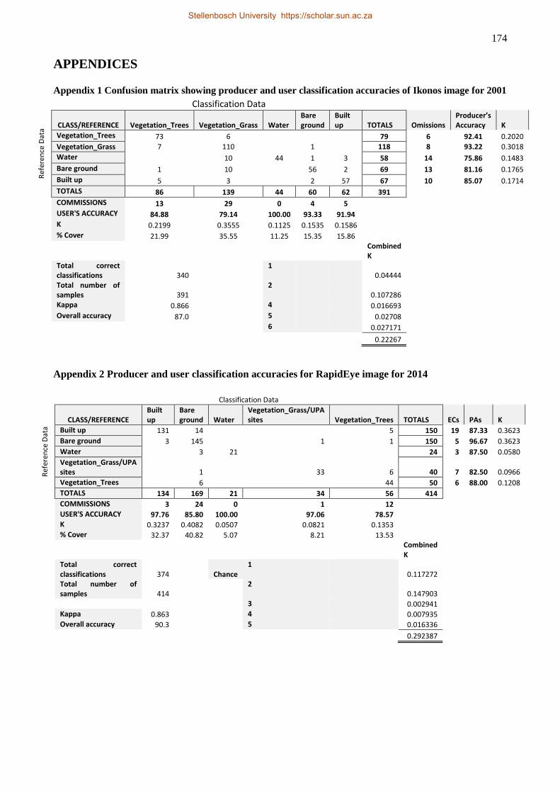
174
APPENDICES
Appendix 1 Confusion matrix showing producer and user classification accuracies of Ikonos image for 2001
Appendix 2 Producer and user classification accuracies for RapidEye image for 2014
Classification Data
Ref
eren
ce D
ata
CLASS/REFERENCE Vegetation_Trees Vegetation_Grass Water Bare ground
Built up TOTALS Omissions
Producer’s Accuracy K
Vegetation_Trees 73 6 79 6 92.41 0.2020
Vegetation_Grass 7 110 1 118 8 93.22 0.3018
Water 10 44 1 3 58 14 75.86 0.1483
Bare ground 1 10 56 2 69 13 81.16 0.1765
Built up 5 3 2 57 67 10 85.07 0.1714
TOTALS 86 139 44 60 62 391
COMMISSIONS 13 29 0 4 5
USER'S ACCURACY 84.88 79.14 100.00 93.33 91.94
K 0.2199 0.3555 0.1125 0.1535 0.1586
% Cover 21.99 35.55 11.25 15.35 15.86
Combined K
Total correct classifications 340
1 0.04444
Total number of samples 391
2 0.107286
Kappa 0.866 4 0.016693
Overall accuracy 87.0 5 0.02708
6 0.027171
0.22267
Classification Data
Ref
eren
ce D
ata
CLASS/REFERENCE Built up
Bare ground Water
Vegetation_Grass/UPA sites Vegetation_Trees TOTALS ECs PAs K
Built up 131 14 5 150 19 87.33 0.3623
Bare ground 3 145 1 1 150 5 96.67 0.3623
Water 3 21 24 3 87.50 0.0580
Vegetation_Grass/UPA sites 1 33 6 40 7 82.50 0.0966
Vegetation_Trees 6 44 50 6 88.00 0.1208
TOTALS 134 169 21 34 56 414
COMMISSIONS 3 24 0 1 12
USER'S ACCURACY 97.76 85.80 100.00 97.06 78.57
K 0.3237 0.4082 0.0507 0.0821 0.1353
% Cover 32.37 40.82 5.07 8.21 13.53
Combined K
Total correct classifications 374 Chance
1 0.117272
Total number of samples 414
2 0.147903
3 0.002941
Kappa 0.863 4 0.007935
Overall accuracy 90.3 5 0.016336
0.292387
Stellenbosch University https://scholar.sun.ac.za
175
Appendix 3 Ethical clearance approval letter
Stellenbosch University https://scholar.sun.ac.za
176
Appendix 4 Departmental introductory letter for fieldwork
Stellenbosch University https://scholar.sun.ac.za
177
Appendix 5 Consent form for research participants
STELLENBOSCH UNIVERSITY
CONSENT TO PARTICIPATE IN RESEARCH
TITLE OF THE RESEARCH PROJECT: Land use competition in peri-urban Tamale: Analysis of spatial planning for sustainable urbanisation
REFERENCE NUMBER: 17439639
RESEARCHER: Mr. Issahaka Fuseini
ADDRESS: Department of Geography and Environmental Studies,
Stellenbosch University
Kamer van Mynwese Building, Cnr Merriman & Ryneveld Str, Stellenbosch, 7600
CONTACT NUMBER:
Dear ………………………………………………………………………………………………... (To whom it may
concern)
My name is Issahaka Fuseini and I am a student from Stellenbosch University, South
Africa. I would like to invite you to participate in a research project entitled Land use competition
in peri-urban Tamale: Analysis of spatial planning for sustainable urbanisation. The
objective of the study is to assess how spatial/land use planning is done is the city in line with
sustainable development goals or principles. In this regard, the economic, social and environmental
dimensions of spatial planning as well as the processes of planning would be explored. You and/or
your outfit are identified as a relevant stakeholder in land use planning or urban governance in the
city. Accordingly, you are invited to participate in this under the terms and conditions outlined below.
Stellenbosch University https://scholar.sun.ac.za

178
Please take some time to read the information presented here, which will explain the details of this
project and contact me if you require further explanation or clarification of any aspect of the study.
Also, your participation is entirely voluntary and you are free to decline to participate. If you say
no, this will not affect you negatively in any way whatsoever. You are also free to withdraw from
the study at any point, even if you do agree to take part.
This study has been approved by the Humanities Research Ethics Committee (HREC) at Stellenbosch University and will be conducted according to accepted and applicable national and international ethical guidelines and principles. Below are further details regarding your participation in this research:
You are free to ask me any question before, during and after the discussion to clarify any doubt you may have about this research or any aspect of it.
There are no foreseeable negative effects or risk of harm to you for participating in the research. If you agree to participate, the time and venue of the interview would be scheduled at your own convenience.
No material or monetary benefit would accrue to you for participating in the research. However, your participation could yield potential benefits in terms of bringing to fore the successes and challenges of sustainable management of urbanisation in Tamale which would be beneficial to policy.
If you agree, I would like to audio record the interview to facilitate speedy conduct and also to enable me capture every detail of the discussion.
Be assured that your responses would be anonymised through an integrated process with other responses by many other respondents.
Your privacy would be respected before, during and after the interview. Consequently, information gathered would be used strictly for the intended purpose, and no third party would have access to this information other than my supervisor and me.
As stated earlier, your participation is voluntary, and you have the right to withdraw entirely from the research even after agreeing to participate or refuse to answer certain questions about which you might not feel comfortable.
If you have any questions or concerns about the research, please feel free to contact me:
Issahaka Fuseini
+233 242604330
+27 746728030
[email protected]; [email protected]
Or my supervisor:
Stellenbosch University https://scholar.sun.ac.za
179
Dr Jaco Kemp
+27 (0) 21 808 9147
RIGHTS OF RESEARCH PARTICPANTS: You may withdraw your consent at any time and
discontinue participation without penalty. You are not waiving any legal claims, rights or remedies
because of your participation in this research study. If you have questions regarding your rights as
a research subject, contact Ms Maléne Fouché [[email protected]; 021 808 4622] at the Division
for Research Development.
You have right to receive a copy of the Information and Consent form.
If you are willing to participate in this study please sign the attached Declaration of Consent for me.
Yours sincerely
(Issahaka Fuseini)
Principal Investigator
DECLARATION BY PARTICIPANT
By signing below, I …………………………………..………………. agree to take part in a research study entitled Land use competition in peri-urban Tamale: Analysis of spatial planning for sustainable urbanisation and conducted by Issahaka Fuseini.
I declare that:
I have read the attached information leaflet and it is written in a language with which I am fluent and comfortable.
I have had a chance to ask questions and all my questions have been adequately answered.
Stellenbosch University https://scholar.sun.ac.za
180
I understand that taking part in this study is voluntary and I have not been pressurised to take part.
I may choose to leave the study at any time and will not be penalised or prejudiced in any way.
I may be asked to leave the study before it has finished, if the researcher feels it is in my best interests, or if I do not follow the study plan, as agreed to.
All issues related to privacy and the confidentiality and use of the information I provide have been explained to my satisfaction.
Signed at (place) ......................…........…………….. on (date) …………....……….. 2009.
Signature of participant
SIGNATURE OF INVESTIGATOR
I declare that I explained the information given in this document to __________________ [name of the
participant] [He/she] was encouraged and given ample time to ask me any questions. This conversation was
conducted in English or Dagbanli26.
________________________________________ ______________
Signature of Investigator Date
26 There may be a small chance of conducting the discussion in the local language of the area (Dagbanli). If the need
arises I will not need any interpreter as I am fluent in the language.
Stellenbosch University https://scholar.sun.ac.za
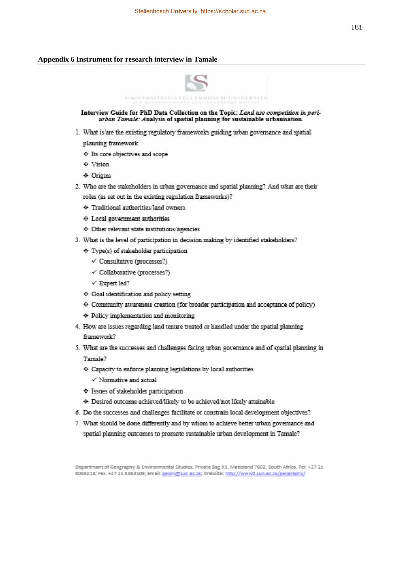
181
Appendix 6 Instrument for research interview in Tamale
Stellenbosch University https://scholar.sun.ac.za
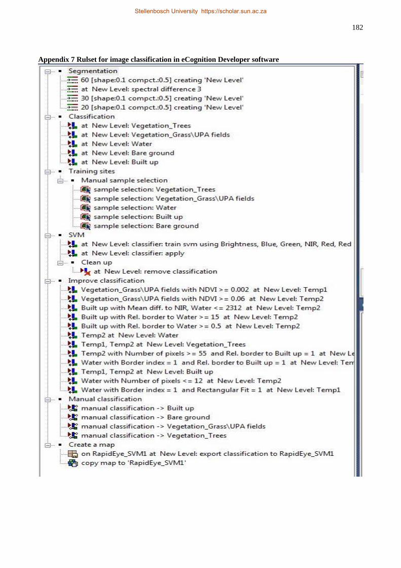
182
Appendix 7 Rulset for image classification in eCognition Developer software
Stellenbosch University https://scholar.sun.ac.za