Embed Size (px)
Citation preview

1 INTRODUCTION
Pierce Lewis, a world-renowned geographer and chronicler of New Orleans, famously described this place as “The Impossible but Inevitable City” (Lewis, 1973). Since its founding in 1718, New Or-leans has occupied a perilous but strategic location for the nation at the base of the Mississippi River system. Low in elevation, flood-prone, swampy, wa-ter-logged, insect-ridden, New Orleans has been subjected to many disasters over the last 300 years: tropical diseases, torrential rains, annual floods and catastrophic hurricanes. However, the worst to date were Hurricanes Katrina and Rita, which struck the Gulf Coast and New Orleans in August and Septem-ber 2005, respectively.
These storms reinforced New Orleans’ perilous position in the eyes of the nation and the world. But since that fateful day, August 29, 2005, New Orleans has demonstrated its resiliency as a city, reaffirmed the people’s belief in its future and cemented the bond its citizens have with this unique city. Today, the city is back after overcoming seemingly insur-mountable odds. The story of New Orleans’ post-Katrina/Rita recovery is a long and drawn out tale of trial, tribulation and, ultimately, triumph but it re-mains a work in progress.
Hurricane Katrina emerged on the national and regional weather alerts in the last days of August 2005 as a monster storm affecting the entire Gulf of
Mexico and heading directly towards New Orleans. With landfall expected during the early morning hours of August 29, Mayor Ray Nagin called for an emergency evacuation of New Orleans at 9:30 AM on August 28, 2005. In the hours before touching coastal Louisiana some 60 miles south of New Or-leans, evacuation of the city and its surrounding par-ishes proceeded with some urgency, but no one ex-pected the normal three-day hurricane inconvenience to stretch into weeks and, for some residents, months or even years.
Katrina, for New Orleans, was both a natural and man-made disaster. The storm’s winds and waters took their toll, but the actual devastation in the city resulted from the failure of its primary flood protec-tion systems: a series of earthen levees, concrete floodwalls and massive drainage canals. When these failed, 80 percent of New Orleans flooded.
Urban resiliency has had a unique history in the traditional growth and development of New Orleans. Our forefathers built appropriate structures with raised first floors on “high” ground. However these traditions were less common at the end of the 19th Century when new mechanical devices allowed the city to drain large portions of former swamplands and greatly enlarge the city’s developable area. However, as Hurricane Katrina tragically demon-strated in 2005, “man and machine” can only do so much to withstand the forces of Mother Nature. Dur-ing Hurricane Katrina and shortly thereafter with
Urban Resilience in post-Katrina/Rita New Orleans
J.R. Amdal Senior Fellow Merritt C. Becker, Jr. University of New Orleans Transportation Institute New Orleans, Louisiana, United States of America
ABSTRACT: From the time of its founding in 1718, New Orleans incorporated resiliency by building raised structures on naturally high ground, separating living space from potential floodwaters. Residents understood and respected the natural limitations of the city. However, in the late 1900s, with the introduction of drainage pumps, outfall canals and equipment stations, New Orleans envisioned a city no longer constrained by either geography or tradition. Below-sea-level areas were drained and became footprints for new neighborhoods. After 1965’s Hurricane Betsy, the Corps of Engineers undertook a series of construction projects throughout the New Orleans region to protect from future hurricanes. In 2005, Hurricane Katrina proved the city’s storm protection system unfit to handle natural disasters, when eighty percent of New Orleans flooded. Conse-quently, government leaders, citizens, professionals and academic advisors have worked to achieve enhanced urban resiliency through recovery projects. New Orleans has embarked on its post-disaster journey by re-thinking and reimagining the city and its neighborhoods for the betterment of all its citizens in an era of strengthening hurricanes, rising sea levels and climate change.

Hurricane Rita, our manmade fortifications against water and wind failed, resulting in the costliest dis-aster in the history of the United States. In the ensu-ing years, countless improvements have been made to our flood protection systems, our evacuation planning processes, and specific rebuilding pro-grams to reintroduce resiliency into New Orleans’ recovery.
2 TRADITIONAL NEW ORLEANS: “CITY BUILDING THAT RESPECTED NATURE”
Given New Orleans’ unique geography (on a deltaic plain next to the Mississippi River in a flood-prone area with low elevations), citizens originally built raised buildings on high ground in anticipation of annual floods. Low-lying areas of the city remained undeveloped until the later part of the 1800s. Our forefathers understood urban resiliency: they built appropriate buildings (raised structures) in appropri-ate places (high ground).
Figure 1. Historic French Quarter Streetscape. Photo courtesy of James Amdal, 2012.
Soon after the founding of New Orleans in 1718,
owners of upriver plantations, citizens of small river towns, and residents of the city started building earthen levees along the banks of the Mississippi River to protect themselves and their property from its annual floods. These earthen levees offered little protection from hurricanes and were frequently overtopped or breached during periods of high wa-ter, but they did offer some protection under normal river conditions. These primitive forms of flood pro-tection, although strengthened and raised over the years, still retain their vital function today.
In large part, early settlers had the right idea. They built where the city was most resilient, on naturally high ground. An 1878 map by Civil Engi-neer T. S. Hardee shows the City of New Orleans
with 200,000 residents confined to the “Sliver by the River,” an area of the city adjoining the river that suffered only minor flooding from Hurricane Ka-trina. Areas labeled “cypress swamp” on this and earlier maps include present day neighborhoods in-cluding Lakeview, most of Gentilly, New Orleans East, Broadmoor and the Lower 9th Ward. During Katrina, these neighborhoods received the worst flooding thanks to their naturally low elevations. It is notable that the unflooded areas on the post-Katrina map are almost identical to the populated areas of New Orleans on the 1878 map. Our historic neigh-borhoods and their flood-conscious architecture weathered the storm with minimal damage and dem-onstrated that traditional New Orleans’ settlement patterns and construction techniques resulted in re-siliency. Neighborhoods within the “Sliver by the River” were the first to repopulate and today have the highest real estate values. In pre-Katrina New Orleans, the real estate maxim was “Location-Location-Location”. Post-Katrina it became “Eleva-tion-Elevation-Elevation.”
Figure 2. Civil Engineer T. S. Hardee’s map of the City of New Orleans, 1878. Photo courtesy of Louisiana State Museum
3 A NEW CITY-BUILDING CONCEPT FOR NEW ORLEANS: “MAN AND MACHINE BEATS NATURE”
Starting in the late 1890s, New Orleans began to change in a rather remarkable manner. The concept of “Man and Machine Beats Nature” was introduced by the city’s Sewerage and Water Board (SWB) when they began constructing a world-renowned drainage system. Using the massive Woods Screw Pumps—invented by a New Orleans engineer in the early 1900s—as well as pump stations and outfall canals, the SWB drained the city’s low lands. This massive construction program dramatically in-creased the city’s buildable area by making vast ar-

eas of the city developable. This was the first large-scale attempt to beat Mother Nature in New Orleans. It would not be the last. After Hurricane Betsy devastated New Orleans as a Category 4 storm in 1965, the US Army Corps of Engineers was directed by Congress to build an ex-tensive flood protection system around the city. This system was comprised of higher and stronger earthen levees and massive concrete floodwalls. Unfortunately, this flood protection system was not complete after 40 years of construction when Ka-trina hit New Orleans in 2005. It remains incomplete today, although it is nearing completion. With these manmade interventions, residents in New Orleans assumed they were safe and secure. They truly be-lieved they lived in a resilient city. Unfortunately, the flaws of their flood protection system were tragi-cally exposed by Katrina’s wrath.
4 HURRICANES KATRINA AND RITA: A DOUBLE WHAMMY
Figure 3. Hurricane Katrina Flood Extent. Map courtesy of Rafe Rabalais, GCR Inc. Hurricane Katrina was the most destructive as well as the costliest natural and manmade disaster in the history of the US. Katrina was a massive Category 3 storm with winds in excess of 125 mph. This hurri-cane impacted the entire Central Gulf Coast includ-ing the states of Louisiana, Mississippi, Alabama and Florida; not just New Orleans and southern Lou-isiana. While the Mississippi Gulf Coast was espe-cially hard hit by Katrina’s winds and 30-foot-plus storm surges, 80 percent of New Orleans flooded from breaches in our federally designed and constructed flood protection system. All utilities and telecommunications systems failed. All surface transportation systems were flooded. Many road-
ways were impassable for months while some, such as the Twin Spans Bridge over Lake Pontchartrain, were completely destroyed. Basic utility services as well as communications (cellular and landline) re-mained severely compromised for months. The Port of New Orleans was an anomaly. It reopened after just 13 days, thanks to access provided by the Mississippi River and a cleared navigational channel provided by both public and private sector forces.
Figure 4. Twin Spans. Photo courtesy of Louisiana Department of Transportation and Development, 2005.
For New Orleans, Katrina was a natural and a manmade disaster, one whose effects were made worse by our natural topography and the man-made protection systems that failed. New Orleans is natu-rally shaped like a bowl with its outer edges formed by earthen levees, floodwalls or natural ridges. When the manmade structures failed during Katrina, the “bowl” filled with water. In a weird turn of fate, the very structures that were meant to keep the water out of the city kept the floodwaters in the city until pumps were able to “dewater” New Orleans. This took 53 days. As has often been reported, roughly 50 percent of the Greater New Orleans region lies below sea level, which compounded this effort. The dark arrows on the map below, prepared by the staff of the Times-Picayune, New Orleans’ local newspaper, indicate some of the sites in the city

where levees were breached during Katrina. There were a total of 50 sites where failures occurred. The city’s naturally low elevation coupled with the failed flood protection system proved a fatal combination. The red areas on the map indicate where deaths oc-curred (estimated in excess of 1480). A computer-generated simulation of Katrina’s flooding in the New Orleans region is available at: www.nola.com/katrina/graphics/flashflood.swf.
Figure 5. Diagrammatic map of Katrina flood protection fail-ures in the New Orleans Region. Map courtesy of The Times Picayune, 2005.
Figure 6. New Orleans Topography. Courtesy of US Army Corps of Engineers, 2005. Hurricane Rita hit just 3 weeks later on the Texas – Louisiana state line, with winds estimated at 120 mph. It caused more coastal erosion, a second evacuation of areas affected by Katrina, localized flooding and additional structural failures. While
Rita’s impact was most severe in southwestern Louisiana and Texas’ upper Gulf coast, New Or-leans suffered surges in excess of 8 feet and breaches occurred in some provisionally-repaired levees. These failures caused a second flood of two to three feet in certain neighborhoods, a dreadful replay of Katrina in New Orleans.
Figure 7. Abandoned school in Holy Cross. Courtesy of James Amdal, 2012.
Six years later, the extent of the storms’ devasta-
tion is still shocking. According to the Louisiana Recovery Authority, these storms in combination caused over $200 billion in losses and 1,800 deaths. They destroyed 204,500 homes and 18,750 busi-nesses (Louisiana Recovery Authority, 2006). The storms also eroded over 100 square miles of coastal wetlands, equivalent to what would naturally occur in 50 years. Nineteen of the state’s 64 parishes were severely affected by the storms. Some were totally destroyed. New Orleans sustained 57 percent of the state’s total economic loss. Access to the city was severely restricted for five weeks following the hur-ricanes. Even today, an estimated 60,000 people who lived in the city at the time of Katrina have not yet returned to New Orleans.
4.1 Grassroots actions and activism became imperative Soon after returning to the city, New Orleanians knew what they could do on their own. To put it bluntly, New Orleans was an utter disaster zone. It was eerily quiet. It was almost totally devoid of noise: no birds tweeting, no dogs barking, nothing but a grim silence spread through the city. And Ka-trina’s wreckage was everywhere. Refrigerators stood on the street like giant tombstones. Garbage and downed trees were everywhere. There were un-kempt lawns and neutral grounds. Debris littered the streets and clogged sewer drains. Flooded remnants
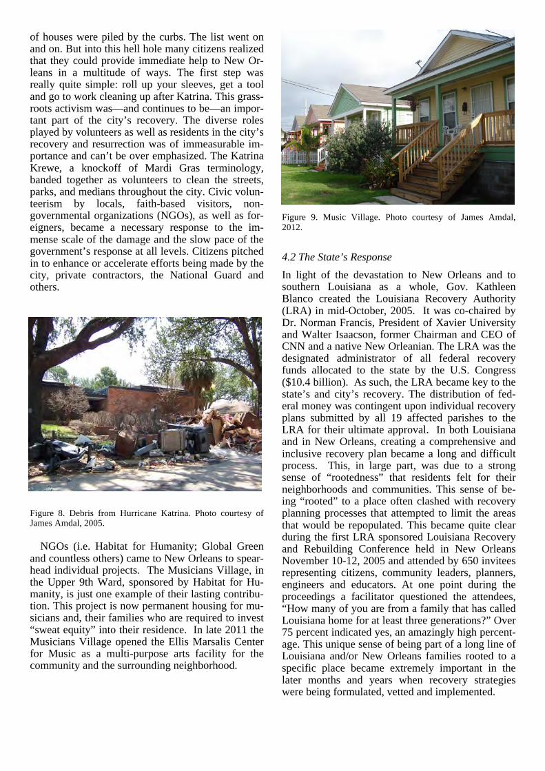
of houses were piled by the curbs. The list went on and on. But into this hell hole many citizens realized that they could provide immediate help to New Or-leans in a multitude of ways. The first step was really quite simple: roll up your sleeves, get a tool and go to work cleaning up after Katrina. This grass-roots activism was—and continues to be—an impor-tant part of the city’s recovery. The diverse roles played by volunteers as well as residents in the city’s recovery and resurrection was of immeasurable im-portance and can’t be over emphasized. The Katrina Krewe, a knockoff of Mardi Gras terminology, banded together as volunteers to clean the streets, parks, and medians throughout the city. Civic volun-teerism by locals, faith-based visitors, non-governmental organizations (NGOs), as well as for-eigners, became a necessary response to the im-mense scale of the damage and the slow pace of the government’s response at all levels. Citizens pitched in to enhance or accelerate efforts being made by the city, private contractors, the National Guard and others.
Figure 8. Debris from Hurricane Katrina. Photo courtesy of James Amdal, 2005. NGOs (i.e. Habitat for Humanity; Global Green and countless others) came to New Orleans to spear-head individual projects. The Musicians Village, in the Upper 9th Ward, sponsored by Habitat for Hu-manity, is just one example of their lasting contribu-tion. This project is now permanent housing for mu-sicians and, their families who are required to invest “sweat equity” into their residence. In late 2011 the Musicians Village opened the Ellis Marsalis Center for Music as a multi-purpose arts facility for the community and the surrounding neighborhood.
Figure 9. Music Village. Photo courtesy of James Amdal, 2012.
4.2 The State’s Response In light of the devastation to New Orleans and to southern Louisiana as a whole, Gov. Kathleen Blanco created the Louisiana Recovery Authority (LRA) in mid-October, 2005. It was co-chaired by Dr. Norman Francis, President of Xavier University and Walter Isaacson, former Chairman and CEO of CNN and a native New Orleanian. The LRA was the designated administrator of all federal recovery funds allocated to the state by the U.S. Congress ($10.4 billion). As such, the LRA became key to the state’s and city’s recovery. The distribution of fed-eral money was contingent upon individual recovery plans submitted by all 19 affected parishes to the LRA for their ultimate approval. In both Louisiana and in New Orleans, creating a comprehensive and inclusive recovery plan became a long and difficult process. This, in large part, was due to a strong sense of “rootedness” that residents felt for their neighborhoods and communities. This sense of be-ing “rooted” to a place often clashed with recovery planning processes that attempted to limit the areas that would be repopulated. This became quite clear during the first LRA sponsored Louisiana Recovery and Rebuilding Conference held in New Orleans November 10-12, 2005 and attended by 650 invitees representing citizens, community leaders, planners, engineers and educators. At one point during the proceedings a facilitator questioned the attendees, “How many of you are from a family that has called Louisiana home for at least three generations?” Over 75 percent indicated yes, an amazingly high percent-age. This unique sense of being part of a long line of Louisiana and/or New Orleans families rooted to a specific place became extremely important in the later months and years when recovery strategies were being formulated, vetted and implemented.

4.3 The City of New Orleans Responds Preceding the creation of the LRA, New Orleans Mayor C. Ray Nagin created the Bring New Orleans Back Commission (BNOB), a 17-member commit-tee of city leaders, to respond to the devastation and deliver a city-wide recovery plan within 90 days. Its members included 2 college presidents, the Arch-bishop of New Orleans, attorneys, religious and civic leaders as well as other highly respected mem-bers of the business community. BNOB represented a top-down decision-making process but one that encouraged significant citizen involvement.
In order to maximize citizen input, at a time when few residents were actually living in the City, BNOB was organized into committees and subcommittees. These included: land use; infrastructure (flood pro-tection, public transit, criminal justice); culture; edu-cation; health and human services; economic devel-opment; and government effectiveness. These groups held hundreds of individual meetings over a three-month period and made substantial contribu-tions to the city’s initial recovery efforts. Since eve-ryone was focused on the failure of the existing sys-tem of floodwalls, floodgates and levees, citizens demanded meaningful improvement to the entire flood protection system. Numerous recommenda-tions made by the infrastructure committee enhanced the overall resiliency of the City and the region. Among these recommendations were:
1 Move the pump stations from their existing inte-
rior locations to the lakefront. 2 Install floodgates at the relocated pump stations
to protect the existing drainage canals from storm surge.
3 Close the Mississippi River Gulf Outlet, a man-made shipping channel that served as a “hurricane highway” for Katrina’s storm surge which devas-tated St. Bernard Parish, New Orleans East and the Lower Ninth Ward.
4 Reconstruct the Lake Pontchartrain Sea Wall and Lakeshore Drive to reinforce this first layer of New Orleans’ flood protection system at the lake.
5 Mandate that the US Army Corps of Engineers complete the New Orleans Primary Flood Protec-tion System to withstand a Category 3 storm.
6 Reform and depoliticize existing parish levee dis-tricts by creating 2 reconstituted regional levee districts: Southeast Louisiana Flood Protection Authority – East and Southeast Louisiana Flood Protection Authority – West, with the Mississippi River serving as the natural dividing boundary.
7 Fund and implement significant coastal restora-tion efforts at the regional and state level.
Historic preservation was another area of intense
interest after Katrina. Given that significant portions of the city’s historic fabric had been spared massive
devastation by the storms, many residents regarded the city’s wealth of historic structures, neighbor-hoods and designated districts as a unique resource for disaster recovery and economic development. They successfully lobbied for expanding the number of designated historic districts; urged leaders to use historic preservation as a foundation for recovery and neighborhood revitalization; suggested that blighted properties be rehabilitated rather than razed; and that existing national preservation programs, such as the Urban Main Streets program, be aggres-sively adopted in appropriate neighborhoods. The Preservation Resource Center (PRC), a New Orleans based not-for-profit, partnered with The National Trust to open a field office in the city and recruited professional preservationists to assist local advocates in recovery-related tasks, including damage assess-ments of properties, homeowner assistance in design and construction, and serving on special task forces. The PRC also sponsors annual events (Christmas in October) and programs (Live in a Landmark) to raise citizens’ awareness of the rewards of historic preservation on a house-by-house and neighbor-hood-by-neighborhood basis.
4.4 Meetings, Meetings and More Meetings
Figure 9. Community Meeting at City Park Pavillion. Photo courtesy of James Amdal, 2006.
As weeks turned into months and eventually years, citizens in New Orleans and in South Louisiana were subjected to countless meetings of all types and sizes with one consistent goal: disaster recovery. Residents felt obligated to attend many meetings. Hundreds, if not thousands, of meetings were held citywide, in individual neighborhoods or disaster-impacted communities, regarding recovery and post-disaster rebuilding. In some neighborhoods these meetings continue today. Despite the overwhelm-ingly intensive nature of the disaster recovery plan-

ning process undertaken in New Orleans, most par-ticipants felt these meetings were well worth the effort. In large part they felt that the ultimate recov-ery of their neighborhood and the city in general could only be assured by their participation.
4.5 Outside Experts Weigh In on Disaster Recovery In the late fall of 2005, a team of volunteer profes-sionals from the Urban Land Institute (ULI), a Washington D.C.-based not-for-profit, was invited to New Orleans to brainstorm with community, business, and academic leaders on the future of New Orleans. This team was composed of planners, land-scape architects, mayors, developers, finance experts and public administrators. After a week of analyz-ing the state of post-Katrina New Orleans, the ULI team presented a recovery plan based on their cumu-lative experience and expertise. Their recommenda-tions included: shrinking the city’s footprint; strate-gically planning for a reduced population; converting heavily-damaged neighborhoods into open space; and creating a massive redevelopment entity. Most disturbing for many residents, ULI suggested that neighborhoods needed to prove their viability in order to participate in the city’s recovery efforts. Finally, they suggested a moratorium be placed on the issuance of any construction permits.
All of ULI’s ideas encompassed various aspects of “resiliency”. They attempted to prevent or slow the repopulation of areas of the city that were most at risk from flooding. Although reasonable and profes-sionally-sound, ULI’s concepts created confusion and fear among many residents, Most of ULI’s rec-ommendations were ultimately rejected. ULI’s plan paid little regard to the rootedness of many residents in their neighborhoods and seemed to pit one section of the city against another (Mid-City versus New Orleans East, for example). A looming question for all citizens was: “What characteristics made a neighborhood viable?” On Nov. 19, 2005 the headline in the local daily newspaper announced “4 months to decide.” This served as public notice that all neighborhoods seek-ing recovery funds must prove that they were com-ing back “safer, stronger and smarter” in post-Katrina New Orleans. Exactly how they were to do this remained to be seen.
Due to political realities, most of the ULI recom-mendations were rejected almost immediately by the Mayor. He chose instead to adopt a market-driven approach to recovery. With this decision, the idea of imposing terms and conditions on redevelopment and repopulation was dropped from civic discourse. This in turn limited serious discussion about reduc-ing the city’s footprint; replacing flood-prone devel-oped areas with water catchment basins / parklands;
and clustering housing for greater density in non-flood prone sections of the city.
5 THE LAMBERT PLAN: PLANNING FOR FLOODED NEIGHBORHOODS
In light of the public outcry that ensued following the release of the final BNOB Report in January 2006, which called for the abandonment or delayed repopulation of certain flood-prone sections of the city, Recovery Steering Committees were formed in most city neighborhoods, in large part to prove to the city leaders that their neighborhoods were viable, important and returning. Neighborhoods were grouped into planning districts based on pre-Katrina designations made by the City Planning Commis-sion. Despite its wholesale rejection by the public and most city politicians, the BNOB plan did gener-ate a renewed sense of worth and purpose for neigh-borhood organizations citywide. But these organiza-tions recognized their need for professional help in developing “credible” recovery plans. Initially, no one knew how that help was going to be provided. During deliberations with the Federal Emergency Management Agency in early 2006, it was deter-mined that FEMA funding could not be used for re-covery planning, leaving open the question of who would provide the necessary financial and profes-sional resources to develop neighborhood recovery plans.
Paul Lambert, a Miami-based housing consultant under contract to the New Orleans City Council, came up with the answer. Given his experience with recovery efforts in Dade County Florida after Hurri-cane Andrew hit in 1992, he knew that unspent Community Development Block Grant (CDBG) funds could be used for recovery planning in the New Orleans neighborhoods flooded during Katrina. “Dry” neighborhoods (unflooded) were ineligible. Lambert formed a team of local and national profes-sionals that began work in early 2006 on CDBG-funded plans for the city’s 40-odd “wet” neighbor-hoods, outlined in black on the map below. A few neighborhoods elected to conduct their own recov-ery plans using resources provided by academic institutions, NGOs such as Acorn, and other inter-ested parties.
District 5, depicted by the light olive color to the upper left of the map, constitutes a series of seven neighborhoods immediately city-side of the infa-mous 17th Street drainage canal. When its city-side floodwall ruptured, catastrophic flooding ensued. Other neighborhoods located immediately south of Lake Pontchartrain were flooded when Katrina’s storm surge overtopped the protective levees at the lakefront. District 5 flooded with over 10 feet of wa-ter and many homes were filled with 6 feet of mud and debris. Most structures in District 5 were con-
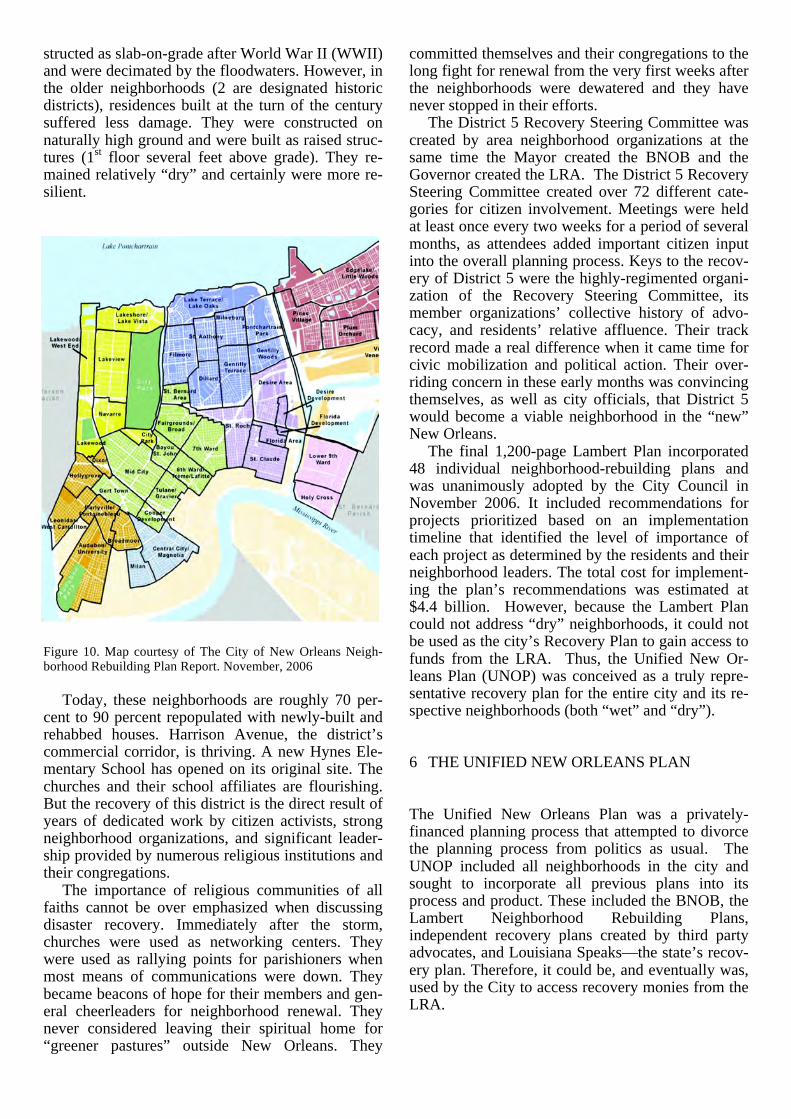
structed as slab-on-grade after World War II (WWII) and were decimated by the floodwaters. However, in the older neighborhoods (2 are designated historic districts), residences built at the turn of the century suffered less damage. They were constructed on naturally high ground and were built as raised struc-tures (1st floor several feet above grade). They re-mained relatively “dry” and certainly were more re-silient.
Figure 10. Map courtesy of The City of New Orleans Neigh-borhood Rebuilding Plan Report. November, 2006
Today, these neighborhoods are roughly 70 per-
cent to 90 percent repopulated with newly-built and rehabbed houses. Harrison Avenue, the district’s commercial corridor, is thriving. A new Hynes Ele-mentary School has opened on its original site. The churches and their school affiliates are flourishing. But the recovery of this district is the direct result of years of dedicated work by citizen activists, strong neighborhood organizations, and significant leader-ship provided by numerous religious institutions and their congregations.
The importance of religious communities of all faiths cannot be over emphasized when discussing disaster recovery. Immediately after the storm, churches were used as networking centers. They were used as rallying points for parishioners when most means of communications were down. They became beacons of hope for their members and gen-eral cheerleaders for neighborhood renewal. They never considered leaving their spiritual home for “greener pastures” outside New Orleans. They
committed themselves and their congregations to the long fight for renewal from the very first weeks after the neighborhoods were dewatered and they have never stopped in their efforts.
The District 5 Recovery Steering Committee was created by area neighborhood organizations at the same time the Mayor created the BNOB and the Governor created the LRA. The District 5 Recovery Steering Committee created over 72 different cate-gories for citizen involvement. Meetings were held at least once every two weeks for a period of several months, as attendees added important citizen input into the overall planning process. Keys to the recov-ery of District 5 were the highly-regimented organi-zation of the Recovery Steering Committee, its member organizations’ collective history of advo-cacy, and residents’ relative affluence. Their track record made a real difference when it came time for civic mobilization and political action. Their over-riding concern in these early months was convincing themselves, as well as city officials, that District 5 would become a viable neighborhood in the “new” New Orleans.
The final 1,200-page Lambert Plan incorporated 48 individual neighborhood-rebuilding plans and was unanimously adopted by the City Council in November 2006. It included recommendations for projects prioritized based on an implementation timeline that identified the level of importance of each project as determined by the residents and their neighborhood leaders. The total cost for implement-ing the plan’s recommendations was estimated at $4.4 billion. However, because the Lambert Plan could not address “dry” neighborhoods, it could not be used as the city’s Recovery Plan to gain access to funds from the LRA. Thus, the Unified New Or-leans Plan (UNOP) was conceived as a truly repre-sentative recovery plan for the entire city and its re-spective neighborhoods (both “wet” and “dry”).
6 THE UNIFIED NEW ORLEANS PLAN
The Unified New Orleans Plan was a privately-financed planning process that attempted to divorce the planning process from politics as usual. The UNOP included all neighborhoods in the city and sought to incorporate all previous plans into its process and product. These included the BNOB, the Lambert Neighborhood Rebuilding Plans, independent recovery plans created by third party advocates, and Louisiana Speaks—the state’s recov-ery plan. Therefore, it could be, and eventually was, used by the City to access recovery monies from the LRA.

Figure 11: Organization of Plans Courtesy of UNOP, 2007.
6.1 A Winning Tool for Demonstrating UNOP’s Validity: Community Congresses UNOP’s Community Congresses, organized by America Speaks, were largely the key to the plan’s success. Eight-hour sessions held on a Saturday in different cities on the same day over three weekends attracted the participation of thousands of residents via a hi-tech, interactive communication tool to al-low for instantaneous voting for specific programs, projects or initiatives. The inclusiveness made pos-sible by participation tools that allowed participation by those who had returned to the city and those still in dispersed convinced the LRA that UNOP was the city’s most representative recovery plan. Thousands of citizens participated with each other and the Congress facilitators during these meetings. An interactive technique helped convince the LRA that UNOP was the city’s recovery plan, based on input from residents and those still in the diaspora. Citizens reached consensus on goals, objectives, policies and projects. This was UNOP’s most im-portant contribution: it proved to the LRA that UNOP was the recovery plan for Orleans Parish
UNOP also analyzed city-wide systems including sewage, water, drainage, power generation and dis-tribution, and communications, as well as all 72 in-dividual neighborhoods with an emphasis on risk-management. Figure 3 illustrates the depth of flood-ing within the City as established by aerial photog-raphy. As you can clearly see, the “Sliver by the River” was spared most of the flooding.
Additionally, UNOP attempted to forecast re-population using a variety of indicators including utility hookups, mail deliveries, and permit activity by classification. These proved imperfect means of attempting to gauge an uncertain future. In fact a lot remained unknown: the number of residents that would return; where they would choose to live if they were to return; and the city services they would require. Answering these questions with any cer-tainly proved to be very problematic in the end. However, these metrics were useful in approaching an uncertain future.
UNOP, using city-wide assessments of physical, social and civic systems, selected projects and pro-grams to be included in its final list of recommenda-tions. These were broadly prioritized in time (imme-diate, mid-term, long-term) as they had been in previous recovery and rebuilding plans (BNOB and The Lambert plans). However, it was the community engagement process, not the list of prioritized pro-ject, that sold UNOP to the people of New Orleans and to their elected and appointed officials. The costs associated with UNOP’s policies and programs were in excess of $14 billion, reflecting its incorpo-ration of all neighborhoods in the city and their col-lective needs.
A significant part of UNOP required planning for the recovery of the “dry” neighborhoods, where the physical damage was less significant but the eco-nomic toll caused by the storm was in some cases dramatic. In approaching two of New Orleans’ prime neighborhoods, it became clear that their damage was economic, not physical. The District 1 Recovery Steering Committee incorporated both the Central Business District (CBD) and adjacent French Quarter. These neighborhoods, designated District 1 for planning purposes, recognized a com-mon challenge: the global perception that New Or-leans was a neverending disaster with no real future. This meant severely-reduced visitor numbers (tour-ists and conventioneers) and an extremely weakened economy. However, by working together, their indi-vidual interests were joined in mutually-reinforcing plans, programs and projects that benefitted both neighborhoods as well as the city. These included marketing and promotional campaigns by the city and its tourism and convention agency, the state and others with an overall goal to restore tourism. As just one indicator, there are now 300 more restau-rants operating in New Orleans than there were be-fore Katrina. For District 1, UNOP proposed a concentration of performing arts venues at a prime intersection in the CBD. “Broadway South” is now being realized at the upper end of Canal Street, the traditional com-mercial corridor in the CBD. The 1927 Saenger Theater, an entertainment icon for the City, is being renovated to recapture its historic past while em-

ploying cutting-edge technologies for the performing arts. Across the street, the 1947 Joy Theater has been renovated and is now hosting live performances. A new $70 million mixed-use development, primarily residential, has also just been approved by the City Council and groundbreaking will begin in 2012. All of this development has only begun in the last twenty-four months.
UNOP’s District 1 plan also called for specific nodes of development with particular characteristics per project. The recent opening of the Bio-Innovation Center, a $60 million incubator for re-search and development in the medical sciences, heralded the emergence of a new bio-medical re-search and technology sector. Another key compo-nent of this burgeoning economic sector is a new Health Sciences Center that includes a new LSU Teaching Hospital and a new VA Hospital, currently being built at a cost of $2 billion in portions of Mid-City, a neighborhood lakeside of the CBD. These new hospitals have been a source of heated debate for the last several years in the community at-large but they are now under construction.
Figure 12. Arial rendering of future VA Hospital Complex. Courtesy of Southeast Louisiana Veterans Healthcare System, 2012.
Although UNOP was expansive in its scale and
cost, much of the plan is now being realized. On just one upper CBD corridor, a new $45 million streetcar line is being built, with 100 percent federal funding, with $1.3 billion in new development planned or built along three blocks of its route (Augustine, 2012). Projects taking shape in its midst include a newly renovated Superdome, the newly-renovated Hyatt Regency Hotel, the Benson Tower and the Saratoga Apartments, a 1950s office building con-verted into 150 units of downtown rental housing. The CBD’s first grocery store opened in mid-October, 2011. Most of these projects have only happened in the last 24 months.
Within District 1 (the Central Business District and the French Quarter) traditional development pat-terns have been augmented by new centers of in-
vestment activity. The Superdome and its immediate environs are seeing over $800 million invested in renovations and new construction within a four-block radius. The Convention Center and the Central Area Riverfront are also seeing additions to their traditional offerings: a new cruise ship terminal at Julia Street, expanded convention facilities at the Morial New Orleans Convention Center and exten-sive renovations to Riverwalk, a specialty retail cen-ter overlooking the Mississippi River. The French Quarter is thriving within its historic context and “toute ensemble.”
Figure 13. Morial New Orleans Convention Center. Photo courtesy James Amdal, 2011.
7 ADDITIONAL RECOVERY INITIATIVES
7.1 Transportation Infrastructure
Figure 14. Bike Lane on S. Carrollton, Courtesy of Matthew Rufo, KidsWalk Coalition, 2011.

To address the damage done to the city’s major streets by the floodwaters, the Regional Planning Commission (the Metropolitan Planning Organiza-tion for the New Orleans region) in partnership with the Louisiana Department of Transportation and De-velopment and the Federal Highway Administration created the Submerged Roads Program to specifi-cally fund the repair of New Orleans’ major arterial roadways. Before the storm, local roads were ade-quate but after the flood they were horrible and deteriorating at an alarming rate due to the influx of salt water with the floodwaters. This program has been able to repair over 56 miles of roadways in the city and significantly added to the local bike path system by specifically designating bike routes within the newly reconstructed roadways. However, the Submerged Roads Program could not address the needs of the minor roadways such as neighborhoods streets. How these repairs will be funded remains another unanswered question post-Katrina.
Attention has also been given to expanding op-tions for mobility with a special emphasis on im-proving and enlarging alternative transportation sys-tems, specifically for pedestrians, the mobility- impaired and cyclists. Through a coordinated plan that addresses multiple needs throughout the city, New Orleans has grown its bicycle network from a meager 5 miles in 2004 to over 50 miles in 2012 (Jatres, 2012). From 2010 to 2011, bicycle use in-creased 20 percent. This network includes bike lanes within roadways, shared-lane markings or “shar-rows” and bike trails. In the coming months New Orleans will begin the construction of the Lafitte Greenway. This 3.1-mile project is converting an abandoned freight rail right-of-way into a multi-functional linear green space that will accommodate a variety of users from toddlers to the elderly. Walk-ers, cyclists, skateboarders, rollerblade aficionados as well as young families with strollers will use this new amenity. This project, long a dream for a core constituency, is now being heralded as the ultimate urban renaissance: turning an abandoned industrial eyesore into a community asset. When complete it will serve multiple neighborhoods along its path, from the French Quarter to Bayou St. John in Mid-City.
7.2 Home elevation On another front, after the floods, elevating houses became another option for homeowners to consider, especially in neighborhoods that were built after WWII in newly developed areas within the city that are extremely vulnerable to flooding. These houses were typically built as “slab-on-grade” and present costly challenges for the homeowner if they choose to raise them off the ground. In many instances
house raising has created visually disturbing results, especially when the raising is taken to extremes. The original elevation program provided up to $30,000 per residence for “house raising”. However, this amount was recently determined to be inade-quate and was increased to provide residents with the funds necessary to properly raise their homes. Another problem with this program was its timing.
Figure 15: Houses Raised in Upper Gentilly, Courtesy of James Amdal 2011. The original “Road Home” program that provided funds for rehab or reconstruction of damaged homes was awarded several years before the elevation pro-gram was activated. This complicated the entire rehab and reconstruction funding decision for homeowners. Equally troubling, abuses are now be-ing reported of unqualified contractors being hired for these projects. Although paid through state ad-ministered programs, fraud claims are common and becoming more so. Finally there are no design stan-dards for house raising, which can lead to unin-tended consequences. Many individual homes look out of place when taken in context of neighboring houses and the overall streetscape.
7.3 Levees and flood protection Since Katrina, the US Army Corps of Engineers (the Corps) has spent over $14.4 billion upgrading, re-pairing and completing the New Orleans Area Hur-ricane and Storm Risk Reduction System. This was and remains the city’s most important resiliency component. One major project built in response to Katrina is the surge protection barrier in Lake Bor-gne, which cost $1.1 billion. When complete in late 2012, the projects undertaken by the Corps will pro-vide protection for a Category 3 storm for the greater New Orleans region. However, many believe this system should offer protection from a Category 5 storm but the costs are astronomical and currently this upgrade is not being seriously pursued. Another

unintended consequence of the storms of 2005 has been their positive impact on the local economy. These flood protection projects, as well as the rest of our recovery activities, have shielded the New Or-leans region from the economic ills currently afflict-ing the United States. We became an isolated bubble of reconstruction activity post-Katrina.
Figure 16. Lake Borgne Protection Barrier. Courtesy of US Army Corps of Engineers, 2011. Coastal restoration has also emerged as a priority within the state and the region. Spearheaded by the America’s Wetlands Foundation, a well recognized NGO, “the passage of the 2012 Coastal Master Plan represents a nationally significant comprehensive systems approach to coastal restoration and protec-tion of one of the nation’s most critical natural re-sources….The State is doing its part to secure im-portant economic and environmental assets that serve America by providing abundant energy, sea-food and agricultural resources, as well as world’s largest port and navigation systems that underpin the U.S. economy and economies of 31 states served by the Mississippi River.” according to King Milling, Chair AWF (Ports Association of Louisiana, 2012).
7.4 Education By 2016, every public school student in New Or-leans will be attending a new or renovated school, designed and constructed with resilience as a core requirement. This $2 billion rebuilding program is being administered by the Recovery School District, a state agency that replaced the highly politicized pre-Katrina Orleans School Board. An alternate pro-gram of charter schools, largely administered by parents and teachers, has proven extremely success-ful in post-Katrina New Orleans, to the delight of lo-cal and national advocates. Fully 78 percent of to-day’s public school students are being educated in a charter school, making New Orleans a model for na-tional public education reform.
Figure 17. Lake Area New Tech Early College High School in Gentilly. Photo courtesy of James Amdal, 2012.
7.5 Public housing Public housing has also been transformed post-Katrina into mixed-income developments by an ag-gressive partnership between the Department of Housing and Urban Development, the Housing Authority of New Orleans and a number of local and national private sector developers. Before Katrina, more than 5,000 families lived in public housing, but today only one-third of these families have returned to the newly built replacements. Former residents have mixed emotions about their new neighborhoods with some decrying the higher rents and utility bills. Others miss their former neighbors who have not re-turned. It remains to be seen if this new model of public housing will fare better than the model it re-placed. However, in all cases, these new develop-ments have incorporated resiliency into their design and construction.
Figure 18. Faubourg Lafitte. Photo courtesy of James Amdal, 2012.

7.6 Entrepreneurialism Post-Katrina, New Orleans has become a hot spot for young entrepreneurs. Many were first drawn to the city by the disaster, but many have stayed and prospered. During a UNOP District 1 Recovery Steering Committee Meeting, a successful marketing executive and member of the committee noted that the new Creative Class residents in New Orleans “can be anywhere. Their businesses are lap-top based, but they have chosen New Orleans due its limitless opportunities for growth and development.” The Idea Village, a local Not-For-Profit founded in 2000, has emerged post-Katrina as a nexus for very successful entrepreneurial initiatives. Recently, The Wall Street Journal referenced this latest New Or-leans phenomenon in the article A Tech Buildup on the Bayou. According to the article “Companies from start-ups to large-established entities are ex-panding or setting up shop here, drawn by a state tax credit that is offered to digital-media and software firms…New Orleans stock of tech jobs grew 19% from October 2005 to April 2012, compared with 3% nationally.” (McWhirter & Dougherty, 2012)
7.7 Crime, blight and other problems Despite our post-storm recovery, long-standing problems still persist in New Orleans. Crime re-mains an on-going problem for residents and visitors alike. According to figures recently released by the Greater New Orleans Community Data Center, cur-rently there are over 48,000 blighted and/or vacant structures and lots in the city. New Orleans ranks number 2 in the US for income disparity, and the 2010 British Petroleum deep-water oil spill is still affecting the local and state economy.
Meantime, despite ongoing neighborhood in-vestment, certain sections of the city stand as unfor-tunate reminders of the devastating effects of the storms. The Lower 9the Ward is still struggling after six years of planning, advocacy, and major invest-ments by foundations and support organizations. The Make It Right Foundation is in the process of build-ing 150 environmentally-friendly homes in the neighborhood that was decimated by Katrina’s floodwaters. The new houses are elevated 8 feet and feature Energy-Star windows and appliances, for-maldehyde-free cabinets and paints free of VOCs. The ultimate success of this initiative is still up in the air in spite of its laudable intent and significant investment. Retail and institutional anchors have been slow to reemerge after the storm. However, it was recently announced that a new 25,000 square foot grocery would be built in the neighborhood to serve area residents.
Figure. Lake Area New Tech Early College High School in Gentilly. Photo courtesy of James Amdal, 2012.
8 CONCLUSION
In February of 2007, Bob Hebert, a columnist for the New York Times, noted that New Orleans was like the fairy tale character Humpty Dumpty who fell off the wall and nobody knew how to put him back to-gether again. At the time, his assessment about the city was accurate: “A great American cultural center like New Orleans was all but washed away, and no one knows how to put it back together again.” (Herbert, 2007). Since then, much progress has been made, but serious problems still persist. The most pressing issues include the city’s high crime levels and the vast numbers of blighted or abandoned hous-ing that sit dormant in many neighborhoods.
The post-Katrina recovery of New Orleans pre-sents a unique opportunity for others to learn from our successes and failures. Today, New Orleans may be the best laboratory in the world for academic and applied research in the ever-expanding disci-plines of disaster recovery and urban resilience. There exist countless avenues of investigation: from public health to economic revitalization. In spite of overwhelming odds, New Orleans has demonstrated success in neighborhoods throughout the city. Each offers a unique view on disaster recovery from many perspectives: the individual citizen, the neighbor-hood leader or organizer, and city, state or national administrator or policy makers in the public and/or philanthropic realm.
Resilience has many different faces in post-Katrina New Orleans: the physical, the social, the historic and the organizational. The city has excelled in some areas more than others, but successes have been achieved in each of these categories. New Or-leans over the last six years has been re-envisioned,

rebuilt and resurrected from the floodwaters of 2005. Post-Katrina, the city clearly has much to offer the international community in understanding and learn-ing from our efforts in disaster recovery and urban resilience.
REFERENCES
Augustine, J. (2012, February 15). Regional Transit Authority Transportation Investments Generate Economic Growth. Retrieved May 31, 2012, from The White House: http://www.whitehouse.gov/blog/2012/02/15/regional-transit-authority-transportation-investments-generate-economic-growth
Jatres, Dan. (2012, June). Regional Planning Commission. Interview.
Herbert, B. (2007, February 22). From Anna to Britney to Zawahri. The New York Times , A23.
Louisiana Recovery Authority. (August 2006). Hurricane Katrina Anniversary Data for Louisiana. Louisiana's Media Center. Louisiana: Louisiana Recovery Authority.
McWhirter, C., & Dougherty, C. (2012, June 8). A Tech Buildup on the Bayou. The Wall Street Journal , A3.
Ports Association of Louisiana. (2012, June 6). News from the Docks. 13 (6) . New Orleans, Louisiana.